cooroibah - shire of noosa
TRANSCRIPT

2 Cooroibah

2

3
Contents
2.1 LAKE COOROIBAH …………………………………………………………………………………… 4
2.2 COOLOOTHIN ………………………………………………………………………………………… 6
2.3 NOOSA RIVER (Lake Cooroibah To Lake Cootharaba Including Johns' Landing And Restdown) 8
2,4 TRONSON'S CANAL ………………………………………………………………………………… 11

4
2.1 LAKE COOROIBAH
LOCATION The southern extremity of the lake is some twelve kilometres upstream from the mouth of the Noosa River.
TENURE The surface area of the lake to its high water mark is state controlled. The land forming its shores is mostly privately owned with parts of its foreshore being included in National Park.
DESCRIPTION Lake Cooroibah is a saline, shallow lake within the Noosa River waterway..
2.1.1 BRIEF HISTORY
Lake Cooroibah, also known as Cooreyba,1 forms a rough rectangle with its longer sides facing northeast and southwest. Its two shorter sides are at right angles to these. The Noosa River enters the lake on its downstream course at its northeastern corner and leaves it about halfway along the long easterly side. It is three kilometres long by one and a half kilometres wide.2
Probably the first European to see the lake was the escaped convict John Graham who absconded from the harshness of the Moreton Bay Penal Settlement in July 1827 and who lived with the Gubbi Gubbi people for some six years, travelling with them as far north as Tin Can Bay.3 Graham played a leading role in the rescue of Eliza Fraser in 1836, walking with some Gubbi Gubbi to Lake Cooroibah, crossing it by canoe and rescuing Mrs Fraser and another member of the crew of the stricken Stirling Castle.4
Rafters and small stern wheeled steamer operators used the lake in the transport of logs from the more northern Lake Cootharaba to Tewantin for milling or transshipping during the latter decades of the nineteenth century5 and commercial fishing, particularly prawning, was carried out in its waters until as late as 1993.6
1 Hibbard, A and Crosby, E, “Mill Point Conservation Plan - Cooloola National Park, Volume 1, Management Plan prepared for the Queensland Department of Environment and Heritage, 1991 quoted William Pettigrew, the sawmiller, in his 1863 survey, p.29. 2 Dennis Gittoes' Map of the Cooloola Coast, 1996. 3 Dwyer, Barry and Buchanan, Neil, The Rescue of Eliza Fraser, Gympie, Gympie and District Historical Society, 1986, Appendix 1, p.22. 4 ibid., p.7. 5 Adams, Rod, Noosa and Gubbi Gubbi, Tewantin, Ultreya Publications, 2000, p.107; The use of the lake for the transport of hewn and
milled timber along the Noosa River from Lake Cootharaba to the river mouth in the latter half of the nineteenth century is discussed quite fully in the citation relating to the Noosa River from Tewantin to Lake Cooroibah.
6 Elainekgreen & associates, Historical and Cultural Heritage Survey of the Noosa, Maroochy and Mooloolah Rivers, for The Maroochy-Mooloolah-Noosa Water Quality Strategy Management Committee as part of the South East Queensland Regional Water Quality

5
Currently, there is a resort complex situated at the eastern end of the southern long side of the lake and a small residential settlement has been developed on the opposite shore.7
Lake Cooroibah is extremely shallow with a navigable channel running through it from north to south, east of its middle section. Even this channel is only available to shallow draught vessels, however, and must be traversed with care.8
Around 1960, a Sydney company, Watson & Son Pty Ltd purchased 28.4 ha (70 acres) for the sum of £36,500. They
planned a subdivision and caravan park on the lake foreshore near where the Lake Cooroibah Road has access to the lake. The caravan park never eventuated but an airfield was built to allow one of the company's directors, Mr. W. Walter to have access for his private aircraft to the property.9
Lake Cooroibah is little used except as a medium for through travel because of its extreme shallowness. Powerboats therefore are not a threat to its integrity. Tourist launches traverse it to a limited extent and houseboats even less. The airstrip still exists.
The ambience of the lake is one of peace. The Noosa River, flowing through the very heart of Lake Cooroibah as it does, keeps its water quality very good. Parts of its foreshores are National Park.
2.1.2 HISTORICAL THEMES
This place site illustrates the following historical themes in Noosa Shire based on the Environmental Protection Agency’s Guidelines for Historical & Indigenous Cultural Heritage Management, 2001:-
2 (f) Developing rural economies - managing and conserving land, water, flora and fauna national park (national park)
2.1.3 POTENTIAL SIGNIFICANCE
Lake Cooroibah forms a vital part of the overall riverine system, which gives Noosa its name. Because of its shallowness and the tranquility of its environment it is very popular with bird life.
It is recommended that Noosa Council consider assessment criteria a, b, e, and h under the Environmental Protection Agency’s Guidelines for Historical & Indigenous Cultural Heritage Management, dated 2001 as relevant to this place.
2.1.4 INTEGRITY
The integrity of Lake Cooroibah is very much preserved as it was in its original state. This is due to the fact that, because it is so shallow, it is of little use to recreational pursuits, which would otherwise threaten it.
It is of the utmost importance that this integrity be kept intact.
Management Strategy, December 2000, p.37.
7 Dennis Gittoes' Map of the Cooloola Coast, 1996. 8 ibid., p.7. 9 Pers. comm., Mrs Irene Christie, 2001.

6
2.2 COOLOOTHIN
LOCATION On the south bank of Cooloothin Creek, approximately one kilometre upstream from where the creek empties into Lake Cootharaba.
TENURE Freehold.
DATE GF St John Carter first settled in the Cooloothin Creek area - he called it Colothin - in 1871.10
DESCRIPTION A small housing community, situated on a historically important area.
The Cooloothin Creek
2.2.1 BRIEF HISTORY
GF St John Carter grew sugar cane on his selection at Cooloothin Creek and such was the excellent quality of his crop that he was awarded first prize and a silver medal at the first Gympie show for it.11 He selected portion 1704 and later a township was surveyed, but it never attracted the establishment of more than three or four houses.12
A school was opened, but it was closed in 1934.13
Very recently interest has been restored in the area, with some six houses of very reasonable quality having been erected along Bundoora Street, although there is virtually no remnant whatsoever of the original township to be seen. The precinct faces good, deep water in Cooloothin Creek nearby, is of a select, reclusive, nature and has potential as an enclave type of development. It is surrounded by rainforest and has aesthetic attractions.
The name Cooloothin is of Aboriginal background, coming from ‘kululu’, the indigenous word for cypress pine, and ‘yungarthin’ meaning to swim. The overall connotation referring to the Aboriginal peoples' attempt to come to grips with the process of rafting cypress logs down the creek by early timber getters14 to Lake Cootharaba for on-shipment in Tewantin.
10 Denis Gittoes' Map of the Cooloola Coast, 1996. 11 Lack, Clem, `Noosa and Tewantin A Romantic Historical and Geographical Region', Local Government, Feb. 1971, vol. 66, no. 2, p.3. 12 Mrs Irene Christie, Tewantin, original notes, p.13. 13 ibid. 14 ibid.

7
There is also a suspicion that a massacre of Gubbi Gubbi people may have taken place in the close proximity of Cooloothin Creek in the nineteenth century.15
Local author, Colin Monks states, that as well as cypress pine, red cedar, beech, and huge kauri pine logs were stockpiled on Cooloothin Creek, known to him as `the rafting ground', by Mill Point sawmillers McGhie, Luya and Goodchap before moving them over their mill for processing.16
Following this processing, with timber having been brought both from Cooloothin and indeed from all other sources available to McGhie, Luya and Goodchap, the milled timber had to be transported down to the firm's trans-shipping centre at Colloy near Tewantin.17 This exercise caused the firm many wearisome days and they explored the possibility of purchasing a shallow-draught steamer from Yarrow & Hedley of the Isle of Dogs18 to expedite to operation. The boatbuilders could not, however, supply a vessel to meet their customers' needs and they decided to build one themselves. The project was attempted successfully, providing them with a flat-bottomed paddle steamer 21.3 metres (70 feet) in length, with a beam of 4.8 metres (16 feet) and which drew only 36 centimetres (14 inches) of water. It was powered by a 9 kilowatt (12 horse-power) multitubular boiler which enabled it to tow four pontoons, each 17 metres (56 feet) long, with a draught of 50 centimetres (20 inches) and each carrying 25 000 feet of sawn timber at a speed of 5 nautical miles per hour.19 Known as a `drogher'20 the vessel was named the Alabama and it proved admirable for the tasks sought of it.21
At Colloy, which was located on the North Shore, just opposite the Esplanade at Gympie Terrace, where a group of houses now exists22 the lumber was stockpiled and transhipped to Brisbane by the firm's paddle wheeler, Culgoa, until it was wrecked upon the Noosa River bar in 1891.23
2.2.2 HISTORICAL THEMES
This place illustrates the following historical themes in Noosa Shire based on the Environmental Protection Agency's Guidelines for Historical & Indigenous Cultural Heritage Management, dated 2001:-
2(d) Developing rural economies - encouraging closer settlement and immigration township (town reserve).
2.2.3 POTENTIAL SIGNIFICANCE
Settlement at Cooloothin Creek goes back to the very earliest of times in relation to the development of Noosa Shire. The site of the present settlement closely follows that of the first attempts at forming a township there and the current situation has considerable merit. The town site can adequately sustain a modest population and it would be to advantage to have it proceed along well-directed lines.
It is recommended that Noosa Council consider assessment criteria a, b, c, d, e, g and h under the Environmental Protection Agency's Guidelines for Historical and Indigenous Cultural Heritage Management, dated 2001 as relevant to this place.
2.2.4 INTEGRITY
The integrity of the environs of the housing settlement is virtually intact. Any further expansion of the township will need to show sensitivity to this important factor in its establishment.
15 Adams, Rod, Noosa and Gubbi Gubbi, Tewantin, Ultreya Publications, 2000, p.143. 16 Monks, Colin, Noosa The Way It Was The Way It Is Now, Tewantin, Colin Monks, 2000, p.125. 17 Brown, Elaine, Cooloola Coast Noosa to Fraser Island The Aboriginal and settler histories of a unique environment, St Lucia, University
of Queensland Press, 2000, p.161. 18 Brisbane Courier 18 Jul. 1877, p.4 cols 2 and 3. (Research by kind favour of Dr Ruth S. Kerr). 19 ibid. 20 Brown, op. cit. 21 Brisbane Courier, op. cit. 22 Pers. comm., Mrs Maisie Monsour, 23 Feb. 2001. 23 Adams, Rod, Noosa and Gubbi Gubbi, op. cit., p.111.
8
2.3 NOOSA RIVER (LAKE COOROIBAH TO LAKE COOTHARABA INCLUDING
JOHNS' LANDING AND RESTDOWN)
LOCATION The Noosa River section lying between Lake Cooroibah and Lake Cootharaba is some seven kilometres in length. The river flows in an east-west direction throughout this section.
TENURE The surface area of the river to its high water mark is state-controlled.
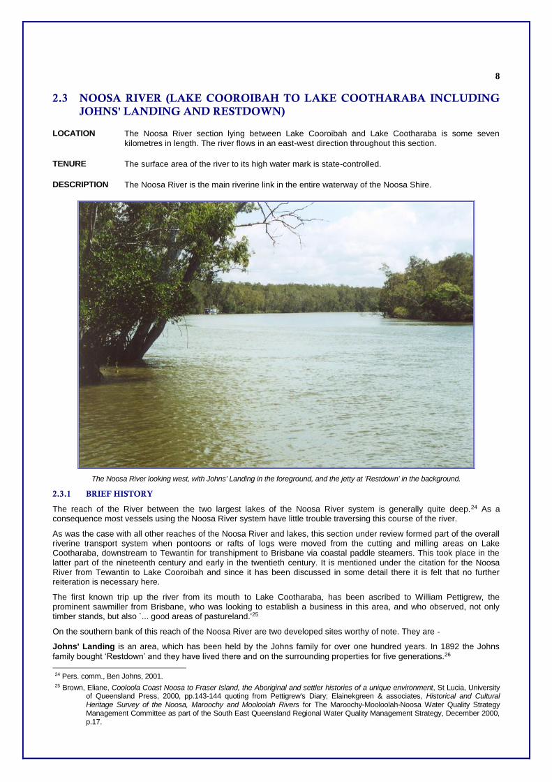
DESCRIPTION The Noosa River is the main riverine link in the entire waterway of the Noosa Shire.
The Noosa River looking west, with Johns' Landing in the foreground, and the jetty at 'Restdown' in the background.
2.3.1 BRIEF HISTORY
The reach of the River between the two largest lakes of the Noosa River system is generally quite deep.24 As a consequence most vessels using the Noosa River system have little trouble traversing this course of the river.
As was the case with all other reaches of the Noosa River and lakes, this section under review formed part of the overall riverine transport system when pontoons or rafts of logs were moved from the cutting and milling areas on Lake Cootharaba, downstream to Tewantin for transhipment to Brisbane via coastal paddle steamers. This took place in the latter part of the nineteenth century and early in the twentieth century. It is mentioned under the citation for the Noosa River from Tewantin to Lake Cooroibah and since it has been discussed in some detail there it is felt that no further reiteration is necessary here.
The first known trip up the river from its mouth to Lake Cootharaba, has been ascribed to William Pettigrew, the prominent sawmiller from Brisbane, who was looking to establish a business in this area, and who observed, not only timber stands, but also `... good areas of pastureland.'25
On the southern bank of this reach of the Noosa River are two developed sites worthy of note. They are -
Johns' Landing is an area, which has been held by the Johns family for over one hundred years. In 1892 the Johns
family bought ‘Restdown’ and they have lived there and on the surrounding properties for five generations.26
24 Pers. comm., Ben Johns, 2001. 25 Brown, Eliane, Cooloola Coast Noosa to Fraser Island, the Aboriginal and settler histories of a unique environment, St Lucia, University
of Queensland Press, 2000, pp.143-144 quoting from Pettigrew's Diary; Elainekgreen & associates, Historical and Cultural Heritage Survey of the Noosa, Maroochy and Mooloolah Rivers for The Maroochy-Mooloolah-Noosa Water Quality Strategy Management Committee as part of the South East Queensland Regional Water Quality Management Strategy, December 2000, p.17.
9
At the present time, is used as a recreational area. Ben Johns and his wife Pat currently run cattle on the property, but camping facilities have been provided on the riverbank where there exist aesthetic surroundings and deep water. However, there is evidence of considerable riverbank erosion at the tourist site. It has been deduced that this erosion has been caused, not by any untoward misuse of the river system by tourists, but merely by overuse of the facility by the entering and exiting of watercraft at the site by a great many people over a number of years.27
Fortunately action has been taken in an experimental manner to remedy the situation by means of a mangrove-replanting programme and results of the experiment will be observed as the years progress.28
“Restdown” has traditions going back to the times of timber rafting in the nineteenth century. In those times, so one commentator claims, it became customary for the rafters to take rest from their labours at Restdown; to check their logs and generally gather their resources together at this place prior to entering the shallows of Lake Cooroibah.
The district developed in the most part under the ownership of the Olds and Johns families who cropped it and grew orchards. In 1895 it was reported that potatoes, and maize were grown and that orchards growing oranges were established.29 In the same year a house had been observed, built some 100 yards back from the river wharf, whilst a member of the Johns family was the resident partner of the Johns and Olds partnership and he purchased two selections, 60 acres and 20 acres from James Smith.30 Orchards flourished both in quality and in diversity with a quite amazing variety of fruit trees, both endemic and exotic, becoming established there, as well as an apiary, flowering trees, shrubs and cacti.31
Perhaps the most interesting industry to originate from Restdown was that of honey production, established by the original selectors, William and Edward Smith, who selected the land in 1871 selling it to the Johns family in 1892. The Smith brothers, successful miners from the Gympie gold days, settled in the area and established the first orchard there, a large one growing citrus trees. In the process, however, they found a swarm of bees and transferred it to a hive.32
From that beginning in 1873, developed a quite extraordinary local industry. By 1876 the brothers exported some six or seven tons of honey and in the following year they began to construct a shed some 100 feet long which contained 240 hives; the whole being surrounded by a banana plantation, two rows wide to supply the hives with shade, and thus coolness.33 In the middle of the shed was a compartment kept free from intrusion by the bees, but into which the hives could be transferred by an elevator from "the lower storey and along a tramway in the upper storey. There the honey drained by gravity from the combs, through strainers, into wooden casks on the floor below" and was processed by means of a centrifugal honey extractor.34 Some of the honey and beeswax production was marketed in Gympie, but most was transported downstream to Tewantin and thence shipped to Brisbane.35
The working of beehives remains active to this time, one of the few human activities to have survived throughout the area since Europeans arrived.36
Today, from the river, Restdown is quickly recognised by the fact that fishing trawlers are tied up at the wharf there, evidence that commercial fishing is still practised in the region.
2.3.2 HISTORICAL THEMES
This place illustrates the following historical themes in Noosa Shire based on the Environmental Protection Agency's Guidelines for Historical & Indigenous Cultural Heritage Management, dated 2001:-
2(c) Developing rural economies - developing extractive industries (timber) logged forest (rafting place and river transport); and
2(e) Developing rural economies - encouraging agricultural expansion mixed farm (orchard, apiary).
2.3.3 POTENTIAL SIGNIFICANCE
The Noosa River, jetties and agriculture established along its shores is an important cultural landscape.
26 Brown, Elaine “Cooloola Coast - Noosa to Fraser Island The Aboriginal and Settler histories of a unique environment”, University of Queensland, St Lucia, 2000, p178. 27 Pers. comm., Ben Johns, 2001. 28 ibid. 29 Gympie Times, 6 Aug. 1895. 30 ibid. 31 ibid. 32 Brown, Elaine, `Nineteenth Century Cooloola A History of Human Contact and Environ-mental Change', M A thesis, University of
Queensland, 1995 p.386. 33 ibid., p.387. 34 ibid., pp.386-7. 35 ibid., p.387. 36 Brown, Elaine, op.cit., pp.177,178.

10
This particular part of the Noosa River has special significance from the viewpoints of its timber background and from the fact that very wide-ranging plantings of flora were undertaken and beekeeping established as a new industry there, particularly at Restdown.
It is recommended that Noosa Council consider assessment criteria a, b, c, d, e, g and h, under the Environmental Protection Agency’s Guidelines for Historical & Indigenous Cultural Heritage Management, dated 2001 as relevant to this place.
2.3.4 INTEGRITY
Generally, the integrity of the overall riverine area and its improvements are very good. The only blemish is in the erosion evident at Johns' Landing, but this problem is being addressed in a very positive and innovative way. The overall impression given of the reach of the river under review then, is one of good management and the retention of sound integrity.

11
2.4 TRONSON'S CANAL
LOCATION Approximately two kilometres downstream from the Noosa River exit of Lake Cootharaba, on the south bank of the river, facing downstream.37
TENURE Freehold. The canal passes through Portions 298, 1700 and 113, Parish of Noosa, County of March.38
DATE 1922 to present39
DESCRIPTION A drainage canal with earth walls and floor. It is unlined and unformed. The canal is wide enough to accommodate a motor boat.40
2.4.1 BRIEF HISTORY
The land on which Tronson's canal is situated was originally selected by one Appleby who later became indebted to the store in Gympie owned by Walter Tronson's father. When Appleby saw no way out of his financial dilemma he offered his farm to the storekeeper as liquidation of the outstanding sum in 1901,41 an offer, which was duly accepted.
When Walter Tronson expressed his interest in becoming a dairy farmer, his parents gave him the property. On it was a small, low three-roomed house, built by Appleby and Tronson used this as the nucleus for his own house. Walter Tronson called his dairy farm "Ringwood" as it was on Ringtail Creek. His daughter, Viva Tronson, subsequently married Cyril Sealy, and her daughter Jan is the current owner of the farm.
37 Dennis Gittoes' Map of the Cooloola Coast, 1996. 38 Map of Parish of Noosa, 1927. 39 Transcript in possession of Mrs Irene Christie. 40 Elaine K. Green & Associates, Historical and Cultural Heritage Survey of the Noosa, Maroochy and Mooloolah Rivers for the maroochy -
Mooloolah - Noosa Water Quality Strategy Management Committee as part of the South East Queensland Regional Water Quality Management Strategy, December 2000, p.51.
41 Transcript in possession of Mrs Irene Christie. The remaining information in this citation has been obtained from Mrs Irene Christie.

12
An innovative instituted by Walter Tronson was the excavation of a canal to carry off surplus water from his farm. The canal runs virtually from south to north for a length of some 700 metres, draining the so-called Sealey's Lagoon. This lagoon forms a swampy area on the farm and affected its potential productivity. The canal as constructed is quite straight, has a width of 6.7 metres (22 feet) and an original depth of 0.9 of a metre. Its overall length is 1.4 kilometres. Walter Tronson began digging the canal from the lagoon to the river in 1922 but then did no further work on it until 1929, at the beginning of the Depression.
It then took him three dry seasons to complete the project as it traversed swampy terrain. He firstly employed a team of bullocks to pull out the melaleuca tree stumps prevalent in the area, and the next season he began work with teams of horses, three to a team, using scoops to construct the drain itself. The project was completed at the beginning of 1932 and it effectively lowers the level of water in the lagoon. This in turn lowers the water from the upper part of the farm thus improving the overall productivity of the land drained.
2.4.2 HISTORICAL THEMES
This place illustrates the following historical themes in Noosa Shire based on the Environmental Protection Agency's Guidelines for Historical & Indigenous Cultural Heritage Management, dated 2001:-
2(e) Developing rural economies - encouraging agricultural expansion farm (drainage canal).
2.4.3 POTENTIAL SIGNIFICANCE
The drain is a rare example of an attempt made to drain swamp land for productive use.
It is recommended that Noosa Council consider assessment criteria a and b under the Environmental Protection Agency's Guidelines for Historical & Indigenous Cultural Heritage Management, dated 2001 as relevant to this place.
2.4.4 INTEGRITY
The drain has withstood many floods since its construction and is still visible. Its entry into the Noosa River is marked by a sign, situated on the western bank of the canal as it enters the river.