coordination of es w.r.t. terrestrial stations and ... · terrestrial stations and notification 1...
TRANSCRIPT

Coordination of ES w.r.t.
terrestrial stations and
Notification
1
ITU Regional Radiocommunication Seminar for the ASIA&PACIFICApia, Samoa19-23 September 2016

Two steps to be followed
CoordinationSubmission of AP4
data to affected ADMsArticle 9
NotificationSubmission of AP4
data to BRArticle 11
2

Coordination of earth stations
• Nos.9.6 : Before notifying to the Bureau or brining into use a frequency assignment of the following cases, an administration shall effect coordination. – No.9.15 : a specific earth station or typical earth station of a non-
geostationary satellite network to which No.9.11A applies in respect of terrestrial station
– No.9.17 : a specific earth station or typical mobile earth station above 100MHz except those under No.9.15 in respect of terrestrial station
– No.9.17A : a specific earth station in respect of other earth stations operating in the opposite direction of transmission or typical mobile earth station in respect of specific earth stations operating in the opposite direction of transmission
– No.9.21 : any station of a service for which the requirement to seek agreement is included in a footnote of the Table of Frequency Allocation
• The coordination between an earth station and terrestrial stations under 9.15 and 9.17 or between earth stations operating in opposite direction of transmission under 9.17A applies only to assignments in bands allocated with equal right
3
Identification of coordination requirement (AP5)
• Identification of administrations with which coordination to be effected– Coordination area of the earth station created using AP7 covers
territories or the earth station located is located within the coordination area
• and concerned frequency assignments – Recorded in MIFR with favourable findings or under 11.41– Included in coordination procedure from the date of dispatch of
coordination data under No.9.29– Terrestrial stations or earth station operating in the opposite direction
of transmission operating or to be operated prior to the date of bringing the earth station assignment into service or within next three years from the date of dispatch of coordination data under No.9.29, whichever is the longer
4
Submission of coordination data
• 9.29 Requests for coordination under 9.15 to 9.19 shall be sent by the requesting administration to the identified administrations, together with the appropriate information listed in Appendix 4 to the Radio Regulations
• SpaceCap software can be used for the capture of information required for coordination requests with the affected Administrations, and the resulting file can be sent to these affected Administrations
• When coordination is completed, the same file can be converted to a notification notice to be submitted to the Bureau
5
Notification of earth stations
• Any frequency assignment to a transmitting station and to its associated receiving stations shall be notified to the Bureau if (No.11.2)– Assignment is capable of causing harmful interference; or– Assignment is used for international radiocommunication; or– Assignment is subject to a world or regional frequency allotment or
assignment plan which does not have its own notification procedure; or
– if that assignment is subject to the coordination procedure of Article 9; or
– It is desired to obtain international recognition; or– Non conforming assignment seeking to be recorded for information
purposes only
• Similar requirements for receiving earth station (No.11.9)
6

Notification of a specific earth station
• Except for mobile earth station, individual notices of frequency assignments are necessary in the following cases (No.11.17):– Earth station whose coordination area includes
the territory of another administration or where the earth station located within the coordination area of an earth station
– Earth station whose interference potential is greater than that of a coordinated typical earth station
7
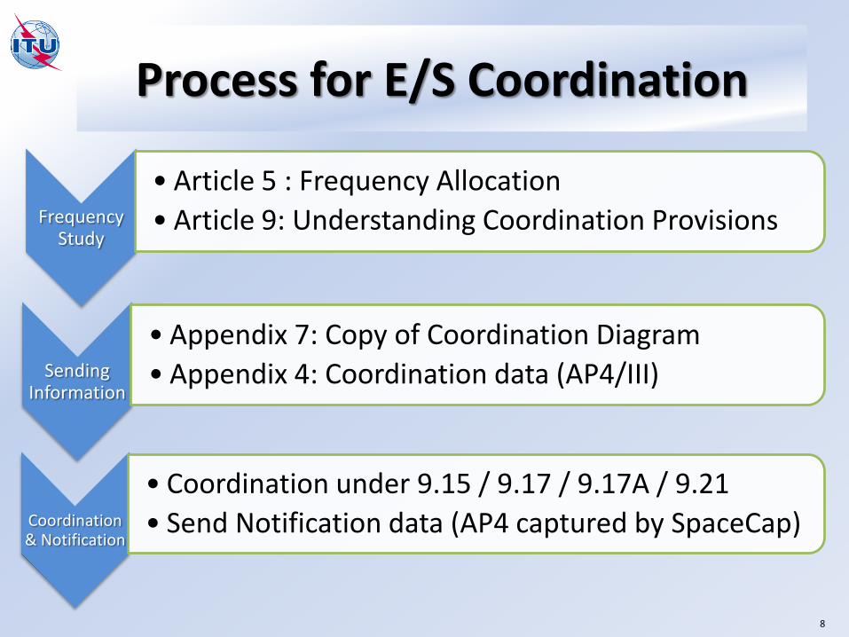
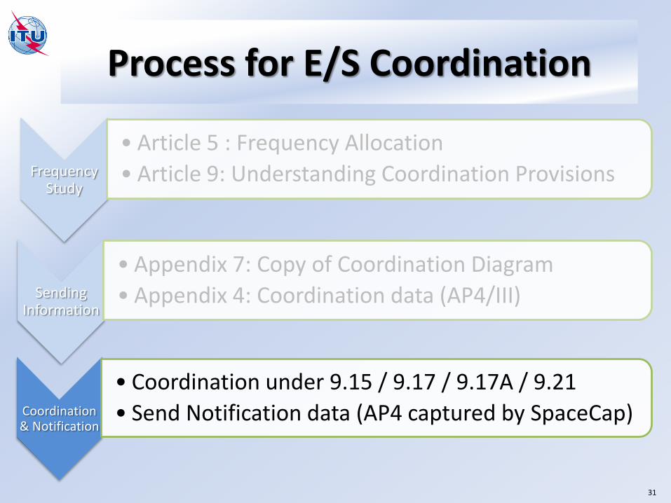
Process for E/S Coordination
Frequency Study
• Article 5 : Frequency Allocation
• Article 9: Understanding Coordination Provisions
Sending Information
• Appendix 7: Copy of Coordination Diagram
• Appendix 4: Coordination data (AP4/III)
Coordination & Notification
• Coordination under 9.15 / 9.17 / 9.17A / 9.21
• Send Notification data (AP4 captured by SpaceCap)
8

Process for E/S Coordination
Frequency Study
• Article 5 : Frequency Allocation
• Article 9: Understanding Coordination Provisions
Sending Information
• Appendix 7: Copy of Coordination Diagram
• Appendix 4: Coordination data (AP4/III)
Coordination & Notification
• Coordination under 9.15 / 9.17 / 9.17A / 9.21
• Send Notification data (AP4 captured by SpaceCap)
9
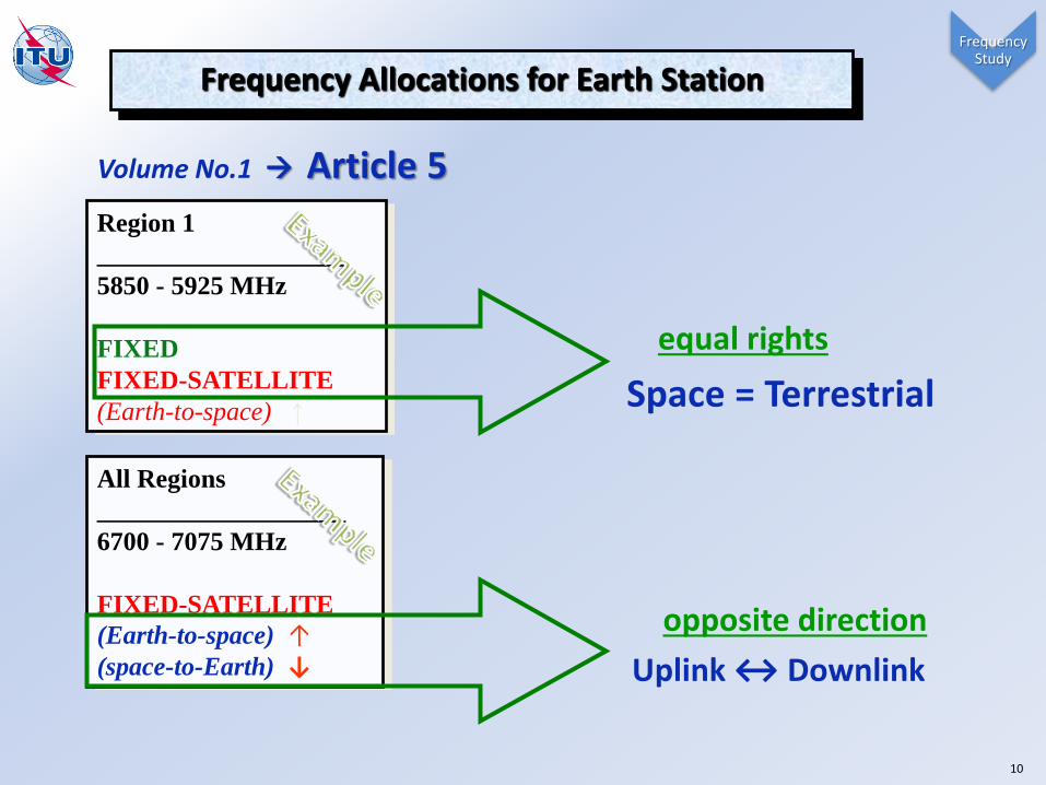
Region 1
___________________
5850 - 5925 MHz
FIXED
FIXED-SATELLITE
(Earth-to-space) ↑
All Regions
___________________
6700 - 7075 MHz
FIXED-SATELLITE
(Earth-to-space) ↑(space-to-Earth) ↓
Volume No.1 Article 5
opposite direction
Uplink ↔ Downlink
equal rights
Space = Terrestrial
Frequency Study
Frequency Allocations for Earth Station
10

Frequency Study
11

9.6
9.15
9.17
9.17A
9.21
Volume No.1 Article 9
9.6Administrations shall effect coordination before notifying to the BR or brings into use any frequency assignment.
Frequency Study
12
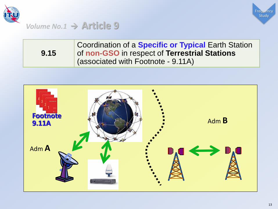
9.15Coordination of a Specific or Typical Earth Station of non-GSO in respect of Terrestrial Stations (associated with Footnote - 9.11A)
Footnote9.11A
Adm A
Adm B
Volume No.1 Article 9
Frequency Study
13

9.17
Coordination of any Specific Earth Station or
Typical Mobile Earth Station in frequency bands
above 100 MHz, in respect of Terrestrial Stations,
with the exception of the coordination under 9.15
Adm A Adm B
Adm A Adm B
Volume No.1 Article 9
Frequency Study
14

9.17A
Coordination of any Specific Earth Station in respect of other Earth Stations operating in the opposite direction of transmission (ODT), or any Typical Mobile Earth Station in respect of Specific Earth Station (ODT) *Rx E/S – No methodology in AP7
Adm A
Adm B
Volume No.1 Article 9
Frequency Study
15

9.21Specific Earth Station of a service required to seek agreement of other administrations (under Footnotes)
Volume No.1 Article 9
Space Service under No. 9.21 agreement(ex: footnote 5.461 – MSS)
“rare case for Earth Station”
Frequency Study
16

Frequency Study
GSO Satellites
Terrestrial
Transmitting
Earth Station
Receiving
Earth Station
Non-GSO
SatellitesInterference
9.17A
9.15/9.17 9.15/9.17
Coordination of Earth Station is ADM’s duty and responsibility.

Process for E/S Coordination
Frequency Study
• Article 5 : Frequency Allocation
• Article 9: Understanding Coordination Provisions
Sending Information
• Appendix 4: Coordination data (AP4/III)
• Appendix 7: Copy of Coordination Diagram
Coordination & Notification
• Coordination under 9.15 / 9.17 / 9.17A / 9.21
• Send Notification data (AP4 captured by SpaceCap)
18
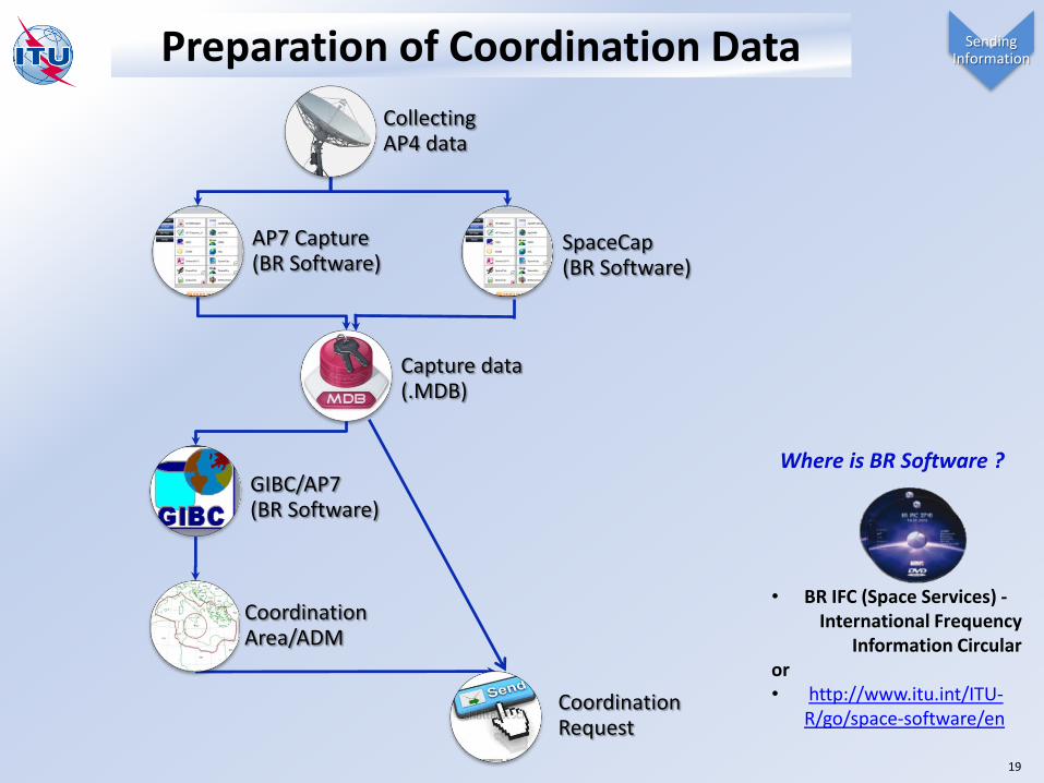
Preparation of Coordination Data
Collecting AP4 data
AP7 Capture (BR Software)
Capture data (.MDB)
GIBC/AP7(BR Software)
Coordination Area/ADM
Coordination Request
SpaceCap(BR Software)
• BR IFC (Space Services) -International Frequency
Information Circularor • http://www.itu.int/ITU-
R/go/space-software/en
Where is BR Software ?
Sending Information
19

Coordination data
Annex 2
GEOGRAPHICAL DATALongitude / Latitude
Altitude
SATELLITEOrbital Location,
Identification (Geo, Non-Geo)
ANTENNAMaximum gain
Radiation pattern
SIGNAL
CHARACTERISTICS
Power
Maximum Power Density
Frequencies
Noise temperature
Emission Type
Others Horizontal Elevation Angle
Volume No.2 Appendix 4
Sending Information
20

*
Option 1: AP4 data - AP7 Capture (Exercise Purpose)
*
* The associated Space Station should be notified and the beam should be matched.
Sending Information
21
22
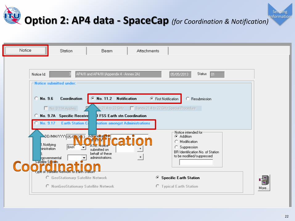
Option 2: AP4 data - SpaceCap (for Coordination & Notification)
Sending Information
22

Attention: Check Associated Satellite:• satellite network: INTELSAT8 304.5E (not Commercial name)
• Check Service area as follows in GIMS• Check Beam name & direction correctly at the point of Earth Station
↑ Up link (↔ Downlink for ↓ ES) beam: HL ↓ Down link SS (↔ Uplink for ↑ ES)beam: HL

AP7 embedded in GIBC (from BR IFIC DVD)
Computer Program forDetermination of Coordination Area
Magic button for Coordination?
C:\BR_SOFT\BATCH
Create your Input File
Sending Information
24

Diffraction(local)
Tropospheric scatter (>100km)
Ducting (>500km)
Elevated layerreflection/refraction(h < x 100m)
Great-circle propagation(Mode 1) – 4 Radio-Clim. zone
Hydrometeor scatter(Mode 2) – 15 Rain zone A-Q+
Anomalous (short-term) Interference Propagation mechanisms
Common Volumeat the intersection of the antenna main beams
Hydrometeor scatter
Volume No.2 Appendix 7 Sending Information
25

,Great-circle propagation
(Mode 1)
Hydrometeor scatter(Mode 2) )Max (
Maximum Calculation Distance (369/ Mode2 up to 1200 Km/ Mode1*Zone C)
(Mode2)
Pt*Ge
Hydrometeor scatter
(Mode1)L(%)=Pt+Ge+Gx
Gx, Pr(%) from Tables of AP7
(10 to 123 Km/f) Minimum Coordination Distance
L(%)=Pt+GxGx, Pr(%) from Tables of AP7
convert to
- Pr(%)
- Pr(%)
GX
26
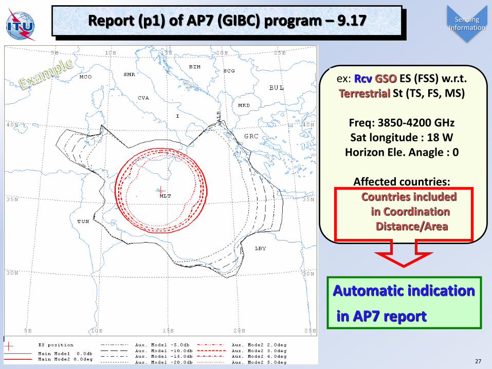
Report (p1) of AP7 (GIBC) program – 9.17
Automatic indication
in AP7 report
ex: Rcv GSO ES (FSS) w.r.t.Terrestrial St (TS, FS, MS)
Freq: 3850-4200 GHzSat longitude : 18 W
Horizon Ele. Anagle : 0
Affected countries:Countries included
in Coordination Distance/Area
Sending Information
27

SUI
SMR
MCO
LUX
LIE
I
F
D
AND
10E 5E 0
10E 5E 0
50N
45N
50N
45N
Tracking Antenna reduce the probability of Mode2.
No Mode2 contours
Earth station (NGSO)
Main Mode 1
Aux. Mode 1
Sending Information
Coordination area of 9.17A (Opposite direction)ex: Tx NGSO ES (FSS) with respect to Rcv GSO ES (EESS)

KRE
KOR
130E125E
130E125E
40N40N
KRE
KOR
J
135E130E125E120E
130E125E120E
40N
35N
40N
35N
Specific, 100Km Specific, 580Km
KRE
KOR
J
130E125E
130E125E
40N
35N
40N
35N
KRE
KOR
J
135E130E125E120E
135E130E125E120E
40N
35N
30N
40N
35N
30N
KRE
KOR
J
CHN
140E135E130E125E120E115E
135E130E125E120E
40N
35N
30N
40N
35N
30N
MAC
KRE
KORJ
HKG
CHN
150E145E140E135E130E125E120E115E110E105E
140E135E130E125E120E115E
45N
40N
35N
30N
25N
45N
40N
35N
30N
25N
Typical, 100Km Typical, 400Km Typical, 500Km Typical, 580Km
MAC
KRE
KORJ
HKG
CHN
150E145E140E135E130E125E120E115E110E105E
140E135E130E125E120E115E
45N
40N
35N
30N
25N
20N
45N
40N
35N
30N
25N
20N
Typical, 1080KmTypical, 1000Km
KRE
KOR
J
CHN
140E135E130E125E120E115E
135E130E125E120E
45N
40N
35N
30N
45N
40N
35N
30N
Predetermined Coordination distance(Table 10 of Appendix 7)
Predetermined AP7 Table 10 (Example Adm: KOR)
Sending Information
29

Calculated parameters by 5° Azimuth
Coordination distance by 5° Azimuth
Tech. parameters of the planning E/S
Report (p2) of AP7 (GIBC) program
( 0 - 355º )
• To: Probably Affected ADMs (9.29/31)• Send AP4/III Coord. Data• Send Copy of Cood. Contour
Sending Information
30
Process for E/S Coordination
Frequency Study
• Article 5 : Frequency Allocation
• Article 9: Understanding Coordination Provisions
Sending Information
• Appendix 7: Copy of Coordination Diagram
• Appendix 4: Coordination data (AP4/III)
Coordination & Notification
• Coordination under 9.15 / 9.17 / 9.17A / 9.21
• Send Notification data (AP4 captured by SpaceCap)
31

0
45
90
135180
225
270
315
ALB
MKD
GRC
SUI
D
AUT
HNGF
E
ALG
TUN
LBY
EGY
ROU
BUL
TUR
I
YUG
SVN
HRV
BIH
SVK
MLT
APPENDIX 7
Definition of the Coordination Area
Mode(1)
Mode(2)
Coordination contours with the greatest coordination distance
It represents a regulatory conceptbased on Worst Cases &
Conservative Assumptions.
However
i.e.
It’s not an exclusion zone.
means
More detailed calculations anddiscussions need to be performed.
Coordination & Notification
32

Earth station
Horizon ElevationAngle
.Azimuth x o
.Azimuth x1 o
HE Angle 1
.Azimuth x2 o
HE Angle 2
Azimuth x 3o
.
HE Angle 3
.Azimuth x4 o
HE Angle 4
Azimuth x5 o
HE Angle 5
Horizontal Elevation Angles • All Azimuths around Earth Station Ant.• if no values between Average value• No values default 0 degree
Coordination & Notification
33

RECEIVING EARTH STATION COORDINATION AREASMAGHTAB MLT/MLT 014E2640 35N5556 4135.0 - 4135.0 MHZ
ALB
MKD
GRC
SUI
D
AUT
HNGF
E
ALG
TUN
LBY
EGY
ROU
BUL
TUR
I
YUG
SVN
HRV
BIH
SVK
MLT
ALG
LBY
TUN
E
F
I
ROU
TUR
EGY
D
SUI
AUTHNG
BUL
GRC
YUGBIH
ALB
MKD
SVN
HRV
MDASVK UKR
MLT
Effect of Horizon Elevation Angle
HORIZON ELEVATION ANGLE : 0 o HORIZON ELEVATION ANGLE: Actual Value
Reduced
Coordination Area
Coordination & Notification
34

AP7 embedded in GIBC
Auxiliary Contour
It’s all
Complementary information.
Extra coordination lines inside main contour
More practical consideration with Auxiliary Contour Coordination & Notification
35
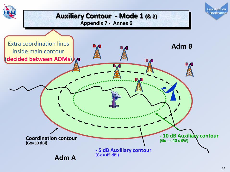
Adm B
Coordination contour (Gx=50 dBi)
- 5 dB Auxiliary contour(Gx = 45 dBi)
- 10 dB Auxiliary contour(Gx = - 40 dBW)
Auxiliary Contour - Mode 1 (& 2)Appendix 7 - Annex 6
Extra coordination lines inside main contour
(decided between ADMs)
Adm A
Coordination & Notification
36

Ad
min
istratio
nB
Actions on Coordination Request (Article 9)
Ad
min
istratio
nA
A Coordination Req. (9.29/9.31)
Ack. of receipt (9.45)
4Months
Notify Adm B’s system (9.52, 11.2/11.9)
if Disagreement (9.51A/9.52)• Adm B’s assignment **
• Suggestion for resolution
Technical Exam (9.50)• Collect existing/planning system• Inside Coordination Contours
Req. additional Info (9.54)
Notify Adm B’s system (9.52B, 11.2/11.9)
if Agreement (9.51A)
Assistance Req. - No reply/decision from Adm B (9.33/9.46/9.60)
ITU
Send Notification (11.2)
Coordination & Notification

3 Things (Planning Adm A)on Coordination of Earth Station
1. Define Affected ADM (AP7)
38
2. Send Request (AP4 & AP7)
3. Coordinate (with mutual cooperation)

3 Things (Requested Adm B)on Coordination of Earth Station
39
1. Acknowledge the reception
2. Coordinate (with mutual cooperation)
3. Give an early decision

Submission of typical earth stations in the fixed-satellite service
• The issue of notification of Typical earth station in the FSS was raised in the Director report to WRC-15
• WRC-15 concluded that further ITU-R studies are needed
• For these studies WRC-15 agreed to instruct the Bureau to publish a Circular letter containing a common format according to which administrations may wish to submit to the Bureau, on a voluntary basis, characteristics and number of typical earth stations deployed in their countries for information purposes only (minutes of 8th plenary)
• The Bureau has provided administrations with a web-based platform for the submission and posting of these typical FSS earth stations (CR/404)
40

Characteristics of Typical Earth Stations in Fixed Satellite Service
https://www.itu.int/net4/ITU-R/space/TypicalESinFSS

Question?
Answer
WRS
42