coordinated needs management strategy (cnms) … · coordinated needs management strategy (cnms)...
TRANSCRIPT

Coordinated Needs Management Strategy
(CNMS) Technical Reference
Database User‟s Guide Version 5.3
May 2013
This Document is Superseded. For Reference Only.

Guidelines and Standards for Flood Risk Analysis and Mapping Page 2 CNMS Technical Reference
CNMS Technical Reference
Document History Supporting Documents
Location
File Path: FEMA Risk MAP sharepoint site – http://pm.riskmapcds.com/riskmap_usergroups/CNMS/Shared%20Documents/Forms/AllItems.aspx
CNMS Team\CNMS_Package\
- CNMS_User'sGuide_v5_3_20130516.doc
- CNMS_FGDB_TEMPLATE_v5_1_20120508.xml
- CNMS_Procedure_Memo_Final_PM56.pdf
- CNMS_NVUE_Attained_Initiated_National_Table
o Updated Quarterly
Revision History
Version Number Version Date Summary of Changes Team/Author
1.0 April 2008 CNMS Team
2.0 April 29,2008 Update of Data Model and Data Dictionary CNMS Team
2.1 April 30, 2008 Update to Section 3 FEMA
2.2 May, 2008 General text editing, Data Model Diagram replacement, Data Dictionary editing
CNMS Team
2.3 November 2008 Restructuring and completion of document framework
CNMS Team
2.4 January 2009 Major review and edit based upon internal development team review
CNMS Team
2.5 January 2009 Addition of content from the State of Alabama CNMS Team
2.6 February 2009 Comments from review by FEMA HQ Beth Norton
2.7 March 2009 Addition of data expected, potential source, and anticipated use rows for each attribute in every table
Michael Bishop
2.8 July 2009 Added new database updates & revise based upon input from stakeholder review
CNMS Team
3.0 March 2010 Added material related to CNMS Inventory and updated Data Model
CNMS Team
3.0 April 2010 Address of E&M IPT Comments CNMS Team
3.1 May 2010 Address of E&M IPT Comments for final delivery Mohan Rajasekar
4.0 August 2010 Address of NVUE and PM guidance updates CNMS Team
4.1 September 2010 Address of NVUE and PM guidance updates Mohan Rajasekar
4.2 October 2010 Address of NVUE and PM guidance updates Mohan Rajasekar
5.0 August 2011 Address of NVUE and PM guidance updates; Domain table updates, Data Model changes
CNMS Team
5.3 May 2013
Overhaul of Section 2 and 3 including updates corresponding to May 2012 Schema Changes. Description of FBS tracking fields.
CNMS Team
5.3 May 2013 Converted CNMS User’s Guide to CNMS Technical Reference
RAMPP
This Document is Superseded. For Reference Only.

Guidelines and Standards for Flood Risk Analysis and Mapping Page 3 CNMS Technical Reference
CNMS Technical Reference
Client Distribution
Name Title/Organization Location
Dahlia Kasperski
Rick Sacbibit
Paul Rooney
FEMA Crystal City, VA
Table of Contents
1. INTRODUCTION ............................................................................................................................................ 11
2. CNMS DATA DEVELOPMENT .................................................................................................................... 13
2.1. WORKFLOW AND PROCESS ......................................................................................................................... 13 2.1.1. Discovery and Scoping Phase Updates ............................................................................................. 14 2.1.2. FIRM Production Phase Update ....................................................................................................... 15 2.1.3. Preliminary Issuance Phase Update ................................................................................................. 16 2.1.4. LFD Issuance Phase Update ............................................................................................................. 16 2.1.5. LOMA (MT-1) & LOMR (MT-2) Integration Workflow .................................................................... 17 2.1.6. Validation Checklist .......................................................................................................................... 17 2.1.7. NVUE Metrics Calculation and Reporting ........................................................................................ 17 2.1.8. CNMS Requests ................................................................................................................................. 18
2.2. DATA INPUT ................................................................................................................................................ 18 2.2.1. CNMS Data model ............................................................................................................................. 18 2.2.2. Flood Insurance Study (FIS) Report ................................................................................................. 19 2.2.3. LOMRs .............................................................................................................................................. 19 2.2.4. FEMA Library ................................................................................................................................... 19 2.2.5. FIRM Data and Linework Sources .................................................................................................... 20
2.3. DOCUMENTATION ....................................................................................................................................... 20 2.4. DATA OUTPUT ............................................................................................................................................ 20 2.5. QUALITY ..................................................................................................................................................... 21
3. DATA ENTRY PROCESS ............................................................................................................................... 23
3.1. PRIMARY KEY CONSIDERATIONS ................................................................................................................ 23 3.2. S_STUDIES_LN FEATURE CLASS (POLYLINE) ............................................................................................. 24
3.2.1. S_Studies_Ln Discovery and Scoping Phase Updates ...................................................................... 34 3.2.2. S_Studies_Ln FIRM Production Phase Update ................................................................................ 35 3.2.3. S_Studies_Ln Preliminary Issuance Phase Update ........................................................................... 35 3.2.4. S_Studies_Ln LFD Issuance Phase Update ...................................................................................... 36
3.3. „S_STUDIES_AR‟ FEATURE CLASS (POLYGON) .......................................................................................... 37 3.4. „S_REQUESTS‟ FEATURE CLASSES (POINT/POLYGON) ................................................................................ 38 3.5. S_UNMAPPED_LN (POLYLINE) ................................................................................................................... 40 3.6. SPECIFIC_NEEDS_INFO (TABLE) ................................................................................................................. 41 3.7. COUNTY_STATUS (TABLE) ......................................................................................................................... 43
3.7.1. County_Status Discovery and Scoping Phase Updates ..................................................................... 45 3.7.2. County_Status FIRM Production Phase Update ............................................................................... 45 3.7.3. County_Status Preliminary Issuance Phase Update ......................................................................... 45 3.7.4. County_Status LFD Issuance Phase Update ..................................................................................... 45
3.8. POINT_OF_CONTACT (TABLE) .................................................................................................................... 46
APPENDIX A. VALIDATION CHECKLIST .................................................................................................... 49
APPENDIX B. VALIDATION PROCESS DOCUMENTATION .................................................................... 54
APPENDIX C. CNMS DATA MODEL .............................................................................................................. 55
This Document is Superseded. For Reference Only.

Guidelines and Standards for Flood Risk Analysis and Mapping Page 4 CNMS Technical Reference
CNMS Technical Reference
APPENDIX D. CNMS DATA DICTIONARY ................................................................................................... 56
APPENDIX E. CNMS LIFECYCLE FLOW DIAGRAM ................................................................................. 82
APPENDIX F. NVUE REPORTING GUIDANCE............................................................................................ 83
F.1. Introduction ................................................................................................................................................. 83 F.2. Understanding the Data Attributes Necessary for NVUE calculations ....................................................... 84 F.3. NVUE CALCULATION ............................................................................................................................... 86
APPENDIX G. LOMA (MT-1) & LOMR (MT-2) INTEGRATION IN CNMS .............................................. 87
G.1. Identifying Mapping Needs/Requests Because of LOMC Processing ......................................................... 87 G.2. Updating the CNMS Inventory for Approved LOMRs ................................................................................ 87
APPENDIX H. CNMS QUALITY MANAGEMENT PLAN (QMP)................................................................ 89
H.1. Introduction ................................................................................................................................................. 89 H.2. Workflow and User Interface ...................................................................................................................... 89 H.3. Quality Control Criteria ............................................................................................................................. 91 H.4. User’s Guide: CNMS FGDB QC Tool – Beta Version ............................................................................... 96
List of Figures
Figure 2.1.1: CNMS Update Touchpoints ............................................................................................................... 13 Figure 2.1.2: CNMS Update Touchpoints ............................................................................................................... 14 Figure 2.2.1.1 CNMS FGDB Components ................................................................................................................ 19 Figure 2.2.1.1: CNMS FGDB Components as seen in ESRI ArcCatalog ................................................................ 229 Figure 3.1. CNMS Record Entry Determination ................................................................................................. 22
List of Tables Table 3.2.1 'S_Studies_Ln' .......................................................................................................................................... 25
Table 3.4.1 'S_Requests_Ar/Pt' (Polygon/Point) ......................................................................................................... 38
Table 3.5.1. 'S_Unmapped_Ln' .................................................................................................................................... 40
Table 3.6.1. ' Specific_Needs_Info' ............................................................................................................................. 41
Table 3.7.1. 'County_Status' ........................................................................................................................................ 43
Table 3.8.1. 'Point_of_Contact' .................................................................................................................................... 46
This Document is Superseded. For Reference Only.
Guidelines and Standards for Flood Risk Analysis and Mapping Page 5 CNMS Technical Reference
CNMS Technical Reference
List of Acronyms
BFE Base Flood Elevation
CE Critical Element (reference the NVUE check list)
CNMS Coordinated Needs Management Strategy
CTP FEMA Cooperating Technical Partners
ESRI Environmental Systems Research Institute
FEMA Federal Emergency Management Agency
FGDB ESRI file geodatabase
FIPS Federal Information Processing Standard
FIRM Flood Insurance Rate Map
FIS Flood Insurance Study
FY Fiscal Year
GIS Geographic Information System
LFD Letter of Final Determination
LOMR Letter of Map Revision
MAS Mapping Activity Statement
MIP Mapping Information Platform
MSC Map Service Center
NAIP National Agricultural Imagery Program
NFIP National Flood Insurance Program
NHD National Hydrography Dataset
NVUE New, Validated, or Updated Engineering
RSC Regional Service Center
This Document is Superseded. For Reference Only.

Guidelines and Standards for Flood Risk Analysis and Mapping Page 6 CNMS Technical Reference
CNMS Technical Reference
SE Secondary Element (reference the NVUE check list)
SFHA Special Flood Hazard Area
USGS United States Geologic Survey
This Document is Superseded. For Reference Only.

Guidelines and Standards for Flood Risk Analysis and Mapping Page 7 CNMS Technical Reference
CNMS Technical Reference
Alphabetical List of Definitions
ASSESSED Validation Status An ASSESSED Validation Status is assigned to flooding
source centerlines in unmapped areas considered for a new
study. This status is used for: allocation of resources for a
new study in the current or a future fiscal year; or a
deferment of the new study request. Streams not part of
FEMA‟s SFHA inventory (e.g., zone X, zone D, or Area
Not Included), that have been, or are being considered for
a new study, would fall under this category.
Bathymetry The study of underwater depth.
CNMS The Coordinated Needs Management Strategy (CNMS) is
comprised of processes and data for tracking: New,
Validated, Updated Engineering (NVUE); unverified
study reaches with identified change characteristics; and
requests for the flood mapping program.
CNMS Database The CNMS database is stored in an ESRI FGDB format.
Version 5.3 is comprised of the following tables: Studies
Inventory (S_Studies_Ln), Requests (S_Requests_Pt and
S_Requests_Ar), County Status Table (County_Status),
and unmapped streams not in FEMA‟s SFHA inventory
(S_Unmapped_Ln). The inclusion of LOMR and coastal
study footprint data are likely to necessitate additional
tables.
CNMS Inventory The CNMS Inventory includes flooding source centerlines
representing FEMA‟s modernized inventory of FIRMs; its
unmodernized inventory of FIRMs; and unmapped areas.
The centerlines enable calculation of NVUE. The feature
classes associated with the CNMS Inventory are
S_Studies_Ln and S_Unmapped_Ln. The CNMS FGDB
Version 5.3 does not include the coastal portion of
FEMA‟s SFHA inventory.
CNMS Request Record A CNMS Request Record represents either a flood data or
cartographic mapping need. Flood data requests may
address: the lack of an existing floodplain model; areas
that remain unstudied; or SFHAs with approximate
designations for which models are not available. The
feature classes associated with CNMS Request Records
are S_Requests_Ar and S_Requests_Pt.
This Document is Superseded. For Reference Only.

Guidelines and Standards for Flood Risk Analysis and Mapping Page 8 CNMS Technical Reference
CNMS Technical Reference
CNMS Study Record A CNMS Study Record represents the most current
knowledge of a mapped SFHA in FEMA‟s inventory, or a
stream considered for inclusion in FEMA‟s SFHA
inventory. The CNMS database feature class for CNMS
Study Records is S_Studies_Ln.
CNMS Validation Checklist The Validation Checklist (Appendix A and B) outlines a
suggested format for documenting a Validation Status
assignment decision that categorizes flood studies as
VALID or UNVERIFIED. The Validation Checklist is
used as the basis for data entry while populating CNMS
study records.
Critical Element One of seven elements documenting Physiological,
Climatological and Engineering methodology (PCE)
changes reviewed during the engineering study validation
process. Individually, if any Critical Element is evaluated
to a YES as a result of the identification of a deficiency, it
is significant enough to trigger an UNVERIFIED
Validation Status.
Raster Data Data that are arranged in a continuous grid typically
associated with imagery or terrain data.
Reach The geographic extent, or upstream and downstream
limits, defined by a CNMS Study Record.
Secondary Element Ten additional elements, secondary to the Critical
Elements, which document PCE changes reviewed during
the engineering study validation process. These elements,
if evaluated to „YES‟ as a result of identification of
deficiencies, and totaling four or more secondary element
deficiencies, are significant enough to trigger an
UNVERIFIED validation status. A secondary deficiency
is considered less impactful than a critical deficiency.
Stream Centerline A geometric approximation of a flooding source
centerline. Stream centerlines in the CNMS Inventory
represent studies in FEMA‟s mapped SFHA inventory, or
flooding sources considered for inclusion in FEMA‟s
SFHA inventory.
Status Type Status Type records the actions being taken, or that will be
taken, once the Validation Status is determined for a study
during update and maintenance cycles of the CNMS
This Document is Superseded. For Reference Only.

Guidelines and Standards for Flood Risk Analysis and Mapping Page 9 CNMS Technical Reference
CNMS Technical Reference
Inventory. Status types are useful in understanding and
tracking map update investment decisions.
Study A study represents a contiguous extent of FEMA‟s
investment to perform an engineering-based evaluation of
potential impacts of a flooding source. A single study in
CNMS may be represented by one or more stream reaches.
UNKNOWN Validation Status An UNKNOWN Validation Status is assigned to existing
detailed and approximate flood hazard studies for which a
CNMS evaluation is planned and in queue; currently being
assessed under CNMS; or when CNMS evaluation is
deferred. An UNKNOWN Validation status is also
assigned to those studies for which inaccessibility of
information results in an incomplete evaluation of the 17
CNMS elements. In such cases, the UNKNOWN
Validation Status may only be assigned after due diligence
research has been performed.
Unmapped Streams Flooding sources that have not been included in the
FEMA inventory of studied streams in the CNMS Study
Records.
UNVERIFIED Validation Status An UNVERIFIED study has not passed the Critical and
Secondary Element checks part of the Validation
Checklist and may either be assigned resources for restudy
in a future fiscal year or is currently being restudied.
Validation Status Validation Status characterizes the engineering and
mapping data used in FEMA‟s FIRMs evaluated against
the specifications provided in this document. This
evaluation could result in a Validation Status of VALID
(targeted condition), UNVERIFIED (requires map update
investment), or UNKNOWN (needs further investigation).
It is assigned for each CNMS Study Record.
VALID Validation Status All VALID studies are considered NVUE compliant, and
contribute to the NVUE Attained metric calculation. A
VALID Validation Status is assigned to CNMS study
records based on the standards provided in this document.
Vector Data Typical forms of GIS vector data which include polygons,
points, and polylines. Vector data are composed of
vertices with relative or geospatially referenced
coordinates sometimes containing vertical measurements.
This Document is Superseded. For Reference Only.

Guidelines and Standards for Flood Risk Analysis and Mapping Page 10 CNMS Technical Reference
CNMS Technical Reference
Executive Summary Under Title 42 of the Code of Federal Regulations, Chapter III, Section 4101(e), the Federal Emergency
Management Agency (FEMA) is to revise and update all floodplain areas and flood risk zones identified,
delineated, or established, based on an analysis of all natural hazards affecting flood risks on a five-year
cycle. Revisions to floodplain risk zones are dependent upon the identification of instances where
information on Flood Insurance Rate Maps (FIRMs) does not reflect current risks in flood-prone areas.
The Coordinated Needs Management Strategy (CNMS) is a FEMA initiative to update the way FEMA
organizes, stores, and analyzes flood hazard mapping needs information for communities. CNMS defines
an approach and structure for the identification and management of flood hazard mapping needs that will
provide support to data-driven planning and the flood map update investment process in a geospatial
environment. CNMS tracks the lifecycle of needs, specifying opportunities to capture needs and proposing
methods for their evaluation to inform planning, tracking, and reporting processes. CNMS establishes a
geospatially enabled effective means for users to enter, monitor, and update their inventory of floodplain
studies. In addition, CNMS will be used to document the areas across the Nation where flood studies meet
FEMA‟s current validity standards and, until otherwise noted, do not need to be updated on the FIRM.
Validity of flood hazard studies is determined by identifying study attributes and change characteristics as
specified in the Validation Checklist (Appendix A). These changes are evaluated for seven critical
elements and ten secondary elements. One or more critical or four or more secondary documented changes
will classify a flood hazard study as having an UNVERIFIED Validation Status. An UNVERIFIED
Validation Status indicates studies for which resources for restudy have been assigned in the current fiscal
year (FY) or will be assigned in a future FY, or those that are currently being restudied.
Apart from documenting basic study attributes, critical and secondary elements are evaluated for detailed
flood hazard studies and this information including study validity is captured within CNMS Study
Records. The CNMS Study Records should also include Validation Status of approximate studies, and
those unmapped areas that have been considered for a new study, making it a stream centerline
representation of FEMA‟s existing, ongoing, and planned studies.
FEMA will utilize the CNMS Study Records as the sole mechanism for reporting New, Validated, or
Updated Engineering (NVUE) percentage. The NVUE percentage metric helps identify the portion of
FEMA‟s inventory of studies that do not have identified needs that would warrant a re-study. Appendix F
provides more information for NVUE calculation.
This CNMS Technical Reference document is to be used by local, state, regional and national users for
development, management, tracking, and reporting of data related to suggested improvements and validity
of flood hazard data nationwide.
This Document is Superseded. For Reference Only.

Guidelines and Standards for Flood Risk Analysis and Mapping Page 11 CNMS Technical Reference
CNMS Technical Reference
1. Introduction
Flood Insurance Rate Maps are FEMA‟s most widely distributed flood hazard identification product.
Flood hazard data presented on FIRMs are based on historic, meteorological, hydrologic, and hydraulic
data, as well as open-space and land cover conditions, flood control works, and development. Due to the
changing nature of the landscape from the influences of physical, engineering, and climatological
processes, timely updates to Special Flood Hazard Area information on FIRMs become necessary to
maintain accuracy and relevance. For successful maintenance of flood hazard information across the
Nation, one must effectively identify and manage flood hazard mapping requirements expressed by
individuals at the local, state, regional, and national levels.
FEMA‟s Coordinated Needs Management Strategy is a collection of procedures for the identification and
management of flood hazard mapping requirements utilizing a standard database model. In addition to
recording and validating studies, CNMS defines an approach for the identification and management of
flood hazard mapping needs and requirements that will provide support to data-driven planning and the
flood hazard information production planning process. By utilizing and maintaining Geographic
Information System and relational database technologies, CNMS has been designed to track the study
attributes of the current state of FEMA‟s study inventory and the lifecycle of studies from origination of a
CNMS Study Record as an identified need or a CNMS Request Record to its resolution as a new, valid, or
updated study. As such, CNMS allows tracking and management of existing, ongoing, and planned
studies. GIS technology adds the capability of spatial analysis allowing communities and FEMA an
effective means to visualize, enter, review, and update its study attributes and to visualize how studies
relate spatially to other features. The terms and use of CNMS as it relates to other FEMA initiatives will
be dictated and directed by FEMA policy.
This document details the FEMA CNMS data model, providing an overview of its purpose and structure.
Definitions, examples of all database fields, and population guidelines are included to ensure the database
can be populated correctly and accurately, as well as used properly for analysis after it is compiled. The
Validation Checklist (Appendix A) is designed to guide the assessment of the validity FEMA‟s study
inventory.
In order to consolidate the data reporting process, a CNMS database has been created to take advantage of
spatial data inventory tools and procedures. By standardizing, centralizing, and storing CNMS data in a
geospatial format, FEMA will improve analysis and reporting by maintaining data that are current, readily
available, and reliable.
A complete CNMS Study Record holds the validation evaluation results. There is potential for an
extensive investigative effort to determine appropriate attribute values for a record. Users of CNMS must
develop a plan and implement the plan for capturing background information used in the validation and
subsequent attribute determination processes. Appendix B outlines the need for capturing this background
information and also suggests ways to provide a summary of this information to FEMA. Delivery of these
summaries to FEMA for all flood hazard studies evaluated is required as part of quarterly National CNMS
data consolidation efforts.
This Document is Superseded. For Reference Only.

Guidelines and Standards for Flood Risk Analysis and Mapping Page 12 CNMS Technical Reference
CNMS Technical Reference
A calculation and reporting mechanism for the New, Validated, or Updated Engineering metric is
provided in Appendix F. FEMA will utilize the CNMS study records as the basis for reporting NVUE
metrics. Appendix G provides procedures to update CNMS resulting from CLOMRs, LOMRs and the
LOMA process. Appendix H provides the CNMS Quality Management Plan currently recommended for
all CNMS development teams and includes step-by-step instructions for using the CNMS FGDB QC
Tool.
This Document is Superseded. For Reference Only.

Guidelines and Standards for Flood Risk Analysis and Mapping Page 13 CNMS Technical Reference
CNMS Technical Reference
2. CNMS Data Development This section identifies the key CNMS data development milestones and the steps needed to populate the
CNMS File geodatabases (FGDBs) appropriately at each milestone. Section 2.1 describes the workflow
and process to create and update the CNMS FGDB for each milestone. Section 2.2 describes the data
required to make updates to the CNMS FGDBs. Section 2.3 identifies additional documentation for
maintenance of the CNMS FGDBs. Section 2.4 identifies the data that may be created from the CNMS
FGDBs. Section 2.5 provides the QA/QC procedures for updating and maintaining CNMS FGDBs.
2.1. Workflow and Process
Figure 2.1.1 and 2.1.2, and Sections 2.1.1 – 2.1.8 detail workflows and processes that warrant an update
of the Regional CNMS FGDBs. The CNMS Data is organized by FEMA Regions and most ongoing
updates and maintenance is conducted at a Regional level by utilizing the Regional CNMS FGDBs.
Figure 2.1.1 : CNMS Update Touchpoints
This Document is Superseded. For Reference Only.

Guidelines and Standards for Flood Risk Analysis and Mapping Page 14 CNMS Technical Reference
CNMS Technical Reference
Figure 2.1.2: CNMS Update Touchpoints
2.1.1. Discovery and Scoping Phase Updates
Upon initiation of the Discovery phase for a new project, the RSC will export the project area from the
Regional CNMS FGDB, and present it to the responsible Mapping Partner for initial review. The Mapping
Partner will then provide input regarding the current status of the SFHA inventory for their area of
This Document is Superseded. For Reference Only.

Guidelines and Standards for Flood Risk Analysis and Mapping Page 15 CNMS Technical Reference
CNMS Technical Reference
interest, which will be used to update the CNMS Inventory. They will also compile and review existing
CNMS Request Records. Once this initial review is complete, the Mapping Partner will use the CNMS
FGDB as a resource and repository for Discovery activities, including collection of new community input
in the form of CNMS Requests.
Once scope is decided upon by FEMA and other stakeholders, or the Discovery efforts are concluded for
the area of interest, the Mapping Partner will gather the data necessary to update the CNMS FGDB to
reflect the proposed study scopes and any additional requests identified for the pending Production phase,
and will submit back to the RSC for updating the Regional CNMS FGDB, within 15 days of scope
finalization.
The Mapping Partner may choose to utilize the CNMS FGDB to capture CNMS Study and Request data
during the course of the Discovery effort. The Mapping Partner is required to submit updated CNMS data
only at the conclusion of the Discovery effort or at finalization of project scope, whichever is sooner. The
minimum required attributes of the inventory file for all scoped engineering study reaches will be updated
as outlined in Sections 3, 3.2, and the Validation Checklist in Appendix A if more detailed stream reach
level assessment were to be performed as part of Discovery. The County_Status table must be updated per
guidance in Section 3.7.
Because project scope is prone to change after initiation, it is the responsibility of the Mapping Partner to
inform the RSC regarding any subsequent changes in project scope and to maintain accuracy of the
CNMS FGDB. In this way, the inventory may be updated several times between initial project scope and
LFD. For previously unmapped areas where new studies are being proposed and/or incorporated, a new
stream centerline feature will be added to the CNMS Study Records and all required attributes will be
populated. New additions to the inventory must be topologically correct and maintain the existing
database structure. Appendix A indicates which updated values are required or optional for CNMS FGDB
feature class attribution. For a complete description of attributes and definitions please refer to Section 3.
The Mapping Partner will follow the quality guidelines in Section 2.5 and utilize the CNMS FGDB QC
Tool to verify feature attributes. Following receipt of data reflecting project scope from the Mapping
Partner, the Region or RSC will perform a review to confirm format consistency and that all required
attributes have been populated. The Region will then use this submission to replace the CNMS data for the
project area of interest in the Regional CNMS FGDB. The version of the CNMS Data for the project area
of interest should be archived in a centralized location, typically the RSC for a duration of 3-years from
date of extraction.
2.1.2. FIRM Production Phase Update
The Mapping Partner will use the latest version of the CNMS FGDB within the area of interest to track
mapping and engineering issues encountered over the course of the production phase. Issues that will not
be resolved by the new or updated engineering or mapping study should be documented appropriately in
CNMS per guidelines in Section 3, 3.2, 3.5. The County_Status table must be updated per guidance in
Section 3.7.
This Document is Superseded. For Reference Only.
Guidelines and Standards for Flood Risk Analysis and Mapping Page 16 CNMS Technical Reference
CNMS Technical Reference
2.1.3. Preliminary Issuance Phase Update
Within 15 days of Preliminary issuance, the Mapping Partner will submit an updated version of the
CNMS FGDB for the project area of interest to the FEMA RSC. If necessary, the Mapping Partner will
procure the latest copy of the CNMS data for the area of interest prior to starting this update which is
typical when multiple projects are active within the area of interest and the CNMS FGDB is updated
quarterly. This version will incorporate all new and revised geospatial elements of the vector flooding
source centerline data developed during the production phase, including flooding sources which may not
have been updated during the Risk MAP project, but for which new vector data was produced to align
with the current base map. All data should be topologically correct and reflect the CNMS Study Record
attribute update requirements per guidelines in Section 3 and 3.2.1. Other CNMS feature class data should
be updated, as needed, to reflect changes in the s_studies_ln feature class. The County_Status table must
be updated per guidance in Section 3.7.1.
Following creation of the updated CNMS FGDB incorporating data from the Preliminary phase, the
Mapping Partner and RSC will perform a review and use the CNMS FGDB QC Tool to confirm format
consistency and that all required attributes have been populated as outlined above. The RSC will then
query and extract the corresponding geographic extent of CNMS FGDB from the regional CNMS FGDB
and replace it with the updated version provided by the Mapping Partner. The extract of CNMS data from
the regional CNMS database will be archived in the same centralized location mentioned in section 2.1.1.
This extract will not replace the prior archived version from the Discovery or Production phase updates.
This process should be completed within 15 days following receipt of the updated S_Studies_Ln feature
class from the Mapping Partner.
2.1.4. LFD Issuance Phase Update
Within 15 days of issuance of LFD, the Mapping Partner will submit data communicating the effective
status of the project area of interest to the RSC for updating the regional CNMS FGDB. These data may
simply be correspondence acknowledging no change in the data since Preliminary when applicable. If
necessary, the Mapping Partner will procure the latest copy of the CNMS data for the geography of
interest prior to starting this update. A final version of the CNMS FGDB for the project will be prepared
by the RSC. At a minimum, when there are no changes since preliminary issuance of the FIRM, this
version will update the validation date attribute to reflect the effective date established by the LFD. All
data should be topologically correct and reflect the CNMS study attribute update requirements per
guidelines in Section 3 and 3.2.4. Other CNMS feature class data should be updated, as needed, to reflect
changes in the S_Studies_Ln feature class. The County_Status table must be updated per guidance in
Section 3.7 and specifically 3.7.4.
Following creation of the updated CNMS FGDB incorporating data from the LFD Issuance phase, the
Mapping Partner and RSC will perform a review and use the CNMS FGDB QC Tool to confirm format
consistency and that all required attributes have been populated as outlined above. The RSC will then
query and extract the corresponding geographic extent of CNMS FGDB from the Regional CNMS FGDB
and replace it with the updated version provided by the Mapping Partner. The extract of CNMS data from
the Regional CNMS database will be archived in the same centralized location mentioned in section 2.1.1.
This Document is Superseded. For Reference Only.

Guidelines and Standards for Flood Risk Analysis and Mapping Page 17 CNMS Technical Reference
CNMS Technical Reference
This extract will not replace the prior archived version from the Discovery, Production or Preliminary
Issuance phase updates. This process should be completed within 15 days following receipt of the updated
S_Studies_Ln feature class from the Mapping Partner.
In the event that a revised Preliminary is warranted, the Mapping Partner should follow the process
outlined for the Preliminary Issuance phase update.
2.1.5. LOMA (MT-1) & LOMR (MT-2) Integration Workflow
Apart from gathering and incorporating LOMRs into CNMS during stream-reach-level validation as
outlined in Appendix G, the efforts of the MT-1 and MT-2 teams within the PTS firms must be integrated
with CNMS efforts to continually update the CNMS Inventory based on LOMR issuance. The MT-1 &
MT-2 teams would incorporate mapping and flood data issues found as CNMS Requests Records using
the process described in Sections 2.1.8 and Section 3.4.
2.1.6. Validation Checklist
The Validation Checklist in Appendix A guides the assessment of FEMA‟s study inventory. The central
purpose of the Validation Checklist is to outline a consistent process that should be used to determine and
document the Validation Status of flood studies and whether they should be categorized as VALID,
UNVERIFIED, or UNKNOWN in the CNMS Study Records. The UNKNOWN category is to be used
only as a placeholder during the time that a CNMS evaluation is in queue, in progress, deferred, or is
found insufficient to assess its validity. Studies with the UNKNOWN Validation Status should transition
into one of the other two categories listed above as soon as warranted. As outlined in PM56, the decision
to defer CNMS evaluation of studied streams with validation status UNKNOWN shall be coordinated
with the FEMA HQ. Regions will need to re-assess streams in the deferred category at least every 5 years
with the understanding that such assessment may be required sooner. Studied stream segments with the
validation status of „Invalid‟ are to be prioritized and funded for study updates. Therefore, as the Regional
CNMS data is rolled up for quarterly reporting, Regions will need to review the list of newly invalidated
studies and initiate assessment as to how these invalid studies will be prioritized and funded for updates.
The CNMS data model also provides for storing information for unmapped streams that have been
considered for a new study. Such stream centerlines are stored as CNMS Study Records and assigned a
Validation Status of ASSESSED to indicate that the stream has been assessed for a new study. The
outcome of such consideration may be that resources are allocated in the current or a future FY, or that
the request for new study has been deferred. Section 3.2 outlines the attribution policy for CNMS Study
Records.
2.1.7. NVUE Metrics Calculation and Reporting
National CNMS data is consolidated on a quarterly basis using the latest Regional CNMS FGDBs to
produce the NVUE Summaries reported at local, state, regional and national levels. The process and
methodology for NVUE metric calculations and reporting is described in Appendix F.
This Document is Superseded. For Reference Only.

Guidelines and Standards for Flood Risk Analysis and Mapping Page 18 CNMS Technical Reference
CNMS Technical Reference
2.1.8. CNMS Requests
In order to capture flood data and SFHA mapping needs on an ongoing basis from FIRM production
teams, MT-1 and MT-2 teams, and local stakeholders, a CNMS Requests dataset within the CNMS
FGDB has been included. CNMS Requests Records are typically of the CARTOGRAPHIC type, or
FLOOD DATA type.
Users including, but not limited to, Discovery teams, FIRM production teams, MT-1 and MT-2 teams,
and local stakeholders will use CNMS Requests as an intermediate state before each CNMS Request
Record is reviewed in the making of map update investment decisions. If the issue identified is
recognized as warranting action, then a resolution will be put in place that will address the issue. This
could lead to a CNMS Study Record update identifying a critical or secondary need, or a decision to issue
a new/updated study for the area of interest. Section 3.4 outlines the attribution policy for CNMS Request
Records.
2.2. Data Input
2.2.1. CNMS Data model
The CNMS data model has three major components:
CNMS ESRI file geodatabase – This template geodatabase contains all spatial entities defined
in the CNMS Entity Relationship Diagram (ERD) with the proper geometry, relationship
classes, fields, and domains. The CNMS FGDB contains two feature datasets and data tables
and associated relationship classes:
1. the CNMS Inventory Feature Dataset [S_Studies_Ln, S_Unmapped_Ln], and
2. the CNMS Requests Feature Dataset [S_Requests_Pt, S_Requests_Ar].
3. Figure 2.2.1.1 identifies all other tables and relationship classes within the CNMS
FGDB.
Although CNMS information is stored in an ESRI file geodatabase (FGDB) format,
information can be extracted for use in other GIS platforms.
This Document is Superseded. For Reference Only.

Guidelines and Standards for Flood Risk Analysis and Mapping Page 19 CNMS Technical Reference
CNMS Technical Reference
Figure 2.2.1.1: CNMS FGDB Components as seen in ESRI ArcCatalog
CNMS E-R Diagram (Appendix C) - This schematic diagram illustrates the entities in the
database, their relationships, and domains.
CNMS Data Dictionary (Appendix D) - This comprehensive dictionary defines the type,
format, domains, and field definitions of every entity in the database.
2.2.2. Flood Insurance Study (FIS) Report
Study information to be tracked in the CNMS inventory would primarily be obtained from Effective or
Preliminary FIS Reports. The Effective FIS text may be procured from the FEMA Map Service Center
and Preliminary FIS Reports may be procured by accessing the MIP Citrix Drive K. The FIS report
documents study engineering and mapping methodology and a list of studied streams associated with the
geography represented in the FIS report.
2.2.3. LOMRs
LOMR case files may be procured from the MIP and in collaboration with the LOMR/MT-2 teams. The
process to be followed to incorporate LOMRs is outlined in Appendix G.
2.2.4. FEMA Library
Several flood insurance studies are digital conversions of historic SFHA maps or redelineation of historic
engineering studies to represent those flood hazard areas superimposed upon the best available imagery
and topographic data. In such instances, the need may arise to access historic Effective FIS reports and
FIRM panels. The FEMA Library is the primary source for accessing such historic data.
This Document is Superseded. For Reference Only.

Guidelines and Standards for Flood Risk Analysis and Mapping Page 20 CNMS Technical Reference
CNMS Technical Reference
2.2.5. FIRM Data and Linework Sources
Sources of polylines to enter into the CNMS Studies Feature Class are varied and are the responsibility of
the user to determine, but some potential sources of stream centerlines in a recommended order of priority
are: „S_Profil_Basln‟ from FIRM Database, „S_Wtr_Ln‟ from the FIRM Database; National
Hydrography Dataset (NHD) High, Medium, Low resolutions; or heads up digitization of a representative
line for the SFHA. The above guidance is provided for S_Studies_Ln features representing SFHAs that
are mapped for riverine flooding sources.
Effective FIRM Databases may be procured from the FEMA MSC and Preliminary FIRM Databases may
be procured from the MIP Citrix Drive K.
Additional details on populating S_Studies_Ln attributes, including mileage calculation guidelines for
handling various riverine flood source types, are provided in Section 3.2 and Appendix F.
2.3. Documentation
The following is a list of documentation for CNMS:
o Appendix B describes the requirements for documentation of the validation process. Most
data processed during the CNMS pilots and CNMS Phase 3 have associated
documentation in a validation process documentation checksheet described in Appendix
B.
o Procedure Memorandum 56, revised June 2011, describes CNMS as the official reporting
mechanism for the NVUE Attained metric and the source-of-record for stream-reach-level
study status information.
o The Flood Study MAS (issued one per FY) that contains Discovery and Study scope
related to CNMS activities.
2.4. Data Output
This section lists the most common uses and outputs that may be derived from the CNMS FGDBs.
o For Discovery
List of current effective studies with Validation Status
List of causes of failure at an element level per study
Mileage distribution by study types of current effective data
Engineering methodology by study reach
Identification of specific study differences along political jurisdiction boundaries
Identification of streams with associated repetitive loss properties
Visualization of new removed structures against trends in urbanization
This Document is Superseded. For Reference Only.

Guidelines and Standards for Flood Risk Analysis and Mapping Page 21 CNMS Technical Reference
CNMS Technical Reference
Other Critical and Secondary validation element issues
o For CTP regional or national planning and reporting
Multi-Year Planning
Post-Purchase Management
NVUE Attained Metric
Life Cycle Cost Model (LCCM)
2.5. Quality
The Mapping Partner is responsible for the implementation of a Quality Management Plan consistent with
Appendix H: CNMS Quality Management Plan (QMP).
To meet the quality standards set forth by FEMA, the Mapping Partner will use the CNMS FGDB User’s
Guide to update and maintain the CNMS FGDBs for their area of interest. The FEMA RSCs will make
use of the CNMS FGDB QC tool outlined in Appendix H to verify the attribute quality and database
integrity of the data submitted for the phases identified in Section 2.1. It is possible for the Mapping
Partner to procure the CNMS FGDB QC tool from the FEMA RSC to conduct a final quality review of
the CNMS FGDB prior to submission.
The CNMS QMP includes independent quality audits from time-to-time conducted by external entities. This Document is Superseded. For Reference Only.
Guidelines and Standards for Flood Risk Analysis and Mapping Page 22 CNMS Technical Reference
CNMS Technical Reference
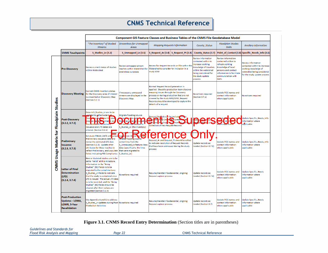
Figure 3.1. CNMS Record Entry Determination (Section titles are in parentheses)
This Document is Superseded. For Reference Only.

Guidelines and Standards for Flood Risk Analysis and Mapping Page 23 CNMS Technical Reference
CNMS Technical Reference
3. Data Entry Process
Figure 3.1 summarizes the workflows and touch points that warrant CNMS data inputs. Structurally, these
data inputs are separated into two types of feature classes: the CNMS Inventory feature dataset with
feature classes „S_Studies_Ln‟ and „S_Unmapped_Ln‟, and the CNMS Requests feature dataset: with
feature classes „S_Requests_Ar „ and „S_Requests_Pt‟. In addition to these feature datasets, several tables
within the CNMS FGDB require specific update. Attribute population policies for each feature class and
table are outlined in sections 3.1 – 3.9.
The validation checklist table in Appendix A may be used as a working document while performing
stream-reach-level validation, results of which need to be transferred to the Validation Process
Documentation Checksheet in Appendix B and to the appropriate CNMS Study Records in the CNMS
FGDB.
Point of Contact (POC) information is to be populated at the time of updating the CNMS FGDB for
associated CNMS Study and Request records, or during the use of the CNMS FGDB QC Tool (Appendix
H). The POC information can change at an organizational level over time. A user should not feel obligated
to retroactively update all records submitted by the organization if the primary POCs for CNMS updates
change. FEMA ensures that any data provided to the agency that is personal in nature such as POC name,
will not be distributed and will be considered private. Should a POC be identified, it is suggested that the
individual be knowledgeable about the record and be someone who will be accessible by FEMA for
follow-up questions or requests for additional information.
3.1. Primary Key Considerations
The primary key in a relational database table allows each record to be uniquely identified. When
generating primary key values for records within relational database tables it is important that a well
documented methodology be followed for the sake of consistency, and to ensure that any information
intended to be imbedded within the primary key is appropriately represented.
CNMS is expected to have many data entry points so special care must be taken to prevent primary key
duplication. If there are multiple sources for record generation for a county, coordination between or
among the multiple sources will be required prior to consolidation of the two databases. However, if
coordination takes place prior to record generation, the parties involved can agree to assigned number
ranges and thereby avoid encroachment on the primary keys created by others.
Primary key generation for most tables within CNMS is based upon a standard scheme consisting of the
concatenation of the appropriate 5 digit County FIPS code, a 2 digit table identification code, and a 5 digit
counter in which leading zeros are always populated and serve as place holders. For example, to generate
a REACH_ID in S_Studies_Ln, 201190100001 would be an appropriate assignment where 20119 is the
county FIPS code, 01 is the table identification code for S_Studies_Ln and 00001 is the counter value for
the first record in S_Studies_Ln for Meade County, Kansas. For tables following the standard scheme and
variations thereof, the length of the key is expected to be 12. Tables such as Point_of_Contact allow for
This Document is Superseded. For Reference Only.

Guidelines and Standards for Flood Risk Analysis and Mapping Page 24 CNMS Technical Reference
CNMS Technical Reference
variations of the scheme. For example, a state-level POC record might substitute the 2 digit state FIPS
followed by three zeros for the 5 digit county FIPS. The only table within the CNMS data model which
does not follow the standard primary key scheme is the County_Status table, for which CO_FIPS is the
primary key by virtue of its inherent uniqueness.
3.2. S_Studies_Ln Feature Class (Polyline)
The S_Studies_Ln feature class resides in the CNMS Inventory feature dataset. Each feature within
S_Studies_Ln is meant to fully encompass the physical extent, upstream and downstream, of a reach that
is regulated by an SFHA under the National Flood Insurance Program (NFIP). Records representing
unmapped reaches and bodies of water may optionally be present in this feature class, provided that they
have been ASSESSED for new study prioritization.
The database contains polylines for most reaches representing SFHAs, but not all. Issues which may have
prohibited the accurate representation of all SFHAs from FEMA‟s mapped inventory could include: cases
where the stream centerlines used to populate the inventory meander in and out of the SFHAs; or where a
study is currently underway and digital data does not exist. The first case can occur when several stream
centerline sources were leveraged to represent SFHA polygons studied in flood insurance studies. In this
instance, one could optionally replace the existing stream centerlines in the CNMS inventory with better
quality polyline data. In the second case, the digital data should overlay stream networks to extract the
reaches that are regulated by SFHA extents when they become available.
This should not be the case in areas where FIRM data were used to populate CNMS Study Records. It is
only anticipated that such inconsistencies with stream centerline representation of SFHAs exist in
unmodernized areas and areas where certain early CNMS pilots were conducted. It should be the goal of
each user to contribute to the inventory by identifying shortcomings in the CNMS Inventory (particularly
in unmodernized areas), providing updates as available, and maintaining the inventory accordingly.
Polyline geometry in the CNMS Studies feature dataset is the result of compilation from various sources
and it is intended that augmentations and improvements to line work geometry be an ongoing process. The
goal is to have every flood hazard study that is part of FEMA‟s mapped inventory represented accurately
within CNMS – the better the line feature quality, the more accurately the CNMS inventory will be able to
inform NVUE reporting. Inventory polylines should be continuous through an SFHA of the same study
type (e.g., zone AE) for individual flooding sources, but split at county or watershed breaks, or within the
same SFHA where one study stops and another starts including LOMR extents. Polylines within
S_Studies_Ln may also be split at community boundaries. In cases where a watershed or a political
boundary may cause a study to be divided into several reaches (each an individual feature), all reaches
may be related to one another and linked to external data by using the „STUDY_ID‟ field.
New polylines should be included in the Inventory when an SFHA does not currently have a line
representing the entire extent of its flood hazard. Sources of stream centerlines entering the inventory are
varied and will be the responsibility of the user to determine. Sources for stream centerlines for riverine
flooding sources in order of preference include: „S_Wtr_Ln‟ or „S_Profil_Basln‟ from: FIRM Database
studies; National Hydrography Dataset (NHD) High, Medium, Low resolution; and heads-up digitization
of a representative line for the SFHA.
This Document is Superseded. For Reference Only.

Guidelines and Standards for Flood Risk Analysis and Mapping Page 25 CNMS Technical Reference
CNMS Technical Reference
Unlike riverine flooding sources, lakes and ponds that are part of FEMA‟s mapped SFHA inventory are
often disconnected from stream centerlines and are two dimensional, making linear representations of
these areas a challenge. Ignoring lakes and ponds altogether would underestimate the representative miles
used for NVUE percentage calculations while including the entire shoreline of these areas would
overestimate the representative miles used. If the stream centerline sources identified above for riverine
flooding sources have line work passing through the lakes or ponds, those may be used to represent these
flooding sources (this includes center line digitization). If none of the datasets has line work usable as
described above, to the appropriate manner in which to address these flooding sources is to then store the
actual polyline representing the lake or pond shore in the CNMS Inventory and to then set the
LINE_TYPE field to a value other than „RIVERINE‟, such as „LAKE OR POND‟. These shoreline miles
will be halved when assessing the mileage for the SFHA study for NVUE calculations.
The S_Studies_Ln feature class is also used to indicate Floodplain Boundary Standard (FBS) compliance
for current studies. Studies that meet the standard will have a value of „YES‟ in the FBS_CMPLNT field.
This value is updated upon Preliminary issuance with information typically received from the Regional
Support Centers.
Sections 3.2.1 – 3.2.4 outlines the updates needed for the S_Studies_Ln table at various Risk MAP
phases.
Table 3.2.1. S_Studies_Ln (Table ID Code: 01)
Field Description
REACH_ID Primary key for table. Assigned by table creator
Type of data expected As the Primary key for this table this field must exist as a unique identifier for each
individual record.
Potential source to obtain
A programmatic approach that prefixes five record counting digits with the 5 digit
County FIPS code and a 2 digit feature class ID will produce a number like
201190100001 (20119 is the county FIPS code, 01 is the feature class ID for
S_Studies_Ln and 00001 represent record counting digits) for the first record in
S_Studies_Ln for Meade County, Kansas. No repeat counting digits should be used
within the same county.
Anticipated use for attribute Unique identification of each individual CNMS record.
STUDY_ID Internal key used to establish relationship between reaches.
Type of data expected This field will be a 12 digit string
Potential source to obtain The value in this field will typically represent the existing REACH_ID of a single reach
amongst a group of related reaches.
Anticipated use for attribute
Key field used to link multiple reaches which represent segments of the same study. This
field can also be used to link multiple reaches to external supporting data which is
common among them. The expected relationship between this field and individual
S_Studies_Ln features in one to many, with a single STUDY_ID being represented by
one or more features.
CO_FIPS Federal Information Processing Standard code
Type of data expected
Five-digit Federal Information Processing Standard code which uniquely indentifies state
and counties, or the equivalent. The first two digits are the FIPS state code and the last
three are the county code within the state or possession.
Potential source to obtain
Countywide FIRM or FIS; U.S Department of Commerce, Bureau of the Census,
Geography Division is the maintenance agency. Many departments within the U.S.
government maintain references back to this standard. Including the EPA:
http://www.epa.gov/enviro/html/codes/state.html
Anticipated use for attribute Establishes a unique identifier for determining what state and/or county the data resides
in.
CID Community Identification Number
This Document is Superseded. For Reference Only.

Guidelines and Standards for Flood Risk Analysis and Mapping Page 26 CNMS Technical Reference
CNMS Technical Reference
Field Description
Type of data expected
A unique five or six-digit number assigned to each community by FEMA and used for
identity in computer databases; it is shown on the FIS, FIRM, and in the Q3 Flood Data
files. The first two digits of the number are always the State FIPS code.
Potential source to obtain FEMA is the source. The CID is obtainable from multiple sources; Community
Information System, Flood Insurance Studies, FIRM panels, FIRM indexes.
Anticipated use for attribute Catalog and referencing
WATER_NAME Name of flooding source
Type of data expected Water feature name (ex. Mississippi River, Lake Superior, Pacific Ocean).
Potential source to obtain
The name of the flooding source should come from the FIS, FIRM, FIRM DB, or source
stream network, and should be given that order of importance. The FIS lists profiles in
alphabetical order in the table of contents and usually discusses them in other FIS
sections in that same order. Section 1.2 should list all of these streams and the dates they
were studied. Section 2.1 should also list all the streams studied by detailed methods, and
should also list all the streams studied by approximate methods. Note that the FIRM
Database should not be the sole source of information that is used to evaluate stream
reaches. Often times there are graphic features or annotation on the PDF map panel that
will help identify a stream reach.
Anticipated use for attribute This attribute provides a geographic place name reference.
WATER_NA_1 Alternate name of flooding source
Type of data expected Water feature name (ex. Mississippi River, Lake Superior, Pacific Ocean).
Potential source to obtain
If an alternative name of a flooding source is identified from the sources identified for
the „WATER_NAME‟ field, which will be stored here. Any other indications of an
alternate name will also be captured in this field.
Anticipated use for attribute This attribute provides a geographic place name reference.
FLD_ZONE Zone type of the SFHA the polyline represents (ex. Zone AE, Zone A)
Type of data expected Entry from domain lookup table D_ZONE
Potential source to obtain Flood zones depicted in the FIRM and/or FIRM Database of the NFIP
Anticipated use for attribute Query into the characteristics of the inventory: type of study, Validation Status, mileage.
VALIDATION_STATUS
This attribute establishes the latest evaluation condition of a flooding source centerline in
relation to the criteria set forth in the CNMS Technical Reference, any procedure
memorandums, or previous work.
Type of data expected Entry from domain lookup table D_VALID_CAT
Potential source to obtain Current entry; or user assessed entry based on evaluation of criteria set forth in the
CNMS Technical Reference, any procedure memorandums, or previous work.
Anticipated use for attribute Used to categorize the Inventory for the purposes of planning, study selection, tracking
and reporting.
STATUS_TYPE
This attribute establishes the sub-categories for each of the Validation Status classes of a
flooding source centerline in relation to the criteria set forth in the CNMS Technical
Reference, any procedure memorandums, or previous work.
Type of data expected Entry from domain lookup table D_STATUS_TYPE
Potential source to obtain Current entry; or user assessed entry based on evaluation of criteria set forth in the
CNMS Technical Reference, any procedure memorandums, or previous work.
Anticipated use for attribute Used to further define the Validation Status type to categorize the Inventory for the
purposes of planning, study selection, tracking and reporting.
MILES An attribute of the calculated miles of the data record entry
Type of data expected A number corresponding to the length of the inventory polyline segment
Potential source to obtain
In feature class format, and if projection is in feet or meters permanent length field of
feature class can be used to populate this field by applying the appropriate conversion to
miles. Otherwise, make a field calculation using field calculator and convert to miles. Be
sure to understand the units the projection is in and how it will influence any resulting
calculations. The CNMS FGDB is provided in the NAD 1983 Geographic Coordinate
System, at the Regional level, the length of the polyline segments can be calculated in
This Document is Superseded. For Reference Only.

Guidelines and Standards for Flood Risk Analysis and Mapping Page 27 CNMS Technical Reference
CNMS Technical Reference
Field Description
local or State projections. During National data consolidation and analysis, the projection
will be standardized across all Regions and mileage recalculated to a National standard.
Anticipated use for attribute Quantifies the CNMS Inventory in stream miles for reporting (ex. NVUE, quarterly
reports)
SOURCE Source of polyline segment represented in the inventory
Type of data expected Entry from domain lookup table D_SOURCE
Potential source to obtain User sourced dataset used for the polyline entry (ex. NFHL, RFHL, FIRM Database,
NHD)
Anticipated use for attribute Verify source of polyline used, and also determine whether it could be updated to a more
accurate polyline feature if one becomes available.
STATUS_DATE
Date when CNMS stream reach validation is completed or a validation assessment of the
stream reach has been made. UNVERIFIED records will have the date the CNMS
evaluation triggered the UNVERIFIED status. If an unverified study becomes VALID,
the date of the status change is recorded.
Type of data expected Calendar date (ex. 01/01/10)
Potential source to obtain Calendar
Anticipated use for attribute
Determine the most recent analysis and condition of the polyline. Will track and maintain
the currency of the inventory, to insure all requirements are being adhered to according
to mandates set forth within the NFIP.
FY_FUNDED Attribute of the most recent effective FEMA fiscal year funding applied to the stream
reach engineering at the time of study (ex. Watershed, county)
Type of data expected Entry from domain lookup table D_FY_FUNDED
Potential source to obtain MIP case numbers (as they are associated with fiscal year first funded), RSC
Management
Anticipated use for attribute Determine the latest FEMA funding year for the underlying SFHA engineering study.
REASON
Attribute allows for user input of detailed description of considerations or special
circumstances when determining attributes VALIDATION_STATUS, SOURCE, or any
pertinent information in the data creation process.
Type of data expected Preferably user defined template “canned” descriptors of their data entry process and
considerations
Potential source to obtain
Criteria evaluated and considered in the bulk validation of CNMS Study Records,
ancillary information presented by the regions or other parties, data used that is not
readily available, etc.
Anticipated use for attribute
Attribute will document more details about the underlying considerations of other
attributes contained in the CNMS database. This will serve as a first stop when questions
arise about the attribution contained in the database without going back to the criteria,
check sheets, or intermediate datasets. By choosing to use template “canned” entries,
query of such entries will be streamlined. A useful example might be the need to query a
specific consideration that based on current business rules is attributed a certain way, but
based on new information might need to be queried and reattributed a different way.
HUC8_KEY
8-digit Hydrologic Unit Code (HUC) representing the smallest watersheds knows as
hydrologic cataloging units. This can be obtained by overlaying the HUC spatial files
with the polyline information to determine which cataloging unit the polyline resides in.
Type of data expected 8-digit Hydrologic Unit Code
Potential source to obtain Originator: United States Geological Survey (USGS): http://nhd.usgs.gov/data.html; or
EPA surf your watershed: http://cfpub.epa.gov/surf/locate/index.cfm
Anticipated use for attribute Provides an attribute to determine what HUC 8 sub-basin the polyline resides in.
STUDY_TYPE Study type of the SFHA represented by the reach based on the current effective FIS text.
Type of data expected Entry from domain lookup table D_STUDY_TYPE
Potential source to obtain FIS Text, Study Manager Input etc.
Anticipated use for attribute Query into the characteristics of the inventory: type of study, Validation Status, mileage.
LINE_TYPE Attribute provides description of flooding source line type as being Riverine, Lake, Pond,
Playa, Ponding, or Other.
This Document is Superseded. For Reference Only.

Guidelines and Standards for Flood Risk Analysis and Mapping Page 28 CNMS Technical Reference
CNMS Technical Reference
Field Description
Type of data expected Entry from domain lookup table D_LINE_TYPE
Potential source to obtain Current entry or user assessed entry based on line geometry source.
Anticipated use for attribute
Attribute will allow for the identification of non-riverine flooding sources which do not
fit well with the linear riverine model for calculating NVUE mileage. This attribute is to
be used to equate the level of effort associated with each of line type relative to the level
of effort associated with Riverine studies.
FBS_CMPLNT Is the flood plain represented by this feature FBS Compliant? (NO/YES/UNKNOWN)
Type of data expected This is a YES/NO field based upon domain lookup table D_ELEMENT.
Potential source to obtain Regional Support Centers and / or TSDN
Anticipated use for attribute Tracking FBS compliance across the National Inventory
FBS_CHKDT Date when the current value within the FBS_CMPLNT field was populated.
Type of data expected Calendar date (ex. 01/01/10)
Potential source to obtain Calendar
Anticipated use for attribute Tracks attribution of latest FBS compliance value.
FBS_CTYP FBS compliance check type – bulk attributed at county level or attributed individually.
Type of data expected This field will hold a user selected value from domain table D_FBS_CTYP.
Potential source to obtain Entered by user when FBS_CMPLNY field is populated, based upon check type
Anticipated use for attribute Indicator of the type of FBS check performed for this reach
DUPLICATE
Is there a second line representing an SFHA across a political boundary, for a second
study on the same extent of the reach? (CATEGORY 1, CATEGORY 2, or CATEGORY
3)
Type of data expected
Where a stream defines a county boundary, and there are two SFHA studies on the same
reach of the stream, there will be two lines representing the same reach. One line will be
set to „ CATEGORY 1‟ and the other line for the same reach extent will be set to
„CATEGORY 2‟. All other streams on the interior of county boundaries, and for which
only one study exists for that stream along a county boundary, will have the value set to
„„CATEGORY 3‟ by default. An exception to this is that two lines are to always be
shown at Regional boundaries, even when the same study is used for both entities.
Ideally, the line set to „CATEGORY 1‟ will be the one with a better Validation Status
and a more detailed study out of the two that represent two studies performed on the
same reach. This way, while considering stream miles for a watershed based scoping, the
better study could be hidden by a query, and the mapping needs will become more
apparent.
The hierarchy for determining the „better‟ of the two studies is defined as follows and the
bullets are organized in decreasing order, meaning the criteria in the first bullet
supersedes ones below it for defining a better study. Legend: „>‟ = „better than‟
Detailed study > Approximates (regardless of Validation Status or study type)
„Valid‟ study > „Unknown‟ study > UNVERIFIED study (assuming both
studies in question are detailed or both are approximate)
Redelineated > Digital Conversion > Non-digital (assuming level of
detail and Validation Status is the same for the 2 studies in question)
Study date or number of failed elements can be used to further
differentiate between two of the same study types. (Newer studies
are better. Lesser elements failing is better. Secondary elements
failing is better than critical ones)
Potential source to obtain While completing this field, one must check the same stream on the neighboring county
to see if there is a second study for the same reach extent.
Anticipated use for attribute
Provides input that helps determine double lines representing the same stream when two
studies have been conducted for that stream on either landward side. This situation
occurs when community boundaries are defined by a stream and each community
performs independent studies to map the SFHA on either side of the county boundary.
If the stream segment with a better Validation Status and a more detailed study, is set to
„CATEGORY 1,‟ while considering stream miles for a watershed based scoping, the
better study can be hidden by a query, and the mapping needs will become more
apparent.
This Document is Superseded. For Reference Only.

Guidelines and Standards for Flood Risk Analysis and Mapping Page 29 CNMS Technical Reference
CNMS Technical Reference
Field Description
POC_ID Foreign key to join to „Point_of_Contact‟ table. ID for Point of Contact
Type of data expected This field, if populated, should have a matching record in the „Point_of_Contact‟ table.
Potential source to obtain Establishing the relationship of „S_Studies_Ln‟ records and „Point_of_Contact‟ records
is user controlled.
Anticipated use for attribute
This field is used to establish a database relationship with records in the
„Point_of_Contact‟ table. The supporting idea is to relate record ownership information
to specific CNMS records.
DATE_RQST The date a study is determined to be unverified
Type of data expected This field is of the type date. Data should be entered in MM/DD/YYYY format.
Potential source to obtain The user should enter the date for which the CNMS record was entered in the database.
Anticipated use for attribute Resource and tracking are the anticipated uses of dates.
DATE_EFFCT Date of effective analysis
Type of data expected
This date field will be used to document when the effective study was produced because
there can be much time between when the study was created and when it went effective.
Age of maps does not adequately reflect the age of the analysis as a study can be
published on multiple effective maps without change. At times, the date that the analysis
first went effective is sufficient as well, especially when supporting data is sparse. Data
should be entered in the MM/DD/YYYY format.
Potential source to obtain The date of effective analysis for a detailed study is usually included in Section 1.2 in the
FEMA Insurance Study (FIS) text.
Anticipated use for attribute This date will be evaluated for age of analysis of the effective study.
HYDRO_MDL Hydrologic model used for the effective study
Type of data expected In this domain based field the user should choose the name of the hydrologic model used
and version, as appropriate.
Potential source to obtain
There are two references in which one expects to find this information. One is in the
reference section of the Flood Insurance Study (FIS) text and the second is the Technical
Support Data Notebook (TSDN) for the study. A complete domain list of Hydrologic
Models recognized by FEMA can be accessed on FEMA's Mapping Information
Platform (MIP) or FEMA‟s website.
Anticipated use for attribute Reference and evaluation
HYDRA_MDL Hydraulic model used for the effective study
Type of data expected In this domain based field the user should choose the name of the hydraulic model used
and version, as appropriate.
Potential source to obtain
There are two references in which one expects to find this information. One is in the
reference section of the Flood Insurance Study (FIS) text and the second is the Technical
Support Data Notebook (TSDN) for the study. A complete domain list of Hydraulic
Models recognized by FEMA can be accessed on FEMA's Mapping Information
Platform (MIP) and FEMA‟s website.
Anticipated use for attribute Reference and evaluation
HODIGFMT Is the effective study‟s hydrologic model in digital format? (NO/YES/UNKNOWN)
Type of data expected Yes or no is expected to indicate whether the data are digital or not.
Potential source to obtain User evaluation of the data format
Anticipated use for attribute Evaluation of the data relative to the expected effort associated with use of the data
HADIGFMT Is the effective study‟s hydraulic model in digital format? (NO/YES/UNKNOWN)
Type of data expected Yes or no is expected to indicate whether the data are digital or not.
Potential source to obtain User evaluation of the data format
Anticipated use for attribute Evaluation of the data relative to the expected effort associated with use of the data
HO_RUNMOD Can the effective study‟s Hydrologic digital model be run? (NO/YES/UNKNOWN)
Type of data expected Yes or no is expected to indicate whether the data can be run in a model.
Potential source to obtain User evaluation of the data format
Anticipated use for attribute Evaluation of the data relative to the expected effort associated with use of the data
HA_RUNMOD Can the effective study‟s Hydraulic digital model be run? (NO/YES/UNKNOWN)
Type of data expected Yes or no is expected to indicate whether the data can be run in a model.
Potential source to obtain User evaluation of the data format
This Document is Superseded. For Reference Only.

Guidelines and Standards for Flood Risk Analysis and Mapping Page 30 CNMS Technical Reference
CNMS Technical Reference
Field Description
Anticipated use for attribute Evaluation of the data relative to the expected effort associated with use of the data
C1_GAGE
Critical Element 1, Change in gage record. Major change in gage record since effective
analysis that includes major flood events? (NO/YES/UNKNOWN) NOTE: Users may
indicate change in rainfall record or other climatologic data in this field if gage data is
not available but other precipitation indicators are available.
Type of data expected This YES/NO field is to capture whether or not a major change in gage records has been
observed since the effective analysis was completed.
Potential source to obtain Investigate the existence of gages along the reach. Record all gages near or on the stream
reach AND gages listed in the FIS.
Anticipated use for attribute This Critical Element field is a trigger for indication of an identified deficiency, and
subsequent assignment of UNVERIFIED Validation Status to the record.
C2_DISCH
Critical Element 2, Change in Discharge. Updated and effective peak discharges differ
significantly based on confidence limits criteria in FEMA's Guidelines and Standards for
Flood Risk Analysis and Mapping? (NO/YES/UNKNOWN)
Type of data expected
This YES/NO field is to capture whether or not updated and effective peak discharges
differ significantly based on FEMA's current confidence limits criteria since the effective
analysis was completed.
Potential source to obtain
Look at the years of record for each gage. The FIS may tell you how many years of
record were used in the model. Gage data are measured, compiled and served via web
access by the USGS. The gage ESRI shapefile will tell you if there are continuous and
updated years of record available. Determine if 100-yr discharge obtained by running
PeakFQ at effective date is still within 68% confidence interval of the Bullet 17B 100-yr
estimate using updated gage data and PeakFQ. If not, Critical Element is set to „YES‟
Anticipated use for attribute This Critical Element field is a trigger for indication of an identified deficiency, and
subsequent assignment of UNVERIFIED Validation Status to the record.
C3_MODEL
Critical Element 3, Model methodology. Model methodology no longer appropriate
based on Guidelines and Standards for Flood Risk Analysis and Mapping (i.e. one-
dimensional vs. two-dimensional modeling; Coastal Guidelines)?
(NO/YES/UNKNOWN)
Type of data expected This YES/NO field is to capture whether or not the model methodology used to produce
the effective analysis still meet current guidelines and specifications.
Potential source to obtain Research and general knowledge to be provided by engineering staff.
Anticipated use for attribute This Critical Element field is a trigger for indication of an identified deficiency, and
subsequent assignment of UNVERIFIED Validation Status to the record.
C4_FCSTR
Critical Element 4, Hydraulic Change. Addition/removal of a major flood control
structure (i.e., certified levee or seawall, reservoir with more than 50 acre-ft storage per
square mile)? (NO/YES/UNKNOWN)
Type of data expected This YES/NO field is to capture whether or not there have been major flood control
structures added or removed since the effective analysis was completed.
Potential source to obtain The originator of the CNMS record should have professional knowledge of this situation.
Anticipated
use for attribute
This Critical Element field is a trigger for indication of an identified deficiency, and
subsequent assignment of UNVERIFIED Validation Status to the record.
C5_CHANN Critical Element 5, Channel Reconfiguration. Current channel reconfiguration outside
effective SFHA? (NO/YES/UNKNOWN)
Type of data expected
This YES/NO field is to capture whether or not any channel reconfiguration outside the
effective special flood hazard area (SFHA) have been observed since the effective
analysis was completed.
Potential source to obtain
NAIP or DOQQ imagery can be used to determine if the mapped SFHAs do not match
the channel configurations on the aerial. If they do not match, record a YES. If you
record a YES be sure you can go back and state with confidence that the SFHAs do not
match information on the aerial. NOTE: when stating YES, you are saying that the
floodplains on the map are no longer valid.
Anticipated use for attribute This Critical Element field is a trigger for indication of an identified deficiency, and
subsequent assignment of UNVERIFIED Validation Status to the record.
C6_HSTR Critical Element 6, Hydraulic Change 2. 5 or more new or removed hydraulic structures
(bridge/culvert) that impact BFEs? (NO/YES/UNKNOWN)
Type of data expected This YES/NO field is to capture whether or not 5 or more new or removed hydraulic
structures (bridge/culvert) that impact base flood elevations (BFEs) have been observed
This Document is Superseded. For Reference Only.

Guidelines and Standards for Flood Risk Analysis and Mapping Page 31 CNMS Technical Reference
CNMS Technical Reference
Field Description
since the effective analysis was completed. Consider any combination of new and
removed of 5 or more structures (i.e. 3 new and 3 removed). This should not be used to
supersede the Letter of Map Revision process.
Potential source to obtain The originator of the CNMS record should have professional knowledge of this situation.
Anticipated use for attribute This Critical Element field is a trigger for indication of an identified deficiency, and
subsequent assignment of UNVERIFIED Validation Status to the record.
C7_SCOUR Critical Element 7, Channel Area Change. Significant channel fill or scour?
(NO/YES/UNKNOWN)
Type of data expected This YES/NO field is to capture whether or not significant channel fill or scour has been
observed since the effective analysis was completed.
Potential source to obtain The originator of the CNMS record should have professional knowledge of this situation.
Anticipated use for attribute This Critical Element field is a trigger for indication of an identified deficiency, and
subsequent assignment of UNVERIFIED Validation Status to the record.
S1_REGEQ Secondary Element 1, Regression Equation. Use of rural regression equations in
urbanized areas? (NO/YES/UNKNOWN)
Type of data expected This YES/NO field is to capture whether or not a regression equation intended for rural
use was used in an urbanized area.
Potential source to obtain
An existing study will indicate the use of a regression equation and provide information
on the area for which the model was run. This field could indicate the incorrect use of a
regression equation intended for rural areas in urban areas or could capture that urban
sprawl has overtaken a once rural area for which a rural regression equation model has
been run.
Anticipated use for attribute Any combination of 4 or more Secondary Elements establishes a CNMS record as
UNVERIFIED
S2_REPLO Secondary Element 2, Repetitive Loss. Repetitive losses outside the SFHA?
(NO/YES/UNKNOWN)
Type of data expected This YES/NO field is to capture whether or not repetitive loss claims have been filed for
properties outside the SFHA.
Potential source to obtain If there are repetitive loss points close to your reach and outside the SFHA, record a
YES.
Anticipated use for attribute Any combination of 4 or more Secondary Elements establishes a CNMS record as
UNVERIFIED
S3_IMPAR
Secondary Element 3, Impervious Area. Increase in impervious area in the sub-basin of
more than 50 percent (i.e., 10 percent to 15 percent, 20 percent to 30 percent, etc.)?
(NO/YES/UNKNOWN)
Type of data expected This YES/NO field is to capture whether or not there is a significant increase in
impervious surface in the sub-basin since the effective study.
Potential source to obtain Taking advantage of remote sensing land use classification data, or change detection
analyses are potential sources for this field.
Anticipated use for attribute Any combination of 4 or more Secondary Elements establishes a CNMS record as
UNVERIFIED
S4_HSTR Secondary Element 4, Hydraulic Structure. More than 1 and less than 5 new or removed
hydraulic structures (bridge/culvert) impacting BFEs? (NO/YES/UNKNOWN)
Type of data expected This YES/NO field is to capture whether or not there have been 1 to 4 new and/or
removed hydraulic structures that impact BFEs since the effective study. This should not
be used to supersede the Letter of Map Revision process.
Potential source to obtain The originator of the CNMS record should have professional knowledge of this situation.
Anticipated use for attribute Any combination of 4 or more Secondary Elements establishes a CNMS record as
UNVERIFIED
S5_CHIMP Secondary Element 5, Channel Improvements. Channel improvements / Shoreline
changes? (NO/YES/UNKNOWN)
Type of data expected
This YES/NO field is to capture whether or not there have been any channel
improvement or shoreline changing projects since the effective study. This should not be
used to supersede the Letter of Map Revision process.
Potential source to obtain
The originator of the CNMS record should have professional knowledge of this situation
but one might check the local public works department for available supporting
documentation.
This Document is Superseded. For Reference Only.

Guidelines and Standards for Flood Risk Analysis and Mapping Page 32 CNMS Technical Reference
CNMS Technical Reference
Field Description
Anticipated use for attribute Any combination of 4 or more Secondary Elements establishes a CNMS record as
UNVERIFIED
S6_TOPO Secondary Element 6, Topography Data. Availability of better topography/bathymetry?
(NO/YES/UNKNOWN)
Type of data expected This YES/NO field is to capture whether or not there are new topographic data meeting
FEMA minimum standards available since the effective study.
Potential source to obtain
Look into all the resources available to determine if newer and/or more accurate
topographic data are available for the reach and record a yes if you find updated
topography (this will ultimately be based on whether or not new topographic data meet
FEMA's minimum standards and are better that what was used for the effective study.
The investigation of „YES's‟ should be performed with an engineer or manager).
Anticipated use for attribute Any combination of 4 or more Secondary Elements establishes a CNMS record as
UNVERIFIED
S7_VEGLU Secondary Element 7, Vegetation or Land Use. Changes to vegetation or land use?
(NO/YES/UNKNOWN)
Type of data expected This YES/NO field is to capture whether or not there are significant changes in land use
or vegetation since the effective study. This does NOT include urban change.
Potential source to obtain Look at the NAIP (streaming) and other sources available to you to determine if the area
has experienced changes to vegetation or land use.
Anticipated use for attribute Any combination of 4 or more Secondary Elements establishes a CNMS record as
UNVERIFIED
S8_DUNE Secondary Element 8, Coastal Dune. Failure to identify primary frontal dune in coastal
areas? (NO/YES/UNKNOWN)
Type of data expected This YES/NO field is to capture whether or not there was a failure to identify a primary
frontal dune in coastal areas since the effective study.
Potential source to obtain The originator of the CNMS record should have professional knowledge of this situation.
One might reference an after action report following a recent disaster or the FIS text.
Anticipated use for attribute Any combination of 4 or more Secondary Elements establishes a CNMS record as
UNVERIFIED
S9_HWMS Secondary Element 9, High Water Mark. Significant storms with High Water Marks.
(NO/YES/UNKNOWN)
Type of data expected This YES/NO field is to capture whether or not there is recent storm surge high water
mark data now available following the effective study.
Potential source to obtain The originator of the CNMS record should have professional knowledge of this situation.
One might reference an after action report following a recent high water event.
Anticipated use for attribute Any combination of 4 or more Secondary Elements establishes a CNMS record as
UNVERIFIED
S10_REGEQ Secondary Element 10, Regression Equation. New regression equations available?
(NO/YES/UNKNOWN)
Type of data expected
The originator of the CNMS record should have professional knowledge of this situation.
This information may come to light following the release of a new study that includes a
new regression model.
Potential source to obtain Research and general knowledge to be provided by engineering staff.
Anticipated use for attribute Any combination of 4 or more Secondary Elements establishes a CNMS record as
UNVERIFIED
CE_TOTAL Total number of critical elements
Type of data expected A number equivalent to the sum of the number of Critical Elements equaling „YES‟ from
above.
Potential source to obtain User is to provide the sum of Critical Elements
Anticipated use for attribute Determination of ‟VALIDATED‟ vs. UNVERIFIED; UNVERIFIED is CE_Total > 0
SE_TOTAL Total number of secondary elements
Type of data expected A number equivalent to the sum of the number of Secondary Elements equaling „YES‟
from above.
Potential source to obtain User is to provide the sum of Secondary Elements
Anticipated use for attribute Determination of ‟VALIDATED‟ vs. UNVERIFIED; UNVERIFIED is SE_Total >= 4
COMMENT Additional comments
Type of data expected Additional analyst comments.
This Document is Superseded. For Reference Only.

Guidelines and Standards for Flood Risk Analysis and Mapping Page 33 CNMS Technical Reference
CNMS Technical Reference
Field Description
Potential source to obtain User comments.
Anticipated use for attribute Though the field cannot be domain enforced, it will sometimes include information
pertaining to Validation decisions, or LOMR incorporation effects.
BS_ZONE Zone type of the SFHA represented by the reach currently being studied based on
scoping data, or the preliminary FIS text.
Type of data expected Entry from domain lookup table D_ZONE
Potential source to obtain Flood zones depicted in scoping data or the Preliminary FIRM and/or FIRM Database of
the NFIP
Anticipated use for attribute Stores the flood zone type of a study currently in progress.
BS_STDYTYP Study type of the SFHA represented by the reach currently being studied based on
scoping data, or the preliminary FIS text.
Type of data expected Entry from domain lookup table D_STUDY_TYPE
Potential source to obtain Scoping data, Preliminary FIS, Study Manager.
Anticipated use for attribute Stores the study type of a study currently in progress.
BS_HYDRO_M Hydrologic model used for creating the SFHA represented by the reach currently being
studied based on scoping data or the preliminary FIS text.
Type of data expected In this domain based field the user should choose the name of the hydrologic model used
and version, as appropriate.
Potential source to obtain Scoping data, Preliminary FIS, Study Manager.
Anticipated use for attribute Stores the study type of a study currently in progress.
BS_HYDRA_M Hydrologic model used for creating the SFHA represented by the reach currently being
studied based on scoping data or the preliminary FIS text.
Type of data expected In this domain based field the user should choose the name of the hydraulic model used
and version, as appropriate.
Potential source to obtain Scoping data, Preliminary FIS, Study Manager.
Anticipated use for attribute Stores the study type of a study currently in progress.
BS_FY_FUND When relevant - Attribute of the most recent non-effective FEMA fiscal year funding
applied to the stream reach engineering at the time of study (ex. Watershed, county)
Type of data expected Entry from domain lookup table D_FY_FUNDED
Potential source to obtain Scoping data, Preliminary FIS, Study Manager.
Anticipated use for attribute FY projections and trend identification
PRELM_DATE Expected Preliminary issuance date for reaches representing areas being actively studied.
Type of data expected Calendar date (ex. 01/01/10)
Potential source to obtain MIP, other pending guidance.
Anticipated use for attribute Stores the expected Preliminary Date of a study currently in progress.
LFD_DATE Expected Letter of Final Determination issuance date for reaches representing areas
being actively studied.
Type of data expected Calendar date (ex. 01/01/10)
Potential source to obtain MIP, other pending guidance.
Anticipated use for attribute Stores the expected Letter of Final Determination Date of a study currently in progress.
EC1_UDEF User Defined Critical Element 1
Type of data expected This YES/NO field is to capture the results of additional Region Specific validation
processes which have been deemed Critical.
Potential source to obtain Dependent upon Element definition.
Anticipated use for attribute
This Critical Element field is a trigger for indication of an identified deficiency, and
subsequent assignment of UNVERIFIED Validation Status to the record. In counties
which have been identified as utilizing the Extra Elements, EC1_UDEF failure will result
in an UNVERIFIED Validation Status assignment.
EC2_UDEF User Defined Critical Element 2
Type of data expected This YES/NO field is to capture the results of additional Region Specific validation
processes which have been deemed Critical.
Potential source to obtain Dependent upon Element definition.
Anticipated use for attribute
This Critical Element field is a trigger for indication of an identified deficiency, and
subsequent assignment of UNVERIFIED Validation Status to the record. In counties
which have been identified as utilizing the Extra Elements, EC2_UDEF failure will result
This Document is Superseded. For Reference Only.

Guidelines and Standards for Flood Risk Analysis and Mapping Page 34 CNMS Technical Reference
CNMS Technical Reference
Field Description
in an UNVERIFIED Validation Status assignment.
ES1_UDEF User Defined Secondary Element 1
Type of data expected This YES/NO field is to capture the results of additional Region Specific validation
processes which have been deemed Secondary.
Potential source to obtain Dependent upon Element definition.
Anticipated use for attribute
Any combination of 4 or more Secondary Elements establishes a CNMS record as
UNVERIFIED. In counties which have been identified as utilizing the Extra Elements,
ES1_UDEF will contribute to the Secondary Element count.
ES2_UDEF User Defined Secondary Element 2
Type of data expected This YES/NO field is to capture the results of additional Region Specific validation
processes which have been deemed Secondary.
Potential source to obtain Dependent upon Element definition.
Anticipated use for attribute
Any combination of 4 or more Secondary Elements establishes a CNMS record as
UNVERIFIED. In counties which have been identified as utilizing the Extra Elements,
ES2_UDEF will contribute to the Secondary Element count.
ES3_UDEF User Defined Secondary Element 3
Type of data expected This YES/NO field is to capture the results of additional Region Specific validation
processes which have been deemed Secondary.
Potential source to obtain Dependent upon Element definition.
Anticipated use for attribute
Any combination of 4 or more Secondary Elements establishes a CNMS record as
UNVERIFIED. In counties which have been identified as utilizing the Extra Elements,
ES3_UDEF will contribute to the Secondary Element count.
ES4_UDEF User Defined Secondary Element 4
Type of data expected This YES/NO field is to capture the results of additional Region Specific validation
processes which have been deemed Secondary.
Potential source to obtain Dependent upon Element definition.
Anticipated use for attribute
Any combination of 4 or more Secondary Elements establishes a CNMS record as
UNVERIFIED. In counties which have been identified as utilizing the Extra Elements,
ES4_UDEF will contribute to the Secondary Element count.
E_ELEMDATE The date on which the User Defined Element values were populated
Type of data expected Calendar date (ex. 01/01/10)
Potential source to obtain User is to provide the date on which the E Elements were evaluated.
Anticipated use for attribute The date on which the User Defined Elements were populated.
3.2.1. S_Studies_Ln Discovery and Scoping Phase Updates
In instances where study mileage has been scoped and funded, but not yet tied to specific reaches, no
updates to S_Studies_Ln are needed. In such a scenario, updates to the County_Status table will however
be required. Such documentation of funded miles in the County_Status table should be limited to one
quarter. Following this duration, the appropriate funded study reaches must be identified in
S_Studies_Ln.
When project scope has been funded and specific reaches have been identified, the following fields within
S_Studies_Ln will need to be updated as indicated. It is assumed that any fields not listed here should be
updated by the user if more accurate data is available.
Field Discovery and Scoping Phase Updates
REACH_ID Update Reach_ID any time on affected features any time a Reach is split, or added to the Inventory.
STUDY_ID Update Study_ID to reflect intended cardinality. Often with new studies, it
will be appropriate to simply set STUDY_ID equal to the Reach_ID
This Document is Superseded. For Reference Only.

Guidelines and Standards for Flood Risk Analysis and Mapping Page 35 CNMS Technical Reference
CNMS Technical Reference
Field Discovery and Scoping Phase Updates
STATUS_TYPE Shall be updated to 'BEING STUDIED' for all scoped Reaches
MILES Recalculate for any Reaches where geometry has been modified.
STATUS_DATE Set the STATUS_DATE to the current date, which should be the
date the other fields were reassigned as well.
POC_ID Set the POC_ID to reflect the most current editing entity.
DATE_RQST Set the DATE_RQST to the current date, which should be the date
that the STATUS_TYPE was set to 'BEINGSTUDIED'
BS_ZONE Select the appropriate flood zone type for the ongoing study
BS_STDYTYP Select the appropriate study type for the ongoing study
BS_HYDRO_M Select the appropriate hydrologic model type being used for the
ongoing study
BS_HYDRA_M Select the appropriate hydraulic model type being used for the
ongoing study
BS_FY_FUND Select the appropriate value for fiscal year funded for the ongoing
study
PRELM_DATE Update with accurate Preliminary issuance date estimate
LFD_DATE Update with accurate LFD issuance date estimate
3.2.2. S_Studies_Ln FIRM Production Phase Update
Throughout the production phase, it is important that the PRELM_DATE and LFD_DATE fields be kept
current. Should scope of work be altered in any way, S_Studies_Ln shall be updated to represent the
updated scope, using the guidelines in 3.2.1. Additionally, it is also imperative that de-scoped studies
resume appropriate VALIDATION_STATUS and STATUS_TYPE values as follows.
Validation status - Status Type
(Active Study Values)
Validation status - Status Type
(De-Scoped Values)
ASSESSED - BEING STUDIED ASSESSED - TO BE STUDIED
UNKNOWN - BEING STUDIED UNKNOWN - TO BE ASSESSED
VALID - BEING STUDIED VALID - NVUE COMPLIANT
UNVERIFIED - BEING STUDIED UNVERIFIED - TO BE STUDIED
3.2.3. S_Studies_Ln Preliminary Issuance Phase Update
At Preliminary issuance, all fields attributed through Discovery and Scoping Phase Updates should be
checked for accuracy and updated as appropriate. Additionally, where line work in the Preliminary FIRM
Database is preferable to (using guidelines established in Section 2.2.5) or of higher quality than line
work currently in S_Studies_Ln, the line work in the feature class should be updated, paying strict
attention to attribute inheritance within the new line features.
This Document is Superseded. For Reference Only.

Guidelines and Standards for Flood Risk Analysis and Mapping Page 36 CNMS Technical Reference
CNMS Technical Reference
Field Preliminary Issuance Phase Updates
FBS_CMPLNT Update to indicate FBS compliance of Preliminary studies
FBS_CHKDT Update with date new FBS_CMPLNT value populated
FBS_CTYPE Update to reflect FBS compliance check type
PRELM_DATE Update with actual Preliminary issuance date
LFD_DATE Update with accurate LFD issuance date estimate
After Preliminary issuance, should it be discovered that scope of work had differed in any way from that
represented in the polylines; S_Studies_Ln shall be updated to represent the correct scope. Additionally, it
is also imperative that de-scoped studies resume appropriate VALIDATION_STATUS and
STATUS_TYPE values as defined in Section 3.2.2.
3.2.4. S_Studies_Ln LFD Issuance Phase Update
At LFD issuance, values from the fields populated for scoping and preliminary data will be migrated into
the primary study fields, and the immediate state fields will be cleared as follow.
Field LFD Phase Updates
FLD_ZONE This field should inherit the value stored in BS_ZONE
VALIDATION_STATUS For Reaches representing New or Updated studies, this field shall be
set to VALID, otherwise this field shall be set to UNKNOWN
STATUS_TYPE
For Reaches representing New or Updated studies, this field shall be
set to 'NVUE COMPLIANT", otherwise this field shall be set to 'TO
BE ASSESSED'
MILES Recalculate for any Reaches where geometry has been modified.
STATUS_DATE Set the STATUS_DATE to the current date, which should be the date
the other fields were reassigned as well.
FY_FUNDED This field should inherit the value stored in BS_FY_FUNDED
STUDY_TYPE This field should inherit the value stored in BS_SDTYTYP
POC_ID Set the POC_ID to reflect the most current editing entity.
DATE_RQST This field should be cleared.
DATE_EFFCT This field should be updated to represent the date the H&H was
completed for the Reach.
HYDRO_MDL This field should inherit the value stored in BS_HYDRO_M
HYDRA_MDL This field should inherit the value stored in BS_HYDRA_M
HODIGFMT This field should be updated to indicate whether or not the Hydro
model of the new study is in digital format
HADIGFMT This field should be updated to indicate whether or not the Hydra
model of the new study is in digital format
This Document is Superseded. For Reference Only.

Guidelines and Standards for Flood Risk Analysis and Mapping Page 37 CNMS Technical Reference
CNMS Technical Reference
Field LFD Phase Updates
HO_RUNMOD This field should be updated to indicate whether or not the Hydro
model, if in digital format, can be run
HA_RUNMOD This field should be updated to indicate whether or not the Hydra
model, if in digital format, can be run
C1 through C7 If the Reach represents a New or Updated study, this field should be
cleared.
S1 through S10 If the Reach represents a New or Updated study, this field should be
cleared.
CE_TOTAL If the Reach represents a New or Updated study, this field should be
cleared.
SE_TOTAL If the Reach represents a New or Updated study, this field should be
cleared.
BS_ZONE After this value has been migrated to the appropriate field, this field
should be cleared.
BS_STDYTYP After this value has been migrated to the appropriate field, this field
should be cleared.
BS_HYDRO_M After this value has been migrated to the appropriate field, this field
should be cleared.
BS_HYDRA_M After this value has been migrated to the appropriate field, this field
should be cleared.
BS_FY_FUND After this value has been migrated to the appropriate field, this field
should be cleared.
PRELM_DATE This field should be cleared.
LFD_DATE This field should be cleared.
EC1_UDEF and
EC2_UDEF
If the Reach represents a New or Updated study, this field should be
cleared.
ES1_UDEF through
ES4_UDEF
If the Reach represents a New or Updated study, this field should be
cleared.
E_ELEMDATE If the Reach represents a New or Updated study, this field should be
cleared.
After LFD issuance, should it be discovered that scope of work had differed in any way from that
represented in the line work, S_Studies_Ln shall be updated to represent the correct scope. Additionally,
it is also imperative that de-scoped studies resume appropriate VALIDATION_STATUS and
STATUS_TYPE values as defined in 3.2.2
3.3. ‘S_Studies_Ar’ Feature Class (Polygon)
The „S_Studies_Ar‟ feature class existed in earlier versions of the CNMS data model within the CNMS
Studies feature dataset. As of version 5.0 of the CNMS data model, the attributes of this polygon feature
This Document is Superseded. For Reference Only.

Guidelines and Standards for Flood Risk Analysis and Mapping Page 38 CNMS Technical Reference
CNMS Technical Reference
class had been moved to the S_Studies_Ln feature class, and all resulting field redundancies removed,
thus eliminating the requirement for maintaining „S_Studies_Ar‟ within the CNMS database. All
validation assessment and evaluation is now performed directly on the lines within S_Studies_Ln. FEMA
Regions have the option of maintaining the original „S_Studies_Ar‟ feature class within their local CNMS
FGDB, however the national version of CNMS will no longer maintain „S_Studies_Ar‟, and it is not a
required component of submittals for National roll-up.
3.4. ‘S_Requests’ Feature Classes (Point/Polygon)
The „S_Requests_Ar‟ and „S_Request_Pt‟ feature classes reside in the CNMS Requests feature dataset
within the CNMS FGDB, and are designed to store details concerning update requests from stakeholders.
Both feature classes possess the same table structure for data capture and storage, the only schematic
difference between them being the name of the primary key fields. For S_Requests_Ar the primary key
field is „SRA_ID‟, and for the S_Requests_Pt the primary key field is „SRP_ID‟.
In order to populate the database with either of these record types, a user needs to determine if the
community request is better stored as a point or polygon feature. This will vary depending on the specific
request type, and the characteristics of the area being identified. Effort should be made to ensure the
database populated to the fullest extent practicable, using the comment field to include any additional
information that may prove valuable in the future when this request is further analyzed.
Table 3.4.1. S_Requests_Ar/Pt (Polygon/Point) (Table ID Code: 03/04)
Field Description
SRA_ID / SRP_ID Primary key for tables. Assigned by table creator
Type of data expected As the Primary key for this table this field must exist as a unique identifier for each individual
record.
Potential source to obtain
A programmatic approach that prefixes five record counting digits with the 5 digit County
FIPS code and a 2 digit feature class ID produces a number like 201190300001 (20119 is the
county FIPS code, 03 is the feature class ID for „S_Requests_Ar‟ and 00001 represent record
counting digits) for the first record in „S_Requests_Ar‟ for Meade County, Kansas . No repeat
counting digits should be used within the same county.
Anticipated use for
attribute Unique identification of each individual CNMS record.
REACH_ID Foreign key to join to the primary key REACH_ID of S_Studies_Ln in the CNMS data model
Type of data expected
A 12 digit key from the corresponding stream centerline in the S_Studies_Ln feature class that
is nearest to the „S_Requests‟ feature when there is a 1-1 or many-1 mapping between the
polygon in this feature class and features in „S_studies_ln.‟ For polygons in „S_Requests_Ar,‟
this field may be left blank when many stream centerlines from S_Studies_Ln lie within a
single polygon in this feature class, i.e. when the mapping is 1- many or many-many.
Potential source to obtain REACH_ID field in the S_Studies_Ln feature class
Anticipated use for
attribute Catalog and referencing; foreign key to primary key of S_Studies_Ln
WTR_NM Name of flooding source
Type of data expected Water feature name (ex. Mississippi River, Lake Superior, Pacific Ocean)
This Document is Superseded. For Reference Only.

Guidelines and Standards for Flood Risk Analysis and Mapping Page 39 CNMS Technical Reference
CNMS Technical Reference
Field Description
Potential source to obtain
The name of the flooding source should come from the FIS, FIRM and FIRM DB, and should
be given that order of importance. The FIS lists profiles in alphabetical order in the table of
contents and usually discusses them in other FIS sections in that same order. Section 1.2
should list all of these streams and the dates they were studied. Section 2.1 should also list all
the streams studied by detailed methods, and should also list all the streams studied by
approximate methods. Note that the FIRM Database should not be the sole source of
information that is used to evaluate stream reaches. Often times there are graphic features or
annotation on the PDF map panel that will help identify a stream reach.
Anticipated use for
attribute This attribute provides a geographic place name reference.
POC_ID Foreign key to join to „Point_of_Contact‟ table. ID for „Point of Contact‟
Type of data expected This field, if populated, should have a matching record in the „Point_of_Contact‟ table.
Potential source to obtain Establishing the relationship of „S_Requests_Ar‟ records and „Point_of_Contact‟ records is
user controlled.
Anticipated use for
attribute
This field is used to establish a database "join" with records in the „Point_of_Contact‟ table.
The supporting idea is to relate record ownership information to specific CNMS records.
RQST_CAT Distinction between Cartographic and Flood Data requests
Type of data expected The predefined acceptable values are to be selected from the „D_RQST_CAT‟ domain list.
Potential source to obtain User selected based upon the circumstances of the request
Anticipated use for
attribute Catalog and reference
RQST_LVL Level of analysis requested
Type of data expected The predefined acceptable values are to be selected from the „D_RQST_LVL‟ domain list.
Potential source to obtain User selected based upon the circumstances of the request
Anticipated use for
attribute Catalog and reference
MTHOD_TYPE Type of method used
Type of data expected The predefined acceptable values are to be selected from the „D_MTHOD_TYPE‟ domain list.
Potential source to obtain User selected based upon the circumstances of the request
Anticipated use for
attribute Study background information gathering
DATE_RQST Date request is made
Type of data expected This field is of the type date. Date should be entered in MM/DD/YYYY format.
Potential source to obtain The user should enter the date for which the CNMS record was entered in the database.
Anticipated use for
attribute Resource and tracking are the anticipated uses of dates.
DATE_RESOL Date request is resolved
Type of data expected This field is of the type date. Date should be entered in MM/DD/YYYY format.
Potential source to obtain Regional Support Center or relevant Study Managers. Date should represent the date of
effective analysis for the study of the associated reach which addressed the Request
Anticipated use for
attribute Resource and tracking are the anticipated uses of dates.
CARTO_RQST Type of cartographic change requested
Type of data expected
It is expected that a single CNMS Request record will be either cartographic or flood data
related. If the „RQST_CAT‟ is CARTOGRAPHIC in nature, this field will be populated with
predefined acceptable values selected from the „D_CARTO_RQST‟ domain list. Populating
this field with cartographic information implies that the „FDATA_RQST‟ field remains
unpopulated.
Potential source to obtain This information is expected to come from the originator of the CNMS Request record.
Anticipated use for
attribute Catalog and reference
FDATA_RQST Type of flood data change requested
This Document is Superseded. For Reference Only.

Guidelines and Standards for Flood Risk Analysis and Mapping Page 40 CNMS Technical Reference
CNMS Technical Reference
Field Description
Type of data expected
It is expected that a single CNMS Request record will be either flood data or cartographic
related. If the „RQST_CAT‟ is FLOOD DATA in nature, this field will be populated with
predefined acceptable values selected from the „D_FDATA_RQST‟ domain list. Populating
this field with flood data information implies that the „CARTO_RQST‟ field remains
unpopulated.
Potential source to obtain This information is expected to come from the originator of the CNMS Request record.
Anticipated use for
attribute Catalog and reference
RESOL_STATUS Current request status pursuant to FEMA record review of the requested action or subsequent
resolution.
Type of data expected Entry from domain lookup table D_RESOL_STATUS
Potential source to obtain This information is expected to come from the reviewer of the CNMS Request record at a
FEMA Regional or HQ level.
Anticipated use for
attribute Resource and tracking
COMMENT Additional comments
PRIORITY Priority of Request (HIGH, MED, LOW). Cartographic requests should not be prioritized as
HIGH
Type of data expected Entry from domain lookup table
Potential source to obtain This information is expected to come from the originator of the CNMS Request record
Anticipated use for
attribute Resource and tracking
DATE_REVIEW Date FEMA has reviewed incoming request and authorized its inclusion in the database
Type of data expected This field is of the type date. Date should be entered in MM/DD/YYYY format.
Potential source to obtain This information is expected to come from the reviewer of the CNMS Request record at a
FEMA Regional or HQ level.
Anticipated use for
attribute Resource and tracking
3.5. S_Unmapped_Ln (PolyLine)
The „S_UnMapped_Ln feature class within the CNMS Inventory feature dataset contains line work
representing flooding sources that have not been included in the FEMA inventory of studied streams in the
CNMS Study Records which have not been ASSESSED for new study prioritization. This line work is
provided to assist CNMS users in performing scoping calculations, and to serve as an additional source
from which to pull line work for population of new studies within S_Studies_Ln. Preferable line sources
for such population are detailed above in the description of the S_Studies_Ln feature class.
Table 3.5.1. S_UnMapped_Ln (Polyline) (Table ID Code: 07)
Field Description
UML_ID Primary key for table. Assigned by table creator
Type of data expected As the Primary key for this table this field must exist as a unique identifier for each individual
record.
Potential source to obtain
A programmatic approach that prefixes five record counting digits with the 5 digit County
FIPS code and a 2 digit feature class ID produces a number like 201190700001 (20119 is the
county FIPS code, 07 is the feature class ID for „S_UnMapped_Ln‟ and 00001 represent
record counting digits) for the first record in „S_UnMapped_Ln for Meade County, Kansas .
No repeat counting digits should be used within the same county.
Anticipated use for
attribute Unique identification of each individual CNMS record.
CO_FIPS Federal Information Processing Standard code for the county
This Document is Superseded. For Reference Only.

Guidelines and Standards for Flood Risk Analysis and Mapping Page 41 CNMS Technical Reference
CNMS Technical Reference
Field Description
Type of data expected
Five-digit Federal Information Processing Standard code which uniquely indentifies state and
counties, or the equivalent. The first two digits are the FIPS state code and the last three are the
county code within the state or possession.
Potential source to obtain
Countywide FIRM or FIS; U.S Department of Commerce, Bureau of the Census, Geography
Division is the maintenance agency. Many departments within the U.S. government maintain
references back to this standard. Including the EPA:
http://www.epa.gov/enviro/html/codes/state.html
Anticipated use for
attribute Establishes a unique identifier for determining what state and/or county the data resides in.
CID Community Identification Number
Type of data expected
A unique six-digit number assigned to each community by FEMA and used for identity in
computer databases; it is shown on the FIS, FIRM, and in the Q3 Flood Data files. The first
two digits of the number are always the State FIPS code.
Potential source to obtain FEMA is the source. The CID is obtainable from multiple sources; Community Information
System, Flood Insurance Studies, FIRM panels, FIRM indexes.
Anticipated use for
attribute Catalog and referencing
HUC8_KEY
8-digit Hydrologic Unit Code (HUC) representing the smallest watersheds knows as
hydrologic cataloging units. This can be obtained by overlaying the HUC spatial files with the
polyline information to determine which cataloging unit the polyline resides in.
Type of data expected 8-digit Hydrologic Unit Code
Potential source to obtain Originator: United States Geological Survey (USGS): http://nhd.usgs.gov/data.html; or EPA
surf your watershed: http://cfpub.epa.gov/surf/locate/index.cfm
Anticipated use for
attribute Provides an attribute to determine what HUC 8 sub-basin the polyline resides in.
MILES An attribute of the calculated miles of the data record entry
Type of data expected A number corresponding to the length of the inventory polyline segment
Potential source to obtain
In feature class format, and if projection is in feet or meters permanent length field of feature
class can be used to populate this field by applying the appropriate conversion to miles.
Otherwise, make a field calculation using field calculator and convert to miles. Be sure to
understand the units the projection is in and how it will influence any resulting calculations.
The CNMS FGDB is provided in the NAD 1983 Geographic Coordinate System, at the
Regional level, the length of the polyline segments can be calculated in local or State
projections. During National data consolidation and analysis, the projection will be
standardized across all Regions and mileage recalculated to a National standard.
Anticipated use for
attribute Quantifies the CNMS databse in stream miles for reporting (ex. NVUE, quarterly reports)
3.6. Specific_Needs_Info (Table)
The „Specific_Needs_Info‟ table includes general information that will be associated, via the „CNMS_ID‟
attribute, with every record that is entered into the CNMS database if applicable. The nature of the
information stored in the „Specific_Needs_Info‟ table is intended to capture CNMS record background
information.
Table 3.6.1. ‘Specific_Needs_Info’ (Table ID Code: 06)
Field Description
CNMS_ID Primary key for table. Assigned by record creator or user. Imported from corresponding
record in „S_Studies_Ar,‟ „S_Requests_Ar‟ and‟ S_Requests_Pt‟
Type of data expected As the Primary key for this table this field must exist as a unique identifier for each individual
record.
Potential source to obtain Imported from corresponding record in „S_Studies_Ar‟, „S_Requests_Ar‟ and
„S_Requests_Pt‟
This Document is Superseded. For Reference Only.
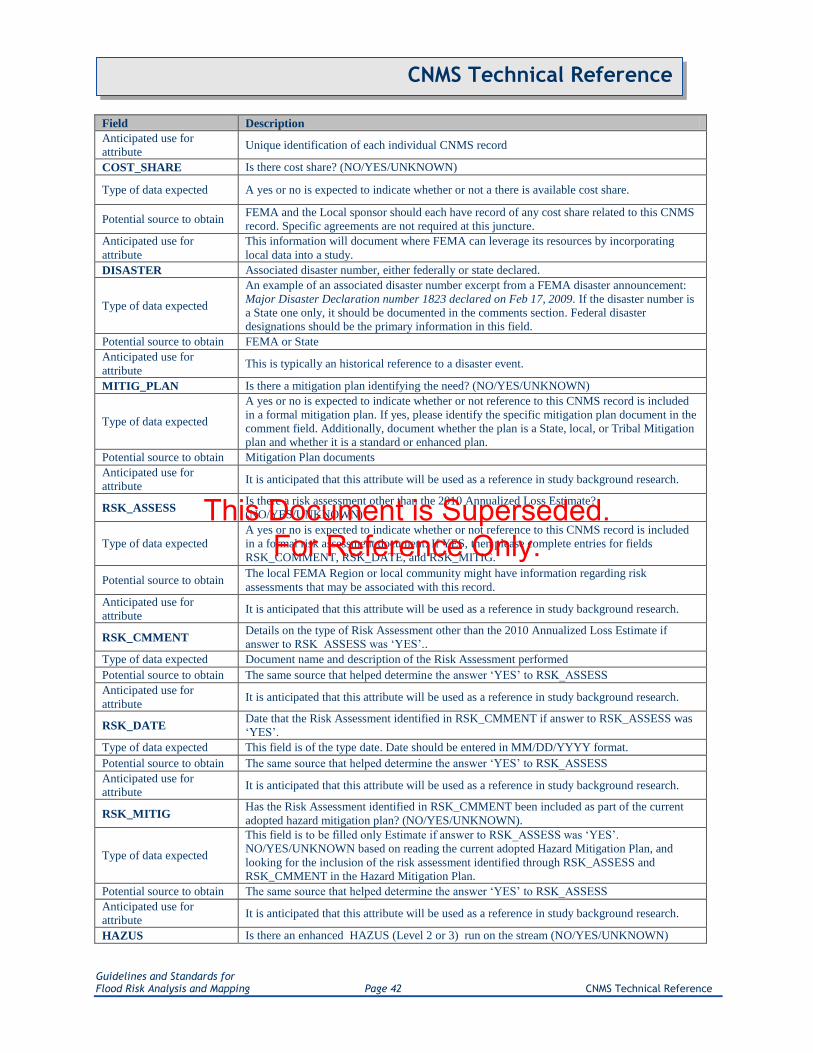
Guidelines and Standards for Flood Risk Analysis and Mapping Page 42 CNMS Technical Reference
CNMS Technical Reference
Field Description
Anticipated use for
attribute Unique identification of each individual CNMS record
COST_SHARE Is there cost share? (NO/YES/UNKNOWN)
Type of data expected A yes or no is expected to indicate whether or not a there is available cost share.
Potential source to obtain FEMA and the Local sponsor should each have record of any cost share related to this CNMS
record. Specific agreements are not required at this juncture.
Anticipated use for
attribute
This information will document where FEMA can leverage its resources by incorporating
local data into a study.
DISASTER Associated disaster number, either federally or state declared.
Type of data expected
An example of an associated disaster number excerpt from a FEMA disaster announcement:
Major Disaster Declaration number 1823 declared on Feb 17, 2009. If the disaster number is
a State one only, it should be documented in the comments section. Federal disaster
designations should be the primary information in this field.
Potential source to obtain FEMA or State
Anticipated use for
attribute This is typically an historical reference to a disaster event.
MITIG_PLAN Is there a mitigation plan identifying the need? (NO/YES/UNKNOWN)
Type of data expected
A yes or no is expected to indicate whether or not reference to this CNMS record is included
in a formal mitigation plan. If yes, please identify the specific mitigation plan document in the
comment field. Additionally, document whether the plan is a State, local, or Tribal Mitigation
plan and whether it is a standard or enhanced plan.
Potential source to obtain Mitigation Plan documents
Anticipated use for
attribute It is anticipated that this attribute will be used as a reference in study background research.
RSK_ASSESS Is there a risk assessment other than the 2010 Annualized Loss Estimate?
(NO/YES/UNKNOWN)
Type of data expected
A yes or no is expected to indicate whether or not reference to this CNMS record is included
in a formal risk assessment document. If YES, then please complete entries for fields
RSK_COMMENT, RSK_DATE, and RSK_MITIG.
Potential source to obtain The local FEMA Region or local community might have information regarding risk
assessments that may be associated with this record.
Anticipated use for
attribute It is anticipated that this attribute will be used as a reference in study background research.
RSK_CMMENT Details on the type of Risk Assessment other than the 2010 Annualized Loss Estimate if
answer to RSK_ASSESS was „YES‟..
Type of data expected Document name and description of the Risk Assessment performed
Potential source to obtain The same source that helped determine the answer „YES‟ to RSK_ASSESS
Anticipated use for
attribute It is anticipated that this attribute will be used as a reference in study background research.
RSK_DATE Date that the Risk Assessment identified in RSK_CMMENT if answer to RSK_ASSESS was
„YES‟.
Type of data expected This field is of the type date. Date should be entered in MM/DD/YYYY format.
Potential source to obtain The same source that helped determine the answer „YES‟ to RSK_ASSESS
Anticipated use for
attribute It is anticipated that this attribute will be used as a reference in study background research.
RSK_MITIG Has the Risk Assessment identified in RSK_CMMENT been included as part of the current
adopted hazard mitigation plan? (NO/YES/UNKNOWN).
Type of data expected
This field is to be filled only Estimate if answer to RSK_ASSESS was „YES‟.
NO/YES/UNKNOWN based on reading the current adopted Hazard Mitigation Plan, and
looking for the inclusion of the risk assessment identified through RSK_ASSESS and
RSK_CMMENT in the Hazard Mitigation Plan.
Potential source to obtain The same source that helped determine the answer „YES‟ to RSK_ASSESS
Anticipated use for
attribute It is anticipated that this attribute will be used as a reference in study background research.
HAZUS Is there an enhanced HAZUS (Level 2 or 3) run on the stream (NO/YES/UNKNOWN)
This Document is Superseded. For Reference Only.

Guidelines and Standards for Flood Risk Analysis and Mapping Page 43 CNMS Technical Reference
CNMS Technical Reference
Field Description
Type of data expected
A yes or no is expected to indicate whether or not loss estimation has been generated for this
study using the Flood Tool within HAZUS-MH. If YES, please identify the location of any
specific HAZUS related outputs in the comment field.
Potential source to obtain The FEMA Region, State or community government, or HAZUS User's Group are three
potential sources for obtaining this information.
Anticipated use for
attribute It is anticipated that this attribute will be used as a reference in study background research.
HAZUS_LVL Level of HAZUS run (System default is „Level 1‟ for Contiguous United States)
Type of data expected
There are three levels of HAZUS modeling runs: Level 1 is the basic level using HAZUS
provided data (FEMA has already run the HAZUS Level 1 modeling for the nation); Level 2
is a run incorporating detailed and updated building stock data; and Level 3 is the most
detailed and user controlled. The type of data expected are indications of whether Levels 2
and 3 have been run.
Potential source to obtain
The organization or individual responsible for initiating the HAZUS study are the most
probable sources for obtaining information related to the level at which a HAZUS run was
developed.
Anticipated use for
attribute It is anticipated that this attribute will be used as a reference in study background research.
COMMENT Additional comments
3.7. County_Status (Table)
The „County_Status‟ table provides status information pertaining to all counties contained within the file
geodatabase. This table provides users with a snap shot of county modernization status, provides an
indicator of whether E Elements should be considered for each county, and is essential for calculation of
NVUE Initiated for counties within certain phases. Sections 3.7.1 – 3.7.4 outlines the updates needed for
the County_Status table at various Risk MAP phases.
Table 3.7.1. County_Status Table (Table ID Code: Not Applicable)
Field Description
CO_FIPS Federal Information Processing Standard code for the county
Type of data expected
Five-digit Federal Information Processing Standard code which uniquely indentifies state
and counties, or the equivalent. The first two digits are the FIPS state code and the last three
are the county code within the state or possession.
Potential source to obtain
Countywide FIRM or FIS; U.S Department of Commerce, Bureau of the Census, Geography
Division is the maintenance agency. Many departments within the U.S. government maintain
references back to this standard. Including the EPA:
http://www.epa.gov/enviro/html/codes/state.html
Anticipated use for attribute Establishes a unique identifier for determining what state and/or county the data resides in.
REGION The FEMA Region into which the County falls.
Type of data expected A value from the list D_REGION
Potential source to obtain This data can readily be found on the web.
Anticipated use for attribute Reference field.
STATE_NAME The state in which the county resides
Type of data expected A value from the list D_STATE
Potential source to obtain This data can be extrapolated from the CO_FIPS, and can readily be found on the web.
Anticipated use for attribute
Reference field. Useful for differentiating between records representing counties with the
same name but in different states in instances where users may not be as familiar with 5 digit
county FIPS codes.
CO_NAME The name of the County represented by this record
Type of data expected Text string.
Potential source to obtain User input.
This Document is Superseded. For Reference Only.

Guidelines and Standards for Flood Risk Analysis and Mapping Page 44 CNMS Technical Reference
CNMS Technical Reference
Field Description
Anticipated use for attribute Reference field. Users are sometimes more comfortable using common names for
geographies rather than referring to them by CO_FIPS
CO_STATUS County Modernization Status
Type of data expected A value from the list D_COSTATUS
Potential source to obtain Current effective county FIRM and FIRM Database data, study managers, RSC tracking
data.
Anticipated use for attribute Determining Inventory status at a glance.
FY_FUNDED When relevant - Attribute of the most recent non-effective FEMA fiscal year funding applied
to stream reach engineering represented in the NVUE_FUNDD field.
Type of data expected Entry from domain lookup table D_FY_FUNDED
Potential source to obtain Scoping data, Preliminary FIS, Study Manager.
Anticipated use for attribute FY projections and trend identification, Calculation of NVUE Initiated.
PRELM_DATE Expected Preliminary issuance date for reaches representing areas being actively studied.
Type of data expected Calendar date (ex. 01/01/10)
Potential source to obtain MIP, other pending guidance.
Anticipated use for attribute Stores the expected Preliminary Date of a study currently in progress.
LFD_DATE Expected Letter of Final Determination issuance date for reaches representing areas being
actively studied.
Type of data expected Calendar date (ex. 01/01/10)
Potential source to obtain MIP, other pending guidance.
Anticipated use for attribute Stores the expected Letter of Final Determination Date of a study currently in progress.
NVUE_FUNDD
Currently funded mileage which will contribute to NVUE, but which has not yet gone
effective. Contributing miles include all New and Updated Study miles anticipated which are
not currently VALID.
Type of data expected Known or estimated mileage value.
Potential source to obtain Scoping or Preliminary data, Study Managers, Regional Service Centers.
Anticipated use for attribute Calculation of NVUE Initiated, particularly in counties for which a mileage has been scoped
for study, but not yet tied to specific reaches.
REPIN_CNMS Indicates whether or not the most current study statuses are representing in CNMS
S_Studies_Ln.
Type of data expected A value from the list D_ELEMENT
Potential source to obtain Scoping or Preliminary data, Study Managers, Regional Service Centers, and GIS Points of
Contact for the Region of interest.
Anticipated use for attribute Determines source of NVUE Initiated miles. See CNMS NVUE Calculation Appendix for
further information.
USE_E_ELEM Indicates whether or not E Elements values should be included in CE and SE totals for
determining Validation Status.
Type of data expected A value from the list D_ELEMENT
Potential source to obtain Determined by Region.
Anticipated use for attribute This field‟s value will directly influence calculation of CE and SE totals, which determine
Validation Status.
CERT_DATE Date which the county successfully passed through the CNMS QC Tool
Type of data expected Calendar date (ex. 01/01/10)
Potential source to obtain This field will be populated by the CNMS QC Tool
Anticipated use for attribute This field will track the most recent data a given county has passed through the automated
QC process.
CERT_ID POC for entity passing the county through the CNMS QC Tool
Type of data expected Existing Point_of_Contact table value
Potential source to obtain This field will be populated by the CNMS QC Tool
Anticipated use for attribute This field will track the POC_ID for the most recent entity to pass the county through the
automated QC process.
This Document is Superseded. For Reference Only.

Guidelines and Standards for Flood Risk Analysis and Mapping Page 45 CNMS Technical Reference
CNMS Technical Reference
3.7.1. County_Status Discovery and Scoping Phase Updates
In instances where study mileage has been scoped and funded, ongoing study characteristics should be
correctly depicted in this table. It is especially important that these updates be made in instances where
scope has not yet been tied to specific reaches.
Field Description
FY_FUNDED Update to indicate fiscal year mileage depicted in NVUE_FUNDED
was funded
PRELM_DATE Update with accurate Preliminary issuance date estimate
LFD_DATE Update with accurate LFD issuance date estimate
NVUE_FUNDED
Indicate total NVUE miles purchased through ongoing studies. Only
ongoing study miles which are New or Updated, which were not
previously VALID should be listed here.
REPIN_CNMS Indicate whether or not S_Studies_Ln has been updated to represent
latest state, inlcuding NVUE purchases indicated in NVUE_FUNDD.
3.7.2. County_Status FIRM Production Phase Update
Throughout the production phase, it is important that the PRELM_DATE and LFD_DATE fields be kept
current. Should scope of work be altered in any way such that the estimated NVUE mileage purchase
changes, the NVUE_FUNDED field should be updated. As soon as the latest state, including NVUE
purchase miles depicted in NVUE_FUNDED, is represented in S_Studies_Ln, REPIN_CNMS should be
set to yes.
3.7.3. County_Status Preliminary Issuance Phase Update
At Preliminary issuance, all fields attributed through Discovery and Scoping Phase Updates should be
checked for accuracy and updated as appropriate.
Field Preliminary Issuance Phase Updates
PRELM_DATE Update with actual Preliminary issuance date.
LFD_DATE Update with accurate LFD issuance date estimate.
3.7.4. County_Status LFD Issuance Phase Update
At LFD issuance, existing values should be updated, replaced with actual known values, or removed as
indicated below.
This Document is Superseded. For Reference Only.

Guidelines and Standards for Flood Risk Analysis and Mapping Page 46 CNMS Technical Reference
CNMS Technical Reference
Field Description
CO_STATUS Update to indicate the current status of the county as a result of the recent
study.
PRELM_DATE Update with accurate Preliminary issuance date estimate. This value can remain
in the table.
LFD_DATE Update with actual LFD issuance date. This value can remain in the table.
NVUE_FUNDED This field should be cleared / set to NULL
REPIN_CNMS Indicate whether or not S_Studies_Ln has been updated to represent latest state,
inlcuding NVUE purchases indicated in NVUE_FUNDD.
3.8. Point_of_Contact (Table)
Table 3.8.1. Point_of_Contact (Table ID Code: 05)
Field Description
POC_ID Primary key for table. Assigned by record creator or user
Type of data expected As the Primary key for this table this field must exist as a unique identifier for each
individual record.
Potential source to obtain
A programmatic approach that prefixes 5 record counting digits with the 5 digit County FIPS
code followed by the table ID 05 produces a number like 201190500001 (20119 is the
county FIPS code, 05 is a table ID to separate from „CNMS_IDs‟ used on the 4 FCs, and
00001 represents record counting digits) for the first POC record in Meade County, Kansas.
Unique identifier obtained from National CNMS viewing solution.
Anticipated use for attribute Unique identification of each individual CNMS POC record
POC_NAME Given name of the point of contact knowledgeable of CNMS record
Type of data expected Free text entry of point of contact‟s name
Potential source to obtain Presumably a person connected to the identification of a CNMS record
Anticipated use for attribute Information is used to identify the name of the POC for each CNMS data entry.
POC_TITLE Any title associated with the point of contract
Type of data expected Free text entry of the position held by the POC at his/her organization
Potential source to obtain
Normally, this information should be readily available to the person making the CNMS
entry. Otherwise, it can be looked up on government websites (if POC works for public
agency) or corporate websites (if POC works for private sector).
Anticipated use for attribute
This information can be used to identify the position of the POC within an organization.
Should the POC move on to a new position, this information can be used to identify the
appropriate new POC for a CNMS data entry.
POC_DESCRIPTION Information regarding the role and responsibilities of the point of contact
Type of data expected Free text entry of the job functions of a POC
Potential source to obtain
Normally, this information should be readily available to the person making the CNMS
entry. Otherwise, it can be looked up on government websites (if POC works for public
agency) or corporate websites (if POC works for private sector).
Anticipated use for attribute This field provides additional information about the job functions of a POC as they relate to
the CNMS project need/request.
ORG_NAME The name of the owner, or managing government agency, of the subject item
Type of data expected Free text entry of the name of the organization
Potential source to obtain Normally, this information should be readily available to the person making the CNMS
entry. Otherwise, it can be looked up on government websites (if POC works for public
This Document is Superseded. For Reference Only.

Guidelines and Standards for Flood Risk Analysis and Mapping Page 47 CNMS Technical Reference
CNMS Technical Reference
Field Description
agency) or corporate websites (if POC works for private sector).
Anticipated use for attribute Information can be used for correspondence with the POC.
ORG_TYPE A code that represents a kind of organization
Type of data expected The predefined acceptable values are to be selected from the „D_Org_Type‟ domain list.
Potential source to obtain
Normally, this information should be readily available to the person making the CNMS
entry. Otherwise, it can be looked up on government websites (if POC works for public
agency) or corporate websites (if POC works for private sector).
Anticipated use for attribute Information can be used to determine the source of the CNMS need/request (e.g. initiated by
public agency vs. private sector, etc.).
BUSINESS_PHONE The business telephone number of the contact person
Type of data expected Free text entry of 10-digit phone number
Potential source to obtain Information can be obtained from government websites (if POC works for public agency) or
corporate websites (if POC works for private sector).
Anticipated use for attribute Correspondence and communications with the POC regarding the CNMS entry
MOBILE_PHONE The cellular phone number of the contact person
Type of data expected Free text entry of 10-digit phone number
Potential source to obtain Information can be obtained from government websites (if POC works for public agency) or
corporate websites (if POC works for private sector).
Anticipated use for attribute Correspondence and communications with the POC regarding the CNMS entry
FAX_PHONE The fax number of the contact person
Type of data expected Free text entry of 10-digit fax number
Potential source to obtain Information can be obtained from government websites (if POC works for public agency) or
corporate websites (if POC works for private sector).
Anticipated use for attribute Correspondence and communications with the POC regarding the CNMS entry
ADDRESS_1 The first line of the point of contact's address
Type of data expected Free text entry of POC‟s address
Potential source to obtain Information can be obtained from government websites (if POC works for public agency) or
corporate websites (if POC works for private sector).
Anticipated use for attribute Correspondence and communications with the POC regarding the CNMS entry
ADDRESS_2 The second line of the point of contact's address
Type of data expected Free text entry of POC‟s address, if applicable
Potential source to obtain Information can be obtained from government websites (if POC works for public agency) or
corporate websites (if POC works for private sector).
Anticipated use for attribute Correspondence and communications with the POC regarding the CNMS entry
CITY_NAME The city or town in which the contact person's address is located
Type of data expected Free text entry of city name in which organization resides
Potential source to obtain Information can be obtained from government websites (if POC works for public agency) or
corporate websites (if POC works for private sector).
Anticipated use for attribute Correspondence and communications with the POC regarding the CNMS entry
STATE The name of the State in which the contact person's address is located
Type of data expected Free text entry of state name in which organization resides
Potential source to obtain Information can be obtained from government websites (if POC works for public agency) or
corporate websites (if POC works for private sector).
Anticipated use for attribute Correspondence and communications with the POC regarding the CNMS entry
ZIP_CODE The Zip Code of the contact person's address
Type of data expected Free text entry of 5- or 9-digit zip code for the organization
Potential source to obtain Information can be obtained from government websites (if POC works for public agency) or
corporate websites (if POC works for private sector).
Anticipated use for attribute Correspondence and communications with the POC regarding the CNMS entry
This Document is Superseded. For Reference Only.

Guidelines and Standards for Flood Risk Analysis and Mapping Page 48 CNMS Technical Reference
CNMS Technical Reference
Field Description
COUNTY The county name
Type of data expected Free text entry of county name in which organization resides
Potential source to obtain Information can be obtained from government websites (if POC works for public agency) or
corporate websites (if POC works for private sector).
Anticipated use for attribute Correspondence and communications with the POC regarding the CNMS entry
EMAIL_ADDRESS Electronic mail address
Type of data expected Free text entry of standard email address of POC
Potential source to obtain Information can be obtained from government websites (if POC works for public agency) or
corporate websites (if POC works for private sector).
Anticipated use for attribute Correspondence and communications with the POC regarding the CNMS entry
COMMENT Additional comments
This Document is Superseded. For Reference Only.

Guidelines and Standards for Flood Risk Analysis and Mapping Page 49 CNMS Technical Reference
CNMS Technical Reference
Appendix A. Validation Checklist
The central purpose of the Validation Checklist (Table A.2) is to outline the information that must be
captured to document a condition assessment as being a VALID or UNVERIFIED flood study. Any
UNVERIFIED flood study, or a CNMS Request Record, will warrant a review for inclusion in the map
production planning process. For existing floodplain studies, this review will be triggered when one
critical or four or more secondary change characteristics have been identified to mark the study as having
an UNVERIFIED Validation Status. However, if a severe secondary change conditions exist, such as a
high number of new or removed bridges and culverts, they can be elevated and considered critical. The
decision to elevate a secondary change condition to critical is subjective and the responsibility for doing
so rests solely with those making decisions on map update investments. Section 3.2 outlines how user
defined critical and secondary elements can be defined for capturing non-standard issue types. Such user
defined elements should be leveraged with permission from the respective FEMA Regional Office. Based
on the Validation Checklist, if the validation evaluation identifies no critical elements and less than four
secondary elements for a stream segment flood study are flagged as condition changes, the engineering
analysis is considered VALID
In summary:
A floodplain study is assigned a VALID Validation Status if zero critical and fewer than
four secondary change conditions have been flagged.
A floodplain study is assigned the UNVERIFIED Validation Status if it has at least one
critical, or four or more secondary change conditions have been flagged.
When a CNMS study record is checked out for evaluation, or when a CNMS evaluation is
planned or in queue, the Validation Status is set to UNKNOWN.
If a detailed evaluation based on the Validation Checklist does not lead to a definitive
determination of the validity, the UNKNOWN Validation Status is applied to the study.
If there is a need for re-visiting the validation process as a result of statutory requirements
or availability of new data, the Validation Status for all affected studies will be toggled to
UNKNOWN. This review process is also triggered 5 years after the initial determination of
the Validation Status when the evaluation is considered outdated. Such studies are queued
up for a CNMS evaluation based on current conditions.
If a flooding source centerline in an unmapped area is considered for a new study, a
Validation Status of ASSESSED is assigned to indicate that the stream has been assessed
for a new study. The outcome of such consideration may be that resources are allocated in
the current or future FY, or that the request for new study has been deferred.
Validity of approximate studies is to be assessed using the Validation Checklist to the greatest extent
possible. It may not be appropriate to utilize the entire Validation Checklist for effective approximate
studies unless the technical data, methodology, and basis for the study are known. Therefore, for
approximate engineering studies, the Validation Checklist should be used to the extent possible and
This Document is Superseded. For Reference Only.

Guidelines and Standards for Flood Risk Analysis and Mapping Page 50 CNMS Technical Reference
CNMS Technical Reference
practical without far exceeding expected costs. The FEMA Regional office can provide guidance to
Mapping Ppartners to ensure this is met. Regional Offices should also leverage the 2012 National Urban
Change Indicator dataset when evaluating Approximate Studies. For an approximate analysis to be
categorized as a „Valid‟ study, FEMA must have determined the approximate floodplains utilizing
engineering methods and/or technical data.
The flow chart diagram included in Appendix E is a graphical overview of the study flow process
including decision trees that result in one of the four Validation Status classifications. Within the CNMS
data model, each of these four Validation Status classes is further categorized by different Status Types.
Status Types are tracked using the STATUS_TYPE field in the CNMS data model. Table 1 summarizes
the different Status Types for each of the four possible Validation Status scenarios. Each possible
Validation Status and Status Type is further described below.
UNKNOWN Validation Status
CNMS Study Records are initially given the Validation Status of UNKNOWN and status type of TO BE
ASSESSED when the FEMA Regional Office has not yet evaluated the CNMS Study Record to provide
input on either deferring or performing a CNMS evaluation. A BEING ASSESSED status type is
assigned when Regional allocation to fund CNMS evaluation is established. The UNKNOWN Validation
Status may also have a DEFERRED status type where the validity remains unknown after Phase III
evaluation or the Region has determined the study to be low priority and CNMS evaluation is deferred.
The option to defer an assessment for 5 years must be held to a minimum and requires discussion with
FEMA Headquarters during each FY production planning process.
UNVERIFIED Validation Status
CNMS Study Records categorized as UNVERIFIED may have one of two status types depending upon
whether resources can be allocated for a restudy in the current or future fiscal year. UNVERIFIED studies
currently being studied or that have been allocated funding for the current fiscal year are given the status
type BEING STUDIED. UNVERIFIED Studies that need to be addressed and are planned for a future FY
will have the status type as TO BE STUDIED.
VALID Validation Status
CNMS Study Records are categorized as VALID when a new or updated study is performed, or stream
reach level validation was completed, and the study validation checklist contains no critical, and less than
four secondary elements flagged during evaluation. These records will have the status type NVUE
COMPLIANT and be monitored for re-evaluation every five years. All newly studied or restudied
streams classified as VALID will be reclassified as UNKNOWN with a Status Type of TO BE
ASSESSED after five years.
ASSESSED Validation Status
The ASSESSED Validation Status is for unmapped streams that have been added into the CNMS
Inventory. The status type assigned to these streams depends upon if or when funding will be allocated by
FEMA to conduct a study. Unmapped streams that are currently being studied or planned for the current
FY, will be assigned BEING STUDIED status type. Unmapped streams with studies planned for a future
FY will be assigned a status type of TO BE STUDIED. Finally, unmapped streams that the Region
determines should not be studied will be assigned the status type DEFERRED.
This Document is Superseded. For Reference Only.

Guidelines and Standards for Flood Risk Analysis and Mapping Page 51 CNMS Technical Reference
CNMS Technical Reference
The Validation Checklist (Table A.2) presents detailed definitions for the critical elements and secondary
elements, and is intended to be used as a tool to assist in gathering information necessary to determine the
Validation Status. Information gathered while using the Validation Checklist below to evaluate flooding
sources and associated studies will translate into a CNMS Study Record entry in the S_Studies_Ln feature
class. Feature Attribution policies are identified in Section 3.2. Other methods, not represented in the
validation checklist, may be available and necessary to complete study validation and not all data and
intelligence gathered for any validation exercise will find a place in the CNMS Studies Feature Dataset.
To aid record keeping, a sample template of a Validation Process Documentation Checksheet with an
example CNMS Study Record will be provided electronically with this document. Appendix B lays out
minimum requirements for Validation Process Documentation that must be consulted over and above the
use of the Validation Checklist. The abovementioned template is only one way to document
methodologies used to make validation decisions. Other methods may be used to track decisions made, but
must contain the fields suggested in the template at the least.
Some examples of conditions that users might identify and enter into CNMS, after passing them through
the validation checklist, include the following:
Flood zones that have been affected by development since the date of the effective FIRM
Inadequate flood hazard engineering data in areas with planned development/anticipated growth
(i.e., areas that currently reflect approximate flood hazard analyses yet have been slated for
upgraded analyses given flood hazard data validation efforts)
Stream reaches requiring restudy because the methodologies used do not produce results that
comply with quality standards.
This Document is Superseded. For Reference Only.

Guidelines and Standards for Flood Risk Analysis and Mapping Page 52 CNMS Technical Reference
CNMS Technical Reference
Table A.1. Validation Status Type Descriptions
Validation
status Status Type Description
UNKNOWN
TO BE ASSESSED Requires Regional input to either defer or perform a
CNMS stream reach level validation.
BEING ASSESSED Studies currently being assessed per CNMS stream
reach level validation described in this document
DEFERRED
Areas that will not be evaluated per CNMS stream
reach level validation. Typically low risk areas. These
stream reaches will be reconsidered in five years.
BEING STUDIED
Streams are currently being studied or have been
allocated funding for the current FY captured during
the Discovery process.
UNVERIFIED
TO BE STUDIED Streams that need to be studied and are planned for a
future FY
BEING STUDIED
Streams are currently being studied or have been
allocated funding for the current FY captured during
the Discovery process.
VALID
NVUE COMPLIANT New study performed or study passes stream reach
level validation
BEING STUDIED
Streams are currently being studied or have been
allocated funding for the current FY captured during
the Discovery process.
ASSESSED
TO BE STUDIED Unmapped streams prioritized to be mapped with an
SFHA
BEING STUDIED Unmapped streams that are currently being studied or
have been allocated funding for the current FY.
DEFERRED Unmapped streams investigated to be mapped with an
SFHA, but analysis resulted in low priority study
This Document is Superseded. For Reference Only.

Guidelines and Standards for Flood Risk Analysis and Mapping Page 53 CNMS Technical Reference
CNMS Technical Reference
Table A.2. VALIDATION CHECKLIST
Background Information
Name of Flooding Source:
Date of Effective Analysis:
Determine from effective FIS the most recent date engineering for a flood hazard was updated. .This is the date of the underlying engineering of the
effective FIRM.
Hydrologic Model Used:
Determine from effective FIS or other source the model (or method) used in the effective engineering.
Hydraulic Model Used and version (if applicable):
Determine from effective FIS or other source model (or method) used in the effective engineering.
Are the models in digital format? If so, can you run the model?
Determine whether the models are in digital format, and if they can be run.
It is suggested that the location of the model be recorded with a description of the amount of effort it will take to prepare the model for a run.
Changes in Physical, Climate, and Engineering Methodologies since Date of Effective Analysis
CRITICAL ELEMENTS
(C1) Major change in gage record since effective analysis that includes major flood events
Determine if USGS gage is on stream.
If yes, record the gage Site No. and Site Name from the gages shapefile (add record in external table joined to CNMS database via REACH_ID as
necessary).
Determine if a major flood event has occurred since the effective analysis. If yes, this Critical Element set to ”YES” and you don‟t have to further evaluate
gage records.
(C2) Updated and effective peak discharges differ significantly based on confidence limits criteria in FEMA‟s G&S
Determine if USGS gage is on stream.
If yes, record the gage Site No. and Site Name from the gages shapefile (add record in external table joined to CNMS database via REACH_ID as
necessary).
Compare years of record from effective FIS to years of record now available.
If newer records are available for gage, , record the gage Site No. and Site Name as above.
Determine if 100-yr discharge obtained by running PeakFQ at effective date is still within 68% confidence interval of the Bulletin 17B 100-yr estimate
using updated gage data and PeakFQ. If not, Critical Element is set to “YES”.
(C3) Model methodology no longer appropriate based on Guidelines and Specifications (i.e one-dimensional vs. two-dimensional modeling; Coastal Guidelines)
This element scrutinizes underlying model methods, rather than modeling software or versions of software.
If effective model methodology is found inappropriate based upon G&S, Critical Element is set to “YES”.
(C4) Addition/removal of a major flood control structure
Determine if dam or reservoir, has been added or removed since the effective analysis.
Determine if new/removed levee or seawall, has occurred since the effective analysis.
Determine if levee or seawall‟s current accreditation status is reflected in the effective analysis.
(C5) Current channel reconfiguration outside effective SFHA
Compare extents of effective SFHA with channel as shown on latest available aerial imagery.
If channel reconfiguration has occurred, Critical Element is set to “YES”.
o Some instances of channel outside of SFHA may be minor natural occurrences, and categorized as requests for mapping updates.
(C6) Five or more new or removed hydraulic structures (bridge/culvert) that impact BFEs
Compare effective mapping and profile to latest available imagery and GIS data.
If five or more new or removed hydraulic structures exist along reach, Critical Element is set to “YES”.
(C7) Significant channel fill or scour
If hydraulically significant fill or scour occurs along stream reach, Critical Element is set to "YES".
SECONDARY ELEMENTS
(S1) Use of rural regression equations in urbanized areas
Determine if rural regression equations were used in an urbanized basin, or if land use has changed from rural to urban since the effective analysis.
(S2) Repetitive losses outside the SFHA
If repetitive loss data is available/accessible, overlay Repetitive Loss spatial dataset with SFHA.
If there are any structures outside of the SFHA for that reach, then you have Repetitive Loss outside of SFHA.
o Instances of repetitive losses caused by local drainage issues, rather than the subject flooding source should not be considered.
(S3) Increase in impervious area in the sub-basin of more than 50 percent (i.e., 10 percent to 15 percent, 20 percent to 30 percent, etc.)
Determine increase of impervious area that has occurred since the effective analysis.
If impervious area has increased by 50% or more, Secondary Element is set to “YES”.
o Consider also meeting minimum impervious threshold to fail element. Consult State‟s regression equations.
(S4) One to four new or removed hydraulic structure (bridge/culvert) that impact BFEs
Compare effective mapping and profile to latest available imagery and GIS data.
If one to four new or removed hydraulic structures exist along reach, Secondary Element is set to “YES”.
(S5) Channel improvements / Shoreline changes
Isolated to channel improvements only; shoreline assessed through coastal CNMS.
Determine whether channel improvements have occurred since the effective analysis. This can consist of straightening, rerouting, concrete lining, rip-rap.
(S6) Availability of better topography/bathymetry
Determine if topo with better resolution and/or being newer than topo used for study exists.
When assessing for redelineated streams, account for topo used during redelineation.
(S7) Changes to vegetation or land use
Determine whether significant vegetation or land use changes have occurred in the drainage area since the effective analysis.
Possible sources include USGS NLCD datasets and any datasets showing large scale landuse changes.
(S8) Failure to identify primary frontal dune in coastal areas
Shoreline assessed through coastal CNMS only.
(S9) Significant storms with High Water Marks
Determine if HWMs have been recorded on flooding source since the effective analysis.
(S10) New regression equations
If regression equations were used in the effective analysis and new equations now exist, set the Secondary Element to “YES”.
This Document is Superseded. For Reference Only.

Guidelines and Standards for Flood Risk Analysis and Mapping Page 54 CNMS Technical Reference
CNMS Technical Reference
Appendix B. Validation Process Documentation Validation process documentation is necessary to ensure that the flooding source being evaluated has a
record of the criteria evaluated, and the data used in the evaluation of those criteria. Summaries of the
background information used to evaluate the criteria should be submitted as part of the CNMS data roll-
up sent to the FEMA regional offices. These summaries will be referred to if FEMA ever has questions
about the validity of methods used to evaluate criteria. Either in the format of the Validation Checklist, or
in the format suggested in the sample template provided electronically with this user guide, the user
should maintain current and accurate records that explicitly describe how the criteria were evaluated
along with a list of the source and location of the data used in that evaluation. Source data should be
documented outlining originator, location (URL, local drives), digital availability, and whether it can be
shared or distributed. Data that has been processed such that it cannot be recreated in a reasonable amount
of time from source data, or was manipulated once obtained from source, should be stored by its creator.
The need of the user to maintain records is important as the deliverable is subject to scrutiny. The first
query under any scrutiny will be on the Validation Checklist entries used for the flooding source. This
will be a summary level document that could be retrieved from Regional Offices and answer most, if not
all, questions in regards to the decisions that went into the evaluation of the flooding source and its
criteria. In extreme circumstances, a second query will be to provide either the unmodified source data
evaluated, or the modified data in cases where the source data was manipulated.
To aid in record keeping in a searchable format and linked to the CNMS Database, a sample template of a
„Validation Process Documentation Checksheet‟ with an example CNMS Study Record is provided
electronically with this document. The template is only one way to document methodologies used to make
validation decisions. Other methods, including making customized Validation Checklists for each study
reach evaluated, may be used to track decisions made. However, these alternate methods must track the
information suggested in the template at the least.
Electronic attachment to Appendix B:
CNMS_Sample_Validation_Process_Documentation_Checksheet_V1.0.xls
This Document is Superseded. For Reference Only.

Guidelines and Standards for Flood Risk Analysis and Mapping Page 55 CNMS Technical Reference
CNMS Technical Reference
Appendix C. CNMS Data Model
This Document is Superseded. For Reference Only.

Guidelines and Standards for Flood Risk Analysis and Mapping Page 56 CNMS Technical Reference
CNMS Technical Reference
Appendix D. CNMS Data Dictionary
S_Studies_Ln Feature Class (polyline)
Field Type Length Required Domain Table Description
REACH_ID Text 12 Yes Primary key for table, assigned by
table creator
STUDY_ID Text 12 No
CO_FIPS Text 12 Yes Federal Information Processing
Standard code (FIPS code)
CID Text 12 Yes FEMA Community ID
WATER_NAME Text 50 No Name of flooding source
WATER_NA_1 Text 50 No Alternate name of flooding source
FLD_ZONE Text 50 Yes D_ZONE SFHA type the polyline represents
(ex. ZONE AE, ZONE A)
VALIDATION_STATUS Text 50 Yes D_VALID_CAT
This attribute establishes the
latest evaluation condition of a
flooding source centerline in
relation to the criteria set forth
in the CNMS Technical
Reference, any procedure
memorandums, or previous
work.
STATUS_TYPE Text 100 Yes D_STATUS_TYPE
This attribute establishes the
sub-categories for each of the
Validation Status classes of a
flooding source centerline in
relation to the criteria set forth
in the CNMS Technical
Reference, any procedure
memorandums, or previous
work.
MILES number
(double) 8 Yes
An attribute of the calculated
miles of the data record entry
SOURCE Text 100 Yes D_SOURCE Source of polyline segment
represented in the inventory
STATUS_DATE Date 8 Yes
Date when CNMS stream
reach validation is completed
or a validation assessment of
the stream reach has been
made. UNVERIFIED records
will have the date the CNMS
evaluation triggered the
UNVERIFIED status. If an
unverified study becomes
VALID, the date of the status
change is recorded.
FY_FUNDED Text 25
Yes for studies in
progress for which a
Preliminary FIRM has not been issued and if
retrievable from MIP
Case Number or RSC
D_FY_FUNDED
Attribute of the most recent
FEMA fiscal year funding applied to the stream reach (ex. watershed,
county)
This Document is Superseded. For Reference Only.

Guidelines and Standards for Flood Risk Analysis and Mapping Page 57 CNMS Technical Reference
CNMS Technical Reference
Management.
REASON Text 255
Attribute allows for user input of
detailed description of considerations or special
circumstances when determining
attributes VALIDATION_STATUS,
SOURCE, or any pertinent
information in the data creation process.
HUC8_KEY number
(double) 8 Yes
8-digit Hydrologic Unit Code
(HUC) representing the smallest watersheds knows as hydrologic
cataloging units. This can be
obtained by overlaying the HUC spatial files with the polyline
information to determine which
cataloging unit the polyline resides in.
STUDY_TYPE Text 40 Yes D_STUDY_TYPE
Study type of the SFHA
represented by the polygon
based on the current effective,
preliminary, or draft FIS text.
FBS_CMPLNT Short Yes D_ELEMENT
Indicator of FBS compliance for
the floodplain represented by the line feature
FBS_CHKDT Date Yes Date the FBS_CMPLNT field
value was most recently populated
FBS_CTYP Text 50 Yes D_FBS_CTYPE FBS Compliance Check Type
LINE_TYPE Text 40 Yes D_LINE_TYPE
Attribute provides description of flooding source line type as being
RIVERINE, LAKE, POND,
PLAYA, PONDING, or OTHER.
DUPLICATE Text 20
Yes if stream reach has
2 lines representing 2
different studies for the same reach extent.
D_DUPLICATE
Is there a second line
representing an SFHA across a
political boundary, for a
second study on the same
extent of the reach?
(CATEGORY 1,
CATEGORY 2, or
CATEGORY 3)
POC_ID Text 20
Yes if POC table is
populated for
associated record
Foreign key to join to
Point_of_Contact table. ID for
Point of Contact.
DATE_RQST Date
Yes if
Validation_Status is
set to UNVERIFIED
Date request is made
DATE_EFFCT Date Yes Date of effective analysis
This Document is Superseded. For Reference Only.

Guidelines and Standards for Flood Risk Analysis and Mapping Page 58 CNMS Technical Reference
CNMS Technical Reference
HYDRO_MDL Text 100 Yes (if applicable) Hydrologic model used
HYDRA_MDL Text 100 Yes (if applicable) Hydraulic model used
HODIGFMT Short Yes if HODIGFMT =
„YES‟ D_ELEMENT
Is the Hydrologic model in
digital format?
(NO/YES/UNKNOWN)
HADIGFMT Short Yes if HADIGFMT =
„YES‟ D_ELEMENT
Is the Hydraulic model in
digital format?
(NO/YES/UNKNOWN)
HO_RUNMOD Short
Yes if
HO_RUNMOD =
„YES‟
D_ELEMENT
Can the Hydrologic digital
model be run?
(NO/YES/UNKNOWN)
HA_RUNMOD Short
Yes if
HA_RUNMOD =
„YES‟
D_ELEMENT
Can the Hydraulic digital
model be run?
(NO/YES/UNKNOWN)
C1_GAGE Short Yes D_ELEMENT
Critical Element 1, Change in
gage record. Major change in
gage record since effective
analysis that includes major
flood events?
(NO/YES/UNKNOWN)
C2_DISCH Short Yes D_ELEMENT
Critical Element 2, Change in
Discharge. Updated and
effective peak discharges
differ significantly based on
confidence limits criteria in
FEMA's G&S?
(NO/YES/UNKNOWN)
C3_MODEL Short Yes D_ELEMENT
Critical Element 3, Model
methodology. Model
methodology no longer
appropriate based on
Guidelines and Specifications
(i.e. one-dimensional vs. two-
dimensional modeling;
Coastal Guidelines)?
(NO/YES/UNKNOWN)
C4_FCSTR Short Yes D_ELEMENT
Critical Element 4, Hydraulic
Change. Addition/removal of
a major flood control structure
(i.e., certified levee or seawall,
reservoir with more than 50
acre-ft storage per square
mile)?
(NO/YES/UNKNOWN)
C5_CHANN Short Yes D_ELEMENT
Critical Element 5, Channel
Reconfiguration. Current
channel reconfiguration
outside effective SFHA?
(NO/YES/UNKNOWN)
This Document is Superseded. For Reference Only.

Guidelines and Standards for Flood Risk Analysis and Mapping Page 59 CNMS Technical Reference
CNMS Technical Reference
C6_HSTR Short Yes D_ELEMENT
Critical Element 6, Hydraulic
Change 2. 5 or more new or
removed hydraulic structures
(bridge/culvert) that impact
BFEs?
(NO/YES/UNKNOWN)
C7_SCOUR Short Yes D_ELEMENT
Critical Element 7, Channel
Area Change. Significant
channel fill or scour?
(NO/YES/UNKNOWN)
S1_REGEQ Short Yes D_ELEMENT
Secondary Element 1,
Regression Equation. Use of
rural regression equations in
urbanized areas?
(NO/YES/UNKNOWN)
S2_REPLO Short Yes D_ELEMENT
Secondary Element 2,
Repetitive Loss. Repetitive
losses outside the SFHA?
(NO/YES/UNKNOWN)
S3_IMPAR Short Yes D_ELEMENT
Secondary Element 3,
Impervious Area. Increase in
impervious area in the sub-
basin of more than 50 percent
(i.e., 10 percent to 15 percent,
20 percent to 30 percent, etc.)?
(NO/YES/UNKNOWN)
S4_HSTR Short Yes D_ELEMENT
Secondary Element 4,
Hydraulic Structure. More
than 1 and less than 5 new or
removed hydraulic structures
(bridge/culvert) impacting
BFEs?
(NO/YES/UNKNOWN)
S5_CHIMP Short Yes D_ELEMENT
Secondary Element 5, Channel
Improvements. Channel
improvements / Shoreline
changes?
(NO/YES/UNKNOWN)
S6_TOPO Short Yes D_ELEMENT
Secondary Element 6,
Topography Data. Availability
of better
topography/bathymetry?
(NO/YES/UNKNOWN)
S7_VEGLU Short Yes D_ELEMENT
Secondary Element 7,
Vegetation or Land Use.
Changes to vegetation or land
use? (NO/YES/UNKNOWN)
S8_DUNE Short Yes D_ELEMENT
Secondary Element 8, Coastal
Dune. Failure to identify
primary frontal dune in coastal
areas?
(NO/YES/UNKNOWN)
S9_HWMS Short Yes D_ELEMENT
Secondary Element 9, High
Water Mark. Significant
storms with High Water
Marks.
(YES/NO/UNKNOWN)
This Document is Superseded. For Reference Only.

Guidelines and Standards for Flood Risk Analysis and Mapping Page 60 CNMS Technical Reference
CNMS Technical Reference
S10_REGEQ Short Yes D_ELEMENT
Secondary Element 10,
Regression Equation. New
Regression Equations
Available?
(NO/YES/UNKNOWN)
CE_TOTAL Short Yes Total number of critical
elements
SE_TOTAL Short Yes Total number of secondary
elements
COMMENT Text 255 No Additional comments
BS_ZONE Text 60
Yes, if reach
represents the extents
of an ongoing funded
study
D_ZONE
Zone type of the SFHA
represented by the reach
currently being studied based
on scoping data, or the
preliminary FIS text.
BS_STDYTYP Text 255
Yes, if reach
represents the extents
of an ongoing funded
study
D_STUDY_TYPE
Study type of the SFHA
represented by the reach
currently being studied based
on scoping data, or the
preliminary FIS text.
BS_HYDRO_M Text 100 No D_HYDRO
Hydrologic model used for
creating the SFHA represented
by the reach currently being
studied based on scoping data
or the preliminary FIS text.
BS_HYDRA_M Text 100 No D_HYDRA
Hydraulic model used for
creating the SFHA represented
by the reach currently being
studied based on scoping data
or the preliminary FIS text.
BS_FY_FUND Text 4
Yes, if reach
represents the extents
of an ongoing funded
study
D_FY_FUNDED
When relevant - Attribute of
the most recent non-effective
FEMA fiscal year funding
applied to the stream reach
engineering at the time of
study (ex. Watershed, county)
PRELM_DATE Date
Yes, if reach
represents the extents
of an ongoing funded
study
Expected Preliminary issuance
date for reaches representing
areas being actively studied.
LFD_DATE Date
Yes, if reach
represents the extents
of an ongoing funded
study
Expected Letter of Final
Determination issuance date
for reaches representing areas
being actively studied.
EC1_UDEF Short No D_ELEMENT User Defined Critical
Element 1
EC2_UDEF Short No D_ELEMENT User Defined Critical
Element 2
ES1_UDEF Short No D_ELEMENT User Defined Secondary
Element 1
ES2_UDEF Short No D_ELEMENT User Defined Secondary
Element 2
ES3_UDEF Short No D_ELEMENT User Defined Secondary
Element 3
ES4_UDEF Short No D_ELEMENT User Defined Secondary
Element 4
This Document is Superseded. For Reference Only.

Guidelines and Standards for Flood Risk Analysis and Mapping Page 61 CNMS Technical Reference
CNMS Technical Reference
E_ELEMDATE Date
Yes, if the E
Elements are non
<NULL>
The date on which the User
Defined Element values were
populated
‘S_Requests’ Feature Classes (Point/Polygon)
Field Type Length Required Domain Table Description
SRA_ID / SRP_ID Text 12 Yes Primary key for table,
assigned by table creator
REACH_ID Text 12
Yes, if there is a
1-1 or 1-many
relationship
between
S_Studies_Ln and
S_Requests feature
(s)
Foreign key for table. Primary
Key for S_Studies_Ln.
WTR_NM Text 100 Yes Name of flooding source
POC_ID Text 20 Yes
Foreign key to join to
Point_of_Contact table. ID for
Point of Contact.
RQST_CAT 30 Yes D_RQST_CAT
Distinction between
Cartographic and Flood Data
requests
RQST_LVL Text 30 Yes D_RQST_LVL Level of analysis requested
MTHOD_TYPE Text 20 Yes D_MTHOD_TYPE Type of method requested to
make FIRM improvement
DATE_RQST Date Yes Date request is made
DATE_RESOL Date Yes Date request is resolved
CARTO_RQST Text 50
Yes if RQST_CAT
is
CARTOGRAPHIC
D_CARTO_RQST Type of cartographic change
requested
FDATA_RQST Text 50 Yes if RQST_CAT
is FLOOD DATA D_FDATA_RQST
Type of flood data change
requested
RESOL_STATUS Text 50 No D_RESOL_STATUS Current resolution status for
the requested action
COMMENT Text 255 No Description of request
PRIORITY Text 20 Yes D_PRIORITY
Priority of request from
originator of CNMS Request
record.
DATE_REVIEW Date No
Date FEMA has reviewed
incoming request and
authorized its inclusion in the
database
‘S_UnMapped_Ln’ Feature Class (polyline)
Field Type Length Required Domain Table Description
This Document is Superseded. For Reference Only.
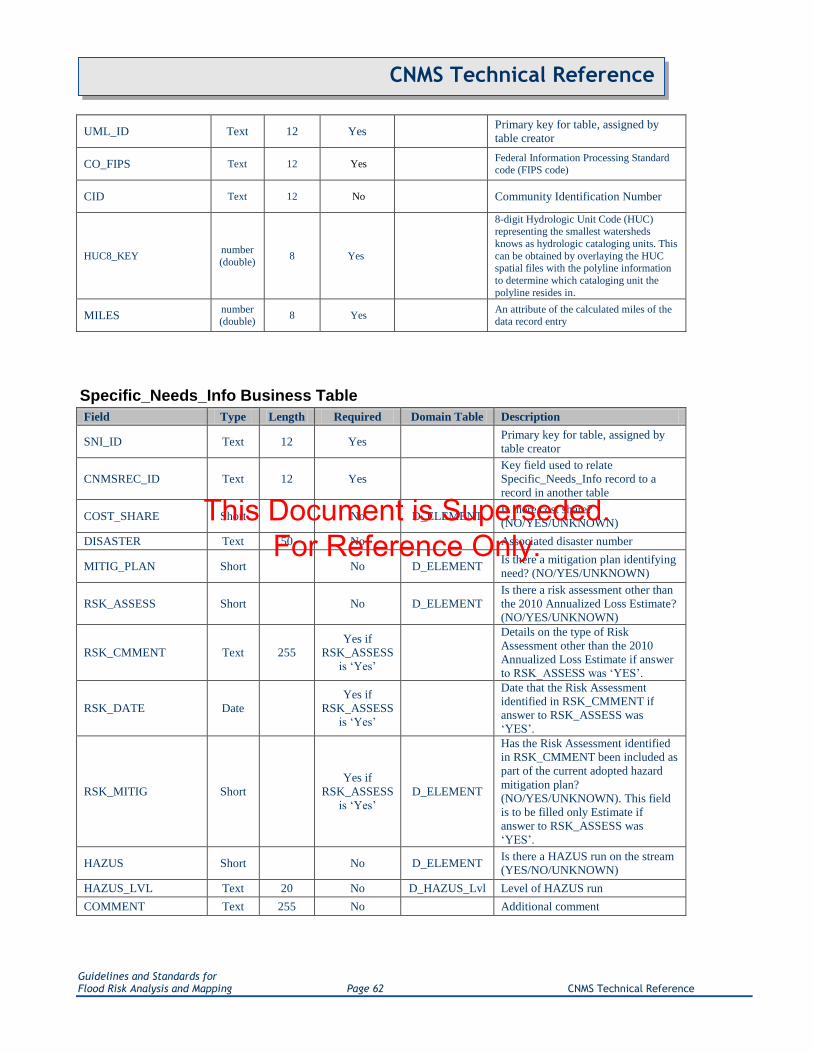
Guidelines and Standards for Flood Risk Analysis and Mapping Page 62 CNMS Technical Reference
CNMS Technical Reference
UML_ID Text 12 Yes Primary key for table, assigned by
table creator
CO_FIPS Text 12 Yes Federal Information Processing Standard code (FIPS code)
CID Text 12 No Community Identification Number
HUC8_KEY number
(double) 8 Yes
8-digit Hydrologic Unit Code (HUC) representing the smallest watersheds
knows as hydrologic cataloging units. This
can be obtained by overlaying the HUC spatial files with the polyline information
to determine which cataloging unit the
polyline resides in.
MILES number (double)
8 Yes An attribute of the calculated miles of the data record entry
Specific_Needs_Info Business Table
Field Type Length Required Domain Table Description
SNI_ID Text 12 Yes Primary key for table, assigned by
table creator
CNMSREC_ID Text 12 Yes
Key field used to relate
Specific_Needs_Info record to a
record in another table
COST_SHARE Short No D_ELEMENT Is there cost share?
(NO/YES/UNKNOWN)
DISASTER Text 50 No Associated disaster number
MITIG_PLAN Short No D_ELEMENT Is there a mitigation plan identifying
need? (NO/YES/UNKNOWN)
RSK_ASSESS Short No D_ELEMENT
Is there a risk assessment other than
the 2010 Annualized Loss Estimate?
(NO/YES/UNKNOWN)
RSK_CMMENT Text 255
Yes if
RSK_ASSESS
is „Yes‟
Details on the type of Risk
Assessment other than the 2010
Annualized Loss Estimate if answer
to RSK_ASSESS was „YES‟.
RSK_DATE Date
Yes if
RSK_ASSESS
is „Yes‟
Date that the Risk Assessment
identified in RSK_CMMENT if
answer to RSK_ASSESS was
„YES‟.
RSK_MITIG Short
Yes if
RSK_ASSESS
is „Yes‟
D_ELEMENT
Has the Risk Assessment identified
in RSK_CMMENT been included as
part of the current adopted hazard
mitigation plan?
(NO/YES/UNKNOWN). This field
is to be filled only Estimate if
answer to RSK_ASSESS was
„YES‟.
HAZUS Short No D_ELEMENT Is there a HAZUS run on the stream
(YES/NO/UNKNOWN)
HAZUS_LVL Text 20 No D_HAZUS_Lvl Level of HAZUS run
COMMENT Text 255 No Additional comment
This Document is Superseded. For Reference Only.

Guidelines and Standards for Flood Risk Analysis and Mapping Page 63 CNMS Technical Reference
CNMS Technical Reference
County_Status Business Table
Field Type Length Required Domain Table Description
CO_FIPS Text 12 Yes
Federal Information Processing
Standard code for the county.
This also serves as the primary
key for this table.
REGION Text 20 Yes D_REGION The FEMA Region into which
the County falls.
STATE_NAME Text 50 Yes D_STATE The state in which the county
resides
CO_NAME Text 50 Yes The name of the County
represented by this record
CO_STATUS Text 50 Yes D_COSTATUS County Modernization Status
FY_FUNDED Text 50 No D_FY_FUNDED
When relevant - Attribute of the
most recent non-effective FEMA
fiscal year funding applied to
stream reach engineering
represented in the
NVUE_FUNDD field.
PRELM_DATE Date
Yes, if
NVUE_FUNDED
has been
populated, and
mileage currently
being studied has
not yet been
represented in the
line work
Expected Preliminary issuance
date for reaches representing
areas being actively studied.
LFD_DATE Date
Yes, if
NVUE_FUNDED
has been
populated, and
mileage currently
being studied has
not yet been
represented in the
line work
Expected Letter of Final
Determination issuance date for
reaches representing areas being
actively studied.
NVUE_FUNDED number (double)
Yes, if mileage
currently being
studied has not
yet been
represented in the
line work
Currently funded mileage which
will contribute to NVUE, but
which has not yet gone effective.
Contributing miles include all
New and Updated Study miles
anticipated which are not
currently VALID.
REPIN_CNMS Short Yes D_ELEMENT
Indicates whether or not the
most current study statuses are
representing in CNMS
S_Studies_Ln.
USE_E_ELEM Short Yes D_ELEMENT
Indicates whether or not E
Elements values should be
included in CE and SE totals for
determining Validation Status.
CERT_DATE Date No
Date which the county
successfully passed through the
CNMS QC Tool
CERT_ID Text 20 No
POC for entity passing the
county through the CNMS QC
Tool
This Document is Superseded. For Reference Only.

Guidelines and Standards for Flood Risk Analysis and Mapping Page 64 CNMS Technical Reference
CNMS Technical Reference
Point_of_Contact Business Table
Field Type Length Required Domain Table Description
POC_ID Text 20 Yes
Primary key for table. A unique, user
defined identifier for each record or
instance of an entity.
POC_NAME Text 50 Yes The name of the point of contact
POC_TITLE Text 20 Yes Any title associated with the point of
contract
POC_DESCRIPTION Text 60 Yes Information regarding the role and
responsibilities of the point of contact
ORG_NAME Text 50 Yes
The name of the owner, or managing
government agency, of the subject
item
ORG_TYPE Text 50 Yes D_ORG_TYPE A code that represents a kind of
organization
BUSINESS_PHONE Text 20 Yes The business telephone number of the
contact person
MOBILE_PHONE Text 20 No The cellular phone number of the
contact person
FAX_PHONE Text 20 No The fax number of the contact person
ADDRESS_1 Text 75 Yes The first line of the point of contact's
address
ADDRESS_2 Text 75 No The second line of the point of
contact's address
CITY_NAME Text 75 Yes The city or town in which the contact
person's address is located
STATE Text 50 Yes D_STATE The name of the State in which the
contact person's address is located
ZIP_CODE Text 10 Yes The Zip Code of the contact person's
address
COUNTY Text 100 Yes The county name
EMAIL_ADDRESS Text 50 Yes Electronic mail address
COMMENT Text 255 No
A description or other unique
information concerning the subject
item
Domain Tables The following tables list the acceptable domain values for the CNMS database. Tables containing coded
values will display two columns, with the coded value on the left and the corresponding description on
the right. Tables where coded values are equal to their corresponding description will display only a
single column with the appropriate code/description text.
D_CARTO_RQST
BASE MAP UPDATE
This Document is Superseded. For Reference Only.

Guidelines and Standards for Flood Risk Analysis and Mapping Page 65 CNMS Technical Reference
CNMS Technical Reference
FLOOD HAZARD FEATURE SYMBOLIZATION AND NOTES
INDEX PANEL ERRORS
MAP BODY (PANEL) ERRORS
MAP COLLAR ISSUES
D_COSTATUS
MODERNIZED
PARTIALLY MODERNIZED
UNMODERNIZED
D_DUPLICATE
CATEGORY 1
CATEGORY 2
CATEGORY 3
Coded Value D_ELEMENT
10 NO
11 YES
12 UNKNOWN
D_FBS_CTYP
COUNTY - BULK ATTRIBUTION
INDIVIDUAL REACH ATTRIBUTION
D_FDATA_RQST
ANY LABELING OUTSIDE COUNTY BOUNDARY
BFE ERRORS
CBRS BOUNDARY ERRORS
CHANGES TO HYDRAULIC CONDITION
CHANGES TO HYDROLOGIC CONDITION
COASTAL GUTTER ERRORS
COMMUNITY MODEL OR DATA
CROSS SECTION ERRORS
This Document is Superseded. For Reference Only.

Guidelines and Standards for Flood Risk Analysis and Mapping Page 66 CNMS Technical Reference
CNMS Technical Reference
FLOODPLAIN DELINEATION ERRORS
FLOODWAY DELINEATION ERRORS
HIGH WATER FROM RECENT FLOOD
IMPACTED STRUCTURES
LEVEE ISSUE
LIMIT OF STUDY ERRORS
OTHER
POPULATION CHANGE OR GROWTH IN FLOODPLAIN
SFHA LABELLING ERRORS
Coded Value D_FY_FUNDED
FY03 FISCAL YEAR 2003 FUNDED
FY04 FISCAL YEAR 2004 FUNDED
FY05 FISCAL YEAR 2005 FUNDED
FY06 FISCAL YEAR 2006 FUNDED
FY07 FISCAL YEAR 2007 FUNDED
FY08 FISCAL YEAR 2008 FUNDED
FY09 FISCAL YEAR 2009 FUNDED
FY10 FISCAL YEAR 2010 FUNDED
FY11 FISCAL YEAR 2011 FUNDED
FY12 FISCAL YEAR 2012 FUNDED
FY13 FISCAL YEAR 2013 FUNDED
FY14 FISCAL YEAR 2014 FUNDED
FY15 FISCAL YEAR 2015 FUNDED
FY16 FISCAL YEAR 2016 FUNDED
FY17 FISCAL YEAR 2017 FUNDED
FY18 FISCAL YEAR 2018 FUNDED
FY19 FISCAL YEAR 2019 FUNDED
FY20 FISCAL YEAR 2020 FUNDED
FY21 FISCAL YEAR 2021 FUNDED
FY22 FISCAL YEAR 2022 FUNDED
FY23 FISCAL YEAR 2023 FUNDED
FY24 FISCAL YEAR 2024 FUNDED
FY25 FISCAL YEAR 2025 FUNDED
This Document is Superseded. For Reference Only.

Guidelines and Standards for Flood Risk Analysis and Mapping Page 67 CNMS Technical Reference
CNMS Technical Reference
Coded Value D_FY_FUNDED
FY26 FISCAL YEAR 2026 FUNDED
FY27 FISCAL YEAR 2027 FUNDED
FY28 FISCAL YEAR 2028 FUNDED
FY29 FISCAL YEAR 2029 FUNDED
FY30 FISCAL YEAR 2030 FUNDED
PRE PRE-MAPMOD FUNDED
D_HAZUS_Lvl
LEVEL 1
LEVEL 2
LEVEL 3
D_HYDRA
ADVANCED ICPR
ADVANCED ICPR 2.20 (OCTOBER 2000)
ADVANCED ICPR 3.02 (NOVEMBER 2002)
B-292
B-MAN NORMAL DEPTH ANALYSIS PROGRAM
CHAN FOR WINDOWS 2.03 (1997)
CRITICAL DEPTH METHOD
CULVERT ANALYSIS
CULVERT MASTER
CULVERT MASTER 2.0 (SEPTEMBER 2002)
DAMBRK
DEPTH FREQUENCY METHOD
DEPTH-DISCHARGE RATING CURVE
DHM
DHM 21 (AUGUST 1987)
DHM 34 (AUGUST 1987)
DWOPER
E431
FAN
This Document is Superseded. For Reference Only.

Guidelines and Standards for Flood Risk Analysis and Mapping Page 68 CNMS Technical Reference
CNMS Technical Reference
D_HYDRA
FEQ
FEQ 8.92 (1997)
FEQ 8.92 (1999)
FEQ 9.98 (2005)
FEQUTL
FEQUTL 4.68 (1997)
FEQUTL 4.68 (1999)
FEQUTL 5.46 (2005)
FESWMS 2DH
FESWMS 2DH 1.1 (JUNE 1995)
FLDWAV
FLDWAV (NOVEMBER 1998)
FLDWY
FLDWY (MAY 1989)
FLO-2D
FLO-2D 2003.6
FLO-2D 2004.10
FLO-2D 2006.1
FLO-2D 2007.06
FLO-2D V.2000.11 (DECEMBER 2000)
GAGE ANALYSIS
GLWRM
HCSWMM
HCSWMM 4.31B (AUGUST 2000)
HEC-2
HEC-2 (1983)
HEC-2 4.6.2 (MAY 1991)
HEC-GEORAS
HEC-RAS
HEC-RAS 2.2 (SEPTEMBER 1998)
HEC-RAS 3.0.1
HEC-RAS 3.1.1
HEC-RAS 3.1.3
This Document is Superseded. For Reference Only.
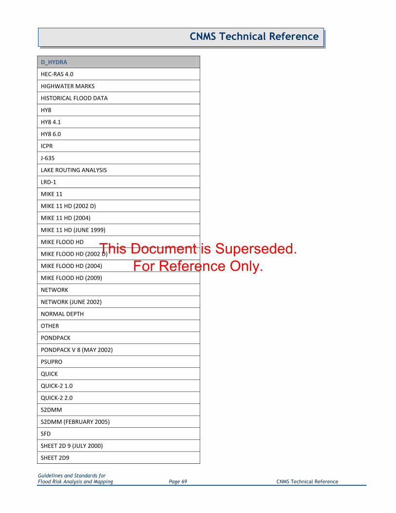
Guidelines and Standards for Flood Risk Analysis and Mapping Page 69 CNMS Technical Reference
CNMS Technical Reference
D_HYDRA
HEC-RAS 4.0
HIGHWATER MARKS
HISTORICAL FLOOD DATA
HY8
HY8 4.1
HY8 6.0
ICPR
J-635
LAKE ROUTING ANALYSIS
LRD-1
MIKE 11
MIKE 11 HD (2002 D)
MIKE 11 HD (2004)
MIKE 11 HD (JUNE 1999)
MIKE FLOOD HD
MIKE FLOOD HD (2002 D)
MIKE FLOOD HD (2004)
MIKE FLOOD HD (2009)
NETWORK
NETWORK (JUNE 2002)
NORMAL DEPTH
OTHER
PONDPACK
PONDPACK V 8 (MAY 2002)
PSUPRO
QUICK
QUICK-2 1.0
QUICK-2 2.0
S2DMM
S2DMM (FEBRUARY 2005)
SFD
SHEET 2D 9 (JULY 2000)
SHEET 2D9
This Document is Superseded. For Reference Only.

Guidelines and Standards for Flood Risk Analysis and Mapping Page 70 CNMS Technical Reference
CNMS Technical Reference
D_HYDRA
SLOPE-AREA METHOD
STORMCAD
STORMCAD V 4 (JUNE 2002)
SWMM
SWMM 4.30 (MAY 1994)
SWMM 4.31 (JANUARY 1997)
SWMM 5 V 5.0.005 (MAY 2005)
TABS-RMA2
TABS-RMA2 V.4.3 (OCTOBER 1996)
TABS-RMA4
TABS-RMA4 V.4.5 (JULY 2000)
UNET
UNET 4.0 (APRIL 2001)
UNKNOWN
WSP-2
WSPGW
WSPGW 12.96 (OCTOBER 2000)
WSPRO
WSPRO (JUNE 1988)
XPSTORM
XPSTORM 10.0 (MAY 2006)
XP-SWMM
XP-SWMM 8.52
D_HYDRO
2POND
AHYMO 97
AHYMO 97 (AUGUST 1997)
API
BULLETIN 15
BULLETIN 17
BULLETIN 17A
BULLETIN 17B
This Document is Superseded. For Reference Only.

Guidelines and Standards for Flood Risk Analysis and Mapping Page 71 CNMS Technical Reference
CNMS Technical Reference
D_HYDRO
CUHPF/PC
CUHPF/PC (MAY 1996)
CUHPF/PC (MAY 2002)
DBRM
DBRM 3.0 (1993)
DEPTH FREQUENCY METHOD
DISCHARGE VERSUS DRAINAGE AREA RELATIONS
DR3M
DR3M (OCTOBER 1993)
FAN
GAGE ANALYSIS
HEC-1
HEC-1 4.0.1
HEC-1 4.1
HEC-FFA
HEC-FFA 3.1
HEC-FFA-REGRESSION EQUATIONS
HEC-HMS
HEC-HMS 1.1
HEC-HMS 2.0
HEC-HMS 2.0.3
HEC-HMS 2.1.1
HEC-HMS 2.1.2
HEC-HMS 2.1.3
HEC-IFH
HEC-IFH 1.03
HEC-IFH 1.04
HEC-IFH 2.0
HEC-IFH 2.01
HIGHWATER; SLOPE AREA METHOD
HSPF
HSPF 10.10
HSPF 10.11
This Document is Superseded. For Reference Only.

Guidelines and Standards for Flood Risk Analysis and Mapping Page 72 CNMS Technical Reference
CNMS Technical Reference
D_HYDRO
HSPF 11.0
HYMO
ICPR
LAKE ROUTING ANALYSIS
LOG-PEARSON TYPE III ANALYSIS
MIKE 11 RR
MIKE 11 RR (2002 D)
MIKE 11 RR (2004)
MIKE 11 RR (JUNE 1999)
MIKE 11 UHM
MIKE 11 UHM (2002 D)
MIKE 11 UHM (2004)
MIKE 11 UHM (JUNE 1999)
MODIFIED PULS ROUTING TECHNIQUES
OTHER
PEAKFQ
PEAKFQ 2.4 (APRIL 1998)
PEAKFQ 2.5
PEAKFQ 3.0
PEAKFQ 4.0
PEAKFQ-REGRESSION EQUATIONS
PONDPACK
PONDPACK V 8 (MAY 2002)
PRECIP
PRMS
PRMS 2.1 (JANUARY 1996)
RATIONAL METHOD
REGRESSION EQUATIONS
REGULATED FREQUENCY CURVES
S2DMM
SNYDER METHOD
SOIL CONVERVATION SERVICE NATIONAL ENGINEERING HANDBOOK
SQUARE ROOT OF THE DRAINAGE AREA METHOD
This Document is Superseded. For Reference Only.

Guidelines and Standards for Flood Risk Analysis and Mapping Page 73 CNMS Technical Reference
CNMS Technical Reference
D_HYDRO
STATISTICAL METHODS IN HYDROLOGY
SWMM
SWMM (RUNOFF) 4.30 (MAY 1994)
SWMM (RUNOFF) 4.31 (JANUARY 1997)
SWMM 5 V 5.0.005 (MAY 2005)
TR-20
TR-20 (FEBRUARY 1992)
TR-20 WIN 1.00.002 (JANUARY 2005)
TR-55
TR-55 (JUNE 1986)
TWO STATION STATISTICAL METHOD
UNET
UNKNOWN
VEN TE CHOW û B462
WIN TR-55 1.0.08 (JANUARY 2005)
WRC
XPSTORM
XPSTORM 10.0 (MAY 2006)
XP-SWMM
XP-SWMM 8.52
D_LINE_TYPE
COASTAL
LAKE OR POND
OTHER
PLAYA
PONDING
RIVERINE
D_MTHOD_TYPE
NEW
REDELINEATION
This Document is Superseded. For Reference Only.
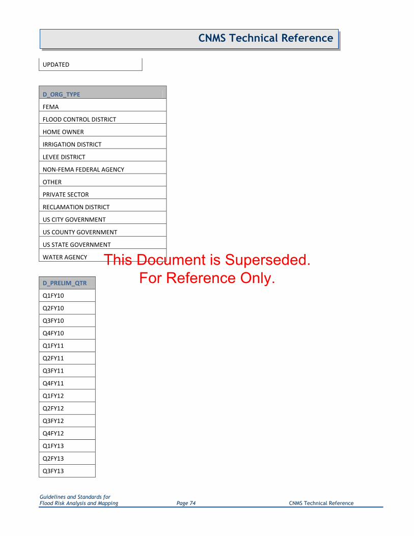
Guidelines and Standards for Flood Risk Analysis and Mapping Page 74 CNMS Technical Reference
CNMS Technical Reference
UPDATED
D_ORG_TYPE
FEMA
FLOOD CONTROL DISTRICT
HOME OWNER
IRRIGATION DISTRICT
LEVEE DISTRICT
NON-FEMA FEDERAL AGENCY
OTHER
PRIVATE SECTOR
RECLAMATION DISTRICT
US CITY GOVERNMENT
US COUNTY GOVERNMENT
US STATE GOVERNMENT
WATER AGENCY
D_PRELIM_QTR
Q1FY10
Q2FY10
Q3FY10
Q4FY10
Q1FY11
Q2FY11
Q3FY11
Q4FY11
Q1FY12
Q2FY12
Q3FY12
Q4FY12
Q1FY13
Q2FY13
Q3FY13
This Document is Superseded. For Reference Only.

Guidelines and Standards for Flood Risk Analysis and Mapping Page 75 CNMS Technical Reference
CNMS Technical Reference
D_PRELIM_QTR
Q4FY13
Q1FY14
Q2FY14
Q3FY14
Q4FY14
Q1FY15
Q2FY15
Q3FY15
Q4FY15
Q1FY16
Q2FY16
Q3FY16
Q4FY16
Q1FY17
Q2FY17
Q3FY17
Q4FY17
Q1FY18
Q2FY18
Q3FY18
Q4FY18
Q1FY19
Q2FY19
Q3FY19
Q4FY19
Q1FY20
Q2FY20
Q3FY20
Q4FY20
Q1FY21
Q2FY21
Q3FY21
Q4FY21
This Document is Superseded. For Reference Only.

Guidelines and Standards for Flood Risk Analysis and Mapping Page 76 CNMS Technical Reference
CNMS Technical Reference
D_PRELIM_QTR
Q1FY22
Q2FY22
Q3FY22
Q4FY22
Q1FY23
Q2FY23
Q3FY23
Q4FY23
Q1FY24
Q2FY24
Q3FY24
Q4FY24
Q1FY25
Q2FY25
Q3FY25
Q4FY25
Q1FY26
Q2FY26
Q3FY26
Q4FY26
Q1FY27
Q2FY27
Q3FY27
Q4FY27
Q1FY28
Q2FY28
Q3FY28
Q4FY28
Q1FY29
Q2FY29
Q3FY29
Q4FY29
Q1FY30
This Document is Superseded. For Reference Only.

Guidelines and Standards for Flood Risk Analysis and Mapping Page 77 CNMS Technical Reference
CNMS Technical Reference
D_PRELIM_QTR
Q2FY30
Q3FY30
Q4FY30
D_PRIORITY
HIGH
LOW
MEDIUM
Coded Value D_REGION
I REGION I
II REGION II
III REGION III
IV REGION IV
V REGION V
VI REGION VI
VII REGION VII
VIII REGION VIII
IX REGION IX
X REGION X
D_RESOL_STAT
DEFERRED
NO
UNKNOWN
YES
D_RQST_CAT
CARTOGRAPHIC
FLOOD DATA
This Document is Superseded. For Reference Only.

Guidelines and Standards for Flood Risk Analysis and Mapping Page 78 CNMS Technical Reference
CNMS Technical Reference
D_RQST_LVL
APPROXIMATE
DETAILED WITH FLOODWAY
DETAILED WITHOUT FLOODWAY
LIMITED DETAIL
N/A
Coded Value D_SOURCE
DFIRM COUNTY DFIRM DATABASE
DFIRM_PRELIM COUNTY DFIRM DATABASE ACQUIRED DURING STUDY PERIOD
DIGITIZED DIGITIZED
NFHL NATIONAL FLOOD HAZARD LAYER
NHD-HIGH NATIONAL HYDROGRAPHY DATASET HIGH RESOLUTION
NHD-LOW NATIONAL HYDROGRAPHY DATASET LOW RESOLUTION
NHD-MED NATIONAL HYDROGRAPHY DATASET MEDIUM RESOLUTION
RFHL REGIONAL FLOOD HAZARD LAYER
D_STATE
ALABAMA
ALASKA
ARIZONA
ARKANSAS
CALIFORNIA
COLORADO
CONNECTICUT
DELAWARE
DISTRICT OF COLUMBIA
FLORIDA
GEORGIA
HAWAII
IDAHO
ILLINOIS
INDIANA
This Document is Superseded. For Reference Only.

Guidelines and Standards for Flood Risk Analysis and Mapping Page 79 CNMS Technical Reference
CNMS Technical Reference
D_STATE
IOWA
KANSAS
KENTUCKY
LOUISIANA
MAINE
MARYLAND
MASSACHUSETTS
MICHIGAN
MINNESOTA
MISSISSIPPI
MISSOURI
MONTANA
NEBRASKA
NEVADA
NEW HAMPSHIRE
NEW JERSEY
NEW MEXICO
NEW YORK
NORTH CAROLINA
NORTH DAKOTA
OHIO
OKLAHOMA
OREGON
PENNSYLVANIA
RHODE ISLAND
SOUTH CAROLINA
SOUTH DAKOTA
TENNESSEE
TEXAS
UTAH
VERMONT
VIRGINIA
WASHINGTON
This Document is Superseded. For Reference Only.

Guidelines and Standards for Flood Risk Analysis and Mapping Page 80 CNMS Technical Reference
CNMS Technical Reference
D_STATE
WEST VIRGINIA
WISCONSIN
WYOMING
D_STATUS_TYPE
BEING ASSESSED
BEING STUDIED
DEFERRED
NVUE COMPLIANT
TO BE ASSESSED
TO BE STUDIED
D_STUDY_TYPE
DIGITAL APPROXIMATE
DIGITAL CONVERSION APPROXIMATE
DIGITAL CONVERSION DETAILED
DIGITAL DETAILED
NEW APPROXIMATE
NEW DETAILED
NON-DIGITAL APPROXIMATE
NON-DIGITAL DETAILED
REDELINEATED
UNMAPPED
UPDATED APPROXIMATE
UPDATED DETAILED
D_VALID_CAT
ASSESSED
UNKNOWN
UNVERIFIED
This Document is Superseded. For Reference Only.

Guidelines and Standards for Flood Risk Analysis and Mapping Page 81 CNMS Technical Reference
CNMS Technical Reference
VALID
D_ZONE
0.2 PCT ANNUAL CHANCE FLOOD HAZARD
0.2 PCT ANNUAL CHANCE FLOOD HAZARD CONTAINED IN CHANNEL
1 PCT ANNUAL CHANCE FLOOD HAZARD CONTAINED IN CHANNEL
1 PCT FUTURE CONDITIONS
A
A99
AE
AH
AO
AR
AREA NOT INCLUDED
D
OPEN WATER
V
VE
X
X PROTECTED BY LEVEE
This Document is Superseded. For Reference Only.

Guidelines and Standards for Flood Risk Analysis and Mapping Page 82 CNMS Technical Reference
CNMS Technical Reference
Appendix E. CNMS Lifecycle Flow Diagram
This Document is Superseded. For Reference Only.
Guidelines and Standards for Flood Risk Analysis and Mapping Page 83 CNMS Technical Reference
CNMS Technical Reference
Appendix F. NVUE Reporting Guidance
F.1. Introduction
FEMA Procedure Memorandum (PM) 56 stipulates that CNMS is the sole reporting mechanism for the NVUE
metric. Per PM56, standard reporting of NVUE should take place on a quarterly schedule that is aligned with the
Joint Program Review (JPR) and Status of Studies reporting processes. The Region (with support from the RSC)
will be responsible for compiling all CNMS data at the regional level to facilitate reporting of NVUE statistics.
Each Regional CNMS database will be submitted for national roll-up on the last business day of each quarter and
also dated and archived at the Region. Following the national-roll-up of the Regional CNMS FGDBs, the national
NVUE table is generated within 10 business days after the end of each quarter, culminating in a report to the
FEMA Headquarters Program Area C Lead. This report will summarize NVUE statistics for each State in the
Region, along with the Region as a whole, including a breakdown by Validation Status and status type for
Modernized, and Paper Inventories, as well as for unmapped areas. The NVUE metric will be reported as both
“NVUE Attained” and “NVUE Initiated”. Any NVUE metric based planning will assume completion and
finalization of all stream miles that are classified in CNMS as BEING STUDIED - barring any changes in scope,
appeals or protests at a project level prior to LFD issuance, NVUE Attained + Initiated represents the final state of
the NVUE metric once all ongoing studies are issued preliminary. The NVUE Initiated metric and associated
attributes in the S_Studies_Ln feature class will support the ability to forecast the attainment rate of NVUE.
Prior to FY11, a single NVUE metric was being reported which was the ratio of all New, Validated, Updated
Engineering Study miles divided by the sum total of all miles in FEMA‟s Mapped SFHA inventory. A New or
Updated study is considered NVUE complaint, and thus included in calculations of NVUE attained, after the
issuance of the Preliminary FIRM. The National NVUE table generated each quarter, reports NVUE mileages and
percentages at a state, regional and national level. It also provides the ability to distinguish between FEMA‟s
Modernized, Unmodernized and Unmapped stream reach inventory. Since the beginning of FY 11, 2 NVUE
metrics are reported – NVUE Attained and NVUE Attained + Initiated. NVUE Attained is described above.
NVUE Initiated miles are those New or Updated Study stream reaches which have been funded for new/updated
engineering, but have not yet been issued as part of a Preliminary FIRM. While a mechanism exists in CNMS to
capture these „Initiated‟ miles, due to the retroactive updates needed for pre-FY11 studies, the CNMS FGDBs do
not hold all NVUE Initiated miles. While the Regional CNMS FGDBs are being updated to store all ongoing
studies, the best available source of all NVUE Initiated miles, along with their Preliminary issuance date, is
available in the Risk MAP Project Planning and Purchasing Portal (P4). The Risk MAP Project Planning and
Purchasing Portal is currently leveraged to calculate NVUE Initiated miles per FEMA Region and their
anticipated attainment FY Quarter. This data is then included in the National NVUE table distributed to a wide
audience to provide NVUE projections into the future.
The sections below describe the steps taken to complete NVUE calculations in the most appropriate manner
possible. However, it should be noted that due to the inherent transient nature of the CNMS FGDBs and the
policy and guidance as it surrounds this metric, all calculations for reporting purposes should be run through the
FEMA HQ‟s CNMS Development team. There are several nuances in geospatial data processing, capturing which
are beyond the scope of this document.
This Document is Superseded. For Reference Only.

Guidelines and Standards for Flood Risk Analysis and Mapping Page 84 CNMS Technical Reference
CNMS Technical Reference
F.2. Understanding the Data Attributes Necessary for NVUE calculations
The fields discussed below are all necessary for NVUE Calculation and mileage classification into bins when
reporting through the format prescribed in PM56 and the National NVUE Table. The primary „bins‟ into which
study mileages get sorted are represented by the different allowed Validation Status and Status Type combinations
as listed below. Within these categories, studies can typically be based on Detailed or Approximate engineering
methods. Further classification includes Modernized (digital) or UnModernized (paper) Inventories.
Allowed VALIDATION_STATUS – STATUS_TYPE Combinations
VALID – NVUE COMPLIANT (can contain detailed or approximate miles, but not unmapped
miles)
VALID – BEING STUDIED
UNKNOWN – BEING ASSESSED
UNKNOWN – TO BE ASSESSED
UNKNOWN – DEFERRED
UNKNOWN – BEING STUDIED
UNVERIFIED – TO BE STUDIED
UNVERIFIED – BEING STUDIED
ASSESSED – TO BE STUDIED*
ASSESSED – BEING STUDIED*
ASSESSED – DEFERRED*
*note: These Validation Status and Status Type combinations are possible only for Unmapped Streams that do not
have mapped SFHAs in FEMA inventory.
FIPS
FIPS is the 5 digit County code which indicates the county in which the study reach lies. The first two digits of
the FIPS code are the State FIPS, and when combined with a separate state lookup table this field can also inform
the Region number of the study. This number defines the levels at which NVUE is reported when a political
boundary based reporting is desired.
FLD_ZONE
FLD_ZONE is used to differentiate between Detailed and Approximate Studies. While the domain range allows
for more values than are currently in use, it has been standard practice when rolling up NVUE thus far to remove
any X, V, or VE records from consideration (as in, they do not get a detailed or approximate assignment and
contribute 0 to NVUE), leaving just A, AE, AO, AH. At this point, where FLD_ZONE = “A”, the study is
considered approximate, and where FLD_ZONE <> “A” the study is considered detailed. At this point in time the
Inventory is entirely Riverine – how coastal miles should be handled has not yet been decided, hence the discount
of the V and VE FLD_ZONE value records. Studies with FLD_ZONE = “X” are unmapped streams which do not
get factored in to the numerator or denominator when calculating NVUE since they are not studied as yet. An
exception to the zone based exclusion is applied when records have a Status Type of BEING STUDIED, and are
This Document is Superseded. For Reference Only.

Guidelines and Standards for Flood Risk Analysis and Mapping Page 85 CNMS Technical Reference
CNMS Technical Reference
past their projected Preliminary FIRM issuance dates. In such cases, the BS_ZONE is instead used in the
determination of Detailed or Approximate.
VALIDATION STATUS
See above for brief description on bins, and sub bins, as well as description of legal combinations of Validation
Status and Status Type attributes for a CNMS Study Record to count towards the NVUE Calculation. Only
„VALID – NVUE COMPLIANT‟ miles, and those with a „BEING STUDIED‟ Status Type which are past their
projected Preliminary FIRM issuance dates are counted in the numerator when calculating NVUE. When
calculating NVUE Attained + Initiated miles, “UNVERIFIED – BEING STUDIED” study miles that have not yet
been issued Preliminary are also included in the numerator, unless the county‟s corresponding County_Status
table REPIN_CNMS field value is „No‟. As of the date of this document, NVUE Initiated Miles are calculated
using the Risk MAP Project Planning and Purchasing Portal (P4). All mapped miles of all VALIDATION
STATUS and STATUS TYPE combinations within the 92% KPI1 footprint are counted for calculating the NVUE
denominator (Note: all ASSESSED miles are omitted from the denominator, as they represent unmapped
reaches).
MILES
Miles are calculated in the North America Albers Equal Area Conic projection. Miles are used to calculate
NVUE percentages for a given political entity or watershed. Miles are counted 1:1 as calculated except in
instances where specific business rules apply such as those described in the LINE_TYPE field discussion below
and discussed in Section 3.2 of this document.
STUDY_TYPE
This field is used to determine whether a study is modernized or unmodernized (paper inventory). This field was a
late addition to the schema and so may not be populated consistently for some regions. Due to the bulk
methodology used to represent the unmodernized inventory in CNMS it is possible to use this field for separating
the unmodernized inventory. Simply put, if the field value equals “Non-Digital Approximate”, or “Non-Digital
Detailed”, then the study is unmodernized. If not, the study is considered Modernized (even when the field is
<Null>). An exception is applied when records have a Status Type of BEING STUDIED, and are past their
projected Preliminary FIRM issuance dates. In such cases, the BS_STDY_TYP field is instead used in the
determination of Modernized and UnModernized.
LINE_TYPE
This Document is Superseded. For Reference Only.

Guidelines and Standards for Flood Risk Analysis and Mapping Page 86 CNMS Technical Reference
CNMS Technical Reference
The LINE_TYPE field is used to communicate the type of study representation the line work is showing. In some
cases line work exists, which depict still water flooding, or lakes / ponds. In these instances, 1 linear mile of study
in the inventory does not represent the same required effort to study as 1 linear mile of true riverine study. To
correct this, the business rule was established which says that any feature with LINE_TYPE = LAKE OR POND,
PONDING, or PLAYA will have its MILES halved before they are added to either the numerator or denominator
when calculating NVUE or reporting mileage break downs. This rule applies no matter what level of rollup is
being performed.
HUC8_KEY (only needed when rolling up at a watershed level)
The HUC8_KEY displays the HUC8 level watershed into which the study reach drains. NVUE can be rolled up at
this level rather than political boundary, but it requires further application of business rules as described in the
DUPLICATE field entry.
DUPLICATE (only when rolling up at a watershed level)
The DUPLICATE field has been populated based on a series of business rules put in place to prevent over
counting of mileage in scenarios where studies form the boundary between multiple political entities. This
approach has allowed mileage calculation to remain accurate while still retaining information related to the side of
the study in each entity (if they differ). Simply put, when rolling up at a watershed level, the mileage for all
records where DUPLICATE = 1 = YES is counted as zero. Handling the DUPLICATE field is complex, but
necessary to ensure appropriate documentation and tracking for streams that define political boundaries. While
assessing watersheds post-discovery, it might be necessary to handle the duplicate field differently. Further details
on the attribute types possible under this field are outlined in Section 3.2 of this document.
STATUS_TYPE
See VALIDATION_STATUS entry above, as these two fields work together to form the bins into which study
miles are separated in the National NVUE Table.
F.3. NVUE CALCULATION
For the NVUE Numerator, when reporting at a political boundary level, NVUE calculation is as simple as halving
all modernized mileages where the LINE_TYPE is of an appropriate value (see above), summing this result with
the remaining modernized mileage in that entity and then dividing the total by the associated total mileage in the
entity‟s 92% KPI1 footprint. Starting Fall 2011, the NVUE denominator was defined as the sum total of all
mapped miles in FEMA‟s SFHA inventory that fall within the geospatial footprint defined by all counties and
communities part of the KPI1 Map Mod metric, at the time it attained 92% (9/30/2011). Since the CNMS FGDBs
are constantly evolving within and outside the 92% KPI1 footprint, the NVUE denominator is calculated each
quarter using the latest CNMS FGDBs and the fixed KPI1 footprint extent defined as of 9/30/2011. As previously
mentioned, any coastal or unmapped miles within the Inventory do not get counted towards the NVUE numerator
or the denominator. FEMA is reviewing the process for Coastal Study inclusion in CNMS as most of the Nation‟s
coastline is being currently revised. As of the date of issuance of this guidance, no coastal or coastally influenced
studies are represented within the CNMS Inventory or the NVUE Metric.
This Document is Superseded. For Reference Only.

Guidelines and Standards for Flood Risk Analysis and Mapping Page 87 CNMS Technical Reference
CNMS Technical Reference
Appendix G. LOMA (MT-1) & LOMR (MT-2) Integration in CNMS
G.1. Identifying Mapping Needs/Requests Because of LOMC Processing
When processing MT-1 and MT-2 case files, occasionally issues are identified that could affect data stored in
CNMS. In order to capture these issues appropriately, the LOMC Analysts should complete request records in
CNMS, or update CNMS study records when secondary or critical issues are identified as outlined in the
validation checklist (Appendix A). To submit CNMS requests, the LOMC group will use the request function of
the National CNMS Web Portal (http://cnms.riskmapcds.com/Main.aspx). Requests will be submitted from
information identified during either a MT-1 or MT-2 review. Typical requests anticipated include the following:
Improvement/Change to flooding source identified during the LOMA process: If there has been a
change, FEMA may deny the request and require that a LOMR be submitted. Many times the
homeowner will not follow up with a LOMR. In cases where homeowners do not follow up with a
LOMR the improvement area/need could be lost and therefore should be recorded in CNMS.
More extensive updated hydrology is submitted: Where new hydrology is developed, it is common for
only the main channel to be updated. This floodway specific practice ignores that hydrology is produced,
and is readily available, for broader areas. As long as the hydrology data meet the minimum DCS, the
full extent of these data can be utilized.
Existing-conditions-modeling developed during the CLOMR stage: During the CLOMR review, an
applicant is required to submit existing-conditions data. In cases where a CLOMR is not followed up by
a LOMR, it is possible this new data could be lost and therefore should be recorded in CNMS.
BFE Determination: If an applicant submits a complete study to determine a BFE in an Approximate A
Zone SFHA, these data could potentially be used to update a Zone A study to a limited-detail study or
higher.
G.2. Updating the CNMS Inventory for Approved LOMRs
Approved LOMRs may include new or revised analysis potentially changing the Validation Status or other
attributes of the study that are stored in CNMS. In order to maintain an accurate database, no less frequent than
once a quarter, the CNMS should be updated to reflect approved LOMRs. Regional CNMS teams will obtain an
extract from the rFHL (Regional Flood Hazard Layer). The extract will include the rFHL clipped to the S_LOMR
layer for all LOMRs that were added to the rFHL that past quarter. The regional CNMS lead will use the rFHL
data with the LOMR Determination Document to determine appropriate updates to CNMS.
When documenting presence of a LOMR in the S_Studies_Ln feature class (especially important when a
FLD_ZONE changes based on the LOMR), recording the LOMR case number in the „REASON‟ field is
suggested. The LOMRs encountered can be classified into the following two categories:
Type 1
LOMRs representing newly studied or completely restudied (typically with updates to both hydrology and
hydraulics) streams or portions of streams using new or updated engineering shall be "broken out" from the
remainder of the stream. These areas will receive their own STUDY_ID and REACH_ID, These are then treated
This Document is Superseded. For Reference Only.
Guidelines and Standards for Flood Risk Analysis and Mapping Page 88 CNMS Technical Reference
CNMS Technical Reference
as a seperate study and are subject to the guidelines outlined in the Validation Checklist (Appendix A) and
Section 3.2.
Type 2
LOMRs that updated only a portion of an existing study, typically to update mapping, topo, or hydraulics fall into
this second category. These stream reaches are not to be broken out from existing studied stream reaches. They do
not receive their own STUDY_ID or _REACH_ID. It is important to remember that if this LOMR was issued due
to a new hydraulic structure, channel, or other hydraulic feature, then that structure / channel or other hydraulic
feature should not count against Elements C6 / S4 in S_Studies_Ln, as a LOMR has been processed to account for
its affects, though it should still be documented appropriately.
This Document is Superseded. For Reference Only.

Guidelines and Standards for Flood Risk Analysis and Mapping Page 89 CNMS Technical Reference
CNMS Technical Reference
Appendix H. CNMS Quality Management Plan (QMP)
H.1. Introduction
The data in the Regional CNMS File geodatabases (FGDBs) are continually updated by multiple stakeholders. In
addition, the evolution of the Risk MAP program needs, warrant changes to CNMS Schema to accommodate the
capture of additional study attributes through bulk geoprocessing, or on a case by case basis.
In order to ensure that the data attributes in the CNMS FGDBs are appropriately populated for consistent
reporting of NVUE and SFHA study status, FEMA has established the requirement to utilize the CNMS FGDB
QC Tool for Quality Assurance and Quality Control. This QC tool has the following features that benefit CNMS-
related operations:
Helps ensure timely and successful reporting of NVUE after each quarterly roll-up of the Regional
CNMS FGDBs
Can be used as a standalone tool within the existing infrastructure of various CNMS Stakeholders.
Uses a self-certification model to document compliance and to note any exceptions requested
Supports multiple platforms including ArcGIS 9.3 and 10
Has an easy to use UI that presents issues found by the QC tool to the user for incorporation and
documentation
Has a phased implementation that accommodates the incorporation of the multiple phases of schema
changes to the Regional CNMS FGDBs
Proper incorporation of the CNMS FGDB QC Tool into the CNMS Update and Maintenance workflow is
necessary to ensure usefulness of the CNMS FGDBs to support Risk MAP program needs.
The following sections outline 1) the targeted user groups who will interact with the CNMS FGDB QC Tool and
their intended workflows, 2) the attribute quality verification criteria applied by the CNMS FGDB QC Tool, and
3) a User‟s Guide for operation of the CNMS FGDB QC Tool.
H.2. Workflow and User Interface
This appendix outlines the workflow envisioned for a targeted list of user types, and key features of the UI of the
CNMS FGDB QC Tool.
User Groups
As outlined in the introduction to this document, multiple stakeholders are expected to update the CNMS FGDBs
locally prior to Regional and National roll-up of the database.
The following profile is assumed for users that will be using the CNMS FGDB QC Tool:
has a knowledge of CNMS Policies and Procedures and is well versed with the CNMS Technical
Reference Version 5.3
is a CNMS liaison representing a FEMA Regional Office, RSC, PTS, or CTP responsible of making
updates to the CNMS FGDB per project scopes and operating procedures
This Document is Superseded. For Reference Only.

Guidelines and Standards for Flood Risk Analysis and Mapping Page 90 CNMS Technical Reference
CNMS Technical Reference
Data Inputs
Due to multiple stakeholder involvement, self-certification and exceptions need to be documented at source. The
CNMS FGDB QC Tool supports data submissions spanning various geography types. It accepts single or multiple
counties‟ data, watershed-level data, and an entire Region CNMS FGDB. The CNMS FGDB used with the QC
Tool should be in the schema that is reflected in the current CNMS Technical Reference Version 5.3. The list of
checks seen in Section H.3. has been grouped into validation categories, that relate to the 3 phases of schema
changes over 2011-2012 and associated quality needs.
The User Interface (UI) for the CNMS FGDB QC Tool outlined in the section below, will prompt the user to
identify the type of geography that the QC check is being applied for. By accepting inputs at various geographic
resolutions, the tool can also be used to check quality at any phase of the database roll-up - locally at the
production centers, or during quarterly Regional/National Roll-up. CNMS database updates warranted by Map
Production, Discovery efforts, Preliminary FIRM Issuance, LFD issuance and Post-production activities can then
be reviewed for quality on a smaller scale prior to reintegration into the Regional CNMS FGDB.
User Interface and Platform
The CNMS FGDB QC Tool can be installed on desktops by users with administrative rights to the workstation,
and operated independent of a license. The CNMS FGDB QC Tool supports functioning in both ESRI ArcGIS 9.3
and 10 environments. Only some components of the CNMS FGDB QC Tool are platform dependent.
The UI itself is integrated with ArcGIS to work within an ArcMap session and can read out of an ESRI FGDB in
software versions 9.3 and 10. Upon launching the UI, the user will be prompted to select from options to
„Validate a Single or Multiple Counties/Watersheds‟ and „Validate Entire Region‟, and will then be asked for an
FGDB file location. The tool will then auto-populate a list of the counties included in the FGDB, or will continue
without a message, respectively, depending on the option first selected.
The tool will perform a series of checks as defined in the table seen in Section H.3., and will prompt the user for
input in several ways. First, the user will be shown results of any certain checks which are not considered critical.
Fixes to these issues may be made by looking into features associated with these secondary issues. The user will
be required to provide brief documentation for any exceptions for secondary issues that will not be addressed
prior to self-certifying and advancing the CNMS FGDB to the next roll-up. Second, values deemed to violate
schema, and/or quality rules, and/or suspected to cause issues in the quarterly roll-up of the Regional CNMS
FGDBs will be flagged and documented in a table with records associated with CNMS FGDB feature primary
keys. This table of records may be used to associate with the appropriate CNMS feature class to identify and
correct issues. The table of records with results of the QC check will contain fields that classify the type of issue
found during the automated check, along with possible suggestions for eliminating the issue for each record.
After addressing the errors listed in the QC check output table, the CNMS FGDB should be resubmitted for a run
through the UI described above iteratively, until a validation check passes without any critical issues remaining
unaddressed. Any secondary issues that have an associated request for exception with a reason noted within the
table of records for the QC issues found, will be allowed in the FGDB that will be advanced for the next stage in
the roll-up. At this point, the CNMS FGDB submission is considered to be self certified and contact details of the
user is collected for the self-certification and for entry in the Points_of_Contact table of the CNMS FGDB.
This Document is Superseded. For Reference Only.

Guidelines and Standards for Flood Risk Analysis and Mapping Page 91 CNMS Technical Reference
CNMS Technical Reference
When the next roll-up happens at the State- or Regional- level, if the table of records resulting from running the
QC tool is carried forward, notes of exceptions will be retained so that subsequent teams rolling the database up,
do not have to re-document the request for exception.
H.3. Quality Control Criteria
This Section outlines the types of checks that will be performed including a categorization of the checks in order
to account for the phased consideration and approval of schema changes since the release of Version 4.2 of the
CNMS Database User’s Guide and FGDB Schema. In addition to several logical consistency requirements, the
quality checks queries have been defined based on the CNMS Technical Reference Version 5.3 in possession with
the 3-PTS CNMS Development Team and FEMA Headquarters.
The grouping of validation checks into categories is to address the various evolutions of the schema. It is likely
that such distinction of validation checks disappear in subsequent versions of the QC Tool, when all contributing
and dependent systems have verified successful migration to the schema described in the CNMS Technical
Reference Version 5.3. The validation categories will merely allow users to easily recognize recent changes and
allow for optionally including or omitting those checks in bulk. For the time being, a single set of standards have
been hard coded on the back-end. Given the needs to consistent FDGB schemas for the quarterly roll-up, it is
unlikely that different users are able to select different sets of standards to base the checks on.
Validation Categories
S0 – This category represents checks against schematic values, such as domain adherence, through the last round
of quarterly roll-ups in CY 11 (12/31/11). The schema version of relevance here was finalized with Version
4.2 of the CNMS Database User’s Guide.
Q0 –This category represents quality issues in the Inventory based on logic checks and combinations of field
values, as they relate to the S0 schema expectations.
S1 – This category represents checks against schematic values, such as domain adherence,. This includes but is
not limited to the joining of S_Studies_Ar values to the appropriate related S_Studies_Ln features, the
incorporation of new DOMAIN values (all domains are now entirely in CAPITAL LETTERS, and the values
for D_DUPLICATE and D_ELEMENT have been changed), and the 1:1 swap of UNVERIFIED for
INVALID.
Q1 – This category represents quality issues in the Inventory based on logic checks and combinations of field
values, as they relate to the S1 schema expectations.
S2 – This category represents checks against schematic values, updated to include the consensus solution for
attribute retention regarding the Prelim vs. LFD NVUE credit discussion.
Q2 – This category represents quality issues in the Inventory based on logic checks and combinations of field
values, as they relate to the S2 schema expectations.
Additional Checks to be Implemented in the Future (S3/Q3)
The Beta Version of the CNMS FGDV QC Tool was distributed in September 2012 and utilized successfully in
the FY12 – Q4 Quarterly Roll-up. Future versions of the tool will have the capability to compare stream mileage
data in the CNMS County Status table (described in section 3.7), with mileage calculations based on the most
recent CNMS FGDB submission for roll-up. Mileage fluctuations above a certain threshold (to be determined
prior to the update of the QC Tool) and outside of those established thresholds will be flagged. The user would
This Document is Superseded. For Reference Only.

Guidelines and Standards for Flood Risk Analysis and Mapping Page 92 CNMS Technical Reference
CNMS Technical Reference
then be required to provide a comment on the cause for the fluctuation, though these checks will not disallow the
submittal or self-certification. Likewise, mileage and validation status changes expected based on the County
FIRM Study status may be checked against the Inventory, again requiring user comment should unexpected
values be encountered. These checks will serve the purpose of documenting the cause of mileage and mileage
type shifts that may occur within the National Inventory. Should stakeholders inquire as to the reason behind such
shifts we will be able to reproduce calculations alongside specific cause.
CNMS S_Studies_Ln Checks Table
Parameter /
Attribute
Allow
Nulls Entity Validity
Validation
Categories Note
REACH_ID No S_Studies_Ln
Must be 12 characters in
length S0
The first five characters
must match with the
associated FIPS field value.
S0
The two characters
following the FIPS must be
„01‟.
S0
Each Reach_ID must be
unique. S0
FIPS No S_Studies_Ln Five Character Length
Enforcement S0
CID Yes S_Studies_Ln None S0
WATER_NAME Yes S_Studies_Ln None S0
WATER_NAME_
ALIAS Yes S_Studies_Ln None S0
FLD_ZONE
No S_Studies_Ln D_ZONE Domain Value S0
No S_Studies_Ln
Zone A + Detailed
STUDY_TYPE is Not
Permissible.
Q0
UnMapped Streams Should
have ASSESSED
Validation Status.
Q0
UnMapped Streams Should
Have SOURCE Field Value
of NHD or Digitized.
Q0
Zone AE/AH/AO Streams
Cannot Have ASSESSED
Validation Status.
Q0
VALIDATION_ST
ATUS No S_Studies_Ln
D_VALID_CAT Domain S0
Validation Status – Status
Type Combination Must
Pass Check Against List of
Acceptable Combinations
Q0 / Q1
Acceptable Combinations
Defined in Latest User‟s
Guide
INVALID Replaced 1:1
with UNVERIFIED Q1
STATUS_TYPE No S_Studies_Ln D_Status_Type Domain S0
This Document is Superseded. For Reference Only.
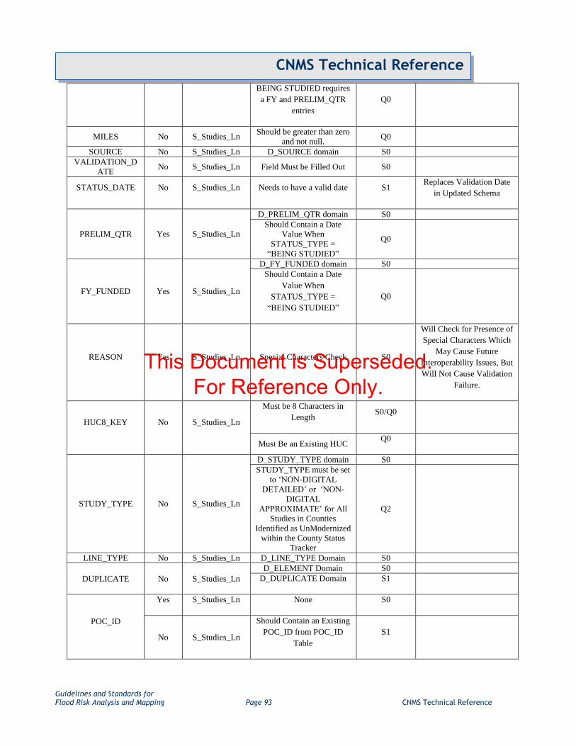
Guidelines and Standards for Flood Risk Analysis and Mapping Page 93 CNMS Technical Reference
CNMS Technical Reference
BEING STUDIED requires
a FY and PRELIM_QTR
entries
Q0
MILES No S_Studies_Ln Should be greater than zero
and not null. Q0
SOURCE No S_Studies_Ln D_SOURCE domain S0
VALIDATION_D
ATE No S_Studies_Ln Field Must be Filled Out S0
STATUS_DATE No S_Studies_Ln Needs to have a valid date S1 Replaces Validation Date
in Updated Schema
PRELIM_QTR Yes S_Studies_Ln
D_PRELIM_QTR domain S0
Should Contain a Date
Value When
STATUS_TYPE =
“BEING STUDIED”
Q0
FY_FUNDED Yes S_Studies_Ln
D_FY_FUNDED domain S0
Should Contain a Date
Value When
STATUS_TYPE =
“BEING STUDIED”
Q0
REASON Yes S_Studies_Ln Special Characters Check S0
Will Check for Presence of
Special Characters Which
May Cause Future
Interoperability Issues, But
Will Not Cause Validation
Failure.
HUC8_KEY No S_Studies_Ln
Must be 8 Characters in
Length S0/Q0
Must Be an Existing HUC Q0
STUDY_TYPE No S_Studies_Ln
D_STUDY_TYPE domain S0
STUDY_TYPE must be set
to „NON-DIGITAL
DETAILED‟ or „NON-
DIGITAL
APPROXIMATE‟ for All
Studies in Counties
Identified as UnModernized
within the County Status
Tracker
Q2
LINE_TYPE No S_Studies_Ln D_LINE_TYPE Domain S0
DUPLICATE No S_Studies_Ln
D_ELEMENT Domain S0
D_DUPLICATE Domain S1
POC_ID
Yes S_Studies_Ln None S0
No S_Studies_Ln
Should Contain an Existing
POC_ID from POC_ID
Table
S1
This Document is Superseded. For Reference Only.

Guidelines and Standards for Flood Risk Analysis and Mapping Page 94 CNMS Technical Reference
CNMS Technical Reference
DATE_RQST Yes S_Studies_Ln
Should be In Expected Data
Format (Date)
If Study is “UNVERIFIED
– TO BE STUDIED”, This
Field Should be Populated
Q0
For VALID studies, if there
is a DATE_RQST, Then
DATE_RESOL Must Also
be Populated. The
DATE_RESOL Value
Should Represent a Later
Date in Time
DATE_RQST.
Q0
DATE_EFFECT Yes S_Studies_Ln Should be In Expected Data
Format (Date) S0
HYDRO_MDL No S_Studies_Ln D_HYDRO Domain S0
HYDRA_MDL No S_Studies_Ln D_HYDRA Domain S0
HODIGFMT No S_Studies_Ln D_ELEMENT Domain
S0 Check Against S0 Type
D_ELEMENT Domain
S1
Check Against S1 Type
D_ELEMENT Domain
HADIGFMT No S_Studies_Ln D_ELEMENT Domain
S0 Check Against S0 Type
D_ELEMENT Domain
S1
Check Against S1 Type
D_ELEMENT Domain
HO_RUNMOD No S_Studies_Ln D_ELEMENT Domain
S0 Check Against S0 Type
D_ELEMENT Domain
S1
Check Against S1 Type
D_ELEMENT Domain
HA_RUNMOD No S_Studies_Ln D_ELEMENT Domain
S0 Check Against S0 Type
D_ELEMENT Domain
S1
Check Against S1 Type
D_ELEMENT Domain
C1 to C7, S1 to
S10 No S_Studies_Ln D_ELEMENT Domain
S0 Check Against S0 Type
D_ELEMENT Domain
S1
Check Against S1 Type
D_ELEMENT Domain
CE_TOTAL No S_Studies_Ln
The Value Should
Accurately Reflect the
Number of Failed Critical
Elements
Q0
SE_TOTAL No S_Studies_Ln
The Value Should
Accurately Reflect the
Number of Failed
Secondary Elements
Q0
This Document is Superseded. For Reference Only.

Guidelines and Standards for Flood Risk Analysis and Mapping Page 95 CNMS Technical Reference
CNMS Technical Reference
COMMENT No S_Studies_Ln Special Characters Check S0
Will Check for Presence of
Special Characters Which
May Cause Future
Interoperability Issues, But
Will Not Cause Validation
Failure.
CNMS S_Requests_Ar and S_Requests_Pt Checks Table
Parameter /
Attribute
Allow
Nulls Entity Validity
Validation
Categories Note
SRA_ID No S_Requests_Ar
Must be 12 characters in
length S0
The two characters
following the FIPS must
be „01‟.
S0
Each Reach_ID must be
unique. S0
SRP_ID No S_Requests_Pt
Must be 12 characters in
length S0
The two characters
following the FIPS must
be „01‟.
S0
Each Reach_ID must be
unique. S0
REACH_ID Yes S_Requests
Must be 12 characters in
length S0
If this Field is Populated,
the Associated
REACH_ID Should be
Present in S_Studies_Ln
S0
Recognizing that
REACH_ID‟s May
Disappear from the
Inventory Through Normal
Maintenance Practices,
This Check Will Not
Cause Validation Failure,
but Will Show Up in the
Data Validation Output
WATER_NAME Yes S_Requests None S0
POC_ID
Yes S_Requests None S0
No S_Requests
Should Contain an
Existing POC_ID from
POC_ID Table
S1
RQST_CAT No S_Requests D_RQST_CAT Domain S0
RQST_LVL Yes S_Requests D_RQST_LVL Domain S0
This Document is Superseded. For Reference Only.

Guidelines and Standards for Flood Risk Analysis and Mapping Page 96 CNMS Technical Reference
CNMS Technical Reference
MTHOD_TYPE Yes S_Requests D_MTHOD_TYPE
Domain S0
DATE_RQST No S_Requests Should be In Expected
Data Format (Date) S0
DATE_RESOL Yes S_Requests
Should be In Expected
Data Format (Date) S0
Value Must Represent
Later Date in Time Than
DATE_RQST
S0
CARTO_RQST Yes S_Requests D_CARTO_RQST
Domain S0
FDATA_RQST Yes S_Requests D_FDATA_RQST
Domain S0
RESOL_STATUS Yes S_Requests D_RESOL_STAT
Domain S0
COMMENT Yes S_Requests Special Characters Check S0
Will Check for Presence of
Special Characters Which
May Cause Future
Interoperability Issues, But
Will Not Cause Validation
Failure.
PRIORITY Yes S_Requests D_PRIORITY Domain S1
DATE_REVIEW Yes S_Requests
Should be In Expected
Data Format (Date) S1
Value Must Represent
Later Date in Time Than
DATE_RQST
S1
H.4. User’s Guide: CNMS FGDB QC Tool – Beta Version
How to Install and Access the Tool:
1. At this point, the CNMS FGDB QC Tool installation file is not available for download directly from the
web. Instead, obtain a copy of the the “RAMPP_CNMS_QC.esriAddIn” file from your FEMA Regional
Support Center and copy to a folder on your computer where you have write access.
2. Open an ArcMap document. Click on Customize-Add-In Manager and go to the Options tab. Click on
„Add Folder‟ and browse to the folder where you placed your add-in file. In the screenshot below, the
add-in file has been placed in the “C:\PROJECTS” folder.
This Document is Superseded. For Reference Only.

Guidelines and Standards for Flood Risk Analysis and Mapping Page 97 CNMS Technical Reference
CNMS Technical Reference
3. Click Customize on the Add-In Manager dialog. In the Customize dialog, click on the Commands tab.
Select the “Add-in controls” under the categories. You can also reach the Customize dialog by clicking on
„Customize-Customize Mode‟ on the main ArcMap menu. The commands pane lists all the add-ins
available.
4. Drag and drop “CNMS FGDB QC Tool” into the ArcMap toolbar area. Alternatively, you can also create
a new custom toolbar and drop the item into the new toolbar.
Note: The user does not need to be an administrator to install and use this tool.
How to Uninstall/Update Previous Add-in:
Add-ins can be updated by simply replacing the add-in file in the folder where the old add-in file resides. Close
any open ArcMap MXDs before replacing the add-in file.
This Document is Superseded. For Reference Only.

Guidelines and Standards for Flood Risk Analysis and Mapping Page 98 CNMS Technical Reference
CNMS Technical Reference
Alternatively, you can completely uninstall the add-in and re-install by using the steps outlined below.
1. In ArcMap, go to Customize-Addin Manager.
2. Click on the „RAMPP_CNMS_QC_Tool‟ add-in.
3. Click on the „Delete this add-in‟ button. Confirm by clicking „Yes‟ on the ensuing confirmation dialog.
4. Follow the procedure outlined in the “How to Install and Access the Tool” section of this document to re-
install the add-in.
Intended FGDB QC Workflow:
1. Start the CNMS FGDB QC Tool by clicking on the icon previously added to either an existing or custom
toolbar
2. Select a ESRI FGDB (conforming to CNMS schema V 5.1 dated 5/8/2012) using the Select FGDB
dialog.
This Document is Superseded. For Reference Only.

Guidelines and Standards for Flood Risk Analysis and Mapping Page 99 CNMS Technical Reference
CNMS Technical Reference
The selected FGDB is listed on the user interface as shown below:
This Document is Superseded. For Reference Only.

Guidelines and Standards for Flood Risk Analysis and Mapping Page 100 CNMS Technical Reference
CNMS Technical Reference
3. Choose to either validate a selection of counties within the selected FGDB or to validate the entire
selected FGDB. Validating a selection of counties allows the user to selection using the “Select Counties”
button.
This Document is Superseded. For Reference Only.

Guidelines and Standards for Flood Risk Analysis and Mapping Page 101 CNMS Technical Reference
CNMS Technical Reference
4. Click on the “Validate FGDB” button to perform a QC check on the selected CNMS FGDB. The grid will
be populated with any issues identified within the area selected for QC. Issues are categorized as either
Critical or Secondary. Critical issues must be addressed before the FGDB is submitted as complete. The
tool allows the addition and documentation of validation exceptions for Secondary issues only.
5. The context-menu available on the grid allows the following actions:
a. Zoom to the selected record on the map. The selection occurs based on the Reach_ID field for
S_Studies_Ln, SRA_ID field for S_Requests_Ar and SRP_ID field for S_Requests_Pt. If there
are no unique ID fields, the OID field is used. (Right click – Zoom to Selection)
b. Add a validation exception (Right click – Mark as exception)
c. Edit an existing validation exception (Right click – Edit exception)
d. Delete an existing validation exception (Right click – Delete exception)
This Document is Superseded. For Reference Only.
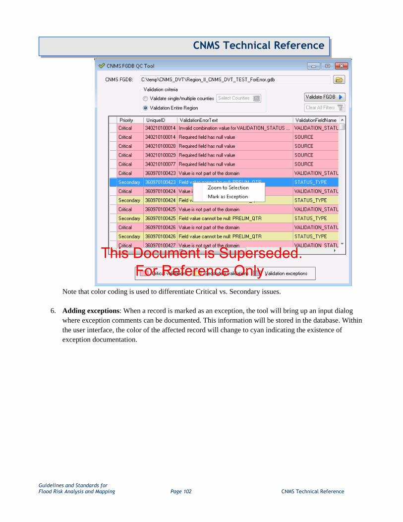
Guidelines and Standards for Flood Risk Analysis and Mapping Page 102 CNMS Technical Reference
CNMS Technical Reference
Note that color coding is used to differentiate Critical vs. Secondary issues.
6. Adding exceptions: When a record is marked as an exception, the tool will bring up an input dialog
where exception comments can be documented. This information will be stored in the database. Within
the user interface, the color of the affected record will change to cyan indicating the existence of
exception documentation.
This Document is Superseded. For Reference Only.

Guidelines and Standards for Flood Risk Analysis and Mapping Page 103 CNMS Technical Reference
CNMS Technical Reference
This Document is Superseded. For Reference Only.

Guidelines and Standards for Flood Risk Analysis and Mapping Page 104 CNMS Technical Reference
CNMS Technical Reference
7. Editing and deleting exceptions: Clicking on an existing exception provides additional options to edit
and/or delete exceptions.
This Document is Superseded. For Reference Only.

Guidelines and Standards for Flood Risk Analysis and Mapping Page 105 CNMS Technical Reference
CNMS Technical Reference
Selecting „Edit Exception‟ brings up the input dialog allowing comments to be altered. This feature can
also be used as to overwrite existing comments. Deleting an exception brings up a confirmation dialog (as
shown below). Upon confirmation, the exception documentation is permanently deleted from the
database.
8. Click on the “Validate FGDB” button after every round of changes until all issues have been addressed.
A success message will appear at the end of the validation process. Validation is complete only when:
a. All Critical validation items have been addressed.
b. All Secondary validation items have been addressed or marked as exceptions with user
documentation.
This Document is Superseded. For Reference Only.

Guidelines and Standards for Flood Risk Analysis and Mapping Page 106 CNMS Technical Reference
CNMS Technical Reference
Additional CNMS FGDB QC Tool Features:
The grid allows filtering and sorting of the data in a familiar manner.
Filtered columns are highlighted in yellow. The “Clear All Filters” button will clear all cuurent filter
criteria.
This Document is Superseded. For Reference Only.

Guidelines and Standards for Flood Risk Analysis and Mapping Page 107 CNMS Technical Reference
CNMS Technical Reference
The grid also allows sorting by clicking on the column headers.
This Document is Superseded. For Reference Only.