conversion timber, forest monitoring, and land-use ...forest-trends.org/releases/uploads/cambodia...
TRANSCRIPT
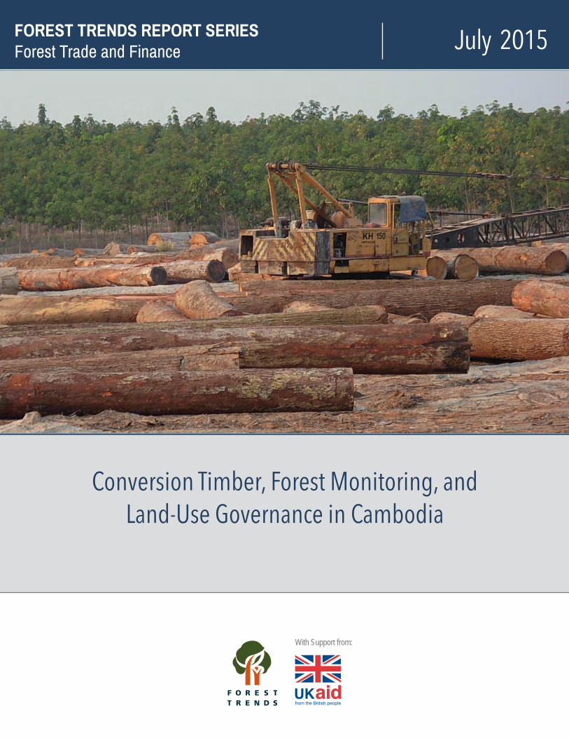
July 2015FOREST TRENDS REPORT SERIES Forest Trade and Finance
Conversion Timber, Forest Monitoring, and Land-Use Governance in Cambodia
With Support from:

Disclaimer: This assessment incorporates the analysis of a number of large numerical datasets pertaining to forest cover mapping, land concessions, and forest fire. The authors have endeavored to ensure that these data have been represented and analyzed appropriately. Nevertheless, we appreciate that each of these datasets continues to develop, as new and/or more refined data are made available in the public domain.
Some of the information in this report is derived from media reports in Cambodia. This information is used to describe the context of past and current practice in Cambodia. Cambodia’s media and press are replete with articles on land grabbing, forest degradation, illegal logging, and related social conflicts. One or more articles on these subjects have been published almost every day since at least mid-2012. We refer readers to websites of two English language papers for additional information: www.phnompenhpost.com and www.cambodiadaily.com.
The analyses presented in this report were undertaken prior to Cambodia’s national election in the 2013. Reported changes in government policy on land concessions and conversion timber after the elections have not been considered here, as comprehensive data have not yet been released into the public domain.
Acknowledgments Funding support for this report was provided by the United Kingdom’s Department for International Development and also (in part) by Norway’s International Climate and Forest Initiative through the Wildlife Conservation Society.
ii

Conversion Timber, Forest Monitoring, and Land-Use Governance in Cambodia

iv

Executive Summary
Overview In many countries, the accelerated clearing of forests for agricultural purposes has resulted in the rapid growth of so-called “conversion timber” in recent years. This has fundamental implications for sustainable forest management (SFM) and the legality of domestic and international timber trade, as it is happening at a time when internationally sponsored programs, notably Forest Law Enforcement, Governance and Trade (FLEGT) and Reduced Emissions from Deforestation and Degradation (REDD+), are promoted as strategies for ensuring that SFM is a reality.
In Cambodia, timber concessions for selective logging under forest management plans were effectively suspended indefinitely due to governance and complicance issues. However, Cambodia’s exports of value timber have continued, raising the question where this timber comes from if not from official forest concessions. Extensive media, civil society, United Nations, and technical reports indicate that the main source of wood harvested in Cambodia since mid-2004 consists of 1) “conversion timber” from forest lands allocated to large-scale agri-industrial plantations, and 2) illegally harvested timber from adjacent lands. As a matter of fact, the Royal Government of Cambodia (RGC) itself has acknowledged that the conversion of forestland to large-scale agricultural plantations under ELCs has been the main driver of Cambodia’s deforestation.
It has been reported that by the end of 2013, 2.6 million hectares of land, 14 percent of the country, had been allocated to Economic Land Concessions (ELCs) for agro-industrial plantations and other types land concessions.1 These land allocations have become controversial due to their environmental and social impacts: many land concessions have been allocated within the boundaries of national protected areas, and violent conflicts resulting from the inclusion of forest lands and community lands have become increasingly common. Even more so, there is no legal framework to justify or support the allocation of the country's forest lands to economic land concessions for monoculture plantation development or the cutting and collection of conversion timber.
Cambodia’s media and press are replete with articles on land grabbing, forest degradation, illegal logging, and related social conflicts, with one or more articles on these subjects published almost daily since at least mid-2012.2 The windfall profit from conversion timber from these cleared lands appears to be either the sole objective or the sole profitable revenue stream for many land concessions – especially for those operators who are not legitimately committed to the agricultural development project in the first place.
The full significance and impact of these developments is not adequately acknowledged and addressed by the government and development partners due to poor information sharing, conflicting development policy priorities, and ineffective forest inventory and law enforcement. There is increasing concern that the environmental service and biodiversity values of forest lands are in rapid decline and that public interest values are not adequately considered by decision makers and their development partners. Currently, the prospects of managing Cambodia’s forest estate for the purposes of sustainable timber production and effective protected area management appear to be minimal.
Current policy and practice indicates that Cambodia will continue to rely on natural forests for timber production rather than utilizing land under concessions. The socio-economic ramifications of allocating extensive lands to agri-industrial plantations and its consequences for long-term productive land-use are also not adequately considered. To ensure balanced national and sub-national land-use planning, the relevant legal, policy, and institutional frameworks need to be improved and revised, particularly if the government’s National Forest Program and any proposed FLEGT and REDD+ programs are to be effective. Without this, current proposals to favor social land concessions (SLC) over ELCs simply risk the perpetuation of Cambodia's deforestation just as the transition from logging concessions to ELCs did a decade ago.
1 By 2015, this number had dropped to 12 percent of the country (2.2 million ha) primarily due to a recent cancellation of a large concession in Stung Treng province. See http://www.licadho-cambodia.org/land_concessions/. 2 See Cambodia’s English daily newspapers www.phnompenhpost.com and www.cambodiadaily.com.
i
This report presents an overview of national patterns and practices of forest land clearance during the 2012-2013 dry season as a basis for discussing challenges for FLEGT and REDD+ in Cambodia posed by land conversion and conversion timber. The report maps and describes the geography of forest land allocations in relation to the major forest formations, land concessions, protected areas, the national forest estate, and the reported concession ownership;
• Outlines the legal and regulatory framework for major land-use classes and the land allocation process for major national programs such as REDD+ or an emerging FLEGT Voluntary Partnership Agreement (VPA) with the European Commission;
• Assesses forest fire as an indicator of land clearance. The nature and progression of the 2012/2013 fire season was described using 38,982 active fire reports developed by NASA’s MODIS/FIRMS satellite facility.3 The goal was to characterize forest fire regimes in relation to major forest formations, land-use categories, and land clearance patterns using standard GIS tools. The fire reports were also used to draft a computer algorithm for identifying forest lands that are being cleared in real time;
• Characterizes forest loss and degradation scenarios. Forest land clearance scenarios are characterized in relation to the major forest formations, land-use allocations, investment in land concessions, forest fire regimes, and carbon emissions; and
• Discusses the implications of these findings with respect to REDD+ and FLEGT in Cambodia.
Key Findings 1. Extensive allocation of forest lands for land conversion: By the end of 2013, 2.6 million hectares of land,
fourteen percent of the country, had been allocated to ELCs and other types land concessions.4 Over 80 percent of land concessions are allocated in production forest or protected areas that remained under forest cover as late as 2010. This is equal to almost 20 percent of the nation’s forest land at that time. About 1.1 million hectares of concession areas were awarded for the stated purpose of rubber plantations, about 150,000 hectares for sugar, and 100,000 hectares for pulp and paper. While the actual operations of the concessionaires have not been verified, this establishes clearing for rubber as a major driver of deforestation and conversion timber.
2. Legality of land conversion: There is no legal framework to justify or support the allocation of forest land to concessions, or the cutting and collection of conversion timber. Constitutional provisions define forests as state property, and specify that their control and use shall be determined by law; they also explicitly require plans to be established for their management. The Land Law does not address the allocation of forest lands to land concessions. It defines both trees and forest land – and therefore “forests” – as immovable property for the purpose of guaranteeing the rights of ownership and other rights related to immovable property under the Constitution. Similarly, neither the Forestry Law nor the Law on Protected Areas envisage that forests would be allocated for clearance. The focus of the Forestry Law concerns sustainable timber harvest by selective logging, community forestry, and forest protection. Accordingly, it defines a category of forest land, “conversion forest” as “idle” land without forest that is available for allocation to other end uses. The Law on Protected Areas focuses on forest conservation and doesn't legally povide for large-scale plantation development.
3. Conversion timber and questions about its legality: The “conversion timber” generated during the clearing of Cambodia’s natural forest areas is believed to have become the main source of wood harvested. It is also believed to provide a mechanism to launder other timber that is illegally cut from nearby areas. When the legality of the land allocation and conversion process is brought to question, the legality of the “conversion
3 NASA’s MODIS/FIRMS satellite facility (Fire Information Research System) collected a total of 38,982 fire reports between 1st October 2012 and 31st March. 2013 when data were downloaded for analysis. Fires continued to occur at low frequencies until after mid-May. 4 By 2015, this number was 2.2 million hectares, twelve percent of the country.
ii

timber” harvested from these lands and ultimately exported onto the international market also becomes questionable. The presentation of the allocation of ELCs on forest land as a fait accompli by the central government level has resulted in confusion over institutional and legal issues concerning the management of the resulting conversion timber. Here, the lack of transparent standards leads to a patchwork of different regulations being seemingly arbitrarily applied by the authorities. This undermines the roles of various institutions in enforcing legal requirements and also effective forest management strategies from being implemented. Therfore, conversion timber has become the main driver of illegal logging in many provinces. This has direct relevance for those wishing to export Cambodian timber to Europe. For example, Vietnam is a key importer of Cambodian timber that is currently negotiating a VPA with the EU. While China is not negotiating a FLEGT VPA is does re-export Cambodian wood products to these same markets as finished products.
4. The existence of conversion timber harvesting signifies a total systems failure: Together with the associated illegal logging and the virtual absence of legal timber sources, conversion timber circumvents and even contradicts existing natural resource legislation and undermines the prospects for SFM. The use of economic land concessions as an unlawful instrument to rapidly exhaust the remaining timber resources of the country has undermined the forest policy reform of the early 2000s and constitutes a second total system failure, after the mismanagment connected to the timber concessions in the 1990s. The resulting lack of transparency concerning both the process and extent of land allocations has resulted in confusion over institutional issues concerning the management of the resulting conversion timber.5 The current practice of retro-fitting the allocation process to decisions made at the highest level of government is also reflected in the attitude of provincial and local authorities in considering conflict between developers and local communities as a “bilateral” issue. Government representatives only get involved if conflicts and disagreements reach a more prominent level. Even under these circumstances, local officials advise villagers to “take the company to court if they have problems.” However, considering the well-connected nature of most ELC developers, companies’ frequent use of military personnel, and the weakness of Cambodia’s legal system, legal actions against ELC companies have been mostly symbolic exercises. Some cases have been pending for a decade without affecting the operations of certain companies.
5. Allocations of land have increased steadily at an average rate of 208,141 hectares per year: Allocations of land to concession agreements commenced in 1995 but remained limited until 1999/2000 when two large concessions totaling 490,904 ha were awarded to two Cambodian companies. The total land area allocated to land concession agreements then remained approximately constant until 2004, while the Independent Multi-stakeholder Forest Sector Review (IFSR) was in progress, after which it increased steadily at an average rate of 208,141 ha/annum through 2013. Where the ELCs are being allocated, forest conditions vary greatly: some are degraded, others disturbed but recoverable, while others are virtually undisturbed and essentially primary.
6. Drivers of deforestation and forest degradation have shifted from smaller landholders to large-scale agricultural clearances: From 1997 to 2002, deforestation in Cambodia was associated with smallholder agricultural encroachment along the boundaries between extensive forest and non-forest landscapes while forest degradation was occurring in nearby portions of these extensive forest landscapes (IFSR 2004). This form of deforestation appears relatively limited today as large-scale agri-industrial plantations have rapidly encroached on forest lands since mid-2004. By 2013, virtually all forest clearance is associated with ELCs though clearance extends beyond ELC boundaries in some areas. All major forest formations are subject to encroachment by ELCs. They include natural or pristine forests, through various degrees of degradation to heavily degraded sites. ELCs are the major form of encroachment into remaining areas of good forest.
7. Fourteen percent of Cambodia’s protected areas overlap with ELCs: As of 2013, fourteen percent of forest lands within Cambodia's protected areas had been allocated to land concessions. Concessions within
5 Surya Subedi, UN Special Representative to the Secretary-General on The Situation of Human Rights in Cambodia, in his report to the UN in July 2012.
iii

protected areas include a high proportion of evergreen forest, whereas concessions outside protected areas include higher proportions of deciduous, semi-evergreen, and secondary forest. Cambodian and Vietnamese investors appear to control most of the ELCs located within these protected areas.
8. Major investors in Cambodia’s large-scale agricultural ELCs: Two exceptionally large Cambodian concessions issued in the 1990s total almost 500,000 hectares. Four investor groups account for the remaining 84 percent of concession areas. Chinese and Vietnamese investors appear to have concessions of 400,000 ha each, while other Cambodian investors and a group of other countries appear to have agreements over 700,000 and 500,000 hectares respectively. Prior to 2008, growth in land concessions allocated to each investor group generally occurred in a step-wise manner. After 2008, Cambodian, Vietnamese and other investors increased their levels of investment dramatically while Chinese investors have maintained a steady rate of growth of land allocations.
Cambodian and Vietnamese investor groups gained access to 46 percent and 30 percent of the evergreen forests allocated to concessions within protected areas. In contrast, concessions allocated to Chinese investors and those from other countries are largely concentrated in deciduous forest areas outside protected areas and have at least three times as much deciduous forest land as evergreen forest land. Deciduous forests also manifestly dominate the two exceptionally large Cambodian concessions.
9. Complicance with basic regulations: There is a lack of reporting on the implementation of many of the basic regulations for ELCs and concern that they have not been fulfilled. For example, Most ELCs granted in recent years comply with the 10,000-hectare size limitation yet some do not.6 Company data and media reports suggest, however, that many ELCs are owned by the same investors and are merely parceled out into 10,000-hectare sections, often adjacent to each other.7 By 2013, the government hadn’t addressed or rectified the issue. One example is the HAGL Group which reportedly controls at least 47,000 hectares of ELCs in northeast Cambodia.
Poor implementation of Environmental and Social Impact Assessment (ESIA) requirements is also a key concern in the allocation and management of concessions. In reality, the required ESIA is rarely conducted,8 and if conducted, it is generally intended to mitigate impacts rather than to inform decisions on the suitability of the land area for allocation as an ELC. The transfer of the area from state public land to state private land and the approval of the Prime Minister’s office are considered sufficient proof of legality of the ELC by provincial, district, and commune authorities. Negotiations with local villagers are limited and significant changes of concession boundaries are usually not considered. Village land and sensitive natural features such as streamside areas frequently fall within concession boundaries.
10. Little to no assessment on whether forest clearance and planting actually occurred: Satellite images and the analysis of fire reports indicate that considerable forest clearance has occurred in recent years. However, there is no comprehensive analysis of the extent to which forests in these land concession areas have been cleared and converted into agriculture, or of the crops proposed for these developments. In the case of the two large Cambodian concessions, Pheapimex and Mong Rethy, large-scale clearing did not generally occur for many years, though some areas were logged and small portions of the concession were allocated to subcontractors for field and tree crops. Preliminary analysis for over 200 ELCs, indicates that over 1 million hectares of concession areas were awarded for the stated purpose of rubber plantations. While the actual operations of the concessionaires have not been verified, this establishes clearing for rubber as a major driver of deforestation and conversion timber.
6 While concessions may exceed this limit slightly, some concession agreements reportedly have provisions for omitting certain natural areas and village land from the concessionaire’s rights to develop that reduce the area to less than 10,000 hectares. 7 Forest Trends 2012. Unpublished report on Illegalities in Forest Clearance for Large-Scale Commercial Agriculture: Cambodian Case Study. Forest Trends 2012. 8 The MOE stated at a workshop on drafting of an ESIA law to supersede the existing sub-decree stated that only five percent of major development projects undertake an ESIA. “1 in 20 Firms Carry Out Environmental Assessments” Cambodia Daily, 23 November 2012.
iv

11. Satellite-based mapping of forest fire is an effective tool for monitoring land clearance: Active fire reports collated by NASA’s MODIS/FIRMS satellites can be used to detect land clearance. In Cambodia, the patterns in fire regimes within evergreen and semi-evergreen forest lands do not follow the typical fire patterns of natural forests, indicating the heavy influence of human activities. Average fire densities are four times higher in concession areas where fire is used as part of the land clearance and preparation process. This tool can be used to map land clearance, and there is the potential to develop it to detect land clearance in real time. Fire densities vary substantially between forest formations. In evergreen forests, an eight-fold increase in fire density is recorded in concession areas. In contrast, fire density in deciduous forest is less than twice that in concession areas than outside them.
12. Forest conversion for large-scale agricultural development was the largest source of carbon emissions from forest lands in Cambodia in the 2012/13 dry season: NASA’s MODIS/FIRMS satellite measures of fire radiative power (FRP) can be used as an indicator of carbon emissions. Total emissions from the concession system – which occupies about 14 percent of forests areas – were equivalent to those detected for the more extensive forest lands outside concessions. Those from evergreen forest dominated emissions from concession areas, whereas those from deciduous forest dominated emissions from areas outside the concession system.
Interestingly, emissions densities from evergreen forest lands in concessions areas are more than three (3.4) times higher than those from secondary forests that would normally be expected for allocation to concessions. At the same time, emissions densities from evergreen forest lands in concessions areas are almost ten times higher than those in areas outside concessions, confirming that land clearance is targeting high biomass forests and resulting in the extensive losses of sequestered carbon. In contrast, emissions from deciduous and secondary forests in concession areas are also higher than those outside concessions, though by only a factor of 2.0 and 3.3 respectively.
Comparisons of data collated for individual land concessions from within the major land clearance scenarios confirm higher emissions from evergreen forests than from deciduous forests. The concession of CRCK (a Vietnamese-owned Chu Pah Rubber development project) in primary lowland evergreen forest has the highest emissions, indicating that these forests possessed high biomass and had remained essentially intact. The emissions were 50 times higher than the background emissions from untouched deciduous forests subject to their normal fire regime. Deciduous forests in concessions that were completely cleared feature medium levels of emissions.
13. Fragmented responsibility for forest lands across government agencies, with critical consequences for REDD+ programs: While considered one of the better examples of REDD+ roadmap development, the Cambodian initiative has been criticized by the Forest Carbon Partnership Facility’s Technical Advisory Panel for its lack of attention to the impact of ELCs and the need to integrate them with land-use planning.9 REDD+ programs have been housed within the Forestry Administration, which has limited ability to consider or integrate other government agencies involved in land-use and allocation issues. The Forestry Administration does not consider ELCs part of its mandate, and there is limited dialogue with development partners about ELC implications on forest lands.
14. Reliance on natural forest lands for future timber production: Preliminary analysis of the proposed crops for over 200 ELCs indicates that timber plantations are not a significant focus of land concession objectives. This implies that Cambodian policy and practice will rely on natural forests for timber production rather than on timber tree crops for the forseeable future. The long history and extensive nature of forest degradation and governance failures in the sector are reason to question the sustainability of future logging, particularly in view of rising domestic demand as Cambodia’s economy expands. Legal, policy, and institutional frameworks for balanced national and sub-national land-use planning require further development and harmonization,
9 FCPF Technical Advisory Panel meeting in Da Lat, Vietnam, 23 March 2011.
v

particularly if the National Forest Program and any proposed FLEGT and REDD+ programs are to be effective in stemming forest loss and degradation, and in ensuring a viable forest estate.
15. Future allocation of agri-industrial plantations on forest lands: Current indications are that government policy precludes the continued issuance of ELC agreements but does provide for the establishment of Social Land Concessions (SLCs). Without further development and harmonization of the legal, policy, and institutional frameworks the current proposals to favor Social Land Concessions (SLCs) over ELCs simply risk the perpetuation of Cambodia’s deforestation as a business-a-usual scenario, just as the transition from logging concessions to ELCs did a decade ago.
Recommendations on Forest Monitoring, REDD+, and FLEGT Government agencies and their development partners are now exploring the potential applicability of programs such as Reduced Emissions from Deforestation and Degradation (REDD+) or a Forest Law Enforcement, Governance and Trade Voluntary Partnership Agreement (FLEGT VPA) with the European Union to help ensure that sustainable or legal forest management is a reality. Both programs could bring to Cambodia opportunities for improved laws and regulations, transparency, reduced corruption, technical and rights-based approaches to sustainable forest management, and monitoring and reporting systems.
Increasing forest loss and social conflict combined with the lack of an effective regulatory framework threatens the conversion of almost all of Cambodia’s lowland evergreen forest and large areas of deciduous forest, except in remote areas. This will inevitably lead to the loss of environmental services and biodiversity and further disenfranchisement of rural communties, as well as the erosion of the nation's protected areas system. The objectives of major international programs such as those looking to reduce emissions from deforestation and forest degradation (e.g., REDD+) will be threatened as existing institutional frameworks are not able to adequately govern the land sector. The government’s National Forest Programme primarily sees REDD+ as an alternative source of funding rather than as a catalyst for promoting effective land-use planning and allocations that are in the public interest at both national and sub-national levels.
Both FLEGT and REDD+ have the potential to contribute to the improvement of the current situation. Both initiatives require interventions in governance and transparency, and the establishment of effective monitoring frameworks. There is considerable potential for synergy between these initiatives. REDD+ places national land-use planning and allocations at the center of policy and promotes institutional developments that assures protection of forest lands. FLEGT provides important aspects of an implementation framework that are linked to the economic incentives of a viable timber industry for sustainable forest management through prevention and elimination of forest crime and incentives for a viable timber industry.
This synergy could conceivably be harnessed to strengthen the delivery of environmental services, whether derived from payment for environmental service schemes, sustainable forest and protected areas management, or the delivery of co-benefits while satisfying domestic timber demands. Without FLEGT, illegalities in the forest sector are more likely to persist. Without an effective REDD+ mechanism, drivers of forest loss and degradation will inevitably and severely diminish the country’s forest resources due to the absence of informed and equitable long-term land-use planning and implementation. The absence of both FLEGT and REDD+ initiatives will likely result in a total systems failure as the prevailing drivers associated with the business-as-usual scenario persist and forest lands are lost and rural communities are disenfranchised.
Embedding a comprehensive new monitoring system in the REDD+/FLEGT initiatives would combine the Measurement, Reporting, and Verification (MRV) framework under REDD+ with FLEGT’s policy and legal requirements. The Royal Government of Cambodia (RGC) and its agencies are responsible for ensuring that legal and policy frameworks deliver effective participation and that institutional frameworks ensure transparent implementation of regulations and gain stakeholder and investor confidence. A reliable monitoring and reporting system is currently lacking but is essential for success. The core elements of an effective monitoring system would:
vi

• Detect potential breaches of environmental and social protections; • Verify field reports, information, and analyses, and develop summary reports; • Communicate this information in real time to law enforcement; • Ensure rapid response mechanisms that effectively regulate key actors; • Mitigate conflict and reduce immunity and impunity; and • Monitor outcomes and identify gaps, weaknesses, and conflicts in political, legal, institutional, and technical
frameworks.
This model serves as a platform for collaboration between civil society, media, and government actors that better integrates community voice into land-use allocations and forest management, thereby mitigating the level and intensity of conflicts that occur. Its establishment requires increasing the acceptance and efficiency of community patrolling and law enforcement, and would help the government to respond more constructively. The media plays an important role in promoting accountability and facilitating information flow. This model is also consistent with the National Forest Programme which envisions a monitoring and information-sharing mechanism including a rapid-response capability, active cooperation with civil society and the media, as well as joint verification.10
The information and verification systems required for undertaking this are based on people-based intelligence networks. GIS mapping should enhance the utility of this information through its collation and analysis, integration with remote-sensing products – such as a MODIS/FIRMS-based land clearance alert system, Landsat 8, and other higher-resolution imagery suitable for identifying log rest areas and milling operations – and the dissemination of the resulting information products to civil society, media, government actors, and their development partners.
Enhanced donor engagement along these lines would have considerable impact on forest governance. Additional recommendations for improving forest governance and law enforcement are provided below.
Land-Use Planning and REDD+ • Declare and implement a moratorium on logging operations in ELCs/SLCs. • Independent review and inventory of timber resources, existing forest and harvested trees, in ELCs/SLCs
awarded on forest land under Ministry of Agriculture, Forestry, and Fisheries (MAFF). • Assess consistency of concessions with the national protected area zoning system and develop transparent
standards for zoning the country’s protected areas. • Identify candidates for ELC/SLCs cancellation in national protected areas. • Identify land concessions on Indigenous Peoples’ lands to be cancelled in accordance with the land law. • Establish and implement an ESIA process to be conducted prior to the granting of a land concessions. • Establish a transparent science-based process to implement Article 4 of the Forestry Law. • Develop a transparent land-use allocation process and land-use plan. • Ensure that investors are well matched to the lands they are granted.
FLEGT-Related • Analyze financial gains/losses caused by ELC-/SLC-related logging inside and outside delineated boundaries. • Start criminal investigations into irregularities surrounding the allocation of forest land for conversion. • Identify forest crime cases related to agri-industrial operations. • Establish monitoring and reporting mechanisms for the allocation and implementation of land concessions,
and develop a public interactive database with verification procedures. Develop transparent and binding standards for agri-business investors.
10 National Forest Programme 2010. Section 3.14 Sub-programme 3: Rapid Response on Forest Crime Information.
vii

TABLE OF CONTENTS
Executive Summary ........................................................................................................................................................... i Key Findings ...................................................................................................................................................................................................... ii Recommendations on Forest Monitoring, REDD+, and FLEGT ........................................................................................................ vi Land-Use Planning and REDD+ ................................................................................................................................................................. vii FLEGT-Related ................................................................................................................................................................................................ vii
Background .......................................................................................................................................................................... 1 Objectives and Approach............................................................................................................................................................................. 1 Historical Context ........................................................................................................................................................................................... 2 Current Context of ELCs and Conversion Timber ................................................................................................................................. 6 Current Initiatives ........................................................................................................................................................................................... 7
Land-Use Designations and Allocations ..................................................................................................................... 9 Geography of Land Use ................................................................................................................................................................................ 9 Allocation of Forest Lands to Land Concessions ................................................................................................................................. 17 Legal Context and Considerations .......................................................................................................................................................... 22 Allocation Processes for ELCs ................................................................................................................................................................... 24
Forest Fire Regimes ........................................................................................................................................................ 28 Historical Fire Regimes of the Major Forest Formations ................................................................................................................. 28 Relationship of Fire to Recent Land Clearance ................................................................................................................................... 28
Forest Land-Clearance Scenarios ............................................................................................................................... 36 Current Fire and Land Clearance Scenarios ......................................................................................................................................... 36 Fire Intensity and Carbon Emissions ...................................................................................................................................................... 51
Land Use, REDD+, and FLEGT ...................................................................................................................................... 55 Challenges for Resource Governance .................................................................................................................................................... 55 Importance and Potential Roles of FLEGT and REDD+ ..................................................................................................................... 57 Measurement, Reporting, and Verification ......................................................................................................................................... 61
Concluding Remarks and Recommendations........................................................................................................ 65 Towards a Monitoring System ................................................................................................................................................................. 65 Recommendations ...................................................................................................................................................................................... 67
References ........................................................................................................................................................................ 70
Annexes ............................................................................................................................................................................. 71 Annex 1: Forest Cover Statistics .............................................................................................................................................................. 71 Annex 2: Allocations of Forest Lands and Protected Areas to Land Concessions .................................................................... 73 Annex 3: Declassification of Forest lands from the Permanent Forest Reserves ..................................................................... 75 Annex 4: Average Fire Density in Different Forest Formations ..................................................................................................... 78 Annex 5: FRP Indicator Data ..................................................................................................................................................................... 79
viii

LIST OF TABLES Annex 1 – Table 1: Forest Cover Statistics Used in this Analysis ............................................................................................. 71 Annex 1 – Table 2: Area Statements for Major Forest Types Derived from the RGC’s Official 2010 Forest Cover
Assessment .................................................................................................................................................. 72 Annex 2 – Table 1: Area Statements (km2) for Major Forest Types Used in this Analysis ................................................... 73 Annex 2 – Table 2: Area Statements (km2) for Allocation of Major Forest Types and Other Land Cover
Classes to Major Investor Groups ............................................................................................................. 74 Annex 4 – Table 1: Distribution and Density of Active Fire Reports in Different Forest Formations Both Inside
and Outside Land Concessions .................................................................................................................. 78 Annex 5 – Table 1: Gross FRP Indicators for Major Forest Formations Inside and Outside Concessions .......................... 79 Annex 5 – Table 2: Average FRP Indicators per Square Kilometer of Major Forest Formations Inside and
Outside Concessions per Square Kilometer (Gross FRP Indicator/Area).............................................. 79 Annex 5 – Table 3: Average FRP Indicators Per Square Kilometer of Major Forest Formations and
Forest Clearance Scenarios ........................................................................................................................ 79
LIST OF FIGURES Figure 1: Forest Formations within Protected Areas and the Forest Estate (km2) ................................................................. 9 Figure 2: Extent of Concession Allocations ................................................................................................................................ 16 Figure 3: Extent of Concession Allocations by Investor Country ............................................................................................. 16 Figure 4: Forest Composition of Four Main De Facto Land-Use Classes ................................................................................ 19 Figure 5a: Area of Forest Formations Allocated to Country Investor Groups (km2) ............................................................. 20 Figure 5b: Country Investor Group Allocations by Major Forest Formations ....................................................................... 21 Figure 6: Allocations of Major Forest Formation in Protected Areas to Investor Groups.................................................... 21 Figure 7: Progression of the 2012-2013 Fire Season in the Major Forest Formations ......................................................... 34 Figure 8: Fire Density in Major Forest Formations and Land Concessions ............................................................................ 35 Figure 9: Indicators of Total Emissions for Major Forest Formations Inside and Outside Concessions ............................. 52 Figure 10: Average Emission Densities per km2 for Major Forest Formations Inside and Outside Concessions .............. 53 Figure 11: Fire Radiative Power (FRP) Indicators for Specific Sites ......................................................................................... 54
LIST OF MAPS Map 1: All Protected Areas Allocated by 2004 ............................................................................................................................ 3 Map 2: Status of Timber Concessions in 2002 ............................................................................................................................ 4 Map 3: National Forest Cover Map 2010 .................................................................................................................................. 12 Map 4: Location, Extent, and Type of Land Concessions ......................................................................................................... 13 Map 5a: Land Concessions by Investor Group .......................................................................................................................... 14 Map 5b: Land Concessions by Proposed Crop Type ................................................................................................................. 15 Map 6: Land Concessions and Protected Areas ........................................................................................................................ 18 Map 7: Active Fire Reports October 2012 – March 2013 ........................................................................................................ 30 Map 8: Fire Distribution in Relation to Forest Formations and Land Concessions ............................................................... 31 Map 9: Fire Distribution in Relation to Forest Formation and Protected Areas ................................................................... 32 Map 10: Overview of Forest Fires October 2012 to March 2013 ........................................................................................... 33 Map 11: Focal Areas of Deforestation in Evergreen and Semi-Evergreen Forest Lands ..................................................... 38 Map 12: Smoke Plumes from Land Clearance Fires Streaming across Cambodia ................................................................ 59 Map 13: Initial Candidate Land Clearance Sites Identified by Computation Algorithm ....................................................... 64 Map 14: Sawmills within Two ELCs in Phnom Samkos Wildlife Sanctuary, Southwest Cambodia .................................... 66
ix

ACRONYMS AND ABBREVIATIONS ADB Asian Development Bank
BAU Business-as-Usual Scenario
CBD Convention on Biological Diversity
CBO Community-Based Organization
CCBA Climate, Community and Biodiversity Alliance
CO2 Carbon Dioxide
CRCK Vietnamese-Owned Chu Pah Rubber Development Project
ELC Economic Land Concession
EMP Environmental Management Plan
ESIA Environmental and Social Impact Assessment
EU European Union
EUTR European Union Timber Regulation
FA Forestry Administration
FAO Food and Agricultural Organization of the United Nations
FCPF World Bank Forest Carbon Partnership Facility
FLEGT Forest Law Enforcement, Governance and Trade
FPIC Free, Prior and Informed Consent
FRP Fire Radiative Power
GDANCP General Department of Administration for Nature Conservation and Protection
GHG Greenhouse Gas
IFSR Independent Multi-Stakeholder Forest Sector Review
LICADHO Cambodian League for the Promotion and Defence of Human Rights
MAFF Ministry of Agriculture, Forestry and Fisheries
MLMUPC Ministry of Land Management, Urban Planning and Construction
MOE Ministry of Environment
MOI Ministry of Interior
MRV Measurement, Reporting and Verification
NASA National Aeronautic Space Agency
MODIS Moderate Resolution Imaging Spectro-radiometer
MRV Measurement, Reporting, and Verification
FIRMS Fire Information Research System
NCCC National Climate Change Committee
NCDD National Committee for Democratic Development
NFP National Forest Programme
x
NGO Non-Governmental organization
NPASMP National Protected Area Strategic Management Plan
REDD+ Reducing Emissions from Deforestation and Forest Degradation
RGC Royal Government of Cambodia
SLC Social Land Concession
SLM Sustainable Land Management
TLAS Timber Legality Assurance System
TWG/FR Technical Working Group for Forestry Reform
UN United Nations
UNDP United Nations Development Programme
UNEP United Nations Environment Programme
UNFCCC United Nations Framework Convention on Climate Change
UN-REDD United Nations Collaborative initiative on Reducing Emissions from Deforestation and forest Degradation (REDD+) in developing countries
USAID United States Agency for International Development
VCS Voluntary Carbon Standard
VPA FLEGT Voluntary Partnership Agreement
WCS Wildlife Conservation Society
xi


Background Accelerated forest clearance in many countries has resulted in the rapid growth of conversion timber in recent years, and has fundamental implications for sustainable forest management (SFM) and the legality of domestic and international timber trade (Lawson 2014). This is happening at a time when internationally sponsored programs, notably FLEGT and REDD+, are promoted as strategies for ensuring that SFM is a reality.
Within Cambodia, the area of forestlands allocated to large-scale agri-industrial plantations has increased rapidly since mid-2004. Extensive media, civil society, United Nations and technical reports indicate that the resultant conversion timber has become the main source of wood harvested since this time.11 The Royal Government of Cambodia (RGC) acknowledged that the conversion of forestland to large-scale agricultural plantations under Economic Land Concessions (ELCs) has been the main driver of Cambodia’s deforestation.12
Despite this, a clear legal framework for conversion timber is lacking. These land concessions have become controversial environmental and social issues due to conflicts surrounding the inclusion of forestlands and community lands. There is increasing concern that the environmental service and biodiversity values of forestlands is in rapid decline, and that public interest values are not adequately considered by decision makers and their development partners. Currently, the prospects of managing Cambodia’s forest estate for the purposes of substantive sustainable timber production appear to be minimal.
The full significance of conversion timber is not widely appreciated due to poor information sharing, conflicting development policy priorities and constraints upon effective forest inventory and law enforcement. The ramifications of allocating extensive lands to agri-industrial plantations for long-term land-use planning also remain unclear.
Objectives and Approach This assessment presents a national overview of the pattern of forest land clearance during the 2012-2013 dry season as a basis for discussing challenges for FLEGT and REDD+ in Cambodia posed by land conversion and conversion timber. This report:
1. Describes the geography of forest land allocations: The geography of forest lands allocated to the RGC’s major land-use designations is mapped using standard geographic information systems (GIS) analytical tools. The allocation of forest lands to protected areas, other areas within the national forest estate, and land concessions was characterized for each of Cambodia’s forest formations. The four major forest formations concerned are evergreen, semi-evergreen, secondary,13 and deciduous forests. The major de facto land-use allocations are:
a. portions of protected areas without land concessions, b. land concessions within protected areas, c. land concessions in other forest lands within the national forest estate, and d. areas within the national forest estate outside both protected areas and land concessions.
The RGC’s 2010 forest cover map,14 and LICADHO’s database on land concessions15 were used to develop this baseline assessment.
11 Surya Subedi, UN Special Representative to the Secretary-General on The Situation of Human Rights in Cambodia, in his report to the UN in July 2012. 12 Cambodia Forest Cover, 2010. Forestry Administration, Phnom Penh. ITTO-PD493/07 Rev.1 (F). 13 Secondary forests considered here include both dry land secondary regrowth of forests after logging and flooded forests of the Tonle Sap Lake and other floodplain areas. 14 Cambodia Forest Cover, 2010. Forestry Administration, Phnom Penh. ITTO-PD493/07 Rev.1 (F). 15 Data collated by Licardo (2012) from MAFF’s website (http://maff.gov.kh/elc/), the RGC’s Royal Gazette and other sources.
1

2. Considers the legal context of major land-use classes: Key aspects of Cambodia’s legal and regulatory framework relevant to REDD+ and FLEGT and the processes by which land concessions are allocated were assessed through a review of Cambodia’s relevant laws and sub-decrees.16
3. Assesses forest fire as an indicator of land clearance: The nature and progression of the 2012/2013 fire season was described using 38,982 active fire reports developed by NASA’s MODIS/FIRMS satellite facility.17 These reports were used to characterize forest fire regimes in terms of their association with major forest formations, land-use categories, and land clearance patterns using standard GIS tools. The fire reports were also used to draft a computer algorithm for identifying forest lands that are being cleared in real time.
4. Characterizes forest loss and degradation scenarios: Forest land clearance scenarios are characterized in terms of their relationship to the major forest formations, land-use allocations, investment in land concessions, forest fire regimes, and carbon emissions. Fire regimes are described in terms of forest fire frequency and intensity, while data on Fire Radiative Power (FRP) derived from NASA’s FIRMS dataset were used as an indicator of carbon emissions. This information was complemented by some informal discussions with government, civil society, and private sector actors. Newly released Landsat 8 imagery was used to help characterize land clearance scenarios of a select series of land concessions.
Historical Context Era of Timber Concessions and Associated Illegal Logging (1993 – 2003) In 1993, forests covered 73 percent of Cambodia’s land area. Roughly 80 percent of the population was concentrated in the 20 percent of land along the floodplains of the Mekong River and Tonle Sap Lake. Lower densities of indigenous minorities and ethnic Khmer communities lived in the forest areas. Decades of war and political isolation insulated Cambodia from the Green Revolution and associated land-use changes that were occurring through-out most of Asia. The traditional concentration of populations in floodplain areas and traditional land-use patterns and practices persisted until the post-war period, affording protection to forests despite population growth.
After the signing of the Paris Peace Accords that led to an end to the war and the country’s political isolation in 1992, Cambodia’s forests have been increasingly subject to heavy pressures, at first from rampant logging by timber concessions. Forests are now estimated to cover 55-60 percent of Cambodia’s land area – a reduction since the 1970s yet still considerably higher than most other countries in Asia except perhaps neighboring Laos and Myanmar.
After a new constitution was promulgated in 1993, the RGC reviewed and re-instituted its pre-war national protected areas system. Initially, 3.3 million hectares were allocated for the conservation and sustainable use of biodiversity and associated environmental services (Map 1). Almost all of the remaining forests were allocated to commercial timber concessions by 1995 (Map 2). While the Forestry Administration (FA) within the Ministry of Agriculture, Forestry and Fisheries (MAFF) is responsible for most of the country’s forests, including protection forests established under the Forestry Law, the General Directorate for Nature Conservation and Protection (GDANCP) within the Ministry of Environment (MoE) is responsible for protected areas established under royal decree.
In reality, the majority of forest areas were subject to heavy logging throughout the 1990s by foreign or local actors associated with the concessionaires irrespective of their land-use designation. This widespread and large-scale anarchic logging became politicized and controversial. A log export ban came into effect in 1996 that, legally speaking, remains in place today.
16 This section of the work draws upon Forest Trends unpublished report on Illegalities in Forest Clearance for Large-Scale Commercial Agriculture: Cambodian Case Study. Forest Trends 2012. 17 NASA’s MODIS/FIRMS satellite facility (Fire Information Research System) collected a total of 38,982 fire reports between 1st October 2012 and 31st March 2013 when data were downloaded for analysis. Fires continued to occur at low frequencies until after mid-May.
2

Map 1: All Protected Areas Allocated by 2004
Source: Independent Multi-stakeholder Forest Sector Review (IFSR 2004).
3

Map 2: Status of Timber Concessions in 2002
4
End of the Timber Concession System (2004) In 1999, the RGC and its international development partners initiated a forestry reform process. In 2000, the Forest Concession Review sponsored by the RGC and the Asian Development Bank (ADB) diagnosed the forest concession system as a “complete systems failure.” A new Forestry Law was passed in 2002. As a product of the forestry reform process this law emphasized timber concessions as the main management tool for forest management, and includes requirements for timber harvest management plans, as well as provisions for forest protection and community forestry. By 2003, many concessions had been cancelled for a variety of reasons, and additional protection forests were designated by 2004. Even so, some Cambodian sub-contractors linked to security forces and high-level government continued to log. Nevertheless, large-scale timber harvesting came to a halt with a logging and log transportation moratorium due to the absence of acceptable management plans and continued illegal logging. Three million hectares of forest remained under sixteen concession agreements at that time (Map 2).
Subsequently, the Independent Multi-stakeholder Forest Sector Review (IFSR) in 2003 and 2004 effectively led to the cancellation or permanent suspension of the timber concession system. A new policy declared the sector closed for investment and the RGC announced that timber harvesting would be managed primarily for the domestic market, ostensibly through a series of annual coupes.18 Those concessions listed as “current” were suspended indefinitely, pending the development of credible management plans that have never been produced. The companies involved are no longer operational. Nevertheless, the legal status of the forest lands contained within these areas requires clarification. They fell within the scope of the IFSR’s assessment as they still retained substantive timber reserves in 2004. Portions of some of these areas were reallocated as the Central Cardamom, Mondolkiri, Preah Vihear, and Seima Protection Forests by 2003 (Map 1).19
The IFSR also made a suite of wide-ranging recommendations that have been pursued to varying degrees. These led to the prioritization of community forestry, the passage of the Law on Protected Areas (2008) and the drafting of a National Forest Programme (NFP) in 2010. The NFP embodies a strategic direction and a set of programs to guide the RGC’s management and administration of forest lands. It includes a program for forest law enforcement and governance as well as provisions for the inclusion of both REDD+ and FLEGT. The NFP also identifies the magnitude of future ELC development as a risk to the nation’s forest lands. However, environmental NGOs and the RGC’s development partners have not engaged the country in substantive dialogue about the IFSR recommendations as key donors left the sector shortly afterwards.
Intensive Logging under Economic Land Concessions (2005 – present) The suspension of Cambodia’s remaining logging concessions coincided with increased domestic and foreign investment in agri-industrial projects for the planting of crops such as rubber and cassava, with some interest in sugar, wood and oil palm plantations. Rapid acceleration in the allocation of economic land concessions (ELCs) followed. These land concessions provided several actors with an entry point (and possibly a cover) to conduct extensive logging operations not only within but also outside the borders of the officially granted ELC areas. Media and civil society reports indicate sawmills were set up within the boundaries, logging crews were employed, and some timber was even brought in from distant areas by outsiders. Operations continued until all valuable timber resources in the wider vicinity of the area were exhausted, usually within one to two years.
The allocation of forested areas to land concessions has become highly controversial and, together with illegally harvested and subsequently laundered timber from nearby areas, is believed by many to be the major source of timber in Cambodia today.
18 The Forestry Law contains provisions specifying the right to harvest specific annual coupes. These coupes, generally 3,000 to 4,000 ha, were auctioned off in a annual basis. Few coupes were formalized, while anecdotal reports indicate that much of the subsequent logging was illegal timber gathering from a wide variety of areas beyond coupe boundaries. 19 An additional 100,000 ha of forestlands was later reallocated to the newly created O Ya Dao Protection Forest.
5

Current Context of ELCs and Conversion Timber The ELCs are associated with problems related to transparency and corruption20, and extreme environmental and social impacts. Most new ELCs have been associated with a lack of transparency concerning both the process and extent of land allocations.21 The legality of the land allocation and conversion process has been brought to question, as has the legality of the timber being harvested from these lands and ultimately exported onto the international market. Government policy regarding timber resources in these areas is conflicting. This has resulted in a lack of clarity of the roles of various institutions which prevents effective forest management strategies from being implemented.
This scenario derives from contradictory policy statements by high-level government and a regulatory framework that did not envision that forest lands would be allocated for large-scale commercial agriculture, as it was not considered to be a legitimate forest management activity. It appears that many actors are deliberately exploiting the unclear legal situation to acquire ELCs on forest land in order to profit from timber harvesting during their development, with or without ultimate intentions to deliver on agricultural development committments. In addition, observers witness a meltdown of protected area management to the extent that large portions of several protected area are allocated to concessions (see Map 4).
The unregulated structure of the timber industry and the business practices in the sector have kept away private investors and specialized outfits, like certifiers, with the exception of a limited number of tree plantation operators. The Forestry Administration, police, and to a lesser extent the General Directorate for Administration for Nature Conservation and Protection (GDANCP), do regularly take action against small-scale illegal timber transports. Nevertheless, these agencies rarely target organized large-scale operations or prevent large-scale logging connected to ELC development.
Often combined with threats and intimidation against the local population and outside visitors, ELC logging remains secretive and demonstrates several indicators of illegality: concealed timber transports at night, fear of confrontation when detected, use of bribery, and occasionally violence. By allocating an area as an ELC, the central level of government triggers a “timber rush” in which the main operators, local officials (especially military and law enforcement), migrants, and local villagers compete over the quickest and most lucrative access to timber resources. Considering the general lack of the rule of law, inconsistent law enforcement by the agencies in charge and the disrespect of designated boundaries, some forest blocks in Cambodia have descended into semi-anarchy.
Violent conflicts surrounding the inclusion of forest lands and community lands have become increasingly common. The wide range, large number and size of newly allocated ELCs has led to increasingly violent confrontations between local villagers and concession operators where loggers target community forests, village lands, and spirit forests, especially in Indigenous People’s areas. Social conflicts over forests and land are increasingly interlinked in Cambodia. The UN, civil society, and the media consider these problems human rights concerns rather than technical issues for Sustainable Forest Management (SFM).
Therefore, forest sector monitoring in Cambodia is primarily provided by civil society organizations with a human rights focus. The media has played an important role in investigating forest crime since the 1990s due to its highly controversial and sometimes politicized nature. In recent years, local forest dwelling communities have become increasingly organized in conducting patrols against logging and encroachment and demanding accountability from national government and local officials.
20 Cambodia was ranked 157th out of 176 countries in Transparency International’s 2012 corruption perception index. http://www.transparency.org/cpi2012/results and http://www.cambodiadaily.com/archives/hun-sen-shares-vision-of-rubber-plantation-boom-11253/ 21 Surya Subedi, UN Special Representative to the Secretary-General on The Situation of Human Rights in Cambodia, in his report to the UN in July 2012.
6

Current Initiatives
Land-Use Planning While Cambodia’s NFP shifts focus to SFM, linkages with the land sector remain general or weak and require considerable strengthening. There is no national land-use plan and, to date, decentralization of natural resource management has made limited progress.22 In recent years, the RGC’s initiatives on land-use planning and allocation tend to focus on agri-industrial developments, albeit with some opportunities or provisions for linking smallholders to large-scale concessionaires. 23
Aspects of this broader issue are the subjects of a draft Land Policy White Paper released by the RGC’s Council for Land Policy for public discussion in April 2013.24 Yet it is unclear how national development plans focusing on agriculture and energy, such as ELCs and hydropower developments, will address social equity and environmental sustainability issues; particularly where conflict is involved. The RGC initiated an ad hoc land titling program in May 201225 that sought to defuse conflict in the lead up to the general election held in July 2013. Nevertheless, the legal, policy and institutional frameworks for balanced national and sub-national land-use planning remain to be developed and fully instituted. While the RGC’s current land titling initiative is allocating titles to local residents, it does not address either contested areas or broader issues posed by the allocation of extensive forest lands to land concessions.
The RGC has considerable focus on supporting community forestry, yet there appears to be a reluctance to allocate high value forest areas to local community groups, which would provide some degree of protection and security for local forest users. However, even community forest designation is increasingly proving to be too weak to either prevent illegal logging or the reallocation of community forest lands to ELC agreements by the central government. In any event, the RGC’s ambitious goal of two million hectares under community forestry pertains to only a small share of the nation’s 10.5 million hectares of forest land, so it cannot constitute a solution for the nation’s forests in general.
International Initiatives on REDD+ and FLEGT While there is considerable interest in promoting a Green Economy, bilateral and multilateral donor initiatives do not appear to be directly addressing environmental and natural resource management issues. The World Bank suspended further program development in the land and natural resource sector after conflict with the RGC over land titling issues prior to 2011, though there is some prospect that it may work with social land concessions (SLCs) in the future. DANIDA’s long-running program in environmental and natural resource management closed in 2012. The ADB, European Union, and USAID are currently implementing environmental programs but will need to deliver the transparent, accountable, and independently verified monitoring frameworks that both REDD+ and FLEGT require.
REDD+: The RGC’s NFP primarily sees REDD+ as an alternative source of funding. In 2010, UNREDD supported the development of a REDD+ Roadmap for Cambodia that aims to develop a national REDD+ strategy and program. UNREDD is currently supporting the implementation of the roadmap with RGC line agencies, FCPF and the UNREDD partners FAO, UNDP, and UNEP. To date, this process has mostly focused on administrative arrangements within government agencies and a set of advisory groups. The Forestry Administration has the leading role and primary ownership of a REDD+ Task Force Secretariat, the principle operational unit of the Cambodia REDD+ programme. In February 2013, MAFF issued a Prakas26 to establish an Inter-Ministerial REDD+ Task Force as the primary decision-making body within the RGC. The Task Force is responsible for coordinating and managing strategies and terms of reference for implementation of a project,
22 Assessment of the Second Term of Decentralization in Cambodia: Commune Council’s performance and Citizens Participation. COMFREL. February 2013. 23 Amongst the RGC’s policy and regulatory framework, a 2009 Declaration on Land Policy promotes “... partnerships between small- and large-scale plantation holders, and corporations in agricultural production, and between ELCs and social land concessions in order to generate employment opportunities and create markets for local residents.” 24 The Land Policy White Paper released to the public for consultation is dated 28th August 2012. 25 Prime Minister’s Directive 001, Measures to strengthen and foster effectiveness of ELC management. 7th May 2012. 26 Decision on Establishment of Cambodian REDD+ Taskforce, No. 87 of the Ministry of Agriculture Forestry and Fisheries, dated February 26th, 2013. A Prakas is a ministerial regulation and is subordinate to an Anukret (sub-decree).
7

decisions concerning pilot project implementation, and ensuring program results are consistent with Cambodia’s current context. The Secretariat reports monthly on project implementation to the Minister of MAFF.
Two REDD+ pilot projects have been established focusing on the management of Seima Protection Forest in Mondulkiri province and a bundled set of community forestry sites in Oddar Meanchey province. Both are managed by the Forestry Administration, supported by international NGOs, and aim for certification to VCS and CCBA standards. The Ministry of Environment also intends to develop a REDD+ project in a protected area and several other project sites have been proposed by various international NGOs.
Forest Law Enforcement, Governance and Trade (FLEGT) and Voluntary Partnership Agreements (VPA): The European Commission’s FLEGT Action Plan provides a framework for the development of VPAs between the EU and producer countries to ensure that timber and timber products exported to the EU from the partner country comes from legal sources. The VPAs also help timber-exporting countries stop illegal logging by improving regulation and governance of the forest sector typically by starting a process by which stakeholders develop a definition of legality through a consultative process. This often leads to forest policy and regulatory reform, thereby enhancing SFM.
The EU has been conducting a series of assessments in order to develop VPAs with countries in the Mekong region. Initial scoping and background studies have been or are being conducted, many with a focus on the establishment of a timber legality assessment system (TLAS) and FLEGT licensing system, which would ultimately facilitate the demonstration of compliance of wood product exports with the EU Timber Regulation (EUTR), and also possibly help to demonstrate compliance with the US Lacey Act and Australian Illegal Logging Prohibition Act.
Beyond having a focus on issues of technical legality, FLEGT is a dialogue process that aims to improve forest governance. VPAs focus on environmental and social criteria and include commitments and actions from both parties to halt the trade in illegal timber, notably with a license scheme to verify the legality of timber exported to the EU. The agreements also promote better enforcement of forest law and promote an inclusive multi-stakeholder approach, involving civil society and the private sector. Legality assurance under FLEGT requires independent monitoring.
In Cambodia, the EU is sponsoring an initial study on timber flow and control which could eventually inform the development of Cambodia a Timber Legality Assurance System (TLAS) as would be required under a VPA. It would trace the origin of timber through all stages of its chain of custory, and result in a FLEGT license. Without a FLEGT license, those wishing to export Cambodian timber to markets in Europe would need to utilize other systems of 'due diligence' to demonstrate that imported timber was harvested and traded legally. Vietnam – a key importers of Cambodian timber that subsequently re-exports to these markets – is currently negotiating a VPA agreement with the EU. China is not negotiating a FLEGT VPA, but do re-export Cambodian wood products to these same markets as finished products.
8

Land-Use Designations and Allocations
Geography of Land Use
Extent of Forest Lands and Protected Areas In 2010, Cambodia’s forest lands covered 57.8 percent or 10,491,102 ha of the country (Map 3, Annex 1). The major dryland forest formations are evergreen, semi-evergreen, and deciduous forests and woodlands; which covered 19.3, 7.0 and 24.7 percent of the nation respectively. Significant areas of secondary forest comprised of both dryland and flooded forest areas covered 5.1 percent of the country, while a number of minor forest and plantation classes account for the remaining areas.27
Evergreen forests possess tall dense or closed canopies and higher species diversity than the shorter open deciduous forests and woodlands. The standing timber volumes of natural unlogged evergreen forests – and their biomass and carbon stocks - are two to four times higher than those of deciduous forests depending on which site comparisons are made.28 Semi-evergreen forests have similar tree timber volumes and biomass to evergreen forests.
Protected areas29 occupy 26.6 percent of the nation and encompass 4,001,972 ha or 38.1 percent of the nation’s forest lands. The portion of evergreen forests allocated for protection was 48 percent while that for deciduous, semi-evergreen, and secondary forests was approximately 34 percent. Eleven percent of non-forest lands fall within protected areas (Figure 1 and Annex 2).30
Figure 1: Forest Formations within Protected Areas and the Forest Estate (km2) Whole Country
27 The RGC’s 2010 forest cover analysis combines a number of forest types under the category of “Other Forests” (see Annex 1). These include 934,241 ha of secondary forest comprised of dry land secondary forests together with flooded forests around the Tonle Sap and other waterways. “Other Forests” also include smaller areas of bamboo (34,996 ha.) and mangrove forests (29,502 ha.) evergreen woodlands (921 ha.) and deciduous woodlands (352 ha.); as well as rubber (103,841 ha.) and oil palm plantations (6,020 ha.). Some designated rubber plantations remained unplanted at the time of the inventory. 28 Key references are Rollet 1962, Schmid 1969; Wharton 1968; Legris & Blasco 1971, 1972; Vidal 1978; Dy Phon 1981, 1982, IFSR 2004, and Leng et.al. 2010. 29 The term “protected areas” is used in this report to encompass the full range of protected areas designations managed by a variety of RGC agencies. The large majority of these are managed by the Ministry of Environment (MOE) or as protection forests by MAFF, although a few small areas of cultural and historical significance are managed by other agencies. 30 Non-forest lands account for the remaining 826,616 ha This figure includes the water bodies of the Tonle Sap Lake and non-forested coastal vegetation in Botum Sakor National Park.
34,992
12,748
44,812
9,342
76,696
Evergreen Semi-evergreen Deciduous Secondary Non-forest
9

Inside Protected Areas Outside Protected Areas
Inside Protected Areas vs. Outside Protected Areas
Land Concessions In 2013, 272 land concession agreements covering 14 percent of the nation (2,539,690 ha) were documented by civil society organizations (Map 4).31 These concessions have an average area of 9,584 ha. By far the large majority of these were awarded in the form of ELCs destined for large-scale commercial agricultural and tree crops. A few were implemented under other arrangements including social land concessions (SLCs), special economic and tourism zones, while some are the subject of divestment agreements for the older state or formerly colonial rubber plantations dating from the 1960s or earlier.32
31 Data collated by Licardo (2012) Ibid. 32 Smaller areas have also been allocated to the military or for hydropower dams and related infrastructure. A large portion of the country is subject to mineral exploration licenses.
16,634
4,223
15,103
3,224
8,266 18,358 8,525
29,709
6,119
68,430
0%
10%
20%
30%
40%
50%
60%
70%
80%
90%
100%
Inside protected areas (%) Outside protected areas (%)
Port
ion
of E
ach
Fore
st F
orm
atio
n
10

A total of 546,971 ha of these land concessions are allocated within protected areas, largely under the responsibility of the Ministry of Environment (MOE) although three concessions are located in the Seima Protection Forest under MAFF. The remaining 1,992,719 ha is allocated to lands under, or formerly under, the responsibility of the Ministry of Agriculture, Fisheries and Forestry (MAFF).
Investors in Land Concessions The major investors have been from Cambodia, China, and Vietnam (Map 5 and Annex 2). They have reportedly acquired rights to 47.4 percent (1,203,492 hectares), 16.2 percent (410,255 hectares) and 16.0 percent (405,265 hectares) of land respectively. A number of other countries – including three Southeast Asian countries (Malaysia, Singapore, and Thailand), South Korea, the U.S., India, France, and Israel – comprise a fourth group of investing countries.33 They have reportedly acquired rights to 20.5 percent (520,221 ha) of concession areas; although South Korea, the U.S., France and Israel have limited investment to date. The relationships between investors from different countries are unclear. Some foreign investors may partner with Cambodian entities for representational purposes as they commonly do in other sectors; however no systematic appraisal of this is available.
The rate at which concession agreements were awarded has varied over time (Figure 2).34 Allocations of land to concession agreements commenced in 1995 but remained limited until 1999/2000 when two large concessions totaling 490,904 ha were awarded to the Cambodian companies Pheapimex and Mong Rethy, along with a number of smaller concessions allocated to other Cambodian entities. The total land area allocated to land concession agreements then remained approximately constant until 2004 while the IFSR was in progress, after which it increased steadily at an average rate of 208,141 ha/annum.
The rate at which each of the four investor groups were awarded concession agreements also varied over time (Figure 3). Prior to 2008, growth in land concessions allocated to each investor group generally occurred in a stepwise manner. After 2008, Cambodian, Vietnamese and other investors increased their levels of investment dramatically while Chinese investors continued to grow their portfolios in the same stepwise manner and rates as previously.
Little Data on Planting of Cleared Areas Satellite images indicate that considerable forest clearance has occurred in recent years. However, there is no available analysis of the extent to which forests in concession areas have been cleared and converted into agriculture, or of the crops proposed for these developments. In the case of the two large Cambodian concessions, Pheapimex and Mong Rethy, large-scale clearing did not generally occur for many years, though some areas were logged and small portions of the concession were allocated to subcontractors for field and tree crops.
Preliminary analysis of government data for over 200 ELCs, indicates that about 1.1 million hectares of concession areas were awarded for the stated purpose of rubber plantations, 150,000 ha for sugar and about 100,000 ha. for pulp and paper (Annex 3). While the actual operations of the concessionaires have not been verified, this establishes clearing for rubber as a major driver of deforestation and conversion timber.
Importantly, it is also clear that timber production is not a significant focus of land concession objectives. This implies that Cambodia policy will rely on natural forests for timber production rather than land concessions for the forseeable future. Legal, policy and institutional frameworks for balanced national and sub-national land-use planning require further development and harmonization, particularly if the National Forest Program and any proposed FLEGT and REDD+ programs are to be effective. Without this, current proposals to favour Social Land Concessions (SLCs) over ELCs simply risk the perpetuation of Cambodia’s deforestation just as the transition from logging concessions to ELCs did.
33 In addition, the country investor group of a few concessions has not been identified. 34 NB: Data on concession ownership are updated on an ongoing basis. Data presented in figures 2 and 3 are derived from Forest Trends (2012) Ibid. whereas those used in the GIS analyses presented in this report are derived from a subsequent update prepared by Licardo in 2013.
11

Map 3: National Forest Cover Map 2010
12

Map 4: Location, Extent, and Type of Land Concessions
Source: Licardo 2012.
13
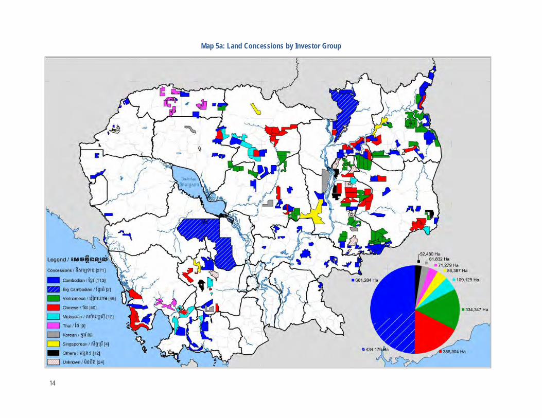
Map 5a: Land Concessions by Investor Group
14

Map 5b: Land Concessions by Proposed Crop Type
.
15

Figure 2: Extent of Concession Allocations
Figure 3: Extent of Concession Allocations by Investor Country
16

Allocation of Forest Lands to Land Concessions
Allocation of Major Forest Formations and Protected Areas to Land Concessions Cambodian law does not allow for the allocation of forest lands to land concessions. However, this is a common practice even in protected areas (Map 6).
The large majority of land concessions (81.2 percent) are located in areas that remained under forest cover as late as 2010 (see Map 10).35 These encompassed 19.7 percent (2,063,049 ha) of the nation’s forest lands. Of these forest lands, 78.5 percent (1,584,821 ha) were outside protected areas. The remaining 21.5 percent (546,971 ha) were located in protected areas36 and encompass 13.7 percent of all forest lands within protected areas (see Map 4, Annex 2).
The concession systems incorporates substantial portions of the nation’s major forest formations; evergreen (14.0 percent), semi-evergreen (18.9 percent), deciduous (25.2 percent) and secondary (9.6 percent). The allocation of major forest formations to concessions varies substantially between four main de facto land-use classes (Figures 4). By 2013, there had been a clear preference to allocate concessions within protected areas to the denser evergreen forests, whereas concessions outside protected areas are dominated by deciduous forest. The key points illustrated in Figure 4 are:
• The portion of concessions within protected areas allocated to the denser evergreen forest lands (48.6 percent) is 4.3 times greater than in concessions outside protected areas (11.4 percent); and 1.5 times greater than in protected areas that remain outside concessions (32.7 percent).
• In contrast, the portion of concessions within protected areas allocated to the sparser deciduous forest lands (23.5 percent) is less than half as much as that in concessions outside protected areas (50.2 percent); but only 0.7 times that in protected areas that remain outside concessions (32.7 percent).
• The portion of semi-evergreen and secondary forests does not vary significantly between the defacto land-use classes.
• Non-forested lands are not usually allocated for concessions. The portion of non-forest outside both concessions and protected areas (56.8 percent) is 4.5 times that allocated to concessions inside protected areas (12.6 percent); and 2.8 times that in concessions outside protected areas(20.5 percent).
Allocations of Major Forest Formations to Country Investor Groups The allocation of major forest formations to concessions also varies substantially between the declared country investor groups. The normally sized Cambodian and the Vietnamese investor groups focus investment on gaining access to larger areas of evergreen forest lands and have access to roughly equal areas of evergreen and deciduous forests lands, whereas the other investor groups primarily have access to deciduous forests and non-forest areas (Figures 5a and 5b, Annex 2).
This trend is particularly evident within protected areas where the normal Cambodian and Vietnamese investor groups gained access to 46 percent and 30 percent (121,487 and 70,066 ha.respectively) of the evergreen forests allocated to concessions within protected areas (Figure 6). In contrast, concessions allocated to Chinese investors and those from other countries are largely concentrated in deciduous forest areas outside protected areas and have at least three times as much deciduous forest land as evergreen forest land. Deciduous forests also manifestly dominate the two large concessions allocated to Cambodian entities in the 1990s.
35 Some concessions allocated prior to 2010 were also allocated to existing forestlands at the time. 36 Including those under the responsibilities of both MOE/GDANCP and MAFF/FA.
17

Map 6: Land Concessions and Protected Areas
18

Figure 4: Forest Composition of Four Main De Facto Land-Use Classes37
37 As a portion of the total land area within each de facto land-use class.
0%
10%
20%
30%
40%
50%
60%
Concessions inside PAs (%) Concessions outside PAs (%)
% o
f Lan
d-U
se C
lass
Evergreen Semi-evergreen Deciduous Secondary Non-forest
0.0%
10.0%
20.0%
30.0%
40.0%
50.0%
60.0%
PAs outside concessions (%) Outside PAs & Concessions (%)
%of
Lan
d-U
se C
lass
19

Figure 5a: Area of Forest Formations Allocated to Country Investor Groups (km2)
China
1,459
512
1,319
195 476
1,824
579 2,311
339
1,208
Cambodia (Normal)
Vietnam
185
509
2,966
105
1,138
669
332
2,190
138 708 778
478
2,510 119
1233
Other Cambodia (Large)
China
20

Figure 5b: Country Investor Group Allocations by Major Forest Formations
Figure 6: Allocations of Major Forest Formation in Protected Areas to Investor Groups
0%
10%
20%
30%
40%
50%
60%
Vietnam China Cambodia (normal) Other
Port
ion
of e
ach
fore
st fo
rmat
ion
in
Prot
ecte
d Ar
eas
Evergreen Semi-evergreen Deciduous Secondary Non-forest
0%
10%
20%
30%
40%
50%
60%
70%
Vietnam Cambodia (normal) China Others Cambodia (large)
Port
ion
of in
vest
or g
roup
Evergreen Semi-evergreen Deciduous Secondary Non-forest
21

Legal Context and Considerations Cambodia’s trees and forests receive substantive legal protections, starting with the national Constitution;
• Article 58 of Cambodia’s Constitution defines forests, land, and natural resources as State Property and specifies that “the control and use of State properties shall be determined by law.”
• Article 59 of the Constitution requires that the State “shall protect the environment and balance of abundant natural resources and establish a precise plan of management,” explicitly requiring these plans to be established for land, water, ecological systems, forests, and forest products, including wildlife amongst an array of natural and physical areas and properties.38
Furthermore, Articles 1 and 2 of the Land Law (2001) defines both trees and forest land - and therefore “forests” - as immovable property “for the purpose of guaranteeing the rights of ownership and other rights related to immovable property, according to the provisions of the 1993 Constitution of the Kingdom of Cambodia.”
Laws and regulations across various sectors have relevance for timber resulting from land clearing and conversion, but no direct or detailed provisions. This is because:
• The Land Law regulates the establishment of ELCs for plantation development but does not address allocation on forest lands despite defining them as immovable property.
• The Forestry Law (2002) focuses on timber concession operations, community forestry, user rights and administrative arrangements, but doesn’t include provisions for conversion timber as it assumes that land to be removed from the forest estate does not contain valuable timber resources.
• The Law on Protected Areas (2008) contains criteria to modify land under its jurisdiction based on scientific criteria and management objectives, including a management zoning system. However, large-scale commercial agriculture is not envisioned or considered a possible land-use in Cambodia’s protected areas.
In the absence of a definitive legal framework, an analysis of ELCs on forest land is based on implementation-oriented legislation, such as the Sub-decree on Environmental Impact Assessment Process, the Sub-decree on ELCs as well as timber royalty, harvesting, and transport regulations.39
As standard practice, the RGC’s Council of Ministers declares a transfer of state public land to state private land upon request from a plantation developer. Numerous regulations apply if activities seriously affect the country’s forests, including Article 4 of the Forestry Law which states that:
“This law shall be implemented to ensure public participation in any government decision that has the potential for heavy impact on concerned general citizens, livelihoods of local communities and forest resources of the Kingdom of Cambodia. Consistent with the Cambodian code of forest management and the Environmental Protection and Natural Resources Law, an Environmental and Social Impact Assessment shall be prepared for any major forest ecosystem related activity that may cause adverse impact on society and environment. Documentation of the environmental and social impact assessment shall be made available for public comment”.
Furthermore, Article 12 of the Forestry Law requires that any decision to declassify any forest from the Permanent Forest Reserves must serve the public interest and be consistent with the National Forest Sector Policy and the National Forest Management Plan. The Forestry Law also provides user rights for forest products and by-products to the local population, such as the collection of tree resin, dead wood, picking wild fruit, collecting honey, and collecting other forest by-products as well as the use of timber to build houses, stables for animals, fences, and to make agricultural instruments.
38 These other natural and physical areas and properties include fish and aquatic resources, air, wind, geology, mines, energy, petrol, and gas, rocks, sand and gems. 39 Generally speaking, Sub-decrees required by individual Cambodian laws tend to focus on procedural matters.
22

Furthermore, the rights of indigenous communities to forest use are guaranteed under the Land Law, ensuring tenure not only to those lands where they have established residences and where they carry out traditional agriculture, but also to forest lands necessary for shifting cultivation. Land titles granted by the State to the indigenous communities should be for collective ownership. No authority outside the community may acquire any rights to immovable properties belonging to an indigenous community.
The existence of conversion timber contradicts various provisions in the Forestry Law concerning, for example, harvesting rules, protected species, and the establishment of facilities, like sawmills, in the permanent forest estate. This absence of a framework is also problematic for protected area management as large portions of some protected areas, up to 80 percent in the case of Snoul Wildlife Sanctuary, are allocated as ELCs prior to forest clearance. Prior to the issuance of the Law on Protected Areas in 2008, changes in protected area boundaries appear limited to the de-gazettement of a major portion of Roniem Daunsam Wildlife Sanctuary by sub-decree.
The Law on Protected Areas defines a Sustainable Use Zone as a zone of high value in national economic development that “directly serves the purpose of management and conservation of the protected area and contributes to promoting the standards of living of the local community and indigenous ethnic minorities.” These zones include sites for environmentally friendly activities of cultural significance, ecotourism, wildlife conservation, recreational services, biological rehabilitation, and establishment of community protected areas and botanical gardens.
The law allows the RGC to permit development and investment activities in this zone. Issuing land title or permission to use land in this zone shall have prior agreement from the Ministry of Environment in accordance with the Land Law. While the Law on Protected Areas includes mining and infrastructure development related to water resources, it does not specify inclusion of agri-industrial commercial agriculture or the establishment of ELCs (Annex 3). Article 8 of the law specifies requirements for establishing and modifying protected areas (Box 1).
Box 1: Establishment or Modification of Any Protected Area Article 8 of the Law on Protected Areas stipulates that “the establishment or modification of any protected area shall be based on the results of research studies, criteria, management objectives, and access rights to resource uses, land titles, and other relevant aspects.” Furthermore it stipulates that proposals for establishing or modifying a protected area shall consist of:
1. A description of significance of the area(s) proposed for establishment or modification in terms of biological, topographical, geological, historical, cultural, and conservation values.
2. A legal description of the area(s) proposed for establishment or modification, attached with appropriately scaled and clear maps indicating its location, boundaries, and size.
3. Management objectives of the area(s) proposed for establishment or modification and current threats. 4. Assessment report of natural resources and land use in the proposed area(s). 5. Results from consultations with relevant agencies, stakeholders, and local authority representatives situated
within or adjacent to the proposed area(s) for establishment or modification.
Article 8 also requires that the modification of a protected area shall be determined by a sub-decree. The law also prescribes a management zoning scheme for protected areas. While the principles for zoning in any protected area are to be prescribed by a ministerial regulation (Prakas) issued by the Ministry of Environment, modification of the boundaries of each zoning system are to be based on:
• Clear scientific information on ecosystem, including animal species, plants species, genetic, biodiversity resources, socio-economic, and cultural aspects that are being changed and threatened.
• Compliance with the policies and strategies of the Royal Government of Cambodia.
23

Generally, companies are required to pay taxes and royalties on timber harvested. Inventories for tax purposes regarding timber category and value are made based on inspections of log stockpiles and timber storage in the area rather than on an inventory of standing timber. Timber transports require permits and are restricted in time and amount.
The Sub-decree on Environmental Impact Assessment Process requires the Ministry of Environment to monitor the performance of an economic land concession and its compliance with the Environmental Management Plan (EMP). This requirement also covers project construction, implementation, and closure as well as the initial assessment.
To date, conversion timber harvesting is circumventing and even contradicting existing natural resource legislation. The allocation of ELCs on forest land lacks transparent standards leading to a patchwork of different regulations being seemingly arbitrarily applied by the authorities. A 2014 joint administrative directive by the Ministers of MAFF and MOE40 aims to reinforce the authority of the two ministries over land concession operations but fails to address the allocation issues and the broader legality of conversion timber.
Allocation Processes for ELCs The allocation process as provided by Cambodian law takes into account environmental and social concerns, as well as transparency and basic land-use planning considerations. Article 4 of the sub-decree on ELCs states that an ELC may be granted only on land that meets all of the following five criteria:
1. The land has been registered and classified as state private land in accordance with the Sub-decree on State Land Management and the Sub decree on Procedures for Establishing Cadastral Maps and Land Register or the Sub decree on Sporadic Registration.
2. A land-use plan for the land has been adopted by the provincial or municipal State Land Management Committees and the land use is consistent with the plan.
3. Environmental and social impact assessments have been completed with respect to the land use and development plan for economic land concession projects.
4. Land that has solutions for resettlement issues, in accordance with the existing legal framework and procedures. The Contracting Authority shall ensure that there will not be involuntary resettlement of lawful landholders and that access to private land shall be respected.
5. Land for which there has been public consultations, with regard to economic land concession projects or proposals, with territorial authorities and residents of the locality.
It allows for an RGC authority to act as a contracting authority and, under Article 7, states “A Contracting Authority may initiate an economic land concession project by taking the following preparatory steps:
1. “Develop initial project documents proposing an Economic Land Concession project in a form established by the Technical Secretariat includes the information specified in Article 8 of this sub-decree.
2. Send the initial project documents to the Technical Secretariat for preliminary study and recommendations based on Article 3 and Article 5 of this sub-decree.
3. Consult with relevant Provincial Land Use and Allocation Committee and Regulatory Institution regarding the economic land concession project;
4. Arrange for the conduct of an initial environmental and social impact assessment of the proposed economic land concession project.
40 Inter-ministerial Notice On the Strengthening Economic Land Concession's Management. Ministry of Agriculture, Forestry and Fisheries, Ministry of Environment. May 9th 2014.
24

5. If the initial environmental and social impact assessment indicates a medium or high degree of adverse impact, arrange for the conduct of a full environmental and social impact assessment.
6. Prepare a complete set of project documents, which shall include all of the recommendations and reports from the steps enumerated above, and which shall be the basis for the Terms of Reference for Solicited Proposals.”
The sub-decree also provides for both solicited and unsolicited proposals. Article 12 states “The application for a Solicited Proposal shall include the following:
1. A business plan detailing the planned use for the land, the investment plan, expenditure and revenue planned for the land development, and the sources of capital to support the proposed concession project;
2. A description of the labor needs for the concession project and the source of the labor; 3. Information about technology, equipment, machinery, fertilizer, pesticides, use plan for types of priority crops; 4. Indication of the environmental and social impacts of the proposed investment activity and preventive or
reduction measures the proposer will take; 5. A description of any linkages and mutual support between social land concessions and economic land
concessions; 6. A description of any linkages to processing of raw materials which are domestic harvests; 7. The proposer’s land use fee offer to the state; 8. Disclosure of any land concession holdings by the proposer as provided under article 59 of the Land Law; and 9. Any guarantee sought by the proposer from the State”.
In addition, Article 20 requires that a detailed unsolicited proposal shall contain all of this information as well as:
“A report of an initial environmental and social impact assessment. If the initial environmental and social impact assessment indicates a medium or high degree of possible adverse impact, the proposal shall also include a report of full environmental and social impact assessment.”
A decision to reclassify must serve the public interest and be consistent with the National Forest Sector Policy, the National Forest Programme and technical, social, and economic data provided by Ministry of Agriculture, Forestry and Fisheries. (see Annex 3). In practice, project developers approach MAFF with particular requests for land. According to government policy, forest land should not be given out for ELC development, however, this often seems to be disregarded. Based on an internal database, the Ministry decides if the land is suitable for the establishment of an ELC.
Article 12 of the Forestry Law empowers the RGC to declassify forest land from the Permanent Forest Reserves. Article 10 defines a category of forest land – Conversion Forest - for this purpose and also defines the functions of Production Forests and Protection Forests. Conversion forest is an administrative category for lands not yet allocated as production or protection forests, and are considered to be “idle land comprised mainly of secondary vegetation.” In contrast, Article 10 of the Forestry Law specifies that “degraded” forest lands fall within the definition of “production forest.”
The RGC’s official 2010 forest cover assessment (see Map 3) specifies secondary forests as belonging to the “Other Forests” category rather than as part of evergreen, semi-evergreen, or deciduous forests categories. This implies that areas allocated to land concessions should be derived from conversion forest but not from production or protection forest, which are to be maintained to allow sustainable production of forest products and protect ecosystems and natural resources respectively.
However the large majority of land concessions are allocated in production or protection forest areas. Current applications of definitions over degraded forest and conversion forest have been a major source of conflict between developers, authorities, and the local population. For example, in the case of Kbal Damrei commune in Kratie province.
25

“The provincial deputy governor argued that the companies had received permission from the national government to establish the three ELCs to develop tree plantations and wood processing factories. He claimed that the government granted only ‘state land’ to the companies, not villagers’ farmland. The deputy governor further suggested that those lands were ‘degraded’ forest areas that were of ‘no use’ for local people, therefore ‘the companies will help to develop local infrastructure and provide jobs to the local people in order to reduce poverty in the region.’ He emphasized that ‘in the future Cambodia will export wood products and get US dollars in return.’
Yet the villagers maintained that most of the area was not ‘degraded’ and ‘non- use,’ but rather ‘old-growth and dense forest,’ locally known as ‘prey chas’ rich in biodiversity and valuable timber. This narrative was supported by the commune land use and natural resource map of 2006 that had been developed by the community forestry project under government and NGO support and had identified more than 50,000 ha of the commune territory as ‘dry evergreen broad-leafed forest, deciduous forest, and mixed forest.’”
An Inter-Ministerial commission is tasked with an evaluation of the proposed project also involving the provincial and local government authorities. The Ministry of Environment is responsible for supervising the ESIA requirements. The project application then awaits approval by the office of the Prime Minister to allow MAFF to enter into a concession agreement. If granted, the investor prepares a master plan covering five years of on-site activities. If approved, the investor commences clearing the ELC area under a special permit.41 The sale of the timber on a concession is considered a windfall for the investors.42 The whole process is often conducted via specialized, well-connected middlemen working on commission.
In reality, the required ESIA is rarely conducted43 and if conducted it is generally undertaken following the development of the master plan. It is therefore intended to mitigate impacts rather than to inform decisions on the suitability of the land area for allocation as an ELC. The transfer of the area from state public land to state private land and the approval of the Prime Minister’s office are considered sufficient proof of legality of the ELC by provincial, district, and commune authorities. Negotiations with local villagers include compensation issues, or the use of private land to supply the company with produce, such as that from smallholder rubber plantings. However, significant changes of concession boundaries are usually not considered an option by the authorities; and village land and sensitive natural features such as streamside areas frequently fall within concession boundaries.
Limitations on land concessions are provided for in Article 59 of the Land Law which stipulates that:
“Land concession areas shall not be more than 10,000 ha. Existing concessions, which exceed such limits, shall be reduced. However, if such reduction would result in compromising the exploitation in progress, a concessionaire may obtain a specific exemption. The procedures for reductions and specific exemptions shall be determined by sub-decree. The issuance of land concession titles on several places relating to surface areas that are greater than those authorized by the first paragraph in favor of one specific person or several legal entities controlled by the same natural persons is prohibited.”
Most ELCs granted in recent years comply with the 10,000 ha-hectare size limitation.44 Company data and media reports suggest however that many ELCs are owned by the same investors and are merely parceled out into 10,000 ha sections,
41 Prices for the land use fee are reportedly between USD350 and USD500 per ha. 42 Arrangements concerning timber harvest and sale may vary from site to site, and continue to evolve. As recently as May 2013, the RGC required all concessionaires operating in Ratanakiri province to manage these contracts through a single contractor. 43 The MOE stated at a workshop on drafting of an ESIA law to supersede the existing sub-decree stated that only five percent of major development projects undertake an ESIA. “1 in 20 Firms Carry Out Environmental Assessments” Cambodia Daily, 23 November 2012. 44 While concessions may exceed this limit slightly, some concession agreements reportedly have provisions for omitting certain natural areas and village land from the concessionaire’s rights to develop that reduce the area to less than 10,000 hectares.
26

often adjacent to each other.45 To date, the government hasn’t addressed or rectified the issue. One example is the HAGL Group which reportedly controls at least 47,000 hectares of ELCs in northeast Cambodia.46
Furthermore, recent analysis of the democratization and decentralization process47 have shown that the Commune Councils have little or no power to influence high-level decisions pertaining to natural resource allocation in their communes. Local officials representing the interest of their constituency against higher-level decision-making are frequently targets of intimidation, threats or in some cases are dismissed.
The extent to which local authorities become involved varies. The decision to establish a concession has sometimes been taken at the central level prior to the development of the preliminary ESIA, and projects are presented to the local population as a fait accompli. Investor demands may overrule the existing frameworks. For example, in the case of an ELC within a protected area, the land was allocated to “…the Vietnamese rubber federation that needs land up to 100,000 hectares… as MAFF does not have enough capability to look for land, so turned to MOE …”48
The current practice of retro-fitting the allocation process to decisions made at the highest level of government is also reflected in the attitude of provincial and local authorities in considering conflict between developers and local communities as a “bilateral” issue. Government representatives only get involved if conflicts and disagreements reach a more prominent level. Even under these circumstances, local officials advise villagers to “take the company to court if they have problems.” Considering the well-connected nature of most ELC developers, companies’ frequent use of military personnel, and the weaknesses in the implementation of Cambodia’s legal system, legal actions against ELC companies have been mostly symbolic exercises. Some cases have been pending for a decade without affecting the operations of certain companies.
45 Forest Trends 2012. Ibid. Page 26. 46 Rubber Barons. Global Witness 2013. 47 Assessment of the Second Term of Decentralization in Cambodia: Commune Council’s performance and Citizens Participation. COMFREL. February 2013. 48 Unofficial translation of the Minutes of a Meeting about the Report on on Preliminary Social and Environmental Impact Assessment Regarding a Proposal of Economic Land Concession Project between the provincial and district officials and the ESIA consultancy company, June 2010.
27

Forest Fire Regimes Forest fire mapping has the potential to be an important tool for monitoring land clearance as fire is used either to facilitate access for logging and/or to prepare land for planting afterwards. This section describes the pattern and progression of forest fire in the 2012/2013 fire season in relation to the major forest formations, land-use allocations, and the natural and historical forest fire regimes.
Historical Fire Regimes of the Major Forest Formations Fire has been a major determinant of vegetation patterns throughout the Indochinese Peninsula over recent centuries, and Cambodia’s lowland forests are an example of a landscape substantially modified by human induced fire.49 Legris and Blasco (1972) estimated that as much as 90 percent of Cambodia’s vast, relatively open deciduous forests came about in this manner, largely as the result of human activity. The expansion of the less diverse and fire tolerant fire disclimax deciduous forests replaced the more diverse, denser and more fire sensitive climax semi-evergreen evergreen forest areas, which are currently of limited extent (see Map 3). This process created Cambodia’s reknown “Serengeti-like” savannahs that were populated by large mammals (Wharton 1968).
Historically, these fires spread relatively unimpeded through the flat, low-lying deciduous forest areas that occur on alluvial and sandstone substrates in north and northeast Cambodia, as well as in lowland areas in the southwest (see Map 3). These fires were largely annual and biennial ground fires in deciduous forests and woodlands, and contribute to the maintenance of deciduous forest areas. Without these fires, evergreen tree species will recolonize accessible deciduous forests, reverting them to semi-evergreen forests.
Relationship of Fire to Recent Land Clearance Currently, the patterns in fire regimes within evergreen and semi-evergreen forest lands now contrast dramatically with those characteristic of historical fire regimes, indicating the heavy influence of human activities.
Duration and Progression of the 2012-2013 Fire Season Satellite mapping of fires shows that forest fire is both widespread and extensive in Cambodia’s forest lands. A total of 38,982 active fire reports were logged by the MODIS/FIRMS satellite facility for the fire season, of which 32,053 (82 percent) were in forest areas (Maps 7, 8, 9 and 10). The peak of the fire season was between January 7th and March 8th when 79 percent of all fire reports (30,842) occurred (Figure 7). Active fire reports generally ranged from 200 to 1,100 per day but were as high as 1,707 reports on some days. Prior to this period, fires increased from a low of 1 to 50 per day prior to mid-December to 200 per day by late December. After March 8th, they declined just as dramatically to a level of 50 to 200 per day.50
The duration and progression of the fire season varies between the major forest formations (Figure 7).51 Fires in the fire-prone deciduous forests have a pattern similar to that of an inverted parabolic curve in which fires are normally distributed around the first week of February. Fire in these forests increases rapidly from mid-December. Following a brief hiatus around the 7th of January, these deciduous forests are subject to high levels of fire activity, peaking at 1,082 fire reports per day, until late February when they fall dramatically back to low levels.
49 Schmid 1969; Wharton 1968; Legris & Blasco 1971, 1972; Vidal 1978; Dy Phon 1981, 1982. 50 Fires commenced on 4th October 2012 and continued until after March 31st 2013 when data were downloaded from NASA’s FIRMS data facility. Low levels of fire, generally between 10 and 100 fire reports/day persisted until the wet season commenced inearly June 2013. These generally occurred in a few select land concessions or in areas of flooded forest around Tonle Sap. 51 Generally speaking, there is a high degree of variability in the number of fires detected by the MODIS/FIRMS fire mapping facility. The high degree of concordance in peaks and troughs experienced in each of the major forest formations across the country and throughout the season indicates that this variability results from variable cloud cover that obscures fires from satellite detection.
28

In contrast, the incidence of fire in the fire sensitive evergreen forests increases in a gradual manner from mid-December and is sustained until beyond the end of March.52 Fire occurs as a series of short phases in which increases in fire frequency are followed by rapid declines. Fires in semi-evergreen and secondary forests tend to follow a similar path as those in evergreen forest lands, albeit at lower levels.
The low levels of fire in non-forest areas tend to exhibit a similar pattern to that seen in deciduous forests. Fires associated with the agricultural cycle in wetland rice fields were not generally detected by MODIS, apparently as they are too short lived. Fires in swidden agricultural systems appear also to have been too short-lived, or not to have been sufficiently clustered to facilitate detection.
52 Daily reference to MODIS/FIRMS fire reports indicates that this continued until at least the first week of June 2013, though these additional data were not included in this analysis.
29

Map 7: Active Fire Reports October 2012 – March 2013
30

Map 8: Fire Distribution in Relation to Forest Formations and Land Concessions
31

Map 9: Fire Distribution in Relation to Forest Formation and Protected Areas
32

Map 10: Overview of Forest Fires October 2012 to March 2013
33

Figure 7: Progression of the 2012-2013 Fire Season in the Major Forest Formations
34

Relationship of Fires to Forest Formations and Land-Use Allocations At the national level, average fire densities in the major forest formations range between 0.19 and 0.36 fire reports/km2
(see Maps 8, 9 and 10; and Annex 4). Densities are highest in deciduous forests (0.36 reports/km2). They are only slightly lower within evergreen and semi-evergreen forests (0.3 reports/km2), but drop to 0.19 in secondary forests and to 0.08 in non-forest areas.
Average fire densities are four times higher in concession areas, than outside them. They also vary substantially between forest formations (Figure 8). In evergreen forests, an eight-fold (7.9) increase in fire density is recorded in concession areas, while a four-fold increase is recorded for semi-evergreen forests. In contrast, fire density in deciduous forest is only 74 percent higher in concession areas than outside them. Fire densities in secondary and non-forest areas are 3.7 and 2.5 times higher in concession areas than outside them respectively.53
Figure 8: Fire Density in Major Forest Formations and Land Concessions
53 Amongst the minor forest types, fires are prevalent in the dry woodlands that are associated with deciduous forest (0.46 reports/km2). Fire densities are 0.15 fires/km2 in bamboo and evergreen woodlands, and drop to 0.02 reports/km2 in mangroves. Again, fire densities are substantially greater in concession areas; being 3.5 times higher in disturbed evergreen woodlands, and 2.4 times higher in deciduous woodland. Comparisons for bamboo and plantations are less meaningful due to their low occurrence both within and outside concession areas. In the case of mangroves, fire is nearly ten times more common in concession areas than outside them.
1.18
0.76
0.53 0.41
0.15 0.19 0.30
0.17
0.0
0.2
0.4
0.6
0.8
1.0
1.2
Evergreen Semi-evergreen Deciduous Secondary
Fire
s/km
2
Inside Concessions Outside Concessions
35

Forest Land-Clearance Scenarios
Current Fire and Land Clearance Scenarios This study confirms the utility of NASA’s active fire reports in mapping deforestion and land clearance. During the 2012/2013 fire season, deforestation was largely associated with land concessions in the lowlands of north and northeast Cambodia. In earlier years, for example from 1997 to 2002, forest loss and degradation in Cambodia were associated with smallholder agricultural encroachment along the boundaries between extensive forest and non-forest landscapes (IFSR 2002). This form of deforestation appears relatively limited today.
The largest frontline of deforestation extends almost 300 hundred kilometers along a NW-SE axis (Map 11). It extends through evergreen forest lands from Seima Protection Forest in Kratie province through the lower reaches of the Prey Lang landscape, around Tumring and Boeung Per Wildlife Sanctuary in Kampong Thom province to Phnom Kulen in Siem Reap province where little forest remains. A second broad but discontinuous front extends eastwards along the Srepok River valley, from Prey Khieu near the Mekong River in Stung Treng province to Andoung Meas district on the Vietnam border. It passes through both evergreen and deciduous forests, and incorporates sites along the southern boundary of the basalt plateau in Ratanakiri Province.
Other key focal areas of deforestation include those in the evergreen forest lands both within and contiguous with Kulen-Promtep Wildlife Sanctuary in northwest Cambodia, as well as in evergreen and semi-evergreen forests of Andoung Meas district in the far northeast, near the Vietnam border (Maps 8 and 11). Numerous other areas feature widely dispersed ELCs that were cleared in the 2012/2013 fire season. In the southwest, forest land clearance is evident at a few locations in accessible valleys and lowlands, and in the vicinity of three hydropower projects.
The pattern of forest fires also reveals land clearance in a number of non-concession areas. These areas, such as those within the Prey Lang landscape, lie closely adjacent to land concessions (see Map 8).54 Encroachment on forest land also appears to occur along some portions of the forest/non-forest boundary in semi-evergreen forests in Ratanakiri and Kampong Cham provinces as well as in a few other small locations. Areas on the edge of the Tonle Sap floodplain are subject to land clearance (see scenario 9) and this was observed to have intensified after the end of March 2013.
Ten forest fire and land clearance scenarios were documented during the 2012/2013 fire season. Those in natural forests free of land concessions are:
• Mature, primary, or largely undisturbed evergreen and semi-evergreen forests • Natural deciduous forest and woodlands.
Those within land concessions are:
• Mature, primary, or largely undisturbed evergreen and semi-evergreen forests • Disturbed but recoverable evergreen forests • Heavily degraded evergreen and semi-evergreen forests • Deciduous forest and woodlands
Scenarios outside concession areas include:
• Encroachment on swidden areas in evergreen, secondary, and semi-evergreen forests • Encroachment upon recoverable evergreen and semi-evergreen forests adjacent to concessions
54 There are a few sites where fire clusters are associated with documented land concessions for which boundaries have not yet been incorporated within Licadho’s database.
36

• Boundary of major forest/non-forest blocks • Flooded forest areas on the edge of the floodplain of the Tonle Sap Lake
These scenarios show that:
• Virtually all forest clearance is associated with ELCs though clearance they may extend beyond ELC boundaries in some areas.
• The pattern of major forest clearances has changed in recent years, shifting to one driven by ELCs that have also captured lands that were once on the edge of the major agricultural and forest belts; as well as extended deeply into previously expansive forest areas.
• The full range of major forest formations are subject to encroachment by ELCs. They include sites that, at the time of assessment, represent a range of forest conditions from natural or pristine through various degrees of degradation to heavily degraded sites.
• ELCs are the major form of encroachment into remaing areas of good forest.
37

Map 11: Focal Areas of Deforestation in Evergreen and Semi-Evergreen Forest Lands
38

Scenario #1: Mature, Undisturbed Evergreen and Semi-Evergreen Forests
Land-Use Designations and History Protected areas and production forests without land concessions.
Locations/Cases Prey Lang, Cardamom Mountains and parts of Nam Lyr Wildlife Sanctuaries and Virachey National Park.
Concession Ownership None
Forest Formation Dominated by evergreen with and semi-evergreen forests
Fire Regime None
Forest Condition/Successional State Primary forests in good condition with little or no evidence of land conversion
Land Clearance Pattern None
39

Scenario #2: Natural Deciduous Forests and Woodlands
Land-Use Designations and History Production forests and protected areas outside concessions
Locations/Cases Widely dispersed across northeast Cambodia (Kratie, Mondolkiri and Ratanakiri provinces) and elsewhere.
Concession Ownership None
Forest Formation Deciduous and some semi-evergreen forests
Fire Regime Fire clusters centered on deciduous forest patches
Forest Condition/Successional State Primary forests with little or no evidence of logging until recently
Land Clearance Pattern None
40

Scenario #3: Mature, Primary, or Largely Undisturbed Evergreen Forests in Land Concessions
Land-Use Designations and History Protected areas and production forests including some derived from former logging concessions.
Locations/Cases Seima Protection Forest; CRCK concession on the edge of Prey Lang, some areas in Boeung Per and Nam Lyr Wildlife Sanctuaries and Virachey National Park
Concession Ownership Cambodian, Vietnamese
Forest Formation Dominated by evergreen and semi-evergreen forests
Fire Regime Fire clusters centered on evergreen forest patches
Forest Condition/Successional State Primary forests or forests in good condition with little or no evidence of logging until recently.
Land Clearance Pattern Highly geometric
41

42

Scenario #4: Disturbed but Recoverable Evergreen Forests
Land-Use Designations and History Production forest areas and some protected areas subject to logging in the past
Locations/Cases Prey Khieu and areas adjacent to hydropower sites in the Cardamom Mountains. Also in the Botum Sakor National Park, Boeung Per and Kulen-Promtep Wildlife Sanctuaries, and possibly remnants in Snoul Wildlife Sanctuary.
Concession Ownership Cambodian, Vietnamese
Forest Formation Dominated by evergreen and semi-evergreen forests
Fire Regime Fire clusters centered on evergreen and semi evergreen forest patches
Forest Condition/Successional State Tall forests with varying degrees of tree harvest in recent years
Land Clearance Pattern Highly geometric
43

44

Scenario #5: Heavily Degraded Evergreen Forests Land-Use Designations and History Production forest that were formerly logging concessions
Locations/Cases Former Casotim and Timas logging concessions
Concession Ownership Various
Forest Formation Dominated by evergreen and semi-evergreen forests
Fire Regime Fire clusters centered on evergreen and semi-evergreen forest patches
Forest Condition/Successional State Patchwork mosaic with varying levels of logging until recently
Land Clearance Pattern Ad-hoc and irregularly sized and arranged plots
45

46

Scenario #6: Deciduous Forests and Woodlands in Land Concessions Land-Use Designations and History Protected areas and former logging concessions
Locations/cases Phnom Aural and Lomphat Wildlife Sanctuaries, and at sporadic locations in the north and north east
Concession Ownership Chinese, and various other investor groups
Forest Formation Deciduous forests
Fire regime Fire clusters centered on deciduous forest patches
Forest Condition/Successional State Healthy forests with little or no evidence of logging until recently
Land Clearance Pattern Generally regular
47

48

Scenario #7: Encroachment on Swidden Areas in Evergreen and Semi-Evergreen Forests
Land-Use Designations and History Production forests and swidden agriculture areas located outside land concessions
Locations/Cases Thala Bariwat District in Stung Treng Province, located on the edge of the Prey Land landscape
Concession Ownership None
Forest Formation Dominated by semi-evergreen forests with some traditional swidden areas
Fire Regime Fire clusters centered on semi-evergreen forest patch
Forest Condition/Successional State Patchwork of primary and secondary forests
Land Clearance Pattern Geometrically irregular
Scenario #8: Encroachment upon Recoverable Evergreen and Semi-Evergreen Adjacent to Concessions
Land-Use Designations and History Protected areas including some derived from former logging concessions
Locations/Cases Various areas adjacent to concession sites at Boeung Per, Prey Khieu, Ratanakiri, Siema Wildlife Sanctuary and Timas.
Concession Ownership Adjacent to Cambodian, Vietnamese concessions
Forest Formation Dominated by disturbed but often recoverable evergreen and semi-evergreen forests
Fire Regime Fire clusters centered on evergreen and semi-evergreen forest patches
Forest Condition/Successional State Sites with various histories of disturbance
Land Clearance Pattern Unknown
49

Scenario #9: Boundary of Major Forest/Non-Forest Blocks
Land-Use Designations and History Various
Locations/Cases Areas adjacent to disturbed forest lands associated with the Casotim, Ratanakiri and Snoul, Timas sites; and possibly within the valley of the Pursat River in the Cardamom Mountains
Concession Ownership Varied, but not always associated with land concessions
Forest Formation Various forest formations
Fire Regime Fire clusters centered on forest edges though generally more diffuse than in concession areas
Forest Condition/Successional State Degraded and secondary forests
Land Clearance Pattern Generally unknown, but irregular in some areas
Scenario #10: Flooded Forests of the Tonle Sap Lake Floodplain
Land-Use Designations and History Transitional zones of the Tonle Sap Biosphere Reserve
Locations/Cases Outer edges of the Tonle Sap floodplain in Battambang, Kampong Thom, Kampong Chhnang and Pursat provinces
Concession Ownership None
Forest Formation Flooded forests and shrub lands
Fire Regime Fire clusters centered on edge of flooded forest and shrub land patches
Forest Condition/Successional State Stable over the long term, at least up until recent years
Land Clearance Pattern Unknown, suspected irregularly shaped and sized smallholder plots
50

Fire Intensity and Carbon Emissions NASA’s MODIS/FIRMS satellite measures fire intensity as fire radiative power (FRP) in megawatts. FRP values are linearly correlated with biomass consumed (e.g. Wooster et.al. 2005)55 and can been used to model global CO2 emissions when a geostationary satellite is available (e.g. Zhang et.al. 2012). The Aqua and Terra satellites used by NASA’s MODIS/FIRMS facility are not geostationary, but circumnavigate the Earth in a polar orbit, generally passing a given area between two and four times a day.56
As such, the data collected can be used as an indicator of carbon emissions rather than as a quantitative or direct measure. FRP values from active fire reports were collated for the major forest formations in terms of the concessional and non-concessional forest lands they were located in; and expressed as an indicator of total carbon emissions (as the sum of individual FRP values), and as emission densities on a per square kilometer-basis (Annex 5).
55 Wooster, M. J., G. Roberts, G. L. W. Perry, and Y. J. Kaufman (2005), Retrieval of biomass combustion rates and totals from fire radiative power observations: FRP derivation and calibration relationships between biomass consumption and fire radiative energy release, J. Geophys. Res., 110, D24311, doi:10.1029/2005JD006318. 56 - The MODIS instruments on board the Terra and Aqua EOS satellites acquire data continuously providing global coverage every one or two days. The satellites orbit the Earth once every 99 minutes. For most parts of the Earth’s equator, there are 4 overpasses in a 24-hour period, two for Aqua and two for Terra. The precise number and timing of overpasses depends therefore on your geographic location. http://earthdata.nasa.gov/data/near-real-time-data/faq/firms accessed June 13, 2013.
51

Total emissions from the concession system – which occupies about 14 percent of forests areas - were equivalent to those detected for the more extensive forest lands outside concessions (Figure 9). Those from evergreen forest dominated emissions from concession areas, whereas those from deciduous forest dominated emissions from areas outside the concession system.
Figure 9: Indicators of Total Emissions for Major Forest Formations Inside and Outside Concessions
Average emission densities from concession areas are relatively high compared to those outside concessions (Figure 10). They vary with the major forest formations concerned, being highest for evergreen forests, intermediate for semi-evergreen, and lowest for both deciduous and secondary/flooded forests. In contrast, emission densities outside concession areas are both low and remain constant irrespective of the forest type.
Emissions densities from evergreen forest lands in concessions areas are almost ten (9.5) times higher than those from areas without concessions, while those from semi-evergreen forest lands are five (5.3) times higher. Emissions from deciduous and secondary/flooded forests in concession areas are also higher than those outside concessions, but by only a factor of 2.0 and 3.3 respectively.
Interestingly, emission densities from evergreen forest lands in concessions areas are more than three (3.4) times higher than those from the secondary forests that would normally be expected for allocations to concessions.
52

Figure 10: Average Emission Densities per km2 for Major Forest Formations Inside and Outside Concessions
It is important to recognize that this analysis is conservative, and that the trends are likely understated as the divisors used in the calculations are overstated for the following reasons:
1. Substantial areas within concessions were not cleared or burnt during the 2012/2013 fire season, thereby diluting emission densities.
2. The inclusion of large areas of evergreen forest within mountainous areas of Cambodia’s southwest and in the far northeast similarly distorts calculations, possibly by more than 30 percent.57 These forests constitute a different evergreen forest type than that occurring in the lowland areas of the north and northeast and are largely free of fires, which are not part of their natural ecology, and few concessions are located in these areas.
3. Fires outside concessions reflect more natural fire regimes, albeit with some encroachment of evergreen forests. Additionally, actual carbon losses from the ubiquitous fires in deciduous forests are likely to be neglible. These fires are generally ground or grass fires in which the carbon lost is resequestered during the next wet season as biomass increases.
Nevertheless, comparisons of FRP indicators for a number of specific sites selected from within the major land clearance scenarios described above confirm the trends described above (Figure 11, Annex 5). CRCK’s concession has the highest emissions, indicating that these forests possessed high biomass and had remained essentially intact. These were 50 times higher than the background emissions from untouched deciduous forests subject to their normal fire regime. Deciduous forests in concessions that were completely cleared feature medium levels of emissions, while low levels were observed at Phnom Aural Wildlife Sanctuary where most of the clearing was done prior to this season.
57 The very general nature of the forest typology used in the RGC’s 2010 forest cover map fails to distinguish lowland forests from sub-montane forests, or lowland dry evergreen forests from Cambodia’s north and northeast, from the wet lowland evergreen forests of the south west (Legris and Blasco 1972). In the mid 2000’s submontane and lowland wet evergreen forests forests covered 1,828,616 ha, or approximately 33 percent of Cambodia’s evergreen forest formations (Cutter and Ashwell 2007).
53

Medium levels of emissions characterized evergreen forests in Seima Protection Forest and the Boeng Per and Phnom Kulen Wildlife Sanctuaries. This confirms that they retained substantial biomass, comparable to that observed in intact deciduous forests. This may reflect upon the level of degradation in some sites, particularly in parts of Boeng Per and Phnom Kulen Wildlife Sanctuaries, where logging occurred in the 1990s. Nevertheless these data are understated for evergreen forests in Seima Protection Forest and some parts of the Boeng Per Wildlife Sanctuary where intensive fires and land clearance were observed to continue on a daily basis until June 2013, three months after the assessment period finished.58
The low emissions derived from the Timas concession during this season reflects upon the long history of logging and land clearance there. The impact of clearance of evergreen forest lands at hydropower sites in the Cambodia’s southwest appears to have been minimal in the current season.
Figure 11: Fire Radiative Power (FRP) Indicators for Specific Sites
58 The investigators continued to monitor active fire reports from MODIS/FIRMS facility for more than two months after data were downloaded from the GIS for analysis and were able to confirm that fires continued on a daily basis.
0.0
2.0
4.0
6.0
8.0
10.0
5.1 4.7
2.3
5.9 4.6 4.3
0.5
10.7
6.4
3.7 3.0
0.7 0.7 0.2 0.2 FRP
Indi
cato
r
Concessions inside PA Concessions outside PA
54

Land Use, REDD+, and FLEGT
Challenges for Resource Governance The production of conversion timber from land concessions exposes weaknesses, gaps, and conflicts in policy and regulatory frameworks that simply did not envision that Cambodia’s forest areas would be allocated for large-scale commercial agricultural production. Government policy on timber resources in these areas is conflicting, with stated policy and actual decision-making often in direct contradiction. As a result, a lack of clarity of the roles of various institutions in the protection of immovable property (land, trees, and forests) and the lack of assurance of best practices in support of the public interest is preventing effective forest management strategies from being designed and/or implemented. This business-as-usual scenario raises a suite of political, legal, institutional, and technical issues affecting the future of forests in the country that constitute both constraints and opportunities for REDD+ and FLEGT.
Failure of the National Forest Program: Key policy issues concern the future of sustainable forest management (SFM) in Cambodia and the utility of the National Forest Program (NFP) in achieving it. The NFP’s vision for SFM has been marginalized by higher-level decision-making and field realities. Its 2010 to 2029 work plan appears already outdated and academic. Many of the problems and risks outlined in the program have materialized. These include concerns over the:
• Magnitude of undertaking ELCs and their use as loophole for timber production
• Uncertainty and low level of implementation of existing policies, including the NFP due to “poor institutional capacities” and arrangements
• Undermining of efforts to develop a “well-organized sector”
• Poor performance record within the forestry sector, especially production figures
• Illegal logging due to, for example, weak law enforcement
A key issue is the need for clarity on the role of exports in the timber market and on how the nation aims to satisfy domestic timber needs. Other policy issues concern the social and economic implications of encroachment upon people’s lands, and the implications of forest loss and degradation for the delivery of environmental services and conservation of biodiversity.
Need for clear legal process to identify conversion forest: There is no clear policy on how conversion forests, as described in the Forestry Law, are to be identified. The RGC has not released a map of conversion forests into the public domain. Application of the criteria enshrined in the typology used in the RGC’s official 2010 forest cover map indicates that only areas within the “Other Forests” category would be available for conversion and reallocation to other uses, including land concessions.
The integrity of the protected area system is being undermined by the approval of large-scale clearing:
• Allocations are made within protected areas without approved management plans and in violation of procedures for the de-gazettement of protected areas.
• Targetting of lowland evergreen forests in the protected area system weakens its key biodiversity values, and undermines the core concept of protected areas at the national level, and at local levels where provisions for management zoning are not being implemented.
Lack of legal process and law enforcement: Legal and institutional concerns include the general lack of application of the existing legal frameworks for natural resource management, the lack of specific provisions for conversion timber, and the resulting lack of forest law enforcement. As a result, rent-seeking by the business sector and other actors remains problematic in the Cambodian forest sector. Consultation processes with local communities are limited and frequently absent while recourse to legal processes by plaintiffs is similarly undermined or denied. This lack of consultation results in
55

further marginalization of both local forest land and other rural communities through their disenfranchisement of land and access to forest and is certain to promote additional conflict and social unrest.
Need for transparency in land allocation processes: Issues concerning land-use planning and allocations include the lack of transparency in the allocation process, which subverts legal processes including ESIA provisions and implementation requirements. Legal provisions intended to guarantee consultations with local communities are not generally implemented. Assessments of forest degradation and land capability assessments are not supportive of an effective ESIA process.
A bidding process that is effective in matching investors with lands requires that these factors be in place and publicized. Provisions for unsolicited proposals cloud transparency in the award of agreements. This situation points to a need to reform allocation processes.
Furthermore, current institutional arrangements do not ensure the delivery of environmental services and the conservation of biodiversity. Consultation between key institutions, particularly between line agencies, and efforts to decentralize decision-making on land use and environmental and natural resource management remain limited. This poses additional constraints on the development of meaningful participation for communities within forest lands at an adequate scale. It also undermines the establishment of effective monitoring mechanisms that have a real opportunity to inform the decision-making process, as well as effective enforcement arrangements required to implement these decisions. Scaling up of program impacts requires collaboration.
The lack of integration of land-use capability assessments into the current land allocation necessarily means that producers will turn to high cost chemical fertilizers and pesticides that will inevitably pollute soil and water resources, as well as pose threats to worker health.
Any failures of business investments - related to land-use capability and poor business models – will further undermine the mitigation of environmental and social impacts as investors maintain an eye to the financial bottom line.
Information systems for monitoring and reporting: Required by law, these systems are either not in place, not adequately shared, or their products are not disseminated effectively within the public domain. The general lack of transparency on the location and purpose of land concessions, and of the regulatory provisions contained within concession agreements, precludes effective participation in both the allocation and the monitoring processes. This undermines the constitutional right of citizens to participate actively in the economic, social, and cultural life of the nation. It prevents documentation of the full suite of illegalities associated with timber harvesting in large-scale commercial agriculture, considered to be the largest source of timber in Cambodia today.
A set of technical issues limits the development of effective monitoring frameworks. These include scientific questions that are of central importance to land-use planning and allocation as well as to the measurement of carbon stocks and flows. The development of an ecological framework - that describes forest patterns, successional, and rehabilitation processes - is required to design viable forest management strategies for SFM and REDD+; and to develop a meaningful assessment of forest degradation. Indeed, this is central to the legal definitions of both “forest” and “degraded forest” needed to underpin decisions for the conversion of State Public Property to State Private Property that are required prior to the allocation of an ELC.
Need to integrate forest fire management into SFM strategies: While the role of fire as a determinant of forest type and species diversity is well understood by forest ecologists, the implications of this for SFM are less well understood by the RGC’s forest managers and conservation partners. A clear understanding of the implications of differing fire regimes for the maintenance - or degradation - of forest formations, plant communities, and carbon stocks is essential for any SFM or REDD+ strategies within tropical monsoon forest lands. The NFP does not consider these broader implications of forest fire regimes for SFM or REDD+ beyond the control of illegal fires.
56

Summary of drivers of deforestation and degradation: Current forest loss and degradation scenarios described here imply that the major threats to forest lands are:
1. Foreign demands for commercial agricultural land and cash crops, and associated “land grabbing” by domestic actors.
2. Overharvesting for the domestic market. 3. Overharvesting of luxury and high value species for export. 4. Establishment of hydropower facilities and related infrastructure leading to the destruction of adjacent forest
lands by organized illegal logging. 5. Internal migration and labor movements, some of which may be a prelude to contract farming arrangements and
the indenture of labor to ELCs or SLCs.
As a result of this situation, the allocation of forested areas to land concessions has become highly controversial and is often likely to be illegal. Large-scale forest conversion – the effective privatization of public lands and destruction of public goods – can also be considered unconstitutional in respect to assurance of the public interest and protection of immovable property. Certainly, they have led to frequent and often violent conflict. The current business-as-usual scenario seems certain to result in both an escalation of environmental degradation and social conflict.
Senior decision-makers within the RGC appear to have acknowledged this and have undertaken some actions such as a land-titling scheme, the formation of an Inter-Ministerial Land Use Committee and new policy statements that no new land concession agreements will be issued. In 2014, the MoE and MAFF have initiated a review of ELC agreements with the declared aim of cancelling “nonperforming concessions”. Nevertheless, it remains to be seen whether these measures will be effective, considering that the allocation of forests to agro-industrial land concessions and associated large-scale logging has not been addressed by any institution so far. Furthermore, in 2014 the government started granting “social land concessions”59 (SLC) in several provinces, some affecting forest and protected area lands. This instrument remains open to abuse and could perpetuate the business-as-usual scenario in the sector.
Observers may differ over whether the principal drivers concerned here are real investments to satisfy a legitimate international demand for agricultural commodities, a focus on domestic and international timber markets, or simply the elite capture of land and resources by a section of Cambodian society. Nevertheless, it is clear that if these drivers continue unabated, the outcome will be a total systems failure for SFM.
Importance and Potential Roles of FLEGT and REDD+
REDD+ The concept of REDD+, with its basic principle of offsetting emissions through better management of forests in developing countries, has been controversial in many countries, including Cambodia. In Cambodia, the viability of natural forests to compete with other land-use options on a purely financial basis has been be called into question60.
While REDD+ programs throughout the Mekong have been leaders in identifying large-scale clearances for agriculture as the main driver of deforestation, they have been slow to directly acknowledge the nature, extent and drivers of illegal deforestation and in making a distinction in the types of tools that are available to address legal versus illegal deforestation. For example, illegal conversion timber produced on illegally cleared forestland can serve as a nexus point for REDD+, FLEGT
59 Art. 49, 51, 52 of the Land Law, 2001 60 CCAP 2012 Assisting Cambodian Policymakers with Designing REDD Plus Approaches under a Post-2012 International Climate Change Policy Framework. Center for Clean Air Policy, the Eco Systems Initiative and the Economic Institute of Cambodia. CCAP Forestry and Climate Change Program Report. Washington, D.C
57
VPA processes in the region, and other market-based instruments designed to curtail the trade in illegally sourced wood products – in addition to national processes to improve forest enforcement and corruption in allocation processes.
In Cambodia, it is the decision to allocate certain forest lands to ELCs that is a key driver of forest degradation and loss rather than legal technicalities concerning tree cutting. The resulting conversion timber from Cambodia could easily be considered illegal as it is derived from flawed or fraudulent land allocation processes61. The primary value of REDD+ therefore lies in its potential to influence government land-use planning and allocations. REDD+ provides an opportunity to raise the profile of forest landscapes as a tool for sustainable development, emphasize long-term perspectives, and caution against the dangers of excessive exploitation. This would bring forests into the national debate about the role of environmentally sound development by advocating for the protection of forest resources, environmental services, and forest-related livelihoods. The opportunity was summarized by Joan Carling of the Asia Indigenous Peoples Pact at a press conference at the UN Permanent Forum on Indigenous Issues in New York in May 2013:
“Now let me cite an example of how this is being regarded on the ground. In the case of Cambodia, where the forest is being given away to economic land concessions left and right, and so the indigenous leaders had asked, ‘If REDD is going to stop the concessions, the government from giving away our land to concessionaires, or to rubber plantations, then we’d rather go for REDD, than anything else, because with REDD, if REDD will assure that our forests will remain standing and that we will be able to do our livelihoods, then that is the way for us to go62.’”
Cambodia’s REDD+ program started promisingly with what appeared to be high-level government support in 2008.63 A people-centered benefit sharing model was approved and forest conservation was widely considered the primary purpose of the first REDD+ pilot project at Oddar Meanchey. In 2010, a REDD+ Road Map was developed with the support of UNREDD. Cambodia’s second pilot project in the Seima Protection Forest also emphasizes conservation. Both projects are currently supported by UNREDD. However, this process has so far failed to influence broader processes on land-use allocations and government decision-making, and therefore deforestation on a broader scale. While considered one of the better examples of REDD+ roadmap development, the initiative has been criticized by the Forest Carbon Partnership Facility’s Technical Advisory Panel for its lack of attention to impact of ELCs and the need to integrate with land-use planning.64 Furthermore, the housing of the REDD+ programs within the Forestry Administration engenders all the risks associated with an institutional cul-de-sac. The NFP considers REDD+ primarily as an alternative source of funding while the Forestry Administration does not consider the allocation of ELCs part of its mandate, limiting its ability to consider or integrate inter-sectoral issues involving other government agencies involved in land use and allocation issues. Thus the scope for dialogue with development partners about implications of ELCs on forest lands has been limited.
Apart from the organizations involved in field pilots for REDD+ project development, civil society buy-in into the REDD+ process has been limited. Most civil society groups take a rights-based approach and perceive it as overly technical, government-driven, and administration-heavy, rather than in resolving the underlying environmental and social problems at hand. They perceive that project developers tend to promote the projects as success stories, placing emphasis on raising the awareness of the local population about the workings of REDD+ and securing their Free, Prior and Informed Consent (FPIC) to protect forest land for 30 years while agri-business encroaches adjacent forest lands.
Illegalities in land conversion processes persist and are increasing. The absence of transparent and fair land-use planning, resulting in socially acceptable land allocations that mitigate environmental degradation, is a fundamental problem in Cambodia which could ultimately undermine confidence in REDD+ programs’ abilities to overcome systemic governance failures.
61 Consumer Goods and Deforestation: an Analysis of the Extent and Nature of Illegality in Forest Conversion for Agriculture and Timber Plantations. Forest Trends. 62 Joan Carling, Asia Indigenous Peoples Pact 63 Council of Ministers letter No.699 Sar.Chor.Nor, 26 May 2008 64 FCPF Technical Advisory Panel meeting in Da Lat, Vietnam, 23 March 2011.
58

Map 12: Smoke Plumes from Land Clearance Fires Streaming across Cambodia
59

Indeed, Cambodia’s two REDD+ pilot field projects have been compromised by land allocation issues and illegal logging – leading to ongoing forest loss and degradation. The Oddar Meanchey project has been plagued by land allocations issues while the sale of carbon credits has failed to materialize despite having fulfilled the required criteria. In the case of the Seima Protected Forest, approximately half of its high biomass evergreen forests (30,000 ha) were excised and allocated to ELCs in 2012, just as the REDD+ project activities were getting underway. The resulting forest clearance produced high emission levels in the 2012-2013 dry season (see Fig. 12) with smoke plumes – and carbon emissions – streaming for more than 100 kilometers across Cambodia (Map 12).
These examples emphasize that compliance with emerging international standards for REDD+ under the UNFCCC and other forums will require a national approach rather than a sub-national one based on projects. National programs can reduce the potential vulnerability of projects whose effectiveness may be compromised by uncoordinated land-use planning and competition from other sectors. In Cambodia, existing cross-sector frameworks are hampered by competing demands on land by different agencies at the national or sub-national levels. Therefore the viability of future long-term REDD+ projects is extremely vulnerable.
The REDD+ program has not yet made protected areas a core priority in mitigating carbon emissions and delivering benefits to local communities. Confidence in the relevance of the REDD+ process is further eroded as ongoing forest loss and degradation threatens the integrity of protected areas that have become a key source of carbon emissions. The National Strategic Protected Area Management Plan (NPASMP), required by law, is an important national land-use tool and essential to any REDD+ strategy, as the national protected system contains substantial carbon stocks. With proper planning the protected area management zoning system prescribed by law provides an opportunity for integrating conservation with landscape level planning as well as for the management of a particular individual protected areas under MOE’s jurisdiction. Current forestry law provisions allow protection forests under MAFF’s jurisdiction to be developed in a similar manner.
REDD+ could inform the work of national institutions and policy frameworks, such as the Council for Land Policy and the further development of the current Land Policy White Paper, to integrate REDD+ in national land-use planning. For REDD+ to gain the trust of investors and to remain viable and productive over time, a high level inter-sector national land-use planning body is required. Its primary functions would be to strengthen national and sub-national land-use planning and allocate lands to end uses based upon transparency in technical assessments, information sharing, and participatory processes. It would not be responsible for management of the resulting land-use designations.
Implementation of REDD+ strategies requires stronger integration into the RGC’s sub-national programs. Sub-national programs provide mechanisms for scaling-up implementation and improving consultations on district and commune based environmental management including land-use and ESIA. It is also a simple pre-condition for successful implementation of almost all aspects of REDD+.
The RGC’s framework for decentralization, the National Committee for Sub-National Democratic Development (NCDD), is backed by legal provisions and has considerable political influence. The Law on the Administration and Management of the Commune/Sangkat (2001), and the Law on Administrative Management of the Capital, Provinces, Municipalities, Districts (collectively referred to as the Organic Laws) set out the roles and responsibilities of these authorities and their organizational/governance arrangements. Commune councils, as publically elected officials mandated to protect and preserve environmental and natural resources under existing legislation, are responsible for developing rolling commune development and land-use plans.
Finding ways to utilize these instruments seems vital to ensuring Cambodia’s REDD+ program remains relevant.
FLEGT Voluntary Partnership Agreement Cambodia and the European Commission have initiatied discussions about the potential for a FLEGT VPA, which would put into place mechanisms to ensure that timber traded to the EU are sourced legally. The FLEGT VPA process itself is designed to lead to transparency and accountability all along the timber supply chain.
60

The widespread, systematic abuse of clearing permits and the production of conversion timber – from the allocation process, to lack of oversight and enforcement – provides the biggest challenge to the development of a FLEGT VPA process in Cambodia. As summarized in this paper, the current situation has provided opportunities for organized illegal logging outside concession boundaries and in connection with the clearing of hydropower reservoir sites.65 In addition, forest crime-related activities by the military and police, and organized forest land grabbing by migrants is rising.66 Furthermore, the government has allocated hundreds of thousands of hectares of protected area land for clearing and conversion without a clear legal basis and in the absence of protected area management plans as provided for in the Law on Protected Areas. These factors led to the erosion and effective suspension of the existing legal frameworks, and protected areas policies – let along SFM concepts that are enshrined in Cambodian law.
VPAs vary country-by-country depending on local conditions, specific problems, and scenarios. In the Cambodian context, fundamental governance problems need to be prioritized over technical issues. Priorities for FLEGT in Cambodia are:
Transparency - Information on conversion timber and associated forest management practices should be made available in the public domain in a readily accessible manner. This includes all aspects of the timber supply chain from the assessment of the distribution and valuation of standing timber within a proposed or allocated ELC to the timber flow, trade and export statistics, and documentation. Mandates of government agencies in relation to timber harvesting and land allocation require clarification, especially when overlapping, or in the case of the Ministry of Environment, severely compromised.
Rights-based approach – The recognition and respect of local user and ownership rights to forest resources under the Land Law, Forestry Law, and the Law on Protected Areas is fundamental to achieve legality assurance.
Public participation in government decisions – A transparent science-based multi-stakeholder mechanism is required to implement Article 4 of the Forestry Law to ensure public participation in government decisions concerning land concessions and conversion timber with potential impacts on forest resources and livelihoods. This mechanism should involve line ministries, universities, civil society, and independent researchers. Findings should be made available for public debate.
Monitoring systems – The FLEGT process should support the development of a reliable forest and land concession monitoring system that integrates current in-country activities by civil society with law enforcement agencies. This should include a response and verification mechanism to detect and prevent forest crime.
Corruption – The EU FLEGT Action Plan Resolution commits to reducing corruption in association with the award of forest exploitations concessions and the harvesting and trade in timber. This focus remains of special relevance for Cambodia’s forest sector.
Addressing these issues from the onset of FLEGT negotiations appears vital for the credibility of the process; especially since confining the debate within the forest sector line agencies and pursuing a narrow legality definition would be counterproductive.
Measurement, Reporting, and Verification
Synergies between REDD+ and FLEGT A Timber Legality Assurance System (TLAS) under FLEGT, providing on-the-ground-monitoring of forest management and law enforcement, would feed directly into forest condition monitoring and assurance of effective local participation as required by REDD+. Independent verification for REDD+, which includes monitoring arrangements that go beyond the
65 Phnom Penh Post, 8th April 2013, 28th May 2013, Cambodia Daily 28th February 2012. 66 Cambodia Daily 7th May 2012, Phnom Penh Post 11th April 2013.
61

technicalities of measuring carbon stocks and flows to participatory monitoring and verification of compliance, is of special relevance in Cambodia. As a requirement under FLEGT and REDD+ schemes it should be embedded and implemented as a joint initiative that integrates civil society and provides opportunities to streamline donor engagement in the sector.
Civil Society Monitoring Controversy over forest management and pervasive forest crime raises the attention of the media and civil society groups in Cambodia. While policy dialogue is lacking, investigations and research into illegal logging, land grabbing, and destructive activities within Cambodia’s forest lands, including its protected areas, is spearheaded by Cambodian human rights NGOs. Community forestry NGOs adopt a passive supporting role for selected community groups at a project level, while international conservation groups present themselves more as service providers. These two groups rarely engage in national policy dialogue about the forest sector but focus primarily at project level research work; arguably contributing to the contraction of the dialogue space experienced in recent years. Support for law enforcement has been provided in the past, but problems with inefficiencies, negligence and systemic corruption have reduced engagement.
In recent years, the proliferation of ELCs and the increasingly anarchic logging, under permit or otherwise, has sparked the formation of a grassroots movement determined to prevent further destruction of forest land.67 Community groups are now actively patrolling areas of forest within their communes and also start coordinating beyond province boundaries. Beyond a passive monitoring role, these groups also take steps to implement forestry regulations leading to the confiscation of chainsaws and the collection of illegally harvested timber in the forest. These loose networks are locally based and operate without central leadership or regular funding. They receive, however, occasional logistical and technical support from some of the human rights groups. Considering that the line agencies - the Forestry Administration and the police - focus on unauthorized timber transports along the main roads, the community patrols are an essential forest monitoring and law enforcement factor to date.
As the pressures on forest lands are certain to increase under current government policy, and the decentralization process has not yet fulfilled expectations for environmental management, local forest monitoring is presenting itself as a potential short- and medium-term instrument to increase legality and accountability in the forest sector.
The relationship between these community networks and the authorities has been dynamic, ambiguous, and occasionally controversial. The patronage system that links local and provincial officials with the business elite causes conflicts with village patrols that disrupt arrangements to exploit forest resources. Support by authorities therefore varies on a case-by-case basis. In some instances, activists were forced to flee from their homes due to threats made by local authorities and sought protection from human rights groups. The community patrol model is more advanced in certain forest areas than in others and acceptance by, or even basic cooperation with, the authorities has been established in some cases.
The community patrol model provides a monitoring, alert and rapid response mechanism. It promotes transparency and increases accountability of government officials, primarily on a case-by-case basis, but increasingly concerns controversial land-use allocations, forest management policies, and practices.
Community patrolling is essentially a rights-based approach, operating in semi-establishment but utilizing the existing policy framework and legal instruments. As a concept it seems well placed to complement or fulfill independent monitoring roles as envisioned under REDD+ and FLEGT. It is potentially scalable across landscape levels and is entitled to legal, moral, organizational and material support from local authorities. As such, it provides a important opportunity to mitigate conflicts in areas where the RGC pursues forest reform.
There are some inherent weaknesses within the community patrol model. Participants can only patrol part-time since they have other commitments. While this enhances the chance of sustainability, seasonal and other potential constraints on manpower pose organizational challenges. There is still a need for capacity building regarding knowledge of the laws of the
67 These activities are not to be confused with community forestry concepts under the Forestry Law.
62

land and the procedures to be applied, for strengthening reporting mechanisms and for planning follow-up activities. Furthermore, group members may be subject to political, legal, or personal harassment that might require outside intervention.
Some human rights groups are trying to address these challenges, but improvements are necessary. These groups can enhance the effectiveness of community-based monitoring by supporting efforts to promote information flow, strengthen community voice, overcome organizational and logistical obstacles that prevent them from informing people of their rights providing follow-up of legal processes; as well as capacity building capacity and logistical support.
Utility of Fire Mapping as a Monitoring Tool NASA’s MODIS/FIRMS facility provides an opportunity to develop an effective and low cost tool for monitoring forest land clearance in a variety of ways. Data are currently provided free of charge and available in a number of forms. The availability of active fire reports in real time allows users to design and implement monitoring strategies that are appropriate to their particular needs. As demonstrated in this assessment, these data can be used to assess the extent of fire and the nature of fire regimes within the landscape. This has tangible implications for understanding the ecology of Cambodia’s forest lands at a variety of scales, and for their management at a site or local community level, and at the landscape and national levels.
As shown in this study, active fire reports can be used to assess land clearance at a variety of scales for a given target area and timeframe. They provide a mechanism for identifying forest lands subject to deforestation and degradation in real time, and for characterizing them in terms of current land-use allocations. For example, forest fire reports indicate that the major frontlines of deforestation over a six-month period are currently associated, at the national level, with land concessions. Previously, during 1997 to 2002, the frontlines of forest loss were located along the historically stable boundary of the traditional agricultural lands and extensive forest blocks where it was the result of smallholder agricultural encroachments as well as timber gathering; and in areas in Tumring and Samlaut and Bokeo where fertile volcanic soils were cleared (IFSR 2004).
Active fire reports also allow modeling of carbon emissions from land clearance. This study shows that emissions from land clearance associated with land concessions are the major source of carbon emissions from the forest sector. The low background levels of emissions from Cambodia’s fire tolerant deciduous forests are part of an annual cycle and are unlikely to result in net carbon emissions as these forests replace lost biomass during the wet season. Emissions from evergreen forests are considerably higher than those from deciduous forests, particularly in protected areas and other areas where forests are relatively intact. This provides clear indications that many of these areas are timber rich forest lands and unlikely to be eligible for allocation to land concessions.
Active fire reports may easily be used as a core element of a monitoring tool in support of NFP, REDD+, and FLEGT goals as well as those of local communities and civil society. Their use increases transparency in the monitoring of forest land clearance dramatically, as anyone with a computer or smartphone can access these data on a daily basis. Concerns over the monopolization or control of information flow are circumvented as data are provided directly to the user. This allows a potentially wide array of both civil society actors and government agencies to design innovative, effective, and low cost monitoring strategies appropriate to their own requirements, and in a manner that strengthens a common understanding of forest land clearance.
These strategies may focus on seasonal, annual, or multi-year monitoring at different scales for a variety of objectives, including mapping of forest degradation as well as deforestation, or to support law enforcement.
NASA’s active fire reports also provide an important opportunity to develop an early warning system for forest clearance. Recurrence of active fire reports indicates sustained land clearance activities in some scenarios. These may be monitored manually by civil society and government monitors or automated through the refinement of an algorithm that models the proximity of fires to one another in both time and space. For example, both the very high and high probability candidates identified on a single day were all confirmed to be associated with land clearance (Map 13). Consideration of the major
63

forest formations involved or the inclusion of fires over a period of up to a few days may further refine this technique. Outputs may be readily communicated between government and civil society actors, and between institutionally and field-based staff, in support of rapid response by community and law enforcement to field threats.
Map 13: Initial Candidate Land Clearance Sites Identified by Computation Algorithm68
These monitoring strategies can be further strengthened by the complementary use of other remote sensing tools. The new Landsat 8 satellite is free of charge and can be used to map ongoing deforestation related to land clearance. Landsat 8 images the entire earth every 16 days and provides detailed imagery within 12 hours of reception. In some scenarios, major log harvests have been undertaken before land clearance begins. Nevertheless, log rest areas and even transports can be monitored with high-resolution satellite imagery. Both civil society and governmental monitors can combine this with the fire mapping to achieve transparent real time monitoring at relatively low cost.
68 Candidate sites for forestland clearance where identified by computing the number of neighbours each fire report recorded in a 24 hour time frame on March 5th 2013 within a certain distance. Threshold values were set to rank the probability of land clearance. Sites were ranked as high (red) or low (yellow) candidate sites, while green represents that a site is not a candidate. Sites with the highest range of nearby points within the same day over evergreen or semi-evergreen (black) are ranked as being very high candidate category.
64

Concluding Remarks and Recommendations Towards a Monitoring System Both FLEGT and REDD+ have the potential to contribute to improvement of the current situation. Both initiatives require interventions in governance and transparency, and the establishment of effective monitoring frameworks. There is considerable potential for synergy between these initiatives. REDD+ places national land-use planning and allocations at the center of policy and promotes institutional developments that assures protection of forest lands. FLEGT provides important aspects of an implementation framework that are linked to the economic incentives of a viable timber industry for legal forest management (as well as sustainable where SFM is enshrined within the law) through prevention and elimination of forest crime and incentives for a viable timber industry.
This synergy could conceivably be harnessed to strengthen delivery of environmental services, whether derived from payment for environmental service schemes, sustainable forest and protected areas management, or the delivery of co-benefits, while satisfying domestic timber demands. Without a FLEGT VPA, illegalities in the forest sector are more likely to persist. Without an effective REDD+ mechanism, drivers of forest loss and degradation will inevitably and severely diminish the country’s forest resources due to the absence of informed and equitable long-term land-use planning and implementation. Both FLEGT VPA and REDD+ initiatives are needed to prevent a total systems failure as the prevailing drivers associated with the business-as-usual scenario persist and forest lands are lost and rural communities are disenfranchised.
Embedding a comprehensive new monitoring system in both the REDD+ and FLEGT initiatives would combine the MRV framework under REDD+ with a negotiated set of policy and legal requirements under a VPA. A reliable monitoring and reporting system, currently lacking, would:
• Detect potential breaches of environmental and social protections • Verify field reports, information and analyses, and develop summary reports • Communicate this information in real time to law enforcement • Ensure rapid response mechanisms that effectively regulate key actors • Mitigate conflict and reduce immunity and impunity • Monitor outcomes and identify gaps, weaknesses, and conflicts in political, legal, institutional, and technical
frameworks.
This model serves as a platform for collaboration between civil society, media, and government actors that better integrates community voice into land-use allocations and forest management, thereby mitigating the level and intensity of conflicts that occur. Its establishment requires increasing the acceptance and efficiency of community patrolling and law enforcement, and would help the government to respond more constructively. The media plays an important role in promoting accountability and facilitating information flow. This model is also consistent with the National Forest Programme which envisions a monitoring and information-sharing mechanism including a rapid-response capability, active cooperation with civil society and the media, as well as joint verification.69
The information and verification systems required for undertaking this are based on people-based intelligence networks. GIS mapping should enhance the utility of this information through its collation and analysis, integration with remote sensing products – such as a MODIS/FIRMS-based land clearance alert system, Landsat 8 and other higher resolution imagery suitable for identifying log rest areas and milling operations (Map 14) – and the dissemination of the resulting information products to civil society, media, government actors, and their development partners.
Enhanced donor engagement along these lines would have considerable impact on forest governance.
69 National Forest Programme 2010. Section 3.14 Sub-programme 3: Rapid Response on Forest Crime Information
65
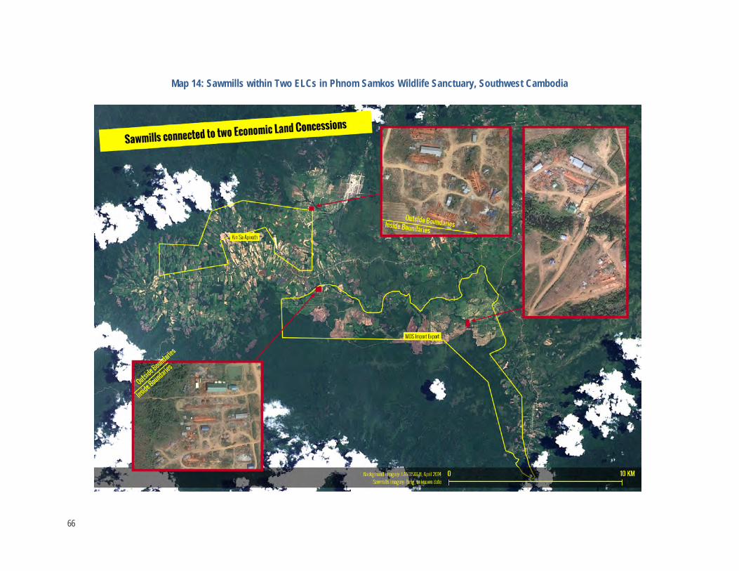
Map 14: Sawmills within Two ELCs in Phnom Samkos Wildlife Sanctuary, Southwest Cambodia
66
Recommendations The monitoring systems should be nationwide and ensure broad and shared ownership of information rather than allow monopolization of it. Open and reliable channels for information flow that link a variety of actors through an effective communications network are required. An umbrella group structure involving government and non-government actors is required to conduct transparent investigations, verify reports, monitor implementation and effectiveness of standard operating procedures, ensure follow-up on casework and assess government agency performance. It should also identify loopholes in policy, legal and institutional frameworks, and technical needs.
A legal component is required to secure the rights and protection of network informants and government staff and the initiative should provide practical capacity building and logistical support for civil society networks and government agencies involved.
The monitoring system should operate in affiliation with but independent from a government agency that has broader authority beyond those of line agencies. The RGC’s Anti-Corruption Unit and the economic police could possibly play a significant role in this.
Additional recommendations for improving forest governance and law enforcement are provided below:
Land-Use Planning and REDD+ • Declare and implement a moratorium on logging operations in existing ELCs/SLCs.
In May 2012, Prime Minister Hun Sen announced a moratorium on the granting of new ELCs in the country. However, timber harvesting under ELC contracts continues on a large scale and is supervised poorly or not at all. The economic, environmental, and social implications of this “timber rush” can only be controlled by a logging and transportation moratorium until minimum requirements for transparency and rule-of-law are established.
• Conduct an independent review and inventory of timber resources, existing forest and harvested trees, in ELCs/SLCs awarded on forest land under MAFF. On-ground verification and local mapping is required to identify areas of social and environmental significance to be excised from concessions. It should identify ELCs/SLCs awarded on forest land and calculate the value of timber harvested as well as the impacts on forest ecosystems. This review should be conducted in connection with, but independent from, government agencies, and include the assessment of forest ecologists. This review should employ several tools including satellite imagery to identify forest distribution, patch size, and height.
• Assess consistency of concessions with the national protected area zoning system and develop transparent standards for zoning the country’s protected areas. The application of the current zoning system appears arbitrary and contrary to the stated objectives of the protected areas to conserve the natural landscape and biodiversity. ELCs/SLCs are allocated without regard to existing zoning provisions or are retro-fitted without clear scientific or logical basis.
• Identify candidates for ELC/SLC cancellation in national protected areas. Provide the government with comprehensive information, based on desk review and field verification, to establish a process to revoke ELCs/SLCs in protected areas. This process should be a condition for international support for the National Protected Area Strategic Management Plan required by the Law on Protected Areas.
67

• Identify land concessions on Indigenous Peoples’ lands to be cancelled in accordance with the land law. Identify large-scale agri-industrial projects which are active or awarded on land used and owned by Cambodia’s ethnic minorities and submit the findings to government and development partners. Develop an emergency plan to prioritize land-use planning activities to guarantee access to communal land titles.
• Establish and implement an ESIA process to be conducted prior to the granting of a land concessions. The development of a new ESIA law in 2013 provides opportunity for a multi-stakeholder approach to identify and highlight the lack of due process to date. As new administrative regulations within the line ministry will not necessarily address the problems identified, new institutional arrangements with a strong emphasis on transparency need further identification and development.
• Establish a transparent science-based process to implement Article 4 of the Forestry Law. Develop a multi-stakeholder mechanism to ensure public participation in government decisions with potential impacts on forest resources and livelihoods. This mechanism should involve line ministries, universities, civil society, and independent researchers. Findings should be made available for public debate.
• Develop a transparent land-use allocation process and land-use plan. Conduct further research to identify a country-specific workable process to achieve cross-sector cooperation within government in support of transparent, participative, and equitable land-use allocations that protect and enhance environmental values at national and local levels. This requires exploration of new options available under the constitution as well as those within the framework and scope of existing institutions such as the Ministry of Land Management, the Council for Land Use Policy, the National Committee for Democratic Development, and the Supreme National Economic Council.
• Ensure that investors are well matched to the lands they are granted. A bidding process that is effective in matching investors with lands requires consideration of land-use capabilities and other factors that should be in place and publicized prior to the granting of land allocations. Provisions for unsolicited proposals cloud transparency in the awarding of agreements. This situation points to a need to reform allocation processes. MAFF databases and its mapping and use of the conversion forest category need reviewing and this data should be accessible to the public.
FLEGT-Related • Analyze financial gains/losses caused by ELC/SLC-related logging inside and outside delineated boundaries.
Establish, in coordination with the Ministry of Finance and line ministries, a technical working group to review the activities of ELC/SLC operators, the impact on the country’s forest resources, and then calculate the financial implications of these activities on the government budget. This requires the analysis of forest loss over the period from 2004 to 2014.
• Start criminal investigations into irregularities surrounding the allocation of forest land for conversion. Assist the Technical Working Group on Forestry Reform (TWG/FR) in securing high-level government support for a comprehensive investigation into corruption and collusion in regard to large-scale plantation development and illegal logging. Utilize and build sector-related capacity within the national Anti-Corruption Unit.
• Identify forest crime cases related to agri-industrial operations. In cooperation with the Forestry Administration, set up a task force to detect, verify, and suppress forest crime activities in land concession areas. The task force should be multi-stakeholder, include civil society actors, and
68

findings should be publicly accessible. The role of the military in concession-related forest crime, and collusion in local and national government agencies, should be examined.
• Establish monitoring and reporting mechanisms for the allocation and implementation of land concessions, and develop a public interactive database with verification procedures. Review the current institutional framework and apply independent monitoring components accordingly, including civil society, independent technical evaluation, and capacity for field verification and capacity building for local communities. This process should utilize the FLEGT related aspects of good forest governance and include a GIS-based assessment component of the allocation of concessions to previous or existing forest areas, analyzed by crop type, country of investor, and agreement type.
• Develop transparent and binding standards for agri-business investors. Identify, based on international experiences and modalities, a new code-of-conduct for large-scale agriculture operations with potential impacts on forest lands. Rather than being technical in nature, these rules should put emphasis on the good governance aspects including transparency and legal compliance with all laws and regulations related to the legality of the production of conversion timber.
Research-Related • Based on the current report, further develop the utility of satellite based fire reports and land cover mapping
into monitoring structures that link civil society and government actors into effective law enforcement strategies. Refine the utility of daily fire mapping, Landsat 8 imagery, and other remote sensing techniques to identify land clearance in real time and integrate this into monitoring frameworks that ensure timely and effective law enforcement through use of GIS analysis, communication strategies and community field patrols reporting.
International Implications • Develop the utility of satellite based fire reports in undertaking assessments of forest land clearance in other
countries, notably Laos and Myanmar, or regionally. Undertake assessments of the fire regimes of Laos and Myanmar to identify forest loss and degradation scenarios of relevance to SFM, REDD+, and FLEGT. Scenario development should be enhanced with the deployment of Landsat 8 imagery for identifying short term forest cover change, and of higher resolution imagery that allows identification of log rest areas and other related infrastructure. As shown here, the process needs to be informed by an understanding of forest ecology in the target countries.
69

References ADB. 2000. Cambodian Forest Concession Review Report. Sustainable Forest Management Project (ADB TA 3152-CAM).
Cutter, P. and Ashwell, D. 2007. Cambodia’s National Protected Area System: A Gap Analysis of its Representativeness and Effectiveness. Biodiversity and Protected Areas Management Project, Phnom Penh, Ministry of Environment Cambodia.
Dy Phon, P. 1981. Contribution a l’ Etude de la Vegetation du Cambodge. Ph.D. Thesis, Universite de Paris-Sud, centre d’ Orsay, Paris.
Dy Phon, P. 1982. Vegetation du Cambodge: endemisme et affinites de sa flore avec les Regions Voisines. C.R. Seance Socio-Biogeographiques 58:135-144.
CCAP. 2012. Assisting Cambodian Policymakers with Designing REDD Plus Approaches under a Post-2012 International Climate Change Policy Framework. Center for Clean Air Policy, the Eco Systems Initiative and the Economic Institute of Cambodia. CCAP Forestry and Climate Change Program Report. Washington, D.C
Forestry Administration. 2008. Cambodia Forest Cover: Forest cover map change 2002-2006. 9pp. Forestry Administration, Royal Government of Cambodia.
IFSR. 2004. Independent Forest Sector Review. Forestry Administration. The Forest Sector in Cambodia: Part 1 Policy Choices, Issues and Options.
IFSR 2004a Independent Forest Sector Review. Forestry Administration. Working Paper No 2: Nature and Status of Cambodian Forests.
Interim REDD+ Taskforce. 2010. Cambodia Readiness Plan Proposal on REDD+, Cambodia REDD+ Roadmap Version 3.0. 27 September 2010.
Legris, P. and Blasco, F. 1971. Carte International du Tapis Vegaetal et des Conditions Ecologiques au Cambodge, 1/1.000.000. Trav. Sect. Scient. Techn. Inst. Fr. Pondichery. Hors ser. 11:1-238.
Legris, P., and F. Blasco. 1972. La Végétation Naturelle. Carté Internationale du Tapis Végétal et des Condition Écologiques au Cambodge, . Notice de la carté Internationale du Tapis Vegetal et des conditions écologiques a 1/1,000,000. Extrait des Travaux de la Section Scientifique et Technique de L'institute Francais de Pondichery.
Leng, C., Ravilious, C., Kapos, V., Bertzky, M., Osti, M., Clements, T., Dickson, B,B. (2010) Carbon, biodiversity, and ecosystem services: Exploring co-benefits. Cambodia UNEP-WCMC, Cambridge, UK.
Royal Government of Cambodia. 2011. “2010 Cambodia Forest Cover.” ITTO-PD493/07 Rev.1(F). http://www.twgfe.org/itto/wp-content/uploads/2012/06/Cambodia-Forest-Cover-2010_E.pdf
Schmid, M. 1989. Vietnam, Kampuchea and Laos. Floristic Inventory of Tropical Countries. D. G. Cambpbell and D. Hammand. New York New York Botanical Garden.
Vidal, J. E. 1978. Outline of Ecology and Vegetation of the Indochine Peninsula. Museum National d'Histoire Naturelle, Paris.
Wharton, C. 1968. Man, Fire, and Wild Cattle in North Cambodia. Pages 107-167. Tall Timbers Fire Ecology Conference.
70

Annexes
Annex 1: Forest Cover Statistics Annex 1 – Table 1: Forest Cover Statistics Used in this Analysis
Forest Formation Area (km2) Area (%)
Evergreen 34,992 19.27
Semi-Evergreen 12,748 7.02
Deciduous 44,812 24.68
Secondary 9,342 5.14
Non-Forest 76,696 42.23
Evergreen Woodlands 921 0.51
Deciduous Woodlands 352 0.19
Bamboo Forests 350 0.19
Mangrove Forests 295 0.16
Palm Oil 60 0.03
Rubber 1,038 0.57
TOTAL 181,606.71 100.00 There are minor discrepancies between the area statements of the non-forest areas and a number of minor forest formations in the GIS files (above) and those provided in the RGC’s published account below. These discrepancies are not considered to impinge on the validity of the analysis as area statements for the major forest formations are the same, and minor forest categories are not considered in the calculations. While the RGC’s summary table includes “Secondary Forests” under the “Other Forests” category they are treated separately in this analysis as they cover a substantial area and are of key significance to the discussion of the allocation of degraded forests and idle lands to land concessions. These “Secondary Forests” include flooded forests around the Great Lake as well as regrowth after disturbance of evergreen forests on dry lands.
71

Annex 1 – Table 2: Area Statements for Major Forest Types Derived from the RGC’s Official 2010 Forest Cover Assessment70
Forest Formation Area (ha.) Area (%)
Evergreen Forest 3,499,185 19.3
Semi-Evergreen Forest 1,274,789 7.0
Deciduous Forest 4,481,214 24.7
Other Forest 1,108,600 6.1
Total Forest Land 10,363,789 57.1
Non-Forest 7,796,885 42.9
TOTAL AREA 18,160,674 100.0
70 Cambodia Forest Cover, 2010. Forestry Administration, Phnom Penh. ITTO-PD493/07 Rev.1 (F).
72

Annex 2: Allocations of Forest Lands and Protected Areas to Land Concessions Annex 2 – Table 1: Area Statements (km2) for Major Forest Types Used in this Analysis
Forest Formation Total Area
Institutions Protected Area(PAs) Concession Areas
MOE MAFF Inside PAs
Outside PAs Total Inside
PAs Outside
PAs
Evergreen 34,992 11,793.36 4,840.66 16,634 18,358 4,914.68 2,645.38 2,269.30
Semi-Evergreen 12,748 3,039.83 1,183.17 4,223 8,525 2,409.83 450.48 1,959.36
Deciduous 44,812 8,698.57 6,404.42 15,103 29,709 11,296.25 1,287.67 10,008.58
Secondary 9,342 3,071.56 152.01 3,224 6,119 896.31 227.30 669.01
Non-Forest 76,696 7,203.61 1,062.55 8,266 68,430 4,761.85 687.43 4,074.42
Evergreen Woodlands 921 66.37 196.41 263 658 77.07 12.08 65.00
Deciduous Woodlands 352 60.99 57.76 119 233 95.20 22.60 72.60
Bamboo 350 200.30 43.50 244 106 87.77 82.29 5.48
Mangroves 295 183.98 0.00 184 111 40.20 28.08 12.12
Palm Oil 60 2.58 0.00 3 58 55.02 2.58 52.43
Rubber 1,038 24.23 0.00 24 1,014 758.15 23.82 734.33
TOTAL 181,606.71 34,345.40 13,940.47 48,285.88 133,320.83 25,392.34 5,469.71 19,922.64
73

Annex 2 – Table 2: Area Statements (km2) for Allocation of Major Forest Types and Other Land Cover Classes to Major Investor Groups
Forest Formation
Concession Ownership
Vietnam China Cambodia (normal)
Cambodia (large) Other
Evergreen 1,458.69 668.71 1,824.44 184.58 778.26
Semi-Evergreen 511.55 331.98 578.74 509.37 478.19
Deciduous 1,319.44 2,189.84 2,311.47 2,965.51 2,509.99
Secondary 195.03 138.15 338.54 105.39 119.21
Non-Forest 475.52 708.17 1,207.57 1,137.86 1,232.74
Evergreen Woodlands 7.53 7.46 26.59 1.27 34.23
Deciduous Woodlands 16.41 27.31 37.58 4.91 8.99
Bamboo 1.57 0.00 80.83 0.00 5.38
Mangroves 0.00 30.93 2.44 0.00 6.84
Palm Oil 0.00 0.00 53.53 0.00 1.49
Rubber 66.93 0.00 664.32 0.00 26.90
TOTAL 4,052.65 4,102.55 7,126.05 4,908.87 5,202.21
74

Annex 3: Declassification of Forest Lands from the Permanent Forest Reserves The Article 12 of the Forestry Law empowers the Royal Government of Kingdom of Cambodia to declassify forest land from the Permanent Forest Reserves. Article 10 of the Forestry Law defines a category of forest land – Conversion Forest - for this purpose (see Box 2). A decision to reclassify must serve the public interest and be consistent with the National Forest Sector Policy, the National Forest Programme and technical, social, and economic data provided by Ministry of Agriculture, Forestry and Fisheries.
Eligibility for the reclassification depends on the quality of land cover, either as forest, other vegetation or bare land; yet there is some lack of specificity about this. While conversion forests are considered to be idle land comprised mainly of secondary vegetation, degraded forest land is considered to be production forest (see Box 1).
In contrast, the National Forest Programme describes conversion forests as “non-forest”. The Forestry Administration’s 2010 forest cover change analysis includes the definition of both “Other Forest” and “Non-forest” classes (see Box 3). These classifications incorporate both degraded forest areas as well as what would be considered idle forest land covered mostly by secondary vegetation under the forestry law.
Consistent with the provisions of the law, declassifying any forest from the Permanent Forest Reserves to a non-forest purpose, the Royal Government shall consider the following priorities:
• Conversion forests for other development purposes; and
• Other land of Permanent Forest Reserves when the present demand is greater than the previous demand.
Yet the legal framework does not provide any clarity as to what is meant by the “present demand is greater than the previous demand”.
Furthermore, MAFF may request the Royal Government to:
• Designate other idle forest land for the purposes of protection and reforestation to replace areas of Permanent Forest Reserve that have been declassified.
• Approve a change in the classification of a forest area to another category within the Permanent Forest Reserves based on new data and function of the forest area.
All decisions to declassify or reclassify forest are to be determined by Sub-decree. Article 4 of the sub-decree on ELCs states that an economic land concession may be granted only on a land that meets all of the following five criteria:
1. The land has been registered and classified as state private land in accordance with the Sub decree on State Land Management and the Sub decree on Procedures for Establishing Cadastral Maps and Land Register or the Sub decree on Sporadic Registration.
2. A land-use plan for the land has been adopted by the Provincial or Municipal State Land Management Committee and the land use is consistent with the plan.
3. Environmental and social impact assessments have been completed with respect to the land use and development plan for economic land concession projects.
4. Land that has solutions for resettlement issues, in accordance with the existing legal framework and procedures. The Contracting Authority shall ensure that there will not be involuntary resettlement by lawful landholders and that access to private land shall be respected.
5. Land for which there have been public consultations, with regard to economic land concessions.
75

The Law on Protected Areas defines the purpose of four management zones as follows:
Core Zone: A zone of high value for conservation of rare, endangered, vulnerable and threatened animal and plant species and a delicate ecosystem.
Entry into this zone is prohibited, except by authorized officials of the Natural Protection and Conservation Administration.
Scientific researchers conducting study of nature with the purpose of protecting and conserving natural resources, biodiversity and environment shall obtain advance permission from the Ministry of Environment.
Annex 3 – Box 1: Permanent Forest Reserve Article 10 of the Forestry Law defines the objectives and scope of three forestland categories in the Permanent Forest Reserve:
Production Forests shall be maintained in a manner to allow for the sustainable production of Forest Products and By-products, and their protection function considered as a secondary priority. Production Forests consist of the following:
• Forest Concessions; • Production Forests not under concession; • Forests rehabilitated; • Reserve Forestland for reforestation or tree plantation; • Reserved forestland for forest regeneration; • Degraded Forestland; and • Community Forests under agreement.
Protection Forests shall be maintained primarily for protection of the forest ecosystems and natural resources therein. Protection Forests consist of the followings:
• Reserve Forests for special ecosystems; • Research forests; • Forests for regulating water sources; • Forests for watershed protection; • Recreation forests; • Botanical gardens; and • Religious forests.
Local communities have customary user rights to collect Forest Products& By-products within the Protection Forest with minor impact of the forests.
Conversion Forests for other development purposes are idle land, comprised mainly of secondary vegetation, not yet designated for use by any sector that shall be classified as Permanent Forest Reserves until the Royal Government decide to use and develop the land for another purpose.
While the Forestry Law includes an extensive list of definitions (Annex?) it does not define “Idle” lands. The National Forest Program states that Conversion Forest is land with “non-forest” cover (see Box 3), and so does not include degraded forest areas, which are included under the definition of Production Forest.
76

Conservation Zone: A zone next to the core zone, which is of conservation value for natural resources, ecosystem, slope, and natural landscape. Entry into this zone shall be by obtaining advance permission from the Natural Protection and Conservation Administration on site. Use of forest by-products for livelihood by the local community and indigenous ethnic minorities, which shall not cause harm to biodiversity, shall be under strict monitoring.
Sustainable Use Zone: A zone of high value in national economic development that directly serves the purpose of management and conservation of the protected area and contributes to promoting the standards of living of the local community and indigenous ethnic minorities.
The Sustainable Use Zone includes the following sites:
• National cultural and heritage • Ecotourism
• Wildlife conservation and recreational services • Biological rehabilitation • Community protected area • Botanic garden • Infrastructure development, including irrigation, reservoir, hydro-electricity, electric networks • Mining
Environment-friendly resin exploitation in the protected area and surroundings.
Local Community Zone: A zone that serves the economic and social development of the local community and indigenous ethnic minorities who already have on-going activities, including housing, farming and vegetable gardening. Issuance of permit or land title or permission to use the land in this zone shall be certified by the Ministry of Environment.
77

Annex 4: Average Fire Density in Different Forest Formations Annex 4 – Table 1: Distribution and Density of Active Fire Reports in Different Forest Formations Both Inside and Outside Land Concessions
Forest Land Cover Class
Count of Fire Reports Forest Area (ha) Fires/km2
Count %Total Count
Inside Concessions
%Inside Concessions Forest Area Forest Area in
concessions %Total Forest
Inside Concessions
Outside Concessions
Overall Average
Evergreen 10,225 26.2 5814 56.9 3,499,188 491,797 14.05 1.182 0.147 0.292
Semi-Evergreen 3,830 9.8 1834 47.9 1,274,789 241,249 18.92 0.760 0.193 0.300
Deciduous 16,204 41.6 6081 37.5 4,481,215 1,150,694 25.68 0.528 0.304 0.362
Secondary 1,794 4.6 367 20.5 934,242 89,647 9.60 0.409 0.169 0.192
Non-Forest 6,470 16.6 1275 19.7 7,669,576 478,707 6.24 0.266 0.072 0.084
Palm Oil 0 0.0 0 0.0 6,020 5,502 91.39 0.000 0.000 0.000
Mangroves 5 0.0 3 60.0 29,502 4,020 13.63 0.075 0.008 0.017
Rubber 100 0.3 68 68.0 103,841 75,815 73.01 0.090 0.114 0.096
Bamboo 0.1 0 0.0 34,996 8,777 25.08 0.000 0.202 0.151
EG Woodlands 132 0.3 32 24.2 92,090 7,707 8.37 0.415 0.119 0.143
Dry Woodlands 168 0.4 84 50.0 35,223 10,338 29.35 0.813 0.338 0.477
Average 38,981 100.0 15558 39.9 18,160,682 2,564,253 14.12 0.607 0.150 0.215
78

Annex 5: FRP Indicator Data Annex 5 – Table 1: Gross FRP Indicators for Major Forest Formations Inside and Outside Concessions
Areas Evergreen Semi-Evergreen Deciduous Secondary All Forests
Inside Concessions 323,031 86,021 195,973 17,420 622,445
Outside Concessions 207,994 69,111 284,507 49,713 611,325
Combined 531,025 155,132 480,481 67,133 - Annex 5 – Table 2: Average FRP Indicators per Square Kilometer of Major Forest Formations Inside and Outside Concessions per Square Kilometer (Gross FRP Indicator/Area)
Areas Evergreen Semi-Evergreen Deciduous Secondary Average
Inside Concessions 65.7 35.7 17.3 19.4 31.9
Outside Concessions 6.9 6.7 8.5 5.9 7.4 Annex 5 – Table 3: Average FRP Indicators Per Square Kilometer of Major Forest Formations and Forest Clearance Scenarios
Clearance Scenario Location Major Forest Formations
Evergreen Semi-Evergreen Deciduous Secondary
Inside Concessions & Protected Areas
Seima PF 5.7 - - -
Seima PF 4.7 - - - Boeung Pe WS 2.3 - - - Boeung Pe WS 5.9 - - - Phnom Kulen WS - - Lomphat WS - - 4.3 - Phnom Aural WS - - 0.5 -
Concessions, Outside Protected Areas
CRCK 10.7 - - -
Thala Boriwat - 6.4 - -
Inside Concessions, Outside Protected Areas
- - - - -
Outside Concessions and Protected Areas
Timas 3.0 - 3.7 - Hydropower 0.7 Hydropower 0.7 Control DF - 0.2 - Control DF 0.2
79

A global platform for transparent informationon ecosystem service payments and markets
Business and Biodiversity Offsets Program, developing, testing and supporting best practice in biodiversity offsets
Building a market-based program to address water-quality (nitrogen) problems in the Chesapeake Bay and beyond
Forest Trade & FinanceBringing sustainability to trade and financial
investments in the global market for forest products
Using innovative financing to promote the conservation of coastal and marine ecosystem services
The Family of Forest Trends Initiatives
www.forest-trends.org
Learn more about our programs at
Building capacity for local communities and governments to engage in emerging environmental markets
Linking local producers and communitiesto ecosystem service markets
Incubator
The Family of Forest Trends Initiatives
A global platform for transparent informationon ecosystem service payments and markets
Business and Biodiversity Offsets Program, developing, testing and supporting best practice in biodiversity offsets
Building a market-based program to address water-quality (nitrogen) problems in the Chesapeake Bay and beyond
Forest Trade & FinanceBringing sustainability to trade and financial
investments in the global market for forest products
Using innovative financing to promote the conservation of coastal and marine ecosystem services
The Family of Forest Trends Initiatives
www.forest-trends.org
Learn more about our programs at
Building capacity for local communities and governments to engage in emerging environmental markets
Linking local producers and communitiesto ecosystem service markets
Incubator
Using innovative financing to promote the conservation of coastal and marine ecosystem services
A global platform for transparent informationon ecosystem service payments and markets
Business and Biodiversity Offsets Program, developing, testing and supporting best practice in biodiversity offsets
Building a market-based program to address water-quality (nitrogen) problems in the Chesapeake Bay and beyond
Forest Trade & FinanceBringing sustainability to trade and financial
investments in the global market for forest products
Using innovative financing to promote the conservation of coastal and marine ecosystem services
The Family of Forest Trends Initiatives
www.forest-trends.org
Learn more about our programs at
Building capacity for local communities and governments to engage in emerging environmental markets
Linking local producers and communitiesto ecosystem service markets
Incubator
A global platform for transparent information on ecosystem service payments and markets
A global platform for transparent informationon ecosystem service payments and markets
Business and Biodiversity Offsets Program, developing, testing and supporting best practice in biodiversity offsets
Building a market-based program to address water-quality (nitrogen) problems in the Chesapeake Bay and beyond
Forest Trade & FinanceBringing sustainability to trade and financial
investments in the global market for forest products
Using innovative financing to promote the conservation of coastal and marine ecosystem services
The Family of Forest Trends Initiatives
www.forest-trends.org
Learn more about our programs at
Building capacity for local communities and governments to engage in emerging environmental markets
Linking local producers and communitiesto ecosystem service markets
Incubator
Bringing sustainability to trade and financial investments in the global market for forest products
A global platform for transparent informationon ecosystem service payments and markets
Business and Biodiversity Offsets Program, developing, testing and supporting best practice in biodiversity offsets
Building a market-based program to address water-quality (nitrogen) problems in the Chesapeake Bay and beyond
Forest Trade & FinanceBringing sustainability to trade and financial
investments in the global market for forest products
Using innovative financing to promote the conservation of coastal and marine ecosystem services
The Family of Forest Trends Initiatives
www.forest-trends.org
Learn more about our programs at
Building capacity for local communities and governments to engage in emerging environmental markets
Linking local producers and communitiesto ecosystem service markets
Incubator
Building capacity for local communities and governments to engage in emerging environmental markets
A global platform for transparent informationon ecosystem service payments and markets
Business and Biodiversity Offsets Program, developing, testing and supporting best practice in biodiversity offsets
Building a market-based program to address water-quality (nitrogen) problems in the Chesapeake Bay and beyond
Forest Trade & FinanceBringing sustainability to trade and financial
investments in the global market for forest products
Using innovative financing to promote the conservation of coastal and marine ecosystem services
The Family of Forest Trends Initiatives
www.forest-trends.org
Learn more about our programs at
Building capacity for local communities and governments to engage in emerging environmental markets
Linking local producers and communitiesto ecosystem service markets
Incubator
Business and Biodiversity Offsets Program, developing, testing and supporting best practice in biodiversity offsets
Learn more about our programs at www.forest-trends.org
Protecting watershed services through markets and incentives that complement conventional management
Water Initiative
Supporting local communities to make informed decisions regarding their participation in environmental markets,
strengthening their territorial rights
Communities and Markets
Public-Private Co-Finance InitiativeCreating innovative, integrated, and efficient financing
to support the transition to low emissions and zero deforestation land use