conventional altimetry for monitoring lake level changes and improvements from swot · ·...
TRANSCRIPT

Conventional altimetry for monitoring lake level changes and
improvements from SWOT
SWOT Hydrology Workshop, Sept 15-17OSU, Colombus
Jean-François Crétaux

What can we learn about lakes From altimetry ?
Global point of view
Regional point of view
Impact of Climate Global change
Anthropogenic impact
Assessment of the State of the Art:
• Forces and limitations of classical altimetry• End users and potential applications• New implication of SWOT mission for lakes

End users and potential applications
Regional Lake management in different perspectives depending on:
climate condition and variability (Arid, Semi-arid, mountaineering, tropical …)water uses purposes (supply for population, industry, agriculture, fishingtourism, navigation)Geopolitical issues: Transboundary water management
Global scale: Multiple Interactions and issues with
hydrological water cycleCarbon and Methane storage and emissionimpact of artificial reservoirs on Global Sea Level Rise
End users:
• national hydrological services and decision makers• international institution and programs: WMO, GEO, GIEC, ILEC, ICOLD ...• Interstate Commission for Water coordination: IFAS (Central Asia),Commission for Lakes Titicaca or Geneva, IJC (Canada/US) …..
• Hydrologists, and climatologists

« Classical » radar altimetry
SWOT
Nadir radar with profiling mode acquisition and intertrack from 70 to 350 km at the equateur10 days to 35 days repeat orbitData: height level over water surfaceAccuracy over lakes highly variable (from 5/6 to 50/60 cm)Ku, C and S bands
Ka Band wide-swath radar altimeter + Nadir altimeter10-20 days repeat orbit Data: height water and storage Image pixel of ~100 mPossibility to derive slope along rivers with 1cm/km VresExcepted accuracy over lakes ~5-10cm

Lakes of Tibetan plateau:IPCC prediction is 1.4 to 5.8 ° increasing for the next 100 yrsÞRecession of Glaciers, floods, surplus of water feeding lakes in a first step, followed by strong reduceÞWater resource stress predicted in the futureÞNeed of precise & full monitoring of lakes and riversÞClassical altimetry insufficiant: 1 lake is monitored in theCentral tidetan plateau (Ziling), another one in the NE (Qinghai)
Lakes from radar altimetry, current results and limitations (1/3):
SWOT: Level and surface time series over dozenof lakes is potentially possibleÞWill serve as proxy for climate changeimpact in the Hymalaya region
Lakes level from Envisat’s35 days repeat orbit
climate change issue

Toktogul reservoir, altimetry(green), in situ(red)
840850860870880890900910
1992 1994 1996 1998 2000 2002 2004 2006 2008
Date (year)le
vel (
m)
Sarykamish from altimetry
0
1
2
3
4
5
6
7
8
1990 1995 2000 2005 2010Date (year)
Leve
l (m)
Issykkul, Altimetry (green), In-situ (Red)
1605,81606
1606,21606,41606,61606,8
16071607,2
1992 1994 1996 1998 2000 2002 2004 2006 2008
Date (year)
leve
l (m
)
Chardarya, altimetry(green), in situ (red)
240242244246248250252254256258
1993 1995 1997 1999 2001 2003 2005 2007
date (year)
level
(m)
Lakes from radar altimetry, current results and limitations (2/3): Climate change and transboundary water management issue
Central Asian river’s flow is changed by acceleration of glaciers melting, variability in rain regime, irrigation and artificial reservoirs regulation under interstate agreements. Complex system, hard political framework, and lack of ground network for free water information delivery and sharing. 5 countries with around 50 million of people leaving.
Small reservoirs not monitored by altimetry & river’s flow not available => potential to enhance cooperationbetween countries through a system like SWOT who doesn’tcare of « boundaries », better knowledge on water storage and dynamics, and support to decision makers and scientists

Impact of Southern Oscillation ?Impact of El Nino ?Impact of PDO ?Impact of Glaciar melting?Impact of Precipitation?
Llanquihue
50.2
50.4
50.6
50.8
51
51.2
51.4
2002.5 2003 2003.5 2004 2004.5 2005 2005.5 2006
Date (year)
level
(m)
-
Lake Argentino
177
177,5
178
178,5
179
179,5
180
180,5
181
181,5
1992 1994 1996 1998 2000 2002 2004 2006 2008
date (year)
level
(m)
-Lakes from radar altimetry, current results and limitations (3/3): Inter-annual climate variability
Lake San Martin
251
252
253
254
255
256
257
2001 2002 2003 2004 2005 2006 2007 2008
Date (year)
level
(m)
-
Ranco
62
62.5
63
63.5
64
64.5
65
65.5
66
2002.5 2003 2003.5 2004 2004.5 2005 2005.5 2006Date (year)
level
(m)
-
Radar altimetry not suitableTo catch geographycalpatterns connected tointer-annual climate variability in Andean lakes(<10 lakes monitored withPoor precision)
SWOT: Level / surface variations for more than 100 lakes all along the Andean is Excepted to improve knowledge on water balance changes under various climate forcing
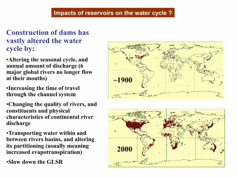
~1900
2000
Construction of dams has vastly altered the water cycle by:•Altering the seasonal cycle, and annual amount of discharge (6 major global rivers no longer flow at their mouths)
•Increasing the time of travel through the channel system
•Changing the quality of rivers, and constituents and physical characteristics of continental river discharge
•Transporting water within and between rivers basins, and altering its partitioning (usually meaning increased evapotranspiration)
•Slow down the GLSR
Impacts of reservoirs on the water cycle ?

Recent calculation based on ICOLD database showed thatover 100 yr, ~11000 km2 of water inpoundmentrepresents ~ -0.55mm/yr on GSLR (Chao et al., 2008)
Lakes and inland seas contributes to ~ +0.1 mm/yr over last 2 decades
Large errors due to -Small Lakes & reservoirs and remote areas less monitored in level and surface-accounting of global abundance and size distribution of lakes and
reservoirs is uncomplete and under-estimated (downing et al., 2006)ÞTheir dynamic is consequently not know at global scale
-Usage of reservoirs has significant storage fluctuation
Impacts of reservoirs on GSLR ?
Current altimetry miss numerous small water bodiesTotal accounting is impossible
SWOT may offer a valuable alternative to fullfill this purpose
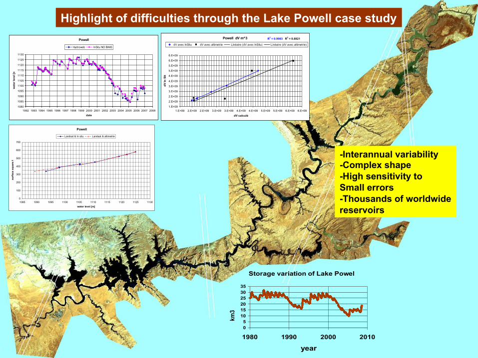
Powell
1080
1085
1090
1095
1100
1105
1110
1115
1120
1125
1130
1992 1993 1994 1995 1996 1997 1998 1999 2000 2001 2002 2003 2004 2005 2006 2007 2008
date
wat
er le
vel [
m]
Hydroweb InSitu NO BIAIS
Highlight of difficulties through the Lake Powell case study
Powell
0
100
200
300
400
500
600
700
1085 1090 1095 1100 1105 1110 1115 1120 1125 1130water level [m]
surf
ace
squa
re K
m
Landsat & In situ Landsat & altimetrie
Powell dV m^3 R2 = 0.9983 R2 = 0.8821
1.E+09
2.E+09
2.E+09
3.E+09
3.E+09
4.E+09
4.E+09
5.E+09
5.E+09
6.E+09
6.E+09
1.E+09 2.E+09 2.E+09 3.E+09 3.E+09 4.E+09 4.E+09 5.E+09 5.E+09 6.E+09 6.E+09
dV calculé
dV In
Situ
dV avec InSitu dV avec altimetrie Linéaire (dV avec InSitu) Linéaire (dV avec altimetrie)
Storage variation of Lake Powel
05
101520253035
1980 1990 2000 2010
year
km
3
-
-Interannual variability-Complex shape-High sensitivity to Small errors-Thousands of worldwidereservoirs

Lake Poyang in China: an example of potential use of SWOT forLake water balance and hydrodynamic understanding
1000 km2< Surface < 4000 km2
Very complex flood sequences of lake Poyangthat need to be studied from remote sensing
including altimetry
Different storage areas at different heights
3
1 Channel linking Poyang lake to Yangtse
2 Small lateral lakes
2
1
2
2
2
3
Fuhe delta and Poyang bassin
Different storage areas filled at different periods
Interannual fluctuations
Numerous tributaries and outflows channels

1
2
3
6
1
Tracks of T/PTracks of ENVISAT
980 163
45
-Heterogeneous distribution of radar altimetry bins-Potential problems due to presence of vegetation-Retracking mode not adapted-Presence of water at a time given by modis
Sept 21 2004
Sept 14, 2006

Modis 21 Sept, 2004
Modis multispectral images
0
1000
2000
3000
4000
5000
6000
7000
1999 2000 2001 2002 2003 2004 2005 2006 2007 2008 2009Year
surf
ace
(km
2)
-
radar altimetry+
SWOT:Spatial resolution of 100 m + vertical resolution of 1kmcombined (or not) with future RS system like MODIS or MERIS On weekly basis will allow the monitoring and mapping of flooding process over a long period of time with enough precision to assimilate measurement in Lake Poyang or similar lake in hydrodynamical model

Conclusion Some arguments for SWOT in lake’s study
Local or regional point of view
Global point of view
Water balance of individual lakesLakes are good proxies of regional impact of Climate variabilityWater management in river basins with articificial reservoirs is criticalHydrodynamic features of complex shallow lakes (Poyang, Tchad, Altiplano Salars …)
Measurement of lakes and reservoirs global distribution and their storage variabilityContribution to GSLR would be accurately established