construction materials in smith county, kansas · construction materials in smith county, kansas ....
TRANSCRIPT

UNITED STATES DEPARTMENT OF THE
INTERIOR J. A. Krug, Secretary
GEOLOGICAL SURVEY W. E. Wrather, Director
LAR 25 November 1948
CONSTRUCTION MATERIALS
IN
SMITH COUNTY, KANSAS
By
Frank E. Byrne, Max S. Houston, and Melville R. Mudge
WASHINGTON, D. C.

• •
: -
• • • 7,-
;-. • ," ••
•••„ ,
• , - ••• •
• ,
•
7,4
t°•;.1 1,9
•

CONSTRUCTION MATERIALS IN SMITH COUNTY, KANSAS
By
Frank E. Byrne, Max S. Houston, and Melville R. Mudge
CONTENTS
Page Page
'ztroduction 2 Stratigraphic sources of per-Purpose of the investigation 2 formance characteristics--Area covered by the investigation. 2 Continued. Geography of the area 2 Sanborn formation 13
stratigraphic units 4 Engineering and geologic
Representative measured section. 6 Stratigraphic sources and
Thickness 8 Engineering and geologic
Smoky Hill chalk member of Niobrara Stratigraphic sources and
Construction materials 9 Engineering and geologic
Areal distribution 9 Stratigraphic sources and
Sanborn formation 10 Engineering and geologic
General description 10 Stratigraphic sources and
Construction materials 11 Smoky Hill chalk member of
General description 11 Engineering and geologic
Thickness 11 Stratigraphic sources and
Alluvium 11 Fort Hays limestone member
General description 12 Smoky Hill chalk member of
Aggregate for concrete 12 Stratigraphic sources and
Investigation procedure 4 Terrace deposits 13 Acknowledgments 4 Alluvium 13
:1(iracteristics of the outcropping Road metal 13
General 4 characteristics 13 Carlile shale 4 Aggregate 13
Areal distribution 4 Crushed rock 13 General description 6 Limestone gravel 13
Thickness 6 performance characteristics 14 Construction materials, 6 Aggregate for concrete 14
Fort Hays limestone member of Crushed rock 14 Niobisra formation 6 Niobrara formation 14
Areal distribution 6 Ogallala formation 14 General description 6 Limestone gravel 14 Representative measured section • 8 Mineral filler 15
Construction materials 8 characteristics 15
formation 8 performance characteristics 15 Areal distribution 8 Sanborn formation 15 General description 8 Terrace deposits 15 Representative measured section. 9 Alluvium 15 Thickness 9 Volcanic ash 15
Ogallala formation 9 characteristics 15
General description 9 performance characteristics 15 Representative measured section • 10 Ogallala formation, 15 Thickness 10 Sanborn formation 15 Construction materials 10 Riprap 15
Areal distribution 10 characteristics 15
Representative measured section. 11 performance characteristics.. 16 Thickness 11 Ogallala formation 16
Terrace deposits 11 Niobrara formation 16 Areal distribution 11 Structural• stone 16
Representative measured section • 11 characteristics 16
Construction materials 11 performance characteristics.. 16
Areal distribution 11 of Ni.obrara formation 16
Representative measured section. 12 Niobrara formation 16 Thickness 12 Ogallala formation 16 Construction materials 12 Calcareous binder 16
.0,entory of construction materials 12 Engineering and geologic General 12 characteristics 16
Engineering and geologic performance characteristics.. 17 characteristics 12 Niobrara formation 17
Stratigraphic sources and Ogallala formation 17 performance characteristics.. 12 Ogallala formation 12
1

ILLUSTRATIONS
Page
Plate 1. Map showing construction materials and geology of Smith County, Kans In pocket Figure 1. Index map of Kansas showing areas covered by this report and by other
construction materials investigations 3 2. Geologic cross section of the valley of North Fork Solomon River 5 3. Outcropping stratigraphic units in Smith County, Kans., and their construction
materials 7
TABLE
Page
Table 1. Summary of materials tests
INTRODUCTION
Purpose of the investigation
The State Highway Commission of Kansas and the United States Geological Survey are cooperating in the compilation of a State-wide inventory of construction materials. A field party composed of personnel from the two cooperating agencies was sent into Smith County, Kans., in the summer of 1947, to investigate sources of engineering con-struction materials. This report of the Smith County investigation is a part of the general inventory and a contribution to the geologic mapping and investigation of mineral resources being made in connection with studies of the Missouri River Basin.'
The primary objective of the investi-gation was that of accumulating all field and laboratory data pertaining to the geologic materials in Smith County that would be of use in the construction of dams, irrigation canals, highways, airports, or other engi-neering structures. Additional geologic data are included in this report but only to the extent of providing information useful in the development of the prospects reported in the inventory or for the location of other prospects to meet future engineering needs.
Area covered by the investigation
Smith County is in the first tier of Kansas counties south of the Nebraska border and in the sixth tier east of Colorado. (See fig. 1.) It comprises 25 townships and covers an area of about 900 square miles. The county is bounded by parallels 39°34' and 40°00' north latitude and meridians 98°30' and 99°04' west longitude. It is bordered on the east by Jewell County, on the west by Phillips County, on the south by Osborne County, all in Kansas, and on the north by Franklin and Webster Counties, Nebr.
1/ Missouri River Basin, conservation, control, and use of water resources: 78th Cong., 2d sees., S. doe. 151, 1944.
Geography of the area
Smith County is in the border region of the Great Plains physiographic province. It has been dissected into moderate relief by streams cutting headward from the lower level of the Central Lowlands province to the east. The principal streams have cut their valleys about 100 feet below the rolling upland surface. The lowest altitude is about 1,500 feet along Oak Creek in the southeast corner of the county. The highest altitudes are on the divides in the northwest corner of the county, some of which are more than 2,100 feet above sea level.
The North Fork of the Solomon River is the largest stream in Smith County. This stream enters from the west, about 6 miles north of the southern county line, and flows toward the east as far as the city of Gaylord, where it turns and flows southeast. It leaves the county at about the middle of the southern boundary. The stream rises in Thomas CountY, Kans., about 120 miles to the west. The southward-flowing tributaries of the North Fork Solomon River are markedly longer streams than the northward-flowing ones. The principal tributaries entering from the north are, in order from west to east, Cedar Creek, Beaver Creek, Spring Creek, and Oak Creek. The only important tributary entering from the south is Madison Creek in the southwest corner of the county.
Two railways serve Smith County. One of the main lines of the Chicago, Rock Island, and Pacific Railroad enters near the midpoint of the eastern boundary and crosses the county Smith Center, the county seat and largest city Lebanon, Kensington, and Athol are located along this railroad. A branch line of the Missouri Pacific Railroad parallels the North Fork of the Solomon River and serves Gaylord, Cedar, Harlan, and Claudell.
Two Federal highways, both of the all-weather type of construction, principally black-top, cross the county- U. S. 36, a major east-west transcontinental route, extends through the center of the county. U. S. 281 enters the county from the south, runs north to Smith Center, turns east along
2
18

NIRORA WLINS DECAll UR J I. WASHINGTON MARSHALL NEMAH A BROV1N DON/PHA NNW MOSOOMSOMMOMO OMMUMISOMOSOU OEM MMMMMM WU e BOOM mil MMMMMM MOO OW • wiemEMOOMOOMMO ti
AT CH I SO N
SH ER IDA, GRA IAM ....lid111111 O
POTT A- JACKSON WATOM I E F.fll EFFE MON
01 A4 A
LINC IN ELL t SS E LL
CEDAR WABAUNSEE BLUFFS OUG LAS JOHNSON
AREA ELLSWORTH OS,AC E
FRANKLIN MIAMIBA Il'ON
et2W6ON MARIONk
CHASE
COFFEY ANDERSON LINN -̂,PAWNEE
HODG E M AN TA I' FOR D
HARD EY
BUTLER GREEN ' 1113 WOODSO 'ALLEN BOURBONEDW. R DS
PRATT
STANTON GRANT HASKELL K IOWA KINGMAN V LSON D I SHO HAWFORD
MEADE CLARK BARBER SUMNER COWLEY
MORTON Slit YENS WARD COMANCHE HARPER MONT- LA BETT GOMERY CHEROKt:FCHAUTAUQU

U. S. 36, which it follows to a point 1.5 miles south of Lebanon, then turns north again and leaves the county at its northeast corner. Kansas Highway 9 parallels the Missouri Pacific Railroad and from Gaylord southeast coincides with U. S. 281. Kansas Highway 181 enters the county 2 miles west of the southeast corner and extends north to its intersection near Lebanon with U. S. 281, which it follows to the northern border of the county. Kansas Highway 8 branches from U. S. 36 a mile west of Athol and extends north to the Nebraska border. The county and township roads generally follow section lines. The more important ones are metalled, and most of the others are maintained by grading.
Investigation procedure
This report is based on field work of the reconnaissance type. The base map (High-way Planning Map, scale 1 inch equals 1 mile) was provided by the State Highway Commission of Kansas. Drainage lines were added to the base map for greater ground control in mapping; these were taken from aerial photo-graphs (scale 1 inch equals 1,000 feet) made available for that purpose by the Soil Conservation Service of the United States Department of Agriculture. The areal distri-bution of the stratigraphic units that crop out in Smith County was then mapped in the field. The mapped stratigraphic ilhits are those recognized as of 1947 by the U. S. Geological Survey and the Kansas Geological Survey. Because the principal emphasis of the project is on construction materials, geologic problems not critically related to the presentation of information on construction materials are considered to be of secondary importance and are ignored insofar as the validity of the information presented is not affected.
An effort was made to accumulate all existing data pertaining to construction materials in the county. These data, together with their sources, are incorporated in this report. In addition, the field party collected samples of construction materials not reported previously. The samples were brought to the Highway Testing Laboratory of the State Highway Commission of Kansas in Manhattan, Kans., where they were subjected to routine laboratory tests. A portion of each sample of aggregate material was analyzed under a binocular microscope in the laboratory of the Department of Geology, Kansas State College, and the constituent rock and mineral grains determined. The laboratory tests and mineralogical analyses, together with the information from other sources, are presented in table 1, Summary of materials tests.
Acknowledgments
Generous assistance in the compilation of the areal map and of construction-materials data by the following is appreciated: State Highway Commission of Kansas at Topeka and Manhattan, Kans., S. E. Horner, chief geolo-gist, R. D. Finney, engineer of materials, and associates; State Geological Survey of Kansas, J. C. Frye, executive director; and the Smith County office of the Soil Con-servation Service, U. S. Department of Agri-culture.
This report, in manuscript form, was reviewed by S. E. Horner and by various
members of the U. S. Geological Survey. Illustrations were prepared by Ruth M. Soelter and others of the State Highway Commission of Kansas. The petrographic determinations included in table 1 were made by J. R. Chelikowsky of the State Highway Commission.
CHARACTERISTICS OF THE OUTCROPPING STRATIGRAPHIC UNITS
General
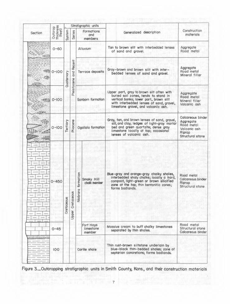
This part of the report discusses the characteristics of each geologic formation or member cropping out in Smith County. The discussions emphasize the areal distribution, the general characteristics, and the thickness of each stratigraphic unit. A representative measured section is given for each formation or member. The measured sections are not necessarily intended to be complete but were selected to show typical outcrops of the unit in this county. The construction materials in each stratigraphic unit are listed. The principal purpose of this part of the report is that of presenting the geologic information required for the location and the effective development of the construction materials contained in each stratigraphic unit.
The relations of the stratigraphic units to one another are illustrated in figure 2, Geologic cross section of the Solomon River Valley, and a summary of the data for each unit is presented in figure 3, outcropping stratigraphic units in Smith County, Kans., and their construction materials.
The areal distribution of the local stratigraphic units is shown on plate 1, map showing construction materials and geology of Smith County, Kans. Each stratigraphic unit is indicated by an identifying symbol, and its outcrop areas are shown by a distinctive pattern. Railroads, roads, and streams are shown to provide a basis for evaluating the accessibility of sources of construction materials.
The locations of auarries and pits also are shown on plate 1. The symbols indicate whether the pit or quarry is or has been operated or is a prospect, the type of con-struction material available at each site, and the quantity of the material (in units of 10,000 cubic yards) that can be removed under no more than moderate overburden (unconsoli-dated sediments less than 6 feet thick). Most of these sources are listed in table 1. Materials sources represented on the map by inclined letters have not been tested and are not listed in table 1. All sources listed in table 1 are numbered within each materials classification according to the following plan: The numbering starts in the northeasternmost township and continues along the same tier to the western boundary of the country; it is continued in the next tier south, starting again with the township in the easternmost range and proceeding to the western boundary of the .county, and so on. Within a township the sources are numbered in the same sequence as are the sections of the township.
Carlile shale
Areal distribution.--The Carlile shale, of Upper Cretaceous age (see fig. 3), is the oldest formation cropping out,. in Smith County and is, therefore, the lowet—unit in the
4

Kns
Kns Qs
0
Knf Qs
\ Qs Qs o -0
oz, E
0 Knf Kc Co
Qt (1) Qt Qs N ••••,• ••••••
0
Qal a, Kc
O O
c° North South A
Scale 0 2 miles
1 1-4 )--1 }—I 1-1
EXPLANATION
Qal
Alluvium Silt Contact without erosional breakQt
Terrace deposits Sand with gravel lenses Contact withQs
erosional break Sanborn formation
LimestoneKns Assumed contact without
Smoky Hill chalk erosional break member Shaly chalk
4.0
Knf I— —1 Assumed contact with Fort Hays limestone Shale erosional break
member
Kc
Carlile shale
Figure 2._Geologic cross section of the valley of North Fork Solomon River along the line between secs. 25 and 26, T. 4 S., R. 15 W.,
and secs. 25 and 26, T 5 S., R. 15 W.

local stratigraphic column exposed at the surface. It crops out only in the southern third of.the county in the valley walls of the North Fork Solomon River and its tribu-taries. (See pl. 1.) The formation is exposed most extensively in the valley of North Fork Solomon River and in the lower part of the valley of Oak Creek. The regional orthwest dip of the Carlile shale and the
other units of Cretaceous age that crop out in the county is about 13 feet to the mile. Because of this regional dip and the general rise of the land surface toward the northwest, the Carlile shale is obscured by younger, stratigraphically higher formations in the northern half of the county and in the western border area.
General description.--The Carlile shale was deposited in marine waters. It is in contact with the overlying Niobrara formation of Cretaceous age, with no erosional break intervening between the two formations. (See fig. 2.) Erosional breaks are present, how-ever, where the Carlile shale is overlain by Tertiary and Quaternary deposits. The Carlile shale is composed of three members. In order from the base to the top of the formation these are the Fairport chalky shale, the Blue Hill shale, and the Codell sandstone members. Only the Codell sandstone member and the upper part of the Blue Hill shale member crop out in Smith County, and these are not differentiated on plate 1 or in figure 3.
The Blue Hill shale member is a thin-bedded to .very thin-bedded, dark-gray to black clay shale, which weathers to a characteristic blue gray. Limonite stains are persistent throughout the member. One zone contains numerous septarian concretions, which range in diameter from a few inches to several feet. Abundant twinned crystals of selenite, a variety of gypsum, were found in the upper part of the shale in the SEiNEi sec. 20, T. 5 S., R. 12 W., but selenite is not generally characteristic of this unit in Smith County. The uppermost 10 feet of the member is somewhat silty and grades into the over-lying Codell sandstone member. Near the south-east corner of the county, the Blue Hill shale member has been eroded to form a badland type of topography. Other badland areas in the Blue Hill shale are partly concealed beneath a thin veneer of the Sanborn formation.
Fossil shells of cephalopods, including the genera Scaphites and Prionocyclus, occur locally in some abundance, as in a small out-crop almost entirely concealed by terrace deposits along the Solomon River in the SEiSEi sec. 27, T. 5 S., R. 13 W.
The Codell sandstone member overlies the Blue Hill shale member without an intervening erosional break. In Smith County the Codell is composed of silt, rather than sand, and is poorly indurated. The siltstone is noncal-careous, and its color ranges from tan in the lower part to rust brown in the upper part. It is reported to contain fossil teeth of sharks.
Representative measured section.--A cut bank alon a small tributary of Spring Creek in the NEiNEi sec. 20, T. 4 S., R. 13 W. shows the following section:
Feet Niobrara formation: Fort Hays limestone member.
Carlile shale: Codell sandstone member:
Siltstone, noncalcareous, poorly indurated; rusty gray brown; limonite-stained; contains fragments of fossil wood 0.4
Blue Hill shale member: Shale, very thin-bedded; blue gray, weathers bluish buff; limonite-stained .9
Shale, noncalcareous, very thin-bedded; blue black, weathers dark blue 6.0
Base covered 7.3
Thickness.--Outcrops of the Carlile shale in Smith County vary in thickness from several feet to a maximum of 30 feet. The estimated aggregate thickness of the formation is 100 feet.
Construction materials.--The Carlile shale in Smith County is not exploited as a source of construction materials.
Fort Hays limestone member •of Niobrara formation
Areal distribution.--The Fort Hays lime-stone member and the Smoky Hill chalk member constitute the Niobrara formation, of Upper Cretaceous_age. (See fig. 3.) As the two members contain somewhat different construction materials, they are mapped on plate 1 as individual units and will be discussed sepa-rately. The Fort Hays limestone member crops, out in the southern half of Smith County, with exposures best developed in the southeastern part of the county and in the area along the southern border. It is exposed in the walls of the valley of North Fork Solomon River and in the lower parts of the tributary valleys.
The Fort Hays limestone member of the Niobrara immediately overlies the Carlile shale, and where the Carlile is exposed the Fort Hays also crops out. Towthd the north-west, however, the Carlile shale dips beneath the surface and the oldest stratigraphic unit exposed is the Fort Hays. Over most of the remainder of the county the Fort Hays is concealed beneath the Smoky Hill chalk member of the Niobrara. The contact between the Fort Hays and the overlying Smoky Hill is without an intervening erosional break, but wherever the Fort Hays is overlain by Tertiary and Quaternary formations there is an erosional break.
General description.--The Fort Hays limestone member is composed predominantly of beds of massive chalk, which average about 3 feet thick, separated by beds of chalky shale usually about 0.1 foot thick. The chalk is quite soft, is buff on fresh surfaces, and weathers to white or tan gray. The inter-bedded chalky shales are buff or tan gray. This member contains numerous specimens of a fossil clam (Inoceramus) and of a fossil oyster (Ostrea). It is reported to contain fossil vertebrates.
Although the Fort Hays limestone is a relatively soft material, it erodes to form bluffs that are particularly conspicuous
Stratigraphic units
Outc
rop
thic
knes
s(f
eet)
E ($) Formations Construction w Generalized descriptionSection materialsand0u-,>, members
_., (r)
Tan to brown silt with interbedded lenses Aggregate0-60 Alluviumo •.----•:,----_ of sand and gravel. Road metal
• ...Q82.4
1 P
leis
toce
ne a
nd
Re
cent
- -----=-7-_-- -f-1_ H.
-- • Aggregate Road metal
.-__ Gray brown and brown silt with inter-C
reta
ceo
u s
Ter t
iary
Q
uate
rnary Terrace deposits------- 0-100
h`l= -7, -•••, --.--:_-:= . .
o&;iii;&.••
bedded lenses of sand and gravel. Mineral filler
Upper part, gray to brown silt often with Aggregateburied soil zones, tends to stand in Road metal
100 Sanborn formation vertical banks; lower part, brown silt-B At0- Mineral filler .• with interbedded lenses of sand, gravel, Volcanic ash
limestone gravel, and volcanic ash.
-•-•," .. Calcareous binder
c. Gray, tan, and brown lenses of sand, gravel,c Aggregate9 ci)c.)0
silt, and clay; ledges of light-gray mortar Road metal46104w- Ogallala formation bed and green quartzite; dense gray0-100 Volcanic ash ,,,,'~~bee .E limestone locally at top; occasional°S) Riprap, /.. fi, . - lenses of volcanic ash.
Structural stone
1
Up
per
Cre
tace
ous
I -
I I
I
I I-
I — I - 0-450
— I I -
._0
+6 Smoky Hill t chalk member
0 ,_
Blue-gray and orange-gray chalky shales, interbedded shaly chalks; locally a hard, compact, light-green or brown silicified zone at the top; thin bentonitic zones; forms badlands.
Road metal Calcareous binder Riprap Structural stone
f -1 — ,..IDa . 0
_
_ I
_ 1 ____ _____
- — — I —
____ 1 ___ _
1-._ _ir— 1 —I —
Fort Hays Road metalMassive cream to buff chalky limestones
limestone Structural stoneI I 0-45 separated by thin shales.member Calcareous binder
.-.•:.•::-..::'.• • -
,--—
100 Carlile shale Thin rust-brown siltstone underlain by
blue-black thin-bedded shales; zone of septarian concretions; forms badlands.
_ _i
Figure 3._Outcropping stratigraphic units in Smith County, Kans., and their construction materials
7
1

along the southeastern border of its outcrop area. The valleys of streams cutting into the limestone. are deeply incised. Weathering of the upper part of an outcrop of the limestone tends to produce a shattered zone, where the massive limestone breaks into irregular flattish fragments 1 or 2 inches thick and 4 or 5 inches long.
The regional dip of the Fort Hays lime-stone member of the Niobrara is the same as that of the Carlile shale, about 13 feet to the mile toward the northwest. Minor fractures and flexures were observed in this member but are not mapped because they do not affect the construction materials character-istics of the unit. A small normal fault was observed in the Fort Hays limestone overlying the section of the Carlile shale measured in the NEiNEi sec. 20, T. 4 S., R. 13 W. A small depressed block of rock (graben), the result of downfaulting, was noted in a road cut in the NEISWi sec. 16, T. 5 S., R. 12 W. Polished or striated surfaces (slickensides) had been developed on the rock, along the fracture planes.
Representative measured section.--The face of a quarry in the SW1.NWt sec. 36, T. 4 S., R. 15 W. revealed the following section:
Feet Fort Hays limestone member of
Niobrara formation: Limestdne, shattered zone 3.0 Limestone, chalky, soft, massive;
cream color 3.7 Shale, laminated; buff gray;
limonite-stained .5 Limestone, chalky, soft, massive;
cream white 3.4 Shale, laminated; buff .2 Limestone, chalky, massive; cream
white; limonitic zone near base 3.9 Shale, laminated; buff gray .1 Limestone, chalky, massive, soft;
cream white 2.2 Shale, laminated; buff gray .2 Limestone, chalky, soft, massive;
cream white .8 Shale, laminated; buff gray .2 Limestone, chalky, massive; buff;
limonite-stained .8 Shale; gray .1 Limestone, chalky, massive; buff;
limonite-stained 2.0 Shale; gray; limonite-stained .1 Limestone, chalky, massive; cream
color; limonite-stained .3 Shale; dark gray green .2 Limestone, chalky, soft, massive;
cream color; Inoceramus and Ostrea 2.2
Shale; dark gray .1 Limestone, chalky, soft, massive;
cream color; Inoceramus and Ostrea. 2.1 Shale, platy; gray .1 Limestone, chalky, soft, massive;
cream color; Inoceramus 1.5 Shale, platy; dark gray, weathers buff .5
Limestone, chalky, soft, massive; cream color; Inoceramus 2.8
Shale; cream color .2 Limestone, chalky, soft, massive;
buff cream; Inoceramus 1.5 Shale; greenish gray .5 Limestone, chalky, soft, massive;
cream color .6 Shale; cream color .1
Feet Fort Hays limestone member of
Niobrara formation--Continued. Limestone, chalky, soft, massive; buff cream; Inoceramus 1.7
Shale; buff .2 Limestone, chalky, soft, massive;
cream color; Inoceramus 3.6 Shale .1 Limestone, chalky, soft, massive;
cream color; Inoceramus 1.0 Base covered. 40.5
Thickness.--Outcrops of the Fort Hays limestone member average between 15 and 20 feet thick in Smith County. The maximum thickness of the member probably is about 45 feet.
Construction materials.--Structural stone. Road metal. Calcareous binder.
Smoky Hill chalk member of Niobrara formation
Areal distribution.--The Smoky Hill chalk member crops out most extensively of all the Upper Cretaceous units in Smith County. (See pl. 1.) It is exposed at the surface in the headward portions of most tributary valleys and on many of the divides. It is especially conspicuous in the east-central part of the county and in the western half. This member is covered by younger formations (Ogallala and Sanborn) in many of the divide areas but has been eroded from the lower parts of most of the stream courses, thus exposing the under-lying Fort Hays limestone member of the Niobrara formation.
General description.--The Smoky Hill chalk member is the youngest of the marine deposits cropping out in Smith County. Its contact with the underlying Fort Hays lime-stone member is without an erosional break, but erosional breaks do intervene in its contacts with younger deposits of the Tertiary and Quaternary periods. (See fig. 3.) The Smoky Hill member consists of interbedded layers of chalky shale and shaly chalk. The lower part of the member is characteristically blue gray and weathers buff gray. The remainder is orange gray and weathers orange buff. The chalk layers are quite shaly and are•massive or slabby. The shale. layers contain a high percentage of chalk and tend to be blocky. There are occasional thin seams of rust-brown bentonitic shale in the member. Fossil shells of Inoceramus and Ostrea are abundant in some zones, and fragments of fossil vertebrates and plants were noted by the field party.
Extensive outcrops of the Smoky Hill chalk member tend to erode to form a badland type of topography. There are probably ancient badland areas buried beneath younger stratigraphic units in many places in the county.
Where the Smoky Hill chalk underlies the Ogallala formation, as in the northern part of Smith County, the chalk may be silicified. Silicified chalk typically is pale green or yellow orange, dense and hard, and it occurs in lenticular masses. In one place (NWi sec. 26, T. 1 S., R. 14 W.) a road cut shows the gradation of the silicified zone into the
8

underlying soft orange-colored chalky shale. Frye and Swineford V suggest that the silici-fication of the Smoky Hill chalk was accomplished by silica-rich percolating sub-surface waters, which had dissolved the silica Prom stratigraphically higher beds of volcanic ash. An exchange of dissolved silica for calcium carbonate may have been made as these waters percolated through the Smoky Hill shalk.
Representative measured section.--An out-1.0p of the Smoky Hill chalk member in the forth wall of the valley of North Fork Solomon diver in the NWISEi sec. 30, T. 4 S., R. 15 W., reveals the following section:
Feet Smoky Hill chalk member of Niobrara formation: Shale, chalky; badly weathered, with thin soil zone at top 7.0
Chalk, massive; light pinkish gray 1.0
Shale, chalky, thin-bedded; light orange brown 16.0
Shale, chalky, thin-bedded; alternating blue-gray and pink bands, which weather buff 1.7
Chalk, slabby; blue gray, weathers buff 5
Shale, chalky, thin-bedded; streaked orange and gray, weathers buff 1.1
Chalk, slabby; light blue' gray, weathers buff 1.6
Shale, somewhat clayey; light chocolate to orange brown, weathers buff .4
Shale, chalky, very thin-bedded; blue gray, weathers buff; thin orange-brown bentonitic streaks; Inoceramus, Ostrea 2.0
Chalk, shaly, thin-bedded; orange brown, weathers buff; Inoceramus, Ostrea 1.4
Chalk, massive, soft; light bluish orange, weathers buff; Inoceramus Ostrea •4
Shale, very chalky, light blue gray, weathers buff; thin, dark orange-brown bentonitic seam near top; Os trea 3.7
Base covered. 36.7
Thickness.--Outcrops of the Smoky Hill talk member vary in thickness from several set to about 40 feet. The aggregate thick-4183 in Smith County is thought to be between SO and 500 feet.
Construction materials.--Road metal. Calcareous binder. Riprap. Structural stone.
Ogallala formation
Areal distribution.--The Ogallala for-Ition, of Pliocene age, crops out most widely Smith County in the northern half of the
)1.1nty, principally in the headward parts of
2/ Frye, J. C., and Swineford, Aria, Silicified k in the Ogallala formation: Kansas Geol. Survey J. 64, pt. 2, p. 57, 1946.
tributary valleys. (See pl. 1 and fig. 3. It is present in the divide areas between valleys but is concealed by the overlying Sanborn formation., Several small outcrops of the formation are mapped in the southeast corner of the county (T. 5 S., R. 11 W.). Undoubtedly the Ogallala formation once extended over the entire area of the county but subsequently has been eroded completely along the streams.
Certain zones in the Ogallala formation are similar in physical characteristics to zones in the overlying Sanborn formation, and in some places only arbitrary formational contacts can be drawn. The mapped contacts are based on the presence of auartzite and mortar-bed ledges and thicker lenses of sand and gravel in the Ogallala formation. Quartzite and mortar-bed ledges do not occur in the Sanborn formation, which is predomi-nantly a silt with only thin local lenses of sand and gravel in the basal part.
General description.--The Ogallala for-mation is In contact with both members of the Niobrara formation in Smith County but is separated from them by a pronounced erosional break. In most places it is underlain by the Smoky Hill chalk member of the Niobrara. An erosional break intervenes between the Ogallala formation and the Sanborn formation, which overlies the Ogallala throughout most of this county.
The Ogallala formation consists of inter-bedded lenses of sand, clay, silt, and some gravel. The lenses are variable in both thick-ness and extent and reflect the stream-deposited origin of the formation. The lower part of the formation appears to have been deposited, for the most part, in pre-Ogallala channels and is appreciably coarser than the upper part. One such channel deposit, most of it buried under the Sanborn formation, was found in secs. 17, 18, and 19, T. 2 S., R. 13 W. Another buried channel deposit was found by a geological field party of the State Highway Commission of Kansas in secs. 33 and 34, T. 2 S., R. 13 W., while working out the engineering geology along a proposed realignment of U. S. Highway 281— Other channels undoubtedly occur within the county but are too well obscured by the Sanborn for-mation for any but accidental discovery. The basal s&nds and their included gravels are composed predominantly of fragments of quartz, feldspar, local limestone, and igneous rock particles. Clay layers in this formation are light gray to greenish gray, are often bentonitic, and may be as much as 5 or 6 feet thick.
The Ogallala formation includes lenticular layers of massive, light-gray, lime-cemented sand and/or gravel. Such lenses are termed mortar beds and form conspicuous outcrops on some of the hillsides in the northwestern part of the country. The firmness of a mortar bed varies directly with the amount of lime-cement it contains.
At many places there is a massive ledge of very dense, hard, buff-gray limestone at the top of the Ogallala formation. The thickest ledge in Smith County is about 3 feet. This material crops out most extensively in the northwest corner of the county, but in the southeast corner there are several small outcrops of a thin (usually less than 0.5 foot)
light brownish-gray limestone that is somewhat less dense and contains scattered sand grains and irregular tan-brown siliceous concretions.
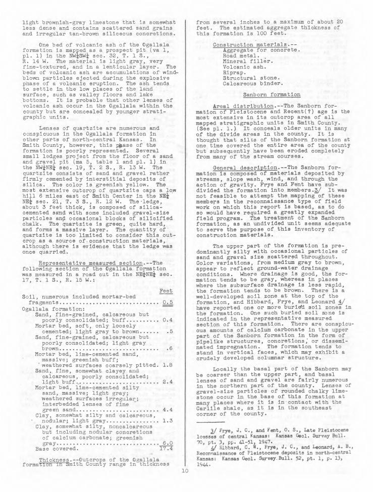
One bed of volcanic ash of the Ogallala formation is mapped as a prospect pit (va 1, pl. 1) in the Nkt-SWi sec. 32, T. 1 S., R. 14 W. The material is light gray, very fine-textured, and in a lenticular layer. The beds of volcanic ash are accumulations of wind-blown particles ejected during the explosive phase of a volcanic eruption. The ash tends to settle in the low places of the land surface, such as valley floors and lake bottoms. It is probable that other lenses of volcanic ash occur in the Ogallala within the county but are concealed by younger strati-graphic units.
Lenses of quartzite are numerous and conspicuous in the Ogallala formation in other parts of north-central Kansas. In Smith County, however, this prnase of the formation is poorly represented. Several small ledges project from the floor of a sand and gravel pit (ma 5, table 1 and pl. 1) in the NWINEi sec. 19, T. 2 S., R. 13 W. The quartzite consists of sand and gravel rather firmly cemented by interstitial deposits of silica. The color is greenish yellow. The most extensive outcrop of quartzite caps a low hill 6 miles east of Smith Center in the Nai NEi sec. 21, T. 3 S., R. 12 W. The ledge, about 3 feet thick, is composed of silica-cemented sand with some included gravel-size particles and occasional blocks of silicified chalk. The quartzite is green, quite hard, and forms a massive layer. The auantity of quartzite is too limited to consider this out-crop as a source of construction materials, although there is evidence that the ledge was once quarried.
Representative measured section.--The following section of the Ogallala formation was measured in a road cut in the NaiNEi sec. 17, T. 1 S., R. 15 W.:
Feet Soil, numerous included mortar-bed fragments 0.5
Ogallala formation: Sand, fine-grained, calcareous but
poorly consolidated; buff 0.4 Mortar bed, soft, only loosely cemented; light gray to brown .5
Sand, fine-grained, calcareous but poorly consolidated; light gray brown .6
Mortar bed, lime-cemented sand, massive; greenish buff; weathered surfaces coarsely pitted. 1.8
Sand. fine, somewhat clayey and calcareous, poorly consolidated; light buff 2.4
Mortar bed, lime-cemented silty sand, massive; light gray; weathered surfaces irregular; interbedded lenses of fine green sand 4.4
Clay, somewhat silty and calcareous, nodular; light gray 1.3
Clay, somewhat silty, noncalcareous but including nodular concretions of calcium carbonate; greenish gray 6.0
Base covered. 17.4
Thickness.--Outcrops of the Ogallalaformation in smith County range in thickness
from several inches to a maximum of about 20 feet. The estimated aggregate thickness of this formation is 100 feet.
Construction materials.--Aggregate for concrete. Road metal. . Mineral filler. Volcanic ash. Riprap. Structural stone. Calcareous binder.
Sanborn formation
Areal distribution.--The Sanborn for-mation of Pleistocene and Recent(?) age is the most extensive in its outcrop area of all mapped stratigraphic units in Smith County. (See pl. 1.) It conceals older units in many of the divide areas in the county. It is thought that silts of the Sanborn formation at one time covered the entire area of the county but subsequently have been eroded completely from many of the stream courses.
General description.--The Sanborn for-mation is composed of materials deposited by streams, slope wash, wind, and through the action of gravity. Frye and Fent have sub-divided the formation into members./ It was not feasible to attempt the mapping of these members in the reconnaissance type of field work on which this report is based, as to do so would have required a greatly expanded field program. The treatment of the Sanborn formation, as an undivided unit seems adequate to serve the purpose of this inventory of construction materials.
The upper part of the formation is pre-dominantly silty with occasional particles of sand and gravel size scattered throughout. Color variations, from medium gray to brown, appear to reflect ground-water drainage conditions. Where drainage is good, the for-mation tends to be gray, whereas in places where the subsurface drainage is less rapid, the formation tends to be brown. There is a well-developed soil zone at the top of the formation, and Hibbard, Frye, and Leonard 1/ have reported one or more buridd soil zones in the formation. One such buried soil zone is indicated in the representative measured section of this formation. There are conspicu-ous amounts of calcium carbonate in the upper part of the Sanborn formation in the form of pipelike structures, concretions, or dissemi-nated impregnation. The formation tends to stand in vertical faces, which may exhibit a crudely developed columnar structure.
Locally the basal part of the Sanborn may be coarser than the upper part, and basal lenses of sand and gravel are fairly numerous in the northern part of the county. Lenses of gravel-size particles of rounded chalky lime-stone occur in the base of this formation at many places where it is in contact with the Carlile shale, as it is in the southeast corner of the county.
2/ irye, J. C., and rent, O. S., Late Pleistocene loesses of central Kansas: Kansas Geol. Survey Bull. 70, pt. 3, pp. 41-51, 1947.
Hibbard, C. W., Frye, J. C., and Leonard, A. B., Reconnaissance of Pleistocene deposits in north-central Kansas: Kansas Geol. Survey. Bull. 52, pt. 1, p. 13, 1944.
10

1
Lenses of volcanic ash were found in the :sal part of the Sanborn formation in the .:rthern half of the county. The largest of ::ese (va 2) is listed in table 1 and mapped .r, plate 1. The material is light gray, aceedingly fine-textured, and relatively free 'rnsi extraneous particles. Other lenses noted :the field are too small to be exploited.
Shells of fossil snails (gastropods) were ollected from several outcrops of the for-tion. Fragments of fossilized vertebrate l(eletons, including the complete skull of a ,:son and several camel teeth, were found by
field party.
It is probable that the Sanborn formation s deposited during at least two different epositional cycles. That part of the for-tion lying on the higher divides may have Mn deposited first by streams, slope wash, '4,o1 the wind. A lower and more recent level tdeposition by the same agents may have °stated in the somewhat less extensive eposits along the sides of the larger stream alleys and over the crests of the lower -/ides. The two levels of deposits of the anborn are mapped as a single unit because, luny places, the contact between the two is distinguishable, owing to the transportation •material from the upper level onto the order area of the lower level.
Representative measured section.--The lirthorn formation, in a typical expression, exhibited in a road cut in the SEiNEI sec. , T. 2 S., R. 2 W.
Feet orn formation: Silt; dark brown; soil zone
developed in the upper part 3.0 Silt, somewhat clayey, powdery, pipe-like concretions of calcium carbonate scattered irregularly throughout; weathered surface develops crude columns; fossil shells of snails 5.4
Soil zone; brown to dark brown; calcium carbonate streaks 1.0
Silt, rather porous; brown 4.6 Silt; light brown; numerous
pipe-like concretions and nodules of calcium carbonate 1.0
Base covered. 15.0
Thickness.--Outcrops of the Sanborn for-tion vary considerably in thickness but Itlelly are less than 25 feet. It is . esti-ted that the formation is thickest in the ,rth-central part of the county, where a *rum of about 100 feet may be reached.
Construction materials.--Aggregate for concrete. Road metal. Mineral filler. Volcanic ash.
Terrace deposits
Areal distribution.--Extensive terrace !Posits have been laid down in the valleys the North Fork Solomon River and its Irloipal tributaries. (See pl. 1.) The mraces reflect two well-defined depositional
',?cies but are mapped as a single strati-:11Phic unit because their constituent :terials are similar. The upper terrace .1,(31 is the more extensive.
The deposits in the valley of the North Fork Solomon River vary in width from 1.5 L.) 3 miles. Those in Oak Creek Valley are about 2 miles wide in the mouthward part of the valley and become progressively narrower toward the head of the creek. The terraces of Beaver Creek are about 1.5 miles wide at the maximum. Terraces in the valleys of the other principal tributaries generally are less than a mile wide. Small fingerlike deposits extend into the valleys of many of the smaller tributaries.
General description.--The terrace deposits overlie all older formations with an inter-vening erosional break. (See fig. 2.) The exposed part of the terrace is composed pre-dominantly of silt, with interbedded lenses of fine sand and, occasionally, clay. The basal part of the formation does not crop out, but from evidence gathered along other streams in north-central Kansas it appears to be somewhat coarser than the upper part, including more extensive lenses of interbedded sand and some of gravel.
Representative measured section.--The following section was measured in a cut bank in the terrace deposits along the North Fork Solomon River in the SEiNWi sec. 6, T. 5 S., R. 14 W.:
Feet Soil zone 1.2 Terrace deposits:
Silt, some very fine sand, powdery; dark gray 1.1
Silt; gray brown; appears to be a buried soil zone 1.3
Silt, powdery, stains and streaks of calcium carbonate; light gray .6
Silt, powdery; light gray 1.8 Clay, blocky; gray brown .9 Silt; light gray; limonite-stained;
stains and streaks of calcium carbonate .6
Clay, blocky; gray brown 1.1 Silt, powdery; light gray;
stains and streaks of calcium carbonate 3.0
Base covered. 10.4
Thickness.--The thickness of the terrace deposits could have been deterssined accurately only by test drilling, and test-hole data are not available for Smith County. The total thickness of the terrace deposits in the valley of North Fork Solomon River is estimated to be about 100 feet. The maximum thickness in the tributary valleys probably does .not exceed 40 or 50 feet, except near the junctions of the tributary valleys with the main valley.
Construction materials.-= Aggregate for concrete. Road metal. Mineral filler.
Alluvium
Areal distribution.--The deposits formed by streams in their present gradational cycles are mapped as alluvium and constitute the most recent stratigraphic unit in the county. (See pl. 1 and table 1.) Alluvium is defined in this report as the material underlying the present floodplain of a stream. The flood-plain is the area adjacent to the stream channel that is covered by water during a normal flood stage. Alluvium is mapped along the Solomon River only. Alluvial deposits are present along parts, at least, of some of its
11
larger tributaries but are generally so narrow they could not be mapped on the scale of the base map, plate 1 (1 inch equals 1 mile). The alluvium.in the valley of the North Fork Solomon River varies in width from about 0.1 to 0.9 mile.
General description.--The material com-posing the alluvium of the valley of the North Fork Solomon River is quite sandy but locally may be composed predominantly of silt. There are interbedded lenses of, chalk and shale fragments. The color of the material indi-cates in a general way the sand content. Where sandy, the alluvium is tan; where silty, the alluvium is brown.
Representative measured section.--The relief of the alluvium is so low that a representative section could. not be measured.
Thickness.--It is estimated that the maximum thickness of the alluvium in the river valley is about 60 feet.
Construction materials.--Aggregate for concrete. Road metal.
INVENTORY OF CONSTRUCTION MATERIALS
General
This part of the report inventories the construction materials in Smith County. Its objectives are to establish the bases upon which the construction materials are classi-fied and to analyze the relations of the various materials to the stratigraphic units in which they occur.
All available laboratory test data have been introduced into the report to aid in the evaluation of the materials. This information, given in table 1 is based on standard testing procedures of the American Association of State Highway Officials and the State Highway Commission of Kansas./ It is expected that the prospects listed in this report will be proved by subsequent augering, drilling, or test-pitting and that the materials themselves will be subjected to laboratory testing prior to exploitation for specific uses.
Although numerous prospect pits and quarries were located in the field, no attempt was made to complete an exhaustive survey.
American Associatior of State Highway Officials, Standard specifications for highway materials and methods of sampling and testing, pt. 2, 5th ed., 361 pp., 1947.
Absorption, pp. 251-252. Compressive strength, pp. 257-258. Deval abrasion, pp. 235-236. Liquid limit, pp. 198-201. Los Angeles abrasion, pp. 237-23%. Plasticity index, pp. 202-204. Specific gravity, pp. 249-250. Toughness, pp. 240-241. 'eight per cubic foot, pp. 253-254.
State Highway Commission of Kansas, Standard specifications for State road and bridge construction, 512 pp., 1945.
Gradation factor, p. 16. Sieve analysis, pp. 333-334. Soundness, pp. 335-336.
The purposes of this report are to inventory the construction materials that occur in Smith County and to establish the geologic pattern required for the location and development of materials at the places in the county where they may be needed. A certain stratigraphic unit may contain one or more construction materials; if the geologic factors of that occurrence are established, the resultant knowledge of the geologic pattern will facili-tate the discovery of additional sites.
Aggregate for concrete
Engineering and geologic characteristics
Aggregate for concrete is distinguished as fine aggregate and mixed aggregate in table 1 and on plate 1. The distinction is an arbitrary one based on the percentage of material retained on a standard no. 4 sieve. The portion of a sample retained on that sieve is designated as the coarse fraction. The material sampled is classified as a mixed aggregate if the coarse fraction is 5 percent or more by weight of the whole sample; as a fine aggregate if the coarse fraction is less than 5 percent. Fine and mixed aggregates will be discussed together under the heading Aggregate for concrete, because the grading of almost any aggregate material may be changed by sweetening or by screening to con-form to required specifications.
Aggregate for concrete consists of fragments of hard, durable rocks or minerals of sand and gravel size. The constituent particles are free from adherent coatings that would interfere with the bonding of cement with the particles. The presence of the following deleterious substances, if in quantities thought to be excessive in a con-crete aggregate, is noted under Remarks in table 1: material passing the no. 200 sieve (wash); shaly, soft, or flaky fragments; sticks or other organic debris; clay lumps; and minerals which, because of their chemical composition, may react with the cement to the detriment of the concrete.
The materials reported in this classifi-cation are exposed at the surface or are under unconsolidated overburden suffdciently thin that they may be economically exploited. Relatively inaccessible deposits or deposits of sand and gravel overlain by thick or con-solidated beds are not included in this classification because of the added expense in the removal of the material.
Stratigraphic sources and performance characteristics
The following stratigraphic units are actual or potential sources of aggregate for concrete in Smith County:
(1) Ogallala formation.--Three operated or prospect pits for fine aggregate (fa 2 to 4) are listed in table 1 and mapped on plate 1. Six actual or potential pit sites for mixed aggregate (ma 2 to 7) are also listed and mapped. The Ogallala formation is probably the most important source of aggre-gate for concrete in Smith County. Many deposits of material of this classification probably are present in the northern half of the county but lie concealed beneath an over-burden of Sanborn formation. Prospecting undertaken near the heads of the draws in the
12

northern half of the county where the over-burden of Sanborn is thinnest probably would prove profitable.
The coarse fraction of the Ogallala for-elation samples analyzed is composed predomi-lantly of fragments of soft, rounded local chalk (Niobrara formation), and subordinately of fragments of basic igneous rocks and chert knd minor amounts of feldspar and quartz particles and limonite nodules. The high percentages of local chalk fragments and of ehert particles probably would mitigate kgainst the use of this material as aggregate tor concrete: Chert is usually considered to ilea deleterious substance because of its Chemical reactivity with standard cement. The tlnusual concentration of chalk fragments in the Ogallala formation probably is related to ItS contact with the underlying Niobrara for-llation, the source of the chalk, and to the tact that, in Smith County, sand and gravel Zones occur only in the basal part of the Ogallala. Farther west in Kansas sand and .ravel zones are found at higher levels within .he Ogallala and include markedly lower per-4mtages of deleterious local materials. The tine fractions of the Ogallala samples analyzed !re composed predominantly of quartz, some telds)ar and chalk, and minor amounts of ,articles of carbonate minerals and basic speous rock and chert.
The test characteristics of the materials Sampled indicate an average weight of 107 k)unds per cubic foot; an average specific tl'avity of slightly less than 2.6; a com-ession ratio after one day of about 1.15,
peter three days of about 1.2; and a gradation '.tictor of about 2.1. One sample (ma 4) tested 'Cr loss by the Los Angeles abrasion method !bowed 34.2 percent and a soundness ratio of ".73 after 25 freeze-and-thaw cycles. The rerage gradation factor for the samples of
1.ne aggregate tested is 2.4; weight per 1,4bic foot, 102 pounds; specific gravity, !•56; and compression ratio after one day, .06, after three days, 1.5.
(2) Sanborn formation.--Two *MO../ T fine aggregate (fa 5 and 6) and one of ,axed aggregate (ma 1) were taken from the inborn formation. The mineral analyses iiiicate that the coarse fraction is composed 'imost entirely of fragments of either mortar-:d or chalk and that the particles of which Ile fine fraction is composed are predominantly
14artz, with some mortar-bed and chalk and ,nor amounts of feldspar. The results of :sts on the 3 samples (table 1) are not con-',dered adequate as a basis for computing Verage values of aggregate materials from the Inborn.
The sources of the aggregate materials the Sanborn formation are lenses, usually
'4 its basal part. Additional pit sites may I found where streams have cut well down to this formation and have exposed the
Asa]. part. It is doubtful if the Sanborn /"Ination would be the source of high quality
3gregate for concrete.
(3) Terrace deposits.--No materials 41asified as mixed aggregate were found in le terrace deposits, but two of the samples lalyzed (fa 1 and 7) are classified in table as fine aggregate. Test data for sample fa indicate that the fine fraction is composed elciominantly of particles of quartz, with
only minor amounts of carbonate mineral and feldspar. A mineral analysis of sample fa 1 was not made. Laboratory test data, based on 2 samples only, are not adequate to indicate the average characteristics of sands and gravels in the terrace deposits.
(4) Alluvium.--One attempt to develop alluvial deposits for aggregate was observed in the Solomon River flood plain, but apparently the material was so unsatisfactory that the operation was abandoned. Examination of spoil from the pit indicates that alluvium at this place (center SWi sec. 5, T. 5,S., R. 14 W.), contained too many fragments of shale and soft limestone. It is possible that very local lenses of material of a quality satisfactory for aggregate might be found in the alluvial deposits of the valley of North Fork Solomon River by augering or test drilling to some distance below the surface. The upper part of the alluvium is composed of very fine sand or of silt, neither of which is suitable aggregate material.
Road metal
Engineering and geologic characteristics
Road metal, known also as surfacing material, is defined in this report as any material that may be applied to a road to improve the performance characteristics of the road surface. Many geologic materials fulfill this requirement, and the list of such materials will vary from one area to the next. The following geologic materials have been used or are available for use in Smith County as road metal:
(1) Aggregate.--The mixed and fine aggre-gates discussed as materials for concrete, as well as other similar materials, have been used as road metal. The present practice, however, is to procure aggregates for road construction from pits along the Republican River in Nebraska because of the limited quantities of suitable materials now known in Smith County.
(2) Crushed rock.--Indurated rocks that have been used or are available in Smith County for use as road metal are (a) limestone, a compact, massive layer of calcareous material; (b) mortar bed, a compact, massive layer of sand and/or gravel firmly cemented by calcium carbonate; (c) silicified chalk, a calcareous rock that has been altered to silica by the action of percolating ground water; and (d) quartzite, a massive hard rock in which sand and/or gravel have been firmly silica-cemented by the action of percolating ground water.
These materials are listed in table 1 and mapped on plate 1 under their names limestone, mortar bed, silicified chalk, and quartzite because, in addition to their use as road metal, they may be used as structural stone and riprap.
(3) Limestone gravel.--Limestone gravel, as defined by the State Highway Commission of Kansas, is a sedimentary material composed of rounded fragments of local limestones, usually about 3/4 of an inch long, incorporated in a matrix of silt-size particles. Limestone gravel is extensively used throughout north-central Kansas as road metal, especially on secondary roads.
13

Stratigraphic sources and performance characteristics
(1)Aggregate for concrete.--The materials discussed previously as aggregate for concrete have been used as road metal on secondary roads in Smith County, and field observation indicates that they are adequate for this purpose. There is no record, however, of the use of such aggregate in the construction of roads of the black-top type. The sources of these materials have been discussed under Aggregate for concrete.
(2)Crushed rock.--(a) Niobrara formation. The Fort
Hays limestone and Smoky Hill chalk members of the Niobrara formation have been quarried, crushed if necessary, and applied to local secondary roads. The Fort Hays limestone has been used as road metal on two county roads, one extending east from U. S. 281 along the northern boundary of the southernmost tier of townships and the other extending south from U. S. 36 along the line between secs. 20 and 21, T. 3 S., R. 12 W., to the south boundary of the county. The limestone usually is quarried from the shattered zone of the Fort Hays limestone and applied directly to the road. It is rolled in place, wetted down, and bladed to form a traffic-bound macadam. The road is maintained by blading only. The Fort Hays limestone, from field observation, forms an excellent all-weather road. Even during and after a heavy rain it stands up well with only a slight tendency toward sloughing and rutting. Its only disadvantage is that after prolonged spells of dry weather the macadam tends to powder and be blown away from the road as each vehicle passes over it. It is possible that a seal coat might be adequate to control the dusting tendency. Experimental construction in which a bituminous-mat wearing course was placed on the limestone macadam indicates that when so covered the limestone tends to accumulate moisture in its upper part with the result that the road fails. Apparently some moisture must be permitted to escape from the macadam by transpiration. Calcium chloride is sometimes used on roads of similar type as an anti-dusting agent, but to be effective, the humidity must be 50 per-cent or more, an unusual climatic condition in north-central Kansas. In addition to using rock from the shattered zone in the Fort Hays limestone, the massive layers might be quarried, crushed to the proper size, and applied. This practice has been observed in other counties in north-central Kansas.
Traffic-bound macadam constructed of the Smoky Hill chalk member was observed on portions of a county road extending east and west for short distances from the north edge of Lebanon. This macadam seems to perform adequately in dry weather, but it is thought, though not observed in the field, that its wet-weather characteristics would be inferior to those of macadam constructed of the Fort Hays limestone member. The test character-istics of the Fort Hays limestone are indi-cated for one sample, ls 4, in table 1 and those of the Smoky Hill chalk by samples ls 2 and 3. Many operated and prospect pits are scattered throughout the county in both members of the Niobrara formation, and addi-tional auarries could be opened at any con-venient site within the area of outcrop. The quantity of material available is almost unlimited.
Material from the silicified zone often found in the Smoky Hill chalk has been quar-ried, crushed, and applied to two of the county roads in Smith County. One road metaled witH silicified chalk extends east and west from Reamsville. The chalk was quarried in the NWz sec. 26, T. 1 S., R. 14 W. (so 2, table 1 and pl. 1). The other Toad extends 9 miles west-ward from U. S. 281 along the line between secs. 10 and 15, T. 1 S., R. 11 W. The silicified chalk for it was quarried in the SWiSEi sec. 18, T. 1 S., R. 12 W. (sc 1, table 1 and pl. 1). Field examination indicates that the crushed silicified chalk performs very well as a loose surfacing agent, although the sharp edges of the particles might cut tires excessively.
(b) Ogallala formation. A county road extending north from Kensington to the Nebraska line along the section line between secs. 20 and 21, T. 3 S., R. 15 W., was metaled with crushed limestone taken from the top of the Ogallala formation. This limestone, however, is so hard that it does not break down under traffic to form a macadam. Field observation indicates that loose road metal of this type performs adequately on secondary roads. One sample of the material (ls 1) was tested and the results recorded in table 1.
Mortar-bed ledges in the Ogallala for-mation in Kansas have been quarried and the crushed material applied to secondary roads in other north-central Kansas counties. The sand and gravel particles in the mortar bed are bound by calcium-carbonate cement to form a low-grade traffic-bound macadam. Mortar-bed ledges crop out on many hillsides in the north-west corner of the county, and one sample (mb 1) has been analyzed and reported in table 1. Several additional prospects are mapped on plate 1.
Ledges of quartzite in the Ogallala for-mation in other counties in north-central Kansas have been quarried, and the resultant material has been crushed and applied as a surfacing agent to secondary roads. Such use of the quartzite in this county was not observed. The only known local deposit of quartzite in which there is an, adequate amount of material available is listed in table 1 (q 1) and mapped on plate 1. The quartzite as it has been observed in other areas makes an adequate road metal. Field observation indicates, however, that the quartzite should be crushed so that the largest dimension of the particles is less than half an inch. Particles larger than this tend to kick out from the road. Field observations also indi-cate that a binder material should be added to the crushed quartzite.
(3) Limestone gravel.--Material classi-fied as limestone gravel has been taken principally from pits opened in the Sanborn formation, but some has been taken from the terrace deposits. The test characteristics of this material are indicated in table 1 (terrace deposits, lg 2; Sanborn formation, lg 1, 3-6). Additional pits, other than those mapped on plate 1, might be located wherever limestone gravel lenses occur in the base of the Sanborn formation or in terrace deposits. Such lenses generally overlie the Carlile shale. Field observation indicates that the limestone gravel, under traffic, compacts to form a type of traffic-bound macadam. Its wet-weather characteristics, despite the high
14

silt content, are only slightly inferior to those of a traffic-bound macadam of the Fort days limestone. It has been observed, however, that roads surfaced with limestone gravel are fot so subject to dusting as those on which rushed Fort Hays limestone or Smoky Hill flialk have been used.
Mineral filler
Engineering and geologic characteristics
Material composed predominantly of silt-qze mineral particles, 50 percent or more of 4hi.ch pass the no. 200 sieve, is classified in his report as mineral filler. It has no more aan a trace of sticks or other organic debris
,:at may contain minor amounts of fine sand ,ad/or clay. The State Highway Commission of Ansas fl/ states that the material will halify for mineral filler only if laboratory ::gists indicate a low coefficient of cemen-;.tion. Deficiencies of the tested samples in this characteristic are noted under Remarks 't table 1. Failure of the material to
lverize easily, a factor of cementation, qlcreases the difficulty of obtaining its Aiform distribution throughout the structure.
Stratigraphic sources and performance characteristics
The analyses of four samples of material .:lassified as mineral filler are listed in :able 1. Two of these, mf 1 and 2, were 'stained from the Sanborn formation and two hers, mf 3 and 4, from the terrace deposits.
.0.) Sanborn formation.--The sieve '4alyses of the samples of mineral filler from :le Sanborn formation indicate that this aterial is acceptable, but in both samples • cementation factor is probably excessive. e cementing substance is calcium carbonate, material often found disseminated through • B zone of the soil profile. The B zone
3 a relatively heavy-textured zone charac-rized by the accumulation of salts, qloids, and particles of clay size as a isult of the action of percolating subsurface aters. It is probable that the material in 4c5 formation below the B zone has only Imated amounts of calcium carbonate and that is cementation factor, therefore, is rela-tvely low. Because the Sanborn formation is widespread in Smith County, only a few of
e mineral-filler prospects are mapped on late 1. Pits can be opened in this formation } almost any convenient site throughout the fthern half of the county. In the southern if, however, the Sanborn is markedly thinner A probably contains excessive amounts of '1cium carbonate.
(2) Terrace deposits.--Terrace deposits the second most important source of
,tieral filler in Smith County. The sedi-trits composing these deposits are predomi-,atly of silt size. One sample tested, mf 3 , table 1, shows a high cementation factor, t the other, mf 4, is acceptable in this apect. Both of the samples tested fall thin the required gradings for mineral 11er. Pits could be opened throughout most. ' che outcrop area of the terrace deposits.
.§./ Horner, S. E., chief geologist, State Highway ,i'llnission of Kansas, letter dated Jan. 4, 1947.
(3) Alluvium.--A third potential source of mineral filler is in the alluvial deposits of the larger streams in Smith County. These deposits are composed predominantly of silt-size particles. In view of the widespread availability of mineral filler in the Sanborn formation and the terrace deposits, it is doubtful that it would be economical to open pits in the alluvium, as much of the material includes lenses of sand and gravel and is below the local water table.
Volcanic ash
Engineering and geologic characteristics
Volcanic ash is sometimes classified as mineral filler, but in this report it is distinguished as a special type of mineral filler because it can be put to certain uses for which the usual silty filler is unsuitable. Volcanic ash consists predominantly of the fine, glass-like shards ejected during the explosive phase of .a volcanic eruption. The material may include silt-size particles of other origins and occasional thin seams of gravel and sand.
Stratigraphic sources and performance characteristics
(1) Ogallala formation.--Lenticular beds of volcanic ash of very local extent were found in the Ogallala and Sanborn formations in Smith County. One prospect pit in the Ogallala formation (va 1) in the NWISEi sec. 32, T. I S., R. 14 W., is listed in table 1 and mapped on plate 1. The ash is light gray and powdery but contains about 3 percent of coarse sand and gravel particles. The bed, which is about 3 feet thick, is covered by a very thin overburden. Other lenses of volcanic ash probably occur in the basal part of the Ogallala formation and may be located by intensive exploration of this formation in the northern half of the county, particularly near the heads of draws where the overburden of Sanborn is relatively thin.
(2) Sanborn formation.--A thick lens of volcanic ash in the Sanborn formation in the NWiNWi sec. 31, T. 3 S., R. 15,W., is listed in table 1 (va 2) and mapped on plate 1. The ash is light gray, powdery, and composed predominantly of material that has washed through the no. 200 sieve. Other lenses of volcanic ash of very limited extent were observed in the base of this formation in Smith County. Additional sources probably can be located if the basal part of the Sanborn for-mation is explored intensively in places where streams have cut deep valleys into the for-mation.
Riprap
Engineering and geologic characteristics
Riprap, as defined in this report, is any material suitable for protecting earthen fills from erosion. To be acceptable for this use the material must be relatively sound and free from cracks and other structural defects or impurities that would cause it to disintegrate through erosion, slaking, or freeze-and-thaw. It is desirable that the material be in blocks having approximately rectangular faces 7 inches or more in width
15

and that the specific gravity be 2.0 or Stratigraphic sources and higher. performance characteristics
Stratigraphic sources and performance characteristics
(1) Ogallala formation.--Several materials in the Ogallala formation might be suitable for use as riprap. Laboratory test data for these materials, quartzite (q 1), mortar bed (mb 1), and limestone (ls 1), are listed in table 1. The soundness ratio of the quartzite is 0.95 and the specific gravity is sufficiently high that the material is satisfactory in these respects for use as riprap on a dam. Field observations of dams in north-central Kansas riprapped with quartzite indicate that it is eminently satis-factory in its performance characteristics. Quartzite riprap of a dam examined in Phillips County shows no appreciable deterioration 6 years after its installation.
The test characteristics of a sample of mortar bed from the Ogallala formation, as given in table 1, indicate that it is sound (ratio of 0.92 after 25 freeze-and-thaw cycles) and has a sufficiently high specific gravity (2.3) to be used as riprap. Water absorption is only moderate (4.53 percent). A slaking test was not run on this sample, but field observation of weathered mortar-bed ledges indicates that some of this material might disintegrate if immersed in water and that most mortar-bed ledges are less compact than the one sampled. Mortar beds are wide-spread throughout the northwest corner of the county, and the material is available in at least moderate quantities. Before being accepted as a riprap for dams, however, samples should be subjected to the standard laboratory tests for slaking, abrasion, and soundness.
The nodular limestone layer found locally at the top of the Ogallala formation might also be considered as riprap material. As indicated in table 1 (ls 1), its soundness ratio is 0.53, its Los Angeles abrasion loss is 52.8 percent, its water absorption is 10.8 percent, and its specific gravity is 1.9. These test data indicate that the nodular limestone is a riprap material of doubtful value. It is abundantly available in the northwestern part of Smith County, but samples should .be laboratory tested before the material is accepted as riprap.
(2)Smoky Hill chalk member of Niobrara formation.--The silicified chalk zone found locally at the top of the Smoky Hill chalk member is a potential source of material for riprap. The test characteristics of the samples (so 1 and 2) are listed in table 1. Its specific gravity is sufficiently high, its water absorption is quite low, and it is sound. This stratigraphic unit appears to be the one of greatest potential value as a source of riprap in Smith County.
Structural stone
Engineering and geologic characteristics
Structural stone, as defined in this report, is any hard, dense rock material that can be quarried and cut to desired size and shape. Materials fulfilling these requirements occur in the Fort Hays limestone member of the Niobrara formation and in the Ogallala for-mation.
(1) Fort Hays limestone member of Niobrara formation.--Blocks of Fort Has lime-stone are used extensively throughout north-central Kansas as structural stone for the construction of dwellings and farm buildings. The limestone is quite soft but hardens after being cut, and structures built of it seem to stand up well in the relatively dry climate of north-central Kansas. Field observations indicate that the Fort Hays limestone should not be used in any place where it will be subjected to water saturation unless it has been protected by a cement cover coat. This stone deteriorates rapidly in the presence of water, either by slaking or freeze-and-thaw. The test characteristics are given for one sample of limestone collected from this stratigraphic unit (table 1, ls 4).
(2) Smoky Hill chalk member of Niobrara formation.--The test characteristics of the silicified material locally present at the top of the Smoky Hill chalk member (table 1, sc 1 and 2) indicate that this material is acceptable as structural stone. In the quarrying operation, however, the stone appears to shatter excessively because of its brittle-ness. This characteristic, in addition to the difficulty of shaping the stone because of its hardness, would probably make the material of doubtful value for use as structural stone.
(3) Ogallala formation.--Quartzite ledges in the Ogallala formation have been quarried extensively in north-central Kansas for structural stone. Numerous city and county buildings and several bridges con-structed of this material were observed in the field. The opinion has been expressed that the opal in the quartzite is reactive with standard cement to the detriment of the structure in which the auartzite is used as a structural stone or as a constituent of con-crete aggregate. No field evidence of this type of failure was observed, however. The stone is sufficiently hard to cause difficulty in cutting it to reouired size and shape.
Occasional use of hard mortar-bed ledges in the Ogallala formation as Structural stone for farm buildings, such as barns, was observed in north-central Kansas. Its test characteristics (table 1, mb 1) indicate that it might be acceptable for this use, but field observations show that the ledges are not uniformly hard and that structures built of mortar bed may deteriorate appreciably within a relatively short time if the stone used is below standard.
The hard compact limestone layer locally present at the top of the Ogallala formation has been used occasionally as a structural stone. The test characteristics of the material indicate that it is acceptable for this use. A church in New Almelo, in the southwest corner of Norton County, was built of this material, and although the stone is not especially pleasing in appearance, it has stood up very well over a long period of time•
Calcareous binder
Engineering and geologic characteristics
To be classified as calcareous binder a material must be composed essentially of
16

calcium carbonate and must be soft and easily pulverized. A variety of geologic materials
included in this classification. Two local stratigraphic units are sources or potential sources of calcareous binder.
Stratigraphic sources and performance characteristics
(1) Niobrara formation.--Both the Smoky , -1 chalk and the Fort Hays limestone members
the Niobrara formation have been accepteday
the State Highway Commission of Kansas as sources of material suitable for use as calcareous binder. The test characteristics op selected samples from the Niobrara for-4tion are presented in table 1 (ls 2 to 4).
The chalks and chalky limestones are soft, easily pulverized, and free from deleterl)us substances. The Niobrara formation is the most widespread source of calcareous binder in Smith County and quarries could be opened in the formation at any convenient site throughout the area of its outcrop. (See pl. 1.)
(2) Ogallala formation.--Mortar-bed ledges in the Ogallala formation have been accepted as calcareous binder by the State Highway Commission of Kansas. Although the one ledge sampled in Smith County is too hard for this use, many others are soft enough to be easily pulverized and would serve adequately as a binder material.
4632117

__
U.S. GEOLOGICAL_ SURVEY CIRCULAR 25
Table I. Summary of materials tests 13,onk spa.* indica. data not ovoid.]
Location Ave age Sieve analysis Description of the material 2 Laboratory test datathickness A.
Est
imat
ed
qua
n o
f ti
ty
mat
eri
al
(cu
b ic
ya
rds)
-A.32 Tii- compress.' . ..P ,-.: I Geologic formation -5 ?..! ii ...8 8 8 8 g ri i 3ening%..i ratio
.. Remorks11 or member=. y - a...S 'i;' ...t--v ... ..., .3.2, 8 12 1 g I v b1= 2OSkl. I 1,_ . 2- !Da
te of
test
it .%, ir. in ' z & ig ..ng 3, -6.- f-511.1 ,SI
Mix
ed
ag
gre
ga
te
Fin
e ag
gre
gate
ercentage of stash.tai NW NE 30 I 14 10,000 5 2-4 Good Terrace deposits SHCK 1-46 0 2 4 4 72 21 1070 26 Excessive p
SHCK 4 uS4S 7-41 0 1 2 10 91 1019 2.59 2_3 108 1.07
to 2 SW SW 30 2 10,000 10 0-1 do Ogallala MS Concoolod by Sanborn formation, high percentage of wash.06 F so 9 7 34
!;i3 SW NW 36 2 12 15,000 10 0-3 do do do do 0 1 2 22 96 2 2 .Ft°2 it 1 :15 , 565 ',I- 107.8 2.6 2.84 1.19 1.11
20 W-t. 4 NW NW 17 2 13 5,000 8 0-4 do do do do 0 10 89 774 C 1 ; 33 Tr , p 99.6 249 232 0.88097 High percentage of wash.
F e9 Sill
61 , 5 too SW NW 4 3 13 5,000 5 0.4 do Sanborn do do 0 1 3 13 91 5.77 FC 1 .I High peraintoos of wash.101.1 2582J3 0.91 0.97
to 6 NW NW 31 3 15 2,000 3 2-4 Four do SHCK 4-43 0 2 33 36.2 Fine sand interrnuad witfi wilco. milt. El.:4,7ra... of .own;probably sham be classified as95.4 2.52 062
fa7 NW SW 3 5 IS 5,000 4. 0-1 Good Terrace deposits n.8 7-47 0 89 6.86,f---- High percentage of trash. 5 1005 2581.58 087 0.81
rna I NE NE 5 1 15 10,000 4.5 1-3 do Sanborn do 6-47 I 5 9 32 High percentages of wash and, in coarse fraction, mortar-trod trim-2 692 SOG 1055 2.09 2.841.12 0.9774 5 17 I mints. C 3 6 13 16 52 conceded try Sanborn formotion;high peraintegm of wmaid and, inmot NE NW 31 2 12 40,000 6 2-5 do 09011010 do do 0 2 6 36 93 624 F 83 1081256 3.061.04 10610 I I 2 5 warm fraction, chalk fragments and limonite noddies.
niii3 SW NW 17 2 13 10,000 510 0-5 do do do do 0 3 5 28 91 C IS Conceded by Sanborn formation; high percontogesof wash and, in6.9 F 1062 2492.811.22 1.21 coarse fraction, chalk and chart fragments.
wad NE SE 18 2 13 8,000 4-5 2-4 do do SHCK 11 - 41 0 1 5 36 Concealed by Sanborn formation; VatOutIti in froem-and-thaw Met. AIL 7
.
96 3.4 105.0 2.6 3231.25 08734.20.75
ma 5 NW NE 19 2 13 150,000 6 0.3 Fair cto Mt 7-47 0 2 5 39 96 3.17 C 105. Concealed by Sanborn formation; high percentages of chalk and chart'rs'S ie. T9r r, 4 635 Tr 'r 3 2343'7 1.28 ,-27 fragments in cooed fraction.
m06 C SW 35 2 13 30,000 5 2-4 Good do ConCoolod by Sanborn formation; high percentage of chalk frag-do do 0 I 5 41 97 110.7 2.623.32118 1.24223'F ;6 10 1 2 3 '11) ments in coarse fraction. liva7 NE NE 36 2 13 10,000 4 1-2 do do do do I 4 9 32 94 5.09 FC Ci ; , 12) 2 T I Concealed by Sanborn formation; high percentages of roost, and, In078 2.6 2951.01 1.23 coarse fraction, chalk and chert fragments and lInsmits nodules. out I SW SE 26 I 12 150,000 104 3-4 do Sanborn do 8-47
, ' 0 I 972 Yellowish-gray silt. High cementation factor.83.9 2.52 100
rnf 2 NW SE 31 1 14 150,000 104 1-2 do 95.0 Light-gray silt and cloy High cementation factor.do do do 0 3 76.2 2.56 100
Powdery, yelMvotet gray s tt and Nay.0 ant 3 NE SW 5 5 14 150,000 104 0-1 do Terrace deposits do 7-47 0 7 88.6 ri 76.7 2.6 100
Mph cementation factor.
mf 4 NW NW 13 5 14 150,000 104 1-2 do do do 8-47 952 Y.' l.w.^-9.,a" as clay.0 2 85.5 2.53 42
0 I 3 I , 790 Light-gray volcanic ash.fit 40 1 NW SW 32 I 14 1,500 3 0-2 do Ogallala SHCK 11-41 56 I SHCK 6 _47 0 3 908 Light-gray volcanic ash. USGS
o 2 NW NW 31 3 15 10,000 10 2-4 do Sanborn 58.3 2.35
Pebbles of Fort Hays limestone.IV SE SE 8 2 13 5,000 4 1-3 do do do 7-47 0 5 17 55 96 329 109.6 2.573.73 1.04 1.05 18 17 ,
I Ig2 NW NW 26 4 14 15,000 4-6 0-3 do Terrace deposits do do 2 14 29 56 91 8.0 Round" limestone Pebble.' 95.3 2493.93 17 5
' 193 SE NW 35 5 I I 5,000 4 0 do Sanborn do 8-47 4 13 34 66 76 217 A°9°' to rounded °m.'''. "Wil. 3.91 26 132 7ri 1114 NE NE 23 5 13 5,000 4 0 do do do do 0 9 27 53 62 364 An"l*r te r*unded "nwst"Pebbi.‘ 3.10 28 II
-I 115 NW SE 29 5 13 20,000 4-6 0-1 do do do 7-47 4 20 39 57 83 361 Fl". CO "'arm °`"Pl°""""t°". fragments. 3.55 32 17
1g6 SE NE 9 5 14 3,000 3-4 I Fair do do 8-47 15 31 50 76 90 9. ""nd" """"n" °ebb's' 5.00 36 14 Limestone, buff gray, hard, mass., same large
...- _ le I NW NE 28 1 15 20,000 3 1-3 do Ogol Iola do 8-47 pores. 1.9 5280.53 108
Limestone, yellowish gray, soft, chalky... le2 SW SW 14 2 1 40,000 10+ 0-3 Good Smoky Hill chalk do 7-47 1.61 74.0,000 23.3 imestone, yel low, soft, chalky.
89.6 100Is 3 NW 32 2 14 30,000 104 0-3 do do SHCK 11-41
Lirriestone, buff cream, massive, sof 1, chalky. . 60.90.24 1798154 SW NW 36 4 IS 150,000 42 0-3 do Fort Hays limestone 7gral 7-47 1.77
sc I SW SE 18 I 12 100,000 3-6 0-4 Fair Smoky Hi I I chalk SHCK 4-37 Chalk, groan, siliceous, hard, brittle. Sound at 50 cycles;Deval abrasion loss, 7.3 Portent-222 12 2 9 Oddk , green, siliceous, Nord, brittle, ma SIM.
242 292075 1.61 SHCK 'Mortar bad, gray, ma sive,hard.
= se2 NW 26 I 14 150,000 12 0-2 Good do do 5-46
1 NW SW 28 13 100,000 3+ 0-3 do Ogallala 6-47 s ereie USGS 2.3 51.1 0.92 4.53
il...... i,iii i N E NE 21 3 12 5,000 3 i - 3 do do do do Guortz its, green, mos sive, fins to coarse-groined 2.32 45.50.95 1.73
SHCK, State Highway Commission of Konsos and USGS, claw onolys.s and laboratory test. by State Highway Commissar of Kansas;sample cMNetion once do-sription of motor.. by U S Geological Sun,
C,Coarse fraction, retained on No 4 wove; F, fine fraction, pose. through Na 4 skive;Tr, trace .
Circular 26, Smith County, KI.S11
