conservation status of okapi in virunga national park, … and lusenge 2008... · conservation...
TRANSCRIPT

Conservation status of okapi in Virunga National Park, DRC B
ZSL Conservation Report No.9
Conservation status of okapi in Virunga National Park, Democratic Republic of Congo
October 2008
S. C. NixonT. Lusenge

Published by: The Zoological Society of London, Regents Park, London, NW1 4RY
Copyright: © Zoological Society of London and contributors 2008. All rights reserved. The use and reproduction of any part of this
publication is welcomed for non-commercial purposes only, provided that the source is acknowledged.
ISSN: 1744-3997
Citation: S. C. Nixon, T. Lusenge (2008). Conservation status of okapi in Virunga National Park, Democratic
Republic of Congo. ZSL Conservation Report No. 9. The Zoological Society of London, London.
Key Words: Okapi, Democratic Republic of Congo, Virunga National Park, Road impact assessment, Wildlife survey, Camera trapping, Bushmeat
Front cover: Okapi photographed by camera trap in the Watalinga Forest, August 2008. © ZSL
Page layout: [email protected]
This document has been produced with the financial assistance of the European Union. The contents of this document are the sole responsibility of the Zoological Society of London and can under no circumstances be regarded as reflecting the position of the European Union.
The Zoological Society of London (ZSL), founded in 1826, is a world-renowned centre of excellence for conservation science and applied conservation (registered charity in England and Wales number 2087282). Our mission is to promote and achieve the worldwide conservation of animals and their habitats. This is realised by carrying out field conservation and research in over 80 countries across the globe and through education and awareness at our two zoos, ZSL London Zoo and ZSL Whipsnade Zoo, inspiring people to take conservation action.
The aim of this Conservation Report series is to inform people of the work that ZSL and its partners do in field conservation. Results of work carried out in field projects are often only reported in unpublished technical reports. This series seeks to bring this grey literature into a more accessible form to help guide conservation management and inform policy. The main intention is to report on particular achievements, especially where lessons learnt form the field can benefit other conservation professionals. The results of field surveys will also be disseminated through this series.
The primary audience for these reports is ZSL’s conservation partners. These include government departments, private sector actors and conservation organisations. In some cases this type of report will also be useful for local communities. This series will be published in English and other languages as appropriate. Because only a limited number of hard copies will be produced, electronic versions of all these reports will be available through the ZSL library. (https://library.zsl.org)

Conservation status of okapi in Virunga National Park, Democratic Republic of Congo
October 2008
S. C. NixonT. Lusenge

Conservation status of okapi in Virunga National Park, DRC 1
Acknowledgements Executive summary SommaireIntroductionBackground The Watalinga Forest Discovery of okapi Global distribution and abundance Ecology and behaviour Threats and conservation status The forgotten okapi of the Watalinga Forest Okapi ‘rediscovered’Study site Altitude, vegetation and topography Human population Local economy and amenities AccessibilityMethods Community participation Training Reconnaissance surveys Data collection Data analysis Camera trap survey Mbau-Kamango road impact assessment Assessment of bushmeat, okapi and forest exploitation and tradeResults Reconnaissance surveys Wildlife Human activities Camera trap survey Okapi images Recognition of individual animals Mbau-Kamango road impact assessment Immigration Road traffic and the charcoal trade Hunting Assessment of bushmeat, okapi and forest exploitation and trade Bushmeat Okapi hunting Charcoal and fuelwood extraction and trade Illegal timber tradeDiscussion Okapi Distribution Abundance Chimpanzees Elephants Protection capacity Camera trapping as a monitoring toolConclusionsRecommendationsReferencesAppendices
23
457789
10101111121212131315151516161718181819191927293031313132333333343536373737373840404141424345
Contents

2 Conservation status of okapi in Virunga National Park, DRC
ACknowledgementsThis survey was funded by the European Union. Fieldwork was made possible thanks to the support and assistance of the following people: Norbert Mushenzi, Assistant Director of Virunga National Park, Emmanuel De Merode, ICCN Provincial Director for North Kivu, Mwami Kahuko of the Mbau collectivity, Beni, Mwami Sambili Bamukoka of the Watalinga collectivity, Kamango, and Chief Bankale of Ndama. Assistance during the surveys was provided by ICCN inspector Mbusa Makuha and the ICCN guards of the Djuma and Mukakati patrol posts, Simon J Childs, Chrysostome Kambale Kaghoma, Kambale Magloire, Jospin Kambale Kamabu and our hard-working field guides and porters. Noëlle Kümpel and Chris Ransom of ZSL’s Bushmeat and Forests Conservation Programme and Lucy Fauveau and all the staff of ZSL’s DRC programme assisted tirelessly with logistical and administrative support. Gratien Bashonga and the staff of WWF in Goma and Andy Plumptre and Deo Kujirakwinja of the Wildlife Conservation Society (WCS) contributed considerably in our preparations for field work. We extend our gratitude to Winnie Eckhardt and Serval Miller of Chester University for their extremely generous assistance in GIS mapping. This report was edited by Noëlle Kümpel and Catherine Lawson.
Cleve Hicks of Amsterdam University, the Wasmoeth Wildlife Foundation and the Bili-Akiti field research project generously provided information on the status of the okapi in north-central DRC. Rosemary Ruf of Gilman International Conservation (GIC) provided fascinating insights into the behaviour and history of the Epulu okapi and Christophe Leonard of SODERU kindly provided data on the recent history of the Mbau-Kamango road. Finally, we would especially like to thank John and Terese Hart of the Tshuapa-Lomami-Lualaba project for their technical and moral support while working in the Watalinga Forest, and for the wealth of information they have shared with us, gathered over 30 years of fieldwork in eastern DRC.

Conservation status of okapi in Virunga National Park, DRC 3
exeCutive summAry This report presents preliminary findings from a recently completed ZSL (Zoological Society of London) and ICCN (Institut Congolais pour la Conservation de la Nature) survey of okapi (Okapia johnstoni) in the Watalinga Forest of Virunga National Park, conducted between June and September 2008. The presence of okapi in the Watalinga Forest was recently reconfirmed by a 2006 field survey led by WWF, but partly due to insecurity there have been only limited follow-up surveys of okapi in the region. The objective of this survey was to estimate distribution and relative abundance of okapi in the park and assess threats to its survival, with a particular focus on the impacts of the rehabilitation of the Mbau-Kamango road, which passes through the Watalinga Forest from west to east.
Field teams conducted 216 km of forest reconnaissance surveys over an area of 550 km2 and a pilot camera trap survey of okapi. Okapi sign was recorded on both the west and east side of the Semliki River, over a total area of 300 km2. These results reveal that okapi are more widely distributed on the east bank of the Semliki than previously documented.
However, okapi are divided into four isolated populations by the Semliki river and the Mbau-Kamango road. Okapi dung encounter rates throughout the survey area and okapi camera trap rates on the west bank of the Semliki river are both low, indicating that okapi are currently rare in the Watalinga Forest. We estimate that no more than 50-100 okapi are likely to be found in the survey area.
Human activities are widespread throughout the Watalinga Forest and hunting was the most frequently encountered of all activities recorded. Okapi are illegally hunted for bushmeat and the trade in skins both locally and regionally. Low encounter rates of other large ungulates and the absence of elephants from the Watalinga Forest indicates recent widespread hunting with automatic weapons. Charcoal production from primary forest trees (Cynometra alexandra) is widespread to the east of the park boundary and trade is greatly facilitated by the presence of the recently completed Mbau-Kamango road. This trade is contributing greatly to the destruction of okapi habitat.
Okapi populations in the Watalinga Forest are severely threatened by hunting and habitat loss and these pressures, coupled with their small population size, mean they should be considered highly threatened. Unless immediate measures are implemented to increase protection and monitor this population, at the rate of hunting estimated during this survey, this newly rediscovered population in Virunga National Park could be extinct within a few years.
Following this survey, workshops were held in Beni (September 2008) and Goma (October 2008) in DRC with a wide range of stakeholders, to discuss the implications of these survey findings and agree a set of recommendations for the conservation of okapi in and around Virunga National Park. The workshop programme is given in Appendix 2 and the recommendations for the short, medium and long term are listed in Appendix 3.

4 Conservation status of okapi in Virunga National Park, DRC
sommAireCe rapport présent les résultats préliminaires d’une enquête sur l’okapi (Okapia johnstoni) récemment réalisée par la ZSL (Zoological Society of London) et l’ICCN (Institut Congolais pour la Conservation de la Nature) entre Juin et Septembre 2008 dans la forêt de Watalinga du Parc National des Virunga. La présence de l’okapi dans la forêt de Watalinga a été récemment reconfirmée par les enquêtes de terrain menées par le WWF en 2006 mais cependant limité en partie par l’insécurité survenue dans la région. L’objectif de cette enquête était d’estimer la distribution et l’abondance relative de l’okapi dans le parc et d’évaluer les menaces de sa survie, avec un accent particulier sur l’impact de la réhabilitation récente de la route qui traverse la forêt de Watalinga de Mbau a l’ouest vers Kamango a l’est.
Les équipes de terrains ont effectué 216 km de reconnaissance en forêt sur une surface de 550 km2 et réalisé un recensement pilote du suivi des okapis par pièges photographiques. Les signes d’okapis ont été enregistrés sur la rive Ouest et Est de la rivière Semliki, dans une zone totale estimée à 300 km2. Ces résultats révèlent que les okapis sont distribués d’une manière plus large sur la rive Est de la Semliki que ce qui a été documenté auparavant.
Toutefois, les okapis sont divisés en quatre populations isolées par la rivière Semliki et la route Mbau-Kamango. Le taux de rencontre des crottes d’okapis à travers toute la zone de recensement et le taux de rencontre d’okapi photographié par les camera traps sur la rive Ouest de la rivière Semliki, sont tous deux moins élevé, ce qui indique que les okapis sont pour le moment rares dans la forêt de Watalinga. Nous estimons que pas plus de 50-100 okapis sont susceptibles de se retrouver dans la zone d’étude.
Les activités humaines sont répandues à travers la forêt de Watalinga avec la chasse qui est souvent l’activité la plus enregistrée. Les okapis sont chassés illégalement pour alimenter le trafic de viande de brousse et de la peau au niveau local et régional. Le faible taux de rencontre d’autres ongulés et l’absence totale d’éléphants de forêt de Watalinga, traduisent une chasse en arme automatique observée depuis plusieurs années. La production du charbon de bois (Cynometra alexandra) des forêts primaires est répandue à l’Ouest de la limite du parc et le trafic est grandement facilité par la présence de la route Mbau-Kamango récemment réhabilitée. Ce trafic contribue énormément à la destruction de l’habitat de l’okapi.
Les populations d’okapis de la forêt de Watalinga sont gravement menacées par la chasse et la destruction de l’habitat et ces pressions, de pair avec une faible taille de la population, signifient qu’ils devraient être considérés comme très menacées. Vu le taux de chasse estimé au cours de cette enquête, et si des mesures immédiates ne sont pas arrêtées pour renforcer la protection et le suivi de cette population de l’okapis nouvellement redécouverte dans le Parc national des Virunga, elle pourrait disparaître d’ici quelques années.
A la suite de cette enquête, les ateliers ont respectivement eu lieu à Beni (Septembre 2008) et Goma (Octobre 2008) en RDC avec une large participation de parties prenantes, afin d’examiner les impacts des résultats de l’enquête et de se convenir sur les recommandations de conservation de l’okapi dans et autour de Parc national des Virunga. Le programme de l’atelier est donné à l’annexe 2 (en anglais) et les recommandations au court, moyen et long terme sont énumérés à l’annexe 4.

Conservation status of okapi in Virunga National Park, DRC 5
introduCtion And objeCtivesThe okapi, Okapia johnstoni, is a rainforest giraffid endemic to the tropical forests of central and north-eastern Democratic Republic of Congo (DRC), a region in the grip of a serious humanitarian and conservation crisis. In 2006 a population of this widely-recognised and emblematic species was ‘re-discovered’ in the Watalinga Forest region of the Virunga National Park’s northern sector (Bashonga 2006; Figs 1 and 2), the site of the species’ initial scientific discovery and subsequent formal description by the Zoological Society of London (ZSL) in 1901. Not reported for almost fifty years from here and once thought extinct in Virunga National Park, this rediscovery was highly important both for the park and for the conservation of okapi.
Figure 1. Location of Democratic Republic of Congo within central Africa (© United Nations)
Preliminary surveys of this population conducted in 2006 and 2007 by WWF and Gilman International Conservation (GIC) in conjunction with the Institut Congolais pour la Conservation de la Nature (ICCN) (Bashonga 2006, 2007), supplemented with data from a broader biological inventory of the region conducted in early 2008 by the Wildlife Conservation Society (WCS) (Plumptre et al. 2008), indicated that okapi in the Watalinga Forest are rare and have a restricted distribution on the west side of the Semliki river. More recently, ICCN rangers confirmed the presence of this species on the east side of the Semliki river for the first time, suggesting that the distribution of okapi in the park may be wider than previously documented.

6 Conservation status of okapi in Virunga National Park, DRC
Figure 2. Location and habitat types of the Virunga National Park and Watalinga Forest
Building on this work, from June to September 2008 a ZSL/ICCN field team conducted a European Union-funded rapid assessment of the Watalinga okapi population aimed at filling in gaps in our knowledge of their distribution and relative abundance and the threats to their survival following the recent rehabilitation of a road bisecting the Watalinga Forest between Mbau and Kamango. Such data are essential to evaluate the environmental impacts of such development and to inform the development of a realistic and effective conservation strategy. The team also conducted a pilot camera trap survey to investigate the feasibility of this technique for monitoring the Watalinga okapi and other wildlife, and trained ICCN field personnel in survey techniques. Following the surveys, workshops were held in Beni (September 2008) and Goma (October 2008) with a wide range of stakeholders to discuss the implications of the survey findings and agree a set of recommendations for the conservation of okapi in and around Virunga National Park.

Conservation status of okapi in Virunga National Park, DRC 7
bACkgroundThe Watalinga Forest
The 1100 km2 Watalinga Forest (Fig. 2) is encompassed within the northern sector of Virunga National Park in North Kivu province of eastern DRC. Created in 1925, Virunga was Africa’s first designated national park and is protected by Congolese law, falling under control of ICCN. Virunga National Park covers around 7500 km2 of the Albertine Rift and stretches almost 300 km along the borders of Rwanda and Uganda, with Lake Kivu to the south and Lake Albert to the north. The park is internationally recognised for its unrivalled species richness and diversity of habitats, which include alpine meadow, bamboo, montane and lowland tropical rainforest, savannah, gallery forest, lava flows, active volcanoes and glaciers, at altitudes from 750m to over 5000m. It is famous for containing over a quarter (about 200) of the world’s remaining critically endangered mountain gorillas (Gorilla beringei beringei), which inhabit the Virunga volcanoes in the south of the park after which it is named.
In recognition of its uniqueness, in 1979 Virunga National Park was named as Africa’s first UNESCO natural World Heritage Site. With the onset of intense armed conflict and humanitarian disaster throughout the Great Lakes region, the park was re-listed as World Heritage Site in Danger in 1994, as hundreds of thousands of refugees displaced by the Rwandan genocide took up occupation of the park and surrounding areas, placing an unprecedented pressure on its biodiversity. Two consecutive civil wars between 1996 and 2003 and the collapse of the central government in Kinshasa seriously depleted the resources and capacity of ICCN across the country. Despite the election of DRC’s first democratic government in 2006, the political situation in the east of the country remains turbulent. Ongoing civil conflict, a struggling economy, high poverty levels and the continued illegal occupation of Virunga National Park by armed militias and displaced people have resulted in widespread exploitation of the park’s precious natural resources. While Virunga National Park is one of the most biologically important protected areas in the world, it remains one of the most dangerous and difficult national parks to manage, a situation highlighted by the killings of mountain gorillas in 2007 (http://www.zsl.org/zsl-london-zoo/news/shocking-images-of-mountain-gorilla-family-shot-dead,377,NS.html) and the resurgence of armed conflict centred around the park’s southern sector in 2008.
ZSL has been working with ICCN in eastern DRC since 2001, carrying out capacity building, training, park infrastructure rehabilitation, patrol and ranger support, socio-economic and ecological research and monitoring. Since 2004 ZSL has focussed on rebuilding both infrastructure and the capacity of ICCN to manage Virunga National Park, funded by the European Union; this survey forms a part of this work.

8 Conservation status of okapi in Virunga National Park, DRC
Discovery of okapi
The scientific description of the okapi (or forest giraffe) was one of the most remarkable zoological events of the twentieth century. Henry Morton Stanley provided the first account of a mysterious horse-like creature inhabiting the forests of the Belgian Congo following his explorations of the Ituri Forest in 1890 (Lyndaker Lindsey et al. 1999). Stanley remarked that M’buti pygmies showed no surprise on first seeing his team’s horses, reporting that they occasionally trapped a similar animal in their traditional hunting pits. The local name for this animal Stanley recorded as atti. Inspired by Stanley, Sir Harry Johnston, the then British commissioner of Uganda and a keen naturalist and explorer, took an expedition into the Belgian Congo in search of the atti. When questioning the M’buti about the atti he was told the local name for the animal was in fact the o’api and that it was a zebra-like animal with striped legs but a dark brown upper body (Johnston 1900). Johnston attempted to track the okapi but, due to the harsh conditions of the forest, had to abandon his expedition without success. During his expedition he was shown tracks which indigenous villagers insisted were made by an okapi but, expecting horse-like rather than cloven-hoofed tracks, Johnston dismissed their claims. Johnston managed to obtain two traditional headbands made from striped pieces of okapi skin and sent them to Dr P.L. Sclater at the Zoological Society of London for inspection. The specimens were exhibited at a meeting of the Zoological Society of London in December 1900 and early in 1901 the new animal was tentatively named Equus (?) johnstoni because of its apparent similarities to the zebra (Sclater 1901). Some months later, a Swedish officer, Karl Eriksson, managed to procure a full skin and two skulls from a native solider in the Semliki (Watalinga) forest and sent these to Johnston. The shape of the skull and the characteristics of the teeth forced Johnston to recognise that, contrary to initial assertions, the okapi appeared to be most like the giraffe (Johnston 1902). Johnston quickly sent these remarkable specimens and descriptions back to the Zoological Society of London where they were displayed in May 1901. At a meeting of the Society in June 1901, Johnston proposed that the scientific name for the okapi should be Helladotherium tigrinum; Helladotherium after an ancient giraffid and tigrinum because of the okapi’s stripes. Later in 1901, however, Sir E. Ray Lankester, Director of the British Museum (Natural History), proposed the new generic name Okapia because of the animal’s distinctiveness from living and fossil giraffids, and the new combination Okapia johnstoni (Lankester 1901) has become accepted scientific nomenclature for the okapi.
Figure 3. (a) Original drawing by Johnston published in 1901 in Proceedings of the Zoological Society of London and (b) captive okapi in ZSL London Zoo in 2008 (© ZSL)
Conservation status of okapi in Virunga National Park, DRC 9
Global distribution and abundance
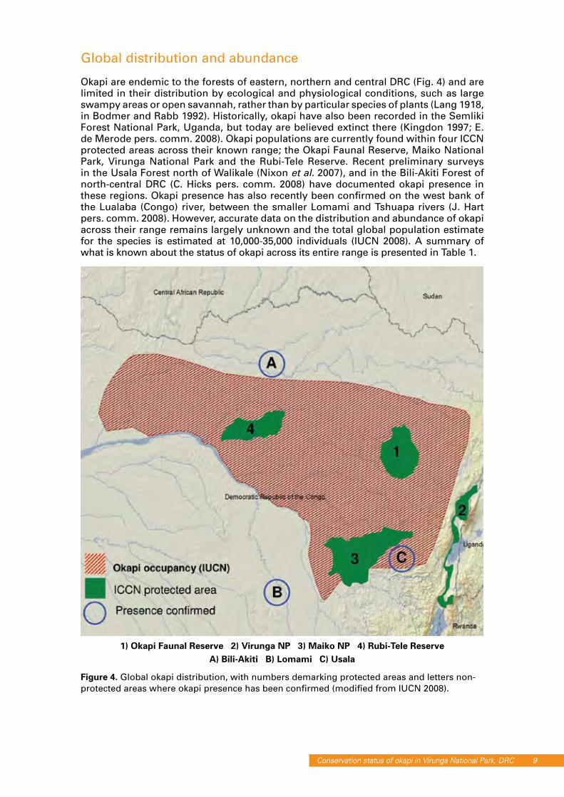
Okapi are endemic to the forests of eastern, northern and central DRC (Fig. 4) and are limited in their distribution by ecological and physiological conditions, such as large swampy areas or open savannah, rather than by particular species of plants (Lang 1918, in Bodmer and Rabb 1992). Historically, okapi have also been recorded in the Semliki Forest National Park, Uganda, but today are believed extinct there (Kingdon 1997; E. de Merode pers. comm. 2008). Okapi populations are currently found within four ICCN protected areas across their known range; the Okapi Faunal Reserve, Maiko National Park, Virunga National Park and the Rubi-Tele Reserve. Recent preliminary surveys in the Usala Forest north of Walikale (Nixon et al. 2007), and in the Bili-Akiti Forest of north-central DRC (C. Hicks pers. comm. 2008) have documented okapi presence in these regions. Okapi presence has also recently been confirmed on the west bank of the Lualaba (Congo) river, between the smaller Lomami and Tshuapa rivers (J. Hart pers. comm. 2008). However, accurate data on the distribution and abundance of okapi across their range remains largely unknown and the total global population estimate for the species is estimated at 10,000-35,000 individuals (IUCN 2008). A summary of what is known about the status of okapi across its entire range is presented in Table 1.
Figure 4. Global okapi distribution, with numbers demarking protected areas and letters non-protected areas where okapi presence has been confirmed (modified from IUCN 2008).
1) Okapi Faunal Reserve 2) Virunga NP 3) Maiko NP 4) Rubi-Tele ReserveA) Bili-Akiti B) Lomami C) Usala

10 Conservation status of okapi in Virunga National Park, DRC
Table 1. Available data on distribution and abundance of okapi across DRC
Ecology and behaviour
To date only one long-term in situ ecological study of okapi has been conducted, at Epulu in the Ituri Forest (Hart and Hart 1989). This study revealed that okapi are almost exclusively folivorous, highly selective browsers, feeding primarily on the leaves of young, emerging trees, shrubs and lianas. Browsing activity was concentrated in light gaps and at tree-fall sites, where an abundance of important okapi foods were identified. Leaves are pulled off branches using their prehensile tongues (Bodmer and Rabb 1992). Home range sizes were highly variable during Hart and Hart (1989)’s study, varying between 1.6 km2 and 10 km2 overall, with males holding larger home ranges than females and moving up to 4 km in a day, possibly following regular pathways through the forest (Bodmer and Gubista 1988). Okapi are principally solitary, and territorial behaviour has been noted (R. Ruf pers. comm. 2008). Other than the leopard and man (pitfall traps set by pygmies being the traditional method of capture: Landsheere 1957), okapi have no natural predators. Their gestation period is on average 440 days (with estimates ranging from 414 to 493 days: Nouvel et al. 1970; Rabb 1978; Gijzen and Smet 1974) and they have a captive lifespan of 15-20 years (Gijzen and Smet 1974).
Threats and conservation status
The forests of DRC are in the grip of a severe conservation crisis. Agricultural and pastoral expansion, subsistence hunting and the commercial bushmeat trade, the exotic animal trade, extensive gold and coltan mining, all exacerbated by poverty and limited livelihood opportunities resulting from over a decade of civil war, are putting growing pressure on forest resources and wildlife populations throughout the country. Although okapi have full legal protection under both Congolese and international law, they remain threatened by hunting (both with firearms and traps) for bushmeat and their skins (Fig. 5) and by habitat destruction. Although the global conservation status of okapi is largely unknown, the illegal hunting of this species for bushmeat (pers. obs.; J. Hart pers. comm.; C. Hicks pers. comm.) and the trade in skins (C. Hicks pers. comm.) has been reported at several sites across its range. Preliminary surveys conducted in eastern DRC in Maiko National Park (Amsini et al. 2005, 2006; Nixon et al. 2006) and the Usala region (Nixon et al. 2007) indicate that okapi are widespread but rare. Recent post-conflict wildlife surveys conducted in the Okapi Faunal Reserve between 2006 and 2007 provide the most telling evidence that these pressures are having serious impacts, documenting a 44% decline in this large population between 1996 and 2006 (Hart et al. 2008). Despite this demonstrated decline and the huge gaps that exist in our knowledge concerning the status of okapi at the global level, okapi are still classified as Near Threatened in the latest IUCN Red List of Threatened Species (IUCN 2008).

Conservation status of okapi in Virunga National Park, DRC 11
Figure 5. (a) Okapi-skin chair at Bili-Akiti; (b) okapi skull and trap at Bili-Akati (© Cleve Hicks)
The forgotten okapi of the Watalinga Forest
Following the initial scientific discovery of okapi in the Watalinga Forest in 1901, the focus for okapi quickly shifted from the Semliki region to Etabiri (now encompassed within Maiko National Park), where a station for the capture of okapi, gorillas and Congo peafowl was established by Belgian interests in the 1930s. Following the closure of the Etabiri facility, a new station was established at Epulu in 1952, where many okapi were captured using traditional M’buti pit traps and exported to zoos in Europe and the United States (R. Ruf pers. comm.). During the late 1980s and up to the start of the civil conflict in 1996, the Epulu station and its captive okapi population were a popular tourist attraction in eastern DRC. Although wild okapi are no longer captured and exported from Epulu, a small captive population is still maintained in large, forested enclosures to this day.
The last official record of okapi in the Watalinga Forest prior to their rediscovery in 2006 was in 1959. Between 1988 and 2006, the forest was occupied by National Army for the Liberation of Uganda (NALU) and various Congolese militias, with the onset of the civil war in 1996 forcing the withdrawal of a permanent ICCN presence in the sector for over a decade. The lack of scientific attention since 1959, alongside the breakdown of wildlife protection activities over the past two decades, led many to presume that okapi had been extirpated from the Watalinga Forest.
Okapi ‘rediscovered’ in Watalinga
In 2005, during the start of the rehabilitation of the Mbau-Kamango road (which cuts through the Watalinga Forest from west to east) and with the re-establishment of a permanent ICCN presence at Djuma and Mukakati, reports from ICCN guards, knowledgeable local inhabitants and road-workers began to indicate the continued existence of okapi in the sector (N. Mushenzi pers. comm.). In 2006, WWF in collaboration with field staff from ICCN and GIC conducted a preliminary exploratory field survey of the Watalinga Forest, recording okapi sign (dung, feeding sign and tracks) on the west bank of the Semliki and thus confirming its continued presence in the Watalinga Forest for the first time in almost 50 years (Bashonga 2006). Subsequent surveys in 2007 by WWF (Bashonga 2007) and in early 2008 by WCS (Plumptre et al. 2008) further documented the continued presence of okapi on the west bank of the river. Results from these surveys indicated that okapi in the Watalinga Forest were rare and restricted in distribution to the west side of the Semliki river. More recently, ICCN rangers reported the presence of this species on the east bank of the Semliki river for the first time (M. Mbusa pers. comm.), suggesting that the distribution of okapi in the park may be wider than previously thought.

12 Conservation status of okapi in Virunga National Park, DRC
study siteAltitude, vegetation and topography
The Watalinga Forest covers approximately 1100 km2 and is bisected from north to south by the Semliki river (Figs 6 and 7). Occurring at a mean al t i tude of approx- imately 850m, the Watalinga Forest represents the south -eastern limit of the extensive Ituri Forest. Mixed mature lowland tropical forest formations dominated by Cynometra alexandra are the principal vegetation types, although other habitats include riverine forest, broken
canopy Marantaceae forest, seasonally-inundated swamp forest, papyrus swamps (bordering the Semliki river), isolated secondary forest formations around tree falls and other sites of natural or anthropogenic disturbance. The Watalinga Forest has never been commercially logged and forest cover is almost complete. Topography in the study region is dominated by a chaotic jumble of low but steep-sided hills, ridges and valleys, although larger hills exist towards the northern park boundaries and in the south-east along the base of the Rwenzori massif.
Figure 7. (a) Watalinga Forest habitat and (b) the Semliki river (© ZSL)
Human populationThe communities found directly adjacent to the Watalinga Forest belong to two administrative collectivities: the Mbau collectivity, consisting of approximately 400 villages encompassed within four village groups, on the west side of the Semliki river, and the Watalinga collectivity, consisting of 224 villages encompassed within three village groups, to the east (Fig. 8). Population census figures collected by local administrators in early 2008 give total population sizes for Mbau as 208,400 and Watalinga as 57,100 (unpublished data). The mean annual population growth between 2005 and 2008 was 3.73 % for Mbau and 7.14% for Watalinga. Mean population density for the region was estimated in 2008 by local administrators as 109 individuals per km2.
Figure 6. Overview of the Watalinga Forest (© ZSL)

Conservation status of okapi in Virunga National Park, DRC 13
Local economy and amenities
Beni is the principal population, economic and adminstrative centre in the region. Local rural amenities adjacent to the Watalinga Forest are few and inadequate. Widespread poverty and insecurity over the past decade has destroyed almost all health and education infrastructure, leaving rural infirmaries, dispensaries and schools suffering from a severe lack of financial resources, low staffing levels and a chronic shortage of necessary materials. There are no mains electricity or piped water facilities in the area. The local economy is based primarily around the artisanal production of charcoal (the region’s principal fuel source) and the cultivation of cocoa, coffee and (more
recently) vanilla for export to Uganda. Shifting slash-and-burn agriculture of bananas, manioc and rice for local markets and subsistence purposes, the import and export of merchandise across the Ugandan border and the transport of people by motorbike and bicycle throughout the region are additional economic activities (Fig. 9)
Figure 8. Administrative map of Watalinga area
Figure 9. (a) Slash and burn agriculture, (b) cocoa and coffee nursery and (c) transport of charcoal (© ZSL)

14 Conservation status of okapi in Virunga National Park, DRC
Accessibility
Until recently, accessibility to the Watalinga Forest from the west and east was severely limited, due to the poor state of the abandoned Mbau-Kamango road which traverses the park between Djuma and Mukakati. In a state of disrepair for at least 30 years (S. Bamukoka pers. comm.), the road had been passable only by foot, bicycle (and occasionally) motorbike, limiting access to the park and villages in the Watalinga collectivity on the eastern side of the Semliki. The long-term presence of NALU rebels in the region and widespread insecurity during the recent civil wars had further reduced accessibility, effectively isolating communities and markets at Watalinga from the rest of DRC. Isolation for the people of Watalinga has been so profound during the last 30 years that until recently regular trade and commerce was only possible with Uganda to the east, and even today the Ugandan shilling remains the dominant local currency (pers. obs.). In 2005 a European Union-funded programme to rehabilitate the Mbau-Kamango road was initiated by the French NGO Solidarité et Développement Rurale (SODERU) (Fig. 10).
The main objectives of this rehabilitation were to reconnect transport links between the villages and communities of the Watalinga collectivity with markets and amenities to the west of the river, to facilitate local, regional and national trade between eastern DRC and neighbouring Uganda, and to improve local security and park surveillance through increased access for national military and ICCN personnel. A full assessment of the impact of the rehabilitation on the park was however not conducted before the project was carried out. The rehabilitation of the road was completed in 2007 and in order to maintain its condition a toll system was implemented, with the revenue generated being used to provide salaries for community-based road maintenance teams. The reparation of the road within the park boundaries is carried out by three teams working from depots at Makoyobo and Abia on the west side of the Semliki and from Lutakila on the east. A permanent Congolese national army (FARDC) presence is also upheld at Abia to help maintain local security. At the start of this study we counted at least 95 people living along the road within the park boundaries (including 10 ICCN personnel).
Figure 10. The Mbau-Kamango road (a) before rehabilitation in 2005 (© SODERU) and (b) after rehabilitation in 2008 (© ZSL)

Conservation status of okapi in Virunga National Park, DRC 15
methods
Community participation
Prior to commencement of fieldwork we held meetings with the local communities at Mbau and Watalinga in order to assess local knowledge of okapi distribution, trends in abundance and local perceptions of the park and the newly-completed road. Communities were introduced to the concepts underlying our survey and shown the camera trap apparatus (Fig. 11). While conducting these meetings an effort was made to inform people as effectively as possible about the importance of protecting the Watalinga okapi and wildlife in general. During the survey we provided temporary employment for 21 members of the local communities as guides, trackers and porters.
Figure 11. Community participation: (a) raising awareness of okapi conservation and (b) explaining the reason for and mode of camera trapping (© ZSL)
Training
Before the onset of fieldwork we conducted a five-day training session for 10 ICCN staff, covering observation and data collection techniques, basic and advanced GPS use, photography techniques and camera operation, camera trap installation and set-up, field etiquette and security and the identification of species through indirect signs. Following this initial session, nine ICCN guards received additional ‘on the job’ training in field observation, data collection, GPS operation and the use of camera traps over a ten-week period (Fig. 12).
Figure 12. ICCN ranger being trained by ZSL staff in camera trapping (© ZSL)

16 Conservation status of okapi in Virunga National Park, DRC
Reconnaissance surveys
Data collectionIn order to assess the distribution and relative abundance of okapi and human activities throughout the study region, we used a series of systematic forest reconnaissance surveys (recces) that followed a compass direction along pre-plotted, off-trail survey routes (following White and Edwards 1998). Recces were walked following as straight a path as possible along the plotted trajectories whilst allowing small deviations where difficult topography, swamps or very dense vegetation would otherwise have hindered progress, thus enabling teams to move quickly across survey blocks and increase coverage. All recce survey data were collected by experienced and trained observers with locally-hired guides to help interpret field sign where necessary. Field observation teams recorded and geo-referenced all direct (sightings and calls) and indirect (tracks, feeding signs, dung and nests) wildlife encounters, signs of human activity (snares, cartridges, paths, settlements/camps and mines) and relevant landscape features. Although the primary objective of this survey was to assess the conservation status of okapi, it was also possible to collect data on a wide variety of other large- and medium-sized mammal species of conservation importance to the park and which together serve as indicators of overall forest intactness and human impact. Table 2 summarises key mammalian species used as indicators in this survey and their relevance to park management (modified from Hart et al. 2008).
Table 2. Potential mammal indicator species for Watalinga Forest
Recce surveys were conducted between 26th July and 13th September 2008 by three field teams over a total of 32 days (Table 3). During this period a total of 59 recce segments (mean length 4.4 km) were completed with a total linear distance of 216.9 km and passing through 56 of 59 (95%) predetermined navigation points. The presence of NALU and Mai-Mai rebels prevented surveys being conducted in the far north of the park near Kwele and the Ugandan border and also in the extreme southwest in the vicinity of Mavivi (Fig. 13).
Table 3. Survey distances and dates

Conservation status of okapi in Virunga National Park, DRC 17
Figure 13. Survey coverage and recce routes
Data analysisGeo-referenced survey data were mapped using GIS software. Indices of relative abundance for wildlife and anthropogenic activities were calculated for each recce as encounter rates of sign observed per survey km. Due to the fact that suspected feeding sign cannot always be reliably attributed to okapi in addition to their tendency to create extensive localised feeding sign and tracks compared to the limited and quantifiable daily production of dung (J. Hart pers. comm.), for okapi, encounter rates of dung piles only were also calculated and used as the primary indicator of relative abundance (Fig. 14).
Figure 14. Okapi dung (© ZSL)
1) Lesse 2) Djuma 3) Mukakati N. 4) Mukakati S. 5) Ndama 6) Rwenzori

18 Conservation status of okapi in Virunga National Park, DRC
Camera trap study
A pilot study was conducted using digital, automatically-triggered, multiple-shot, infrared camera traps (RECONYX RC55 infrared game cameras) to test the efficiency of this technique to monitor okapi and other wildlife in the Watalinga Forest in the future. Our main objective was to test the efficiency of the cameras at capturing images of okapi that allow for identification of individuals by the unique stripe patterns on their hindquarters. A total of 18 cameras (two of which failed) were positioned in the forest at four sites (camera stations) on the west side of the Semliki river between 21st July and 13th September 2008, over a total of 177 trap days (Fig. 15). Partly because of
security concerns and partly in order to maximise the likelihood of capturing high quality images, cameras were placed non-randomly at easily accessible sites in regions where the presence of okapi had been previously confirmed by ICCN field personnel.
All cameras were mounted on tree trunks (<40cm diameter at breast height) facing trail positions where the likelihood of capturing clear images of okapi was considered high (i.e. along ridges, stream beds and at junctions of well used animal trails). Clearance of vegetation was kept to an absolute minimum at each camera site, only cutting or disturbing what was absolutely necessary in order to ensure each camera had a clear field of view. Where necessary, alternative trail routes were blocked with fallen wood in order to persuade animals to pass directly in front of the camera stations. Optimum camera height and distance from trails or potential image capture points was calibrated at each site by downloading and viewing test images into either a portable picture viewer or laptop computer, making necessary adjustments to the camera position before arming. All cameras were armed using the RC55 default ‘trail’ setting, whereby three images were taken per camera trigger at the maximum image capture speed of 1 frame per second (www.reconyx.com). Following installation, all cameras were checked at regular intervals to ensure effective operation, to assess battery life and to download any images captured.
Mbau-Kamango road impact assessment
In order to make a preliminary assessment of threats to the Watalinga Forest presented by the newly-rehabilitated Mbau-Kamango road, we visited local records offices to view recently collected demographic data and collected data on road traffic from ICCN records at Djuma and Mukakati. We also carried out informal interviews with local inhabitants and village chiefs and collected opportunistic observations while travelling along the road in the course of visiting field sites.
Assessment of bushmeat, okapi and forest exploitation and trade
We conducted an informal and preliminary survey of regional markets and settlements in September 2008 in order to get a broad overview of commercial forest exploitation. At each site visited we recorded evidence of trade in bushmeat, charcoal and other forest products, and
Figure 15. Locations of camera trap sites

Conservation status of okapi in Virunga National Park, DRC 19
held opportunistic and informal interviews with hunters, market traders, local inhabitants and, where appropriate, local authorities. The sale of bushmeat was recorded at all regional markets visited west of the park boundary, with principal markets being recorded at Eringeti and Mangazi and secondary/tertiary markets recorded at Mamove, Oicha, Mangina and Beni. Bushmeat was hidden from public view at all sites visited, being presented only on request. A large and open weekly market was reported to be held at Mangazi every Friday, which we were unfortunately unable to visit due to time and financial restrictions. In total markets at six localities were visited.
resultsReconnaissance surveys
WildlifeDuring the reconnaissance surveys we identified the presence of at least 29 mammal species and made a total of 440 observations of mammal sign. The overall mean composite encounter rate for mammal observations throughout the survey region was 1.91 sign/km. Overall mammal encounter rates were highest in the Lesse and Mukakati south survey regions and lowest in the Mukakati north and Djuma regions (Table 4 and Fig. 16).
Table 4. Wildlife observations and composite encounter rates
Figure 16. Distribution of all medium/large mammal encounters

20 Conservation status of okapi in Virunga National Park, DRC
OkapiIndirect indicators of okapi presence (dung, tracks and feeding sign) were unevenly distributed throughout the study region over an area of approximately 300 km2 (Fig. 17). These results confirm the continued presence of this species on both the west bank of the Semliki river at Lesse and Djuma and on the east bank in the Mukakati South survey block. The presence of okapi was also recorded north of the Mbau-Kamango road towards the Ugandan border for the first time. No okapi sign was recorded on 65 km of recces conducted in the Ndama survey block or, as expected, in the ecologically-unsuitable montane forests of the Rwenzoris. Details of okapi sign and dung encounter rates per survey block are presented in Table 5.
Table 5. Okapi observations and dung encounter rates
No direct observations of okapi were recorded during the recces. Overall okapi sign was recorded on 42% of all completed recce segments. The overall encounter rate for dung piles throughout the survey area was 0.14 dung/km. The highest overall dung encounter rate (0.38 dung/km) was recorded in the Lesse survey block, where okapi sign was recorded on 77% of completed recce segments. A relatively high abundance
of okapi sign was also recorded in the Mukakati South survey block on the east side of the Semliki (0.21 dung/km). In both the Lesse and Mukakati South survey blocks okapi sign was also recorded outside (yet immediately adjacent to) to the park boundary.
The lowest dung encounter rates were recorded on the east side of the river in the Mukakati North sector (0.10 dung/km), where field teams recorded okapi sign on just three recce segments at the north-eastern limit of the survey area. Encounter rates were only marginally higher in the Djuma survey block (0.14 dung/km) on the east side of the Semliki. Throughout the survey area, fresh or recent (<1 month) dung piles were encountered rarely and accounted for only 34% of all dung recorded.
ChimpanzeesDuring the survey chimpanzee sign was widespread but rare, being recorded infrequently in all survey blocks (Fig. 18). Details of chimpanzee nest observations are presented in Table 6. In total we observed 137 individual chimpanzee nests in 30 nest group sites throughout the survey region. Mean nest group size was 4.9 individuals (range 1-12). Although no direct observations of chimpanzees were recorded during the survey, chimpanzee calls were heard on six occasions. Our highest nest encounter rates (1.77 nests/km) were observed on a single short recce made in the Rwenzori mountains adjacent to Ndama village and on the east side of the Semliki river in the Mukakati South survey block (1.66 nests/km). Nest observations in the Mukakati South survey block were highly localised, with all nests being recorded on just 33% of recce segments, and 74% of these nests being recorded on just two recce segments. Encounter rates were lowest in the Ndama and Djuma survey blocks. On the Rwenzori recce we recorded chimpanzee nests, dung and trail sign over a wide range of altitudes between 1010m and 2400m. This included a single terrestrial nest constructed in the bamboo (Arundinaria sp.) zone at 2400m and evidence of bamboo consumption by chimpanzees (Fig. 19).

Conservation status of okapi in Virunga National Park, DRC 21
Figure 17a. Distribution of all okapi
Figure 17b. Distribution of okapi dung encounters

22 Conservation status of okapi in Virunga National Park, DRC
Figure 18a. Distribution of all chimpanzee encounters
Figure 18b. Distribution of all chimpanzee nest encounters

Conservation status of okapi in Virunga National Park, DRC 23
Table 6. Chimpanzee observations and nest encounter rates
Figure 19. (a) Evidence of bamboo feeding by chimps; (b) Arundinaria bamboo forest in the Rwenzoris
Large ungulatesOther than okapi we recorded the presence of two additional large ungulate species: buffalo (Syncerus caffer) and bongo (Tragelaphus euryceros). Both species were recorded very infrequently with only ten encounters of buffalo (three dung and seven tracks) and four encounters of bongo (all tracks) recorded throughout the whole study area. Neither species was recorded in the Ndama or Rwenzori survey blocks (Fig. 20).
Figure 20. Buffalo and bongo encounters

24 Conservation status of okapi in Virunga National Park, DRC
Figure 21. Pig encounters
Figure 22. Duiker dung encounters

Conservation status of okapi in Virunga National Park, DRC 25
PigsTwo species of pig were recorded, the red river hog (Potamochoerus porcus) and the giant hog (Hylochoerus meinertzhageni). As field teams were inconsistent in reliably distinguishing between these species when recording sign, all pig observations are combined. In total, pig observations (tracks, dung and feeding sign) accounted for 12.2% of all mammal observations. Encounter rates for all pig sign combined were highest in the Mukakati South survey block (0.32 sign/km) and lowest in the Mukakati North survey block (0.07 sign/km). No pig sign was observed in the Rwenzoris (Fig. 21).
DuikerWe recorded the presence of at least four duiker species: blue duiker (Cephalophus monticola), two species of red duiker (C. dorsalis and C. weynsi) and yellow-backed duiker (C. sylvicultor). When combined, duiker trail sign (dung and tracks) was the most frequently recorded of all mammal sign, accounting for 37% of all observations made. Given the frequency of duiker tracks in some areas and the need to keep a reasonable pace for security reasons, duiker tracks were inconsistently recorded between survey sectors, but field teams recorded and georeferenced all dung piles encountered (47% of all duiker observations). Duiker dung encounter rates were highly variable (ranging from 0.03 dung/km in the Ndama area to 1.04 dung/km in Lesse), with no duiker sign observed on the Rwenzori segment (Fig. 22).
MonkeysDirect observations of monkey groups were uncommon throughout the survey area, with a total of 45 observations or 0.22 groups/km (range 0.13-0.34 groups/km) (Fig. 23). In total we recorded the presence of nine diurnal primate species, including the regionally endemic owl-faced guenon (Cercopithecus hamlyni). Although L’Hoest’s guenon (Cercopithecus l’hoesti) was widely reported as extant throughout the study region, we did not observe this species during our surveys (Fig. 24).
Figure 23. Monkey group sightings

26 Conservation status of okapi in Virunga National Park, DRC
Figure 24. Monkey species observation frequencies
LeopardSign of the endemic Rwenzori leopard (a distinct and endangered morph) was recorded on just five occasions during this survey, accounting for only 0.1 % of all mammal observation recorded (Fig. 25). Leopard scat was recorded on one occasion in the Ndama survey block and tracks were also observed at Lesse and Mukakati South. One nocturnal cry was also heard in the Mukakati South block.
Figure 25. Leopard encounters

Conservation status of okapi in Virunga National Park, DRC 27
ElephantNo evidence of elephant was found in any of the survey blocks.
Human activitiesEvidence of human activities was widespread and encountered in all survey areas. Details of composite encounter rates per survey block are presented in Table 7 and observation frequencies of principal activities observed in Fig. 26. The overall encounter rate for human sign was 2.25 sign/km. Human sign was encountered most frequently in the Lesse block (4.68 sign/km) although the distribution of these activities was highly skewed towards recce segments conducted beyond the western park limits. Our short survey in the Rwenzoris also revealed high evidence of human activities. Human activities were encountered infrequently in the Mukakati north (0.81 sign/km) and Djuma (0.90 sign/km) blocks. Most frequently encountered were snares (1.45/km) and active paths (0.22/km). No evidence of permanent settlements or mining activities within park boundaries was observed during the survey.
Table 7. Observations and encounter rates of signs of human activities
Figure 26. Proportion of different types of human activity observed

28 Conservation status of okapi in Virunga National Park, DRC
HuntingEvidence of hunting activity (snares, bullet/shell casings and camps) was encountered frequently within the survey blocks (1.53 sign/km) and accounted for 79% of all human activities recorded (Fig. 27). Snares (72% of which were active) were the most frequently encountered hunting sign, accounting for 94% of all observations. Duiker and small antelope were targeted by 93% of snares (Fig. 28). Hunting sign was most frequently encountered in the Lesse survey block (3.56 sign/km), being highly localised along three recce segments outside the western park boundary. Significant numbers of active snares were also found and destroyed immediately adjacent to the SODERU road repair depot at Makoyobo (in both the Djuma and Lesse survey blocks).
Figure 27. Distribution of hunting activity
Figure 28. Observation frequencies of different snare types
Conservation status of okapi in Virunga National Park, DRC 29
Figure 29. Hunting activities observed: (a) blue monkey caught in tree snare; (b) hunting camp being destroyed by ICCN rangers during the survey (© ZSL)
Camera trap study
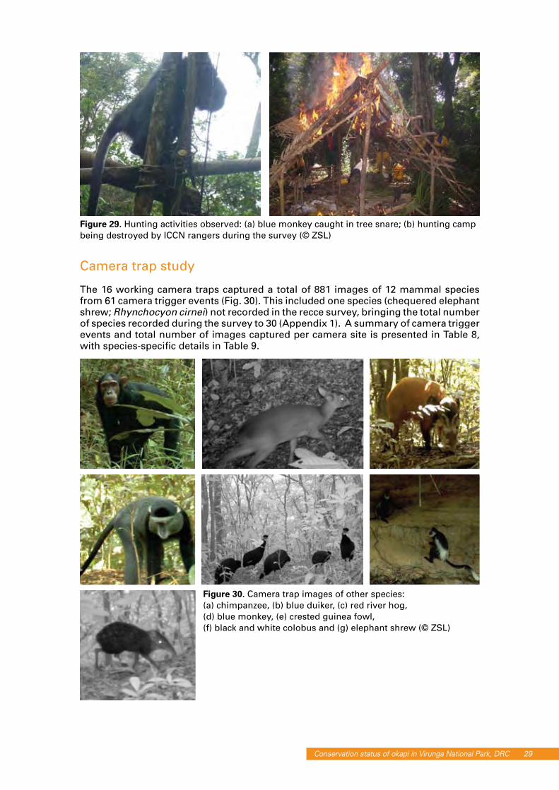
The 16 working camera traps captured a total of 881 images of 12 mammal species from 61 camera trigger events (Fig. 30). This included one species (chequered elephant shrew; Rhynchocyon cirnei) not recorded in the recce survey, bringing the total number of species recorded during the survey to 30 (Appendix 1). A summary of camera trigger events and total number of images captured per camera site is presented in Table 8, with species-specific details in Table 9.
Figure 30. Camera trap images of other species: (a) chimpanzee, (b) blue duiker, (c) red river hog, (d) blue monkey, (e) crested guinea fowl, (f) black and white colobus and (g) elephant shrew (© ZSL)

30 Conservation status of okapi in Virunga National Park, DRC
Table 8. Camera trap survey details
Table 9. Camera trap trigger events per species and sector
Okapi imagesIn total, 71 images of okapi of variable quality were captured at four camera stations over a total of five trigger events (Fig. 31). All okapi images were captured in the Djuma block and included evidence of both diurnal and nocturnal activity. Despite a high density of okapi trail (browse, dung and tracks) at the Lesse site we did not capture any images of okapi at this site during the study period. All images captured were of female individuals.
Figure 31. Okapi camera trap images (© ZSL)

Conservation status of okapi in Virunga National Park, DRC 31
Recognition of individual animalsPrior to this study we had anticipated it would be possible to identify individual okapi by the unique series of stripe markings on their rump, hind limbs and lower forelimbs. The 71 images of okapi captured during this study included only a limited number of clear images showing the stripe patterns on both sides of an individual (which is needed to reliably identify an individual). Fig. 32 compares the left hind side images for individual okapi captured by cameras at different stations within the Djuma block in greyscale to emphasise their stripe patterns, and clearly shows the images are of different individuals. We were able to positively identify two individuals during the survey.
Figure 32. Comparison of okapi stripe patterns (© ZSL)
Mbau-Kamango road impact assessment
The lack of data on the distribution and abundance of wildlife populations and human activities prior to the completion of the Mbau-Kamango road rehabilitation in 2006 makes a thorough evaluation of the road’s impact on the Watalinga Forest difficult. Nonetheless we use a combination of data collected opportunistically on road traffic and forest exploitation levels, demographic data generously provided by local administrators and information gathered during our discussions with local communities to carry out a preliminary impact assessment of the road.
ImmigrationPrior to the commencement of our work, local chiefs at Djuma and Kamango had expressed their concern that the Mbau-Kamango road, while greatly increasing local trade and accessibility to regional amenities, had caused an increase in uncontrolled immigration to the area and was increasing land use pressure in these regions. At Mbau and Kamango we were kindly granted access to data from population censuses conducted between 2005 and 2008. From this data we calculated annual population growth (%) for the years 2005 through to 2007 (Fig. 33).

32 Conservation status of okapi in Virunga National Park, DRC
Figure 33. Population growth in collectivities adjacent to the Watalinga Forest
These data show clearly that annual population growth in both collectivities rose sharply in 2006 (in comparison to 2005 and the most recent census in December 2007), indicating significant immigration of people into both regions during 2006. While there are many socio-political factors that could account for this increase, given that 2006 was the year the Mbau-Kamango road was completed, this suggests that the opening of the road could be a factor contributing to the observed peak in population growth during this period.
Road traffic and the charcoal tradeA burgeoning charcoal trade exists immediately adjacent to the western park boundary, centred on Djuma. The high local abundance of Cynometra alexandra in the Watalinga Forest, a tree species preferred for charcoal production (Hart 2001), and the high level of trade brought by regular passing of heavy goods cargo vehicles along the road are likely to be significant drivers of this trade.
During the survey period we observed and recorded a steady increase in the number of sacks of charcoal being sold and collected by commercial vehicles along the Mbau-Kamango road, from 465 bags in July, to 620 in August and finally 875 in September. Data collected from road tariff records shows that the number of large trucks traversing the park via the new road for the months of April to September increased over three-fold between 2007 and 2008 (Fig. 34).
Figure 34. Truck traffic between Djuma and Mukakati 2007-2008

Conservation status of okapi in Virunga National Park, DRC 33
HuntingIn addition to our preliminary observations of recent local increases in population growth, charcoal production and heavy goods traffic, our recce results revealed high encounter rates for active snares in both the Lesse and Djuma survey blocks immediately adjacent to the SODERU depot at Makoyobo. While hunting and access to the park is strictly forbidden for all SODERU road workers based at the three road repair depots at Makoyobo, Abia and Lutakila, our results indicate that the Makoyobo site (at least) is being used periodically as an access point to the forest by poachers. The presence of a permanent and currently largely unsupervised population of road reparation workers within the park boundaries between Djuma and Mukakati clearly represents an additional threat to okapi and other wildlife in the Watalinga Forest.
Assessment of bushmeat, okapi and forest exploitation and trade
BushmeatDuring the market surveys both domestic and smoked bushmeat products were recorded on sale, with fresh domestic meat (pork, goat and beef) being far more prevalent at all markets visited. Due to the hidden nature of the bushmeat trade we were unable to assess regional differences in bushmeat prices or make accurate comparisons with the price of domestic meat, although smoked monkey and blue duiker carcasses were observed on sale at the markets in Eringeti and Mamove for US$8 each (Fig. 35), making their purchase per unit (although not necessarily per kg, given that an adult blue duiker carcass weighs on average 1.85kg smoked or 4.8kg fresh: Kümpel 2006 and unpublished data) more expensive than fresh pork (US$2.80/kg), beef (US$3.20/kg) or goat (US$3.50/kg). At Oicha we visited a household that also functioned as a restaurant specialising in bushmeat and we were also offered bushmeat from an alternative and hidden menu at a major restaurant in Beni. Interviewees reported that generally the higher unit cost of an entire bushmeat carcass put it out of the price range for a meal for a typical household, and that the bushmeat trade is driven by demand from wealthier households and restaurants, but further research is needed into this.
Figure 35. Bushmeat on sale: (a) smoked monkeys at Eringeti market; (b) smoked red duiker being transported by a hunter outside Mamove (© ZSL)

34 Conservation status of okapi in Virunga National Park, DRC
At the southern limit of the Watalinga Forest we interviewed a commercial hunter who claimed to hunt monkeys and medium-sized ungulates (such as pigs) regularly in the park using arms supplied by military personnel at Nyaleke on the Beni-Kasindi road. Further interviews in this region supplemented by information from reliable sources in Beni indicate trafficking of bushmeat originating in the region as far south as Butembo (Fig. 36). Although no commercial bushmeat hunting was reported or recorded on the eastern side of the Watalinga Forest at Kamango, we observed the carcass and live infant of a female Cercopithecus ascanius shot locally by military personnel, heard gunshots in the Rwenzori mountains while at Ndama and received reports that three chimpanzees had been shot and eaten by military at the village the week before our visit. More work is needed in the region to assess the levels of bushmeat hunting, its drivers, markets and sustainability; although it is clear that this trade represents a serious and rapidly growing threat to wildlife throughout eastern DRC (J. Hart pers. comm.).
Figure 36. Location of commercial hunting, okapi hunting, bushmeat markets and charcoal production
Okapi huntingDuring the survey we received several reports of regional okapi hunting for bushmeat and skins (Fig. 36). We were offered okapi skins on three occasions in Beni and we interviewed a hunter at Eringeti who claimed to possess an okapi skin collected from the park ‘near the Ugandan border’. Hunted okapi remains (tail and teeth) were also shown to us on the east side of the Semliki at Ndama (Fig. 37) and we received reports of okapi being hunted on the west side of the Semliki during the past five years. In Beni, okapi meat was reported on sale from bushmeat traders at the bus station on an irregular but frequent basis at a price of US$10/kg, and was also reported as available to order. The origin of this meat was given as ‘east of Eringeti’. Although okapi were not reported as favoured prey species by hunters or as favoured meat by local inhabitants, five okapi were reported as having been hunted opportunistically ‘south-east of the river’ over the past 18 months. Additional Figure 37. Evidence of okapi hunting,
Ndama (© ZSL)

Conservation status of okapi in Virunga National Park, DRC 35
recent okapi hunting was reported ‘west of Mangazi’. The price for illegally-acquired okapi skins was reported as varying between US$200-300 depending on skin quality and the availability of buyers. We were unable to identify markets for okapi skins although one informant reported the export of skins from DRC to Uganda. In all regions hunters and/or bushmeat traders interviewed were fully aware that okapi were protected by national and international laws.
Charcoal and fuelwood extraction and tradeThe artisanal production of charcoal is a major regional economic activity and extensive evidence of it was observed (Fig. 36). Charcoal production was focused heavily around the western park limits east of Eringeti and along a 8.5 km stretch of the Mbau-Kamango road, with a concentration of charcoal production within 1.5 km (but also right up to) the park boundary at Djuma village (Fig. 38). Major sites of charcoal production were also observed west of Oicha and along the southern park boundary near Nyaleke. The most favoured and heavily exploited tree species reported and observed during the survey period was Cynometra alexandra (known locally as ‘tuna’; Fig. 39), a primary forest species associated with mature lowland formations and one of the most prominent tree species in the Watalinga. In all regions, observed charcoal production and market sale was heaviest immediately adjacent to paved road where transport is greatly facilitated by commercial vehicles traveling to major markets in Beni and further south to Butembo. Charcoal use was reported as being restricted to the west of the Watalinga Forest with communities at Kamango, Ndama and Nobili preferring the use of chopped wood as an energy source.
Figure 38. Charcoal trade at Djuma Figure 39. ‘Tuna’ (Cynometra alexandra) (© ZSL) (© ZSL)
Prices per unit (70 kg sack) of charcoal varied considerably between production and market sites, costing for example $6 per unit at the point of origin at Djuma and $15 at market in Beni. We calculate a crude and preliminary estimation from weekly counts of charcoal sacks for sale observed along the side of the Mbau-Kamango road (while travelling to and from the field sites), and by questioning traders and government officials at Djuma, Eringeti, Oicha and Beni, that in the region of 1600-2000 70 kg sacks (112-140 tons) of charcoal are produced and sold on a weekly basis in the vicinity of the park. Using a very crude parameter that charcoal is on average about 25% the weight by volume of the fresh wood it is produced from (B. Poole pers. comm.), this could equate to the felling and processing of 560-700 tons of wood every week. No regulation of charcoal production was observed or reported in the region.

36 Conservation status of okapi in Virunga National Park, DRC
Illegal timber tradePrincipal production sites for the cutting and preparation of planks for the construction industry were observed at Eringeti and Mangina, where local traders informed us that each week at least 200 tons of wood per site was sold. The majority of locally-produced planks is picked up on a weekly basis and transported south via road to Beni, Butembo and Goma and west to Uganda via commercial heavy goods vehicles (Fig. 40). As with charcoal production, no regulation or monitoring of this trade was observed.
Figure 40. Commercial vehicle with plank cargo, Eringeti (© ZSL)

Conservation status of okapi in Virunga National Park, DRC 37
disCussionOkapi
DistributionThis survey has revealed that okapi in Virunga National Park are more widely distributed than previously documented but have a restricted range, occurring in two principal populations, to the west and east of the Semliki river. Due to the depth and breadth of the Semliki it is most likely that these populations are currently genetically isolated from one another. The presence of the new Mbau-Kamango road likely further restricts the movements of okapi within these two principal areas and has at least partially fragmented both populations. The Lesse region on the west bank and the Mukakati South survey block on the east both had relatively high concentrations of okapi activity and the highest overall faunal encounter rates, indicating that these are faunal hotspots or refuges for many species and are therefore key sites for protection. Okapi sign was much less frequently observed in both the Djuma and Mukakati North survey blocks, although our surveys were more limited in these regions due to localised insecurity. The distribution of okapi in these blocks could be wider than that observed during these surveys and warrants further investigation.
We recorded no okapi in the far south-west of our study or on our short Rwenzori recce. Although we did not expect to find okapi in the ecologically unsuitable montane forests of the Rwenzoris, we had hoped to confirm okapi presence in the lowland forests southwest of Ndama, having received numerous local reports that okapi (along with buffalo and forest elephant) recently occurred in this area. The absence of okapi, elephants and buffalo sign on surveys in this block, coupled with low encounter rates of duiker and widespread evidence of trap and gun hunting, indicate that the region has been subject to long-term hunting pressure, an observation supported by local reports of elephant poaching and occupation of these forests by various armed militia during the recent conflicts. On completion of surveys in this block we were shown the tail and tooth of an okapi reportedly shot by military south-west of Ndama in 2003. Okapi may periodically range into this area, but we believe that they have either been exterminated from the survey block or are actively avoiding human disturbance (noted okapi behaviour: R. Ruf pers. comm.).
Our observation that okapi were the most frequently encountered large ungulate in the Watalinga Forest suggests that okapi may have been subject to less overall hunting pressure than elephants, buffalo and bongo. Nonetheless, numerous reports of hunting of this species across their range and the catastrophic decline of okapi populations in the Okapi Faunal Reserve during the civil war clearly indicate that okapi are highly threatened by hunting, whether targeted or opportunistic.
AbundanceAs the recce methodology doesn’t record perpendicular distances (White and Edwards 1998), dung encounter rates derived from recce surveys alone cannot be used to calculate accurate density and abundance estimates. Nevertheless, studies on African apes and forest elephants at several sites have shown that when compared, dung and nest encounter rates from recces and associated transects are positively correlated (e.g. Hall et al. 1998; Walsh and White 1999), suggesting that encounter rates derived from recces are a reasonable indicator of relative abundance for these species. Time limitations due to highly unpredictable security conditions throughout the survey period meant we were unable to conduct comparative transect and dung decay studies without compromising survey coverage and therefore a precise population estimate for the Watalinga okapi was not possible.

38 Conservation status of okapi in Virunga National Park, DRC
An initial comparison of okapi dung encounter rates from recent rapid wildlife assessment surveys carried out in other protected areas suggests that the mean encounter rate for the Watalinga Forest overall (0.14 dung/km) is markedly higher than that observed for both Maiko National Park and the Usala Forest, yet only around half of that observed in the Okapi Faunal Reserve (Table 14). However, okapi sign was only found in around 300 km2 of the 550 km2 Watalinga survey area. The mean encounter rate for recces conducted only within this 300 km2 is 0.20 dung/km, suggesting a localised density comparable to that observed in the Okapi Faunal Reserve (0.20 dung/km).
Table 10. Okapi dung ‘recce’ encounter rates at different sites
Hart et al. (2008) recently calculated post-conflict okapi abundance in the Okapi Faunal Reserve using dung encounter rates derived from comparative transect and recce surveys. As the off-path recce technique employed in this study is very similar to the recce protocol used for their surveys, taking the ratio of their encounter rate to density (0.25/0.17 = 1.47), we can convert our encounter rate of 0.14 dung/km to an approximate density of 0.095 individuals/km2. When scaled up, this gives a very crude estimate of 52 okapi found within the 550 km2 study area. Using Hart et al. (2008)’s actual density of 0.17 individuals/km2 as recorded in the Okapi Faunal Reserve gives a slightly higher estimate of 94 okapi within the 550 km2 study area. These calculations are clearly very preliminary and more detailed study is needed to calculate the entire distribution and population size of okapi in the Watalinga forest. However these survey findings suggest that no more than 50-100 individuals are likely to be found in the entire survey area. We do not extrapolate this population estimate to regions outside our survey area where okapi presence remains unconfirmed.
Chimpanzees
The lowland forests of the Watalinga and the transitional and montane forests of the adjoining Rwenzori Mountains are important areas for the conservation of chimpanzees in the Virunga National Park (Plumptre et al. 2008). During their recent surveys of the region, Plumptre et al. (2008) concluded that the forests of the Rwenzoris support a higher density of chimpanzees than the lowland regions of the Watalinga Forest, an observation further supported by our survey data. We found a high abundance of chimpanzee sign in the region south of Ndama on the north face of the Rwenzoris, a site not previously surveyed before. Occurring up to an altitude of at least 2400m, these high altitude chimpanzees display some interesting behaviours rarely or never recorded before. We found evidence of terrestrial nest construction, a widespread but rarely occurring phenomenon in eastern chimpanzees (S. Nixon pers. obs.; C. Hicks pers. comm.), as well as bamboo consumption, which we believe has not been officially documented for this species before and is potentially a characteristic behavioural trait of this population. Terrestrial nest construction and feeding on bamboo are behaviours normally associated with high altitude eastern gorilla populations; however the Rwenzori mountains lie outside the current and recent historical range of the eastern gorilla (Gorilla beringei; Mehlman 2007) and our observations were accompanied

Conservation status of okapi in Virunga National Park, DRC 39
by chimpanzee dung of the same age at the same sites. It is almost certain that these unusual and interesting traits are the cause of many reports we received from inhabitants of Ndama that gorillas exist in the high forests of the Rwenzoris.
We also found high levels of human disturbance within the park boundaries, including hunting, up to 2350m and although we were told of a local taboo against the consumption of chimpanzees, we received reports that military stationed nearby had shot and eaten three chimpanzees one week before we surveyed the site. A significant amount of deforestation and land conversion has occurred along the base of the Rwenzoris at this site (Fig. 41) and considerable confusion concerning the limits of the park in the region was noted.
Figure 41. Deforestation of the Rwenzoris (© ZSL)
Plans to rehabilitate the Kamango-Ndama-Kikingi road (C. Leonard pers. comm.) are likely to further increase settlement in this region and, in the absence of affordable or realistic alternatives, intensify current hunting and land conversion. With the current lack of an ICCN presence in the Ndama region we believe that chimpanzees and other wildlife should be considered highly threatened here.
Our results show that chimpanzees found within our survey regions are distributed over almost the entire altitudinal range recorded for the species and occur in a diversity of habitat types, making this a highly important area for chimpanzee conservation at a global level. Further studies to assess the distribution and abundance of chimpanzees in the park and its adjacent forests on both sides of the Semliki are clearly warranted in order to develop a long-term management plan for this important species.

40 Conservation status of okapi in Virunga National Park, DRC
Elephants
Overall low encounter rates of large mammals sensitive to hunting pressure indicate that the Watalinga is in a current state of partial defaunalisation, with most large/medium mammal species being rare and/or localised in distribution. The outlook for the forest elephant appears to be particularly bleak. While it is possible that some elephants still remain in regions of the northern sector not covered in this survey (including the higher altitude forests of the Rwenzoris), we suspect that the forest elephant is already locally extinct in the Watalinga Forest. Reports from local people and long-term ICCN staff (e.g. N. Mushenzi pers. comm.) indicate that prior to 1996 the Watalinga Forest supported high local densities of forest elephants. A period of intensive elephant poaching then started in 1996 with the onset of the civil war and occupation of the Watalinga Forest by a multitude of armed groups. So intensive was this poaching that reports indicate elephants were completely eradicated from much of the park by early 2000. These findings mirror those being reported from elsewhere in eastern DRC, where elephants are undergoing a sharp and drastic decline across much of their range (Amsini et al. 2006; Hart et al. 2008; Nixon et al. 2006, 2007) and it is currently difficult to see how the forest elephant population can recover in the Watalinga Forest.
However, recent reports from the nearby Mt Hoyo region indicate that forest elephants may still occur at the site (K. Kipiri pers. comm), which is remarkable considering the long-term and continued occupancy of the Mt Hoyo region by armed groups and the breakdown of conservation activities in the region over the past decade. With the long-term existence of elephants hanging in the balance across much of DRC, if any elephants still exist at Mt Hoyo, immigration from this population will most likely represent the best and last chance for elephants to repopulate the Watalinga Forest.
Protection capacityThe protection of okapi and wildlife in the Watalinga Forest is a serious challenge for ICCN. Currently only nine guards are stationed along the Mbau-Kamango road at the Mukakati and Djuma patrol posts and no ICCN presence exists in the northern region of the Watalinga Forest near Kwele or on the east side of the Semliki near Ndama. While current ICCN staff in the Watalinga Forest are dedicated to the protection of Virunga National Park, the team is too small to attain sufficient monthly patrol coverage in the key areas where okapi and other important wildlife populations remain. Ironically, the Mbau-Kamango road was constructed in collaboration with ICCN, with one supposed benefit to park authorities being increased survey coverage due to improved accessibility, yet the ICCN staff stationed along this road have insufficient transport to facilitate the rapid and regular deployment of ICCN guards along its length. Currently the Djuma and Mukakati stations have no communication system installed and guards suffer from low and irregular salaries and a shortage of high quality field equipment.
Protection capacity is further compromised by the continued presence of NALU and Mai Mai militias throughout the region. The armed attack and murder during the study period of an ICCN guard while on patrol from Mavivi by unknown assailants clearly highlights the dangerous and potentially explosive situation which ICCN field staff are exposed to on a daily basis. ICCN field staff are the last line of defence for okapi in the Watalinga Forest and require additional and sustained support from both government and NGO partners in the immediate future, in order to protect the highly threatened okapi and other wildlife. Once a stronger ICCN presence is established in the Watalinga Forest, longer-term activities should be developed and implemented aimed at reducing pressure on the park’s natural resources (such as identifying alternative protein, fuel and income sources), promoting connectivity with the Mt Hoyo and Ituri regions through the creation of a forest corridor (Plumptre et al. 1998) and involving local communities in wildlife monitoring and conservation activities.

Conservation status of okapi in Virunga National Park, DRC 41
Camera trapping as a monitoring toolA promising, non-invasive and low-cost tool for monitoring okapi (and other wildlife) in the Watalinga Forest is the continued use of automatic camera traps tested during this survey. This technique has proved highly successful in assessing and monitoring the density of other large mammals with distinctive, individually-recognisable features, most notably large cats such as tigers (Karanth et al. 1998) and jaguars (Silver et al. 2004). Camera traps could be used to monitor several aspects of the Watalinga okapi, such as dispersal between subpopulations, distribution, density, habitat use and home range, all of which will be required in order to formulate a long-term management plan for this species. The 16 working Reconyx camera traps used during this study remain with ICCN, so that ongoing monitoring can be carried out by the personnel trained in camera trapping field methodology by the ZSL survey team, but there remains a need for (1) further field testing of this and other camera models, (2) an increase in the number of traps (usually systematic sampling grids are set up using a minimum of 40 camera traps) and (3) advanced training in data analysis (including mapping) and reporting.
In addition, camera trapping is being developed as a broader wildlife monitoring tool, which can be applied to a variety of elusive forest species difficult to census by traditional methods. Rowcliffe et al. (2008) have shown that camera traps can be used to monitor abundance of non-individually recognisable species. Preliminary work conducted on duikers in Tanzania (Bowkett et al. 2007) has also shown that camera traps can be used to assess habitat use and suitability. ZSL and WCS have developed the Wildlife Picture Index – a global biodiversity indicator which is being tested in a variety of WCS and ZSL field sites around the world – which could be used to monitor wildlife in Virunga National Park over time.
ConClusionsOkapi and other wildlife in the Watalinga Forest are clearly at risk. Our results indicate that okapi are rare and occur at low density in four partially or completely isolated subpopulations. These populations are highly threatened by increasing human population density, widespread bushmeat hunting and habitat destruction, all of which are facilitated by the presence of the new Mbau-Kamango road. These factors are compounded by the increasing threat of genetic isolation from okapi populations in the Ituri Forest to the north-west (due to habitat loss and hunting throughout the corridor between Watalinga and Ituri), the continued presence of armed militia and a small, under-equipped ICCN presence in the sector.
In the short term, we believe that the Watalinga okapi are highly threatened, and unless immediate and extensive conservation measures are taken, this population is likely to become reduced to the point of extinction within a few years. In the long term, the genetic viability of the okapi in the Watalinga Forest is now questionable, and without protection of the forest corridor linking Watalinga, through the Mt Hoyo area, to the Ituri Forest, it is possible that the translocation of okapi from other regions may be the only solution to increase genetic variation within the Watalinga population.
Although the Watalinga population appears to be very small, the presence of okapi in the park is important for two main reasons. Firstly, with the wider status of okapi across their range remaining largely unknown but all available evidence suggesting they are increasingly threatened, every effort should be made to safeguard all okapi populations that reside within legally protected areas. Secondly, okapi are a highly charismatic flagship species for the northern sector of the Virunga National Park as well as throughout DRC in general. The continued presence of this elusive and highly emblematic species in the Watalinga Forest will likely be a huge asset in garnering public attention and support for the conservation of this sector at the local, national and international level. A solid and realistic plan to conserve and monitor this population should therefore be developed and implemented as soon as possible.

42 Conservation status of okapi in Virunga National Park, DRC
reCommendAtionsTwo multi-stakeholder workshops were held following the end of the field surveys, in Beni (September 2008) and Goma (October 2008), where these survey results were presented and recommendations for the conservation of okapi in and around Virunga National Park were discussed and agreed (Fig. 42). The agenda and list of participating organisations for the Goma workshop is presented in Appendix 2. The joint recommendations from the two workshops (as agreed by the Goma workshop participants) are provided in English and French in Appendices 3 and 4 respectively.
Figure 42. Workshops in (a) Goma and (b) Beni (© ZSL)
Conservation status of okapi in Virunga National Park, DRC 43
referenCes Amsini, F., Grossmann, F., Hart, J., Kibambe, C., Nyembo, B. and Vyahavwa, C. (2005) Identifying conservation priorities for the recovery of the Maiko National Park: post-conflict surveys of wildlife populations and human impact in the North Sector of the park. IMU Technical Report No. 4. Wildlife Conservation Society
Amsini, F., Grossmann, F., Hart, J., Kibambe, C., Nyembo, B. and Vyahavwa, C. (2006) Identifying conservation priorities for the recovery of the Maiko National Park: post-conflict surveys of wildlife populations and human impact in the South Sector (Oso Block) of the park. IMU Technical Report No. 6. Wildlife Conservation Society
Bashonga, G. (2006) Okapi survey report No.1. WWF
Bashonga, G. (2007) Okapi survey report No.2. WWF
Bodmer, R.E. and Gubista, K.R. (1988) A note on the social structure of free-ranging okapi. Acta Zoologica et Pathologica Antverpiensa 80: 11-17
Bodmer, R.E. and Rabb, G.B. (1992) Okapia johnstoni. Mammalian Species 422:1-8
Bowkett, A.E., Rovero, F. and Marshall, A.R. (2007) The use of camera-trap data to model habitat use by antelope species in the Udzungwa Mountain forests, Tanzania. African Journal of Ecology (compilation) Blackwell Publishing. DOI: 10.1111/j.1365-2028.2007.00881.x
Gijzen, A. and Smet, S. (1974) Seventy years of okapi, Okapia johnstoni (Sclater, 1901) Acta Zoologica et Pathologica Antverpiensia 59:1-90
Hall, J.S., White, L.J.T., Inogwabini, B.I., Omari, I., Morland, H.S., Williamson, E.A., Saltonstall, K., Walsh, P., Sikubwabo, C., Bonny, D., Kiswele, K.P., Vedder, A. and Freeman, K. (1998). Survey of Grauer’s gorillas (Gorilla gorilla graueri) and eastern chimpanzees (Pan troglodytes schweinfurthi) in the Kahuzi-Biega National Park lowland sector and adjacent forest in eastern Democratic Republic of Congo. International Journal of Primatology 19(2):207-235
Hart, J.A. and Hall, J.S. (1996). Status of eastern Zaire’s forest parks and reserves. Conservation Biology 10(2): 316–27
Hart, J., Beyers, R., Grossman, F., Carbo, M., Dino, S., Kahindo, F. (2008) La Réserve de Faune Okapi: la distribution et fréquence de la grande faune et des activités humaine avec une évaluation de l’impact de 10 ans de conflit: 1996-2006. IMU technical report No.9. Wildlife Conservation Society
Hart, J. and Hart, T. (1989) Ranging and feeding behaviour of okapi (Okapia johnstoni) in the Ituri Forest of Zaire: food limitation in a rainforest herbivore? Zoological Society of London Symposia 61:31-50
Hart, T.B. (2001) Forest Dynamics in the Ituri Forest (DR Congo): dominance, diversity, and conservation. In: Weber, W., White, L.J.T., Vedder, A., and Naughton-Treves, L. (eds.) African Rain Forest Ecology and Conservation. Yale University Press: 154-164
IUCN (2008) 2008 IUCN Red List of Threatened Species. <www.iucnredlist.org>
Johnston, H. (1900) On a new horse. Proceedings of the Zoological Society of London 1900: 774-775
Johnston, H. (1902) The Uganda Protectorate. Hutchinson and Co., London

44 Conservation status of okapi in Virunga National Park, DRC
Karanth, K.U. and Nichols, J.D. (1998). Estimating tiger densities in India from camera trap data using photographic captures and recaptures. Ecology 79: 2852–2862
Kingdon, J. (1997) The Kingdon field guide to African mammals. A & C Black Publishers Ltd
Kümpel, N.F. (2006) Incentives for sustainable hunting of bushmeat in Río Muni, Equatorial Guinea. PhD thesis, Imperial College London and Institute of Zoology, Zoological Society of London. Available at www.iccs.org.
Landsheere, J., de (1957) Observations concernant le captur, l’élevage et les soins de l’okapi. Zoo 23: 12-25
Lankester, R.E. (1901) On Okapia johnstoni. Proceedings of the Zoological Society of London 1901(2): 279-281
Lyndaker Lindsey, S., Neel Green, M. and Bennet, C.L. (1999) The okapi: mysterious animal of Congo-Zaire. University of Texas Press
Nouvel, J., Rinjard, J. and Pasquier, M.A. (1970) Evolution de la famille okapis du Parc Zoologique de Paris. Mammalia 34: 320-323
Nixon S.C., Emmanuel E.E., Mufabule K., Nixon F.L., Bolamba D. and Mehlman P.T. (2006) The post-conflict status of Grauer’s eastern gorilla (Gorilla beringei graueri) and other wildlife in the Maiko National Park Southern Sector and adjacent forests, Eastern Democratic Republic of Congo. Unpublished report submitted to ICCN and DFGFI
Nixon S.C., Mufabule K., Bahati A.E. and Patule I.M. (2007) A prospection survey of the Usala Forest and proposed Usala Community Reserve, Democratic Republic of Congo, March-April 2007. Unpublished report submitted to DFGFI
Mehlman, P.T. (2007) Current status of wild gorilla populations and strategies for their conservation. In: Stoinski, T.S., Steklis, H.D. and Mehlman, P.T., (eds.) Conservation in the 21st century: gorillas as a case study. Springer, New York. pp. 3-54
Plumptre, A.J., Kujirakwinja D. & Matunguru J.A (2008) Survey of chimpanzees in the Virunga Park and an assessment of a potential corridor to Mt Hoyo. Unpublished report, Wildlife Conservation Society
Rabb, G.B. (1978) Birth, early behaviour and clinical data on the okapi. Acta Zoologica et Pathologica Antverpiensia 71: 93-105
Rowcliffe, J.M., Field, J., Turvey, S.T. and Carbone, C. (2008) Estimating animal density using camera traps without the need for individual recognition. Journal of Applied Ecology DOI: 10.1111/j.1365-2664.2008.01473.x
Sclater, P.L. (1901) On an apparently new species of zebra from the Semliki forest. Proceedings of the Zoological Society of London 1901 (1): 50-52
Silver, S.C., Ostro Linde, E.T., Marsh, L.K., Maffei, L., Noss, A.J., Kelly, J.M., Wallace, R.B., Gomez, H. and Ayala, G. (2004) The use of camera traps for estimating jaguar Panthera onca abundance and density using capture/recapture analysis. Oryx 38 (2): 148-154
Walsh P.D. and White L.J.T. (1999) What will it take to monitor forest elephant populations? Conservation Biology 13(5): 1194-1202
White, L.J.T and Edwards, A. (1998) Conservation research in the African forest: a technical handbook. ECOFAC, Gabon

Conservation status of okapi in Virunga National Park, DRC 45
Appendix iMammals recorded through recce and camera trap surveys in the Watalinga Forest, Virunga National Park, Democratic Republic of Congo, June-September 2008

46 Conservation status of okapi in Virunga National Park, DRC
Appendix i iOkapi workshop programme and participant list, Goma, DRC, October 2008
Workshop on okapi conservation in and around Virunga NP – 20th October 2008, Goma, DRC
Objectives
1. Disseminate results from okapi surveys in Watalinga forest2. Discuss actions necessary to conserve okapi and forest resources in and around
northern Virunga NP3. Discuss funds needed and potential sources for above actions4. Draft recommendations for actions needed for the conservation of okapi in and
around Virunga NP
Programme
09:00 - 10:00Welcome, introductions and background
His Excellence the Governor of North Kivu/Her Excellence the Provincial •Minister of the Environment, or representatives Technical Assistant for ICCN ADG – Mr Stanislas Bakinahe•ZSL DRC Project Manager - Lucy Fauveau•
10:00 – 10:30Coffee break
10:30 – 12:30Results of recent okapi surveys in Virunga NP
WWF - Gratien Bashonga•WCS - Jeff Matunguru •ZSL - Stuart Nixon •
Okapi conservation beyond Virunga NPGIC / ICCN (Epulu) - Rosmarie Ruf / Chief Warden of Epulu, Mr Mapilanga•ICCN (Maiko) – Didier Bolamba•
12:30 – 13:30Lunch
13:30 – 15:00Discussions on actions needed to conserve okapi in and around Virunga NP
• Results of Beni workshop held on 14th September 2008 - Thierry Lusenge (ZSL)Group discussion of actions needed (over short, medium and long term) and funding•
15:00 – 15:30Coffee break
15:30 – 16:30Conclusions and agreement of recommendations for action
17:00Closing
ICCN Provincial Director - Dr Emmanuel de Merode•

Conservation status of okapi in Virunga National Park, DRC 47
Organisations present at workshop:
DFGFI (Dian Fossey Gorilla Fund International)•
ECNT (• Service de l’Environnement et Conservation de la Nature)
FRCF (• Fonds de Reconstitution du Capital Forestier)
French Embassy•
FZS (Frankfurt Zoological Society)•
GIC (Gilman International Conservation)•
GO (Gorilla Organization)•
ICCN (• Institut Congolais pour la Conservation de la Nature) - Maiko NP
ICCN (• Institut Congolais pour la Conservation de la Nature) - Virunga NP
IGCP (International Gorilla Conservation Programme)•
MGVP (Mountain Gorilla Veterinary Project)•
Ministry of Agriculture - North Kivu•
Ministry of Environment - North Kivu•
MONUC (United Nations Mission in Congo)•Réseau CREF (• Réseau pour la Conservation et la Réhabilitation des Ecosystèmes Forestiers)
RGLPE (• Radio Grand Lac Plein Evangile)
RTNC (• Radio et Télévision Nationale Congolaise)
UNDP (United Nations Development Programme)•
Usala Gorilla Reserve•
WCS (Wildlife Conservation Society)•
WWF - • Programme Environnemental des Virunga
ZSL (Zoological Society of London)•

48 Conservation status of okapi in Virunga National Park, DRC
Appendix i iiRecommendations of the ZSL-led workshops held in Beni (September 2008) and Goma (October 2008) on the conservation of okapi in and around Virunga National Park
SHORT TERM
Recommendations Actors
Increase in capacity for patrols and law enforcement
ICCN, partners, Ministry of Environment
Park delimitation Local authorities, ICCN, partners, local communities
Improved control of vehicles and loads at Djuma and Mukakati barriers
ICCN, police, Ministry of Environment
Improved control of road-worker depots along Mbau-Watalinga road
ICCN, partners
Lobbying at national and international level for the removal of domestic and foreign armed groups from the park
National and provincial government, international governments, ICCN, partners, MONUC
Monitoring of okapis in and around the park ICCN, partners
Awareness-raising of local communities on forest code, illegal practices and value of okapi
ICCN, partners, local chiefs, local communities, Ministry of Environment
Mobilisation of funds at national and international level to support planned actions
ICCN, partners
MEDIUM TERM
Recommendations ActorsPutting in place and training of mixed wildlife monitoring team outside the park
ICCN, partners, local communities
Development, training and equipping of intelligence network against the consumption and trade of bushmeat, charcoal and illegal timber
ICCN, local authorities, Ministry of Environment, timber concessions
Evaluation of the dependence of local populations on different energy sources and bushmeat consumption
ICCN, partners, development NGOs, local communities
Development of technology to reduce charcoal consumption (e.g. fuel efficient stoves) and raising awareness of communities of its value
Partners, development NGOs, private entrepreneurs, Ministry of Environment, local communities
Reforestation outside the park Partners, development NGOs, private entrepreneurs, Ministry of Environment, local communities
Development of more intensive and sustainable agricultural techniques
Partners, development NGOs, private entrepreneurs, Ministry of Agriculture, local communities
Surveys and zoning of forest, households and land use around Watalinga
Partners, development NGOs, academic institutions, local chiefs
Development of land use plan for Watalinga- Hoyo corridor to enable conservation of the forest and restoration of genetic contact for okapi
ICCN, partners, private entrepreneurs, local authorities, provincial and national government, local communities
Studies to establish the genetics and movement of populations of okapis in the Watalinga Forest
ICCN, partners, academic institutions

Conservation status of okapi in Virunga National Park, DRC 49
LONG TERM
Recommendations ActorsDevelopment of alternative sources of energy and animal protein as alternatives to deforestation and bushmeat hunting
Ministry of Environment, partners, development NGOs, private entrepreneurs, local communities
Development of microprojects with communities as alternative sources of income to unsustainable exploitation of natural resources
Ministry of Environment, partners, development NGOs, private entrepreneurs, local communities
Execution of land use plan for Watalinga-Hoyo corridor
Ministry of Environment, ICCN, partners, timber concessions, local communities
Range-wide genetic studies of okapi (including Ituri, Usala, Maiko, etc.)
ICCN, partners, academic institutions
Support and capacity-building of government and private concessions in the control of illegal logging
Ministry of Environment, partners, timber concessions, local communities
Appendix ivRecommandations des ateliers par ZSL au Beni (Septembre 2008) et Goma (Octobre 2008), sur la conservation des okapis dans et dehors du Parc National des Virunga
COURT TERME
Recommandations ActeursAugmentation de la capacité de renforcer les patrouilles et d’appliquer la loi
ICCN, Partenaires, Ministère de l’Environnement
Délimitation du Parc Autorités locales, ICCN, Partenaires, communautés locales
Renforcement du contrôle des véhicules et leur marchandise aux barrières Djuma et Mukakati
ICCN, Police, Ministère de l’Environnement
Renforcement du contrôle des dépôts des cantonniers de la route Mbau-Watalinga
ICCN, Partenaires
Lobbying au niveau national et international pour l’évacuation des groupes armés nationaux et étrangers du Parc
Gouvernement national et provincial, autres gouvernements internationales, ICCN, Partenaires, MONUC
Monitoring des okapis dans et dehors de Parc ICCN, PartenairesSensibilisation des communautés locales sur le code forestier, les pratiques illégales et la valeur des okapis
ICCN, Partenaires, chefs coutumiers, communautés locales, Ministère de l’Environnement
Mobilisation des fonds au niveau national et international pour soutenir les actions à mener
ICCN, Partenaires

50 Conservation status of okapi in Virunga National Park, DRC
MOYEN TERME
Recommandations ActeursMise en place et formation d’une équipe mixte de suivi de la faune en dehors du Parc
ICCN, Partenaires, communautés locales
Développement, formation et équipement d’un réseau d’intelligence contre la consommation et le trafic de la viande de brousse, charbon de bois et bois illégal
ICCN, autorités locales, Ministère de l’Environnement, concessionnaires
Evaluation de la dépendance des populations par rapport à l’utilisation des sources d’énergie et de la consommation de la viande
ICCN, Partenaires, ONGs de développement, communautés locales
Développement de la technologie réduisant la consommation de produit de bois (par ex. foyer amélioré) et sensibilisation des communautés sur sa valeur
Partenaires, ONGs de développement, entrepreneurs privés, Ministère de l’Environnement, communautés locales
Reboisement en dehors du Parc Partenaires, ONGs de developpement, entrepreneurs privés, Ministère de l’Environnement, communautés locales
Amélioration des techniques agricoles plus intensives et plus durables
Partenaires, ONGs de developpement, entrepreneurs privés, Ministère d’Agriculture, communautés locales
Recensement et zonage de la forêt, des habitations des installations humaines et de l’utilisation des terres autour de Watalinga
Partenaires, ONGs de developpement, institutions académiques, chefs coutumiers
Développement d’un plan de gestion des espaces (land use plan) du couloir Watalinga-Hoyo pour la restauration de contact génétique des okapis et la conservation de la forêt
ICCN, Partenaires, entrepreneurs privés, autorités locales, Gouvernement provincial et nationale, communautés locales
Etudes génétiques et suivi du mouvement des populations des okapis de Watalinga
ICCN, Partenaires, institutions académiques
LONG TERME
Recommandations ActeursDéveloppement d’autres sources d’énergies et des protéines animales comme alternatives à la déforestation et à la chasse
Ministère de l’Environnement, Partenaires, ONGs de développement, entrepreneurs privés, communautés locales
Développement des microprojets avec les communautés comme sources de revenus alternatives à l’exploitation des ressources naturelles non-durables
Ministère de l’Environnement, Partenaires, ONGs de développement, entrepreneurs privés, communautés locales
Exécution du plan de gestion des espaces (land use plan) au Watalinga-Hoyo couloir
Ministère de l’Environnement, ICCN, Partenaires, concessionnaires, communautés locales
Etudes génétiques globales des okapis (inclus Ituri, Usala, Maiko, etc.)
Partenaires, institutions académiques
Appui et renforcement des capacités du gouvernement et des concessionnaires privés dans le contrôle de l’exploitation illégale du bois
Ministère de l’Environnement, Partenaires, concessionnaires, communautés locales

Conservation status of okapi in Virunga National Park, DRC B
Zoological Society of London, Regents Park, London NW1 4RY www.zsl.org
Registered Charity no. 208728