conrad e. heidenreich - university of chicago press€¦ · voyages, traders began to ... ter...
TRANSCRIPT

The cartography of Samuel de Champlain marks the be-ginning of the detailed mapping of the Atlantic coast northof Nantucket Sound, into the St. Lawrence River valley,and, in a more cursory fashion, to the eastern Great Lakes.Previous maps were based on rapid ship-board reconnais-sance surveys made in the early to middle sixteenth cen-tury, particularly on the expeditions of Jacques Cartier andJean-François de La Rocque, sieur de Roberval (1534 –43). These maps conveyed little more than the presence ofa stylized coastline. The immediate result of the Cartier-Roberval expeditions was that France lost interest inNorth America, except for fishing off the northeast coast.The indigenous population was considered impoverishedand hostile, there were no quick riches, and the winterswere so brutal that the French wondered whether Euro-peans could live there. By the 1580s, French interest in theSt. Lawrence-Acadia area revived with the realization thatgood furs could be obtained by establishing friendly con-tact with the indigenous population.1 In new, sporadicvoyages, traders began to operate a small ship-based sum-mer fur trade out of the bays along the coast of Acadia andthe Gulf of St. Lawrence. These traders were not explor-ers or colonizers, and, if they produced maps, none havesurvived.
Late in the sixteenth century the French king Henri IVdemanded that attempts be made to create a settlement inNew France by the merchants who operated there. Com-petition among traders, however, resulted in low profitsthat made the creation of a settlement prohibitively ex-pensive, unless those who attempted such an enterprisewere given a trade monopoly. After some initial failures,largely because of the long, cold winters and deaths fromscurvy, the old doubts resurfaced whether Europeanscould settle in Canada.
Little is known about Champlain’s early career andtraining. He was born into a seagoing family between1567 and 1570 in the small port of Brouage, southwest ofRochefort in modern Charente-Maritime (Saintonge).2
His father Antoine was variously listed as pilote à Brouageand capitaine de la marine; his maternal uncle GuillaumeAlléne was also a captain and late in life served as pilotegénéral in the service of Spain.3 From about 1593 to 1598Champlain served in the army of Henri IV. In an army pay
roster of 1595 he was listed as a fourier (sergeant) and aideto the maréchal de logis (quartermaster), apparentlyreaching the rank of maréchal himself.4 The same pay ros-ter states that in 1595 he went on a secret mission for theking that was regarded to be of some importance. He alsomade a “special report” to Henri IV after his West Indianvoyage (1601) and after the first two voyages to Canada(1603 and 1607). These reports seem to indicate thatChamplain had a personal relationship with Henri IV,probably accounting for the pension the king awarded himsometime before 1603.5 After the war, Champlain joinedhis uncle’s ship, the 500-tun Saint-Julien, in SpanishCaribbean service.6 In June 1601, Champlain was inCádiz where he was a witness to his dying uncle’s testa-ment leaving him a large estate near La Rochelle as well assubstantial investments in Spain.7 Two years later Cham-plain met with Aymar de Chaste, governor of Dieppe, tosee if he could be of service to him.8 It is likely the two hadknown each other in Henri IV’s army.
In 1603, when Champlain joined the company of Ay-mar de Chaste on an expedition to the St. Lawrence River,he was given the task “to see this country, and what thecolonizers might accomplish there.”9 The question hehad to settle was whether Canada had suitable physical
51 • The Mapping of Samuel de Champlain, 1603–1635Conrad E. Heidenreich
1538
1. Conrad E. Heidenreich, “History of the St. Lawrence–Great LakesArea to A.D. 1650,” in The Archaeology of Southern Ontario to A.D.1650, ed. Chris J. Ellis and Neal Ferris (London, Ont.: London Chap-ter, Ontario Archaeological Society, 1990), 475–92.
2. There are many biographies of Champlain. Probably the best areMarcel Trudel, “Champlain, Samuel de,” in Dictionary of Canadian Bi-ography, ed. George W. Brown (Toronto: University of Toronto Press,1966 –), 1:186 –99, and Morris Bishop, Champlain: The Life of Forti-tude (New York: A. A. Knopf, 1948).
3. Samuel de Champlain, The Works of Samuel de Champlain,6 vols., ed. Henry P. Biggar (Toronto: Champlain Society, 1922–36), 2:315 and 1:4.
4. Champlain, Works, 1:3, and Robert Le Blant and René Baudry,eds., Nouveaux Documents sur Champlain et son époque (Ottawa:Publications des Archives publiques du Canada, 1967–), 1:17–18.
5. Champlain, Works, 3:315.6. Champlain, Works, 1:5.7. Joe C. W. Armstrong, Champlain (Toronto: Macmillan of Canada,
1987), 274 –81.8. Champlain, Works, 3:314 –15.9. Champlain, Works, 3:315–18, esp. 315.

The Mapping of Samuel de Champlain, 1603–1635 1539
10. Conrad E. Heidenreich, Explorations and Mapping of Samuel deChamplain, 1603–1632 (Toronto: B. V. Gutsell, 1976), 126. TheTraitté de la marine is in Champlain, Works, 6:253–346.
11. The Récollet missionary Chrestien Le Clercq stated that Cham-plain was a “royal geographer,” but there is no corroborating evidencefor this title. See Chrestien Le Clercq, First Establishment of the Faithin New France, 2 vols., trans. John Gilmary Shea (New York: J. G. Shea,1881), 1:63–64.
12. Conrad E. Heidenreich, “The Beginning of French Explorationout of the St. Lawrence Valley: Motives, Methods, and Changing Atti-tudes towards Native People,” in Decentring the Renaissance: Canadaand Europe in Multidisciplinary Perspective, 1500–1700, ed. GermaineWarkentin and Carolyn Podruchny (Toronto: University of TorontoPress, 2001), 236 –51. For an attempt to delineate Champlain’s use ofnative geographical information and maps, see Heidenreich, Explo-rations and Mapping.
13. Champlain, Works, 3:317–18 and 6:189. For Des sauvages, see1:81–189.
14. Champlain, Works, 1:207–8 and 3:321–23.15. Champlain, Works, 1:391.16. Champlain, Works, 1:459.17. Champlain, Works, 2:3 and 4:37.18. The spelling of the title appears to be: descrpsion des costs /
p[or]ts rades Illes de la nouuelle / france faict selon son vray meridien /avec la declinaison de le [y]ment / de plussieurs endrois selon que le /Sieur de casteslefranc ledemontre / en son liure de la mecometrie de le[y]m[a] nt / faict et observe par Le Sr de / Champlain / 1607. This mapwas finished in 1606 (Champlain, Works, 1:391) and originally datedas such. The following year Champlain altered the date to 1607.
19. Champlain, Works, 1:203– 469, constitutes book 1 of Les vo-yages dv sievr de Champlain xaintongeois, capitaine ordinaire pour leRoy, en la marine.
conditions for a settlement. Before the expedition’s depar-ture, the king issued an order supporting Champlain’sfact-finding mission and demanded that he report to himon his return. From 1604 to 1607, Champlain fulfilled thesame role on the Atlantic coast. After 1607, he was em-ployed to establish a settlement at Quebec and begin theexploration of the interior. The many maps he drew andpublished during his career reflect the tasks he was set byhis employers: resource surveys leading to settlement,charts of the coast he traveled for safe navigation, andmappings of the interior in his search for a route to China.These maps form an integral part of the books he wroteand published. They were also used in the verbal and writ-ten reports he submitted to his superiors and the king andwere regarded as proof of French exploration and territo-rial claims.
Champlain’s writings suggest that he had a practicalrather than classical education. He recorded what he sawwithout making classical allusions or indulging in specu-lation. His treatise on navigation, the Traitté de la marine,also points to a practical background—learning throughobservation and doing rather than schooling.10 He showslittle knowledge of the mathematical principles of naviga-tion and surveying but used basic navigational and sur-veying procedures. As he cited only Spanish texts andused the Spanish marine league exclusively, it is probablethat most of what he learned about navigation and map-ping was on board his uncle’s ship. He had the keen ob-servational powers one might expect from a maréchal delogis responsible for feeding and billeting an army thatwas used to living off the land. Although he held the rankof capitaine ordinaire pour le roy en la marine, there is noevidence that he ever commanded or served as navigatoron a ship.11 He was observant, a fast learner, self-assured,and completely loyal and honest toward his superiors. Al-though others might have had better theoretical trainingto evaluate new lands for settlement and to make maps,Champlain brought an energetic practicality to thesetasks and a determination to do the best job he could forthose whom he served.
Exploration and Mapping
In 1603, Champlain sailed to the St. Lawrence River forthe company of Aymar de Chaste, under the command ofFrançois Gravé du Pont (Pontgravé), to see whether thearea was habitable. By the end of the summer he had de-termined how New France might be explored, and he col-lected native information and maps that enabled him todeduce the presence of Hudson Bay and the route to LakeErie.12 On his return to France he published his first book,Des sauvages, and presented his superiors as well as theking with reports and a map.13 The map has not beenfound.
In 1604, the merchants, now headed by Pierre Du Guade Monts, shifted operations from the St. Lawrence southto Acadia, believing it to have better opportunities for set-tlement than the St. Lawrence. Champlain was given thetask of continuing his resource surveys and mapping.14 ByAugust 1606, he had charted the coast from La Have,Nova Scotia, to Nantucket Sound.15 Along the way hesurveyed fourteen potential harbors and drew two pictureplans. In May 1607, the members of the expeditionlearned of the loss of their monopoly and had to returnhome, abandoning their settlement at Port Royal. On thereturn trip, Champlain charted the coast from La Have toCanso.16 When he arrived in France, a map and reportwere given to de Monts and the king.17 It is likely that this was his manuscript map “Descrpsion des costs . . .1607,” a miraculous chart for its period and the condi-tions under which it was made (fig. 51.1).18 The secondmap of the coast north of La Have no longer seems to ex-ist. The fourteen charts and two picture plans were pub-lished in the first book of Les voyages of 1613.19
On the urging of Champlain, de Monts sought and re-ceived a monopoly on the fur trade for the St. LawrenceRiver area. Champlain was appointed lieutenant to deMonts with orders to erect a settlement and begin explo-ration of the interior, while Pontgravé was to engage in

trading.20 Over the next three years, Champlain drew achart of Tadoussac (fig. 51.2) and the areas around Mon-treal and Quebec as well as three picture plans: the Que-bec settlement and fights with the Iroquois in 1609 and1610. These were published in book 2 of Les voyages.
Champlain spent the fall of 1611 and all of 1612 inFrance trying to place the St. Lawrence enterprise on amore solid footing and seeing to the publication of Lesvoyages. To accompany the volume, he prepared the largeCarte geographiqve de la Novvelle Franse, which he drewfor navigators who used French compasses not correctedfor declination (fig. 51.3).21 It is likely that this map in-cludes the coastal geography from the lost charts of the St.Lawrence and of the coast from La Have to Canso. Latein 1612, Champlain acquired Hessel Gerritsz.’s publishedchart of Henry Hudson’s voyages.22 As he began a com-posite of this map and his own explorations, he receivedthe news that one of his men, Nicolas de Vignau, had been
north up the Ottawa River to the bay Hudson had dis-covered, where de Vignau had seen the wreck of an En-glish ship.23 About the same time, Champlain was ap-pointed lieutenant, with the powers of a governor, to thenew viceroy of New France, Henri II de Bourbon, princede Condé. Armed with de Vignau as his guide, a map deVignau had drawn for him, his own maps, and the one by
1540 State Contexts of Renaissance Mapping
20. Champlain, Works, 2:4 and 4:31–32.21. Carte geographiqve de la Novvelle Franse faictte par le sievr de
Champlain Saint Tongois cappitaine ordinaire povr le Roy en la marine(1612). The St. Lawrence River and lakes west of Montreal were basedon maps and verbal accounts Champlain requested from three separategroups of Algonquins early in July 1603. Of the three accounts, Cham-plain seems to have used the sketch given to him for the second account.See Champlain, Works, 1:153–65.
22. Conrad E. Heidenreich and Edward H. Dahl, “The Two States ofChamplain’s Carte Geographique,” Canadian Cartographer 16, no. 1(1979): 1–16.
23. Champlain, Works, 2:255–56.
fig. 51.1. CHAMPLAIN’S MANUSCRIPT CHART “DE-SCRPSION DES COSTS P[OR]TS RADES ILLES DE LANOUUELLE FRANCE FAICT SELON SON VRAY MERI-DIEN,” 1607. Champlain began his survey in 1604 at La Haveand finished it in 1606 at Nantucket Sound. In August of that
year he completed the chart. The following year he altered thedate to 1607.Size of the original: 37 � 54.5 cm. Photograph courtesy of theGeography and Map Division, Library of Congress, Washing-ton, D.C. (Vellum Chart Collection #15).

Gerritsz., Champlain returned to New France in 1613 toexplore northward. He got part of the way up the OttawaRiver before the Kichesipirini Algonquins accused de Vi-gnau of being a liar and persuaded the party to turnback.24 When he returned to France in the late summer, hereworked the plate of the composite map he had beenpreparing, composed a legend to be printed below it, andwrote up his 1613 voyage as the Quatriesme voyage. Theprinter, however, had already printed maps from theunfinished and undated [1612] plate and now printedthe reworked 1613 version, with the result that somecopies of the book Les voyages contain the undated firststate [1612] and others the second state with the date 1613and the newly explored lower Ottawa River. Because Lesvoyages had been typeset, the Quatriesme voyage was setas a separate book but bound together with Les voyages.Although the whole is dated 1613, the book did not ap-pear until the following year. In 1614, therefore, all ofChamplain’s works and maps finally appeared in print.25
After 1614, Champlain increasingly became an admin-istrator. His last exploratory trip was in 1615, to LakeHuron (Lac Attigouautan or Mer douce). From theHuron country he participated in a raid against the Iro-quois southeast of Lake Ontario (Lac St. Louis), waswounded, and spent the winter in a Huron village. In1619, he published his third book, Voyages et descov-
vertvres.26 Although a map is not mentioned in the book,it is evident one was planned. Two impressions of a mapwith no title, but bearing the inscription faict par le Sr deChamplain -1616-, are known to exist.27 The unfinishedplate of this map was augmented and published by PierreDuval in 1653, with four further states to 1677.28 Cham-plain’s unfinished map was the first to show any part ofthe Great Lakes based on European experiences.
New France fell in 1629 to an English attack underLouis Kirke. As part of the capitulation, Champlain drewa map to show the areas explored and claimed by France.The original draft of the capitulation and the map wereturned over by Champlain to the French ambassador inLondon.29 Of the two, only the articles of capitulationhave been located.
Three years before his death on 25 December 1635,Champlain published his last book, Les voyages de laNovvelle France. This volume, which is as long as theother three combined, summarizes his career in NewFrance. It contains his last and best known map, Carte dela nouuelle france, as well as his Traitté de la marine.30
The map exists in two slightly different states.31
The Mapping of Samuel de Champlain, 1603–1635 1541
24. Champlain even had his interpreter explain a map de Vignau haddrawn for him to the Algonquins, who declared de Vignau a liar. Cham-plain, Works, 2:291–96.
25. The printing history of the two states of the map has been dis-cussed in Heidenreich and Dahl, “Two States.” The undated state be-gun in 1612 has the title Carte geographique de la Nouelle franse ensonvraymoridia. The altered plate of this map, dated 1613, bears the ti-tle Carte geographique de la Nouelle franse en son vraymeridiein. Forbook 2 of Les voyages de sievr de Champlain, see Champlain, Works,2:xiii–236. The Qvatriesme voyage dv sr de Champlain . . . was ap-pended to Les voyages and appears in Champlain, Works, 2:237–311.
26. For Voyages et descovvertvres faites en la Novvelle France, depuisl’année 1615 iusques à la fin de l’année 1618, see Champlain, Works,3:1–230.
27. The impressions are in the John Carter Brown Library, Provi-dence, Rhode Island, and in the Rossiyskaya Natsional’naya Biblioteka(Russian National Library), St. Petersburg.
28. Le Canada / faict par le Sr de Champlain / ou sont / la NouvelleFrance / la Nouvelle Angleterre / la Nouvelle Holande / la NouvelleSvede / la Virginie & c. . . . P. Du Val / Geographe du Roy . . . 1653.Further states bear the dates 1664, 1669, 1677, and one undated state.
29. Champlain, Works, 6:147, and the capitulation can be found on6:353–54.
30. For Les voyages de la Novvelle France occidentale, dicte Canada,faits par le s r de Champlain (1632), see Champlain, Works, 3:233–418, 4:1–371, 5:1–329, and 6:1–220. Appended to the end of thebook is the legend for the Carte de la nouuelle france, and the Traittéde la marine et dv devoir d’vn bon marinier, Champlain, Works, 6:224 –52 and 6:253–346.
31. Carte de la nouuelle france, augmentée depuis la derniere, seruanta la nauigation faicte en son vray meridien, 1632. The main differencebetween the two states appears to be that on the first state, Bras d’OrLake on Cape Breton Island runs roughly northeast to southwest,whereas on the second state, it has been incorrectly altered to run eastto west.
fig. 51.2. CHART OF TADOUSSAC DRAWN BY CHAM-PLAIN IN 1608, PUBLISHED IN 1613. This chart is repre-sentative of the seventeen large-scale charts Champlain drewbetween 1604 and 1611.Size of the original: 16 � 16 cm. Photograph courtesy of Li-brary and Archives Canada, Ottawa (AMICUS No. 4700723).

Data Gathering for Maps
Champlain’s methods for obtaining the observations thatform the basis of his maps can be gleaned from his writ-ings, especially the Traitté de la marine. Like some of thebetter maps of his time, Champlain’s are based on esti-mates of distance, calculations of latitude, and compassbearings.32
Champlain cites two methods for estimating distancesat sea. The most common, used also in coastal waters,was dead reckoning, that is, distance estimated from thespeed of a ship under varying sailing conditions. He rec-ommended that a reckoning be made at two-hour inter-vals and recorded in a log.33 The other method, used onthe high seas, was distance by the so-called “rule to raiseor lay” a degree of latitude.34 This rule was based on theprinciples of plane sailing (nautical triangle), where thecourse of the ship is the hypotenuse of a right-angled tri-angle and the other two sides are the latitudinal and lon-gitudinal distances traversed. Because lines of longitudeand latitude cross at right angles and the bearing of theship can be taken with a compass, the three interior an-gles of the nautical triangle are known. In addition, all theobserver needed to know was the length of one side. Al-
though the hypotenuse of the triangle was estimated bydead reckoning, Champlain, like most mariners, pre-ferred to trust his instruments. He therefore calculated thelatitudinal distance traversed with an astrolabe or crossstaff; one degree of latitude being 17.5 Spanish marineleagues. By sailing on one of eight standard compasspoints of 11.25� each and taking observations of latitude,Champlain avoided all mathematical calculations. Hecould simply look up his bearing on a table published inany standard nautical text and, providing he had stayedon course over one degree of latitude, read off his coursedistance and departure (longitudinal distance). The tabu-lar result of course distance could then be compared todistance estimated by dead reckoning. If adjustments hadto be made, Champlain did them in favor of the listingsin the table and his instrumental observations.
In all his writings, Champlain betrays no knowledge ofeither geometry or trigonometry. In August 1632, in Que-bec, the Jesuit Father Paul Le Jeune tried to calculate the
1542 State Contexts of Renaissance Mapping
32. For a more detailed explanation of Champlain’s data gatheringand mapping techniques, see Heidenreich, Explorations and Mapping.
33. Champlain, Works, 6:264, 295, 300–301, 314.34. Champlain, Works, 6:323–29, 345– 46.
fig. 51.3. CHAMPLAIN’S FIRST PUBLISHED MAP, CARTEGEOGRAPHIQVE DE LA NOVVELLE FRANSE, 1612.The map incorporates Champlain’s explorations and mappingto 1611. The angular difference between the oblique meridianand the fleur-de-lis indicates that the map is oriented to themagnetic pole for uncorrected compasses. The map incorpo-
rates the chart of 1607 and probably the lost maps of the St.Lawrence (1603) and the coast west of La Have to Canso(1607).Size of the original: 43 � 76 cm. Photograph courtesy of Li-brary and Archives Canada, Ottawa (AMICUS No. 4700723).

longitudinal difference between Quebec and Dieppe byspherical trigonometry, a form of mathematics unknownto Champlain. His answer of 91�38� was incorrect by 19�because the great circle distance he used was only an es-timate made by some sailors, but his mathematics wereflawless.35
All of Champlain’s small-scale maps contain bar scalesin Spanish marine leagues.36 In his Traitté he used theSpanish league throughout, as well as Pedro de Medina’sArte de nauegar, suggesting that he received his basic nau-tical training between 1598 and 1601 on board his uncle’sship while in the service of Spain.37 An examination of hisrecorded estimates of distance demonstrates great varia-tion in the absolute length of his league. In his longer esti-mates on the high seas and Gulf of St. Lawrence, he comesclose to the length of a Spanish league of 3.45 statute miles,dropping to about 2.5 to 2.8 statute miles on the St.Lawrence River and 2.1 statute miles inland. The range ofstandard deviations for these observations shows that hewas inconsistent in his estimates. It is also probable thathe was using more than one league on his maps; the Span-ish marine league on the high seas, the French commonleague (2.43 statute miles) on the St. Lawrence River, andthe French land league (2.13 statute miles) in the interior.38
In his Traitté, Champlain described the English log andline with directions for how to use it for calculating dis-tances at sea (fig. 51.4).39 There is, however, no evidencethat he ever used the device. It is likely that he learnedabout it when he was taken from New France as a pris-oner on an English ship in 1629.
For observations of latitude by the sun, Champlainknew how to use both an astrolabe and a cross staff. Theseobservations were adjusted for declination, but it is notknown what tables he used—perhaps a set out of de Me-dina’s work, the only nautical text he ever mentioned. Forobservations of the pole star, Champlain suggested a crossstaff, noting that measurements had to be adjusted for po-lar distance.40 Most of his published observations aregiven to a quarter or a third of a degree, suggesting that hefelt safe reading his instruments to at least 15� of arc. Hisaverage error on sixty-two published observations was16.6�, with mainly positive errors on his surveys of the At-lantic coast (1604 –7), and primarily negative errors in-land and on the St. Lawrence River after 1608. These sys-tematic positive and negative errors may have been causedby the use of different instruments, such as a cross staffwhere a visible horizon was available on the coast and anastrolabe inland where no visible horizon was available.Alternatively, Champlain may have used different declina-tion tables with systematic errors. Of his maps, the large1607 and 1612 maps have the smallest latitudinal errors,9.7� and 11.1�, respectively, in fact smaller than his pub-lished observations. What this suggests is that the mapswere based on more observations than merely those
recorded in his journals, and that some of these observa-tions were superior to those in the journals. The smallerscale of the [1612]/13, 1616, and 1632 maps probably ac-counts for their less precise latitudinal grid.41
The Mapping of Samuel de Champlain, 1603–1635 1543
35. Conrad E. Heidenreich, “Early French Exploration in the NorthAmerican Interior,” in North American Exploration, 3 vols., ed. JohnLogan Allen (Lincoln: University of Nebraska Press, 1997), 2:65–148,esp. 93 and 405, n. 74.
36. Heidenreich, Explorations and Mapping, 43.37. Champlain, Works, 6:322.38. Heidenreich, Explorations and Mapping, 43–50.39. Champlain, Works, 6:338– 43.40. Champlain, Works, 6:272–73.41. Heidenreich, Explorations and Mapping, 50–55.
fig. 51.4. CHAMPLAIN’S DRAWING OF THE ENGLISHLOG, LOG-LINE, HALF-MINUTE GLASS, AND LOGREEL. The device at the left is a line knotted at seven-fathomintervals (forty-two feet). At the end of the line is a sea anchor.The left column of the log is divided into two-hour intervalsover twenty-four hours. The final three columns show typicallog entries: for example, the first row indicates that for the firstthirty seconds after 2 a.m., the ship sailed over three knots andtwo fathoms on a route north by east (one point, or 11�15�east of north). The speed of the ship over those thirty secondswas therefore 3.13 miles per hour. This log is in fact a sampleof six minutes sailing over twenty-four hours. In this example,the ship would have traveled 93.4 miles in twenty-four hours. From Samuel de Champlain, Les voyages de la NouvelleFrance . . . (Paris: Chez Pierre Le-Mur, 1632), 52. Photographcourtesy of Library and Archives Canada, Ottawa (AMICUSNo. 10416396).
Much has been made of the small sea astrolabe foundnear Cobden, Ontario, in 1867.42 Although dubbed the“Champlain astrolabe,” largely on the basis of where itwas found and the date 1603 stamped on it, there is noconclusive proof that it belonged to Champlain. Given thesmall size of this astrolabe (127 mm in diameter) and thetiny divisions representing degrees (one degree averages1.1 mm), it would have been almost impossible to read thisinstrument with any accuracy better than half a degree.43
For most purposes Champlain used a standard mari-ner’s box compass with a card divided into thirty-twopoints of 11�15� each.44 To take true bearings he empha-sized the necessity of making frequent calculations of themagnetic declination of places visited (the angle betweenthe bearing of the magnetic pole from a place and truenorth). Like most navigators of his time, he knew noth-ing about annual variation. To correct his compass fordeclination he determined true north by the sun’s shadowat noon, aligned the edge of his box compass along theline cast by the shadow, and recorded the angular differ-ence between the shadow and his compass needle.45 Asthe nine observations of declination given in his journalsand recorded on the 1607 and 1612 maps are all given tothe nearest minute, one must conclude that for this pur-pose Champlain was using a compass card divided intodegrees and minutes rather than points. Due to gradualchanges in the earth’s magnetic field over time, it is im-possible to determine the precision of his observations.Although Champlain was critical of mariners who didnot correct their compasses, he realized that it was not yet a standard practice. For this reason he constructed thelarge 1612 map for use with uncorrected French com-passes, which results in its peculiar orientation.46
Champlain also took frequent observations of declina-tion because he believed that they were useful for deter-mining longitude.47 The assumption was that the earthwas encircled by a symmetrical grid of magnetic meridiansradiating outward from the magnetic poles. By knowingone’s latitude and the angle at which the magnetic merid-ian crossed it (declination) one could look up one’s longi-tude on a set of tables. The tables used by Champlain werethose published by Guillaume de Nautonier.48 The primemeridian for this scheme was the agonic line (magneticdeclination of 0�), which at that time ran through theAzores between Fayal and Corvo. Champlain seems tohave used de Nautonier’s data but adjusted his meridianeastward to Pico in the Azores for the [1612]/13 map.49
The meridians on the 1632 map are more complicated.For the Gulf of the St. Lawrence he is on de Nautonier’smeridian, whereas the Atlantic coast of Nova Scotiaand New England are on the same meridian as his[1612]/13 map. This is a significant error, accounting inlarge part for the short distance on the 1632 map betweenthe Atlantic coast and the St. Lawrence Valley. From com-
ments made by Champlain, it is clear that he used de Nau-tonier to fix the longitude of the North American coast.An interesting fact that has surfaced is that Champlaincorresponded with de Nautonier, furnished him with ob-servations of declination, and corrected the map boundinto the second edition of de Nautonier’s work.50 Themention of Ste. Croix (established in 1604) in de Nau-tonier’s text and the location of Port Royal (established in1605) on the map suggest that de Nautonier receivedChamplain’s information after the latter date, even thoughthe book itself is dated 1603– 4. The second state of deNautonier’s map, Orbis terrae compendiosa, is the firstexample of the impact Champlain was to have on the map-ping of northeastern North America.51
Champlain’s coastal surveys, as displayed on the1607 map and his charts of potential harbors and river es-tuaries, are rough reconnaissance surveys based on com-pass bearings and estimates of distance. The vessel used forshort surveys was a shallop—an open longboat fitted foroars, a removable mast, and a lateen sail. On longercoastal surveys, Champlain used a small pinnace of lessthan fifteen tuns manned by up to ten men.
The survey would begin at a prominent headland bytaking a bearing to the next headland, constituting the first“leg” or “run” of the survey (fig. 51.5).52 Next, a series ofbearings were taken of prominent features along the coastthat were to be included on the map. As the ship sailed tothe next headland, the traveled distance was carefully es-timated by determining the speed of the ship with half-minute sandglasses. Upon arrival at the new location, a se-ries of backsightings were taken to the features observedfrom the previous anchorage and then sightings ahead toa new series of features as well as the bearings of a new run.With practice this method could be used even if the shipwas not stationary at the beginning and end of a run. This
1544 State Contexts of Renaissance Mapping
42. The astrolabe is now in the Canadian Museum of Civilization,Ottawa. Randall C. Brooks, “A Problem of Provenance: A TechnicalAnalysis of the ‘Champlain’ Astrolabe,” Cartographica 36, no. 3(1999): 1–16.
43. Heidenreich, Explorations and Mapping, 54 –55.44. Champlain, Works, 6:274 –76, 287.45. Champlain, Works, 2:229–30.46. Champlain, Works, 2: 224 –29.47. Champlain, Works, 6:276.48. Champlain, Works, 2:222, 6:275–76, 293–94.49. Heidenreich, Explorations and Mapping, 55–67.50. Guillaume de Nautonier, Mecometrie de leymant c est a dire la
maniere de mesvrer les longitudes par le moyen de l’eymant, 3 vols.(Toulouse and Venes: Raimond Colomies & Antoine de Courtneful,1603– 4). The first edition of the Mecometrie appeared privately printedby the author at Venes in 1603.
51. Orbis terrae compendiosa descriptio ex peritissimorvm to / tivsorbis gaeographorvm tabvlis . . . de Nautonier (no date). NationalArchives of Canada, NMC 84681. The main difference between the twostates seems to be the reworked north Atlantic coast on the second state.
52. Champlain, Works, 6:287–92.

procedure is, of course, a rough form of triangulation, inwhich the distance sailed is the base of a series of trianglesto features on the coast and the bearings to those featuresform the two interior angles and therefore determine thelength of the other two sides. If Champlain had under-stood trigonometry he could have calculated the length ofthe other sides of his triangles. Instead, he kept a runningchart with a bar scale in Spanish marine leagues. All bear-ings were laid out with a protractor, with the estimateddistance of the ship’s run taken from the bar scale withproportional dividers. Bays, estuaries, hills, shoals, andother features not triangulated were simply sketched in.
Champlain’s large-scale charts of bays, river estuaries,and potential harbors were also surveyed by triangula-tion. He would set a base line in toises (the French fathom,about six and a half feet) between two anchorages andtriangulate prominent features along the shore. The num-ber of such features depended on the amount of time hehad. Native settlements were sketched in and depth
soundings taken along the best route into an estuary,around an anchorage, or along his base line. Dependingon the visibility of the sun, he would take both the com-pass declination and the latitude of these places.
Within days after he arrived in New France for the firsttime, Champlain questioned the natives through an inter-preter about the geography of the interior.53 By the timehe got to the Lachine rapids, he requested that they drawmaps for him. Champlain’s inland mapping began with arough outline based on native verbal accounts and maps,initiating a practice followed by every French explorer af-ter him. His journals suggest that when he traveled inlandin 1609, 1613, and 1615–16 he kept a more comprehen-sive diary than appears in his published accounts. It is ap-parent that he recorded the direction in which he traveledand the distances. He may also have made little sketchesof the principal trends of the rivers and lake shores along
The Mapping of Samuel de Champlain, 1603–1635 1545
53. Heidenreich, “Beginning of French Exploration,” 238–39.
fig. 51.5. CHAMPLAIN’S CHART TO ILLUSTRATE ACOASTAL SURVEY. The lines A–B, B–C, C–H, etc., are suc-cessive legs of a survey along a hypothetical coast. The dis-tances along each leg are carefully estimated and their bearingtaken with a compass. Depth soundings are taken along eachleg and important shoals. An example of triangulation is givenfor the leg B–C where sightings were taken to D, G, and Ffrom B and C. A bar scale at ten-league intervals is given at the
top of the chart as well as true north. Comparing the bar scaleto the latitudinal scale shows that Champlain used the Span-ish marine league at 17.5 leagues to a degree.From Samuel de Champlain, Les voyages de la NouvelleFrance . . . (Paris: Chez Pierre Le-Mur, 1632), 23. Photographcourtesy of Library and Archives Canada, Ottawa (AMICUSNo. 10416396).
his route. It is likely that his main concern was to recordthe river system over which he traveled. On the Atlanticcoast he was more concerned with the location of re-sources and finding good harbors and places for settle-ment, which was cartographically a more taxing exercise.Beyond the areas he had seen, he trusted native cartogra-phy and included it on his maps, the first European todo so.54
In his Traitté de la marine, Champlain describes in de-tail the methods he used in drawing his maps. First, hedrew one or more compass faces, each divided into thirty-two points, at suitable places on a sheet of paper, and fromeach point lines were drawn radiating outward.55 Next, heplaced a scale along the left and right margins of the pa-per, representing the latitudinal extent of the map. Oneach compass he noted the declination at the location ithad been drawn on the map as well as a bar scale in unitsof 10 leagues, using 17.5 Spanish leagues to a degree of lat-itude. The route of the shallop or pinnace was scaled onthe map with a set of proportional dividers, with bearingscorrected for declination. Finally, using a protractor—al-
though Champlain wrote “compass”—the bearings of thefeatures along the coast were sketched in and the rest ofthe coastline completed from memory or supplementarymaterial.
His printed maps of 1612 and [1612]/13 were dual-purpose maps; at least he considered them to be. The large1612 map was meant to convey the portions of NewFrance he had explored and to serve as a chart for naviga-tors with uncorrected compasses. The difference betweenthe orientation of the oblique meridian on the map and thefleur-de-lis on the compass face indicates the magneticdeclination. The [1612]/13 map was also meant to be used
1546 State Contexts of Renaissance Mapping
54. On 16 July 1605, Champlain tested native mapping by drawingthe coastline he had just explored to Cape Ann for a group of natives.He then asked them to add to the map the coastline he was about to ex-plore to the south. What they drew for him was Massachusetts Bay, themouth of the Merrimac River, and, with pebbles, located the number oftribes (peuplades) he was going to encounter. The next day he wrote: “Irecognised in this bay everything the Indians at Island Cape [Cape Ann]had drawn for me,” Champlain, Works, 1:335–36 and esp. 340.
55. Champlain, Works, 6:287–92.
[Mer du costé du Nort]
[Baye ou ont
les Anglois]hiuerné
[Baye ou ont
[ M e r O c e a n n e ]
[Mer douce]45°
40°
35°
50°
55°
60°
65°
45°
40°
50°
55°
60°
65°
0 50 100 lieues
EUROPEAN SOURCES NATIVE SOURCES
Henry Hudson, Tabula nautica, 1612; compiled and engraved by Hessel Gerritsz.
Montagnais, 1603 (Saguenay River, Lake Mistassini, Rupert River, JamesBay, and Saint Maurice River to James Bay)
John Smith, Virginia, 1612
Samuel de Champlain's observations, 1603–16
Sources unknown
No sources available to Champlain
Algonquin, 1603 (Lachine Rapids, Saint Lawrence River, Lakes Ontarioand Erie to Lake Huron, Rchielieu River to Hudson River to Atlantic coast)
Nipissing, 1615 (Upper Ottawa River, Lake Abitbi, Abitbi River, JamesBay from Eastmain River to Akimiski Island)
Ottawa, 1615 (Georgian Bay, Lake Huron, Saginaw Bay, Lake Michigan)
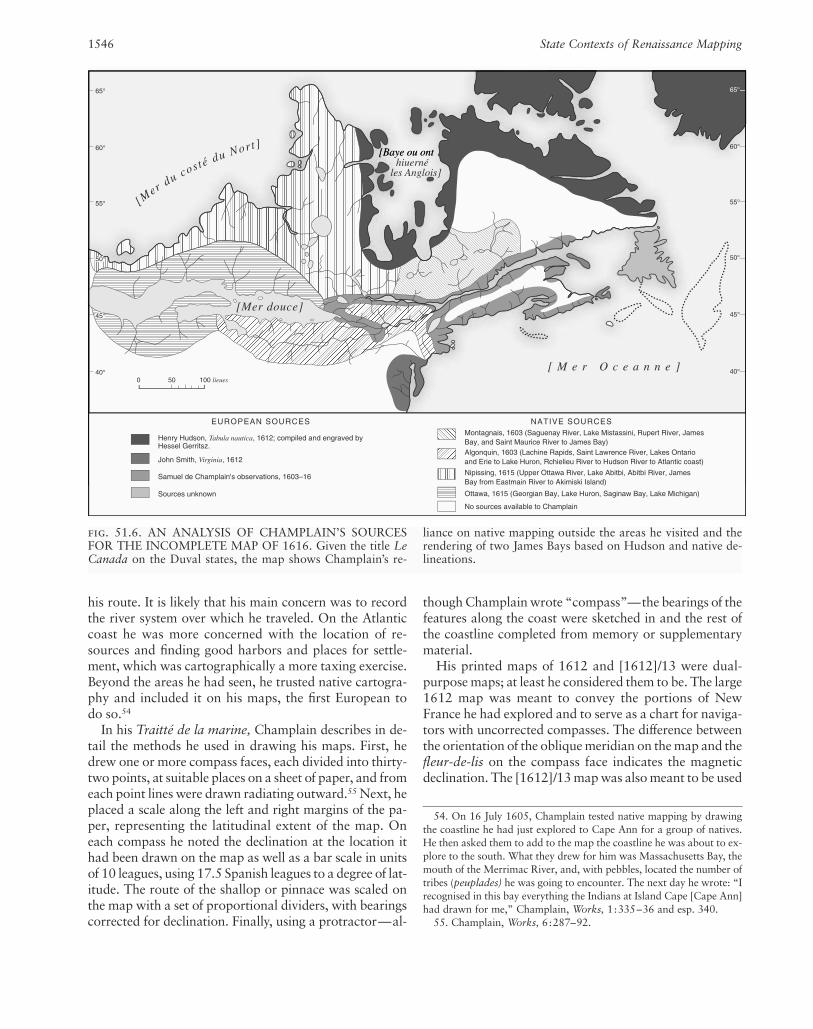
fig. 51.6. AN ANALYSIS OF CHAMPLAIN’S SOURCESFOR THE INCOMPLETE MAP OF 1616. Given the title LeCanada on the Duval states, the map shows Champlain’s re-
liance on native mapping outside the areas he visited and therendering of two James Bays based on Hudson and native de-lineations.

by navigators, this time with corrected compasses.56 Thisis the first map made by Champlain that includes infor-mation from another source: the Hudson map Tabulanavtica, compiled and engraved by Hessel Gerritsz. Un-fortunately, Champlain never finished the 1616 map, butits scale precludes it from being anything but a generalmap showing the extension of his explorations into theGreat Lakes. Besides the usual native information andthe Gerritsz. rendering of Hudson’s data, it also includesthe Chesapeake Bay area from John Smith’s Virginia(1612) (fig. 51.6).57 The 1632 map was constructed as ageographical summary of northeastern North America forthe 1632 edition of Les voyages.
Both the [1612]/13 and 1632 maps contain a longitu-dinal scale. The placement of the Atlantic coast on thesemaps, as well as on the 1607 chart, was, according toChamplain, based on calculations derived from de Nau-tonier’s tables.58 As there is no longitudinal grid on the1607 map, it is unclear how de Nautonier was used inthis case. In both the [1612]/13 and 1632 maps Cham-plain had to decide on a projection. On the former heused an equirectangular projection centered on 45�N. Forthe 1632 map he used a sinusoidal projection, with evenlyspaced straight line parallels, meridians that converge atthe North Pole, and a central meridian at 309� throughQuébec.59 In both cases, the longitudinal grid must havebeen placed on the map after the latitudinal grid had beendrawn. In tracing the Gerritsz. rendering of Hudson’s ex-plorations, Champlain seems to have been unaware thatthis map was on a Mercator projection. It is entirely pos-sible that he did not know the properties of this projec-tion or he might have used it himself for the maps he drewfor navigators.
Conclusions
In 1630, Champlain wrote a short text on the explorationof northeastern North America to justify the return of theSt. Lawrence-Acadia area to France after its seizure by theKirke expedition in 1629. “Everyone,” he wrote, “isaware of it [the French claim] through the Voyages of the Sieur de Champlain, which have been printed with the maps that he made of the ports and harbors of all thecoasts—maps which have since come into general use,and have been adopted for globes and world-maps.”60
Until the appearance of Nicolas I Sanson d’Abbeville’smaps in 1650 and 1656, Champlain’s were the undis-puted authorities for New France (for a complete list ofChamplain’s maps, see appendix 51.1). Extracts of all his
maps began to appear shortly after their publication onDutch, French, and English maps. The plate of his un-completed 1616 map was augmented by Pierre Duval andpublished in 1653, with further states in 1664, 1669, and 1677. The 1632 map was copied by Jean Boisseauand published without acknowledgment in 1643. In 1669the engraver/geographer Nicolas de Fer took plagiarism a step further by issuing a map from the slightly alteredplate of the second state of Champlain’s 1632 map onwhich all references to Champlain had been removed.Whatever one may think of these practices, plagiarismand copying are at least a tribute to the original sources.
The importance of Champlain to the early seventeenth-century mapping of North America is that his were thefirst accurate maps of the Atlantic coast north of CapeCod, the first accurate maps of the St. Lawrence River tothe eastern Great Lakes, and the first maps to combineEnglish Arctic exploration with that of the French to thesouth. His maps also show an appreciation for native ge-ographic information, which was so important to Frenchexploration of the interior of the continent. It is clear,however, that Champlain was not primarily a cartogra-pher. His original tasks were resource evaluation and ex-ploration; after 1616 he became an administrator re-sponsible for the smooth functioning of the fur trade andthe settlement and governance of New France. Althoughtoday he is known among academics for the quality of hismaps and writings, to the general public, in Canada atleast, he is best known for having established the Frenchpresence in their country as a permanent feature thatgives it some of its distinctive character.
The Mapping of Samuel de Champlain, 1603–1635 1547
56. Champlain, Works, 2:223–24.57. This is the first map of any part of the Great Lakes based on Eu-
ropean exploration. The area west of the mouth of the French River(“R. de reuillon”) was based on a map drawn by an Ottawa chief “withcharcoal on a piece of tree-bark.” Champlain gave the chief a hatchetfor the map (Champlain, Works, 3:44). Note that James Bay is on themap twice. The eastern bay is based on the Hudson-Gerritsz. map,whereas the river system north to the western James Bay was probablyobtained from the Nipissing, with whom Champlain stayed for twodays (Champlain, Works, 3:39– 41).
58. For the 1607 chart see the title. For the [1612]/13 map, seeChamplain, Works, 2:222. For the 1632 map see the title page of Lesvoyages, in Champlain, Works, 3:232.
59. Although it is generally believed that the sinusoidal projection wasinvented later, the 1632 Champlain map proves that this is not the case.It may have been in use for world and continental maps as early as 1570.See Mark Monmonier, Drawing the Line: Tales of Maps and Carto-controversy (New York: Henry Holt, 1995), 14.
60. Champlain, Works, 6:188–89.

1548
appendix 51.1 Maps by Samuel de Champlain
Small-Scale Maps
Size (cm) LocationTitle Date Format (h � w)
“descrpsion des costs p[or]ts rades Illes 1607; revised Manuscript; 37 � 54.5 Library of Congress, de la nouuelle france . . .” from 1606 ink on vellum Washington, D.C.(fig. 51.1) by Champlain
Carte geographiqve de la Novvelle 1612 Engraved and 43 � 76 Les voyages dv sievr de Franse faictte par le sievr de printed Champlain xainton-Champlain Saint Tongois cappitaine geois, capitaine ordinaire povr le Roy en la marine ordinaire pour le Roy, (fig. 51.3) en la marine (Paris: Iean
Berjon, 1613)Carte geographique de la Nouelle No date; Engraved and 25.5 � 33.5
franse en sonvraymoridia probably 1612 printedCarte geographique de la Nouelle 1613 Engraved and 25.5 � 33.5
franse en son vraymeridiein faictte par printedle S r Champlain Cappine por le Roy en la marine
None given [La Nouvelle France] 1616 Engraved 34.5 � 53.7 John Carter Brown Library, Providence, R.I.
Carte de la nouuelle france, augmentée 1632; two Engraved and 86.4 � 52.7 Les voyages de la depuis la derniere, seruant a la known states printed Novvelle France nauigation faicte en son vray occidentale, dicte meridien, par le Sr de Champlain . . . Canada . . . (Paris:
Clavde Collet, 1632)
Large-Scale Maps and Plans
Title Date Location
Port de La heue [Green Bay and mouth May 1604 Les voyages dv sievr de Champlain xaintongeois, of the La Have River, Nova Scotia] capitaine ordinaire pour le Roy, en la marine (Paris: Iean
Berjon, 1613), 8Por du Rossÿnol [Liverpool Bay, May 1604 Les voyages, 9
Nova Scotia]port au mouton [Port Mouton, May 1604 Les voyages, 17
Nova Scotia]port Royal [Annapolis Basin, June 1604 Les voyages, facing 22
Nova Scotia]Port des mines [Advocate Harbour, June 1604 Les voyages, 26
Nova Scotia]R. S t. Iehan [mouth of St. John River, June 1604 Les voyages, 30
New Brunswick]Isle de sainte Croix [Dochet Island and July 1604 Les voyages, 35
surroundings, Maine and New Brunswick]habitasion de lisle s tte croix [picture plan 1604 –5 Les voyages, 38
of the settlement of Dochet Island]qui ni be quy [mouth of the Kennebec July 1605 Les voyages, 64
River, Maine]

1549
appendix 51.1 (continued)
Large-Scale Maps and Plans
Title Date Location
Chaoacoit R [Saco Bay and mouth of the July 1605 Les voyages, 70Saco River, Maine]
Port S t Louis [Plymouth Harbor, July 1605 Les voyages, 80Massachusetts]
Malle-Barre [Nauset Harbor, July 1605 Les voyages, facing 88Massachusetts]
abitasion du port royal [picture plan of 1605–6 Les voyages, 99the settlement at Port Royal]
Le Beau port [Gloucester Harbor, September 1606 Les voyages, 118Massachusetts]
port. fortuné [Stage Harbor and October 1606 Les voyages, 132surroundings, Massachusetts]
None [picture plan of the attack by a October 1606 Les voyages, facing 136group of natives on de Poutrincourt’s men at Stage Harbor on 15 October 1606]
port de tadoucac [mouth of the Saguenay June 1608 Les voyages, 172River and Tadoussac] (fig. 51.2)
Quebec [Quebec and surroundings] 1608 Les voyages, 176Abitation De Qvebecq [picture plan of 1608 Les voyages, 187
the settlement at Quebec]Deffaite des Yroquois au Lac de 1609 Les voyages, facing 232
Champlain [picture plan of Huron-Montagnais-Algonquian and French attack on an Iroquois encampment on 29 July 1609]
Fort des Yroquois [drawing of the 1610 Les voyages, facing 254Montagnais-Algonquian-French attack on an Iroquois encampment near the mouth of the Richelieu River on 19 June 1610]
le grand sautl stlouis [southeast side June 1611 Les voyages, 293of Montreal Island and opposite shore from Ile Ronde to the Lachine Canal]
None [picture plan of an Iroquois 1615–16 Voyages et descovvertvres faites en la Novvelle France, village attacked by a Huron-Algonquian- depuis l’année 1615 iusques à la fin de l’année 1618, par French force on 10 October 1615] le sieur de Champlain, cappitaine ordinaire pour le Roy en
la Mer du Ponant (Paris: Clavde Collet, 1619), between 43vand 44