connectoregon v application review package waterfront multimoda… · 4. statutory review...
TRANSCRIPT
February 03 2014
ConnectOregon V Application Review Package
The following documents are contained (or will be added as received) in this application package 1 Public Comment Received (11-25-13 to present) 2 Scoring Summary and Tier rating 3 Economic Benefits Evaluation 4 Statutory Review Evaluation 6 Applicant responses to ConnectOregon V Staff questions
(11-25-13 to 02-03-2014) 6 ConnectOregon V Staff questions to the Applicant
(11-25-13 to 02-03-2014) 7 EligibilityFeasibility Review 8 Completeness Review Checklist 9 Project Application (including maps drawings other supporting materials and
letters of support) CO V Reviewer Instructions are posted online at httpwwworegongovODOTTDTPpagesconnectoraspx
2B0310 1
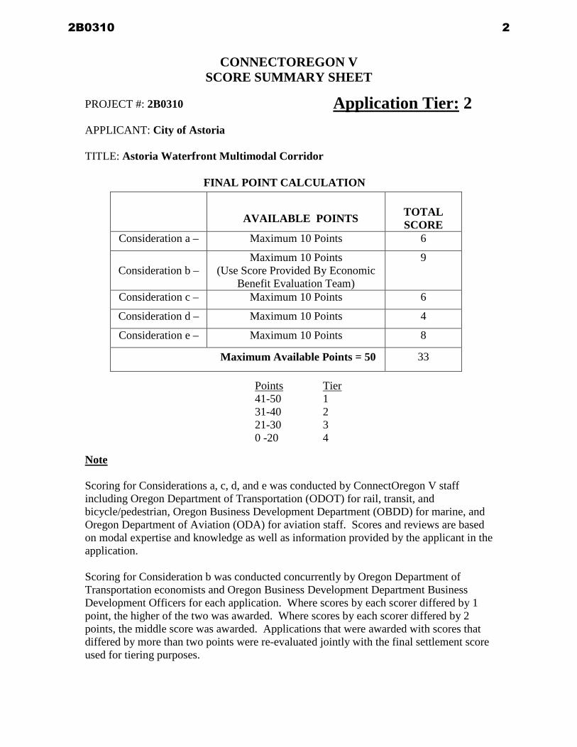
CONNECTOREGON V SCORE SUMMARY SHEET
PROJECT 2B0310 APPLICANT City of Astoria TITLE Astoria Waterfront Multimodal Corridor
FINAL POINT CALCULATION
AVAILABLE POINTS
TOTAL SCORE
Consideration a ndash Maximum 10 Points 6
Consideration b ndash
Maximum 10 Points (Use Score Provided By Economic
Benefit Evaluation Team)
9
Consideration c ndash Maximum 10 Points 6
Consideration d ndash Maximum 10 Points 4
Consideration e ndash Maximum 10 Points 8
Maximum Available Points = 50 33
Points Tier 41-50 1 31-40 2 21-30 3 0 -20 4
Note Scoring for Considerations a c d and e was conducted by ConnectOregon V staff including Oregon Department of Transportation (ODOT) for rail transit and bicyclepedestrian Oregon Business Development Department (OBDD) for marine and Oregon Department of Aviation (ODA) for aviation staff Scores and reviews are based on modal expertise and knowledge as well as information provided by the applicant in the application Scoring for Consideration b was conducted concurrently by Oregon Department of Transportation economists and Oregon Business Development Department Business Development Officers for each application Where scores by each scorer differed by 1 point the higher of the two was awarded Where scores by each scorer differed by 2 points the middle score was awarded Applications that were awarded with scores that differed by more than two points were re-evaluated jointly with the final settlement score used for tiering purposes
Application Tier 2
2B0310 2
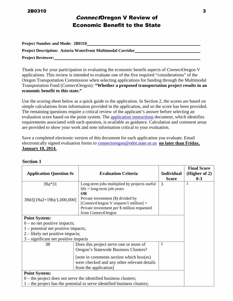
ConnectOregon V Review of Economic Benefit to the State
Project Number and Mode 2B0310
Project Description Astoria Waterfront Multimodal Corridor
Project Reviewer
Thank you for your participation in evaluating the economic benefit aspects of ConnectOregon V applications This review is intended to evaluate one of the five required ldquoconsiderationsrdquo of the Oregon Transportation Commission when selecting applications for funding through the Multimodal Transportation Fund (ConnectOregon) ldquoWhether a proposed transportation project results in an economic benefit to this staterdquo Use the scoring sheet below as a quick guide to the application In Section 2 the scores are based on simple calculations from information provided in the application and so the score has been provided The remaining questions require a critical review of the applicantrsquos answer before selecting an evaluation score based on the point system The application instructions document which identifies requirements associated with each question is available as guidance Calculation and comment areas are provided to show your work and note information critical to your evaluation Save a completed electronic version of this document for each application you evaluate Email electronically signed evaluation forms to connectoregonodotstateorus no later than Friday January 10 2014
Section 1
Application Question s Evaluation Criteria
Individual
Score
Final Score (Higher of 2)
0-3 39a31
39d[(19a2+19b)1000000]
Long-term jobs multiplied by projects useful life = long-term job-years OR Private investment ($) divided by [ConnectOregon V request1 million] = Private investment per $ million requested from ConnectOregon
3 3
Point System 0 ndash no net positive impacts 1 ndash potential net positive impacts 2 ndash likely net positive impacts 3 ndash significant net positive impacts
38 Does this project serve one or more of Oregonrsquos Statewide Business Clusters
[note in comments section which box(es) were checked and any other relevant details from the application]
3
Point System 0 ndash the project does not serve the identified business clusters 1 ndash the project has the potential to serve identified business clusters
2B0310 3
2 ndash the project is likely to serve identified business clusters 3 ndash the project will serve identified business clusters CalculationsComments
75 X 20 = 1500 2 letters detailing jobs submitted Breweries Tourism
Section 2
Application Question s Evaluation Criteria
Individual
Score
Final Score (Higher of 2)
0-3 40c
[(19a2+19b)1000000] Short-run construction-related jobs divided by [ConnectOregon IV request1 million] = construction related jobs per $ million requested from ConnectOregon
2 2
Point System 1 ndash less than 15 jobs per $million requested 2 ndash 15-23 jobs per $million requested 3 ndash greater than 23 jobs per million requested
41 Project area unemployment rate (from instruction table) compared to state unemployment rate
1
Point System 0 ndash located in area with unemployment rate more than 2 percentage points below state average 1 ndash located in area with unemployment rate 0-2 percentage points below state average 2 ndash located in area with unemployment rate 0-2 percentage points above state average 3 ndash located in area with unemployment rate more than 2 percentage points above state average
2B0310 4
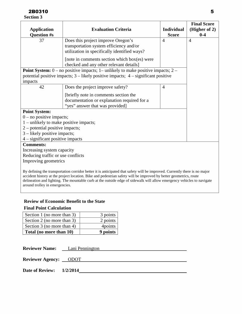
Section 3
Application Question s
Evaluation Criteria
Individual
Score
Final Score (Higher of 2)
0-4 37 Does this project improve Oregonrsquos
transportation system efficiency andor utilization in specifically identified ways
[note in comments section which box(es) were checked and any other relevant details]
4 4
Point System 0 ndash no positive impacts 1ndash unlikely to make positive impacts 2 ndash potential positive impacts 3 ndash likely positive impacts 4 ndash significant positive impacts
42 Does the project improve safety
[briefly note in comments section the documentation or explanation required for a ldquoyesrdquo answer that was provided]
4
Point System 0 ndash no positive impacts 1 ndash unlikely to make positive impacts 2 ndash potential positive impacts 3 ndash likely positive impacts 4 ndash significant positive impacts Comments Increasing system capacity Reducing traffic or use conflicts Improving geometrics By defining the transportation corridor better it is anticipated that safety will be improved Currently there is no major accident history at the project location Bike and pedestrian safety will be improved by better geometrics route delineation and lighting The mountable curb at the outside edge of sidewalk will allow emergency vehicles to navigate around trolley in emergencies
Review of Economic Benefit to the State Final Point Calculation
Section 1 (no more than 3) 3 points Section 2 (no more than 3) 2 points Section 3 (no more than 4) 4points Total (no more than 10) 9 points
Reviewer Name Lani Pennington Reviewer Agency ODOT Date of Review 122014
2B0310 5
ConnectOregon V Review of Economic Benefit to the State
Project Number and Mode 2B0310
Project Description Astoria Waterfront Multimodal Corridor
Project Reviewer Dennie Houle
Thank you for your participation in evaluating the economic benefit aspects of ConnectOregon V applications This review is intended to evaluate one of the five required ldquoconsiderationsrdquo of the Oregon Transportation Commission when selecting applications for funding through the Multimodal Transportation Fund (ConnectOregon) ldquoWhether a proposed transportation project results in an economic benefit to this staterdquo Use the scoring sheet below as a quick guide to the application In Section 2 the scores are based on simple calculations from information provided in the application and so the score has been provided The remaining questions require a critical review of the applicantrsquos answer before selecting an evaluation score based on the point system The application instructions document which identifies requirements associated with each question is available as guidance Calculation and comment areas are provided to show your work and note information critical to your evaluation Save a completed electronic version of this document for each application you evaluate Email electronically signed evaluation forms to connectoregonodotstateorus no later than Friday January 10 2014
Section 1
Application Question s Evaluation Criteria
Individual
Score
Final Score (Higher of 2)
0-3 39a11
39d[(19a2+19b)1000000]
Long-term jobs multiplied by projects useful life = long-term job-years OR Private investment ($) divided by [ConnectOregon V request1 million] = Private investment per $ million requested from ConnectOregon
3
3
Point System 0 ndash no net positive impacts 1 ndash potential net positive impacts 2 ndash likely net positive impacts 3 ndash significant net positive impacts
38 Does this project serve one or more of Oregonrsquos Statewide Business Clusters
[note in comments section which box(es) were checked and any other relevant details from the application]
1
Point System 0 ndash the project does not serve the identified business clusters 1 ndash the project has the potential to serve identified business clusters
2B0310 6
2 ndash the project is likely to serve identified business clusters 3 ndash the project will serve identified business clusters CalculationsComments 20yrs x 75 jobs = 1500 jobyrs
Section 2
Application Question s Evaluation Criteria
Individual
Score
Final Score (Higher of 2)
0-3 40c
[(19a2+19b)1000000] Short-run construction-related jobs divided by [ConnectOregon IV request1 million] = construction related jobs per $ million requested from ConnectOregon
2 2
Point System 1 ndash less than 15 jobs per $million requested 2 ndash 15-23 jobs per $million requested 3 ndash greater than 23 jobs per million requested
41 Project area unemployment rate (from instruction table) compared to state unemployment rate
1
Point System 0 ndash located in area with unemployment rate more than 2 percentage points below state average 1 ndash located in area with unemployment rate 0-2 percentage points below state average 2 ndash located in area with unemployment rate 0-2 percentage points above state average 3 ndash located in area with unemployment rate more than 2 percentage points above state average
2B0310 7
Section 3
Application Question s
Evaluation Criteria
Individual
Score
Final Score (Higher of 2)
0-4 37 Does this project improve Oregonrsquos
transportation system efficiency andor utilization in specifically identified ways
[note in comments section which box(es) were checked and any other relevant details]
4
4 Point System 0 ndash no positive impacts 1ndash unlikely to make positive impacts 2 ndash
potential positive impacts 3 ndash likely positive impacts 4 ndash significant positive impacts
42 Does the project improve safety
[briefly note in comments section the documentation or explanation required for a ldquoyesrdquo answer that was provided]
4
Point System 0 ndash no positive impacts 1 ndash unlikely to make positive impacts 2 ndash potential positive impacts 3 ndash likely positive impacts 4 ndash significant positive impacts Comments
Review of Economic Benefit to the State Final Point Calculation
Section 1 (no more than 3) 3 points Section 2 (no more than 3) 2 points Section 3 (no more than 4) 4 points Total (no more than 10) 9 points
Reviewer Name Dennie Houle Reviewer Agency Business Oregon Date of Review 182014
2B0310 8
STATUTORY CONSIDERATION REVIEW FORM ConnectOregon V
Project Number 2B0310
Project Description Astoria Waterfront Multimodal Corridor
Project Reviewer
On the following pages tables are provided indicating which application questions relate to the identified consideration A given question may relate to more than one consideration and will appear under each relevant consideration
Committee staff will record the results on the Review Matrix for presentation to the Committee during public meetings Consideration (a) - Whether a proposed transportation project reduces transportation costs for Oregon businesses or improves access to jobs and sources of labor
Item No
Brief Description of Question (from Application) Points
Appraiserrsquos Score
Items are evaluated in pairs with a shared point value
To determine the score of questions with a shared point value score each question separately
then select the highest of the two scores as the ldquoappraiserrsquos scorerdquo
34 Industrial or employments connections 3
2
35 Linking workers to jobs
33 Measurement of Success (Improved use and efficiency) 4
2
42 Safety
32 Transportation Connections 3
2
38 Serving Business Clusters
TOTAL AVAILABLE POINTS ndash Consideration ldquoArdquo 10
6
Point System for 34 35 32 and 38 0 ndash No positive benefit 1 ndash Potential positive benefit 2 ndash Likely positive benefit 3 ndash Significant positive benefit Point System for 33 and 42 0 ndash No positive impacts 1 ndash Unlikely to make positive impacts 2 ndash Potential positive impacts 3 ndash Likely positive impacts 4 ndash Significant positive impacts
COMMENTS
2B0310 9
Project is only one block long Benefits are potential until rest of system is built
Consideration (c) - Whether a proposed transportation project is a critical link connecting elements of Oregonrsquos transportation system that will measurably improve utilization and efficiency of the system
Item No
Brief Description of Question (from Application) Points
Appraiserrsquos Score
Items 34 and 36 are evaluated together with a shared point value
34 Industrial or employments connections
3
2
36 Linking populations to medical care social services or shopping
Items 33 and 44 are evaluated together with a shared point value and Items 32 and 37 are evaluate
together with a shared point value
33 Measurement of Success (Improved use and efficiency)
4
2
42 Safety
32 Transportation Connections 3
2
37 Improve system efficiency and utilization
TOTAL AVAILABLE POINTS ndash Consideration ldquoCrdquo
10 6
Point System for 34 36 and 32 37 Point System for 33 and 42 0 ndash No positive benefit 0 ndash No positive impact 1 ndash Potential positive benefit 1 ndash Unlikely to make positive impact 2 ndash Likely positive benefits and 2 ndash Potential positive benefits 3 ndash Significant positive benefits 3 ndash Likely positive benefits and 4 ndash Significant positive benefits To determine the score of questions with a shared point value score each question separately then select the highest of the scores as the ldquoappraiserrsquos scorerdquo COMMENT
Project is only one block long Benefits are potential until rest of system is built
2B0310 10
Consideration (d) - How much of the cost of a proposed transportation project can be borne by the applicant for the grant or loan from any source other than the Multimodal Transportation Fund
Item No
Brief Description of Question (from Application) Points
Appraiserrsquos Score
Overmatch Criteria
(Question 19dAdditional Match Question (19c)ConnectOregon Project Total) x 100 = Overmatch Percentage
Example ($25K $100K) x 100 = 25
1 Applicant will provide no Overmatch ($0K$100K) x 100 = 0
1
1 Applicant will provide between 1 to 20 Overmatch ($15K$100K) x 100 = 15
2
1 Applicant will provide between 21 to 40 Overmatch ($25K$100K) x 100 = 25
4
1 Applicant will provide between 41 to 60 Overmatch ($45K100K) x 100 = 45
6
1 Applicant will provide between 61 to 81 Overmatch ($70K100K) x 100 = 70
8
1 Applicant will provide gt80 Overmatch ($90K100K) x 100 = 90
10
TOTAL AVAILABLE POINTS ndash Consideration ldquoDrdquo
10 4
COMMENT
2B0310 11
Consideration (e) - Whether a proposed transportation project is ready for construction
Item No
Brief Description of Question (from Application) Points
Appraiserrsquos Score
For this consideration assume a grant execution date of September 2014
24 Project is ready to start construction 6 months
after grant agreement execution
10
24 Project is ready to start construction 12 months after grant agreement execution
8
24 Project is ready to start construction 18 months after grant agreement execution
6
24 Project where property is not owned by applicant and negotiations are not underway
-2
TOTAL AVAILABLE POINTS ndash Consideration ldquoErdquo
10 8
FINAL POINT CALCULATION
AVAILABLE POINTS
TOTAL SCORE
Consideration a ndash
Maximum 10 Points 6
Consideration
b ndash
Maximum 10 Points (Use Score Provided By
Economic Benefit Evaluation Team)
Consideration c ndash
Maximum 10 Points 6
Consideration d ndash
Maximum 10 Points 4
Consideration e ndash
Maximum 10 Points 8
Maximum Available Points = 50 24
2B0310 12
From Jeff HarringtonTo Cummings Christopher J FISHER Patricia R ODOTCc Brett Estes Ken Cook Rosemary Johnson Nathan CraterSubject City of Astoria - Connect Oregon V Grant Application No 2B0310Date Wednesday January 08 2014 25517 PMAttachments Connect V X-sec Exhibit Map-Exhibit Mappdf
Chris amp Pat Please find that attached Exhibit showing the cross section dimensions for the proposed project Ifyou wouldnrsquot mind could you please verify that you received this so I know that it made it throughand that I have your e-mail addresses correct Please let me know if you need any additionalinformation Thanks Jeff Jeff Harrington PECity EngineerCity of Astoria1095 Duane StreetAstoriaOregon 97103Office (503) 338-5173Fax (503) 338-6538jharringtonastoriaorus
2B0310 13
CONNECTOREGON V SCORE SUMMARY SHEET
PROJECT 2B0310 APPLICANT City of Astoria TITLE Astoria Waterfront Multimodal Corridor
FINAL POINT CALCULATION
AVAILABLE POINTS
TOTAL SCORE
Consideration a ndash Maximum 10 Points 6
Consideration b ndash
Maximum 10 Points (Use Score Provided By Economic
Benefit Evaluation Team)
9
Consideration c ndash Maximum 10 Points 6
Consideration d ndash Maximum 10 Points 4
Consideration e ndash Maximum 10 Points 8
Maximum Available Points = 50 33
Points Tier 41-50 1 31-40 2 21-30 3 0 -20 4
Note Scoring for Considerations a c d and e was conducted by ConnectOregon V staff including Oregon Department of Transportation (ODOT) for rail transit and bicyclepedestrian Oregon Business Development Department (OBDD) for marine and Oregon Department of Aviation (ODA) for aviation staff Scores and reviews are based on modal expertise and knowledge as well as information provided by the applicant in the application Scoring for Consideration b was conducted concurrently by Oregon Department of Transportation economists and Oregon Business Development Department Business Development Officers for each application Where scores by each scorer differed by 1 point the higher of the two was awarded Where scores by each scorer differed by 2 points the middle score was awarded Applications that were awarded with scores that differed by more than two points were re-evaluated jointly with the final settlement score used for tiering purposes
Application Tier 2
2B0310 2
ConnectOregon V Review of Economic Benefit to the State
Project Number and Mode 2B0310
Project Description Astoria Waterfront Multimodal Corridor
Project Reviewer
Thank you for your participation in evaluating the economic benefit aspects of ConnectOregon V applications This review is intended to evaluate one of the five required ldquoconsiderationsrdquo of the Oregon Transportation Commission when selecting applications for funding through the Multimodal Transportation Fund (ConnectOregon) ldquoWhether a proposed transportation project results in an economic benefit to this staterdquo Use the scoring sheet below as a quick guide to the application In Section 2 the scores are based on simple calculations from information provided in the application and so the score has been provided The remaining questions require a critical review of the applicantrsquos answer before selecting an evaluation score based on the point system The application instructions document which identifies requirements associated with each question is available as guidance Calculation and comment areas are provided to show your work and note information critical to your evaluation Save a completed electronic version of this document for each application you evaluate Email electronically signed evaluation forms to connectoregonodotstateorus no later than Friday January 10 2014
Section 1
Application Question s Evaluation Criteria
Individual
Score
Final Score (Higher of 2)
0-3 39a31
39d[(19a2+19b)1000000]
Long-term jobs multiplied by projects useful life = long-term job-years OR Private investment ($) divided by [ConnectOregon V request1 million] = Private investment per $ million requested from ConnectOregon
3 3
Point System 0 ndash no net positive impacts 1 ndash potential net positive impacts 2 ndash likely net positive impacts 3 ndash significant net positive impacts
38 Does this project serve one or more of Oregonrsquos Statewide Business Clusters
[note in comments section which box(es) were checked and any other relevant details from the application]
3
Point System 0 ndash the project does not serve the identified business clusters 1 ndash the project has the potential to serve identified business clusters
2B0310 3
2 ndash the project is likely to serve identified business clusters 3 ndash the project will serve identified business clusters CalculationsComments
75 X 20 = 1500 2 letters detailing jobs submitted Breweries Tourism
Section 2
Application Question s Evaluation Criteria
Individual
Score
Final Score (Higher of 2)
0-3 40c
[(19a2+19b)1000000] Short-run construction-related jobs divided by [ConnectOregon IV request1 million] = construction related jobs per $ million requested from ConnectOregon
2 2
Point System 1 ndash less than 15 jobs per $million requested 2 ndash 15-23 jobs per $million requested 3 ndash greater than 23 jobs per million requested
41 Project area unemployment rate (from instruction table) compared to state unemployment rate
1
Point System 0 ndash located in area with unemployment rate more than 2 percentage points below state average 1 ndash located in area with unemployment rate 0-2 percentage points below state average 2 ndash located in area with unemployment rate 0-2 percentage points above state average 3 ndash located in area with unemployment rate more than 2 percentage points above state average
2B0310 4
Section 3
Application Question s
Evaluation Criteria
Individual
Score
Final Score (Higher of 2)
0-4 37 Does this project improve Oregonrsquos
transportation system efficiency andor utilization in specifically identified ways
[note in comments section which box(es) were checked and any other relevant details]
4 4
Point System 0 ndash no positive impacts 1ndash unlikely to make positive impacts 2 ndash potential positive impacts 3 ndash likely positive impacts 4 ndash significant positive impacts
42 Does the project improve safety
[briefly note in comments section the documentation or explanation required for a ldquoyesrdquo answer that was provided]
4
Point System 0 ndash no positive impacts 1 ndash unlikely to make positive impacts 2 ndash potential positive impacts 3 ndash likely positive impacts 4 ndash significant positive impacts Comments Increasing system capacity Reducing traffic or use conflicts Improving geometrics By defining the transportation corridor better it is anticipated that safety will be improved Currently there is no major accident history at the project location Bike and pedestrian safety will be improved by better geometrics route delineation and lighting The mountable curb at the outside edge of sidewalk will allow emergency vehicles to navigate around trolley in emergencies
Review of Economic Benefit to the State Final Point Calculation
Section 1 (no more than 3) 3 points Section 2 (no more than 3) 2 points Section 3 (no more than 4) 4points Total (no more than 10) 9 points
Reviewer Name Lani Pennington Reviewer Agency ODOT Date of Review 122014
2B0310 5
ConnectOregon V Review of Economic Benefit to the State
Project Number and Mode 2B0310
Project Description Astoria Waterfront Multimodal Corridor
Project Reviewer Dennie Houle
Thank you for your participation in evaluating the economic benefit aspects of ConnectOregon V applications This review is intended to evaluate one of the five required ldquoconsiderationsrdquo of the Oregon Transportation Commission when selecting applications for funding through the Multimodal Transportation Fund (ConnectOregon) ldquoWhether a proposed transportation project results in an economic benefit to this staterdquo Use the scoring sheet below as a quick guide to the application In Section 2 the scores are based on simple calculations from information provided in the application and so the score has been provided The remaining questions require a critical review of the applicantrsquos answer before selecting an evaluation score based on the point system The application instructions document which identifies requirements associated with each question is available as guidance Calculation and comment areas are provided to show your work and note information critical to your evaluation Save a completed electronic version of this document for each application you evaluate Email electronically signed evaluation forms to connectoregonodotstateorus no later than Friday January 10 2014
Section 1
Application Question s Evaluation Criteria
Individual
Score
Final Score (Higher of 2)
0-3 39a11
39d[(19a2+19b)1000000]
Long-term jobs multiplied by projects useful life = long-term job-years OR Private investment ($) divided by [ConnectOregon V request1 million] = Private investment per $ million requested from ConnectOregon
3
3
Point System 0 ndash no net positive impacts 1 ndash potential net positive impacts 2 ndash likely net positive impacts 3 ndash significant net positive impacts
38 Does this project serve one or more of Oregonrsquos Statewide Business Clusters
[note in comments section which box(es) were checked and any other relevant details from the application]
1
Point System 0 ndash the project does not serve the identified business clusters 1 ndash the project has the potential to serve identified business clusters
2B0310 6
2 ndash the project is likely to serve identified business clusters 3 ndash the project will serve identified business clusters CalculationsComments 20yrs x 75 jobs = 1500 jobyrs
Section 2
Application Question s Evaluation Criteria
Individual
Score
Final Score (Higher of 2)
0-3 40c
[(19a2+19b)1000000] Short-run construction-related jobs divided by [ConnectOregon IV request1 million] = construction related jobs per $ million requested from ConnectOregon
2 2
Point System 1 ndash less than 15 jobs per $million requested 2 ndash 15-23 jobs per $million requested 3 ndash greater than 23 jobs per million requested
41 Project area unemployment rate (from instruction table) compared to state unemployment rate
1
Point System 0 ndash located in area with unemployment rate more than 2 percentage points below state average 1 ndash located in area with unemployment rate 0-2 percentage points below state average 2 ndash located in area with unemployment rate 0-2 percentage points above state average 3 ndash located in area with unemployment rate more than 2 percentage points above state average
2B0310 7
Section 3
Application Question s
Evaluation Criteria
Individual
Score
Final Score (Higher of 2)
0-4 37 Does this project improve Oregonrsquos
transportation system efficiency andor utilization in specifically identified ways
[note in comments section which box(es) were checked and any other relevant details]
4
4 Point System 0 ndash no positive impacts 1ndash unlikely to make positive impacts 2 ndash
potential positive impacts 3 ndash likely positive impacts 4 ndash significant positive impacts
42 Does the project improve safety
[briefly note in comments section the documentation or explanation required for a ldquoyesrdquo answer that was provided]
4
Point System 0 ndash no positive impacts 1 ndash unlikely to make positive impacts 2 ndash potential positive impacts 3 ndash likely positive impacts 4 ndash significant positive impacts Comments
Review of Economic Benefit to the State Final Point Calculation
Section 1 (no more than 3) 3 points Section 2 (no more than 3) 2 points Section 3 (no more than 4) 4 points Total (no more than 10) 9 points
Reviewer Name Dennie Houle Reviewer Agency Business Oregon Date of Review 182014
2B0310 8
STATUTORY CONSIDERATION REVIEW FORM ConnectOregon V
Project Number 2B0310
Project Description Astoria Waterfront Multimodal Corridor
Project Reviewer
On the following pages tables are provided indicating which application questions relate to the identified consideration A given question may relate to more than one consideration and will appear under each relevant consideration
Committee staff will record the results on the Review Matrix for presentation to the Committee during public meetings Consideration (a) - Whether a proposed transportation project reduces transportation costs for Oregon businesses or improves access to jobs and sources of labor
Item No
Brief Description of Question (from Application) Points
Appraiserrsquos Score
Items are evaluated in pairs with a shared point value
To determine the score of questions with a shared point value score each question separately
then select the highest of the two scores as the ldquoappraiserrsquos scorerdquo
34 Industrial or employments connections 3
2
35 Linking workers to jobs
33 Measurement of Success (Improved use and efficiency) 4
2
42 Safety
32 Transportation Connections 3
2
38 Serving Business Clusters
TOTAL AVAILABLE POINTS ndash Consideration ldquoArdquo 10
6
Point System for 34 35 32 and 38 0 ndash No positive benefit 1 ndash Potential positive benefit 2 ndash Likely positive benefit 3 ndash Significant positive benefit Point System for 33 and 42 0 ndash No positive impacts 1 ndash Unlikely to make positive impacts 2 ndash Potential positive impacts 3 ndash Likely positive impacts 4 ndash Significant positive impacts
COMMENTS
2B0310 9
Project is only one block long Benefits are potential until rest of system is built
Consideration (c) - Whether a proposed transportation project is a critical link connecting elements of Oregonrsquos transportation system that will measurably improve utilization and efficiency of the system
Item No
Brief Description of Question (from Application) Points
Appraiserrsquos Score
Items 34 and 36 are evaluated together with a shared point value
34 Industrial or employments connections
3
2
36 Linking populations to medical care social services or shopping
Items 33 and 44 are evaluated together with a shared point value and Items 32 and 37 are evaluate
together with a shared point value
33 Measurement of Success (Improved use and efficiency)
4
2
42 Safety
32 Transportation Connections 3
2
37 Improve system efficiency and utilization
TOTAL AVAILABLE POINTS ndash Consideration ldquoCrdquo
10 6
Point System for 34 36 and 32 37 Point System for 33 and 42 0 ndash No positive benefit 0 ndash No positive impact 1 ndash Potential positive benefit 1 ndash Unlikely to make positive impact 2 ndash Likely positive benefits and 2 ndash Potential positive benefits 3 ndash Significant positive benefits 3 ndash Likely positive benefits and 4 ndash Significant positive benefits To determine the score of questions with a shared point value score each question separately then select the highest of the scores as the ldquoappraiserrsquos scorerdquo COMMENT
Project is only one block long Benefits are potential until rest of system is built
2B0310 10
Consideration (d) - How much of the cost of a proposed transportation project can be borne by the applicant for the grant or loan from any source other than the Multimodal Transportation Fund
Item No
Brief Description of Question (from Application) Points
Appraiserrsquos Score
Overmatch Criteria
(Question 19dAdditional Match Question (19c)ConnectOregon Project Total) x 100 = Overmatch Percentage
Example ($25K $100K) x 100 = 25
1 Applicant will provide no Overmatch ($0K$100K) x 100 = 0
1
1 Applicant will provide between 1 to 20 Overmatch ($15K$100K) x 100 = 15
2
1 Applicant will provide between 21 to 40 Overmatch ($25K$100K) x 100 = 25
4
1 Applicant will provide between 41 to 60 Overmatch ($45K100K) x 100 = 45
6
1 Applicant will provide between 61 to 81 Overmatch ($70K100K) x 100 = 70
8
1 Applicant will provide gt80 Overmatch ($90K100K) x 100 = 90
10
TOTAL AVAILABLE POINTS ndash Consideration ldquoDrdquo
10 4
COMMENT
2B0310 11
Consideration (e) - Whether a proposed transportation project is ready for construction
Item No
Brief Description of Question (from Application) Points
Appraiserrsquos Score
For this consideration assume a grant execution date of September 2014
24 Project is ready to start construction 6 months
after grant agreement execution
10
24 Project is ready to start construction 12 months after grant agreement execution
8
24 Project is ready to start construction 18 months after grant agreement execution
6
24 Project where property is not owned by applicant and negotiations are not underway
-2
TOTAL AVAILABLE POINTS ndash Consideration ldquoErdquo
10 8
FINAL POINT CALCULATION
AVAILABLE POINTS
TOTAL SCORE
Consideration a ndash
Maximum 10 Points 6
Consideration
b ndash
Maximum 10 Points (Use Score Provided By
Economic Benefit Evaluation Team)
Consideration c ndash
Maximum 10 Points 6
Consideration d ndash
Maximum 10 Points 4
Consideration e ndash
Maximum 10 Points 8
Maximum Available Points = 50 24
2B0310 12
From Jeff HarringtonTo Cummings Christopher J FISHER Patricia R ODOTCc Brett Estes Ken Cook Rosemary Johnson Nathan CraterSubject City of Astoria - Connect Oregon V Grant Application No 2B0310Date Wednesday January 08 2014 25517 PMAttachments Connect V X-sec Exhibit Map-Exhibit Mappdf
Chris amp Pat Please find that attached Exhibit showing the cross section dimensions for the proposed project Ifyou wouldnrsquot mind could you please verify that you received this so I know that it made it throughand that I have your e-mail addresses correct Please let me know if you need any additionalinformation Thanks Jeff Jeff Harrington PECity EngineerCity of Astoria1095 Duane StreetAstoriaOregon 97103Office (503) 338-5173Fax (503) 338-6538jharringtonastoriaorus
2B0310 13
ConnectOregon V Review of Economic Benefit to the State
Project Number and Mode 2B0310
Project Description Astoria Waterfront Multimodal Corridor
Project Reviewer
Thank you for your participation in evaluating the economic benefit aspects of ConnectOregon V applications This review is intended to evaluate one of the five required ldquoconsiderationsrdquo of the Oregon Transportation Commission when selecting applications for funding through the Multimodal Transportation Fund (ConnectOregon) ldquoWhether a proposed transportation project results in an economic benefit to this staterdquo Use the scoring sheet below as a quick guide to the application In Section 2 the scores are based on simple calculations from information provided in the application and so the score has been provided The remaining questions require a critical review of the applicantrsquos answer before selecting an evaluation score based on the point system The application instructions document which identifies requirements associated with each question is available as guidance Calculation and comment areas are provided to show your work and note information critical to your evaluation Save a completed electronic version of this document for each application you evaluate Email electronically signed evaluation forms to connectoregonodotstateorus no later than Friday January 10 2014
Section 1
Application Question s Evaluation Criteria
Individual
Score
Final Score (Higher of 2)
0-3 39a31
39d[(19a2+19b)1000000]
Long-term jobs multiplied by projects useful life = long-term job-years OR Private investment ($) divided by [ConnectOregon V request1 million] = Private investment per $ million requested from ConnectOregon
3 3
Point System 0 ndash no net positive impacts 1 ndash potential net positive impacts 2 ndash likely net positive impacts 3 ndash significant net positive impacts
38 Does this project serve one or more of Oregonrsquos Statewide Business Clusters
[note in comments section which box(es) were checked and any other relevant details from the application]
3
Point System 0 ndash the project does not serve the identified business clusters 1 ndash the project has the potential to serve identified business clusters
2B0310 3
2 ndash the project is likely to serve identified business clusters 3 ndash the project will serve identified business clusters CalculationsComments
75 X 20 = 1500 2 letters detailing jobs submitted Breweries Tourism
Section 2
Application Question s Evaluation Criteria
Individual
Score
Final Score (Higher of 2)
0-3 40c
[(19a2+19b)1000000] Short-run construction-related jobs divided by [ConnectOregon IV request1 million] = construction related jobs per $ million requested from ConnectOregon
2 2
Point System 1 ndash less than 15 jobs per $million requested 2 ndash 15-23 jobs per $million requested 3 ndash greater than 23 jobs per million requested
41 Project area unemployment rate (from instruction table) compared to state unemployment rate
1
Point System 0 ndash located in area with unemployment rate more than 2 percentage points below state average 1 ndash located in area with unemployment rate 0-2 percentage points below state average 2 ndash located in area with unemployment rate 0-2 percentage points above state average 3 ndash located in area with unemployment rate more than 2 percentage points above state average
2B0310 4
Section 3
Application Question s
Evaluation Criteria
Individual
Score
Final Score (Higher of 2)
0-4 37 Does this project improve Oregonrsquos
transportation system efficiency andor utilization in specifically identified ways
[note in comments section which box(es) were checked and any other relevant details]
4 4
Point System 0 ndash no positive impacts 1ndash unlikely to make positive impacts 2 ndash potential positive impacts 3 ndash likely positive impacts 4 ndash significant positive impacts
42 Does the project improve safety
[briefly note in comments section the documentation or explanation required for a ldquoyesrdquo answer that was provided]
4
Point System 0 ndash no positive impacts 1 ndash unlikely to make positive impacts 2 ndash potential positive impacts 3 ndash likely positive impacts 4 ndash significant positive impacts Comments Increasing system capacity Reducing traffic or use conflicts Improving geometrics By defining the transportation corridor better it is anticipated that safety will be improved Currently there is no major accident history at the project location Bike and pedestrian safety will be improved by better geometrics route delineation and lighting The mountable curb at the outside edge of sidewalk will allow emergency vehicles to navigate around trolley in emergencies
Review of Economic Benefit to the State Final Point Calculation
Section 1 (no more than 3) 3 points Section 2 (no more than 3) 2 points Section 3 (no more than 4) 4points Total (no more than 10) 9 points
Reviewer Name Lani Pennington Reviewer Agency ODOT Date of Review 122014
2B0310 5
ConnectOregon V Review of Economic Benefit to the State
Project Number and Mode 2B0310
Project Description Astoria Waterfront Multimodal Corridor
Project Reviewer Dennie Houle
Thank you for your participation in evaluating the economic benefit aspects of ConnectOregon V applications This review is intended to evaluate one of the five required ldquoconsiderationsrdquo of the Oregon Transportation Commission when selecting applications for funding through the Multimodal Transportation Fund (ConnectOregon) ldquoWhether a proposed transportation project results in an economic benefit to this staterdquo Use the scoring sheet below as a quick guide to the application In Section 2 the scores are based on simple calculations from information provided in the application and so the score has been provided The remaining questions require a critical review of the applicantrsquos answer before selecting an evaluation score based on the point system The application instructions document which identifies requirements associated with each question is available as guidance Calculation and comment areas are provided to show your work and note information critical to your evaluation Save a completed electronic version of this document for each application you evaluate Email electronically signed evaluation forms to connectoregonodotstateorus no later than Friday January 10 2014
Section 1
Application Question s Evaluation Criteria
Individual
Score
Final Score (Higher of 2)
0-3 39a11
39d[(19a2+19b)1000000]
Long-term jobs multiplied by projects useful life = long-term job-years OR Private investment ($) divided by [ConnectOregon V request1 million] = Private investment per $ million requested from ConnectOregon
3
3
Point System 0 ndash no net positive impacts 1 ndash potential net positive impacts 2 ndash likely net positive impacts 3 ndash significant net positive impacts
38 Does this project serve one or more of Oregonrsquos Statewide Business Clusters
[note in comments section which box(es) were checked and any other relevant details from the application]
1
Point System 0 ndash the project does not serve the identified business clusters 1 ndash the project has the potential to serve identified business clusters
2B0310 6
2 ndash the project is likely to serve identified business clusters 3 ndash the project will serve identified business clusters CalculationsComments 20yrs x 75 jobs = 1500 jobyrs
Section 2
Application Question s Evaluation Criteria
Individual
Score
Final Score (Higher of 2)
0-3 40c
[(19a2+19b)1000000] Short-run construction-related jobs divided by [ConnectOregon IV request1 million] = construction related jobs per $ million requested from ConnectOregon
2 2
Point System 1 ndash less than 15 jobs per $million requested 2 ndash 15-23 jobs per $million requested 3 ndash greater than 23 jobs per million requested
41 Project area unemployment rate (from instruction table) compared to state unemployment rate
1
Point System 0 ndash located in area with unemployment rate more than 2 percentage points below state average 1 ndash located in area with unemployment rate 0-2 percentage points below state average 2 ndash located in area with unemployment rate 0-2 percentage points above state average 3 ndash located in area with unemployment rate more than 2 percentage points above state average
2B0310 7
Section 3
Application Question s
Evaluation Criteria
Individual
Score
Final Score (Higher of 2)
0-4 37 Does this project improve Oregonrsquos
transportation system efficiency andor utilization in specifically identified ways
[note in comments section which box(es) were checked and any other relevant details]
4
4 Point System 0 ndash no positive impacts 1ndash unlikely to make positive impacts 2 ndash
potential positive impacts 3 ndash likely positive impacts 4 ndash significant positive impacts
42 Does the project improve safety
[briefly note in comments section the documentation or explanation required for a ldquoyesrdquo answer that was provided]
4
Point System 0 ndash no positive impacts 1 ndash unlikely to make positive impacts 2 ndash potential positive impacts 3 ndash likely positive impacts 4 ndash significant positive impacts Comments
Review of Economic Benefit to the State Final Point Calculation
Section 1 (no more than 3) 3 points Section 2 (no more than 3) 2 points Section 3 (no more than 4) 4 points Total (no more than 10) 9 points
Reviewer Name Dennie Houle Reviewer Agency Business Oregon Date of Review 182014
2B0310 8
STATUTORY CONSIDERATION REVIEW FORM ConnectOregon V
Project Number 2B0310
Project Description Astoria Waterfront Multimodal Corridor
Project Reviewer
On the following pages tables are provided indicating which application questions relate to the identified consideration A given question may relate to more than one consideration and will appear under each relevant consideration
Committee staff will record the results on the Review Matrix for presentation to the Committee during public meetings Consideration (a) - Whether a proposed transportation project reduces transportation costs for Oregon businesses or improves access to jobs and sources of labor
Item No
Brief Description of Question (from Application) Points
Appraiserrsquos Score
Items are evaluated in pairs with a shared point value
To determine the score of questions with a shared point value score each question separately
then select the highest of the two scores as the ldquoappraiserrsquos scorerdquo
34 Industrial or employments connections 3
2
35 Linking workers to jobs
33 Measurement of Success (Improved use and efficiency) 4
2
42 Safety
32 Transportation Connections 3
2
38 Serving Business Clusters
TOTAL AVAILABLE POINTS ndash Consideration ldquoArdquo 10
6
Point System for 34 35 32 and 38 0 ndash No positive benefit 1 ndash Potential positive benefit 2 ndash Likely positive benefit 3 ndash Significant positive benefit Point System for 33 and 42 0 ndash No positive impacts 1 ndash Unlikely to make positive impacts 2 ndash Potential positive impacts 3 ndash Likely positive impacts 4 ndash Significant positive impacts
COMMENTS
2B0310 9
Project is only one block long Benefits are potential until rest of system is built
Consideration (c) - Whether a proposed transportation project is a critical link connecting elements of Oregonrsquos transportation system that will measurably improve utilization and efficiency of the system
Item No
Brief Description of Question (from Application) Points
Appraiserrsquos Score
Items 34 and 36 are evaluated together with a shared point value
34 Industrial or employments connections
3
2
36 Linking populations to medical care social services or shopping
Items 33 and 44 are evaluated together with a shared point value and Items 32 and 37 are evaluate
together with a shared point value
33 Measurement of Success (Improved use and efficiency)
4
2
42 Safety
32 Transportation Connections 3
2
37 Improve system efficiency and utilization
TOTAL AVAILABLE POINTS ndash Consideration ldquoCrdquo
10 6
Point System for 34 36 and 32 37 Point System for 33 and 42 0 ndash No positive benefit 0 ndash No positive impact 1 ndash Potential positive benefit 1 ndash Unlikely to make positive impact 2 ndash Likely positive benefits and 2 ndash Potential positive benefits 3 ndash Significant positive benefits 3 ndash Likely positive benefits and 4 ndash Significant positive benefits To determine the score of questions with a shared point value score each question separately then select the highest of the scores as the ldquoappraiserrsquos scorerdquo COMMENT
Project is only one block long Benefits are potential until rest of system is built
2B0310 10
Consideration (d) - How much of the cost of a proposed transportation project can be borne by the applicant for the grant or loan from any source other than the Multimodal Transportation Fund
Item No
Brief Description of Question (from Application) Points
Appraiserrsquos Score
Overmatch Criteria
(Question 19dAdditional Match Question (19c)ConnectOregon Project Total) x 100 = Overmatch Percentage
Example ($25K $100K) x 100 = 25
1 Applicant will provide no Overmatch ($0K$100K) x 100 = 0
1
1 Applicant will provide between 1 to 20 Overmatch ($15K$100K) x 100 = 15
2
1 Applicant will provide between 21 to 40 Overmatch ($25K$100K) x 100 = 25
4
1 Applicant will provide between 41 to 60 Overmatch ($45K100K) x 100 = 45
6
1 Applicant will provide between 61 to 81 Overmatch ($70K100K) x 100 = 70
8
1 Applicant will provide gt80 Overmatch ($90K100K) x 100 = 90
10
TOTAL AVAILABLE POINTS ndash Consideration ldquoDrdquo
10 4
COMMENT
2B0310 11
Consideration (e) - Whether a proposed transportation project is ready for construction
Item No
Brief Description of Question (from Application) Points
Appraiserrsquos Score
For this consideration assume a grant execution date of September 2014
24 Project is ready to start construction 6 months
after grant agreement execution
10
24 Project is ready to start construction 12 months after grant agreement execution
8
24 Project is ready to start construction 18 months after grant agreement execution
6
24 Project where property is not owned by applicant and negotiations are not underway
-2
TOTAL AVAILABLE POINTS ndash Consideration ldquoErdquo
10 8
FINAL POINT CALCULATION
AVAILABLE POINTS
TOTAL SCORE
Consideration a ndash
Maximum 10 Points 6
Consideration
b ndash
Maximum 10 Points (Use Score Provided By
Economic Benefit Evaluation Team)
Consideration c ndash
Maximum 10 Points 6
Consideration d ndash
Maximum 10 Points 4
Consideration e ndash
Maximum 10 Points 8
Maximum Available Points = 50 24
2B0310 12
From Jeff HarringtonTo Cummings Christopher J FISHER Patricia R ODOTCc Brett Estes Ken Cook Rosemary Johnson Nathan CraterSubject City of Astoria - Connect Oregon V Grant Application No 2B0310Date Wednesday January 08 2014 25517 PMAttachments Connect V X-sec Exhibit Map-Exhibit Mappdf
Chris amp Pat Please find that attached Exhibit showing the cross section dimensions for the proposed project Ifyou wouldnrsquot mind could you please verify that you received this so I know that it made it throughand that I have your e-mail addresses correct Please let me know if you need any additionalinformation Thanks Jeff Jeff Harrington PECity EngineerCity of Astoria1095 Duane StreetAstoriaOregon 97103Office (503) 338-5173Fax (503) 338-6538jharringtonastoriaorus
2B0310 13
Section 3
Application Question s
Evaluation Criteria
Individual
Score
Final Score (Higher of 2)
0-4 37 Does this project improve Oregonrsquos
transportation system efficiency andor utilization in specifically identified ways
[note in comments section which box(es) were checked and any other relevant details]
4 4
Point System 0 ndash no positive impacts 1ndash unlikely to make positive impacts 2 ndash potential positive impacts 3 ndash likely positive impacts 4 ndash significant positive impacts
42 Does the project improve safety
[briefly note in comments section the documentation or explanation required for a ldquoyesrdquo answer that was provided]
4
Point System 0 ndash no positive impacts 1 ndash unlikely to make positive impacts 2 ndash potential positive impacts 3 ndash likely positive impacts 4 ndash significant positive impacts Comments Increasing system capacity Reducing traffic or use conflicts Improving geometrics By defining the transportation corridor better it is anticipated that safety will be improved Currently there is no major accident history at the project location Bike and pedestrian safety will be improved by better geometrics route delineation and lighting The mountable curb at the outside edge of sidewalk will allow emergency vehicles to navigate around trolley in emergencies
Review of Economic Benefit to the State Final Point Calculation
Section 1 (no more than 3) 3 points Section 2 (no more than 3) 2 points Section 3 (no more than 4) 4points Total (no more than 10) 9 points
Reviewer Name Lani Pennington Reviewer Agency ODOT Date of Review 122014
2B0310 5
ConnectOregon V Review of Economic Benefit to the State
Project Number and Mode 2B0310
Project Description Astoria Waterfront Multimodal Corridor
Project Reviewer Dennie Houle
Thank you for your participation in evaluating the economic benefit aspects of ConnectOregon V applications This review is intended to evaluate one of the five required ldquoconsiderationsrdquo of the Oregon Transportation Commission when selecting applications for funding through the Multimodal Transportation Fund (ConnectOregon) ldquoWhether a proposed transportation project results in an economic benefit to this staterdquo Use the scoring sheet below as a quick guide to the application In Section 2 the scores are based on simple calculations from information provided in the application and so the score has been provided The remaining questions require a critical review of the applicantrsquos answer before selecting an evaluation score based on the point system The application instructions document which identifies requirements associated with each question is available as guidance Calculation and comment areas are provided to show your work and note information critical to your evaluation Save a completed electronic version of this document for each application you evaluate Email electronically signed evaluation forms to connectoregonodotstateorus no later than Friday January 10 2014
Section 1
Application Question s Evaluation Criteria
Individual
Score
Final Score (Higher of 2)
0-3 39a11
39d[(19a2+19b)1000000]
Long-term jobs multiplied by projects useful life = long-term job-years OR Private investment ($) divided by [ConnectOregon V request1 million] = Private investment per $ million requested from ConnectOregon
3
3
Point System 0 ndash no net positive impacts 1 ndash potential net positive impacts 2 ndash likely net positive impacts 3 ndash significant net positive impacts
38 Does this project serve one or more of Oregonrsquos Statewide Business Clusters
[note in comments section which box(es) were checked and any other relevant details from the application]
1
Point System 0 ndash the project does not serve the identified business clusters 1 ndash the project has the potential to serve identified business clusters
2B0310 6
2 ndash the project is likely to serve identified business clusters 3 ndash the project will serve identified business clusters CalculationsComments 20yrs x 75 jobs = 1500 jobyrs
Section 2
Application Question s Evaluation Criteria
Individual
Score
Final Score (Higher of 2)
0-3 40c
[(19a2+19b)1000000] Short-run construction-related jobs divided by [ConnectOregon IV request1 million] = construction related jobs per $ million requested from ConnectOregon
2 2
Point System 1 ndash less than 15 jobs per $million requested 2 ndash 15-23 jobs per $million requested 3 ndash greater than 23 jobs per million requested
41 Project area unemployment rate (from instruction table) compared to state unemployment rate
1
Point System 0 ndash located in area with unemployment rate more than 2 percentage points below state average 1 ndash located in area with unemployment rate 0-2 percentage points below state average 2 ndash located in area with unemployment rate 0-2 percentage points above state average 3 ndash located in area with unemployment rate more than 2 percentage points above state average
2B0310 7
Section 3
Application Question s
Evaluation Criteria
Individual
Score
Final Score (Higher of 2)
0-4 37 Does this project improve Oregonrsquos
transportation system efficiency andor utilization in specifically identified ways
[note in comments section which box(es) were checked and any other relevant details]
4
4 Point System 0 ndash no positive impacts 1ndash unlikely to make positive impacts 2 ndash
potential positive impacts 3 ndash likely positive impacts 4 ndash significant positive impacts
42 Does the project improve safety
[briefly note in comments section the documentation or explanation required for a ldquoyesrdquo answer that was provided]
4
Point System 0 ndash no positive impacts 1 ndash unlikely to make positive impacts 2 ndash potential positive impacts 3 ndash likely positive impacts 4 ndash significant positive impacts Comments
Review of Economic Benefit to the State Final Point Calculation
Section 1 (no more than 3) 3 points Section 2 (no more than 3) 2 points Section 3 (no more than 4) 4 points Total (no more than 10) 9 points
Reviewer Name Dennie Houle Reviewer Agency Business Oregon Date of Review 182014
2B0310 8
STATUTORY CONSIDERATION REVIEW FORM ConnectOregon V
Project Number 2B0310
Project Description Astoria Waterfront Multimodal Corridor
Project Reviewer
On the following pages tables are provided indicating which application questions relate to the identified consideration A given question may relate to more than one consideration and will appear under each relevant consideration
Committee staff will record the results on the Review Matrix for presentation to the Committee during public meetings Consideration (a) - Whether a proposed transportation project reduces transportation costs for Oregon businesses or improves access to jobs and sources of labor
Item No
Brief Description of Question (from Application) Points
Appraiserrsquos Score
Items are evaluated in pairs with a shared point value
To determine the score of questions with a shared point value score each question separately
then select the highest of the two scores as the ldquoappraiserrsquos scorerdquo
34 Industrial or employments connections 3
2
35 Linking workers to jobs
33 Measurement of Success (Improved use and efficiency) 4
2
42 Safety
32 Transportation Connections 3
2
38 Serving Business Clusters
TOTAL AVAILABLE POINTS ndash Consideration ldquoArdquo 10
6
Point System for 34 35 32 and 38 0 ndash No positive benefit 1 ndash Potential positive benefit 2 ndash Likely positive benefit 3 ndash Significant positive benefit Point System for 33 and 42 0 ndash No positive impacts 1 ndash Unlikely to make positive impacts 2 ndash Potential positive impacts 3 ndash Likely positive impacts 4 ndash Significant positive impacts
COMMENTS
2B0310 9
Project is only one block long Benefits are potential until rest of system is built
Consideration (c) - Whether a proposed transportation project is a critical link connecting elements of Oregonrsquos transportation system that will measurably improve utilization and efficiency of the system
Item No
Brief Description of Question (from Application) Points
Appraiserrsquos Score
Items 34 and 36 are evaluated together with a shared point value
34 Industrial or employments connections
3
2
36 Linking populations to medical care social services or shopping
Items 33 and 44 are evaluated together with a shared point value and Items 32 and 37 are evaluate
together with a shared point value
33 Measurement of Success (Improved use and efficiency)
4
2
42 Safety
32 Transportation Connections 3
2
37 Improve system efficiency and utilization
TOTAL AVAILABLE POINTS ndash Consideration ldquoCrdquo
10 6
Point System for 34 36 and 32 37 Point System for 33 and 42 0 ndash No positive benefit 0 ndash No positive impact 1 ndash Potential positive benefit 1 ndash Unlikely to make positive impact 2 ndash Likely positive benefits and 2 ndash Potential positive benefits 3 ndash Significant positive benefits 3 ndash Likely positive benefits and 4 ndash Significant positive benefits To determine the score of questions with a shared point value score each question separately then select the highest of the scores as the ldquoappraiserrsquos scorerdquo COMMENT
Project is only one block long Benefits are potential until rest of system is built
2B0310 10
Consideration (d) - How much of the cost of a proposed transportation project can be borne by the applicant for the grant or loan from any source other than the Multimodal Transportation Fund
Item No
Brief Description of Question (from Application) Points
Appraiserrsquos Score
Overmatch Criteria
(Question 19dAdditional Match Question (19c)ConnectOregon Project Total) x 100 = Overmatch Percentage
Example ($25K $100K) x 100 = 25
1 Applicant will provide no Overmatch ($0K$100K) x 100 = 0
1
1 Applicant will provide between 1 to 20 Overmatch ($15K$100K) x 100 = 15
2
1 Applicant will provide between 21 to 40 Overmatch ($25K$100K) x 100 = 25
4
1 Applicant will provide between 41 to 60 Overmatch ($45K100K) x 100 = 45
6
1 Applicant will provide between 61 to 81 Overmatch ($70K100K) x 100 = 70
8
1 Applicant will provide gt80 Overmatch ($90K100K) x 100 = 90
10
TOTAL AVAILABLE POINTS ndash Consideration ldquoDrdquo
10 4
COMMENT
2B0310 11
Consideration (e) - Whether a proposed transportation project is ready for construction
Item No
Brief Description of Question (from Application) Points
Appraiserrsquos Score
For this consideration assume a grant execution date of September 2014
24 Project is ready to start construction 6 months
after grant agreement execution
10
24 Project is ready to start construction 12 months after grant agreement execution
8
24 Project is ready to start construction 18 months after grant agreement execution
6
24 Project where property is not owned by applicant and negotiations are not underway
-2
TOTAL AVAILABLE POINTS ndash Consideration ldquoErdquo
10 8
FINAL POINT CALCULATION
AVAILABLE POINTS
TOTAL SCORE
Consideration a ndash
Maximum 10 Points 6
Consideration
b ndash
Maximum 10 Points (Use Score Provided By
Economic Benefit Evaluation Team)
Consideration c ndash
Maximum 10 Points 6
Consideration d ndash
Maximum 10 Points 4
Consideration e ndash
Maximum 10 Points 8
Maximum Available Points = 50 24
2B0310 12
From Jeff HarringtonTo Cummings Christopher J FISHER Patricia R ODOTCc Brett Estes Ken Cook Rosemary Johnson Nathan CraterSubject City of Astoria - Connect Oregon V Grant Application No 2B0310Date Wednesday January 08 2014 25517 PMAttachments Connect V X-sec Exhibit Map-Exhibit Mappdf
Chris amp Pat Please find that attached Exhibit showing the cross section dimensions for the proposed project Ifyou wouldnrsquot mind could you please verify that you received this so I know that it made it throughand that I have your e-mail addresses correct Please let me know if you need any additionalinformation Thanks Jeff Jeff Harrington PECity EngineerCity of Astoria1095 Duane StreetAstoriaOregon 97103Office (503) 338-5173Fax (503) 338-6538jharringtonastoriaorus
2B0310 13
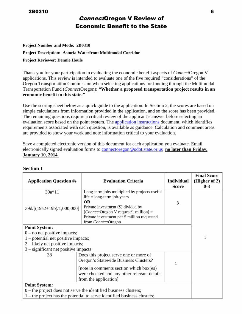
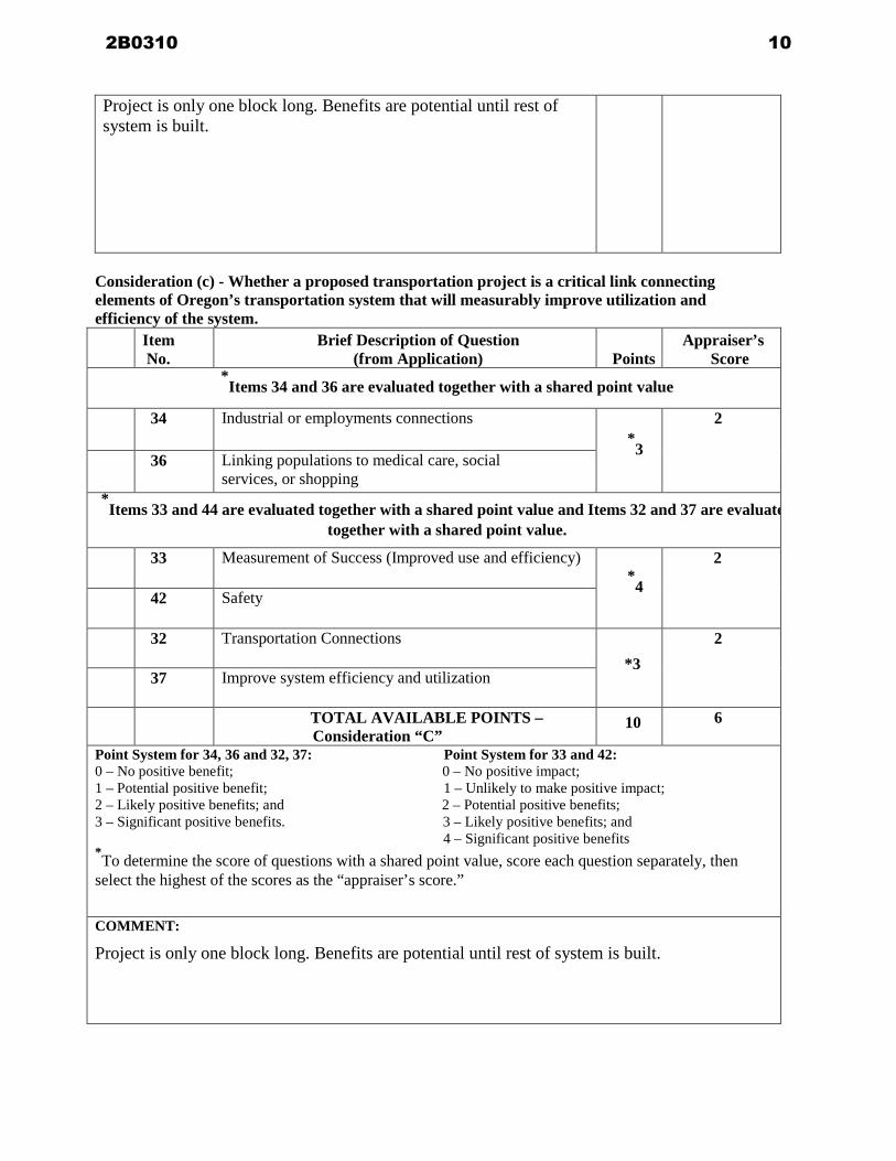
Project is only one block long Benefits are potential until rest of system is built
Consideration (c) - Whether a proposed transportation project is a critical link connecting elements of Oregonrsquos transportation system that will measurably improve utilization and efficiency of the system
Item No
Brief Description of Question (from Application) Points
Appraiserrsquos Score
Items 34 and 36 are evaluated together with a shared point value
34 Industrial or employments connections
3
2
36 Linking populations to medical care social services or shopping
Items 33 and 44 are evaluated together with a shared point value and Items 32 and 37 are evaluate
together with a shared point value
33 Measurement of Success (Improved use and efficiency)
4
2
42 Safety
32 Transportation Connections 3
2
37 Improve system efficiency and utilization
TOTAL AVAILABLE POINTS ndash Consideration ldquoCrdquo
10 6
Point System for 34 36 and 32 37 Point System for 33 and 42 0 ndash No positive benefit 0 ndash No positive impact 1 ndash Potential positive benefit 1 ndash Unlikely to make positive impact 2 ndash Likely positive benefits and 2 ndash Potential positive benefits 3 ndash Significant positive benefits 3 ndash Likely positive benefits and 4 ndash Significant positive benefits To determine the score of questions with a shared point value score each question separately then select the highest of the scores as the ldquoappraiserrsquos scorerdquo COMMENT
Project is only one block long Benefits are potential until rest of system is built
2B0310 10
Consideration (d) - How much of the cost of a proposed transportation project can be borne by the applicant for the grant or loan from any source other than the Multimodal Transportation Fund
Item No
Brief Description of Question (from Application) Points
Appraiserrsquos Score
Overmatch Criteria
(Question 19dAdditional Match Question (19c)ConnectOregon Project Total) x 100 = Overmatch Percentage
Example ($25K $100K) x 100 = 25
1 Applicant will provide no Overmatch ($0K$100K) x 100 = 0
1
1 Applicant will provide between 1 to 20 Overmatch ($15K$100K) x 100 = 15
2
1 Applicant will provide between 21 to 40 Overmatch ($25K$100K) x 100 = 25
4
1 Applicant will provide between 41 to 60 Overmatch ($45K100K) x 100 = 45
6
1 Applicant will provide between 61 to 81 Overmatch ($70K100K) x 100 = 70
8
1 Applicant will provide gt80 Overmatch ($90K100K) x 100 = 90
10
TOTAL AVAILABLE POINTS ndash Consideration ldquoDrdquo
10 4
COMMENT
2B0310 11
Consideration (e) - Whether a proposed transportation project is ready for construction
Item No
Brief Description of Question (from Application) Points
Appraiserrsquos Score
For this consideration assume a grant execution date of September 2014
24 Project is ready to start construction 6 months
after grant agreement execution
10
24 Project is ready to start construction 12 months after grant agreement execution
8
24 Project is ready to start construction 18 months after grant agreement execution
6
24 Project where property is not owned by applicant and negotiations are not underway
-2
TOTAL AVAILABLE POINTS ndash Consideration ldquoErdquo
10 8
FINAL POINT CALCULATION
AVAILABLE POINTS
TOTAL SCORE
Consideration a ndash
Maximum 10 Points 6
Consideration
b ndash
Maximum 10 Points (Use Score Provided By
Economic Benefit Evaluation Team)
Consideration c ndash
Maximum 10 Points 6
Consideration d ndash
Maximum 10 Points 4
Consideration e ndash
Maximum 10 Points 8
Maximum Available Points = 50 24
2B0310 12
From Jeff HarringtonTo Cummings Christopher J FISHER Patricia R ODOTCc Brett Estes Ken Cook Rosemary Johnson Nathan CraterSubject City of Astoria - Connect Oregon V Grant Application No 2B0310Date Wednesday January 08 2014 25517 PMAttachments Connect V X-sec Exhibit Map-Exhibit Mappdf
Chris amp Pat Please find that attached Exhibit showing the cross section dimensions for the proposed project Ifyou wouldnrsquot mind could you please verify that you received this so I know that it made it throughand that I have your e-mail addresses correct Please let me know if you need any additionalinformation Thanks Jeff Jeff Harrington PECity EngineerCity of Astoria1095 Duane StreetAstoriaOregon 97103Office (503) 338-5173Fax (503) 338-6538jharringtonastoriaorus
2B0310 13
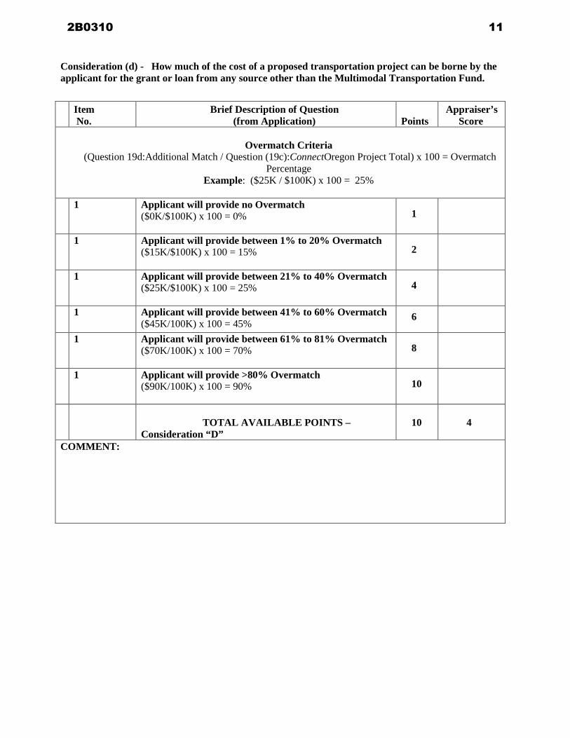
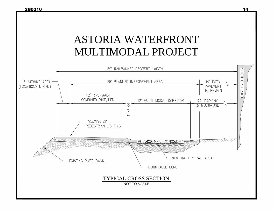
ASTORIA WATERFRONTMULTIMODAL PROJECT
TYPICAL CROSS SECTIONNOT TO SCALE
ASTORIA WATERFRONTMULTIMODAL PROJECT
TYPICAL CROSS SECTIONNOT TO SCALE
2B0310 14
2B0310 15
2B0310 16
2B0310 17
2B0310 18
ConnectOregon V
Program Application 2013-2014 To ensure you have current program information sign up for the ConnectOregon electronic mailing list at httpspubl icgovdelivery comaccou ntsORDOT su bscribernewtopic id=ORDOT 135
bull Please read ConnectOregon V Application Instructions prior to completing th is application bull The Application Instructions the Draft Project Agreement and Frequently Asked Questions are available on the
ConnectOregon V website httpwwworegongovODOTTDTPpagesconnectoraspx bull Submission Requ irements are detailed in Section 9 of the Application Instructions bull Completed Application and Checklist are required bull Answer all questions
Project Summary and Certification
1 Applicant ORGANIZATION NAME
City of Astoria ADDRESS
1095 Duane Street CITY STATE ZIP
CONTACT PERSON NAME
Willi s L Van Dusen CONTACT PERSON TITLE
Mayor PHONE
Astoria OR 971 03 503-325-5824 I FAX 503-325-2017
WEBSITE ADDRESS
wwwastoriaorus
2 Project name and location PROJECT NAME
Astoria Waterfront Multimodal Corridor Project
E-MAIL (REQUIRED)
mayorastoriaorus
PROJECT LOCATION
11 th-12th Street - Waterfront
3 Cost summary (These fields will fill automatically as the application is completed)
a ConnectOregon V grant amount
b Match amount (20 of grant)
c ConnectOregon V loan amount
d ConnectOregon V overmatch amount
e ConnectOregon V project total
4 Certification
STAFF USE ONLY
$800000
$200000
$0
$23899 1
$ 1238991
1 certify that The City of Astoria supports the proposed project has the legal authority APPLICANT ORGANIZATION
to pledge matching funds and has the legal authority to apply for ConnectOregon V funds I further certify that matching funds are available or will be available for the proposed project I understand that all State of Oregon rules for contracting auditing underwriting (where applicable) and payment will apply to this project I certify that I have read the Sample Draft Agreement and will sign the Agreement if selected
PRINT NAME DATE
Willi s L VanDusen Mayor 112213
731-0509 (909) ConnectOregon V Program Application 201 3-2014 October h 201 3
2B0310 19
731-0509 (909) 2 ConnectOregon V Program Application 2013-2014 October 7th 2013
Project Description5 Project summary
BRIEF SUMMARY OF PROJECT (MAXIMUM 400 CHARACTERS)
6 Project purpose and descriptionProject maps must be included with this application Maximum map size 11 by 17 inches Attach additional pages if necessary For projects with any portion in ODOT right-of-way the right-of-way must be clearly identified and portions of the project in ODOT right-of-way must be identifiedPROJECT DESCRIPTION AND PURPOSE (MAXIMUM 4500 CHARACTERS)
The River Walk area between 11th Street and 20th Street falls within what the City Riverfront Vision Plan defines as theUrban Core area Within this area the River Walk transitions from an urban trail with only bicycles and pedestrians to acorridor where bicycles and pedestrians interact with vehicular traffic which parallels the highway The portion of thecorridor proposed for rehabilitation under this phase consist of approximately 400 feet of bike amp pedestrian path trolleytrack and all associated infrastructure including enhanced lighting to address safety
The proposed project would redefine the interaction of all users of the corridor and more clearly define the separationbetween the multiple uses The City has seen a dramatic increase in all modes of traffic within this corridor due to increasedtourism increased service businesses along the waterfront increased cruise ships to the Port and increased local pedestrianuse More people are walking and biking to their destinations along the waterfront and the trolley is transitioning from arecreational activity to also a means of transportation
The City has recently completed the reconstruction of the 17th Street Dock a Connect Oregon III Project and is realizingincreased pedestrian use at the dock The Coast Guard and the other commercial vessels that use the dock are contributing toan increased use of the waterfront corridor to get around town
It is envisioned that should the grant be funded this project would create an environment that is friendly to all of theexisting modes of transportation The design intention will include a multi-modal facility that encourages alternative modesof transportation including pedestrians bicycles trolley transportation and vehicles in an effort to relive State Highway 30
Additionally should the grant be funded a public involvement component would be included in the design process to gaininput from citizens and stakeholders within the limits of the project We also anticipate that this first phase will set the themefor the remaining segments of the corridor out to the Maritime Museum area
The project cost is estimated at $1238991 The City proposes a grant of $800000 and a match of $438991 ($200000required plus $238991 overmatch) The project would have a design life of 20 years
The City of Astoria is seeing increased use of its downtown waterfront corridor and anticipates expanded use inthe future This corridor parallels SR 30 and serves bicycles pedestrians the Astoria Trolley vehicles freighttraffic The entire corridor runs from 11th Street to 20th Street and the proposed project is the first phase andincludes the block between 11th and 12th Street
2B0310 20
731-0509 (909) 3 ConnectOregon V Program Application 2013-2014 October 7th 2013
7 Project locationSTREET ADDRESS OR NEAREST STREET INTERSECTION
CITY(IES)
COUNTY(IES)
GPS COORDINATES
LATITUDE (DEGREES AND DECIMAL)
LONGITUDE (DEGREES AND DECIMAL)
COUNTY TAX PARCEL IDENTIFICATION NUMBER(S)
8 Project mode (check all that apply) Air Marine Rail Transit BicyclePedestrian
9 ConnectOregon region CO Region 1 CO Region 2 CO Region 3 CO Region 4 CO Region 5For more information refer to the Application Instructions For processing purposes when projects are located in more than one ConnectOregon region applicant must identify which region will contain the majority of the planned project
10
a) Is the applicant responsible for paying state and local taxes fees and assessments
Yes No NA Public Agency
b) Are all taxes and fees current Yes No
If no explain(MAXIMUM 400 CHARACTERS)
Complete Form ldquoTax Information Authorizationrdquo and attach with application
11 For rail applicants is the applicant a railroad that operates solely in Benton or Linn County Yes NoRequired for a yes answer Complete Form ldquoRailroad Certificationrdquo and attach with application
12 After project completion who will assume responsibility for the continued maintenance and operation of the projectRESPONSIBLE PARTY
13 What will be the source(s) of funds for the continued maintenance and operation of the projectSOURCE(S)
14 What is the status of funds for maintenance and operations
Secured - available now Budgeted - committed for future Unknown or unconfirmed
112613 ODOT staff has assigned this application to CO Region 2
Waterfront between 11th and 12th Streets
Astoria Clatsop
X735856496 Y93749585 4619 12383
80908CA07200
City of Astoria
City of Astoria funds
2B0310 21
731-0509 (909) 4 ConnectOregon V Program Application 2013-2014 October 7th 2013
Describe how and when these steps will occur If unknown or unconfirmed explain or describe necessary steps for funding assuranceDESCRIBE
15 Is all the property required for the project owned by the applicant (See also Questions 16-18)
Yes project real estate is wholly owned by the applicantNo project real estate is partly owned by the applicantNo
If yes project area is wholly owned what was the purchase price of the property PURCHASE PRICE
If no project area is partly owned or if no include the property ownerrsquos information and signature for the non-owned portionOWNER NAME PHONE
OWNER ADDRESS FAX
OWNER CITY STATE ZIP E-MAIL
AUTHORIZED REPRESENTATVE NAME AUTHORIZED REPRESENTATVE PHONE
AUTHORIZED REPRESENTATVE ADDRESS AUTHORIZED REPRESENTATVE FAX
AUTHORIZED REPRESENTATVE CITY STATE ZIP AUTHORIZED REPRESENTATVE E-MAIL
I certify that is authorized to use the real estate underlying the ORGANIZATION NAME
project I understand that all State of Oregon rules for contracting auditing underwriting (where applicable) and payment will apply to this project and that these rules may require a 20-year lease of the sitePROPERTY OWNERLESSOR OR AUTHORIZED REPRESENTATVESIGNATURE
X
PRINT NAME DATE
Check if additional owners are listed on Page 34 of this application
16 Will the project property or easements be purchased by the applicant to complete the project Yes NoIf yes is the property in escrow Yes No
17 Will the project property be leased by the applicant Yes NoIf yes have the negotiations begun Yes No
Maintenance of all proposed improvements will be rolled into general city maintenance for the River Walk which is alreadyfunded through the City approved budget
$000
City of Astoria through the Rails to Trails Act
City of Astoria
Refer to Interim Trail Use Agreement
2B0310 22
731-0509 (909) 5 ConnectOregon V Program Application 2013-2014 October 7th 2013
18 Provide any additional property detailsADDITIONAL DETAILS (MAXIMUM 1600 CHARACTERS)
Project Budget and Schedule19 Identify the source and amount of funds for the project budget including grants loans and matching
funds
SOURCE AMOUNT
DATE AVAILABLESTAFF USE
ONLYCALENDAR YEAR MONTH
a Grant portion 00000
1 Required match(For grants 20 grant project subtotal)
00000
2 ConnectOregon V grant amount requested
00000
b ConnectOregon V loan portion requested(no match required)
00000
c ConnectOregon V total (a+b) 00000
d Additional applicant match (not required) 00000
Project total 00000
The River Walk (Downtown portion 6th to 17th Streets) and River Trail follow the former Burlington Northern Railroad linewhich was railbanked in 1997 and deeded to the City of Astoria Through the National Rails-To-Trails Act the City acquiredthe railroad right-of-way as City property through an Interim Trail Use Agreement At such time that the railroad could returnservice to Astoria the right-of-way is preserved and can be returned to the railroad for use The City many not dispose of therail corridor and must maintain it in City ownership for potential future railroad service The River Trail River Walk andother improvements have been constructed to allow for combined use in the future Construction of usesencroachments mayoccur with the understanding that future rail reactivation could ask for the full width of the railbanked property and theencroachment would need to be removed at the userrsquos expense The minimum width for rail operation of 85rsquo from centerlinein straight sections should be maintained The proposed project would be incompliance with the conditions of the Trail UseAgreements
Railbanking DocumentsInterim Trail Use Agreement 12-5-95Transfer and Railbanking Agreement 7-19-96Deed from Burlington Northern to City 7-31-96Quitclaim Deed from Burlington Northern to Astoria Development Commission 10-26-99ICC Decision on Interim Trail Use on Abandonment AB-6 12-5-1995
$100000000
$20000000
$80000000
$000
$100000000
$23899100
$123899100
2B0310 23
731-0509 (909) 6 ConnectOregon V Program Application 2013-2014 October 7th 2013
20 For grant projects detail the source and timing of the match shown above
TYPE OF MATCH SOURCE OF MATCH FUNDS AMOUNT
WILL THIS EXPENDITURE BE INCURRED PRIOR TO COMPLETION
OFAGREEMENT
DATE AVAILABLESTAFF USE
ONLYCALENDAR YEAR MONTH
Labor (payroll) Yes No 00000
Contracted services Yes No 00000
Materials and supplies Yes No 00000Capital outlay ndash land (purchase price) Yes No 00000
Yes No 00000
Yes No 00000
Yes No 00000
Yes No 00000
TotalTotal must equal
19a1ndashRequired match + 19dndashAdditional applicant match
00000
21 If the ConnectOregon V project is part of a larger project describe the scope of the entire project Include the total amounts of public and private investment in the proposed project Please note which portions of the project are already completed or already funded and which remaining portions are ConnectOregon VeligibleDESCRIBE (MAXIMUM 1200 CHARACTERS)
City funds
$43899100
$43899100 2014
$43899100
Other (describe)
Other (describe)
Other (describe)
Other (describe)
The proposed project is intended to be the first phase in a series of projects that would enhance the corridor between 11thStreet and the Maritime Museum Barbey Center at 20th Street where the River Walk is not as defined and interacts withvehicular traffic private properties and businesses This segment of the River Walk is primarily located within the RiverfrontVision Plan Urban Core Area where a mix of transportation modes are anticipated to interact This project would furtherimplement the goals of the Vision Plan The overall project would also connect to the 17th Street Dock which is experiencingincreased pedestrian traffic from both visitors and residents alike and marine traffic Marine traffic includes tour boat usecommercial vessels and recreational boats
The entire trail is a corridor that has been constructed over a 20 year period with a combination of City State Federal andprivate funds Many sections of this trail and the amenities along the trail were constructed as publicprivate partnerships It isanticipated that additional publicprivate funding will be used for these future phases
2B0310 24
731-0509 (909) 7 ConnectOregon V Program Application 2013-2014 October 7th 2013
22 Is there an urgency to this project (See Application Instructions for examples) Yes No
If yes describe below DESCRIBE
23 Is the project construction ready Yes No NA
If no describe the remaining steps and when these steps will occur if ConnectOregon funds are received DESCRIBE
24 Complete the following tables regarding current and projected milestones for the project Check to indicate if the project is a construction or a non-construction project
MILESTONECONSTRUCTIONPROJECTS
OTHER (NON-CONSTRUCTION) PROJECTS ndash DESCRIBE
HAS THE MILESTONE BEEN MET
PROJECTED START DATE OF MILESTONE WORK
PROJECTED MILESTONE COMPLETION DATE
1 Scoping and planning Yes No
2 Right-of-way and land acquisition Yes No
3 Permits Yes No
4 Final Plansbidding
engineering documents
Yes No
5 Construction contract award Yes No
6 Project completion Yes No
The rehabilitation of the infrastructure supporting the River Walk and trolley corridor is critical due to its age andincreased use as a multimodal transportation corridor
Preliminary concept plans have been completed and the project design elements have been defined in order to allowan expedited design and construction process to take place once funding is available
9114
9114
6115
8115
6115
3115
8115
2116
2B0310 25
731-0509 (909) 8 ConnectOregon V Program Application 2013-2014 October 7th 2013
25 Complete the following table regarding pre-construction documentation and permits (Potential projects are expected to be at varying stages of construction readiness some of the steps below will not apply or must be marked ldquoStill requiredrdquo or ldquoDonrsquot knowrdquo See the ConnectOregon V Application Instructions for detailed explanations of the terms below)
ENVIRONMENTAL AND PUBLIC INVOLVEMENTSTEP STATUS
PERMIT PERMIT PERMIT NOT DONrsquoTCOMPLETED UNDERWAY REQUIRED APPLICABLE KNOW
a NEPA Categorical Exclusion (CE)
b NEPA Environmental Assessment (EA)
c Environmental Impact Statement (EIS)
d Air-quality conformity determination
e In-water work permit
f Army Corps of Engineers permit
g Coordination of project approval with any Native American tribe or another state
h Stakeholder involvement
i Permits
j
k
PLANNING AND LAND USESTEP STATUS
INCLUDED INCLUDED STILL NOT DONrsquoTCOMPLETE UNDERWAY NEEDED APPLICABLE KNOW
l Identified in adopted transportation system plan (TSP)
m Identified in adopted local comprehensive plan
n Identified in adopted regional transportation plan (RTP)
o Identified in Zoning amendment
p Goal exception (if required by state planning goals)
q
r
List other federal state modal regional or local plans where this project is listedNAME OF PLAN PROJECT ROUTESITE GENERAL
SPECIFIC SPECIFIC GOALPOLICY
Local land use
Other (describe)
Other (describe)
Other (describe)
See Item 26
2B0310 26
731-0509 (909) 9 ConnectOregon V Program Application 2013-2014 October 7th 2013
DESIGN AND SPECIFICATIONSTEP STATUS
ALREADY INCOMPLETE STILL NOT DONrsquoTCOMPLETED UNDERWAY REQUIRED APPLICABLE KNOW
s Engineering andor design services contracted
t 30 design and environmental complete
u 60 design complete
v 90 preliminary design complete
w Final design complete
x Plans and specifications
y
z
26 Describe how the proposed project is consistent with or identified in a public or corporate planning document Provide the portion of the document that appliesLIST PROJECTS (MAXIMUM 1600 CHARACTERS)
Check if documentation of the approval coordination is attached in Supplemental Information
Building Permits
Electrical Permits
The River TrailRiver Walk and trolley line are identified in multiple documents as a key multi-modal corridor forpedestrian bicycle and trolley activities The project is part of the larger River Trail system A common thread through allof the documents is the need for this alternate method of transportation recommendations for signage amenities increasedpublic safety and the upgrade and maintenance of the corridor features It is identified as an economic catalyst and as atransportation link for both locals and tourists between the residential neighborhoods tourist portals such as 17th Streetdock Port cruise ship dock motelshotels and the commercial areas including Downtown Safeway grocery and theregional medical facilities two blocks from the riverfront Documents include
Astoria Riverfront Vision Plan November 2009Astoria Transportation System Plan July 1999Astoria Waterfront Planning Study June 1990City of Astoria Bicycle Plan October 5 1992Civic Dossier April 2013Comprehensive Plan Parks Recreation and Open Space ndash Section CP260 to CP275Comprehensive Plan Transportation - Section CP355 to CP370Trails Master Plan May 6 2013
2B0310 27
731-0509 (909) 10 ConnectOregon V Program Application 2013-2014 October 7th 2013
27 Is the construction of the project limited to specific construction timeframes due to environmental considerations (such as bird-nesting or fish-spawning seasons or temperature)
Yes No No however additional information is included in addenda
If yes note the periods when construction is limited
RESTRICTION DESCRIPTIONSTART DATE
OF RESTRICTIONEND DATE
OF RESTRICTION
28 Can you demonstrate project support from public agencies that must approve the project
Yes Yes started but not completed NoLIST APPROVALS (MAXIMUM 1600 CHARACTERS)
Check if documentation of the approval coordination is attached in Supplemental Information
See Addenda
NA
2B0310 28
731-0509 (909) 11 ConnectOregon V Program Application 2013-2014 October 7th 2013
29 Describe any unique construction-readiness issues or possible delays not identified aboveDESCRIBE (MAXIMUM 1600 CHARACTERS)
30 The project schedule presented above has the following level of risk involved
High Medium Low
a Describe the reason for your answer regarding level of risk(MAXIMUM 300 CHARACTERS)
b Who was responsible for determining the project schedule and what is their level of expertise (ie City or consultant engineer construction project manager city staff etc)(MAXIMUM 300 CHARACTERS)
Project Details
31 What is the projectrsquos useful life YEARS
The City of Astoria has recently received ODOT Bridge STIP Funding for our six (6) street end bridge structures includingthe 11th Street Bridge which is adjacent to the west end of the proposed project Since the STIP project is adjacent to theproposed Connect Oregon V BikePedestrian project the project schedules will have to be coordinated to avoid conflict andminimize impacts to local businesses
The required coordination identified above is expected to be manageable due to the short construction duration of eachproject
City Engineer Jeff Harrington is a Professional Engineer with 25 years of public and private engineering experience and wasCity Project Manager on the recently completed Connect Oregon III 17th Street Dock Project
20
2B0310 29
731-0509 (909) 12 ConnectOregon V Program Application 2013-2014 October 7th 2013
32 Does the project improve existing or create new critical links for Oregonrsquos transportation system
Yes No
IF YES CHECK ALL THAT APPLY
The project
creates a new link
improves an existing link
The project improves or creates new transportation links
between multiple modes of transportation (check all that apply)
air marine pipeline passenger rail freight rail transit truck
bus bicycle pedestrian personal automobile
to transportation networks outside Oregon
EXPLAIN (MAXIMUM 400 CHARACTERS)
33 How is success measured for this type of project THIS ANSWER MUST INCLUDE THE METHODOLOGY FOR CALCULATION ATTACH ADDITIONAL INFORMATION IN QUESTION 44 AS NECESSARY(MAXIMUM 300 CHARACTERS)
a What is the existing measurement today
b What is anticipated measurement when the project is fully operational
34 Does the project improve an existing transportation connection or add a new connection to an industrial or employment center
Yes No
IF YES CHECK ALL THAT APPLY
The project
Creates a new connection
Improves an existing connection
a This project improves or creates access to
Industrial centerSPECIFY
Employment centerSPECIFY
This project provides access toSITE NAME
which is a site certified as ldquoProject Readyrdquo by the Oregon Business Development Department (OBDD) For more information refer to the Application Instructions
The project improves the existing facility providing an alternate route multi modal to vehicular use of Highway 30 Itreduces conflicts between pedestrian bicycle and vehicular use It provides a direct bikepedestrian access to theTransportation Intermodal Center (bus depot) located at 9th Street
Upgrades needed to keep multi-modal link operational Failure of infrastructure would require closure of corridor section ampwould impact ability of locals and tourists to access employment amp tourist facilities Enhancement will assure continuedeconomic growth of businesses especially in this block
Downtown business core
2B0310 30
731-0509 (909) 13 ConnectOregon V Program Application 2013-2014 October 7th 2013
35 Does this project link workers to jobs
Yes No
EXPLAIN (MAXIMUM 300 CHARACTERS)
a Which mode(s) are linked for workersMODE LINKS (CHECK ALL THAT APPLY)
Fixed-route bus Light rail Air servicesDemand-responsive bus Passenger rail FerryBicyclePedestrian Commuter rail Water taxi
OtherDESCRIBE (MAXIMUM 75 CHARACTERS)
b Estimated use by new workersESTIMATED NUMBER OF NEW WORKERS PER DAY EXPECTED TO USE THE PASSENGER SERVICE WHEN OPENED
EXPLAIN BASIS FOR ESTIMATE (MAXIMUM 300 CHARACTERS)
c Describe the demographics or other relevant characteristics of the residential areas that gain new or improved access to jobs as a result of this project
DESCRIBE
d Geographic service levelIDENTIFY GEOGRAPHIC SERVICE AREA (CHECK ALL THAT APPLY)
RuralIntra-city (within a town or city) Intercity (between towns or cities)Interstate (between states) International
The River Trail River Walk and trolley line are a multi-modal corridor linking residential areas (Alderbrook UniontownMill Pond and Downtown) to the commercial areas of the City Residents regularly use the route for transportation to andfrom their places of business
Trolley
NA
NA
Project is part of a greater multi-modal system linking commercial residential and tourist areas Several areas of higherresidential densities along the River Trail include 3 condominium buildings (102 units) Mill Pond Village with single-familydwellings one low income senior apartments 3 senior apartment buildings workforce housing apartment buildingUniontown Apartments on west end Downtown second story apartments Alderbrook neighborhood with mostly single-family dwellings Other neighborhoods connected through the existing street amp trail system in the City Corridor providesmulti-modal access from all of these neighborhoods to the many employment facilities in Astoria Employment retail andmedical services are concentrated on the north side of Astoria along the riverfront and this multi-modal corridor
2B0310 31
731-0509 (909) 14 ConnectOregon V Program Application 2013-2014 October 7th 2013
36 Does this project link populations to medical care social services or shopping
Yes No
EXPLAIN (MAXIMUM 300 CHARACTERS)
a Mode links for medical care social services shoppingMODE LINKS (CHECK ALL THAT APPLY)
Fixed-route bus Light rail Air servicesDemand-responsive bus Passenger rail FerryBicyclePedestrian Commuter rail Water taxi
OtherDESCRIBE (MAXIMUM 75 CHARACTERS)
b Estimated use by new usersESTIMATED NUMBER OF NEW USERS PER DAY EXPECTED TO USE THE SERVICE WHEN OPENED
EXPLAIN BASIS FOR ESTIMATE (MAXIMUM 300 CHARACTERS)
c Describe the demographics or other relevant characteristics of the residential areas that gain new or improved access to jobs as a result of this project
DESCRIBE
d Geographic service levelIDENTIFY GEOGRAPHIC SERVICE AREA (CHECK ALL THAT APPLY)
RuralIntra-city (within a town or city) Intercity (between towns or cities)Interstate (between states) International
Project is within walkingbiking distance of the regional medical center many social services such as State Employmentoffice Clatsop Community Action Community Action Team Health Department etc Local and tourist services such asdowntown businesses and Safeway grocery store are located along
Trolley
Observed historical growth and available in-fill housing development area along waterfront
Continued growth with existing services due to additional housing proposed for future construction along the waterfront
Project is part of a greater multi-modal system linking residential medical social services amp shopping areas within the CityIn addition to residential areas noted in Item 35c other low income and limited mobility residential apartments are located atOwens Adair amp JJ Astor Apartments Other neighborhoods are also connected through the existing street amp trail system Thiscorridor provides multi-modal access from all of these neighborhoods to the medical amp social service facilities in AstoriaEmployment retail amp medical services are concentrated on the north side of Astoria along the riverfront and this multi-modalcorridor 40 of the population is over 50 years of age and 174 is below poverty level
2B0310 32
731-0509 (909) 15 ConnectOregon V Program Application 2013-2014 October 7th 2013
37 This project will improve system efficiency andor utilization byincreasing system capacityrelieving a bottleneck or congestion pointcompleting one or more gaps in Oregonrsquos transportation systemremoving an existing barrierreducing traffic or use conflictsimproving geometricsimplementing technology Other (describe below)
EXPLAIN (MAXIMUM 1250 CHARACTERS) INCLUDE IN YOUR ANSWER AND ATTACH DOCUMENTATION SUPPORTING YOUR ANSWER CITE IN QUESTION 44
38 Does the project serve one or more of Oregonrsquos Statewide Business Clusters For more information refer to the Application InstructionsSTATEWIDE BUSINESS CLUSTERS (CHECK ALL THAT APPLY)
Agriculture Forestry and Wood ProductsAthletic amp Outdoor Gear and Apparel Green Building and DevelopmentAviation ManufacturingBioscience Nursery ProductsBreweriesCreative Industries Semiconductors and Electronics ComponentsDefense SoftwareEducation Services and Technology SolarElectric Vehicles and Sustainable Trans Tourism and HospitalityEnergy Efficiency Wave EnergyEnvironmental Technology and Services Wind EnergyFood Processing
PROVIDE DETAIL (MAXIMUM 500 CHARACTERS)
This project will increase system capacity by providing new geometrics that will improve interaction between bicyclespedestrians and vehicles Route delineation will reduce use conflicts and the mountable curb concept will optimizemultiuse while allowing emergency vehicles to traverse around the trolley in emergencies Currently the multiuse aspectsof this area are not clearly defined and the project intends to create a multi use corridor that clearly defines a route for allmodes of traffic but especially bicycles and pedestrians
Tourism is a major industry amp most hotelsmotels are located along the riverfront Astoria has a cluster of breweries due tothe increased tourism with tour boats at 17th Street dock cruise ships at Port amp easy access to breweries via the River TrailExisting breweries Wet Dog Cafe amp Brewery Astoria Brewing Co Rogue Brew Pub Fort George Public House ampBrewery New facilities Buoy Brewing amp North Coast Distillery Most are located on River Trail or within two blocks ofthe trail
2B0310 33
731-0509 (909) 16 ConnectOregon V Program Application 2013-2014 October 7th 2013
39 Does this project benefit the Oregon economy by generating a net increase in or retention of long-term jobs (beyond short-term construction jobs) andor increasing private investment in Oregon
Yes No
If yes please complete the followinga Number of long-term (non-construction) jobs created or retained
as a direct result of the project
b Average annual wage of long-term (non-construction) jobs created or retained
c List up to five businesses that will verify job creationretention or new private investment BUSINESS NAME NAME OF CONTACT PERSON CONTACT PERSON PHONE
1
2
3
4
5
d What is the size of the increase or initial investment by these businesses in Oregon as a result of this project
Required for a yes answer Commitment letters must be included in Supplemental Information and cited in Question 44 These letters must be from businesses or organizations stating their intention to operate in Oregon and detailing the number of jobs created or retained over a specific period of time as a result of this project andor the amount of additional private investment that the entity would make in Oregon over a specified period of time as a direct result of this project
EXPLAIN (MAXIMUM 400 CHARACTERS)
40 Consider to what extent does this project generate economic stimulus in the state by supporting short-term construction-related jobs in Oregon
a What year were the planning and engineering land and construction cost estimates done for this project and by whom
YEAR COST ESTIMATE WAS
DONE
BUSINESS NAME ESTIMATE ELEMENT(IF MORE THAN ONE)
1
2
3
4
5
75
$000
Baked Alaska
Wet Dog Cafe amp Brewery
Astoria Brewing Company
Chris amp Jennifer Holen
Steve Allen
Steve Allen
503-325-7414
503-325-2171
503-325-2171
$000
Baked Alaska invested in upgrades to business including opening Baked Pizzeria amp other proposed upgrades Existingemployment is 35 to 45 people Wet Dog Cafe amp Brewery is expanding to second location for Astoria Brewing Co withtotal employment of 40 people now amp increase to 50 by 2015 All four businesses are reliant on the pedestrianbicycletrolley access to their facilities
13
13 Greenworks
City Staff Estimates
Concept and Plans
2B0310 34
731-0509 (909) 17 ConnectOregon V Program Application 2013-2014 October 7th 2013
b For which year are the costs estimated (ie the cost estimate was done in 2011 for a project expected to occur in 2014 and so the estimator inflated the costs of the project to 2014 dollars therefore the answer would be 2014)EXPLAIN (MAXIMUM 400 CHARACTERS)
c The short-run jobs supported by this project are (Calculate the jobs number using Fields 1-5 below The result in Field 5 below will populate here)
Field 1Project costs (planning engineering land construction)
Field 2Inflation Adjustment factor based on year (see instructions)
Field 3Project cost multiplied by Inflation Adjustment Factor(Field 1 x Field 2)
Field 4Result divided by 1000000(Field 31000000)
Field 5Result multiplied bythe job multiplier of118(Field 4 x 118)
41 What is the unemployment rate in the project areaAverage unemployment rate in the project area for the last 12 months (Refer to the Application Instructions)
COUNTYJURISDICTION
PROVIDE ADDITIONAL DETAILS ON ANY OTHER SPECIAL ECONOMIC CONSIDERATIONS IN THE PROJECT LOCATION
42 Does the project improve safety
Yes No
Required for a yes answer Documentation or explanation of the incident(s) or safety situation(s) that have occurred that this project is addressing or documentation of a high risk or of a safety issue or hazard potentially occurring
EXPLAIN (MAXIMUM 400 CHARACTERS) PLEASE NOTE THE NUMBER AND TYPE OF INCIDENTS (FATAL ACCIDENT INJURY ACCIDENT PROPERTY-DAMAGE ACCIDENT CRIME OR OTHER) WITHIN A SPECIFIED TIMEFRAME
2013 cost figures did not inflate as construction cost trends are not increasing in our area Project contingency of 25expected to be more than adequate to cover any potential construction cost increases
$123899100 118943136 1189 14868096
14868
6 Clatsop
By defining the transportation corridor better it is anticipated that safety will be improved Currently there is no majoraccident history at the project location Bike and pedestrian safety will be improved by better geometrics route delineationand lighting The mountable curb at the outside edge of sidewalk will allow emergency vehicles to navigate around trolley inemergencies
2B0310 35
731-0509 (909) 18 ConnectOregon V Program Application 2013-2014 October 7th 2013
Other Considerations and Information43 Describe any other considerations and information that support why the project should be selected
DESCRIBE (MAXIMUM 1200 CHARACTERS)
44 List the supporting materials to be submitted in your paper application packet
Question 26 Commitment letters
1
2
3
4
5
Question 28 Documentation of coordination and support of public agencies that must approve the project
1
2
3
4
5
Question 39 Commitment letters from businesses or organizations stating their intention to operate in Oregon and their intentions regarding job creation and private investment plans over a specified period
1
2
The project will provide a unique opportunity for the City to reinvent the multimodal corridor and the interaction between themany transportation uses along the waterfront This urban core area is experiencing increased use by the public Examplesinclude use by Coast Guard staff to commute to work on bicycle increase walkers during lunch hour for health exercise theuse of the trolley to commute from one end of town to the other and increased use by waterfront businesses such as thevarious restaurants and breweries
Astoria Riverfront Vision Plan November 2009 ndash plan for the protection and development of the riverfront Project islocated within the Urban Core Area of the PlanAstoria Transportation System Plan July 1999 ndash Goal 3 ldquoPromote the increased use of alternative modesrdquo Chapter 4ldquoTransportation Safetyrdquo Chapter 7 ldquoTransportation System Planrdquo ldquoNon-Motorized PlanrdquoComprehensive Plan Parks Recreation and Open Space ndash Section CP260 to CP275 CP260 CP27520B2CP27521 CP2759 CP2758 identify River Trail for multi-modal use and need for continued maintenance amp upgradeComprehensive Plan Transportation ndash Section CP355 to CP370 CP3552 CP3553 CP3601 CP36013 encouragesmulti-modal routes and improvements CP3558 supports economic development through good transportation elementsTrails Master Plan 2013 ndash plan identifies River Trail and need for maintenance increased safety improvements signageamenities lighting
NA
Baked Alaska and Baked Pizzeria
Wet Dog Cafe amp Brewery and Astoria Brewing Company
2B0310 36
731-0509 (909) 19 ConnectOregon V Program Application 2013-2014 October 7th 2013
3
4
5
Other supporting documents
1
2
3
4
5
Astoria Downtown Historic District Association letter of support
Astoria-Warrenton Chamber of Commerce letter of support
2B0310 37
731-0509 (909) 22 ConnectOregon V Program Application 2013-2014 October 7th 2013
BICYCLEPEDESTRIANQuantity (Q)
Unit Price (UP)
Cost (QxUP)
PRELIMINARY ENGINEERING (PE)Project Administration
1 ODOT Project Administration for federal projects (TE or TA)
2 Applicant Staff Costs - Direct
Project Development and PE1 Surveying amp Descriptions
2 Engineering Design
3
Environmental Work1
2
Coordination and Outreach1
2
Total PE
1 10000 10000
0
0
1
1
17500
175000
17500
175000
0
0
0
0
1 20000 20000
0
0
1
1
4000
2000
4000
2000
0
228500
Environmental Clearances
Public Meetings
Public Information Distribution
2B0310 38
731-0509 (909) 23 ConnectOregon V Program Application 2013-2014 October 7th 2013
Quantity (Q)
Unit Price (UP)
Cost (QxUP)
RIGHT-OF-WAY (ROW)1 Appraisal amp Negotiation
2 Acquisition (Land Improvement)
3 Relocation amp Damages
4 Personnel amp Legal Cost
Total ROWUTILITY amp RAILROAD (UR)
1 Utility Relocation
2 Railroad Costs
Total URNON-CONSTRUCTION (OTHER)
1 Leased Space
2 Capital Equipment
3 Education amp Interpretive
4 Enforcement Activities
Total OTHERCONSTRUCTION (CONST)Mobilization amp Traffic Control
1 Mobilization (10)
2 Traffic Control TP amp DT (10 min)
0
0
0
0
0
0
0
0
0
0
0
0
0
0
0
0
0
0
1
1
64000
64000
64000
64000
2B0310 39
731-0509 (909) 24 ConnectOregon V Program Application 2013-2014 October 7th 2013
Quantity (Q)
Unit Price (UP)
Cost (QxUP)
Erosion amp Sediment Control1
2
Roadwork (Bikeway or Walkway)1 Construction Surveys
2 Clearing amp Grubbing
3 Excavation
4 Stabilization
Drainage amp Sewers1
2
Structures1 Buildings
2 Bridges
3 Retaining Walls
1 2500 2500
0
0
1
1
900
7500
18700
18
7500
18700
16200
1
1
1
50000
186550
136500
50000
186550
136500
360
1
75
19000
27000
19000
0
0
0
0
0
0
0
0
0
0
Erosion amp Sediment Control
5 Pedestrian Improvements
6 Trolley Rail Improvements
Storm Drain Pipe
Storm Drain Structures
2B0310 40
731-0509 (909) 25 ConnectOregon V Program Application 2013-2014 October 7th 2013
Quantity (Q)
Unit Price (UP)
Cost (QxUP)
Traffic Control amp Illumination1 Signs
2 Signals
3 Pavement Marking
4 Lighting
Other Costs - Construction1 Landscaping
2 Fences
3 Water Quality Features
4 Erosion Control Seeding
Construction Subtotal
Contingency 20-30 of total construction costs above
Construction Engineering 15-20 of construction with contingency
Total CONSTTOTAL COST
10
1
250
2500
2500
0
2500
1 60000 60000
0
0
1
1
31000
15000
31000
0
15000
0
0
0
702950
175738
131803
1010491
1238991
2B0310 41
731-0509 (909) 33 ConnectOregon V Program Application 2013-2014 October 7th 2013
AddendaAttach additional text here as necessary identifying the question number Please note Only additional text contained on this page will be considered as part of this application Additional pages will not be consideredMAXIMUM 4500 CHARACTERSItem 27The project is within 50rsquo of the Columbia River Estuary shoreline and requires review under Development Code Section 2750to 2760 ldquoColumbia River Estuary Shoreland Overlay Zonerdquo Development Code Article 4 ldquoColumbia River Estuary andShoreland Regional Standardsrdquo and Development Code Article 5 ldquoImpact Assessment and Resource Capability DeterminationrdquoThe Columbia River has listed endangered species however no in-water work is proposed There are no known bird-nestingsites in the vicinity of the project
2B0310 42
731-0509 (909) 34 ConnectOregon V Program Application 2013-2014 October 7th 2013
Additional property ownerslessors
OWNER NAME PHONE
OWNER ADDRESS FAX
OWNER CITY STATE ZIP E-MAIL
AUTHORIZED REPRESENTATVE NAME AUTHORIZED REPRESENTATVE PHONE
AUTHORIZED REPRESENTATVE ADDRESS AUTHORIZED REPRESENTATVE FAX
AUTHORIZED REPRESENTATVE CITY STATE ZIP AUTHORIZED REPRESENTATVE E-MAIL
PROPERTY OWNERLESSOR OR AUTHORIZED REPRESENTATVE SIGNATURE
X
PRINT NAME DATE
See Application Instructions for submittal requirements
2B0310 43
ATTACHMENTS
Astoria Waterfront Multimodal Corridor Project
Connect Oregon V Grant Application
Question 6
a Birdseye Context b View 01 - 11th Street West c View 02 - 12th Street East d Existing Conditions Photos - Astoria Waterfront
Item 44 Question 26
a Astoria Riverfront Vision Plan b Astoria Transportation System Plan c Comprehensive Plan ldquoParks Recreation and Open Spacerdquo d Comprehensive Plan ldquoTransportationrdquo e Trails Master Plan
Item 44 Question 39
a Letter of Economic Commitment ndash Baked Alaska b Letter of Economic Commitment ndash Wet Dog Cafeacute amp Brewery
Item 44 ndash Other Supporting Documents
a Letter of Support ndash Astoria Downtown Historic District Association b Letter of Support ndash Astoria-Warrenton Chamber of Commerce
2B0310 44
2B0310 45
2B0310 46
2B0310 47
Astoria Waterfront Multimodal Corridor Project
Connect Oregon V Grant Application
Existing Conditions at 11th Street Looking East Toward 12th Street
Existing Conditions at 12th Street Looking West Toward 11th Street
2B0310 48
6th Street viewing platform
Chinese Heritage Park
URBAN CORE The Urban Core area extends from 2nd Street to
approximately 16th Street This area is and will
continue to be characterized by a more dense
level of development and provides opportunities
for intimate gathering spaces to avoid inclement
weather while allowing views of the river through
building corridors andor over public rights-of-way
at street ends Extension of piers along these public
rights-of-way over the water as part of potential
future redevelopment efforts or public projects will
provide continued visual and physical access to the
riverfront edge even if over-water development
occurs Creative design of sites and buildings such
as the use of setbacks and stepbacks will continue
to allow views of and to the Columbia River
Human scale elements such as benches walkways
landscaping and lighting can contribute to the
individuality of each space while linking the whole
This area will allow for a mix of commercial
residential and water-dependent uses that
support but should not compete with downtown
development New construction and rehabilitated
older buildings should respect local character
Strong physical and visual connections such as
safety and aesthetic improvements along 8th
Street between Marine and Commercial will draw
pedestrians to and from downtown while reducing
pedestrianvehicle conflicts A proposed parking
district will address parking needs and issues on an
area-wide basis
49t0ri4R111KIRONI VISION PLAN bull THE CITY OF ASTORIA OREGON bull AUGUST 2009
2B0310 49
Transportation and Other Public Improvements The following transportation and other public improvements are proposed for the Urban Core area
Improved bicycle and pedestrian facilities and streetscaping along Marine Drive Continuous safe and pleasant facilities would encourage more people to walk and ride bicycles between downtown and the west end of Astoria
Improved pedestrian connection across Marine Drive at 6th Street with items including but not limited to pedestrian islands andor curb extensions Although posted speeds are slow at this location the space is open and traffic is heavy Pedestrians have a difficult time crossing the highway across four lanes of traffic yet it is important to provide the connection between the neighborhood and the river especially in combination with a viewpoint at the river and 6th Street before Marine Drive splits into the couplet A pedestrian island or curb extensions would help shorten the distance pedestrians need to cross
Improvements on downtown streets could include streetscape improvements such as planters lighting awnings and street furniture
bull THE CITY OF ASTORIA OREGON bull AUGUST 2009
2B0310 50
Wayfinding signs can help people locate important destinations
Riverfront parking is limited
Create and manage a new parking district in the riverfront area to provide for and manage parking in a more holistic manner and encourage visitors to park once and walk instead of moving their car from location to location Elements of the parking district could include
Refinements to existing on-site off-street parking requirements
diams Creating of shared parking facilities funded by new development
6 Expansion of parking regulations that encourage employees to park off-site while freeing up adjacent parking for shoppers Provisions to allow on-street parking to count toward off-street parking requirements Creation of walking maps and wayfinding in the riverfront area and downtown to help people navigate between the two areas
Safety and gateway treatments to the 8th Street and Marine Drive intersection to encourage pedestrians to cross the highway elsewhere (either at 6th Street or 9th Street) Improvements on 8th Street between Marine and Commercial also are needed to enhance pedestrian access and safety in this area
Streetscaping along Commercial Street between 8th and 16th Streets Commercial Street is already an attractive place to walk Streetscaping treatments (such as planters lighting awnings and street furniture) could further enhance the experience and encourage more pedestrian traffic while being consistent with historic preservation objectives in the area
Wayfinding and other pedestrian amenities along 12th Street between Duane Street and the river This area marks the heart of downtown Astoria with the Liberty Theater and the Hotel Elliott among other historic attractions Similar streetscaping treatments recommended for Commercial Street should also be considered for this section of 12th Street
Safety and gateway treatments to the 15th Street and Marine Drive intersection to encourage pedestrians to cross the highway elsewhere (either at 14th Street or 17th Street)
bull THE CITY OF ASTORIA OREGON bull AUGUST 2009
2B0310 51
2B0310 52
1
Astoria Transportation System Plan July 1999 Excerpts
Chapter 2 Public InvolvementGoals and Objectives
GOALS AND OBJECTIVES
The following goals and objectives are recommended by the TAC for the Astoria Transportation System Plan
These goals and objectives are derived from the public input obtained through questionnaires and an open house
and issuepriorities identified by the TAC
GOAL 3 Promote the increased use of alternative modes
Objectives
Identify measures to resolve physical impediments to circulation for alternative modes
Improve pedestrian circulation within and between neighborhoods and commercial centers
Ensure connections to the existing pedestrian system with new developments
Identify intersection improvements that enhance pedestrian safety
Provide additional sidewalks and improve existing sidewalk pavement for pedestrian safety and access
Ensure connections to bicycle paths with the new county fairgrounds
Improve bicycle and pedestrian crossings for US 30 101 and OR 202
Improve bicycle and pedestrian facilities on the New Youngs Bay Bridge
Construct riverwalkbicycle path around the city
Identify measures to maintain and increase transit usage including coordination of existing transit
services extended service hours more frequent service transit connections to airport and cruise ships
and improved cross-town transit
Identify measures to address the lack of truck facilities
Utilize the abandoned Burlington Northern railroad right-of-way for pedestrianbicycle uses and rail
bank it for potential future rail use
In coordination with the Port of Astoria identify measures to obtain and maintain regularly scheduled
air service and to improve access to the airport
Assess opportunities and constraints associated with increased water transportation including impacts
of cruise ships Lewis and Clark Greenway opportunities lack of camping facilities for
canoeistskayakers lack of transient mooragesovernight tie-ups and reduced truck traffic to Port
properties
2B0310 53
2
Assess the role of telecommunications as a transportation mode
Chapter 4 Transportation SAFETY
OREGON TRANSPORTATION SAFETY ACTION PLAN (OTSAP)
When considering safety issues for roadways in the State of Oregon the Oregon Transportation Safety Action
Plan (OTSAP) is a primary resource The OTSAP is part of the 1992 Oregon Transportation Plan which
identifies major issues and agenda items for transportation improvements and policy statewide The OTSAP
was also adopted by the Oregon Transportation Committee in June 1995 The Safety Action Plan focuses on
significant transportation related safety problems It also provides guidance for investment directions
A total of 70 actions in the OTSAP were chosen by the Transportation Safety Action Plan Advisory Committee
Eight key actions are associated with transportation-related deaths and injuries and should be implemented by
the year 2000 Three high priority key actions address the critical concerns in the area of traffic safety records
statewide incident management programs and pedestrian safety and traveling Local agencies are responsible
for the following key actions
Support for Local Transportation Safety Program
Support for Pedestrian Safety and
Chapter 7 Transportation Systems Plan
NON-MOTORIZED PLAN
The Transportation Planning Rule and Goal 12 require that planning be done for all modes of travel This
includes non-motorized travel as well as the vehicular modes This section provides plans designed to improve
the ability of travelers to choose bicycles or walking as a mode of transportation within Astoria All non-
motorized improvement projects included in the Bicycle Plan and Pedestrian System Plan are summarized in
Table 7-4 with the locations shown on Figure 7-10 in the projects list section of this chapter
Bicycle Plan
The current Bicycle Plan for the City of Astoria was adopted on October 5 1992 This plan outlined the bicycle
plans and policies for the city from 1992 to 2012 The bicycle facilities recommended in the Astoria TSP
support the recommendations made in the Astoria Bicycle Plan with some modifications through street
improvement projects specific bicycle projects and recommended street design standards (Figures 7-3 through
7-9)
Where new bike lanes are recommended they will be one-way four to six feet wide and will be located adjacent
to the curb except where there is curb parking a right-turn lane or other mitigating factor Where these
conditions occur the bike lane will be located between the through travel lane and the parking or right-turn lane
The bike lane will be marked in the same direction as the adjacent travel lane The striping shall be done in
conformance with the Manual on Uniform Traffic Control Devices
Bicycles are legally classified as vehicle which may be ridden on most public roadways in Oregon Because of
this bicycle facilities shall be designed to allow bicyclists to emulate motor vehicle drivers Shared roadway
facilities are common on city street systems On a shared roadway facility bicyclists share normal vehicle lanes
with motorists Where bicycle travel is significant these roadways shall be signed as bicycle routes
2B0310 54
3
The bikeways on new streets or streets to be improved as part of the street system plan shall be added when the
improvements are made The implementation program identifies an approximate schedule for these
improvements
On arterial and collector streets not scheduled to be improved as part of the street system plan improvements
shall be implemented based on traffic volumes When forecast traffic volumes exceed 2500 to 3000 vehicles
per day bike lanes shall be added to the existing roadway The striping of bike lanes on streets that lead directly
to schools shall be high priority Bikeways on local residential streets will only be signed as a route because the
vehicular traffic volume is low on these streets and exclusive bike lanes are not necessary
In cases where a bikeway is proposed within the street right-of-way the roadway pavement (between curbs)
shall be widened to provide a five-foot bike lane (collector streets) or a four-foot bikeway (one way arterial
streets) as shown on the cross sections in Figures 7-3 through 7-9 Bike lanes on one-way streets shall be
located on the right side of the roadway be one-way and flow in the same direction as vehicular traffic The
striping shall be done in conformance with the Manual on Uniform Traffic Control Devices In cases where
curb parking will exist with a bike lane the bike lane will be located between the parking and travel lanes In
some situations curb parking may have to be removed to permit a bike lane
Bicycle racks for parking have been installed at key locations around the city in the past This practice should
be continued as development or redevelopment occurs Bicycle parking racks should be installed at all major
attractions
Pedestrian System Plan
A complete pedestrian system should be implemented in the city Every paved street should have sidewalks on
both sides of the roadway as shown on the cross sections in Figure 7-3 through 7-9 Sidewalks on residential
and collector streets shall have a five-foot-wide paved width Sidewalks along arterial streets will have widths
ranging between five and 12 feet they may be present on one or both sides of the road and may also be part of a
multi-use pathway with bicycle usage In commercial areas sidewalks should be a minimum of six feet wide
and at least eight feet wide in downtown areas
Pedestrian access on walkways shall be provided between all buildings including shopping centers and abutting
streets and adjacent neighborhoods (Ordinances specifying these requirements will be prepared in a separate
document)
Some sidewalks will be added as improvements to the street system are made The implementation program
identifies an approximate schedule for these improvements
To address some of the high priority locations a list of specific sidewalk improvements is included in the capital
improvement program
Costs for adding sidewalks are relatively low if the addition is within the existing right-of-way A five-foot-
wide sidewalk with no curb would cost about $9 per linear foot Adding a curb as well as a five-foot-wide
sidewalk would cost about $15 per linear foot In commercial areas an eight-foot-wide sidewalk with a curb
would cost about $20 per linear foot
Applying these costs to a typical block in Astoria would require about 300 linear feet of sidewalk For a five-
foot-wide sidewalk with curbs the cost would be approximately $4500 Without curbs the cost would be
approximately $2700 The cost of making the mid and low priority pedestrian improvements have not been
included in the total capital improvement program cost Instead it is recommended these improvements be made
as funding becomes available andor as development occurs
2B0310 55
City of Astoria Comprehensive Plan
Parks Recreation and Open Space Element - 1
PARKS RECREATION AND OPEN SPACE ELEMENT Excerpt
CP275 Policies 8 The Parks and Community Services Department in cooperation with the Citys
Engineering Department and other agencies should recommend and periodically update a long range park and trail maintenance and improvement program
[CP2758 amended by Ordinance 06-05 June 19 2006 amended by Ordinance
13-04 May 6 2013] 9 Ways should be explored for the development of hiking and bike trails along
appropriate City streets railway rights-of-way utility corridors and park access routes as per recommendations in the Transportation System Plan and the Recreational Trail Master Plan To the extent possible such trails will utilize existing City maintained trails and provide linkages to major park lands and other public facilities Planning for trails must consider such limitations as topography climate maintenance and development costs adjacent landowner concerns legal access to the trails and should emphasize intensive use areas
[CP2759 amended by Ordinance 06-05 June 19 2006 amended by Ordinance 13-04 May 6 2013]
10 To the extent possible open space park features and landscaping will be
considered in specific downtown redevelopment projects and proposals Pedestrian shelters street furniture and similar improvements can add to the appeal of the Citys center
12 The City will continue its efforts to improve public access to the shoreline
through a The construction of public access points pathways and street ends b The encouragement of public access projects in conjunction with private
waterfront development actions possibly through the use of local improvement districts andor grant funds and
c The protection of street ends and other public lands from vacation or sale
where there is the potential for public access to the water The City will work with the Division of State Lands (DSL) to determine the status of submerged and submersible lands adjacent to the City street ends [CP27512 added by Ordinance No 90-19 July 2 1990]
2B0310 56
City of Astoria Comprehensive Plan
Parks Recreation and Open Space Element - 2
19 The Astoria Column Park should be used as the main trail head for the City trail
system However additional designated parking areas considered should be located near the Cathedral Tree on Irving Avenue at the ends of James Street Franklin Avenue Spruance Avenue at Clatsop Community College at the west end of the River Walk at Smith PointPort area and at the proposed new sports complex located at the former Transfer Station (1800 Williamsport Road)
[CP27519 added by Ordinance 06-05 June 19 2006 amended by Ordinance 13-04 May 6 2013]
20 The City trail system use should be limited as follows A Pedestrian Trails Pedestrian trails in the City permit foot traffic only
Pedestrian trails include the Clatsop Community College Connector Richard Fencsak Cathedral Tree Trail City Water Reservoir Path Middle School Path and the Coast Guard Trail
B Multiple-Use Trails
1 Soft Surface Trails Bike and pedestrian use are the only allowed
uses on soft-surface trails designated as multiple-use Multiple-Use Soft Surface Trails include new trails that are developed within the Urban Forest
2 Hard Surface Trails Multiple-use trails with hardened surfaces
such as the River Walk also allow other non-motorized activities such as skateboarding and rollerblading Multiple-Use Hard Surface Trails include the River Walk Shively Park Pipeline Road and any new hard surfaced trails that are developed within the Urban Forest
C Trail use classifications shall not exclude use by ldquowheelchairsrdquo as defined
in the American With Disabilities Act
[CP27520 added by Ordinance 06-05 June 19 2006 amended by Ordinance 13-04 May 6 2013]
21 Trail improvement projects and new trail developments should follow
recommendations in the Trails Master Plan for trail design standards and amenities
[CP27521 added by Ordinance 06-05 June 19 2006 amended by Ordinance 13-04 May 6 2013]
2B0310 57
City of Astoria Comprehensive Plan
Parks Recreation and Open Space Element - 3
22 The City should develop trail user maps and informational signage for the City Trail System
[CP27522 added by Ordinance 06-05 June 19 2006]
23 The City will create an active urban downtown park space that will incorporate a
wide variety of uses for all downtown visitors and workers including areas for uses such as picnics outdoor concerts movies chess workers to have lunch and other activities
[CP27523 added by Ordinance 12-04 2-6-12]
2B0310 58
TRANSPORTATION Excerpt
CP355 Transportation Goals The City will work toward 1 The maintenance of a safe and efficient transportation system 2 The provision of several types of transportation including public transit bicycle and
pedestrian systems 3 The implementation of the Murase Plan for waterfront revitalization [Section CP355(3) amended by Ordinance 91-14 6-17-91] 4 The reduction of traffic congestion on Marine Drive and in the downtown area 5 The conservation of energy in transportation by encouraging forms other than private
vehicles 6 The continued support of transportation for disadvantaged persons such as
wheelchair ramps in the downtown area and the senior citizen bus 7 The coordination of transportation with land use designations especially along the
Columbia River shoreline 8 The support of economic development activities through the improvement of the
transportation system and 9 Cooperation with other agencies involved in transportation including the Port of
Astoria the Oregon Department of Transportation the State Highway Division Clatsop County and the Public Utility Commission
CP360 Transportation Policies 1 The City will continue to support public transportation for all segments of the
community [Section CP360(1) amended by Ordinance 91-14 6-17-91] 13 The City will consider the use of its bike and trail route allocation ($8375 in 1978)
when enough funds are available to complete a project An ad hoc committee should be appointment to make recommendations on possible projects to the Planning Commission and City Council The City will coordinate its efforts with the Clatsop County Bike Route Committee
2B0310 59
[Section CP360(13) amended by Ordinance 91-14 6-17-91] 14 The City will cooperate with the State Highway Division in the protection and
improvement of the Oregon Coast Bike Route [Section CP360(14) added by Ordinance 81-16 11-16-81]
2B0310 60
Astoria Recreational Trail Master Plan
2013 Excerpt
1
Recommended Actions
Recommended Actions are a direct product of feedback provided from
the people and agencies that were included in the public engagement
process
Process
Comments and feedback collected from the public engagement strategies listed in the
previous chapter were transferred to action statements for the City of Astoria to consider
including in the 2013 Trails Master Plan These draft actions were reviewed by the Trails
Advisory Group City staff the Parks Board the Astoria Planning Commission and the general
public during the second round of public engagement Recommendations and comments
from these efforts are included in Appendix B2 Actions were revised and finalized based on
this feedback
Vision
The City of Astoria aims to efficiently and effectively develop a trail network that provides trail
users of all abilities and interests a variety of trail experiences
Actions
Actions are grouped into the following categories Trail Maintenance amp Improvements New
Trail Development Trail Design Standards and Amenities Trail Regulations and Safety and
Trail Management and Funding The actions are given numbers however they are not listed
in order of importance or priority
1 Trail Maintenance amp Improvements Actions for Train Maintenance amp Improvements
13 Develop a MaintenanceImprovement Plan that addresses the specific
needs for each of the trails The plan should include frequency for regular
clearing and a prioritized list of repairs and needed improvements A
maintenanceImprovement Plan should address the following trail specific
considerations and desires collected through this planning process
135 Prioritize the following trail improvements to the River Walk
Work with Police Department to increase patrolling of trail
Increase signage to encourage good trail etiquette and
Develop a plan to manage invasive species
2B0310 61
Astoria Recreational Trail Master Plan
2013 Excerpt
2
2 New Trail Development The following is a list of new trails to be constructed in Astoria There was strong support for
new trails that increased connectivity between existing trails and some preference for new
trails that would create new experiences such as developing longer routes for runners and
bikers to enjoy
Actions for New Trail Development
21 Expansion of the River Walk eastwards towards Tongue Point
22 Expansion of the River Walk eastwards towards Clatsop Community Collegersquos MERTS
campus
23 Expansion of the River Walk along Youngs Bay (along Hwy 202) to Williamsport Road
24 Provide clear connections from the River Walk to the Astoria Column
25 Create trail connections from the eastern River Walk extensions to the urban
forest trails
210 Develop a connector from Irving Road to the River Walk at Columbia
Memorial Hospital (2111 Exchange)
3 Trail Design Standards amp Amenities
31 Actions for Trailheads
311 Include dog bags for pet waste at each trailhead
312 Provide garbage cans at each trailhead
313 Provide trail name wayfinding and regulation signing at each trailhead
(see signage section)
32 Actions for Trails
321 Provide connectivity by creating loops whenever possible
322 Route trails to take advantage of scenery and viewpoints
323 Provide seating opportunities occasionally along trails
324 Provide soft surface path for runners along paved trails when possible
325 Urban trails should be wider than forested trails to accommodate for
multiple uses
326 Future postsbollards installed along the River Walk should include reflectors
or lights
327 When designing extensions of the River Walk account for both bike and
pedestrian safety measures When feasible include bike friendly surfaces
2B0310 62
Astoria Recreational Trail Master Plan
2013 Excerpt
3
33 Actions for Signage
331 Develop trail maps for the City of Astoria that can be posted online and
printed for public use Map should include only official trails trail names
mileage information allowed uses mountain bike access pointsstaging
areas and some key destinations including parks museums historic
landmarks cruise ship landings significant businesses and restroom
locations
332 Develop official names for each trail in Astoria so that it can be signed and
clearly defined for public use
333 Add signage with trail name map of its location and restricted uses at
each trailhead
334 Add mile markers along trail routes
336 Consider including signage providing education on trail etiquette along
multi-use trails or at trailheads
337 Consider including interpretive signage at appropriate locations
4 Trail Regulations and Safety
Recommendations for Trail Regulations and Safety
41 Prohibited activities include use of firearms target practice equestrian
and motorized bikes or vehicles (Note ldquowheelchairrdquo as defined in the
American With Disabilities Act is not included as a prohibited motorized
vehicle)
42 Coordinate with public safety agencies to develop a plan to address illicit
behavior throughout the trail system
5 Trail Management amp Funding
Recommendations for Trail Management amp Funding
51 Trail funds should be prioritized for maintenance first and then for new trail
development
52 Implement an adopt-a-trail program for the City to utilize assistance from
the many potential volunteer groups in the area
53 Work with partners to develop a plan for invasive species control
54 Designate a Trail Coordinator within the Parks Department to track progress
coordinate trail projects and proactively engage volunteers to accomplish
trail goals
55 Develop a ParksCity internship or AmeriCorps position to assist the Trails
Coordinator
56 Work with partners to establish walkrunbike events along trails to raise
money and awareness about trails Utilize these events as opportunities to
recruit volunteers host workdays for trail improvements advertise
donorspartners and provide information about proper trail etiquette
2B0310 63
S
November 20 2013
Connect Oregon V Selection Committee
RE ASTORIA WATERFRONT MULTI-MODAL CORRIDOR PROJECT
We are writing to express support for the City of Astorias Connect Oregon V grant application for the rehabilitation of the infrastructure supporting the Astoria Trolley line and River Trail Baked Alaska restaurant located at 1 12th Street Mise en Place and Baked Pizzeria in the same building are three businesses we own within the proposed project area between 11th and 12th Streets along the River Trail
Baked Alaska restaurant opened in August 2000 and moved to its current location on the Riverfront in April 2001 We expanded with a culinary shop Mise en Place a few years later and recently opened the Baked Pizzeria in the same building Our growth and expansions with two other businesses are a direct result of the improvements the City made to the Riverfront with construction of the River Trail and initiation of the Riverfront trolley The business has flourished at this location and we have invested in the building with many upgrades over the years including a complete remodel this year We are currently planning upgrades to include additional outdoor seating area upgraded building signage and a new screening for the solid waste disposal area
The success of our expansions and upgrades depend on the ability to draw customers to the site from the River Trail and trolley Failure of the infrastructure supporting this corridor would be detrimental to our continued operation at this location The trolley line and River Trail provide an alternate routemode of transportation for the local community and tourists to this area
We would hope that the Selection Committee will consider this application and approve the grant to support Astorias much needed enhancement of its transportation infrastructure
Our continued investment in the upgrade and expansion of our riverfront businesses is contingent upon the continued maintenance of this vital pedestrian bicycle and trolley corridor connecting the downtown with other commercial and residential parts of the community Our combined businesses currently employ 35 people with a seasonal increase to 45 employees during the tourist season
We are committed to the economic growth of Astoria and I urge you to give full and favorable consideration to the City of Astorias ASTORIA WATERFRONT MULTI-MODAL CORRIDOR PROJECT and Connect Oregon V application
If you have any questions regarding this matter please contact me at 503-325-7414 or jenniferbakedakcom or chefholenbakedakcom Thank you for your consideration of this matter
Chris a d Jennifer Nolen Baked Alaska
1 12th Street Astoria OR 97103
2B0310 64
Sincerly
Steve Wet Dog Cafe and Brewery Astoria Brewing Company
November 20 2013
Connect Oregon V Selection Committee
RE ASTORIA WATERFRONT MULTI-MODAL CORRIDOR PROJECT
I am writing to express my support for the City of Astorias Connect Oregon V grant application for the rehabilitation of the infrastructure supporting the Astoria Trolley line and River Trail The Astoria Brewing Company located at 1296 Marine Drive and Wet Dog Cafe and Brewery located at 144 11th Street are two businesses I own at the opposite ends of the proposed project area between 11th and 12th Streets along the River Trail
The Wet Dog business opened in 1995 and expanded to include a brewery in 1997 as a direct result of the improvements the City made to the Riverfront with construction of the River Trail and initiation of the Riverfront trolley The business has flourished at this location and we have invested in the building with many upgrades over the years including installation of a solar water heater on the roof and the installation of moveable full wall windows on the north to open the business up to the River Trail and Riverfront
We have recently decided to expand the Astoria Brewing Company and are in the process of restoring a second building to allow for a production brewery bar and tasting room The success of this expansion depends on the ability to draw customers to the site from the River Trail and trolley Failure of the infrastructure supporting this corridor would be detrimental to our continued operation at this location The trolley line and River Trail provide an alternate routemode of transportation for the local community and tourists to this area
We would hope that the Selection Committee will consider this application and approve the grant to support Astorias much needed enhancement of its transportation infrastructure
Our continued investment in the upgrade of these riverfront buildings is contingent upon the continued maintenance of this vital pedestrian bicycle and trolley corridor connecting the downtown with other commercial and residential parts of the community Our two businesses employ 40 people at this time It is our hope to have 45 staff by 2015
We are committed to the economic growth of Astoria and I urge you to give full and favorable consideration to the City of Astorias ASTORIA WATERFRONT MULTI-MODAL CORRIDOR PROJECT and Connect Oregon V application
If you have any questions regarding this matter please contact me at 503-325-2171 or sallenallencpascom Thank you for your consideration of this matter
PO Box 261 Astoria OR 97103
2B0310 65
Dulcye ylor President
November 20 2013
Connect Oregon V Selection Committee
RE ASTORIA WATERFRONT MULTI-MODAL CORRIDOR PROJECT
Dear Selection Committee
We are writing to express support for the City of Astorias Connect Oregon V grant application for the rehabilitation of the infrastructure supporting the Astoria Trolley line and River Trail We would hope that the Selection Committee will consider this application and approve the grant to support Astorias much needed enhancement of its transportation infrastructure The project would also improve the existing corridor providing better bicycle and pedestrian safety and access
The Astoria Downtown Historic District Association (ADHDA) believes an investment of this nature will provide significant long-term benefits to the transportation network and economic development of the region The trolley line and River Trail provide an alternate routemode of transportation for the local community and tourists to this area The current condition of the supporting infrastructure is failing rapidly and can no longer continue to support these facilities creating an unsafe condition Use of this transportation corridor by pedestrians bicyclists and the trolley support the local businesses and help to sustain existing jobs businesses and services essential to the local economy
The corridor serves as a main downtown portion of the east-west trolley lineRiver Trail that connects the downtown with the rest of the Citys waterfront operations and businesses It is a vital transportation component for local business especially during high tourist visitation months When completed the River Trail rehabilitation and expansion will provide a safe alternative mode of transportation for both locals and tourists to access and connect local businesses medical services and residential neighborhoods
I urge you to give full and favorable consideration to the City of Astorias ASTORIA WATERFRONT MULTI-MODAL CORRIDOR PROJECT and Connect Oregon V application
If you have any questions regarding this matter please contact me at 503-791-7940 or Alanaastoriadowntowncom Thank you for your consideration of this matter
Sincerely
ASTORIA DOWNTOWN HISTORIC DISTRICT ASSOCIATION
0601)-4A144 Alana Garner Director
PO Box 261 Astoria OR 97103
2B0310 66
A sr0R1 -v7A R vioN
November 20 2013
Connect Oregon V Selection Committee
RE ASTORIA WATERFRONT MULTI-MODAL CORRIDOR PROJECT
Dear Selection Committee
On behalf of the Astoria-Warrenton Chamber of Commerce I am writing to express my support for the City of Astorias Connect Oregon V grant application for the rehabilitation of the infrastructure supporting the Astoria Trolley line and River Trail We would hope that the Selection Committee will consider this application and approve the grant to support Astorias much needed enhancement of its transportation infrastructure The project would also improve the existing corridor providing better bicycle and pedestrian safety and access
I believe an investment of this nature will provide significant long-term benefits to the transportation network and economic development of the region Tourism is a major economic catalyst for the region and has increased exponentially since the creation of the Astoria River Trail corridor The trolley line and River Trail provide an alternate routemode of transportation for the local community and tourists to this area The current condition of the supporting infrastructure is failing rapidly and can no longer continue to support these facilities creating an unsafe condition Use of this transportation corridor by pedestrians bicyclists and the trolley support the local businesses and help to sustain existing jobs businesses and services essential to the local economy
The corridor serves as a main east-west trolley lineRiver Trail that connects the downtown with the rest of the Citys waterfront operations and businesses With the cruise ship moorage at the Port on the west end of the City and the 17th Street transient moorage and Columbia River Maritime Museum east of this project it is a vital transportation component for local businesses especially during high tourist visitation months When completed the River Trail rehabilitation will provide a safe alternative mode of transportation for both locals and tourists to access and connect local businesses medical services and residential neighborhoods
I urge you to give full and favorable consideration to the City of Astorias ASTORIA WATERFRONT MULTI-MODAL CORRIDOR PROJECT and Connect Oregon V application If you have any questions regarding this matter please contact me at 503-325-6311 or skipoldoregoncom Thank you for your consideration of this matter
Sincerely ASTORIA-WARRENTON CHAMBER OF COMMERCE
Skip Ha e Directo PO Box 176 Astoria OR 97103
2B0310 67
- City of Astoria ConnectOregon V Attachmentspdf
-
- 00ATTACHMENTS
- 01Birdseye_Context
- 02View_01_11th_Ave_West
- 03View_02_12th_Ave_East
- 04Existing Photos - Astoria Waterfront Multimodal Corridor Project
- 05Riverfront Vision Planexcerpt
-
- Page 1
- Page 3
- Page 4
- Fast scan to a color PDF large_1PDF
-
- Page 1
-
- 06Astoria Transportation System Plan
- 07CPPARKSexcerpt
- 08CPTRANSPORTATIONexcerpt
- 09Trails Master Planexcerpt
- 10Letter of Economic commitmentBaked Alaska
-
- Page 1
-
- 11Letter of Economic commitmentWet Dog
-
- Page 1
-
- 12Letter of SupportADHDA
-
- Page 1
-
- 13Letter of SupportChamber
-
- Page 1
-
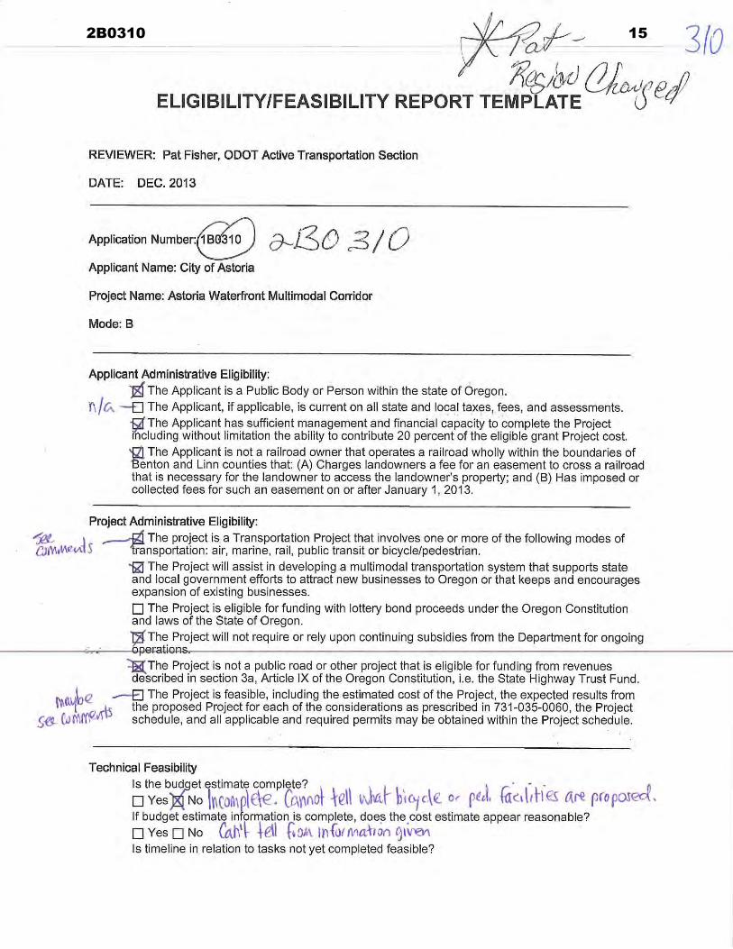
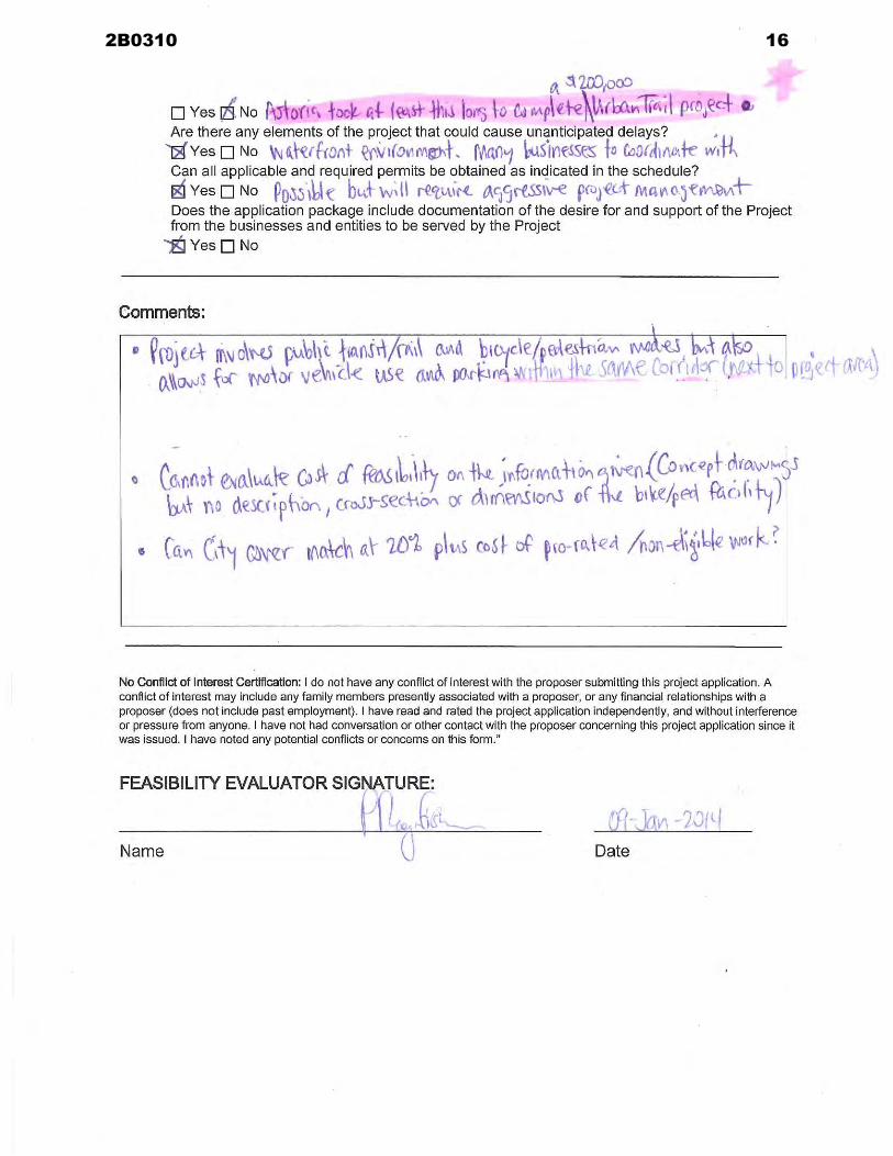
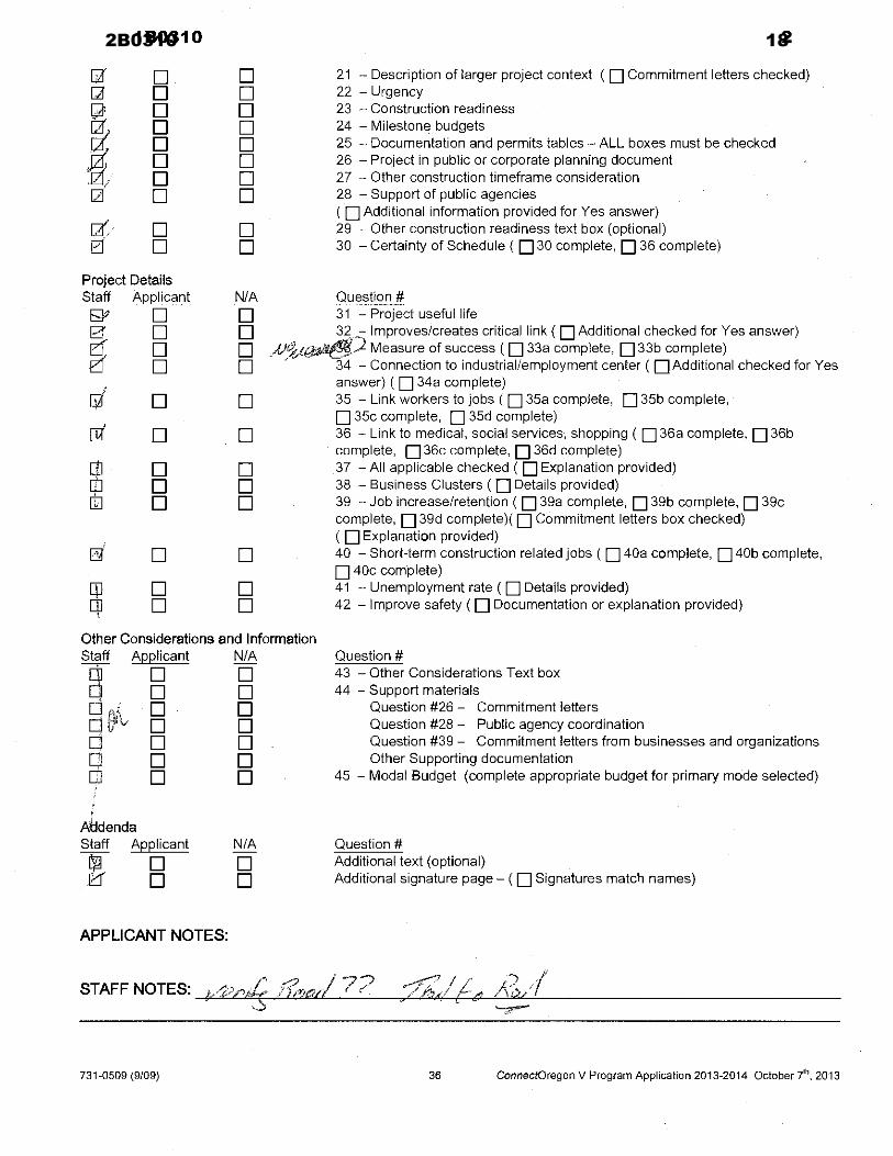
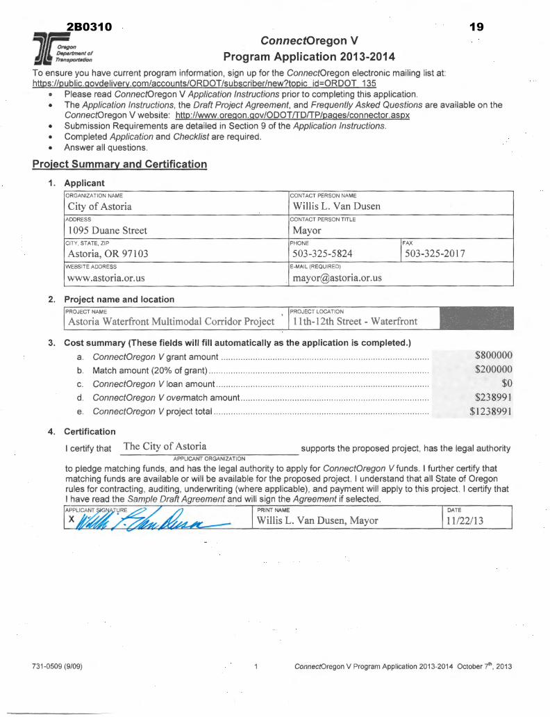
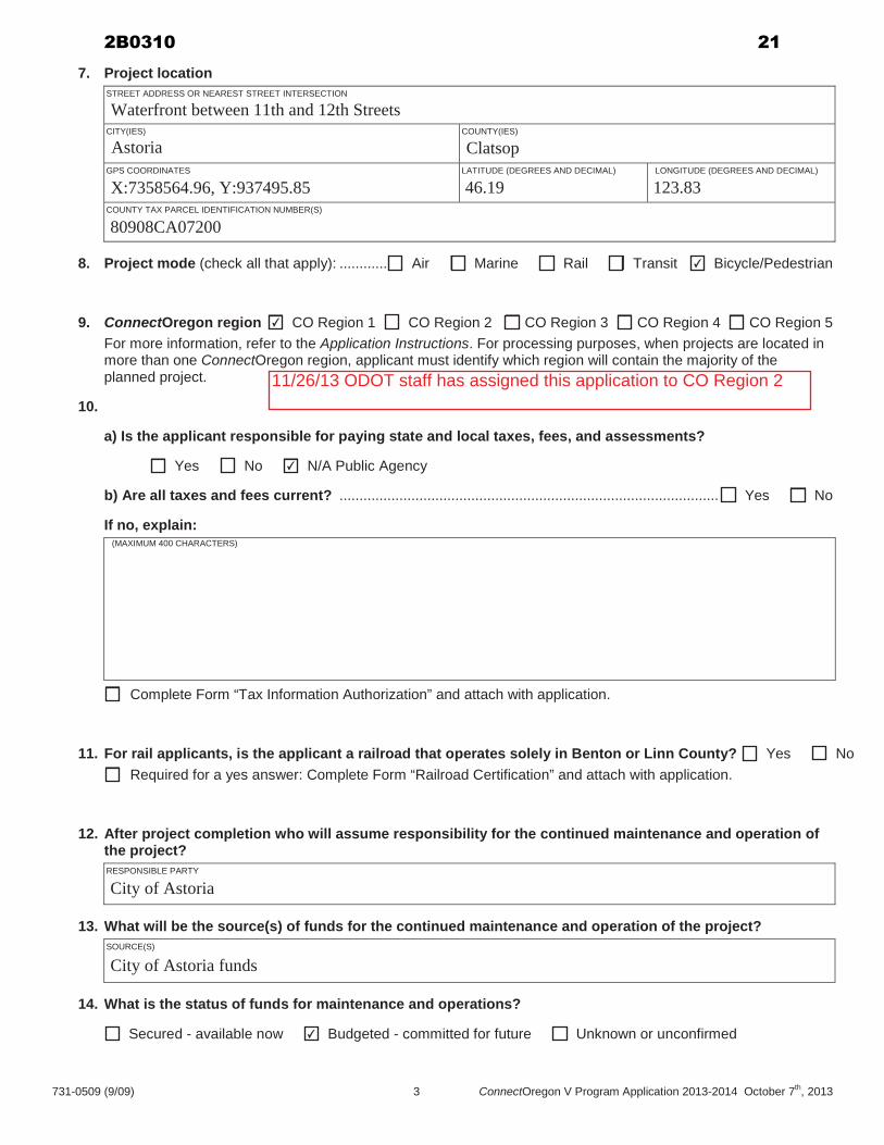
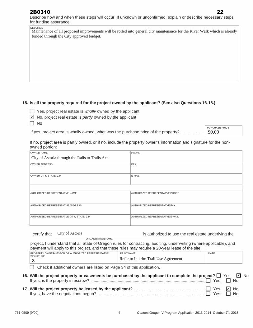
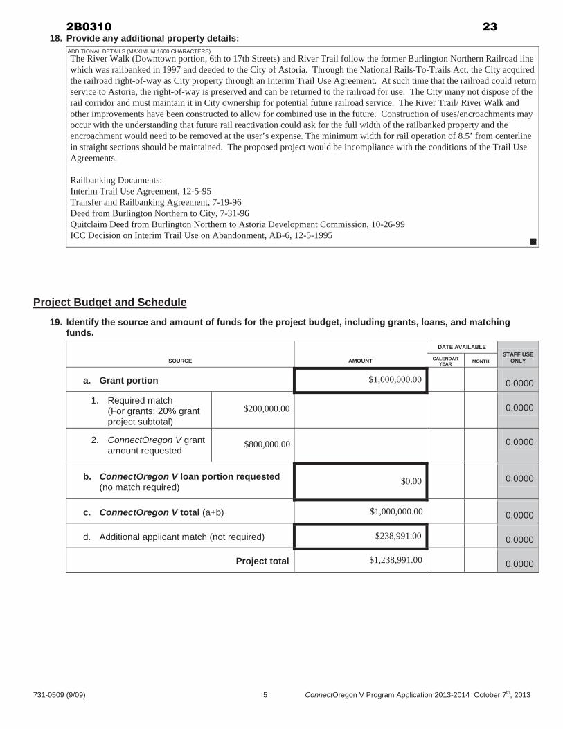
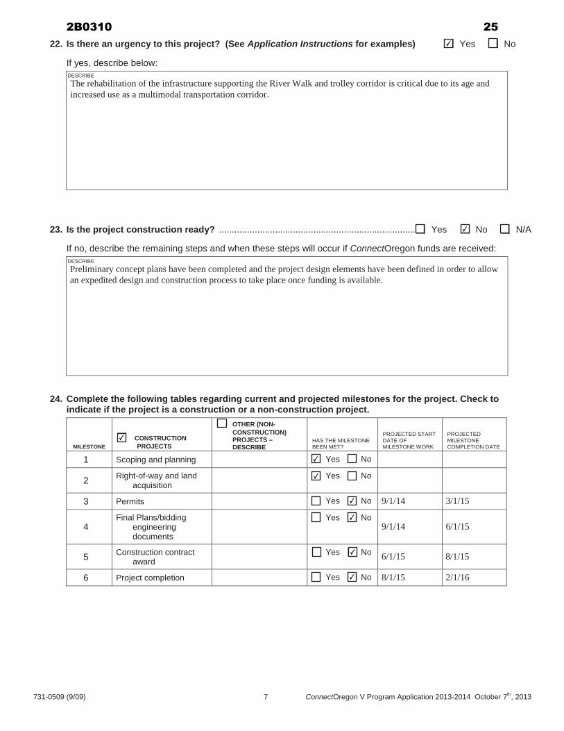
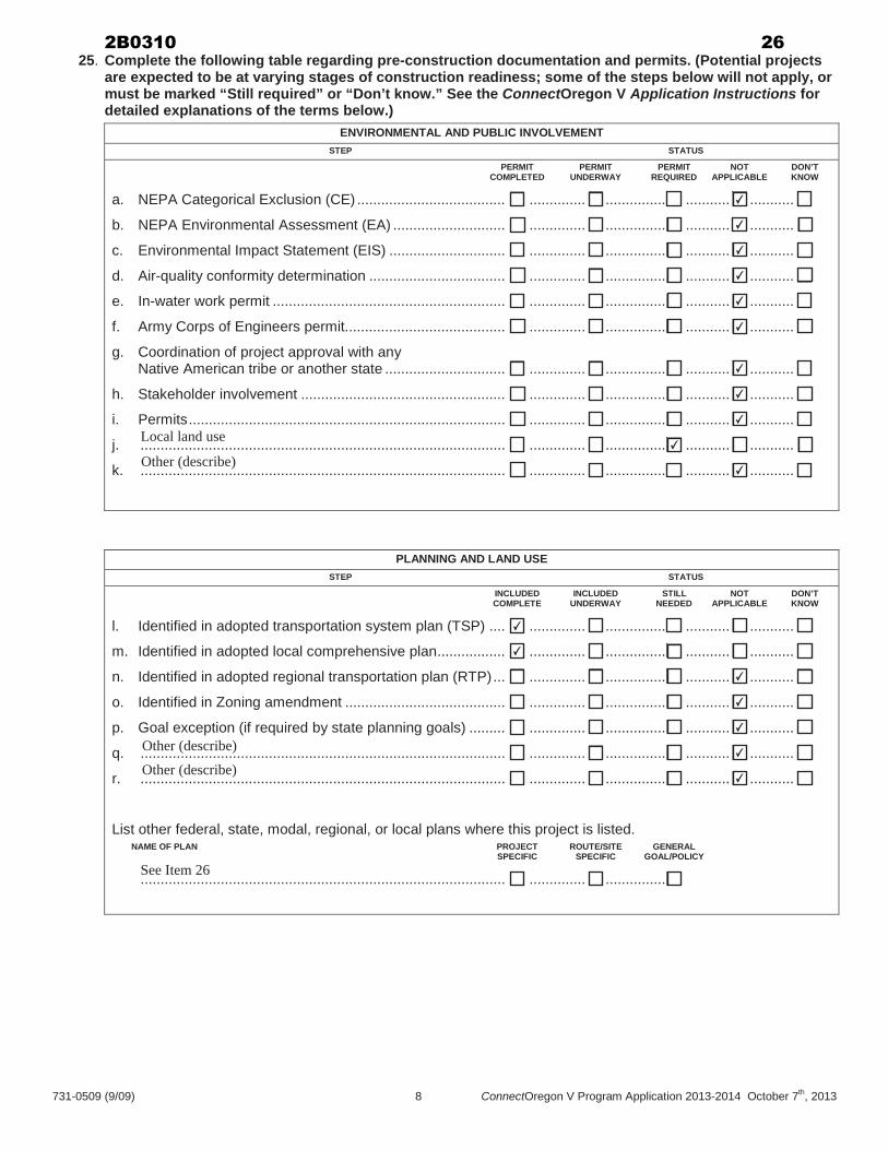
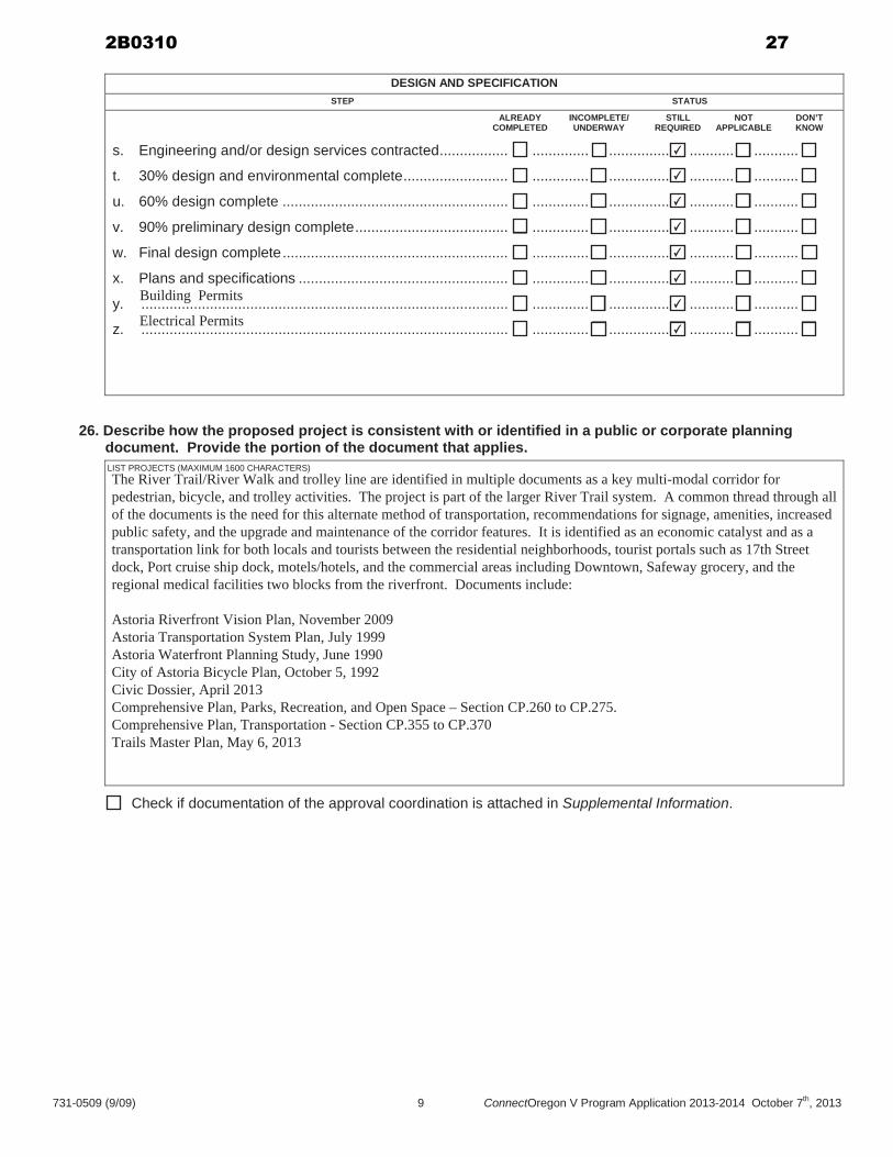
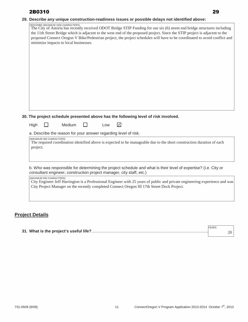
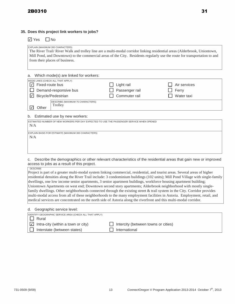
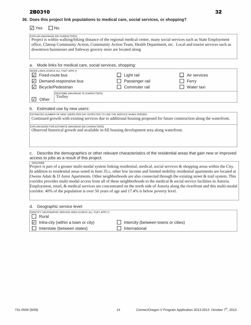
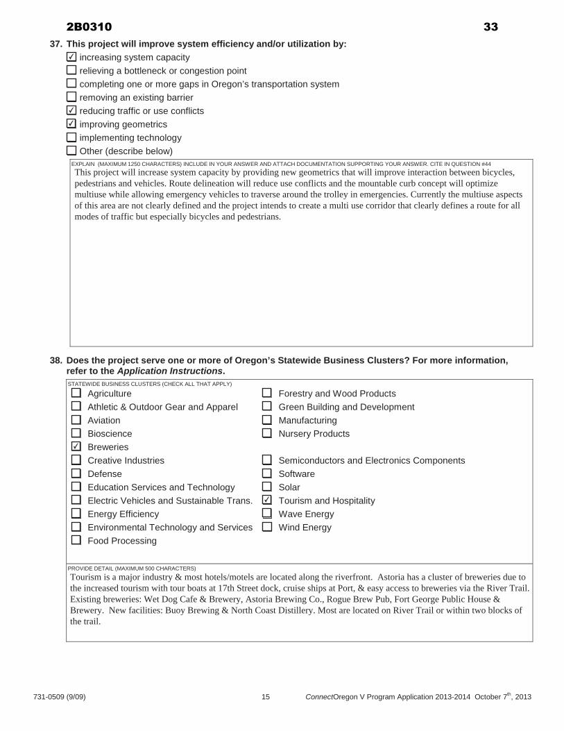
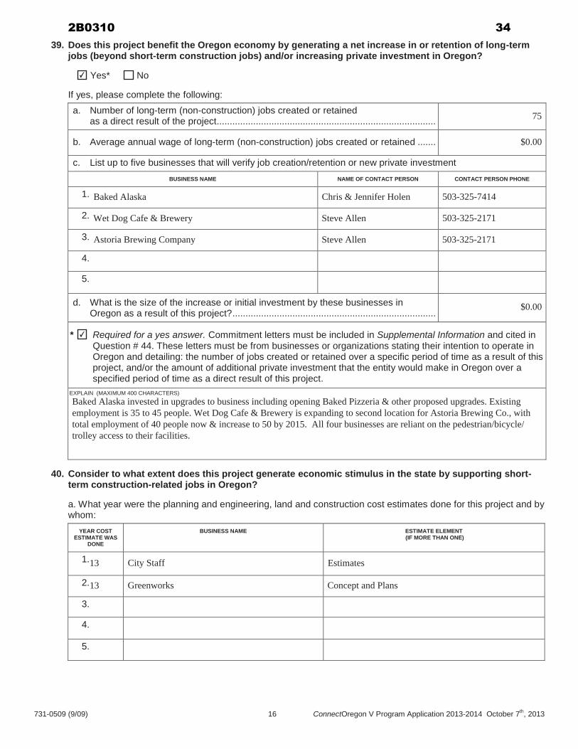
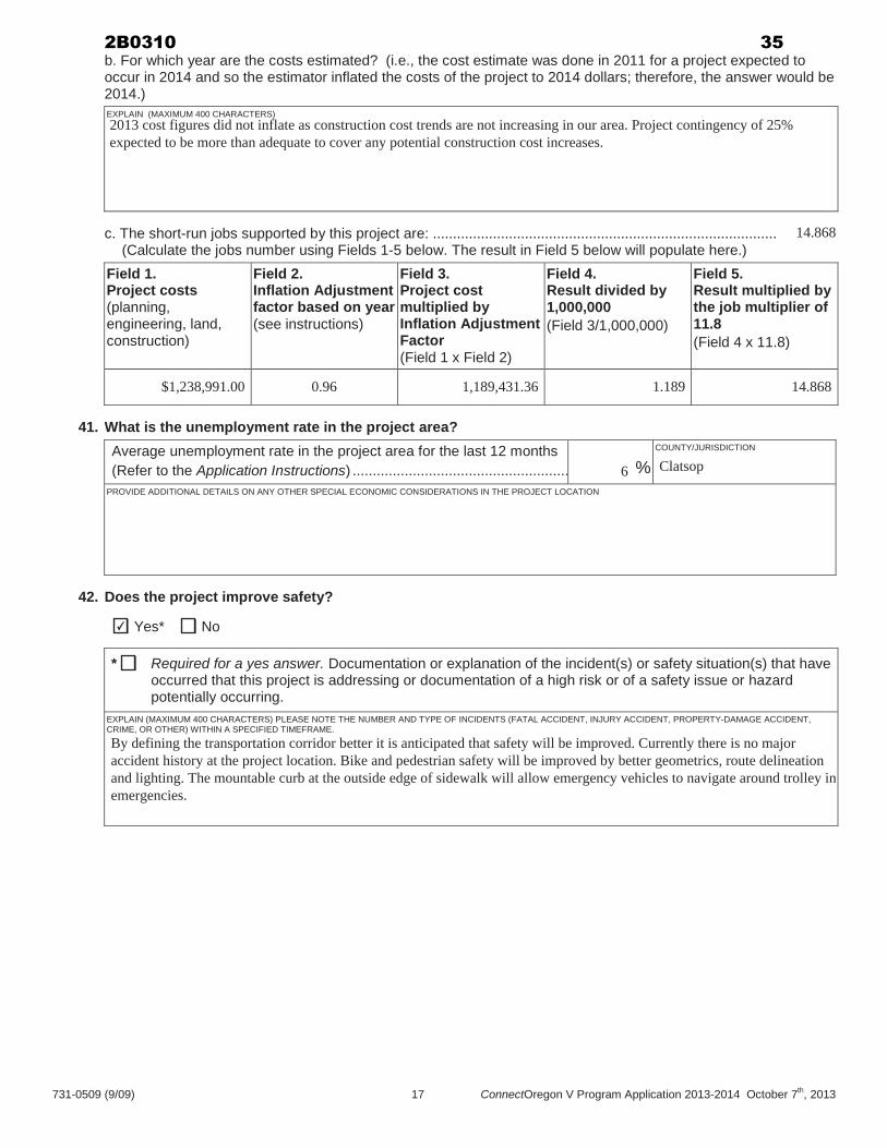
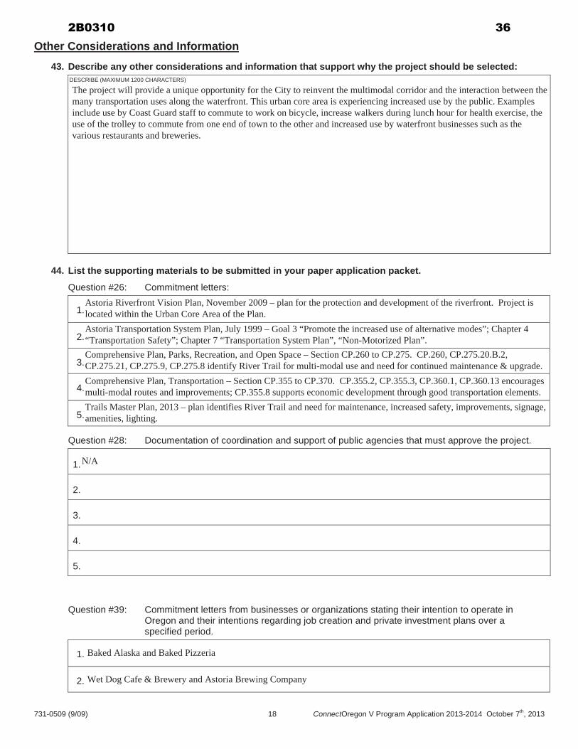
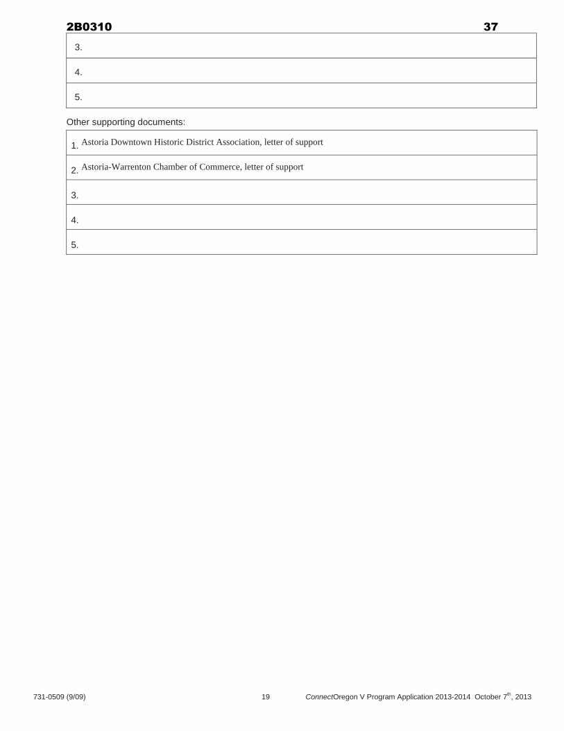
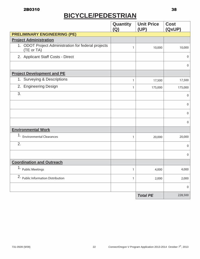
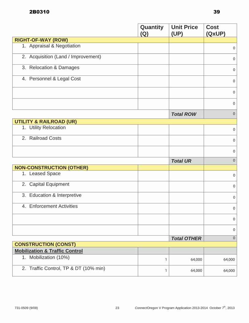
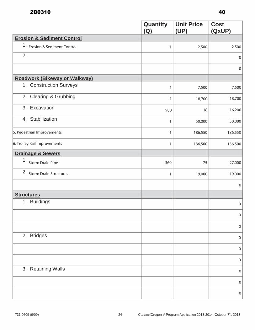
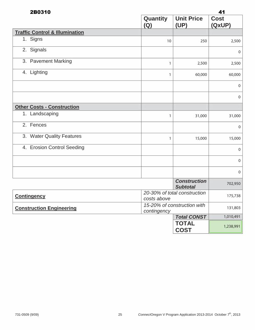
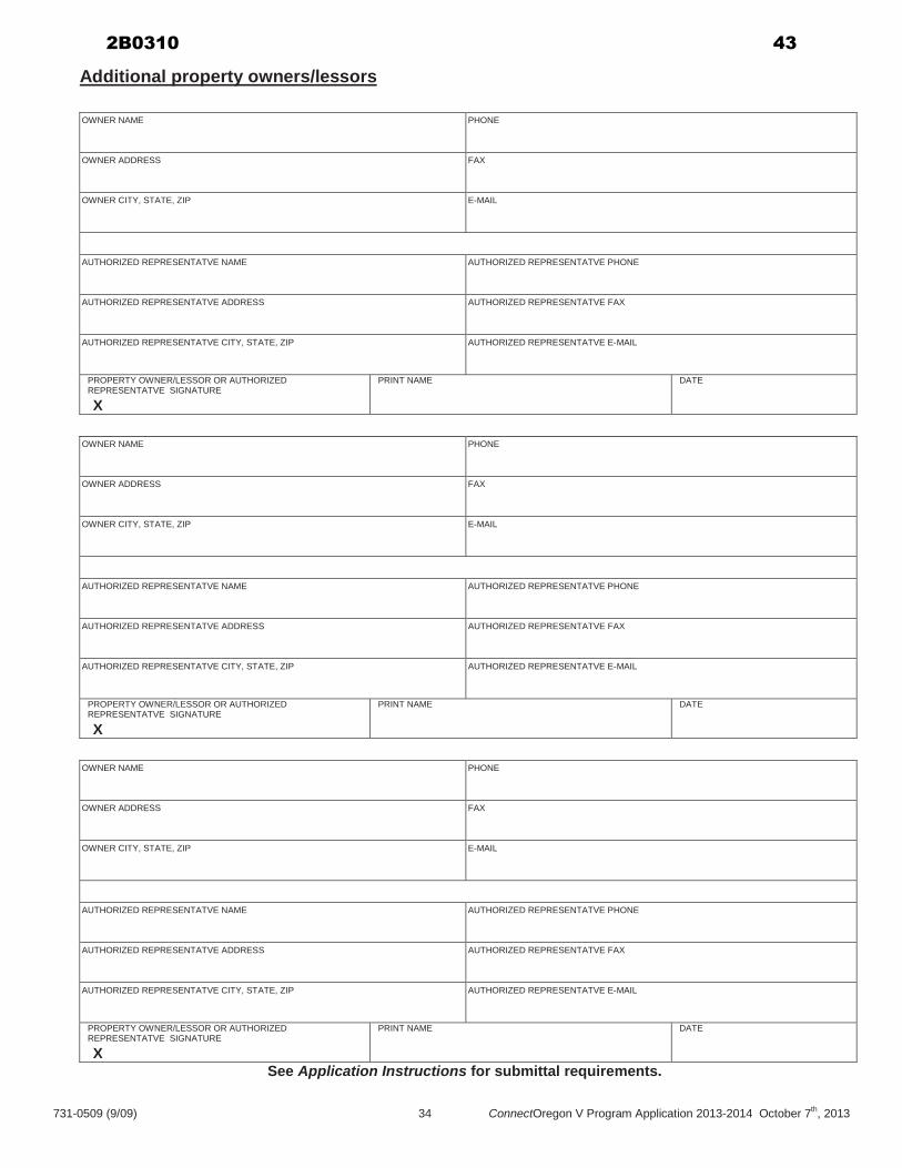
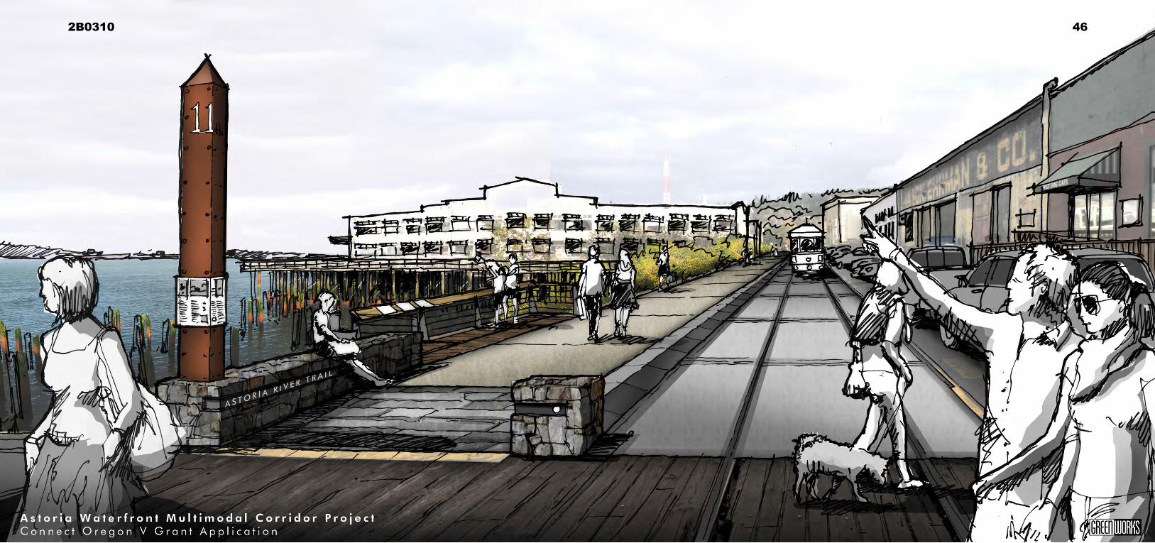
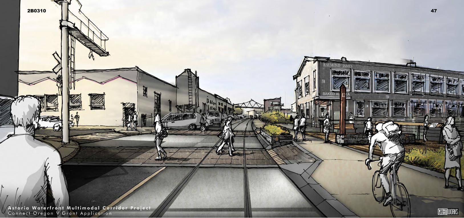
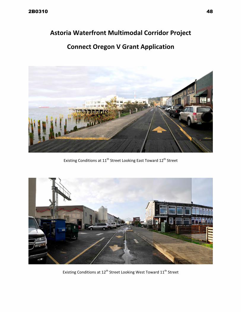
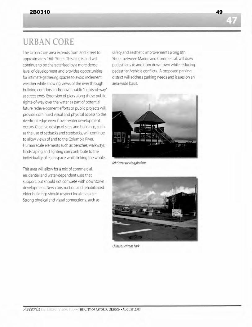
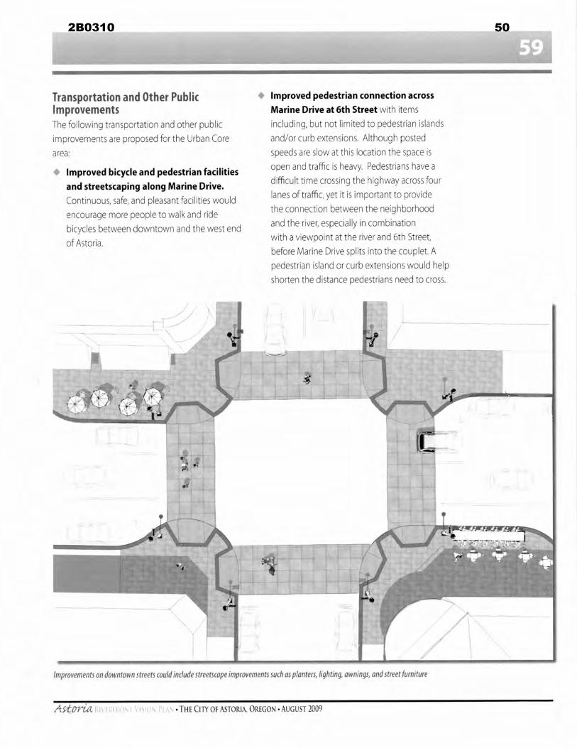
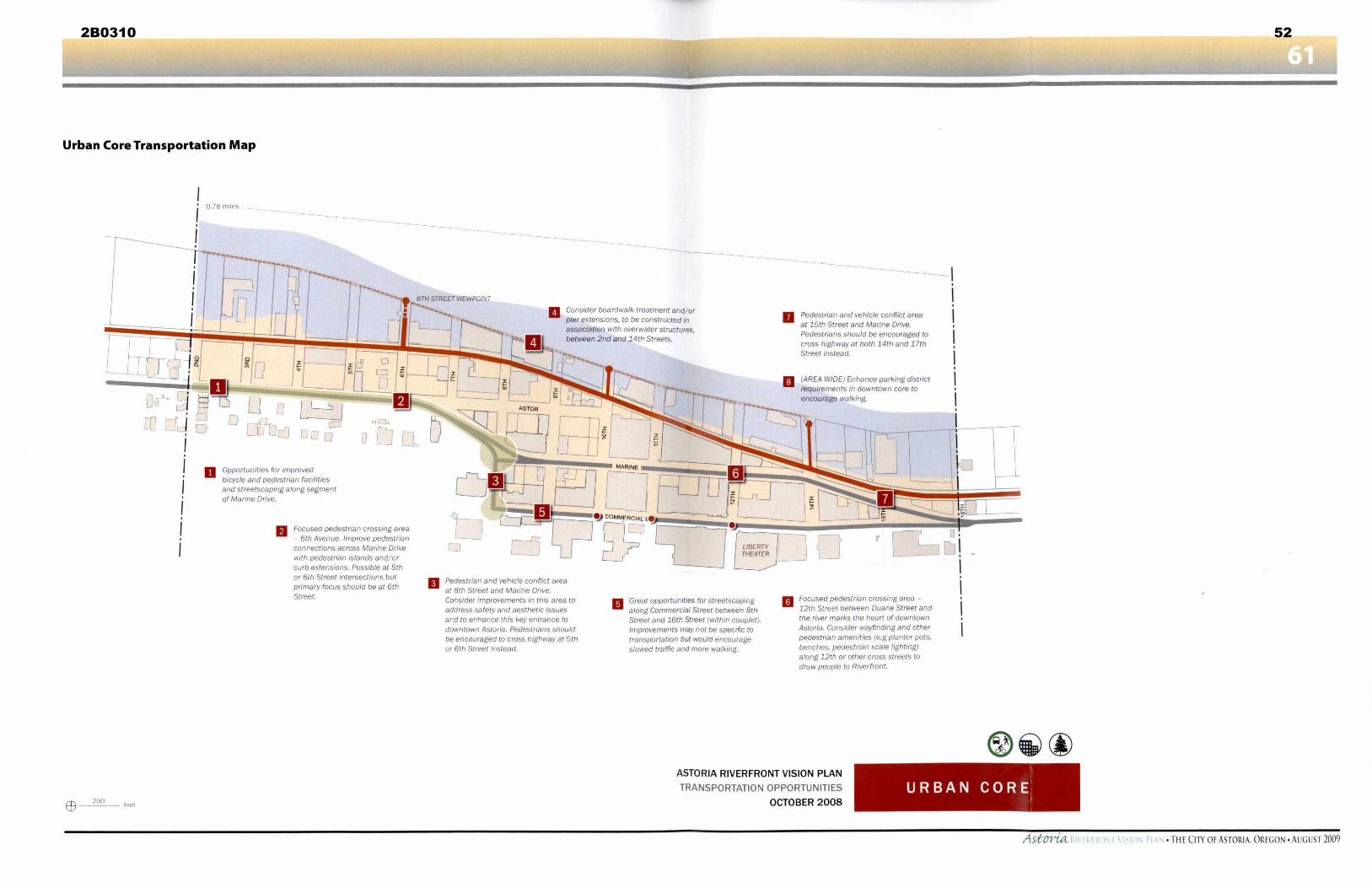
1
Astoria Transportation System Plan July 1999 Excerpts
Chapter 2 Public InvolvementGoals and Objectives
GOALS AND OBJECTIVES
The following goals and objectives are recommended by the TAC for the Astoria Transportation System Plan
These goals and objectives are derived from the public input obtained through questionnaires and an open house
and issuepriorities identified by the TAC
GOAL 3 Promote the increased use of alternative modes
Objectives
Identify measures to resolve physical impediments to circulation for alternative modes
Improve pedestrian circulation within and between neighborhoods and commercial centers
Ensure connections to the existing pedestrian system with new developments
Identify intersection improvements that enhance pedestrian safety
Provide additional sidewalks and improve existing sidewalk pavement for pedestrian safety and access
Ensure connections to bicycle paths with the new county fairgrounds
Improve bicycle and pedestrian crossings for US 30 101 and OR 202
Improve bicycle and pedestrian facilities on the New Youngs Bay Bridge
Construct riverwalkbicycle path around the city
Identify measures to maintain and increase transit usage including coordination of existing transit
services extended service hours more frequent service transit connections to airport and cruise ships
and improved cross-town transit
Identify measures to address the lack of truck facilities
Utilize the abandoned Burlington Northern railroad right-of-way for pedestrianbicycle uses and rail
bank it for potential future rail use
In coordination with the Port of Astoria identify measures to obtain and maintain regularly scheduled
air service and to improve access to the airport
Assess opportunities and constraints associated with increased water transportation including impacts
of cruise ships Lewis and Clark Greenway opportunities lack of camping facilities for
canoeistskayakers lack of transient mooragesovernight tie-ups and reduced truck traffic to Port
properties
2B0310 53
2
Assess the role of telecommunications as a transportation mode
Chapter 4 Transportation SAFETY
OREGON TRANSPORTATION SAFETY ACTION PLAN (OTSAP)
When considering safety issues for roadways in the State of Oregon the Oregon Transportation Safety Action
Plan (OTSAP) is a primary resource The OTSAP is part of the 1992 Oregon Transportation Plan which
identifies major issues and agenda items for transportation improvements and policy statewide The OTSAP
was also adopted by the Oregon Transportation Committee in June 1995 The Safety Action Plan focuses on
significant transportation related safety problems It also provides guidance for investment directions
A total of 70 actions in the OTSAP were chosen by the Transportation Safety Action Plan Advisory Committee
Eight key actions are associated with transportation-related deaths and injuries and should be implemented by
the year 2000 Three high priority key actions address the critical concerns in the area of traffic safety records
statewide incident management programs and pedestrian safety and traveling Local agencies are responsible
for the following key actions
Support for Local Transportation Safety Program
Support for Pedestrian Safety and
Chapter 7 Transportation Systems Plan
NON-MOTORIZED PLAN
The Transportation Planning Rule and Goal 12 require that planning be done for all modes of travel This
includes non-motorized travel as well as the vehicular modes This section provides plans designed to improve
the ability of travelers to choose bicycles or walking as a mode of transportation within Astoria All non-
motorized improvement projects included in the Bicycle Plan and Pedestrian System Plan are summarized in
Table 7-4 with the locations shown on Figure 7-10 in the projects list section of this chapter
Bicycle Plan
The current Bicycle Plan for the City of Astoria was adopted on October 5 1992 This plan outlined the bicycle
plans and policies for the city from 1992 to 2012 The bicycle facilities recommended in the Astoria TSP
support the recommendations made in the Astoria Bicycle Plan with some modifications through street
improvement projects specific bicycle projects and recommended street design standards (Figures 7-3 through
7-9)
Where new bike lanes are recommended they will be one-way four to six feet wide and will be located adjacent
to the curb except where there is curb parking a right-turn lane or other mitigating factor Where these
conditions occur the bike lane will be located between the through travel lane and the parking or right-turn lane
The bike lane will be marked in the same direction as the adjacent travel lane The striping shall be done in
conformance with the Manual on Uniform Traffic Control Devices
Bicycles are legally classified as vehicle which may be ridden on most public roadways in Oregon Because of
this bicycle facilities shall be designed to allow bicyclists to emulate motor vehicle drivers Shared roadway
facilities are common on city street systems On a shared roadway facility bicyclists share normal vehicle lanes
with motorists Where bicycle travel is significant these roadways shall be signed as bicycle routes
2B0310 54
3
The bikeways on new streets or streets to be improved as part of the street system plan shall be added when the
improvements are made The implementation program identifies an approximate schedule for these
improvements
On arterial and collector streets not scheduled to be improved as part of the street system plan improvements
shall be implemented based on traffic volumes When forecast traffic volumes exceed 2500 to 3000 vehicles
per day bike lanes shall be added to the existing roadway The striping of bike lanes on streets that lead directly
to schools shall be high priority Bikeways on local residential streets will only be signed as a route because the
vehicular traffic volume is low on these streets and exclusive bike lanes are not necessary
In cases where a bikeway is proposed within the street right-of-way the roadway pavement (between curbs)
shall be widened to provide a five-foot bike lane (collector streets) or a four-foot bikeway (one way arterial
streets) as shown on the cross sections in Figures 7-3 through 7-9 Bike lanes on one-way streets shall be
located on the right side of the roadway be one-way and flow in the same direction as vehicular traffic The
striping shall be done in conformance with the Manual on Uniform Traffic Control Devices In cases where
curb parking will exist with a bike lane the bike lane will be located between the parking and travel lanes In
some situations curb parking may have to be removed to permit a bike lane
Bicycle racks for parking have been installed at key locations around the city in the past This practice should
be continued as development or redevelopment occurs Bicycle parking racks should be installed at all major
attractions
Pedestrian System Plan
A complete pedestrian system should be implemented in the city Every paved street should have sidewalks on
both sides of the roadway as shown on the cross sections in Figure 7-3 through 7-9 Sidewalks on residential
and collector streets shall have a five-foot-wide paved width Sidewalks along arterial streets will have widths
ranging between five and 12 feet they may be present on one or both sides of the road and may also be part of a
multi-use pathway with bicycle usage In commercial areas sidewalks should be a minimum of six feet wide
and at least eight feet wide in downtown areas
Pedestrian access on walkways shall be provided between all buildings including shopping centers and abutting
streets and adjacent neighborhoods (Ordinances specifying these requirements will be prepared in a separate
document)
Some sidewalks will be added as improvements to the street system are made The implementation program
identifies an approximate schedule for these improvements
To address some of the high priority locations a list of specific sidewalk improvements is included in the capital
improvement program
Costs for adding sidewalks are relatively low if the addition is within the existing right-of-way A five-foot-
wide sidewalk with no curb would cost about $9 per linear foot Adding a curb as well as a five-foot-wide
sidewalk would cost about $15 per linear foot In commercial areas an eight-foot-wide sidewalk with a curb
would cost about $20 per linear foot
Applying these costs to a typical block in Astoria would require about 300 linear feet of sidewalk For a five-
foot-wide sidewalk with curbs the cost would be approximately $4500 Without curbs the cost would be
approximately $2700 The cost of making the mid and low priority pedestrian improvements have not been
included in the total capital improvement program cost Instead it is recommended these improvements be made
as funding becomes available andor as development occurs
2B0310 55
City of Astoria Comprehensive Plan
Parks Recreation and Open Space Element - 1
PARKS RECREATION AND OPEN SPACE ELEMENT Excerpt
CP275 Policies 8 The Parks and Community Services Department in cooperation with the Citys
Engineering Department and other agencies should recommend and periodically update a long range park and trail maintenance and improvement program
[CP2758 amended by Ordinance 06-05 June 19 2006 amended by Ordinance
13-04 May 6 2013] 9 Ways should be explored for the development of hiking and bike trails along
appropriate City streets railway rights-of-way utility corridors and park access routes as per recommendations in the Transportation System Plan and the Recreational Trail Master Plan To the extent possible such trails will utilize existing City maintained trails and provide linkages to major park lands and other public facilities Planning for trails must consider such limitations as topography climate maintenance and development costs adjacent landowner concerns legal access to the trails and should emphasize intensive use areas
[CP2759 amended by Ordinance 06-05 June 19 2006 amended by Ordinance 13-04 May 6 2013]
10 To the extent possible open space park features and landscaping will be
considered in specific downtown redevelopment projects and proposals Pedestrian shelters street furniture and similar improvements can add to the appeal of the Citys center
12 The City will continue its efforts to improve public access to the shoreline
through a The construction of public access points pathways and street ends b The encouragement of public access projects in conjunction with private
waterfront development actions possibly through the use of local improvement districts andor grant funds and
c The protection of street ends and other public lands from vacation or sale
where there is the potential for public access to the water The City will work with the Division of State Lands (DSL) to determine the status of submerged and submersible lands adjacent to the City street ends [CP27512 added by Ordinance No 90-19 July 2 1990]
2B0310 56
City of Astoria Comprehensive Plan
Parks Recreation and Open Space Element - 2
19 The Astoria Column Park should be used as the main trail head for the City trail
system However additional designated parking areas considered should be located near the Cathedral Tree on Irving Avenue at the ends of James Street Franklin Avenue Spruance Avenue at Clatsop Community College at the west end of the River Walk at Smith PointPort area and at the proposed new sports complex located at the former Transfer Station (1800 Williamsport Road)
[CP27519 added by Ordinance 06-05 June 19 2006 amended by Ordinance 13-04 May 6 2013]
20 The City trail system use should be limited as follows A Pedestrian Trails Pedestrian trails in the City permit foot traffic only
Pedestrian trails include the Clatsop Community College Connector Richard Fencsak Cathedral Tree Trail City Water Reservoir Path Middle School Path and the Coast Guard Trail
B Multiple-Use Trails
1 Soft Surface Trails Bike and pedestrian use are the only allowed
uses on soft-surface trails designated as multiple-use Multiple-Use Soft Surface Trails include new trails that are developed within the Urban Forest
2 Hard Surface Trails Multiple-use trails with hardened surfaces
such as the River Walk also allow other non-motorized activities such as skateboarding and rollerblading Multiple-Use Hard Surface Trails include the River Walk Shively Park Pipeline Road and any new hard surfaced trails that are developed within the Urban Forest
C Trail use classifications shall not exclude use by ldquowheelchairsrdquo as defined
in the American With Disabilities Act
[CP27520 added by Ordinance 06-05 June 19 2006 amended by Ordinance 13-04 May 6 2013]
21 Trail improvement projects and new trail developments should follow
recommendations in the Trails Master Plan for trail design standards and amenities
[CP27521 added by Ordinance 06-05 June 19 2006 amended by Ordinance 13-04 May 6 2013]
2B0310 57
City of Astoria Comprehensive Plan
Parks Recreation and Open Space Element - 3
22 The City should develop trail user maps and informational signage for the City Trail System
[CP27522 added by Ordinance 06-05 June 19 2006]
23 The City will create an active urban downtown park space that will incorporate a
wide variety of uses for all downtown visitors and workers including areas for uses such as picnics outdoor concerts movies chess workers to have lunch and other activities
[CP27523 added by Ordinance 12-04 2-6-12]
2B0310 58
TRANSPORTATION Excerpt
CP355 Transportation Goals The City will work toward 1 The maintenance of a safe and efficient transportation system 2 The provision of several types of transportation including public transit bicycle and
pedestrian systems 3 The implementation of the Murase Plan for waterfront revitalization [Section CP355(3) amended by Ordinance 91-14 6-17-91] 4 The reduction of traffic congestion on Marine Drive and in the downtown area 5 The conservation of energy in transportation by encouraging forms other than private
vehicles 6 The continued support of transportation for disadvantaged persons such as
wheelchair ramps in the downtown area and the senior citizen bus 7 The coordination of transportation with land use designations especially along the
Columbia River shoreline 8 The support of economic development activities through the improvement of the
transportation system and 9 Cooperation with other agencies involved in transportation including the Port of
Astoria the Oregon Department of Transportation the State Highway Division Clatsop County and the Public Utility Commission
CP360 Transportation Policies 1 The City will continue to support public transportation for all segments of the
community [Section CP360(1) amended by Ordinance 91-14 6-17-91] 13 The City will consider the use of its bike and trail route allocation ($8375 in 1978)
when enough funds are available to complete a project An ad hoc committee should be appointment to make recommendations on possible projects to the Planning Commission and City Council The City will coordinate its efforts with the Clatsop County Bike Route Committee
2B0310 59
[Section CP360(13) amended by Ordinance 91-14 6-17-91] 14 The City will cooperate with the State Highway Division in the protection and
improvement of the Oregon Coast Bike Route [Section CP360(14) added by Ordinance 81-16 11-16-81]
2B0310 60
Astoria Recreational Trail Master Plan
2013 Excerpt
1
Recommended Actions
Recommended Actions are a direct product of feedback provided from
the people and agencies that were included in the public engagement
process
Process
Comments and feedback collected from the public engagement strategies listed in the
previous chapter were transferred to action statements for the City of Astoria to consider
including in the 2013 Trails Master Plan These draft actions were reviewed by the Trails
Advisory Group City staff the Parks Board the Astoria Planning Commission and the general
public during the second round of public engagement Recommendations and comments
from these efforts are included in Appendix B2 Actions were revised and finalized based on
this feedback
Vision
The City of Astoria aims to efficiently and effectively develop a trail network that provides trail
users of all abilities and interests a variety of trail experiences
Actions
Actions are grouped into the following categories Trail Maintenance amp Improvements New
Trail Development Trail Design Standards and Amenities Trail Regulations and Safety and
Trail Management and Funding The actions are given numbers however they are not listed
in order of importance or priority
1 Trail Maintenance amp Improvements Actions for Train Maintenance amp Improvements
13 Develop a MaintenanceImprovement Plan that addresses the specific
needs for each of the trails The plan should include frequency for regular
clearing and a prioritized list of repairs and needed improvements A
maintenanceImprovement Plan should address the following trail specific
considerations and desires collected through this planning process
135 Prioritize the following trail improvements to the River Walk
Work with Police Department to increase patrolling of trail
Increase signage to encourage good trail etiquette and
Develop a plan to manage invasive species
2B0310 61
Astoria Recreational Trail Master Plan
2013 Excerpt
2
2 New Trail Development The following is a list of new trails to be constructed in Astoria There was strong support for
new trails that increased connectivity between existing trails and some preference for new
trails that would create new experiences such as developing longer routes for runners and
bikers to enjoy
Actions for New Trail Development
21 Expansion of the River Walk eastwards towards Tongue Point
22 Expansion of the River Walk eastwards towards Clatsop Community Collegersquos MERTS
campus
23 Expansion of the River Walk along Youngs Bay (along Hwy 202) to Williamsport Road
24 Provide clear connections from the River Walk to the Astoria Column
25 Create trail connections from the eastern River Walk extensions to the urban
forest trails
210 Develop a connector from Irving Road to the River Walk at Columbia
Memorial Hospital (2111 Exchange)
3 Trail Design Standards amp Amenities
31 Actions for Trailheads
311 Include dog bags for pet waste at each trailhead
312 Provide garbage cans at each trailhead
313 Provide trail name wayfinding and regulation signing at each trailhead
(see signage section)
32 Actions for Trails
321 Provide connectivity by creating loops whenever possible
322 Route trails to take advantage of scenery and viewpoints
323 Provide seating opportunities occasionally along trails
324 Provide soft surface path for runners along paved trails when possible
325 Urban trails should be wider than forested trails to accommodate for
multiple uses
326 Future postsbollards installed along the River Walk should include reflectors
or lights
327 When designing extensions of the River Walk account for both bike and
pedestrian safety measures When feasible include bike friendly surfaces
2B0310 62
Astoria Recreational Trail Master Plan
2013 Excerpt
3
33 Actions for Signage
331 Develop trail maps for the City of Astoria that can be posted online and
printed for public use Map should include only official trails trail names
mileage information allowed uses mountain bike access pointsstaging
areas and some key destinations including parks museums historic
landmarks cruise ship landings significant businesses and restroom
locations
332 Develop official names for each trail in Astoria so that it can be signed and
clearly defined for public use
333 Add signage with trail name map of its location and restricted uses at
each trailhead
334 Add mile markers along trail routes
336 Consider including signage providing education on trail etiquette along
multi-use trails or at trailheads
337 Consider including interpretive signage at appropriate locations
4 Trail Regulations and Safety
Recommendations for Trail Regulations and Safety
41 Prohibited activities include use of firearms target practice equestrian
and motorized bikes or vehicles (Note ldquowheelchairrdquo as defined in the
American With Disabilities Act is not included as a prohibited motorized
vehicle)
42 Coordinate with public safety agencies to develop a plan to address illicit
behavior throughout the trail system
5 Trail Management amp Funding
Recommendations for Trail Management amp Funding
51 Trail funds should be prioritized for maintenance first and then for new trail
development
52 Implement an adopt-a-trail program for the City to utilize assistance from
the many potential volunteer groups in the area
53 Work with partners to develop a plan for invasive species control
54 Designate a Trail Coordinator within the Parks Department to track progress
coordinate trail projects and proactively engage volunteers to accomplish
trail goals
55 Develop a ParksCity internship or AmeriCorps position to assist the Trails
Coordinator
56 Work with partners to establish walkrunbike events along trails to raise
money and awareness about trails Utilize these events as opportunities to
recruit volunteers host workdays for trail improvements advertise
donorspartners and provide information about proper trail etiquette
2B0310 63
S
November 20 2013
Connect Oregon V Selection Committee
RE ASTORIA WATERFRONT MULTI-MODAL CORRIDOR PROJECT
We are writing to express support for the City of Astorias Connect Oregon V grant application for the rehabilitation of the infrastructure supporting the Astoria Trolley line and River Trail Baked Alaska restaurant located at 1 12th Street Mise en Place and Baked Pizzeria in the same building are three businesses we own within the proposed project area between 11th and 12th Streets along the River Trail
Baked Alaska restaurant opened in August 2000 and moved to its current location on the Riverfront in April 2001 We expanded with a culinary shop Mise en Place a few years later and recently opened the Baked Pizzeria in the same building Our growth and expansions with two other businesses are a direct result of the improvements the City made to the Riverfront with construction of the River Trail and initiation of the Riverfront trolley The business has flourished at this location and we have invested in the building with many upgrades over the years including a complete remodel this year We are currently planning upgrades to include additional outdoor seating area upgraded building signage and a new screening for the solid waste disposal area
The success of our expansions and upgrades depend on the ability to draw customers to the site from the River Trail and trolley Failure of the infrastructure supporting this corridor would be detrimental to our continued operation at this location The trolley line and River Trail provide an alternate routemode of transportation for the local community and tourists to this area
We would hope that the Selection Committee will consider this application and approve the grant to support Astorias much needed enhancement of its transportation infrastructure
Our continued investment in the upgrade and expansion of our riverfront businesses is contingent upon the continued maintenance of this vital pedestrian bicycle and trolley corridor connecting the downtown with other commercial and residential parts of the community Our combined businesses currently employ 35 people with a seasonal increase to 45 employees during the tourist season
We are committed to the economic growth of Astoria and I urge you to give full and favorable consideration to the City of Astorias ASTORIA WATERFRONT MULTI-MODAL CORRIDOR PROJECT and Connect Oregon V application
If you have any questions regarding this matter please contact me at 503-325-7414 or jenniferbakedakcom or chefholenbakedakcom Thank you for your consideration of this matter
Chris a d Jennifer Nolen Baked Alaska
1 12th Street Astoria OR 97103
2B0310 64
Sincerly
Steve Wet Dog Cafe and Brewery Astoria Brewing Company
November 20 2013
Connect Oregon V Selection Committee
RE ASTORIA WATERFRONT MULTI-MODAL CORRIDOR PROJECT
I am writing to express my support for the City of Astorias Connect Oregon V grant application for the rehabilitation of the infrastructure supporting the Astoria Trolley line and River Trail The Astoria Brewing Company located at 1296 Marine Drive and Wet Dog Cafe and Brewery located at 144 11th Street are two businesses I own at the opposite ends of the proposed project area between 11th and 12th Streets along the River Trail
The Wet Dog business opened in 1995 and expanded to include a brewery in 1997 as a direct result of the improvements the City made to the Riverfront with construction of the River Trail and initiation of the Riverfront trolley The business has flourished at this location and we have invested in the building with many upgrades over the years including installation of a solar water heater on the roof and the installation of moveable full wall windows on the north to open the business up to the River Trail and Riverfront
We have recently decided to expand the Astoria Brewing Company and are in the process of restoring a second building to allow for a production brewery bar and tasting room The success of this expansion depends on the ability to draw customers to the site from the River Trail and trolley Failure of the infrastructure supporting this corridor would be detrimental to our continued operation at this location The trolley line and River Trail provide an alternate routemode of transportation for the local community and tourists to this area
We would hope that the Selection Committee will consider this application and approve the grant to support Astorias much needed enhancement of its transportation infrastructure
Our continued investment in the upgrade of these riverfront buildings is contingent upon the continued maintenance of this vital pedestrian bicycle and trolley corridor connecting the downtown with other commercial and residential parts of the community Our two businesses employ 40 people at this time It is our hope to have 45 staff by 2015
We are committed to the economic growth of Astoria and I urge you to give full and favorable consideration to the City of Astorias ASTORIA WATERFRONT MULTI-MODAL CORRIDOR PROJECT and Connect Oregon V application
If you have any questions regarding this matter please contact me at 503-325-2171 or sallenallencpascom Thank you for your consideration of this matter
PO Box 261 Astoria OR 97103
2B0310 65
Dulcye ylor President
November 20 2013
Connect Oregon V Selection Committee
RE ASTORIA WATERFRONT MULTI-MODAL CORRIDOR PROJECT
Dear Selection Committee
We are writing to express support for the City of Astorias Connect Oregon V grant application for the rehabilitation of the infrastructure supporting the Astoria Trolley line and River Trail We would hope that the Selection Committee will consider this application and approve the grant to support Astorias much needed enhancement of its transportation infrastructure The project would also improve the existing corridor providing better bicycle and pedestrian safety and access
The Astoria Downtown Historic District Association (ADHDA) believes an investment of this nature will provide significant long-term benefits to the transportation network and economic development of the region The trolley line and River Trail provide an alternate routemode of transportation for the local community and tourists to this area The current condition of the supporting infrastructure is failing rapidly and can no longer continue to support these facilities creating an unsafe condition Use of this transportation corridor by pedestrians bicyclists and the trolley support the local businesses and help to sustain existing jobs businesses and services essential to the local economy
The corridor serves as a main downtown portion of the east-west trolley lineRiver Trail that connects the downtown with the rest of the Citys waterfront operations and businesses It is a vital transportation component for local business especially during high tourist visitation months When completed the River Trail rehabilitation and expansion will provide a safe alternative mode of transportation for both locals and tourists to access and connect local businesses medical services and residential neighborhoods
I urge you to give full and favorable consideration to the City of Astorias ASTORIA WATERFRONT MULTI-MODAL CORRIDOR PROJECT and Connect Oregon V application
If you have any questions regarding this matter please contact me at 503-791-7940 or Alanaastoriadowntowncom Thank you for your consideration of this matter
Sincerely
ASTORIA DOWNTOWN HISTORIC DISTRICT ASSOCIATION
0601)-4A144 Alana Garner Director
PO Box 261 Astoria OR 97103
2B0310 66
A sr0R1 -v7A R vioN
November 20 2013
Connect Oregon V Selection Committee
RE ASTORIA WATERFRONT MULTI-MODAL CORRIDOR PROJECT
Dear Selection Committee
On behalf of the Astoria-Warrenton Chamber of Commerce I am writing to express my support for the City of Astorias Connect Oregon V grant application for the rehabilitation of the infrastructure supporting the Astoria Trolley line and River Trail We would hope that the Selection Committee will consider this application and approve the grant to support Astorias much needed enhancement of its transportation infrastructure The project would also improve the existing corridor providing better bicycle and pedestrian safety and access
I believe an investment of this nature will provide significant long-term benefits to the transportation network and economic development of the region Tourism is a major economic catalyst for the region and has increased exponentially since the creation of the Astoria River Trail corridor The trolley line and River Trail provide an alternate routemode of transportation for the local community and tourists to this area The current condition of the supporting infrastructure is failing rapidly and can no longer continue to support these facilities creating an unsafe condition Use of this transportation corridor by pedestrians bicyclists and the trolley support the local businesses and help to sustain existing jobs businesses and services essential to the local economy
The corridor serves as a main east-west trolley lineRiver Trail that connects the downtown with the rest of the Citys waterfront operations and businesses With the cruise ship moorage at the Port on the west end of the City and the 17th Street transient moorage and Columbia River Maritime Museum east of this project it is a vital transportation component for local businesses especially during high tourist visitation months When completed the River Trail rehabilitation will provide a safe alternative mode of transportation for both locals and tourists to access and connect local businesses medical services and residential neighborhoods
I urge you to give full and favorable consideration to the City of Astorias ASTORIA WATERFRONT MULTI-MODAL CORRIDOR PROJECT and Connect Oregon V application If you have any questions regarding this matter please contact me at 503-325-6311 or skipoldoregoncom Thank you for your consideration of this matter
Sincerely ASTORIA-WARRENTON CHAMBER OF COMMERCE
Skip Ha e Directo PO Box 176 Astoria OR 97103
2B0310 67
- City of Astoria ConnectOregon V Attachmentspdf
-
- 00ATTACHMENTS
- 01Birdseye_Context
- 02View_01_11th_Ave_West
- 03View_02_12th_Ave_East
- 04Existing Photos - Astoria Waterfront Multimodal Corridor Project
- 05Riverfront Vision Planexcerpt
-
- Page 1
- Page 3
- Page 4
- Fast scan to a color PDF large_1PDF
-
- Page 1
-
- 06Astoria Transportation System Plan
- 07CPPARKSexcerpt
- 08CPTRANSPORTATIONexcerpt
- 09Trails Master Planexcerpt
- 10Letter of Economic commitmentBaked Alaska
-
- Page 1
-
- 11Letter of Economic commitmentWet Dog
-
- Page 1
-
- 12Letter of SupportADHDA
-
- Page 1
-
- 13Letter of SupportChamber
-
- Page 1
-

2
Assess the role of telecommunications as a transportation mode
Chapter 4 Transportation SAFETY
OREGON TRANSPORTATION SAFETY ACTION PLAN (OTSAP)
When considering safety issues for roadways in the State of Oregon the Oregon Transportation Safety Action
Plan (OTSAP) is a primary resource The OTSAP is part of the 1992 Oregon Transportation Plan which
identifies major issues and agenda items for transportation improvements and policy statewide The OTSAP
was also adopted by the Oregon Transportation Committee in June 1995 The Safety Action Plan focuses on
significant transportation related safety problems It also provides guidance for investment directions
A total of 70 actions in the OTSAP were chosen by the Transportation Safety Action Plan Advisory Committee
Eight key actions are associated with transportation-related deaths and injuries and should be implemented by
the year 2000 Three high priority key actions address the critical concerns in the area of traffic safety records
statewide incident management programs and pedestrian safety and traveling Local agencies are responsible
for the following key actions
Support for Local Transportation Safety Program
Support for Pedestrian Safety and
Chapter 7 Transportation Systems Plan
NON-MOTORIZED PLAN
The Transportation Planning Rule and Goal 12 require that planning be done for all modes of travel This
includes non-motorized travel as well as the vehicular modes This section provides plans designed to improve
the ability of travelers to choose bicycles or walking as a mode of transportation within Astoria All non-
motorized improvement projects included in the Bicycle Plan and Pedestrian System Plan are summarized in
Table 7-4 with the locations shown on Figure 7-10 in the projects list section of this chapter
Bicycle Plan
The current Bicycle Plan for the City of Astoria was adopted on October 5 1992 This plan outlined the bicycle
plans and policies for the city from 1992 to 2012 The bicycle facilities recommended in the Astoria TSP
support the recommendations made in the Astoria Bicycle Plan with some modifications through street
improvement projects specific bicycle projects and recommended street design standards (Figures 7-3 through
7-9)
Where new bike lanes are recommended they will be one-way four to six feet wide and will be located adjacent
to the curb except where there is curb parking a right-turn lane or other mitigating factor Where these
conditions occur the bike lane will be located between the through travel lane and the parking or right-turn lane
The bike lane will be marked in the same direction as the adjacent travel lane The striping shall be done in
conformance with the Manual on Uniform Traffic Control Devices
Bicycles are legally classified as vehicle which may be ridden on most public roadways in Oregon Because of
this bicycle facilities shall be designed to allow bicyclists to emulate motor vehicle drivers Shared roadway
facilities are common on city street systems On a shared roadway facility bicyclists share normal vehicle lanes
with motorists Where bicycle travel is significant these roadways shall be signed as bicycle routes
2B0310 54
3
The bikeways on new streets or streets to be improved as part of the street system plan shall be added when the
improvements are made The implementation program identifies an approximate schedule for these
improvements
On arterial and collector streets not scheduled to be improved as part of the street system plan improvements
shall be implemented based on traffic volumes When forecast traffic volumes exceed 2500 to 3000 vehicles
per day bike lanes shall be added to the existing roadway The striping of bike lanes on streets that lead directly
to schools shall be high priority Bikeways on local residential streets will only be signed as a route because the
vehicular traffic volume is low on these streets and exclusive bike lanes are not necessary
In cases where a bikeway is proposed within the street right-of-way the roadway pavement (between curbs)
shall be widened to provide a five-foot bike lane (collector streets) or a four-foot bikeway (one way arterial
streets) as shown on the cross sections in Figures 7-3 through 7-9 Bike lanes on one-way streets shall be
located on the right side of the roadway be one-way and flow in the same direction as vehicular traffic The
striping shall be done in conformance with the Manual on Uniform Traffic Control Devices In cases where
curb parking will exist with a bike lane the bike lane will be located between the parking and travel lanes In
some situations curb parking may have to be removed to permit a bike lane
Bicycle racks for parking have been installed at key locations around the city in the past This practice should
be continued as development or redevelopment occurs Bicycle parking racks should be installed at all major
attractions
Pedestrian System Plan
A complete pedestrian system should be implemented in the city Every paved street should have sidewalks on
both sides of the roadway as shown on the cross sections in Figure 7-3 through 7-9 Sidewalks on residential
and collector streets shall have a five-foot-wide paved width Sidewalks along arterial streets will have widths
ranging between five and 12 feet they may be present on one or both sides of the road and may also be part of a
multi-use pathway with bicycle usage In commercial areas sidewalks should be a minimum of six feet wide
and at least eight feet wide in downtown areas
Pedestrian access on walkways shall be provided between all buildings including shopping centers and abutting
streets and adjacent neighborhoods (Ordinances specifying these requirements will be prepared in a separate
document)
Some sidewalks will be added as improvements to the street system are made The implementation program
identifies an approximate schedule for these improvements
To address some of the high priority locations a list of specific sidewalk improvements is included in the capital
improvement program
Costs for adding sidewalks are relatively low if the addition is within the existing right-of-way A five-foot-
wide sidewalk with no curb would cost about $9 per linear foot Adding a curb as well as a five-foot-wide
sidewalk would cost about $15 per linear foot In commercial areas an eight-foot-wide sidewalk with a curb
would cost about $20 per linear foot
Applying these costs to a typical block in Astoria would require about 300 linear feet of sidewalk For a five-
foot-wide sidewalk with curbs the cost would be approximately $4500 Without curbs the cost would be
approximately $2700 The cost of making the mid and low priority pedestrian improvements have not been
included in the total capital improvement program cost Instead it is recommended these improvements be made
as funding becomes available andor as development occurs
2B0310 55
City of Astoria Comprehensive Plan
Parks Recreation and Open Space Element - 1
PARKS RECREATION AND OPEN SPACE ELEMENT Excerpt
CP275 Policies 8 The Parks and Community Services Department in cooperation with the Citys
Engineering Department and other agencies should recommend and periodically update a long range park and trail maintenance and improvement program
[CP2758 amended by Ordinance 06-05 June 19 2006 amended by Ordinance
13-04 May 6 2013] 9 Ways should be explored for the development of hiking and bike trails along
appropriate City streets railway rights-of-way utility corridors and park access routes as per recommendations in the Transportation System Plan and the Recreational Trail Master Plan To the extent possible such trails will utilize existing City maintained trails and provide linkages to major park lands and other public facilities Planning for trails must consider such limitations as topography climate maintenance and development costs adjacent landowner concerns legal access to the trails and should emphasize intensive use areas
[CP2759 amended by Ordinance 06-05 June 19 2006 amended by Ordinance 13-04 May 6 2013]
10 To the extent possible open space park features and landscaping will be
considered in specific downtown redevelopment projects and proposals Pedestrian shelters street furniture and similar improvements can add to the appeal of the Citys center
12 The City will continue its efforts to improve public access to the shoreline
through a The construction of public access points pathways and street ends b The encouragement of public access projects in conjunction with private
waterfront development actions possibly through the use of local improvement districts andor grant funds and
c The protection of street ends and other public lands from vacation or sale
where there is the potential for public access to the water The City will work with the Division of State Lands (DSL) to determine the status of submerged and submersible lands adjacent to the City street ends [CP27512 added by Ordinance No 90-19 July 2 1990]
2B0310 56
City of Astoria Comprehensive Plan
Parks Recreation and Open Space Element - 2
19 The Astoria Column Park should be used as the main trail head for the City trail
system However additional designated parking areas considered should be located near the Cathedral Tree on Irving Avenue at the ends of James Street Franklin Avenue Spruance Avenue at Clatsop Community College at the west end of the River Walk at Smith PointPort area and at the proposed new sports complex located at the former Transfer Station (1800 Williamsport Road)
[CP27519 added by Ordinance 06-05 June 19 2006 amended by Ordinance 13-04 May 6 2013]
20 The City trail system use should be limited as follows A Pedestrian Trails Pedestrian trails in the City permit foot traffic only
Pedestrian trails include the Clatsop Community College Connector Richard Fencsak Cathedral Tree Trail City Water Reservoir Path Middle School Path and the Coast Guard Trail
B Multiple-Use Trails
1 Soft Surface Trails Bike and pedestrian use are the only allowed
uses on soft-surface trails designated as multiple-use Multiple-Use Soft Surface Trails include new trails that are developed within the Urban Forest
2 Hard Surface Trails Multiple-use trails with hardened surfaces
such as the River Walk also allow other non-motorized activities such as skateboarding and rollerblading Multiple-Use Hard Surface Trails include the River Walk Shively Park Pipeline Road and any new hard surfaced trails that are developed within the Urban Forest
C Trail use classifications shall not exclude use by ldquowheelchairsrdquo as defined
in the American With Disabilities Act
[CP27520 added by Ordinance 06-05 June 19 2006 amended by Ordinance 13-04 May 6 2013]
21 Trail improvement projects and new trail developments should follow
recommendations in the Trails Master Plan for trail design standards and amenities
[CP27521 added by Ordinance 06-05 June 19 2006 amended by Ordinance 13-04 May 6 2013]
2B0310 57
City of Astoria Comprehensive Plan
Parks Recreation and Open Space Element - 3
22 The City should develop trail user maps and informational signage for the City Trail System
[CP27522 added by Ordinance 06-05 June 19 2006]
23 The City will create an active urban downtown park space that will incorporate a
wide variety of uses for all downtown visitors and workers including areas for uses such as picnics outdoor concerts movies chess workers to have lunch and other activities
[CP27523 added by Ordinance 12-04 2-6-12]
2B0310 58
TRANSPORTATION Excerpt
CP355 Transportation Goals The City will work toward 1 The maintenance of a safe and efficient transportation system 2 The provision of several types of transportation including public transit bicycle and
pedestrian systems 3 The implementation of the Murase Plan for waterfront revitalization [Section CP355(3) amended by Ordinance 91-14 6-17-91] 4 The reduction of traffic congestion on Marine Drive and in the downtown area 5 The conservation of energy in transportation by encouraging forms other than private
vehicles 6 The continued support of transportation for disadvantaged persons such as
wheelchair ramps in the downtown area and the senior citizen bus 7 The coordination of transportation with land use designations especially along the
Columbia River shoreline 8 The support of economic development activities through the improvement of the
transportation system and 9 Cooperation with other agencies involved in transportation including the Port of
Astoria the Oregon Department of Transportation the State Highway Division Clatsop County and the Public Utility Commission
CP360 Transportation Policies 1 The City will continue to support public transportation for all segments of the
community [Section CP360(1) amended by Ordinance 91-14 6-17-91] 13 The City will consider the use of its bike and trail route allocation ($8375 in 1978)
when enough funds are available to complete a project An ad hoc committee should be appointment to make recommendations on possible projects to the Planning Commission and City Council The City will coordinate its efforts with the Clatsop County Bike Route Committee
2B0310 59
[Section CP360(13) amended by Ordinance 91-14 6-17-91] 14 The City will cooperate with the State Highway Division in the protection and
improvement of the Oregon Coast Bike Route [Section CP360(14) added by Ordinance 81-16 11-16-81]
2B0310 60
Astoria Recreational Trail Master Plan
2013 Excerpt
1
Recommended Actions
Recommended Actions are a direct product of feedback provided from
the people and agencies that were included in the public engagement
process
Process
Comments and feedback collected from the public engagement strategies listed in the
previous chapter were transferred to action statements for the City of Astoria to consider
including in the 2013 Trails Master Plan These draft actions were reviewed by the Trails
Advisory Group City staff the Parks Board the Astoria Planning Commission and the general
public during the second round of public engagement Recommendations and comments
from these efforts are included in Appendix B2 Actions were revised and finalized based on
this feedback
Vision
The City of Astoria aims to efficiently and effectively develop a trail network that provides trail
users of all abilities and interests a variety of trail experiences
Actions
Actions are grouped into the following categories Trail Maintenance amp Improvements New
Trail Development Trail Design Standards and Amenities Trail Regulations and Safety and
Trail Management and Funding The actions are given numbers however they are not listed
in order of importance or priority
1 Trail Maintenance amp Improvements Actions for Train Maintenance amp Improvements
13 Develop a MaintenanceImprovement Plan that addresses the specific
needs for each of the trails The plan should include frequency for regular
clearing and a prioritized list of repairs and needed improvements A
maintenanceImprovement Plan should address the following trail specific
considerations and desires collected through this planning process
135 Prioritize the following trail improvements to the River Walk
Work with Police Department to increase patrolling of trail
Increase signage to encourage good trail etiquette and
Develop a plan to manage invasive species
2B0310 61
Astoria Recreational Trail Master Plan
2013 Excerpt
2
2 New Trail Development The following is a list of new trails to be constructed in Astoria There was strong support for
new trails that increased connectivity between existing trails and some preference for new
trails that would create new experiences such as developing longer routes for runners and
bikers to enjoy
Actions for New Trail Development
21 Expansion of the River Walk eastwards towards Tongue Point
22 Expansion of the River Walk eastwards towards Clatsop Community Collegersquos MERTS
campus
23 Expansion of the River Walk along Youngs Bay (along Hwy 202) to Williamsport Road
24 Provide clear connections from the River Walk to the Astoria Column
25 Create trail connections from the eastern River Walk extensions to the urban
forest trails
210 Develop a connector from Irving Road to the River Walk at Columbia
Memorial Hospital (2111 Exchange)
3 Trail Design Standards amp Amenities
31 Actions for Trailheads
311 Include dog bags for pet waste at each trailhead
312 Provide garbage cans at each trailhead
313 Provide trail name wayfinding and regulation signing at each trailhead
(see signage section)
32 Actions for Trails
321 Provide connectivity by creating loops whenever possible
322 Route trails to take advantage of scenery and viewpoints
323 Provide seating opportunities occasionally along trails
324 Provide soft surface path for runners along paved trails when possible
325 Urban trails should be wider than forested trails to accommodate for
multiple uses
326 Future postsbollards installed along the River Walk should include reflectors
or lights
327 When designing extensions of the River Walk account for both bike and
pedestrian safety measures When feasible include bike friendly surfaces
2B0310 62
Astoria Recreational Trail Master Plan
2013 Excerpt
3
33 Actions for Signage
331 Develop trail maps for the City of Astoria that can be posted online and
printed for public use Map should include only official trails trail names
mileage information allowed uses mountain bike access pointsstaging
areas and some key destinations including parks museums historic
landmarks cruise ship landings significant businesses and restroom
locations
332 Develop official names for each trail in Astoria so that it can be signed and
clearly defined for public use
333 Add signage with trail name map of its location and restricted uses at
each trailhead
334 Add mile markers along trail routes
336 Consider including signage providing education on trail etiquette along
multi-use trails or at trailheads
337 Consider including interpretive signage at appropriate locations
4 Trail Regulations and Safety
Recommendations for Trail Regulations and Safety
41 Prohibited activities include use of firearms target practice equestrian
and motorized bikes or vehicles (Note ldquowheelchairrdquo as defined in the
American With Disabilities Act is not included as a prohibited motorized
vehicle)
42 Coordinate with public safety agencies to develop a plan to address illicit
behavior throughout the trail system
5 Trail Management amp Funding
Recommendations for Trail Management amp Funding
51 Trail funds should be prioritized for maintenance first and then for new trail
development
52 Implement an adopt-a-trail program for the City to utilize assistance from
the many potential volunteer groups in the area
53 Work with partners to develop a plan for invasive species control
54 Designate a Trail Coordinator within the Parks Department to track progress
coordinate trail projects and proactively engage volunteers to accomplish
trail goals
55 Develop a ParksCity internship or AmeriCorps position to assist the Trails
Coordinator
56 Work with partners to establish walkrunbike events along trails to raise
money and awareness about trails Utilize these events as opportunities to
recruit volunteers host workdays for trail improvements advertise
donorspartners and provide information about proper trail etiquette
2B0310 63
S
November 20 2013
Connect Oregon V Selection Committee
RE ASTORIA WATERFRONT MULTI-MODAL CORRIDOR PROJECT
We are writing to express support for the City of Astorias Connect Oregon V grant application for the rehabilitation of the infrastructure supporting the Astoria Trolley line and River Trail Baked Alaska restaurant located at 1 12th Street Mise en Place and Baked Pizzeria in the same building are three businesses we own within the proposed project area between 11th and 12th Streets along the River Trail
Baked Alaska restaurant opened in August 2000 and moved to its current location on the Riverfront in April 2001 We expanded with a culinary shop Mise en Place a few years later and recently opened the Baked Pizzeria in the same building Our growth and expansions with two other businesses are a direct result of the improvements the City made to the Riverfront with construction of the River Trail and initiation of the Riverfront trolley The business has flourished at this location and we have invested in the building with many upgrades over the years including a complete remodel this year We are currently planning upgrades to include additional outdoor seating area upgraded building signage and a new screening for the solid waste disposal area
The success of our expansions and upgrades depend on the ability to draw customers to the site from the River Trail and trolley Failure of the infrastructure supporting this corridor would be detrimental to our continued operation at this location The trolley line and River Trail provide an alternate routemode of transportation for the local community and tourists to this area
We would hope that the Selection Committee will consider this application and approve the grant to support Astorias much needed enhancement of its transportation infrastructure
Our continued investment in the upgrade and expansion of our riverfront businesses is contingent upon the continued maintenance of this vital pedestrian bicycle and trolley corridor connecting the downtown with other commercial and residential parts of the community Our combined businesses currently employ 35 people with a seasonal increase to 45 employees during the tourist season
We are committed to the economic growth of Astoria and I urge you to give full and favorable consideration to the City of Astorias ASTORIA WATERFRONT MULTI-MODAL CORRIDOR PROJECT and Connect Oregon V application
If you have any questions regarding this matter please contact me at 503-325-7414 or jenniferbakedakcom or chefholenbakedakcom Thank you for your consideration of this matter
Chris a d Jennifer Nolen Baked Alaska
1 12th Street Astoria OR 97103
2B0310 64
Sincerly
Steve Wet Dog Cafe and Brewery Astoria Brewing Company
November 20 2013
Connect Oregon V Selection Committee
RE ASTORIA WATERFRONT MULTI-MODAL CORRIDOR PROJECT
I am writing to express my support for the City of Astorias Connect Oregon V grant application for the rehabilitation of the infrastructure supporting the Astoria Trolley line and River Trail The Astoria Brewing Company located at 1296 Marine Drive and Wet Dog Cafe and Brewery located at 144 11th Street are two businesses I own at the opposite ends of the proposed project area between 11th and 12th Streets along the River Trail
The Wet Dog business opened in 1995 and expanded to include a brewery in 1997 as a direct result of the improvements the City made to the Riverfront with construction of the River Trail and initiation of the Riverfront trolley The business has flourished at this location and we have invested in the building with many upgrades over the years including installation of a solar water heater on the roof and the installation of moveable full wall windows on the north to open the business up to the River Trail and Riverfront
We have recently decided to expand the Astoria Brewing Company and are in the process of restoring a second building to allow for a production brewery bar and tasting room The success of this expansion depends on the ability to draw customers to the site from the River Trail and trolley Failure of the infrastructure supporting this corridor would be detrimental to our continued operation at this location The trolley line and River Trail provide an alternate routemode of transportation for the local community and tourists to this area
We would hope that the Selection Committee will consider this application and approve the grant to support Astorias much needed enhancement of its transportation infrastructure
Our continued investment in the upgrade of these riverfront buildings is contingent upon the continued maintenance of this vital pedestrian bicycle and trolley corridor connecting the downtown with other commercial and residential parts of the community Our two businesses employ 40 people at this time It is our hope to have 45 staff by 2015
We are committed to the economic growth of Astoria and I urge you to give full and favorable consideration to the City of Astorias ASTORIA WATERFRONT MULTI-MODAL CORRIDOR PROJECT and Connect Oregon V application
If you have any questions regarding this matter please contact me at 503-325-2171 or sallenallencpascom Thank you for your consideration of this matter
PO Box 261 Astoria OR 97103
2B0310 65
Dulcye ylor President
November 20 2013
Connect Oregon V Selection Committee
RE ASTORIA WATERFRONT MULTI-MODAL CORRIDOR PROJECT
Dear Selection Committee
We are writing to express support for the City of Astorias Connect Oregon V grant application for the rehabilitation of the infrastructure supporting the Astoria Trolley line and River Trail We would hope that the Selection Committee will consider this application and approve the grant to support Astorias much needed enhancement of its transportation infrastructure The project would also improve the existing corridor providing better bicycle and pedestrian safety and access
The Astoria Downtown Historic District Association (ADHDA) believes an investment of this nature will provide significant long-term benefits to the transportation network and economic development of the region The trolley line and River Trail provide an alternate routemode of transportation for the local community and tourists to this area The current condition of the supporting infrastructure is failing rapidly and can no longer continue to support these facilities creating an unsafe condition Use of this transportation corridor by pedestrians bicyclists and the trolley support the local businesses and help to sustain existing jobs businesses and services essential to the local economy
The corridor serves as a main downtown portion of the east-west trolley lineRiver Trail that connects the downtown with the rest of the Citys waterfront operations and businesses It is a vital transportation component for local business especially during high tourist visitation months When completed the River Trail rehabilitation and expansion will provide a safe alternative mode of transportation for both locals and tourists to access and connect local businesses medical services and residential neighborhoods
I urge you to give full and favorable consideration to the City of Astorias ASTORIA WATERFRONT MULTI-MODAL CORRIDOR PROJECT and Connect Oregon V application
If you have any questions regarding this matter please contact me at 503-791-7940 or Alanaastoriadowntowncom Thank you for your consideration of this matter
Sincerely
ASTORIA DOWNTOWN HISTORIC DISTRICT ASSOCIATION
0601)-4A144 Alana Garner Director
PO Box 261 Astoria OR 97103
2B0310 66
A sr0R1 -v7A R vioN
November 20 2013
Connect Oregon V Selection Committee
RE ASTORIA WATERFRONT MULTI-MODAL CORRIDOR PROJECT
Dear Selection Committee
On behalf of the Astoria-Warrenton Chamber of Commerce I am writing to express my support for the City of Astorias Connect Oregon V grant application for the rehabilitation of the infrastructure supporting the Astoria Trolley line and River Trail We would hope that the Selection Committee will consider this application and approve the grant to support Astorias much needed enhancement of its transportation infrastructure The project would also improve the existing corridor providing better bicycle and pedestrian safety and access
I believe an investment of this nature will provide significant long-term benefits to the transportation network and economic development of the region Tourism is a major economic catalyst for the region and has increased exponentially since the creation of the Astoria River Trail corridor The trolley line and River Trail provide an alternate routemode of transportation for the local community and tourists to this area The current condition of the supporting infrastructure is failing rapidly and can no longer continue to support these facilities creating an unsafe condition Use of this transportation corridor by pedestrians bicyclists and the trolley support the local businesses and help to sustain existing jobs businesses and services essential to the local economy
The corridor serves as a main east-west trolley lineRiver Trail that connects the downtown with the rest of the Citys waterfront operations and businesses With the cruise ship moorage at the Port on the west end of the City and the 17th Street transient moorage and Columbia River Maritime Museum east of this project it is a vital transportation component for local businesses especially during high tourist visitation months When completed the River Trail rehabilitation will provide a safe alternative mode of transportation for both locals and tourists to access and connect local businesses medical services and residential neighborhoods
I urge you to give full and favorable consideration to the City of Astorias ASTORIA WATERFRONT MULTI-MODAL CORRIDOR PROJECT and Connect Oregon V application If you have any questions regarding this matter please contact me at 503-325-6311 or skipoldoregoncom Thank you for your consideration of this matter
Sincerely ASTORIA-WARRENTON CHAMBER OF COMMERCE
Skip Ha e Directo PO Box 176 Astoria OR 97103
2B0310 67
- City of Astoria ConnectOregon V Attachmentspdf
-
- 00ATTACHMENTS
- 01Birdseye_Context
- 02View_01_11th_Ave_West
- 03View_02_12th_Ave_East
- 04Existing Photos - Astoria Waterfront Multimodal Corridor Project
- 05Riverfront Vision Planexcerpt
-
- Page 1
- Page 3
- Page 4
- Fast scan to a color PDF large_1PDF
-
- Page 1
-
- 06Astoria Transportation System Plan
- 07CPPARKSexcerpt
- 08CPTRANSPORTATIONexcerpt
- 09Trails Master Planexcerpt
- 10Letter of Economic commitmentBaked Alaska
-
- Page 1
-
- 11Letter of Economic commitmentWet Dog
-
- Page 1
-
- 12Letter of SupportADHDA
-
- Page 1
-
- 13Letter of SupportChamber
-
- Page 1
-
3
The bikeways on new streets or streets to be improved as part of the street system plan shall be added when the
improvements are made The implementation program identifies an approximate schedule for these
improvements
On arterial and collector streets not scheduled to be improved as part of the street system plan improvements
shall be implemented based on traffic volumes When forecast traffic volumes exceed 2500 to 3000 vehicles
per day bike lanes shall be added to the existing roadway The striping of bike lanes on streets that lead directly
to schools shall be high priority Bikeways on local residential streets will only be signed as a route because the
vehicular traffic volume is low on these streets and exclusive bike lanes are not necessary
In cases where a bikeway is proposed within the street right-of-way the roadway pavement (between curbs)
shall be widened to provide a five-foot bike lane (collector streets) or a four-foot bikeway (one way arterial
streets) as shown on the cross sections in Figures 7-3 through 7-9 Bike lanes on one-way streets shall be
located on the right side of the roadway be one-way and flow in the same direction as vehicular traffic The
striping shall be done in conformance with the Manual on Uniform Traffic Control Devices In cases where
curb parking will exist with a bike lane the bike lane will be located between the parking and travel lanes In
some situations curb parking may have to be removed to permit a bike lane
Bicycle racks for parking have been installed at key locations around the city in the past This practice should
be continued as development or redevelopment occurs Bicycle parking racks should be installed at all major
attractions
Pedestrian System Plan
A complete pedestrian system should be implemented in the city Every paved street should have sidewalks on
both sides of the roadway as shown on the cross sections in Figure 7-3 through 7-9 Sidewalks on residential
and collector streets shall have a five-foot-wide paved width Sidewalks along arterial streets will have widths
ranging between five and 12 feet they may be present on one or both sides of the road and may also be part of a
multi-use pathway with bicycle usage In commercial areas sidewalks should be a minimum of six feet wide
and at least eight feet wide in downtown areas
Pedestrian access on walkways shall be provided between all buildings including shopping centers and abutting
streets and adjacent neighborhoods (Ordinances specifying these requirements will be prepared in a separate
document)
Some sidewalks will be added as improvements to the street system are made The implementation program
identifies an approximate schedule for these improvements
To address some of the high priority locations a list of specific sidewalk improvements is included in the capital
improvement program
Costs for adding sidewalks are relatively low if the addition is within the existing right-of-way A five-foot-
wide sidewalk with no curb would cost about $9 per linear foot Adding a curb as well as a five-foot-wide
sidewalk would cost about $15 per linear foot In commercial areas an eight-foot-wide sidewalk with a curb
would cost about $20 per linear foot
Applying these costs to a typical block in Astoria would require about 300 linear feet of sidewalk For a five-
foot-wide sidewalk with curbs the cost would be approximately $4500 Without curbs the cost would be
approximately $2700 The cost of making the mid and low priority pedestrian improvements have not been
included in the total capital improvement program cost Instead it is recommended these improvements be made
as funding becomes available andor as development occurs
2B0310 55
City of Astoria Comprehensive Plan
Parks Recreation and Open Space Element - 1
PARKS RECREATION AND OPEN SPACE ELEMENT Excerpt
CP275 Policies 8 The Parks and Community Services Department in cooperation with the Citys
Engineering Department and other agencies should recommend and periodically update a long range park and trail maintenance and improvement program
[CP2758 amended by Ordinance 06-05 June 19 2006 amended by Ordinance
13-04 May 6 2013] 9 Ways should be explored for the development of hiking and bike trails along
appropriate City streets railway rights-of-way utility corridors and park access routes as per recommendations in the Transportation System Plan and the Recreational Trail Master Plan To the extent possible such trails will utilize existing City maintained trails and provide linkages to major park lands and other public facilities Planning for trails must consider such limitations as topography climate maintenance and development costs adjacent landowner concerns legal access to the trails and should emphasize intensive use areas
[CP2759 amended by Ordinance 06-05 June 19 2006 amended by Ordinance 13-04 May 6 2013]
10 To the extent possible open space park features and landscaping will be
considered in specific downtown redevelopment projects and proposals Pedestrian shelters street furniture and similar improvements can add to the appeal of the Citys center
12 The City will continue its efforts to improve public access to the shoreline
through a The construction of public access points pathways and street ends b The encouragement of public access projects in conjunction with private
waterfront development actions possibly through the use of local improvement districts andor grant funds and
c The protection of street ends and other public lands from vacation or sale
where there is the potential for public access to the water The City will work with the Division of State Lands (DSL) to determine the status of submerged and submersible lands adjacent to the City street ends [CP27512 added by Ordinance No 90-19 July 2 1990]
2B0310 56
City of Astoria Comprehensive Plan
Parks Recreation and Open Space Element - 2
19 The Astoria Column Park should be used as the main trail head for the City trail
system However additional designated parking areas considered should be located near the Cathedral Tree on Irving Avenue at the ends of James Street Franklin Avenue Spruance Avenue at Clatsop Community College at the west end of the River Walk at Smith PointPort area and at the proposed new sports complex located at the former Transfer Station (1800 Williamsport Road)
[CP27519 added by Ordinance 06-05 June 19 2006 amended by Ordinance 13-04 May 6 2013]
20 The City trail system use should be limited as follows A Pedestrian Trails Pedestrian trails in the City permit foot traffic only
Pedestrian trails include the Clatsop Community College Connector Richard Fencsak Cathedral Tree Trail City Water Reservoir Path Middle School Path and the Coast Guard Trail
B Multiple-Use Trails
1 Soft Surface Trails Bike and pedestrian use are the only allowed
uses on soft-surface trails designated as multiple-use Multiple-Use Soft Surface Trails include new trails that are developed within the Urban Forest
2 Hard Surface Trails Multiple-use trails with hardened surfaces
such as the River Walk also allow other non-motorized activities such as skateboarding and rollerblading Multiple-Use Hard Surface Trails include the River Walk Shively Park Pipeline Road and any new hard surfaced trails that are developed within the Urban Forest
C Trail use classifications shall not exclude use by ldquowheelchairsrdquo as defined
in the American With Disabilities Act
[CP27520 added by Ordinance 06-05 June 19 2006 amended by Ordinance 13-04 May 6 2013]
21 Trail improvement projects and new trail developments should follow
recommendations in the Trails Master Plan for trail design standards and amenities
[CP27521 added by Ordinance 06-05 June 19 2006 amended by Ordinance 13-04 May 6 2013]
2B0310 57
City of Astoria Comprehensive Plan
Parks Recreation and Open Space Element - 3
22 The City should develop trail user maps and informational signage for the City Trail System
[CP27522 added by Ordinance 06-05 June 19 2006]
23 The City will create an active urban downtown park space that will incorporate a
wide variety of uses for all downtown visitors and workers including areas for uses such as picnics outdoor concerts movies chess workers to have lunch and other activities
[CP27523 added by Ordinance 12-04 2-6-12]
2B0310 58
TRANSPORTATION Excerpt
CP355 Transportation Goals The City will work toward 1 The maintenance of a safe and efficient transportation system 2 The provision of several types of transportation including public transit bicycle and
pedestrian systems 3 The implementation of the Murase Plan for waterfront revitalization [Section CP355(3) amended by Ordinance 91-14 6-17-91] 4 The reduction of traffic congestion on Marine Drive and in the downtown area 5 The conservation of energy in transportation by encouraging forms other than private
vehicles 6 The continued support of transportation for disadvantaged persons such as
wheelchair ramps in the downtown area and the senior citizen bus 7 The coordination of transportation with land use designations especially along the
Columbia River shoreline 8 The support of economic development activities through the improvement of the
transportation system and 9 Cooperation with other agencies involved in transportation including the Port of
Astoria the Oregon Department of Transportation the State Highway Division Clatsop County and the Public Utility Commission
CP360 Transportation Policies 1 The City will continue to support public transportation for all segments of the
community [Section CP360(1) amended by Ordinance 91-14 6-17-91] 13 The City will consider the use of its bike and trail route allocation ($8375 in 1978)
when enough funds are available to complete a project An ad hoc committee should be appointment to make recommendations on possible projects to the Planning Commission and City Council The City will coordinate its efforts with the Clatsop County Bike Route Committee
2B0310 59
[Section CP360(13) amended by Ordinance 91-14 6-17-91] 14 The City will cooperate with the State Highway Division in the protection and
improvement of the Oregon Coast Bike Route [Section CP360(14) added by Ordinance 81-16 11-16-81]
2B0310 60
Astoria Recreational Trail Master Plan
2013 Excerpt
1
Recommended Actions
Recommended Actions are a direct product of feedback provided from
the people and agencies that were included in the public engagement
process
Process
Comments and feedback collected from the public engagement strategies listed in the
previous chapter were transferred to action statements for the City of Astoria to consider
including in the 2013 Trails Master Plan These draft actions were reviewed by the Trails
Advisory Group City staff the Parks Board the Astoria Planning Commission and the general
public during the second round of public engagement Recommendations and comments
from these efforts are included in Appendix B2 Actions were revised and finalized based on
this feedback
Vision
The City of Astoria aims to efficiently and effectively develop a trail network that provides trail
users of all abilities and interests a variety of trail experiences
Actions
Actions are grouped into the following categories Trail Maintenance amp Improvements New
Trail Development Trail Design Standards and Amenities Trail Regulations and Safety and
Trail Management and Funding The actions are given numbers however they are not listed
in order of importance or priority
1 Trail Maintenance amp Improvements Actions for Train Maintenance amp Improvements
13 Develop a MaintenanceImprovement Plan that addresses the specific
needs for each of the trails The plan should include frequency for regular
clearing and a prioritized list of repairs and needed improvements A
maintenanceImprovement Plan should address the following trail specific
considerations and desires collected through this planning process
135 Prioritize the following trail improvements to the River Walk
Work with Police Department to increase patrolling of trail
Increase signage to encourage good trail etiquette and
Develop a plan to manage invasive species
2B0310 61
Astoria Recreational Trail Master Plan
2013 Excerpt
2
2 New Trail Development The following is a list of new trails to be constructed in Astoria There was strong support for
new trails that increased connectivity between existing trails and some preference for new
trails that would create new experiences such as developing longer routes for runners and
bikers to enjoy
Actions for New Trail Development
21 Expansion of the River Walk eastwards towards Tongue Point
22 Expansion of the River Walk eastwards towards Clatsop Community Collegersquos MERTS
campus
23 Expansion of the River Walk along Youngs Bay (along Hwy 202) to Williamsport Road
24 Provide clear connections from the River Walk to the Astoria Column
25 Create trail connections from the eastern River Walk extensions to the urban
forest trails
210 Develop a connector from Irving Road to the River Walk at Columbia
Memorial Hospital (2111 Exchange)
3 Trail Design Standards amp Amenities
31 Actions for Trailheads
311 Include dog bags for pet waste at each trailhead
312 Provide garbage cans at each trailhead
313 Provide trail name wayfinding and regulation signing at each trailhead
(see signage section)
32 Actions for Trails
321 Provide connectivity by creating loops whenever possible
322 Route trails to take advantage of scenery and viewpoints
323 Provide seating opportunities occasionally along trails
324 Provide soft surface path for runners along paved trails when possible
325 Urban trails should be wider than forested trails to accommodate for
multiple uses
326 Future postsbollards installed along the River Walk should include reflectors
or lights
327 When designing extensions of the River Walk account for both bike and
pedestrian safety measures When feasible include bike friendly surfaces
2B0310 62
Astoria Recreational Trail Master Plan
2013 Excerpt
3
33 Actions for Signage
331 Develop trail maps for the City of Astoria that can be posted online and
printed for public use Map should include only official trails trail names
mileage information allowed uses mountain bike access pointsstaging
areas and some key destinations including parks museums historic
landmarks cruise ship landings significant businesses and restroom
locations
332 Develop official names for each trail in Astoria so that it can be signed and
clearly defined for public use
333 Add signage with trail name map of its location and restricted uses at
each trailhead
334 Add mile markers along trail routes
336 Consider including signage providing education on trail etiquette along
multi-use trails or at trailheads
337 Consider including interpretive signage at appropriate locations
4 Trail Regulations and Safety
Recommendations for Trail Regulations and Safety
41 Prohibited activities include use of firearms target practice equestrian
and motorized bikes or vehicles (Note ldquowheelchairrdquo as defined in the
American With Disabilities Act is not included as a prohibited motorized
vehicle)
42 Coordinate with public safety agencies to develop a plan to address illicit
behavior throughout the trail system
5 Trail Management amp Funding
Recommendations for Trail Management amp Funding
51 Trail funds should be prioritized for maintenance first and then for new trail
development
52 Implement an adopt-a-trail program for the City to utilize assistance from
the many potential volunteer groups in the area
53 Work with partners to develop a plan for invasive species control
54 Designate a Trail Coordinator within the Parks Department to track progress
coordinate trail projects and proactively engage volunteers to accomplish
trail goals
55 Develop a ParksCity internship or AmeriCorps position to assist the Trails
Coordinator
56 Work with partners to establish walkrunbike events along trails to raise
money and awareness about trails Utilize these events as opportunities to
recruit volunteers host workdays for trail improvements advertise
donorspartners and provide information about proper trail etiquette
2B0310 63
S
November 20 2013
Connect Oregon V Selection Committee
RE ASTORIA WATERFRONT MULTI-MODAL CORRIDOR PROJECT
We are writing to express support for the City of Astorias Connect Oregon V grant application for the rehabilitation of the infrastructure supporting the Astoria Trolley line and River Trail Baked Alaska restaurant located at 1 12th Street Mise en Place and Baked Pizzeria in the same building are three businesses we own within the proposed project area between 11th and 12th Streets along the River Trail
Baked Alaska restaurant opened in August 2000 and moved to its current location on the Riverfront in April 2001 We expanded with a culinary shop Mise en Place a few years later and recently opened the Baked Pizzeria in the same building Our growth and expansions with two other businesses are a direct result of the improvements the City made to the Riverfront with construction of the River Trail and initiation of the Riverfront trolley The business has flourished at this location and we have invested in the building with many upgrades over the years including a complete remodel this year We are currently planning upgrades to include additional outdoor seating area upgraded building signage and a new screening for the solid waste disposal area
The success of our expansions and upgrades depend on the ability to draw customers to the site from the River Trail and trolley Failure of the infrastructure supporting this corridor would be detrimental to our continued operation at this location The trolley line and River Trail provide an alternate routemode of transportation for the local community and tourists to this area
We would hope that the Selection Committee will consider this application and approve the grant to support Astorias much needed enhancement of its transportation infrastructure
Our continued investment in the upgrade and expansion of our riverfront businesses is contingent upon the continued maintenance of this vital pedestrian bicycle and trolley corridor connecting the downtown with other commercial and residential parts of the community Our combined businesses currently employ 35 people with a seasonal increase to 45 employees during the tourist season
We are committed to the economic growth of Astoria and I urge you to give full and favorable consideration to the City of Astorias ASTORIA WATERFRONT MULTI-MODAL CORRIDOR PROJECT and Connect Oregon V application
If you have any questions regarding this matter please contact me at 503-325-7414 or jenniferbakedakcom or chefholenbakedakcom Thank you for your consideration of this matter
Chris a d Jennifer Nolen Baked Alaska
1 12th Street Astoria OR 97103
2B0310 64
Sincerly
Steve Wet Dog Cafe and Brewery Astoria Brewing Company
November 20 2013
Connect Oregon V Selection Committee
RE ASTORIA WATERFRONT MULTI-MODAL CORRIDOR PROJECT
I am writing to express my support for the City of Astorias Connect Oregon V grant application for the rehabilitation of the infrastructure supporting the Astoria Trolley line and River Trail The Astoria Brewing Company located at 1296 Marine Drive and Wet Dog Cafe and Brewery located at 144 11th Street are two businesses I own at the opposite ends of the proposed project area between 11th and 12th Streets along the River Trail
The Wet Dog business opened in 1995 and expanded to include a brewery in 1997 as a direct result of the improvements the City made to the Riverfront with construction of the River Trail and initiation of the Riverfront trolley The business has flourished at this location and we have invested in the building with many upgrades over the years including installation of a solar water heater on the roof and the installation of moveable full wall windows on the north to open the business up to the River Trail and Riverfront
We have recently decided to expand the Astoria Brewing Company and are in the process of restoring a second building to allow for a production brewery bar and tasting room The success of this expansion depends on the ability to draw customers to the site from the River Trail and trolley Failure of the infrastructure supporting this corridor would be detrimental to our continued operation at this location The trolley line and River Trail provide an alternate routemode of transportation for the local community and tourists to this area
We would hope that the Selection Committee will consider this application and approve the grant to support Astorias much needed enhancement of its transportation infrastructure
Our continued investment in the upgrade of these riverfront buildings is contingent upon the continued maintenance of this vital pedestrian bicycle and trolley corridor connecting the downtown with other commercial and residential parts of the community Our two businesses employ 40 people at this time It is our hope to have 45 staff by 2015
We are committed to the economic growth of Astoria and I urge you to give full and favorable consideration to the City of Astorias ASTORIA WATERFRONT MULTI-MODAL CORRIDOR PROJECT and Connect Oregon V application
If you have any questions regarding this matter please contact me at 503-325-2171 or sallenallencpascom Thank you for your consideration of this matter
PO Box 261 Astoria OR 97103
2B0310 65
Dulcye ylor President
November 20 2013
Connect Oregon V Selection Committee
RE ASTORIA WATERFRONT MULTI-MODAL CORRIDOR PROJECT
Dear Selection Committee
We are writing to express support for the City of Astorias Connect Oregon V grant application for the rehabilitation of the infrastructure supporting the Astoria Trolley line and River Trail We would hope that the Selection Committee will consider this application and approve the grant to support Astorias much needed enhancement of its transportation infrastructure The project would also improve the existing corridor providing better bicycle and pedestrian safety and access
The Astoria Downtown Historic District Association (ADHDA) believes an investment of this nature will provide significant long-term benefits to the transportation network and economic development of the region The trolley line and River Trail provide an alternate routemode of transportation for the local community and tourists to this area The current condition of the supporting infrastructure is failing rapidly and can no longer continue to support these facilities creating an unsafe condition Use of this transportation corridor by pedestrians bicyclists and the trolley support the local businesses and help to sustain existing jobs businesses and services essential to the local economy
The corridor serves as a main downtown portion of the east-west trolley lineRiver Trail that connects the downtown with the rest of the Citys waterfront operations and businesses It is a vital transportation component for local business especially during high tourist visitation months When completed the River Trail rehabilitation and expansion will provide a safe alternative mode of transportation for both locals and tourists to access and connect local businesses medical services and residential neighborhoods
I urge you to give full and favorable consideration to the City of Astorias ASTORIA WATERFRONT MULTI-MODAL CORRIDOR PROJECT and Connect Oregon V application
If you have any questions regarding this matter please contact me at 503-791-7940 or Alanaastoriadowntowncom Thank you for your consideration of this matter
Sincerely
ASTORIA DOWNTOWN HISTORIC DISTRICT ASSOCIATION
0601)-4A144 Alana Garner Director
PO Box 261 Astoria OR 97103
2B0310 66
A sr0R1 -v7A R vioN
November 20 2013
Connect Oregon V Selection Committee
RE ASTORIA WATERFRONT MULTI-MODAL CORRIDOR PROJECT
Dear Selection Committee
On behalf of the Astoria-Warrenton Chamber of Commerce I am writing to express my support for the City of Astorias Connect Oregon V grant application for the rehabilitation of the infrastructure supporting the Astoria Trolley line and River Trail We would hope that the Selection Committee will consider this application and approve the grant to support Astorias much needed enhancement of its transportation infrastructure The project would also improve the existing corridor providing better bicycle and pedestrian safety and access
I believe an investment of this nature will provide significant long-term benefits to the transportation network and economic development of the region Tourism is a major economic catalyst for the region and has increased exponentially since the creation of the Astoria River Trail corridor The trolley line and River Trail provide an alternate routemode of transportation for the local community and tourists to this area The current condition of the supporting infrastructure is failing rapidly and can no longer continue to support these facilities creating an unsafe condition Use of this transportation corridor by pedestrians bicyclists and the trolley support the local businesses and help to sustain existing jobs businesses and services essential to the local economy
The corridor serves as a main east-west trolley lineRiver Trail that connects the downtown with the rest of the Citys waterfront operations and businesses With the cruise ship moorage at the Port on the west end of the City and the 17th Street transient moorage and Columbia River Maritime Museum east of this project it is a vital transportation component for local businesses especially during high tourist visitation months When completed the River Trail rehabilitation will provide a safe alternative mode of transportation for both locals and tourists to access and connect local businesses medical services and residential neighborhoods
I urge you to give full and favorable consideration to the City of Astorias ASTORIA WATERFRONT MULTI-MODAL CORRIDOR PROJECT and Connect Oregon V application If you have any questions regarding this matter please contact me at 503-325-6311 or skipoldoregoncom Thank you for your consideration of this matter
Sincerely ASTORIA-WARRENTON CHAMBER OF COMMERCE
Skip Ha e Directo PO Box 176 Astoria OR 97103
2B0310 67
- City of Astoria ConnectOregon V Attachmentspdf
-
- 00ATTACHMENTS
- 01Birdseye_Context
- 02View_01_11th_Ave_West
- 03View_02_12th_Ave_East
- 04Existing Photos - Astoria Waterfront Multimodal Corridor Project
- 05Riverfront Vision Planexcerpt
-
- Page 1
- Page 3
- Page 4
- Fast scan to a color PDF large_1PDF
-
- Page 1
-
- 06Astoria Transportation System Plan
- 07CPPARKSexcerpt
- 08CPTRANSPORTATIONexcerpt
- 09Trails Master Planexcerpt
- 10Letter of Economic commitmentBaked Alaska
-
- Page 1
-
- 11Letter of Economic commitmentWet Dog
-
- Page 1
-
- 12Letter of SupportADHDA
-
- Page 1
-
- 13Letter of SupportChamber
-
- Page 1
-
City of Astoria Comprehensive Plan
Parks Recreation and Open Space Element - 3
22 The City should develop trail user maps and informational signage for the City Trail System
[CP27522 added by Ordinance 06-05 June 19 2006]
23 The City will create an active urban downtown park space that will incorporate a
wide variety of uses for all downtown visitors and workers including areas for uses such as picnics outdoor concerts movies chess workers to have lunch and other activities
[CP27523 added by Ordinance 12-04 2-6-12]
2B0310 58
TRANSPORTATION Excerpt
CP355 Transportation Goals The City will work toward 1 The maintenance of a safe and efficient transportation system 2 The provision of several types of transportation including public transit bicycle and
pedestrian systems 3 The implementation of the Murase Plan for waterfront revitalization [Section CP355(3) amended by Ordinance 91-14 6-17-91] 4 The reduction of traffic congestion on Marine Drive and in the downtown area 5 The conservation of energy in transportation by encouraging forms other than private
vehicles 6 The continued support of transportation for disadvantaged persons such as
wheelchair ramps in the downtown area and the senior citizen bus 7 The coordination of transportation with land use designations especially along the
Columbia River shoreline 8 The support of economic development activities through the improvement of the
transportation system and 9 Cooperation with other agencies involved in transportation including the Port of
Astoria the Oregon Department of Transportation the State Highway Division Clatsop County and the Public Utility Commission
CP360 Transportation Policies 1 The City will continue to support public transportation for all segments of the
community [Section CP360(1) amended by Ordinance 91-14 6-17-91] 13 The City will consider the use of its bike and trail route allocation ($8375 in 1978)
when enough funds are available to complete a project An ad hoc committee should be appointment to make recommendations on possible projects to the Planning Commission and City Council The City will coordinate its efforts with the Clatsop County Bike Route Committee
2B0310 59
[Section CP360(13) amended by Ordinance 91-14 6-17-91] 14 The City will cooperate with the State Highway Division in the protection and
improvement of the Oregon Coast Bike Route [Section CP360(14) added by Ordinance 81-16 11-16-81]
2B0310 60
Astoria Recreational Trail Master Plan
2013 Excerpt
1
Recommended Actions
Recommended Actions are a direct product of feedback provided from
the people and agencies that were included in the public engagement
process
Process
Comments and feedback collected from the public engagement strategies listed in the
previous chapter were transferred to action statements for the City of Astoria to consider
including in the 2013 Trails Master Plan These draft actions were reviewed by the Trails
Advisory Group City staff the Parks Board the Astoria Planning Commission and the general
public during the second round of public engagement Recommendations and comments
from these efforts are included in Appendix B2 Actions were revised and finalized based on
this feedback
Vision
The City of Astoria aims to efficiently and effectively develop a trail network that provides trail
users of all abilities and interests a variety of trail experiences
Actions
Actions are grouped into the following categories Trail Maintenance amp Improvements New
Trail Development Trail Design Standards and Amenities Trail Regulations and Safety and
Trail Management and Funding The actions are given numbers however they are not listed
in order of importance or priority
1 Trail Maintenance amp Improvements Actions for Train Maintenance amp Improvements
13 Develop a MaintenanceImprovement Plan that addresses the specific
needs for each of the trails The plan should include frequency for regular
clearing and a prioritized list of repairs and needed improvements A
maintenanceImprovement Plan should address the following trail specific
considerations and desires collected through this planning process
135 Prioritize the following trail improvements to the River Walk
Work with Police Department to increase patrolling of trail
Increase signage to encourage good trail etiquette and
Develop a plan to manage invasive species
2B0310 61
Astoria Recreational Trail Master Plan
2013 Excerpt
2
2 New Trail Development The following is a list of new trails to be constructed in Astoria There was strong support for
new trails that increased connectivity between existing trails and some preference for new
trails that would create new experiences such as developing longer routes for runners and
bikers to enjoy
Actions for New Trail Development
21 Expansion of the River Walk eastwards towards Tongue Point
22 Expansion of the River Walk eastwards towards Clatsop Community Collegersquos MERTS
campus
23 Expansion of the River Walk along Youngs Bay (along Hwy 202) to Williamsport Road
24 Provide clear connections from the River Walk to the Astoria Column
25 Create trail connections from the eastern River Walk extensions to the urban
forest trails
210 Develop a connector from Irving Road to the River Walk at Columbia
Memorial Hospital (2111 Exchange)
3 Trail Design Standards amp Amenities
31 Actions for Trailheads
311 Include dog bags for pet waste at each trailhead
312 Provide garbage cans at each trailhead
313 Provide trail name wayfinding and regulation signing at each trailhead
(see signage section)
32 Actions for Trails
321 Provide connectivity by creating loops whenever possible
322 Route trails to take advantage of scenery and viewpoints
323 Provide seating opportunities occasionally along trails
324 Provide soft surface path for runners along paved trails when possible
325 Urban trails should be wider than forested trails to accommodate for
multiple uses
326 Future postsbollards installed along the River Walk should include reflectors
or lights
327 When designing extensions of the River Walk account for both bike and
pedestrian safety measures When feasible include bike friendly surfaces
2B0310 62
Astoria Recreational Trail Master Plan
2013 Excerpt
3
33 Actions for Signage
331 Develop trail maps for the City of Astoria that can be posted online and
printed for public use Map should include only official trails trail names
mileage information allowed uses mountain bike access pointsstaging
areas and some key destinations including parks museums historic
landmarks cruise ship landings significant businesses and restroom
locations
332 Develop official names for each trail in Astoria so that it can be signed and
clearly defined for public use
333 Add signage with trail name map of its location and restricted uses at
each trailhead
334 Add mile markers along trail routes
336 Consider including signage providing education on trail etiquette along
multi-use trails or at trailheads
337 Consider including interpretive signage at appropriate locations
4 Trail Regulations and Safety
Recommendations for Trail Regulations and Safety
41 Prohibited activities include use of firearms target practice equestrian
and motorized bikes or vehicles (Note ldquowheelchairrdquo as defined in the
American With Disabilities Act is not included as a prohibited motorized
vehicle)
42 Coordinate with public safety agencies to develop a plan to address illicit
behavior throughout the trail system
5 Trail Management amp Funding
Recommendations for Trail Management amp Funding
51 Trail funds should be prioritized for maintenance first and then for new trail
development
52 Implement an adopt-a-trail program for the City to utilize assistance from
the many potential volunteer groups in the area
53 Work with partners to develop a plan for invasive species control
54 Designate a Trail Coordinator within the Parks Department to track progress
coordinate trail projects and proactively engage volunteers to accomplish
trail goals
55 Develop a ParksCity internship or AmeriCorps position to assist the Trails
Coordinator
56 Work with partners to establish walkrunbike events along trails to raise
money and awareness about trails Utilize these events as opportunities to
recruit volunteers host workdays for trail improvements advertise
donorspartners and provide information about proper trail etiquette
2B0310 63
S
November 20 2013
Connect Oregon V Selection Committee
RE ASTORIA WATERFRONT MULTI-MODAL CORRIDOR PROJECT
We are writing to express support for the City of Astorias Connect Oregon V grant application for the rehabilitation of the infrastructure supporting the Astoria Trolley line and River Trail Baked Alaska restaurant located at 1 12th Street Mise en Place and Baked Pizzeria in the same building are three businesses we own within the proposed project area between 11th and 12th Streets along the River Trail
Baked Alaska restaurant opened in August 2000 and moved to its current location on the Riverfront in April 2001 We expanded with a culinary shop Mise en Place a few years later and recently opened the Baked Pizzeria in the same building Our growth and expansions with two other businesses are a direct result of the improvements the City made to the Riverfront with construction of the River Trail and initiation of the Riverfront trolley The business has flourished at this location and we have invested in the building with many upgrades over the years including a complete remodel this year We are currently planning upgrades to include additional outdoor seating area upgraded building signage and a new screening for the solid waste disposal area
The success of our expansions and upgrades depend on the ability to draw customers to the site from the River Trail and trolley Failure of the infrastructure supporting this corridor would be detrimental to our continued operation at this location The trolley line and River Trail provide an alternate routemode of transportation for the local community and tourists to this area
We would hope that the Selection Committee will consider this application and approve the grant to support Astorias much needed enhancement of its transportation infrastructure
Our continued investment in the upgrade and expansion of our riverfront businesses is contingent upon the continued maintenance of this vital pedestrian bicycle and trolley corridor connecting the downtown with other commercial and residential parts of the community Our combined businesses currently employ 35 people with a seasonal increase to 45 employees during the tourist season
We are committed to the economic growth of Astoria and I urge you to give full and favorable consideration to the City of Astorias ASTORIA WATERFRONT MULTI-MODAL CORRIDOR PROJECT and Connect Oregon V application
If you have any questions regarding this matter please contact me at 503-325-7414 or jenniferbakedakcom or chefholenbakedakcom Thank you for your consideration of this matter
Chris a d Jennifer Nolen Baked Alaska
1 12th Street Astoria OR 97103
2B0310 64
Sincerly
Steve Wet Dog Cafe and Brewery Astoria Brewing Company
November 20 2013
Connect Oregon V Selection Committee
RE ASTORIA WATERFRONT MULTI-MODAL CORRIDOR PROJECT
I am writing to express my support for the City of Astorias Connect Oregon V grant application for the rehabilitation of the infrastructure supporting the Astoria Trolley line and River Trail The Astoria Brewing Company located at 1296 Marine Drive and Wet Dog Cafe and Brewery located at 144 11th Street are two businesses I own at the opposite ends of the proposed project area between 11th and 12th Streets along the River Trail
The Wet Dog business opened in 1995 and expanded to include a brewery in 1997 as a direct result of the improvements the City made to the Riverfront with construction of the River Trail and initiation of the Riverfront trolley The business has flourished at this location and we have invested in the building with many upgrades over the years including installation of a solar water heater on the roof and the installation of moveable full wall windows on the north to open the business up to the River Trail and Riverfront
We have recently decided to expand the Astoria Brewing Company and are in the process of restoring a second building to allow for a production brewery bar and tasting room The success of this expansion depends on the ability to draw customers to the site from the River Trail and trolley Failure of the infrastructure supporting this corridor would be detrimental to our continued operation at this location The trolley line and River Trail provide an alternate routemode of transportation for the local community and tourists to this area
We would hope that the Selection Committee will consider this application and approve the grant to support Astorias much needed enhancement of its transportation infrastructure
Our continued investment in the upgrade of these riverfront buildings is contingent upon the continued maintenance of this vital pedestrian bicycle and trolley corridor connecting the downtown with other commercial and residential parts of the community Our two businesses employ 40 people at this time It is our hope to have 45 staff by 2015
We are committed to the economic growth of Astoria and I urge you to give full and favorable consideration to the City of Astorias ASTORIA WATERFRONT MULTI-MODAL CORRIDOR PROJECT and Connect Oregon V application
If you have any questions regarding this matter please contact me at 503-325-2171 or sallenallencpascom Thank you for your consideration of this matter
PO Box 261 Astoria OR 97103
2B0310 65
Dulcye ylor President
November 20 2013
Connect Oregon V Selection Committee
RE ASTORIA WATERFRONT MULTI-MODAL CORRIDOR PROJECT
Dear Selection Committee
We are writing to express support for the City of Astorias Connect Oregon V grant application for the rehabilitation of the infrastructure supporting the Astoria Trolley line and River Trail We would hope that the Selection Committee will consider this application and approve the grant to support Astorias much needed enhancement of its transportation infrastructure The project would also improve the existing corridor providing better bicycle and pedestrian safety and access
The Astoria Downtown Historic District Association (ADHDA) believes an investment of this nature will provide significant long-term benefits to the transportation network and economic development of the region The trolley line and River Trail provide an alternate routemode of transportation for the local community and tourists to this area The current condition of the supporting infrastructure is failing rapidly and can no longer continue to support these facilities creating an unsafe condition Use of this transportation corridor by pedestrians bicyclists and the trolley support the local businesses and help to sustain existing jobs businesses and services essential to the local economy
The corridor serves as a main downtown portion of the east-west trolley lineRiver Trail that connects the downtown with the rest of the Citys waterfront operations and businesses It is a vital transportation component for local business especially during high tourist visitation months When completed the River Trail rehabilitation and expansion will provide a safe alternative mode of transportation for both locals and tourists to access and connect local businesses medical services and residential neighborhoods
I urge you to give full and favorable consideration to the City of Astorias ASTORIA WATERFRONT MULTI-MODAL CORRIDOR PROJECT and Connect Oregon V application
If you have any questions regarding this matter please contact me at 503-791-7940 or Alanaastoriadowntowncom Thank you for your consideration of this matter
Sincerely
ASTORIA DOWNTOWN HISTORIC DISTRICT ASSOCIATION
0601)-4A144 Alana Garner Director
PO Box 261 Astoria OR 97103
2B0310 66
A sr0R1 -v7A R vioN
November 20 2013
Connect Oregon V Selection Committee
RE ASTORIA WATERFRONT MULTI-MODAL CORRIDOR PROJECT
Dear Selection Committee
On behalf of the Astoria-Warrenton Chamber of Commerce I am writing to express my support for the City of Astorias Connect Oregon V grant application for the rehabilitation of the infrastructure supporting the Astoria Trolley line and River Trail We would hope that the Selection Committee will consider this application and approve the grant to support Astorias much needed enhancement of its transportation infrastructure The project would also improve the existing corridor providing better bicycle and pedestrian safety and access
I believe an investment of this nature will provide significant long-term benefits to the transportation network and economic development of the region Tourism is a major economic catalyst for the region and has increased exponentially since the creation of the Astoria River Trail corridor The trolley line and River Trail provide an alternate routemode of transportation for the local community and tourists to this area The current condition of the supporting infrastructure is failing rapidly and can no longer continue to support these facilities creating an unsafe condition Use of this transportation corridor by pedestrians bicyclists and the trolley support the local businesses and help to sustain existing jobs businesses and services essential to the local economy
The corridor serves as a main east-west trolley lineRiver Trail that connects the downtown with the rest of the Citys waterfront operations and businesses With the cruise ship moorage at the Port on the west end of the City and the 17th Street transient moorage and Columbia River Maritime Museum east of this project it is a vital transportation component for local businesses especially during high tourist visitation months When completed the River Trail rehabilitation will provide a safe alternative mode of transportation for both locals and tourists to access and connect local businesses medical services and residential neighborhoods
I urge you to give full and favorable consideration to the City of Astorias ASTORIA WATERFRONT MULTI-MODAL CORRIDOR PROJECT and Connect Oregon V application If you have any questions regarding this matter please contact me at 503-325-6311 or skipoldoregoncom Thank you for your consideration of this matter
Sincerely ASTORIA-WARRENTON CHAMBER OF COMMERCE
Skip Ha e Directo PO Box 176 Astoria OR 97103
2B0310 67
- City of Astoria ConnectOregon V Attachmentspdf
-
- 00ATTACHMENTS
- 01Birdseye_Context
- 02View_01_11th_Ave_West
- 03View_02_12th_Ave_East
- 04Existing Photos - Astoria Waterfront Multimodal Corridor Project
- 05Riverfront Vision Planexcerpt
-
- Page 1
- Page 3
- Page 4
- Fast scan to a color PDF large_1PDF
-
- Page 1
-
- 06Astoria Transportation System Plan
- 07CPPARKSexcerpt
- 08CPTRANSPORTATIONexcerpt
- 09Trails Master Planexcerpt
- 10Letter of Economic commitmentBaked Alaska
-
- Page 1
-
- 11Letter of Economic commitmentWet Dog
-
- Page 1
-
- 12Letter of SupportADHDA
-
- Page 1
-
- 13Letter of SupportChamber
-
- Page 1
-
Astoria Recreational Trail Master Plan
2013 Excerpt
3
33 Actions for Signage
331 Develop trail maps for the City of Astoria that can be posted online and
printed for public use Map should include only official trails trail names
mileage information allowed uses mountain bike access pointsstaging
areas and some key destinations including parks museums historic
landmarks cruise ship landings significant businesses and restroom
locations
332 Develop official names for each trail in Astoria so that it can be signed and
clearly defined for public use
333 Add signage with trail name map of its location and restricted uses at
each trailhead
334 Add mile markers along trail routes
336 Consider including signage providing education on trail etiquette along
multi-use trails or at trailheads
337 Consider including interpretive signage at appropriate locations
4 Trail Regulations and Safety
Recommendations for Trail Regulations and Safety
41 Prohibited activities include use of firearms target practice equestrian
and motorized bikes or vehicles (Note ldquowheelchairrdquo as defined in the
American With Disabilities Act is not included as a prohibited motorized
vehicle)
42 Coordinate with public safety agencies to develop a plan to address illicit
behavior throughout the trail system
5 Trail Management amp Funding
Recommendations for Trail Management amp Funding
51 Trail funds should be prioritized for maintenance first and then for new trail
development
52 Implement an adopt-a-trail program for the City to utilize assistance from
the many potential volunteer groups in the area
53 Work with partners to develop a plan for invasive species control
54 Designate a Trail Coordinator within the Parks Department to track progress
coordinate trail projects and proactively engage volunteers to accomplish
trail goals
55 Develop a ParksCity internship or AmeriCorps position to assist the Trails
Coordinator
56 Work with partners to establish walkrunbike events along trails to raise
money and awareness about trails Utilize these events as opportunities to
recruit volunteers host workdays for trail improvements advertise
donorspartners and provide information about proper trail etiquette
2B0310 63
S
November 20 2013
Connect Oregon V Selection Committee
RE ASTORIA WATERFRONT MULTI-MODAL CORRIDOR PROJECT
We are writing to express support for the City of Astorias Connect Oregon V grant application for the rehabilitation of the infrastructure supporting the Astoria Trolley line and River Trail Baked Alaska restaurant located at 1 12th Street Mise en Place and Baked Pizzeria in the same building are three businesses we own within the proposed project area between 11th and 12th Streets along the River Trail
Baked Alaska restaurant opened in August 2000 and moved to its current location on the Riverfront in April 2001 We expanded with a culinary shop Mise en Place a few years later and recently opened the Baked Pizzeria in the same building Our growth and expansions with two other businesses are a direct result of the improvements the City made to the Riverfront with construction of the River Trail and initiation of the Riverfront trolley The business has flourished at this location and we have invested in the building with many upgrades over the years including a complete remodel this year We are currently planning upgrades to include additional outdoor seating area upgraded building signage and a new screening for the solid waste disposal area
The success of our expansions and upgrades depend on the ability to draw customers to the site from the River Trail and trolley Failure of the infrastructure supporting this corridor would be detrimental to our continued operation at this location The trolley line and River Trail provide an alternate routemode of transportation for the local community and tourists to this area
We would hope that the Selection Committee will consider this application and approve the grant to support Astorias much needed enhancement of its transportation infrastructure
Our continued investment in the upgrade and expansion of our riverfront businesses is contingent upon the continued maintenance of this vital pedestrian bicycle and trolley corridor connecting the downtown with other commercial and residential parts of the community Our combined businesses currently employ 35 people with a seasonal increase to 45 employees during the tourist season
We are committed to the economic growth of Astoria and I urge you to give full and favorable consideration to the City of Astorias ASTORIA WATERFRONT MULTI-MODAL CORRIDOR PROJECT and Connect Oregon V application
If you have any questions regarding this matter please contact me at 503-325-7414 or jenniferbakedakcom or chefholenbakedakcom Thank you for your consideration of this matter
Chris a d Jennifer Nolen Baked Alaska
1 12th Street Astoria OR 97103
2B0310 64
Sincerly
Steve Wet Dog Cafe and Brewery Astoria Brewing Company
November 20 2013
Connect Oregon V Selection Committee
RE ASTORIA WATERFRONT MULTI-MODAL CORRIDOR PROJECT
I am writing to express my support for the City of Astorias Connect Oregon V grant application for the rehabilitation of the infrastructure supporting the Astoria Trolley line and River Trail The Astoria Brewing Company located at 1296 Marine Drive and Wet Dog Cafe and Brewery located at 144 11th Street are two businesses I own at the opposite ends of the proposed project area between 11th and 12th Streets along the River Trail
The Wet Dog business opened in 1995 and expanded to include a brewery in 1997 as a direct result of the improvements the City made to the Riverfront with construction of the River Trail and initiation of the Riverfront trolley The business has flourished at this location and we have invested in the building with many upgrades over the years including installation of a solar water heater on the roof and the installation of moveable full wall windows on the north to open the business up to the River Trail and Riverfront
We have recently decided to expand the Astoria Brewing Company and are in the process of restoring a second building to allow for a production brewery bar and tasting room The success of this expansion depends on the ability to draw customers to the site from the River Trail and trolley Failure of the infrastructure supporting this corridor would be detrimental to our continued operation at this location The trolley line and River Trail provide an alternate routemode of transportation for the local community and tourists to this area
We would hope that the Selection Committee will consider this application and approve the grant to support Astorias much needed enhancement of its transportation infrastructure
Our continued investment in the upgrade of these riverfront buildings is contingent upon the continued maintenance of this vital pedestrian bicycle and trolley corridor connecting the downtown with other commercial and residential parts of the community Our two businesses employ 40 people at this time It is our hope to have 45 staff by 2015
We are committed to the economic growth of Astoria and I urge you to give full and favorable consideration to the City of Astorias ASTORIA WATERFRONT MULTI-MODAL CORRIDOR PROJECT and Connect Oregon V application
If you have any questions regarding this matter please contact me at 503-325-2171 or sallenallencpascom Thank you for your consideration of this matter
PO Box 261 Astoria OR 97103
2B0310 65
Dulcye ylor President
November 20 2013
Connect Oregon V Selection Committee
RE ASTORIA WATERFRONT MULTI-MODAL CORRIDOR PROJECT
Dear Selection Committee
We are writing to express support for the City of Astorias Connect Oregon V grant application for the rehabilitation of the infrastructure supporting the Astoria Trolley line and River Trail We would hope that the Selection Committee will consider this application and approve the grant to support Astorias much needed enhancement of its transportation infrastructure The project would also improve the existing corridor providing better bicycle and pedestrian safety and access
The Astoria Downtown Historic District Association (ADHDA) believes an investment of this nature will provide significant long-term benefits to the transportation network and economic development of the region The trolley line and River Trail provide an alternate routemode of transportation for the local community and tourists to this area The current condition of the supporting infrastructure is failing rapidly and can no longer continue to support these facilities creating an unsafe condition Use of this transportation corridor by pedestrians bicyclists and the trolley support the local businesses and help to sustain existing jobs businesses and services essential to the local economy
The corridor serves as a main downtown portion of the east-west trolley lineRiver Trail that connects the downtown with the rest of the Citys waterfront operations and businesses It is a vital transportation component for local business especially during high tourist visitation months When completed the River Trail rehabilitation and expansion will provide a safe alternative mode of transportation for both locals and tourists to access and connect local businesses medical services and residential neighborhoods
I urge you to give full and favorable consideration to the City of Astorias ASTORIA WATERFRONT MULTI-MODAL CORRIDOR PROJECT and Connect Oregon V application
If you have any questions regarding this matter please contact me at 503-791-7940 or Alanaastoriadowntowncom Thank you for your consideration of this matter
Sincerely
ASTORIA DOWNTOWN HISTORIC DISTRICT ASSOCIATION
0601)-4A144 Alana Garner Director
PO Box 261 Astoria OR 97103
2B0310 66
A sr0R1 -v7A R vioN
November 20 2013
Connect Oregon V Selection Committee
RE ASTORIA WATERFRONT MULTI-MODAL CORRIDOR PROJECT
Dear Selection Committee
On behalf of the Astoria-Warrenton Chamber of Commerce I am writing to express my support for the City of Astorias Connect Oregon V grant application for the rehabilitation of the infrastructure supporting the Astoria Trolley line and River Trail We would hope that the Selection Committee will consider this application and approve the grant to support Astorias much needed enhancement of its transportation infrastructure The project would also improve the existing corridor providing better bicycle and pedestrian safety and access
I believe an investment of this nature will provide significant long-term benefits to the transportation network and economic development of the region Tourism is a major economic catalyst for the region and has increased exponentially since the creation of the Astoria River Trail corridor The trolley line and River Trail provide an alternate routemode of transportation for the local community and tourists to this area The current condition of the supporting infrastructure is failing rapidly and can no longer continue to support these facilities creating an unsafe condition Use of this transportation corridor by pedestrians bicyclists and the trolley support the local businesses and help to sustain existing jobs businesses and services essential to the local economy
The corridor serves as a main east-west trolley lineRiver Trail that connects the downtown with the rest of the Citys waterfront operations and businesses With the cruise ship moorage at the Port on the west end of the City and the 17th Street transient moorage and Columbia River Maritime Museum east of this project it is a vital transportation component for local businesses especially during high tourist visitation months When completed the River Trail rehabilitation will provide a safe alternative mode of transportation for both locals and tourists to access and connect local businesses medical services and residential neighborhoods
I urge you to give full and favorable consideration to the City of Astorias ASTORIA WATERFRONT MULTI-MODAL CORRIDOR PROJECT and Connect Oregon V application If you have any questions regarding this matter please contact me at 503-325-6311 or skipoldoregoncom Thank you for your consideration of this matter
Sincerely ASTORIA-WARRENTON CHAMBER OF COMMERCE
Skip Ha e Directo PO Box 176 Astoria OR 97103
2B0310 67
- City of Astoria ConnectOregon V Attachmentspdf
-
- 00ATTACHMENTS
- 01Birdseye_Context
- 02View_01_11th_Ave_West
- 03View_02_12th_Ave_East
- 04Existing Photos - Astoria Waterfront Multimodal Corridor Project
- 05Riverfront Vision Planexcerpt
-
- Page 1
- Page 3
- Page 4
- Fast scan to a color PDF large_1PDF
-
- Page 1
-
- 06Astoria Transportation System Plan
- 07CPPARKSexcerpt
- 08CPTRANSPORTATIONexcerpt
- 09Trails Master Planexcerpt
- 10Letter of Economic commitmentBaked Alaska
-
- Page 1
-
- 11Letter of Economic commitmentWet Dog
-
- Page 1
-
- 12Letter of SupportADHDA
-
- Page 1
-
- 13Letter of SupportChamber
-
- Page 1
-