connecting transportation decision making with responsible … · 2019-08-21 · mti report 07-03...
TRANSCRIPT
Funded by
U.S. Department of
Transportation and
California Department
of Transportation
MTI
Connectin
g Tran
sportatio
n D
ecision M
aking w
ith R
esponsib
le Land U
se: State and R
egio
nal P
olicies, P
rogram
s, and In
centives
Rep
ort 0
7-0
3 Feb
ruary 2
008
MTI Report 07-03
Mineta
Transportation
Institute
Created by
Congress in 1991
Connecting Transportation
Decision Making with
Responsible Land Use:
State and Regional Policies,
Programs, and Incentives

MTI Current Inside Cover.indd 1MTI Current Inside Cover.indd 1 4/25/2008 12:15:02 PM4/25/2008 12:15:02 PM
MINETA TRANSPORTATION INSTITUTE
The Norman Y. Mineta International Institute for Surface Transportation Policy Studies (MTI) was established by
Congress as part of the Intermodal Surface Transportation Efficiency Act of 1991. Reauthorized in 1998, MTI was
selected by the U.S. Department of Transportation through a competitive process in 2002 as a national “Center of
Excellence.” The Institute is funded by Congress through the United States Department of Transportation’s Research
and Innovative Technology Administration, the California Legislature through the Department of Transportation
(Caltrans), and by private grants and donations.
The Institute receives oversight from an internationally respected Board of Trustees whose members represent all major
surface transportation modes. MTI’s focus on policy and management resulted from a Board assessment of the industry’s
unmet needs and led directly to the choice of the San José State University College of Business as the Institute’s home.
The Board provides policy direction, assists with needs assessment, and connects the Institute and its programs with
the international transportation community.
MTI’s transportation policy work is centered on three primary responsibilities:
Research MTI works to provide policy-oriented research for all levels of government and the private sector to foster the
development of optimum surface transportation systems. Research areas include: transportation security; planning and
policy development; interrelationships among transportation, land use, and the environment; transportation finance;
and collaborative labor-management relations. Certified Research Associates conduct the research. Certification
requires an advanced degree, generally a Ph.D., a record of academic publications, and professional references. Research
projects culminate in a peer-reviewed publication, available both in hardcopy and on TransWeb, the MTI website
(http://transweb.sjsu.edu).
Education The educational goal of the Institute is to provide graduate-level education to students seeking a career in the
development and operation of surface transportation programs. MTI, through San José State University, offers an
AACSB-accredited Master of Science in Transportation Management and a graduate Certificate in Transportation
Management that serve to prepare the nation’s transportation managers for the 21st century. The master’s degree is the
highest conferred by the California State University system. With the active assistance of the California Department
of Transportation, MTI delivers its classes over a state-of-the-art videoconference network throughout the state of
California and via webcasting beyond, allowing working transportation professionals to pursue an advanced degree
regardless of their location. To meet the needs of employers seeking a diverse workforce, MTI’s education program
promotes enrollment to under-represented groups.
Information and Technology Transfer MTI promotes the availability of completed research to professional organizations and journals and works to integrate
the research findings into the graduate education program. In addition to publishing the studies, the Institute also
sponsors symposia to disseminate research results to transportation professionals and encourages Research Associates
to present their findings at conferences. The World in Motion, MTI’s quarterly newsletter, covers innovation in the
Institute’s research and education programs. MTI’s extensive collection of transportation-related publications is
integrated into San José State University’s world-class Martin Luther King, Jr. Library.
DISCLAIMER
The contents of this report reflect the views of the authors, who are responsible for the facts and accuracy of the information presented herein. This document is disseminated under the sponsorship of the U.S. Department of Transportation, University Transportation Centers Program and the California Department of Transportation, in the interest of information exchange. This report does not necessarily refl ect the offi cial views or policies of the U.S. government, State of California, or the Mineta Transportation Institute, who assume no liability for the contents or use thereof. This report does not constitute a standard specification, design standard, or regulation.

MTI REPORT 07-03
CONNECTING TRANSPORTATION DECISION MAKING WITH RESPONSIBLE LAND USE:
STATE AND REGIONAL POLICIES, PROGRAMS, AND INCENTIVES
February 2008
Gary Binger, Principal Investigator Richard Lee
Charles Rivasplata Alexis Lynch
Marlene Subhashini
a publication of the
Mineta Transportation Institute College of Business
San José State University San José, CA 95192-0219
Created by Congress in 1991

TECHNICAL REPORT DOCUMENTATION PAGE
1. Report No. FHWA/CA/OR-070862A
2. Government Accession No. 3. Recipient’s Catalog No.
4. Title and Subtitle Connecting Transportation Decision Making with Responsible Land Use: State and Regional Policies, Programs, and Incentives
5. Report Date February 2008
6. Performing Organization Code
7. Authors Gary Binger; Richard Lee; Charles Rivasplata; Alexis Lynch; Marlene Subhashini
8. Performing Organization Report No.
9. Performing Organization Name and Address Mineta Transportation Institute College of Business San José State University San José, CA 95192-0219
10. Work Unit No.
11. Contract or Grant No. 65W136
12. Sponsoring Agency Name and Address California Department of
Transportation Sacramento, CA 95815
U.S. Department of Transportation Research and Innovative Technology
Administration 400 7th Street, SW Washington, DC 20590-0001
13. Type of Report and Period Covered
14. Sponsoring Agency Code
15. Supplementary Notes
16. Abstract
Connecting Transportation Decision Making with Responsible Land Use: State and Regional Policies, Programs, and Incentives highlights a growing number of state and regional initiatives aimed at curbing unsustainable land use patterns through the use of targeted transportation funding. Just as a disconnect between transportation decision making and land use planning can develop and continue sprawling urban conditions, the linkage between the two processes can, in contrast, foster responsible growth.
This report is intended to provide planning agencies at various levels of government with tools that can be used to strengthen the connection between transportation and land use planning. This report showcases 17 jurisdictions in the United States that have developed policies, programs, and incentives to connect transportation funding with various “smart growth” efforts. These jurisdictions are both state governments and regional planning agencies. The programs reviewed have had varying levels of success and have implemented a range of approaches in order to meet program goals. This variety of approaches shows that there is no single formula for achieving a strong linkage between transportation funding and responsible land use planning. These various approaches show that success in linking transportation planning with land use decision making most likely depends on creating context-specific strategies.
17. Keywords: Government funding; Local government agencies; Regional policies; State government agencies; Transportation planning; Land use planning
18. Distribution Statement No restriction. This document is available to the public through the National Technical Information Service, Springfield, VA 22161
19. Security Classif. (of this report) Unclassified
20. Security Classif. (of this page) Unclassified
21. No. of Pages 170
22. Price $15.00
Form DOT F 1700.7 (8-72)

Copyright © 2008
by Mineta Transportation Institute
All rights reserved
Library of Congress Catalog Card Number: 20079328661
To order this publication, please contact the following: Mineta Transportation Institute
College of Business San José State University San José, CA 95192-0219
Tel (408) 924-7560 Fax (408) 924-7565
E-mail: [email protected] http://transweb.sjsu.edu
ACKNOWLEDGMENTS
The authors greatly appreciate the help and support of the many people and agencies that assisted in the completion of this report. These individuals, from all over the country, contributed by providing their time for personal interviews and reviews of the case studies. In particular, we would like to thank the following individuals for their valuable time and contribution to this project:
• Trixie Johnson, research director, Mineta Research Institute; Adhir Kackar, senior policy analyst, Smart Growth Program, Environmental Protection Agency; John Thomas, senior transportation analyst, Smart Growth Program, Environmental Protection Agency; Shishir Mathur, assistant professor, Department of Urban & Regional Planning, San José State University.
• Atlanta Regional Commission (ARC): Dan Reuter, chief, ARC Land Use Division; David Haynes, short-range planning manager, Transportation Division; Rob LeBeau, program manager, Livable Centers Initiative; Julie Kovach, transportation program manager, Livable Centers Initiative.
• Capital District Transportation Committee (CDTC): Sandy Misiewicz AICP, senior transportation planner.
• Commonwealth of Massachusetts: Todd Fontanella, manager of alternative transportation, Executive Office of Transportation, Massachusetts.
• Delaware Valley Regional Planning Commission (DVRPC): Barry Seymour, DVRPC executive director; Rich Bickel, AICP, director, Planning Division.
• Denver Regional Council of Governments (DRCOG): Nathan Chatfield, DRCOG; Steve Rudy, transportation operations manager.
• Metropolitan Transportation Commission (MTC): Doug Johnson, transportation planner; Rebecca Long, legislative analyst; Ross McKeown, programming and funding manager.
• North Central Texas Council of Governments (NCTOG): Alicia Hopkins, principal transportation planner.
• Portland Metro: Christina Deffebach, long-range policy planning manager; Pamela Peck, regional travel options program manager.
• Puget Sound Regional Council (PSRC): Norman Abbott, director of growth management planning, and Rocky Piro, principal, Growth Management Planning.
• Sacramento Area Council of Governments (SACOG): Gordon Garry, director of research and analysis; Gregory Chew, senior planner.
• San Diego Association of Governments (SANDAG): Carolina Gregor, senior regional planner; Chris Kluth, associate lane use/transportation planner; Colleen Clementson, principal planner; Rob Rundle, TransNet project manager; Stephan Vance, senior regional planner.

v
• State of California: Brian Travis, staff member of Caltrans Districts 01, 04, 06, and 10, Caltrans; Chris Ratekin, chief, Office of Community Planning, Division of Transportation Planning, Caltrans; Judith MacBrine, chief, Research and Transit Outreach Branch, Division of Mass Transportation, Caltrans; Linda Wheaton, assistant deputy director, California Department of Housing & Community Development.
• State of Florida Department of Transportation: Terry Kraft, AICP, P.E., senior transportation planner; Ron Magee, MPO/growth management liaison.
• State of Illinois: Les Nunes, bureau chief, Urban Program Planning, Illinois Department of Transportation; Susan Stitt, section chief, Planning Services, Urban Program Planning, Illinois Department of Transportation.
• State of Maryland: Bihui Xu, transportation planning manager, Maryland Department of Planning; Don Halligan, assistant secretary, Department of Planning, State of Maryland; John Frece, associate director, National Center for Smart Growth, University of Maryland; Kelly J. Clifton, assistant professor, National Center for Smart Growth, University of Maryland.
• State of New Jersey: Ben Spinelli, executive director, Office of Smart Growth, New Jersey.
• Twin Cities Metropolitan Council: Guy Peterson, director, Community Development Division; Jan Gustafson, manager, Livable Communities; Joanne Barron, coordinator, Livable Communities Demonstration Account; Phyllis Hanson, manager, Local Planning Assistance; Bonnie Kollodge, media relations coordinator, Office of Communications; Connie Kozlak, manager, Systems Planning, Transportation Services Division.
Thanks are also offered to MTI staff, including student assistant Sahil Rahimi and Research Assistant Megan Fitts. Editing services were provided by Jean Blomquist and Irene Rush.
Mineta Transportation Institute

vi
Mineta Transportation Institute

vii Table of Contents
TABLE OF CONTENTS
EXECUTIVE SUMMARY 1
Study Purpose 1
Methodology 1
Case Studies 2
Conclusions 3
Appendices 4
INTRODUCTION 5
Study Purpose 7
RESEARCH OBJECTIVES AND METHODOLOGY 9
CASE STUDIES 11
ATLANTA REGIONAL COMMISSION
(ATLANTA, GEORGIA REGION) 13
BACKGROUND 13
PLANS AND POLICIES 13
PROGRAMS 14
FINDINGS 16
STATE OF CALIFORNIA 19
BACKGROUND 19
PLANS AND POLICIES 19
PROGRAMS 19
FINDINGS 22
CAPITAL DISTRICT TRANSPORTATION COMMITTEE
(ALBANY, NEW YORK REGION) 23
BACKGROUND 23
PLANS AND POLICIES 23
PROGRAMS 24
FINDINGS 25
Mineta Transportation Institute
viii Table of Contents
DELAWARE VALLEY REGIONAL PLANNING COMMISSION
(PHILADELPHIA, PENNSYLVANIA REGION) 27
BACKGROUND 27
PLANS AND POLICIES 28
PROGRAMS 29
FINDINGS 30
DENVER REGIONAL COUNCIL OF GOVERNMENTS
(DENVER, COLORADO REGION) 33
BACKGROUND 33
PLANS AND POLICIES 33
PROGRAMS 34
FINDINGS 36
STATE OF FLORIDA 39
BACKGROUND 39
PLANS AND POLICIES 39
PROGRAMS 40
FINDINGS 42
STATE OF ILLINOIS 45
BACKGROUND 45
PLANS AND POLICIES 45
PROGRAMS 46
FINDINGS 47
STATE OF MARYLAND 49
BACKGROUND 49
PLANS AND POLICIES 49
PROGRAMS 50
FINDINGS 54
COMMONWEALTH OF MASSACHUSETTS 57
BACKGROUND 57
PLANS AND POLICIES 57
Mineta Transportation Institute

ix Table of Contents
PROGRAMS 60
FINDINGS 61
METROPOLITAN TRANSPORTATION COMMISSION
(SAN FRANCISCO BAY AREA REGION, CALIFORNIA) 63
BACKGROUND 63
PLANS AND POLICIES 63
PROGRAMS 64
FINDINGS 68
STATE OF NEW JERSEY 71
BACKGROUND 71
PLANS AND POLICIES 71
PROGRAMS 72
FINDINGS 76
NORTH CENTRAL TEXAS COUNCIL OF GOVERNMENTS
(DALLAS–FORT WORTH, TEXAS REGION) 77
BACKGROUND 77
PLANS AND POLICIES 78
PROGRAMS 79
FINDINGS 80
PORTLAND METRO
(PORTLAND, OREGON REGION) 83
BACKGROUND 83
PLANS AND POLICIES 84
PROGRAMS 85
FINDINGS 86
PUGET SOUND REGIONAL COUNCIL
(SEATTLE, WASHINGTON REGION) 89
BACKGROUND 89
PLANS AND POLICIES 90
PROGRAMS 93
FINDINGS 94
Mineta Transportation Institute

x Table of Contents
SACRAMENTO AREA COUNCIL OF GOVERNMENTS
(SACRAMENTO, CALIFORNIA REGION) 97
BACKGROUND 97
PLANS AND POLICIES 97
PROGRAMS 98
FINDINGS 100
SAN DIEGO ASSOCIATION OF GOVERNMENTS
(SAN DIEGO, CALIFORNIA REGION) 103
BACKGROUND 103
PLANS AND POLICIES 103
PROGRAMS 104
FINDINGS 106
TWIN CITIES METROPOLITAN COUNCIL
(MINNEAPOLIS–ST. PAUL, MINNESOTA REGION) 109
BACKGROUND 109
PLANS AND POLICIES 110
PROGRAMS 111
FINDINGS 113
CONCLUSIONS 115
SUMMARY OF PROGRAMS 115
OVERARCHING CONCLUSIONS 120
ENDNOTES 127
ABBREVIATIONS AND ACRONYMS 147
BIBLIOGRAPHY 149
ABOUT THE AUTHORS 163
APPENDIX A: SELECTED CASE STUDY DATA 165
APPENDIX B: PROGRAM INFORMATION 167
Mineta Transportation Institute

xiii
12
List of Figures
LIST OF FIGURES
1. Map Showing Case Study Locations
Mineta Transportation Institute

xiv List of Figures
Mineta Transportation Institute

xv List of Tables
LIST OF TABLES
1. ARC Programs Checklist 14
2. California Programs Checklist 19
3. CDTC Programs Checklist 24
4. DVRPC Programs Checklist 29
5. DRCOG Programs Checklist 34
6. Florida Programs Checklist 40
7. Illinois Programs Checklist 46
8. Maryland Programs Checklist 50
9. Massachusetts Programs Checklist 60
10. MTC Programs Checklist 64
11. New Jersey Programs Checklist 72
12. NCTCOG Programs Checklist 79
13. Portland Metro Programs Checklist 85
14. PSRC Programs Checklist 93
15. Key Performance Indicators for the 2006 MTP 98
16. SACOG Programs Checklist 98
17. SANDAG Programs Checklist 104
18. Twin Cities Metropolitan Council Programs Checklist 111
19. Resource Programs 117
20. Planning Grant Programs 117
21. Infrastructure Programs 118
22. Hybrid Strategies 119
23. Case Study Data Matrix 165
24. Programs Checklist 167
25. Detailed Program Information 168
Mineta Transportation Institute

xvi List of Tables
Mineta Transportation Institute

1
EXECUTIVE SUMMARY
Connecting Transportation Decision Making with Responsible Land Use: State and Regional Policies, Programs, and Incentives highlights a growing number of state and regional initiatives aimed at curbing unsustainable land use patterns through the use of targeted transportation funding. Just as a disconnect between transportation decision making and land use planning can develop and continue sprawling urban conditions, the linkage between the two processes can, in contrast, foster growth patterns that support compact development and enhance transit accessibility. This potential linkage between land use and transportation planning can enhance “responsible” land use decision making. Responsible land use decision making, for the purposes of this report, is defined as planning that strives for compact, transit-oriented development; balanced employment and housing opportunities; affordable housing; and balanced travel mode split.
STUDY PURPOSE
This report is intended to provide planning agencies at various levels of government with tools that can be used to strengthen the connection between transportation and land use planning. This report showcases 17 jurisdictions (listed below) in the United States that have developed policies, programs, and incentives to connect transportation funding with various responsible land use efforts. These jurisdictions are both state governments and regional planning agencies.
STATES REGIONAL AGENCIES
California Atlanta Regional Commission (Atlanta, GA) Florida Capital District Transportation Committee (Albany, NY) Illinois Delaware Valley Regional Planning Commission (Philadelphia, PA) Maryland Denver Regional Council of Governments (Denver, CO) Massachusetts Metropolitan Transportation Commission (San Francisco, CA) New Jersey North Central Texas Council of Governments (Dallas–Ft. Worth, TX)
Portland Metro (Portland, OR) Puget Sound Regional Council (Seattle, WA) Sacramento Area Council of Governments (Sacramento, CA) San Diego Association of Governments (San Diego, CA) Twin Cities Metropolitan Council (Minneapolis–St. Paul, MN)
METHODOLOGY
The jurisdictions discussed in this report have been chosen based on an innovative approach to responsible land use practices through noteworthy transportation programs. Although the
Mineta Transportation Institute

2 Executive Summary
selection of jurisdictions in the report is not exhaustive, it is intended to include diverse and well-known programs currently at work. The first phase of research was a literature review that identified potential case studies, policies, and programs. The research team reviewed both professional and academic literature to find strategies that have recently been implemented or are currently being pursued. This first phase also involved a state-by-state analysis to gather information from state governors’ offices and departments of transportation (DOTs). A similar analysis was also conducted of publications such as peer-reviewed journals (particularly in the fields of transportation, city planning, housing, and urban affairs) and websites of professional, academic, and nonprofit organizations.
The second phase of research focused on identifying and examining state and regional agencies that are promoting responsible land use practices by channeling transportation funds to meet certain growth objectives. Information gaps in the details of these strategies were filled through interviews with public agency officials.
The third and final phase involved summarizing and categorizing the range of approaches highlighted in the case–study reports for each jurisdiction.
CASE STUDIES
Case studies in this report have been evaluated in terms of their attempt at addressing the following five elements of responsible land use:
• compact development patterns
• transit-oriented development
• jobs–housing balance
• adequate housing supply and affordability
• balanced travel mode split
The report identifies key programs in each agency that attempt to advance either all or some of these five elements of responsible land use. The elements satisfied in each case study are identified and tabulated in the form of a matrix. A total of 40 programs in 17 jurisdictions are reviewed in the report. Of these forty programs, nine address all five of the responsible land use elements listed above. These programs are the Atlanta Regional Commission’s Livable Centers Initiative and Community Choices Toolkit, the State of California’s Proposition 1C and Community-Based Transportation Planning Grants, the Denver Regional Council of Government’s Mile High Compact, the Metropolitan Transportation Commission’s Housing Incentive Program, the State of New Jersey’s Plan Endorsement process, the Sacramento Area Council of Governments’ Blueprint Initiative, and the Twin Cities Metropolitan Council’s Livable Communities Grant Program. The remaining 31 programs vary in terms of the range of elements addressed.
Mineta Transportation Institute

3 Executive Summary
CONCLUSIONS
The programs reviewed have had varying levels of success and have implemented a range of approaches in order to meet program goals. This variety of approaches shows that there is no single formula for achieving a strong linkage between transportation funding and responsible land use planning.
Programs highlighted are either regulatory or incentive-based, with the majority of programs falling under the latter category. The Florida approach illustrates a strong regulatory stance. Florida’s Growth Management Act of 1985 set the stage for the state’s various smart growth strategies. The state also administers regional planning processes in order to ensure that local development decisions meet state goals. Florida’s concurrency requirements have received national attention as a model for linking infrastructure and growth management. Several governmental agencies use a concurrency requirement as a growth management tool. Concurrency policies require that certain needed public facilities and elements be in place when a development takes place.
In contrast to the regulatory approach employed in Florida is the more commonly used incentive-based strategy such as that used by the North Central Texas Council of Governments. This agency has taken an approach that involves the private sector as a way of using federal transportation funds and educating jurisdictions about growth management. This approach reflects the strong support of Texas for development and property rights. The North Central Texas Council of Governments’ programs do not include mandatory compliance measures, but rather rely upon incentives to local jurisdictions. Unlike the State of Florida’s framework, which has strengthened regional authority over local land use decisions, the Texas approach has avoided usurping local authority.
In an effort to further distinguish the programs rather than only in terms of regulatory versus incentive-based, the “Conclusions” section of the report identifies four categories under which the majority of programs fall: resource, planning grants, infrastructure, and hybrid. Resource programs provide planning tools or technical assistance such as software packages, staffing support, and information. Planning grants fund initiatives such as transportation plans, community-based planning efforts, redevelopment initiatives, and corridor plans. Infrastructure programs fund capital improvements such as housing, roadways, bicycle facilities, pedestrian amenities, transit improvements, and transit-oriented development. Hybrid strategies use a combination of these approaches, such as coupling technical assistance with capital improvement funds.
These various approaches show that success in linking transportation planning with land use decision making most likely depends on creating context-specific strategies. In an area that heavily values local land use control and private property rights, it seems that incentives are the most appropriate—and therefore most likely to be effective. In a state with a history of strong public visioning, a regulatory “top-down” approach may be the best way to ensure that local and regional land use decisions meet state criteria. Alternatively, in agencies not often
Mineta Transportation Institute

4 Executive Summary
cited for involvement in growth management, success has been achieved by focusing on coordinating various departments and strengthening citizen education and participation.
The evolving nature of state politics poses a recurring barrier to program implementation. Too often the changes in administration that come with elections interrupt growth management programs carefully planned by previous administrations. Maryland and Massachusetts, a pair of states well regarded for their smart growth efforts, have been affected by such disturbances. While the new governors in these states have stressed the importance of smart growth, the transition periods between administrations bring periodic uncertainty to the future of existing programs.
APPENDICES
Following the Conclusions section of this report are two appendices. Appendix A contains a table with selected information regarding the jurisdictions highlighted in the report (population size, jobs supply, and so on). Appendix B contains two tables. Table 24 compiles the program matrices from each case study. This table will assist readers who may be interested only in particular elements of responsible land use planning (compact development, transit-oriented developers, jobs-housing balance, housing supply and affordability, and travel mode split). Table 25 is designed to assist readers in determining which case studies may be most relevant to their research interests. It contains detailed information regarding programs and funding. Readers can use this table to see which programs are based on regulations or incentives, when programs were started, whether programs allocated funding, and other selected characteristics.
Mineta Transportation Institute

5
INTRODUCTION
Transportation planning influences development patterns in fundamental ways. New highway corridors attract auto-based commercial and residential activity, while mass transit investment helps fight sprawl. Similarly, development patterns influence travel patterns. Low-density development makes automobile use a necessity, while dense development reduces dependency on the car.1 Although transportation and land use planning over past decades often prioritized the automobile and suburban development, recent federal actions have improved the link between transportation funding and land use planning.
In 1991, Congress passed the Intermodal Surface Transportation Efficiency Act (ISTEA). This act ended the focus on building the interstate highway system and made it possible for communities to use federal transportation money on a broader range of transportation investments. ISTEA stressed the importance of flexible use of funds to promote multimodal transportation.2 Since ISTEA was passed, the federal government has instituted several programs to channel transportation funds toward transit-oriented development (TOD), traffic calming, livability measures, and other projects that promote a balanced travel mode split and community safety. Federal programs such as the Transportation and Community and System Preservation Pilot Program, the Transit Enhancements Program, and the New Starts Program provide funding to states, local governments, and Metropolitan Planning Organizations (MPOs) to investigate and address the relationship between transportation and community and system preservation. These programs aim to fund projects that make mass transit service attractive and convenient, and to fund public transportation projects.3
This report focuses on the coordination between land use practices and transportation funding. This coordination is necessary for “responsible” planning. Responsible land use decision making, for the purposes of this report, is defined as planning that strives for compact, transit-oriented development; balanced employment and housing opportunities; affordable housing; and balanced travel mode split. Responsible land use planning is related to other movements that seek to reform the planning process in order to create more livable, ecologically sound communities. The “smart growth” and “sustainability” movements are two related fields that seek to enhance long-term conditions through better planning. The Smart Growth Network is a national organization that was started in 1996 as a partnership of nonprofits and government organizations.4 The Smart Growth Network serves as a resource for individuals and communities interested in pursuing smart growth practices. Their website states that there is no single formula for achieving smart growth but outlines the following central principles of the movement:
• to create a range of housing opportunities and choices
• to create walkable neighborhoods
• to encourage community and stakeholder collaboration
Mineta Transportation Institute

6 Introduction
• to foster distinctive, attractive communities with a strong sense of place
• to make development decisions predictable, fair, and cost–effective
• to mix land uses
• to preserve open space, farmland, natural beauty, and critical environmental areas
• to provide a variety of transportation choices
• to strengthen and direct development toward existing communities
• to take advantage of compact building design5
The sustainability movement, which seeks to create better communities, is a related effort that balances short- and long-term needs. A widely accepted definition of sustainability, put out by the Brundtland Commission in 1987, is “meeting the needs of the present generation without compromising the ability of future generations to meet their needs.” The Brundtland Commission, also known as the World Commission on Environment and Development, popularized the term in the United Nations report Our Common Future. Since that time, sustainability has evolved to encompass several definitions and variations. The most widely used view of sustainability seeks to balance the three E’s: economy, ecology/environment, and equity.6
Another commonly used planning goal is the concept of “livability.” Livability is in many ways related to smart growth planning, and the two terms are often used interchangeably. The California Department of Transportation provides a thorough definition of the term that encompasses many of the components of livability that are used in this report: “The characteristics that make livable communities so appealing are also the characteristics and principles that support smart growth. These characteristics include: mixed land uses; compact development; range of housing choices; walkable neighborhoods; sense of place; preservation of open space and farmland; rehabilitation and redevelopment in existing communities; and, [sic] variety of transportation choices. In the area of transportation planning, livable communities are supported by terms like intermodal, integrated, seamless, and pedestrian/bicycle friendly.”7
Smart growth and sustainability both emphasize the importance of balancing different goals in order to achieve a healthier, more viable future society. The standards for responsible land use planning put forth in this report fall within the frameworks of smart growth and sustainability but are not as comprehensive. That is, while our criteria for responsible planning meet smart growth and sustainability aims, they do not encompass as wide a range of values. Rather, this report focuses on the land use aims that are successfully targeted with transportation funding.
An increasing number of government agencies are incorporating transportation initiatives into the land use decision-making process. The agencies profiled in this report represent only some of the state and regional governments advocating responsible planning.
Mineta Transportation Institute

7 Introduction
STUDY PURPOSE
A growing number of agencies throughout the United States are implementing policies, programs, and incentives aimed at curbing unsustainable development. Some of these initiatives leverage state and regional transportation funds toward responsible land use goals. Many of these programs provide incentives for local planning efforts and avoid usurping local government control.
The purpose of this study is to identify and evaluate the efforts of a diverse group of state and regional agencies by examining the historical context, major legislative and programmatic elements, and overall impacts of a diverse set of programs aimed at promoting responsible land use.
This study identifies 17 state and regional agencies working to connect transportation and land use through the following methods:
• establishing compact urban development patterns
• encouraging transit-oriented development
• strengthening the balance between jobs and housing
• encouraging adequate housing supply and affordability
• achieving a more balanced mode split of travel types among auto, bicycle, pedestrian, and public transit
This report is intended to serve as a resource for state and regional policy makers and practitioners, local government leaders, academics, and stakeholders representing economic, environment, and equity interests. It is the authors’ hope that readers may find this research useful in developing policies to make growth more sustainable.
Finally, implementing state and regional transportation policies and funding efforts to encourage responsible land use can play a significant role in advancing new federal and state priorities. For example, when assessing funding requests for new rail systems, the Federal Transit Administration gives credit for policies that encourage TOD 8 through its New Starts Program, which funds locally planned and implemented transit-related capital projects. 9 The Federal Transit Administration’s attention to TOD illustrates the way in which funding agencies are increasingly encouraging a link between land use and transportation decision making. Local, regional, and state agencies across the United States are taking similar measures to support responsible land use planning. Although this report only focuses on regional and state agencies in its case studies, it should be noted that local governments have also established significant measures to promote responsible land use within their own jurisdictions. Just as federal regulations have increased state and regional involvement in responsible planning, the lessons learned from lower levels of government can inform future federal programming.
Mineta Transportation Institute

8 Introduction
Mineta Transportation Institute

9
RESEARCH OBJECTIVES AND METHODOLOGY
This study identifies and investigates state and regional agency transportation strategies that advance on-the-ground responsible land use practices. The focus is on policies, programs, and incentives that promote compact development patterns, transit-oriented development (TOD), jobs–housing balance, housing supply and affordability, and balanced travel mode split.
The research methodology has been conducted in three phases. The first phase was a literature review identifying potential case studies, policies, and programs relating to the research objectives. The research team reviewed professional and academic literature conducted in the past ten years on the subject. This included selected strategies that have been recently implemented, are currently being pursued, or have been recommended by independent institutions or experts. A state-by-state analysis gathered information from websites of the governor’s office and departments of transportation (DOTs). An analysis was also carried out on publications such as peer-reviewed journals (especially in such fields as transportation planning, urban planning, housing, and urban affairs) and websites of professional organizations such as the National Governors Association, Western States Governors Association, Association of Metropolitan Planning Organizations, National Association of Regional Councils, Urban Land Institute, Brookings Institution, Lincoln Institute of Land Policy, Environmental Design Research Association, Urban and Regional Information Systems, Congress for New Urbanism, Surface Transportation Policy Project, American Planning Association, National Center for Smart Growth at the University of Maryland, and the Smart Growth Network. A key source of information was research conducted in a graduate studio entitled “Workshop on Metropolitan Planning” within the Department of City and Regional Planning at the University of California, Berkeley, in the spring of 2006.
In the second phase, the study selected 17 state and regional agencies that are promoting all, or some, responsible land use plans and practices. Selection criteria included potential applicability to a wide range of states and regions, and identifying a diversity of approaches. For each case study, an effort was made to provide the context in which these programs were created. To this end, each case study includes a brief history of noteworthy political and planning events. Interviews with public agency officials who were actively involved in policy-making and implementation processes filled information gaps. Stakeholder feedback included comments on preliminary case study findings, implementation barriers and how they were overcome, effectiveness of the activities to date, planned next steps, and evaluation procedures measuring strategy effectiveness.
The third and final phase involved summarizing and categorizing the range of approaches undertaken in the case studies. This process included summarizing existing plans and policies in place that help to connect transportation and land use. Following an examination of plans and policies, each case study highlights various programs. These programs were analyzed to develop conclusions about the range of possible state and regional strategies, and the
Mineta Transportation Institute

10 Research Objectives and Methodology
identification of lessons learned. Each program is classified in terms of whether or not it addresses the following elements of responsible land use planning:
1. Compact development patterns
2. Transit-oriented development
3. Jobs–housing balance
4. Adequate housing supply and affordability
5. Balanced travel mode split
These strategies combine elements of both smart growth and sustainability. As such, an effort was made to include goals toward environmental, accessibility, and social ends. (Selection of these criteria was admittedly subjective in part, as the authors already had knowledge of programs and best practices currently in place.)
Mineta Transportation Institute

11
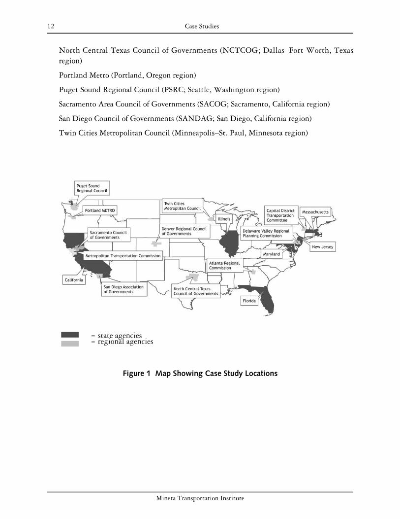
CASE STUDIES
Agencies selected for analysis had varying goals, policies, and program objectives.
In preparing case studies, the purpose was to review and evaluate the efforts of a diverse group of state and regional agencies by examining the historical and legislative context, major programmatic elements, and the stated or implied evaluative criteria of their programs. After we investigated transportation-related state and regional programs across the country, 17 agencies were selected for in-depth evaluation.
Each agency is discussed individually, beginning with an overview of institutions, legislative history, and existing plans. This is followed by a summary of each implementation program that is related to at least one of the responsible land use objectives listed above. Each summary begins with a matrix that classifies the programs in terms of their attempt to address the following elements of responsible land use:
1. Compact development patterns
2. Transit-oriented development
3. Jobs–housing balance
4. Adequate housing supply and affordability
5. Balanced travel mode split
Each case study ends with a set of findings summarizing the effectiveness of the programs. The following states and regional agencies were studied:
Atlanta Regional Commission (ARC; Atlanta, Georgia region)
State of California
Capital District Transportation Commission (CDTC; Albany, New York region)
Delaware Valley Regional Planning Commission (DVRPC; Philadelphia, Pennsylvania region)
Denver Regional Council of Governments (DRCOG; Denver, Colorado region)
State of Florida
State of Illinois
State of Maryland
State of Massachusetts
Metropolitan Transportation Commission (MTC; San Francisco, California region)
State of New Jersey
Mineta Transportation Institute
12 Case Studies
North Central Texas Council of Governments (NCTCOG; Dallas–Fort Worth, Texas region)
Portland Metro (Portland, Oregon region)
Puget Sound Regional Council (PSRC; Seattle, Washington region)
Sacramento Area Council of Governments (SACOG; Sacramento, California region)
San Diego Council of Governments (SANDAG; San Diego, California region)
Twin Cities Metropolitan Council (Minneapolis–St. Paul, Minnesota region)
= state agencies= regional agencies
Figure 1 Map Showing Case Study Locations
Mineta Transportation Institute

13
ATLANTA REGIONAL COMMISSION (ATLANTA, GEORGIA REGION)
BACKGROUND
Atlanta was the fastest growing metropolitan area in the United States from 2000 to 2006, gaining almost 900,000 new residents.10 Atlanta’s steady population growth, coupled with regional congestion problems, has made regional growth management a salient issue in Georgia. One of the most notable agencies working for growth control is the Atlanta Regional Commission (ARC), the regional planning agency for the metropolitan Atlanta area. ARC encompasses more than 10 counties and 63 municipalities.11 It provides comprehensive and up-to-date statistical information about the region’s population, job market, and transportation trends, which helps in making informed decisions on regional policies.12
The ARC board comprises 39 individuals, with 23 members being locally elected officials of political subdivisions.13 The board includes
• each county commission chairman in the region;
• one mayor from each county (except Fulton County, which has two representative mayors);
• the mayor of the city of Atlanta;
• one member of the Atlanta City Council;
• fifteen private citizens;
• one member appointed by the board of the Georgia Department of Community Affairs.14
PLANS AND POLICIES
As a federally designated Metropolitan Planning Organization (MPO) for 18 counties (the 10 ARC counties plus 8 additional counties), ARC adopts a Regional Transportation Plan (RTP) every four years and a six-year Transportation Improvement Program (TIP) annually.15 The RTP covers a variety of transportation topics, including safety improvements, bicycle paths, sidewalks, bridges, roadways, transit services, transportation demand management initiatives, and emission reduction strategies. ARC’s current RTP, Mobility 2030, was drafted through a two-phase plan. Phase 1 created the Aspirations Plan, in which the ARC determined, free from financial constraints, what would be required to improve mobility and reduce congestion. Phase 2 created Mobility 2030 and its associated TIP, identifying the gap between aspirations and current revenue sources.16
In addition to its RTP, ARC has also developed a regional development plan (RDP), which sets forth policies for guiding future development decisions in the Atlanta region. The RDP contains two components, the regional development plan policies and a technical report.17
The regional development plan consists of 18 policies that seek to integrate land use planning
Mineta Transportation Institute

14 Atlanta Regional Commission (Atlanta, Georgia Region)
with transportation, environmental, and community development actions.18 The technical report consists of eight elements: population, economic development, natural and historic resources, public facilities, community services, housing, transportation, and land use. The technical report is submitted to the Georgia Department of Community Affairs for review and approval, along with a regional work program. The regional work program outlines programs and strategies working to address regional needs and achieve regional goals outlined in the technical report.19
PROGRAMS
Table 1 ARC Programs Checklist
Compact Adequate Housing Transit-Oriented Jobs–Housing Balanced Travel Programs Development Supply and Development Balance Mode SplitPatterns Affordability
Livable Centers Initiative X X X X X Community Choices Toolkit X X X X X
Livable Centers Initiative
In 1998, federal transportation funding was withheld from the Atlanta region because the region was found to be out of compliance with air-quality standards. Federal dollars for transportation projects were barred until the Atlanta region adopted a transportation plan that met the provisions of the Clean Air Act.20 Since then, ARC has created several initiatives aimed at promoting quality growth through its Community Choices program, which seeks to provide community leaders with innovative community planning tools.21
ARC created the Livable Centers Initiative as a way to restore the region’s eligibility for federal transportation funding. This program was launched in May 1999 with a five-year $350 million commitment of federal Surface Transportation Program funds.22 It was based on Regional Transportation Plan policies intended to provide funding for both planning studies and transportation projects located in activity and town centers in the region. The program uses federal Surface Transportation Program funds administered through ARC and encourages increased residential development, mixed uses, and connectivity.23
In March 2000, the ARC Board approved an allocation of $5 million over five years to fund Livable Centers Initiative planning studies,24 at a rate of $1 million per year.25 In December 2004, the ARC Board extended the program to include another $5 million for five additional years of planning studies.26 Study projects are awarded on a competitive basis to local governments and nonprofit sponsors, such as transportation management associations, to produce plans that define future center development strategies and to support public and private investments.27
ARC funding is awarded to studies that demonstrate the following concepts:
• connecting homes, shops, and offices
Mineta Transportation Institute

15 Atlanta Regional Commission (Atlanta, Georgia Region)
• enhancing streetscape and sidewalks
• emphasizing the pedestrian
• improving access to transit and other transportation options
• expanding housing options28
Study areas that will be given priority consideration include the following:
• existing or planned transit station areas
• commuter rail locations (proposed)
• town centers
• existing activity centers
• infill/redevelopment projects
• study areas that utilize the products of the ARC Community Choices program29
Study proposals that will not be considered include the following:
• projects in greenfield areas (for purposes of this program, “greenfield” is defined as areas with 50 percent or more of nonimproved land)
• single-purpose studies or incomplete study scopes (such as housing parking studies)
• inappropriately defined activity centers
• applicants that demonstrate no local coordination with major stakeholders30
In addition to these planning grants, the Livable Centers Initiative funds transportation projects resulting from Livable Centers Initiative studies. In March 2000, the ARC board approved an allocation of $350 million for priority funding to implement such projects. The board then approved an additional $150 million in December 2004, for a total commitment of more than $500 million. In selecting TIP projects for the dedicated Livable Centers Initiative money, priority is given to those communities that have completed and approved the planning study, have independently taken local actions as identified in the study’s implementation plan, and have met the basic goals of the Livable Centers Initiative.31
Along with ARC, several other organizations participate in the Livable Centers Initiative, including business owners, the Chamber of Commerce, municipalities, environmental groups, and the Metropolitan Atlanta Rapid Transit Authority.32
Community Choices Toolkit
Another element of the Community Choices program is the Community Choices Toolkit, created in 200533 by ARC for local governments and the public as one of its quality growth resources. The toolkit offers customized solutions for different community needs and incorporates best practices that apply to the Atlanta region. It discusses in detail the practical uses of each tool and provides model ordinances.34 The 24-tool Community Choices Toolkit includes 9 model ordinances. Local governments can modify these ordinances according to the
Mineta Transportation Institute

16 Atlanta Regional Commission (Atlanta, Georgia Region)
unique circumstances of their localities.35 The toolkit offers techniques that address a wide variety of topics, including the following:
• bicycle and pedestrian planning
• quality growth audits
• context-sensitive street design
• green building
• greyfield redevelopment
• infill development
• jobs–housing balance
• mixed-income housing
• mixed-use development
• overlay districts
• planning in a fast-growth environment
• retrofitting corridors
• traditional neighborhood development
• transit-oriented development36
The toolkit was developed from best practices at work both locally and nationally that have been deemed as appropriate for the Atlanta metropolitan region.37 For each strategy identified in the toolkit, there is a document available at no cost on ARC’s website describing the concept, how it can be implemented, project costs, case studies, and other relevant information.38
FINDINGS
As of February 2007, the Livable Centers Initiative had awarded more than $115 million since its inception, including approximately $7 million in planning grants and $107 million in funding for transportation projects. At that time, 724 Livable Centers Initiative plans were in the implementation stage. These projects will ultimately add more than 62,000 new homes, 9,000 hotel units, 11.5 million square feet of commercial space, and 40 million square feet of office space. Transportation projects and developments have cut vehicle trips and vehicle miles traveled by up to 25 percent, have increased transit ridership and opportunities, and have reduced air pollution.39
According to Dan Reuter, chief of ARC’s Land Use Division, the Livable Centers Initiative “has been successful because it puts the resources in the hands of the local communities to envision, plan, and implement the kinds of environments they find desirable and highly livable. It’s a grassroots process that yields unique and quality ideas that are changing our entire region.”40 Another reason for the success of the Livable Centers Initiative lies in the fact that it does not require localities to think “regionally.” Instead, it enables localities to pursue
Mineta Transportation Institute

17 Atlanta Regional Commission (Atlanta, Georgia Region)
their own goals as long as they are consistent with the regionally established smart growth criteria and transportation strategies. As the market for more livable places takes hold, many Atlantans are optimistic that the Livable Centers Initiative will play a crucial role to help the region in accommodating the projected additional two million people by 2030.41
The Community Choices Toolkit program has been successful in making ARC planners available for technical assistance to communities implementing quality growth practices. A public involvement strategy was also incorporated into this effort.42 It has helped to advance and implement regional policies set forth by the regional development plan.43 It also provides technical information in the form of technical assistance papers and model ordinances. The Community Choices Toolkit is a logical adjunct to and useful catalyst for the Livable Communities Initiative.
According to Rob LeBeau, Livable Centers Initiative program manager, ARC has drafted a scope of work for examining travel changes in Livable Centers Initiative communities in a systematic manner and hopes to implement such an evaluation program in the coming fiscal year.44 To date, ARC and Georgia Tech faculty have used the INDEX software to estimate vehicle miles traveled (VMT) changes attributable to land use changes affected by Livable Centers Initiative plans and policies. ARC staff have identified the need to quantify and measure Livable Centers Initiative benefits, not only to convince skeptical politicians, but also to distinguish and rate proposed projects that are competitive (only one-fourth of the proposals for infrastructure grants were funded in the most recent round).45
A notable aspect of ARC’s efforts is to provide municipalities with significant information and resources. The Livable Centers Initiative and Community Choices Toolkit place a strong emphasis on research, planning, and implementation; it is perhaps this balance between various approaches that makes the strategies successful.
Mineta Transportation Institute

18 Atlanta Regional Commission (Atlanta, Georgia Region)
Mineta Transportation Institute
19
STATE OF CALIFORNIA
BACKGROUND
For the past decade, California has been experiencing a steady increase in population. As of January 1, 2007, the state’s population had grown to nearly 38 million. One in eight people in the United States currently live in the state,46 making California the most populous state in the country.47 The state’s population and geographic size make growth management and transportation both vital and challenging issues to address.
PLANS AND POLICIES
Facing problems with traffic congestion and air quality, the State of California is looking to policies and programs to increase the quality of life in communities across the state. In October 2001, the passage of Governor’s Executive Order D-46-01 promoted smart growth planning on a statewide level. In 2000, the California Department of Transportation (Caltrans) created a new division, the Office of Community Planning, designed to assist local communities with smart growth. The Office of Community Planning was created, in part, to link smart growth with transportation planning and projects and to integrate local community goals with the Caltrans planning processes.48 Key players in the state’s growth management efforts are for the most part regional agencies; however, the State of California does have some noteworthy programs in place, two of which are outlined below.
PROGRAMS
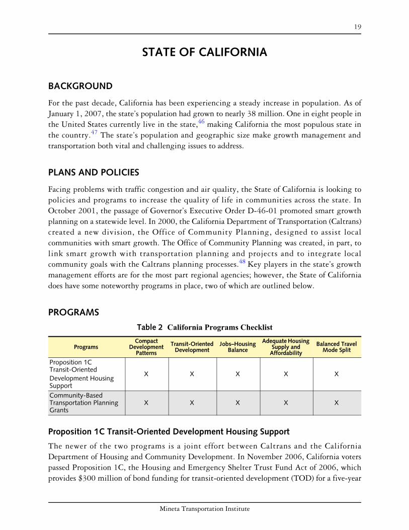
Table 2 California Programs Checklist Compact Adequate Housing Transit-Oriented Jobs–Housing Balanced Travel Programs Development Supply and Development Balance Mode SplitPatterns Affordability
Proposition 1C Transit-Oriented Development Housing Support
X X X X X
Community-Based Transportation Planning Grants
X X X X X
Proposition 1C Transit-Oriented Development Housing Support
The newer of the two programs is a joint effort between Caltrans and the California Department of Housing and Community Development. In November 2006, California voters passed Proposition 1C, the Housing and Emergency Shelter Trust Fund Act of 2006, which provides $300 million of bond funding for transit-oriented development (TOD) for a five-year
Mineta Transportation Institute

20 State of California
period beginning in 2008. The TOD program can include loans for housing developments within one-quarter mile of a “transit station” as defined in Government Code Section 65460.1(b) and/or infrastructure funding that either
• is necessary for development of qualifying housing or
• facilitates connections between qualifying housing and a transit station.
The statute requires that proposed Proposition 1C TOD projects and developments be evaluated on the extent to which they will increase public transit ridership and minimize automobile trips. Currently a methodology to conduct this required evaluation at the project level is under development. This method will include consideration of station area land use factors (including density, mixed land uses, pedestrian-friendly design, proximity to regional destinations) and well as transportation factors (for example, frequency of mainline and feeder transit service).49
This is a transportation-centered program that rewards jurisdictions for planning and approving housing in locations near public transportation hubs. The program has parallels with the Transportation for Livable Communities initiative launched in 1998 by the San Francisco Bay Area’s Metropolitan Transportation Commission, discussed beginning on page 63.
Since this state program is new, it has no track record. However, the level of funding makes it one of largest funding commitments by a state to promote development focused on public transportation.
Community-Based Transportation Planning Grants
Introduced for the 2000–2001 fiscal year, the Community-Based Transportation Planning Grants program provides funds for projects that support livable communities. The program is intended to fund planning efforts that promote smart growth, public involvement, and the linkage between transportation and community development.50 It offers a nontraditional way of participating in the transportation decision-making process.51 It is also intended to fund projects that have statewide or multiregional significance.
In order to receive funds, projects must do the following:
• support livable community concepts
• define a clear transportation objective
• address a deficiency, conflict, or opportunity in integrating transportation and land use planning
• pertain to an area in which remedies to deficiencies in balanced, multimodal transportation planning will result in significant community benefits
• support increased residential development, revitalization of residential uses, or improvement of transportation service to benefit residential uses
Mineta Transportation Institute
21 State of California
• include identifiable and synergistic effects (for example, a situation in which provision of a single benefit will produce additional benefits)
• stress community-based, grassroots, or innovative public involvement52
A 20 percent local or in-kind contribution is required for a grant to be awarded.53 Projects should involve planning and design activities to promote at least one of the following livable communities’ concepts:
• TOD or transit villages
• increased transportation and mobility choices for a wider range of users
• mixed-use development
• safe pedestrian, bicycle, and transit linkages
• context-sensitive streetscapes
• jobs–housing balance
• reuse, infill, or compact development
• long-term sustainable community and economic development54
The program has been popular from the outset. During its first year, Caltrans received requests for funds totaling $4 million but had only $1.5 million available.55 Over the next two years, total funding for the program was $3 million per year. The maximum grant awarded during those years was $300,000 per project.56
Because demand for funds exceeds the supply, a multifaceted review process has been developed. Local agencies submit their proposal to their Caltrans district office. The district office ranks the projects and passes high-ranking applications on to Caltrans headquarters. At this point, two reviewers, (drawn from a pool of 15 persons, mostly in state government but outside the Office of Community Planning) review and score each proposal. The Office of Community Planning does a more technical critique (for example, determining the adequacy of the local match there, or examining if the project is primarily a highway capacity-enhancing project rather than community-based). The process concludes with a roundtable discussion of all proposals. It may be determined that there is other funding from other sources for a proposed project, enabling the Office of Community Planning to make the grant to another project that has no other funding source.57
The Community-Based Transportation Planning Grants program appears likely to continue; it also appears that the evaluation process and evaluation criteria will be enhanced. Given that this is a broad statewide program, evaluation will likely remain a difficult and complex process. The typical Community-Based Transportation Planning Grants program grant provides financial support for local conceptual planning work (design work is not an allowable use of funding). Because of the conceptual nature of the plans that are funded, it is not possible to evaluate a project on quantitative criteria, such as their relative impact on vehicle miles traveled or transit ridership.58
Mineta Transportation Institute

22 State of California
FINDINGS
On a statewide level, Caltrans is a primary player in connecting transportation and land use planning. The Community-Based Transportation Planning Grants program represents one way in which Caltrans is working to specifically link transportation provision with smart growth efforts.
The Office of Community Planning has been making Community-Based Transportation Planning Grants program grants for eight years. While staff administrators note that much has been learned, the wide variety of projects, along with staff and reviewer turnover, means that some relearning must be done every year.
The passage of Proposition 1C, the Housing and Emergency Shelter Trust Fund Act of 2006, provides $300 million of bond funding for transit-oriented development, greatly increasing the commitment of the state to promoting development that is supportive of public transportation. This program will complement the planning grants provided by the Community-Based Transportation Planning Grants program and will result in substantial capital grants for housing development near transit stations.
Mineta Transportation Institute

23
CAPITAL DISTRICT TRANSPORTATION COMMITTEE (ALBANY, NEW YORK REGION)
BACKGROUND
The Capital District Transportation Committee (CDTC) is the Metropolitan Planning Organization (MPO) designated for the Albany–Schenectady–Troy region. CDTC originated from the 1965 Capital District Transportation Study, which was set up through agreements between the State of New York, the four Capital District Counties (Albany, Rensselaer, Saratoga, and Schenectady), and the seventy-eight municipalities within those counties. Within the Capital region, a wide variety of development patterns, densities, land uses, and community character can be found.
Initially, CDTC was charged with developing a long-range transportation plan for the region. Today it takes on broader planning activities to guide development patterns, create incentives for responsible growth, manage and improve the region’s transportation system, and secure financial requirements for planning goals.59
CDTC is composed of both elected and appointed officials from the following jurisdictions and agencies:
• Albany, Rensselaer, Saratoga, and Schenectady counties
• eight major cities within those four counties
• New York State Department of Transportation
• Capital District Transportation Authority
• Capital District Regional Planning Commission
• New York State Thruway Authority
• various other members representing the region’s towns and villages
The Federal Highway Administration and the Federal Transit Administration serve as advisory members to CDTC. CDTC’s staff is funded primarily with Federal Highway Administration, Federal Transit Administration, and county funds.60
PLANS AND POLICIES
CDTC developed and adopted its first long-range Regional Transportation Plan under modern federal transportation legislation (ISTEA) in the mid-1990s. The planning process involved a strong public outreach component that revealed strong regional consensus that the region’s quality of life, mobility, and economic vitality depend upon improving land use planning and better integration of land use and transportation. CDTC determined that meeting the region’s
Mineta Transportation Institute

24 Capital District Transportation Committee (Albany, New York Region)
social, economic, and environmental goals would require both reducing automotive travel and improving transportation services and facilities.
The resulting plan, New Visions for Capital District Transportation, calls for a one-third reduction in the growth of vehicular travel. This is to be achieved largely through altering the form and location of future growth and its accompanying transportation infrastructure. The central premise of the New Visions policies is that site and community design, coupled with transportation actions, can realize the region’s goals.61 It should be noted, however, that the home-rule powers of New York State weaken the ability of regional agencies such as CDTC to directly plan for the region as a whole, that CDTC has no direct authority over land use, and that localities are not required to follow New Visions principles nor required to consult with CDTC on local land use or transportation planning.
New Visions for Capital District Transportation is currently in draft form and is available for public review.62
PROGRAMS
Table 3 CDTC Programs Checklist
Compact Adequate Housing Transit-Oriented Jobs–Housing Balanced Travel Program Development Supply and Development Balance Mode SplitPatterns Affordability
Community and Transportation Linkage Planning Program
X X X
Community and Transportation Linkage Planning Program
A key component of achieving the New Visions goals to reduce vehicular travel is CDTC’s Community and Transportation Linkage Planning Program (also known as the Linkage Program). The Linkage Program was established by CDTC in 2000 to implement the plan’s land use strategies.63 The program is intended to link transportation and land use, plan for a range of transportation options, and build all transit modes.
CDTC recognizes transportation investment as a tool to preserve and enhance the Capital District’s urban form.64 CDTC annually reserves $200,000 of its federal planning funds for consultant activities and $100,000 for CDTC staff technical assistance. Apart from this, CDTC funds up to $92,000 of federal transit planning funds for studies that link land use planning with transit development.65
CDTC encourages program applicants to integrate planning principles that consider both land use and transportation. It has developed seven broad strategies for the program to assist potential sponsors. The strategies are consistent with the adopted New Visions plan principles, as well as with other initiatives, such as the New York State Quality Communities initiative, and smart growth principles. Submissions are chosen based on how well they
Mineta Transportation Institute
25 Capital District Transportation Committee (Albany, New York Region)
incorporate these strategies; submissions that incorporate more program strategies are given higher priority. These seven strategies are to
• revitalize and redevelop existing commercial and residential areas;
• improve street connectivity and reduce driveway conflicts;
• enhance activity and town centers;
• enhance transit corridors and built environments supporting transit;
• encourage a greater mix and intensity of land uses;
• develop bicycle- and pedestrian-friendly design standards;
• create an integrated multimodal transportation network.66
The Linkage Program provides technical assistance for joint regional-local planning initiatives linking transportation and land use, with support provided by either consultants or CDTC staff. The program is an important aspect of CDTC’s local planning assistance and public outreach efforts. In addition, CDTC established an ongoing Community/Transportation Planning Group that reviews progress on many Linkage and related local planning efforts. CDTC considers this group, which was later reframed as the Linkage Regional Coordination Forum, to be a successful regional planning roundtable. Participants have been involved from at least two dozen municipalities.67
FINDINGS
CDTC has less planning and project programming resources available to it than Metropolitan Planning Organizations (MPOs) in larger regions. In addition, some MPOs have access to additional resources due to specific state policies (for example, California MPOs have direct access to state transportation funds). Despite those disadvantages, CDTC commits roughly 25 percent of its total federal planning funds per year to Linkage Program studies.68
As of early 2007, the Linkage Program had funded 55 collaborative studies, in coordination with various sponsors. Study sponsors included 30 municipalities and counties from urban, suburban, and rural areas. Other sponsors included nonprofits and public agencies. Since 2000, over $3.3 million in federal, state, and local funds had been allocated to the Linkage Program.69 Communities within the Capital region have had positive feedback regarding the program. In 2005, the Upstate New York Chapter for the American Planning Association awarded the program with the Outstanding Comprehensive Planning Award.70
CDTC is very careful in how it views linkage studies. Although many are community–based, in most cases control of the study is not given to the community entirely. By retaining influence over the study through consultant administration, the use of a memorandum of understanding, and so on, CDTC staff remains directly involved with the study and can offer assistance to the community in guiding study progress. This also assures that New Visions principles are integrated into local plans.71
Mineta Transportation Institute

26 Capital District Transportation Committee (Albany, New York Region)
Six evaluation criteria have been developed for use in proposal review. The criteria include meeting the program requirements, demonstrating a need for the study, past sponsor performance on a linkage study, demonstrating local commitment to the study, the degree of regional benefit/involvement of multiple jurisdictions, and satisfying one or more of the program strategies.72
In recent months, a CDTC working group has been discussing some specific ideas that could help CDTC more fully realize the model’s potential. One recommendation calls on CDTC to undertake a review of completed linkage studies to see to what degree they have been successfully implemented. This effort may highlight areas that represent weaknesses in implementation opportunities, weaknesses in the plans themselves, or other lessons learned that could lead to changes in the Linkage Program or additional assistance initiatives.
Overall, CDTC’s Linkage Program has proved effective in funding urban, suburban, and rural planning efforts to link transportation and land use efforts. It appears that the program will continue, and possibly expand, in the near future.
Mineta Transportation Institute

27
DELAWARE VALLEY REGIONAL PLANNING COMMISSION (PHILADELPHIA, PENNSYLVANIA REGION)
BACKGROUND
The Delaware Valley Regional Planning Commission (DVRPC) is a regional planning body that was formed in 1965 as a result of a bistate compact to address the needs of the greater Philadelphia area. The DVRPC covers a 9-county area in 2 states (Pennsylvania and New Jersey), including 353 townships, boroughs, and cities.73 The major cities in the area, apart from Philadelphia and Pennsylvania, include Trenton and Camden in New Jersey. The area has a total population of approximately 5.5 million people, with 3.9 million in Pennsylvania and 1.6 million in New Jersey. The population is growing slowly, at about 0.4 percent per year, although Philadelphia itself is actually losing population.74
The DVRPC is governed by an 18-member board, which is composed of
• elected officials from the four major cities and eight suburban counties in the region, and three representatives from each state—the state representatives come from the Pennsylvania and New Jersey Departments of Transportation, the Pennsylvania Governor’s Policy Office, the New Jersey Department of Community Affairs, and appointees of both governors; and
• additional nonvoting board members representing other interested parties, such as the Department of Housing and Urban Development.75
The DVRPC is the federally designated Metropolitan Planning Organization (MPO) for this area, and in that capacity approves a long-range transportation plan and shorter-range Transportation Improvement Program (TIP) in a process that includes public participation and consultation with the various transportation agencies in the area. A transportation project must be on the TIP to receive federal funds, but the TIP also includes other regionally important transportation projects that will be funded from other sources. In assigning priority to projects, the TIP attempts to reflect the goals of the DVRPC’s long-range plan.76
The DVRPC initially focused on regional transportation planning but has expanded to provide support for other regional planning objectives. For instance, DVRPC has conducted a study on housing affordability and proximity to jobs, and another on regional open space needs.77 It also maintains a regional inventory of protected open space and has developed a series of brochures on tools that jurisdictions can use to implement smart growth concepts.78
For transit-oriented development (TOD), it has conducted and made available a study of regional rail stations to identify priority sites for TOD.79
Mineta Transportation Institute

28 Delaware Valley Regional Planning Commission (Philadelphia, Pennsylvania Region)
PLANS AND POLICIES
On June 23, 2005, the DVRPC adopted Destination 2030, the long-range plan for the Delaware Valley region.80 The plan includes land use and transportation policies supporting eight major issue areas: urban revitalization, growth management, economic development, the environment, equity and opportunity, transportation facilities, transportation operations, and transportation finance. The policies touch on many of the smart growth strategies highlighted in this report, with the exception of jobs–housing balance. Similar to the approach studied in New Jersey (see the “State of New Jersey” on page 71), DVRPC’s long-range plan calls for growth in centers; different locations and types of centers are expressly identified in the plan. The plan also includes growth areas and farmland/open space preservation areas.81
An interesting idea from Pennsylvania, which DVRPC has helped publicize, is that of “transit revitalization investment districts,” authorized by law in 2005. This program allows for the creation of public–private partnerships between transit agencies, municipalities, and developers to create TOD (usually within one-quarter mile of transit stations), and is meant to have an impact on a regional scale. A transit revitalization investment district, once established near a transit station, can use tax-increment financing. These transit revitalization investment districts are still in the planning stages and have not yet been implemented.82
Pennsylvania also has grant money available for multimunicipal planning projects.83
The DVRPC conducts regular environmental justice analysis of current transportation infrastructure, its plans, its TIP, and other programs in order to ensure that disadvantaged communities (low-income, minority, Hispanic, limited English proficient, elderly, disabled, carless, or single-mother residents) have accessibility to transportation. The analysis involves qualitatively reviewing plans’ goals and policies to assess whether they conform to environmental justice principles. Public participation continues in the form of a regional citizens’ committee that meets monthly to provide citizen access to, and participation in, the regional planning and decision-making process.
Mineta Transportation Institute

29 Delaware Valley Regional Planning Commission (Philadelphia, Pennsylvania Region)
PROGRAMS
Table 4 DVRPC Programs Checklist
Compact Adequate Housing Transit-Oriented Jobs–Housing Balanced Travel Programs Development Supply and Development Balance Mode SplitPatterns Affordability
Transportation and Community Development Initiative Grants
X X
Transportation Improvement Program Approval for Projects
X X X X
Transportation and Community Development Initiative Grants
Since 2002, the DVRPC has had a Transportation and Community Development Initiative program, which gives approximately $1.5 million in grants per year—$1 million in Pennsylvania and $500,000 in New Jersey. There is a maximum of $125,000 per grant.84
Only municipal or multimunicipal planning, feasibility studies, and other preparatory work can be funded—not capital projects.85
The grants are intended to reverse disinvestment and decline by
• supporting local planning projects that create residential, employment, or retail opportunities;
• improving the character and quality of life within communities to retain and attract business and residents (in order to prevent sprawl and suburban growth);
• enhancing and utilizing existing transportation infrastructure capacity to reduce demand for the region’s transportation network;
• reducing congestion and improving the transportation system’s efficiency.86
Transportation and Community Development Initiative grants are targeted to the region’s core cities and older suburbs. Such targeting has been accomplished by requiring applicants to meet eligibility criteria, such as being identified as a “revitalizing center” in the DVRPC’s long-range plan, being identified as a “future growth area” in the long-range plan, having lost at least 5 percent of its population in the 1990s, being designated a “future growth area” in the long-range plan, or having a median income less than 75 percent of the county average.87
Targeting these grants has become more precise in recent years. Grants can be provided at the census tract level by considering the “degrees of disadvantage” in a tract; this identification process is a result of the environmental justice analysis discussed earlier.
Although Transportation and Community Development Initiative projects do not necessarily lead to capital improvements, many projects require small-scale capital investments such as highway or transit improvements to initiate revitalization. To help municipalities implement important plans, eligible capital improvements from Transportation and Community Development Initiative projects will receive priority consideration when applying for
Mineta Transportation Institute

30 Delaware Valley Regional Planning Commission (Philadelphia, Pennsylvania Region)
implementation funding through existing transportation programs contained in DVRPC’s TIP.
Approximately 25 new projects are funded per year.88 They appear to be mostly revitalization plans, corridor studies, and TOD plans.89
Transportation Improvement Program Approval for Projects
The DVRPC has leverage over the kinds of transportation projects that are built in the region through its ability to prevent federal funds from going to projects that are not in its Transportation Improvement Program. For New Jersey, this TIP is updated yearly and covers a three-year period. For Pennsylvania, the TIP is updated every other year and covers a four-year period. Projects should conform to the DVRPC’s long-range plan. 90
The long-range plan of the DVRPC, on which the TIP is based, anticipates $27.2 billion out of $59.9 billion available in state and federal funds going to mass transit over 25 years, with the rest allotted to highways. Of the $32.7 billion allotted to highways, $13.49 billion is for maintaining and replacing roads and $7.56 billion for maintaining bridges. Only $3.27 billion is allotted for new highway capacity. $3.47 billion is going to new transit capacity.91
Given the emphasis on maintenance, the long-range plan should serve the goal of reducing vehicle miles traveled, and the shorter-range TIP should serve that goal as well. The DVRPC also tries to focus its TIP dollars on areas that follow smart growth principles such as building near transit, clustering, and offering a range of housing choices.
FINDINGS
These programs generally fit into three categories of assistance: the provision of tools for localities; the provision of financial support for local planning work; and the provision of capital funding for implementation. The Transportation and Community Development Initiative falls under the first two categories; however, these have led to the provision of capital funds to implement the plans (the third category). The program has also helped implement regional goals and policies through the local implementation of these projects by way of the TIP program. The first program uses monies, largely for planning projects, that originally went to capital funding.
Historically, a number of factors led to the creation of these programs at the regional level. For example, the central reason for developing the Transportation and Community Development Initiative was to strengthen ties not only with communities in Philadelphia and a few other central cities, but also with suburban counties, where inner-ring suburbs had faced some critical problems, including job loss and competition with other areas. The Transportation and Community Development Initiative is seen as a vehicle for awarding planning grants to municipal governments rather than solely to suburban counties in the states of New Jersey and
Mineta Transportation Institute

31 Delaware Valley Regional Planning Commission (Philadelphia, Pennsylvania Region)
Pennsylvania. In turn, counties have helped promote DVRPC programs, serving on selection committees for projects.
It is expected that these programs will continue to operate, as they have been well received at the municipal level and the DVRPC Board is pleased with the work that has been completed. While the Transportation and Community Development Initiative grants are funded from the TIP, many of these efforts have also leveraged funding for capital projects that eventually receive capital funding from the TIP. For example, Transportation and Community Development Initiative planning grants have funded economic feasibility and market studies that eventually led to transit and streetscape improvements funded by the TIP. Similarly, the DVRPC has highlighted the success of the Environmental Justice Assessment program when applying for MPO certification from the federal government.
While the impacts of these programs have not yet been measured over the entire DVRPC region, the agency has measured how investment has been able to leverage other funding, such as grants, capital projects, and private investment. The DVRPC has not actively measured the total vehicle miles traveled (VMT) or other key indicators attributed to a program because it has been more concerned with providing available funding to counties.
It appears that the DVRPC will maintain the current structure of the Transportation and Community Development Initiative and its relationship to the TIP. Recently, the board studied the possibility of carving out a separate component of the TIP that would provide capital funding for successful Transportation and Community Development Initiative projects; however, the board decided to keep the same program structure but give strong consideration to Transportation and Community Development Initiative projects when awarding TIP allocations. This strategy recognizes that some Transportation and Community Development Initiative projects may depend on other capital projects that are only eligible under the TIP (for example, infrastructure-related projects). The DVRPC’s 2002 assessment report for the Transportation and Community Development Initiative grants shows the progress of the projects themselves through late 2003, but does not quantify regional impact.
The DVRPC is considering developing a program that would be aimed at assisting the newer, suburban municipalities that rely heavily on the private vehicle. Only half of the region’s municipalities are eligible to receive Transportation and Community Development Initiative funding (most of them in the inner areas). Emphasis needs to be placed on educating the newer suburbs, thereby promoting the development and implementation of sustainability plans and incentive programs.
Mineta Transportation Institute

32 Delaware Valley Regional Planning Commission (Philadelphia, Pennsylvania Region)
Mineta Transportation Institute

33
DENVER REGIONAL COUNCIL OF GOVERNMENTS (DENVER, COLORADO REGION)
BACKGROUND
The nine-county Denver metropolitan region is one of the nation’s fastest-growing regions. More than 2.6 million people currently live in the nine-county Denver region. By 2030, the population is expected to increase again by nearly 50 percent, to almost 3.9 million.92
Approximately 500 square miles of the region were built out or classified as urban development in 2000.93
The Denver Regional Council of Governments (DRCOG) is the designated metropolitan transportation organization (MTO) and regional planning authority for the Denver region. The DRCOG formed in 1955 and is a nonprofit, voluntary association of 9 counties and 43 cities. Each participating local government has an elected official as its representative on DRCOG’s Board of Directors. In 1969, DRCOG supported legislation creating the Regional Transportation District to coordinate transit service for the region. Under state law, DRCOG must review Regional Transportation District plans for consistency with regional goals. The Regional Transportation District is the lead agency for the Denver region’s FasTracks program, which will build 114 miles of light rail within the next ten years and is being monitored by DRCOG.
Despite recent attempts to enact regional growth-related bills, Colorado does not have strong statewide regional planning legislation. In January 2000, Governor Bill Owens made smart growth a priority of his administration, launching the Smart Growth: Colorado’s Future initiative. During the subsequent year, a number of bills aimed at improving coordination in local planning, preserving open space, and implementing regional planning measures failed to pass in the legislature.
During the 2000 legislative session, five bills related to regional planning did pass. The first, HB 1427, created the Office of Smart Growth, which administers $750,000 in planning grants to designated “heritage communities.” A second bill, HB 1001, provides additional criteria that may be used in local comprehensive plans. The third, HB 1306, promotes infill development through a state income tax incentive of up to $100,000 for each developer. The fourth, HB 1302, provides a state income tax credit to developers who build low-income rental housing and make it available for 15 years. The fifth measure that was signed, HB 1348, offers a state tax refund up to $20,000 for the donation of conservation easements.94
PLANS AND POLICIES
In 1997, the DRCOG Board of Directors adopted Metro Vision 2020, the region’s growth and development plan. The plan was prepared by a task force of local elected officials, business
Mineta Transportation Institute
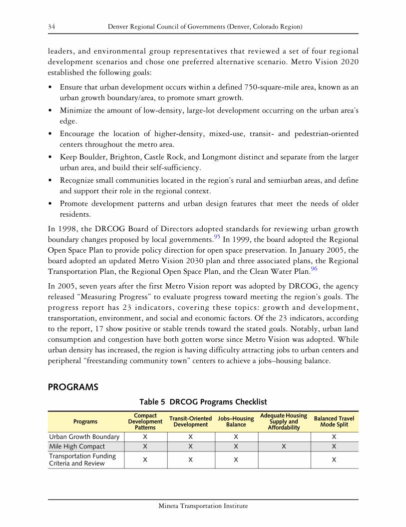
34 Denver Regional Council of Governments (Denver, Colorado Region)
leaders, and environmental group representatives that reviewed a set of four regional development scenarios and chose one preferred alternative scenario. Metro Vision 2020 established the following goals:
• Ensure that urban development occurs within a defined 750-square-mile area, known as an urban growth boundary/area, to promote smart growth.
• Minimize the amount of low-density, large-lot development occurring on the urban area’s edge.
• Encourage the location of higher-density, mixed-use, transit- and pedestrian-oriented centers throughout the metro area.
• Keep Boulder, Brighton, Castle Rock, and Longmont distinct and separate from the larger urban area, and build their self-sufficiency.
• Recognize small communities located in the region’s rural and semiurban areas, and define and support their role in the regional context.
• Promote development patterns and urban design features that meet the needs of older residents.
In 1998, the DRCOG Board of Directors adopted standards for reviewing urban growth boundary changes proposed by local governments.95 In 1999, the board adopted the Regional Open Space Plan to provide policy direction for open space preservation. In January 2005, the board adopted an updated Metro Vision 2030 plan and three associated plans, the Regional Transportation Plan, the Regional Open Space Plan, and the Clean Water Plan.96
In 2005, seven years after the first Metro Vision report was adopted by DRCOG, the agency released “Measuring Progress” to evaluate progress toward meeting the region’s goals. The progress report has 23 indicators, covering these topics: growth and development, transportation, environment, and social and economic factors. Of the 23 indicators, according to the report, 17 show positive or stable trends toward the stated goals. Notably, urban land consumption and congestion have both gotten worse since Metro Vision was adopted. While urban density has increased, the region is having difficulty attracting jobs to urban centers and peripheral “freestanding community town” centers to achieve a jobs–housing balance.
PROGRAMS
Table 5 DRCOG Programs Checklist
Compact Adequate Housing Transit-Oriented Jobs–Housing Balanced Travel Programs Development Supply and Development Balance Mode SplitPatterns Affordability
Urban Growth Boundary X X X X Mile High Compact X X X X X Transportation Funding Criteria and Review X X X X
Mineta Transportation Institute

35 Denver Regional Council of Governments (Denver, Colorado Region)
Urban Growth Boundary
In 1997, the adopted Metro Vision 2020 plan created a 731-square-mile urban growth boundary in order to direct development within the boundary and set policies for differing growth patterns based on location and community type. Within the growth boundary, 70 urban centers were identified for development of high-density, mixed-use activity nodes. The urban centers are intended to absorb population and employment growth and create nodes of concentrated development that, among other benefits, will help to support transit. Metro Vision also adopted policies to guide growth outside the urban growth boundary. The plan encourages growth in four “freestanding communities” identified beyond the larger urban area, with the goal for them to become self-sufficient. The transportation element of Metro Vision complements these land use policies by generally not extending infrastructure past the growth boundary and encouraging transportation investments consistent with the land use vision. Although DRCOG had no authority to require local governments to comply with the established growth boundary, through the Mile High Compact (discussed below), many city and county governments voluntarily agreed to comply with the growth boundary.
Mile High Compact
After the legislative reforms proposed in 2000 failed, DRCOG partnered with the Metro Mayors Caucus to build commitment for implementation of the Metro Vision 2020 plan. To date, 42 of the cities and counties, comprising more than 87 percent of the region’s population, have signed on to the compact. The compact is an intergovernmental agreement between the cities and counties that have signed on.
The compact binds its signatories to
• use Metro Vision as the regional planning framework;
• develop and approve comprehensive plans with a defined set of elements;
• adopt the Metro Vision 2020 urban growth boundaries within their comprehensive plans;
• allow urban development only within the defined growth boundary;
• coordinate comprehensive plans with those of neighboring and overlapping entities and integrate plans at the regional level.
According to Linda Capra, Mile High Compact coordinator of DRCOG, support for the Mile High Compact grew out of a sense that local governments wanted to control their own destiny rather than follow mandates from the state. As a result, municipalities were motivated to voluntarily comply with Metro Vision through the Mile High Compact. In interacting with local officials, DRCOG has found that most local comprehensive plans are consistent with Metro Vision.97
Transportation Funding Criteria and Review
In programming its TIP, DRCOG uses a weighted system of prioritization criteria, providing incentives to communities following the Metro Vision plan. Prior to the adoption of the first
Mineta Transportation Institute

36 Denver Regional Council of Governments (Denver, Colorado Region)
Metro Vision plan in 1997, the DRCOG Board of Directors recognized that the state did not provide regulations requiring localities to follow the regional plan. Transportation funding allocation was one area the board saw as an opportunity to create incentives for communities to follow regional goals.
The weighted TIP funding system gives 26 of 100 points for criteria related to implementing the Metro Vision plan, many of which are not directly tied to transportation. Of the 100 points, 13 are also land use related. In short, cities that are complying with the Metro Vision plan are more likely to have their transportation projects funded.
In addition to serving as the MPO, DRCOG reviews regional transit plans created by the Regional Transportation District, which provides all transit service in the nine-county region. Specifically, SB 90-208, adopted in 2004, requires that DRCOG review and approve any fixed guideway system proposed by the Regional Transportation District. The review process applies to the Regional Transportation District’s FasTracks plan to build nine new light rail corridors by 2017. Under SB 90-208, the DRCOG staff and board will also review the FasTracks project on an annual basis.
FINDINGS
Since it was adopted in 1997, the urban growth boundary has been amended and expanded several times, partly in response to concerns from local governments who felt that their original allocations were inadequate. It should be noted, however, that the boundary was not expanded at all when the planning horizon was extended from 2020 to 2030, even though the population was forecast to increase by an additional 350,000, because it was felt the boundary was large enough to accommodate the increase.
The boundary is now 757 square miles in area, leading some Colorado environmental groups, including Environment Colorado, to question the effectiveness of the boundary. Some also contend that the effectiveness of the boundary has been further compromised by local policies that allow for unlimited semiurban development on 1- to 35-acre parcels outside the boundary. Currently, approximately 4 percent of the metropolitan area population lives in such areas, occupying about 250 square miles of land outside the growth boundary.98
Although density is increasing in the region, according to DRCOG’s “Measuring Progress” report, land consumption has not slowed since the adoption of Metro Vision 2020. If land consumption continues at the current rate, DRCOG predicts that the urban area will consist of 800 square miles by 2030, exceeding the goal by 50 square miles.
Politically, the Mile High Compact has been successful. As the program has progressed, local officials and the DRCOG Board have become increasingly resistant to changes to the adopted regional plan, including pressure to extend the urban growth boundary.99 The voluntary nature of the agreement gave municipalities a sense of ownership and commitment to regional
Mineta Transportation Institute
37 Denver Regional Council of Governments (Denver, Colorado Region)
goals, whereas state legislation was seen as imposing state or regional interests on local jurisdictions.
The Mile High Compact is considered by academics and practitioners to be one of the most significant aspects of the regional planning strategy in the Denver area. It should also be noted that even those jurisdictions that have not signed the Mile High Compact are generally participating in the Metro Vision planning program. This is in part because there are other incentives available for them, including transportation funding opportunities and wastewater-permitting regulations that require consistency with the urban growth boundary.100
According to Steve Rudy, transportation planner for DRCOG, the TIP funding criteria system has been successful in supporting the Metro Vision plan. Although there is not a way to quantitatively measure its efficacy, localities recognize that complying with Metro Vision will give them an advantage in the highly competitive allocation of transportation funds. According to Mr. Rudy, the program particularly affects middle-range projects—those that are neither obviously good nor bad according to the other, transportation-related criteria.101
The Fiscally Constrained Regional Transportation Plan, which outlines implementation and funding of transportation improvements, includes the following breakdown of funding:
• 52 percent: preservation, maintenance, management, and operation of transportation system
• 9 percent: expansion of regional roadway system (adding 1,100 lane-miles and 26 new interchanges)
• 7 percent: expansion of rapid transit and bus system (adding 150 miles and 350 buses in fleet)
• 32 percent: miscellaneous funding for local and private streets, aviation, bicycle and pedestrian facilities, and debt service
According to Mr. Rudy, the land use elements of the TIP are accepted by and popular with local jurisdictions. Despite this acceptance and popularity, the program’s future is not assured because of uncertainty about the level of federal funding for the region. The region has fared well under the federal Safe, Accountable, Flexible, Efficient Transportation Equity Act: A Legacy for Users, but this level of funding may not be matched in the next federal legislation. Local support plus measurement of effectiveness and results by DRCOG might prove essential to continuation of the TIP program in which 26 percent of funding criteria are related to implementing the Metro Vision plan.102
Mineta Transportation Institute

38 Denver Regional Council of Governments (Denver, Colorado Region)
Mineta Transportation Institute

39
STATE OF FLORIDA
BACKGROUND
The State of Florida has a relatively long history of growth management planning. Since 1940, Florida has experienced steady population growth, with a 1949 population of 1.9 million growing to 6.8 million in 1970 and nearly 16 million by 2000. In response to the state’s growing population and a number of environmental crises related to land use and development in the late 1960s, an important series of environmental and planning legislation was passed in the 1970s. Included in this legislation were the Environmental Land and Water Management Act, the Water Resources Act, the Land Conservation Act (which provides for the purchase of environmentally endangered lands), and the Florida Comprehensive Planning Act (which provides a basis for statewide policies guiding long-range social, economic, and physical growth within the state).
In 1975, the state passed the Local Government Comprehensive Planning Act, making Florida the second state to require a comprehensive plan for all levels of local government. By 1982, 419 of 461 cities and counties had adopted comprehensive plans, and by 1984 all local governments had adopted plans reviewed by state agencies. Concerns about the quality, consistency, and implementation of these plans led to the 1985 Local Government Comprehensive Planning and Land Development Regulation Act and the Omnibus Growth Management Act. These laws required local city and county governments to redraft local comprehensive plans in accordance with a statewide comprehensive plan, which included growth management goals, objectives, and policies. The State Department of Community Affairs was given the power to review and approve these local plans. Enforcement mechanisms included the ability to fine local governments and withhold state funds. Noteworthy elements of these acts were the requirement of regional planning and the establishment of a concurrency requirement, which requires that approval of new developments be contingent on the presence of adequate public facilities and services.
As the state planning agency, the Department of Community Affairs reviews local comprehensive plans and plan amendments to assure compliance with requirements of the Growth Management Act; assists local governments in developing and implementing their plans; adopts explanatory rules and sets timetables for evaluation and appraisal reports that are required by statute of local governments; and enforces concurrency requirements and the maintenance of five-year capital improvement element statements in the local comprehensive plans.
PLANS AND POLICIES
The State of Florida has enacted a number of statutes as part of its planning reform effort to address developments with regional significance. In 1998, two laws added criteria to the
Mineta Transportation Institute

40 State of Florida
future land use elements of local comprehensive plans and clarified that mayoral veto power did not extend to zoning variances. In 1999, another law passed authorizing counties and municipalities to designate urban infill and redevelopment areas based upon specific criteria.
In 2005, the state enacted legislation (SB 360) that amended the 1985 Growth Management Act. The bill took effect July 1, 2005. The new act seeks to enable further implementation of its growth management laws by focusing on
• school planning;
• transportation planning;
• water-supply planning;
• capital improvements and financial feasibility;
• the fiscal impact analysis model.
The act represents the most significant changes in Florida’s growth management laws since 1985. The following elements of the act add considerably to the already-complex planning requirements imposed on local governments:
• mandatory school concurrency
• proportionate fair-share mitigation ordinances (each local government must develop an ordinance allowing developers to choose to satisfy concurrency requirements through a “pay as you grow” scheme)
• funding for technical assistance for assessment of fiscal feasibility
• GIS tools for making growth assessments and planning impacts on infrastructure
• public visioning processes
• financial feasibility standards for transportation facilities
The act also offers incentives for local governments to adopt 10-year urban service boundaries and requires workshops and public meetings for a “visioning” process that must precede boundary designation. Future land use map amendments within an urban service boundary will be exempt from state review. The act includes the first major funding for infrastructure in many years, with a total of $1.5 billion composed of $750 million in recurring and $750 million in nonrecurring revenues.103
PROGRAMS Table 6 Florida Programs Checklist
Compact Adequate Housing Transit-Oriented Jobs–Housing Balanced Travel Programs Development Supply and Development Balance Mode SplitPatterns Affordability
Pay As You Grow X Strategic Intermodal System X
Mineta Transportation Institute

41 State of Florida
Pay as You Grow Plan for Florida’s Future
Florida’s 2005 Growth Management Act, typically referred to as Senate Bill 360, closes the gap between new development and construction of needed transportation and school facilities, and requires communities to identify water supplies needed for new growth. The law requires that local government comprehensive plans be “financially feasible” and requires a “pay as you grow” system to address backlogs and future growth needs. The act allocated $1.5 billion in state revenues in the first year for transportation, water, and school infrastructure needs, and allocates $750 million annually thereafter. The Florida Department of Transportation estimates that the new revenues will finance $7.5 billion for projects on the Strategic Intermodal System, a new Transportation Regional Incentive Program, its New Starts Transit Program, and a program to assist small counties. The act also allows local governments to require “proportionate fair share” contributions from developers for impacts on transportation and schools. Funds were allocated annually to provide technical assistance to local governments and school boards for implementation of the act. Initial implementation of the act included technical assistance grants and pilot programs in these key program areas:
• Strengthening interlocal processes in schools, with participation from 41 communities...
• Coordinating water districts on a regional level and developing guidelines for local authorities’ local comprehensive plan development...
• Linking with the Florida Department of Transportation (FDOT)... FDOT developed a number of programs related to concurrency criteria, implementation of a regional transportation incentive program, and a model proportionate fair-share ordinance that will help local agencies to develop ordinances according to new requirements under Senate Bill 360.
• Assisting local authorities with concurrency and urban service boundary requirements. Grants are available to local authorities to meet new requirements for concurrency management and boundary establishment
• Organizing public workshops and outreach
Strategic Intermodal System
The Strategic Intermodal System is made up of statewide and regionally significant facilities and services for moving people and goods, including linkages that provide smooth and efficient transfers between modes and major facilities, on a single, integrated network. This Strategic Intermodal System includes highway, rail, and water corridors; hubs (for example, airports and seaports); and connectors between the corridors and hubs. It was created in Florida law in 2003 and is based on designation criteria recommended by a 41-member steering committee. The steering committee included 31 statewide partner organizations representing state and local governments, businesses, environmental interests, and the development community. Florida law establishes minimum annual funding levels, and a minimum share of “new discretionary highway capacity” funding, for the Strategic Intermodal System.
Mineta Transportation Institute

42 State of Florida
Funding from the 2005 Growth Management Act provided $2.775 billion for projects on the Strategic Intermodal System in the department’s work program for fiscal years 2005–2006 through 2010–2011. Funding is distributed across all modes for a variety of reasons:
• The Strategic Intermodal System is the state’s highest transportation capacity priority.
• Improved access to hubs is critical to efficient operation of the Strategic Intermodal System.
• FDOT seeks to demonstrate its commitment to the Strategic Intermodal System by addressing the highest-priority system needs, regardless of mode.
During the development of the Strategic Intermodal System work program, importance is placed on maximizing the state’s investment in the Strategic Intermodal System through the financial participation of modal partners. The work program for 2005–2006 through 2010–2011 included a total of $350.7 million that will be invested by these private and public partners. Department staff, working in cooperation with Florida’s public and private transportation partners, identified candidate projects requesting a total of $4.7 billion in Strategic Intermodal System growth management funding. The department selected projects in conjunction with the following growth management criteria:
• consistency with adopted local government comprehensive plans
• identification as a backlog facility in a local government comprehensive plan and/or concurrency management system
• support for mobility within a designated infill area, redevelopment and revitalization areas, and multimodal districts
• location on a strategic intermodal system connector and removal of significant truck traffic from downtowns, historic districts, or residential areas
FINDINGS
The two programs featured in this case study represent the most recent steps on a path toward better growth management that began in 1985. Each provides support at a number of levels, while imposing limited regulation. On the one hand, the Pay as You Grow program has effectively linked development approval to infrastructure planning, providing some tools and financial support to localities. This policy seems clear and concise, not overburdening local authorities or making compliance and enforcement difficult. Similarly, the Strategic Intermodal System program follows through with support for cooperative arrangements at all levels.
Since the 1980s, state transportation planners have recognized the fact that Florida cannot continue to expand its transportation infrastructure to meet prevailing growth rates. It was shown that infrastructure expansion is not necessarily desirable because it can induce additional travel demand. Florida’s 2020 Transport Plan, released in 2000, was a response to this concern. It directly led to the creation of these programs, clearly identifying the need to
Mineta Transportation Institute

43 State of Florida
balance environmental issues with economic vitality. In light of the fact that rapid growth was expected to increase, the only way to accommodate this growth was for regions and communities to work together.
Development of the Strategic Intermodal System program in 2005 clearly altered the institutional culture that had historically focused on the private vehicle as the principal mode of choice, providing funds for local implementation. The Strategic Intermodal System has brought about a change in thinking, resulting in the formation of a comprehensive planning partnership between local planners and regional planners in Florida. It created an atmosphere that brought all parties to the table, carving out a series of regional visions.
Initially, interagency coordination was not valued and was generally nonexistent at the local level. A principal barrier was distrust among transportation planners, stemming from a historic pattern of fragmented planning, where modes were planned in isolation of one another and planning was only conducted locally. An assessment of the situation identified the need to break down these barriers and begin to work together to solve common, cross-jurisdictional issues. Resources were shifted into the Strategic Intermodal System program to provide localities with the necessary tools to pursue cooperative working arrangements. Eventually a consensus was developed on the role of the Strategic Intermodal System.
It is anticipated that these programs will continue indefinitely because they are supported by state legislation, especially on the growth management side. In light of the successful buy-in that has occurred by planning bodies throughout the state, there is an additional incentive to continue these programs. Nevertheless, in the case of Pay as You Grow, while it is likely that the program will continue, its scope has been constrained by a slowdown in development (for example, developer revenues available for transportation improvements have decreased). In addition, infrastructure costs have risen dramatically throughout the state, and less can be constructed per dollar of investment.
The Florida DOT has struggled with transportation performance measures, as they have tended to employ capacity and throughput measures in the overall evaluation of impacts rather than such measurement indicators as vehicle miles traveled (VMT) or transit ridership. Instead the agency has focused on qualitatively measuring the success of these programs and how they have helped in the advancement of growth management throughout the state. This approach emphasizes the value of weighing policy and partnership perspectives, particularly as they relate to the Strategic Intermodal System.
The most salient new program currently being developed at the state level is probably Future Corridors, which employs a 50-year time horizon to determine where new corridors will need to be developed or changed. It will be based on a series of comprehensive corridor plans incorporating the collective vision of the more than 460 separate jurisdictions throughout Florida. Similarly, Pay as You Grow will play an important role in the establishment of cooperative arrangements for corridor planning.
Mineta Transportation Institute

44 State of Florida
Mineta Transportation Institute

45
STATE OF ILLINOIS
BACKGROUND
In 2006, Illinois was the fifth most populous state, with a population of over 12.8 million.104
Population growth in Illinois has been inconsistent among the state’s largest cities, with some cities growing quickly and some cities, including Chicago, losing population during 2005. Despite its recent periods of population loss, Chicago was ranked as the nation’s third largest city in 2005. Three Illinois cities—Joliet, Aurora, and Naperville—are on the nation’s list of the 50 fastest-growing large cities. The city of Joliet, located approximately 40 miles southwest of downtown Chicago, experienced a cumulative population growth rate of more than 27 percent between 2000 and 2005, ranking twelfth in growth rate among United States cities for the five-year period.105
In the 1990s, Illinois was experiencing decreasing open space, aging infrastructure, and increasing congestion. Unbalanced growth patterns were identified as a factor in these problems, as was the disconnect between transportation projects and their impacts on nearby land uses. In April 2000, in an effort to address these concerns, the governor created the Balanced Growth Cabinet, intended to serve as an advisory group to the governor regarding growth and planning issues and strategies.106
The governor’s senior advisor for environment and natural resources acts as cabinet chair. Other members include the secretary of the Illinois Department of Transportation (IDOT) and the directors of the state’s Department of Natural Resources, Environmental Protection Agency, Department of Agriculture, Department of Commerce and Community Affairs, Development Finance Authority, and Housing Development Authority.107
PLANS AND POLICIES
One of the Balanced Growth Cabinet’s first actions was to launch the Illinois Tomorrow Initiative, in order to promote smarter growth practices. The initiative was designed to assure the effective implementation of existing state programs, and to promote new solutions aimed at affecting growth problems and promoting livable communities. The overall effort is guided by long-range transportation plans under the auspices of the Balanced Growth Cabinet. Some state legislation has developed grant programs for the initiative. Ninety-five percent of grant funds are used to maintain existing urbanized areas and emphasize balanced growth principles.108
Transportation plans now follow balanced growth guidelines and focus less on new and expanded highways, with more emphasis on pedestrian- and bicycle-friendly facilities and transit-oriented development (TOD). The main objectives of the initiative are to enhance quality of life and allocate public resources more effectively. It is anticipated that better
Mineta Transportation Institute

46 State of Illinois
planning to create denser and more economically vibrant communities will result in environmental preservation, open space conservation, and reduced land consumption.109
PROGRAMS
Table 7 Illinois Programs Checklist
Compact Adequate Housing Transit-Oriented Jobs–Housing Balanced Travel Program Development Supply and Development Balance Mode SplitPatterns Affordability
Corridor Planning Grant Program X X
Illinois Tomorrow Corridor Planning Grant Program
The Illinois Tomorrow Initiative also established the Corridor Planning Grant Program, which is intended to assist community land development and growth projects. This program strives to balance future growth by assisting local communities in funding plans and studies that integrate land development, transportation, and infrastructure.110 A central feature is the promotion of the efficient use of transportation facilities and the enhancement of quality of life.111 The program was initially a five-year $15 million grant (with annual funding of $3 million) for counties and municipalities in urbanized areas, and continues at that level. These funds are provided to support local planning activities that integrate land use, transportation, and infrastructure facility planning in transportation corridors. Grants range from $20,000 for a bicycle path study or intersection improvement to $500,000 for corridorwide planning.112
Only planning projects are eligible for funding; engineering and construction costs are not eligible. Priority is given to projects that focus on economic development, land use decisions, and congestion relief. In addition, projects must address the program’s goals. Key goals of the program are to
• promote land use and transportation solutions to reduce traffic congestion;
• connect infrastructure and development decisions;
• balance economic development to reduce infrastructure costs;
• promote intergovernmental cooperation, public-private partnerships, and coalitions;
• promote collaboration among local governments, the development industry, and labor and environmental organizations;
• minimize taxpayer costs for infrastructure;
• maximize use of existing infrastructure.113
Examples of projects that qualify include
• development of transit-oriented and mixed-use development plans that improve transportation options, walkability, and access to transit;
Mineta Transportation Institute

47 State of Illinois
• development of intergovernmental agreements that allow multijurisdictional planning of land use, zoning, and developmental decisions;
• development of public–private plans and agreements which encourage affordable housing for workers that is convenient to employment centers;
• creation of multicommunity corridor plans to create efficient transportation facilities and land uses;
• projects that promote economic development or consider redevelopment opportunities;
• projects that relieve traffic congestion.114
Although the program is administered by the state, Metropolitan Planning Organizations (MPOs) review applications to ensure regional coordination and consistency between regional and local planning efforts. Municipalities and counties are the primary recipients targeted by the program; however, multijurisdictional and public–private partnerships involving municipalities and counties are also encouraged to participate. Although partnerships may be eligible for grants, a county or municipality must be the recipient of the grant.115
FINDINGS
Stakeholders consider the Illinois Tomorrow Initiative’s Corridor Planning Grant Program to be successful because it promotes voluntary state–local partnerships, focuses on investment in existing communities, coordinates among various agencies, and increases public awareness of growth management issues.116 It has responded to growing citizen concerns about the need for smarter growth practices throughout the state without creating a centralized land use management system that threatens to usurp local control over land use decisions.
IDOT determined early in the process that when it came to responsible land use and balanced growth, the communities themselves were in a better position than IDOT to suggest what was of greatest interest and importance. The state’s ability to fund both relatively small-scale local plans as well as interjurisdictional corridor efforts is seen as a positive feature in assuring the program’s popularity and likely continuation.
IDOT found that meeting with recipients of the grant money to explain how the contracting process worked, how to bill the department, and how to handle other administrative details helped minimize mistakes and reduce the likelihood of future problems. This, in turn, contributed to successful outcomes and encouraged more grant applications. One procedural area of concern revolves around state delays, occasionally taking several months, in acting on and formally announcing the awarding of grants.
The Corridor Planning Grant Program does not require or suggest that the state would direct future transportation investments to implement plans developed through this program. There has not been any measurement of the effectiveness of the program, from the standpoint of reducing vehicle miles traveled (VMT) or in accomplishing some other congestion relief objective, and its sponsors are not intending to do this because they believe that the primary
Mineta Transportation Institute

48 State of Illinois
purpose of the program is to promote responsible planning, not simply to focus on mitigating automobile congestion or air-quality problems.
IDOT staff members involved in managing this grant program believe that there would be significant program benefit from greater involvement by senior representatives from all major state agencies. It is felt that such an interagency approach would broaden the program’s potential benefits and strengthen internal cooperation and coordination.
There is no plan to expand the planning grant program beyond its present scope. There is, however, discussion among staff about possibly having different themes in each year’s planning grants, such as promoting economic development one year and historic or environmental preservation the next.
Mineta Transportation Institute

49
STATE OF MARYLAND
BACKGROUND
Maryland, the fifth most densely populated state in the country, is expected to see population grow from 5.6 million in 2005 to 7 million by 2030. The 5.7 percent population growth between 2000 and 2005 exceeded the national average of 5.3 percent and ranked the state nineteenth in the country in terms of growth rate. In the past 30 years, there was a 30 percent increase in population with a 124 percent increase in the amount of developed land within the state. Prompted by such rapid land development relative to population growth, the state has been pursuing a variety of smart growth planning initiatives to encourage reinvestment in older communities and development in designated growth areas to mitigate loss of farmland, environmentally sensitive land, and rural landscape areas.
The Smart Growth and Neighborhood Conservation Policy, adopted by executive order in 1998, required state agencies to consider whether development proposed for funding supported existing communities and promoted mass transit use. The more recent State Smart Growth Areas Act of 1997 links the disbursement of state funds with local growth planning. It calls for the establishment of Priority Funding Areas, outside of which the state cannot fund growth-related projects. Every six years local plans are assessed, amended, and submitted to the state to be reviewed for compliance with state law and consistency with the state’s planning policies.117
State policies aim to support and enhance existing communities, to preserve natural resources and agricultural areas, to save taxpayers the cost of providing new infrastructure, and to provide a high quality of life for communities.118 In 2006, the state passed legislation concerning water resources, municipal growth, priority preservation, and workforce housing that local jurisdictions are required to incorporate into their comprehensive plans.
PLANS AND POLICIES
Maryland articulates its growth policy through eight “visions.” This policy not only guides state activities, but also applies to local jurisdictions that are required to address these visions in their comprehensive plans:
• Development is concentrated in suitable areas.
• Sensitive areas are protected.
• In rural areas, growth is directed to existing population centers and resource areas are protected.
• Stewardship of the Chesapeake Bay and the land is a universal ethic.
• Conservation of resources, including a reduction in resource consumption, is practiced.
Mineta Transportation Institute

50 State of Maryland
• To assure the achievement of the above, economic growth is encouraged and regulatory mechanisms are streamlined.
• Adequate public facilities and infrastructure under the control of the counties or municipal corporations are available or planned in areas where growth is to occur.
• Funding mechanisms are addressed to achieve these visions.
Five major smart growth programs were established in 1997: Priority Funding Areas, Brownfields, Live Near Your Work, Job Creation Tax Credits, and Rural Legacy. Local participation was critical in carrying out these programs, and the state achieved a high level of participation through the allocation of funds for open–space preservation and infrastructure development.
Legislation in 2006, amended in 2007, established a task force to study and make recommendations concerning laws or regulations that are needed to address challenges hindering the state’s growth management efforts. This task force is directed to report its recommendations to the governor and state legislature by December 1, 2008.
Information on programs is paraphrased and excerpted from documents available on the State of Maryland website, http://www.maryland.gov/.
PROGRAMS
Table 8 Maryland Programs Checklist
Compact Adequate Housing Transit-Oriented Jobs–Housing Balanced Travel Programs Development Supply and Development Balance Mode SplitPatterns Affordability
Priority Funding Areas X X Transit-Oriented Development Strategy X X X
Live Near Your Work Plus X X X
Priority Places X X X Community Safety and Enhancement X X X
Priority Funding Areas
Under the 1997 Smart Growth Areas Act, the state sought to control sprawl by limiting funding for growth to Priority Funding Areas. Such funding includes money for highways, sewage and water infrastructure, economic development, state leases, and construction of new office facilities. Predetermined Priority Funding Areas included municipalities, Baltimore City, areas inside the Baltimore and Washington beltways, neighborhoods designated for revitalization by the Department of Housing and Community Development, enterprise and empowerment zones, and certified heritage areas within county-designated growth areas. Counties designate their own Priority Funding Areas if they meet certain state-mandated criteria, including density, water and sewer availability, and local designation as a growth area.
Mineta Transportation Institute

51 State of Maryland
Local jurisdictions have some flexibility in determining how these criteria are calculated as well as the actual boundaries of the Priority Funding Areas.119
Priority Funding Areas provide a geographic focus for the state’s investment in growth-related projects. They include existing communities and places where local governments want state investment to support future growth. Growth-related projects include most state programs supporting growth and development, for example, major transportation capital projects, sewer and water construction, and economic development assistance.
Considering that transportation investment plays a significant role in affecting growth and land uses (or vice versa), the State of Maryland funds only major transportation projects that are located within Priority Funding Areas, aiming to support development or revitalization in these areas. For major projects that are located outside of Priority Funding Areas to get state funding for detailed engineering, right-of-way acquisition, and construction, they must meet the exception criteria defined by the Priority Funding Areas law. Since the passage of the 1997 Smart Growth Act, the Department of Transportation and the Department of Planning have been working jointly to evaluate major projects for compliance with the Priority Funding Areas law and for consistency with the Smart Growth Act policies.
Transit-Oriented Development Strategy
Maryland has significant transit-oriented development (TOD) potential, with more than 75 rail, light rail, and subway stations, and dozens more proposed in the next 20 years. The Maryland Department of Transportation (MDOT) has been proactive in its commitment to develop transportation investments and facilities, and support for transit-oriented, joint, and transit-adjacent development that supports economic growth and neighborhood revitalization in close proximity to transit facilities.120
Maryland’s TOD strategy is built around several goals:
• to ensure that station areas are “market ready” for development
• to build state agencies’ and local jurisdictions’ understanding of TOD and their ability to carry out TOD projects
• to strengthen public support for TOD throughout the Baltimore and Washington, DC, metropolitan areas
• to enhance the potential for federal funding to expand transit in the Baltimore area by showing that development patterns can support transit121
MDOT analyzes the market readiness of station areas by evaluating their existing land uses, surrounding communities, regulations, and other factors in order to identify those areas with the greatest TOD potential. It also works with local jurisdictions, developers, and others with a stake in TOD; carries out a detailed analysis of sites to help design transit-area development; does demographic analysis; and develops public education materials as well as TOD zoning and development regulations.122
Mineta Transportation Institute

52 State of Maryland
MDOT promotes new development on its property through any one of the following approaches:
• Directed requests for proposal—MDOT engages in predevelopment planning to assess market potential and community objectives. The resulting solicitation for proposals specifically identifies the development program MDOT seeks.
• General solicitations—MDOT identifies properties with development potential and local government support. It advertises for developers’ proposals that meet TOD principles.
• Transportation Public-Private Partnership Program—The Transportation Public-Private Partnership Program offers a process for MDOT to receive unsolicited proposals for the development of its transportation facilities. Development proposals that meet TOD principles may be submitted at any time on any property that the Metropolitan Transit Authority owns.123
MDOT is currently partnering with local authorities to promote land use regulations that support development in proximity to major transit facilities. In Montgomery County, for example, MDOT is working with the local partners to reconfigure the Silver Spring Metro Station area as a multimodal transit center. This facility will be a major transit hub serving the Silver Spring Central Business District and the surrounding region, and will also support proposed air-rights development over the transit center that would include a hotel and up to two residential buildings. Another example is in the heart of Baltimore City, where MDOT is working with local partners to facilitate the redevelopment of the 25-acre State Center complex.
Live Near Your Work Plus
The original Live Near Your Work program was established in 1997 as part of the governor’s smart growth initiatives. It included flat funding from the state that augmented business and local government grants to individuals for the purpose of buying a home in designated neighborhoods. The program sought to revitalize urban areas and produce environmental and social benefits from reductions in worker commute times and distances. However, the program did not specify how close a home had to be to the individual’s work. In 2003, the program was suspended due to state budget limitations. The program was resuscitated as the Live Near Your Work Plus program under Governor Robert L. Ehrlich, Jr., in late 2006 with significant changes but without much fanfare. Currently, the state provides grants of up to 3 percent of a person’s mortgage to help offset high fees and taxes imposed by the state on transaction closing. The grants are not restricted to Priority Funding Areas, but homes must be located within 25 miles of the homeowner’s work. The program is administered and funded by the Maryland Department of Housing and Community Development.
Maryland’s Live Near Your Work Plus program offers $3,000 toward closing costs for employees who buy a home within five miles of their workplace. One-third of the money comes from the state, one-third from the local government, and one-third from the employer.
Mineta Transportation Institute

53 State of Maryland
Priority Places
The Priority Places program, an initiative that began in October 2003, targets assistance for older and smaller towns and communities. The program is supported by the Smart Growth Subcabinet, made up of all of the state agencies (including MDOT) that play a role in land use and growth decisions.124 The program was created as a continuation of the state’s Priority Funding Areas law. It directs state funding toward particular projects and small areas within Priority Funding Areas.125
Under the program, development project areas must apply, with local government support, to receive designation as a “priority place” by the state. Applicants can include government entities, companies, or partnerships.126 The project must serve to encourage broader development trends in the area, strengthen economic growth, and improve quality of life. Currently six places have been designated, and they receive assistance—such as expedited processing of development initiatives through government departments and technical assistance—from the state. The state offers a variety of financial, technical, and regulatory support to help local officials address land use and development challenges. Capital budget line items, grants, loans, and tax credits can be tapped to reduce the cost of development, as long as the priority place proposal meets other program requirements.127
Community Safety and Enhancement
This program, currently a key transportation program in support of Maryland’s smart growth efforts, has been in effect since 1998. Formerly called the Neighborhood Conservation Program, it addresses transportation needs by improving traffic safety and operation, providing pedestrian and bicycle facilities, improving street amenities and landscaping, building connections to transit stops and stations, and providing parking bays and other roadway improvements on state highways located in communities where the improvement will promote community revitalization and conservation.
The program pays 100 percent of eligible projects. For fiscal year 2007 through 2012, a six-year budget cycle, the program is funded for $161.2 million. Since its implementation in 1998, this program has invested $196.3 million in Maryland’s communities toward smart growth projects.
In coordination with a multidisciplinary task force comprising agency representatives and community and business leaders, the Maryland State Highway Administration manages this program. It works to integrate transportation improvements with local revitalization programs and community improvement projects in support of local main street development while improving transportation on state roadways.
A typical project may include “upgrading and interconnecting a traffic signal system, drainage improvements, improving pavement conditions and pedestrian/bicycle accessibility, adding traffic calming elements, decorative lighting, street furniture and bus shelters and transit stop connections, and corridor landscaping.”128
Mineta Transportation Institute

54 State of Maryland
FINDINGS
Since passage of the 1997 Smart Growth and Neighborhood Conservation Act, Maryland has directed its major growth-related transportation capital projects to smart growth areas (Priority Funding Areas, as discussed above). MDOT, in coordination with the Department of Planning, reviews each major transportation project for compliance with 1997 Smart Growth and Neighborhood Conservation Act and the Priority Funding Areas law, and its consistency with the 1992 Maryland Economic Growth, Resource Protection, and Planning Act.
Maryland’s programs have the involvement and support of several state departments that promote cooperation and effective implementation of the policies. However, most programs are dependent upon the state’s “carrot” of funding for growth and land preservation—often subject to cuts in times of budget crunches. The impact of these programs has also depended on likemindedness of local governments and leadership and support from the governor’s office.
The Priority Funding Areas program’s effectiveness in controlling sprawl is largely dependent upon the buy-in of the local jurisdictions because tools such as rural zoning and private development financing can be used instead of dependence on the state for growth funding. Many counties are experiencing such rapid growth or constraints on existing urban infrastructure that they have not embraced the state’s growth strategies. The governor’s leadership and pressure on counties has promoted smart growth participation at the local level. Counties that allowed development contrary to smart growth policies were proactively encouraged to get on board by the threatened reduction of funds for infrastructure and open space preservation. In certain cases, the governor reduced and removed funding from some counties based on these admonishments and slowness in spending previous allocations.129 In recent years, the governor has chosen to be less aggressive in the local application of smart growth policies. The most recent exemption given was for a project to widen Maryland Route 32 in Howard County, which led to criticism that this exemption will increase sprawl in rural areas. This project was granted on grounds of public safety concerns with the existing highway.130
Although distance parameters were undefined in the original Live Near Your Work program, studies have concluded that the program did reduce commute times of those who participated in the program. By 2000, 267 homeowners had bought a home through the program and 49 employers had participated. Although it is too early to assess the effects of the current Live Near Your Work Plus program, there has been criticism that the 25-mile maximum distance is too great and that home purchases are not limited to priority development areas. The program is, however, being touted as less complicated than its predecessor because of the elimination of local government and employer involvement and the more generous grant size. Whether this will lead to greater participation, despite relatively muted publicity, and reduced commute times is to be determined. Demand for the program in Baltimore has been so strong that it surpassed the state’s funding, which the city has decided to cover.
Mineta Transportation Institute

55 State of Maryland
The Priority Places program has been criticized for its limited reach (originally 20 projects were targeted for assistance). Also, despite the primary purpose of the program to speed processes, two of the first four redevelopment projects were held up due to political and other reasons, mostly at the local level.131 Environmentalists have expressed concern that expedited processing of development initiatives might cause natural resources to be mishandled or overlooked.132 It is still too early to determine whether this program has been effective at reorienting development to these older neighborhoods.
For transportation planning, challenges include (1) different agencies’ missions, goals, and priorities occasionally creating conflicting interests; (2) priority and policy changes at the top of the state administration; (3) lack of understanding and support from project and program lead agencies; (4) different interests and needs of suburban counties and inner cities; (5) lack of a clear statewide smart growth strategy; and (6) lack of effective coordination mechanisms.
Mineta Transportation Institute

56 State of Maryland
Mineta Transportation Institute

57
COMMONWEALTH OF MASSACHUSETTS
BACKGROUND
Massachusetts, although only larger than five other states in land area, has been the thirteenth most populous state since 1990. As of 2005, Massachusetts was ranked as being the state with the third-highest population density in the United States, with a density of 816.2 people per square mile.133 In 2006, the population of the Commonwealth of Massachusetts exceeded 6.4 million.134 Despite these statistics, the growth rate in Massachusetts has slowed over recent years. From 1980 to 1990, the commonwealth experienced a population growth of 4.9 percent, and during the 1990s this rate increased to 5.5 percent. From 2000 to 2005, however, the growth rate decreased to 0.8 percent, a figure significantly lower than that of most other states.135
Massachusetts has become increasingly engaged in responsible land use planning and policy making. In 2003, Massachusetts created the Office for Commonwealth Development, an oversight agency that coordinated the work of state-level environmental, transportation, housing, and energy agencies with the objective of creating a unified set of statewide development policies. The increased level of coordination also facilitated collaborative interagency relationships. Massachusetts government officials cited rapid growth, development, and sprawl as reasons to implement initiatives to improve the quality of life in its communities. These initiatives are intended to reduce neighborhood traffic congestion, improve the quality of life, and use infrastructure and public resources more efficiently.136
PLANS AND POLICIES
Since 2003, Massachusetts has implemented several legislative actions to support smart growth. These actions include the Community Preservation Act, Executive Order 418, and the Massachusetts Environmental Policy Act.
Under the Community Preservation Act, voters chose an increase in property taxes to be used with state matching funds for open space, historic preservation, and affordable housing. Although the state has no land use authority because of home rule, it issued Executive Order 418 in 2000. The order mandates that the state provide technical assistance to cities and towns in preparing community development plans. The Massachusetts Environmental Policy Act triggers impact assessments based on thresholds of development. If the minimum threshold is exceeded, the project must go through a higher-level impact assessment to ensure that it does not create negative sprawl and traffic impacts.
Three commonwealth executive offices jointly develop and administer smart growth policies and programs in the disciplines of energy, environment, housing, and transportation. From 2003 to 2006, these executive offices coordinated their work through the Office for
Mineta Transportation Institute

58 Commonwealth of Massachusetts
Commonwealth Development. Since early 2007, the executive offices have administered their policies and a program with oversight from Governor Deval Patrick’s newly formed Development Cabinet. The cabinet’s members include the secretaries of the three executive offices. The Executive Office of Energy and Environmental Affairs has regulatory, funding, advisory, and policy roles in these smart growth efforts. The Executive Office of Housing and Economic Development has both funding and policy roles. The Executive Office of Transportation and Public Works acts in regulatory, funding, advisory, planning, and implementation roles. In sum, the Development Cabinet is the successor entity to the Office for Commonwealth Development for interagency sustainable development program coordination.
In addition to these legislative efforts, Massachusetts also has established a policy to promote smart growth principles. Its 2004 Draft Long-Range Transportation Plan outlined the following strategies: smart growth/sustainable development, Communities First, and Fix-It-First.
The smart growth strategy promotes the creation of housing and employment that
• preserve natural and cultural landscapes;
• recognize the need for choice and equity in the provision of transportation services;
• respect the mobility needs of all users;
• link community preservation with economic growth.
The commonwealth’s Sustainable Development Principles are designed to facilitate the integration of traditional development patterns common throughout Massachusetts with present-day state-of-the-practice development strategies. The principles were updated and reissued in 2007; while fundamentally similar to the preexisting principles, the updated version adds emphasis to certain issues, for example, energy development and use.
Announced in January 2003,137 the Fix-It-First policy prioritized the preservation of central business districts, traditional town centers, and areas that have already been designed for commercial, industrial, and business use, and enhanced expenditures encouraging development in those areas. This policy was rooted in the premise that by strengthening investment and encouraging growth in existing centers, open space would likewise be preserved and enhanced.138 Also announced in January 2003,139 the Communities First initiative works with the Fix-It-First policy. Communities First emphasized the importance of achieving densities that are contextually appropriate, support transit and pedestrian-scale activities, encourage the creation of new housing and employment, and respect the natural and cultural environment of Massachusetts.140 These two policies will likely continue to inform the commonwealth’s sustainable development agenda.
On April 4, 2007, Governor Patrick announced a plan for action to bring passenger rail to the South Coast of Massachusetts by 2016. The project will bring rail transportation from Boston’s South Station to the cities of Fall River and New Bedford. The project is estimated to cost a total of $1.4 billion. The Patrick administration made an initial commitment of
Mineta Transportation Institute

59 Commonwealth of Massachusetts
$17.2 million to advance the project through 2010.141 On May 18, 2007, Patrick’s administration announced two new developments in the South Coast rail project. The administration is launching a $2 million economic development and land use study that will be conducted by the Land Use and Economic Development Study Team. The goal of the study is to ensure long-term benefits of the rail project through the creation of new jobs and housing along rail lines in a form that is consistent with environmental goals and community character.142
Major transportation expansion projects typically begin with a corridor planning study, which identifies the transportation deficiency and how it can be addressed through improvements. When considering project alternatives, current and potential land uses and development must inform the decision-making process. Evaluation criteria used to assess the benefits and impacts of a given transportation alternative must include the effect on land use and development. Projects that are prioritized are those that not only address a transportation problem, but also advance state and regional growth goals.
The corridor planning study process is intended to be a tool to help municipalities balance the opportunities and pressures in the project. As part of the corridor planning study process, the commonwealth asks that community and regional leaders consider the following issues:
• targeting job growth, economic development, and brownfield redevelopment
• maximizing TOD opportunities
• increasing housing stocks (including multigenerational neighborhoods and multifamily housing)
• developing travel demand management strategies
• reforming zoning to prevent sprawl and focus development
• protecting open space and managing watersheds
• avoiding environmental injustice by meeting the needs of underserved constituencies
• adopting guidelines for access control and traffic management143
The commonwealth is also implementing other smart growth initiatives. Its Commonwealth Capital Program was launched in 2003; its purpose was (and remains) to foster municipal alignment and coordination with the Sustainable Development Principles. The Commonwealth Capital Program coordinates several state programs relating to energy, environment, housing, and transportation with the Sustainable Development Principles. In the summer of 2007, the governor announced that the Commonwealth Capital Program will be continued in fiscal year 2008 with relatively minor changes.
Mineta Transportation Institute

60 Commonwealth of Massachusetts
PROGRAMS
Table 9 Massachusetts Programs Checklist
Program Compact
Development Patterns
Transit-Oriented Development
Jobs–Housing Balance
Adequate Housing Supply and
Affordability
Balanced Travel Mode Split
Transit-Oriented Development Bond Program
X X
Transit-Oriented Development Bond Program
On February 10, 2004, former Governor Mitt Romney filed H.4507, “An Act Modernizing the Commonwealth’s Transportation System.”144 The act created a new transit-oriented development (TOD) initiative to use publicly owned land as a catalyst to create high-quality residential and commercial centers around transit stations. The $1.15 billion transportation bond bill proposed $54 million dedicated to TODs. Of the funds requested, the legislature ultimately authorized $30 million in Chapter 291 of the Acts of 2004 for the TOD program. The program regulations (701 CMR 6.00) are designed to foster compact, mixed-use, walkable development within one-quarter mile of transit stations through the provision of grants for various transportation improvements, such as pedestrian improvements, bicycle facilities, housing projects, and mixed-use developments. 145 The program regulations prioritize affordable housing production and connectivity to existing activity centers.
The commonwealth’s largest transit agency is the Massachusetts Bay Transportation Authority, which provides bus, rail, boat, and paratransit services to eastern Massachusetts communities and to northern Rhode Island. In addition, the commonwealth has 14 regional transit authorities that provide local and regional transportation. The Transit-Oriented Development Bond Program is applicable to transit facilities operated by these authorities as defined in the regulations. The Executive Office of Transportation and Public Works provides capital and operating assistance to the regional transit authorities on a stand-alone basis and is required to match federal transit funds.
Two Transit-Oriented Development Bond Program rounds have been implemented. Representatives from housing and transportation secretariats jointly reviewed all applications, conducted site inspections, and made recommendations, with coordination provided by the former Office for Commonwealth Development. Once the administration made award announcements, individual agency responsibilities were assigned for grant management. The Executive Office of Housing and Economic Development administered Transit-Oriented Development Bond funds for housing projects as part of their collective housing grant and loan programs that directly support housing production. The Executive Office of Transportation and Public Works administered Transit-Oriented Development Bond grants for bicycle, pedestrian, and parking project awards. New housing construction, including the construction of affordable units, was targeted to urban areas in an effort to advance the administration’s goal of providing more housing that is affordable to the state’s workforce. A
Mineta Transportation Institute
X X

61 Commonwealth of Massachusetts
companion initiative earmarks housing funding specifically for mixed-income development to assure that affordable housing in these Massachusetts Bay Transportation Authority developments can be financed.146
Massachusetts Bay Transportation Authority property includes transit stations and land around stations. In cooperation with the Office for Commonwealth Development, the Massachusetts Bay Transportation Authority actively encouraged TOD projects on appropriate surplus parcels or in air rights near transit stations. These parcels were attractive to developers because of the proximity to transit, financial opportunities from other state incentive programs, and the involvement of the host municipality. The Massachusetts Bay Transportation Authority continues to work on several TOD projects.
Massachusetts further supports TOD and smart growth principles by siting state facilities near transit stations where feasible, and by planning and designing these facilities in accordance with Smart Growth Principles. It also works to prevent and mitigate potential impacts from TOD projects. These impacts include rising rents and property taxes associated with increased property values, as well as loss of surface park-and-ride lots to construction projects, which could necessitate the creation of more expensive structured parking.147
To be eligible for funding, applicants must be either a public entity or be part of a public-private partnership. If participants in a public-private partnership are awarded funds, the money is granted to the private developer by the public agency.148 In order to receive funds, the project must rely upon and support transit use, walking, or bicycling. The projects must also contain or support a mix of uses. To be considered as transit-oriented, projects can either directly abut transit or can be in the immediate vicinity (within one-quarter mile) of transit.149
The amount of funding available to an applicant varies depending on project type. Grants are available for housing, parking, pedestrian improvements, and bicycle paths. Grants for housing or parking can reach up to $2 million. For housing, the maximum grant per unit is $50,000, and the applicant is required to develop at least 25 units. Grants for pedestrian improvements or bicycle paths do not exceed $500,000. However, applicants are permitted to apply for grants in two or more categories, with the total award capped at $2.5 million.150
FINDINGS
As Massachusetts continues to advance its smart growth programs, additional TOD projects should generate local, regional, and statewide economic development, enhanced tax revenue, increased transit ridership, fewer traffic and environmental impacts, and an improved quality of life.151 To date, Massachusetts has awarded $13 million in two grant rounds.152
The commonwealth’s sustainable development agenda and many of its smart growth programs, initiated during Governor Romney’s administration, have continued under the
Mineta Transportation Institute

62 Commonwealth of Massachusetts
Patrick administration. Constituent agencies are conducting internal program reviews and making recommendations for improvements.153
Massachusetts has recognized that sustainable development is a broad-reaching term that includes smart growth as well as sound management of existing resources. Regardless of how the issue is defined, Massachusetts appears committed to focusing on the importance of promoting smart growth and responsible land use patterns.
Mineta Transportation Institute

63
METROPOLITAN TRANSPORTATION COMMISSION (SAN FRANCISCO BAY AREA REGION, CALIFORNIA)
BACKGROUND
The Metropolitan Transportation Commission (MTC) was created by the California Legislature in 1970 as the transportation planning, coordinating, and financing agency for the nine-county San Francisco Bay Area. It functions both as a state-designated transportation planning agency as well as the region’s Metropolitan Planning Organization (MPO).154 The San Francisco Bay Area comprises Alameda, Contra Costa, Marin, Napa, San Francisco, San Mateo, Santa Clara, Solano, and Sonoma counties. This area includes Silicon Valley, the technological center of the southern Bay Area. With a population of nearly 7 million, the Bay Area is the second largest metropolitan area in California and the fourth largest in the nation. By 2020, the Bay Area is projected to have a population of 8 million and employ 4.7 million people.155
The Bay Area currently faces a severe housing shortage. With high housing costs, many workers live outside the region, increasing the number of vehicle miles driven and adding to traffic congestion.156 In response to this trend, MTC has developed several programs to boost transit ridership and increase housing supplies near transit centers.
The MTC Board includes 19 members, composed as follows:
• Fourteen commissioners appointed by the local elected officials. Of the fourteen commissioners, two representatives are from each of the five most populous counties; the remaining four counties appoint one commissioner each.
• Two representatives each from the Association of Bay Area Governments and the Bay Conservation and Development Commission.
• Three nonvoting members who represent the federal and state transportation agencies and the federal housing department.157
The Metropolitan Transportation Commission has established many innovative grant programs that have allowed for federal dollars to be spent on the Bay Area’s transportation needs.158
PLANS AND POLICIES
In 1996, the MTC adopted a Transportation/Land-Use Connection policy statement that began an effort to find a way to better coordinate regional transportation planning with local land use planning and decision making. This process lasted for several years and involved extensive research, close collaboration with MTC’s advisory council, and countless interviews
Mineta Transportation Institute

64 Metropolitan Transportation Commission (San Francisco Bay Area Region, California)
with federal, state, and local agencies and community-based organizations.159 Under the policy, MTC encourages community plans that
• enable residents to use a range of travel modes;
• support transit, streets, pedestrian ways, and bicycle lanes as an integrated system;
• provide for the development of housing and activity centers accessible to the regional transit network;
• provide for a variety of transportation strategies designed to maximize opportunities to access basic daily necessities within one’s own community;
• integrate the design of streets and transportation facilities into a community design conducive to a sense of community identity and pride.160
The commission is also responsible for the regular update of the Bay Area’s Regional Transportation Plan. In February 2005, the agency prepared the long-range plan, known as Transportation 2030, to promote smart growth development patterns.161 The plan is updated every three years to reflect new planning priorities as well as changing projections of growth and travel demand, while having a realistic forecast of future revenues.162
PROGRAMS
Table 10 MTC Programs Checklist
Compact Adequate Housing Transit-Oriented Jobs–Housing Balanced Travel Programs Development Supply and Development Balance Mode SplitPatterns Affordability
Transportation for Livable Communities X X X X
a. Community Design Planning Program X X X
b. Capital Grants Program X X X
c. Housing Incentive Program X X X X X
Resolution 3434: Transit-Oriented Development Policy
X X X
Transportation for Livable Communities
MTC’s endeavor to link transportation and land use through its policies and programs began with the creation of the Transportation for Livable Communities program, launched in 1998. Through the program, grants are available to municipalities for both transportation planning and project construction. Grants are awarded based on project merit and adherence to Transportation for Livable Communities criteria. The Transportation for Livable Communities initiative originally established a planning grant program, followed by a capital grant program. In 2001, the Transportation for Livable Communities program was expanded
Mineta Transportation Institute

65 Metropolitan Transportation Commission (San Francisco Bay Area Region, California)
to include the Housing Incentive Program. This capital grant program awards funds to cities based on the construction of housing near transit.
The planning funds come from state Transportation Development Act funds. These funds are distributed to community-based planning efforts that enhance regional transportation needs such as transit-oriented development (TODs), land use studies, improved pedestrian and bicycle mobility, and access to transit. The funds for Transportation for Livable Communities capital and Housing Incentive Program projects come from federal transportation funding sources, including the Surface Transportation Program (STP) and the Congestion Mitigation and Air Quality Improvement Program (CMAQ). CMAQ funds represent the bulk of program funding. Capital funds are allocated according to a project’s quality based on connection of transportation to land use, public involvement, overall impact, and promotion of internal community mobility.163
With the launch of the Transportation for Livable Communities program, the MTC committed $9 million annually over six years in federal Transportation Enhancement Activities (TEA), STP, and CMAQ funds for Transportation for Livable Communities project construction. In 2005, the program was expanded to $27 million annually, including a $9 million program for county congestion management agencies to select and fund Transportation for Livable Communities projects consistent with program goals.
Transportation for Livable Communities projects are primarily located around urban centers, in downtowns, commercial centers, neighborhoods, and transit corridors. Most Transportation for Livable Communities projects are sited in disadvantaged communities around the Bay Area region. As of July 2004, approximately $40 million in Transportation for Livable Communities funds had been allocated to projects supporting improvements to pedestrian facilities such as sidewalks, crosswalks, bulb-outs, and medians. The remainder of Transportation for Livable Communities funds is spent on enhancing or creating new bicycle routes or transit access.
The central goal of the Transportation for Livable Communities program is to invest transportation funds in a way that creates more vital and livable neighborhoods. The Transportation for Livable Communities initiative is designed to support community-based transportation projects that
• support infill, TOD, and neighborhood revitalization activities;
• enhance a community’s sense of place and quality of life;
• are developed through a collaborative and inclusive planning process among a variety of stakeholders;
• improve the range of transportation choices by enhancing pedestrian, transit, and bicycle facilities, and by strengthening the links between transportation and major activity nodes;
• support well-designed, high-density and mixed-use development well served by transit, or that help to build capacity for future transit.
Mineta Transportation Institute

66 Metropolitan Transportation Commission (San Francisco Bay Area Region, California)
The Transportation for Livable Communities program comprises three programs, which are described in the following sections.
Community Design Planning Program
Prior to the full implementation of the Transportation for Livable Communities program, MTC funded four demonstration community-based planning projects in the 1997–1998 fiscal year. This initial phase of the program awarded $65,000 in Transportation Development Act funds for transportation planning. With the success of these projects, MTC launched its Community Design Planning Program in 1998. The Community Design Planning Program funds community design and planning to revitalize existing neighborhoods, downtowns, commercial centers, and transit stops. The program works to create communities that are pedestrian, bicycle, and transit friendly through “bottom-up” planning.164 Planning efforts must include a strong community and stakeholder participation element.
The funds are awarded as planning grants available through the Transportation for Livable Communities program. Annual funding totals approximately $500,000, with individual grants ranging from $5,000 to $75,000. Funds are typically received through state Transportation Development Act funds or federal STP planning funds.165
The Community Design Planning Program has become very competitive. As of 2004, MTC had received requests from 220 applicants, requesting a total of $10 million. As of February 2005, the Community Design Planning Program had funded 67 planning projects, with a total expenditure of $2.7 million.
Capital Grants Program
The Capital Grants Program funds transportation infrastructure improvements that foster neighborhood revitalization, infill housing, and smart growth goals. Grants are awarded to projects that encourage pedestrian, bicycle, and transit trips, and that improve pedestrian and bicycle access to transit. The maximum size of these grants has recently been increased from $2 million to $3 million, with a minimum grant size of $500,000.
From 1998 to 2006, MTC spent $85 million in federal TEA, STP, and CMAQ funds toward 84 capital planning projects. As with MTC’s other programs, competition for funds is very high: the summer 2006 call for projects received $113 million in funding requests for the $17 million available. Projects in this latest round were funded exclusively with CMAQ dollars.
Housing Incentive Program
In 2001, MTC launched a pilot cycle of its Housing Incentive Program in an effort to address regional housing needs and maximize transit use. This pilot cycle used $9 million in federal STP funds. The program was expanded in 2005 to $9 million annually, primarily in CMAQ funding.
The Housing Incentive Program rewards communities with capital funds when they support transit use by successfully promoting high-density housing and mixed-use developments near
Mineta Transportation Institute
67 Metropolitan Transportation Commission (San Francisco Bay Area Region, California)
transit stops. As part of the program, MTC also awards a bonus for the provision of affordable units.166 The key objectives of this program are to
• increase housing supplies in areas with existing infrastructure and services;
• locate new housing where there are viable nonautomotive transportation options;
• establish the residential density and ridership markets needed to support high-quality transit.167
Housing Incentive Program funds do not subsidize housing construction, but rather are to be used by municipalities for financing transportation improvements that meet the goals of the Transportation for Livable Communities program.168 Typical capital projects include
• pedestrian and bicycle facilities that connect a housing project to nearby activity and transit centers;
• improvements for sidewalks and crosswalks that link housing to nearby community facilities, such as schools or parks;
• streetscape improvements that support increased pedestrian, bicycle, and transit activities and safety.
Funds available for applications vary based on the density and number of affordable bedrooms in the qualifying housing development. The maximum amount for a grant is $3 million per jurisdiction.169 As of June 2007, 18 local agencies had been awarded Housing Incentive Program funding totaling $19 million.170
Resolution 3434: Transit-Oriented Development Policy for Regional Transit Expansion Projects
In addition to the Transportation/Land Use Connection policy, MTC also adopted a TOD policy. Adopted July 27, 2005, MTC Resolution 3434, Transit-Oriented Development Policy for Regional Transit Expansion Projects, asserts MTC’s commitment to expanding transit service and stimulating new residential development alongside new transit corridors. The TOD policy comprises three key elements:
1. Corridor-level thresholds to quantify appropriate minimum levels of TOD.
2. Local station area plans to address key TOD features such as land use changes, access needs, circulation improvements, and pedestrian-friendly design. (This program is funded at $9.2 million from 2006 through 2009.)
3. Working groups that bring together key stakeholders (such as congestion management agencies, city and county staff, and transit agencies) to identify expectations, timelines, roles, responsibilities, and key stages of the project process.
The TOD policy only applies to transit extensions funded through Resolution 3434. The policy document identifies several regional funding sources to be allocated for environmental-and design-related work in preparation for addressing the needs of the TOD policy. The funds are also to be allocated for right-of-way acquisition. No funds will be programmed and
Mineta Transportation Institute
68 Metropolitan Transportation Commission (San Francisco Bay Area Region, California)
allocated before the requirements of the policy are satisfied.171 Each funded project must plan for a minimum number of housing units along the transit corridor. Thresholds vary by transit mode and require that the combination of existing and planned land uses within a half-mile of stations meet or exceed the overall housing level determined by the threshold. To be counted toward the threshold, planned uses must be incorporated into both general plans and implementation processes (such as zoning ordinances). It is ideal for planned land uses to be adopted through a specific plan, zoning ordinance, and general plan amendment, along with an accompanying environmental impact report. Below-market housing units will count as 1.5 units toward reaching a threshold. Transit expansion projects that do not currently meet threshold levels are the highest priority to receive MTC’s Station Area Planning Grants.172
FINDINGS
The two programs featured in this study—Transportation for Livable Communities and Transit-Oriented Development Policy for Regional Transit Expansion Projects—provide planning support and capital funding to local jurisdictions while regulating local planning. For example, the Transportation for Livable Communities and TOD programs provide financial support to local planning. Similarly, the Capital Grants and Housing Incentive Program components of Transportation for Livable Communities provide capital funding to implement land use planning in the selected cities. The TOD extension policy lays out regulatory requirements to cities applying for station-area grant funding.
The Transportation for Livable Communities/Housing Incentive Program and TOD programs have sought to achieve two principal objectives: promoting infill development and encouraging community revitalization throughout the region. In California, where there is no land use authority at the regional or multicounty level, MTC is one of the few organizations providing incentives for smart growth, facilitating the revitalization of communities through the provision of grants, and focusing on encouraging smarter land use at the local level. These programs effectively support investment in transit, efficient operation of services, and construction of housing in areas with good access to transit.
The Transportation for Livable Communities program was initiated in 1998, beginning with small grants ranging from $20,000 to $80,000. These funds were modest and locally focused. More recently, Transportation for Livable Communities has evolved into a robust capital funding program. The Housing Incentive Program was initiated later, providing an even stronger linkage between transportation and housing, while the TOD program has a transit-oriented policy framework that focuses on the provision of station-area planning grants on the part of MTC.
Experience has shown that it is important to locate transit facilities near housing. TOD policies are largely driven by the need to make efficient use of transit. Over time, MTC has come to understand the impact that small funding allocations can have on local jurisdictions
Mineta Transportation Institute

69 Metropolitan Transportation Commission (San Francisco Bay Area Region, California)
(for example, station area design). In light of budget shortfalls, MTC planners recognize that transportation funds need to be invested in responsible land use practices.
While the Transportation for Livable Communities program is popular throughout the region, some jurisdictions initially viewed it as a threat to their own autonomy and ability to secure funding for local projects. Many jurisdictions felt that MTC should not be involved in the establishment of local housing densities near stations. Development of the Transportation for Livable Communities/Housing Incentive Program and TOD programs has often come at the expense of other, local programs, causing some regional tension between local planning authorities and MTC.
One way of mitigating this conflict has been to direct some of these funds to the county congestion management agency. This action, originally supported under the 2004 Regional Transportation Plan, has allowed MTC to give one-third of the Transportation for Livable Communities funds directly to counties. While MTC has continued to evaluate proposals applying for the remaining two-thirds of the Transportation for Livable Communities funds, it has provided counties with sole discretion over how to use their share of funding (for example, on streetscape improvements or pedestrian projects) as part of a county vision. Funding for the MTC share of Transportation for Livable Communities comes from CMAQ funding; the county share comes from both CMAQ and TEA funding.
While it is anticipated that MTC will continue to operate these programs, it will revisit the Transportation for Livable Communities/Housing Incentive Program and make the necessary adjustments to impact smart growth and infill development planning. It is anticipated that the initial Transportation for Livable Communities planning grant component will be removed and will be replaced in part by the station-area planning grant money offered out of the TOD program. Thus, the direct ties between planning and capital planning may draw the Transportation for Livable Communities and TOD programs closer.
In an attempt to improve its programs, MTC is currently reassessing the Transportation for Livable Communities/Housing Incentive Program. Modifications may be made to the Housing Incentive Program in response to the recent downturn in new development throughout the region. This decrease in revenue flow has meant that funds have not always been secure and some projects have not been completed. Given the size and diversity of the projects funded under these programs, assessment is difficult. MTC has chosen not to focus funding on real estate assessments of projects and investments. Consequently, it has taken a more qualitative approach to the evaluation of programs, seeking to explore the following areas:
• how jurisdictions, merchants, and residents feel about projects and their impacts
• whether there is reinvestment, meaning a market for private development, in these areas
MTC has focused on making investments in areas where transit is accessible to the public, especially in residential or mixed-use areas. To this end, it has attempted to target a set of localities that could stand to benefit from these funding programs. One way to identify these
Mineta Transportation Institute

70 Metropolitan Transportation Commission (San Francisco Bay Area Region, California)
areas is through the use of quantitative tools, such as the Bay Area Travel Survey or the recent Transit Passenger Survey.
MTC intends to continue administering many of its successful Transportation for Livable Communities/Housing Incentive and TOD programs. One area of discussion in the coming months will be the reorientation of programs to support the regional vision. Recent developments in the region have focused on encouraging cities and counties to develop a vision for future development in their areas.
Mineta Transportation Institute

71
STATE OF NEW JERSEY
BACKGROUND
New Jersey, with a population of approximately 8.7 million people, has 566 municipalities and 21 counties.173 The state’s approach to growth management operates as both a top-down and bottom-up process. There is a statewide plan developed through a cooperative process between the state and municipalities, with mandatory public participation. The State Plan (see below) acts as a policy guide and is not regulatory. Local and regional governments are strongly encouraged by cross-acceptance and incentives to have plans consistent with the State Plan. Cross-acceptance is a process where various government agencies compare plans to assure compatibility and consistency between different levels of government. In New Jersey, local and regional governments are encouraged to use cross-acceptance as a means of ensuring accordance with the State Plan. The notion of cross-acceptance began in the late 1970s and in 1986 evolved into a “state development guide plan” that identifies areas of growth, limited growth, agriculture, and conservation.
PLANS AND POLICIES
As a result of the State Planning Act of 1986, New Jersey now has a State Development and Redevelopment Plan, or State Plan. There have been several subsequent State Plans since the passage of the 1986 law.174
The purpose of the State Plan is to “coordinate planning activities and establish Statewide planning objectives in the following areas: land use, housing, economic development, transportation, natural resource conservation, agriculture and farmland retention, recreation, urban and suburban redevelopment, historic preservation, public facilities and services, and intergovernmental coordination.”175 The plan divides the state into five different planning areas—Metropolitan Planning Area (PA1), Suburban Planning Area (PA2), Fringe Planning Area (PA3), Rural Planning Area (PA4), and Environmentally Sensitive Planning Area (PA5)—with different policies for each planning area. These areas are mapped on a State Plan policy map.176 The plan defines centers—areas of compact growth—as the best way to direct and organize new growth and redevelopment in the state. Each planning area has different types of centers.177
The State Board of Public Utilities considers the State Plan policy map in its regulation of infrastructure extension. The Board of Public Utilities has adopted a rule that developers must pay the full bill for extending infrastructure to new development when it is outside of smart growth areas.178
First drafted in 2004, a new State Plan is now going through a cross-acceptance process before being finalized.179 Under this process, each local and regional government is able to comment on the draft statewide plan, and changes are then made to the draft in response. This process
Mineta Transportation Institute

72 State of New Jersey
repeats several times before the plan is ultimately adopted. County officials, coordinating with their municipalities, discuss with the State Planning Commission and negotiate over proposed policies and planning area boundaries. There is first a preliminary plan, then an interim plan, and an impact assessment of the interim plan, before the final plan is adopted. At the end of the process, a municipality or county can disagree with the plan but is nevertheless encouraged to comply with it.180
PROGRAMS
Table 11 New Jersey Programs Checklist
Compact Adequate Housing Transit-Oriented Jobs–Housing Balanced Travel Programs Development Supply and Development Balance Mode SplitPatterns Affordability
Plan Endorsement X X X X X Smart Future Planning Grants X X X
Transit Villages X X X
Plan Endorsement
New Jersey offers incentives and technical assistance for regionally coordinated planning consistent with the State Plan through the “plan endorsement” process (previously known as the centers designation process).181 The Office of Smart Growth and the State Planning Commission review a local, county, or regional plan, and its accompanying development regulations, for consistency with the guidelines for plan endorsement adopted by the State Planning Commission. If the commission finds the plan to be consistent with the State Plan, the plan becomes “endorsed.” Jurisdiction(s) with endorsed plans receive many benefits, such as higher priority for grant money, enhanced coordination with state agency services, and streamlined state permitting review.182 The endorsement process also includes designation and delineation of centers (compact areas in which growth should be focused, which are mentioned but not officially identified in the State Plan).183
The endorsement process encourages many smart growth goals found in the State Plan. These goals can be found in the Statewide Policies section of the plan, which includes several noteworthy policy statements. For example:
• There are 34 policies in the Urban Revitalization section of the Statewide Policies. These policies are grouped under a heading that states: “Prepare strategic revitalization plans, neighborhood empowerment plans and urban complex strategic revitalization plans that promote revitalization, economic development and infrastructure investments, coordinate revitalization planning among organizations and governments, support housing programs and adaptive reuse, improve access to waterfront areas, public open space and parks, and develop human resources with investments in public health, education, work force readiness and public safety in cities and towns.”
Mineta Transportation Institute
73 State of New Jersey
• There are 23 policies in the Housing section of the Statewide Policies. These policies relate to housing supply or affordability. They are grouped under a heading that states: “Preserve and expand the supply of safe, decent and reasonably priced housing by balancing land uses, housing types and housing costs and by improving access between jobs and housing. Promote low- and moderate-income and affordable housing through code enforcement, housing subsidies, community-wide housing approaches and coordinated efforts with the New Jersey Council on Affordable Housing.”
• There are also policy statements in the Transportation section of the Statewide Policies. The section heading states: “Improve transportation systems by coordinating transportation and land-use planning; integrating transportation systems; developing and enhancing alternative modes of transportation; improving management structures and techniques; and utilizing transportation as an economic development tool.”
The Centers of Place grants are available only to municipalities that have endorsed plans. This grant is administered by the New Jersey Department of Transportation (NJDOT), in consultation with representatives from the New Jersey Economic Development Authority and Downtown New Jersey (a downtown advocacy group that is not a state agency). The grant funds nontraditional transportation improvements that support smart growth objectives, such as bike and pedestrian improvements, parking and circulation management, landscaping, and rehabilitation of transportation structures. Applicants must have completed a strategic revitalization plan and program approved by the State Planning Commission. Funding levels have varied from $750,000 to $3 million, depending upon appropriations by the legislature.184
Another benefit of plan endorsement is that the Board of Public Utilities has established cheaper rates in jurisdictions with endorsed plans within designated Metropolitan Planning Areas (PA1) through its Smart Growth Infrastructure Investment Program. The Board of Public Utilities has also authorized utilities to create the capacity for more infrastructure in jurisdictions with endorsed plans, through its targeted revitalization incentive program.185
Smart Future Planning Grants
A major grant program of the state related to smart growth is the Smart Future Planning Grants program, which has been offered for several years and consists of several categories to assist cities in planning that meets the State Plan’s goals. In fiscal year 2006, $2,295,000 in Smart Future Planning Grants was offered.186
The categories of planning grants in the latest grant cycle, which included several new categories, were
• Design Guidelines for Creating Places (intended for historic, rehabilitation, and redevelopment areas);
• ReSTORE New Jersey (to encourage revitalization plans for neighborhood business and commercial districts);
• Go Green! (to encourage the integration of green building ideas into local government);
Mineta Transportation Institute

74 State of New Jersey
• Park & Go (to encourage new ways of thinking about parking and alternatives to parking);
• Transfer of Development Rights (to allow municipalities to plan for the transfer of development rights from sending areas—such as historic sites, farmland, or environmentally sensitive areas—to receiving areas that can grow further);
• Charettes (an intense period of design activity aimed at developing a vision for a physical plan or project);
• Greyfield Redevelopment (intended to help plan for redevelopment of underutilized shopping areas and industrial parks).187
Transit Villages
The Transit Village Task Force, led by the New Jersey Department of Transportation and NJ TRANSIT, designates municipalities whose plans meet certain transit-oriented and mixed-use development criteria as “transit villages.” For the purposes of this designation, both rail and bus passenger facilities qualify as transit stations around which to develop. To date, 17 transit villages have been designated in the state. Designated municipalities are eligible for grant money ($1 million per year statewide), technical assistance by various state agencies, and priority for some other state funding.
A transit village is designated as the half-mile area around the transit facility. (This is also typically referred to as a transit-oriented development area or a “TOD area.”) The Transit Village Initiative fits into the larger smart growth agenda in New Jersey as it promotes the growth of businesses and residential population around existing (or planned, in one case) transportation infrastructure investments. Its aim is to reduce traffic congestion and improve air quality by promoting increased transit ridership, pedestrian activity, and bicycle use. In addition, the goals of economic revitalization and increasing the housing stock are part of an overall effort to create vibrant, enjoyable, and exciting areas around major transit nodes.
Although the Transit Village Initiative is staffed and directed by NJDOT, a task force of representatives from several state agencies meets regularly to guide the initiative. The participating agencies are the following:
• New Jersey Department of Transportation
• New Jersey Department of Environmental Protection
• New Jersey Redevelopment Authority
• NJ TRANSIT
• New Jersey Department of Community Affairs
• Office of Smart Growth
• MainStreet New Jersey
• New Jersey Economic Development Authority
• New Jersey Housing and Mortgage Finance Agency
Mineta Transportation Institute

75 State of New Jersey
• New Jersey Commerce and Economic Growth Commission
• New Jersey Council on the Arts
Joint Development Projects is an ongoing endeavor spearheaded by NJ TRANSIT’s Real Estate and Economic Development unit to competitively solicit TOD on targeted properties owned by NJ TRANSIT that are proximate to rail, light rail, bus, or ferry passenger facilities. Goals include
• creating a nonfare revenue stream to NJ TRANSIT;
• expanding commuter parking (where needed or appropriate);
• creating an economic return to the host municipality (tax ratable);
• enhancing the vibrancy and “sense of place” of the transportation facility, particularly as it relates to the host community.
The most recently approved project is The Highlands at Morristown Station, a mixed-use development on over three acres of NJ TRANSIT–owned property located across the street from a historic train station. The project consists of 218 residential units, 10,400 square feet of retail space, and a 736-space parking deck to be shared by residents, shoppers, and commuters. Pending projects for the program include mixed-use developments at Bound Brook, Hamilton, and Netcong rail stations.
In 2004, NJ TRANSIT and Fannie Mae introduced the New Jersey Statewide Smart Commute Initiative. The New Jersey Association of Realtors and a range of local and national lending institutions support the program, designed to encourage state residents to consider homeownership options near public transportation.
The Smart Commute Initiative is based on the premise that living near transit and using it for both work and nonwork trips can reduce a household’s total spending on transportation, and that those potential savings can be redirected toward housing costs. Lenders participating in the program will add a share of the borrower’s potential transportation savings—$200 per month for single-wage households and $250 per month for dual-wage households—to their qualifying income, thus increasing the applicant’s home-buying power. To qualify for the program, homes must be within one-half mile of rail or light rail stations or within one-quarter mile of a bus stop. Buyers cannot own more than two cars and must agree to use transit for their trips to work. Additional features of the Smart Commute Initiative include low down payments of 3 percent and up to two free one-month transit passes from NJ TRANSIT. This newest incentive for living near transit complements transit friendly financing products already offered by the New Jersey Housing and Mortgage Finance Agency. These include the Housing and Mortgage Finance Agency’s City Living program, for the development of market-rate rental housing in urban locations, and its At Home Downtown program for the rehabilitation or construction of one- to four-unit residential structures with storefront commercial components.
Mineta Transportation Institute
76 State of New Jersey
FINDINGS
While only a small minority of municipalities has pursued the plan endorsement or the centers designation process to date, there could soon be a large increase in the number of municipalities pursuing endorsement because of growing financial and regulatory reform incentives linked to plan conformance and a new rule linking local housing strategies with plan endorsement.188 The Office of Smart Growth has been working over the past year with local and county governments as well as members of the public to complete the cross-acceptance process as part of the update of the State Plan. The input received during the cross-acceptance process, as well as contributions from various state agencies and departments, will be incorporated into the final version of the plan. This next version of the plan will contain statewide goals and policies as well as elements covering various subjects. It will be similar in structure to local master plans, and will also contain suggestions for implementation strategies at the local and state level. The ultimate goal of this collaborative process is to adopt a State Plan that will be a reliable, easy-to-understand, and useful tool for local planners and officials as well as for the state’s agencies and departments.
Since their introduction in 1999, state planning grants have been politically effective in getting local governments to care more about the State Plan process. It has been noted by staff, however, that it would have been helpful if these grants had been available earlier.189
The Transit Villages program does seem to have been effective in encouraging TOD. Using building permit data, a report by the Alan M. Voorhees Transportation Center at Rutgers University in 2004 found that between 1999 and 2003 in the first seven transit villages, there was $186 million in new construction within a half-mile of transit stations, $147 million of which was nonresidential and $39 million residential. The amount spent per year increased from 1999 to 2003. The residential construction was focused within a quarter-mile of the transit station: $24.6 million was spent and 61.2 percent of the 478 new housing units were built in those areas. Over the same time, public investment, estimated based on municipal reports, was $150 million to $175 million. More research needs to be done, however, on the extent that vehicle miles traveled have been reduced. A monitoring and assessment tool has now been developed to gather further information, such as transit usage, public perception, affordable housing created, and area of brownfields reclaimed.190
Some of the major lessons learned in New Jersey’s efforts are that it has been hard to coordinate state agencies through the multiplicity of programs that have been established. Although the current governor’s support for smart growth programs is strong, over the years the priority given to these efforts has varied as changes in leadership within the governor’s office has occurred. It also appears that while the power to implement many of these programs has come from the leveraging of available funding from the Department of Transportation, there has been growing influence on local jurisdictions to adhere to state planning policies coming from the Department of Environmental Protection on such issues as water quality, wastewater disposal, and endangered species protection objectives.
Mineta Transportation Institute

77
NORTH CENTRAL TEXAS COUNCIL OF GOVERNMENTS (DALLAS–FORT WORTH, TEXAS REGION)
BACKGROUND
The North Central Texas area, which includes Dallas and Fort Worth, is the largest urban area in size and population in Texas, with approximately 5.2 million residents in 2000. In 2002, the Arlington–Fort Worth area was named the tenth most sprawl-dominated habitat in America by Smart Growth America.191 By 2030, the population is expected to grow by another 4 million, putting strains on already low transportation resources, water, and air quality. While many individual counties have started to incorporate smart growth in their land use planning, the region as a whole has only started to have a more positive view of this type of development in the past five to ten years. For example, poor traffic and air quality in the region has attracted special funding from the federal government and is helping communities to realize the connection between these effects and past land use choices.192
Progress has been made—for example, in 2003 the Dallas–Fort Worth region was found to have the highest carpooling rate in the nation.193
The North Central Texas Council of Governments (NCTCOG) is a voluntary association of local governments that was established to promote regional opportunities and allow for greater efficiencies within the area. The NCTCOG was enabled through legislation in 1966 that made it a political subdivision of the state without any of the regulatory power or other authority possessed by cities, counties, or other local governments. Any county, incorporated city, municipality, town, or village, as well as independent school, hospital, water, sewer, and other special-purpose districts within the North Central Texas State Planning Region, is eligible for membership with the payment of dues and passage of a resolution. Currently there are 230 member governments, including all 16 counties covered by the NCTCOG.
The NCTCOG’s Executive Board writes policies, decisions, plans, and budgets for the NCTCOG, but these decisions are not binding on the members. The executive board is elected by the general assembly, which is made up of one appointed representative per member. (Representatives must be an elected public official.) A professional staff supports the board, and committees comprise elected and appointed officials, and representatives from business, industry, education, and the public. NCTCOG’s staff and programs are organized into various divisions including administration, public affairs, transportation, community services, environmental resources, workforce development, research and information services, and emergency preparedness.
The federally designated Metropolitan Planning Organization (MPO) is also housed within the NCTCOG. It is made up of the NCTCOG Transportation Department, NCTCOG Executive Board, Regional Transportation Council, and several technical committees. The Regional Transportation Council is an independent policy body of the NCTCOG that is made
Mineta Transportation Institute

78 North Central Texas Council of Governments (Dallas–Fort Worth, Texas Region)
up primarily of local elected officials. Its responsibilities include the planning and implementation of transportation projects, including the Metropolitan Transportation Plan, Transportation Improvement Program, Congestion Management System, and Unified Planning Work Program. The Dallas region is ranked ninth nationally in demand for transit-oriented development (TOD). This is perhaps a result of the successes of the Dallas Area Rapid Transit light rail system. TOD demand is expected to grow by 364 percent by 2025.
NCTCOG avoids using the term “smart growth” because of a poor connotation (related to earlier exclusionary policies) and chooses to use the terms “sustainable development” and “development excellence” in its current initiatives. Governments in Texas generally have a high level of concern for landowners’ property rights and thus tend to favor developers and market mechanisms over legislation to promote these initiatives.194 Like all of NCTCOG’s programs, there are no mandatory compliance measures, only incentives to local jurisdictions. Cities in Texas hold all zoning power; however, there are efforts currently underway to give counties land use authority. Although efforts in the past have failed many times, there is optimism that another push to give counties some local zoning authority in order to better promote sustainable development and farmland conservation may succeed.195
PLANS AND POLICIES
In NCTCOG’s Strategic Plan for 1999–2003, a Center of Development Excellence was created with the mission to “promote quality growth in North Central Texas that enhances the built environment, reduces vehicle miles of travel, uses water and energy resources effectively and efficiently, and helps advance environmental stewardship in order to ensure continued economic vitality and provide the highest attainable quality of life for all residents.” The Development Excellence Steering Committee, a diverse group of stakeholder representatives from the public, private, and nonprofit sectors, drafted 10 principles that were ultimately approved by the NCTCOG Executive Board. These principles include balanced and varied development, efficient growth, pedestrian design, housing options, mixed-use and TOD centers, environmental stewardship, and transportation efficiency. The Center of Development Excellence does not mandate any specific policies for members, but serves as a repository of successful programs and policies executed by member jurisdictions.
The Center of Development Excellence is in the process of gaining stakeholder input into potential responsible land use policies through its Vision North Texas program. The program is established as a public–private partnership among NCTCOG, the Urban Land Institute, and the University of Texas at Arlington. The program serves to bring public awareness of and promote dialogue concerning the immense growth (nearly 80 percent) expected in the North Texas region over the next 30 years. Phase I included participation from the 10 counties expected to be most affected by the growth and took approximately nine months to complete with a budget under $90,000. In April 2005, a Phase I workshop brought together constituencies to formulate growth patterns for the future. Fifteen possible plans were
Mineta Transportation Institute

79 North Central Texas Council of Governments (Dallas–Fort Worth, Texas Region)
developed by teams of participants, and follow-up studies were conducted on how well these plans performed on important regional measures including overall growth distribution; transportation; downtown and neighborhood revitalization; jobs–housing balance; air quality; infrastructure; development near rail stations; open space and agricultural lands; and ability to walk or bike to work. At the same time, the Transportation Division created its own scenarios—one focused on growth near rail, a second on growth in existing urban centers, and a third scenario, a hybrid of the first two. Anonymous feedback was extremely positive, with over 90 percent of participants believing that the scenarios presented were realistic and that the region should consider development patterns that differ significantly from current trends.
Phase II of the Vision North Texas program will continue through 2006–2007, with a budget of over $300,000 (including donations from the private sector). The process will include all sixteen counties and have four initiatives as its basis: education and outreach, involvement, research into development excellence best practices, and policy decisions. Among the questions that NCTCOG hopes to answer during this phase are, “Is there a preferred regional scenario?” and if so, “How should such a regional scenario be implemented?” 196
The Regional Transportation Council also has pushed sustainable development through its Mobility 2025 Update that was amended in April 2005. In the plan, sustainable development was positioned as the region’s new strategic approach to transportation planning, programming, and construction. The approach recognizes four categories of sustainable development: strategic urban development, integrated land use planning/urban design, transit-oriented development (TOD), and access management. The Regional Transportation Council’s programs use existing tools such as special assessment districts, tax increment financing districts, and local enterprise zones to carry out their goals. NCTCOG is available for planning support and technical assistance.
Information on programs is paraphrased and excerpted from documents available on the North Central Texas Council of Governments’ website, http://www.nctcog.org/.
PROGRAMS
Table 12 NCTCOG Programs Checklist
Compact Adequate Housing Transit-Oriented Jobs–Housing Balanced Travel Program Development Supply and Development Balance Mode SplitPatterns Affordability
Sustainable Development Funding X X X
Sustainable Development Funding Program
Initially called the Land Use/Transportation Joint Venture Program, the NCTCOG Sustainable Development Funding Program was created in 2001 by NCTCOG’s Regional Transportation Council with the goal of using federal transportation funds to promote sustainable development. The program encourages public–private partnerships that utilize
Mineta Transportation Institute

80 North Central Texas Council of Governments (Dallas–Fort Worth, Texas Region)
existing transportation system capacity, improve rail access, promote mixed land uses, and improve access management.
Projects are selected through a call-for-projects process through which public sector sponsors, such as a local government or transit agency, partner with private sector developers to submit a sustainable development project for funding assistance. The public sector must participate by providing such things as tax relief for the design and maintenance of infrastructure, and the private sector partner must participate through the investment in property development.
The first sustainable development call for projects in 2001 was open to the entire metropolitan planning area and had no specific eligibility requirements other than a public–private partnership. This call was geared toward physical development projects, and federal transportation funds were applied to the transportation infrastructure associated with selected projects. There was $40 million in Congestion Mitigation/Air Quality (CMAQ) and Surface Transportation Program–Metropolitan Mobility (STP-MM) funds were programmed to 19 projects.
In an effort to create a more aggressive program with an increased benefit to the region, the second call for projects, issued in 2005, focused on funding rail-oriented and infill projects. Eligible projects included infrastructure projects, requesting transportation infrastructure funding assistance; planning projects, requesting planning assistance; and land banking projects, requesting funds to acquire land for future sustainable development projects.197
Eligible projects had to be located around a rail line, in a historic downtown, or in an area with a high number of low-income households and/or a high unemployment rate. Infrastructure projects were also required to have the necessary zoning already in place for the project to be built by right under local zoning without the need to secure discretionary approvals. An additional $40 million was programmed to 40 infrastructure, planning, and land banking projects. A key element to the 2005–2006 call for projects was the use of Regional Transportation Council local funds for the projects. In an effort to build more projects quicker and for a lower price tag, the Regional Transportation Council worked with local entities to trade federal transportation dollars for local funds. The Regional Transportation Council then programmed local funds for the selected projects and took on the responsibility of administering the funds, a task typically completed by the Texas Department of Transportation.
Additional activities funded through the Sustainable Development Funding Program include a regional rail corridor study to assess the potential of converting freight rail to passenger rail, several years of outreach under NCTCOG’s Center of Development Excellence, and NCTCOG staff planning assistance to 52 TOD implementation projects.
FINDINGS
The Regional Transportation Council was one of the first regional agencies to use CMAQ and STP-MM funds to promote sustainable development initiatives. Now other government
Mineta Transportation Institute
81 North Central Texas Council of Governments (Dallas–Fort Worth, Texas Region)
agencies, such as the City of Atlanta, have followed the Regional Transportation Council’s lead. A number of sidewalks, street enhancements, pedestrian plazas, and crosswalks near town centers have been approved through this program.198
The NCTCOG has not only provided tools to localities and educated local governments on the implications of growth and what needs to be done to make the region more sustainable, but also has carefully monitored project performance to determine the agencies that have been the most successful, further improving the scope and quality of proposals submitted.
These programs, designed to encourage and support sustainable development practices, were originally developed in 2001, in response to rapid growth in the area. Local planners and politicians began to realize that it was neither feasible nor desirable to continue investing in roads, as growth was rapidly outstripping infrastructure improvements. Planners began to explore ways of accommodating growth through demand-side strategies at the local level.
With the support of the Regional Transportation Council, a new set of funding programs was developed to
• increase transportation capacity;
• allow for greater mobility;
• encourage access management;
• promote mixed-use development.
At the outset, the NCTCOG encountered barriers to implementation: funding shortfalls, allocation delays, and local zoning requirements. During the first cycle of funding allocation, when federal CMAQ and STP monies were distributed, the amount of funding available far exceeded the amount requested. In addition, the process was found to be long and drawn out, with a significant learning curve for applicants. As a result, NCTCOG established a public outreach program to educate prospective applicants.
In an attempt to remove these initial barriers, a number of program changes were introduced for the second cycle of funding in 2005. For example, NCTCOG entered an arrangement with local jurisdictions to exchange federal monies for local monies, providing greater flexibility and allowing it to more freely manage funds. This allowed the agency to enter individual planning agreements with local areas and to offer funding not only for implementation but also for initial planning. In the case of TOD, it encouraged “land banking,” an arrangement whereby future development opportunities are preserved through interest-free loans to localities. In addition, to qualify for funding, the NCTCOG requires that applicants have required zoning in place.
The NCTCOG has continued to reach out and educate communities on the benefits of good land use planning. In addition to local funds, project planners have two options:
1. Standard reimbursement of costs once the notice to proceed is given.
2. Some funding commitments under a “proceed at risk” arrangement.
Mineta Transportation Institute

82 North Central Texas Council of Governments (Dallas–Fort Worth, Texas Region)
It is envisioned that these programs will continue on into the foreseeable future. For example, the NCTCOG is currently directing staff to allocate program funds to sustainable development activities for the next call for projects in 2008–2009. During this period, it is anticipated that staff will have close to $40 million to award to the most promising project proposals.
Planners at the NCTCOG are always looking for performance measures that will allow them to highlight the benefits of these programs. For example, they have employed before-and-after data for measuring changes in property values, local sales tax revenues, and transit ridership. In addition, the agency has begun to track vehicle miles traveled by household, and has developed demographic profiles and policies based on best-case scenarios.
The NCTCOG is currently planning for the next call for projects. Over time, the agency has become increasingly aggressive with respect to the sorts of projects encouraged. In 2001, it promoted some greenfield projects, but by 2005, the focus was clearly on brownfield projects. The agency’s long-term goal is to continue maximizing investment in these land use–transport projects.
The approach of the North Central Texas Council of Governments has been to involve the private sector, relying heavily on market motivations, to use federal transportation funding dollars and to educate local jurisdictions with successful examples of development throughout other parts of the region. The Vision North Texas program is one way the NCTCOG is trying to promote better land use, but it is just beginning by bringing awareness to the problem. Any real change will have to come from strong private sector and public awareness of the problem and coordination for an agreed-upon solution.
Mineta Transportation Institute

83
PORTLAND METRO (PORTLAND, OREGON REGION)
BACKGROUND
The policies and plans enacted by the State of Oregon and the Portland metropolitan area governments have been nationwide models for pursuing smart growth objectives. Metro is a directly elected regional government that serves more than 1.3 million residents in Clackamas, Multnomah, and Washington counties, and the 25 cities in the Portland metropolitan area.199
Metro was established in 1979 when the Columbia Region Association of Governments combined with the Metropolitan Service District. Initial Metro functions included solid waste management, transportation planning, zoo management, and oversight of the region’s urban growth boundary.200 With its elected governing body, the Metro Council, Metro became the only elected regional government in the nation and the only regional government organized under a home-rule charter approved by the voters.201
The council has the ability to adopt enforceable ordinances governing land use and growth management within its jurisdiction, defined as the territory within the Metropolitan Service District and its annexes. Ordinances primarily address matters of the regional framework plan, such as
• regional transportation and mass transit systems;
• management and amendment of the urban growth boundary;
• protection of lands outside the urban growth boundary for natural resource, future urban, or other uses;
• housing densities;
• urban design and settlement patterns;
• parks, open spaces, and recreational facilities;
• water sources and storage;
• coordination of growth management and land use planning policies with those of Clark County, Washington;
• planning responsibilities mandated by state law.202
The charter requires each city and county within Metro’s jurisdiction to make local land use decisions consistent with the regional framework plan until its comprehensive plan has been determined to be consistent with the regional framework plan. The council can require changes in local land use standards and procedures if changes are necessary to remedy a pattern or practice of decision making inconsistent with the regional framework plan.203
Metro is responsible for establishing and maintaining the state-mandated urban growth boundary (UGB) for the Portland region. Revisions to Metro’s UGB currently meet 20-year
Mineta Transportation Institute
84 Portland Metro (Portland, Oregon Region)
demand projections. State laws require local governments to prepare comprehensive land use plans. Changes to zoning must comply with local comprehensive plans, Metro statutes and plans, statewide plans, and federal mandates.
PLANS AND POLICIES
Portland’s Metro 2040 Growth Concept, adopted in 1995, defines regional growth and development in the Portland metropolitan region. The plan was adopted in the region 2040 planning and public involvement process in December 1995 with the unanimous endorsement of local government partners. Policies in the 2040 Growth Concept encourage
• efficient use of land;
• protection of farmland and natural areas;
• balanced transportation systems;
• a healthy economy;
• diverse housing options;
• mixed-use urban centers;
• interrelated types of centers;
• open spaces.204
Metro’s Centers Program is designed to further the 2040 Growth Concept by creating compact, mixed-use areas of high-density housing, employment, and retail that are pedestrian oriented and well served by public transportation and roads. Adopted by the Metro Council in December 2002 as part of the urban growth boundary expansion decision, this program is a major part of Metro’s 2040 Growth Concept, which defines regional growth and development in the Portland metropolitan region through the year 2040. On November 6, 2003, the Metro Council approved a resolution naming Beaverton as the pilot for the Centers Program. The council allocated $100,000 in funding toward consulting and local government efforts toward developing the Beaverton strategy.
In creating the 2040 Growth Concept, planners studied mixed-use areas and distinguished them by size, market area, and density. The areas were subsequently categorized as the central city, regional centers, town centers, station communities, or main streets.
The Regional Framework Plan, adopted in 1997 and amended in 2005, contains all of Metro’s adopted land use planning policies and requirements that direct the region’s growth. Metro’s charter directs it to address a comprehensive list of issues, including mass transit, management of the UGB, urban design, open space, and housing densities.205
Benchmarks are formulated for key indicators to gauge advancement toward the goals set forth in Metro plans and in the 2040 Growth Concept. Every two years, Metro gathers and analyzes data to determine the level of progress toward the goals. In recent years, the reports have included annual data updates. However, the performance measures reports avoid specific
Mineta Transportation Institute
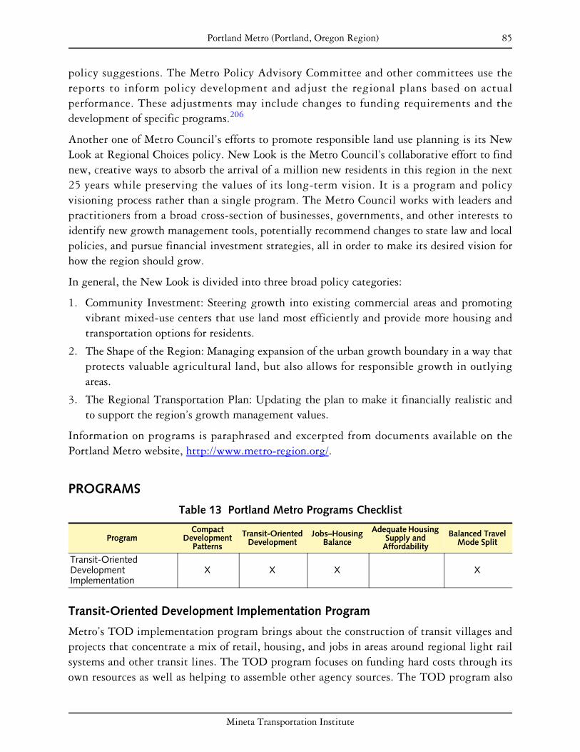
85 Portland Metro (Portland, Oregon Region)
policy suggestions. The Metro Policy Advisory Committee and other committees use the reports to inform policy development and adjust the regional plans based on actual performance. These adjustments may include changes to funding requirements and the development of specific programs.206
Another one of Metro Council’s efforts to promote responsible land use planning is its New Look at Regional Choices policy. New Look is the Metro Council’s collaborative effort to find new, creative ways to absorb the arrival of a million new residents in this region in the next 25 years while preserving the values of its long-term vision. It is a program and policy visioning process rather than a single program. The Metro Council works with leaders and practitioners from a broad cross-section of businesses, governments, and other interests to identify new growth management tools, potentially recommend changes to state law and local policies, and pursue financial investment strategies, all in order to make its desired vision for how the region should grow.
In general, the New Look is divided into three broad policy categories:
1. Community Investment: Steering growth into existing commercial areas and promoting vibrant mixed-use centers that use land most efficiently and provide more housing and transportation options for residents.
2. The Shape of the Region: Managing expansion of the urban growth boundary in a way that protects valuable agricultural land, but also allows for responsible growth in outlying areas.
3. The Regional Transportation Plan: Updating the plan to make it financially realistic and to support the region’s growth management values.
Information on programs is paraphrased and excerpted from documents available on the Portland Metro website, http://www.metro-region.org/.
PROGRAMS
Table 13 Portland Metro Programs Checklist
Compact Adequate Housing Transit-Oriented Jobs–Housing Balanced Travel Program Development Supply and Development Balance Mode SplitPatterns Affordability
Transit-Oriented Development Implementation
X X X X
Transit-Oriented Development Implementation Program
Metro’s TOD implementation program brings about the construction of transit villages and projects that concentrate a mix of retail, housing, and jobs in areas around regional light rail systems and other transit lines. The TOD program focuses on funding hard costs through its own resources as well as helping to assemble other agency sources. The TOD program also
Mineta Transportation Institute

86 Portland Metro (Portland, Oregon Region)
supports developers with technical assistance and project enhancements such as green building methods through its discretionary funds generated from auctioning and investing tax credits.
The program staff emphasize public–private partnerships over zoning mixed-use and density requirements. Through these partnerships, public entities buy land as easements on development properties in order to offset project costs. The TOD Implementation Program acquires these mixed-use/density easements at a cost proportionate to the increased cost of the project.
FINDINGS
Plans, policies, and programs managed by Portland Metro have offered tools to local jurisdictions, have provided funding for planning work, and have allocated monies to capital projects. While Metro used to closely monitor activities in the past, they have now moved away from the regulation of local governments.
Twenty-six programs have been funded as part of the TOD program since 1998. There has not been any agency-led research or evaluation of the program’s impact on vehicle miles traveled (VMT) reduction and transit ridership. However, a case study of the Merrick TOD by Professor Jennifer Dill of Portland State University found that the project altered travel behavior. The study concluded that 29 percent of residents switched from private vehicle travel to another mode. Over 75 percent of the residents moved from outside of the city, indicating the generation of new transit riders and the support of higher densities and mixed land use in the Portland center.
The grants provided by the TOD program have ranged from $30,000 to $2 million. The land acquisition practices of TriMet, the transit agency for the three-county Portland region, also contribute to the TOD program. When assembling land for rail projects, TriMet often negotiates to obtain additional adjacent lots. Later it partners with Metro to plan these lots as joint developments.
The Centers Program is relatively small, reflecting Metro’s comprehensive approach to growth management. Conceived as an integral part UGB management, it recognizes the need to collaborate with local authorities to ensure infrastructure concurrency and to understand the broader economic trends that impact growth. As this is a pilot program, its success in furthering the 2040 Growth Concept is yet to be seen.
While the 2000 Regional Transportation Plan was the first regional, multimodal planning document linking transportation investment to comprehensive land use planning, the 2040 Growth Concept, released in 1995, was the document that first encouraged land use coordination and strengthened ties between land use planning and transportation facility planning.
The principal barrier to the full development of Metro’s programs has been funding. Often agency planners have assumed funding levels that have not materialized, leading to problems.
Mineta Transportation Institute

87 Portland Metro (Portland, Oregon Region)
For example, lack of funding has proven to be a constraint to the Centers Program. Similarly, the TOD program has helped underwrite projects, but has had very limited funding.
These programs are likely to continue indefinitely. Currently, program funding has been secured for the next six years, although the RTP considers a 20-year horizon, and efforts will be made to set up funding for the future. At this time, TOD program funding comes from federal flexible funding such as CMAQ and STP.
Mineta Transportation Institute

88 Portland Metro (Portland, Oregon Region)
Mineta Transportation Institute

89
PUGET SOUND REGIONAL COUNCIL (SEATTLE, WASHINGTON REGION)
BACKGROUND
The Puget Sound region of Washington comprises the four counties of King, Kitsap, Pierce, and Snohomish. Since 1990, population and employment have increased throughout the region. The exception to this trend can be found in Kitsap County, which lost 1 percent of the region’s employment from 1990 to 2000 but nevertheless received 9 percent of the region’s population growth during that period. King County, which includes the state’s largest city, Seattle, has received the majority of the region’s recent growth, receiving 75 percent of the region’s employment growth between 1990 and 2000, and 38 percent of the population growth. Along with this population growth, traffic congestion on the region’s roadways has risen steadily.207 Increases in residential and economic activity link closely to growing traffic concerns. These concerns have played a large role in improving growth management in Washington at both the regional and state levels.
In 1990, the Washington State Legislature agreed that “uncoordinated and unplanned growth, together with a lack of common goals ... pose a threat to the environment, sustainable economic development, and the health, safety, and high quality of life enjoyed by the residents of this state. It is in the public interest that citizens, communities, local governments, and the private sector cooperate and coordinate with one another in comprehensive land use planning.” This is the foundation for the Washington State Growth Management Act of 1990.208
The key elements of regional planning at the state level in Washington are
• state growth goals;
• transportation and land use concurrency requirement;
• urban growth boundaries.
The seeds of the Growth Management Act (GMA) can be traced back to 1987, when the speaker of the house was stuck in traffic. He, like many residents in Washington, watched the quality of life diminishing because of increased traffic congestion, urban sprawl, and the loss of open space. Some counties experienced increased population growth of up to 38 percent from 1980 to 1990, according to Growth Management Services. In counties within the Puget Sound area, King County saw a 19 percent increase, Kitsap 29 percent, Pierce 21 percent, and Snohomish 39 percent. In 1991, the legislature passed amendments on how the Growth Management Act would be implemented. In 1992, the governor appointed the first growth management hearing board members.
One of the key features of Washington’s Growth Management Act is the emphasis on coordinated and consistent planning among jurisdictions. The act requires coordination and consistency among planning efforts where there are common borders or related regional issues.
Mineta Transportation Institute

90 Puget Sound Regional Council (Seattle, Washington Region)
The act also requires countywide and multicounty planning policies to serve as a framework for ensuring consistency among local comprehensive plans. In addition, Regional Transportation Planning Organization legislation, which was adopted with the Growth Management Act, mandates that regional agencies certify that the transportation elements in local comprehensive plans are consistent with regional transportation plans. The Puget Sound Regional Council’s (PSRC) Framework Plan for regional planning also directs the agency to work with local, state, transit and other regional planning agencies to ensure that planning efforts are coordinated.
In addition to state-level regional planning, the PSRC coordinates planning among King, Kitsap, Pierce, and Snohomish counties, including most of the cities they contain as well as the Muckleshoot and Suquamish tribes. Of the 83 cities in the region, 72 are members of the PSRC.209
Regionally, a general assembly and an executive board govern the PSRC. The general assembly is composed of all members, and each has a vote on major regional decisions. The 32 members of the executive board are appointed by PSRC’s membership to ensure full representation. A transportation policy board and a growth management policy board both make recommendations to the executive board.
The PSRC is the designated Metropolitan Planning Organization (MPO) for the Puget Sound as well as the Regional Transportation Planning Organization under state law. The PSRC has multicounty planning policies that guide local comprehensive plans. PSRC does not review local transit plans; transit agencies are not subject to the Growth Management Act plan review requirements. They do have a certification-of-consistency review under state law for Sound Transit, the regional high-capacity transit agency. Each year the regional council is responsible for distributing approximately $160 million of federal transportation dollars to regions.210
PLANS AND POLICIES
The Growth Management Act requires all cities and counties in the state to
• designate and protect wetlands, frequently flooded areas, and other ecologically critical areas;
• designate farmlands, forest lands, and other natural resource areas;
• determine that new residential subdivisions have appropriate provisions for public services and facilities.211
The Growth Management Act (GMA) requires counties to create and submit a comprehensive plan that designates an urban growth boundary if the county has a population of 50,000 or more and the population increased by at least 10 percent in the previous 10 years, or the county has a population of less than 50,000 and the population increased at least 20 percent in the last 10 years. Other communities can chose to comply. All cities that comply with the GMA can levy a 0.5 percent real estate excise tax, which can be used to fund infrastructure
Mineta Transportation Institute

91 Puget Sound Regional Council (Seattle, Washington Region)
contained in the comprehensive plan’s capital improvement projects. Each municipality must have a comprehensive plan with six elements (land use, housing, capital facilities, utilities, transportation, and economic development) that conforms to the countywide comprehensive plan. Regional Transportation Plans have to address a number of land use elements, including development patterns that promote pedestrian and nonmotorized transportation, density, mixed-use development, development corridors and urban design that support high-capacity transit, and economic activity areas.
All counties that are subject to the Growth Management Act are required to identify an urban growth area in consultation with municipalities. These areas are to accommodate 20 years of growth, based on projections provided by the Washington State Office of Financial Management. Urban growth area designations are to be reviewed every 10 years.212 No annexations are allowed beyond designated growth areas. The creation of these growth areas marked a breakthrough, changing the way business is done in the region.
In 1997, the Washington State Legislature adopted the Buildable Lands Amendment to the Growth Management Act. The amendment requires the six most populated western Washington counties and their cities to determine the amount of land suitable for urban development, and evaluate its capacity for growth, using a five-year time frame.213 King County and the other five counties first had to report findings to the state by 2002 and every five years thereafter. Within their reports, they had to provide remedial measures to address shortfalls in density and capacity.
The state provided $4.5 million in grants to local governments for buildable lands work from 1997 to 2000. All state funding was eliminated as of June 30, 2002, but the buildable lands requirements for the six counties remain. According to regional planners, the program has been successful at the county level but not at the regional level. Builders look for redevelopment opportunities, so part of the equation is infill development.
The Growth Management Act sets 14 statewide planning goals and allows local governments flexibility in achieving the goals. The 14 goals are to
1. encourage development in urban areas where public facilities and services exist or can be efficiently provided;
2. reduce urban sprawl;
3. encourage efficient, multimodal transportation systems;
4. provide affordable housing for citizens of all income levels, promote a variety of housing densities and types, and preserve the existing housing stock;
5. promote economic opportunity consistent with the capacities of the state’s natural resources and public services and facilities;
6. respect private property rights;
7. provide timely, fair, and predictable permit review processes;
8. conserve and enhance natural resources;
Mineta Transportation Institute

92 Puget Sound Regional Council (Seattle, Washington Region)
9. retain open space, conserve fish and wildlife habitat, increase access to natural resource lands and water, and provide recreational opportunities;
10. protect the environment and enhance the state’s high quality of life;
11. encourage citizen participation in the planning process and ensure coordination among jurisdictions;
12. ensure that public facilities and services are adequate;
13. preserve historic and archaeological resources;
14. provide consistency between shoreline management and growth management.214
Throughout the development of comprehensive plans is an extensive public process. Public participation is critical and enables local jurisdictions to develop comprehensive plans that are a truer reflection of their communities. As counties, cities, and regional planning organizations must work together to ensure consistency with each other, they are informed of issues that cross jurisdictional boundaries. Even though the state requires counties to provide 20-year growth management plans and set urban growth boundaries, the state does not approve plans. However, the Growth Management Services division of the Department of Community, Trade, and Economic Development assists counties and cities in designing growth management programs. It also provides many forms of technical and financial assistance for cities and counties planning under the Growth Management Act, helping them to fulfill necessary requirements such as supplying minimum guidelines for resource lands and critical areas and providing procedural criteria. In addition, cities and counties send draft versions of plans and policies to the Community, Trade, and Economic Development department and other state agencies (such as the DOT) for comment. In the Puget Sound region (King, Pierce, Kitsap, and Snohomish counties), the Puget Sound Regional Council reviews draft plans and policies as part of an interlocal agreement. It can only review the plans and make recommendations.
The Growth Management Hearings Boards act as the judicial arm of the Growth Management Act. They review allegations that a city, county, or state agency has not complied with the goals and requirements of the Growth Management Act or related provisions of the Shoreline Management Act and the State Environmental Policy Act.215
VISION 2020 is the regional growth, transportation, and economic development strategy that calls for preserving and developing compact communities, redeveloping urban transportation corridors, and directing employment and housing growth into centers that support walking, biking, and transit use. Adopted in 1990 and updated in 1995, VISION 2020 contains policies and strategies that address the following key components: (1) urban growth areas; (2) contiguous and orderly development; (3) regional capital facilities; (4) housing; (5) rural areas; (6) open space, resource protection, and critical areas; (7) economics; and (8) transportation.216
To better coordinate land use and transportation, VISION 2020 designated twenty-one regional growth centers and eight manufacturing/industrial centers in the region. These growth centers include both older neighborhoods and newer developments. The regional
Mineta Transportation Institute

93 Puget Sound Regional Council (Seattle, Washington Region)
growth centers are around 730 acres or 1.14 square miles, though some are smaller.217 The number of designated regional growth centers in the Puget Sound area is now up to 26.
Destination 2030 is the transportation plan for VISION 2020 and is the region’s strategy for addressing transportation issues. Destination 2030 strongly emphasizes the link between land use and transportation. The regional centers laid out in VISION 2020 were also encouraged to implement ten physical design guidelines to promote “people-oriented” development.218
PROGRAMS
Table 14 PSRC Programs Checklist
Compact Adequate Housing Transit-Oriented Jobs–Housing Balanced Travel Programs Development Supply and Development Balance Mode SplitPatterns Affordability
Transportation and Land Use Concurrency Requirement Commuter Trip Reduction Law X
Transportation and Land Use Concurrency Requirement
The Washington State Growth Management Act requires that public transportation and other infrastructure facilities be in place within six years of “the time of development” in order to accommodate the impacts of new development. “Concurrency” means that any needed improvements are in place at the time of development or that a financial commitment exists to complete the improvements within six years.
Local governments’ planning under the Growth Management Act must establish level of service (LOS) standards for their transportation systems, primarily roadways, in their comprehensive plans. They can permit new development within their jurisdictions as long as the transportation infrastructure will sustain the required LOS or the developer mitigates circumstances to achieve the LOS.219 Transportation facilities and services that are designated to be of statewide significance are exempt from concurrency requirements according to state law. It should be noted, however, that concurrency is an evolving process. LOS standards in one jurisdiction may be different than those in another.
Commute Trip Reduction Law and Supporting Programs
Enacted in 1991 as part of Washington’s Clean Air Act, the Commute Trip Reduction Law requires major employers to provide employee transportation programs that encourage more employees not to drive alone to work every day. A major employer is a private or public employer that has, at a single work site, 100 or more full-time employees who begin their regular workday between 6 AM and 9 AM. In 1996, the commuters affected by the Commute Trip Reduction Law reviewed the law on a statewide basis. Based on their input and feedback,
Mineta Transportation Institute

94 Puget Sound Regional Council (Seattle, Washington Region)
a number of revisions were made to the law, one of which was the revision of the Commute Trip Reduction Law goals.
Washington developed a Commute Trip Reduction Performance Grant Program (now known as Trip Reduction Performance Program) between 2003 and 2005, and funding was allocated to the Washington Department of Transportation (WSDOT) to develop an entrepreneurial grant program. Grants were then awarded on a competitive basis to private employers, public agencies, nonprofits, developers, and property managers who provided incentives to their own or other employees for rideshare, public transit, nonmotorized commute, telework, and alternative work schedules as part of their proposal, and who reduced the number of vehicle trips and miles traveled for commuting.220 It was a flexible program that relied on employers to be innovative to get people to reduce vehicle miles traveled (VMT) and single occupancy vehicle use.
WSDOT received 50 proposals and funded 33 of them, totaling $1.5 million dollars. Of the 33, only 29 were able to be implemented. Fourteen projects exceeded their goal; seven made at least 50 percent of their goal; four did not make 50 percent of their goal; and four showed an increase in single occupancy vehicle trips.221 Overall, the actual number of trips reduced was 5,141, with 1.285 million vehicle trips eliminated per year.222
One exemplary program has been the City of Redmond’s Employer Commute Trip Reduction Incentives–Reward for Performance. King County and the Greater Redmond Transportation Management Association partnered to provide performance-based incentives to employers for reducing vehicle trips and for maintaining those trip reductions into a second year. Projected daily trips reduced were 300, but the program exceeded its projections and reduced 1,032 daily trips.223
FINDINGS
While the PSRC does not directly regulate local areas, it does seek to encourage sound planning through regional guidance. For example, it has developed and tested some model ordinances that local jurisdictions can adopt or modify to encourage smart growth and strengthen linkages between transportation and land use planning.
In addition, under growth management legislation introduced by the State of Washington, the PSRC is charged with reviewing local planning provisions, such as the establishment of land use (density, mixed uses) and transportation criteria. It regularly takes action to confirm if a local plan complies with state and regional planning provisions. Of course, this applies only to those local jurisdictions that have formerly applied for funding as part of one of the PSRC’s programs.
In general, these programs were initially created to address anticipated growth in population, jobs, and travel in the Puget Sound area. Institutionally, they were created in direct response to federal (TEA) and state (Washington State Growth Management Act) provisions. The latter
Mineta Transportation Institute
95 Puget Sound Regional Council (Seattle, Washington Region)
was initially introduced in 1990 and is amended regularly. These regulations are primarily concerned with growth management and environmental protection as it relates, in this case, to the metropolitan region.
The principal barrier to the success of these efforts has been funding. Despite a high degree of regional concurrence on principal issues and program acceptance, many areas find it difficult to achieve everything, largely due to financial constraints. In addition, the local tax structure makes it somewhat difficult to capture revenues that can be invested in the programs.
The PSRC is currently restructuring its methodology for evaluating programs, hoping to incorporate ideas into the new VISION document. A series of regional monitoring reports have attempted to determine if programs are proceeding as expected. However, it is felt that these reports have looked at regionwide trends and have not directly measured program impacts. The new VISION update will introduce a monitoring and measurement program that measures inputs against desirable results (for example, VMT). The next steps may be to determine the impacts that were attributable to particular strategies.
At present, the VISION 2020 is being updated and will evolve into the new VISION 2040 document. PSRC is in the process of defining numerous possible program actions in such areas as environment, monitoring, and the economy. Two new transportation-related areas of action involve growth and pricing. In the first case, the PSRC is proposing a numeric growth strategy aimed at quantifying the magnitude and distribution of population and employment growth. This represents a commitment to the growth strategy, that is, strengthening regional guidance and setting a pattern for growth.
In the area of pricing, the PSRC hopes to implement both standard tolls and time-of-day charging. The former would control traffic more efficiently on major bridges in the area, while the latter would impose a toll on vehicle users for use of the roadway, charging them for some of the real costs imposed on the system.
Mineta Transportation Institute
96 Puget Sound Regional Council (Seattle, Washington Region)
Mineta Transportation Institute
97
SACRAMENTO AREA COUNCIL OF GOVERNMENTS (SACRAMENTO, CALIFORNIA REGION)
BACKGROUND
The Sacramento region comprises the six counties of El Dorado, Placer, Sacramento, Sutter, Yolo, and Yuba, as well as 22 cities including the city of Sacramento. Encompassing more than 6,500 square miles and with a 2005 population of 2.1 million, the region is expected to grow by 1.8 million in the next 50 years.224 Regional growth management is accorded to the Sacramento Council of Governments (SACOG), which is both the federally designated MPO (Metropolitan Planning Organization) and the regional transportation planning agency for the Sacramento area.
Historically, efforts to coordinate transportation and land use planning in the Sacramento region have been largely unsuccessful. In 1989, SACOG released a regional planning document called Metro Study, which included three alternative scenarios for growth management and transportation infrastructure provisioning. Despite the SACOG Board’s approval of this plan, the Metropolitan Transportation Plan (MTP) a few years later did not include Metro Study’s recommendations. In its 1995 MTP, SACOG tried to include land use issues but was criticized for its lack of collaboration with local government, among other issues.
In 2000, in efforts to better integrate land use and transportation issues, SACOG funded a regional land use study that resulted in the Blueprint Initiative, a series of community-derived goals and policies that will be incorporated into the 2007 Metropolitan Transportation Plan for 2030. Instrumental in the success of this project was SACOG’s Transportation Roundtable, an advisory group that brainstormed and devised goals for the plan. Between 1999 and 2002, the roundtable met 13 times, and has been hailed as the Sacramento region’s first attempt at multistakeholder planning.225
PLANS AND POLICIES
The following are the primary planning documents influencing land use and transportation decision making in the Sacramento region:
• Sacramento Region Blueprint: Land Use and Transportation Study—Preferred Scenario (December 2004);
• Metropolitan Transportation Plan 2027 (March 2006) and Metropolitan Transportation Improvement Program 2007–2009 (July 2006);
• Affordable Housing Compact (2004)
Mineta Transportation Institute

98 Sacramento Area Council of Governments (Sacramento, California Region)
Although the MTP is generally similar to federally mandated Regional Transportation Plans in other regions, Sacramento’s plan contains some interesting measures that may be applicable to other areas. First is the application of federal transportation funding to Blueprint and other smart growth programs throughout the region, connecting land use with transportation issues. Additionally the MTP lays out a set of quantitative indicators that compares vehicle miles traveled (VMT) in 2006 with a 2027 projection, shown in the table below. In its support for compact development, jobs–housing balance, and VMT reduction, the MTP addresses many goals with which this report is concerned.226 The information in the following table came from the 2006 MTP.
Table 15 Key Performance Indicators for the 2006 MTP
Indicators Year 2005 Year 2027
Vehicle Miles Traveled per Capita 22.3 23.4 Vehicle Trips per Capita 3.2 3.5
Daily Mode Shares
Carpool – 46.5% Transit – 0.9%
Bike/Ped – 6.2%
SOV – 46.4%
Carpool – 46.9% Transit – 1.1%
Bike/Ped – 6.1%
SOV – 45.9%
Peak Period Mode Shares
Carpool – 9.8% Transit – 2.6%
Bike/Ped – 5.4%
SOV – 82.2%
Carpool – 10.9% Transit – 3.0%
Bike/Ped – 4.9%
SOV – 81.2%
Percent Growth in Vehicle Trips (2005–2027) - 33.5%
Percent Growth in Vehicle Miles Traveled (2005–2027) - 33.3%
PROGRAMS
Table 16 SACOG Programs Checklist
Programs Compact
Development Patterns
Transit-Oriented Development
Jobs–Housing Balance
Adequate Housing Supply and
Affordability
Balanced Travel Mode Split
Blueprint Initiative X X X X X Community Design Grant Program X X X
Jobs Access Reverse Commute Program X X
Blueprint Initiative
A unique and lauded aspect of regional planning in the Sacramento area has been its extensive citizen participation effort, which included more than 5,000 people in more than 40 workshops over the past three years. At these workshops, citizens provided input preferences about shaping the region’s urban growth through a zoning and transportation computer
Mineta Transportation Institute

99 Sacramento Area Council of Governments (Sacramento, California Region)
model called PLACE3S. The results of this effort were used to create a Preferred Blueprint Scenario, which outlines measurable goals and Blueprint “principles” within many of the policy categories that we have selected for this report. Below we describe the project’s efforts to meet revitalization, compact development, transit-oriented development (TOD), open space and agricultural preservation, jobs–housing balance, housing affordability, and VMT reduction goals.227
The Blueprint Initiative aims to create compact development that increases infill development and preserves open space. The stated Blueprint principle aims to accommodate 13 percent of new jobs and 10 percent of all new housing units within infill and reinvestment areas. The Blueprint commits to limiting urban expansion to 304 square miles over the next 50 years, which is a 55 percent reduction from the no-action baseline scenario of a 661-square mile expansion.228 A “natural resources conservation” goal hopes to limit the acreage of agricultural land converted to urban uses to 102 square miles, a 31 percent reduction from the baseline case.229 One notable implementation effort of this policy can be found in the city of Folsom, which has adopted a 30 percent open space requirement.230 By 2050, 53 percent of the region’s people will live in communities that provide a mix of jobs, housing, and other mixed-use activity.231
The initiative also includes significant steps toward reducing VMT and increasing nonautomotive transportation options. Blueprint funding accounts for some of SACOG’s Community Design Grant Program (described on page 100).
Although formally approved by the SACOG Board of Directors in December 2004, the Preferred Blueprint Scenario remains a voluntary framework for managing urban growth in the Sacramento region. SACOG has recommended that each local government devise its own strategy for accommodating growth in a way that accords with Blueprint principles. This would take the form of a resolution in support of growth allocation, including a 2030 land use allocation map and a list of locally appropriate implementation strategies.232 Cities that choose to model local growth after the Preferred Blueprint Scenario, and who implement Blueprint project principles in built projects, plans, or general plans, can receive SACOG technical assistance as well as federal funding through two regional grant programs.
Technical assistance includes such tools and information as monthly Blueprint implementation seminars held by SACOG in 2005 for members, free access to the PLACE3S software from which the preferred scenario was derived, and review of city and county 2030 growth maps and strategies. Already, $25,000 has been allocated toward these assistance programs, and another $20,000 is expected from a National Endowment for the Arts grant.
Funding sources for Blueprint projects come predominantly from Community Design grants and Civic Engagement grants, both of which derive from the federal transportation dollars allocated to all MPOs. Blueprint projects have been designated an appropriate use of transportation funding for their linkages between land use and transportation.233
Mineta Transportation Institute
100 Sacramento Area Council of Governments (Sacramento, California Region)
The Blueprint is a model for other regions as a truly community-oriented and pluralistic bottom-up planning process on a large scale. Its success lies in its clear identification of long-term planning goals and citizen participation. Whether its bold visions will actually be implemented over time remains to be seen, for although some funding is available and SACOG has identified concrete “next steps” to realize the Blueprint Preferred Scenario, some opposition is already rising from citizens who do not want high-density projects in their backyards.234
Community Design Grant Program
The Community Design Grant Program receives overall $500 million235 to allocate for planning grants to local governments and for transportation improvements. Projects that receive Community Design grants are those that encourage people to make local trips, use transit, walk, or bike.236 Over the next 45 years, 41 percent of new jobs and 38 percent of new housing should be located within a quarter-mile of a public transit node. In addition, its “design for quality” policy sets a goal of providing 69 percent of the region’s residents with pedestrian-friendly neighborhood environments, up from the current 36 percent.237
Community Design funds are expected to provide $250 million between 2003 and 2025 toward Blueprint-friendly projects, with $12.1 million allocated in the 2005–2007 funding cycle alone. In addition, as a result of an appeal to Senator Barbara Boxer to encourage more involvement by citizens in the planning process, $5 million in federal funding over five years was secured to be allocated to support public involvement in Sacramento regional planning. Half of the money flows directly to local jurisdictions for local civic engagement grants, and the other $2.5 million is given to SACOG for the same purpose at a regional level.238
Jobs Access Reverse Commute Program
High unemployment areas are geographically distant from job centers, and traditional transit service hours often do not correspond with available jobs. SACOG’s Jobs Access Reverse Commute program provides $1.5 million in 2007–2009 to fill the Sacramento region’s “transit gaps.” These federal funds will be used to support extended hours and weekend service along existing transit routes, community shuttles within low-income areas, corridor bus service from distant high unemployment areas to job centers, and increased service to community colleges and industrial centers.
FINDINGS
As a standard transportation management tool, the MTP seems to be successful in both laying out measurable goals and enforcing their implementation through the allocation of funding. SACOG’s MTP 2027 allocates $1.1 billion in federal transportation funds toward three types of grants: bicycle and pedestrian ($4.9 million awarded for the 2005–2007 funding cycle), community design ($12.1 million awarded for the 2005–2007 funding cycle), and air quality
Mineta Transportation Institute

101 Sacramento Area Council of Governments (Sacramento, California Region)
($4 million awarded for the 2003–2005 funding cycle). SACOG receives further funding from the federal CMAQ program for being in a nonattainment air-quality zone, which has provided SACOG with $44 million through 2027 for transportation demand management (TDM) funding for their rideshare, carpool, and vanpool incentive programs.
The key performance indicators shown above that forecast the implementation of the 2006 MTP goals in the year 2027 appear to prevent any significant increase in vehicle miles traveled per capita—this seems promising. However, while they envision a 33 percent growth in overall VMT due to population increase, the indicators do not reveal that the 2006 MTP will substantially increase the proportion of alternative transit modes used by 2027.
Community Design is SACOG’s primary program for providing incentives to implement the responsible land use consistent with the MTP. SACOG staff reports that past recipients would all like to see the program continue and grow, as they see the program as one of the few means through which they can receive critical funding for Blueprint-style projects. Preliminary discussions have revolved around focusing the funding in three specific areas:
1. Dedicate a higher percentage of the funds (approximately 90 percent) to capital rather than planning projects. The main reason is that capital projects are much more likely to meet federal transportation funding requirements.
2. Segment the current program into at least three separate programs targeted at different situations:
a. an infill program designed to produce more housing and help create a higher-density, mixed-use environment in transportation corridors (for example, arterials) and nodes (around light rail stations, downtowns in any community in the region);
b. a program for those jurisdictions that take more than their SACOG-estimated “fair share” of low- and very-low-income units;
c. a program designed to produce more base sector jobs in communities located far from the urban core to facilitate more self-sustaining communities on the metropolitan fringe.
3. Possibly move toward funding fewer, larger projects, to make a difference at a larger scale.
Although these program enhancements are preliminary, the Community Design Program seems destined to continue and grow.239
Mineta Transportation Institute
102 Sacramento Area Council of Governments (Sacramento, California Region)
Mineta Transportation Institute

103
SAN DIEGO ASSOCIATION OF GOVERNMENTS (SAN DIEGO, CALIFORNIA REGION)
BACKGROUND
The San Diego Association of Governments (SANDAG) is both the Metropolitan Planning Organization (MPO) and the council of governments for San Diego County, as a result of state legislation effective January 1, 2003.240 Its board is made up of representatives from the local jurisdictions it encompasses, including some mayors, council members, and other regional representatives.241 San Diego County encompasses almost all of the San Diego metropolitan area, with an estimated population of over 2.9 million in 2006.242 This is one of the fastest-growing regions in the country, with a forecast population of 3.8 million in 2030, a 37 percent increase from the 2000 population.
SANDAG has little legal authority over constituent jurisdictions. As a result, its approach to planning, according Carolina Gregor, a senior regional planner at SANDAG, has been extremely cooperative and inclusive so as to encourage the participation and agreement of as many jurisdictions as possible.
SANDAG is designated by the State of California as the areawide clearinghouse for the review of environmental documents and certain grant applications for projects and programs to be conducted or located in the San Diego region. In this way, SANDAG can ensure that large federally funded projects are not at odds with the Regional Comprehensive Plan.243
In November 2004, 67 percent of voters approved a 40-year extension of TransNet, a half-cent sales tax for local transportation projects. TransNet is expected to generate $14 billion for public transit, highway, and local street and roadway improvements.
PLANS AND POLICIES
In 2000, SANDAG adopted the 2020 Regional Transportation Plan (RTP), which explicitly addressed the goals of coordinating land use planning and transportation, demand management, capacity enhancements, and system management.244 Its forecasts are based on land use plans that jurisdictions have approved.245 In 2002, SANDAG began the process of developing a Regional Comprehensive Plan to develop a long-term planning framework for the region that all jurisdictions could rally around. It was developed with the participation of all jurisdictions in order to ensure broad agreement regarding its principles. The process of developing the plan took two years, and SANDAG’s Board of Directors adopted the Regional Comprehensive Plan in 2004.246 The vision statement for the Regional Comprehensive Plan is as follows:
To preserve and enhance the San Diego region’s unique features—its vibrant and culturally-diverse communities, its beaches, deserts, mountains, lagoons, bluffs, and
Mineta Transportation Institute
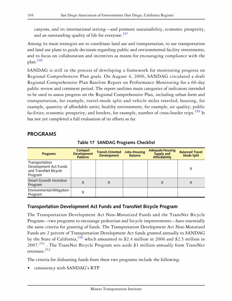
104 San Diego Association of Governments (San Diego, California Region)
canyons, and its international setting—and promote sustainability, economic prosperity, and an outstanding quality of life for everyone.247
Among its main strategies are to coordinate land use and transportation, to use transportation and land use plans to guide decisions regarding public and environmental facility investments, and to focus on collaboration and incentives as means for encouraging compliance with the plan.248
SANDAG is still in the process of developing a framework for monitoring progress on Regional Comprehensive Plan goals. On August 4, 2006, SANDAG circulated a draft Regional Comprehensive Plan Baseline Report on Performance Monitoring for a 60-day public review and comment period. The report outlines main categories of indicators intended to be used to assess progress on the Regional Comprehensive Plan, including urban form and transportation, for example, travel-mode split and vehicle miles traveled; housing, for example, quantity of affordable units; healthy environment, for example, air quality; public facilities; economic prosperity; and borders, for example, number of cross-border trips.249 It has not yet completed a full evaluation of its efforts so far.
PROGRAMS
Table 17 SANDAG Programs Checklist
Compact Adequate Housing Transit-Oriented Jobs–Housing Balanced Travel Programs Development Supply and Development Balance Mode SplitPatterns Affordability
Transportation Development Act Funds and TransNet Bicycle Program
X
Smart Growth Incentive Program X X X X
Environmental Mitigation Program X
Transportation Development Act Funds and TransNet Bicycle Program
The Transportation Development Act Non-Motorized Funds and the TransNet Bicycle Program—two programs to encourage pedestrian and bicycle improvements—have essentially the same criteria for granting of funds. The Transportation Development Act Non-Motorized Funds are 2 percent of Transportation Development Act funds granted annually to SANDAG by the State of California,250 which amounted to $2.4 million in 2006 and $2.5 million in 2007.251 . The TransNet Bicycle Program sets aside $1 million annually from TransNet
252revenues.
The criteria for disbursing funds from these two programs include the following:
• consistency with SANDAG’s RTP
Mineta Transportation Institute

105 San Diego Association of Governments (San Diego, California Region)
• environmental factors, including local employment and residential densities (higher-density areas are given preference), determined through geographic information systems (GIS) analysis
• consistency with SANDAG’s design guidelines
• coordination with other affected jurisdictions253
There does not appear to be any evaluation of the effectiveness of the bicycle measures funded to date, apart from consistency with local and regional plans. One crude measure would be whether or not trips by bicycle have increased or decreased over the past several years. Comparing the 1990 and 2000 U.S. census data, the proportion of work trips that were in modes other than motor vehicle or public transit (that is, walking or biking) decreased significantly;254 although this decline occurred in most regions, it suggests that providing walking and bicycling amenities is not enough to encourage people to walk or bike to work. The budget increase for bicycle (as well as pedestrian and traffic calming) measures may begin to change this, but more time will be needed to perform this evaluation.
Smart Growth Incentive Program
SANDAG initiated a process of identifying areas of existing and potential smart growth in the region in order to prioritize funding for capital grants and planning grants. They did this by asking each of the local jurisdictions to identify areas of both “existing/planned” and “potential” smart growth within their borders.255 Areas that had already built or had been zoned for dense development accessible to transit could be designated as existing or planned smart growth areas; areas that had the potential for densification, but for which such development had not been incorporated into the city plan, could be designated as potential smart growth areas. Each municipality nominated at least one smart growth area and, using GIS, SANDAG approved areas as either existing/planned or potential smart growth areas. In total, 200 areas were identified, and SANDAG designated approximately 40 percent of these as existing/planned smart growth areas and 60 percent as potential smart growth areas. Collectively, this is known as the Smart Growth Concept Map.
The Smart Growth Incentive Program was created to encourage that development be concentrated in these smart growth areas. Of the TransNet tax, 2 percent, or approximately $280 million over 40 years ($7 million per year), was approved for the Smart Growth Incentive Program.256 This program approves two different kinds of grants—capital improvement grants and planning grants. All grants are awarded based on a points system, whereby a number of factors including need, quality of proposal, and past performance are taken into account and given a point value. The cities whose proposals are awarded the greatest number of points receive the grants.
Existing or planned smart growth areas on the Smart Growth Concept Map are eligible to apply for capital improvement grants, which may include streetscaping, pedestrian and bicycle improvements, façade improvements, and other projects. Potential smart growth areas on the Smart Growth Concept Map are eligible to apply for planning grants, which fund
Mineta Transportation Institute

106 San Diego Association of Governments (San Diego, California Region)
investigations of how these areas could be planned for smart growth. If jurisdictions actually incorporate the plans for potential smart growth areas into their general plans, the jurisdictions can apply to SANDAG to have their smart growth area upgraded from “potential” to “existing/planned,” making it then eligible for capital improvement grants.
In the initial pilot Smart Growth Incentive Program, which preceded the current program, funding sources included some federal agencies that allowed more flexibility to SANDAG for allocating funds. As such, in the pilot program, the criteria for which Smart Growth Incentive Program grants were given out included whether or not jurisdictions were accommodating their fair share of affordable housing under the Regional Housing Needs Assessment. Jurisdictions that were accommodating their fair share or more were given preference for Smart Growth Incentive Program grants. This practice was officially adopted for most discretionary SANDAG grants in a 2005 memorandum passed by the SANDAG Board, which will be discussed later. However, specific to the Smart Growth Incentive Program, this memorandum also states that jurisdictions with a disproportionately higher share of lower-income households than the regional average shall receive at least 15 bonus points for projects requesting Smart Growth Incentive Program funds.
The Smart Growth Concept Map also informed the creation of the Regional Comprehensive Plan and the RTP.257
Environmental Mitigation Program
The Environmental Mitigation Program is a measure that was approved by San Diego region voters in 2004. The program dedicates $850 million of the TransNet tax over 40 years. Most ($650 million) will be used to mitigate the impacts of the transportation projects in the RTP. To help mitigate the negative environmental effects of increased densities and infrastructure in urban areas, $200 million is targeted for purchasing and maintaining lands for conservation. These funds are generally granted to regional and municipal agencies that already manage conservation areas. The funding allows SANDAG to identify and purchase areas in the short term that will offset future growth in the long term, allowing lands to be purchased at a cheaper price than if the land were sold when under threat of development.258 Thus, the TransNet tax will fund environmental enhancements that extend beyond transportation corridors.
FINDINGS
The TransNet tax represents a tremendous opportunity for sustained funding for transportation projects that support responsible land use and development. The tax is not an actual implementation policy, but will provide substantial funding for SANDAG programs including the Smart Growth Incentive Program, bicycle and other nonmotorized transportation, and the innovative Environmental Mitigation Program.259 Most of these
Mineta Transportation Institute
107 San Diego Association of Governments (San Diego, California Region)
programs were begun with state and federal funds, so the TransNet tax effectively represents regional funding and expansion of program launched with higher-government funding.
The Environmental Mitigation Program is particularly innovative in that it aims to both fully mitigate the RTP transportation improvements and provide funds for preserving environmentally sensitive areas throughout the region. The Environmental Mitigation Program will not begin until 2008, when funds from the TransNet tax become available, so evaluation of its effectiveness will not be possible for some time.260
SANDAG recognizes that $7 million a year for the Smart Growth Incentive Program is not sufficient to create change on a large scale. However, this is the first source of steady funding for this kind of initiative, and SANDAG has hopes that they will eventually be able to supplement this funding with grants from other agencies such as the Environmental Protection Agency, as well as eventually require jurisdictions to match funding, in order to fund larger projects. Because 2005 was the first year of the program, it has not yet been evaluated in terms of effectiveness. However, some indicators of the success of the grants may be evaluated once the monitoring of the Regional Comprehensive Plan begins.
Mineta Transportation Institute

108 San Diego Association of Governments (San Diego, California Region)
Mineta Transportation Institute

109
TWIN CITIES METROPOLITAN COUNCIL (MINNEAPOLIS–ST. PAUL, MINNESOTA REGION)
BACKGROUND
The region surrounding Minneapolis and St. Paul in Minnesota includes 7 counties and 192 incorporated municipalities.261 In 2000, the region had a population of 2.6 million; it grew at a rate of 15 percent between 1990 and 2000. The region is on course to add a million people between 2000 and 2030, when the population is expected to top 3.6 million.262
The Twin Cities are served by the Metropolitan Council, a regional planning body established by the state legislature in 1967 to plan for the orderly and economical development of the region.263 The Metropolitan Council’s authority was increased during regional legislative reforms that took place in 1974, 1976, and 1994.264
Today the Metropolitan Council has authority to review mandatory city and county comprehensive plans to ensure coordination with regional goals and four infrastructure systems: transit, wastewater treatment, airports, and parks. Since 1993, the Metropolitan Council has had budgetary control over the region’s wastewater treatment facilities, transit facilities, airport, and open-space provisions, with a $600 million budget. The governor appoints 17 members of the Metropolitan Council; 16 members each represent a geographic district, and one chair serves at large.265
The key elements of regional planning in Minnesota are
• the 2030 Regional Development Framework;
• regional tax-base sharing;
• comprehensive plan review and Metropolitan Urban Services Area;
• regional fair-share housing;
• Livable Communities Grant Program.
Minnesota’s original regional planning legislation, passed in 1967, established the Metropolitan Council and gave it limited authority to coordinate land use planning by reviewing and commenting on a local community’s comprehensive plan. In the early 1970s, the council’s authority was strengthened by federal recognition of regional agencies as the basic coordination unit for federal investments. The Metropolitan Land Planning Act of 1976 strengthened the council’s role by requiring, for the first time, that all local governments in the seven-county area adopt a comprehensive plan. The law was crafted to prevent communities from adopting plans in isolation from one another or the region as a whole. Four years later, in 1971, the legislature passed the Fiscal Disparities Act, which created the region’s tax-base-sharing program.266
Mineta Transportation Institute

110 Twin Cities Metropolitan Council (Minneapolis–St. Paul, Minnesota Region)
From 1993 to 1995, legislative reforms further strengthened the role of the Metropolitan Council and provided funding for projects that meet regional goals. One piece of legislation merged the regional planning functions of the Metropolitan Council with the operation of wastewater and transit. The 1995 Livable Communities Act provided funding for programs focused on brownfield redevelopment, transit-oriented development (TOD), and affordable housing.267
PLANS AND POLICIES
The Metropolitan Council adopted a new regional plan, the 2030 Regional Development Framework, in January 2004.268 For the first time, the regional plan includes benchmarks to measure progress toward its goals. The four main goals of the framework are to
1. accommodate growth in a flexible, connected, and efficient manner;
2. slow growth in traffic congestion and improve mobility;
3. encourage expanded choices in housing location and choice;
4. conserve, protect, and enhance the region’s vital natural resources.269
In addition to the Regional Framework plan, the Metropolitan Council also developed specific plans to cover its areas of oversight, including the 2030 Transportation Policy Plan, which was adopted on December 14, 2005.270
The Twin Cities have fairly aggressive transportation goals. including
• limiting vehicle miles traveled (VMT) per capita growth to no more that 0.02 percent annually;
• keeping congestion growth below 1 percent per year;
• increasing transit service 3 percent per year;
• doubling transit ridership to 150 million riders by 2030.271
The plan also calls for 300 new lane-miles of freeway to be added in congested areas.272
Congestion has remained relatively flat in the region.273 Data for VMT is only collected each decade, so there is no data for that goal. Transit ridership declined by 10 million riders per year from 2002 to 2004, due to service cuts, fare increases, and a transit strike. However, ridership on the Hiawatha light rail corridor, which opened in 2004, had more than double the expected passenger volumes.274
Mineta Transportation Institute

111 Twin Cities Metropolitan Council (Minneapolis–St. Paul, Minnesota Region)
PROGRAMS
Table 18 Twin Cities Metropolitan Council Programs Checklist
Compact Adequate Housing Transit-Oriented Jobs–Housing Balanced Travel Programs Development Supply and Development Balance Mode SplitPatterns Affordability
Comprehensive Plan Review and Metropolitan Urban Services Area
X X X
Regional Fair-Share Housing X X
Livable Communities Grant Program X X X X X
Comprehensive Plan Review and Metropolitan Urban Services Area
As stated above, the 1976 Minnesota Land Use Planning Act strengthened the Metropolitan Council’s role in ensuring that communities plan for development that is consistent with regional goals. The act established a process under which the Metropolitan Council provides each community with a “system statement” showing how their community is affected by regional plans for sewers, transportation, parks, and airports;275 communities develop their plans and share them with neighboring communities; and the council reviews these plans to ensure that they are consistent with regional system plans.276
The comprehensive plan update process is completed every 10 years, with the next round due in 2008.277 Each comprehensive plan is required to include the following elements: land use, transportation, water resources, parks and open space, and implementation. To help communities plan for compliance with the 2030 Regional Development Framework, the Metropolitan Council has developed online planning resources.
The Metropolitan Council has reviewed nearly 4,000 comprehensive plan updates and amendments since given the authority by the Land Use Planning Act. There have been approximately 60 cases in which plan changes were required for consistency with regional goals. Most of the revisions were completed through a negotiation process between the council and the city, and only once has the Metropolitan Council been taken to court. In that case, which was decided in 2000, the State Supreme Court upheld the Metropolitan Council’s authority to require comprehensive plan revisions. This ruling effectively reinforced the Metropolitan Council’s authority.278
To encourage growth in areas with adequate sewage and transportation infrastructure, the Metropolitan Council also establishes the Metropolitan Urban Services Area. The Metropolitan Urban Services Area is not a growth boundary. It is intended to direct, but not require, growth in areas that are already developed and that have adequate infrastructure capacity. In order to expand the area, local government entities whose comprehensive plans call for development outside the Metropolitan Urban Services Area boundary must apply for a Metropolitan Urban Services Area extension, so that infrastructure planning will take into account their planned growth. The Metropolitan Urban Services Area boundary will not be
Mineta Transportation Institute
112 Twin Cities Metropolitan Council (Minneapolis–St. Paul, Minnesota Region)
extended unless a community meets specific conditions, including having an average residential density of three units per acre. In its 2030 Regional Development Framework, the Metropolitan Council set a goal of not extending the Metropolitan Urban Services Area past 702,000 acres through 2030.
Regional Fair-Share Housing
In the 1970s, Minnesota developed one of the nation’s most successful regional fair-share housing programs. The Land Use Planning Act of 1976 required communities to include a plan for meeting regional affordable housing needs in their comprehensive plans. The program was implemented through the Metropolitan Council, which adopted a set of zoning and land use guidelines that cities could use to meet their goals. Although the Metropolitan Council did not have operating control of regional infrastructure until the 1990s, infrastructure funding was tied to compliance with regional goals, including affordable housing allocation.279
The Livable Communities Act, passed in 1995, gave the Metropolitan Council even more authority to tie regionwide fair-share housing allocation to infrastructure. Given budgetary and operations authority for the four regional systems (transit, wastewater, parks, and airports), the council’s allocation of sewer infrastructure was specifically linked to suburban cities’ development of affordable housing plans.280
Since the adoption of the 2030 Regional Development Framework, the Metropolitan Council has created a new system to ensure that affordable housing allocation meets regional goals. In order to be consistent with regional goals, affordable housing is allocated to municipalities that are currently served by sewage capacity. The process now takes into consideration projected need in each community for affordable housing, proximity to low-wage jobs, and proximity to transit.281
Livable Communities Grant Program
The Livable Communities Grant Program was created by the legislature in 1995 to provide incentives for brownfield redevelopment (development on previously industrial sites), efficient ties between land use and infrastructure planning, and affordable housing. The program is administered through four separate programs. Two of these programs are the Tax Base Revitalization Account and the Livable Communities Demonstration Account. The Tax Base Revitalization Account is focused on cleaning up polluted land for redevelopment, directing growth to central cities and older suburbs. The Livable Communities Demonstration Account provides funding for projects that connect housing, jobs, and services to use regional infrastructure efficiently.282
Mineta Transportation Institute

113 Twin Cities Metropolitan Council (Minneapolis–St. Paul, Minnesota Region)
FINDINGS
The Metropolitan Council’s system of state-mandated plan review is now in its fourth decade. Regional planning and regional review of local plans are practices that are well established, fully funded with regional revenues, and have been endorsed by the courts and by state government led by three political parties. The real key to the success of regional plan review is that is set up in a way that fosters cooperation between communities and the council. System statements are created for each community and give a clear picture of how the community is expected to grow. Sharing plans among neighboring communities allows the Metropolitan Council to get feedback from communities affected by other cities’ growth. Because the Metropolitan Council has budget authority over transit, sewage, and parks systems, they are able to enforce consistency with the regional plans through infrastructure service provision.
Tying regional housing requirements to infrastructure provision was first done in the Metropolitan Council’s first plans in the 1970s. This power has been enhanced through the Livable Communities Act of 1995, which gives incentives and “teeth” to the Twin Cities’ system of fair-share housing allocation and allows housing programs to be linked to other smart growth goals. The Metropolitan Council case shows the advantage of having a firm legal foundation for linking regional housing and transportation needs.
Through the four-part Livable Communities Grant Program, the Metropolitan Council has awarded 425 grants totaling $145 million, leveraging billions of dollars in private investment and federal funds. Through the Tax Base Revitalization Account, 186 grants have been awarded in 33 communities, providing $59 million for brownfield redevelopment. Over 1,300 acres of contaminated urban land are expected to be developed, increasing annual net tax capacity by $52.1 million. The Livable Communities Demonstration Account has provided $66 million in grants to 46 communities to encourage development in areas with existing infrastructure. The 133 grants are expected to result in 21,834 new and 618 rehabilitated housing units in areas served by transit. The Local Housing Incentive Account, a program within the overall Livable Communities Grant Program, has awarded $14.85 million in 93 grants to 50 communities.283 Since these programs are awarded on a reimbursement basis, the implementation of the improvements is guaranteed.284
In summary, the Metropolitan Council shows the advantage of having a well-established and well-funded planning agency in place. While local governments everywhere resist the imposition of constraints on their ability to control land use, the Metropolitan Council’s long-standing funding and operating authority demonstrates that it is possible to implement innovative programs that link transport funding to responsible land use with relative ease.
Mineta Transportation Institute

114 Twin Cities Metropolitan Council (Minneapolis–St. Paul, Minnesota Region)
Mineta Transportation Institute

115
CONCLUSIONS
The jurisdictions and programs reviewed have implemented a range of approaches, with varying levels of complexity and success in meeting program goals. This range of approaches includes informational support and planning grants for localities, funding for infrastructure, and state mandates requiring local policies to conform to state or regional guidelines. The variety in strategies shows that there is no single formula for achieving a strong linkage between state and regional transportation funding and responsible land use. Much depends on past land use policies and practices, as well as the specific context of each state or region.
This section summarizes research by grouping the case study programs into categories to better synthesize our findings. Each category below contains a table showing relevant program information. Following these tables, noteworthy programs within each category are highlighted. The remainder of this section summarizes the project team’s overarching conclusions, presents what we believe to be the most important keys to success, and reviews the daunting barriers that remain.
SUMMARY OF PROGRAMS
Table 25 on page 168 provides detailed program information for all of the programs reviewed in this report. A central distinction that can be made between the various programs can be found in the far right column of this table, which classifies programs as either regulatory or incentive-based. Of the 40 programs reviewed in the report, 7 are regulatory, 32 are incentive based, and one cannot be classified as either (Atlanta Regional Commission’s Community Choices Toolkit). To further differentiate the programs, they are divided into four categories that describe the central purpose of the program. In the table, programs are categorized as providing one or more of the following:
1. Planning resources
2. Technical assistance
3. Planning grants
4. Infrastructure
The first two categories, planning resources and technical assistance, can be considered to be less aggressive than the others. These programs create resources for jurisdictions and planning agencies by providing software, technical assistance, staff, planning tools, and other products and services to assist in responsible planning practices. The third and fourth categories, planning grants and infrastructure, provide incentives to planning agencies that meet certain criteria and goals. Many of the programs reviewed in this report provide both planning grants and infrastructure. Other programs only employ one of these approaches. Planning grants are allocated in order to fund progressive transportation and land use planning processes.
Mineta Transportation Institute

116 Conclusions
Infrastructure programs, in contrast, provide grants to fund capital projects. This is considered to be the most aggressive type of program because capital improvements often pose the greatest funding challenge for planning agencies.
Below we review four classifications of programs:
• resource programs, which provide either planning tools or technical assistance (categories 1 and 2 above)
• planning grant programs, which provide grants for planning efforts alone (category 3)
• infrastructure programs, which fund capital improvements alone (category 4)
• hybrid strategies, which fall in more than one of the above categories
The following paragraphs expand on each of these classifications. Each classification includes a table with relevant program information. These tables are followed by additional discussion of noteworthy programs within each category. Noteworthy programs are those that have met with relative success and provide examples of how common barriers (outlined at the end of this section) can be overcome.
The following six programs reviewed in the report do not fall under any of the four categories, as shown in Table 25:
• Denver Regional Council of Governments—Mile High Compact
• State of Maryland—Live Near Your Work Plus
• Puget Sound Regional Council
• Transportation and Land Use Concurrency Requirement
• Commuter Trip Reduction Law
• San Diego Association of Governments—Environmental Mitigation Program
• Twin City Metropolitan Council—Livable Communities Grant Program
Resource Programs
Table 19 shows six programs that provide resources, either as planning tools or technical assistance. None of these programs provides planning grants, funds capital improvements, or allocates infrastructure funding.
Mineta Transportation Institute

Conclusions 117
Table 19 Resource Programs
JURISDICTION PROGRAM
FUN
DIN
G
PRO
VID
ED?
SOU
RC
E O
FFU
ND
ING
PROGRAM PROVIDES
YEA
R S
TAR
TED
REGULATORY OR INCENTIVE-BASED?
PLA
NN
ING
RES
OU
RC
ES
TEC
HN
ICA
LA
SSIS
TAN
CE
ATLANTA REGIONAL COMMISSION
Community Choices Toolkit No N/A X X 2005 N/A
STATE OF FLORIDA Pay as You Grow No State X 2005 Regulatory
STATE OF MARYLAND
Priority Funding Areas Yes State X 1997 Regulatory
TOD Strategy No N/A X 1997 Incentive-Based
SACRAMENTO AREA COUNCIL OF GOVERNMENTS
Blueprint Initiative Yes Federal X X 2004 Incentive-Based
TWIN CITIES METROPOLITAN COUNCIL
Comprehensive Plan Review & Metropolitan Urban Services Area
No N/A X 1976 Regulatory
Arguably the most well known of these programs is the State of Maryland’s Priority Funding Areas program. Under the program, growth funding is restricted to Priority Funding Areas. Therefore, state funding for common practices such as infrastructure construction and economic development is limited to existing communities and areas that are desirable for future growth. The program is also established at the county level, with counties having the authority to designate their own Priority Funding Areas so long as they meet state-mandated criteria. In addition, local jurisdictions have some control over specific boundaries.
This program is a prime example of state planning for responsible growth. The program creates a systematic link between transportation, environmental resources, land use conditions, and future growth. Because counties and local jurisdictions retain some control over funding decisions, this program is also a good example of how responsible planning can be executed at a state level without completely compromising local control.
Planning Grant Programs
The four programs in Table 20 fund planning initiatives such as transportation plans, community-based planning, redevelopment efforts, and corridor plans.
Table 20 Planning Grant Programs
JURISDICTION
STATE OF CALIFORNIA
PROGRAM
Community-Based Transportation Planning Grants
FUNDING PROVIDED?
Yes
SOURCE OF FUNDING
State DOT
YEAR STARTED
2000
REGULATORY OR INCENTIVE-BASED?
Incentive-Based
STATE OF ILLINOIS Illinois Tomorrow Corridor Planning Grant Program
Yes State 2000 Incentive-Based
Mineta Transportation Institute
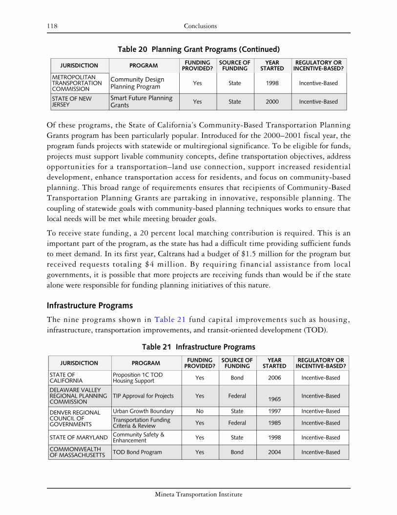
118 Conclusions
Table 20 Planning Grant Programs (Continued)
JURISDICTION
Community Design Planning Program
PROGRAM
Yes
FUNDING PROVIDED?
State
SOURCE OF FUNDING
1998
YEAR STARTED
Incentive-Based
REGULATORY OR INCENTIVE-BASED?
METROPOLITAN TRANSPORTATION COMMISSION
STATE OF NEW JERSEY
Smart Future Planning Grants Yes State 2000 Incentive-Based
Of these programs, the State of California’s Community-Based Transportation Planning Grants program has been particularly popular. Introduced for the 2000–2001 fiscal year, the program funds projects with statewide or multiregional significance. To be eligible for funds, projects must support livable community concepts, define transportation objectives, address opportunities for a transportation–land use connection, support increased residential development, enhance transportation access for residents, and focus on community-based planning. This broad range of requirements ensures that recipients of Community-Based Transportation Planning Grants are partaking in innovative, responsible planning. The coupling of statewide goals with community-based planning techniques works to ensure that local needs will be met while meeting broader goals.
To receive state funding, a 20 percent local matching contribution is required. This is an important part of the program, as the state has had a difficult time providing sufficient funds to meet demand. In its first year, Caltrans had a budget of $1.5 million for the program but received requests totaling $4 million. By requiring financial assistance from local governments, it is possible that more projects are receiving funds than would be if the state alone were responsible for funding planning initiatives of this nature.
Infrastructure Programs
The nine programs shown in Table 21 fund capital improvements such as housing, infrastructure, transportation improvements, and transit-oriented development (TOD).
Table 21 Infrastructure Programs
JURISDICTION PROGRAM FUNDING PROVIDED?
SOURCE OF FUNDING
YEAR STARTED
REGULATORY OR INCENTIVE-BASED?
STATE OF CALIFORNIA
Proposition 1C TOD Housing Support Yes Bond 2006 Incentive-Based
DELAWARE VALLEY REGIONAL PLANNING COMMISSION
TIP Approval for Projects Yes Federal 1965 Incentive-Based
DENVER REGIONAL Urban Growth Boundary No State 1997 Incentive-Based COUNCIL OF GOVERNMENTS
Transportation Funding Criteria & Review Yes Federal 1985 Incentive-Based
STATE OF MARYLAND Community Safety & Enhancement Yes State 1998 Incentive-Based
COMMONWEALTH OF MASSACHUSETTS TOD Bond Program Yes Bond 2004 Incentive-Based
Mineta Transportation Institute

Conclusions 119
Table 21 Infrastructure Programs (Continued)
JURISDICTION PROGRAM FUNDING PROVIDED?
SOURCE OF FUNDING
YEAR STARTED
REGULATORY OR INCENTIVE-BASED?
METROPOLITAN Capital Grants Program Yes Federal 1998 Incentive-Based TRANSPORTATION COMMISSION
Housing Incentive Program Yes Federal 2001 Incentive-Based
SAN DIEGO ASSOCIATION OF GOVERNMENTS
TDA Non-Motorized Funds & TransNet Bicycle Program
Yes State & TransNet tax 1987 Incentive-Based
Massachusetts has received growing attention for its smart growth and sustainable development initiatives. The commonwealth’s Transit-Oriented Development (TOD) Bond Program allocates funds to projects near any one of several transportation authorities’ facilities. Funds go toward transportation improvements such as bicycle, pedestrian, and parking projects, as well as to the development of housing and mixed-use projects. The TOD Bond Program is a good example of how collaborative projects can be successful in achieving common goals. In this case, the governor’s goals were realized through coordination with various transportation authorities as well as the Executive Office of Transportation and Public Works.
Hybrid Strategies
The programs shown in Table 22 serve multiple goals. Nearly all of these programs fund infrastructure (12 of 14) and/or provide planning grants (13 of 14); 9 of these 14 programs fund both infrastructure and planning projects. In this sense, these programs can be considered as the most aggressive in terms of funding efforts. These programs meet multiple goals and function through a variety of implementation methods.
Table 22 Hybrid Strategies
JURISDICTION PROGRAM
FUN
DIN
G
PRO
VID
ED?
SOU
RC
E O
FFU
ND
ING
PROGRAM PROVIDES
YEA
R S
TAR
TED
REGULATORY OR INCENTIVE-BASED?
TEC
HN
ICA
L A
SSIS
TAN
CE
PLA
NN
ING
GR
AN
TS
INFR
A-
STR
UC
TUR
E
ATLANTA REGIONAL COMMISSION Livable Centers Initiative Yes Federal X X 1999 Incentive-Based
CAPITAL DISTRICT TRANSPORTATION COMMITTEE
Community & Transportation Linkage Planning Program
Yes Federal X X 2000 Incentive-Based
DELAWARE VALLEY REGIONAL PLANNING COMMISSION
Transportation & Community Development Initiative Grants
Yes
Federal, State, and
Local
X X 2002 Incentive-Based
STATE OF MARYLAND Priority Places Yes State X X 2003 Incentive-Based
METROPOLITAN TRANSPORTATION COMMISSION
Transportation for Livable Communities Yes Federal X X 1998 Incentive-Based
TOD Policy Yes Regional X X 2005 Incentive-Based
Mineta Transportation Institute
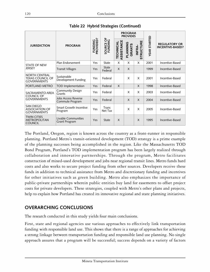
120 Conclusions
Table 22 Hybrid Strategies (Continued)
JURISDICTION PROGRAM
FUN
DIN
G
PRO
VID
ED?
SOU
RC
E O
FFU
ND
ING
PROGRAM PROVIDES
YEA
R S
TAR
TED
REGULATORY OR INCENTIVE-BASED?
TEC
HN
ICA
LA
SSIS
TAN
CE
PLA
NN
ING
G
RA
NTS
INFR
A-
STR
UC
TUR
E
STATE OF NEW JERSEY
Plan Endorsement Yes State X X X 2001 Incentive-Based
Transit Villages Yes State Federal X X 1999 Incentive-Based
NORTH CENTRAL TEXAS COUNCIL OF GOVERNMENTS
Sustainable Development Funding Yes Federal X X 2001 Incentive-Based
PORTLAND METRO TOD Implementation Yes Federal X X 1998 Incentive-Based
SACRAMENTO AREA COUNCIL OF GOVERNMENTS
Community Design Grants Yes Federal X X 2003 Incentive-Based
Jobs Access Reverse Commute Program Yes Federal X X 2004 Incentive-Based
SAN DIEGO ASSOCIATION OF GOVERNMENTS
Smart Growth Incentive Program Yes Trans
Net Tax X X 2005 Incentive-Based
TWIN CITIES METROPOLITAN COUNCIL
Livable Communities Grant Program Yes State X X 1995 Incentive-Based
The Portland, Oregon, region is known across the country as a front-runner in responsible planning. Portland Metro’s transit-oriented development (TOD) strategy is a prime example of the planning successes being accomplished in the region. Like the Massachusetts TOD Bond Program, Portland’s TOD implementation program has been largely realized through collaboration and innovative partnerships. Through the program, Metro facilitates construction of mixed-used development and jobs near regional transit lines. Metro funds hard costs and also works to secure project funding from other sources. Developers receive these funds in addition to technical assistance from Metro and discretionary funding and incentives for other initiatives such as green building. Metro also emphasizes the importance of public-private partnerships wherein public entities buy land for easements to offset project costs for private developers. These strategies, coupled with Metro’s other plans and projects, help to explain how Portland has created its innovative regional and state planning initiatives.
OVERARCHING CONCLUSIONS
The research conducted in this study yields four main conclusions.
First, state and regional agencies use various approaches to effectively link transportation funding with responsible land use. This shows that there is a range of approaches for achieving a strong linkage between transportation funding and responsible land use planning. No single approach assures that a program will be successful; success depends on a variety of factors
Mineta Transportation Institute

Conclusions 121
including political support for program goals, sufficient funding for program initiatives, coordination among different levels of government, and active citizen involvement.
Second, all the jurisdictions evaluated in this study provide localities with planning grants and resources aimed at promoting responsible land uses. This approach is well received by localities, even when the authorizing state or region requires that these grants must aim to achieve certain land use objectives.
Third, several jurisdictions have had success in linking funding for transportation facilities with local conformity to state and regional land use criteria or standards. Pursuing this connection requires a degree of commitment and/or funding capacity that doesn’t exist in all states and regions.
Fourth, there has generally been minimal performance measurement on the impact of the programs reviewed in this report. As a result, it is difficult to assess the direct effect these programs have on reducing vehicle miles traveled, promoting transit use, or improving air quality at a regional or state level.
Keys to Success
Some of the most critical elements in assuring that state and regional transportation funding results in more responsible land use are outlined below.
Collaboration and Cooperation
Effective implementation of state transportation funding and responsible land use programs has resulted from both interagency cooperation at the state level and cooperation among state, regional, and local agencies. Several state and regional agencies have successfully worked with local governments to develop transportation projects that are consistent with local land use policies and regulations.
A number of jurisdictions, including Illinois, Massachusetts, New Jersey, and the Puget Sound Regional Council, have state legislation that directly or indirectly encourages state-local collaboration in land use and transportation planning. The Capital District Transportation Committee (CDTC), for instance, collaborates with its stakeholders but is careful in how it views linkage studies. Although many linkage studies are community-based, in most cases control of the study is not given to the community entirely. By retaining influence over the study, the CDTC staff remains directly involved and can offer assistance to the community in guiding study progress. This ensures that its goals are integrated into local plans.
Financial Incentives
Several of the state departments of transportation and Metropolitan Planning Organizations reviewed have influenced local land use planning through the use of strategic and incentive-based transportation investments. These incentives are available for both plan preparation and the provision of transportation infrastructure.
Mineta Transportation Institute
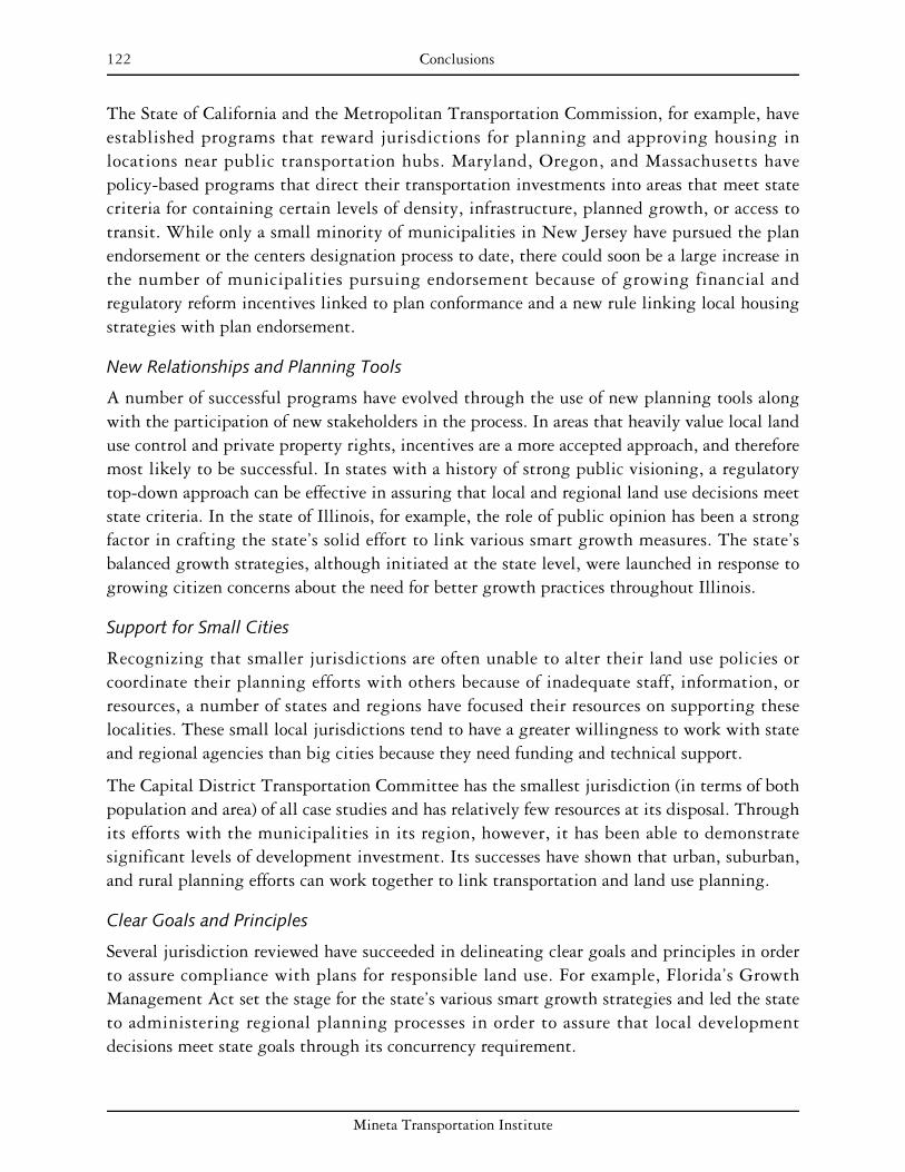
122 Conclusions
The State of California and the Metropolitan Transportation Commission, for example, have established programs that reward jurisdictions for planning and approving housing in locations near public transportation hubs. Maryland, Oregon, and Massachusetts have policy-based programs that direct their transportation investments into areas that meet state criteria for containing certain levels of density, infrastructure, planned growth, or access to transit. While only a small minority of municipalities in New Jersey have pursued the plan endorsement or the centers designation process to date, there could soon be a large increase in the number of municipalities pursuing endorsement because of growing financial and regulatory reform incentives linked to plan conformance and a new rule linking local housing strategies with plan endorsement.
New Relationships and Planning Tools
A number of successful programs have evolved through the use of new planning tools along with the participation of new stakeholders in the process. In areas that heavily value local land use control and private property rights, incentives are a more accepted approach, and therefore most likely to be successful. In states with a history of strong public visioning, a regulatory top-down approach can be effective in assuring that local and regional land use decisions meet state criteria. In the state of Illinois, for example, the role of public opinion has been a strong factor in crafting the state’s solid effort to link various smart growth measures. The state’s balanced growth strategies, although initiated at the state level, were launched in response to growing citizen concerns about the need for better growth practices throughout Illinois.
Support for Small Cities
Recognizing that smaller jurisdictions are often unable to alter their land use policies or coordinate their planning efforts with others because of inadequate staff, information, or resources, a number of states and regions have focused their resources on supporting these localities. These small local jurisdictions tend to have a greater willingness to work with state and regional agencies than big cities because they need funding and technical support.
The Capital District Transportation Committee has the smallest jurisdiction (in terms of both population and area) of all case studies and has relatively few resources at its disposal. Through its efforts with the municipalities in its region, however, it has been able to demonstrate significant levels of development investment. Its successes have shown that urban, suburban, and rural planning efforts can work together to link transportation and land use planning.
Clear Goals and Principles
Several jurisdiction reviewed have succeeded in delineating clear goals and principles in order to assure compliance with plans for responsible land use. For example, Florida’s Growth Management Act set the stage for the state’s various smart growth strategies and led the state to administering regional planning processes in order to assure that local development decisions meet state goals through its concurrency requirement.
Mineta Transportation Institute
Conclusions 123
Barriers to Overcome
If strengthening the linkage between transportation funding and responsible land use were easy, everyone would do it successfully. Some of the more significant barriers, both local and those arising from the decisions and policies of state and regional agencies, are described below.
Local Home Rule
The maintenance of local home rule can hinder a regional or state agency’s ability to influence land use decisions and plan for responsible growth management. For instance, the Capital District Transportation Committee (CDTC) has had difficulty affecting land use decisions because it has no direct land use authority. Its New Visions for Capital District Transportation plan calls for a one-third reduction in the growth of vehicular travel. This is to be achieved largely through altering the form and location of future growth and its accompanying transportation infrastructure. The central premise of the New Visions policies is that site and community design, coupled with transportation actions, can realize the region’s goals. However, the home rule powers of New York State weaken the ability of regional agencies such as CDTC to directly plan for the region as a whole, since CDTC has no direct authority over land use and localities are not required to follow New Visions principles.
The Metropolitan Transportation Commission has also experienced difficulty in implementing its programs because of issues with home rule. While MTC’s Transportation for Livable Communities program is popular throughout the region, some jurisdictions initially viewed it as a threat to their own autonomy and ability to secure funding for local projects. Many jurisdictions felt that MTC should not be involved in the establishment of local housing densities near stations.
Some governments have overcome the obstacle of home rule by remaining sensitive to the authority of local governments. The North Central Texas Council of Governments, for example, has relied heavily upon incentives for the private sector and local governments as a way of using funds to work toward growth management. By not including mandatory requirements, Texas has maintained support for development and property rights.
Inconsistent Leadership and Support
A recurring barrier to program implementation can be found in the evolving nature of state politics. The change in administration that occurs when a new governor is elected has threatened a number of the programs reviewed in this report. Maryland and Massachusetts, a pair of states well regarded for their smart growth efforts, have in particular been affected by such disturbances in program implementation. Both of these states are frequently cited for their successful efforts to curb sprawl and enhance responsible land use practices. However, changes in state leadership have had negative impacts on program continuance and success. While the new governors in these states have stressed the importance of smart growth, the
Mineta Transportation Institute

124 Conclusions
transition periods that come with the entry of new administrations have brought uncertainty to the future of existing programs.
In New Jersey, it has been hard to coordinate state agencies through the multiplicity of programs that have been established. Although the current governor’s support for smart growth programs is strong, over the years the priority given to these efforts has varied as changes of leadership in the governor’s office has occurred.
One way to overcome inconsistent political support is to rely upon bottom-up rather than top-down approaches. For example, Colorado, despite a lack of strong statewide smart growth legislation, has seen innovative regional planning actions in recent years. These successes have perhaps been due to the voluntary nature of these actions. The Mile High Compact in the Denver region was formed in response to the failures to achieve statewide legislative reform. The compact, while voluntary, reflects the strong commitments of the various local governments that have joined to work toward responsible land use planning.
Inadequate Budgets for Meeting Demand
The principal barrier to the full development of these programs has been funding. Often agency planners have assumed funding levels that have not materialized, leading to problems. In Oregon, for example, lack of funding has constrained the Centers Program, and its TOD program, which has helped underwrite projects, has had limited financial support.
Effective strategies for overcoming inadequate budgets vary across different contexts. Different levels of government have found that better coordination with each other helps to lessen the burdens on one agency in meeting common goals. In California, the Office of Community Planning reviews local matching funds to ensure that state funds are going toward appropriate planning projects. By requiring local matching funds, the state is able to use its budget to meet planning goals in coordination with local governments. In many cases, Metropolitan Planning Organizations (MPOs) will act primarily to channel federal funds. This reduces funding requirements for regional agencies while taking advantage of the authority of MPOs to allocate funds based on certain planning criteria. In Massachusetts, voters chose an increase in property taxes in order to meet open space, historic preservation, and affordable housing goals. Although the tax involves state matching funds, the willingness of the public to tax itself helps to relieve the burden on the Commonwealth of Massachusetts.
Lack of Performance Measurement
Research has uncovered a lack in performance measurement. Several of the jurisdictions reviewed have not developed indicators to use for evaluating existing programs. As a result, it is difficult to assess the direct effect that these programs have had on actual land use and transportation planning outcomes, such as transit ridership, vehicle miles traveled, and emissions levels. One reason for this lack of evaluation could be that many of the programs in this report are relatively new. In fact, 32 of the 40 programs were developed since 1997.
Mineta Transportation Institute

Conclusions 125
This lack of performance measurements and program evaluation, coupled with this report’s focus on existing programs, may create a misleading optimism regarding this topic. By reviewing what is actually being done around the country, with an admitted lack in evaluation capabilities, this report may portray the transportation–land use connection as being rather strong across the country. On the contrary, few jurisdictions have made strong progress in coordinating transportation funds with responsible land use practice. In addition, many programs reviewed (as discussed below) have faltered in recent years due to lack of funds and political support. This means that the little work being done in this area is still vulnerable to cynical political climates.
Nevertheless, some programs are making improvements in this area. The Atlanta Regional Commission and Portland Metro, for example, have done some evaluation of their programs to measure performance. Perhaps the work being done in these jurisdictions could serve as models for other jurisdictions in trying to develop benchmarks and performance indicators.
Mineta Transportation Institute

126 Conclusions
Mineta Transportation Institute

127
ENDNOTES
INTRODUCTION
1. Susan Handy, “Smart Growth and the Transportation–Land Use Connection: What Does the Research Tell Us?” International Regional Science Review 28, no. 2 (April 4, 2005): 147.
2. Smart Growth America, “Transportation: Federal Transportation Law: TEA 21,” http://www.smartgrowthamerica.org/transportation.html (accessed May 18, 2007).
3. Smart Growth Network, “Smart Growth Funding Resource Guide,” June 2007, http://www.smartgrowth.org/pdf/funding_resources.pdf (accessed May 18, 2007).
4. Smart Growth Network, “Smart Growth Network,” http://www.smartgrowth.org/sgn/default.asp (accessed September 17, 2007).
5. Smart Growth Network, “About Smart Growth,” http://www.smartgrowth.org/about/default.asp (accessed September 17, 2007).
6. Sustainable Development Commission of the United Kingdom, “About Sustainable Development,” http://www.sd-commission.org.uk/pages/aboutsd.html (accessed September 17, 2007).
7. California Department of Transportation, “Definition of Livable Communities,” http://www.dot.ca.gov/hq/tpp/offices/ocp/livable_communities (accessed October 1, 2007).
8. Handy, “Smart Growth,” 156.
9. Federal Transit Administration, “Introduction to New Starts,” http://www.fta.dot.gov/ planning/newstarts/planning_environment_2608.html (accessed September 17, 2007).
ATLANTA REGIONAL COMMISSION
10. U.S. Census Bureau, “50 Fastest-Growing Metro Areas Concentrated in West and South,” http://www.census.gov/Press-Release/www/releases/archives/population/009865.html (accessed May 4, 2007).
11. Platforms for Progress, “ARC: History,” http://www.platformsforprogress.com (accessed June 3, 2007).
12. Brookings Institution, Moving Beyond Sprawl: The Challenge for Metropolitan Atlanta, http://www.brookings.edu/dybdocroot/es/urban/atlanta/Atl01-17.pdf (accessed June 2, 2007).
13. Atlanta Regional Commission, “ARC Board,” http://www.atlantaregional.com/ cps/rde/xchg/arc/hs.xsl/202_ENU_HTML.htm (accessed May 27, 2007).
Mineta Transportation Institute

128 Endnotes
14. Atlanta Regional Commission, “History, Funding & Membership,” http://www.atlantaregional.com/cps/rde/xchg/ arc/hs.xsl/186 _ENU_HTML.htm accessed (May 4, 2007).
15. Atlanta Regional Commission, “Transportation,” http://www.atlantaregional.com/ cps/rde/xchg/arc/hs.xsl/15_ENU_HTML.htm (accessed May 6, 2007).
16. Atlanta Regional Commission, Mobility 2030, http://www.atlantaregional.com/ cps/rde/xchg/arc/hs.xsl/360_ENU_HTML.htm (accessed May 6, 2007).
17. Atlanta Regional Commission, Regional Development Plan, http://www.atlantaregional. com/cps/rde/xchg/arc/hs.xsl/317_ENU_ HTML.htm (accessed May 6, 2007).
18. Atlanta Regional Commission, “RDP Policies,” http://www.atlantaregional.com/ cps/rde/xbcr/arc/rdp_policies.pdf (accessed May 6, 2007).
19. Atlanta Regional Commission, Regional Development Plan.
20. Michael Dobbins, “Focusing Growth Amid Sprawl: Atlanta’s Livable Centers Initiative,” http://repositories.cdlib.org/ced/places/vol17/iss2/MichaelDobbins/ (accessed May 27, 2007).
21. Atlanta Regional Commission, “Community Choices,” http://www.atlantaregional. com/cps/rde/xchg/arc/hs.xsl/393_ENU_HTML.htm (accessed May 6, 2007).
22. Dobbins, “Focusing Growth.”
23. Capital District Transportation Committee, “Summary of Regional Smart Growth Incentive Programs,” http://www. cdtcmpo.org/ rtp2030/e-growth.pdf (accessed March 21, 2007).
24. Atlanta Regional Commission, “Livable Centers Initiative,” http://www.atlantaregional. com/cps/rde/xchg/arc/hs.xsl/308_ENU_ HTML.htm (accessed February 7, 2007).
25. Sara J. Hendricks and Julie Goodwill, “Building Transit Oriented Development in Established Communities,” Center for Urban Transportation Research (November 2002): 36–37; available www.nctr.usf.edu/pdf/473-135.pdf (accessed March 23, 2007).
26. Atlanta Regional Commission, “Livable Centers Initiative.”
27. Capital District Transportation Committee Metropolitan Planning Organization, “Summary of Regional Smart Growth Incentive Programs,” http://www.cdtcmpo.org/rtp2030/e-growth.pdf (accessed June 2, 2007).
28. Hendricks and Goodwill, “Building Transit Oriented Development,” 36–37.
29. Capital District Transportation Committee Metropolitan Planning Organization, “Summary.”
30. Ibid.
Mineta Transportation Institute

Endnotes 129
31. Capital District Transportation Committee Metropolitan Planning Organization, “Summary”; and Atlanta Regional Commission, “Livable Centers Initiative.”
32. Brian S. Bochner, et al., “Introducing Smart Growth to Texas: Research Report” (September 2002), http://tti.tamu.edu/documents/4238-1.pdf (accessed March 23, 2007).
33. Atlanta Regional Commission, “(Evaluation of 2005 Public Involvement Activities in Transportation Planning)” September 2006 available http://www.atlanta regional.com/documents/2005TPPPEvalReport.pdf (accessed May 7, 2007).
34. Atlanta Regional Commissi on, “Community Choices” (Regional Development Plan, 2003), http://www.atlantaregional.com/webdocs/Governmental%20Services/Quality%20Growt h%20Resources/Resources/Regional%20Development%20Plan/RDP%202003.pdf (accessed May 27, 2007.)
35. Atlanta Regional Commission, “ARC Makes Model Ordinances Available for Local Communities,” http://www.atlantaregional.com/cps/rde/xchg/arc/hs.xsl/ 566_ENU_HTML.htm (accessed June 3, 2007).
36. Atlanta Regional Commission, “Community Choices Toolkit,” http://www.atlantaregional.com/cps/rde/xchg/arc/hs.xsl/392_ENU_ HTML.htm (accessed May 7, 2007).
37. Hendricks and Goodwill, “Building Transit Oriented Development,” 36–37.
38. Atlanta Regional Commission, “Community Choices Toolkit.”
39. Atlanta Regional Commission, “ARC’s Livable Centers Initiative Funds New Smart Growth Studies” (February 28, 2007), http://www.atlantaregional.com/cps/rde/xchg/ arc/hs.xsl/81_3101_ENU_HTML.htm (accessed July 1, 2007).
40. Atlanta Regional Commission, “ARC’s Livable Centers Initiative Funds New Smart Growth Studies” (February 14, 2006), http://www.atlantaregional.com/cps/rde/xchg/ arc/hs.xsl/81_1782_ENU_HTML.htm (accessed February 19, 2007).
41. Dobbins, “Focusing Growth.”
42. Atlanta Regional Commission, “Evaluation of 2005 Public Involvement Activities.”
43. Atlanta Regional Commission, “How Community Choices Tools Can Implement Regional Policies,” in ARC RDP Guidebook, http://www.atlantaregional.com/ cps/rde/xbcr/arc/rdpguidebook.pdf (accessed June 3, 2007).
44. Rob Lebeau, personal communication with Richard Lee, June 12, 2007.
45. Julie Kovach, personal communication with Richard Lee, June 12, 2007.
Mineta Transportation Institute

130 Endnotes
STATE OF CALIFORNIA
46. Steve Lawrence,” California Population Nears 28 Million, L.A. Tops 4 Million” (May 1, 2007), http://www.signonsandiego.com/news/state/ 20070501-1517-ca-californiapopulation.html (accessed May 8, 2007).
47. Institute of Governmental Studies–University of California, Berkeley, California Policy Inbox (March 23, 2007), http://inbox.berkeley.edu/?m=200703 (accessed May 8, 2007).
48. Bochner, et al., “Introducing Smart Growth.”
49. Judith MacBrine, chief of public outreach and research, Division of Mass Transportation, Caltrans; and Linda Wheaton, assistant deputy director, California Department of Housing and Community Development, personal communication with Richard Lee, June 19, 2007.
50. Bochner, et al., “Introducing Smart Growth.”
51. California State Assembly Bill AB 392 Fact Sheet, http://www.transact.org/ca/ab392.htm (accessed May 28, 2007).
52. California Department of Transportation, “California Department of Transportation Planning Grants Application Package Fiscal Year 2003–2004,” (p. 5), http://www.dot.ca.gov/hq/tpp/Planning%20&%20Research%20Funds/03 _04DOTP_ grantapp_pkg.pdf# xml=http://dap1.dot.ca.gov/cgi-in/texis/webinator/search/pdfhi.txt? query=compact+development&db=db&pr=www&prox= page&rorder=500&rprox= 500&rdfreq=500&rwfreq=500&rlead=500&sufs=0& order=r&cq=&id=460d9a7913 (accessed May 8, 2007).
53. Bochner, et al., “Introducing Smart Growth.”
54. California Department of Transportation, “Planning Grants Application Package Fiscal Year 2003–2004.”
55. California State Department of Transportation, “Community-Based Transportation Planning Grant Program: Past Cycle FY 00/01,” http://www.dot.ca.gov/hq/tpp/ offices/ocp/awarded_grants.htm (accessed March 20, 2007).
56. Bochner, et al., “Introducing Smart Growth.”
57. Brian Travis, Caltrans Office of Community Planning, personal communication with Richard Lee, June 14, 2007.
58. Ibid.
CAPITAL DISTRICT TRANSPORTATION COMMITTEE
59. Capital District Transportation Committee, “About CDTC,” http://www.cdtcmpo.org/whatcdtc.htm (accessed May 16, 2007).
60. Ibid.
Mineta Transportation Institute
Endnotes 131
61. Federal Highway Administration (FHA), “Capital District Transportation Committee,” http://www.fhwa.dot.gov/planning/landuse/albanycs.htm (accessed March 24, 2007).
62. Capital District Transportation Committee homepage, http://www.cdtcmpo.org/ (accessed September 9, 2007).
63. Capital District Transportation Committee, CDTC Linkage Program, http://www.cdtcmpo.org/linkage.htm (accessed March 3, 2007).
64. Capital District Transportation Committee, CDTC Linkage Program, http://www.cdtcmpo.org/linkageprog.pdf (accessed May 28, 2007).
65. Capital District Transportation Committee, CDTC Linkage Program, http://www.cdtcmpo.org/linkage/brochure07-08.pdf (accessed May 28, 2007).
66. Federal Highway Administration, “Capital District Transportation Committee.”
67. Capital District Transportation Committee, “Unified Planning Work Program,” http://www.cdtcmpo.org/upwp/upwp.pdf (accessed June 5, 2007).
68. Capital District Transportation Committee, “Concepts for Assisting Local Decision Making in a Regional Context,” (November 2005), http://www.cdtcmpo.org/rtp2030/e-concepts.pdf (accessed July 1, 2007).
69. Capital District Transportation Committee, “CDTC Linkage Program,” http://www.cdtcmpo.org/linkage.htm (accessed March 3, 2007).
70. Capital District Transportation Committee, “Concepts for Assisting Local Decision Making.”
71. Ibid.
72. Ibid.
DELAWARE VALLEY REGIONAL PLANNING COMMISSION
73. Delaware Valley Regional Planning Commission (DVRPC), “TIP Guide,” http://www.dvrpc.org/transportation/capital/tip /tipguide.htm (accessed October 2006).
74. Delaware Valley Regional Planning Commission, “Municipal, County, and Regional Population Estimates, 2000–2005,” http://www.dvrpc.org/data/databull/rdb/db84.htm (accessed October 2006).
75. Delaware Valley Regional Planning Commission, “Board Members,” http://www.dvrpc.org/about/board.htm (accessed October 2006)
76. Delaware Valley Regional Planning Commission, “TIP Guide.”
Mineta Transportation Institute

132 Endnotes
77. Delaware Valley Regional Planning Commission, “Housing,” http://www.dvrpc.org /planning/regional/housing.htm (accessed October 2006); and Delaware Valley Regional Planning Commission, “Recreational Open Space Needs Analysis for the Delaware Valley,” http://www.dvrpc.org/planning/environmental/openspace/02021.pdf (accessed October 2006).
78. Delaware Valley Regional Planning Commission, “Protected Open Space Inventory,” http://www.dvrpc.org/planning/ environmental/openspace/inventory.htm (accessed October 2006); and Delaware Valley Regional Planning Commission, “Municipal Implementation Tools,” http://www.dvrpc.org/planning/ community/MCDTools.htm (accessed October 2006).
79. Delaware Valley Regional Planning Commission, http://www.dvrpc.org/about/marketing/regional.htm (accessed October 2006).
80. Delaware Valley Regional Planning Commission, The Long-Range Plan, http://www.dvrpc.org/LongRange.htm (accessed October 2006).
81. Delaware Valley Regional Planning Commission, Destination 2030: Future Land Use and Transportation Facilities (administrative version 47), http://www.dvrpc.org/ LongRangePlan/2030/LRP_Admin.pdf (accessed October 2006).
82. Karin Morris, “Regional Planning Approaches to TOD: Moving Beyond Policy,” http://www.railvolution.com/rv2005_pdf (accessed September 2006).
83. Rick Bickel, Delaware Valley Regional Planning Commission, email to Gary Binger, September 6, 2006.
84. Delaware Valley Regional Planning Commission, 2002 TCDI Assessment Report, http://www.dvrpc.org/planning/ tcdi/2002Report.pdf (accessed September 2006). This figure was also double-checked against the list of funded projects for later years.
85. Rick Bickel, Delaware Valley Regional Planning Commission, email to Gary Binger, September 6, 2006.
86. Delaware Valley Regional Planning Commission, Transportation and Community Development Initiative webpage, http://www.dvrpc.org/planning/tcdi.htm (accessed October 2006).
87. Delaware Valley Regional Planning Commission, Transportation and Community Development Initiative: “2002 Project Summaries and Program Evaluation” (Publication No. 03041).
88. Delaware Valley Regional Planning Commission, Transportation and Community Development Initiative webpage.
89. Delaware Valley Regional Planning Commission, annual lists of funded projects, http://www.dvrpc.org/planning/tcdi.htm (accessed May 24, 2007).
Mineta Transportation Institute
Endnotes 133
90. Delaware Valley Regional Planning Commission, “TIP Guide.”
91. Delaware Valley Regional Planning Commission, Destination 2030, 77, 80.
DENVER REGIONAL COUNCIL OF GOVERNMENTS
92. Denver Regional Council of Governments (DRCOG), Metro Vision, (January 2005), http://www.drcog.org/index.cfm?page=RegionalTransportationPlan (accessed September 2006).
93. Denver Regional Council of Governments, Fiscally Constrained Metro Vision 2025 Interim Regional Transportation Plan, http://www.drcog.org/documents/ 2025_Interim_Regional_Transportation_Plan_4-17-02.pdf (accessed September 2006).
94. “APA Smart Growth Fact Sheet: Colorado,” http://www.planning.org/growingsmart/States/Colorado.htm#9 (accessed September 2006).
95. Denver Regional Council of Governments, “Urban Growth Boundaries Flexibility Provisions,” www.drcog.org (accessed September 2006).
96. Denver Regional Council of Governments, “A Brief History of Metro Vision,” http://www.drcog.org/index.cfm?page=AbriefhistoryofMetroVision (accessed July 1, 2007).
97. Linda Capra, Denver Regional Council of Governments, personal communication with Gary Binger, October 3, 2006.
98. Environment Colorado, “Sprawl in the Metro Region,” www.environmentcolorado.org (accessed September 2006).
99. Ibid.
100. Bill Johnston, Denver Regional Council of Governments, personal communication with Gary Binger, October 8, 2006.
101. Steve Rudy, transportation planner, Denver Regional Council of Governments, personal communication with Gary Binger, October 5, 2006.
102. Steve Rudy, transportation planner, Denver Regional Council of Governments, personal communication with Richard Lee, June 11, 2007.
STATE OF FLORIDA
103. All background, legislative, and policy information from Jia Ching Chen, et al., “Seeking New Strategies in Regional Planning: Metropolitan-Regional Planning Case Studies,” (Department of City and Regional Planning, University of California, Berkeley, Fall 2006, class paper.)
Mineta Transportation Institute

134 Endnotes
STATE OF ILLINOIS
104. U.S. Census Bureau, “The 2007 Statistical Abstract,” http://quickfacts.census.gov/qfd/states/17000.html (September 2007).
105. U.S. Census Bureau, Population Estimates Division, “Northeastern Illinois Municipal Population Estimates,” http://www.nipc.org/forecasting/munipop05.html (accessed November 20, 2007).
106. Federal Highway Administration, Illinois Tomorrow Corridor Planning Grant Program, http://www.fhwa.dot.gov/planning/landuse/illinoiscs.htm (September 2007).
107. Ibid.
108. Bochner, et al., “Introducing Smart Growth.”
109. Ibid.
110. Federal Highway Administration, Illinois Tomorrow Corridor Planning Grant Program, http://www.fhwa.dot.gov/planning/ landuse/illinoiscs.htm (accessed May 16, 2007).
111. Illinois Department of Transportation (IDOT), Illinois Tomorrow Corridor Planning Grant Program, http://www.dot.state.il.us/ corridorPlanning/corridor_grant.html (accessed March 2, 2007)
112. Federal Highway Administration, Illinois Tomorrow.
113. Illinois Department of Transportation, Corridor Planning Grant Program, http://www.dot.il.gov/corridorplanning/pdf/cpgpbrochure.pdf.
114. Ibid.
115. Illinois Department of Transportation, “Corridor Planning Grant Brochure,” http://www.dot.state.il.us/corridorplanning/pdf/cpgpbrochure.pdf (accessed May 16, 2007).
116. Illinois Department of Transportation, “Illinois Tomorrow”; Illinois Department of Transportation, Corridor Planning; and Bochner, et al., “Introducing Smart Growth.”
STATE OF MARYLAND
117. Bochner, et al., “Introducing Smart Growth.”
118. Maryland Department of Planning, “Smart Growth Background,” http://www.mdp.state.md.us/smartintro.htm (accessed July 1, 2007).
119. Maryland Department of Planning, “Managing Maryland’s Growth: Models and Guidelines,” http://www.mdp.state.md.us/smartgrowth/pdf/PFA.PDF (accessed July 1, 2007).
120. Maryland Department of Transportation, “Maryland’s TOD Strategy,” http://www.mdot-realestate.org/tod.asp#Strategy (accessed July 1, 2007).
Mineta Transportation Institute

Endnotes 135
121. Ibid.
122. Ibid.
123. Maryland Department of Transportation, “What is Transit Oriented Development (TOD)?”, http://www.mdot-realestate.org/tod.asp (accessed July 1, 2007).
124. Maryland Department of Transportation, Priority Places, http://www.priorityplaces.com/ (accessed May 28, 2007).
125. Maryland Department of Transportation, “What is Priority Places Strategy?” http://www.priorityplaces.com/priority.htm (accessed September 9, 2007).
126. Maryland Department of Transportation, Maryland Priority Places Application, http://www.priorityplaces.com/pdf/Application.doc (accessed September 9, 2007).
127. Maryland Department of Transportation, Priority Places, http://www.priorityplaces.com/pdf/PP_brochure.pdf (accessed May 28, 2007).
128. Federal Highway Administration, 2007 Environmental Excellence Awards, 2007, http://www.fhwa.dot.gov/environment/eea2007/livable.htm (July 2007).
129. Parris N. Glendening, “Smart Politics,” The Environmental Law Institute (2004), http://www2.eli.org/pdf/research/21-1smartpolitics.pdf (July 2007).
130. Timothy B. Wheeler, “Group plans to sue state over highway widening,” Baltimore Sun, December 1, 2004.
131. John Frece (National Center for Smart Growth Research and Education), in personal interview with Gary Binger, October 9, 2006.
132. Timothy B. Wheeler and Childs Walker, “State launches program to help revitalize areas,” Baltimore Sun, July 15, 2004.
COMMONWEALTH OF MASSACHUSETTS
133. U.S. Census Bureau, “State Population—Rank, Percent Change, and Population Density,” www.census.gov/compendia/statab/tables/07s0018.xls (accessed June 23, 2007).
134. U.S. Census Bureau, “Population Finder,” http://factfinder.census.gov/home/saff/main.html?_lang=en (June 2007).
135. U.S. Census Bureau, “State Population.”
136. Bochner, et al., “Introducing Smart Growth.”
137. Massachusetts Executive Office of Transportation, Chapter 196, Acts of 2004, (March 1, 2005, p. 5), http://www.eot.state.ma.us/ downloads/chap196/intro.pdf (accessed May 8, 2007).
Mineta Transportation Institute
136 Endnotes
138. Massachusetts Executive Office of Transportation, The Commonwealth of Massachusetts Long-Range Transportation Plan 2006, http://www.eot.state.ma.us/default.asp? pgid=content/longplanIndex&sid=level2 (June 2007).
139. Massachusetts Executive Office of Transportation, Chapter 196.
140. Massachusetts Executive Office of Transportation, Long-Range Transportation Plan 2006.
141. “Governor Patrick Announces South Coast Rail Plan: Plan Outlines Steps to Deliver Passenger Service by 2016; Commits $17 Million to Initial Phase,” http://www.commentmgr.com/projects/1212/docs/SCR%20Press%20Release.pdf (accessed June 8, 2007).
142. “Lieutenant Governor Murray, Secretaries Cohen and O’Connell Announce Economic Development and Land Use Study of South Coast Rail Corridor,” http://www.eot.state.ma.us/default.asp?pgid=content/releases/pr051807_socoastcorridor &sid=release (accessed June 8, 2007).
143. Massachusetts Executive Office of Transportation, Long-Range Transportation Plan 2006.
144. Citizens’ Housing and Planning Association, “Housing Briefs,” March 1, 2004, http://www.chapa.org/news_03-01-04.htm (accessed May 7, 2007).
145. Massachusetts Housing Partnership, “E-Bulletins: Q&A on Transit Oriented Grants,” November 4, 2005, http://www.mhp.net/vision/e_ bulletins.php?page_function= detail&bulletin_id=9 (accessed March 4, 2007).
146. National Governors Association Center for Best Practices, “Issue Brief: Integrating Affordable Housing with State Development Policy,” http://www.dcgoodwill.org/news/legislation_2004.htm (June 2007).
147. Massachusetts Executive Office of Transportation, Long-Range Transportation Plan 2006, 191–93.
148. Massachusetts Housing Partnership, “E-Bulletin,” http://mhp.net/ (accessed November 17, 2007).
149. Todd Fontanella, personal correspondence with Alexis Lynch, June 8, 2007.
150. Massachusetts Housing Partnership, “E-Bulletin.”
151. Ibid.
152. Todd Fontanella, personal correspondence with Gary Binger, June 8, 2007.
153. Commmonwealth of Massachusetts, “Sustainable Development Principles,” http://www.mass.gov/?pageID=gov3terminal&L=2&L0=Home&L1=Smart+Growth&si d=Agov3&b=terminalcontent&f=smart_growth_sustainable_dev_principles&csid=Ago v3 (accessed June 13, 2007).
Mineta Transportation Institute

Endnotes 137
METROPOLITAN TRANSPORTATION COMMISSION
154. Metropolitan Transportation Commission, “About MTC,” http://mtc.ca.gov/about_mtc/about.htm (accessed May 28, 2007).
155. Association of Bay Area Governments (ABAG), “Regional Overview,” http://www.abag. ca.gov/abag/overview/pub/p2000/summary.html (accessed September 14, 2007).
156. Metropolitan Transportation Commission, “MTC Launches Housing Incentive Program,” http://www.mtc.ca.gov/news/transactions/ta11-1200/hip.htm (accessed October 14, 2007).
157. Metropolitan Transportation Commission, “About MTC.”
158. Ibid.
159. Metropolitan Transportation Commission, Transportation for Livable Communities: Works in Progress, 4, http://www.mtc.ca.gov/library/TLC/index.htm (May 2007).
160. Metropolitan Transportation Commission, 2001 RTP Project Notebook, 1–38, http://www.mtc.ca.gov/library/2001_rtp/ downloads/PN/PartI_systmaint.pdf (accessed May 9, 2007).
161. Metropolitan Transportation Commission, “About MTC.”
162. Metropolitan Transportation Commission, Transportation 2030 Plan, http://mtc.ca.gov/planning/2030_plan/index.htm (accessed May 28, 2007).
163. Association of Bay Area Governments, “Compact Communities,” http://www.abag.ca.gov/planning/theoryia/compsfbamtc.htm (accessed May 28, 2007).
164. Metropolitan Transportation Commission, Livable Communities.
165. Metropolitan Transportation Commission, Transportation 2030 Project Notebook, 2.4-1–2.4-2, http://www.mtc.ca. gov/planning/2030_plan/downloads/Final_ Project_Notebook.pdf (accessed May 9, 2007).
166. Metropolitan Transportation Commission, Livable Communities; and Metropolitan Transportation Commission, Transportation 2030.
167. Metropolitan Transportation Commission, “Smart Growth/Transportation for Livable Communities: Housing Incentive Program (HIP),” http://www.mtc.ca.gov/planning/smart_growth/hip.htm (accessed May 9, 2007).
168. Metropolitan Transportation Commission, Transportation for Livable Communities.
169. Metropolitan Transportation Commission, “Smart Growth/Transportation.”
170. Metropolitan Transportation Commission, Transportation 2030.
171. Metropolitan Transportation Commission, “MTC Resolution 3434 Transit-Oriented Development (TOD) Policy for Regional Transit Expansion Projects,” http:// www.mtc.ca.gov/planning/smart_growth/tod/TOD_policy.pdf (accessed May 11, 2007).
Mineta Transportation Institute

138 Endnotes
172. Ibid.
STATE OF NEW JERSEY
173. U.S. Census Bureau, “State and County Quick Facts,” http://quickfacts.census.gov/qfd/ states/34000.html (accessed October 2006); and New Jersey Department of Community Affairs Office of Smart Growth, “Smart Growth Benefits New Jersey,” http://www.state.nj.us/dca/osg/smart/benefits/index.shtml (accessed October 2006).
174. New Jersey Future, “NJF Guide to the State Plan,” http://www.njfuture.org/index.cfm?ctn=9t45e1o30v9g&emn=5u92y86g2h42& useaction=user.item&ThisItem=166 (accessed October 2006).
175. State of New Jersey Office of Smart Growth, New Jersey State Development and Redevelopment Plan, http://www.nj.gov/dca/osg/plan (accessed September 2006).
176. State of New Jersey, New Jersey State Development and Redevelopment Plan: State Plan Policy Map, available http://www.state.nj.us/dca/osg/plan/state plan/intro_map.shtml (accessed October 2006).
177. New Jersey Future, “NJF Guide.”
178. Walter G. Reinhard, “BPU Changes the Rules of the Game for Utilities Installations,” Dimensions (January 10, 2005), http://www. nmmlaw.com/articles/bpu_rules.pdf (accessed October 2006).
179. New Jersey Department of Community Affairs Office of Smart Growth, “Cross-acceptance process,” http://www.state.nj.us/dca/osg/plan/crossacceptance.shtml (accessed September 2006).
180. New Jersey Future, “NJF Guide to the State Plan.”
181. Ben Spinelli, New Jersey Office of Smart Growth, interview with Gary Binger, October 10, 2006.
182. State of New Jersey, New Jersey State Development and Redevelopment Plan: Plan Endorsement, http://www.nj.gov/dca/osg/plan/endorsement.shtml (accessed October 2006); and New Jersey Department of Community Affairs Office of Smart Growth, “Plan Endorsement Process,” http://www.state.nj.us/dca/osg/plan/endorsement.shtml (accessed October 2006).
183. Ben Spinelli, New Jersey Office of Smart Growth, interview with Gary Binger, September 28, 2006.
184. New Jersey Department of Transportation (NJDOT), Centers of Place, http://www.state. nj.us/transportation/business/localaid/ enterplace.shtm (accessed October 2006).
185. New Jersey Board of Public Utilities, “New Jersey Administrative Code 14:3” (subsections 68 & 70), http://www.state.nj.us/bpu/ wwwroot/secretary/ NJAC3Cleanup_050222.pdf (accessed October 2006).
Mineta Transportation Institute

Endnotes 139
186. New Jersey Department of Community Affairs Office of Smart Growth, “Smart Growth Begins with Smart Planning,” http://www.state.nj.us/dca/osg/resources/ grants/index.shtml (accessed November 16, 2007).
187. New Jersey Department of Community Affairs, “NJ Department of Community Affairs Announces $2.295 Million in Smart Future Planning Grants,” July 15, 2005, http://www.state.nj.us/dca/osg/docs/sfgrants06announcement.pdf (accessed November 16, 2007).
188. Ben Spinelli, New Jersey Office of Smart Growth, interview with Gary Binger, October 10, 2006.
189. Martin Bierbaum, “Smart Plan/Smart Growth Implementation in New Jersey: A Focus on Changing State Bureaucracy 1998–2001,” International Symposium on Incentives, Regulations and Plans (2004): 50.
190. Jan Wells and John Renne, “Implementation of the Assessment Tool: Measuring Economic Activity,” (October 2004, pp. 1, 4), paper prepared for the Alan Voorhees Transportation Center, http:// www.policy.rutgers.edu/vtc/tod/documents/ NJ%20Transit%20Villages_economic%20activity.pdf (accessed November 16, 2007).
NORTH CENTRAL TEXAS COUNCIL OF GOVERNMENTS
191. O. K. Carter, “O. K. Carter Commentary Column,” Fort Worth Star-Telegram, October 27, 2002.
192. Karen Walz, project manager, Vision North Texas, interview with Charles Rivasplata, October 5, 2006.
193. Karen Walz, “Straight Talk. It Ai n’t Your Grandpa’s Texas Anymore,” Planning Magazine (February 2006).
194. Karen Walz, phone interview with Charles Rivasplata, n.d.
195. Alicia Hopkins, senior transportation planner, North Central Texas Council of Governments, interview with Charles Rivasplata, October 9, 2006.
196. Karen Waltz, phone interview with Charles Rivasplata, n.d.
197. Alicia Hopkins, phone interview with Charles Rivasplata, n.d.
198. Walz, “Straight Talk.”
PORTLAND METRO
199. Portland Metro, “About Metro,” http://www.metro-region.org/pssp.cfm?ProgServID=62 (accessed June 10, 2007).
200. Portland Metro, “Metro Profile,” http://www.metro-region.org/article.cfm?articleid=5357 (accessed June 10, 2007).
Mineta Transportation Institute

140 Endnotes
201. Planners Network, “Regional Profiles: Metropolitan Governance and Regional Planning: Four Cities, Four Approaches,” http://www.plannersnetwork.org/publications/ 1998_128/hall.htm (accessed June 9, 2007).
202. Portland Metro, Regional Framework Plan: Updated & Effective 12/18/05, Metropolitan Regional Government, http://www.metroregion.org/library_docs/land_use/ rfp_introduction.pdf (accessed June 9, 2007).
203. Portland Metro, “Metro Charter,” 332, http://www.metro-region.org/library_docs/ land_use/appendixe_metro_charter_sections_5_7.pdf (accessed June 9, 2007).
204. Portland Metro, 2040 Growth Concept, http://www.metro-region.org/article.cfm?articleID=231 (accessed June 9, 2007).
205. Portland Metro, Regional Framework Plan, http://www.metro-region.org/article.cfm?ArticleID=432 (accessed June 9, 2007).
206. Portland Metro, Urban Growth Management Functional Plan, http://www.metro-region.org/article.cfm?ArticleID=274 (accessed June 10, 2007).
PUGET SOUND REGIONAL COUNCIL
207. “Puget Sound Trends,” a website of the Puget Sound Regional Council, http://www.psrc.org/publications/pubs/trends/index.htm (accessed November 16, 2007).
208. Washington State Department of Community, Trade, and Economic Development, “Creating Livable Communities, Managing Washington’s Growth for 15 Years” (June 2006), http://www.cted.wa.gov/_CTED/documents/ID_3176_Publications.pdf (June 2006).
209. Puget Sound Regional Council, “Frequently Asked Questions,” http://www.psrc.org/about/what/faq.htm (accessed June 10, 2007).
210. Information on the functions and structure of Puget Sound Regional Council (PSRC) comes from the PSRC website, http://www.psrc.org/index.htm (accessed June 10, 2007).
211. Washington State Department of Community, Trade and Economic Development, “Growth Management Services: Overview of the Growth Management Act,” 1, http://www.cted.wa.gov/_CTED/documents/ID_892_Publications.pdf (accessed June 10, 2007).
212. Ibid.
213. Kitsap County Community Development, “Buildable Lands Program (RCW 36.70A.215),” http://www.kitsapgov.com/dcd/community_plan/blp/bla.htm (accessed June 10, 2007).
Mineta Transportation Institute
Endnotes 141
214. Washington State Department of Community, Trade, and Economic Development, “White Paper on Washington’s Growth Management Act and WSDOT Planning and Environmental Assessment Requirements,” (March 2005, 18) http://www.wsdot.wa.gov/ NR/rdonlyres/558C9B2E-B81E-4AA5-B78FF3B3397D0E83/0/GMAwhitepaper.pdf (accessed June 10, 2007).
215. Growth Management Hearings Boards, “Role of the Growth Management Hearings Boards,” http://www.gmhb.wa.gov/board_role/index.html (accessed June 10, 2007).
216. Puget Sound Regional Council, Vision 2020: 1995 Update, http://www.psrc.org/projects/vision/pubs/1995update/intro.htm (accessed June 10, 2007).
217. Puget Sound Regional Council, “Central Puget Sound Regional Growth Centers–2002,” http://www.psrc.org/projects/monitoring/pdf%20files/summary.pdf (accessed June 10, 2007).
218. Puget Sound Regional Council, “Design Guidelines Manual: Destination 2030 Physical Design Guidelines,” http://www.psrc.org/projects/growth/designmanual.pdf (accessed June 10, 2007).
219. Washington State Transportation Center, University of Washington, “What Is Concurrency?” Eastside Transportation Concurrency Study, http://depts.washington.edu/trac/concurrency/questions.html (accessed June 10, 2007).
220. Washington State Legislature, WAC 468-60-010: Trip Reduction Performance Program, http://apps.leg.wa.gov/WAC/default.aspx?cite=468-60-010 (accessed June 10, 2007).
221. Washington State Department of Transportation, “Transportation Demand Management Improves the Transportation System” (February 2007), http://www.wsdot.wa.gov/publications/folio/TDM.pdf (accessed June 10, 2007).
222. Washington State Department of Transportation, “Create a Project for Reducing the Number of Commuters Who Drive Alone,” www.wsdot.wa.gov/tdm/ program_summaries/TRPP_brochure.pdf (accessed June 10, 2007).
223. Washington State Department of Transportation, “Guide to Trip Reduction Performance Program,” (January 2005), www.wsdot.wa.gov/tdm/program_summaries/ TRPP_guidelines.pdf (accessed June 10, 2007).
SACRAMENTO AREA COUNCIL OF GOVERNMENTS
224. Sacramento Area Council of Governments (SACOG), Valley Vision, and Community Services Planning Council, Sacramento Region Quality of Life Report 2004, http://www.valleyvision.org/projects-2004QoLReport.html (accessed June 2007).
Mineta Transportation Institute

142 Endnotes
225. Jeannie Eisberg, “SACOG Transportation Planning and Land Use Blueprint” (in-progress draft, Department of City and Regional Planning, University of California at Berkeley, 2006).
226. Sacramento Area Council of Governments, 2006 Metropolitan Transportation Plan for the Sacramento Region, http://www.sacog.org/mtp/.
227. Federal Highway Administration, “Transportation Planning Excellence Awards: Public Involvement Education and Outreach Award Winner,” http://www.fhwa.dot.gov/planning/tpea/pubinvolv.htm (accessed June 11, 2007).
228. Sacramento Area Council of Governments, Special Report: Preferred Blueprint Alternative (January 2005), http://www.sacregionblueprint.org/sacregionblueprint/media_center/ download/2007-06-BlueprintReport.pdf (accessed June 11, 2007).
229. Ibid.
230. Sacramento Area Council of Governments, “Sacramento Region Blueprint Transportation and Land Use Study: Implementation: Local Government Feature: City of Folsom” (June 2005), 3, http://www.sacregionblueprint.org/sacregionblueprint/the_project/ pdf/localGovtFeatures/Folsom.pdf (accessed June 11, 2007).
231. Ibid., 8.
232. Sacramento Area Council of Governments, “Next Steps for the Blueprint Project,” in Special Report: Preferred Blueprint Alternative, http://www.sacregionblueprint.org/ sacregionblueprint/media_center/download/2007-06-BlueprintReport.pdf (accessed June 2007).
233. Greg Chu, Community Design funding program manager, Sacramento Area Council of Governments, interview with Richard Lee, October 4, 2006.
234. Tim Youmans, managing principal, Economic and Planning Systems, and president, Sacramento Council Urban Land Institute, interview with Richard Lee, October 5, 2006.
235. Sacramento Area Council of Governments, Regional Report (August 2004), http://www.sacog.org/regrpt/august04rr.pdf (accessed June 11, 2007).
236. Sacramento Area Council of Governments, “A Bold First Step for Mobility in the Sacramento Region: Metropolitan Transportation Plan for 2025,” 35, http://www.sacog.org/mtp/pdf/mtpfor2025.pdf (accessed June 11, 2007).
237. Sacramento Area Council of Governments, Special Report.
238. Greg Chu, Community Design funding program manager, Sacramento Area Council of Governments, interview with Richard Lee, October 4, 2006.
239. Gordon Garry, personal communication with Richard Lee, June 14, 2007.
Mineta Transportation Institute

Endnotes 143
SAN DIEGO ASSOCIATION OF GOVERNMENTS
240. San Diego Association of Governments, “About SANDAG: Bylaws and Policies,” http://www.sandag.org/index.asp?fuseaction=about.bylaws (accessed June 12, 2007).
241. San Diego Association of Governments, “About SANDAG: Board of Directors,” http://www.sandag.org/index.asp?fuseaction=about.board (accessed June 12, 2007).
242. U.S. Census Bureau, “Population Finder,” http://factfinder.census.gov/servlet/SAFFPopulation?_sse=on (accessed June 2, 2006).
243. San Diego Association of Governments, “Environment: Comprehensive Environmental Projects: Regional Intergovernmental Review,” http://www.sandag.org/ index.asp?projectid=93&fuseaction=projects.detail (accessed June 12, 2007).
244. San Diego Association of Governments, 2020 Regional Transportation Plan, 14, http://www.sandag.org/uploads/publicationid/publicationid_869_1973.pdf (accessed June 12, 2007).
245. Ibid., 48.
246. San Diego Association of Governments, “News: Full Story: Board Unanimously Adopts Regional Comprehensive Plan (RCP),” (July 23, 2004), http://www.sandag.org/ index.asp?newsid=246&fuseaction=news.detail (accessed June 12, 2007).
247. San Diego Association of Governments, Regional Comprehensive Plan (July 2004), 31, http://www.sandag.org/uploads/publicationid/publicationid_1094_3362.pdf (accessed June 11, 2007).
248. Robert A. Leiter, “San Diego Adopts a Regional Comprehensive Plan for Growth,” Western City Magazine (December 2005), http://www.cacities.org/ index.jsp?zone=wcm&previewStory=24349 (accessed June 12, 2007).
249. San Diego Association of Governments, “The Regional Comprehensive Plan: Establishing a Baseline for Monitoring Performance,” 11, http://www.sandag.org/uploads/ publicationid/publicationid_1264_6072.pdf (accessed June 12, 2007).
250. San Diego Association of Governments, “Transportation Development Act Claim Manual,” (April 2005), 13, http://www.sandag.org/programs/transportation/ public_transit/tda/tda_manual.pdf (accessed June 12, 2007).
251. San Diego Association of Governments, “News: Full Story: June Board Actions: FY 2006 Transportation Development Act (TDA) Allocations,” http://www.sandag.cog.ca.us/ index.asp?newsid=312&fuseaction=news.detail (accessed June 12, 2007).
252. San Diego Association of Governments, “Claim Manual.”
253. Ibid., 14.
Mineta Transportation Institute

144 Endnotes
254. San Diego Association of Governments, Final 2030 Regional Transportation Plan, (April 2003), http://www.sandag.org/programs/transportation/comprehensive_ transportation_projects/2030rtp/2030_final_rtp_3.pdf (accessed July 1, 2007).
255. San Diego Association of Governments, “Fact Sheet: Mapping Smart Growth in the San Diego Region,” http://www.sandag.org/uploads/publicationid/ publicationid_1252_5841.pdf (accessed June 12, 2007).
256. San Diego Association of Governments, Regional Comprehensive Plan: Revised Draft, Chapter 4a, 62, http://www.sandag.cog.ca.us/rcp_revised_draft/chapter4a.pdf (accessed June 12, 2007).
257. San Diego Association of Governments, “Land Use & Regional Growth: Comprehensive Land Use & Regional Growth Projects—Public Participation,” http://www.sandag.org/ index.asp?projectid=1&fuseaction=projects.detail (accessed June 12, 2007).
258. San Diego Association of Governments, “Fact Sheet: TransNet Environmental Mitigation Program,” http://www.sandag.org/uploads/publicationid/publicationid_1138_4880.pdf (accessed June 12, 2007).
259. Leiter, “Plan for Growth.”
260. Ibid.
TWIN CITIES METROPOLITAN COUNCIL
261. Bill Toland, “A Blueprint for Tax Sharing: In Minnesota, Dividing the Spoils Helps Cities and Suburbs,” Pittsburgh Post-Gazette, February 15, 2004, http://www.post-gazette.com/pg/04046/273339.stm (accessed June 12, 2007).
262. 2005 Twin Cities Transportation System Performance Audit: “Chapter 4: Demographic and Development Trends,” Metro Council (p. 7), available http://metrocouncil.org/ planning/transportation/Audit2005/Chapter4.pdf, accessed June 12, 2007.
263. Peter Bell, “State of the Region Address,” February 5, 2007, http://www.metrocouncil. org/directions/planning/planning2007/SORSpeech2007.pdf (accessed June 12, 2007).
264. Twin Cities Metropolitan Council, “About the Council,” http://www.metrocouncil.org/about/about.htm (accessed June 12, 2007).
265. Twin Cities Metropolitan Council, “Metropolitan Council 2006 Proposed Unified Budget: Authority and Organization,” http://www.metrocouncil.org/about/ 2006Budget/BudgetBackground.pdf (access June 12, 2007).
266. Steve Dornfield, personal interview with Richard Lee, September 19, 2006.
267. Twin Cities Metropolitan Council, Livable Communities Grant Program, http://www.metrocouncil.org/services/livcomm.htm (accessed June 12, 2007).
Mineta Transportation Institute
Endnotes 145
268. Twin Cities Metropolitan Council, 2030 Regional Development Framework, http://www. metrocouncil.org/planning/framework/Framework.pdf (accessed June 12, 2007).
269. Twin Cities Metropolitan Council, Planning: 2030 Regional Development Framework Documents, http://www.metrocouncil.org/planning/framework/documents.htm (accessed June 12, 2007).
270. Twin Cities Metropolitan Council, Planning: 2030 Transportation Policy Plan, http://www.metrocouncil.org/planning/transportation/TPP/2004/TPP04Chapter2_ Final.pdf (accessed June 12, 2007).
271. Twin Cities Metropolitan Council, 2030 Transportation Policy Plan, http://www.metrocouncil.org/planning/transportation/TPP/2004/summary.htm (accessed June 12, 2007).
272. Twin Cities Metropolitan Council, Planning: 2030 Transportation Policy Plan.
273. Twin Cities Metropolitan Council, “Region’s Benchmark Performance Is Positive,” http://www.metrocouncil.org/Directions/planning/planning2006/benchmarks.htm (accessed June 12, 2007).
274. Twin Cities Metropolitan Council, “Third Month of Rail Ridership Exceeds Expectation,” (news release, October 7, 2004), http://www.electricrailroaders.org/swindler/ 2004_1002-1008.php (accessed June 12, 2007).
275. Twin Cities Metropolitan Council, “System Statements,” http://www.metrocouncil.org/ planning/assistance/systemstatements.htm (accessed June 12, 2007).
276. Ibid.
277. Eric Hagen, “Cities Preparing Comp Plan Updates,” MNSUN, January 10, 2007, http://www.mnsun.com/articles/2007/01/11/news/focomplans.txt (accessed June 12, 2007).
278. Phyllis Hanson, planning director, Twin Cities Metropolitan Council, personal communication with Richard Lee, October 5, 2006.
279. Edward Goetz, Karen Chapple, and Barbara Lukermann, “Enabling Exclusion: A Retreat from Regional Fair-Share Housing in the Implementation of the Minnesota Land Use Planning Act,” Journal of Planning Education and Research 22 (2003): 213–25.
280. Scott Bollens, “In Through the Back Door: Social Equity and Regional Governance,” Housing Policy Debate 13, no. 4 (2003).
281. Twin Cities Metropolitan Council, “2006 Together, Shaping Our Future,” 17, http://www.metrocouncil.org/resources/AnnualReport2006.pdf (accessed June 13, 2007).
282. Twin Cities Metropolitan Council, “Livable Communities Program Fact Sheet,” (April 2007), http://www.metrocouncil.org/about/facts/LivableCommunitiesFacts.pdf (accessed June 13, 2007).
Mineta Transportation Institute

146 Endnotes
283. Twin Cities Metropolitan Council, “Metropolitan Livable Communities Act— Expected Results: Budgeted Funds 1996 to 2006,” http://www.metrocouncil.org/services/ livcomm/LCAResults.pdf (accessed June 13, 2007).
284. Joanne Barron, Twin Cities Metropolitan Council, personal communication with Richard Lee, June 16, 2007.
Mineta Transportation Institute
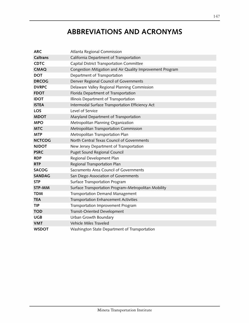
147
ABBREVIATIONS AND ACRONYMS
ARC Atlanta Regional Commission Caltrans California Department of Transportation CDTC Capital District Transportation Committee CMAQ Congestion Mitigation and Air Quality Improvement Program DOT Department of Transportation DRCOG Denver Regional Council of Governments DVRPC Delaware Valley Regional Planning Commission FDOT Florida Department of Transportation IDOT Illinois Department of Transportation ISTEA Intermodal Surface Transportation Efficiency Act LOS Level of Service MDOT Maryland Department of Transportation MPO Metropolitan Planning Organization MTC Metropolitan Transportation Commission MTP Metropolitan Transportation Plan NCTCOG North Central Texas Council of Governments NJDOT New Jersey Department of Transportation PSRC Puget Sound Regional Council RDP Regional Development Plan RTP Regional Transportation Plan SACOG Sacramento Area Council of Governments SANDAG San Diego Association of Governments STP Surface Transportation Program STP-MM Surface Transportation Program–Metropolitan Mobility TDM Transportation Demand Management TEA Transportation Enhancement Activities TIP Transportation Improvement Program TOD Transit-Oriented Development UGB Urban Growth Boundary VMT Vehicle Miles Traveled WSDOT Washington State Department of Transportation
Mineta Transportation Institute

148 Abbreviations and Acronyms
Mineta Transportation Institute

149
BIBLIOGRAPHY
American Planning Association. “APA Smart Growth Fact Sheet: Colorado.” http://www.planning.org/growingsmart/States/Colorado.htm#9 (accessed June 24, 2007).
Apple Valley (MN), City of. “Comprehensive Planning in Apple Valley: A Citizens Guide.” http://www.ci.applevalley.mn.us/Community_Development_and_Planning/comprehens ive_plan/ citizens_guide_to_the_comprehensive_plan_without_maps.pdf (accessed June 12, 2007).
Association of Bay Area Governments. “Compact Communities: Grant Program Integrates Transportation and Land Use.” http://www.abag.ca.gov/planning/theoryia/compsfbamtc.htm (accessed May 28, 2007).
Atlanta Regional Commission. “ARC Board.” http://www.atlantaregional.com/cps/rde/xchg/ arc/hs.xsl/202_ENU_HTML.htm (accessed May 27, 2007).
———. “ARC’s Livable Centers Initiative Funds New Smart Growth Studies.” http://www.atlantaregional.com/cps/rde/xchg/SID-3F57FEE7-F94670EA/arc/hs.xsl /81_3101_ENU_HTML.htm (accessed February 19, 2007).
———. “ARC Makes Model Ordinances Available for Local Communities.” http://www.atlantaregional.com/cps/rde/xchg/arc/hs.xsl/566_ENU_HTML.htm (accessed June 3, 2007).
———. “Community Choices.” http://www.atlantaregional.com/cps/rde/xchg/arc/hs.xsl/ 393_ENU_HTML.htm (accessed May 6, 2007).
———. “Community Choices Toolkit.” http://www.atlantaregional.com/cps/rde/xchg /arc/hs.xsl/392_ENU_ HTML.htm (accessed May 7, 2007).
———. “Envision Regional Development Plan Land Use Policies.” http://www.at lantaregional.com/cps/rde/xbcr/arc/rdp_policies.pdf (accessed May 6, 2007).
———. “Evaluation of 2005 Public Involvement Activities in Transportation Planning.” http://www.atlantaregional.com/documents/2005TPPPEvalReport.pdf (accessed May 7, 2007).
———. “History, Funding & Membership.” http://www.atlantaregional.com/cps/rde/xchg/ arc/hs.xsl/186_ENU_HTML.htm (accessed May 4, 2007).
———. “How Community Choices Tools Can Implement Regional Policies.” http://www. atlantaregional.com/cps/rde/xbcr/arc/rdpguidebook.pdf (accessed June 3, 2007).
———. Livable Centers Initiative. http://www.atlantaregional.com/cps/rde/xchg/arc/hs.xsl/ 308_ENU_ HTML.htm (accessed February 7, 2007).
Mineta Transportation Institute
150 Bibliography
———. Mobility 2030. http://www.atlantaregional.com/cps/rde/xchg/arc/hs.xsl/ 360_ENU_HTML.htm (accessed May 6, 2007).
———. Regional Development Plan. http://www.atlantaregional.com/cps/rde/xchg/arc/ hs.xsl/317_ENU_ HTML.htm (accessed May 6, 2007).
———. Regional Development Plan: Land Use Policies. http://www.grta.org/ regional_forum/regionalforum_files/Envision6SummaryReportMay2006%20_3_.pdf (accessed November 17, 2007).
———. “Transportation.” http://www.atlantaregional.com/cps/rde/xchg/arc/hs.xsl/15_ENU _HTML.htm (accessed May 6, 2007).
Bay Area Economic Forum. “The Region.” http://www.bayeconfor.org/baefregion.html (accessed June 23, 2007).
Bayonne (NJ), City of. “Federal, State, Local Officials Announce Light Rail Extension to 8th
Street in Bayonne.” http://www.bayonnenj.org/cgi-bin/news/newsall.cgi?news=1101 (accessed October 2006).
Bell, Peter. “State of the Region Address.” http://www.metrocouncil.org/directions/ planning/planning2007/SORSpeech2007.pdf (accessed June 12, 2007).
Bierbaum, Martin. “Smart Plan/Smart Growth Implementation in New Jersey: A Focus on Changing State Bureaucracy 1998–2001.” http:www.smartgrowth.umd.edu/ InternationalConference/ConferencePapers/ Bierbaum_SGNewJersey_DateNA.pdf (accessed June 24, 2007).
Bochner, Brian S., Carol A. Lewis, Robin L. Rabinowitz, Laura L. Higgins, and Josias Zietsman. “Introducing Smart Growth to Texas: Research Report.” Texas Transportation Institute (September 2002). http://tti.tamu.edu/documents/ 4238-1.pdf (accessed March 23, 2007).
Bollens, Scott. “In Through the Back Door: Social Equity and Regional Governance.” Housing Policy Debate 13, no. 4 (2003): 631–657.
Brookings Institute. “Moving Beyond Sprawl: The Challenge for Metropolitan Atlanta.” http://www.brookings.edu/dybdocroot/es/urban/atlanta/Atl01-17.pdf (accessed June 7, 2007).
California Department of Transportation. “California Department of Transportation Planning Grants Application Package Fiscal Year 2003–2004.” http://www.dot.ca.gov/hq/tpp/ Planning%20&%20Research%20Funds/03_04DOTP_grantapp_pkg.pdf# xml=http://dap1.dot.ca.gov/cgi bin/texis/webinator/search/pdfhi.txt?query= compact+development&db=db&pr=www&prox= page&rorder=500&rprox=500&rdfreq= 500&rwfreq=500&rlead=500&sufs=0& order=r&cq=&id=460d9a7913 (accessed May 8, 2008).
Mineta Transportation Institute

Bibliography 151
———. Community-Based Transportation Planning Grant Program: Past Cycle FY 00/01. http://www.dot.ca.gov/hq/tpp/offices/ocp/awarded_grants.htm (accessed March 20, 2007).
Capital District Transportation Committee. “About CDTC.” http://www.cdtcmpo.org/ whatcdtc.htm (accessed May 16, 2007).
———. “CDTC Linkage Program.” http://www.cdtcmpo.org/linkage.htm (accessed March 3, 2007).
———. “Summary of Regional Smart Growth Incentive Programs.” http://www. cdtcmpo.org/rtp2030/e-growth.pdf (accessed March 21, 2007).
Carlson, Daniel, Zach Hill, Jill Simmons, and Alex Atchison. “WSDOT’s Role in Transportation Demand Management: Strategic Interest, Structure, and Responsibilities.” Evans School of Public Affairs, University of Washington. http://evans.washington.edu/fac/Carlson/pdf/Carlson-WSDOT.pdf (accessed June 24, 2007).
Carter, O. K. “O. K. Carter Commentary Column.” Fort Worth Star-Telegram, October 27, 2002.
Cervero, Robert, and Michael Duncan. “Which Reduces Vehicle Travel More: Jobs-Housing Balance or Retail-Housing Mixing?” Journal of the American Planning Association 72, no. 4 (Autumn 2006): 475–91.
Citizens’ Housing and Planning Association. “Housing Briefs.” http://www.chapa.org/ news_03-01-04.htm (accessed May 7, 2007).
Delaware Valley Regional Planning Commission. 2002 TCDI Assessment Report. http://www.dvrpc.org/planning/ tcdi/2002Report.pdf (accessed September 2006).
———. http://www.dvrpc.org/about/marketing/regional/htm (accessed October 2006).
———. “Board Members.” http://www.dvrpc.org/about/board.htm (accessed October 15, 2006).
———. Destination 2030: Future Land Use and Transportation Facilities. http://www.dvrpc.org/ LongRangePlan/2030/LRP_Admin.pdf (accessed October 2006).
———. “Fiscal Year 2006 Transportation Improvement Program for New Jersey—Program Summary and Explanatory Information.” http://www.dvrpc.org/transportation/capital/ tip/NJfinal/2006/FY2006NJ-text.pdf (accessed October 2006).
———. “FY2005 Transportation Improvement Program Volume III Pennsylvania Subregion.” http://www.dvrpc.org/transportation/capital/ tip/pafinal/2005/ volume3-web.pdf (accessed October 2006).
———. “Housing.” http://www.dvrpc.org/planning/regional/housing.htm (accessed October 15, 2006).
Mineta Transportation Institute
152 Bibliography
———. The Long-Range Plan. http://www.dvrpc.org/LongRange.htm (accessed October 2006).
———. “Municipal, County, and Regional Population Estimates, 2000–2005.” http://www.dvrpc.org/data/databull/rdb/db84.htm (accessed June 24, 2007).
———. “Municipal Implementation Tools.” http://www.dvrpc.org/planning/ community/MCDTools.htm (accessed October 24, 2006).
———. “Protected Open Space Inventory.” http://www.dvrpc.org/planning/environmental/ openspace/inventory.htm (accessed October 22, 2006).
———. “Recreational Open Space Needs Analysis for the Delaware Valley.” http://www.dvrpc.org/planning/environmental/openspace/02021.pdf (accessed October 20, 2006).
———. TCDI [Tranportation and Community Development Initiative] 2002 Assessment Report. http://www.dvrpc.org/planning/tcdi/2002Report.pdf (accessed September 2006).
———. “TIP Guide.” http://www.dvrpc.org/transportation/capital/tip/tipguide.htm (accessed June 24, 2007).
———. “Transportation and Community Development Initiative.” http://www.dvrpc.org/ planning/tcdi.htm (accessed October 2006).
———. “Transportation and Community Development Initiative: 2007 Program Guide and Grant Application Forms.” http://www.dvrpc.org/planning/tcdi/FY2007 TCDIProgram.pdf (accessed May 28, 2007).
———. “Transportation and Community Development Initiative Program (TCDI) Aids Communities.” http://www.dvrpc.org/publicaffairs/publicinvolvement/ej/ chronicle2004-07/ejchronicle2004-07.htm#22 (accessed October 2006).
Denver Regional Council of Governments. Fiscally Constrained Metro Vision 2025 Interim Regional Transportation Plan. http://www.drcog.org/documents/2025_Interim_ Regional_Transportation_Plan_4-17-02.pdf (accessed June 24, 2007).
——. Metro Vision. http://www.drcog.org/index.cfm?page=2030Regional TransportationPlan (accessed November 17, 2007).
———. “Urban Growth Boundaries Flexibility Provisions.” www.drcog.org (accessed June 24, 2007).
Dobbins, Michael. “Focusing Growth Amid Sprawl: Atlanta’s Livable Centers Initiative.” http://repositories.cdlib.org/cgi/viewcontent.cgi?article=1946&context=ced/places (accessed May 27, 2007).
Dressel, Jr., William G. “Re: Transportation Trust Fund.” New Jersey State League of Municipalities. http://www. njslom.org/ml021606.html (accessed October 2006).
Mineta Transportation Institute

Bibliography 153
Eastside Transportation Concurrency Study. “What Is Concurrency?” http://depts.washington.edu/trac/concurrency/questions.html (accessed June 10, 2007).
Environment Colorado. “Sprawl in the Metro Region.” www.environmentcolorado.org (accessed June 24, 2007).
Executive Department, Commonwealth of Massachusetts, “Governor Patrick Announces South Coast Rail Plan: Plan Outlines Steps to Deliver Passenger Service by 2016; Commits $17 Million to Initial Phase.” https://www.commentmgr.com/ projects/1212/docs/SCR%20Press%20Release.pdf (accessed June 8, 2007).
Federal Highway Administration. 2007 Environmental Excellence Awards, 2007.
———. “Capital District Transportation Committee.” http://www.fhwa.dot.gov/planning/ landuse/albanycs.htm (accessed March 24, 2007).
———.Illinois Tomorrow Corridor Planning Grant Program. http://www.fhwa.dot.gov/planning/landuse/illinoiscs.htm (accessed June 12, 2007).
———. “Transportation Planning Excellence Awards: Public Involvement Education and Outreach, Award Winner.” http://www.fhwa.dot.gov/planning/tpea/pubinvolv.htm (accessed June 11, 2007).
Glendening, Parris N. “Smart Politics.” Environmental Law Institute (January/February 2004). http://www2eli.org/pdf/research/21-1smartpolitics.pdf (accessed June 24, 2007): 21–30.
Goetz, Edward, Karen Chapple, and Barbara Lukermann. “Enabling Exclusion: A Retreat from Regional Fair Share Housing in the Implementation of the Minnesota Land Use Planning Act.” Journal of Planning Education and Research 22 (2003): 213–25.
Growth Management Hearings Board. “Role of the Growth Management Hearings Boards.” http://www.gmhb.wa.gov/board_role/index.html (accessed June 10, 2007).
Hagen, Eric. “Cities Preparing Comp Plan Updates.” MNSUN. http://www.mnsun.com/ articles/2007/01/11/news/focomplans.txt (accessed June 12, 2007).
Handy, Susan. “Smart Growth and the Transportation–Land Use Connection: What Does the Research Tell Us?” International Regional Science Review 28, no.2 (April 4, 2005): 146–67.
Hendricks, Sara J., and Julie Goodwill. “Building Transit Oriented Development in Established Communities.” Center for Urban Transportation Research (November 2002). http://www.dot.state.fl.us/research-center/Completed_Proj/Summary_PTO/ FDOT_BC 137_ 38_TOD_rpt.pdf (accessed March 23, 2007).
Illinois Department of Transportation. Illinois Tomorrow Corridor Planning Grant Program. http://www.dot.state.il.us/ corridorPlanning/corridor_grant.html (accessed March 2, 2007).
———. Illinois Tomorrow Corridor Planning Grant Program. http://www.dot.il.gov/ corridorplanning/pdf/cpgpbrochure.pdf (accessed June 24, 2007).
Mineta Transportation Institute

154 Bibliography
Institute of Governmental Studies–University of California, Berkeley, California Policy Inbox. March 23, 2007. http://inbox.berkeley.edu/?m=200703 (accessed May 8, 2007).
Kitsap County (WA) Community Development. “Buildable Lands Program (RCW 36.70A.215).” http://www.kitsapgov.com/dcd/community_plan/blp/bla.htm (accessed June 10, 2007).
Lawrence, Steve. “California Population Nears 28 Million, L.A. Tops 4 Million.” http://www.signonsandiego.com/news/state/ 20070501-1517-ca-californiapopulation.html (accessed May 8, 2007).
Leiter, Robert A. “San Diego Adopts a Regional Comprehensive Plan for Growth.” Western City Magazine, December 2005. http://www.cacities.org/index.jsp?zone=wcm&preview Story=24349 (accessed June 12, 2007).
Maryland Department of Planning. “Managing Maryland’s Growth: Models and Guidelines.” http://www.mdp.state.md.us/smartgrowth/pdf/PFA.PDF (accessed June 24, 2007).
———. “Smart Growth Background.” http://www.mdp.state.md.us/smartintro.htm (accessed June 24, 2007).
Maryland Department of Transportation. “About Transit-Oriented Development.” http://www.mdot-realestate.org/tod.asp#Strategy (accessed June 24, 2007).
Maryland, State of. Website. http://www.maryland.gov (accessed June 20, 2007).
Massachusetts, Commonwealth of. Sustainable Development Principles. http://www.mass.gov/?pageID=gov3terminal&L=2&L0=Home&L1=Smart+Growth&si d=Agov3&b=terminalcontent&f=smart_growth_sustainable_dev_principles&csid=Ago v (accessed June 13, 2007).
Massachusetts Executive Office of Transportation. Chapter 196, Acts of 2004. http://www.eot.state.ma.us/ downloads/chap196/intro.pdf (accessed May 8, 2007).
———. The Commonwealth of Massachusetts Long-Range Transportation Plan 2006. http://www.eot.state.ma.us/default.asp?pgid=content/longplanIndex&sid=level2.
———. “Lieutenant Governor Murray, Secretaries Cohen and O’Connell Announce Economic Development and Land Use Study of South Coast Rail Corridor.” http://www.eot.state.ma.us/default.asp?pgid=content/releases/pr051807_socoastcorridor &sid=release (accessed June 8, 2007).
———. “South Coast Rail.” https://www.commentmgr.com/cmprojects/projects/1212/ nextsteps.asp (accessed June 8, 2007).
Massachusetts Housing Partnership. “E-Bulletin.” http://mhp.net (accessed November 17, 2007).
———. “E-Bulletins: Q&A on Transit Oriented Grants.” http://www.mhp.net/vision/ e_bulletins.php?page_function=detail&bulletin_id=9 (accessed March 4, 2007).
Mineta Transportation Institute

Bibliography 155
Metropolitan Transportation Commission. 2001 RTP Project Notebook. http://www.mtc. ca.gov/library/2001_rtp/downloads/PN/PartI_systmaint.pdf (accessed May 9, 2007).
———. “About MTC.” http://mtc.ca.gov/about_mtc/about.htm (accessed May 28, 2007).
———. “MTC Resolution 3434 Transit-Oriented Development (TOD) Policy for Regional Transit Expansion Projects.” www.mtc.ca.gov/planning/smart_growth/tod/TOD_policy.pdf (accessed May 11, 2007).
———. “Smart Growth/Transportation for Livable Communities: Housing Incentive Program (HIP).” http://www.mtc.ca.gov/ planning/smart_growth/hip.htm (accessed May 9, 2007).
———. “Transportation for Livable Communities: Works in Progress.” http://www.mtc.ca.gov/library/TLC/index.htm (accessed June 24, 2007).
——. Transportation 2030 Plan. http://mtc.ca.gov/planning/2030_plan/index.htm (accessed May 28, 2007).
——. Transportation 2030 Project Notebook. http://www.mtc.ca. gov/planning/ 2030_plan/downloads/Final_Project_Notebook.pdf (accessed May 9, 2007).
Morris, Karin. “Regional Planning Approaches to TOD: Moving Beyond Policy.” http://www.railvolution.com/rv2005_pdf (accessed September 2006).
National Governors Association Center for Best Practices. “Issue Brief: Integrating Affordable Housing with State Development Policy.” http://www.nga.org/cda/files/ 0411AFFORDABLEHOUSING.pdf (accessed June 24, 2007).
New Jersey Board of Public Utilities. “New Jersey Administrative Code 14:3.” http://www.state.nj.us/bpu/wwwroot/secretary/NJAC3Cleanup_050222.pdf (accessed October 2006).
New Jersey Department of Community Affairs Office of Smart Growth. “Cross-Acceptance Process.” http://www.state.nj.us/dca/osg/plan/crossacceptance.shtml (accessed September 2006).
———. New Jersey State Development and Redevelopment Plan. http://www.nj.gov/dca/osg/plan (accessed September 2006).
——. New Jersey State Development and Redevelopment Plan: Plan Endorsement. http://www.state.nj.us/dca/osg/plan/stateplan/intro_role.shtml (accessed October 2006).
———. “NJ Department of Community Affairs Announces $2.295 Million in Smart Future Planning Grants.” http://www.state.nj.us/dca/osg/docs/sfgrants06announcement.pdf (accessed October 2006).
———. “Plan Endorsement Process.” http://www.state. nj.us/dca/osg/plan/ endorsement.shtml (accessed October 2006).
Mineta Transportation Institute

156 Bibliography
———. “Smart Growth Begins with Smart Planning.” http://www.state.nj.us/dca/osg/resources/ grants/index.shtml (accessed October 2006).
———. “Smart Growth Benefits New Jersey.” http://www .state.nj.us/dca/osg/ smart/benefits/index.shtml (accessed October 2006).
New Jersey Department of Transportation. “Centers of Place.” http://www.state.nj.us/ transportation/business/localaid/centerplace.shtm (accessed October 2006).
———. “Corzine Signs Legislation to Reform, Replenish, and Grow Transportation Trust Fund.” http://www.state.nj.us/transportation/about/press/2006/32306.shtm (accessed June 24, 2007).
New Jersey Future. “NJF Guide to the State Plan.” http://www.njfuture.org/index.cfm?ctn=9t45e1o30v9g&emn=5u92y86g2h42& useaction=user.item&ThisItem=166 (accessed October 2006).
New Jersey, State of. New Jersey State Development and Redevelopment Plan: “State Plan Policy Map.” http://www.state.nj.us/dca/osg/plan/state plan/intro_map.shtml (accessed October 2006).
NJ TRANSIT. “Newark Light Rail Opens to Support City’s Economic Revitalization.” http://www.njtransit.com/nn_press_release.jsp?PRESS_RELEASE_ID=2246 (accessed October 2006).
Northern Illinois Planning Commission. “Northeastern Illinois Municipal Population Estimates.” http://www.nipc.org/forecasting/munipop05.html (accessed June 22, 2007).
Planners Network. “Regional Profiles: Metropolitan Governance and Regional Planning: Four Cities, Four Approaches.” http://www.plannersnetwork.org/publications/ 1998_128/hall.htm (accessed June 9, 2007).
Platforms for Progress. “ARC: History.” http://www.platformsforprogress.com (accessed June 3, 2007).
Portland Metro. 2040 Growth Concept. http:www.metro-region.org/article.cfm?articleID=231 (accessed June 9, 2007).
———. “About Metro.” http://www.metro-region.org/pssp.cfm?ProgServID=62. (accessed June 10, 2007).
———. “Budget, FY 2003–04: Organization and Regional Profile.” http://www.metro-region.org/article.cfm?articleid=5357 (accessed June 10, 2007).
———. Regional Framework Plan. http://www.metro-region.org/article.cfm?ArticleID=432 (accessed June 9, 2007).
———. Regional Framework Plan: Updated & Effective 12/18/05. http://www.metroregion. org/library_docs/land_use/rfp_introduction.pdf (accessed June 9, 2007).
Mineta Transportation Institute

Bibliography 157
———. Regional Transportation Plan. http://www.metro region.org/article.cfm?articleid=137 (accessed June 9, 2007).
———. Urban Growth Management Functional Plan. http://www.metro-region.org/ article.cfm?ArticleID=274 (accessed June 10, 2007).
Priority Places. “An Overview of Priority Places.” http://www.priorityplaces.com/ (accessed May 28, 2007).
———. Priority Places. http://www.priorityplaces.com/pdf/PP_brochure.pdf (accessed May 28, 2007).
Puget Sound Regional Council. “Central Puget Sound Regional Growth Centers–2002.” http://www.psrc.org/projects/monitoring/pdf%20files/summary.pdf (accessed June 10, 2007).
———. “Design Guidelines Manual: Destination 2030 Physical Design Guidelines.” http://www.psrc.org/projects/growth/designmanual.pdf (accessed June 10, 2007).
———. “Frequently Asked Questions.” http://www.psrc.org/about/what/faq.htm (accessed June 10, 2007).
———. Project Listing. http://www.psrc.org/projects/index.htm (accessed June 10, 2007).
———. “Puget Sound Trends.” Issue T5, June 2002. http://www.psrc.org/publications/pubs/trends/t5jun02.pdf (accessed June 23, 2007).
———. Vision 2020: 1995 Update. http://www.psrc.org/projects/vision/pubs/1995update/ v2020.pdf (accessed June 24, 2007).
Reinhard, Walter G. “BPU Changes the Rules of the Game for Utilities Installations.” Dimensions, January 10, 2005. http://www. nmmlaw.com/articles/bpu_rules.pdf (accessed October 2006).
Sacramento Area Council of Governments. 2006 Metropolitan Transportation Plan for the Sacramento Region. http://www.sacog.org/mtp (accessed June 24, 2007).
———. 2007/2009 Metropolitan Transportation Improvement Program. www.sacog.org/mtip/ (accessed November 18, 2007).
———. “A Bold First Step for Mobility in the Sacramento Region: Metropolitan Transportation Plan for 2025.” http://www.sacog.org/mtp/pdf/mtpfor2025.pdf (accessed June 11, 2007).
———. Regional Report. http://www.sacog.org/regrpt/august04rr.pdf (accessed June 11, 2007).
Sacramento Area Council of Governments Land Use and Housing Committee. Blueprint Project: 2006 Blueprint Implementation Tasks. http://www.sacog.org/calendar/ 2006/03/06/luh/pdf/04BLUE.pdf (accessed June 11, 2007).
Mineta Transportation Institute

158 Bibliography
Sacramento Area Council of Governments, Valley Vision, and Community Services Planning Council. Sacramento Region Quality of Life Report 2004. http://www.valleyvision.org/projects-2004QoLReport.html (accessed June 24, 2007).
Sacramento Blueprint. “Sacramento Region Blueprint Transportation and Land Use Study: Implementation: Local Government Feature: City of Folsom.” http://www.valleyvision.org/qol/index.html (accessed November 17, 2007).
———. Special Report: Preferred Blueprint Alternative. www.sacregionblueprint.org/ sacregionblueprint/the_project/BP_Insert_JAN_2005.pdf (accessed June 24, 2007).
San Diego Association of Governments. 2020 Regional Transportation Plan. http://www.sandag.org/uploads/publicationid/publicationid_869_1973.pdf (accessed June 12, 2007).
———. “About SANDAG: Board of Directors.” http://www.sandag.org/index.asp?fuseaction=about.board (accessed June 12, 2007).
———. “About SANDAG: Bylaws and Policies.” http://www.sandag.org/index.asp?fuseaction=about.bylaws (accessed June 12, 2007).
———. “Environment: Comprehensive Environmental Projects: Regional Intergovernmental Review.” http://www.sandag.org/index.asp?projectid=93&fuseaction=projects.detail (accessed June 12, 2007).
———. “Fact Sheet: Mapping Smart Growth in the San Diego Region.” http://www.sandag.org/uploads/publicationid/publicationid_1252_5841.pdf (accessed June 12, 2007).
———. “Fact Sheet: TransNet Environmental Mitigation Program.” http://www.sandag.org/ uploads/publicationid/publicationid_1138_4880.pdf (accessed June 12, 2007).
———. Final 2030 Regional Transportation Plan. http://www.sandag.org/programs/ transportation/comprehensive_transportation_projects/2030rtp/2030_final_3.pdf (accessed May 12, 2007).
———. “Land Use & Regional Growth: Comprehensive Land Use & Regional Growth Projects: Public Participation.” http://www.sandag.org/ index.asp?projectid=1&fuseaction=projects.detail (accessed June 12, 2007).
———. “News: Full Story: July 23, 2004: Board Unanimously Adopts Regional Comprehensive Plan (RCP).” http://www.sandag.org/ index.asp?newsid=246&fuseaction=news.detail (accessed June 12, 2007).
———. “News: Full Story: June Board Actions: FY 2006 Transportation Development Act (TDA) Allocations.” http://www.sandag.cog.ca.us/index.asp?newsid=312&fuseaction =news.detail (accessed June 12, 2007).
Mineta Transportation Institute

Bibliography 159
———. Regional Comprehensive Plan. http://www.sandag.org/uploads/publicationid/ publicationid_1094_3362.pdf (accessed June 11, 2007).
———. “The Regional Comprehensive Plan: Establishing a Baseline for Monitoring Performance.” http://www.sandag.org/uploads/publicationid/ publicationid_1264_6072.pdf (accessed June 12, 2007).
———. Regional Comprehensive Plan: Revised Draft: Chapter 4a. http://www.sandag.cog.ca.us/rcp_revised_draft/chapter4a.pdf (accessed June 12, 2007).
———. “TransNet Fact Sheet.” http://sdapa.org/download/SANDAG_TransNet.pdf (accessed June 12, 2007).
———. “Transportation Development Act Claim Manual.” http://www.sandag.org/ programs/transportation/public_transit/tda/tda_manual.pdf (accessed June 12, 2007).
San Diego Board of Supervisors, County of. “Statement of Proceedings: Regular Meeting.” http://www.sdcounty.ca.gov/cnty/bos/agenda/sop/051104sop.doc (accessed June 12, 2007).
San Diego, City of. Government Relations Department. “Position Paper: TEA Reauthorization.” http://www.sandiego.gov/governmentalrelations/pdf/ TransportationEfficiencyActTEAReauthorization.pdf (accessed May 9, 2007).
Seattle Department of Transportation. “Commute Trip Reduction.” http://www.seattle.gov/transportation/commute.htm (accessed June 10, 2007).
Smart Growth America. “Transportation: Federal Transportation Law: TEA 21.” http://www.smartgrowthamerica.org/ transportation.html (accessed May 18, 2007).
Smart Growth Network. “Smart Growth Funding Resource Guide.” http://www.smartgrowth.org/pdf/funding_ resources.pdf (accessed May 18, 2007).
State Environmental Resource Center. “Traffic Congestion Relief.” http://www.serconline.org/trafficcongestionrelief/index.html (accessed October 2006).
Surface Transportation Policy Partnership. “AB 392 Fact Sheet.” http://www.transact.org/ca/ab392.htm (accessed May 28, 2007).
———. “Transportation for Livable Communities.” http://www.transact.org/ca/tlc_fact_ sheet.pdf (accessed May 8, 2007).
Sustainable Development Commission of the United Kingdom. “About Sustainable Development.” http://www.sd-commission.org.uk/pages/aboutsd.html (accessed September 17, 2007).
Toland, Bill. “A Blueprint for Tax Sharing: In Minnesota, Dividing the Spoils Helps Cities and Suburbs.” Pittsburgh Post-Gazette, February 15, 2004. http://www.post-gazette.com/pg/04046/273339.stm (accessed June 12, 2007).
Mineta Transportation Institute

160 Bibliography
Twin Cities Metropolitan Council. 2006 Together, Shaping Our Future. http://www. metrocouncil.org/resources/AnnualReport2006.pdf (accessed June 13, 2007).
———. 2030 Regional Development Framework. http://www.metrocouncil.org/ planning/framework/Framework.pdf (accessed June 12, 2007).
———. 2030 Transportation Policy Plan. http://www.metrocouncil.org/planning/ transportation/TPP/2004/summary.htm (accessed June 12, 2007).
———. “About the Council.” http://www.metrocouncil.org/about/about.htm (accessed June 12, 2007).
——. “Demographic and Development Trends.” Chapter 4 in 2005 Twin Cities Transportation System Performance Audit. http://metrocouncil.org/planning/transportation/Audit2005/ Chapter4.pdf (accessed June 12, 2007).
———. Livable Communities Grant Program. http://www.metrocouncil.org/services/livcomm.htm (accessed June 12, 2007).
———. “Livable Communities Program Fact Sheet.” http://www.metrocouncil.org/ about/facts/LivableCommunitiesFacts.pdf (accessed June 13, 2007).
———. “Metropolitan Council 2006 Proposed Unified Budget: Authority and Organization.” http://www.metrocouncil.org/about/2006Budget/ BudgetBackground.pdf (accessed June 12, 2007).
———. “Metropolitan Livable Communities Act: Expected Results: Budgeted Funds 1996 to 2006.” http://www.metrocouncil.org/services/livcomm/LCAResults.pdf (accessed June 13, 2007).
———. Planning: 2030 Regional Development Framework Documents. http://www. metrocouncil.org/planning/framework/documents.htm (accessed June 12, 2007).
———. Planning: 2030 Transportation Policy Plan. http://www.metrocouncil.org/ planning/transportation/TPP/2004/TPP04Chapter2_Final.pdf (accessed June 12, 2007).
———. “Region’s Benchmark Performance Is Positive.” http://www.metrocouncil.org/ Directions/planning/planning2006/benchmarks.htm (accessed June 12, 2007).
———. “System Statements.” http://www.metrocouncil.org/planning/assistance/ systemstatements.htm (accessed June 12, 2007).
———. “Third Month of Rail Ridership Exceeds Expectation.” News release, October 7, 2004. http://www.electricrailroaders.org/swindler/2004_1002-1008.php (accessed June 12, 2007).
U.S. Census Bureau. “50 Fastest-Growing Metro Areas Concentrated in West and South.” http://www.census.gov/Press-Release/www/releases/archives/population/009865.html (accessed May 4, 2007).
Mineta Transportation Institute

Bibliography 161
———. “The 2007 Statistical Abstract.” http://www.census.gov/compendia/statab/rankings.html (accessed June 22, 2007).
———. “Population Finder.” http://factfinder.census.gov/servlet/SAFFPopulation?_sse=on (accessed June 23, 2007).
———. “State and County Quick Facts.” http://quickfacts.census.gov/qfd/states/34000.html (accessed October 2006).
———. “State Population—Rank, Percent Change, and Population Density.” www.census.gov/compendia/statab/tables/07s0018.xls (accessed June 23, 2007).
Walz, Karen. “Straight Talk. It Ain’t Your Grandpa’s Texas Anymore.” Planning Magazine, February 2006, 22–27.
Washington State Department of Community, Trade, and Economic Development. “Creating Livable Communities, Managing Washington’s Growth for 15 Years.” http://www.cted. wa.gov/_CTED/documents/ID_3175_Publications.pdf (accessed June 24, 2007).
———. “Growth Management Services: Overview of the Growth Management Act.” http://www.cted.wa.gov/_CTED/documents/ID_892_Publications.pdf (accessed June 10, 2007).
———. “White Paper on Washington’s Growth Management Act and WSDOT Planning and Environmental Assessment Requirements.” http://www.wsdot.wa.gov/NR/rdonlyres/558C9B2E-B81E-4AA5-B78FF3B3397D0E83 /0/GMAwhitepaper.pdf (accessed June 10, 2007).
Washington State Department of Transportation. “Create a Project for Reducing the Number of Commuters Who Drive Alone.” www.wsdot.wa.gov/tdm/ program_summaries/TRPP_brochure.pdf (accessed June 10, 2007).
———. “Guide to Trip Reduction Performance Program.” www.wsdot.wa.gov/tdm/ program_summaries/TRPP_guidelines.pdf (accessed June 10, 2007).
———.“Transportation Demand Management Improves the Transportation System.” http://www.wsdot.wa.gov/publications/folio/TDM.pdf (accessed June 10, 2007).
Washington State House of Representatives. “Bill Analysis: SSB 5602.” http://wsl.leg.wa.gov/pub/BillInfo/2003-04/Pdf/Bill%20Reports/House/5602-S.HBA.p df (accessed June 10, 2007).
Washington State Legislature. “WAC 468-60-010: Trip Reduction Performance Program.” http://apps.leg.wa.gov/WAC/default.aspx?cite=468-60-010 (accessed June 10, 2007).
Wells, Jan, and John Renne. “Implementation of the Assessment Tool: Measuring Economic Activity.” http://www.policy.rutgers.edu/vtc/tod/documents/ NJ%20Transit%20Villages_economic%20activity.pdf (accessed June 24, 2007).
Mineta Transportation Institute

162 Bibliography
Wheeler, Timothy B. “Group Plans to Sue State Over Highway Widening: Route 32 Project Called Smart Growth Violation.” Baltimore Sun, December 1, 2004.
Wheeler, Timothy B., and Childs Walker. “State Launches Program to Help Revitalize Areas: Priority Places to Offer Technical Aid, Little Cash.” Baltimore Sun, July 15, 2004.
Mineta Transportation Institute

163
ABOUT THE AUTHORS
GARY BINGER, FAICP, PRINCIPAL INVESTIGATOR
Gary Binger, principal investigator of this report, has extensive experience in land use, development processing, and intergovernmental coordination. He has served as an assistant planner in Concord, California; associate planner in Oakland, California; planning director for the City of Del Mar, California; chief of planning and community development director for the City of Walnut Creek, California; deputy executive director of the Association of Bay Area Governments; and director of the Urban Land Institute’s California Smart Growth Initiative.
Binger earned his bachelor of architecture degree from Cal Poly–San Luis Obispo, and his master of urban planning degree from the University of Washington, Seattle. He has performed graduate study at the University of Manchester, England, where he studied the British New Town Program. He recently received the Distinguished Leadership Award from the California Chapter of the American Planning Association.
RICHARD W. LEE, PhD, AICP
Richard Lee has been a research associate with the Mineta Transportation Institute (MTI) for over 10 years, and has led MTI studies of general plans and sustainability, and of sustainability indicators for transportation (MTI Reports 01-18 and 02-05). He is also a senior transportation planner with Fehr & Peers in Walnut Creek, and has over 20 years of experience as a transportation consultant and academic. His consulting experience includes management of regional transportation plans, general plan studies, high-speed rail and transit projects, and smart growth transportation studies, as well as a wide variety of traffic impact, travel demand management, and transportation policy studies.
Dr. Lee earned his master’s degrees in civil engineering (1984) and city and regional planning (1985) and his PhD in city and regional planning (1995), all from the University of California at Berkeley. He has taught transportation planning and conducted transportation research projects at several universities, including Massey University in New Zealand, UCLA, Cal Poly–San Luis Obispo, San José State University, and UC Berkeley.
CHARLES R. RIVASPLATA, PhD, RESEARCHER
Since his arrival at the San Francisco Planning Department in 1991, Charles Rivasplata has worked as both an associate planner and a senior transportation planner in the Citywide Policy Section. He has participated in a number of projects linking land use planning and transportation investment, and has been involved in issues related to interagency coordination. Prior to his arrival at the Planning Department, he worked as an assistant transportation planner at TJKM Transportation Consultants in Pleasanton, California. He has also served on both the Minority Citizens Advisory Committee and the Advisory Council of the
Mineta Transportation Institute

164 About the Authors
Metropolitan Transportation Commission (MTC). Currently he is a visiting lecturer in the Urban and Regional Planning Department at San José State University in San José, California.
Rivasplata earned a bachelor of arts, a master of arts, a master of science, and a master of city planning from the University of California at Berkeley. In 2006, he received a doctor of philosophy degree from the University of California at Davis. His doctoral dissertation addressed recent transportation reforms and their impacts on transit integration in the United Kingdom. In the past 15 years, he has written and presented a number of articles on a variety of transportation topics, ranging from transit service planning to travel demand management and regional transportation planning.
ALEXIS LYNCH, GRADUATE STUDENT RESEARCH ASSISTANT
Alexis Lynch is a master’s degree candidate in the Department of City and Regional Planning at the University of California at Berkeley. She earned her bachelor of arts in sociology from Vassar College in Poughkeepsie, New York. Her areas of research interest include land use, regional planning, sustainable development, and transportation.
MARLENE SUBHASHINI, GRADUATE STUDENT RESEARCH ASSISTANT
Marlene Subhashini is a graduate student of Urban & Regional Planning at San José State University in San José, California. She has an undergraduate degree in architecture from Bangalore, India. She is currently an assistant planner at a private planning consultant company. Her areas of research interest include sustainability and green buildings, smart growth, transit-oriented development, and community-based planning.
Mineta Transportation Institute
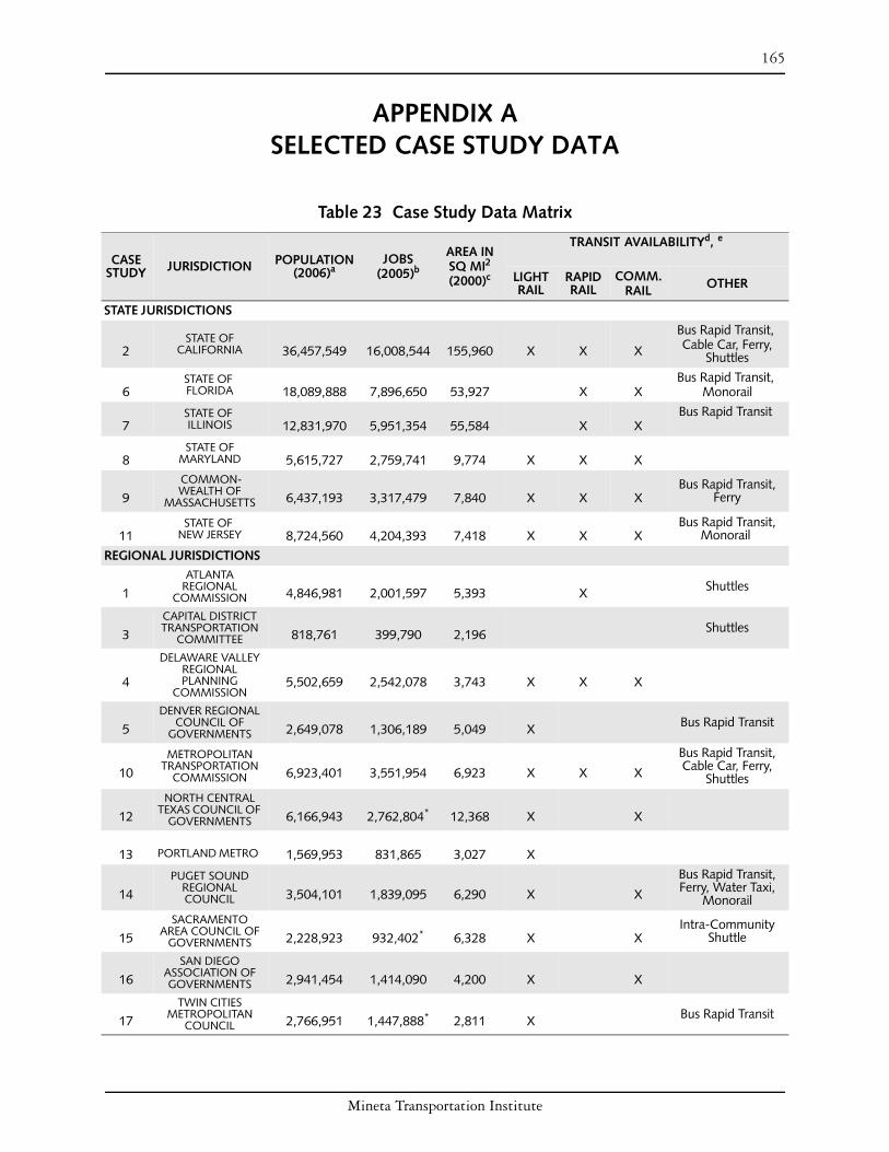
165
APPENDIX A SELECTED CASE STUDY DATA
Table 23 Case Study Data Matrix
CASE STUDY JURISDICTION POPULATION
(2006)a JOBS
(2005)b
AREA IN SQ MI2
(2000)c LIGHT RAIL
TRANSIT AVAILABILITYd , e
RAPID RAIL
COMM. RAIL OTHER
STATE JURISDICTIONS
2 STATE OF
CALIFORNIA 36,457,549 16,008,544 155,960 X X X
Bus Rapid Transit, Cable Car, Ferry,
Shuttles
STATE OF Bus Rapid Transit, 6 FLORIDA 18,089,888 7,896,650 53,927 X X Monorail
STATE OF Bus Rapid Transit 7 ILLINOIS 12,831,970 5,951,354 55,584 X X
STATE OF 8 MARYLAND 5,615,727 2,759,741 9,774 X X X
9 COMMONWEALTH OF
MASSACHUSETTS 6,437,193 3,317,479 7,840 X X X Bus Rapid Transit,
Ferry
11 STATE OF
NEW JERSEY 8,724,560 4,204,393 7,418 X X X Bus Rapid Transit,
Monorail
REGIONAL JURISDICTIONS ATLANTA
1 REGIONAL COMMISSION 4,846,981 2,001,597 5,393 X Shuttles
CAPITAL DISTRICT
3 TRANSPORTATION COMMITTEE 818,761 399,790 2,196 Shuttles
DELAWARE VALLEY REGIONAL
4 PLANNING COMMISSION
5,502,659 2,542,078 3,743 X X X
DENVER REGIONAL
5 COUNCIL OF GOVERNMENTS 2,649,078 1,306,189 5,049 X Bus Rapid Transit
10 METROPOLITAN
TRANSPORTATION COMMISSION 6,923,401 3,551,954 6,923 X X X
Bus Rapid Transit, Cable Car, Ferry,
Shuttles NORTH CENTRAL
12 TEXAS COUNCIL OF GOVERNMENTS 6,166,943 2,762,804* 12,368 X X
13 PORTLAND METRO 1,569,953 831,865 3,027 X
14 PUGET SOUND
REGIONAL COUNCIL 3,504,101 1,839,095 6,290 X X
Bus Rapid Transit, Ferry, Water Taxi,
Monorail
15 SACRAMENTO
AREA COUNCIL OF GOVERNMENTS 2,228,923 932,402* 6,328 X X
Intra-Community Shuttle
SAN DIEGO
16 ASSOCIATION OF GOVERNMENTS 2,941,454 1,414,090 4,200 X X
TWIN CITIES
17 METROPOLITAN COUNCIL 2,766,951 1,447,888* 2,811 X Bus Rapid Transit
Mineta Transportation Institute

166 Appendix A Selected Case Study Data
a. All population data is collected or calculated from United States Census Bureau, “Population Finder,” http://factfinder.census.gov/servlet/SAFF Population?_sse=on (accessed June 2, 2006).
b. All job data is collected or calculated from United States Census Bureau, http://factfinder.census.gov/jsp/ saff/SAFFInfo.jsp?_pageId=gn10_ select_state (accessed June 7, 2007).
c. All area data is collected or calculated from Unit ed States Census Bureau, “State and County QuickFacts,” http://quickfacts.census.gov/qfd/ (accessed June 4, 2006).
d. Modes of transit provided by various agencies within the state/region.
e. Standard bus services are currently operated in all of the states and regions surveyed. * = Data is for 2000
Mineta Transportation Institute

167
APPENDIX B PROGRAM INFORMATION
Table 24 Programs Checklist
BA
LAN
CED
TRAVEL
MO
DE SPLIT
AD
EQU
ATE
HO
USIN
G SU
PPLY
& A
FFOR
DA
BILITY
JOB
S–HO
USIN
G
BA
LAN
CE
TRA
NSIT-O
RIEN
TED
DEVELO
PMEN
T
CO
MPA
CT
DEVELO
PMEN
T PATTER
NS
JURISDICTION PROGRAM
ATLANTA REGIONAL COMMISSION
STATE OF CALIFORNIA
CAPITAL DISTRICT TRANSPORTATION
COMMITTEE
DELAWARE VALLEY REGIONAL PLANNING
COMMISSION
DENVER REGIONAL COUNCIL OF
GOVERNMENTS
STATE OF FLORIDA
STATE OF ILLINOIS
STATE OF MARYLAND
COMMONWEALTH OF MASSACHUSETTS
METROPOLITAN TRANSPORTATION
COMMISSION
Livable Centers Initiative
Community Choices Toolkit
Proposition 1C TOD Housing Support
Community-Based Transportation Planning Grants
Community & Transportation Linkage Planning Program
Transportation & Community Development Initiative Grants
TIP Approval for Projects
Urban Growth Boundary
Mile High Compact
Transportation Funding Criteria & Review
Pay as You Grow Plan for Florida’s Future
Strategic Intermodal System
Illinois Tomorrow Corridor Planning Grant Program
Priority Funding Areas
TOD Strategy
Live Near Your Work Plus
Priority Places
Community Safety & Enhancement
TOD Bond Program
Transportation for Livable Communities
Community Design Planning Program
Capital Grants Program
X
X
X
X
X
X
X
X
X
X
X
X
X
X
X
X
X
X
X
X
X
X
X
X
X
X
X
X
X
X
X
X
X
X
X
X
X
X
X
X
X
X
X
X
X
X
X
X
X
X
X
X
X
X
X
X
X
X
X
X
X
X
X
X
X
X
X
X
X
X
X
X
X
X
Housing Incentive Program X X X X X
TOD Policy X X X
Plan Endorsement X X X X X
STATE OF NEW JERSEY Smart Future Planning Grants X X X
NORTH CENTRAL TEXAS COUNCIL OF
GOVERNMENTS
PORTLAND METRO
Transit Villages
Sustainable Development Funding
TOD Implementation
X
X
X
X
X
X X
X
X
X
Mineta Transportation Institute

168 Appendix B Program Information
Table 24 Programs Checklist (Continued) B
ALA
NC
ED TR
AVEL
TRA
NSIT-O
RIEN
TED
& A
FFOR
DA
BILITY
INFR
ASTR
UC
TUR
E
AD
EQU
ATE H
OU
SING
SUPPLY
JOB
S–HO
USIN
G
CO
MPA
CT
DEVELO
PMEN
T
DEVELO
PMEN
T
MO
DE SPLIT
INC
ENTIVE-B
ASED
?
PATTERN
S
BA
LAN
CE
JURISDICTION PROGRAM
PUGET SOUND REGIONAL Transportation & Land Use Concurrency Requirement COUNCIL
Commuter Trip Reduction Law X
Blueprint Initiative X X X X X SACRAMENTO AREA
COUNCIL OF Community Design Grant Program X X XGOVERNMENTS
Jobs Access Reverse Commute Program X X
SAN DIEGO ASSOCIATION OF GOVERNMENTS
TWIN CITIES METROPOLITAN COUNCIL
TDA Non-Motorized Funds & TransNet Bicycle Program X
Smart Growth Incentive Program X X X X
Environmental Mitigation Program X Comprehensive Plan Review & Metropolitan Urban Services Area X X X
Regional Fair-Share Housing X X
Livable Communities Grant Program X X X X X
Table 25 Detailed Program Information PROGRAM
PROVIDES…
SOU
RC
E OF FU
ND
ING
FUN
DIN
G PR
OVID
ED?
REG
ULATO
RY OR
YEAR
STAR
TED
RESO
UR
CES
GR
AN
TS
TECH
NIC
AL
ASSISTA
NC
E
PLAN
NIN
G
PLAN
NIN
G
JURISDICTION PROGRAM
ATLANTA REGIONAL COMMISSION
Livable Centers Initiative
Community Choices Toolkit
Yes
No
Federal
N/A X X
X X 1999
2005
Incentive
N/A
STATE OF CALIFORNIA
Proposition 1C TOD Housing Support
Community-Based Transportation Planning Grants
Yes
Yes
Bond
State DOT X
X 2006
2000
Incentive
Incentive
CAPITAL DISTRICT TRANSPORTATION
COMMITTEE
Community & Transportation Linkage Planning Program Yes Federal X X 2000 Incentive
DELAWARE VALLEY REGIONAL PLANNING
COMMISSION
Transportation & Community Development Initiative Grants
TIP Approval for Projects
Yes
Yes
Federal, State, and Local
Federal
X X
X
2002
1965
Incentive
Incentive
DENVER REGIONAL COUNCIL OF
GOVERNMENTS
Urban Growth Boundary
Mile High Compact
Transportation Funding Criteria & Review
No
No
Yes
N/A
N/A
Federal
X
X
1997
2000
1985
Incentive
Incentive
Incentive
STATE OF FLORIDA Pay as You Grow Plan for Florida’s Future
Strategic Intermodal System
No
Yes
State
State
X
X
2005
2003
Regulatory
Incentive
STATE OF ILLINOIS Illinois Tomorrow Corridor Planning Grant Program Yes State X 2000 Incentive
Mineta Transportation Institute

169 Appendix B Program Information
Table 25 Detailed Program Information (Continued) PROGRAM
PROVIDES…
JURISDICTION PROGRAM
RESO
UR
CES
SOU
RC
E OF FU
ND
ING
FUN
DIN
G PR
OVID
ED?
INFR
ASTR
UC
TUR
E
PLAN
NIN
G
GR
AN
TS
TECH
NIC
AL
ASSISTA
NC
E
PLAN
NIN
G
YEAR
STAR
TED
REG
ULATO
RY OR
IN
CEN
TIVE-BA
SED?
Priority Funding Areas Yes State X 1997 Regulatory
TOD Strategy No N/A X 1997 Incentive
State, Local & STATE OF MARYLAND Live Near Your Work Plus Yes Participating
Employers 1997 Incentive
Priority Places Yes State X X 2003 Incentive
Community Safety & Enhancement Yes State X 1998 Incentive
COMMONWEALTH OF MASSACHUSETTS TOD Bond Program Yes Bond X 2004 Incentive
Transportation for Livable Communities Yes Federal X X 1998 Incentive
METROPOLITAN Community Design Planning Program Yes State X 1998 Incentive
TRANSPORTATION COMMISSION
Capital Grants Program
Housing Incentive Program
Yes
Yes
Federal
Federal
X
X
1998
2001
Incentive
Incentive
TOD Policy Yes Regional X X 2005 Incentive
Plan Endorsement Yes State X X X 2001 Incentive
STATE OF NEW JERSEY Smart Future Planning Grants Yes State X 2000 Incentive
Transit Villages Yes State/Federal X X 1999 Incentive
NORTH CENTRAL TEXAS COUNCIL OF Sustainable Development Funding Yes Federal X X 2001 Incentive
GOVERNMENTS
PORTLAND METRO TOD Implementation Yes Federal X X 1998 Incentive
PUGET SOUND Transportation & Land Use Concurrency Requirement No N/A 1990 Regulatory
REGIONAL COUNCIL Commuter Trip Reduction Law Yes State Tax
Credits 1991 Regulatory
SACRAMENTO AREA Blueprint Initiative Yes Federal X X 2004 Incentive
COUNCIL OF GOVERNMENTS
Community Design Grant Program
Jobs Access Reverse Commute Program
Yes
Yes
Federal
Federal
X
X
X
X
2003
2004
Incentive
Incentive
SAN DIEGO TDA Non-Motorized Funds & TransNet Bicycle Program Yes State &
TransNet Tax X 1987 Incentive
ASSOCIATION OF GOVERNMENTS Smart Growth Incentive Program Yes TransNet Tax X X 2005 Incentive
Environmental Mitigation Program Yes TransNet Tax 2004 Regulatory
TWIN CITIES METROPOLITAN
Comprehensive Plan Review & Metropolitan Urban Services Area No N/A X 1976 Regulatory
COUNCIL Regional Fair-Share Housing No N/A 1976 Regulatory
Mineta Transportation Institute

170 Appendix B Program Information
Mineta Transportation Institute

MTI Current Inside Cover.indd 2MTI Current Inside Cover.indd 2 4/25/2008 12:15:27 PM4/25/2008 12:15:27 PM
MTI FOUNDER Hon. Norman Y. Mineta
MTI BOARD OF TRUSTEES Honorary Co-Chair
Hon. James Oberstar **
Chair
House Transportation and
Infrastructure Committee
House of Representatives
Washington, DC
Honorary Co-Chair
Hon. John L. Mica **
Ranking Member
House Transportation and
Infrastructure Committee
House of Representatives
Washington, DC
David L. Turney *
Chair/President/CEO
Digital Recorders, Inc.
Dallas, TX
William W. Millar ^
Vice Chair/President
American Public Transportation
Association (APTA)
Washington, DC
Hon. Rod Diridon, Sr. #
Executive Director
Mineta Transportation Institute
San Jose, CA
Ronald Barnes
General Manager
Veolia Transportation/East
Valley RPTA
Mesa, AZ
Rebecca Brewster
President/COO
American Transportation
Research Institute
Smyrna, GA
Donald H. Camph
President
California Institute for
Technology Exchange
Los Angeles, CA
Anne P. Canby
President
Surface Transportation
Policy Project
Washington, DC
Jane Chmielinski
President
DMJM Harris
New York, NY
William Dorey
President/CEO
Granite Construction, Inc.
Watsonville, CA
Mortimer Downey
Chairman
PB Consult Inc.
Washington, DC
Nuria Fernandez
Commissioner
City of Chicago,
Department of Aviation
Chicago, IL
Steve Heminger
Executive Director
Metropolitan Transportation
Commission
Oakland, CA
Hon. John Horsley #
Executive Director
American Association of State
Highway & Transportation
Offi cials (AASHTO)
Washington, DC
Will Kempton
Director
California Department of
Transportation
Sacramento, CA
Alex Kummant
President/CEO
Amtrak
Washington, DC
Brian Macleod
Senior Vice President
Gillig Corporation
Hayward, CA
Dr. Bruce Magid
Dean
College of Business
San José State University
San José, CA
Stephanie Pinson
President/COO
Gilbert Tweed Associates, Inc.
New York, NY
Hans Rat
Secretary General
Union Internationale des
Transports Publics
Bruxelles, Belgium
Vickie Shaffer
General Manager
Tri-State Transit Authority
Huntington, WV
Paul A.Toliver #
President
New Age Industries
Seattle, WA
Michael S. Townes #
President/CEO
Transportation District
Commission of Hampton Roads
Hampton, VA
Edward Wytkind
President
Transportation Trades
Department, AFL-CIO
Washington, DC
** Honorary * Chair ^ Vice Chair # Past Chair
Directors
Hon. Rod Diridon, Sr.
Executive Director
Hon. Trixie Johnson
Research Director
Dr. Peter Haas
Education Director
Leslee Hamilton
Communications Director
Research Associates Policy Oversight Committee
Dayana Salazar, Chair Dr. Dongsung Kong
Associate Professor and Chair, Associate Professor,
Dept. of Urban & Dept. of Political Science
Regional Planning San José State University
San José State University Dr. Jacqueline Snell
Professor and Chair, Marketing and
Decision Science
San José State University
Dr. Jan Botha Diana Wu Professor, Dept. of Civil &
Research LibrarianEnvironmental Engineering Martin Luther King, Jr. Library San José State University
San José State University
MTI Report 07-03
Mineta
Transportation
Institute
Created by
Congress in 1991
Connecting Transportation
Decision Making with
Responsible Land Use:
State and Regional Policies,
Programs, and Incentives
MTI
Connectin
g Tran
sportatio
n D
ecision M
aking w
ith R
esponsib
le Land U
se: State and R
egio
nal P
olicies, P
rogram
s, and In
centives
Rep
ort 0
7-0
3 Feb
ruary 2
008
Funded by
U.S. Department of
Transportation and
California Department
of Transportation