(concept design stage) - shire of serpentine jarrahdale · road safety audit rport (concept design...
TRANSCRIPT
ROAD SAFETY AUDIT RPORT
(CONCEPT DESIGN STAGE)
OPTIONS FOR INTERSECTION LOCATION
SOUTH WESTERN HIGHWAY, SLK 14.00 & SLK 14.414
WHITBY
FINAL REPORT
OCTOBER, 2011
CLIENT:
A.B.N. 22 087 386 374 3 Skipton Way
City Beach, WA 6015.
C K
KLYNE
CONSULTANTS
SD074.7/12/11

Road Safety Audit (Concept Design) – South Western Highway - Intersection Options SLK 14.00 to SLK 14.414 Page-1-.
ROAD SAFETY AUDIT REPORT (CONCEPT DESIGN)
INTERSECTION TO SERVICE PROPOSED SUBDIVISION
SOUTH WESTERN HIGHWAY – SLK 14.00 & SLK 14.414. EXECUTIVE SUMMARY The Local Structure Plan (LSP) prepared by the proponents on behalf of the Shire of Serpentine-Jarrahdale proposes a road connection to South Western Highway. Two options for this road connection as indicated in the Local Structure Plan are shown in the drawing contained in Appendix “A”. The northern-most location, (Access Road Intersection – Option 1) is the location preferred by the developer. Access Road Intersection Option 2 is the location preferred by the Shire of Serpentine-Jarrahdale. As South Western Highway falls within the jurisdiction of Main Roads WA, approval from Main Roads is required for any changes, such as the construction of a new intersection on the Highway. In the ultimate stage, South Western Highway will be constructed to dual-carriageway standard comprising two traffic lanes in each direction. In the interim stage, where South Western Highway remains a two-lane undivided road, Main Roads WA will require that the design of the intersection on South Western Highway complies with an Austroads Type “C” intersection layout. Main Roads WA commissioned a Road Safety Audit to assess and recommend the preferred location of a new road connection onto South Western Highway. This “Concept Design” audit was primarily to identify any features of the concept design, with respect to the vehicle access location, which could be modified or removed to improve the safety of the project FINDINGS & RECOMMENDATIONS. This audit has been carried out for the sole purpose of identifying features in the vicinity of the two (2) proposed locations where they intersect South Western Highway, which could be altered or removed to improve the safety of the project. The significant recommendations of the audit are summarised as follows:- AUDIT FINDINGS AND RECOMMENDATIONS (BOTH OPTIONS). Ensure that the safe intersection sight distance (SISD) is available for drivers from the side road entering
South Western Highway. Remove roadside vegetation where necessary to ensure that the safe intersection sight distance as recommended in Austroads Part 4A is available. (IMPORTANT).
Install street lighting meeting the requirements of AS 1158 at the intersection of the Access Road with South Western Highway.
Revise the design for South Western Highway/Access Road intersection with the object of providing wider sealed shoulders to facilitate on-road cycling.
Provide footpaths on the Access Road to facilitate the movement of pedestrians from the subdivision to South Western Highway.
SD074.7/12/11

Klyne Consultants
Road Safety Audit (Concept Design) – South Western Highway- Intersection Options - SLK 14.00 & SLK 14.414. Page-2-.
AUDIT FINDINGS AND RECOMMENDATIONS (Access Road Intersection Option 1, located at SLK 14.00). Revise the design for the South Western Highway/Access Road intersection to extend the overtaking
lanes (northbound and southbound) past the Type “C” intersection proposed. (IMPORTANT). Revise the design for the proposed Collector-Distributor Road to provide for a “straight” section of road
at the approach to South Western Highway and right-angled intersections with the internal roads. (IMPORTANT).
Ensure that the levels of the road “formation” for the intersection do not result in non-recoverable slopes in the road verges. (IMPORTANT).
AUDIT FINDINGS AND RECOMMENDATIONS (Access Road Intersection Option 2, located at SLK 14.414). Ensure that the “Passing Lane” northbound, on South Western Highway is extended past the Type “C”
intersection layout proposed for the Collector-Distributor Road with South Western Highway. (IMPORTANT).
SD074.7/12/11

Klyne Consultants
Road Safety Audit (Concept Design) – South Western Highway- Intersection Options - SLK 14.00 & SLK 14.414. Page-3-.
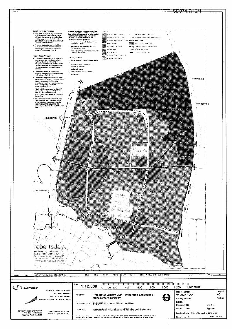
1.0 BACKGROUND. The Local Structure Plan (LSP) prepared by the proponents on behalf of the Shire of Serpentine-Jarrahdale proposes a road connection to South Western Highway. Two possible options for this road connection as shown in the Local Structure Plan are shown in the drawing contained in Appendix “A”. The northern-most location, (Access Road Intersection Option 1) is the location preferred by the developer. Access Road Intersection Option 2 is the location preferred by the Shire of Serpentine-Jarrahdale. As South Western Highway falls within the jurisdiction of Main Roads WA, approval from Main Roads is required for any changes, such as the construction of a new intersection on the Highway. Main Roads WA requires the design of the intersection on South Western Highway to comply with an Austroads Type “C” intersection layout. Klyne Consultants Pty Ltd was commissioned by Main Roads WA to undertake a Road Safety Audit of two design options, Access Road Intersection Option 1 at SLK 14.00 and Access Road Intersection Option 2, at SLK 14.414. This “Concept Design” audit was primarily to identify any features of the design with respect to the vehicle access location, which could be altered or removed to improve the safety of the project. 2.0 DISCLAIMER This is a final report. It is to be referred to Main Roads WA for consideration and implementation. This report contains the findings, opinions and recommendations of the audit team based on the examination of the site on July 26, 2011. As a consequence the report may not identify all the deficiencies that may have existed before and after the audit. Neither Main Roads WA (MRWA) nor the Shire of Serpentine – Jarrahdale is bound by any of the contents of this report. Notwithstanding that this report may contain statements in relation to technical matters, both of a general nature and in relation to specific issues, in no way should readers of the report rely solely on its contents. Readers must seek appropriate expert advice on their own particular circumstances and rely on such advice. 3.0 PROJECT AND SITE DETAILS Transport Modelling undertaken by Main Roads WA indicates that in 2031, some 8,000 vehicle movements per day to and from South Western Highway will be generated by the subdivision. Traffic volumes to the north of the access road are expected to be 19,600 vehicles per day and 14,600 vehicles per day, south of the intersection. A type “C” intersection layout is proposed for the intersection. This intersection type as detailed in Appendix “B” provides for a right-turn lane from the Highway into the access road and facilitates a high entry angle left-turn slip lane into and out of the access road. Access Road Intersection Option 1, located at SLK 14.00. Access Road Intersection Option 1 is proposed as an Austroads Right Turn Type “C” intersection, comprising a dedicated right-turn lane, with high entry angle left turn slip lane to service the subdivision. This intersection is proposed at SLK 14.00 and is connected to the road network of the subdivision. The geometry of the access road comprises a 450 angle junction with the proposed east-west “Collector-Distributor” internal road. Access Road Intersection Option 2, located at SLK 14.414. Access Road Intersection Option 2 is proposed as an Austroads Right Turn Type “C” intersection, comprising a dedicated right-turn lane, with high entry angle left turn slip lane to service the subdivision. This intersection is proposed at SLK 14.414 and aligns with the “Collector-Distributor” road within the Whitby Local Plan subdivision.
SD074.7/12/11

Klyne Consultants
Road Safety Audit (Concept Design) – South Western Highway- Intersection Options - SLK 14.00 & SLK 14.414. Page-4-.
4.0 ROAD SAFETY AUDIT
4.1 Objectives The objectives of this road safety audit are:-
To review the design and background information and to form conclusions about the safety performance and accident potential of the proposed intersection(s).
To evaluate the proposal in terms of interaction with its surrounds and nearby roads, and to visualise potential impediments and conflicts for road users.
To report on the conclusions drawn and to make recommendations regarding aspects which involve unnecessary or unreasonable hazards.
The purpose of the Road Safety Audit report is not to rate the design, but rather to address any road safety concerns. In reviewing the safety aspects of a road project, the reporting procedure is not intended as a re-design process, but to outline potential or existing road safety issues and establish a basis upon which a design could produce an acceptable solution to the safety problem. The recommendations will indicate the nature or direction of a solution, rather than specifying the details of how to solve the problem. Items which are considered to be of significantly greater potential hazard than most identified deficiencies are recorded as “IMPORTANT” or “SERIOUS” in the Audit Findings. Items of sufficient hazard to require immediate attention are recorded as “URGENT”. These two classifications are not mutually exclusive. Further, where other items are not so recorded it does not mean they are unimportant, but are simply considered to be of lesser hazard. It is intended that the recommendations for corrective action be discussed with Main Roads WA to determine whether the recommendations should be implemented, and where it is decided otherwise, to give reasons in writing for the decision. 4.2 Auditor and Audit Process Details This report results from a Road Safety Audit (Concept Design Stage) for the two Location Options for the proposed intersection to be constructed on South Western Highway, at SLK 14.00 and SLK 14.414 (See Local Structure Plan in Appendix “A”). Klyne Consultants Pty Ltd was commissioned to undertake the Road Safety Audit of the two intersection location options for South Western Highway at SLK 14.00 and SLK 14.414. The Audit team comprised:-
Team Leader Michael Klyne Principal Klyne Consultants Pty Ltd. Member Frank Strever Manager Operations & Parks Shire of Serpentine-Jarrahdale Member George Formentin Road Safety Officer Main Roads WA Member Kevin Ovington Traffic Services Officer S/E Main Roads WA Observer Joanna Hyde Traffic Services Officer S/E Main Roads WA
The audit was carried out following the procedures set out in AUSTROADS Guidelines for Road Safety audit (2002). Checklist 1.1 to 1.5 inclusive was completed for the two (2) intersection location options for South Western Highway at SLK 14.00 and SLK 14.414. 5.0 SUPPORTING INFORMATION Local Structure Plan Appendix “A”. Type “C” intersection Design Appendix “B”. Safety Audit Checklist Appendix “C”. Photographs Appendix “D”.
SD074.7/12/11

Klyne Consultants
Road Safety Audit (Concept Design) – South Western Highway- Intersection Options - SLK 14.00 & SLK 14.414. Page-5-.
6.0 AUDIT FINDINGS AND RECOMMENDATIONS (BOTH OPTIONS). 6.1 Intersection Sight Distance
The locations of the proposed connections from the subdivision to South Western Highway for both options are on the “inside” of large radii curves. The provision of the left-turn lane as featured in the “Type C” intersection design on South Western Highway, will warrant the clearing of some roadside vegetation so that safe intersection sight distance for the 110 km/h speed limit is maintained. Austroads Part 4A – Signalised and Unsignalised Intersections, recommends a safe intersection sight distance (SISD) of 285 metres for 2.0sec reaction time and 300 metres for 2.5 sec reaction time for the 110 km/h speed limit. Recommendation: Ensure that the safe intersection sight distance (SISD) is available for drivers from the side road entering South Western Highway. Remove roadside vegetation where necessary to ensure that the safe intersection sight distance as recommended in Austroads Part 4A is available. (IMPORTANT).
6.2 Street Lighting
Transport Modelling undertaken by Main Roads WA forecasts that the construction of a “full movement” intersection on South Western Highway will generate some 8,000 vehicle per day to and from the subdivision. Drivers on South Western Highway, travelling in a high speed rural environment should be made aware of the intersection. In this respect, the provision of street lighting on South Western Highway at the intersection will warn and inform drivers at night, that they are approaching a “change” in the road environment. Recommendation: Install street lighting meeting the requirements of AS 1158 at the intersection of the Access Road with South Western Highway.
6.3 Special Road Users – Cyclists. The Type “C” intersection design does not make specific provision for on-road cycling facilities. It may be possible to provide wider sealed shoulders on South Western Highway and the Access Road so that on-road cycling could be facilitated. Recommendation: Revise the design for South Western Highway/Access Road intersection with the object of providing wider sealed shoulders to facilitate on-road cycling.
6.4 Pedestrian Issues – South Western Highway/Access Road intersection. The Type “C” intersection design provides for kerb-ramps and “cut-throughs” in the “splitter” traffic islands to facilitate pedestrian (particularly disabled) movement across the intersecting road. Pedestrian facilities including footpaths should be provided on the Access Road servicing the subdivision. Recommendation: Provide footpaths on the Access Road to facilitate the movement of pedestrians from the subdivision to South Western Highway.
SD074.7/12/11

Klyne Consultants
Road Safety Audit (Concept Design) – South Western Highway- Intersection Options - SLK 14.00 & SLK 14.414. Page-6-.
7.0 AUDIT FINDINGS AND RECOMMENDATIONS (Access Road Intersection Option 1 at SLK 14.00).
7.1 South Western Highway Southbound Overtaking Lane.
The southbound overtaking lane (as recorded in the MRWA SLK Book) on South Western Highway commences at SLK 12.77 and terminates at SLK 13.78. This overtaking lane is currently below the 1.2 km “standard” length adopted by Main Roads WA. It is important that the safety of vehicles merging back to the single traffic lane is maintained and as the length of the existing overtaking lane is below the 1.2 km minimum standard, the reduction in length is not recommended. The southbound overtaking lane should be extended past the intersection to retain an acceptable length of the overtaking lane and maintain traffic safety. This intersection will be located at the end of a curve on South Western Highway (See Photograph No. 1) where W-Beam Safety Barriers are installed on both sides of the road. The northbound overtaking lane (as recorded in the MRWA SLK Book) commences at SLK 15.20 and terminates at SLK 14.25. The length of this overtaking lane is well below the 1.2km standard and the construction of the left-turn lane into the access road (with the associated taper) will compromise the length of the northbound overtaking lane. This may necessitate the extension of the northbound overtaking lane, northwards past the proposed intersection. Recommendation: Revise the design for the South Western Highway/Access Road intersection to extend the overtaking lanes (northbound and southbound) past the Type “C” intersection proposed. (IMPORTANT).
7.2 Access Road alignment and geometry. The location of the proposed intersection with South Western Highway results in the need for a curve in the access road at the approach to South Western Highway and a 450 intersection with the internal Collector-Distributor Road. This geometry and intersection layout will have an adverse impact on road safety. The intersection will be located at the end of a curve on South Western Highway (See Photograph No. 1) where W-Beam Safety Barriers are installed on both sides of the road. Recommendation: Revise the design for the proposed Collector-Distributor Road to provide for a “straight” section of road at the approach to South Western Highway and right-angled intersections with the internal roads. (IMPORTANT).
7.3 Access Road Intersection Option 1 on South Western Highway. The existing W-Beam Safety Barriers installed on both sides of South Western Highway will require re-location to accommodate the road pavement for the Type “C” intersection. A right-turn traffic lane and a left-turn lane, including a “painted” central median need to be constructed on South Western Highway to facilitate the right and left turn movements required for a Type “C” intersection. The steep batter slopes for this section of South Western Highway (See Photographs Nos. 3 & 4) will require extensive earthworks to accommodate the Type “C” intersection layout. Recommendation: Ensure that the levels of the road “formation” for the intersection do not result in non-recoverable slopes in the road verges. (IMPORTANT).
SD074.7/12/11
Klyne Consultants
Road Safety Audit (Concept Design) – South Western Highway- Intersection Options - SLK 14.00 & SLK 14.414. Page-7-.
8.0 AUDIT FINDINGS AND RECOMMENDATIONS (Access Road Intersection Option 2 at SLK 14.414).
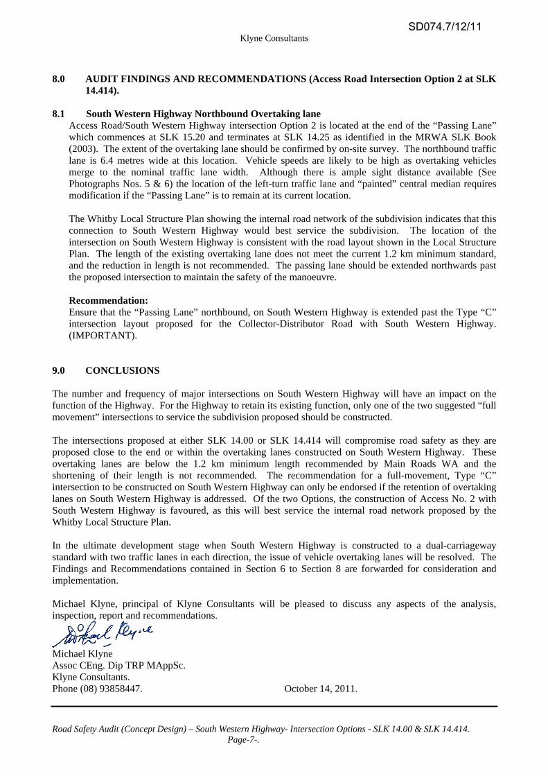
8.1 South Western Highway Northbound Overtaking lane
Access Road/South Western Highway intersection Option 2 is located at the end of the “Passing Lane” which commences at SLK 15.20 and terminates at SLK 14.25 as identified in the MRWA SLK Book (2003). The extent of the overtaking lane should be confirmed by on-site survey. The northbound traffic lane is 6.4 metres wide at this location. Vehicle speeds are likely to be high as overtaking vehicles merge to the nominal traffic lane width. Although there is ample sight distance available (See Photographs Nos. 5 & 6) the location of the left-turn traffic lane and “painted” central median requires modification if the “Passing Lane” is to remain at its current location. The Whitby Local Structure Plan showing the internal road network of the subdivision indicates that this connection to South Western Highway would best service the subdivision. The location of the intersection on South Western Highway is consistent with the road layout shown in the Local Structure Plan. The length of the existing overtaking lane does not meet the current 1.2 km minimum standard, and the reduction in length is not recommended. The passing lane should be extended northwards past the proposed intersection to maintain the safety of the manoeuvre. Recommendation: Ensure that the “Passing Lane” northbound, on South Western Highway is extended past the Type “C” intersection layout proposed for the Collector-Distributor Road with South Western Highway. (IMPORTANT).
9.0 CONCLUSIONS The number and frequency of major intersections on South Western Highway will have an impact on the function of the Highway. For the Highway to retain its existing function, only one of the two suggested “full movement” intersections to service the subdivision proposed should be constructed. The intersections proposed at either SLK 14.00 or SLK 14.414 will compromise road safety as they are proposed close to the end or within the overtaking lanes constructed on South Western Highway. These overtaking lanes are below the 1.2 km minimum length recommended by Main Roads WA and the shortening of their length is not recommended. The recommendation for a full-movement, Type “C” intersection to be constructed on South Western Highway can only be endorsed if the retention of overtaking lanes on South Western Highway is addressed. Of the two Options, the construction of Access No. 2 with South Western Highway is favoured, as this will best service the internal road network proposed by the Whitby Local Structure Plan. In the ultimate development stage when South Western Highway is constructed to a dual-carriageway standard with two traffic lanes in each direction, the issue of vehicle overtaking lanes will be resolved. The Findings and Recommendations contained in Section 6 to Section 8 are forwarded for consideration and implementation. Michael Klyne, principal of Klyne Consultants will be pleased to discuss any aspects of the analysis, inspection, report and recommendations.
Michael Klyne Assoc CEng. Dip TRP MAppSc. Klyne Consultants. Phone (08) 93858447. October 14, 2011.
SD074.7/12/11

Klyne Consultants
Road Safety Audit (Concept Design) – South Western Highway- Intersection Options - SLK 14.00 & SLK 14.414. Page-8-.
10.0 DOCUMENTS USED DURING THE AUDIT. 1. Main Roads Western Australia (MRWA) Road Safety Audit Operational Guidelines, 1995. 2. Local Structure Plan by ROBERTSDAY 3. AustRoads Guide to Road Safety – Part 6 "Road Safety Audit". 4. AustRoads Guide to Road Design – Part 4A "Unsignalised and Signalised Intersections". 5. AustRoads Guide to Road Design – Part 6A "Pedestrian & Cyclist Paths”. 6. AustRoads Guide to Road Design – Part 6B "Roadside Environment". 7. AustRoads Guide to Road Design – Part 3 "Geometric Design".
SD074.7/12/11

Klyne Consultants Pty Ltd
Road Safety Audit (Concept Design) – South Western Highway- Intersection Options - SLK 14.00 & SLK 14.412.
APPENDIX ‘A’
LOCAL STRUCTURE PLAN
SD074.7/12/11
SD074.7/12/11

Klyne Consultants Pty Ltd
Road Safety Audit (Concept Design) – South Western Highway- Intersection Options - SLK 14.00 & SLK 14.412.
APPENDIX ‘B’
TYPE “C” INTERSECTION LAYOUT
SD074.7/12/11

SD074.7/12/11

Klyne Consultants Pty Ltd
Road Safety Audit (Concept Design) – South Western Highway- Intersection Options - SLK 14.00 & SLK 14.412.
APPENDIX ‘C’
SAFETY AUDIT CHECKLIST
SD074.7/12/11

Checklist 1: Feasibility stage audit Issue Yes No Comment
1.1 General topics 1 Scope of project; function; traffic mix What is the intended function of the scheme? comment)
To provide vehicle access off South Western Highway to the proposed subdivision.
Is the design consistent with the function of the road?
If the type “C” intersection layout
is constructed.
Will the proposed scheme/redesign adequately cater for: - cars - motorcyclists - pedal cyclists? - pedestrians? - heavy vehicles? buses?
No specific facilities provided for Pedestrians or Cyclists. (Both Options)
Is the expected mix of traffic adequately catered for?
Will the proposed scheme be consistent with adjacent roads, landforms and traffic management?
(Both Options)
2 Type and degree of access to property and developments
Is the degree of access control consistent with the road’s function and with other sections of the road?
Will sight distances be satisfactory: - at intersections? - at property accesses?
Sight-distances at Property Access to be addressed.
Is the design speed (or the likely vehicle speeds) compatible with the number and type of intersections/property accesses present?
Does the width of the right of way satisfy access requirements?
3 Major generators of traffic Are all major generators of traffic (including housing or shopping centres) far enough away to avoid unsafe influences on the form of the design?
To be addressed
Have existing or alternative accesses been arranged to ensure existing suburbs/areas are not cut off by the development of the scheme/works?
The future internal road layout will not be well served with the access to SW Hwy being at SLK 14.00
Are the accesses for significant traffic generators far enough away from intersections for safety?
Is sight distance to and from accesses to significant traffic generators adequate?
SD074.7/12/11

Checklist 1: Feasibility stage audit continued……….
Second Edition 2
Issue Yes No Comment Will the proposed scheme be consistent with adjacent roads, landforms and traffic management?
4 Staging requirements Will this design be implemented in one stage only?
If the design is to be implemented in more than one stage, has safety been given a high priority? - in transitions between stages? - in transitions to existing roads?
Will the work avoid problems with safety standards elsewhere during construction?
5 Future works Will the route be free of compromises in safety if there is to be: - future widening? - the addition of a complete second carriageway? - after realignments? - major geometric changes at intersections? - linear extensions of the scheme?
6 Wider network effects Have any harmful safety effects of this scheme upon the surrounding road network identified? Have they been adequately dealt with?
1.2 Design issues (general) 1 Route choice Are all aspects associated with the location of the route and/or its alignment safe?
Not for Access No. 1
If the route follows existing roads what are the effects of this? (comment)
If the route is in “green fields” (undeveloped corridor), is the alignment safe? Could it be safer? (comment)
See Findings & Recommendations
Does the scheme fit in with the physical constraints of the landscape?
Not for Access No. 1, - extensive earthworks associated with the widening of SW Hwy required.
Does the scheme take account of major network considerations?
2 Impact of continuity with the existing network Are all sections/transitions where the proposed road scheme connects with the existing network free of potential problems?
SD074.7/12/11

Checklist 1: Feasibility stage audit continued……….
Second Edition 3
Issue Yes No Comment
3 Broad design standards Have the appropriate design standards been used (having regard to the scope of the project and its function in relation to the traffic mix)?
Austroads Type “C” intersection proposed.
Does the geometric plan and profile meet design guidelines?
Have the appropriate design vehicle and check vehicle been used?
4 Design speed Has the appropriate design standards been selected with regard to: - horizontal and vertical alignment? - visibility? - merging? - weaving? decelerating or accelerating traffic at intersections?
The existing default” speed limit – 110 km/h is to be reviewed.
Is sight distance generally satisfactory: - at intersections? (if not, what implications?) - at entry and exit ramps? - at property entrances? - at emergency vehicle access points?
Can any sudden change in the speed regime or posted speed limit be safely accommodated?
Is the designated speed limit, if any, on the proposed road appropriate?
Is the designated or intended speed limit consistent with the design speed?
5 Design volume and traffic characteristics Is the design appropriate with regard to the design volume and traffic characteristics (including the effects of unusual proportions of heavy vehicles, cyclists and pedestrians, or side friction effects)?
Will the scheme safely cope with unforeseen or large increases in traffic volume?
Will the scheme safely cope with unforeseen changes in the traffic characteristics?
SD074.7/12/11

Checklist 1: Feasibility stage audit continued……….
Second Edition 4
Issue Yes No Comment 1.3 Intersections 1 Number and type of intersections Are all aspects of intersections (for example, spacing, type, layout, etc.) appropriate with respect to: - the broad concept of the project - the function of this road and intersecting roads - the traffic mix on this road and intersecting roads - types which are consistent within the scheme, and
consistent with adjacent sections?
Only One (1) intersection is proposed.
Is the frequency of intersections appropriate (neither too high nor too low)… - for safe access? - to avoid impacts on the surrounding network? - for emergency vehicle access?
N/A – See above
Have all physical, visibility or traffic management constraints which would influence the choice or spacing of intersections been considered? (comment needed)
N/A – See above
Has the vertical and/or horizontal alignment been taken into account with regard to the style or spacing of intersections?
Are all of the proposed intersections necessary or essential?
Only One (1) intersection is proposed
Can any unnecessary intersections be removed/can access be achieved more safely by changes on the surrounding road network?
N/A
Will the angle of the intersecting roads and the sight lines be adequate for the safety of all road users?
Is the movement of vulnerable road users safely catered for at all intersections?
To be included in the detailed design of the intersection.
Is the movement of heavy vehicles safely catered for at all intersections?
1.4 Environmental constraints 1 Safety aspects Is the surrounding terrain free of physical or vegetation defects which could affect the safety of the scheme? (for example, heavy planting, forestry, deep cuttings, steep or rocky bluffs which constrain the design).
Not for Access No. 1 at SLK 14.00
Have effects like wind, mist, ice, fog, sun angles at sunrise and sunset been given adequate consideration?
Do the gradients, curves and general design approaches fit in with the likely weather or environmental aspects of the terrain? (for example, fog-prone areas)
Curve alignment of road north of Access No. 1, Passing lane ends at approach to Access No. 2.
SD074.7/12/11

Checklist 1: Feasibility stage audit continued……….
Second Edition 5
Issue Yes No Comment Has safety been considered in the location of environmental features (for example, noise fences)?
Construction of intersection will have an adverse impact on “Bush for ever”
Does the scheme perform safely at night when it is wet or there is fog?
Street lighting will enhance safety of the intersection.
Are visual distractions (for example, scenic vistas) adequately dealt with (for example, by providing areas for people to stop safely)?
Has the issue of unstable country been considered (for example, mine subsidence)?
1.5 Any other matters 1 Safety aspects not already dealt with Has the possibility of flooding been adequately dealt with?
Level of road pavements above surrounding ground levels
Have any railway level crossings been identified and are they treated adequately?
None present – not applicable
Have other distractions (for example, low-flying aircraft, advertising, etc) been adequately dealt with?
Has the need for laybys or parking (for example, for tourist routes, trucks, picnic or rest areas) been considered?
Has the potential of the location to attract roadside stalls been considered?
Will there be special events? have any consequent unusual or hazardous conditions been considered?
Have all classes of pedestrians that could be seriously affected by the proposal been catered for? (for example, school children, elderly etc.)
Low volume (if any) of pedestrians crossing SW Highway
Have any safety or accident problems on the existing network been addressed? (Not carried over to the new scheme)
New Intersection
Has the issue of providing lighting for the design been considered?
Street lighting to AS 1185 requirements to be installed.
Has the need for drivers to stop been considered (for example, generally, rest areas, truck parking, enforcement)?
Any other matter which may have a bearing on safety?
SD074.7/12/11

Klyne Consultants Pty Ltd
Road Safety Audit (Concept Design) – South Western Highway- Intersection Options - SLK 14.00 & SLK 14.412.
APPENDIX ‘D’
PHOTOGRAPHS
SD074.7/12/11

Klyne Consultants Pty Ltd.
Road Safety Audit (Concept Design) – South Western Highway - Intersection Options SLK 14.00 & SLK 14.412
PHOTOGRAPHS
Photograph No. 1. South Western Highway, north of Access No. 1 (SLK 14.00), view south. Note: Horizontal & vertical alignment geometry at the proposed intersection – Sight distance 320m from north.
Photograph No. 2. South Western Highway, south of Access No. 1 (SLK 14.00), view north. Note: The “sloping end” treatment of the Safety Barrier, sight distance 285m to the Access Road from south.
SD074.7/12/11

Klyne Consultants Pty Ltd.
Road Safety Audit (Concept Design) – South Western Highway - Intersection Options SLK 14.00 & SLK 14.412
PHOTOGRAPHS
Photograph No. 3. South Western Highway, north of Access No. 1 (SLK 14.00), view north. Note: The batter slopes to the high embankment of South Western Highway – the W-Beam barriers in place.
Photograph No. 4. South Western Highway, south of Access No. 1 (SLK 14.00), view north. Note: The “sloping end” of the Safety Barrier, the available sight distance to drivers from the Access Road.
SD074.7/12/11

Klyne Consultants Pty Ltd.
Road Safety Audit (Concept Design) – South Western Highway - Intersection Options SLK 14.00 & SLK 14.412
PHOTOGRAPHS
Photograph No. 5. South Western Highway, north of Access No. 2 (SLK 14.414), view south. Note: The available sight distance of 340m from south, the verge levels relative to the road pavement levels.
Photograph No. 6. South Western Highway, south of Access No. 2 (SLK 14.414), view north. Note: Sight distance 340m from north, 6.4m wide northbound traffic lane and 3.7m wide southbound lane.
SD074.7/12/11