comprehensive land use plan 2016 - 2025
TRANSCRIPT

COMPREHENSIVE LAND USE PLAN 2016 - 2025
6.0 Spatial Development Plan
129
PART 6: SPATIAL DEVELOPMENT PLAN The Spatial Development Plan provides the overall framework for the preparation of the city’s land use plan. This will serve as a guiding force that will advance the realization of the city’s goals and objectives. This Plan will come-up with a map that shows the preferred strategic developmental direction and spatial configuration for the next ten years.
6.1. VISION
Navotas as a world class Fishing and Industrial Eco Port with a God-fearing, family oriented, disciplined, resilient, empowered citizenry living in an ordered, green and aesthetically pleasing urban setting supported by adequate, responsive, efficient, progressive infrastructure sheltered by an ecologically balanced, sustainable, safe environment supported by a financially self-sufficient, economically viable, dynamic local economy administered by a responsive, committed and strong leadership and governance.
6.2. DEVELOPMENT GOALS AND OBJECTIVES
Vision 2011-2022 Development Objectives
Navotas as a world class fishing port
• Expand its linkage to the sea through fishing and port industries with an urban pattern sustainably supported by its coastal and water resources.
• Continue to promote and enhance its natural and historical links to the sea.
With a God-fearing, family-oriented, disciplined, resilient, empowered citizenry
• A healthy, educated, empowered and stress-free population living in secured and comfortable dwelling units in a peaceful and orderly city.
Living in an ordered, green and authentically pleasing urban setting
• Continue to promote the ordering of the urban landscape via nodal landscape targeting new developments, new areas, and coastal resources
• Institute a coordinated and efficient movement system through the available and new network systems that will support the ordering pattern of the city
• Integrate green concepts into plots and grid patterns for appropriate ecological interphases
• Develop an appropriate image for the City to enhance its identity and delineate its character within Metro Manila’s larger context
Supported by adequate, responsive, efficient, progressive infrastructure
• Improve circulation and ease traffic in the City in tandem with reduction in circulation congestion
• Provide continuity between existing and potential transport modes (land-river-sea)
• Enhance City’s transport system thru new and

COMPREHENSIVE LAND USE PLAN 2016 - 2025
6.0 Spatial Development Plan 130
appropriate technologies in transport and traffic management
Sheltered by an ecologically balanced, sustainable, safe environment
• Improve the quality of inland and coastal waters as well as ambient air quality of the City
• Develop and operationalize an effective and efficient solid waste management system
• Protect the mangrove areas of the City
• Improve the productive capabilities of the urban and coastal resources to support socioeconomic growth
• Reduce the effects of natural calamities and man-made disasters that continually plague the City
• Increase the level of resiliency and adaptive capacity of the city from the effects of climate change
Supported by a financially self-sufficient, economically viable, dynamic local economy
• Increase employment rate and family income
• Augment livelihood and increase capital investments from commercial expansion
• Improve tax collection as well as encourage the establishment of new businesses
• Strengthen tourism and partnership in coastal management
Administered by a responsive, committed and strong leadership and governance
• Fast-track the provision of services for the public and within the organization
• To improve the active participation of public officials in meetings, sessions and seminars
• To promote well-being of rank and file employees
• To fully implement existing ordinances and statutes of the City with impartiality.
6.3. PROPOSED DEVELOPMENT THRUST (OVERLAY)
6.3.1. Development Option1 - North-South Nodal Development Focus
a. The strategic land use of this option is geared towards the development of the fishpond area and the targeted growth of the industrial sector in the southern tip of the city by the Navotas Fish Port Complex;
b. The city government is looking into the potential of the existing unproductive
fishponds as an area for urban expansion. The northern area to be developed can serve as a new focal point for the city, a counterpoint to the southern industrial belt effectively adjoining it to the traditional central core;
c. However, it can be seen that the fishponds may present environmental concerns in terms of converting these ecosystems into an urban expansion area. In addition, based on the Climate and Disaster Risk Assessment

COMPREHENSIVE LAND USE PLAN 2016 - 2025
6.0 Spatial Development Plan 131
(CDRA) conducted by the city, the abovementioned fishponds were identified to have moderate to high risk to flooding and other natural hazards;
d. Yet the city government is taking into consideration that these fishponds were underutilized for their intended purposes and at present, these fishponds continue to lose their traditional economic significance;
e. Relative to the urban expansion in the underutilized fishponds, the city government has already initiated the conduct of flushing and flooding studies in the same area prior to the development of the socialized housing in Barangay Tanza. The said 8.4 hectares housing facility is a reclaimed area in the underutilized fishponds. The result of the said studies, showed that the development in the fishponds will have a net positive effect to the area such as improvement in water quality. This will also decrease the susceptibility of the area to several hazards such as flooding as the development will eliminate the water plains in the area. Also, the studies revealed that the development in the fishponds will not affect the water levels in the surrounding area, thus will not adversely affect the adjacent communities such as Barangay Dampalit in Malabon City and Obando in Bulacan;
f. Consequently, the development in the underutilized fishponds outweighs the challenges that may arise in the urban expansion in these fishponds since the city government is continuously instituting structural and non-structural mitigating measures in the area to lessen these risks and minimize the adverse effects of natural disasters and climate change. Furthermore, any problems or concerns that may arise during the development will be mutually addressed by the city government and the future developers. Also, design guidelines and development strategies to sufficiently address these concerns as well as sustainably and optimally develop this high potential area will be in place;
g. The other development trend indicates the continued commercialization of the main roads specifically the M. Naval St., North Bay Boulevard road and parts of Gov. A. Pascual St. There is also an increasing demand to create a commercial center to further augment the development of the linear economic network which is seen to be located at Barangays Bagumbayan North and Bagumbayan South;
h. The riverways of the city was identified to have a high risk to flooding due to the presence of informal settler families. But, the city is already implementing the relocation and resettlement of these ISFs to safeguard their safety and welafre. Also, disaster mitigating measures such as the riverwalls and pumping stations are continuously being instituted and constructed by the city government. Ultimately, the industrial profile of the Navotas River front in this scenario will remain and be preserved, but river bank protection and greening are required as well as the mandated 3 meter easement will be observed and sustained;
COMPREHENSIVE LAND USE PLAN 2016 - 2025
6.0 Spatial Development Plan 132
i. One of the results of the CDRA conducted revealed that the informal settler
families are at high risk to flooding, thus as part of the relocation and resettlement program of the city government, development of portions of the unproductive fishponds into additional resettlement sites is seen to be a viable strategy. These resettlement sites are part of the intended urban expansion in the area and can accommodate the highly vulnerable stakeholders. The area to be developed into resettlement sites are the fishponds that are adjacent to the existing socialized housing facilities in barangay Tanza;
j. There will also be a continued pressure for the traditional core to accommodate the increase in the demand for residential uses which permits strategic urban redevelopment and renewal strategies. Increasing the capacity of the residential units by constructing additional floors or vertical densification can be a strategy. Besides, the medium rise development housings that will be constructed in the intended urban expabnsion area will also help manage the projected increase in the city’s population;
k. Strategic planning of green areas needs to be resorted to, particularly in
terms of the innovative use and integration of institutional green and open spaces as part of public open areas. Riverbanks and shoreline easements for environmental protection and health as well as risk protection for the population from the undesirable effects of climate change and natural disasters need to be employed as part of a City wide green system. This can further be augmented when sidewalks can be freed from obstructions by locals so these may be included in the “green arterial system” of the City which will include these pedestrian circulation areas as well as vehicular movement systems like roads which can integrate greening both ground cover or vertical greening;
l. In this development option, the mangrove area located along the coastal area
of Barangay Tanza will be a major consideration of development in the context of sustainable eco-tourism; the mangroves which appear to be in a relatively pristine condition will serve as an example of the City’s advocacy for green development. The mangrove area can function as a new green center for the City where opportunities for greening remain quite challenging. It is known that mangroves can reduce storm surge water levels by slowing the flow of water to the land and reducing surface waves. In that way, these mangroves can potentially play a role in coastal defense and disaster risk reduction, alongside other risk reduction measures employed by the city like the 3.5 kilometer coastal dike and the river wall. Also, as mandated by the law, at least twenty (20) meters easement from the existing delineation of the mangroves will be observed so that they can be protected from any forms of deterioration;

COMPREHENSIVE LAND USE PLAN 2016 - 2025
6.0 Spatial Development Plan 133
m. The transport system of the city will be improved to cater the demand of further developments, especially in the projected urban expansion in the unproductive fishponds in Barangay Tanza, and the Navotas Fish Port Complex in Barangay North Bay Boulevard South. The movement system of the city need to be further integrated, specially the north-south continuum as the fishpond area will be the target of urban expansion in the medium term; therefore, access to these areas should be given priority. This can be done by expanding the vehicular capacity of the major thoroughfares and constructing additional roadways that can lead to these areas. In addition, sea and river ways can be used as an alternative mode of transportation to reach the aforementioned areas. Lastly, the improvement and integration of the city’s transport network with other neighboring cities will be prioritized in this spatial option. The utilization of the sea and river ways as transport routes to reach these cities is also a viable strategy.
n. Navotas City has used land-use planning as a tool to mainstream disaster risk reduction and climate change adaptation into urban development processes. The LGU performed an assessment of the natural hazards that may befall on the city. These includes flooding, ground shaking, liquefaction, storm surge, severe winds, and tsunami. With the knowledge gained in the Climate and Disaster Risk Assessment (CDRA) conducted, the city was able to craft policies, programs, and projects which are disaster risk and climate change sensitive. As for the land use plan, the guidelines for the land using activities in the city were based on the result of the CDRA.
o. Moreover, the CDRA has led the city to determine various mitigating measures which will be beneficial to the city’s disaster prevention and mitigation, preparedness, response, and rehabilitation and recovery.

COMPREHENSIVE LAND USE PLAN 2016 - 2025
6.0 Spatial Development Plan
134
Map 6.1. North-South Nodal Development Focus

COMPREHENSIVE LAND USE PLAN 2016 - 2025
6.0 Spatial Development Plan
135
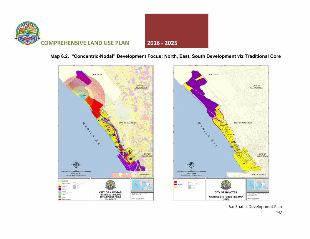
6.3.2. Development Option 2– “Concentric-Nodal” Development Focus: North, East, South Development viz Traditional Core
a. The main focus of this scenario is the open coastline of the City which is
seen to offer an option for reclamation, as a means of increasing the land available to the City for development; examples of this are already existing along Manila Bay; the CCP Complex, SM MOA and the one within the City, the NFPC; the administration sees these accomplished projects as indications of the feasibility of this scenario.
b. The reclamation of the coastal front seems to have a good potential,
particularly since it has been successfully completed in other portions of the Manila Bay shoreline. However, extensive environmental studies to address appropriate ecological and sustainability concerns need to be undertaken. And for this development option, a longer implementation time frame is expected;
c. Environmental and sustainability concerns and risks in reclaiming the open
coastline of the City presents a considerable challenge to the development; not all of the coastline of Manila Bay exhibit the same set of environmental considerations; Navotas at this time, though low lying and prone to flooding, does not appear to be subject to prolonged flooding since flood water may easily flow out to sea; these are only exacerbated when rains and high tides occur and the City is doubly exposed to the hazard of serious and prolonged flooding; for the reclamation strategy to work for the City, the environmental hazards and risks must thoroughly be accounted for to safeguard its population and future long term viability;
d. Aside from the open coastline, another potential development area is the
existing unproductive fishponds. They present the same environmental concerns in terms of developing these ecosystems into an urban expansion area. The northern area to be allocated for urban expansion can serve as a new focal point for the town, a counterpoint to the southern industrial belt and effectively adjoining the traditional central core;
e. The above strategy is seen as paralleling Spatial Option 1 with the difference
mainly in that this Spatial Option looks into further reclamation of the foreshore areas of the City into Manila Bay as added areas for expansion;
f. This scenario therefore sees three direction of development expansion, the
continued intensification of the industrial core in the south, the expansion to the north end fishponds which will be developed into an urban expansion area and finally the projected reclamation paralleling the traditional core offshore into Manila Bay, which will be targeted as mixed use with an

COMPREHENSIVE LAND USE PLAN 2016 - 2025
6.0 Spatial Development Plan 136
industrial core, mainly port activities to support the nearby fish port to the south, and the Manila North and South Harbor Complexes in Manila City;
g. This multi nodal development scenario will require not only a north-south
spine, but also an east west connection to integrate the City of Navotas with the reclamation area extending outward into Manila Bay. This envisioned reclamation area will substantially change the City’s profile, providing greater land mass width than its historically narrow width of less than a kilometer. The circulation pattern and movement system within the City will drastically change in the long term in this development scenario which will require both a north-south spine or spines and extending east-west transport networks aside from the obvious waterways that the new shoreline and the original river fronts can still provide;
h. In this scenario, the possibility of opening up green areas is greater in terms
of planning for setting aside these green buffers and pocket green developments in the new development cores of the reclamation or the fishponds; the circulation systems, i.e. roads and pedestrian sidewalks continue to be venues for greenings as well as riverine and coastal easements. The city government will develop and institute strategic design development guidelines, new developments can address more open areas at ground level as well as use green technologies, green architecture, and sustainable design to introduce a more ecologically sustainable city;
i. In line with the previous spatial option, the city has mainstreamed disaster risk reduction and climate change adaptation as a result of the CDRA conducted, to the different programs, projects, and activities being undertaken by the city.
COMPREHENSIVE LAND USE PLAN 2016 - 2025
6.0 Spatial Development Plan
137
Map 6.2. “Concentric-Nodal” Development Focus: North, East, South Development viz Traditional Core

COMPREHENSIVE LAND USE PLAN 2016 - 2025
6.0 Spatial Development Plan 138
Map 6.3. Conceptual Land Use Framework

COMPREHENSIVE LAND USE PLAN 2016 - 2025
6.0 Spatial Development Plan 139
6.4. Preferred Spatial Strategy Development Thrust The table below shows the advantages and disadvantages of each spatial strategy. Each strategy was analyzed based on its impacts to the environment, people, and economy, including the overall impact on the image of the city.
Table 6.1. Assessment of the Impacts of the Spatial Strategies on the Stakeholders
Characteristics North-South Nodal
Development Focus Concentric-Nodal
Development Focus
Public Investment in transport and other economic and social infrastructure
Moderate-High Low-Moderate
Disaster risk reduction and Climate Change Adaptation
High Low
Strict Government enforcement of Regulations
High Moderate
People’s Compliance with desired Regulations
High Moderate
Impacts on the Environment
Sustainable Environment High Low
Generation of air and water pollution Low-Moderate High
Efficient and Sustainable Use of Local Resources
Moderate Moderate
Impacts to the People
Encourages community Participation High Moderate
Decentralization of the Population High Low
Urban Sprawl Low Moderate
Prone to Disasters pertaining to its Allocation and Form
Low High
Equal Distribution of Services High High
Food Sufficiency High High
Traffic Issues Low-Moderate Moderate-High
Efficiency of mobility and circulation High Moderate
Access to Social Services High Moderate
Crime Incidence Low-Moderate Low
Impact to the Economy
Job Creation High High
Potential Revenues for the Government High High
Growth of Tourism High High
Growth of Industries High High
Impact on the Image of the City
Enhancement on the image of the City High High
Overall attractiveness to investors and tourists
High High
The fulfillment of Navotas’ role towards the achievement of its Vision
High Moderate

COMPREHENSIVE LAND USE PLAN 2016 - 2025
6.0 Spatial Development Plan 140
The North-South Nodal Development Focus strategy is the preferred spatial strategy and is believed to achieve the city’s goal of being a world-class fishing and industrial eco-port. The preferred development strategy aims to support the growth of the city’s potential areas; and was therefore chosen because it is assumed to achieve the goals and vision in the most beneficial and suitable approach. It is also seen to embody the capabilities of the Barangays based on the present data on the sectoral analysis and the disaster and risk reduction and climate change adaptation analyses.
6.5. GENERAL SPATIAL DEVELOPMENT STRATEGIES
The development strategies outlined in this section reflect the focus of the physical development objectives of the city and highlights the key features which of various development scenarios:
6.5.1. North and South nodal development to generate a rational landscape pattern
within the constraints of a linear City landscape profile.
• Two branched nodal growth approach, focusing on complimentary economic land-using activities;
• Utilization of potential areas for development, i.e. urban expansion in the underutilized fishponds; sustainable reclamation of land beyond the existing shoreline along Manila Bay, and better defined development integration with the Navotas Fish Port Complex;
• Delineation of a market and commercial hub linked via linear dispersion through existing economic land use threads.
6.5.2. Directed but controlled growth in the highly developed, built up areas in particular
the traditional core of the City via densification strategy guided by rational urban redevelopment/renewal as defining parameters in the ordering of the City’s urbanscape:
• Control of continued informal settlers proliferation and dispersion over high risk areas in the City via: (a.) Strict implementation of environmental easement laws, particularly for the vulnerable and hazard prone ecological areas like the coastal areas, riverbanks, and mangroves; and (b.) Relocation strategy to available resettlement sites (in-city and off-city) to address the city’s housing needs, especially for the poor and marginalized.
6.5.3. Ordering of the urban landscape via a complete and efficient circulation and
movement system that:
• Effect circulation and movement order among users of existing transport route;

COMPREHENSIVE LAND USE PLAN 2016 - 2025
6.0 Spatial Development Plan 141
• Improve the transportation network within the city to establish a complete north to south and the traditional core integration;
• Increase the City’s inter-city linkage;
• Expand the capacity of public transport and utilities network; and
• Upgrade the riverine and coastal transport network and integrate with the existing and proposed land based circulation pattern and hierarchy.
6.5.4. Public Open Space Policy that increases the multi-use function of available areas
in the city that can enhance socio-economic activities and support green initiatives for the environment and increase adaptive capacity of the city’s constituents such as:
• Reintroduce into the City’s development image the pristine mangroves located at Barangay Tanza, which buffers the fishponds and is a very unique feature of the City; these Mangroves can also serve as an added environmental protection from natural disasters and acts as a natural mitigating measure for the effects of Climate Change;
• Innovative coastal and riverine development aimed at ecological and aesthetic amenity improvement for enjoyment and use by locals as well as tourists;
• Landmark development, including the preservation and adaptive re-use of valuable structures: a. Fish port b. Shipyards
• Recognition of the importance of streets as the framework of open spaces;
• Integrated green and open space network: a. Linear parks built in the easement area along the waterways of the city; b. Designation of pocket gardens and recreational facilities per barangay; c. Innovative strategy to include institutional green and open areas into the
network; d. Incentives for greening of open or vacant lands; e. Multi-functional use of the green and open area in the city to serve as
integrated sports and leisure areas.
6.5.5. Revitalization and preservation of ecologically threatened areas to
• Restore the viability of the coastline for the City to pursue its future growth into a “world class fishing and industrial Eco port”;
• Re-acquire and re-establish the coastal and riverine easements;

COMPREHENSIVE LAND USE PLAN 2016 - 2025
6.0 Spatial Development Plan 142
• Rehabilitate the capacity of the riverine network and coastline as movement paths and transportation strategies;
• The sustainability of coastal tourism depends partly on the ability of the fisihing communities to adapt plans and management practices to mitigate the impacts of climate change and also to increase their ability to effectively manage natural disasters. In order to attain these, the city needs to increase the operational capacity of local fishing communities in coastal areas to respond in emergencies caused by natural disasters; support the adaptation efforts of these communities to the long term effects of climate change; and reduce the impacts of natural disasters to local communities in coastal areas by reducing the exposure level and increasing adaptive capacity to current risks.