compendium on flood and water-related risks · 2015-02-06 · research assistance was gratefully...
TRANSCRIPT

1
COMPENDIUM ON WATER-RELATED HAZARDS AND EXTREME WEATHER EVENTS
IN CENTRAL ASIA AND NEIGHBOURING COUNTRIES
ECONOMIC AND SOCIAL COMMISSION FOR ASIA AND THE PACIFIC

2
Acknowledgements This publication was prepared by national experts and professionals from countries in North and Central Asia. Sergey Myagkov was the principal author of the study. Key contributions for the chapters were provided by Alexandr Kravchuk, Nurbek Zhumaliev, Yuri Simonov and Venkat Raju Pokkuluri. Research assistance was gratefully provided by Linda Orozco. Coordination was provided by Nokeo Ratanavong. Explanatory notes The designations employed and the presentation of the material in this publication do not imply the expression of any opinion on the part of the Secretariat of the United Nations concerning the legal status of any country, territory, city or area or of its authorities, or concerning the delimitation of its frontiers or boundaries. Mention of firm names and commercial products does not imply the endorsement of the United Nations.
The boundaries and names shown and the designations used on the maps in this publication do not imply official endorsement or acceptance by the United Nations.
References to dollars ($) denote United States dollars unless otherwise noted.
The term “Central Asia” in this publication refers collectively to a select group of countries
that are members of the United Nations Special Programme for the Economies of Central Asia (SPECA): Afghanistan, Azerbaijan, Kazakhstan, Kyrgyzstan, Tajikistan and Uzbekistan. Turkmenistan, which is a member of SPECA, was not included in this report due to lack of data. The term “subregion” in this publication refers to the specific geographical area of the countries under study and should not be confused with official regions (e.g., the Asia-Pacific region) or subregions (e.g. North and Central Asia) as defined by the United Nations. The term “neighbouring countries” in this publication refers collectively to China, India, Mongolia, Pakistan and the Russian Federation. These countries were selected because they participate in the Central Asia DRR Knowledge Network for Flood Risk Reduction, which is an online network for the sharing of information and knowledge that will improve disaster risk reduction and management in the subregion.
The opinions, figures and estimates set forth in this publication are the responsibility of the authors, and should not necessarily be considered as reflecting the views or carrying the endorsement of the United Nations.
The United Nations accepts no responsibility for the accuracy or completeness of this report.
This publication has been issued without formal editing.
CONTENTS Page
EXECUTIVE SUMMARY 4
CHAPTER I. OVERVIEW OF FLOODS AND WATER-RELATED HAZARDS AND EXTREME WEATHER EVENTS IN CENTRAL ASIA 6
CHAPTER II. WATER-RELATED HAZARDS AND DISASTER RISK MANAGEMENT IN CENTRAL ASIA 9
1. Afghanistan 9
2. Azerbaijan 14
3. Kazakhstan 16
4. Kyrgyzstan 24
5. Tajikistan 30
6. Uzbekistan 35
7. Cross-border hazards in Central Asia and neighbouring countries 40
8. Subregional cooperative programmes and mechanisms 42
CHAPTER III. WATER-RELATED RISK MANAGEMENT PRACTICES AND REGIONAL MECHANISMS IN NEIGHBOURING COUNTRIES 46
1. China 46
2. India 47
3. Mongolia 51
4. Pakistan 54
5. Russian Federation 55
6. ESCAP/WMO Typhoon Committee 63
7. WMO/ESCAP Panel on Tropical Cyclones 64
8. Sentinel Asia 65
CHAPTER IV. THE WAY FORWARD 68
1. Information gaps for water-related risk reduction in Central Asia 68
2. Common priority needs and paths towards regional cooperation in flood risk reduction 73

Executive Summary Water-related disasters and extreme weather events are occurring with increasing frequency in Central Asia and in the countries that surround it. Floods, landslides / mudflows, droughts and earthquakes, which frequently affect the region, cause enormous economic and social damage and often lead to massive loss of human life. Extreme weather events, such as long periods of abnormally high rainfall and glacial melting, are increasingly becoming the most common cause of floods and associated water-related hazards. From 1990-2011, floods accounted for 48 per cent of the total number of disasters events that were recorded by the Centre for Research on the Epidemiology of Disasters (CRED); earthquakes accounted for 22 per cent of the total number of disaster events, but killed more people. Even though droughts did not occur as frequently as floods and earthquakes, they affected nearly 60 per cent of the total number of people impacted by disasters and substantially impacted agricultural production and associated food security in the region. In the mountainous areas of Central Asia, the climate is predominately continental; extremely arid conditions prevail and vegetation is sparse. The lack of abundant vegetation increases the risk of water-related hazards, such as mudflows. Central Asia is dotted with glaciers. When extreme weather events, such as abnormally high rainfall, are combined with water from melting snow and glaciers, the situation becomes dangerous. As glaciers melt and recede, barrier lakes form beneath them. When these lakes are breached, they send huge flows of water and debris downstream and cause damage — particularly in terms of property and lives — in the low-lying river valleys. The subregion is also prone to earthquakes, which frequently cause barrier lakes to burst and catastrophic floods / mudflows. Extreme weather events, such as a drought, are common in Central Asia. When a drought event occurs over a long period of time, it can cause substantial damage to ecosystems, agricultural production and economic systems. In the wake
of global warming and climate change, it is expected that Central Asia, and its neighbouring countries, will see an increase in both the frequency and intensity of extreme weather events in the future. In Central Asia, many water-related disasters transcend national boundaries, making them difficult to predict, control and manage. Countries in the subregion have different systems for monitoring water-related hazards and extreme weather events, often with dissimilar types of technical equipment. Access to sources of critical and timely data is limited. In several countries the density of the observation network is below the standard requirements for operational analysis. Uzbekistan, Tajikistan and Kyrgyzstan do have special services for dealing with national emergencies, but not all of the countries in the subregion have modern flood monitoring and early-warning systems. In more technologically advanced countries, such as China, India and Japan, flood monitoring and early warning systems are based on real-time satellite data and employ up-to-date communications technologies. The data are processed in specialized centres and subsequently sent to Government agencies. Most of the countries in Central Asia do not have the capability to accurately predict or manage disasters, especially those that transcend national borders. A regional monitoring and early-warning system that can exchange strategic information, combined with the use of real-time satellite data, is, therefore, urgently needed. At the international level, there is a large body of useful information on how best to monitor, manage and respond to water-related hazards and extreme weather events. Making that information available to the appropriate governmental agencies in Central Asia would help to facilitate the formation of a regional monitoring and early-warning system. Over the course of the past decade, several initiatives and programmes related to disaster risk management have been introduced in Central Asia, but no regional monitoring and early-warning system exists.

5
In order to mitigate the negative impacts of water-related disasters and extreme weather events, it is imperative that Central Asian countries cooperate to create a regional network that can collect and disseminate accurate and timely hydro-meteorological and socio-economic data. Such a network must have access to and utilize modern information and communication technologies, including space-
based, and should include a number of automated monitoring stations with the ability to transfer real-time data to data processing centres. On this point, a framework for cooperation that could support a regional cooperative mechanism in the subregion, such as the United Nations Special Programme for the Economies of Central Asia (SPECA), has been proposed.

6
Chapter I. Overview of floods and water-related hazards and extreme weather events in Central Asia Floods and associated hazards Central Asia is frequently impacted by floods, which cause direct and indirect damage. Direct damage involves damage to property, structures and living biota (plants and animals, including humans); indirect damage involves the disruption of physical (e.g. transportation) and economic activities (e.g. factory closures). The extent of the damage caused by a flood depends on the depth and duration of flooding, velocity of flow, the size of the inundated area, seasonal factors, type of soils, topography, presence and type of vegetation, population density, the degree of economic activity, the presence of hydro-technical facilities (e.g. canal locks and weirs) and the level of disaster preparedness. In Central Asia, floods are typically caused by a combination of heavy snow melt, heavy rains and abrupt warming events in the high mountain areas. Floods often bring with them catastrophic mudflows. Table 1 shows the number of flood events that took place in Central Asian countries from 2000-2009. Table 1. Flood events in Central Asian countries (2000-2009)
Country Number Afghanistan 45 Azerbaijan 3 Kazakhstan 4 Kyrgyzstan 2 Tajikistan 12 Uzbekistan 4
Source: CRED (2012). Note: Turkmenistan was not included because of lack of data. Dam or levee failures, while infrequent, can cause flash floods. When a dam or levee breaks, a large quantity of water is suddenly let loose downstream, often destroying everything in its path. In some cases, the force of the water is so
great that it can move boulders, tear out trees, destroy buildings and obliterate bridges. Walls of water can reach heights of 3-6 m, and they generally carry a huge amount of debris with them. Floods can also unleash mudflows, which are rapid movements of large masses of mud formed from loose soil and water. Mudflows are common in Central Asia, especially in the mountainous zones. These water-related disasters cause substantial damage to natural resources and man-made structures. A mudflow can reach a velocity of up to 80 km per hour. In the piedmont areas of Central Asia, the most destructive mudflows occur in spring when snow and ice melt and rainfall increases. A mudflow can cause tremendous socio-economic damage, destroying crop seedlings, irrigation canals, watersheds, bridges, houses, shops, highways and railways — virtually anything that is in its path. Mudflows are especially severe in the mountain ranges that surround the Fergana and Issyk-Kul lake basins; the northern parts of Tien Shan and Djungar Ala-Tau; the mountains of the western Tien Shan and Karatau ridge; the river basins of Zeravshan, Kashkadarja and Surkhandarja; the mountainous areas of Badakhshan; the Turkmenistan mountains; the mountainous regions of the Kazakh part of Altai; and the central and southern areas of Tien Shan. About 2,000 mudflow-prone river channels have been identified in Central Asia. “Over the last century of observations, roughly 8,000 mudflow events took place”. Mudflows are triggered by physical, geographical, geological and hydro-meteorological factors. In Central Asia, heavy rainfall is the primary trigger of a mudflow (intensive snowmelt rarely causes a mudflow). In the spring of 1969, for example, a series of storms dropped an unusually high amount of rain in Central Asia, causing catastrophic mudflows in Tajikistan and Uzbekistan. In Central Asia, 15 mudflow-prone areas have been identified, and three stand out as being areas where mudflows frequently take place: the Fergana valley, south-western Uzbekistan (particularly the Surkhandarja, Kashkadarja and

7
Zeravshan river basins) and the river basins of Turkmenistan. The mudflows that take place in the aforementioned areas originate in the mountains that surround the Fergana valley, in Kyrgyzstan. Major damage from these mudflows, however, occurs in the low-lying regions of Uzbekistan. Floods, and associated mudflows, can also occur when glacial lakes are breached. Central Asia is dotted with numerous glaciers, which are valuable storehouses of fresh water. Climate change is causing these glaciers to melt and recede. As they retreat, the water they release flows downhill and becomes trapped behind various natural dams, such as moraine or ice dams, forming glacial lakes. Due to the instability of these dams, the potential of a sudden outburst / breach is extremely high. Sub-glacial lakes, which are lakes that are embedded inside the cavity of a glacier, are also a source of floods / mudflows. These lakes are typically not large but when breached can give rise to an intense flood / mudflow event. Sub-glacial lakes are sometimes the source of rivers in Central Asia (e.g. Aksai River). The phenomenon known as the “ice break flood” is related to the ice-formation process on the Amudarya River, which is one of the largest rivers in Central Asia. Ice conditions on the Amudarya River are, in most cases, in the process of freezing or outbreak, because the edge is moving up or down the stream. Usually, the freezing-up on the Amudarya River is characterized by a number of cross pieces of different lengths. The distance between the cross pieces changes, depending on the air temperature. A cross piece is a natural dam that holds back a portion of water, which is sometimes substantial. If one of the upper cross pieces breaks, water and ice are released and move down to the lower one. This phenomenon is called an “ice break flood”. Climate change is accelerating the degradation of glaciers in northern Tien Shan. The volume of the cavities in the glacial moraine complexes increases because of the heat flow of melting glaciers, occurring in underground drainage channels. Studies of the temperature and turbidity of the runoff from melting glaciers show that an underground reservoir exists with a
volume of over 500,000 m3. If it reaches a critical stage, it could break and lead to debris flows with volumes exceeding the capacity of the Medeo mudflow reservoir and, consequently, the destruction of large parts Almaty city. The same danger threatens other human settlements on the alluvial fans of northern slope of Trans-Ili Ala-Tau.
Figure 1. A typical glacial lake in the Zaravshan River basin
(Tajikistan and Uzbekistan)
Photograph by I. Dergacheva Droughts
Central Asia is particularly prone to drought. The damage caused by a drought can be overwhelming. In the absence of an effective disaster-risk response network, responding to food shortages and implementing measures to assist the victims may come about too late. Such a situation was observed during the severe drought that afflicted the countries of Central Asia (and the Caucasus) in 2000/2001, after which Governments and donor agencies expressed their desire to improve the management of drought and mitigate its effects. Countries in Central Asia and the Caucasus are highly susceptible to meteorological and hydrological drought. The frequency and intensity of drought varies considerably. In most arid regions, severe and widespread drought occurs only once or twice within a ten-year period. In some Central Asian countries, drought brings damage to one or more territories each year. After a lengthy meteorological drought, water availability can be reduced by 20-45 per cent. Many small mountain streams are characterized by large changes in flow level; that

8
cannot be said of the big rivers, partly due to the regulation of their levels of reservoirs or other water-partitioning structures. If predictions about climate change are accurate, susceptibility to drought in Central Asia will grow in the 21st century. Some areas will see an increase in rainfall; other areas will see a decrease in rainfall. It is expected that the onset of droughts and other natural phenomena will become more frequent and intense. High temperatures will increase the amount of evaporation, leading to a decrease in the amount of water and a reduction of the water levels, while the demand for water is likely to increase. Although poverty in the region has decreased since 1990, countless communities remain vulnerable to drought. In many countries of the region, drought-prone areas are among the most deprived areas. Poor water quality and unreliable delivery to households and families makes it difficult to survive periods of insufficient water supply. Table 2. Drought events in Central Asian countries (2000-2009)
Country Number Afghanistan 3 Azerbaijan 1 Tajikistan 2 Uzbekistan 1
Source: CRED (2012). Many climate change studies note the growing number of extreme weather events in the region. Researchers have noted that an “unbalancing” of climatic factors has changed the weather. As described in national reports on climate change, the temperature in Central Asia has increased by 0.2-1.6°C (Uzbekistan, Centre of Hydrometeorological Service, 2008). Rainfall during the base period studied by the United Nations Framework Convention on Climate Change in 1961-1990 was uneven. Despite the general trend of increasing rainfall (as the atmosphere absorbs more moisture, the hydrological cycle accelerates), it has not happened in some areas, and increases were not significant in other areas. According to forecasts of global warming, increases in temperature will be significant.
Due to a lack of reliable data, the models for atmosphere-ocean changes are limited in their portrayal of precipitation in Asia. The Intergovernmental Panel on Climate Change (IPCC) predicts a 1.3 per cent increase in annual rainfall by 20-50 (6.9 per cent in winter), although the level of summer rainfall will decrease by 2.3 per cent. By 2080 the volume of annual and summer precipitation will be 1.3 per cent and 4.0 per cent respectively, less than the average in 1961-1990. The global rise in evapotranspiration will lead to worsening conditions of water stress in many low-lying lands. The continued desiccation of the Aral Sea will only aggravate this process in Central Asia. Global warming is expected to increase the number of storms and seasonal cycles of displacement. According to the data provided by scientists from the National Oceanic and Atmospheric Administration (NOAA), and the International Research Institute for Climate Prediction, the occurrence of severe droughts, like those that occurred in 2000-2001 in Central and South-West Asia, is possibly related to changes in rainfall, temperature and winds in large parts of the Indian and Pacific oceans. An increase in temperature, in accordance with prevailing trends that took place during the period 1961-1999, was also significant. Anomalies in the levels of the rivers will be compounded from year to year, and the next few decades will be characterized by cycles of years with droughts and floods, as observed in 2000-2001 and 2002-2003, respectively. Due to reduced snow reserves, snowmelt will decrease by 15-30 per cent; water entering rivers in the form of rain will increase by 12-35 per cent. The water level in rivers receiving water from snowmelt will increase, due to increased temperatures and rapid melting. Their peak will begin a month earlier, and will become faster and more intense. If evapotranspiration projections are correct, semi-arid regions may be among the first to suffer visible consequences of climate change. Growing seasons will change, with large fluctuations in the dry and wet periods. Ecosystems could permanently lose valuable specimens of flora and fauna, many of which are endemic.

9
Chapter II. Water-related hazards and disaster risk management in Central Asia The following sections discuss water-related hazards and disaster risk management in countries of the United Nations Special Programme for the Economies of Central Asia (SPECA), comprising Central Asian countries as well as Afghanistan, which participates in activities relating to Central Asia as a member of the SPECA. 1. Afghanistan 1.1 Hazard profile and socio-economic effects
Afghanistan’s geographical and topographical conditions make it vulnerable to disasters, such as floods, earthquakes, extreme winter conditions, droughts, landslides, sandstorms and avalanches, which, historically, have been the most common events (Afghanistan Disaster Knowledge Network, 2009). Afghanistan’s socio-economic conditions, particularly poverty, absence of income generating opportunities, lack of adequate infrastructure, insufficient sanitation systems, and chronic health problems, increase its susceptibility to disasters. According to the World Bank, in 2008, 36 per cent of the total population were living below the national poverty line (Afghanistan, Ministry of Economy, 2010). In 2009, Afghanistan was considered the poorest country in the Asia-Pacific region by the Asian Development Bank (Afghanistan National
Disaster Management Authority, 2011). The Livelihood and Vulnerability Analysis Unit (LVAU) estimated that six million people, approximately 25 per cent of the population, live in a situation of critical or extreme poverty; extreme poverty is experienced when someone “is living with an income level below half of the poverty line” (Lang, 2007, pp. 55-56). The criterion used for this measure is food insecurity over a period of seven days. Poor and critically poor people that live in open spaces and abandoned houses are considered more vulnerable during extreme weather or water-related events. These groups primarily include the disabled, persons internally displaced, returnees, poppy growing households and nomads (kuchi) (United Nations Assistance Mission in Afghanistan, 2003). From 1960-2011, Afghanistan experienced 90 water-related hazards and extreme weather events, which killed 7,076 people, affected an estimated 8,435,307 people and caused economic losses totalling $401 million. These disasters can be divided into floods, mass movements wet, extreme temperatures, droughts, and storms, as shown in Figure 2. In contrast to deaths or “people killed”, people are “affected” in numerous other ways, as well; they may be injured (suffering physical injuries, trauma or illness requiring medical treatment), homeless (needing immediate assistance for shelter) or otherwise affected (needing assistance during a period of emergency, such as people displaced or evacuated) (CRED, 2012).
Figure 2. Natural disaster occurrences in Afghanistan (1960-2011)
Natural Disaster Ocurrences (1960-2011)
Flood69%
Drought7%
Mass movement wet
13%
Extreme Temperature
7%
Storm4% Flood
Mass movementwetDrought
ExtremeTemperatureStorm
Source: CRED (2012).
Floods were the most common disaster, accounting for 69 per cent of the total number of water-related and extreme weather disasters that
occurred in Afghanistan in 1960- 2011, followed by mass movement wet (13 per cent).
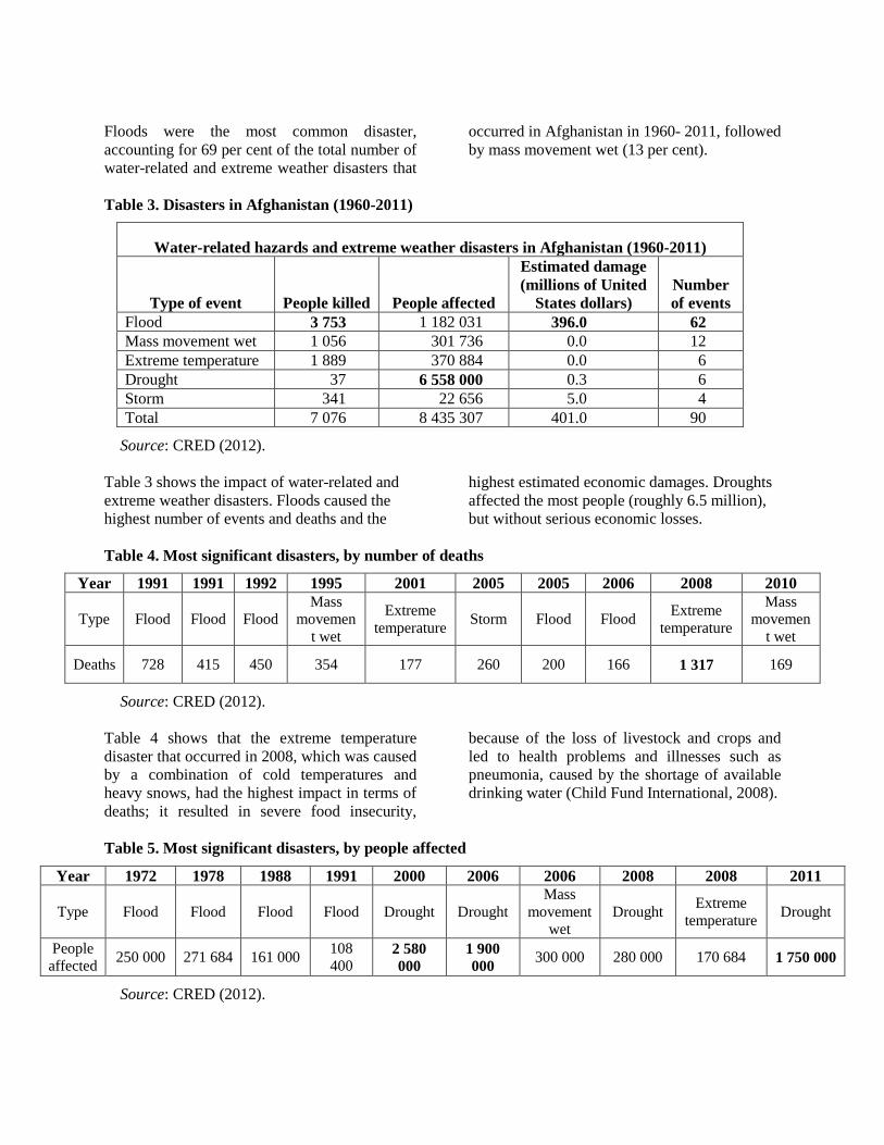
Table 3. Disasters in Afghanistan (1960-2011)
Water-related hazards and extreme weather disasters in Afghanistan (1960-2011)
Type of event People killed People affected
Estimated damage (millions of United
States dollars) Number of events
Flood 3 753 1 182 031 396.0 62 Mass movement wet 1 056 301 736 0.0 12 Extreme temperature 1 889 370 884 0.0 6 Drought 37 6 558 000 0.3 6 Storm 341 22 656 5.0 4 Total 7 076 8 435 307 401.0 90
Source: CRED (2012). Table 3 shows the impact of water-related and extreme weather disasters. Floods caused the highest number of events and deaths and the
highest estimated economic damages. Droughts affected the most people (roughly 6.5 million), but without serious economic losses.
Table 4. Most significant disasters, by number of deaths
Year 1991 1991 1992 1995 2001 2005 2005 2006 2008 2010
Type Flood Flood Flood Mass
movement wet
Extreme temperature Storm Flood Flood Extreme
temperature
Mass movemen
t wet
Deaths 728 415 450 354 177 260 200 166 1 317 169
Source: CRED (2012). Table 4 shows that the extreme temperature disaster that occurred in 2008, which was caused by a combination of cold temperatures and heavy snows, had the highest impact in terms of deaths; it resulted in severe food insecurity,
because of the loss of livestock and crops and led to health problems and illnesses such as pneumonia, caused by the shortage of available drinking water (Child Fund International, 2008).
Table 5. Most significant disasters, by people affected
Source: CRED (2012).
Year 1972 1978 1988 1991 2000 2006 2006 2008 2008 2011
Type Flood Flood Flood Flood Drought Drought Mass
movement wet
Drought Extreme temperature Drought
People affected 250 000 271 684 161 000 108
400 2 580 000
1 900 000 300 000 280 000 170 684 1 750 000

Table 5 demonstrates that the three main disasters were the drought events in 2000, 2006 and 2011, which were particularly significant in terms of people affected. A severe drought can have a major impact on food security, agriculture, health, nutrition and access to water. 1.1.1 Environmental causes of disasters
The occurrence of water-related and extreme weather events is explained by geographical and
climatological conditions, such as seasonal weather changes and the locations of the main river basins, mountains and deserts. Consequently, they place constraints on Afghanistan’s water supplies, population growth, and economic development, among other socio-economic factors. The distribution and concentration of Afghanistan’s water supply within the five major river basins in the country is very important, as shown in Table 6.
Table 6. Annual flow per basin (population and cubic metres per capita)
Basin Flow (millions of cubic metres)
Flow (percentage) Population Cubic metres
per capita Panj-Amu 48 120 57.3 2 968 122 16 212 Kabul 21 650 25.8 7 184 974 3 013 Hilmand 9 300 11.1 5 881 571 1 581 Harirod Murghab 3 060 3.6 1 722 275 1 777 Northern 1 880 2.2 2 783 033 676 Total 84 010 100 20 539 975 4 090
Source: Beekma and Fiddes (2011). Table 6 shows the differences in the annual water flow in the regions, in which Panj-Amu accounts for the highest m3 of renewable water per capita, and the northern region has the lowest. The basin of Kabul represents 3,013 m3 per capita, while the Harirod Murghab and Hilmand basins are close to 1,600 m3. This table clarifies how the water is distributed along the five major river basins and illustrates which basins are most prone to floods and droughts. 1.1.2 Floods and droughts
According to the United Nations Development Programme (UNDP), from 1980-2000, Afghanistan ranked as the country with the second-highest physical exposure to floods, after Bhutan, and had relatively high vulnerability (United Nations Development Programme, 2004b). Normally, floods occur between February and June and are caused by the high average rainfall, which is estimated at 250 mm, and by the main river basin, which runs from the northern provinces to Kabul and on to Heart and Kandahar in the south. In addition, water from spring snow melts runs down the mountains and increases the water level in the river basins below, increasing the hazard risk from floods and landslides (Afghanistan Disaster Knowledge Network, 2009).
Afghanistan has the fourth-highest physical exposure to drought, after Jordan, Iraq and Ecuador (United Nations Development Programme, 2004b). The most exposed areas are the southern and western provinces, as they have less rainfall than the rest of the country and are mostly desert. Strong winds in these areas create a drying effect; the absence of vegetation, along with the presence of bare rocks, prevents moisture from collecting, typically from April to August (Qureshi and Akhtar, 2004). According to the Food and Agriculture Organization, “more than 80 percent of the Afghan population relies on agriculture for their livelihoods” (Food and Agricultural Organization, 2011). In 2010, an estimated 31.6 per cent of Afghanistan’s Gross Domestic Product was dependent on agriculture (United States, Department of State, 2011). For these reasons, events such as floods, droughts and extreme weather conditions reduce crop diversity and productivity, reduce the number of livestock, diminish groundwater levels, and increase the prices for basic goods, which lead to food insecurity and malnutrition (Food and Agricultural Organization, 2011).

12
Droughts in Afghanistan are not the most frequent disasters, but they have large-scale consequences and generate needs in food security, agriculture, health, nutrition and access to water. In Afghanistan, the three most severe droughts occurred in 2000/2002, 2006 and 2011;
they affected 2,580,000 people, 1,900,000 people and 1,750,000 people, respectively. Figure 3 shows cereal production deficits over the period 1999-2011, and illustrates the impact of droughts on the agricultural sector.
Figure 3. Cereal production deficits (1999-2011)
Source: United Nations (2011). Consolidated Appeal Emergency Revision in Response to Drought Figure 3 shows the impacts of the large-scale disasters on the agriculture sector; it is possible to identify the three droughts mentioned above and the deficits they caused, which in 2000-2002 was more than 2 million metric tons, and slightly less than 2 million metric tons in 2011. The impact on agriculture is connected mainly to the reduction of the wheat crop, which depends on water for irrigation. The drought in 2011-2012 affected approximately 1,750,000 people (CRED, 2012). The 2012 Afghanistan Consolidated Appeal requested over $437 million in order to provide aid and give assistance to the most vulnerable groups and people affected, with the purpose of achieving the Millennium Development Goals (Office for the Coordination of Humanitarian Affairs, 2012a). In answer, at the Fifth Regional Economic Cooperation Conference on Afghanistan, which took place in Tajikistan from 26 to 27 March 2012, the Economic and Social Commission for Asia and the Pacific (ESCAP) expressed its support for Afghanistan in order to increase its integration with other Central Asian economies through the implementation of a regional economic development strategy.
In Afghanistan, droughts are explained by fewer snowfalls during winter and lack of rain during April and May. Droughts generate food insecurity, because of the reduction of wheat yields and other cereals, and loss of livestock, as well as a shortage of drinking water. These factors, combined with sanitation and hygiene problems, create difficulties in obtaining the necessary food for an adequate diet, and consequently people end up surviving on tea and bread. (European Commission Directorate-General for Humanitarian Aid – ECHO, 2006). The 2011 drought caused nutritional problems for roughly 2.6 million people, including 210,350 pregnant and lactating women, and 523,876 children under 5 years of age; the expectations for malnourished children under 5 years of age are not encouraging, since 73,622 are projected to be acutely malnourished and 25,242 are expected to be “severely acutely malnourished” (United Nations, 2011). 1.2 Disaster risk management arrangements
The national Government institutions that have a key role in risk management, in terms of preparedness and response, before, during and after a disaster, are as follows:

13
• The Department for Disaster
Preparedness (DPP) is the national body that coordinates and mainstreams disaster risk reduction at the multi-sectoral level; it aims to identify, coordinate and organize efficient prevention and mitigation activities in order to achieve effective contingency plans, early warning systems and emergency response (Preventionweb, 2012). The National Disaster Management Project supported by the United Nations seeks to improve the capacity of institutional response and management for the disasters at national, provincial and district level (United Nations Development Programme, 2011).
• The Afghanistan National Disaster
Management Authority (ANDMA) is the national focal organization that is responsible for the disaster management response; its objectives are developed with the South Asian Association for Regional Cooperation Disaster Management Centre. It gives and receives mutual support and consultancy from the most important ministries involved in the disaster risk reduction policies, and it provides guidance and recommendations to the National Commission’s Executive Committee in times of emergency. The importance of its role lies in the resource mobilization and fund raising activities during emergencies, as well as in reconstruction and rehabilitation after disasters occur. It increases coordination with international aid agencies, national partners and regional operation centres (Afghanistan National Disaster Management Authority, n.d.).
The Emergency Department Management Office of ANDMA provides policy advice, coordinates emergency operations and disseminates information to the key ministries through the National Commission (Afghanistan National Disaster Management Authority, n.d.).
• The National Commission for
Emergency and Natural Disasters comprises 20 relevant ministries that are meant to take policymaking decisions aimed at improving disaster risk reduction and identifying strategies and measures in order to improve the Government’s management and development of national plans. The Commission gives the approval for national plans for preparedness, response and reconstruction; it is also in charge of declaring states of emergency or disaster, and in times of great emergencies mobilizes international assistance (United Nations Assistance Mission in Afghanistan, 2004).
• The Ministry of Communication contributes to improving the early warning systems before and during a disaster by delivering and providing communication links between provincial and national Governments (United Nations Assistance Mission in Afghanistan, 2004).
1.3 Information gaps and priority needs
The national Government’s disaster management structure is composed of ministries and agencies that monitor and control the disaster impacts and make the proper policy decisions to mitigate, prepare, respond and rehabilitate. However, issues such as chronic poverty, food and health insecurity, and lack of income-generating opportunities, aside from the weak institutional capacity and government instability, lead to a high dependency on the aid given by international organizations. Climate variability in Afghanistan makes disaster forecast and control difficult. Since 1990, large-scale disasters have become more recurrent, prolonged and unpredictable. For this reason, the Government must develop more advanced early warning systems and preparedness strategies, accompanied by forecast initiatives, in order to improve disaster risk reduction (Beekma and Fiddes, 2011). Given the huge socio-economic impacts on the highly important agriculture sector, ANDMA and the key stakeholders must ensure that the

14
policies are reaching the people, which have fewer coping measures than before. In addition, ANDMA has recognized that its main limitations when addressing disaster risk reduction are related to the absence of funding and a lack of adequate early warning systems and technology. The need to improve communication and collaboration between institutions should also be recognized; the Government must establish a proper and structured system in which information sharing and communication between the stakeholders is prioritized. Moreover, community-level participation and training, which includes the most vulnerable groups, and the spread of public information are an essential element of early warning mechanisms. Because water-related and extreme weather hazards, especially floods and droughts, are expected to take place each year, the Government must become aware of the far-
reaching impacts of these hazards and focus on ways to alleviate their impact on health, agriculture and poverty. Additionally, the support received by international organizations and agencies must be reinforced with strong political commitment and Government stability. 2. Azerbaijan 2.1 Hazard profile and socio-economic effects According to CRED (2012), from 1990-2011, Azerbaijan experienced nine flood and related hazards and extreme weather events that killed 30 people and affected over 1.8 million people in other ways, such as being injured or made homeless or requiring other types of emergency services. The estimated economic losses totalled $196.2 million. These disasters can be divided into floods, mass movements wet, and droughts, as shown in Figure 4.
Figure 4. Natural disaster occurrences in Azerbaijan (1990-2011)
Natural Disaster Occurrences (1990-2011)
Flood78%
Drought11%
Mass Movement Wet
11% Flood
Drought
MassMovementWet
Source: CRED (2012).
Floods were the most common disaster (78 per cent of the total number of disasters), followed
by droughts (11 per cent) and mass movement wet (11 per cent) .

15
Table 7. Disasters in Azerbaijan (1990-2011)
Water related hazards and extreme weather disasters in Azerbaijan (1990-2011)
Type of event People killed
People affected
Economic damage (millions of United
States dollars)* Number of
events Flood 19 1 840 300 96.2 7 Drought - - 100 1 Mass movement wet 11 - - 1 Total 30 1 840 300 196.2 9
Source: CRED (2012). * Estimated. Table 7 shows the type of disaster event in relationship to the number of people killed, the number of people affected and economic cost. It should be noted that floods accounted for the
highest number of both people killed and people affected; drought caused the highest estimated economic damage .
Table 8. Disaster timeline in Azerbaijan (1990-2011)
Year 1995 1995 1995 1997 2000 2000 2003 2009 2010
Type Flood Flood Flood Flood Drought
Mass movement
wet Flood Flood Flood People killed - - 5 11 - 11 - - 3
People affected 1650000 2800
6000
75000 - - 31 500 5 000 70 000 Economic damage (millions of United States dollars)* 6.7 5.5 4 25 100 - 55 - -
Source: CRED (2012). * Estimated
Table 8 shows the disasters by year and their effects. Floods were the most frequent disaster and caused high impacts in the country, affecting the highest number of people, totalling over 1.8 million. The 2000 drought did not result in people killed or affected; however, it caused the highest economic losses in Azerbaijan’s history. Two of the major extreme weather events in Azerbaijan were the 1995 flood and the 2000 drought. The flood in 1995 occurred because of the sea level rise along the Caspian Sea border and torrential rainfall on the previous days, which ended up flooding the southern region of the country. This event affected 1,650,000 people and produced economic damages accounting for $6.7 million, due mainly to inundations of houses and crop fields
(Reliefweb, 2011). The 2000 drought, which affected several countries in Central Asia, caused economic damage in Azerbaijan, accounting for $100 million. It also diminished water levels in the rivers and caused the cereal crops to dry in the fields. 2.2 Emergency arrangements
Emergency activities in Azerbaijan include all aspects of prevention, warning, protection of the population and critical buildings and infrastructure, search and rescue, rapid response, and organization and coordination of humanitarian action, as well as the creation and management of the State reserve fund. Azerbaijan has established a centre for crisis management, which brings together various ministries and departments, such as the Ministry

16
of Emergency Situations, the Ministry of Communications and Information Technology, and the Ministry of Environment and Natural Resources, among others. Interaction between the Ministry of Emergency Situations and other ministries and committees is governed by existing regulations. Prevention and elimination of emergency situations, both natural and man-made, is an important activity for sustaining the country’s national security, defence and stability. The coordinating body is the Ministry of Emergency Situations, which coordinates the work of the State Fire Service and State Fire Control, civil defence forces, emergency and rescue services for the Caspian basin, and the Centre for Crisis, as well as numerous other safety and security bodies. 2.3 Information and communication
Early warning and emergency response would be greatly assisted by the creation of an automated information-analytical system with a central database, and the use of modern programming techniques. One of the major challenges of prevention and rapid response in natural and man-made disasters is the collection, processing, analysis, sharing and providing of timely and relevant information. Their effective implementation of the operational challenges is inextricably linked with the technical and operational capabilities of the system control, communications and information systems of all departments in responding to emergencies. The Ministry of Emergency Situations has special-purpose vehicles equipped with the following types of communication devices: satellite, VHF, HF communication, TETRA communication, a camcorder designed to broadcast live from the site, GPS, and access to local and international connections, thus bringing a variety of rescue services to the incident. The information-analytical system covers all the basic levels of emergency management and covers several tasks. Two-way communication is provided between nodes, to enable the collecting and processing of information within and between levels. The system has uniform standards for collecting, processing and storing information in databases, and for communication interaction, which allows
sharing of various kinds of information about natural and man-made emergencies. To be fully effective, information and communication technologies in Azerbaijan require decisions on strategic and organizational planning in order to develop and implement a disaster risk management system to gather information for reference, and to create new and effective methods, techniques and tools to handle responses to emergencies. It also needs to make progress on integration of disparate information systems and databases, and on technical support and maintenance of information systems. Establishing and maintaining information systems for the management of structural units would reduce the socio-economic impact of disasters. The creation of information resource management divisions in the Government would go far towards achieving a better system. 3. Kazakhstan 3.1 Flood and related hazards and their social and economic effects
In Kazakhstan, meteorological hazards, such as strong wind, snow storms, dust storms, heavy rain and snow, thunder storms, hail, fog and temperature extremes are reported throughout the entire country. The most frequent causes of emergency situations are spring floods and hazardous meteorological events (hurricanes, strong wind with hail, extremely low air temperatures, strong snowfalls, and strong whirlwinds). These kinds of hazards can paralyze production and business activities across vast regions, causing annually up to several hundred million dollars in damage and killing hundreds of people. Seasonal flash floods and river floods are the most hazardous kinds among the hydrological processes; water-related destruction occurs principally as a result of floods and mudflows. There is no data about adverse effects of water factors in other types of water-related disasters. 3.1.1 Floods
Flood-prone areas are in almost all regions of Kazakhstan. There are about 800 rivers of more than 50 km in length, and more than 600 water reservoirs of various capacities and purposes,

17
and not less than 3,000 lakes, with a surface area of 1 km2 or more, all of which may trigger different types of floods. Floods directly affect 75 rural districts and more than 800 communities, with a total of 5 million inhabitants. Floods are caused primarily by heavy and long-lasting rainfalls, intense snow melting in the valleys, snow and glacier melting in the mountains, outbreaks of lakes and reservoirs, upsurges in large reservoirs, and ice jams and narrow gorges. The greatest damage is usually caused by the flooding on rivers, particularly the Irtysh, Tobol, Ishim, Nura, Emba, Turgai, and Sary-Su, among others, as well as in small river streams. River floods occur in February-June in southern parts of Kazakhstan, in March-July in south-eastern and eastern parts, and from March-June in the lower lying rivers. Catastrophic floods causing fatalities and substantial damage occur once every 50-100 years along various rivers. During the period 1994-2003, more than 300 floods (caused by several different factors) were recorded; they include 70 per cent of floods caused by spring high waters, with the rest caused by rainfall and other factors (United Nations Development Programme, 2004a). One of the worst river floods in recent history occurred in the spring of 1993, when excessive snow, sudden warming, and heavy rainfall led to a catastrophic snowmelt and rain-swollen waters in all valley rivers throughout the country. Six hundred and sixty nine communities were affected, six people killed, and 12,700 people evacuated; 7,000 homes were under water;
50,000 ha of cultivated fields and 2,300 cattle-breeding facilities were flooded, and 66,000 head of livestock killed; and 875 km of roads, 718 km of electricity lines, 275 km of communication lines, and 513 hydraulic engineering sites were damaged. An estimated $500-600 million in direct damages was inflicted. Similar floods caused by melting snow and rainfall, took place in 2008, 2010 and 2011, though with less extensive damage and fewer casualties. Disastrous floods caused by winds are common in the delta of the Ural River and along the north-eastern coast of the Caspian Sea. The most dangerous periods are from October to December and in May, when the water rises up to 2.0-2.5 m and sea water extends tens of km into the mainland, flooding up to 2 million ha. Recent years have seen an increase of the number of floods caused by anthropogenic forces. The main reasons include excessive and forced water discharge from water reservoirs, which is particularly hazardous in winter, and outbreaks of dams (which occurred in 2004; 2008, 2009 and 2010). For example, flooding on the Syrdarya River occurred during an increased water discharge from the Shardarya water reservoir in the winters until 2010. Fortunately, the Koksarai counter-regulator dam, launched in January 2011, intakes the high spring waters of the Syrdarya River and stands by in anti-high water mode. Table 9 presents data on hydrological hazards in Kazakhstan during the period 2000-2008.
Table 9. Hydrological hazards occurring in Kazakhstan (2000-2008)
Hydrological hazard events 2000
2001
2002
2003
2004
2005
2006
2007
2008
Seasonal flooding 3 2 2 6 4 13 - 6 - Snowmelt-related floods, flash floods and intense slope flows 3 6 21 14 11 3 3 4 1
Source: Kazhydromet. Wastewater ponds in Almaty, Aktyubinsk, Zhambyl, and other large cities pose a danger; because of insufficient budget allocations, there is a serious threat of pond outbreaks, which would result in catastrophically high waters and a seriously affected population. One such
example was a mudflow and high water event that occurred in the aftermath of the breakout of the Zhamankum wastewater treatment facility on 28-29 January 1988 near Almaty. Several building and facilities, as well as road and railway bridges, were destroyed and 19 people

18
were killed. Wastewater also got into the Kapshagai water reservoir. This disaster did not become a large-scale event only because it happened in an area with a low population. The poor condition of some of the largest hydro-station dams (Tasotkel, Ters-Ashybulak, Shardarian, Sergeevsky and others) may also be the root cause of some instances of flooding. (Hydro-technical facilities are discussed in more detail below.) 3.1.2 Mudflows
Mountain and foothill areas in southern and south-eastern Kazakhstan occupy 160,000 km2 and are exposed to mudflows. Mudflows occur suddenly and create huge destructive power along their course. The throw distance of the mudflow may be up to 20-30 km and tens of metres in width. The creation of mudflow is conditioned by three main factors: sufficient surface slope degree, critical water release, and friable fragmental materials. All of these factors exist in the mountainous and adjoining low-lying areas.
Figure 5. Kazakhstan – Mudflow areas
Source: Office for the Coordination of Humanitarian Affairs (2012b). Most of the mudflows are triggered by intensive rainfalls (80 per cent), moraine and glacier lake outbursts (15 per cent), and by landslides of a glacial or seismic nature (5 per cent). There are more than 300 mudflow basins in the country, and during the last 150 years, more than 800 major mudflows have been recorded.
3.1.3 Assessment of damage
Despite the broad consensus on what types of damage and losses occur, there are currently no official methods in Kazakhstan for estimating
flood damage, and Government authorities do not possess full and accurate damage data. Flood damage is estimated by local executive authorities, usually on a random basis. Therefore, estimated flood damage reported by various sources is not consistent or accurate, so the total direct damage from the floods and mudflows in Kazakhstan may range from several hundred thousand to tens of million dollars annually. The data in Table 10 refer to hydrometeorological and geological hazards, including extreme weather events, recorded in

19
Kazakhstan in the last decade. Hydrometeorological and geological hazards include floods, seasonal floods, mudflows and extreme weather hazards such as snow storms, ice storms, heavy snowfalls and wind storms.
There are no statistics on extreme weather events, and the data do not fully reflect the potential risks of floods and mudflows in Kazakhstan, since no outstanding disasters occurred during the period under study.
Table 10. Hydrometeorological and geological hazards reported in Kazakhstan (2002-2011)
2002
2003
2004
2005
2006 2007 2008 200
9 2010 2011 (11 months)
Number of hydro-meteorological and geological hazards
80 89 69 31 27 39 29 40 44 42
Number of affected people 29 15 101 16 18 132 12
815 21 15 500 16 000
Number of deaths 19 8 32 9 6 11 8 18 54 5 Damage estimates (millions of United States dollars)
3.52 2.70 2.45 0.78 0.45 0.19 134.68 0.14 57.82 116.32
Source: Annual analytical reports produced by the Ministry of Emergency Situations of Kazakhstan. Analysis of information and data leads to the following conclusion: generally, estimates of the damage caused by floods and water hazards are quite unreliable, yet it is certain that the damage is being underestimated. Estimates of the flood damage do not count actual figures and do not include all flood-related losses. It is more than likely that these are merely estimates of direct damage to property, facilities and public infrastructure. 3.2 Water-related risk management arrangements
In accordance with the State budget programme “Launch of hydro and meteorological monitoring”, the State enterprise Kazhydromet, under the Ministry of Environmental Protection, is responsible for hydrological and meteorological monitoring. However, although there is a legal framework for monitoring hazards, there is no single organization in Kazakhstan that deals with prevention and mitigation of adverse effects of water-related events. In addition, here is no even distribution of responsibilities within the Government (Ministry of Emergency Situations, Ministry of Agriculture, Ministry of Environmental
Protection, and local executive authorities). Moreover, there is no coordination at the national level. The overall legislative and administrative regulations for water-related hazards are stipulated by multiple legislative decisions on water relations, the environment, and natural and anthropogenic hazards. There is no single legislative act that regulates legal approaches to water-related hazard prevention and mitigation. Existing legislation has the following gaps:
• Indefinite boundaries of legal framework, and inconsistencies;
• Many of the legal norms duplicate each other, are subjective and declarative;
• Some legal norms are inadequate with regard to related international law.
Because of these gaps, officials are unable to use legislation as the primary management tool for prevention and mitigation of water-related adverse impacts. Therefore, administrative and command forms of management still prevail in this area, which means that reliable protection from water-related hazards is lacking.
20
Along with strengthened legislation, officials at Kazhydromet and other relevant agencies need an approved classification of water-related adverse effects, along with a corresponding, systematized database; furthermore, there must be research on the regularity of the many adverse effects, and more risk and damage assessments. Therefore, major challenges with regard to water-related adverse effects remain outstanding within the system of the Integrated Water Resources Management Department. 3.2.1 Water management
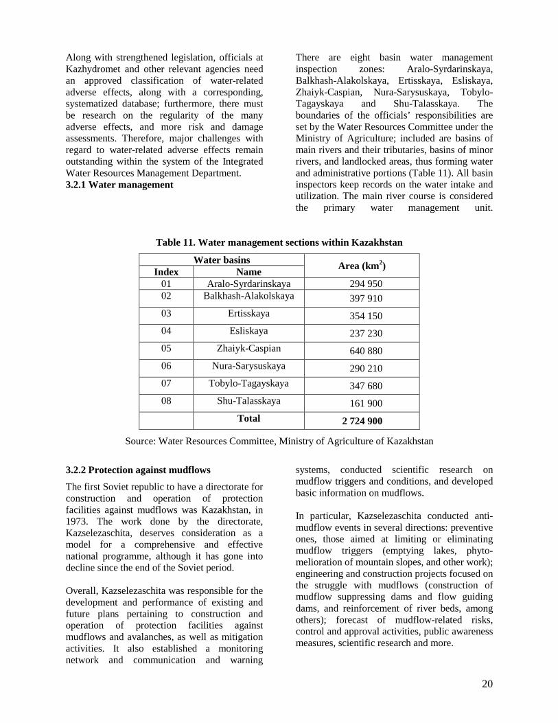
There are eight basin water management inspection zones: Aralo-Syrdarinskaya, Balkhash-Alakolskaya, Ertisskaya, Esliskaya, Zhaiyk-Caspian, Nura-Sarysuskaya, Tobylo-Tagayskaya and Shu-Talasskaya. The boundaries of the officials’ responsibilities are set by the Water Resources Committee under the Ministry of Agriculture; included are basins of main rivers and their tributaries, basins of minor rivers, and landlocked areas, thus forming water and administrative portions (Table 11). All basin inspectors keep records on the water intake and utilization. The main river course is considered the primary water management unit.
Table 11. Water management sections within Kazakhstan
Water basins Area (km2) Index Name 01 Aralo-Syrdarinskaya 294 950 02 Balkhash-Alakolskaya 397 910 03 Ertisskaya 354 150 04 Esliskaya 237 230 05 Zhaiyk-Caspian 640 880 06 Nura-Sarysuskaya 290 210 07 Tobylo-Tagayskaya 347 680 08 Shu-Talasskaya 161 900
Total 2 724 900
Source: Water Resources Committee, Ministry of Agriculture of Kazakhstan
3.2.2 Protection against mudflows
The first Soviet republic to have a directorate for construction and operation of protection facilities against mudflows was Kazakhstan, in 1973. The work done by the directorate, Kazselezaschita, deserves consideration as a model for a comprehensive and effective national programme, although it has gone into decline since the end of the Soviet period. Overall, Kazselezaschita was responsible for the development and performance of existing and future plans pertaining to construction and operation of protection facilities against mudflows and avalanches, as well as mitigation activities. It also established a monitoring network and communication and warning
systems, conducted scientific research on mudflow triggers and conditions, and developed basic information on mudflows. In particular, Kazselezaschita conducted anti-mudflow events in several directions: preventive ones, those aimed at limiting or eliminating mudflow triggers (emptying lakes, phyto-melioration of mountain slopes, and other work); engineering and construction projects focused on the struggle with mudflows (construction of mudflow suppressing dams and flow guiding dams, and reinforcement of river beds, among others); forecast of mudflow-related risks, control and approval activities, public awareness measures, scientific research and more.

21
In the aftermath of these activities, by the early 1990s Kazakhstan had a reliable protection system against mudflows that was recognized by both the former Union of Soviet Socialist Republics and developed countries, such as Italy, Japan, Switzerland, and the United States, among others. However, since the collapse of the Soviet Union in 1991, this protection system has degraded owing to insufficient financing. Research and other studies have stopped; scheduled activities for introducing protection tools against mudflows have been suspended; the scope of operational maintenance of engineering facilities has been reduced; and analytical and forecasting work has folded. The monitoring, warning and communication services of this State enterprise must use worn-out equipment and devices, and it is forced to reduce the number of departments and personnel, which unfortunately includes the most qualified professionals. These conditions could be reversed by increasing research, introducing new protection tools and up-to-date equipment, improving maintenance, reviving analysis and forecasting, and employing qualified personnel. 3.2.3 Flood and water-related hazards monitoring systems
Since 1999, national hydrometeorological services, such as monitoring of water resource indicators, have been performed by the State enterprise Kazhydromet, in the Ministry of Environment Protection, and the Water Resources Committee, under the Ministry of Agriculture. National hydrometeorological services consist of three primary units:
• National monitoring networks, such as meteorological, hydrological and agro-meteorological, and environmental;
• Information and television communication system that collects, processes and broadcasts data;
• Forecast services that assess water resources and make hydrometeorological forecasts, and send them to all State authorities, various users and residents of the country.
Floods in Kazakhstan, including those caused by wind surges, are forecast well in advance and accurately, except for floods triggered by water breakouts. Kazhydromet receives data on the water content of rivers and lakes from the hydrological check point network, based on regular standard measurements of water level, water discharge, water temperature, ice thickness, slush ice and snow thickness lying on the ice. In addition, meteorological values, such as air temperature, precipitation, wind speed and surface evaporation, are measured. The water level at hydrological stations is measured either manually, using a water level scale or breakwater, or automatically by a recorder. Float-type recorders have been used in the past and are being replaced by the bubble and radar level meters. The hydrometric flow meter remains the primary device for measuring river flow rate, but this is a time-consuming process, when measurements might continue for several hours. However, new gauges are being introduced for water discharge measurements, such as mobile and stand-alone ultrasound Doppler geometry tools. The new gauges are equipped with systems for automated measurement management and long-lasting data storage; in addition, the gauges automatically transfer data to remote receivers.
Box 1. Projects to prevent water-related hazards in Kazakhstan
The Government of Kazakhstan does a great deal of work on water-related hazard prevention and reduction. Below are three of the most outstanding examples of projects to prevent water-related hazards:
• Project on “Regulating Syrdarya and Northern Aral Sea” (first phase accomplished in 2004-2007, with more than 9.6 billion tenge (over $64 million) in financing);
• Construction of Koksarai counter-regulator in southern Kazakhstan, with 3 billion km3 in project volume (launched in 2011);

22
• Project on “Protecting Astana city from flash floods on the Esil River”, with 450 million m3 in regulated volume, ground dam 12 m in height and 31.1 km in length, and head intake gate with 450 m3/sec in capacity. Estimated cost of the project is 12 billion tenge ($80 million).
3.2.4 Hydro-technical facilities
The failure of reservoir and water intake facilities of river hydro-technical facilities may result in emergency situations covering a vast territory and inflicting fatalities and enormous damage. Among anthropogenic hazards, hydrodynamic accidents caused by dam destruction are the most frequently occurring and inflict the heaviest damage. The second most frequently occurring accident trigger is aging facilities that are not replaced, owing to the lack of proper State control. Declining maintenance levels in the majority of hydropower systems and delayed repairs to water release facilities led to a rise in the number of accidents during the last decade. Big dams and other hydro facilities are deteriorating because of 30-40 years of operation and silt sedimentation, resulting in declining reliability and technical capacity. In addition, the dams are exposed to seismic, mudflow, landslide and avalanche-related hazards, as well as being exposed to surging glaciers and other geodynamic events.
There are serious concerns raised in relation to the declining safety level of dams and hydro facilities, which provide about 90 per cent of the water for agribusiness and 40 per cent for power generation and other economic fields, and, foremost, which affect the safety of about 50 per cent of local residents. In Kazakhstan, there are 653 major hydro-technical facilities and more than 200 water reservoirs, with a total capacity more than 80 km3 (excluding ponds and minor reservoirs for spring water retention). Some of the sites are potentially highly hazardous. In the course of an analytical review, a group of experts has revealed that every fifth reservoir surveyed is in poor condition (Eurasian Development Bank, Almaty, 2011). According to the estimations done by the Water Resources Committee under the Ministry of Agriculture, around 53 billion tenge (over $353 million) is needed up until 2020, or 5 billion tenge (over $33 million) per year for the upgrade of 66 large reservoirs of strategic importance owned by the republic (Mukhatov, 2010).
Box 2. Purpose of State regulation
A draft of the law “Safety of hydro facilities” is being reviewed and discussed. The main purpose of State regulation of safety of hydro facilities is to prevent accidents. The following steps would achieve that aim:
• Enhancing rules and norms for the layout, construction and operation of hydro facilities;
• Establishing State control over operators and owners, in order to enforce rules and norms of safe operation;
• Observing and analysing condition of facilities and their bases, and finding and removing defects in a timely manner;
• Training technicians on how to conduct anti-accident activities and how to respond to emergency situations;
• Replenishing assets and financial reserves to support responses to accidents.
Box 3. Principles of safety monitoring tools
The main principles of safety monitoring tools in hydro-technical facilities are as follows:

23
• Launch of effective State regulation of the safety of hydro-technical facilities by the State regulator;
• State control requiring operators to follow rules and norms of safe operation of hydro facilities, including inspections;
• Regular screening, examination and centralized investigation of hydro facilities;
• Checking the safety of hydro-technical facilities and maintaining an inventory of facilities;
• Diagnosis and definition of safety criteria, accident risk assessment, and timely elimination of defects that might trigger full or partial failure of a facility and occurrence of hazard;
• Equipping most hydro-technical facilities with measuring devices, software datasets, and monitoring systems;
• Training personnel on how to conduct anti-damage events and what actions to undertake to mitigate emergency situations;
• Allocation of necessary assets and funds. 3.3 Information gaps and priority needs
Kazhydromet hydro and meteorological services are not able to fulfil the minimal needs of the country: there are no meteorological radio locators or satellite data specialized receivers; the capacity of numerical forecasting is very limited and is not used for operational purposes; the level of available information technology is rather low; 60-80 per cent of the main items of equipment are worn out; and the monitoring networks (number of stations, hydrological measurement units and upper-atmosphere sounding stations) have been downgraded since the mid-1980s.
Overall, the problems of hydrological and meteorological monitoring systems in Kazakhstan may be identified as follows:
• Insufficient budget allocation; • Poor monitoring network; • Insufficient and irregular information
collection; old tools and equipment are used;
• Poor technical supply of the monitoring network and lack of modern methods;
• Weak coordination among monitoring services of different agencies, and no reconciliation of monitoring system locations.
Box 4. Programme needs in Kazakhstan
Accomplishing the following tasks would enable Kazakhstan – and other countries in a similar situation – to solve a number of problems.
• Clearly define information needs; • Draft a national concept and long-term programmes; • Draft monitoring strategies and programmes using modern technologies
(to expand and upgrade the network); • Increase the budget for the monitoring system – personnel and equipment
– including a strategy envisaging sustainable growth of Kazakhstan’s economy;
• Enhance coordination between monitoring agencies; • Establish a unified information and analytical system of the basins in
Kazakhstan, such as risk maps and simulations, based on geographic information system (GIS) technologies;
• Apply remote sensing and space-based techniques, enabling area risk assessments rather than point-wise assessments.
On the whole, the discussion above reveals that environmental monitoring in the Republic of Kazakhstan does not meet modern standards.
The State network of observation points reaches 20 per cent of the total number needed and is equipped to only 40-80 per cent of the required

24
level. Worn-out monitoring equipment and unreliable measurements have led to reduced volume and accuracy of information. Lack of consensus between different ministries and agencies prevents them from making a full assessment of the environment and from receiving operational information in a timely manner.
Nevertheless, awareness of the shortcomings has prompted actions and plans from various quarters, and steps both broad and specific are being considered. The Government of Kazakhstan is making all efforts to restore the full range of Kazhydromet functions, whilst continuing to fill in the major funding gaps that have occurred over the previous years.
Box 5. Elements of a unified monitoring system for the environment and natural resources
Urgent actions are required in order to create a unified monitoring system for the environment and natural resources based on a geo-information system that would include all companies and agencies performing governmental monitoring, as well as production monitoring systems. In order to launch the system, it is necessary to create an environment information fund for collection, systematization, and storage and sharing of the information; it is also necessary to upgrade existing assets and equipment of monitoring and measuring units; and it is necessary to adopt regulatory legal acts to coordinate activities of the interested State agencies.
4. Kyrgyzstan 4.1 Water-related hazards and their socio-economic effects
Kyrgyzstan is located in a collision zone of two giant tectonic plates: the Euro-Asian in the north and the Indo-Australian from the south, which are responsible for a range of different natural disasters and catastrophes. In this mountainous country, seismotectonic movements create landslides, avalanches, rock falls, mudflows and floods, avalanches, earthquakes, flooding, lakes, permafrost and other hazards. As for the climate, most of the territory is in a belt of temperate latitudes, and the southern regions are in the subtropical climate zone. Owing to the difficult and varied terrain, the distribution of meteorological phenomena in Kyrgyzstan takes on a colourful character. Within the territory of Kyrgyzstan, four climatic regions are highlighted, with significant climatic differences between them: the north and north-west district, the south-western district, the north-east region, and the inner Tien Shan. Most of the disasters that occur in Kyrgyzstan are weather-related, particularly mudslides and flash floods, landslides, avalanches, and adverse
weather. Statistics on the locations of emergencies from 1990-2011 show that, in descending order, they are distributed in the districts (oblast) Osh and Jalal-Abad, Chui, Batken (an incomplete figure, since the region was established in 1999), Issyk-Kul, Naryn and Talas. The greatest number of emergency situations was noted in 2008, and the lowest in 1992. The annual average number of emergency situations during the period amounted to 159. The percentages of recorded emergency situations may be classified as follows: 29 per cent were floods; landslides and rock falls came to 13 per cent; 10 per cent were avalanches; man-made disasters, including fires, accounted for 13 per cent; meteorological events (winds, rain, snow, hail, etc.) comprised 10 per cent; earthquakes were 9 per cent of the events; and others (including infectious diseases among humans and animals) made up 16 per cent. 4.1.1 Glaciers
The main sources of information about the state of glaciers in Kyrgyzstan are the Catalogue of the Glaciers of the USSR and a map of modern glaciation at a scale of 1:500,000 from the series The Natural Resources of the Kirghiz SSR.

25
According to sources from the 1960s, the total volume of glaciers reached 494.7 km3, but in 2000, the amount was estimated at 417.5 km3; that is, by 2000, glaciers had lost about 15 per cent of their volume. Their melting has not only intensified, but has also increased in duration, from early spring to late autumn. Increasing temperatures due to climate change are likely to lead to a steady decrease in the area of large glaciers, and small glaciers will, for the most part, gradually disappear. Assuming a scenario of moderate climate change in Kyrgyzstan, models of possible changes in the glaciers predict that the decrease in glaciation from 2000-2100 will be from about 64-95 per cent. Kyrgyzstan has approximately 45 per cent of all glaciers in Central Asia, and they occupy about 4 per cent of the total area of the country. 4.1.2 Glacial mountain lakes
One of the main factors in the risk of mudflows and floods are glacial mountain lakes. Currently, according to a complex hydrogeological expedition, the CD catalogue of the Ministry of Natural Resources includes 330 glacial lakes; 27 lakes are classified in first category of risk, 66 in the second category, and the rest of the lakes in the third category. The greatest threats are due to the “Lake Moreno” type (47 per cent of the total number of glacial lakes), the Moreno-transom (26 per cent), moraine (14 per cent), landslide
lakes (12 per cent), and lakes formed by ice (1 per cent). 4.1.3 Landslides
In the territory of Kyrgyzstan, there are about 5,000 landslides, affecting about 7.5 per cent of the country. The greatest number of landslides is situated in the oblasts of Osh and Jalal-Abad, as well as the Issyk-Kul region. Landslides occur mainly in lower and middle zones, coinciding with the area of distribution of Meso-Cenozoic sediments, represented by interbedded variegated clays, sandstone, limestone, marl, gypsum from multiple aquifers, and loess-like loams. The number of landslides is increasing annually owing to increasing interaction of modern geodynamic movements, seismic activity, the rise of groundwater levels, and an abnormal amount of atmospheric precipitation – as well as engineering and human activities in violation of the balance of the stability of slopes in mountainous areas. Large landslides that are formed under the influence of groundwater occur in dry years, regardless of the period of the year, but more often in the spring, when the weight of the landslide mass is greatly increased due to the infiltration of snowmelt and rainwater. Landslides often lead to the formation of dammed lakes or barrier lakes, which present a serious flood risk.
Figure 6. A schematic map of landslide hazard prediction in Kyrgyzstan
Source: Ministry of Emergency Situations, Kyrgyzstan.
4.1.4 Avalanches
Avalanches are a particularly dangerous hydrometeorological natural phenomenon for
humans and are capable of causing immense damage to buildings, transportation infrastructure, bridges and power lines, as well as livestock and forests. Up to 105,000 km2 of Kyrgyzstan, accounting for 53 per cent of the entire territory, is subject to the disastrous

26
effects of avalanches. Avalanches occur almost everywhere there are steep mountain slopes and sufficient snow cover (Figure 7). The formation of avalanches is determined by the interaction of meteorological conditions, the quantity of snow accumulation, and the physical condition of the snow layer from which they arise. The avalanche season lasts from three to four months in western Tien Shan, and 10-12 months in central Tien Shan. The most frequent avalanches in the Tien Shan happen in February and March (63 per cent of the total recorded avalanches that have caused damage to highways). January accounts for 16 per cent of
avalanches. In April, as a rule, 13 per cent of the avalanches take place. In December, only about 4 per cent of the avalanches occur. Depending on the snow and weather conditions in winter, between 800 and 1,500 avalanches of various sizes come down the mountain slopes. Specialists are able to examine only 10-15 per cent of the potential avalanche area. But unfortunately, with increasing human influence on the snowy slopes – the construction of new high-altitude roads and railways, power lines, hiking and climbing routes, and the organization of ski bases and recreational facilities – the avalanche danger will increase.
Figure 7. Map of avalanche danger zones in Kyrgyzstan
Source: Ministry of Emergency Situations, Kyrgyzstan. 4.1.5 Mudflows and floods
Kyrgyzstan is largely exposed to mudflow and flood processes. The main source of flooding is rivers. About 65 per cent of the rivers of Kyrgyzstan are of mixed glacial-snow and snow and glacier origin, with the passage of floods most often in the first or second half of summer. The rivers that are fed by the seasonal snow have a period of flooding lasting two to five months. The extension of the flooding period may be due to sequential melting of snow at
different altitudes, most often in April and May. In addition to snow and glacial floods, some rivers may experience short-term storm floods and form mudflows. On average, according to the Ministry of Emergency Situations, each year sees around 40 emergency situations related to mudflows and floods, amounting to 30-35 per cent of all emergencies of natural origin. The total damage (direct and indirect) from mudslides ranks first

27
among the natural hazards in Kyrgyzstan. Floods affect a great many settlements (95 per cent of all settlements are located on the banks of rivers and alluvial fans and ephemeral streams), transportation routes, communications infrastructure, agricultural lands, hydraulic engineering, irrigation and other facilities. Debris flow increases channel erosion, and flooding increases siltation of irrigation systems.
Among the approximately 3,900 river basins, the most-affected mudflow areas are in the western and eastern parts of the Jalal-Abad region, the southern part of Chui, Osh (southern part of the Alai valley and central regions), Batken and Issyk-Kul.
Figure 8. Map of mudflow hazard zones in Kyrgyzstan
Source: Ministry of Emergency Situations, Kyrgyzstan. The largest flood in recent years was a flood on a river in Kugart Jalal-Abad province on 19 May 1998, which was due to abundant spring rainfall and snowmelt. The flow in most of the river reached a rate seen once every 200 years. Check dams, river intakes, and other hydrological structures were damaged or destroyed. The greatest damage was caused to the district centre, Suzak Kugart, where over 1,000 homes were destroyed, and the total damage exceeded $134 million. 4.1.6 Freezing
The late spring and early autumn frosts are a very important agrometeorological phenomenon because of the losses they can cause. Whereas such phenomena as hail, squalls, and other storms are local in nature, freezing covers large areas at the same time. Frosts are classified as a
natural disaster if over 30 per cent of the country suffers a drop in air temperature or soil surface temperature to below freezing during the crop growing season. Due to the large diversity of climatic conditions in Kyrgyzstan, the terms of late spring and early autumn frosts differ significantly in different areas. The threat of frost in the warmest areas of Kyrgyzstan – the cotton growing area of Osh, and the regions of Jalal-Abad and Batken – continues until April. The probability of their appearance at this time is 3-6 per cent. Early autumn frosts (with a probability of 6-11 per cent) may occur in early October. 4.1.7 Drought
Meteorological and hydrological droughts occur relatively often in Central Asia. Meteorological

28
drought means a precipitation deficit over the long-term averages, and formation depends on the location and time of year. Hydrological drought is associated with a deficit of water resources from surface and subsurface runoff, due to lack of rainfall. Given the fact that most of the farm land in Kyrgyzstan is irrigated, the next most important risk factor is the lack of water in rivers, or hydrological drought, during the spring and early summer and the growing season (April-September). 4.2 Disaster monitoring arrangements
The main Government body that monitors and forecasts flood risk, prepares for and ensures the safe passage of debris flows and floods, responds to emergencies, and is in charge of restoration of areas damaged by landslides and floods is the Ministry of Emergencies. Based on the findings of the Department of Surveys and readings from monitoring instruments, protective measures are set up to prevent and minimize damage. The inistry of Emergency Situations clarifies potentially dangerous areas and makes decisions on protective measures. It also previews, compiles and approves the plans that will be applied at regional, district and city levels. Monitoring of high-altitude glacial lakes is conducted by the Ministry of Emergency Situations, together with the Ministry of Natural Resources and Hydrometeorological Services. Monitoring of emergencies related to flooding at the national level is conducted by the Department of Monitoring and Forecasting, the Office of Selvodzaschita, and the Hydrometeorology Agency (Kyrgyzhydromet), all of which are under the Ministry of Emergency Situations. The Department of Monitoring and Forecasting in the Ministry of Emergency Situations conducts surveys of potentially dangerous areas, on the basis of which it develops and publishes an annual forecast document, Monitoring and Forecast of Possible Activation of Hazardous Processes and Phenomena in the Kyrgyzstan Republic. There is ongoing monitoring and supervision of anti-mudslide protection facilities, as well as monitoring of water levels in rivers, and visual inspection of anti-mudslide protection structures. The Hydrometeorology
Agency conducts surveillance and monitoring of meteorological and hydrological conditions, and pollution of surface water and air, including radioactivity. At present, meteorological observations are conducted by 33 manned weather stations, four automatic weather stations and 69 posts; agro-meteorological observations are carried out by 31 stations and one post. Observation of the level of Issyk-Kul Lake is carried out at four positions, similar to observations made at the Kirov reservoir by one post. Hydrological monitoring on the rivers comprises 77 posts. Observations are carried out according to World Meteorological Organization (WMO) Technical Regulations. In order to warn the population and prepare them to respond to emergencies, the Department of Monitoring and Forecasting issues forecasting and training materials. All forecasting material is recorded in the GIS system at the Centre for Crisis Management, for the coordinated operation of the State system of prevention and mitigation of emergency situations in Kyrgyzstan and along borders with other countries. 4.3 Adaptation and prevention measures
Adaptation measures should develop the existing set of actions aimed at prevention of emergency situations. The basic component of these actions is spatial planning of all emergency situations, including the identification of danger zones and consequent requirements for use of these zones. In order to identify danger zones, it is necessary to take into account the existing data on the probability of emergency situations and then predict incidents in view of probable climate change and prospective use of danger zones. Engineering actions should be aimed at elimination of hazard source and precursor conditions. After implementation of engineering actions, additional research to redefine danger zones will need to be carried out. Legislative measures must prescribe standards and rules as a basis for carrying out all spatial planning and engineering actions. Instruction and training of emergency personnel would go far towards preventing inaccurate decisions. In view of expected climatic change,

29
the information should be directed not only to the analysis of existing situations, but also to the probable changes in future. Analysis of vulnerability and development of adaptation actions is a continuous, dynamic process which should be performed on a regular basis – which entails corresponding institutional development.
Along with the above-stated measures, there are particular actions that focus on risk reduction and prevention of mudflows, high water, landslides, avalanches and other emergency situations in regions of Kyrgyzstan that are at most at risk.
Box 6. Landslide prevention in Osh, Jalal-Abad and Batken, Kyrgyzstan
An effective passive form of protection is to discover the optimum locations for new construction projects, thus reducing engineering and economic activity that breaks the natural balance of mountain slopes. Active engineering prevention includes drainage of hazardous slopes by means of water diverting; use of water accumulating and drainage facilities; construction of protective retaining walls; and artificial unloading and levelling of landslide-prone slopes. Afforestation of mountain slopes would also improve the stability of the surface.
Box 7. Mudflow prevention in Osh, Jalal-Abad and Batken
Prevention of mudflows entails several measures. The data-gathering phase involves recalculation of estimated river water discharge related to climate change factors for use of new data in designing protective and water-controlling constructions. Passive actions include mudflow dams, silt-blocking facilities for mountain rivers and dams to prevent washouts. More complex actions are also needed for protection, involving measures such as afforestation terracing, trenching, and irrigation actions in mudflow formation zones, and river bed levelling would remove possible flow obstructions near protected objects.
Besides irrigation, engineering and agriculture, afforestation and irrigation actions, it is necessary to carry out the following organizational actions: establishing of standards, regulating terms of cattle pasturing on the eroded slopes; scheduling and observance of cattle drove locations; reducing destruction of the topsoil at construction sites of buildings, roads, open casts, and the like; and elimination of waste rock stockpiling in the riverbeds.
Box 8. Anti-avalanche actions in Naryn, Issyk-Kul and Chui
In Naryn, Issyk-Kul and Chui oblasts, and in Chatkal, which is climatically similar to the central region, passive preventive actions comprise avalanche danger assessment, regulation of economic activities, protection and reproduction of forests, no-access mode for avalanche hazard locations, and forecasting of avalanches. Active preventive actions consist of systematic snow clearing on hazardous slopes; regulation of snow drifts by means of snow accumulating and snow-blowing facilities; artificial snow-retaining facilities on the avalanche-prone slopes by means of snow retaining shields and fences, terracing, and afforestation of slopes. Changing of avalanche direction is done by means of snow breaks and directing berks; pyramids, posts and other types of avalanche-blocking facilities can reduce the speed of avalanches. Galleries, tunnels and bridges are constructed to make avalanches pass over or avoid roads, railways and other structures.
Box 9. Dam construction

30
A dam is the main protective structure built to stand against a flood. Traditionally, dams are constructed of rubble and a concrete lining. But projects have begun using a special mattress, the “Reno mattress” on dam slopes, reducing construction costs and construction time. Improved use of Reno mattresses and the use of geotextiles have made dam construction easier and less costly.
The Office of Selvodzaschita (inistry of Emergency Situations), together with the Design Institute, has prepared a draft scheme for the rehabilitation and construction of dams on the rivers of Kyrgyzstan. The Office has identified the location of dams, protected objects, the extent and estimated cost of construction of dams, the potential damage, and the priority of the scheme’s phases. Practice shows that, in order to carry out protective measures, Governments need to fully fund the work, placing priority on potentially dangerous areas. Preventing damage is essential; otherwise, economic losses and human casualties will be nearly impossible to recover from in full. 5. Tajikistan 5.1 Weather-related hazards
Climate change considerably impacts not only basic climatic characteristics (temperature, precipitation, and snow cover), but the intensity of extreme weather events as well (extreme temperatures, fogs, dust storms, strong winds, heavy precipitation, thunderstorms, hail, mudflows and avalanches). Extremely high temperatures: With the increase of maximum temperatures, the number of days in Tajikistan with high temperatures equal to 40ºC or over increases. The highest temperatures for the studied period were observed in southern Tajikistan in 1944 and in 1997, when the daytime temperature was 45-47ºC. The number of days with temperature equal to or over 40ºC increased in the flat areas of the country, with the exception of those territories where development of land and construction of reservoirs was taking place (Tajikistan, 2003). Dust storms and haze: Dust storms are distributed unevenly over the territory of Tajikistan and are observed primarily in the southern deserts and semi-deserts (especially in
Shartuz). Haze is most frequently observed in the dry summer-autumn period. The maximum number of days with haze occurred in 1971; in Dushanbe it constituted 80 days, in Kurgan-Tyube, four days. In November 2007, a severe dust storm covered the southern and central parts of the country, even up to elevations of 3,000 m, with visibility of 50-100 m. During the days of the most intense storms, the precipitation of dust particles amounted to 100,000 tons per day. During the last 15 years, the number of days with dust storms and haze is half of the number in the preceding period. This is most likely caused on the one hand by intensive development and irrigation of land prone to dust storm formation, and on the other hand, by the reduction of the north-west weather fronts (Tajikistan, State Agency for Hydrometeorology, 2008). Avalanches: Avalanches are common phenomena in the high mountains of Tajikistan. Fearing the possibility of avalanches, the traffic is stopped every winter on the Dushanbe-Khujand highway, which is considered the most important one, as well as on other roads. Avalanches took 46 lives during 2003-2006 (mostly local inhabitants and passengers in vehicles). A number of avalanches were observed in the winter of 2007-2008, when snow drifts blocked the motorway connecting central and northern Tajikistan, damaged much of the infrastructure and resulted in numerous fatalities. According to expert evaluations, an increase or reduction in avalanches is connected to an increase or decrease in atmospheric temperature and the amount of solid precipitation in the zone of 1,500 m above sea level and higher. Heavy rainfall: In recent years, the number of days with precipitation of 5 mm and more has increased in most areas, especially in the central mountainous zones. The number of days with heavy precipitation (30 mm per day) increased in the foothill areas and the Gissar valley. It

31
should be noted that, along with the increase in rainy days, the number of snowy days decreased. Thunderstorms: The highest number of days with thunder was observed in the central region (Dushanbe, 43 days in 1954) and the southern region (Kurgan-Tyube, 24 days in 1963). However, for the last 15-25 years, the number of thunderstorms has considerably decreased. In central and southern Tajikistan, thunderclouds are often formed prior to the intrusions of cold arctic fronts; a reduction in days with thunder indicates a decrease in cold winds. In the Pamir highlands, thunderstorms are very rare. Hail: During the period of 1941-1970, hailstorms occurred rather often over the whole of Tajikistan. Hailstones as large as walnuts were observed in May 1966 in the Gissar valley, Darvaz, and Karategin. Many cotton fields and other crops were damaged, and countless animals and birds died from the hail. Starting in 1970, however, the number of days with hail decreased. If the average number of days with hail in the Gissar valley was 24 from 1941-1970, it follows that from 1971-1990 the frequency of hailstorms decreased by almost 50 percent and occurred on only 14 days. The occurrence of hail decreased even more in 1990-2005, because of the drought of 2000-2001. In general, the decrease in the number of days with hail observed is due to less intrusion of cold air, which stimulates hail formation and hail storms. Strong wind: The densely populated territories of Tajikistan are generally characterized by mild winds; strong winds are often observed only in the bottlenecks of valleys (Khudjand). Winds at a speed of 20 m/s are annually observed in northern Tajikistan and eastern Pamir, southern regions of the Republic (Shartuz and Nizhni Pyandj), and mountainous passes. In central Tajikistan, such winds are observed in Faizabad. Winds at 30 m/s are observed only on the Anzob
pass. The analysis of meteorological activity shows that there are fewer days with the western wind (along with the decrease of days with dust storm), and the number of days with winds from the east and north-east increases. The reduction in the western and south-west winds is related to the reduction of active cold-wave intrusions. The increase in the eastern and south-east winds indicates that the intrusion of tropical air into Tajikistan is increasing. Mudflows and glacial lake outbursts: According to observation data, the year 1969 and the period of 1998-1999 were the rainiest years in the past 50 years. The number and size of mudflows occurring as a result of heavy precipitations significantly increased. The mudflows in the spring of 1998 destroyed 7,000 houses and took the lives of more than 130 people. There were almost no mudflows in the arid period of 2000-2001 (Tajikistan, 2001). http://www.wmo.int/pages/prog/www/OSY/Meetings/GCW-IM1/glaciers.pdf Floods which occurred in the Zerafshan River basin in 2002, 2003 and 2005 washed away houses and infrastructure and caused human fatalities. Due to the increasing summer temperatures in the mountains, there is a risk of mudflows of glacial origin because of the increased melting of snow (Figure 9). In 2001, another motion of the Medvezhiy glacier was observed. It occurred without creating a glacial lake, which in the past had caused dramatic floods alongside the Vanj River. In 2007, the RGO glacier retreated considerably, which might have resulted in blockage of the Vanj River and creation of a glacial lake. The breakthrough of the glacial lake and mud flood in Roshtkala district of Pamir in 2005 resulted in 25 human fatalities and damage to property. .
Figure 9. Flood risks associated with glaciers in Tajikistan

32
Source: State Administration for Hydrometeorology, Tajikistan.
Dynamics of aridity and droughts: Drought is considered a severe meteorological phenomenon, which in extreme cases can cause significant damage to property. The 2000/2001 drought in Tajikistan was the most devastating natural disaster in the last decade (Figure 10). In lowland arid regions of the Amudarya River basin (e.g. Karakalpakstan), the supply of water for farms and households reduced by half, causing many catastrophic consequences to the economy and local residents. In light of climate warming, drought assessment and regular analysis play a crucial role in ecological cooperation and in long-term prediction of the drought years. At present, the greater part of the territory of Tajikistan is included in the arid and slightly moist zones. Only certain mountainous areas are situated in the moistened climate zone. Particularly arid territories include the eastern Pamir, the lowland areas of Sogd district, and southern Tajikistan (where annual precipitation
is less than 100-150 mm). In summer, arid conditions predominate over almost the whole territory of the Republic. As a rule, absolute droughts are observed as separate hotbeds, and severe ones embrace large regions. During the period studied (60 years), in eight cases the droughts simultaneously covered the whole country (in 1940, 1947, 1956, 1971, 1980, 1988, 2000 and 2001). Drought events that were particularly severe took place in 1971, 2000 and in 2001. In 2007 the summer and autumn period witnessed an extreme lack of atmospheric precipitation, which caused soil drought. The southern regions of the country and the Gissar valley, where the greatest number of years (15-19) with average and severe droughts are observed, suffer particularly badly from droughts. Therefore, it is predicted that droughts in Tajikistan will occur more intensively and frequently in future (Tajikistan, State Agency for Hydrometeorology, 2008).
Figure 10. Drought index in Tajikistan

33
Source: State Administration for Hydrometeorology, Tajikistan. Table 12. Extreme weather events losses in Tajikistan
5.2 Monitoring network
The hydrometeorological observation network, which spreads over all regions and altitudinal belts of Tajikistan, includes 57 hydrometeorological stations and 96 hydrological, meteorological, agrometeorological observation, and environmental pollution monitoring points. However, a lack of financial support and investment has forced a reduction of the observation network in recent decades: the number of hydrometeorological stations has diminished by 20 per cent, the number of gauges by 36 per cent, and the number of environmental pollution monitoring points by 80 per cent. The loss of observations considerably deteriorates
the quality and quantity of the information provided. Meteorological observations: Meteorological observations include measurements and qualitative assessments of meteorological elements and phenomena, such as air temperature and humidity, atmospheric pressure, wind, cloudiness, precipitation, fog, snowstorms, thunderstorms, visibility, and the like. At present, the state of the meteorological observation network is unsatisfactory: out of 57 stations, eight are temporarily closed, and many monitoring points lack devices and equipment, so the volume of implemented work, as well as

34
the timelines and quantity of efficient data transmission, is significantly reduced. Aerological observations: Aerological observations investigate the meteorological parameters of the atmosphere at heights up to 30-40 km. This information is used for analysis of atmospheric processes and elaboration of weather forecasts, for use by aviation and other sectors. Aerological observations used to be conducted at three stations (Khujand, Dushanbe and Khorog), but since 1996, observations have been terminated at all stations because of lack of supplies and failure of the out-of-date radar tracking equipment. Hydrological observations: Hydrological observations study the hydrological cycle of the regular inventory of water, and assess the impact on water resources. In Tajikistan, where 50 per cent of the water resources of the Central Asian region are formed, accurate analysis and forecasts of the flow are particularly important. The average density of existing gauges within seven major river basins is 0.8 gauges per thousand km2. The lowest density of hydrological observation points is observed in the Syrdarya (0.04), Pyandj (0.33) and Vakhsh (0.52) basins. Presently, the hydrological network includes 75 river and six lake observation points, but observations of water runoff are undertaken at 48 gauges only. 5.3 Capacity-building activities
Significant contributions to capacity-building of the Tajik hydrometeorological service have been made by the Swiss Agency for Development and Cooperation (SDC), which supports the projects of the national hydrometeorological services of the Central Asian countries. The SDC project has assisted rehabilitation, equipping, and, in some cases, constructing over a dozen meteorological and hydrological stations. Considerable progress has been made in automation of hydrological data processing, thanks to the introduction of the HydroPro software. Automation of data management reduces the workload and minimizes errors. Along with existing methods of hydrological forecasting, a Swiss-American mathematical model was introduced, which has already demonstrated efficiency in operational conditions. It will be used for rehabilitation of the Pyandj River basin, within the framework of
the Asian Development Bank (ADB) project on disaster risk management within the Pyandj River. In accordance with the project implementation plan, it is envisaged that necessary technical equipment will be provided to the stations and observation points; databases will be established; and a modelling approach to forecasting flow will be utilized. Another issue of particular importance in the development of the national hydrometeorological service is the automation of meteorological data processing. In order to enhance the automated patterns in the initial processing of the regime meteorological information, and to minimize errors, the latest model of the PERSONA MIS/MIP system was introduced and training was provided by specialists from the Russian hydrometeorology service (RosGidroMet). Along with modernization of automated systems for hydrometeorological data processing, the satellite forecasting developed considerably. Within the framework of the WMO Voluntary Cooperation Programme, the Chinese hydrometeorological service donated satellite equipment, FENGYUNCast, to the Tajik hydrometeorological service. The modernization and automation of hail-suppression services is also under way; technical equipment and spare parts for anti-hail installations are regularly replaced. Within the framework of the programme for rehabilitating and equipping the hail-suppression service, a meteorological radar unit in Gissar was rehabilitated and modernized, enabling observation of meteorological processes and notification of storms. In the spring of 2008, thanks to modern observation methods, 24 cases of hail were prevented, saving agricultural productivity. In the future, systematic observations of the environment and climate, along with improved methods of manipulating meteorological processes, will enable the Government to increase the amount of artificial precipitation in some agricultural areas. The World Bank conducts assessments of the state of the national hydrometeorological services (infrastructure, forecasting and data transmission methodologies) in Europe and Central Asia, including Tajikistan. It is expected that outcomes of the research will define the next stages for enhancement and modernization of current activities of the national

35
hydrometeorological services, and will determine the practical benefits of the World Bank investments into development of cooperation and hydrometeorological data exchange between neighbouring countries. Young specialists from the Tajik hydrometeorological service participate in the international conferences, seminars, courses and training programmes in different areas of hydrometeorology, thus strengthening its capacity and professionalism. In this area, significant changes are driven by the World Meteorological Organization, the United Nations Framework Convention on Climate Change (UNFCCC), the United Nations Environmental Programme (UNEP), regional meteorological training centres, and the national hydrometeorological services of China, India, the Islamic Republic of Iran, Japan, the Republic of Korea, the Russian Federation and Central Asian countries, among others. Emergency arrangements
During emergency situations in Tajikistan, a response may involve 15 Government services: medical, health, public services, protection of animals and plants, provision of fuel, fire fighting, public safety, logistics, road transport, maintenance, technical, municipal and technical, energy, engineering, warning and communications, mudflow defence and shore protection. Responsibilities for these services are in the hands of several Government agencies. Centrospas (in Russian, tsentrospa, which means “rescue centre”) is a professional search and rescue unit in the Ministry of Emergency Situations. It is located on the outskirts of Dushanbe and responds to all emergency situations across the country, as well as helping to clear roads of snow after avalanches and to repair the main bridges. The division consists of 35 rescuers, divided into four shifts and responding to emergencies using available vehicles (two jeeps and three vans); the Ministry of Emergency Situations does not have air transport. Before becoming a certified lifeguard, rescuers have three years of education in the workplace. However, with much of the equipment obsolete and worn out, rescuers have too few resources for training and exercises. Some international organizations have provided Centrospas with a small amount of equipment. Except for radio, cellular and conventional
phones, there are no other means of communication between units. During disaster situations, when humanitarian aid from overseas is delivered, Tajikstandart at the Ministry of Emergency Situations is the responsible body for testing material in their labs and for approving the quality and suitability of incoming supplies. Procedures for assisting in medical emergencies will be simplified, with the exception of psychotropic drugs and medicines. Communications (including satellite phones) can be freely imported and are exempt from taxes; however, the use of radio communication equipment requires permission from the State Inspectorate of Communication. 6. Uzbekistan Global warming increases the frequency of extreme and hazardous hydrometeorological phenomena. Because Uzbekistan is highly vulnerable to such phenomena as droughts, high temperatures, heavy precipitation, mudflows, floods and avalanches, the Government must prepare responses to protect the population and mitigate their effects. The National Hydrometeorological Service (NHMS) of Uzbekistan provides forecasts and warnings, and the Ministry for Extreme Situations operates in close coordination with local authorities. Although extreme natural phenomena regularly take place, the severity of their effects depends on the Government’s preparedness for natural disasters. In this context, the changing risks associated with climate variability also have to be evaluated. 6.1 Hydrometeorological hazards
6.1.1 Mudflows and floods
All rivers in Uzbekistan, including temporary streams in the mountains and foothills, have a hazardous potential for mudflows, particularly in the lower areas of the river valleys, where the mud is finally deposited. The territories most vulnerable to mudflows amount to about 12 per cent of the country, with at least 4 million people (Chub and Trofimov, 2007). With the development of the piedmont and low mountain territories, this share of the population is increasing.

36
On Uzbekistan’s rivers there are, on average, 22 mudflows a year, frequently causing tragic consequences. Intensive rains – as well as incoming water from the highland and moraine lakes, frequently due to heavy snowmelt – are responsible for the mudflow formation. The period of the highest mudflow risk is March-July (96 per cent of total mudflow). Frequently, mudflows cross national boundaries, meaning that mudflows originating on the territory of cross-border countries will have adverse effects on the territory of Uzbekistan. There are several key factors of increased mudflow activity in line with various climate scenarios:
• Rainfall increase and variability enhancement;
• Increase of the daily rainfall peaks; • Increase of the rain precipitation share; • Snowmelt intensification; • Rain floods overlapping floods caused
by melting. Since 1870, Uzbekistan has recorded more than 3,312 cases of debris flows (Figure 11), almost half of them due to storm activity (cases of debris flows with established genesis). Most mudflows take place in the Fergana valley, where 40 per cent of all recorded floods have occurred.
Figure 11. Number of mudflows in Uzbekistan for the period 1900-2008
Source: Centre of Hydro-meteorological Services of Uzbekistan
For the climate change impact assessment, statistical analysis shows that around 90 per cent of the mudflows that are formed involve rainfall (Chub, 2007). The daily peak of precipitation, mean annual number of rains, quintiles of daily precipitation, and mudflow periodicity were selected as the key indicators. Assessment of the changes in the rain-related mudflow periodicity for 29 rivers with the longest observation periods was made on the basis of statistical dependences among selected indicators. The assessment demonstrated that changes in the mudflow risk for various altitudinal zones occur in line with the values of the rainfall change. Numeric evaluations of the rain flood peak were made by applying the methods developed for the Central Asian region. Calculations reveal an increase in the peak flows of rain, which then cause the mudflow floods. Small rivers in the
low mountain area of Uzbekistan are the most vulnerable ones, where the mudflow formation is due to the rare but very intensive rains. In the whole of Uzbekistan, the increase in the number of mudflows by 2030-2050 is expected to be 19-24 per cent, but 12-13 per cent by 2080. An increase in the mudflow risk period is also expected. Therefore, the future risks from the mudflow activity on Uzbekistan’s rivers will increase. Specific dangers include river plain floods and low river terraces, with potential bank destruction, stream-way deformation, mudflow mass deposit, block appearance and increasing flood levels. 6.1.2 Outburst risk lakes
Particularly catastrophic mudflows occur when the highland lakes burst. Uzbekistan is threatened by 271 lakes of various origins, and

37
the majority are located outside the country. The largest one is Sarez Lake, located in Tajikistan,
in the central part of the Murgab River (Amudarya River basin).
Figure 12. Barrier lakes on the river basins Pskem, Koksu, Chatkal and Akhangaran, Uzbekistan
Source: Uzhydromet. In years of improved water availability, the monitoring of the highland periglacial and rock-dammed lakes is conducted. Aerial visual observations are carried out in periods of maximal water mass accumulation in the lakes, and field observations are carried out at Ikhnach and Shovurkul lakes in the outburst-risk period. Data on the lake conditions are delivered to the Ministry of Emergency Situations and other concerned organizations. However, at present, the possibility of aerial visual observations of the outburst-prone lakes located outside the country depends on the neighbouring States (Kyrgyzstan and Tajikistan). Climate change impact assessment on the outburst risk lakes shows that an increase in the
air temperature in the mountainous areas and intensification of the rainfall variability would cause an increase in the altitudinal limit of the lakes’ existence, so the probability of new lake formation in the area of the glacial recession will increase, along with the likelihood of outbursts. In general, the mudflow risk from the lake outburst in the upper mountains will grow. 6.1.3 Avalanches
Avalanche (snowslide) activity occurs practically everywhere that scarp slopes exist and there is heavy snow cover. Snowslides impact many sectors, and the transport sector is particularly vulnerable, with a high probability of loss of human life (Figure 13) (Semakova and Trofimov,2007).
Figure 13. Avalanche damage distribution in Uzbekistan
Source: Semakova and Trofimov (2007).

Periodicity of avalanches and their sizes, as well as the altitudinal scope of their impact, are informative indicators of avalanche hazards. Under the conditions in Uzbekistan, altitudes from 2,000-2,900 m are the most probable for avalanche formation (73.4 per cent of all snowslides have been recorded in this zone). The main area of avalanche deposition is located at 1,400-2,900 m; however, avalanches have been traced at lower elevations as well. Assessment of the avalanche risk for the motorway section Tashkent - Osh in the region of the mountain pass Kamchik demonstrates that, in absence of avalanche control, an average of 10-28 people may lose their lives on the highway in winter, and 21-42 people in extreme years. In the winter of 1999/2000, when the total snow accumulation amounted to about 50 per cent of normal, 29 people lost their lives due to avalanches; therefore, various protection and monitoring measures are carried out. Monitoring of avalanches is conducted in Chingan, a recreation area of Uzbekistan. Large-scale maps of the avalanche hazard were developed for this purpose. For assessment of future avalanche hazards, climate scenario data (temperature and rainfall at the mountain stations) were applied, along with the data on the
probability of avalanche formation, which depends on the degree of mountain slopes and snow cover thickness. The estimates were carried out by application of a digital elevation model. Cartographic analysis has shown that reduction of the avalanche indicators was expected for recreation areas in Tashkent province, densely populated regions and the Kamchik pass. However, many territories continue to be high-risk avalanche areas in terms of avalanche period duration, number of avalanches and their potential peaks (Blagoveshenskiy, 1997). 6.1.4 Mitigation measures
Existing strategies and specific activities for reducing the risk of mudflow and avalanche hazard are specified in the Decree by the President of Uzbekistan of 9 February 2006 on “high-priority measures for protection of the population and territories from extreme situations associated with mudflows and landslide phenomena, as well as on liquidation of their consequences”. Measures for mitigating the adverse effects of floods, mudflows and avalanches are divided into three types, as shown in Box 10.
Box 10. Mitigating the effects of water-related hazards in Uzbekistan
There are three categories of actions that would help to reduce the adverse effects of water-related hazards:
1. Organizational measures: • Ensuring protection measures when constructing sites in the mudflow and
avalanche hazard areas; • Development of monitoring of potential avalanches, mudflows and outburst
lakes; • Improvement of data for the warning system, including an international
system.
2. Technical measures: • Protection of residences and sites from mudflows and avalanches with the
help of hydro-technical and avalanche-protection constructions (debris basins, mudflow flumes, tunnels, avalanche-protection galleries, among others) in the regions most at risk;
• Preventive avalanche release; • Warning system introduction.
3. Mapping and planning: • Development of large-scale maps of avalanche and mudflow hazards; • Development and updating of recommendations for the planning institutions
and decision makers;

39
• Improvement of the forecast techniques and warning systems;
• Improvement of the insurance system. 6.2 Climate risk management
Observations show that increased periodicity of hazardous hydrometeorological phenomena in Uzbekistan is likely. Government, professional and commercial organizations have to receive complete, full-scale information on the possibility and necessity of mitigating the adverse after-effects on the economy, environment and human health. Early warning systems and implementation of effective measures to reduce the chance of hazardous phenomena will reduce the vulnerability of the population. The National Hydrometeorological Service (NHMS) of Uzbekistan is responsible for providing forecasts and climatic information, as well as data on the hazardous phenomena. 6.2.1 Monitoring of the areas with high danger from hydrometeorological phenomena
Currently, NHMS is implementing measures focused on climate risk management, involving maintenance and publication of the State cadastres (climatic, water cadastres and hazardous phenomena). The annual publication State Cadastre of Areas with High Natural Danger (Section: “High risk areas in terms of hydrometeorological phenomena”) has been issued since 2006 for the monitoring of hazardous hydrometeorological phenomena and assessment of their trends and consequences (Djuraev and others, 1977). This cadastre comprises data on extreme air temperatures, frost, heavy precipitation, strong wind, air and hydrological drought, floods, water logging, mudflows and avalanches. It also includes information on material damage and other adverse consequences due to hazardous hydrometeorological phenomena recorded on the territory of Uzbekistan during recent years. Maintenance of the cadastre will enable officials to make well-grounded decisions on design and implementation of construction work, tourism planning, and more rational allocation of agricultural crop cultivation.
6.2.2 Improvement of forecasting and servicing
The expansion and improvement of monitoring and scientific research is the primary strategy enabling climate risk management and mitigation of after-effects of the climate-related hazardous phenomena. More reliable short-term hydrometeorological forecasts for agriculture may assist in on-line water management and improve the efficiency of irrigation water use, and this is one of the key measures of adaptation to the arid climatic conditions. Agriculture and water management are specifically vulnerable to the caprices of climate variability. In the case of a large-scale drought (a combination of abnormally hot weather conditions in a vegetation period and a deficiency of water resources), wide areas are vulnerable to the risk of crop failure, and this, ultimately, affects the food security of the country. 6.2.3 Early warning systems
Early warning systems alert the population to an impending drought in order to enable adjustments in the management of available water resources, including the operation mode of the key reservoirs. Local authorities may activate the relevant programmes for mitigation of effects. Development and introduction of these systems, including the relevant action plans, is the second strategy for climatic risk management. Measures enabling improvement of climatic risk management are associated with capacity-building of NHMS, which involves development of research that applies new forecasting technologies and techniques, as well as active exploration of hydrometeorological processes and development of an information dissemination system. Specific needs for capacity-building are listed below:
• Development of an above-ground system of hydrometeorological

40
surveillance, including the areas of outflow formation located in neighbouring countries;
• Expansion of the network of specialized avalanche stations and establishment of glaciological stations;
• Application and development of remote monitoring techniques;
• Renewal of observations in the upper atmosphere over Uzbekistan;
• Improvement of the forecasting methods of the weather and hazardous phenomena;
• Active exploration of hazardous hydrometeorological processes and phenomena.
7. Cross-border hazards in Central Asia and neighbouring countries All Central Asian countries are exposed to natural hazards, such as floods and mudflows, droughts, frosts, avalanches, and rainfall with hail and storms, which together cause most of the economic damage in these countries. Climate variability is the main source of uncertainty. As many river basins are located on transboundary territory, almost all natural disasters in Central Asia have a cross-border nature. A classic example is the Shakhimardan mudflow of 1998, which formed on Kyrgyz territory and destroyed land in Uzbekistan. An outbreak of lakes led to a flood on the Shakhimardan River on 8 July 1998, causing over 100 deaths and substantial economic damage to agricultural land. Often, the reason for such events is the collapse of a dammed lake as a result of the melting of ice buried under the moraines. The mudflow was formed as a result of the breaking of the three moraine lakes formed on the end moraine and the “dead” ice, below the glacier of Archabashi in Kyrgyzstan. The total volume of water in the broken lakes was approximately 40,000 m3. Lake Superior, the largest, broke through the moraine-ice bridle and splashed into the lower lake, which in turn broke and caused the formation of a flood with a maximum flow rate of about 50-70 m3/s. The intensive erosion of the riverbed and banks resulted in a mudflow which moved down to the river, which was swollen with additional melt water from other
tributaries of the Shakhimardan River. As a result, the water flow in the area of Shakhimardan city was equal to 150-200 m3/s. After the tragedy in Shakhimardan, aerovisual surveys of all mountain regions of neighbouring States were conducted. As it turned out, the territory of Uzbekistan is under threat from 271 lakes located in Tajikistan and in the mountains of Kyrgyzstan. With the reformation of glaciers and snowfields taking place in the alpine areas, the monitoring of glaciers and glacial moraines is necessary. The agriculture sector of Central Asian countries, which constitutes about 80-90 per cent of the economy, depends substantially on the water from rivers. The flow of the rivers in Central Asia is formed primarily by the melting of seasonal snow and alpine glaciers. It is therefore necessary to monitor and forecast snow accumulation and temperature conditions of alpine zones in Central Asia. The monitoring of the snow cover is not implemented to the full extent because of the absence of automatic weather stations, the sparse network of meteorological stations in the mountains, and lack of snow-measuring observations. About 90 per cent of the runoff from Aral Sea basin rivers is formed in Kyrgyzstan and Tajikistan, but more than 60 per cent of the water is used in the middle and lower part of the river flow in Kazakhstan, Turkmenistan and Uzbekistan. For this reason, the downstream countries are understandably concerned about forecasting river flow in the upstream countries, especially when there is a threat of drought. It is therefore necessary to promote regional cooperation to deal with hazards associated with water – floods, flash floods, mudflows, and glacial lake outbursts – that originate in adjacent countries. Since hydrometeorological processes and climate change do not have geographic boundaries, it is important to set up effective monitoring of hydrometeorological processes at the regional level in the basins of Central Asia. Providing weather, water and climate-related services of better quality is an important factor in sustainable social and economic development.

Box 11. Tasks of hydrological monitoring
The main tasks of hydrometeorological monitoring in Central Asia include providing accurate and timely hydrometeorological information and making preparations based on the forecast and analytical products:
• Regional intergovernmental organizations should draft agreements on water resources utilization and environment protection;
• Ministries and agencies of countries in the region should undertake adequate measures by drafting national economic development plans in case of adverse hydrometeorological conditions;
• Disaster mitigation agencies need to organize and develop activities to protect residents and facilities against extreme hydrometeorological occurrences.
Each country in Central Asia has its own national hydrometeorological service responsible for data collection, storage, processing and exchange. These services are responsible for monitoring air, surface water and soil pollution. Despite some differences in the legal status of these services, all of them inherited rather simple organizational structures and methods of work from the former Union of Soviet Socialist Republics. Being members of the World Meteorological Organization, the national hydrometeorological services of Central Asia follow its Charter and principles by providing free and unlimited exchange of hydrometeorological information within the framework of the global broadcasting network of the worldwide weather service. The hydrometeorological services of the Central Asian countries are bound by the Interaction Agreement in the hydrometeorological field between the countries of the Commonwealth of Independent States, and by the agreement between the Governments of Kazakhstan, Kyrgyzstan, Tajikistan and Uzbekistan on interaction in the field of hydrometeorology. In addition, Central Asian countries have signed a number of information exchange agreements, with donor support, under different regional projects. Unfortunately, the economic situation in a number of countries prevents the performance of the agreements to their full extent. For instance, the main difficulty with regard to providing reliable information to regional and national agencies with hydrometeorological information about water resources of the Aral Sea is the reduction of the hydrometeorological observation network in the high-mountain zones
of Kyrgyzstan and Tajikistan, where the Syrdarya and Amurdarya rivers form. The most dense observation network in the Aral Sea basin used to include 559 hydrological check points, which existed until 1985. The largest volume of meteorological observations, using 365 meteorological stations, was collected in 1980. Since that year, the number of network stations and checkpoints and the volume of observations have been constantly shrinking. At present, the number of observation points in high mountainous zones with river flow formations has fallen by 30-40 per cent. At the same time, observations are no longer done at the most reliable stations in the mountains to collect snow formation data. In fact, the conditions at most of the main river basins in Central Asia are not covered – neither with hydrological readings, meteorological observations, nor snow surface measurements. Given these circumstances, the data obtained from artificial Earth satellites are the only source of information regarding the formation and the dynamics of snow cover in the mountains. Nevertheless, restoration and expansion of hydrometeorological ground observation networks, particularly in the high mountain zones of river flow formations, is the priority task of each country in Central Asia and of international regional organizations. The next important task is to upgrade the system to improve data collection information, processing and exchange between national hydrometeorological services. Completion of this task will provide free real-time access to hydrometeorological information and forecast products for all users of such information. Existing infrastructure, however, both at national

42
and regional levels, for data collection, processing, storage and exchange of information about water quality are insufficient and unreliable. Lack of financing and sporadic vandalism have not allowed the restoration of the entire hydrometeorological network, as it existed back in the Soviet period. Only a few countries have installed digital registrars and self-recorders and real-time data collection and processing systems, since most of the monitoring points are equipped with outdated mechanical devices. The water level in rivers is still measured by human observers and transmitted by old means, so it may take up to several months before the complete set of data is processed and ready to be used; this limitation is relevant to the flood-prone areas. The remoteness of some unpopulated areas that are potentially convenient for locating hydrometeorological stations and check points, and that could be equipped with manually operated devices and transmit required data to the processing centres, hinders effective data sharing. Data is rarely received in the form of information that would meet the needs of interested parties. In most cases, such basic products as yearbooks are not issued for several years. After processing, data is stored in databases that can be neither processed by modern workstations and exchanged in real-time mode nor automatically transmitted to interested users. The small volume of real-time data available for monitoring and prevention of floods in the lower reaches of rivers is the key constraint on developing and controlling water resources. For instance, because there is no flood warning at the Syrdarya and Amurdarya riverheads, the destructive impact, casualties and property damage in this area were high. It is impossible to forecast the water volume between the riverheads and the dams and monitor the formation and course of the flood waters without having real-time or near-real-time data. Forecast estimations of hydrological modelling do not create enough results, owing to the lack of accurate and timely
hydrometeorological data, including snow and avalanche data. One can come to the conclusion that weak information support is the primary challenge for regional management of water resources (starting with collection of initial data, up to providing information to the final users). 8. Subregional cooperative programmes and mechanisms 8.1 Current water resources cooperative programmes and projects
The Central Asian Countries Initiative for Land Management (CACILM) is a multi-country and multi-donor partnership in Central Asian countries formed to combat land degradation and desertification through the promotion of sustainable land management (SLM) approaches in Central Asia, which subsequently should lead to greater economic and social well-being of the people who depend on these resources, while maintaining their ecological functions in the spirit of the United Nations Convention to Combat Desertification (UNCCD). CACILM is realized through the implementation of the regional cooperation and national measures, actions and projects on SLM to combat desertification and drought. Strategic goals and priorities of CACILM support national and subregional programmes and action plans under the UNCCD and strategies to improve the population’s living conditions and are closely linked to targets established by UNFCCC and the United Nations Convention on Biological Diversity (CBD). The main accomplishments of CACILM include the following:
• Establishing a strong, effective organizational structure and coordination mechanisms at inter-country / regional and national levels;
• Forming a reliable system of monitoring and evaluation, based on the results, indicators and reporting on the achievement of CACILM Global Environment Facility (GEF) projects and a 10-year strategy for UNCCD;
• Ensuring broad participation and a high level of awareness about the activities

43
and practices of CACILM through its products and knowledge network.
The purpose of the regional information system for the CACILM project is to provide assistance to countries in the Central Asian region for the harmonization of data on land resources and management information, thus making possible an integrated approach to planning and land management based on the methodology of the Food and Agriculture Organization (FAO) land degradation assessment in drylands (LADA). Among the results that have been achieved is a national information system on sustainable land management, which has prepared a set of climatic and socio-economic vector maps at the national and regional levels. For the first time, there is a map of land use systems in the format of the Global Resource Information Database showing the FAO land use system. It defines the baseline status of land degradation in a country and helps to develop key indicators for monitoring and assessment of land degradation and desertification. 8.1.1 International Water Management Institute – Central Asia at a glance
The International Water Management Institute (IWMI), based in Sri Lanka and with its subregional office for Central Asia in Tashkent, Uzbekistan, is one of the 15 institutes of the Consultative Group on International Agricultural Research (CGIAR). The mission of IWMI is to improve water and land resources management for food production and environment protection. IWMI is a non-profit research organization, specializing in sustainable water and land resources use in agriculture and water needs in developing countries. IWMI cooperates with partners in South Asia on developing tools and methods for assisting the region’s countries in eradicating poverty through more effective water and resources management. In 2000, IWMI began work in the Aral Sea region, which includes the five countries making up Central Asia – Kazakhstan, Kyrgyzstan, Tajikistan, Turkmenistan and Uzbekistan. In 2001, IWMI opened a subregional office in Tashkent to oversee these activities. Since then, IWMI’s work has concentrated on addressing some of the key water management issues facing the region. While carrying out its work, IWMI
collaborates closely with farmers, canal managers, relevant ministries, non-governmental organizations, other Consultative Group centres and donor-funded projects. In particular, IWMI research here focuses on identifying best practices for water savings, improving irrigation performance, reversing trends in land degradation and salinity, and contributing to the development of effective water resource institutions in the region. During 2001-2002, IWMI established its formal partnerships with International Centre for Agricultural Research in the Dry Areas (ICARDA), the Scientific Information Centre of the Interstate Commission for Water Coordination (SIC-ICWC), the Global Water Partnerships’ Central Asia chapter, and the Tashkent Institute of Irrigation and Mechanization Engineers (presently, Tashkent Institute of Irrigation and Amelioration). Moreover, IWMI has close relationships and collaborations with other important development partners in the region, such as the Asian Development Bank (ADB), the International Bank for Reconstruction and Development (IBRD), UNDP, the Inter-American Development Bank (IDB), the Japan International Cooperation Agency (JICA), and others. Such relationships are maintained through regular donor coordination meetings, joint field missions, various focused meetings, workshops and round-tables to discuss issues facing the region. 8.1.2 IWRM-FERGANA – Integrated Water Resources Management in Fergana Valley
The overall goal of the IWRM-FERGANA project is a contribution to more secure livelihoods, increased environmental sustainability, and greater social harmony, through improved effectiveness of water resources management in the Fergana valley. This overall goal of the project was unchanged for all previous phases of the project and remains valid for the current phase. Three specific project objectives have been identified:
• Pilot areas and selected transboundary small rivers functions are determined, according to IWRM principles. Approaches are consolidated and ready

44
to be promoted in other areas of the region;
• Governments and donors follow the same principles concerning the roles and scope of IWRM institutions, from water user associations to the basin level;
• There is clarity on financial and economic aspects, as well as the ability to pay at the different operational and management levels.
During the fourth phase (1 May 2008 – 31 December 2010), institutional, organizational and management approaches to integrated water resources management that had been developed and tested in pilot canals and in command areas below those canals were then consolidated and made operational. A preliminary draft of the proposal for the fourth phase was shared with stakeholders of all three countries (Kyrgyzstan, Tajikistan and Uzbekistan). Later, on 3-4 February 2008, a stakeholders’ meeting was organized, in Tashkent, to discuss the Phase IV proposal, with participation of representatives of all three countries, and participants from the Swiss Agency for Development and Cooperation (SDC), SIC-ICWC and IWMI. 8.1.3 Improvement of shared water resources management in Central Asia
The overall goal of the regional Technical Assistance (RETA 6163), which is financed by the Asian Development Bank, is to achieve sustainable and efficient water management in the region. The purpose of the Technical Assistance is to help the Central Asian countries strengthen their cooperation in the management of shared water resources in the Aral Sea basin and other transboundary basins. The long-term economic, political, and social stability of the region is directly dependent on the sustainable management of the subregion’s shared water resources. Reducing tensions among riparian States originating from transboundary water disputes will improve mutual trust and create an atmosphere conducive to greater economic and political cooperation among the States. During the Regional Consultative Meeting of Senior Officials of Central Asian Countries, which took place in August 2001, in Manila, the Central Asian Governments formally requested ADB’s assistance in subregional water management
issues. ADB responded to this and other specific requests made by Central Asian countries by supporting high-level policy dialogues, forums, and consultations on regional water management issues. With its emphasis on country ownership and a consensus-based approach, ADB’s efforts to promote regional cooperation among Central Asian countries have gained increasingly strong support and appreciation in the subregion. Clearly, promoting inter-State cooperation for improved management of shared water is a challenging task. The proposed regional technical assistance focuses on specific and practical targets where substantially positive progress has been made. It has been designed through extensive consultation with Governments, civil society, and donor agencies that are active in the region, including the World Bank, United Nations Development Programme, United States Agency for International Development (USAID) and Swiss Agency for Development and Cooperation. 8.1.4 Strengthening of the capacity of natural hazards risk management
Under the UNDP framework on the reduction of consequences of natural hazards in Central Asia, the project aims to facilitate the establishment of sustainable mechanisms for reducing the risks from natural hazards. The project targets professional staff development, strengthening of the logistics capacity of the Ministry of Emergency Situations, Academy of Sciences, Red Crescent Society and civil society in the field of reduction of risks. The main project areas are (i) capacity-building of the Ministry of Emergency Situations and stakeholders involved in the management of risks of natural and climatic hazards, risk mitigation and reduction, and timely and strategic responses to any catastrophic event threatening human lives, (ii) expanding coverage of measures directed to the reduction of risks from natural and climatic hazards to local societies and communities, by taking into account the local instructions regarding readiness, risk mitigation and responses to extreme weather events, and (iii) strengthening of the United Nations system’s capacity for elaboration of a uniform strategy for reducing risks, which is needed in order to assist the

45
countries in the case of catastrophic weather phenomena. 8.1.5 Central Asian programme on Risk Management in the Area of Climate Change
The Central Asian programme on Risk Management in the Area of Climate Change (CA-RMCC) is designed to reduce climate risk levels, strengthen adaptive capacity, and stimulate improvement of early warning measures. It also establishes a basis for attraction of long-term investments which are to be used for strengthening the resistance against climate impacts in this region. CA-RMCC is implemented at national and regional levels. The main goal of the intra-country project is to encourage the reduction of risks from natural hazards related to climate changes, as well as enabling the integration of climate risk management with the key strategies and plans in Central Asian countries. The multi-country regional component of CA-RMCC is aimed at (i) strengthening the human resource capacity for risk management in the area of climate change, (ii) circulating the knowledge and lessons gained as a result of amendments made to the national development processes, with the aim of inclusion of risks and opportunities related to climate change at the global, multi-country and national levels, and (iii) improving the level of knowledge and awareness on the degradation of glaciers in Central Asia. These projects facilitate the spreading of the intra-country cooperation under UNDP management and other international organizations and will enable the development of cooperation in the working up of measures that will mitigate the consequences of extreme weather events related to water. 8.2 Planned cooperative programmes and projects
8.2.1 Aral-HYCOS
The purpose of the Aral Sea Hydrological Cycle Observing System (Aral-HYCOS) project, as part of World-HYCOS, is to develop real-time data transmission, and thus to create the missing link with related past, on-going or planned activities. The main project results expected are
(i) consolidation and/or completion of the activities of past and present related projects, (ii) implementation of real-time data transmission, harmonization of data processing and provision of respective data banks and web sites, (iii) preparation and dissemination of hydrological products of national and regional interest, (iv) upgrading the knowledge base of national hydrological personnel, and (v) building institutional capacity within the legal and institutional frameworks of the local water resources management scene. The project has the participation of the Aral Sea basin States: Kazakhstan, Kyrgyzstan, Tajikistan, Turkmenistan and Uzbekistan.
8.2.2 Regional project “Improvement of meteorological, climatic and hydrological services and disaster reduction in Central Asia and Caucasus”
This project has support from the World Bank, the European Commission, the United Nations International Strategy for Disaster Reduction, and the WMO. It is carried out within the framework of preparation and realization of regional initiatives in Central Asia, including the Third Aral Sea Basin Programme Technical Assistance and Partnership, and the Central Asia and Caucasus Disaster Risk Management Initiative. The main purposes of the project are to reveal and assess the potential for reduction of disasters caused by climate change, to discuss issues of rendering climatic and hydrometeorological services in Central Asia and the Caucasus, and to reach agreement on improvement of the quality of such services.

46
Chapter III. Water-related risk management practices and regional mechanisms in neighbouring countries 1. China Among all natural disasters, floods have the highest frequency. From 1 January 2008 to 23 September 2010, a total of 4,046 natural disasters took place in China; 1,613 were floods, or about 40 per cent of the total number of natural disasters. The causes of floods in China are similar to those for floods occurring in Central Asia, except that China, with its coastal areas, has floods that originate from typhoons in the summer. One major cause of flooding is storms caused by weather fronts; they appear in most area of China, often in summer, owing to the monsoon, but they also sometimes appear in spring and autumn. Another cause is fast snow or ice thaw in the winter and spring, normally in north-west China. Barrier lakes, caused by geological disasters, frequently suffer breakouts; they happen most often in mountain areas in the west and south-west, and they can happen in any season. In recent years, especially since the Wenchuan earthquake on 12 May 2008, there have been numerous geohazards and barrier lakes in the south-west not only lead to inundations in local areas, but pose a serious flood menace for the lower reaches. Facing a serious flood menace, China has taken many precautions. It has developed many water conservation projects to reduce flood risk (for example, the Three Gorges Reservoir, which has played an important role in reducing disasters along the Yangtze River in recent years, especially in 2010) and established meteorological and hydrological monitor systems, supported by information and communication technology (ICT) to monitor flood hazard factors. After a major flood in 1998, China began to reflect on the planning and implementation of flood control and drought relief. In 2003, China transformed its approach from flood control to flood management. The essence of flood management is flood risk management. Therefore, a national flood hazard mapping project was carried out.
Both non-structural and structural measures to prevent and control sediment-related disasters at the county level were also carried out, because sediment-related disasters (flash flood, debris-flow, and landslide) frequently occur and the proportion of the damage they cause is on the increase. 1.1 National flood hazard mapping project
The research work in support of the mapping project began in the 1980s and pilot studies were carried out in 1997 and in 2005. The national flood hazard mapping project (first phase) was started by the Ministry of Water Resources in June 2008, and flood hazard mapping at the national level was comprehensively performed. The main work in this project covered the three areas discussed below. Establishing of technical standards and management method: The “Guideline of flood hazard mapping” and “Technology detailed regulations of flood hazard mapping” were established, in which disaster classifications, mapping scope, mapping methods, mapping requirements, updating and other techniques and criteria for flood hazard mapping were provided. Also established were the “Fixed budget of flood hazard mapping” and “Management method of flood hazard mapping”, in which administrative rules for mapping, the issuing of maps, and applications and management aiming at various flood hazard maps were provided. Development of analysis and management tools: Utilizing the tools of GIS, databases and other techniques, several systems were developed, such as “Flood analysis software system in detention areas”, “Flood analysis software system in flood control protected areas”, “Flood analysis software system in urban areas”, “Flood analysis software system in reservoirs”, “Flood hazard mapping platform”, and “Flood hazard mapping management system”, among others. These systems can provide technology support for flood hazard mapping and management. The above series of flood analysis software was developed based on a hydraulics model. It also has an independently developed system for pre-treatment of graphical model data and a system for analysis and showing results. Flood hazard mapping in typical areas: Flood hazard mapping in nine flood control prevention

47
areas, six detention areas, two reservoirs and two key flood control cities was finished. At present, the project has almost been completed, and the approval process for the second phase is being carried out. 1.2 Non-structural measures for sediment-related disaster prevention and control
National planning for prevention and control of sediment-related disasters was started in 2002 and was finished in October 2006. Pilot studies of sediment-related disaster prevention and control were carried out in 12 counties, and further pilot studies were carried out in 103 counties in 2009. Non-structural measures in about 500 counties were planned for completion in three years.
The work mainly includes general survey of sediment-related disasters, defining danger zones, determining of early warning index such as critical rainfall and water level and other indicators, construction of monitoring and early warning systems, establishment of the system for organizational responsibility, and the formulation and perfection of protection planning, broadcasting, training, and drilling, among other steps. Experience analysis methods, hydrology models and hydraulics models were used to determine the parameters of an early warning index, such as critical rainfall, water level and the like. An effective monitoring and early warning system that is based on a GIS platform would include functions such as information acquisition, inquiry, early warning analysis and early warning announcing, among others.
Box 12. Data for a warning network in China
A monitoring and warning system requires an early warning information transport network. The monitored data is sent to the data centre by a wired or wireless network, such as the following:
• A wireless, automatic, depth measuring device can send real-time information on water depth to a control centre or to mobile phones via a General Packet Radio Service / Global System for Mobile Communications (GPRS/GSM) network every ten minutes;
• Weather radar system; • Disaster information management: A 24-hour dynamic monitoring
system covering major disaster information at home and abroad has been put in place; it provides disaster-management departments with timely and reliable disaster information.
While the use of ground-based, on-the-scene instruments is not likely to be superseded by satellite sensors, there are several advantages to space information technology for flood disaster management. Serious floods often destroy instrument in the field, including information and communication systems. Even when instruments are left intact, it is difficult to get information about serious, widespread flood disasters by conventional means, which creates difficulties for emergency response and disaster relief teams. Integrating remote sensing, the Global Navigation Satellite System, GIS, satellite communication and Internet technology would unite the essential processes of acquisition, processing, analysis and application of the earth observation information, thus
enabling scientists and researchers to make more effective use of the data. 2. India 2.1 Flood disaster risk in India
India has traditionally been vulnerable to natural disasters on account of its unique geo-climatic conditions. Floods, droughts, cyclones, earthquakes and landslides are recurrent phenomena. About 60 per cent of the landmass is prone to earthquakes of various intensities; over 40 million ha is prone to floods; about 8 per cent of the total area is prone to cyclones; and 68 per cent of the area is susceptible to drought. On average, 7.5 million ha of land is affected every year, 1,600 lives lost, and total damage to crop

48
land, houses and public utilities is 1,805 crores (over $194 million). Floods are a frequent phenomena occurring in India during monsoon season (June-September). The frequency of major floods is more than once every five years. India receives annual precipitation of 4,000 billion m3, out of which 75 per cent is received during the four months of the summer monsoon (June-September), and, as a result, almost all the rivers carry heavy discharge during this period. The flood hazard is compounded by the problems of sediment deposition, drainage congestion, and synchronization of river floods with sea tides in the coastal plains. As is the case in Central Asia, rivers originating from neighbouring countries pose additional challenges and complexities in flood risk reduction and management. 2.2 Flood risk reduction and management in India
The Government of India policy on disaster management and risk reduction occupies an important place in the country’s policy framework, as its poor and underprivileged are the ones most affected by such events. The National Disaster Framework covers institutional mechanisms, disaster prevention strategies, early warning systems, disaster mitigation measures, preparedness, response, recovery, restructuring, capacity-building and human resource development. Various measures to reduce flood risks – such as floodway planning, creation and periodic maintenance of flood-proofing structures, legislation and enforcement of land use practices, development of flood forecasting and warning systems, establishment of a real-time information dissemination network, creation of a database for emergency management, and training and capacity-building – are being realized through multidisciplinary expertise and multi-institutional endeavours. The various phases of disaster management, from early warning to restructuring are conceptualized and are addressed in a systematic and holistic manner through various departments of central and state government establishments, which are briefly discussed in the following sections under various phases of flood disaster
risk reduction – before, during and after a disaster. The pre-disaster phase comprises creation of a knowledge base, risk assessment, early warning, prevention, mitigation and preparedness. Efforts during and immediately following a disaster involve relief and rescue operations. The post-disaster phase includes response, rehabilitation and reconstruction. 2.2.1 Early warning and disaster preparedness
Floods in India are normally caused by rainstorms, which are generally associated with low-pressure systems like well-marked lows, depressions and cyclones. The India Meteorological Department, responsible for all meteorological services, monitors all weather-related phenomena over India, and continuously captures rainfall and associated events all over India. Installation of a Doppler Weather Radar network facilitates continuous monitoring of evolving weather phenomena. Flood forecasting and warning has the most significant, useful role among all of the non-structural measures for flood risk reduction and management. The Central Water Commission established a nationwide flood forecasting and warning system to monitor regularly all major flood-prone river basins with a broad network of hydrometeorological observations, and it issues level forecasts for 145 sites and inflow forecasts of 28 dam barrage sites located on the main rivers. Forecasts of 12-48 hours in advance are issued to the concerned departments. Gauge-discharge correlations and hydro-dynamic modelling techniques are employed to forecast flood events. 2.2.2 Flood inundation monitoring and damage assessment
The National Remote Sensing Centre, in the Indian Space Research Organization (ISRO), Department of Space, continuously monitors monsoon season floods and cyclones using all the available information sources from both the Government and the private sector. As soon as an event occurs, satellite data of the affected area are obtained both from indigenous and foreign satellites (optical and microwave) and processed on a near-real-time basis.

49
Spatial maps are derived from information on flood-affected areas through satellite data. A synthetic aperture radar (SAR) device that is mounted on an aircraft is flown over the affected areas. Automated procedures have been developed to delineate flood inundation layers from satellite images. Flood maps are composed at various scales, showing administrative boundaries, settlements, roads and rails, and the extent of inundation. Flood damage statistics, such as length of rails/roads or extent of submerged crop areas, are also transmitted to the decision makers. The spatial inundation map, along with estimates on submergence, is generated within six hours of receiving the satellite data and is disseminated to the Ministry of Home Affairs, Central Water Commission, and State Relief Commissioners through electronic means for further use in relief and rescue operations. There has been a systematic feedback mechanism, through which the decision makers are able to interact and affect the value addition to the information. 2.2.3 Disaster mitigation and management
Disaster risk reduction and management requires an exhaustive, integrated database for effective planning, implementation, relief and rescue operations, capacity-building and sustainable
practices. To accomplish these aims, various measures and practices – such as national flood disaster database creation, flood hazard zonation, flood forecasting and inundation modelling, automated field data collection and transmission, the Flood Management Information System, and training and capacity-building – are taken up through multi-institutional endeavours. Some of them are described below. National flood disaster database creation: The Database for Emergency Management is under development through multi-institutional cooperation for emergency management to enable development of decision support systems in the form of customized user interfaces. The system consists of a multi-scale database with a disaster-specific theme database for hazard-prone districts. It generates 1:50,000-scale products for hazard prone districts, 1:10,000 products for multi-hazard prone districts, and 1:2,000 for metropolitan areas. Development of decision support tools for addressing emergency management are incorporated in the design plans. Prototypes of certain application tools, such as the River-Watch Tool, flood hazard information system, flood disaster decision support system, and others, are under development.
Box 13. Flood Management Information System, Bihar, India
Improvement of the institutional capacity for delivering better flood management and drainage services is the key to achieving higher and more sustainable development, especially in flood-prone areas. In this direction, the Government of Bihar initiated the Flood Management Information System (FMIS) to generate and disseminate timely and customized information to support agencies, from disaster response to improved disaster preparedness, leading to effective flood control and management. The development of FMIS is planned in four stages: (i) flood hazard characterization and emergency response, (ii) improved flood preparedness and community participation, (iii) flood hazard mitigation, and (iv) integrated flood management. FMIS would graduate into a water resources information system, implementing operational community-based flood management, and operationalizing a regional flood knowledge base and management plans. The fully upgraded FMIS would support preparation of a master plan for flood control and drainage, irrigation improvement, and overall water sector development in Bihar State.

50
Training and capacity-building: To promote and propagate effective disaster management, the Government of India formulated the National Institute of Disaster Management (NIDM), a premier national organization working for human resource development in the area of disaster mitigation and management. NIDM focuses on training and capacity development initiatives and on developing a pool of trainers for conducting disaster management training programmes in different sectors at various levels in the country. NIDM will integrate the work of knowledge resource institutions and synthesize the research activities. Other initiatives: A number of ICT-based initiatives and application tools are under various phases of development and use in the work of flood disaster risk management functionaries. The Indian Disaster Resource Network, a web-based online information system, has been established under the Disaster Risk Management Programme of the United Nations Development Programme. The network acts as a disaster resources inventory containing a comprehensive database of material and human resources available, along with their locations. It is also a decision-making tool to enable Government administrators and crisis managers to coordinate effective emergency response operations in the shortest possible time. 2.3 Disaster management support through space technology and ICT applications
Information and communication technology and space technology play a decisive role in reducing and managing disaster risks. The space community in India is closely associated with the National Disaster Management Authority, and is methodically engaged in using aerospace technology to reduce the risks and hardships. Data from various satellite sensor systems and aerial sensors are being analysed continuously to generate disaster-related information. Integration of multiple datasets in a GIS environment is being done for objective assessment of the prevalence and progress of disasters – from floods and droughts to forest fires – at different spatial and temporal dimensions. Space technology is put into operational use at various phases of the disaster management cycle, including tracking, forewarning, mitigation, relief and rescue management, rehabilitation, recovery and reconstruction; it is also used in disaster identification, response prioritization, damage assessment, inundation monitoring, river course changes, and identification of vulnerable zones, information that is necessary for flood disaster management. Objective and near-real-time information on the intensity of disasters disseminated to decision makers through an exclusive communication network is of immense help to devise risk reduction strategies. Disaster vulnerability maps, which are generated using multi-criteria approach, are useful in developing long-term management strategies.
Box 14. Disaster Management Support Programme at ISRO ISRO-DMSP established the Decision Support Centre at the National Remote Sensing Centre as a single-window delivery point for aerial and space-enabled inputs for use in the management of pre-disaster, during-disaster and post-disaster phases. Major activities of ISRO-DMSP, beyond regular disaster watch and alert, include generation of vulnerability and hazard maps, providing aerial and satellite information on inundation (for damage assessment and mitigation and for relief and rescue operations), and warehousing and maintenance of databases. The programme also networks with emergency control rooms at all levels, and it supports the International Charter on Space and Major Disasters, UN-SPIDER, and Sentinel Asia, among others.
Near-real-time flood inundation mapping and damage assessment: Space-based flood mapping and monitoring in the country is carried out by the Decision Support Centre established at the National Remote Sensing Centre under ISRO-DMSP. Presently, optical satellite data from the
IRS-P6 satellite and microwave data from RADARSAT/ERS SAR satellites is being used for flood mapping and monitoring, whereas for detailed damage assessment, Cartosat-1 and 2 images are used. The spatial inundation maps, along with estimates on submergence, are generated within five to six hours after receiving

51
raw satellite data and are then disseminated to the state and central governments and user departments through a VSAT-based satellite communication network. Flood hazard zonation: Through the analysis of historic satellite images, a flood frequency map is prepared showing the frequency of flooding and the extent of inundation. Based on these maps, flood hazard zones are delineated and updated under each river system. This information plays a vital role in the designing of structural flood mitigation measures and flood plain management. Flood forecasting and inundation modelling: Flood forecasting is a relatively inexpensive non-structural flood damage control measure. Satellite remote sensing technology can play a key role in providing near-real-time inputs on land surface characteristics for distributed hydrological modelling. The advent of distributed hydrological models in a GIS environment improved the accuracy of flood forecasting. The flood forecast model has been adopted using open source hydrological modelling software, such as HEC-GeoHMS and HEC-HMS. Fine-resolution digital elevation maps are under generation from the Airborne Laser Terrain Mapper instrument for the flood-prone areas. Such data facilitate accurate assessment of the depth of flooding, inundation simulation, flood forecasting, and other factors. 2.4 Recent and future space initiatives in support of flood risk reduction
New initiatives in the utilization of technology, such as use of airborne laser terrain mapping to generate finer elevation data for flood depth assessment, establishment of automatic weather stations, quantitative assessment of disaster impact, early warning, and other initiatives, are now in progress, which will further strengthen the risk assessment capabilities. The proposed launch of the state-of-the-art indigenous Radar Imaging Satellite (RISAT) will facilitate all-weather monitoring of disaster events. Hydro-dynamic modelling, such as flood forecasting and inundation simulation, demands fine-resolution digital elevation data. Using stereo-pair Cartosat-1 satellite data, a digital elevation model for the entire territory of India has been generated. The data will further
augment the accuracy of research studies in flood forecasting and inundation modelling. RISAT is the first microwave satellite imaging mission of ISRO, using an active radar sensor system, namely a C-band SAR imager, an important microwave complement to its optical IRS series observations missions. RISAT-2 is able to take images of the earth during day and night, and during cloudy weather. One of the major gap areas in the research on rainfall, storms and cyclonic events is the lack of systematic climatic data variables contributing to the phenomena. With the intention of closing the gap, ISRO is scheduled to launch the MEGHA-TROPIQUES satellite, exclusively devoted to atmospheric research; it will greatly improve understanding of the processes linked to tropical convection. 3. Mongolia 3.1 Climate-related hazards and socio-economic effects
Mongolia is the second-largest landlocked country in Central Asia, after Kazakhstan. Its geo-climatic conditions make it vulnerable to extreme weather and disasters such as floods, storms, wildfires, extreme temperatures and droughts. Mongolia is particularly affected by a climatic phenomenon known as dzud, in which, after a summer drought, the land is frozen due to heavy snowfalls, extreme cold and strong winds (Climate and Development Knowledge Network, 2012). In Mongolia, the agriculture sector represents 13 per cent of gross domestic product (GDP) and involves 33.5 per cent of the workforce. The socio-economic impact of extreme weather events is relatively high, since several social issues come into play, particularly diminished livelihood for herders, decreased food security, worsened living standards and increased poverty (Sayed, 2012). According to the Statistical Yearbook for Asia and the Pacific 2011 (United Nations, Economic and Social Commission for Asia and the Pacific, 2011), 36.1 per cent of the population is below the national poverty line. From 1960 to 2011, Mongolia experienced 21 floods and water-related hazards and extreme weather events, accounting for 317 people killed and 3,525,824 people affected (that is, injured,

52
made homeless, or needing other assistance), and causing economic losses totalling $2 billion. The major disasters were the 1966 wildfire, the 2000 drought, the 2000 and 2002 dzud, and the 2009 cold wave. These disasters took place mainly in rural areas, causing major economic
losses, affecting million of people and killing hundreds. They also caused losses in agricultural production, increased unemployment and augmented internal migration to urban centres (Helminen, 2002).
Figure 14. Climate-related disaster occurrences (1960-2011)
Source: CRED (2012).
According to Figure 14, storms are the most common disaster, accounting for 43 per cent of the total number of climate-related disasters that occurred in Mongolia, followed by floods (33
per cent) and wildfires (14 per cent). Extreme temperatures and droughts caused 10 per cent of the total number of disasters combined.
Table 13. Climate-related disasters in Mongolia (1960-2011)
Source: CRED (2012). Table 13 demonstrates the impact of disasters in terms of people killed, people affected, and estimated economic damages. Floods and storms caused the highest number of deaths, accounting for 287 people in total. Storms accounted for
over half of the people affected. The 1966 flood and the 2008 storm killed 57 and 52 people, respectively. Economic losses due to wildfires totalled $1,823,000.
Water-related hazards and extreme weather disasters in Mongolia (1960-2011)
Type of event People killed People affected
Estimated economic damage (millions of United States
dollars)
Number of events
Storm 143 2 011 000 90 9 Flood 144 290 650 25 7 Wildfire 25 5 061 1 823 3 Extreme temperature 5 769 113 62 1
Drought - 450 000 - 1 Total 317 3 525 824 2 000 21

53
Table 14. Most important disasters, by people affected
Year 1966 1993 2000 2000 2000 2001 2002 2009 2009
Type Flood Storm Storm Storm (dzud)
Drought Storm Storm
(dzud) Flood
Extreme temperature
s (cold wave)
People affected
270 000
100 000
500 000
571 000
450 000
175 000 665 000 15
000 769 113
Source: Compilation from CRED. Table 14 shows that the disasters that affected the highest number of people were extreme temperatures, followed by storms that turned into dzud. Mongolia is affected by extreme changes of temperature and water-related disasters, which cause adverse effects on agriculture, food security, health, nutrition and access to water, among others. It should be noted that 2000 was a critical year for disasters because Mongolia experienced three major events that affected 1,521,000 people. The 2000 dzud caused the loss of 1.4 million livestock, and was followed by a drought
that drastically increased food shortages. Similarly, the 2002 dzud phenomenon left 665,000 people affected, and reported livestock losses came to 210,761. The extremely severe dzud during the winter of 2009/2010 affected more than 760,000 people in 15 provinces of Mongolia (the provinces were declared disaster zones). The dzud led to an increase in maternal and child mortality and caused an unprecedented loss of livestock of more than 7.5 million animals or over 17 per cent of the country’s total livestock (Office for the Coordination of Humanitarian Affairs, 2012c).
Figure 15. Map of dzud-affected areas, Mongolia
Source: United Nations International Children's Emergency Fund (2010).

54
Institutional and legal system
Mongolia adopted the Law on Disaster Protection in 2004 and established the National Emergency Management Agency (NEMA), which is responsible for implementation of the disaster protection policy and legislation, as well as for the organization of nationwide disaster risk reduction (DRR) activities. The National Disaster Risk Reduction and Disaster Management Framework for Action and Implementation Strategies (2006-2015) was developed for the purpose of implementing the recommendations of the 2005 World Conference on Disaster Reduction.
4. Pakistan National strategy for disaster management
Pakistan is vulnerable to disaster risks from a range of hazards that include avalanches, cyclones/storms, droughts, earthquakes, epidemics, floods, glacial lake outbursts, landslides, pest attacks, river erosion and tsunamis. The most serious hazards, in terms of their frequency and scale of impact, are earthquakes, droughts, flooding, wind storms and landslides, all of which have caused widespread damage and losses in the past. A reactive, emergency response approach has remained the predominant way of dealing with disasters in Pakistan. The Calamity Act of 1958 was concerned principally with organizing emergency response. A system of relief commissions at the provincial level was
established. An Emergency Relief Cell in the Cabinet Secretariat was responsible for organizing disaster response by the federal Government. The awareness of policymakers, media, civil society, NGOs, United Nations agencies and other stakeholders, however, remains low about disaster risk management, and the country as a whole lacks a systematic approach towards disaster risk management. The need for strong institutional and policy arrangements has been fulfilled with the promulgation of the National Disaster Management Ordinance, 2006. Under the ordinance, the National Disaster Management Commission (NDMC) was established under the chairmanship of the Prime Minister as the highest policymaking body in the field of disaster management. As an executive arm of the NDMC, the National Disaster Management Authority has been made operational to coordinate and monitor implementation of national policies and strategies on disaster management. The new system envisages a devolved and decentralized mechanism for disaster management. Accordingly, Provincial Disaster Management Commissions and Provincial Disaster Management Authorities have been established. District disaster management authorities have been notified across the country; they will be the linchpin of the whole system and would play the role of the first line of defence in the event of a disaster.
Box 15. Preparation for and management of floods in Pakistan Efforts by the National Disaster Management Authority to manage disasters include both measures to prepare for floods and measures taken after flooding begins. These include (i) organization of a pre-monsoon conference involving all stakeholders to review the preparatory measures taken by the provinces and other relevant stakeholders, (ii) issuance of necessary relief stores, including tents, medicine, and food, to all provinces through the Emergency Relief Cells of the Cabinet Secretariat, United Nations agencies, and the Pakistan Red Crescent Society, and (iii) establishment of a coordination and logistics system involving all stakeholders at both federal and provincial levels.

55
The National Disaster Risk Management Framework has been formulated to guide the work of the entire system in disaster risk management. It has been developed through wide consultation with stakeholders from the local, provincial and national levels. The framework identifies national strategies and policies for disaster management. Nine priority areas have been identified within this framework to establish and strengthen policies, institutions and capacities over the next five years:
1. Institutional and legal arrangements for disaster risk management;
2. Hazard and vulnerability assessment; 3. Training, education and awareness; 4. Disaster risk management planning; 5. Community and local level
programming; 6. Multi-hazard early warning system; 7. Mainstreaming disaster risk reduction
into development; 8. Emergency response system; 9. Capacity development for post-disaster
recovery.
5. Russian Federation The territory of the Russian Federation is exposed to more than 30 types of hazardous natural events. Among all natural hazards, water-related hazards are one of the most challenging events for the Russian economy. Water-related risks significantly threaten the social and economic state of the country. More than 50 per cent of all the damage from natural disasters comes from water-related hazards (Koronkevich and others, 2010). All types of water-related hazards occur in the Russian Federation: floods, low water, ice jams, mudslides and more. The greatest economic losses (around 30 per cent of all natural disasters) in the Russian Federation result from floods. The total area of periodic flooding is around 400 thousand km2. Floods threaten more than 700 cities and thousands of other locations (Atlas of Natural and Man-made Hazards and Risks from Emergency Situations in the Russian
Federation, 2010). According to data from the Russian Ministry of Natural Resources, annual economic losses from floods amount to $1.5 billion. One of the most unfavourable ecological and socio-economical consequences of climate change is increased frequency of extreme hydrological events in the Russian Federation (Semenov, 2011; Federal Service for Hydrometeorology and Environmental Monitoring, 2008). During the last decades, damage from natural disasters, including water-related hazards has been constantly growing (World Bank, and United Nations, 2010). A comprehensive understanding of the nature of water-related hazards is a vital step toward the development of stable and accurate forecasting and warning facilities, thus reducing water-related risks and negative socio-economic impacts. The following sections describe the major sources for water-related risks, and the classification system used in the Russian Federation. Spatial and temporal distribution of hazardous flood events in the Russian Federation is analysed, and the most recent advances in monitoring, forecasting and early warning system development are presented. 5.1 Water-related risks
Water-related risks in different regions of the Russian Federation come from different extreme (hazardous) hydrological events. The term “extreme hydrological event” may be defined as the quantitative or qualitative state of a water body or element of the hydrological regime in an area that differs from its mean normal state (Koronkevich and others, 2010). The major sources of the most significant water-related risks that threaten the economy and may bring the heaviest damage to the socio-economic stability of different parts of the Russian Federation are presented in Table 15.
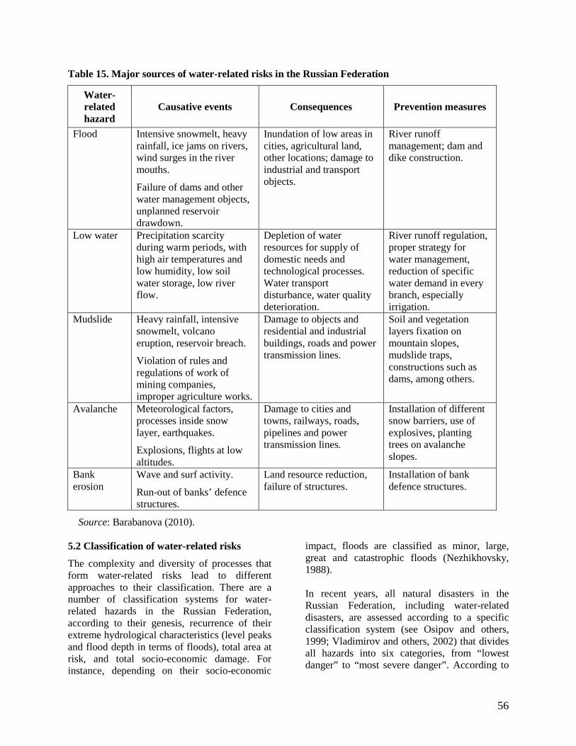
56
Table 15. Major sources of water-related risks in the Russian Federation
Water-related hazard
Causative events Consequences Prevention measures
Flood Intensive snowmelt, heavy rainfall, ice jams on rivers, wind surges in the river mouths.
Failure of dams and other water management objects, unplanned reservoir drawdown.
Inundation of low areas in cities, agricultural land, other locations; damage to industrial and transport objects.
River runoff management; dam and dike construction.
Low water Precipitation scarcity during warm periods, with high air temperatures and low humidity, low soil water storage, low river flow.
Depletion of water resources for supply of domestic needs and technological processes. Water transport disturbance, water quality deterioration.
River runoff regulation, proper strategy for water management, reduction of specific water demand in every branch, especially irrigation.
Mudslide Heavy rainfall, intensive snowmelt, volcano eruption, reservoir breach.
Violation of rules and regulations of work of mining companies, improper agriculture works.
Damage to objects and residential and industrial buildings, roads and power transmission lines.
Soil and vegetation layers fixation on mountain slopes, mudslide traps, constructions such as dams, among others.
Avalanche Meteorological factors, processes inside snow layer, earthquakes.
Explosions, flights at low altitudes.
Damage to cities and towns, railways, roads, pipelines and power transmission lines.
Installation of different snow barriers, use of explosives, planting trees on avalanche slopes.
Bank erosion
Wave and surf activity.
Run-out of banks’ defence structures.
Land resource reduction, failure of structures.
Installation of bank defence structures.
Source: Barabanova (2010). 5.2 Classification of water-related risks
The complexity and diversity of processes that form water-related risks lead to different approaches to their classification. There are a number of classification systems for water-related hazards in the Russian Federation, according to their genesis, recurrence of their extreme hydrological characteristics (level peaks and flood depth in terms of floods), total area at risk, and total socio-economic damage. For instance, depending on their socio-economic
impact, floods are classified as minor, large, great and catastrophic floods (Nezhikhovsky, 1988). In recent years, all natural disasters in the Russian Federation, including water-related disasters, are assessed according to a specific classification system (see Osipov and others, 1999; Vladimirov and others, 2002) that divides all hazards into six categories, from “lowest danger” to “most severe danger”. According to

57
this classification, insignificantly dangerous natural disasters cause insignificant harm to certain buildings, with damage up to $0.15 million. Moderately dangerous natural disasters cause moderate but seldom heavy destruction, usually result in no victims, and can cause damage up to $15 million. Dangerous natural disasters cause heavy and moderate destruction to certain local plots of terrain, single victims, with the damage up to $150 million. Fairly dangerous natural disasters cause mass-scale destructions in limited territories, human victims, with damage of up to $500 million. Extremely dangerous natural disasters cause mass-scale destruction over large territories, with many human victims, and total damage over $500 million. It is impossible to single out one classification system that suits a country. Different classification systems are used to solve different tasks (Borshch and others, 2012). Sometimes several classification schemes are used at one time.
5.3 Risks from floods
The greatest water-related risk to the socio-economic state of a region comes from floods. According to Bedritsky (2009), a flood is a spontaneous inundation of land with water that overflows river banks as a result of heavy rains, snow melting, wind surge, or effluent. The Russian Federation faces rather large hazards from floods – an area of 400,000 km2 is subjected to floods; 50,000 km2 is flooded annually. Catastrophic floods have been registered in a region where 300 cities, thousands of smaller populated areas, and 7 million ha of agricultural lands are located (Taratunin, 2008; Malik, 2003). In Table 16, the mean annual cost of damage from floods in different regions in the Russian Federation is listed. One of the most important factors is the value of unit damage per km2. This factor allows officials to conduct comparisons of floods and their consequences for the economy in different parts of the country.
Table 16. Distribution of long-term mean annual damage from floods in the Russian Federation by the end of the 20th century (costs in 1991)
River basin Damage type
Direct Total Unit (United States dollars per km2)
Northern and north-western 57.4 89.7 71.5
Volga 1 097.0 1 728.0 1 270.0
Don 388.9 606.8 1 438.0
Kuban 240.3 374.8 6 474.0 North Caucasus (excluding the Kuban River)
682.8 1 065.0 3 223.0
Ural 36.6 57.1 248.0
West Siberia 494.6 755.7 251.6
East Siberia 61.7 96.3 13.4
Transbaikal 292.1 454.9 579.8
Amur 1 041.0 1 625.0 876.0 Sakhalin and Kamchatka 195.2 304.5 544.2
Total 4 588.0 7 157.0 419.3
Source: Dobroumov and Tumanovskaya (2002).
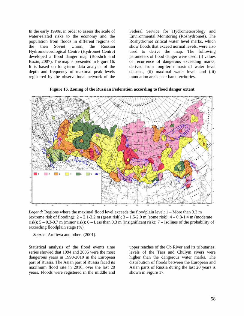
58
In the early 1990s, in order to assess the scale of water-related risks to the economy and the population from floods in different regions of the then Soviet Union, the Russian Hydrometeorological Centre (Hydromet Centre) developed a flood danger map (Borshch and Buzin, 2007). The map is presented in Figure 16. It is based on long-term data analysis of the depth and frequency of maximal peak levels registered by the observational network of the
Federal Service for Hydrometeorology and Environmental Monitoring (Roshydromet). The Roshydromet critical water level marks, which show floods that exceed normal levels, were also used to derive the map. The following parameters of flood danger were used: (i) values of recurrence of dangerous exceeding marks, derived from long-term maximal water level datasets, (ii) maximal water level, and (iii) inundation areas near bank territories.
Figure 16. Zoning of the Russian Federation according to flood danger extent
Legend: Regions where the maximal flood level exceeds the floodplain level: 1 – More than 3.3 m (extreme risk of flooding); 2 – 2.1-3.2 m (great risk); 3 – 1.5-2.0 m (some risk); 4 – 0.8-1.4 m (moderate risk); 5 – 0.3-0.7 m (minor risk); 6 – Less than 0.3 m (insignificant risk); 7 – Isolines of the probability of exceeding floodplain stage (%).
Source: Arefieva and others (2001).
Statistical analysis of the flood events time series showed that 1994 and 2005 were the most dangerous years in 1990-2010 in the European part of Russia. The Asian part of Russia faced its maximum flood rate in 2010, over the last 20 years. Floods were registered in the middle and
upper reaches of the Ob River and its tributaries; levels of the Tara and Chulym rivers were higher than the dangerous water marks. The distribution of floods between the European and Asian parts of Russia during the last 20 years is shown in Figure 17.

59
Figure 17. Flood dynamics registered by Roshydromet network
Source: Borshch and Buzin (2007). An analysis of long-term fluctuations in maximal flow and its climate factors shows that, in the last several decades, a majority of rivers have experienced increasing maximal flow (Semenov, 2011). Increases in extreme low water were also registered, which led to the increase in economic losses in water management, agriculture and water transport. 5.4 Monitoring and forecasting of water-related hazards
Hydrological gauging networks monitor the characteristics of water bodies and forecast possible water-related hazards. A hydrological network is a group of data collection gauges that collects hydrological data according to a special monitoring programme. A data station network is a basis for the development of operational forecasting and monitoring facilities. Optimal network design is defined by two basic criteria: on the one hand, it is limited by the economic effectiveness of its operation, and on the other, it must have a suitable structure (that is, a sufficient number of gauges in appropriate locations) to collect adequate data for the solving of the designed tasks. Network designers must thoroughly consider the hydrological
variables to be observed, the place and frequency of observation, accuracy of observation, and duration of the observational programme (World Meteorological Organization, 1994a, 2009). The main source for information on surface water regimes in the Russian Federation is the State network of stations and gauges of Roshydromet. There are two main types of stations in the Russian Federation: benchmark stations and operational stations. Operational stations transmit reports with measurements in operational mode to forecast centres for use in forecasting and warning systems, in order to monitor and forecast extreme hydrological events and to alert national and regional responsible governing bodies to possible risks. One of the most important factors of an observational network is network density, or the area covered per station. The design must reflect actual socio-economic and physical and climatic conditions. Minimum densities of various types of hydrological stations are recommended for different climatic and geographic zones and are listed in Guide to Hydrological Practices (World Meteorological Organization, 2009).

60
Currently, the Roshydromet hydrological network has a density of 5,250 km2 per gauge (in the United States, the area covered by one gauge is 450 km2; in Canada, 2,150 km2; and in China, 2,000 km2). However, to evaluate the density of a hydrological gauge network, it is necessary to take into account the population density. There are a number of regions in Russia where the population density values are low – more than 1 km2 per person. For this reason, it is not possible to install a dense stationary network even in case of urgent need (Borsch and others, 2012). At present, the Roshydromet hydrological network comprises 3,068 hydrological gauges: 71 per cent of them are gauges for measuring both water levels and discharge, and 29 per cent are gauges for measuring only water levels. One of the major features and advantages of hydrological forecasting in the Russian Federation is the fact that meteorological and hydrological services are combined into a single hydrometeorological service. It allows the agency to solve problems that arise during hazardous hydrological events forecasting. 5.5 Water-related risk reduction projects
Recent catastrophic floods have highlighted shortcomings in the areas of forecasting, early detecting, warning and taking preventive measures. A functioning forecasting and warning system would enable users – at the national, regional and local level – to take action to minimize flood damage and mitigate the harmful consequences. Such warning systems incorporate the following subsystems: observation of rivers, lakes and reservoirs;
information transmission to collection and processing units; primary data check and processing; forecasting and consumers supply; decision-making based on the issued forecast or warning; informing the local population about imminent flood danger and advising people on safety; educating the population before floods and hazards occur; building safety infrastructure; and mitigating flood consequences in the aftermath (World Meteorological Organization, 1994a, 1994b, 2009). The realization of two major projects – “Early detection and warning of flash hydrometeorological phenomena on the territory of South and North Caucasian federal districts” and “Risk reduction and consequence mitigation of natural and man-made emergency situations in the Russian Federation by 2015” – will result in a united forecasting and warning system for the whole region. The system will include subsystems of the main hydrometeorological network, a centre for “nowcasting” and short-range forecasts, and a communication subsystem for data collection and exchange. The first step towards increasing the region’s flood awareness was the development and implementation of the forecasting system for the Kuban River basin, situated in the south of the European part of Russia, on the western part of the northern slope of the Greater Caucasus range (Figure 18). The origin of the river is a glacier located on the western slope of Mount Elbrus, at an altitude of 3,080 m. The river’s length is 906 km, and its basin area is 57,900 km2.

61
Figure 18. River network of the Kuban River and Black Sea rivers along the Russian coast, with network of data stations
Source: Hydrometeorological Research Centre of the Russian Federation (2012).
The flood forecasting and warning system for the region was developed and implemented in 2010-2011, in the Hydrometeorological Research Centre of the Russian Federation. The mathematical methods that form the basis of the system are hydrological models: physical-statistical models for the plains part of the river basin and a semi-distributed conceptual model of flow formation for mountain watersheds. Limitations on the model lead time are a consequence of the rather low ability of numerical weather prediction models to predict convective rainfall, especially in mountainous areas (Losev, 2010).
The final products of the forecasting system are tables and maps with the forecast discharges and water levels in the Kuban River and gauges in its tributaries. The flood hazard level is labelled “no flood” if water levels are below the floodplain mark; “small flood” if the floodplain mark is exceeded; “adverse event” if the adverse mark is reached; and “dangerous event” in cases when the dangerous mark is exceeded (Figure 19). The flood forecasting and warning system for the Kuban River basin, which is in operational mode, has demonstrated its stability and the accuracy of its forecasts. The system issues forecasts twice a day, with a 48-hour lead time, and plays a significant role in

62
decreasing water-related risks from extreme floods and flash floods, and thus contributes to the safety of the region. The major output of the flood warning system is sent to the National Centre for Crisis Situation Management, which
is operated by the Ministry of the Russian Federation for Civil Defence, Emergencies and Elimination of Consequences of National Disasters (EMERCOM).
Figure 19. Kuban River basin, with levels classified by their dangerous state
Source: Hydrometeorological Research Centre of the Russian Federation (2012). A nation’s reaction to floods and other hydrological hazards can reveal problems with efforts to mitigate their effects (Vorobiev and others, 2003). Common shortcomings include a lack of regulations for managing emergency situations; insufficient training of rescue missions and other rescue personnel; and lack of training of local governments in terms of population warning and mitigation of consequences. The result is low preparedness of the local population, who are unable to react appropriately to flood warnings. Another serious issue is the absence of legal foundation for insurance of buildings and other objects damaged in floods. The majority of buildings in many flood zones are built from flimsy or weak materials, and are destroyed even in minor floods. Addressing these concerns will greatly improve the methods for dealing with the
consequences of disasters and will create more sustainable socio-economic conditions. An accurate and stable system for forecasting and providing early warning of extreme hydrological events can result in the mobilization of all responsible bodies and the local population when water-related events are forecast. Preparedness of local management, services and people significantly reduces socio-economic dangers caused by hydrological hazards and also leads to more efficient mitigation measures. Hence, forecasting and early warning systems are among the key issues in terms of reducing water-related risks.

63
6. ESCAP/WMO Typhoon Committee The Typhoon Committee is an intergovernmental body jointly established by ESCAP and the World Meteorological Organization in 1968 to promote and coordinate the planning and implementation of measures required for minimizing the loss of lives and minimizing social, economic, and environmental impacts by typhoon-related disasters in a changing climate in Asia and the Pacific. The following countries are members of the Typhoon Committee: Cambodia, China, Democratic People’s Republic of Korea, Japan,
Lao People’s Democratic Republic, Malaysia, Philippines, Republic of Korea, Singapore, Thailand, Viet Nam, and United States of America. Hong Kong, China, and Macao, China, are also members. The Typhoon Committee provides a platform for its members to exchange views on their progress and to discuss the lessons on implementation programmes through an annual session, integrated workshops and working group meetings. It develops activities under three substantive components: meteorology, hydrology, and disaster risk reduction, as well as in training and research.
Box 16. Key areas of cooperation among Typhoon Committee members
Members of the Typhoon Committee are able to take advantage of cooperation in several areas:
• Risk assessment: Identification of the impacts of the social and economic damages caused by typhoon-related disasters and more accurate and reliable information on future typhoons at the national and regional levels;
• Monitoring: Application of advanced technology, including satellite and radar technology, to monitor hazards more accurately with longer lead times;
• Forecasting and warning: Application of the multiple-model ensemble prediction system that narrows the uncertainty of forecasting, and gives warnings longer lead times;
• Dissemination: Clear, understandable warning messages to the public with advanced information communications technology, preparation of an alternative communication system, and good networking with media and national and local authorities.
The existing capacity on disaster risk reduction for Typhoon Committee members should be strengthened through enhancing the end-to-end early warning systems, including risk assessment, monitoring, forecasting and warning, and dissemination of early warnings to people at the community level. Regional cooperative programmes
The Project on Flood Hazard Mapping (FHM) is a vital component for appropriate land use planning in flood-prone areas and emergency response in real-time flood events. It creates easily readable, rapidly accessible charts and maps, which facilitate the work of decision makers, planners and dwellers in communities to
identify areas of risk and prioritize their mitigation and response efforts. Therefore, as one of the major non-structural measures for flood control, FHM plays a very important role in reducing flood-related disasters. The FHM project was concluded in 2010. Sediment-related disasters (flash floods, debris flow, mudflows and landslides) are becoming the severest threat causing the loss of lives, especially in the Asia-Pacific region, because of the extreme weather events and changing climate. The aim of the Project on Sediment-related Disaster Forecasting/Warning System is to build a framework for non-structural measures simply by using rainfall indices. A system for sediment-related disaster forecasting

64
and early warning is also considered a necessity, as it will aid decision-making during public evacuations and thus reduce damage, particularly loss of life. The project was concluded in 2010. A new Typhoon Committee project, the Urban Flood Risk Management Project, was launched with three goals: (i) to exchange and share experiences in urban flood management between the Typhoon Committee members, including technology for urban flood monitoring, forecasting and warning, (ii) to enhance capacity of urban flood risk management, and (iii) to strengthen regional cooperation on making cities more flood-resilient, considering the risks due to climate change. A new typhoon disaster Web-GIS-based data information management system, the Typhoon Committee Disaster Information System,was developed to standardize climate and disaster information and to build a disaster management and early warning system that can reduce damage from extreme events, via information sharing and research (ESCAP/WMO Typhoon Committee, 2009). 7. WMO/ESCAP Panel on Tropical Cyclones The Panel on Tropical Cyclones (PTC) is a regional intergovernmental body jointly established by WMO and ESCAP in 1973, whose main objective is to promote measures to improve tropical cyclone warning systems in the Bay of Bengal and the Arabian Sea, including dissemination of technical information on tropical cyclone research and forecasting operations to mitigate the socio-economic impacts of tropical cyclone-related disasters. Panel member countries are Bangladesh, India, Maldives, Myanmar, Oman, Pakistan, Sri Lanka and Thailand. The PTC is associated with the Tropical Cyclone Programme (TCP) of WMO, which is tasked to establish national and regionally coordinated systems to ensure that the damage and loss of life caused by tropical cyclones are reduced to a minimum. Cooperative action is at the core of the work of TCP members, particularly forecasts
and timely warnings, and promoting public awareness of warnings, such as public information and education. They provide one another with basic meteorological and hydrological data and advice to support hazard assessment and risk evaluation of disasters, as well as establishing national disaster preparedness and prevention measures. The Panel develops activities under five components: Meteorology, Hydrology, Disaster Prevention and Preparedness (DPP), Training and Research. It regularly reviews progress made in various fields, and it recommends measures to improve the multi-hazard warning systems, including training and research with regard to hydrological and meteorological disasters. It also recommends measures to improve telecommunication systems, in order to ensure the timely provision of warnings for community preparedness and disaster risk management, and it advises on possible sources of financial and technical support for necessary measures. Coordination of activities is an essential function for the improvement of capabilities and knowledge in all areas. Members undertake technical activities in meteorology, hydrology, disaster prevention and preparedness, training and research. The principal objective of the Panel’s Operational Plan is to facilitate the most effective warning system for the region, using existing facilities, and the sharing of responsibilities between member countries is defined. It also contains arrangements for standardization of operational procedures, efficient exchange and archiving of data related to disasters and issuance of weather outlooks, and procedures for the preparation, distribution and exchange of information and warnings. It is designed to serve as a readily available reference for forecasters and other users.

65
.Box 17. Strategic objectives towards enhancing capabilities of PTC members to produce and provide better hydrological forecasts and assessments
Improving their ability to provide forecasts and assessments would enable members of the Panel on Tropical Cyclones to achieve several specific objectives:
• To improve regional cooperation in real-time monitoring and exchange of relevant data and information, derived (forecasting) products and technical expertise related to hydrological hazards;
• To improve flood forecasts and warnings by coupling meteorological storm surge forecasts with river flow forecasting;
• To enhance regional capabilities relating to flood hazard mapping through continued interaction with the user agencies;
• To improve management of water resources, including assessment of surface and groundwater resources in relation to weather disturbances.
The member countries would be better able to promote disaster-resilient communities by providing guidance on dissemination of early warnings and improvement of response mechanisms. In particular, countries would improve regional cooperation in policies and strategies on DPP and establish a regional information system and database on disaster information and best practices on DPP, based on Internet web sites and other means. It is also expected that public awareness of mitigation and response actions would improve, through effective communication with the media prior to, during, and after the disasters. There should also be improvements in coordination and interaction between meteorological/hydrological services on the one hand and emergency management/disaster response agencies on the other through integrated emergency management, disaster response and preparedness programmes. Other strategic objectives are related to Research, Partnership, and Management and Governance. Research relevant to Central Asia would comprise such fields as effects of global warming, modelling of river water depth and flow, melting of snow and glaciers, and lake formation and collapse. The objective of Partnership is to promote exchange of information and data among Members and with regional bodies to enhance regional cooperation in the five components: meteorology, hydrology, DPP, training and research. And in the area of
Management and Governance, one of the objectives is to ensure effective and collaborative relationships among the meteorology, hydrology and DPP working groups. Regional cooperative programmes
A regional water-related risk management project that brings benefits to Members is the Hindu Kush-Himalayan Hydrological Cycle Observing System. The objective of the project is to implement and operate a regional flood information system, using precipitation estimates from satellites and terrestrial stations. This links to tropical cyclone activities in the subregion associated with precipitation forecasts, which are inputs to the regional flood information system and used for national operational flood forecast. The project had been developed in collaboration with the International Centre for Integrated Mountain Development and was agreed by Bangladesh, Bhutan, China, India, Nepal and Pakistan. Afghanistan and Myanmar were observers in this process (WMO/ESCAP Panel on Tropical Cyclones, 2011). 8. Sentinel Asia The Sentinel Asia initiative is a collaborative initiative between space agencies and disaster management agencies to assist disaster management in the Asia-Pacific region using remote sensing and Web-GIS technologies.

66
It promotes cooperation amongst the space community members in the Asia-Pacific Regional Space Agency Forum (APRSAF), the disaster reduction community (Asian Disaster Reduction Centre, disaster management authorities in member countries) and the international community (ESCAP, United Nations Office for Outer Space Affairs, Asian Institute of Technology, and universities, among others), in order to monitor natural disasters in the Asia-Pacific region. To support the implementation of the Sentinel Asia project, a Joint Project Team (JPT) was organized. Membership in the JPT is open to all the APRSAF members, disaster management organizations, and regional/international organizations that are prepared to contribute their experience and technical capabilities and wish to participate in technical aspects of disaster information sharing activities. Sentinel Asia uses earth observation satellites and other space technologies to collect disaster-related information, and then shares it over the Internet. The principal aims are (i) to mitigate and prevent damage caused by disasters, (ii) to improve the speed and accuracy of disaster preparedness and early warning, and (iii) to minimize the number of victims and the socio-economic losses (Japan Aerospace Exploration Agency, 2009). Its architecture is designed to operate initially as an Internet-based, node-distributed information distribution backbone, eventually distributing relevant satellite and in situ spatial information on multiple hazards in the Asia-Pacific region. Sentinel Asia received images from the Japan Aerospace Exploration Agency (JAXA) land observing satellite Daichi. Other participating earth observation satellites include IRS (ISRO), KOMPSAT-1 (KARI), THEOS (GISTDA), and FORMOSAT-2, which help assess damage caused by disasters. In addition, MTSAT, a meteorological satellite operated by the Japan Meteorological Agency, provides comprehensive coverage of the Central Asian region. MTSAT provides basic hourly imagery covering the full earth disk once every
hour on the hour. In addition, northern hemisphere imagery is collected every hour on the half hour, while southern hemisphere imagery is covered every six hours on the half hour. 8.1 Principal activities of Sentinel Asia
Sentinel Asia has two main responsibilities: (i) providing disaster-related information in the Asia-Pacific region, such as satellite imagery and satellite data products through the website, and (ii) capacity-building to develop human resources and a human network to utilize the information provided by the website. The main activities of Sentinel Asia include emergency observations for wildfire monitoring, flood monitoring, and glacier lake outburst flood information. Emergency observation by earth observation satellites: When a disaster happens, Sentinel Asia can accept an Emergency Observation Request from users, and the space agency observes the disaster stricken area by satellite. Then satellite imagery is provided to users. Sentinel Asia has so far responded to 68 disasters since its establishment. Wildfire monitoring: In order to find wildfires immediately, Sentinel Asia monitors wildfire activity by using satellite observation. The Asian Institute of Technology (AIT) in Bangkok, the University of Tokyo, the Commonwealth Scientific and Industrial Research Organization (CSIRO) in Australia, and the Centre for Remote Imaging, Sensing and Processing (CRISP) in Singapore detect the potential wildfires as hotspots by using MODIS data, and provide the hotspot information to Sentinel Asia. Sentinel Asia combines the hotspot information from various organizations, and provides the information every day. Flood monitoring: In order to support prediction of flooding, Sentinel Asia provides rainfall information. As well as rainfall information, Sentinel Asia provides Global Flood Alert System (GFAS) information from the International Centre for Water Hazard and Risk

67
Management (ICHARM), and GSMap near-real-time information from the Earth Observation Research Centre at JAXA. GFAS provides precipitation information (spatial resolution is 0.25 degrees) and statistical data. GSMap provides hourly rainfall information with a four-hour time delay, at a spatial resolution of 0.1 degrees. Capacity-building: In order to enable utilization of earth observation images provided under the Sentinel Asia initiative, Sentinel Asia provides opportunities for improving institutions’ capacity for interpretation of earth observation images and for learning how to operate the system. Capacity-building activities for technical and emergency-response agencies/users of the Sentinel Asia system are carried out by the Asian Institute of Technology and ESCAP. Other activities: Toward the more actual and practical utilization of satellite data by users themselves in the field of disaster management, Sentinel Asia conducts not only the activities mentioned above but also helps to confirm the results of earth observation, evaluates the quality of data provided by Sentinel Asia, and works to expand utilization to local organizations. 8.2 Flood Monitoring Working Group
The main activities of the Flood Monitoring Working Group are to contribute to the mitigation of flood disasters in Asia through (i) utilizing satellite, GIS and information network technologies as much as possible, (ii) enhancing the sharing of information on flood risks and disasters among national and international organization in relation to flood management, and (iii) realizing the above concepts through the Sentinel Asia system. The flood monitoring concept of Sentinel Asia involves two complementary processes: (i) rainfall monitoring and flood forecasting and (ii) flood detection and situation analysis. In both, the first three stages comprise satellite observation, processing of satellite data, and integration of the data into usable outputs, such as socio-economic data, alerts, maps of hazards and damage, and GIS data. The integrated data
is then ready for use by disaster management organizations in planning, warning, rescue and mitigation, and the information may be available to residents in the flood-prone areas, as well. Meteorological and hydrological information in various formats is available from the Flood Monitoring Working Group:
• Global satellite-based rainfall information (daily, long-term) and heavy rainfall identification;
• Global cloud cover image and its overlay;
• Global rainfall map in near real time (hourly);
• Global flood identification using AMSR-E;
• Satellite River Watch. In Sentinel Asia Step-2, the Flood Monitoring Working Group promotes the Integrated Flood Analysis System (IFAS), under the contribution with ICHARM. IFAS uses earth observation satellites to monitor rainfall and to gather near-real-time data, which is turned into maps and topographical data and GIS data concerning runoff. The data can then be downloaded free of charge over the Internet.

68
Chapter IV. The way forward 1. Information gaps for water-related risk reduction in Central Asia Given the immense amount and variety of hydrological and meteorological information – and the great diversity of interrelations between scientific, economic, social and political issues – it is understandable that there are many challenges and gaps in the process of receiving data that are accurate, timely, and compatible between countries. The basic source of indices is official State statistics. But it is difficult to provide time continuity and stability of data using these key indices. There is an urgent need for improving and expanding statistical accounts of several indices, such as GDP in internationally comparable prices; GDP by the parity of purchasing power; population mortality distinguished from deaths that directly or indirectly relate to climatic factors; and direct damage and indirect losses caused to agricultural production and other sectors by extreme weather conditions, among others. What will be the effect of climate change in the near future on the environment and economy, infrastructure and people’s livelihood? What adaptation measures should be taken when dangerous changes in the environment occur? The answers to these and other questions depend on the scale of the impacts and the adaptive capacity of the environment, and the elaboration of knowledge among the people at all levels and in all socio-economic sectors. The basis for the assessment of climate-related impacts is supported, first of all, by the scientific methods of climate observation (which adequately correspond to accepted principles of climate monitoring), and second, by the presence of “non-climatic” socio-economic data, upon which any sectoral assessment and analysis of adaptation measures is based. Often, the climate-related impacts are subtle and ambiguous, which is why, before undertaking an adaptation measure, it is necessary to assess potential climate-related damage and to correlate it to the cost of developing and implementing such a measure. Therefore, submission of data
on the current and potential future damages from climate change in diverse socio-economic sectors is an obligatory condition for approving a strategy of adaptation to climate change. 1.1 The need for socio-economic data and data on the state of the environment
The shortage and inaccessibility of specific socio-economic data from diverse sectors makes it difficult to produce an assessment of vulnerability to extreme weather events and to analyse proposals for adaptation measures. In the process of vulnerability assessment, difficulties relate to the availability of socio-economic data and the development of socio-economic scenarios in the following sectors or spheres: water resources in the run-off distribution zones, agriculture, ecosystems, and population health, among others, as well as trends in extreme weather events. 1.1.1 Systematic climate observations
To obtain authentic data on the climate it is necessary to create an adequate system of observation and data collection. In Uzbekistan, for instance, there is the basis for performing the Rio Convention obligations related to systematic observation; however, supplementary development of capacity (materials and technical support, improvement of management, and in-service training of experts) is needed. 1.1.2 Addressing the gaps
The economic factors that caused the reduction in the number of hydrometeorological observation networks also meant that they could not be supplied with devices, gauges and equipment; many countries lack sufficient funds for reorganization and development of their networks. First of all, it is necessary to restore observations in aerologic stations, to improve information collection and storage technology, and to save data and establish databases appropriate to the modern requirements, including ease of access to information. It is necessary to synchronize diverse international initiatives on strengthening of observation networks and on developing of interrelations between the States of the region. The Regional Plan of Action on Global System

69
of Climate Observation for Central Asia, regarding restoration of the work of high-mountain stations in the Aral Sea basin, still exists, but only on paper. Forecasting of river run-off would benefit from hydrometeorological information from the formation zones, as well an adequate long-term assessment of water resources, considering climate change. Exchange of regional data and historical observation series between the neighbouring countries faces difficulties, as well. A regional climatic database should be established, which would include a long-term (not less than 30 years), homogeneous series of observations of different parameters (meteorological, hydrological and glaciological) for the whole basin of the Aral Sea. The objective of having such a database is to reveal climatic changes and to assess the impacts for the whole region and for separate States, provinces, geographic districts and river basins. Undertaking meteorological and hydrological observations would comprise a number of activities and may bring about a wide array of advantages:
• Improving of interactions at the regional level;
• Making development plans for observation networks;
• Improving installation of gauges and equipment in the network;
• Technical modernization of observation production, initial data processing and communications;
• Installation of automated stations in remote areas;
• Organization of supplementary hydrological posts on trans-border rivers;
• Resumption of water-balance stations operation;
• Improving of operation of specialized meteorological stations (agro-meteorological and others);
• Improving of data processing, archiving storing;
• Organization of operations directed to data saving and recovery (re-analysis on national level);
• Improving of current databases and creating modern, open-source databases.
Improvements to aerologic observations would take place, as well:
• Recovery of aerologic observations; • Funding of station networks (equipment
and consumables); • Technical modernization and provision
of long-term functioning of stations; • Carrying out of calibration of
observations for distance flexing data applications (in a future perspective).
Table 17. Basic capacity-building needs for organizing and collecting socio-economic data
Requirements Obstacles Ways of solving / capacity-building Development and choice of sectoral and integrated indices and criteria of vulnerability
Lack / shortage of sectoral data Lack of experience Probable change of indices and criteria in processes of examination and assessment
Examination of international and regional experience Sectoral expert assessments
Development of national mechanisms for data collection and submission with the framework of UNFCCC
Lack of regulatory documents and persons responsible for implementation of UNFCCC in different establishments
Development of regulatory documents and accounting forms with participation of international coordinating organizations Appointment of persons responsible for implementation of UNFCCC
Source: Centre for Hydro-meteorological Service under the Cabinet of Ministers of Uzbekistan (2008)

70
In practically every sector, information is deficient, and data on economic damage is absent. Moreover, vulnerability indices and criteria have not been sufficiently developed, both sector-based and integrated ones, which does not allow officials to perform a complete analysis and assessment of adaptation measures. Examination and assessment of the “impact / reaction / damage / selection of measures” sequence should be based upon factual data, differentiated by the sectors, territories, and separate natural and anthropogenic objects. For this reason, it is necessary to develop recommendations, schemes and mechanisms for submission of socio-economic data, which are essential for assessment of the impact, including information on economic damage from natural calamities to the responsible national bodies. Development and introduction of international standards for statistical reports, taking into account assessment requirements, will allow officials to assess the vulnerability of economic sectors to climate-related hazards in a more reliable and authentic way and to develop more convincing adaptation measures. A common problem in the region is that internal sources for research funding are insufficient, and implementation of most international projects does not imply long-term support of research activities. However, research on climate change is essential for the solving of many tasks:
• Analysis of social, ecological, and economic consequences of climate-related hazards and related risk assessment;
• Distribution of continuously updated information on issues of climate change and related hazards;
• Development and implementation of an early-warning system to forecast dangerous calamities, related to climate (floods, droughts, thermal waves and others);
• Development of ecological education programmes to involve people in solving the problems of climate change,
and development of appropriate social behaviour;
• Maintenance of specialized training programmes at appropriate levels and on relevant subjects (ecological, hydrometeorological, and agro-climatic, among others);
• Determination of costs and benefits of potential measures, development of adaptation projects, and involvement of additional resources through international cooperation.
Floods: According to assessments, climate change is expected to increase the number of events, while the duration of hazardous periods will extend. The bottom lands of the rivers and low river terraces will be especially dangerous, owing to the possibility of shore destruction, river bed deformation, mudflow mass deposits, and the formation of gorges. Outburst risk lakes: Currently, hundreds of lakes of various origins threaten the territories of Central Asian nations. Because of global warming, the mudflow hazard after lake outbursts in the upper mountainous zones is likely to increase. Avalanches: On average, the avalanche periodicity and avalanche risk period duration due to climate change will decrease only slightly by 2050, which means that the avalanche risk remains. Moreover, the expanding development of towns and facilities in the mountainous areas increases the natural risks associated with avalanches and mudflows. Droughts: The assessment of vulnerability and analysis of adaptation measures to the increasingly frequent droughts have demonstrated that more information on their impact on socio-economic aspects is needed. In regard to all water-related hazards in the region, the following questions arise: what is the size of the territory that would be affected; what would the consequences be; what measures would be required for the mitigation of the effects? In order to answer these questions, it is necessary to expand hydrometeorological

71
monitoring, conduct research in relevant fields, and develop organizational measures. Research that would be directly related to impact assessment and adaptation measures requires capacity-building in the following areas:
• Improving hydrometeorological monitoring;
• Improving drought forecast methods; • Conducting socio-economic
consequences assessment with differentiated territory information;
• Developing programmes and plans of action aimed at drought prevention and risk reduction for the agricultural sector (ensuring preparedness for extraordinary situations, mechanisms for dissemination of information and warnings in the provinces, and preparedness of the population and administrative bodies);
• Developing a drought early warning system;
• Insuring the drought consequences. There is a need for institutional strengthening (establishment of a drought monitoring centre) and political measures (identifying joint transboundary concepts of water use in drought conditions at the regional level, and improving water resources monitoring). 1.2 Assessment of vulnerability and adaptation
The risks due to any of the events discussed above depend on the probability of the hazardous phenomena, their extent, the geography and hydrologic features of the territories where they take place, the locations of communities and farms, and the population size in each threatened region. Assessment of the location, the periodicity, and consequences of the hazardous phenomena – and the possible alterations due to climate change – is one of the priority objectives of research on disasters in Central Asia. The risk assessment of floods, mudflows and avalanches (snowslides) includes identification of the hazardous areas, probability of events and
duration of the hazardous period. Improving the assessment of the population’s vulnerability and measures for adaptation is linked with prevention (non-admission), impact mitigation (protection), and damage division (insurance). The types of activities requiring gap-filling and capacity-building are given below:
• Vulnerability assessment, which involves analysis of the variability of extreme hydrometeorological phenomena (probability of occurrence, duration of hazardous period in each territory) and their after-effects;
• Future risk assessment, in line with the climate change scenarios and application of advanced methods and tools;
• Development of large-scale maps of the current and future risk for individual phenomena in line with the needs of the various sectors (construction, transportation, recreation areas and others) for identification of the high-risk areas;
• Assessment of the potential reduction of risks via improvements in forecasting and warning.
In summary, the overall goals of vulnerability assessment and adaptation are to identify the potential for risk reduction and elimination, to identify priority activities, to implement the identified measures, and to mitigate the natural disaster consequences. 1.3 The role of insurance
A properly arranged and smoothly functioning insurance system enables reimbursement for damage caused by hazardous weather phenomena (frosts, heavy precipitation, hail, wind, hot winds, high temperatures, among others). Before damage occurs and insurance cases come forward, thorough studies of the hazardous phenomena have to be carried out by experts who are able to assess the probability of various types of damage and the costs that would be incurred by policy holders and the insurance companies. However, these criteria have not been properly studied.

72
The key need is clear, straightforward criteria of the degrees of damage caused by hazardous phenomena for the various economic sectors, based upon accurate information and considering the peculiarities of geographic regions. In this context, the guidelines, schemes and mechanisms for providing information on economic damage from the hazardous hydrometeorological phenomena need to be developed. Key restrictions and gaps in the development of the insurance system are as follows:
• Low demand for insurance services among the population, due to the lack of transparency in the insurance market;
• Poor infrastructure of the insurance market, lack of efficient agency networks, and insufficient development of priority insurance types;
• Lack of legislative basis for obligatory insurance types meeting international practice;
• Inadequate professional competence of insurance company employees.
An example of practice on promoting insurance is the programme of insurance market reform and development which was adopted in Uzbekistan for the period 2007-2010 in order to overcome existing shortcomings in the insurance service system. 1.4 Information systems
At the national level, the countries of Central Asia should expand their use of information and communication technologies. In some countries, there are databases and information systems, but they lack computer operating systems with access to the Internet, making it difficult to carry out operational monitoring during disasters. Developing information systems with high-speed access to the Internet will give the countries of Central Asia several advantages. At the national level, they will be able to do the following:
• Provide timely information to all interested users;
• More accurately determine the degree of risk and spatial distribution of hazards;
• Quickly and accurately identify the needs for emergency response;
• Determine more accurately the social and economic losses caused by the emergency.
There are similar benefits at the subregional level:
• Raise awareness in the bordering countries on the extent of an emergency;
• Increase the ability of neighbouring countries to adopt appropriate preventive measures;
• Improve the management system in the aftermath and thus reduce socio-economic losses.
At both the national and regional levels, countries need access to operational satellite data. Remote sensing images and other appropriate data will more accurately portray – and predict – the manifestation of water-related disasters and the extreme weather events that cause many of them. For the processing of satellite data using GIS technology, it is necessary to educate and train personnel in national administrations to improve the reliability and timeliness of services. At the national level, there are several requirements:
• Developing and improving information and communication technology on the basis of modern GIS and satellite data;
• Creating websites with information on floods, mudflows, glacial lakes and other phenomena, with broadband access to the Internet;
• Creating satellite monitoring systems based on existing practices in the region;
• Participating in meetings and conferences with specialists and concerned ministries and agencies, to share experiences and practical lessons;
• Training young scientists and specialists.

73
2. Common priority needs and paths towards regional cooperation in flood risk reduction Central Asia is located in an area of high exposure to seismic activity. Although earthquakes are the dominant disaster risk affecting all countries in the subregion, there were more floods and related disaster events such as mudslides in the subregion. Floods normally occur during spring and summer because of the snow and glacial melting, which increase the likelihood of landslides or mudflows. The floods and related disasters caused the highest economic losses and killed the highest number of people. It should be noted that earthquakes could have secondary effects as they could generate other hazards such as landslides, mudflows, the creation of glacial lakes and floods (Preventionweb, 2012). For instance, in Tajikistan, on 22 July 2007, an earthquake measuring 5.5 on the Richter scale hit the Asht District in the northern border of the country with Uzbekistan. It affected approximately 7,003 people, killed 11 people, and damaged more than 1,000 houses (International Federation of Red Cross and Red Crescent Societies, 2007).
Additionally, a flood occurred the same day in the same location, worsening the situation, with a further 125 people affected and 21 killed. Countries such as Afghanistan, Kyrgyzstan, Tajikistan and Uzbekistan have the highest vulnerability to earthquakes in the subregion. Droughts are not frequent but 12.9 million people were reportedly affected. The economic damage could be underestimated since they impact agriculture, decrease the population’s livelihoods, increase food insecurity, reduce employment generation opportunities, and increase poverty, among other impacts. The 2000 drought in Afghanistan, which lasted for two years, had the highest number of people affected, up to 2.5 million people. Table 18 compiles the disasters between 1990 and 2011 in the SPECA countries. The total number of weather-related hazards and earthquakes in Central Asia reached 206 events. Afghanistan was the most affected in terms of people killed, people affected, and number of events. Tajikistan accounted for the highest estimated economic damages caused by floods and extreme temperature.

74
Table 18. Disasters in SPECA countries (1990-2011)
Source: Compilation from CRED. In Central Asia, the majority of dangerous hydrometeorological phenomena are of a transboundary nature; hence, it is necessary to develop cross-border cooperation for disaster risk reduction. Each of the countries has various institutional and organizational frameworks that are responsible for monitoring and preventing the
occurrence of hazards associated with water. What is common to all countries is that national meteorological services are engaged in predicting the development of severe weather events and they conduct monitoring as regularly and extensively as possible. National hydrometeorological services are among the Government agencies that are major suppliers of forecast products.
Country
Earthquakes (1990-2011) Weather-related hazards (1990-2011)
Extreme
temperature Flood Mudslide Storm Drought
Peop
le k
illed
Afghanistan 8 673 1 889 3 362 886 362 37 Tajikistan 17 - 1 588 355 - - Kyrgyzstan 132 11 4 249 4 - Kazakhstan 3 3 57 48 112 - Azerbaijan 33 - 19 11 - - Uzbekistan 22 - - 24 - - Turkmenistan 11 - - - - -
Total 8 891 1 903 5 030 1 573 478 37
Peop
le a
ffec
ted
Afghanistan 461 310 370 884 399 157 301 736 22 661 6 510 000 Tajikistan 38 000 2 000 000 757 482 97 384 2 330 3 800 000 Azerbaijan 712 474 - 1 840 300 - - - Kyrgyzstan 154 283 - 10 623 68 161 9 075 2 000 000 Kazakhstan 36 626 600 012 119 368 - - - Uzbekistan 50 086 - 1 500 - - 600 000 Turkmenistan - - 420 - - -
Total 1 452 779 2 970 896 3 128 850 467 281 34 066 12 910 000
Est.
dam
age
(U
S$ m
illio
n)
Tajikistan 24 840 662 215 - 57 Kazakhstan - - 277 - 3 - Afghanistan 20 - 84 - 5 142 Azerbaijan 15 - 96 - - 100 Kyrgyzstan 163 - 5 38 - - Turkmenistan - - 100 - - - Uzbekistan - - - - - 50
Total 222 840 1 225 252 8 349
Num
ber o
f eve
nts
Afghanistan 23 6 57 10 5 4 Tajikistan 8 1 22 11 2 2 Kyrgyzstan 7 1 3 8 1 1 Kazakhstan 1 2 8 1 1 - Azerbaijan 3 - 7 1 - 1 Uzbekistan 2 - 1 1 - 1 Turkmenistan 1 - 1 - - -
Total 45 10 99 32 9 9

75
In all countries, there is a lack of equipment for early warning and monitoring, particularly in terms of information and communication technologies. Lack of operational satellite data and lack of specialized centres for data processing make it difficult to monitor events promptly or in real time. The use of GIS technology is underdeveloped. Central Asian countries do not have a common system for rapid exchange of information during emergency situations on rivers, leading to an increased risk of catastrophic consequences. Existing systems are not sufficiently equipped or extensive enough to fully and accurately assess damage due to floods, mudslides and other hazards associated with water. The development of cooperation on the basis of existing regional projects, using best practices, would be an appropriate step to take. 2.1 Ground monitoring networks
Central Asia has an insufficiently developed network for ground observation of hydrological objects that pose a threat; this fact is particularly important with regard to the cross-border effects of hazardous hydrological phenomena. As is indicated in the country reports, the outbreaks of glacial lakes or the occurrences of mudflows may occur in one country, but the effect is often manifested in the neighbouring countries and leads to significant damage. At the same time, however, monitoring the entire country is not economically feasible, owing to the high costs of the observing systems. In this regard, it is necessary to develop monitoring systems that have a structure of cooperation between the countries. On this point, regional cooperation under the umbrella of international organizations is of immense value and would provide a greatly expanded perspective on conditions in the region and beyond. 2.2 Monitoring of potential glacial lake outbursts through satellites
In Central Asia there are many potentially dangerous and developing hazards – such as
glacial lakes and outbreak lakes – and monitoring them is difficult because of inaccessibility. Objects that are themselves small in size have an enormous potential threat in the event of their destruction. Dammed lakes, in particular, have an unpredictable and dynamic character, such as changes in volume and corresponding area of the surface. There are also systems of moraine lakes formed by large glaciers. The existence of such a system of lakes depends on the regime of the glacier. In this case, the system may change dramatically over time. Some lakes can disappear in consequence of increased filtration through the detrital material, and in other lakes, melt water can accumulate, with the subsequent risk of an outbreak. Systematic monitoring of glacial lakes in Central Asia demands access to high-resolution satellite images for early prediction of a dangerous situation. Satellite images have the added advantage that they can be used to monitor hazards in and risks to neighbouring countries. 2.3 Communication links between the countries
Priorities for the countries include the rapid exchange of information on the origin and development of emergency situations using information-switching technology. At the moment, the communication system in Central Asia is based principally on telephone transmission lines, which means that the warning system may be too slow for timely action. Moreover, the phone lines themselves may be damaged and disrupted as a result of the hazard. With this in mind, it is imperative to establish a system for exchanging information through communication satellites. Furthermore, language barriers between countries must be taken into account. The information exchange system should use a unified system of coding and common symbols to make information sharing more efficient. For the purposes of damage assessment and taking appropriate action, it is necessary to develop warning systems through the Internet. In this

76
case, the information can be distributed even when normal telephone lines are broken. Installation of a system for exchange of operational information between countries on the basis of new technologies would significantly reduce the risk of exposure to hazardous processes. 2.4 Regional cooperation in disaster risk reduction
With high vulnerability coupled with relatively small economies, regional cooperation holds considerable ground for more efficient and cost-effective collective efforts for disaster risk reduction. The development of a mechanism for effective exchange of information and best practices will strengthen national capacities to mitigate the risks associated with water-related hazards and the effects of extreme weather events. The setting up of a subregional network for sharing information and knowledge will improve disaster risk reduction in the subregion. The subregional network will connect the Governments in Central Asia and neighbouring
countries, the National Disaster Management Authorities and relevant institutions that are mandated to address disaster risk reduction in their respective sector, and the development agencies that need to share knowledge and exchange data and information on various aspects of cross-boundary hazards and risk management. Regional cooperation in disaster risk reduction and management can be promoted through the United Nations Special Programme for the Economies of Central Asia (SPECA) framework. The framework of SPECA could provide the necessary platform to support the subregional network for information sharing on disaster risk reduction and management, and the provision of SPECA countries to access satellite data by incorporating the exchange of information into a single network. In addition, organizing seminars and training courses for professionals will build regional capacity in flood forecasting and water-related disaster risk management by improving the monitoring and forecasting of extreme weather conditions.

77
References
Afghanistan, Ministry of Economy (2010). Poverty status in Afghanistan: a profile based on National Risk and Vulnerability Assessment (NRVA) 2007/08. World Bank, Economic Policy & Poverty Sector, South Asia Region. Available from http://reliefweb.int/sites/reliefweb.int/files/resources/Full_Report_3605.pdf.
Afghanistan Disaster Knowledge Network (2009). Country Profile.
Afghanistan National Disaster Management Authority (n.d.). Afghanistan National Disaster Management Authority Role in National Commission. Available from www.andma.gov.af/Contents/296/Documents/145/ANDMA2.pdf.
__________ (2011). Afghanistan Strategic National Action Plan (SNAP) for disaster risk reduction: towards peace and stable development. Available from www.andma.gov.af/Contents/295/Documents/223/SNAP%20Final%20version.pdf.
Arefieva, O.N., and others (2001). Floods. In Natural Hazards in Russia, vol. 5: Hydrometeorological Hazards, G.S. Golitsin and A.A. Vasiliev, eds. Moscow.
Atlas of Natural and Man-made Hazards and Risks from Emergency Situations in the Russian Federation (2010). Moscow. [In Russian].
Barabanova, E.A. (2010). Emergency situations of a hydrological nature in the territory of Russia. In Extreme Hydrological Situations, pp. 33-56. Moscow. [In Russian].
Bedritsky, A.I., ed. (2009). Russian Hydrometeorological Encyclopaedia Dictionary, Volume II. Moscow. [In Russian].
Beekma, Jelle, and Joel Fiddes (2011). Floods and droughts: The Afghan water paradox. Afghanistan Human Development Report 2011 Research Paper. Available from www.cphd.af/Downloads/Background%20Papers/Flood%20and%20drought%20-%20The%20Afghan%20water%20paradox.pdf.
Blagoveshenskiy, V.P. (1997). Assessment of avalanche risk. MSI. 82nd ed., pp. 165-167.
Borshch, S.V., and V.A. Buzin (2007). Forecasts of extreme hydrological characteristics for the warning systems of the hazardous hydrological events. In Prediction and Adaptation of Society to Extreme Climate Changes, pp. 114-127. Plenary lectures of the International Conference on the Problems of Hydrometeorological Security. Moscow, 26-29 September 2006. Moscow: Hydrometeorological Centre of Russia. [In Russian].
Borshch, S.V., and others (2012). Floods. In Assessment Methods of Climate Change Consequences for Physical and Biological Systems, pp. 87-125. Moscow. [In Russian].
Centre for Research on the Epidemiology of Disasters (2012). EM-DAT: the OFDA/CRED International Disaster Database. Brussels: Université Catholique de Louvain. Available from www.emdat.be/database.
Child Fund International (2008). Afghanistan: extreme weather leads to emergency. Available from www.childfund.org/media/articles/archives/CCF_archives/2008-2009_archives/Afghanistan_Extreme_Weather_Leads_to_Emergency.aspx.
Chub, V.E. (2007). Climate change and its impact on hydrometeorological processes, agricultural climatic and water resources of the Republic of Uzbekistan. Tashkent.

78
Chub, V.E., and G.N. Trofimov (2007). Assessment of the mudflow danger on the territory of the Republic of Uzbekistan under various scenarios of climate change. Climate Scenarios, Climate Change Impact Assessment, Bulletin, No. 6, pp. 66-70. Tashkent: NIGMI.
Climate and Development Knowledge Network (2012). Managing Climate Extremes and Disasters in Asia: Lessons from the IPCC SREX Report. Available from http://cdkn.org/wp-content/uploads/2012/05/SREX-Lessons-for-Asia-revised-final-copy.pdf.
Djuraev, A.D., S.G. Chanysheva, and O.I. Subbotina, eds. (1977). Hazardous Hydrometeorological Phenomena in Central Asia. Leningrad: Gidrometeoizdat (Hydrometeorological Publishing House).
Dobroumov, B.M., and S.M. Tumanovskaya (2002). Floods on the Russian rivers: generation and zoning. Russian Meteorology and Hydrology, No. 12, pp. 70-78.
ESCAP/WMO Typhoon Committee (2009). Working Groups: The Disaster Risk Reduction Group. Available from www.typhooncommittee.org/wgdpp.htm.
Eurasian Development Bank, Almaty (2011). Safety of Hydro-technical Facilities in Central Asia: Challenges and Solution Approaches. Report by the Executive Committee of International Fund for Aral Salvation. March 2011.
European Commission Directorate-General for Humanitarian Aid – ECHO (2006). Emergency humanitarian aid for the victims of drought in Afghanistan. Available from http://reliefweb.int/sites/reliefweb.int/files/resources/386970C011DDCFC3852572CE006F0D46-Full_Report.pdf.
Federal Service for Hydrometeorology and Environmental Monitoring (2008). Assessment Report on Climate Change and Its Consequences in the Russian Federation. No. 2: Consequences of Climate Change. Moscow: Roshydromet. [In Russian].
Food and Agriculture Organization (2011). Afghanistan Proposals: FAO emergency and Rehabilitation Assistance. Available from www.fao.org/fileadmin/templates/tc/tce/pdf/CAP2011_Afghanistan.pdf.
Helminen, Marjut (2002). Mongolia: Serious drought in Mongolia causes difficulties for herders. Reliefweb, 10 September. Available from http://reliefweb.int/node/109249.
International Federation of Red Cross and Red Crescent Societies (2007). Tajikistan: earthquake and floods. Information Bulletin, No. 1 (23 July). Available from http://reliefweb.int/sites/reliefweb.int/files/resources/4EA1136C8C161AC9852573210066DDDC-Full_Report.pdf.
Japan Aerospace Exploration Agency (2009). Sentinel Asia. Available from http://dmss.tksc.jaxa.jp.
Koronkevich, N.I., and others (2010). Main ideas of extreme hydrological situations. In Extreme Hydrological Situations, pp. 12-32. Moscow. [In Russian].
Lang, Kevin (2007). Poverty and Discrimination. Princeton, NJ: Princeton University Press.
Losev, V.M. (2010). Regional hydrodynamic model of the Hydromet Centre of Russia. In Eightieth Anniversary of the Hydromet Centre of Russia, pp. 36-58. Moscow.
Malik, L.G. (2003). Reasons and consequences of floods. In Safety of Power Facilities, Issue 11: Hydrological safety and environmental protection and population from floods, pp. 50-74. Moscow. [In Russian].
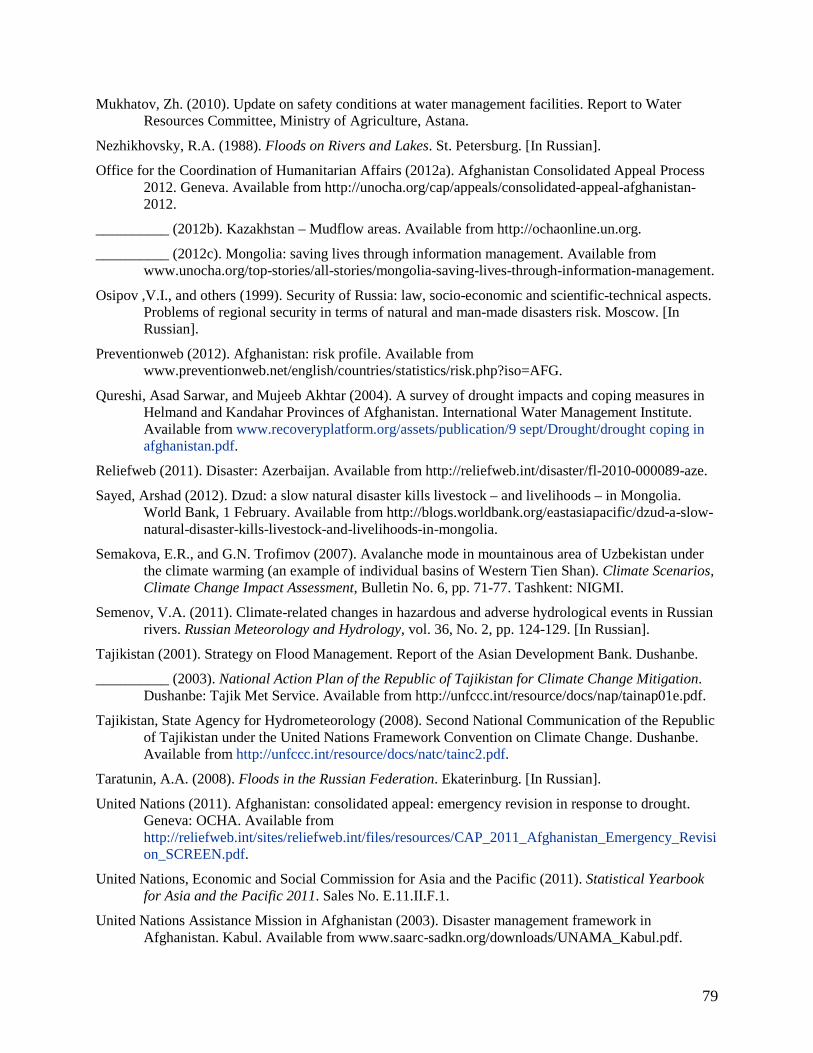
79
Mukhatov, Zh. (2010). Update on safety conditions at water management facilities. Report to Water Resources Committee, Ministry of Agriculture, Astana.
Nezhikhovsky, R.A. (1988). Floods on Rivers and Lakes. St. Petersburg. [In Russian].
Office for the Coordination of Humanitarian Affairs (2012a). Afghanistan Consolidated Appeal Process 2012. Geneva. Available from http://unocha.org/cap/appeals/consolidated-appeal-afghanistan-2012.
__________ (2012b). Kazakhstan – Mudflow areas. Available from http://ochaonline.un.org.
__________ (2012c). Mongolia: saving lives through information management. Available from www.unocha.org/top-stories/all-stories/mongolia-saving-lives-through-information-management.
Osipov ,V.I., and others (1999). Security of Russia: law, socio-economic and scientific-technical aspects. Problems of regional security in terms of natural and man-made disasters risk. Moscow. [In Russian].
Preventionweb (2012). Afghanistan: risk profile. Available from www.preventionweb.net/english/countries/statistics/risk.php?iso=AFG.
Qureshi, Asad Sarwar, and Mujeeb Akhtar (2004). A survey of drought impacts and coping measures in Helmand and Kandahar Provinces of Afghanistan. International Water Management Institute. Available from www.recoveryplatform.org/assets/publication/9 sept/Drought/drought coping in afghanistan.pdf.
Reliefweb (2011). Disaster: Azerbaijan. Available from http://reliefweb.int/disaster/fl-2010-000089-aze.
Sayed, Arshad (2012). Dzud: a slow natural disaster kills livestock – and livelihoods – in Mongolia. World Bank, 1 February. Available from http://blogs.worldbank.org/eastasiapacific/dzud-a-slow-natural-disaster-kills-livestock-and-livelihoods-in-mongolia.
Semakova, E.R., and G.N. Trofimov (2007). Avalanche mode in mountainous area of Uzbekistan under the climate warming (an example of individual basins of Western Tien Shan). Climate Scenarios, Climate Change Impact Assessment, Bulletin No. 6, pp. 71-77. Tashkent: NIGMI.
Semenov, V.A. (2011). Climate-related changes in hazardous and adverse hydrological events in Russian rivers. Russian Meteorology and Hydrology, vol. 36, No. 2, pp. 124-129. [In Russian].
Tajikistan (2001). Strategy on Flood Management. Report of the Asian Development Bank. Dushanbe.
__________ (2003). National Action Plan of the Republic of Tajikistan for Climate Change Mitigation. Dushanbe: Tajik Met Service. Available from http://unfccc.int/resource/docs/nap/tainap01e.pdf.
Tajikistan, State Agency for Hydrometeorology (2008). Second National Communication of the Republic of Tajikistan under the United Nations Framework Convention on Climate Change. Dushanbe. Available from http://unfccc.int/resource/docs/natc/tainc2.pdf.
Taratunin, A.A. (2008). Floods in the Russian Federation. Ekaterinburg. [In Russian].
United Nations (2011). Afghanistan: consolidated appeal: emergency revision in response to drought. Geneva: OCHA. Available from http://reliefweb.int/sites/reliefweb.int/files/resources/CAP_2011_Afghanistan_Emergency_Revision_SCREEN.pdf.
United Nations, Economic and Social Commission for Asia and the Pacific (2011). Statistical Yearbook for Asia and the Pacific 2011. Sales No. E.11.II.F.1.
United Nations Assistance Mission in Afghanistan (2003). Disaster management framework in Afghanistan. Kabul. Available from www.saarc-sadkn.org/downloads/UNAMA_Kabul.pdf.

80
__________ (2004). Proposed strategy for institutional strengthening in disaster risk management in Afghanistan. Available from http://www.saarc-sadkn.org/downloads/Report_UNAMA_IRoA_ADB.doc
United Nations Development Programme (2004a). Water resources of Kazakhstan in the new millennium. Report No. UNDPKAZ 07. Almaty. Available from www.undp.kz/library_of_publications/files/2496-19223.pdf.
__________ (2004b). Reducing Disaster Risk: A Challenge for Development – A Global Report. New York: UNDP Bureau for Crisis Prevention and Recovery. Available from www.preventionweb.net/files/1096_rdrenglish.pdf.
__________ (2011). Afghanistan: national disaster management programme. Available from www.undp.org.af/whoweare/undpinafghanistan/Projects/psl/prj_ndmp.htm.
United Nations International Children's Emergency Fund (2010). Map of Dzud-Affected Areas of Mongolia. Available from www.unicef.org/eapro/Map_of_Dzud-affected_areas.pdf.
United States, Department of State (2011). Background Note: Afghanistan.
Uzbekistan, Centre of Hydrometeorological Service (2008). Second National Communication of the Republic of Uzbekistan under the United Nations Framework Convention on Climate Change. Tashkent.
Vladimirov, V.A., Yu.L. Vorobiev, and V.I. Osipov, eds. (2002). Natural Hazards in Russia, Vol. 1: Natural Hazards and Society. Moscow.
Vorobiev, Yu.L., V.A. Akimov, and Yu.I. Sokolov (2003). Catastrophic Floods in the Beginning of the 21st Century: Lessons and Conclusions. Moscow. [In Russian].
World Bank, and United Nations (2010). Natural Hazards, UnNatural Disasters: The Economics of Effective Prevention. Washington, D.C.: International Bank for Reconstruction and Development. Available from www.gfdrr.org/gfdrr/node/281.
WMO/ESCAP Panel on Tropical Cyclones (2011). Coordinated technical plan (2009-2011). Available from www.ptc-wmoescap.org/PTC Coordinated Technical Plan 2009-2011.doc.
World Meteorological Organization (1994a). Guide to Hydrological Practices: Data Acquisition and Processing, Analysis, Forecasting and Other Applications. 5th ed. WMO No.168. Geneva. Available from www.bom.gov.au/hydro/wr/wmo/guide_to_hydrological_practices/WMOENG.pdf.
__________ (1994b). The legal basis and role of hydrological services. Technical Reports in hydrology and water resources No. 40, WMO/TD-No. 602. Geneva.
__________ (2009). Guide to Hydrological Practices, Volume II: Management of Water Resources and Application of Hydrological Practices. 6th ed. WMO No.168. Geneva. Available from www.whycos.org/chy/guide/168_Vol_II_en.pdf.

81
List of tables 1. Flood events in Central Asian countries (2000-2009) 2. Drought events in Central Asian countries (2000-2009) 3. Disasters in Afghanistan (1960-2011) 4. Most significant disasters, by number of deaths 5. Most significant disasters, by people affected 6. Annual flow per basin (population and cubic metres per capita) 7. Disasters in Azerbaijan (1990-2011) 8. Disaster timeline in Azerbaijan (1990-2011) 9. Hydrological hazards occurring in Kazakhstan (2000-2008) 10. Hydrometeorological and geological hazards reported in Kazakhstan (2002-2011) 11. Water management sections within Kazakhstan 12. Extreme weather events losses in Tajikistan 13. Climate-related disasters in Mongolia (1960-2011) 14. Most important disasters, by people affected 15. Major sources of water-related risks in the Russian Federation 16. Distribution of long-term mean annual damage from floods in the Russian Federation by the end of
the 20th century (costs in 1991) 17. Basic capacity-building needs for organizing and collecting socio-economic data 18. Disasters in SPECA countries (1990-2011)
List of figures 1. A typical glacial lake in the Zaravshan River basin (Tajikistan and Uzbekistan) 2. Natural disaster occurrences in Afghanistan (1960-2011) 3. Cereal production deficits (1999-2011) 4. Natural disaster occurrences in Azerbaijan (1990-2011) 5. Kazakhstan – Mudflow areas 6. A schematic map of landslide hazard prediction 7. Map of avalanche danger zones in Kyrgyzstan 8. Map of mudflow hazard zones 9. Flood risks associated with glaciers in Tajikistan 10. Drought index and areas of severe drought 11. Number of mudflows in Uzbekistan for the period 1900-2008 12. Barrier lakes on the river basins Pskem, Koksu, Chatkal and Akhangaran – Uzbekistan territory 13. Avalanche damage distribution in Uzbekistan 14. Climate-related disaster occurrences in Mongolia (1960-2011) 15. Map of dzud-affected areas 16. Zoning of the Russian Federation according to flood danger extent 17. Flood dynamics registered by Roshydromet network 18. River network of the Kuban River and Black Sea rivers along the Russian coast, with network of data
stations 19. Kuban River basin, with levels classified by their dangerous state
List of boxes 1. Projects to prevent water-related hazards in Kazakhstan 2. Purpose of State regulation 3. Principles of safety monitoring tools 4. Programme needs in Kazakhstan

82
5. Elements of a unified monitoring system for the environment and natural resources 6. Landslide prevention in Osh, Jalal-Abad and Batken, Kyrgyzstan 7. Mudflow prevention in Osh, Jalal-Abad and Batken 8. Anti-avalanche actions in Naryn, Issyk-Kul and Chui 9. Dam construction 10. Mitigating the effects of water-related hazards in Uzbekistan 11. Tasks of hydrological monitoring 12. Data for a warning network in China 13. Flood Management Information System, Bihar, India 14. Disaster Management Support Programme at ISRO 15. Preparation for and management of floods in Pakistan 16. Key areas of cooperation among Typhoon Committee members 17. Strategic objectives towards enhancing capabilities of PTC Members to produce and provide better
hydrological forecasts and assessments