community wildfire planning and design: a review and
TRANSCRIPT

Utah State University Utah State University
DigitalCommons@USU DigitalCommons@USU
All Graduate Theses and Dissertations Graduate Studies
12-2017
Community Wildfire Planning and Design: A Review and Community Wildfire Planning and Design: A Review and
Evaluation of Current Policies and Practices in the Western United Evaluation of Current Policies and Practices in the Western United
States States
Carlene C. Klein Utah State University
Follow this and additional works at: https://digitalcommons.usu.edu/etd
Part of the Landscape Architecture Commons
Recommended Citation Recommended Citation Klein, Carlene C., "Community Wildfire Planning and Design: A Review and Evaluation of Current Policies and Practices in the Western United States" (2017). All Graduate Theses and Dissertations. 6921. https://digitalcommons.usu.edu/etd/6921
This Thesis is brought to you for free and open access by the Graduate Studies at DigitalCommons@USU. It has been accepted for inclusion in All Graduate Theses and Dissertations by an authorized administrator of DigitalCommons@USU. For more information, please contact [email protected].

COMMUNITY WILDFIRE PLANNING AND DESIGN: A REVIEW AND
EVLAUATION OF CURRENT POLICIES AND PRACTICES
IN THE WESTERN UNITED STATES
by
Carlene C. Klein
A thesis submitted in partial fulfillment of the requirements for the degree
of
MASTER OF LANDSCAPE ARCHITECTURE
Approved: ______________________ ____________________ Barty Warren-Kretzschmar, Ph.D. Richard E. Toth Major Professor Committee Member ______________________ ____________________ Carlos V. Licon, Ph.D. Mark R. McLellan, Ph.D. Committee Member Vice President for Research and Dean of the School of Graduate Studies
UTAH STATE UNIVERSITY Logan, Utah
2017

ii
Copyright © Carlene C. Klein 2017
All Rights Reserved
iii
ABSTRACT
Community Wildfire Planning & Design: A Review and Evaluation of Current Policies
and Practices in the Western United States
by
Carlene C. Klein, Master of Landscape Architecture
Utah State University, 2017
Major Professor: Dr. Barty Warren-Kretzschmar Department: Landscape Architecture and Environmental Planning
Wildland fire is an important and complex issue, particularly in the fire-prone
ecosystems of the Western United States. At the same time that the number of
catastrophic wildland fires is increasing across the United States, more people are moving
into at-risk areas across the West, growing the interface between urban and wildlands.
Communities in this wildland-urban interface are the most at risk of wildland fire and the
protection of communities in these high-risk areas accounts for the largest percentage of
fire suppression costs. Scientific knowledge of risk, perceptions, and management of
wildfire is numerous and well researched. However, the extent to which professionals
charged with the planning and design of communities at risk of wildfire incorporate best
available research in the development of these communities is unclear. Therefore, the
purpose of this study is first, conduct a state of the art review exploring the fundamentals
of wildfire and the benefits and limitations of current community planning and design
practices that are being employed at the federal, state and local levels. Second, the aim is

iv
to evaluate these current approaches employed at the various levels through case study
research. Knowledge of the best practices supported in both best-available research and
current practice will provide the foundation for the development of a framework for
planning and design decision-making to improve the resilience of Western communities
in the face of wildfire.
(201 pages)

v
PUBLIC ABSTRACT
Community Wildfire Planning & Design: A Review and Evaluation of Current Policies
and Practices in the Western United States
Carlene C. Klein
Wildland fire is an important and complex issue, particularly in the fire-prone
ecosystems of the Western United States. At the same time that the number of
catastrophic wildland fires is increasing across the United States, more people are moving
in to wildland areas growing the interface between urban and wildlands. Managing
wildfire in the Western United States is becoming increasingly more complex and costly
as growth and development continues to push the edge of municipalities into
undeveloped wildlands. Communities in this wildland urban interface are exacerbating
the problem of wildfire in the West.
With more people living in wildfire prone areas and changes facing our climate,
the occurrence of catastrophic wildfire in the U.S., particularly in the West, is only
expected to increase. It is unrealistic to rely on voluntary actions to address the problem
of development in wildfire prone ecosystems. Greater understanding of the ways we can
build our communities to live with wildfire and using this understanding to guide
planning and design decisions will be necessary to improve community resilience to
wildfire in the West. Planners and designers will play a key role because these
professionals have unique opportunity to address development in areas at-risk of wildfire
before the need or want for development occurs.
In order to improve the resilience of Western communities to wildfire, the current
state of wildfire science and planning must be known to identify the gaps between best
available science and practice and improve the development of communities at risk of
wildfire. Therefore, the first objective of this study was to conduct a comprehensive
literature review, and the second objective was to use key findings from the literature

vi
review to inform a framework to guide planning and design decisions in wildfire prone
communities. The intent of the state of the art review was to provide a critical
examination of both best available, peer-reviewed wildfire literature and the current
strategies communities in the Western United States are employing to address the
growing threat of wildland fire.
Knowledge of the benefits and limitations of the current state of community
wildfire planning and design in the fire-prone ecosystems of the West helped identify
where community resilience could be improved. Beneficial community wildfire planning
and design strategies provided the foundation for a planning and design audit. The goal of
this audit was to evaluate a community’s preparedness for wildfire, which was assessed
based on reduction of losses to life and property. This audit was tested using two Western
communities: one that successfully reduced its risk of wildfire and one that was
unsuccessful. The wildfire planning and design audit provides a checklist for planners
and designers to ensure future growth and development reflects wildfire risk.

vii
ACKNOWLEDGMENTS
First and foremost, I would like to thank my committee for their mentorship and
encouragement. The following individuals were instrumental in the completion of this
thesis: Barty Warren-Kretzschmar, Carlos Licon and Richard Toth. I would also like to
thank the faculty and staff in the Department of Landscape Architecture for their
important insight along the way. Lastly, I would like to thank my family for their love
and support.
Carlene C. Klein

viii
CONTENTS
Page
ABSTRACT ........................................................................................................... iii
PUBLIC ABSTRACT ............................................................................................ v
ACKNOWLEDGMENTS .................................................................................... vii
LIST OF TABLES .................................................................................................. x
LIST OF FIGURES .............................................................................................. xii
CHAPTER I. INTRODUCTION ............................................................................................... 1
Wildfire is a Critical Issue ................................................................................ 1 More People are Moving to Wildfire-Prone Areas ........................................... 2 Managing Wildfire Prone Areas is Complex and Costly .................................. 3 Fuel treatments and Fire Prevention Methods Only Go So Far ........................ 4 Planners and Designers Need to be a Part of the Solution ................................ 4
II. OBJECTIVES ................................................................................................... 6 Purpose .............................................................................................................. 6 Research Questions ........................................................................................... 7 Significance....................................................................................................... 8
III. LITERATURE REVIEW .............................................................................. 10 Wildfires in the West ...................................................................................... 11 Development in the West ................................................................................ 25 The Wildland Urban Interface ........................................................................ 32 Responsibility in the Wildland Urban Interface ............................................. 46 Findings and Conclusions of the Literature Review ....................................... 51
IV. METHODOLOGY ........................................................................................ 55 Procedures and Design .................................................................................... 55 Methodology Limitations................................................................................ 65
V. STATE OF THE ART REVIEW ..................................................................... 67 Federal Policies, Acts and Strategies .............................................................. 67 State Statutes, Codes and Legislation ............................................................. 84 Local Ordinances, Standards and the Site Plan Review ................................. 96

ix
VI. KEY FINDINGS AND COMMUNITY APPLICATION .......................... 132 Current Wildfire Planning Policies and Practices ......................................... 132 Benefits and Limitations of Current Community ......................................... 134 Wildfire Planning and Design ....................................................................... 134 Community Development in At-Risk Areas Audit ....................................... 137
VII . CASE STUDY VERIFICATION .............................................................. 142 Stevenson Ranch ........................................................................................... 142 Scripps Ranch ............................................................................................... 148 Summary of the Case Study Evaluation ....................................................... 154
CONCLUSION ................................................................................................... 158
GLOSSARY ....................................................................................................... 161
REFERENCES ................................................................................................... 167
APPENDICES Appendix A. State Codes Relevant to Wildfire and Development ............... 180 Appendix B NFPA 1144 Wildland Fire Risk Checklist ............................... 183 Appendix C. International Wildland-Urban Interface
Code Fire Hazard Severity Form ............................................................ 186 Appendix D. Sample Legislation for Adoption of the International
Wildland-Urban Interface Code .............................................................. 187 Appendix E. Pacific Southwest Fire Regime Groups, 2001 ......................... 188

x
LIST OF TABLES
Table Page
1 Fire Causes and Number of Acres Burned in the West .................................. 17
2 Significant Western Wildfires Resulting in Life and Property Loss .............. 31
3 Western States Wildland Urban Interface 2000.............................................. 38
4 Case Study Contextual Information ................................................................ 63
5 Summary of Federal Policies, Acts and Strategies ......................................... 78
6 Evaluation of Federal Policies, Acts and Strategies ....................................... 83
7 Summary of State Statutes, Codes and Legislation ........................................ 91
8 Evaluation of State Statutes, Codes and Legislation ...................................... 95
9 Wildfire Hazard Element Example ............................................................... 100
10 Example of a Subdivision Ordinance in Wildfire Prone Areas ................... 108
11 Example of a Vegetation Management Ordinance ...................................... 112
12 Summary of Local Ordinances, Standards and Site Plan Reviews .............. 124
13 Evaluation of Local Ordinances, Standards and Site Plan Reviews ............ 130
14 Benefits and Limitations of Current Federal, State and Local Community
Wildfire Planning and Design ..................................................................... 135
15 Federal Policies, Acts and Strategies Audit ................................................. 138
16 State Statutes, Codes and Legislation Audit ................................................ 138
17 Local Ordinances, Standards and Site Plan Review Audit .......................... 139
18 Example of a Site Plan Review Checklist for Development in
Wildfire Prone Areas ................................................................................... 140

xi
19 Stevenson Ranch Contextual Information ................................................... 143
20 Federal Initiatives Relevant to Stevenson Ranch......................................... 144
21 State Objectives Relevant to Stevenson Ranch ........................................... 145
22 Local Objectives Relevant to Stevenson Ranch .......................................... 146
23 Scripps Ranch Contextual Information ........................................................ 149
24 Federal Objectives Relevant to Scripps Ranch ............................................ 151
25 State Objectives Relevant to Scripps Ranch ................................................ 151
26 Local Objectives Relevant to Scripps Ranch ............................................... 152
27 Decision-making Differences between Stevenson
Ranch vs. Scripps Ranch ............................................................................. 155
28 Key Terms .................................................................................................... 161
29 State Codes Relevant to Wildfire and Development ................................... 180

xii
LIST OF FIGURES
Figure Page
1 Process Diagram ............................................................................................... 9
2 Wildfire Hazard Potential ............................................................................... 16
3 Historical Fire Regime Groups ....................................................................... 20
4 Percent area within each U.S. county disturbed by wildfire ........................... 21
5 Acres Burned by Wildfire in the West ............................................................ 21
6 Housing Density Change in the United States ................................................ 27
7 Structures lost to wildfires 1999 - 2011 .......................................................... 30
8 Wildland Urban Interface Categories ............................................................. 35
9 The Western Wildland Urban Interface in 2000 ............................................. 37
10 The mean number of fire stations per 100sq. miles in Western counties ...... 40
11 Methodology Diagram ................................................................................... 56
12 Counties that have County Level CWPPs or community CWPPs within ..... 73
13 Example of an Urban Growth Boundary ..................................................... 103
14 Example of a Wildfire Hazard Overlay District .......................................... 106
15 Example of Inadequate Resident Egress ...................................................... 116
16 Example of Building Features to Reduce Wildfire Risk ............................. 118
17 Example of State Recommendations for Plant Selection ............................ 119
18 Policies and Practices Guiding Community Development
in the Western U.S. ....................................................................................... 133
19 Stevenson Ranch, 2004 ................................................................................ 142

xiii
20 Scripps Ranch 2003 ..................................................................................... 148
21 NFPA 1144 Wildland Fire Risk Checklist................................................... 185
22 International Wildland-Urban Interface Code Fire Hazard Severity Form . 186
23 Sample Legislation for Adoption of the International Wildland-Urban
Interface Code ............................................................................................... 187
24 Wildfire Context Map of Case Study Communities .................................... 188

1
CHAPTER 1
INTRODUCTION
Wildfire is naturally reoccurring natural hazard with significant consequences for
lives and property, most notably in the fire prone landscapes of the West. As the number
of devastating wildfires occurring across the West continues to increase, the West is also
experiencing accelerated growth rates. This growth and development is pushing the edge
of urban areas into in to wildfire prone areas, complicating and increasing the costs of the
management of these hazardous areas. Consensus exists within the wildfire management
circles that pre-fire fuel treatments and suppression are important to mitigate wildfire
risks to communities. However, even with modern advancements in suppression
technology and fuel treatments that have produced the most effective firefighting
capabilities in history, the total amount of the landscape burned each year in the West
continues to increase. Therefore, it is becoming more and more imperative that planners
and designers understand and implement best practices for development in wildfire prone
areas in order to help create fire resilient communities that reduce risk to wildfire and
minimize losses of life and property.
Wildfire is a Critical Issue
Wildfire is an important issue facing communities in the United States,
particularly in the West as the occurrence of large wildland fires is increasing. The annual
area burned by wildfires has increased across the U.S. during the last few decades, with
the most dramatic increases in the fire-prone ecosystems of the Western United States
(Schoennagel, Veblen, & Romme, 2004). In 2012, 7.5 million acres burned in the 11

2
western states of Arizona, California, Colorado, Idaho, Montana, New Mexico, Nevada,
Oregon, Utah, Washington and Wyoming, which accounted for almost 91 percent of the
total acreage burned in the United States (Arno & Allison-Bunnell, 2002; National
Interagency Fire Center [NIFC], 2014; Western Regional Strategy Committee, 2013).
The average-sized wildfire in these Western states is 330 acres, 10 times larger than those
in the Northeast and Southwest regions of the United States (Western Regional Strategy
Committee, 2013).
Rising temperatures and decreased snowpack in the West in this coming century
suggest that the area affected by wildfires will only continue to increase (International
Panel on Climate Change [IPCC], 2007). Additionally, the year-to-year variability in
annual area burned in the western U.S. has been dramatically higher over the last two
decades than at any time during the last century (Brown, Hall, & Westerling, 2004).
While increasing fire occurrences and greater variability in wildfire season severity poses
a challenge to wildfire management, it also increases the need for efforts to manage risk
factors such as population growth in wildfire-prone areas in order to protect lives and
property.
More People are Moving to Wildfire-Prone Areas
At the same time that the number of catastrophic wildland fires occurring across
the United States has increased, the number of people settling in wildland areas has also
grown placing more homes and lives at risk of wildland fires (Blanchard & Ryan, 2003).
Large areas of western landscapes are being converted to housing because of preference
for rural landscapes, increasing popularity of large lots, and the draw of natural amenities
(Gude, Rasker, & ven den Noort, 2008; Johnson & Beale, 1994; Johnson, 1999; Rasker
3
& Hansen, 2000; Radeloff, Hammer, Stewart, Fried, Holcomb, & McKeefrey, 2005). The
conversion of large areas of land to development is increasing the total area of the
wildland-urban interface (WUI), which is defined as areas where structures and other
human development meet or intermingle with undeveloped wildlands (U.S. Department
of Agriculture [USDA] Office of Inspector General, 2006). The expansion of human
population and development is the single greatest factor confounding wildfire
management (Dombeck, Williams, & Wood, 2004).
Managing Wildfire Prone Areas is Complex and Costly
As growth and development continues to push the edge of municipal boundaries
into undeveloped wildlands, managing wildfire in the Western United States is becoming
increasingly more complex and costly. Social aspects such as perceptions of risk and
growth pressures on top of environmental factors such as climate change and historical
wildfire regimes add to the complexity of wildfire in the West. And, our complex wildfire
problem will only become costlier with additional development. Homes and lives in
wildfire prone areas is the primary factor increasing federal wildfire suppression costs
and, in 87 percent of large wildfires, protection of private property is the primary reason
for firefighting efforts (USDA Office of Inspector General, 2006).
Marked increases in federal wildfire suppression costs began in the 1980s. Now,
annual federal expenditures on just wildfire suppression regularly exceed $1 billion.
These annual costs do not account for the millions in insured private property losses, in
loans and grants, local damages, recreation concessionaire revenue losses, or losses in
value from natural resources. Community development decisions in the wildfire prone
areas clearly affect larger economic, social and environmental risks. Interest in the

4
problem of life and property loss in these areas will only continue to increase as the
number of people who live in or adjacent to wildland areas grow and more homes and
lives are lost to wildfires (Davis, 1990).
Fuel treatments and Fire Prevention Methods Only Go So Far
Wildland fire managers responsible for community protection perceive human
communities built within wildland ecosystems, without fuel treatments or fire
preventions methods, to be at greater risk to wildland fires (Brown et al., 2004).
Consensus exists within the wildland fire research that to reduce the risk to communities
of catastrophic wildland fires, a combination of planning, education, and fuel treatments
must be used (Mutch, 1994; Agee, 1999; Sampson, 1999; and, Pyne, 2001). Most of the
federal risk reduction efforts in recent years have been focused on fuel treatments.
However, the total amount of the landscape burned each year continues to increase,
showing the West is still vulnerable to significant losses during wildland fires regardless
of modern advancements in suppression technology and fuel treatments, which have
produced the most effective firefighting capabilities in history (Agee, 1997; Cohen &
Butler, 1996). It is unrealistic to ignore wildfire risks in the planning and design of many
Western Communities and assume pre-fire fuel treatments and suppression strategies
alone will protect homes in a wildfire event.
Planners and Designers Need to be a Part of the Solution
The continuation of current growth and development trends has serious
ramifications as much of the wildfire prone land in the West is yet to be developed. Most
community wildfire planning currently occurs as deemed necessary based on differing
risk perceptions and attitudes at the local levels (Gude et al., 2008). Planners and

5
designers could play an important leadership role in the wildfire problem at the state and
local levels by incorporating land-use planning into statewide comprehensive plans and
guiding new community construction using best practices and development standards for
wildfire prone areas. Planners can address the risks of wildfire prone landscapes through
comprehensive hazard planning efforts, land use policies and local ordinances and codes.
Landscape architects can contribute to community resilience to wildfire. Policies and
design that reduce sprawl and fragmentation in favor of compact development
complimented with fire-resistant landscapes and building materials are just some
strategies the landscape architect can employ to reduce wildland fire threat. (Brzuszek,
Walker, Cchauwecker, Campany, Foster, & Grado, 2010).
“Maybe, instead of focusing on how the fire was started and who’s going to sue whom, we should be talking about reducing the risks in susceptible areas. We should be thinking about building disaster-resistant communities…and we should be thinking about the effects of sprawl and of new ways of developing our communities.” —Nan Johnson, AICP, American Planning Association Magazine, July 2000

6
CHAPTER II
OBJECTIVES
Purpose
The purpose of this study was first to conduct a comprehensive literature review
of research relevant to community wildfire planning and design and current policies and
practices guiding growth and development in wildfire prone areas. The intent of this
comprehensive review of current wildland fire planning practices that result in
community resilience is to provide a critical examination of what communities in the
Western United States are currently doing to address growing populations and the threat
of wildland fire, and to identify, what is working and what is not working. Understanding
the current state of community wildfire planning and design in the fire-prone ecosystems
of the West helped identify benefits and limitations of the existing strategies.
Second, building on the key findings from the literature review, the aim was to
develop a framework that guides planning and design decisions in wildfire prone
communities. Best available science and best practices informed a framework for
evaluating community wildfire resilience. This framework was assessed using two
opposing case study communities that had either successfully or unsuccessfully reduced
wildfire risks. The resulting planning and design audit provides a framework for planning
and design professionals to evaluate land use and design decisions in wildfire-prone
areas.
7
Research Questions
In an effort to understand the complexity of wildfire problem and how population
growth and community development fits into the problem, the following questions were
answered through a comprehensive literature review of best-available research:
1. What are the important components of wildfire in the West?
2. Why is the problem of wildfire increasing?
3. Where is the problem of wildfire greatest and what are the greatest risks and
challenges?
4. Who is responsible to reduce risk to lives and property from wildfire?
A review of current policies and practices at the federal, state, and local levels
explored the following questions:
1. What are the current policies and practices employed to reduce the risks to life
and property from wildfire?
2. What are the benefits and limitations of these current policies and practices?
Findings from both the review of best-available research and current policies and
practices at the federal, state, and local levels informed the planning and design audit, a
framework intended to guide community planning and design decision making in
wildfire-prone areas. This framework was tested using case study research of two
communities affected by wildfire with markedly different outcomes, the following
question guided the case studies:
3. Did the community use best practices identified in the literature review in its
planning and design and did they result in a reduction of losses to life and
property during an actual wildfire event?

8
Figure 1 provides an overview of this study and how these questions will be
answered, diagramming the process of this study and the relationships among the steps in
the process.
Significance
Managing wildfire in in the West is becoming increasingly more complex and
costly as growth and development continues to push the edge of municipalities in to
wildfire prone areas. Even with advancements in fire prevention and suppression,
communities are still being devastated by wildfires. Planners and designers need to be a
part of the solutions that make communities more fire resilient. But, to better the current
practice of community wildfire planning and design, it is critical to be aware of and
understand wildfire resilience research and the benefits and limitations of planning and
design strategies that federal agencies, state governments and local jurisdictions employ
in the development of communities in wildfire prone landscapes.
This thesis provides both planning and design professionals and wildfire
researchers and specialists with a comprehensive review and evaluation of current
federal, state and local practices. The outcome of this review and evaluation is a
comprehensive audit for communities at risk of wildfire that brings together current
wildfire research and community development practice. The audit created as part of this
thesis provides a tool for planners and designers to ensure development in areas across
the West that are at-risk of wildfire occurs with the goal of improving community
resilience to wildfire event.

9
Figure 1. Process Diagram

10
CHAPTER III
LITERATURE REVIEW
To better examine the current state of community wildfire planning and design, it
is important to understand the current research of the complex scientific and social
components of wildfire. The loss of life and property associated with wildfire were
identified as the problem and the catalyst for this study. Therefore, this literature review
explored variables, such as wildfire regimes and community development that are fueling
the problem of wildfire in the West. This review also investigated the locations that are
most threatened by increasing occurrences of wildfires and the risks to life and property
in wildfire prone areas to understand where the responsibility to protect the health, safety
and welfare of residents and their homes lies.
The objective of this review of current literature about scientific and social
components of wildfire is to first, place the topic of planning and designing wildfire
prone communities within the context of the diverse and current work in the social
science of wildfire. Second, the review aims to encompass both an understanding of best
wildfire science and the recommended planning and design strategies. Third, it reviews
key authors and respective studies and their relation to on-the-ground practices in
planning and design (Ridley, 2008). And fourth, it presents a critical review of existing
work, key themes and viewpoints about the current state of wildfire and development in
the West.
This literature review is structured around the following questions:
1. What are the important components of wildfire in the West?

11
2. Why is the problem of wildfire increasing?
3. Where is the problem of wildfire greatest and what are the greatest risks and
challenges?
4. Who is responsible to reduce risk to lives and property from wildfire?
Wildfires in the West
Wildfire is a natural process and a mechanism for biological renewal. It occurs at
fairly regular intervals that vary by regions due to type of vegetative fuel, topography and
climate. Across the West, however, wildfires are increasingly becoming
uncharacteristically large, severe and costly. They threaten homes, communities, cultural
and natural resources, which can cause widespread property and environmental damage
(Western Regional Strategy Committee, 2012). The diversity of issues concerning
wildfire illustrates the difficulty in balancing protection of natural resources and
community environments. Planning for the occurrence of wildfires and designing
communities resilient to wildfire require knowledge of wildfire, historical fire regimes,
traditional wildfire management and suppression practices, and the role of wildfire in a
changing climate.
Fundamentals of Wildfire
Planners and designers must understand of how wildfires behave because this has
important implications for both site planning and building design (Schwab & Meck,
2005). Fire is a chemical transformation that depends entirely on three ingredients: heat,
fuel and oxygen. Fire cannot occur without all three of these components. Wildfires can
display three basic types of fire behavior: ground, surface and crown fire. Ground fires
are fires in subsurface organic fuels, such as duff layers under forest stands, often ignited

12
by surface fires. Surface fires spread by flaming combustion through fuels at or near the
surface, which includes vegetation such as grass, shrubs, dead and down limbs, forest
needles, leaf litter and duff. Crown fires burn through the tree canopy and are often
ignited by surface fires (Pyne, Andrews, & Laven, 1996).
Fires within each of these three basic types can exhibit a wide and varied range of
fire behavior. When spreading rapidly, a fire is said to be “running.” When spreading
slowly with low flames, it is called “creeping.” Smoldering fires burn very slowly
without a flame. Spotting occurs when a fire produces firebrands, or embers, that are
carried by the wind up to 3 miles away and start new fires. These new fires that are
started are called “spot fires.” A “flareup” is a sudden, relatively short acceleration of fire
spread or intensity whereas a “blowup” is a dramatic change in the behavior of the whole
fire (Pyne et al., 1996). In a given wildfire event, any number of these behaviors can
happen because many variables can influence wildfires. Familiarity with the many
variations in the environment and their effect on wildfires is important not only to predict
wildfire behavior but also to prepare communities for the many types of fire that may
occur with wildfire events.
Fire Environment
The behavior of a wildfire is a product of the environment – the surrounding
conditions, influences and forces – in which it is burning. Topography, fuel, weather, and
the fire itself are the interacting influences that make up a fire environment (Pyne et
al.,1996). The relationship of these factors and interaction determine the characteristics
and behavior of a fire at any point (Pyne et al., 1996). Of these components, topography
is the most static, remaining unchanged in time but varying greatly in space. Fuel varies

13
with both space and time. Weather is the most dynamic, changing rapidly with time and
space.
Topography. Elevations, aspect, barriers, and slope steepness are just some of the
variations of topography that can dramatically change wildfire behavior (Pyne et al.,
1996). The elevation influences the general climate and fuel patterns. Fire season lengths
and fuel availability vary with elevation. Higher elevations have shorter fire seasons
because they tend to receive more precipitation and have earlier snowfall and later
snowmelt dates than lower elevations. The aspect, or the direction the slope is facing,
affects fire behavior through variations in the amount of solar radiation and wind that
different aspects receive. Generally, south and southwest aspects are more favorable for
fire starts and spread because these aspects receive more sunlight and are therefore hotter
and drier (Pyne et al., 1996). Barriers, such as rocks, bare soil, lakes, streams, roads or
trails are important terrain features and can be advantageous to halting the spread of the
wildfire.
Slope steepness has a direct effect on flame length and the rate of spread of a
surface fire. Fires running up steep slopes have longer flame lengths, which makes homes
at the crest of hills and ridges more vulnerable than homes downhill from a wildfire.
Slope has become a major factor in hazard rating systems, with the National Fire
Protection Agency (NFPA) defining slope as the most significant factor (Schwab &
Meck, 2005). Additionally, variations in slope of the landscape can play a significant role
in the behavior of wildfires. Fires burning in narrow canyons or ravines can radiate, or
heat, nearby slopes making multiple points in the canyon susceptible to spot fires and

14
new starts. Chimney canyons, defined by a steep narrow chute with three walls, can pose
serious risks to life and property in a wildfire event (Pyne et al., 1996).
Fuel. Fuel is critical to the fire environment. Essentially, fuel is the vegetative
material that burns in a wildfire. The type and amount changes over time, from abrupt
changes to seasonal and annual changes. The characteristics of fuels change the behavior
of the fire by affecting the ease of ignition as well as fire size and intensity. Fuel is
important to fire managers because it influences fire suppression and fuel management,
but fuel is also important to planners and designers because it is a vital consideration in
planning fire resilient landscapes (Pyne et al., 1996; Schwab & Meck, 2005).
The size, shape, compactness, and arrangement of fuel are important physical
characteristics that affect the way the fuel burns (Pyne et al., 1996). Small fuels ignite and
sustain fire easier than large pieces of fuel. Compactness, affects both fire ignition and
combustion. Loosely compacted fuels will normally catch fire and spread quicker than
densely compacted fuels. Arrangement, including the orientation of fuel, horizontally and
vertically, and the spatial relationship between fuels, has a major influence on fire
behavior (Pyne et al., 1996). The horizontal plane of fuels and the proximity of fuels will
determine if the fire will burn or spread at all. Vertical arrangements of fuel can act as
“ladders” leading fire from the ground plane to the tree canopy.
Weather. Climate and weather, often used interchangeably, actually describe two
separate regional physical conditions. Weather can be thought of as the short-term, lower
atmosphere conditions that affect an area’s temperature, precipitation, humidity, wind
speed and cloud cover. Climate is the region’s general pattern of atmospheric or weather
conditions over a prolonged period of time, primarily determined by average

15
precipitation, average temperature, latitude and elevation (Miller & Spoolman, 2011).
Weather can be both a dominating factor or a subtle influence in a wildfire event. Daily
fluctuations in temperature and relative humidity can create conditions more susceptible
to the spread of wildfire. Winds can create instability in the atmosphere, contributing to
increased fire behavior. Dry, hot air lowers fuel moistures allowing for rapid spread of
wildfires. The Haines Index, which is a tool commonly used in the monitoring of wildfire
conditions, measuring air stability to indicate the potential for wildfire growth by
assessing the stability and dryness of the air over a fire (Pyne et al., 1996).
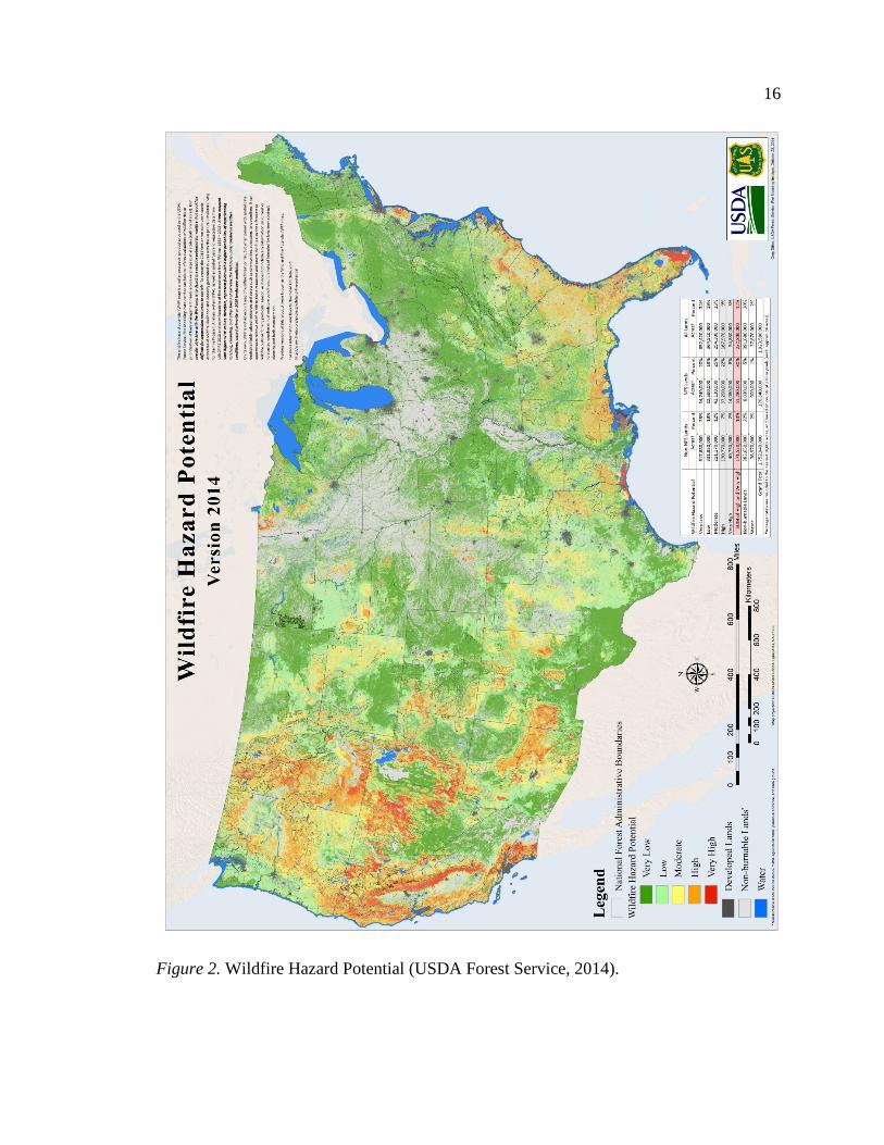
Wildfire Risk
Wildfire experts use information about fuels, weather, topography and historic
fire occurrence to identify and map areas of high wildfire risk across the country. Figure
2 shows one mapping effort by the Forest Service, illustrating areas of highest wildfire
potential across the country (USDA Forest Service, 2014). The largest areas of high risk
are most notable in the Western states. The elevated degree of hazards and risk across
much of the West has serious implications for the documented 7,606 communities at risk
of wildfire in the region and the planning and design of future growth (National
Association of State Foresters [NASF], 2013). Unlike other natural hazards such as
floodplains, there is not one nationally recognized map of areas at risk of wildfire across
the U.S. to help make development decisions. A nationally accepted risk assessment is
needed to help guide growth and development in hazardous areas.
16
Figure 2. Wildfire Hazard Potential (USDA Forest Service, 2014).

17
Table 1
Fire Causes and Number of Acres Burned in the West
Totals 2001 – 2011 # of Fires or Acres % of Fires or Acres Total Human Caused Fires 123 123 Total Lightning Caused Fires 456 456 Total Human Caused Acres 789 789 Total Lightning Caused Acres 123 123
(NIFC, 2014; Western Regional Strategy Committee, 2012).
Sources of Wildfire
Because humans are the dominant source of wildfire ignition, it is difficult to
address natural wildfire cycles without acknowledging the role human activity plays
(National Interagency Fire Center [NIFC], 2014). However, both human ignitions and
lightening ignitions are key contributors to the fire issue in the West. Table 1 shows
approximately two thirds of wildfires in the period between 2001 and 2011 were human
caused. This can be attributed to a surge in people moving to and recreating in
undeveloped areas (Western Regional Strategy Committee, 2012). Although human
caused fires account for the larger share of total number of fires, more total acres are
burned by lightening cause fires. Such fires can pose serious threats to communities
because strikes often cause multiple wildfire starts all at once (Western Regional Strategy
Committee, 2012).
Wildfire Regimes
Distinct eco-regional differences in the natural role of wildfire are critical to
defining appropriate fuels management practices, as well as community planning and
design practices (Keeley, 2010). A fire regime is the pattern, frequency, and intensity of
wildfires prevailing in a landscape. Fire regimes characterize the spatial and temporal

18
patterns and ecosystem impacts of fire on the landscape (Morgan, Hardy, Swetnam,
Rollins, & Long, 2001; Keeley, 2009). The concept of fire regimes provides an integrated
way of classifying the impacts of factors such as vegetation composition, fuel structure,
past disturbances, past management, climate, weather, etc. on fire and its impacts at an
ecosystem or landscape level (Hardy, Menakis, Long, Brown, & Bunnell, 1998; Morgan
et al. 2001; McKenzie, Miller, & Falk 2011).
The two most important factors in determining fire regimes are vegetation type
(ecosystem) and weather and climate patterns. Understanding the different types of
vegetation of fire regime groups is important to predicting potential interaction between
fire and climate. Climate not only affects the frequency, size and severity of fires, but
also influences vegetation structure and composition. On the local scale, terrain features,
slope, management practices, landscape patterns can also affect fire regimes, and fuel
loads. Fire regimes are not static. As land uses, or vegetative patterns, and climate change
within a landscape, so does the fire regime. Fire history provides evidence of past
relationships between fire and climate and land use (Keeley, 2009).
Although many fire regime classifications exist and there is not one consistent and
generally accepted fire regime classification system in use, this study will use the
Landscape Fire and Resource Management Planning Tools (LANDFIRE) mapping and
modeling system to describe fire regimes [sponsored by the U.S. Department of the
Interior (DOI) and the U.S. Department of Agriculture, Forest Service (USFS)]. The
LANDFIRE databases are readily available to federal, state and local stakeholders and
are free to download. Additionally, LANDFIRE classification is useful because both the
historic fire regimes and the departure of current vegetation from historic conditions are

19
mapped for all United States wildland ecosystems. The five fire regime groups of the
LANDFIRE model are shown in Figure 3. These groups are not meant to infer levels of
risk, like a wildfire risk assessment map would. Rather fire regime groups are used to
understand how often a wildfire can be expected to occur in a certain eco region and how
severe the wildfire will be when it does occur. Following is a description of each of the
wildfire regime groups:
1. Group I is characterized by fire occurring in 0 – 35 year frequency with a low
to mixed severity. Generally, these low severity fires replace, or burn, less
than 25 percent of the dominant overstory vegetation, but this group can also
include mixed-severity fires that replace up to 75 percent of the overstory.
This group is typical of perennial grasslands.
2. Group II also has a 0 – 35 year frequency but is characterized by replacement
severity, which mean high-severity fires replace greater than 75 percent of the
dominant overstory. This group is typical of annual grasslands and some
forest types with frequent surface fires.
3. Group III and IV are both characterized by fire occurring in 35 – 200 year
frequency. Group III has mixed severity fires, but can also include low-
severity fires. This group is typical of many forests and shrublands, such as
chaparral.
4. Group IV is characterized by replacement severity with its high-severity fires.
This group is typical of forests and some shrublands with non-sprouting
shrubs.

20
Figure 3. Historical Fire Regime Groups (Landfire, 2008).
5. Fires occurring in frequencies greater than 200 years characterize Group V.
Generally, the severity seen in this group are replacement severity, although it
can include any fire severity in this frequency range. This group is typical of
some moist forests, tundra and deserts (landfire, 2008).
Wildfire Occurrence
The average area burned in the United States has increased dramatically, most
notably in the fire prone ecosystems of the West (Brown et al., 2004). The magnitude of
areas in the West experiencing wildfires is illustrated in Figure 4, which shows the area
affected by wildfires across the U.S. The incidence of large wildfires began to increase in
the mid-1980s. Wildfire frequency in the West, between the years 1987-2003, was nearly
four times the average of 1970-1986 and the total area burned by these fires was more

21
Figure 4. Percent area within each U.S. county disturbed by wildfire (NIFC,
2014; Western Regional Strategy Committee, 2012).
Figure 5. Acres Burned by Wildfire in the West (NIFC, 2014; Western
Regional Strategy Committee, 2012).

22
than six and half times its previous level (Westerling, Hidalgo, Cayan, & Swetnam,
2006). Figure 5 shows the number of acres burned each year for most of the last century
in the 11 Western states of Arizona, California, Colorado, Idaho, Montana, Nevada, New
Mexico, Oregon, Utah, Washington, and Wyoming. This figure illustrates the total
number of acres burned significantly increased around 1985.
Wildland Fire Suppression & Management
Our current wildfire situation has been created in part by historical wildfire and
forest management. The historical relationship between human management of the land
and the way nature responds is important to the current increases in the occurrence of
wildfire in the West. Large wildfires in the late 19th and early 20th centuries prompted a
“war on wildfire” led by President Theodore Roosevelt and forester Gifford Pinchot.
Total suppression, extinguishing wildfires as quickly as possible became the new
campaign (Schwab & Meck, 2005). Firefighting equipment evolved rapidly during this
time. Firefighting forces also increased with the manpower of the Civilian Conservation
Corps and later with the trained forces of returning veterans.
These decades of total fire exclusion, regardless of cause or size, ignored the
natural role of wildfires in the ecological system and allowed fuel loads to grow to
exceedingly high levels. In retrospect, the policy of total suppression did not protect the
forests in their natural state, but progressively altered their natural state. The 1970s
brought realizations that fighting fires uncompromisingly was unrealistic and fire could
be a useful tool for ecological management. However, it is still simply not possible to let
fire take its natural course at this point because landscapes have been so significantly

23
altered and we have placed too many lives and property in harms way to refrain from
mitigating the hazards of wildfire (Schwab & Meck, 2005).
Today, two primary strategies are used in the United States to reduce the risks and
losses associated with wildfire. One strategy is to fund suppression equipment and
personnel to maximize success of initial wildfire attack efforts. (Dicus & Scott, 2006).
With advanced technology and firefighting resources, 98 percent of wildfires are
typically put out during initial suppression response efforts (Agee, 1997). While wildfire
suppression performs a valuable short-term function of protecting property and resources,
it also has the effect of increasing fuel load due to the restriction of the natural process by
which fuel is reduced or removed: wildfire (Brown et al., 2004).
The other strategy is to employ treatments to reduce vegetation and minimize fire
behavior. In order to reduce the risk to communities of catastrophic wildland fires and
manage future wildfires, land management agencies have reached some consensus that
pre-fire treatments such as prescribed fire must be used in combination with the
mechanical reduction of fuels (Mutch, 1994; Agee, 1999; Sampson, 1999; Pyne, 2001;
and Wilkinson, 2001). Prescribed burning is fire applied to forest fuels on a specific land
area under selected weather and fuel conditions. This is done to accomplish
predetermined management objectives such as reducing fuel loads on public lands around
communities (Bright, Newman, & Carroll, 2007). Mechanical reduction of fuels involves
physically removing selected trees and plants from a forest to decrease the likelihood of
large, uncontrollable fires (Bright et al., 2007). These two common management
techniques are considered viable options for decreasing fuel loads and reducing wildfire

24
potential, but both of these options have positive and negative impacts on cultural and
natural resources (Bright et al., 2007).
Even with modern advancements in suppression technology and fuel treatments
that have produced the most effective firefighting capabilities in history, the West is still
vulnerable to significant losses during wildland fires (Cohen, 1998). A large fire can
destroy communities in just a few hours, much faster than the response time of and
capabilities of well-equipped firefighters, making it unrealistic to assume suppression
strategies alone will protect homes in a wildfire event (Cohen, 1998). Implementing pre-
fire fuel treatments improves the success of suppression. However, the total amount of
the landscape burned each year has increased in recent decades compared to with the
mid-1990s (Agee, 1997). Decades of widespread fire suppression in the Western United
States, and recent cutbacks to active forest management have resulted in a buildup of
surface fuels such as vegetation, downed wood, litter and duff. It becomes more difficult
and more expensive to suppress the next fire when surface fuel build up is factored in
with prevailing conditions in the West of drought, insects and disease, changing climate
and increasing growth in wildfire prone areas (Western Regional Strategy Committee,
2012).
Wildland Fire in a Changing Climate
Climate models predict rising temperatures and decreased snowpack in the West
in this century, suggesting that the area affected by wildfires will only continue to
increase (IPCC, 2007). A look at fire history in the West provides evidence of past
relationships between fire and climate; fire regimes that are dictated by climate will
change as climate varies (Morgan et al., 2001). We have already begun to see the length

25
of the wildfire season increase by 78 days since the 1980s (Westerling et al., 2006). The
implications of an earlier snowmelt and more severe or prolonged droughts as a result of
our changing climate will profoundly affect the frequency and severity of fires in many
regions and ecosystems (Westerling et al., 2006; Bowman, Balch, Artaxo, Bond, Carlson,
Cochrane… & Pyne 2009; Flannigan, Krawchuk, de Groot, Wotton, & Gowman, 2009;
Littell, McKenzie, Peterson, & Westerling, 2009; Morgan, Heyerdahl, & Gibson 2008;
Kitzberger, Brown, Heyerdahl, Swetnam, & Veblen, 2007).
It is also important to note that the year-to-year variability in annual area burned
in the West has been dramatically higher over the last two decades than at any time
during the last century (Brown, et al. 2004). Anomalously wet years promote more
vegetation growth and therefore more fuel loading, and large anomalously dry years
decrease fuel moisture, increasing fire risk. Multi-wet years and multi-dry years will
heighten the natural role of fire during these regimes. Greater variability in wildfire
season severity poses significant challenges for planners and designers interested in
creating fire resilient communities. The overall importance of climate in relation to
wildfire underscores the value of climate information that enables forecasts of fire season
severity or enhances efforts to manage risk factors in and around communities (Brown, et
al. 2004).
Development in the West
Population more than doubled in the U.S. between 1940 and 2000 reaching 280
million in 2000 and in the same period the number of housing units tripled, reaching 116
million in 2000 (Hammer, Stewart, & Radeloff, 2009). Since 1940, interregional
migration in the U.S. has led to significantly higher population and housing growth in the
26
West. The population in the West was 4.5 times larger in 2000 than it had been in 1940;
in contrast, the population of the rest of the U.S. was only 1.7 times larger in 2000. The
abundance of natural amenities such as mountain, lakes, and forests of the West
contribute to disproportionate population growth in the U.S. (Hansen, Knight, Marrzluff,
Powell, Brown, Gude, & Jones, 2005; Gude et al., 2008; Johnson & Beale, 1994;
Johnson, 1999; Hammer et al., 2009; Rasker & Hansen, 2000; Radeloff et al., 2005).
These accelerated demographic trends in the West have resulted in growth and expansion
in wildfire prone areas. The expansion of human population and development is the
single greatest factor confounding wildfire management (Dombeck et al., 2004).
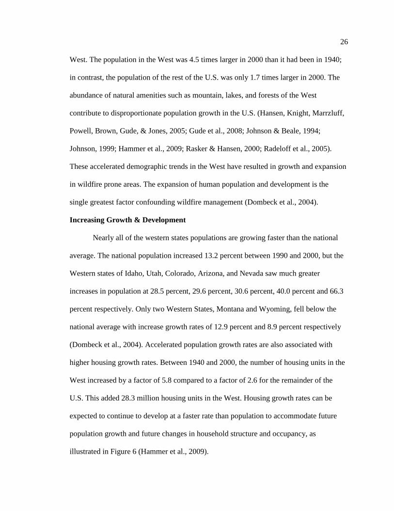
Increasing Growth & Development
Nearly all of the western states populations are growing faster than the national
average. The national population increased 13.2 percent between 1990 and 2000, but the
Western states of Idaho, Utah, Colorado, Arizona, and Nevada saw much greater
increases in population at 28.5 percent, 29.6 percent, 30.6 percent, 40.0 percent and 66.3
percent respectively. Only two Western States, Montana and Wyoming, fell below the
national average with increase growth rates of 12.9 percent and 8.9 percent respectively
(Dombeck et al., 2004). Accelerated population growth rates are also associated with
higher housing growth rates. Between 1940 and 2000, the number of housing units in the
West increased by a factor of 5.8 compared to a factor of 2.6 for the remainder of the
U.S. This added 28.3 million housing units in the West. Housing growth rates can be
expected to continue to develop at a faster rate than population to accommodate future
population growth and future changes in household structure and occupancy, as
illustrated in Figure 6 (Hammer et al., 2009).

27
Figure 6. Housing Density Change in the United States (Hammer et al., 2009).
Patterns of Growth. Much of the housing and population growth is occurring as
a deconcentration from urban areas to the periphery of metropolitan areas and to selected
nonmetropolitan areas, known appropriately as exurbanization (Hammer et al., 2009).
Across the nation, substantial residential and commercial development has occurred on
the urban fringe pushing the edges of cities outward. Estimates indicate that up to 14
million acres of non-industrial forests, or undeveloped lands, were converted to urban
uses between 1952 and 1997 (Alig, Butler, & Swenson, 2000; Theobold & Romme,
2007). This trend of exurban growth beyond the urban fringe is especially prominent in
the more sparsely populated West, in forested areas, and in areas adjacent to federal lands
(Hammer, Volker, Freid, & Stewart, 2007).

28
A significant portion of this exurban development in the West is medium to low
density. In some cases, this is because of zoning codes that require large-lot
developments to preserve rural characteristics (Radeloff et al., 2005; Theobald, Miller, &
Hobbs, 1997; Hammer, Stewart, Winkler, Radeloff, & Voss, 2004). The popularity of
low-density development has led to large areas of land in affordable rural areas being
converted to homes and subdivisions (Theobald et al., 1997; Hammer et al., 2004). This
has led to rapidly expanding growth and development in areas of wildland vegetation,
resulting in an increase in the number of people and houses located in areas with high risk
of wildfire (Schoennagel, Nelson, Theobald, Carnwath, & Chapman, 2009).
Why Are People Moving to wildlands? The 1950s saw the emergence of new
phenomenon in land-use development. Middle class and affluent homeowners, initially in
California, began to move in suburban subdivisions built in wildfire prone areas at the
fringe of development (Schwab & Meck, 2005). Although people have long lived in
forested areas, the development boom of pre-planned subdivisions in California was
different. This movement toward rural, or formerly rural, areas marked the beginning of
what sociologists call “amenity migration” (Schwab & Meck, 2005). Similar growth
patterns have also been noted in other rapidly growing Western States in the West like
Colorado, Utah, Idaho, Nevada, Arizona, New Mexico, Oregon, and Washington.
Some of the communities in these states are experiencing the proliferation of
development in these wildfire-prone areas in part because of overall population growth;
other communities are growing largely as a matter of choices made by homeowners and
builders (Schwab & Meck, 2005). The lure of rural landscapes, the increasing popularity
of large lots, and the draw of natural amenities are driving development of some

29
communities in these wildland areas (Hansen et al., 2005; Gude et al., 2008; Johnson &
Beale, 1994; Johnson, 1999; Rasker & Hansen, 2000; Radeloff et al., 2005). However,
living in these wildland areas that are wildfire prone can be risky. The “amenity
migration” trends must weigh risks against tradeoffs such as nature, wildlife, privacy, and
the rugged nonurban lifestyle (Schwab & Meck, 2005). A growth in second-home
communities in amenity rich landscapes is further proliferating development in areas at
risk. This expansion of multiple homeownership in the U.S. is a major factor in the
growth rate of housing, increasing from 5.6 for every 1,000 persons in 1940 to 12.8 in
2000 (Hammer et al., 2009).
The continuation of “amenity migration” in the West has significant impacts of
the local environment and contradicts risk management in wildfire prone areas. Buildings
and subdivisions fragment habitat, forcing the wildlife many desire to witness to relocate.
Resident’s desire to live close to nature and seek privacy places limitations on the extent
of acceptable human intervention environment, which is problematic for mitigation
efforts such as thinning, prescribed fire and other vegetation management strategies.
Shifts in technology have also enabled people to live and work from home, away from
cities, growing the number of people no longer tied to urban areas. This has allowed
further development in rugged, nonurban areas, such as the Rocky Mountains, which
reshapes development pressures and compounds the challenge or regulating development
in wildfire prone areas.
Development and Wildfire
The biggest factor complicating wildland fire in the West is human population
growth and the resulting development (Dombeck et al., 2004). The combination of

30
Figure 7. Structures lost to wildfires 1999 - 2011 (Stein et al., 2013).
exurban development and recreational and amenity development is resulting in
substantial expansion of low-density housing located in close proximity to wildland fuels
(Hammer et al., 2007). The dramatic expansion of housing in these areas next to or
intermixing with wildland vegetation is significantly increasing wildfire threats to lives
and property (Hammer et al., 2009; Radeloff et al., 2005; Theobald & Romme, 2007).
Figure 7 spatially illustrates the current wildfire problem, highlighting incidents in the
U.S that resulted in life and, or, property loss.
As housing developments push into foothills and mountainsides in fire-prone
areas more homes and lives are being put in danger of wildfire. Life and property loss
resulting from wildfires used to be widely viewed as a problem unique to California.

31
However, considerable losses have been seen in states across the West. Wildland fire-
caused losses in the 15-year period between 1985 and 2000 totaled 32 deaths and
destroyed 7467 structures in California alone. In that same period, wildland fires in
Oregon and Washington destroyed 570 structures (Hammer et al., 2007). Table 2 lists
significant wildfires across the West and the number of lives and property lost in each
event.
Table 2
Significant Western Wildfires Resulting in Life and Property Loss
Year Incident Location Life & Property Lost Source
1990 Painted Cave Santa Barbara, CA
479 homes / 641 structures NIFC, 2014; Cohen, 2010
1990 Dude Fire Arizona 63 homes / 6 lives NIFC, 2014; 1991 Spokane “Firestorm” Spokane, WA 108 homes Cohen, 2010 1991 Tunnel/Oakland Oakland, CA 2900 structures / 25 lives NIFC, 2014;
Cohen, 2010 1992 Fountain Shasta, CA 636 structures Schwab &
Meck, 2005 1992 Old Gulch Calaveras, CA 170 structures Schwab &
Meck, 2005 1993 Kinneola Los Angeles,
CA 196 structures Schwab &
Meck, 2005 1993 Laguna Hills, Old
Topanga Laguna and Malibu, CA
634 homes NIFC, 2014
1996 Millers Reach Big Lake, AK 344 structures NIFC, 2014 1999 Canyon Shasta, CA 230 structures Schwab &
Meck, 2005 1999 Jones Shasta, CA 954 structures/ 1 life Schwab &
Meck, 2005 2000 Cerro Grande Los Alamos,
NM 235 structures NIFC, 2014
2002 Hayman Lake George, CO
132 homes/ 600 structures NIFC, 2014
2002 Rodeo-Chediski Heber-Overgaard, AZ
426 structures NIFC, 2014;
2003 Aspen Summerhaven, AZ
340 homes Cohen, 2010
2003 Old, Cedar, Grand Prix etc.
Southern CA 3640 structures/ 15 lives NIFC, 2014; Schwab & Meck, 2005

32
Table Continues 2003 Paradise San Diego, CA 415 Structures / 2 lives Schwab &
Meck, 2005 2003 Simi Ventura, CA 300 Structures Schwab &
Meck, 2005 2005 Cave Creek Complex Sonoran Desert,
AZ 11 structures NIFC, 2014
2007 Angora Lake Tahoe, CA 245 homes Cohen, 2010
2007 Witch, Slide, Grass Valley, etc.
Southern CA 2180 homes Cohen, 2010
2010 Four Mile Canyon Boulder, CO 170 structures NIFC, 2014 2012 Waldo Canyon CO 346 homes NIFC, 2014 2013 Yarnell Hill Arizona 19 lives NIFC, 2014
The noticeable wildfire problem across the West makes studying housing and
population growth in the region’s wildfire prone areas particularly important. Any long-
term solution to wildland fire issues in the western United States will have to address
housing growth patterns (Hammer et al., 2007). Local and regional land-use planning
efforts, building codes and standards, and other planning and design decisions will be key
to addressing wildland fire issues and limiting the vulnerability of communities to
wildfire (Stein, Menakis, Carr, Comas, Stewart, Cleveland,… & Radeloff, 2013).
Proactive wildfire preparedness planning will require a comprehensive evaluation of
wildland fire risk factors, which includes population and housing growth in addition to
traditional factors, such as wildfire regimes.
The Wildland Urban Interface
The growing proximity of development to wildland areas places more people and
homes at risk of wildfire. The expansion of community development into vegetated and
wildfire prone areas is enlarging the wildland-urban interface. Increased emphasis is
being placed on the problems of life and property loss due to wildland fires in the

33
wildland-urban interface. However, the continual change of the wildland-urban interface
area makes it difficult to identify its current size and location. Furthermore, few Western
States have comprehensively mapped the wildland urban interface for use by planners
and designers. Understanding where the wildland urban interface exists is important
because these areas pose significant risk management challenges and environmental
threats. Protection of life and property as well as environmental mitigation efforts
continue to skyrocket the costs of managing the wildland-urban interface.
Definition of Wildland Urban Interface
The areas where residential structures and fire-prone wildlands meet is called the
urban–wildland interface or wildland–urban interface (WUI) (Cortner & Gale, 1990;
Ewert 1993; Fried, Winter, & Giles, 1999). Similarly, fire managers within the federal
government use this definition published in the Federal Register: ‘‘the Wildland–Urban
Interface is the area where houses meet or intermingle with undeveloped wildland
vegetation’’ (Radeloff et al., 2005; USDA & DOI, 2001). The WUI concept was
developed to help identify communities at risk of wildfire and prioritize mitigation
efforts. However, designation of WUI does not represent the diversity of potential
wildfire exposures and damages that could occur because delineation does not
incorporate data on fuel, topography, weather, or other factors that influence fire risk
(Paveglio, Prato & Hardy, 2013).
Defining the WUI does require detailed data on housing density and proximity to
wildland vegetation. To be considered WUI, areas must contain at least one house per 40
acres. No maximum housing density is set. As defined by the U.S. Census Bureau, a
housing unit may be a house, an apartment or a mobile home, and can be occupied or

34
vacant, so seasonal homes are included (Radeloff et al., 2005). Non-WUI areas, on the
other hand, include:
• Very low-density areas with less than one home per 40 acres;
• Vegetated areas with no homes in addition to medium to high-density urban
areas;
• Low-density agricultural areas completely devoid of wildland vegetation.
Wildland-Urban Interface Categories.
The WUI can be divided into three categories: interface/boundary, intermix or
island/occluded. These categories reflect different types of wildfire-prone areas, which
are determined by population growth and development. Depending on the conditions
present, any of these areas can be at risk of wildfire. These categories are further
described below and illustrated in Figure 8.
1. Interface – Areas of new development where houses, especially new
subdivisions, abut the wildland edge and are commonly known as the
“interface” or “boundary” WUI. This is the classic type of interface in
wildfire-prone areas, with a clearly defined boundary between the suburban
fringe and undeveloped lands. From a planning perspective, it is best to
minimize the length of the boundary, clearly define the urban boundary, and
utilize advantageous natural or man-made barriers to define and protect the
boundary (Schwab & Meck, 2005; Florida Department of Agriculture and
Consumer Services, Division of Forestry, 2010).
2. Intermix – The “intermix” WUI areas are defined by structures scattered and
interspersed throughout a wildland area. These can be areas transitioning from

35
rural to urban land uses or isolated rural houses. Intermix areas are
problematic and costly to firefighting resources. In terms of planning in these
Figure 8. Wildland Urban Interface Categories (Florida Department of
Agriculture and Consumer Services, Division of Forestry, 2010).
areas, it is best to limit, cluster, or simply avoid intermix development as
research suggests wildfire damage is greatest in the intermix category
(Schwab & Meck, 2005; Florida Department of Agriculture and Consumer
Services, Division of Forestry, 2010).
3. Island – The “island” or “occluded” WUI are tracts of lands left undeveloped,
vacant, or intentionally preserved surrounded by a predominantly urban or

36
suburban environment. As cities or subdivisions grow, remnants of
undeveloped lands remain as parks or as land that can’t be developed due to
site limitations. These areas add the benefits of open space within
communities, but these areas can also be the hardest to manage with fire
(Schwab & Meck, 2005; Florida Department of Agriculture and Consumer
Services, Division of Forestry, 2010).
Location and Size
The WUI itself is not a physical place but rather a set of conditions that are
constantly changing as human development continues to expand into previously
uninhabited areas (Grayzeck-Souter, Nelson, Brummel, Jakes, & Williams, 2009). In
2005 the USDA funded research that uses the Federal Register definition of the WUI,
housing density patterns, and land cover data to map the wildland urban interface across
the U.S. The result indicates that the WUI covers approximately 9.4 percent of the lower
48 United States and contains 44,348,628 housing units, which amounts to 38.5 percent
of all housing units (Radeloff et al., 2005).
WUI areas are present in all 48 of the states. In the West, the major WUI areas are
located along the West Coast and the Colorado Front Range. WUI areas are also common
at the fringe of major metropolitan areas such as Los Angeles, San Francisco, Seattle and
Denver, in addition to nonmetropolitan areas rich in natural amenities such as the Sierra
Nevada foothills (Radeloff et al., 2005). (Figure 9).

37
Figure 9. The Western Wildland Urban Interface in 2000
The WUI in the West is seeing the greatest proportion of residential land
conversion, in part because these areas tend to be rich in natural amenities. In many
Western States, more than 50 percent of new housing development is in areas classified
as severe fire zones (Gude et al., 2008). The number of housing units in the Western WUI
versus non-WUI is broken down by state in Table 3 (the table reflects data from the
above-mentioned study funded by the USDA in 2005). It is interesting to note that
although the majority of land in each of the Western States is not classified as WUI, the
number of housing units in WUI areas is comparable to non-WUI areas. If current growth
patterns of low-density and large lot development in the urban fringe continue, than more
undeveloped, vegetated non-WUI lands in the West will be converted to WUI. This
expansion of the WUI will result in increased risk to homes, property and lives.

38
Table 3
Western States Wildland Urban Interface 2000
State Type Acres % Housing Units %
AZ WUI Intermix Interface Non-WUI Total
2,146,531 1,782,590 363,941 70,532,109 72,678,640
3.0 % 2.5 % .5% 97.0 %
1,192,172 565,055 627,117 997,017 2,189,189
54.5 % 25.8 % 28.6 % 45.5 %
CA WUI Intermix Interface Non-WUI Total
7,228,666 5,385,168 1,843,498 92,162,068 99,390,734
7.3 % 5.4 % 1.9 % 92.7 %
5,087,909 1,607,624 3,480,285 7,126,607 12,214,516
41.7 % 13.2 % 28.5 % 58.3 %
CO WUI Intermix Interface Non-WUI Total
1,978,474 1,490,506 487,968 64,361,912 66,340,912
3.0 % 2.2 % 0.7 % 97 %
836,961 298,543 538,418 971,076 1,808,037
46.3 % 16.5 % 29.8 % 53.7 %
ID WUI Intermix Interface Non-WUI Total
850,006 516,621 333,386 52,094,797 52,944,803
1.6 % 1.0 % 0.6 % 98.4 %
233,565 85,872 147,693 294,259 527,824
44.3 % 16.3 % 28.0 % 55.7 %
MT WUI Intermix Interface Non-WUI Total
942,057 607,653 334,404 92,132,662 93,074,720
1.0 % 0.7 % 0.4 % 99.0 %
254,437 90,666 163,771 158,196 412,633
61.7 % 22.0 % 39.7 % 38.3 %
NM WUI Intermix Interface Non-WUI Total
1,648,481 1,336,785 311,696 75,942,615 77,591,096
2.1 % 1.7 % 0.4 % 97.9 %
613,085 292,444 320,641 167,494 780,579
78.5 % 37.5 % 41.1 % 21.5 %
NV WUI Intermix Interface Non-WUI Total
642,660 478,838 163,823 69,587,165 70,229,826
0.9 % 0.7 % 0.2 % 99.1 %
466,542 201,989 264,553 360,915 827,457
56.4 % 24.4 % 32.0 % 43.6 %
OR WUI Intermix Interface Non-WUI Total
2,175,068 1,525,540 649,528 59,203,443 61,378,510
3.5 % 2.5 % 1.1 % 96.5 %
621,086 245,922 375,164 831,623 1,452,709
42.8 % 16.9 % 25.8 % 57.2 %
UT WUI Intermix Interface Non-WUI Total
790,755 471,830 318,924 51,714,201 52,504,955
1.5 % 0.9 % 0.6 % 98.5 %
435,206 130,260 304,946 333,387 768,594
56.6 % 16.9 % 39.7 % 43.4 %

39
Table Continues WA WUI
Intermix Interface Non-WUI Total
3,749,328 2,911,396 837,933 38,725,619 42,474,947
8.8 % 6.9 % 2.0 % 91.2 %
1,206,475 614,365 592,110 1,244,600 2,451,075
49.2 % 25.1 % 24.2 % 50.8 %
WY WUI Intermix Interface Non-WUI Total
446,885 277,160 169,724 61,655,645 62,102,529
0.7 % 0.4 % 0.3 % 99.3 %
179,690 40,630 139,060 44,164
80.3 % 18.2 % 62.1 % 19.7 %
(Radeloff, 2005)
Challenges and Risks
It is in the WUI where the greatest challenge to protect homes and structures from
wildland fire exist (Cohen, 2000; Winter & Fried, 2001). In the four-year period between
2002-2006, 10,000 homes were destroyed by wildfire (Gude et al., 2008). In 2003, alone,
over 4,200 homes were lost to wildfire in the United States, which amounted in over $2
billion in damages (NIFC, 2014). The historical fire frequency of landscapes as well as
the distance from fire suppression services, current land use patterns, and road networks
often associated with WUI communities create dangerous situations and make structure
protection difficult. In addition to risks to life and property, development in the WUI
disturbs natural vegetation, fragments habitat and contributes to erosion.
Historical Fire Frequency. Wildfire is a key process in the wildland landscapes
across the West, but some landscapes are more prone to frequent fires due to topography,
fuels and weather. The historical fire frequency is an important variable of a
community’s wildfire risk. There is a significantly higher likelihood of property loss in
areas with historically high fire frequencies (Syphard, Keeley, Massada, Brennan, &
Radeloff, 2012). Wildfire regimes, described in more detail previously and mapped in

40
Figure 4, characterize the spatial and temporal patterns and ecosystem impacts of fire on
the landscape and are well defined across the West. The continued development of
communities in historically high fire frequencies due to the absence of community
development decision makers understanding of the landscape factors that most
significantly contribute to wildfire danger is intensifying the problem of life and property
loss in the WUI. Complete suppression of wildfire in these wildfire prone areas only
Figure 10. The mean number of fire stations per 100sq. miles in Western counties
(Western Regional Strategy Committee, 2012).

41
allows unnatural fuel loads to accumulate, changing the fire regimes, laying the
groundwork for infrequent, high intensity crown fires (Keeley, 2010).
Response Time. A recent government audit shows that in 87 percent of large
fires, protection of private property was described as the major reason for firefighting
efforts (USDA Office of Inspector General, 2006). While advances in firefighting
technology have produced the most effective firefighting capabilities to date, innovative
technologies do not prevent all losses of lives and property in the WUI. Severe wildfires
can destroy entire communities in a matter of a few hours, faster than the response time
of the best-equipped and staffed firefighting services (Cohen & Butler, 1998). In the WUI
response times to initial smoke reports of wildfires can take hours, as many WUI
communities do not have full-time suppression services nearby or rely on volunteer
firefighting services. Many counties across the West do not even have fire stations within
their jurisdictions, as seen in Figure 10.
Land Use Patterns. Population growth and housing development increase fire
frequency in the WUI simply because humans cause more wildfires annually than natural
causes such as lightning (Syphard et al., 2012). Wildfire risk is further exacerbated by the
current tendency for incremental planning of low-density, large lot housing in fire prone
areas. Structures interspersed with wildland vegetation add to the existing fuel loads,
increasing wildfire risk. Additionally, WUI development patterns complicate the tactics
firefighters use to suppress or manage wildfires and increase costs of firefighting efforts.
The extent and spatial patterns of residential development in the WUI can
significantly influence the likelihood of property loss in the event of a wildfire (Syphard
et al., 2012). Studies in California have shown that property loss is more likely in

42
intermix WUI with smaller, more isolated housing clusters with low to medium density.
Scattered, isolated homes are difficult for wildland firefighters to defend and disperse
limited firefighting resources over large areas. Structures located on the edge of
developments or housing clusters on steep slopes were also more susceptible to wildfire.
New development arranged in moderate to high-density neighborhoods, minimizing the
interface between homes and wildlands. When they are located away from wind corridors
and steep slopes, they have a lower likelihood of ignition in a wildfire event (Syphard et
al., 2012). Restrictive growth management policies can also be effective against wildfire
as well as other hazards like flooding (Paveglio et al., 2013; Syphard et al., 2012).
Accessibility. Residential development in the fire-prone WUI is continuing
without proportionate improvements to community transportation systems. As the WUI
grows and more homes are added, the primary road networks remain unchanged (Cova,
2005). Interface communities are often built into topographic contexts that prohibit the
construction of new roads or the costs associated with the construction of a new road is
prohibitive. Additionally, residents tend to prefer fewer roads because it reduces
nonresident traffic (Cova, 2005). Accessibility, however, is critical for fire suppression
forces to locate, reach, and safely remain at a structure and continue suppression efforts
(Cohen, 1990).
Accessibility out of an area, or egress, in the event of a wildfire evacuation is
equally important. Egress standards are currently defined in terms of minimum exit-road
widths, or minimum number of exits, without regard to how many people might rely on
these exits in the event of a wildfire or the arrangement of these exits or road
intersections (Cova, 2005). The focus of accessibility has placed more emphasis on
43
maintaining fire fighter ingress than resident egress; however, with the growing number
of people living in WUI communities and poor egress has proven to be a problem.
Planners and designers need to play a role in implementing new accessibility codes in the
WUI and improving egress systems, as well as ingress systems.
Environmental Threats. Development and growth in or near the WUI poses a
major threat to the environment directly and indirectly (Theobald et al., 1997; Johnson,
2001). The exurban development of communities causes habitat loss and fragmentation,
threatens wildlife populations and results in biodiversity declines (Theobald et al., 1997;
McKinney 2002). The removal of native vegetation during construction of building and
roads alters the habitat that determines the wildlife species found in the area. The fencing
of areas, which increases with development, inhibits the movement of wildlife species
(Theobald et al., 1997). It has been estimated that 50 percent of all federally listed
threatened and endangered species in the United States are in peril due to urbanization
(Czech, Krausman, & Devers, 2000). These problems are of particular concern in the
WUI, where homes and associated structures are built among critical forest, shrub or
grassland habitats.
Clustering development reduces disturbance of development on wildlife habitat,
although fragmentation can still occur. Many clustered development designs place homes
around cul-du-sacs and these dead-end roads, which are problematic for firefighter
suppression efforts and evacuations, can also create islands of habitat within the
development that are too small to support a viable population and inaccessible to the
surrounding habitat (Theobald et al., 1997). Landscape connectivity and habitat
fragmentation are important components to consider, in addition to reduced disturbance

44
zones, when planning and designing subdivisions in naturally vegetated, wildfire prone
areas.
The recommended clearance of “defensible space,” the removal of vegetation
around the home to prevent ignition, in WUI areas disrupts habitat and can also create
serious erosion problems such as, slumping, soil liquefaction and sliding, during
rainstorms. Complete reduction of fuels in specified radii around the homes can destroy
the intricate root networks of native plant communities, which tie sensitive lands
together. In intense rain events, mudslides that remove the healthy topsoil become
inevitable. Although thought of as fire precautions, the removal of natural vegetation to
create fuel breaks around homes and communities can also open the door for invasive
weeds to take root, which tend to be more susceptible to wildfire (Landis, 2010). The
environmental threats development in the WUI poses could be reduced with improved
land use planning and the restriction of development in areas that are not only at-risk of
wildfire but also environmentally sensitive.
Costs
The protection of life and property in the vulnerable areas of the WUI is the
primary driver of escalating wildfire suppression and related costs. Federal wildfire
suppression costs exceed $1 billion annually and the majority of these costs are directed
toward the protection people and their homes (USDA Office of the Inspector General,
2006). State expenditures related to wildfire have also shown increases during this period.
It is estimated that $1.6 billion is spent annually by state forestry agencies on wildfire
protection, prevention and suppression; these annual expenditures have more than
doubled in the past 10 years (NASF, 2010). In the five-year period from 2002 to 2006,

45
the federal government spent $6.3 billion fighting wildfires. Even with all of the federal
and state expenditures during this time, 92 people were killed during wildfire operations
and 10,159 homes were lost (NIFC, 2014).
The potential future magnitude of fire suppression costs from the continued
development of wildlands is only expected to grow. In a study conducted by Gude et al.
(2008), only 14 percent of the WUI in the West had been developed, leaving another 86
percent of interface that could potentially be developed. According to the study’s
estimates, if 50 percent of the WUI is developed the average cost of fighting fires to
protect private structures could range from $2.3 to $4.3 billion annually (Gude et al.,
2008). Additionally, fire suppression costs closely track annual variations in area burned
in large wildfires, so fire suppression budget needs will likely continue to be highly
variable from year to year with changes in climate. Since fire suppression managers must
be prepared for the worst case, rather than the average fire season, this has profound
implications for the cost of wildfire management. (Brown et al., 2004).
Although suppression costs associated with large wildfires are the most publicized
cost, fire suppression expenses only represent a fraction of the monetary value spent on
or lost in damages due to wildfires. The costs of massive firefighting efforts are also high
in terms of human safety, economic losses, damage caused by bulldozers to fragile soils
and sensitive botanical areas, and the potential for spread of exotic organisms by
firefighting equipment (Dombeck et al., 2004). For example, the total documented cost of
Colorado’s 2002 Hayman Fire reached $115.9 million from $38.7 million in insured
private property losses; $4.9 million in loans and grants from Small Business
Administration and FEMA; $880 thousand in damages to transmission lines; $382

46
thousand in recreation concessionaire revenue losses; $37 million in lost value of water
storage capacity; and, $34 million in lost value from timber (Stein et al., 2013). Without
improved land-use planning in the wildland interface, the future costs of wildfire
suppression, both monetary and social, will likely become politically unacceptable.
Responsibility in the Wildland Urban Interface
Scientific literature, government documents and popular press have all
highlighted the cost of firefighting, the risk to firefighter lives, and the damage to private
property that results from the expanding wildland-urban interface (Gude et al., 2008).
However, perception of wildfire risk in the interface between development and wildlands
varies greatly among residents, fire managers, developers and planners. The current roles
and responsibilities of each of these groups are equally as varied. Much of the efforts to
reduce wildfire risk have been focused on federal agencies and homeowners (Bhandry &
Muller, 2009). This top-down bottom-up approach has left ambiguous responsibilities for
the state and local decision makers. As the risks of growing and developing the wildland-
urban interface receive national spotlight, it begs the question, who is and who should be
responsible?
Perception of Wildfire
While wildfire may have historically played a natural role in western landscapes,
today the potential ecological benefits of wildfire must also be considered within the
context of threats to private property, decrease in air quality and negative impacts to
scenic quality (Bright et al., 2007). The present attitudes toward the reality of wildfire are
largely contextual. Wildland fire managers responsible for community protection
perceive human communities built within wildland ecosystems to be at greater risk to

47
wildland fires, without fuel treatments or fire preventions methods (Brown et al., 2004).
Resident perception of wildfire risk, however, can vary greatly depending on geographic
location, past experience with wildfire, residential choice factors, residency status,
environmental knowledge and length of residency (Blanchard & Ryan, 2003; Cortner &
Gale, 1990; Winter & Fried, 2000; Winter & Fried, 2001; Winter, Vogt, & Fried, 2002).
Preventative fire management techniques such as prescribed fire and mechanical
treatments, supported by most federal and state land managers, often illicit concern from
residents and homeowners. Precedents exist of prescribed fires getting out of control and
causing damage to human life and property. Furthermore, heavy machinery and road
building required for mechanical thinning can detract from the scenic quality (Bright et
al., 2007). Therefore, homeowner’s concerns of mechanical treatments and prescribed
fire can lead to opposition of tree thinning and defensible space for aesthetic reasons and
prescribed fire for health and safety reasons (Blanchard & Ryan, 2003; Brown et al.,
2004).
Role of Fire Managers
The West is unique in that over 50 percent of the land base is federally managed;
creating varied jurisdictional responsibility and protection responsibility (Western
Regional Strategy Committee, 2012). Private land owners expect federal and state
agencies to protect private property from wildfires that spread on public lands and
threaten adjacent private lands. This means as more homes are constructed along
wildland boundaries and in private inholding within federal and state lands, fire agencies
are focusing more of their firefighting efforts on protecting human lives and property
(Dombeck et al., 2004).

48
In wildfire events in areas where development has moved in to wildlands, the job
of the wildland firefighter is transforming in large part because more residents, tourists
and structures are at risk. The traditional suppression duties of a wildland firefighter
differ from that of the urban firefighter, though the general public often does not
recognize the difference. Wildland fire tactics focus largely on preventing fire from
spreading beyond its current location, while urban fire suppression addresses life safety
and then fire containment (Cohen, 2001). But, the frequency of wildland firefighters
encountering structural fires, vehicle fires and other non-wildland fire emergencies is
increasing as WUI pressures intensify (Cortner, 1990). Increasingly, wildland firefighting
resources are being committed to structural protection, and concerns are growing whether
training and equipment are adequate for with these complex situations (Cortner, 1990).
Suppression efforts in a wildfire event typically assume that the wildfire may pass
through residential areas, while firefighters attempt fire containment, so structures are
prepared as best as possible to withstand fire. Because of time constraints, however,
major changes to the home and its immediate surroundings cannot occur during the
approach of a wildfire. Therefore, it is important that most prevention efforts and home
preparation occur before a wildfire occurs (Cohen, 2001).
To inform residents while reducing the risks present in wildfire prone areas, many
federal fire management programs are incorporating wildfire education programs with
traditional prevention methods, such as fuel treatments. Evaluations of past wildfires in
Florida, a state that has experienced significant wildfires, show that wildfires occurring in
areas that had previously been burned or treated tended to be smaller and burn fewer
acres. It was found that for each dollar spent in fuel management, $2.14 in wildfire

49
suppression and damages was saved (Florida Department of Agriculture and Consumer
Services, Division of Forestry, 2010). Additionally, research has shown that investment
in wildfire prevention outreach and education activities results in suppression cost
savings of $1,267 per acre (Prestemon, Butry, Abt, & Sutphen, 2010).
Role of Homeowners
Recent wildfire events have sparked discussions focused on the responsibility of
individual homeowners and community associations. Studies indicate that the likelihood
of homes and neighborhoods burning in wildfire events depends more on ignitability and
landscaping and less on wildland fuels management, which is stressed by fire managers
(Cohen & Butler, 1996; Cohen, 2000). When a wildfire occurs, homes can ignite directly
from flames and/or from burning embers falling directly on the home. During high
intensity crown fires, large flames can ignite structures up to 200 feet away (Cohen,
2000). As burning areas increase and flame lengths grow, burning embers are released
and can travel miles away in high winds.
This places more of the responsibility to reduce home ignitability on the individuals in at-
risk communities than wildfire managers. Homeowners can reduce vulnerability to
wildland fire by: reducing fuel loads within 100-200 feet around homes, using fire
resistant materials and storing flammable materials away from structures. It is the
homeowner’s responsibility to remove firewood piles, dead leaves, conifer needles, grass
and other flammable materials from around their home seasonally.
However, reducing risk to wildfire exposure is not limited to property lines. In
interface communities, where houses are closer together, individual owner efforts may be
inadequate. Greater coordinated neighborhood fuel management would be more effective

50
(Stephens & Ruth, 2005). The main social challenge within neighborhoods is convincing
entire communities to prepare for a fire event that may be quite rare. They must act as a
cohesive unit in managing their fuels, and perhaps suppression, despite having divergent
values and contrasting levels of fire awareness (Gill & Stephens, 2009). Increasingly,
research is pointing to the importance of community leadership and community wildfire
preparedness networks to increase community wildfire resilience (Jakes, Agrawal, &
Monroe, 2003; Lang, Nelson, & Jakes, 2006).
Role of Planning and Design Professionals
In many states across the West, the focus has been on managing fuels, educating
homeowners, and creating defensible space but the extent to which land use planning and
design standards could alleviate wildfire risk has largely been missing from the debate.
This is despite the fact that increasingly large numbers of homes are being placed in the
most hazardous parts of the landscape (Syphard et al., 2012). Wildfire is a natural process
in the landscape of the Western United States and it is unreasonable to form expectations
that wildfires will not occur. Wildfires will continue to impact communities and their
people, property and resources (Cohen, 2001). Planning in fire-prone ecosystems requires
an understanding of local forest types, fire history, potential fire behavior, past
management actions, land-use changes, watershed needs, species viability, and relative
risk to human communities (USDA Forest Service, 2000).
In the West, more than 50 percent of new housing areas fall within areas
classified as severe fire zones, which are prone to catastrophic wildfires, yet few
communities or local governments have enacted zoning requirements to guide growth
and development of homes in the wildland-urban interface or building requirements to

51
reduce flammability of structures (Theobald & Romme, 2007; Dombeck et al., 2004).
One of the most basic responsibilities of planning professionals is to ensure health,
welfare and safety. Development in many hazardous areas such as flood plains, fault
lines, and landslide paths is well known and many communities actively plan and design
for these catastrophes. Wildfire is just one more disaster that professionals need to be
concerned with when guiding growth and development. Solving wildfire and
development problems will require landscape level planning and zoning decisions and
community development and design standards to create communities compatible and
resilient to wildfire (Cova, 2005; Radeloff, 2005).
Findings and Conclusions of the Literature Review
What are the important components of wildfire in the West?
Wildfire in the West is a natural process that varies by regions according to
environmental influences, such as topography, fuel and weather (Western Regional
Strategy Committee, 2012; Pyne et al., 1996). However, the natural wildfire cycle is
difficult to address because humans are the dominant source of wildfire ignition (NIFC,
2014; Western Regional Strategy Committee, 2012). Wildfire regime classifications do
provide a means of classifying distinct eco-regional differences in the natural role of
wildfire. Wildfire regime groups are critical to defining appropriate wildfire management
practices (Keeley, 2010). Using information about fuels, weather, topography and historic
fire occurrences, the wildfire risk across the West can be mapped. Currently many
mapping efforts exist, but there is not one federally recognized model defining areas at-
risk. Identifying areas at-risk of wildfire and understanding the natural role of wildfire in
the West is key to planning and designing communities resilient to wildfire.

52
Why is the problem of wildfire increasing?
The average area burned each year is dramatically increasing in the wildfire-prone
ecosystems of the West (Brown et al., 2004). This is in part due to historical wildfire and
forest management, which encouraged total suppression of all fire (Schwab & Meck,
2005). However, the single greatest factor confounding wildfire is the expansion of
human population and development in fire-prone ecosystems (Dombeck et al., 2004). The
abundance of natural amenities in the West has led to significantly higher population and
housing growth than the rest of the U.S., resulting in more people living in wildfire prone
areas (Hansen et al., 2005; Gude et al., 2008; Johnson & Beale, 1994; Johnson, 1999).
Between 1940 and 2000, the number of housing units in the West increased by a factor of
5.8, adding 28.3 million housing units (Hammer et al., 2009). Housing and population
rates can be expected to continue to climb in the wildfire prone ecosystems of the West,
making it imperative that additional development takes steps to recognize areas at risk of
wildfire and to reduce risks of wildfire.
Where is the problem of wildfire greatest and what are the greatest risks and challenges?
Much of the housing and population growth in the West is occurring in the form
of exurbanization creating a dangerous situation that is known as the wildland-urban
interface (WUI) (Hammer et al., 2009). The WUI is constantly changing as development
continues to expand into previously undeveloped areas, and it is in the WUI where the
greatest challenge to protect homes and lives from wildfire exists (Cohen, 2000; Winter
& Fried, 2001; Grayzeck-Souter, 2009). The WUI is defined as the area where residential
structures and fire-prone wildlands meet and there are three categories: interface,
intermix and occluded (Cortner et al., 1990; Ewert, 1993; Fried et al., 1999).

53
Areas of development where houses abut a wildland edge are known as the
interface. In these areas research suggests minimizing the length of the WUI boundary,
clearly defining the urban boundary; and using barriers to define and protect the
boundary (Schwab & Meck, 2005; Florida Department of Agriculture and Consumer
Services, Division of Forestry, 2010). Intermix areas are defined by scattered and
interspersed homes in an area prone to wildfire. these areas are problematic and research
suggests it is best to cluster, limit or avoid development in these areas (Schwab & Meck,
2005; Florida Department of Agriculture and Consumer Services, Division of Forestry,
2010; Syphard et al., 2012). Occluded areas are lands left undeveloped, vacant or
intentionally preserved. These areas add the benefits of greenspace, but these areas can
also be the hardest to manage due to their proximity to development (Schwab & Meck,
2005; Florida Department of Agriculture and Consumer Services, Division of Forestry,
2010).
Studies suggest that only fourteen percent of the WUI in the West is currently
developed. This means the potential magnitude of fire suppression costs from continued
development could grow between $2.3 billion to $4.3 billion annually because protection
of homes and lives is the primary driver of escalating suppression costs (Gude et al.,
2008; USDA Office of the Inspector General, 2006). In addition to escalating costs of
firefighting efforts, the tendency for incremental planning of low-density, large-lot,
interspersed housing in fire prone areas add to existing fire loads and increase wildfire
frequency because the humans cause a larger share of wildfires (Syphard et al., 2012).
Residential development in the WUI is also continuing without proportionate
improvements to local transportation infrastructure, limiting evacuation efforts (Cova,

54
2005). And lastly, the recommended clearance of defensible space can lead to serious
erosion problems and open the door for more flammable invasive species to take root
(Landis, 2010).
Who is responsible to reduce risk to lives and property from wildfire?
Perception of wildfire risk and accountability varies greatly among the residents,
fire managers, and the planning and design professionals. Traditionally, federal fire
managers have primarily used preventative fire management techniques, such as
prescribed fire and mechanical treatments, to reduce landscape risk of wildfire and state
land management agencies have followed suit. As more homes are constructed along
boundaries of public lands, state and federal agencies are expected to focus more of their
firefighting efforts on protecting lives and property (Dombeck et al., 2004). On the other
hand, studies suggest that more of the responsibility to reduce home ignitability is
actually in the hands of the individuals than state and federal wildfire managers (Cohen &
Butler, 1996; Cohen, 2000; Cohen; 2001). Most research on responsibility in the WUI
follows this dichotomous debate, and the extent to which planning and design
professionals could alleviate wildfire risk has largely been missing.

55
CHAPTER IV
METHODOLOGY
Procedures and Design
This study relied on a mixed methods approach to investigate the following:
1. The fundamentals of wildfire and preparing for its occurrence.
2. The extent to which wildfire is considered in current planning and
development of communities in wildfire prone areas; and, the benefits and
limitations of the current state of wildfire planning and design decisions.
3. The extent to which policies and best practices employed in at-risk
communities reduce loss of life and property.
The investigation first reviewed scientific literature to develop a fundamental
understanding of the important components of wildfire; the increasing problem of
wildfire; the greatest challenges to protect lives and property; and responsibility to reduce
wildfire risk. The results of this inquiry can be found in the previous chapter (Chapter III
Wildfire in the West).
Second, current federal, state and local policies and practices relevant to
development in wildfire prone ecosystems were reviewed. Using the findings from the
literature review in Chapter III, current policies and practices were evaluated based their
ability to reduce a community’s loss of life and property in a wildfire event. The
limitations of current development policies and practices in wildfire prone ecosystems
were also identified.

56
Figure 11. Methodology Diagram

57
Third, the results of this review informed a framework to evaluate wildfire
planning and design decisions and ultimately, community resilience toward wildfire. This
framework that was tested using two case study communities. These two communities
had similar environmental conditions and experienced wildfires. However, one
community successfully reduced its risk to wildfire and minimized losses while the other
community suffered extensive losses. This verification through the use of case studies
tested the policies and practices that were successful in an actual wildfire event.
The outcome of this study informed the final Wildfire Planning and Design Audit,
directly based on the framework developed to evaluate planning and design decisions.
This audit is intended to be used by planning and design professionals to guide
community development decision making in wildfire prone areas. This research design
that guided the investigator is illustrated in Figure 11. Further discussion of the
methodology of Steps 2 and 3 follows.
State of the Art Review
First, current policies and practices at the federal, state, and local levels were
investigated to examine the extent to which policies and practices relevant to
development in wildfire prone ecosystems are employed.
Research Questions and Analysis Criteria. The following question guided the
investigation into current policies and practices:
1. What are the current policies and practices employed at the federal, state
and local levels to manage growth in wildfire prone areas and reduce the
risks to life and property from wildfire?

58
The following questions guided the evaluation of current federal, state, and local
policies and practices:
1. What policies and practices minimize losses to life and property from
wildfire?
2. What policies and practices do not reduce risks or minimize losses? Why
aren’t these policies and practices working?
Data Collection Methods.
Federal. This search examined policies at the federal level, beginning in the year
2000. The year 2000 was selected because the destructive wildfires in the year 2000 are
often cited as the catalyst for federal policies aimed at reducing losses to life and property
from wildfire. Federal wildfire policies relevant to community planning and design were
examined in addition to peer-reviewed journal articles and papers published by notable
authors in the field that both summarized and evaluated these policies. These articles and
papers were found using keyword searches on databases such as Google Scholar, Web of
Science, Scopus and Science Direct. Examples of keywords included: community
wildfire planning, land use planning for wildfire, community wildfire resilience and
community design for wildfire.
State. A search of state statutes, codes and legislation in the 11 western states of
Arizona, California, Colorado, Idaho, Montana, Nevada, New Mexico, Oregon, Utah,
Washington, and Wyoming was conducted. This review summarized a search of
legislation in each of the 11 western states using the keyword “wildfire.” The resulting
codes and laws that were directly relevant to wildfire were reviewed for their influence
on development in wildfire-prone areas.
59
Local. This search examined the mechanisms available to local governments that
influence planning and design decisions, which include ordinances, standards and the site
plan review. Peer-reviewed journal articles, publications from the American Planning
Association, local comprehensive plans, and nationally recognized standards were
reviewed to investigate communities that are currently using planning and design
mechanisms to guide growth and development in wildfire prone ecosystems.
Research Process.
1. Summary of Current Policies and Practices: The investigation into federal,
state, and local policies and practices from Step 1 produced a summary at each level of
the wildfire policies and practices that address wildfire risks to life and property and
influence the growth and development of communities in the Western U.S. This summary
identified the primary objectives of current federal, state, and local policies and practices
relevant to development in the wildfire-prone ecosystems of the West.
At the Federal level, relevant policies, acts, and strategies as well as the primary
objectives were also identified. At the State level, current statutes, codes, and legislation
in the West and the primary objectives were also identified. At the local level, the
mechanisms for planning and designing wildfire resilient communities were summarized
and the primary objectives of these mechanisms were also identified.
2. Evaluation of Current Policies and Practices: This evaluation analyzed the
benefits and limitations of current policies and practices at each level. The review from
step 1, which presented contemporary policies and practices influencing community
development in these at-risk areas, and the summary from step 2, which summarized
these policies and practices and identified their primary objectives, were both used to
60
identify the overall benefits and limitations of wildfire planning. Using this information,
connections were drawn between the wildfire planning and design strategies
recommended in research and the actual practice of wildfire planning and design. The
benefits and limitations identified in this evaluation informed the development of a
community wildfire planning and design audit. The proposed audit was verified using
case studies of two communities affected by wildfire, step 4.
Evaluation Criteria.
Federal. The existing federal policies, acts, and strategies were first evaluated on
their ability to influence community development in wildfire ecosystems in the Western
U.S. Policies, acts, and strategies were also evaluated on their capacity to reduce risks of
wildfire in and around communities in the West. These federal policies, acts, and
strategies that increased awareness of the risks of wildfire and minimized losses of life
and property were determined to be beneficial. Federal policies, acts, and strategies that
had little or no impact on the loss of life and property in a wildfire event were also
identified and the limitations of these were discussed.
State. The existing state statutes, codes and legislation were evaluated based on
their capacity to guide growth and development in areas at-risk of wildfire and minimize
losses of life and property from wildfire. State statutes, codes and legislation that resulted
in increased community safety in the event of a wildfire and had the potential to reduce
losses of life and property from wildfire were determined to be beneficial. States with
few, if any, statutes, codes and legislation addressing development in wildfire prone
ecosystems were also identified and the limitations of these were discussed.

61
Local. This review evaluated the mechanisms available to local governments that
influence planning and design decisions based on their capacity to guide growth and
development in areas at-risk of wildfire and minimize losses of life and property from
wildfire. Local ordinances, standards and site plan review processes that have the
potential to reduce losses of life and property from wildfire were determined to be
beneficial. While the summary of local planning and design decisions focused on
examples of communities that have addressed risks of wildfire, this review also
acknowledged traditional approaches that do not address wildfire and discussed the
limitations of such community planning and design approaches.
Case Study Evaluation
A case study approach was used to evaluate the community wildfire planning and
design audit, which was developed from findings in the review of current planning and
design practices. Case study research is a useful methodology to use to evaluate the
findings of the current wildfire planning and design review. Case study research helps to
tell the story of the relationships, interactions, and processes that are currently in place.
This may lead to a better understanding of the policies and practices that are reducing
risks to communities and reducing losses of life and property in a wildfire event.
Through the use of case studies, the benefits and limitations identified in the
review were tested against real-life communities affected by wildfire. Two case studies
were chosen based on the following criteria: both were affected by the wildfire events at
the same time under similar environmental conditions; however, one community was
successful at reducing its risk to wildfire and one community was unsuccessful at
reducing its risks. The successful and unsuccessful real-life interventions of these two

62
communities were investigated and compared against the benefits and limitations
identified in the review of current policies and practices. The intended outcome of this
study is to make recommendations for planning and designing communities in wildfire
prone areas based on current practices that were identified as either beneficial or limiting
through research and supported by case study research.
Analysis Criteria. The benefits and limitations identified through the review, in
the previous step, formed the foundation for the design of this case study research. This
next research question examined the extent to which federal, state, and, or local policies
and practices actually did benefit a community in a wildfire prone ecosystem. The
following questions guided this case study research:
1. What policies and practices did the community utilize to minimize losses
to life and property from wildfire?
2. Did the federal, state, and, or local policies or practices utilized in the
community minimize the losses of life and property experienced in an
actual wildfire event?
Case Study Design. The case study examines two communities hit by the
Southern California Firestorm in 2003: Scripps Ranch and Stevenson Ranch. During this
Firestorm, multiple fires burning in the State of California resulted in the loss of 24 lives
and 3,631 homes, 36 commercial buildings and 1,169 structures (Governor’s Blue
Ribbon Fire Commission, 2004). Both case study communities stood in the direct path of
fire. Significant losses occurred in the Scripps Ranch development, but not a single home
or life was lost in the Stevenson Ranch development. Scripps Ranch and Stevenson
Ranch were selected not only due to this marked difference in losses, but also because

63
numerous accounts of the wildfire event itself and the policies and decisions that formed
these communities exist.
A framework was established to facilitate the data collection, review, and analysis
in these two case studies. First, available contextual information and community policies
and practices in place in 2003 in the communities of Scripps Ranch and Stevenson Ranch
were collected. Next, the steps the community to reduce risks of wildfire and minimize
losses of life and property in the 2003 Southern California Firestorm were analyzed.
Lastly, the policies and practices that were beneficial in the event of a wildfire were
identified. The relevant data about the case study is summarized in the framework
described in Table 4.
Table 4
Case Study Contextual Information
Community Profile • Urban, Suburban or Rural • Population • Demographics • Average Price of Homes
Physical Setting • Climate • Topography • Vegetation
Wildfire History • Historical Wildfire Regime • Past Wildfire Events and Severity • Past Wildfire Prevention Treatments
Wildfire Event • Date and Size of Wildfire Event • Severity of Wildfire Event • Behavior of Wildfire Event • Number of Homes Lost in Wildfire Event
Reaction • Response Time • Response Tactics • Degree of Federal, State and resident involvement

64
Collect. This step involved the collection of information available on Scripps
Ranch and Stevenson Ranch circa 2003. Contextual information was gathered to
understand the community profile and physical setting at the time of the wildfire and to
investigate the community’s history of wildfire, the 2003 wildfire, and the reaction to the
2003 wildfire. Specific policies and practices in place at the time of wildfire were also
collected to investigate the extent to which the community addressed the occurrence of
wildfire and their future growth and development. The composition of the two
communities being compared is important to be aware of in site-specific case study
research. Table 4 illustrates the quantifiable information that was gathered for each
community being researched.
Evaluate. The degree to which these two wildfire prone communities in Western
U.S. implemented planning and design policies and practices identified as beneficial in
the review of current policies and practices, in step 2, was measured through a
comprehensive audit. This audit examined the objectives of federal, state, and local
policies and practices that impacted the development of the community. In an effort to
discover the extent wildfires were considered in the planning and design of the
community, federal, state, and local policies and practices influencing the development of
the communities prior to 2003 were investigated; the audit provided a framework for
content analysis of guiding planning documents for the communities. This content
analysis investigated specific kinds of rhetoric and key narratives surrounding the
development of these communities. This audit identified:
• Which federal, state, and, or local wildfire planning objectives were
implemented in the community; and,

65
• When and how planning and design objectives were implemented, in
addition to showing where no formal efforts were made to plan for
wildfire.
The resulting audit from each community was used to evaluate whether the
policies and practices identified as beneficial in the literature review did in fact benefit a
real-life community. Policies and practices that were actually implemented in the
community were evaluated on their effectiveness in reducing the number of lives and
homes lost.
Methodology Limitations
Due to the breadth of wildfire management strategies, this review was limited to
major policies influencing development in wildfire prone areas, state codes regulating
development in these at-risk areas, and local practices reducing the risks of wildfire
through planning and design. For example, federal policies were evaluated based on their
ability and effectiveness in guiding growth and development in wildfire prone areas and
reducing risks of wildfire to communities. At the state level, laws identified as relevant to
wildfire were discovered through a keyword search of each state’s codes. This search
yielded policies containing the keyword “wildfire.” This obviously has limitations as the
codes of each state might contain legislation that is constructive to wildfire planning,
such as subdivisions requiring clustered development, but may not appear in the search
because the legislation did not contain the keyword “wildfire.” However, this search did
provide insight in to the extent each state considered wildfire in its legislation. And, the
overarching goal of discovering whether wildfire specific legislation guiding
development existed was accomplished.
66
A similar situation occurred in the search for all practices and policies employed
at the local level. It was not feasible to discuss every policy and practice communities
have enacted across the West to guide growth and development in wildfire prone areas.
Therefore, it was determined the most efficient review would begin with planning tools
commonly used by planning and design professionals. This review does sufficiently
highlight beneficial ordinances and standards local governments can use to plan for
wildfire occurrences and reduce risk and discusses the limitations of these commonly
used tools.
As a research method, case studies are used in many situations where there is a
need to understand complex social phenomena, as is the case with wildfire. The case
study validation allowed for the retention of holistic and meaningful characteristics in the
two communities in a real-life event. The goal of this case study research was to expand
and generalize theories on community wildfire planning practice; however, additional
validation against other communities both successful and unsuccessful at mitigating risks
of wildfire would serve to reinforce the conclusions drawn.

67
CHAPTER V
STATE OF THE ART REVIEW
The wildland fire threat to communities has been a major motivation for
improvements to wildfire management strategies at many levels. The severe wildfire
season of 2000 catalyzed wildfire policies at the federal level. Successive statewide and
countywide efforts targeting development in wildfire prone areas have also gained
momentum across the West, although little uniformity exists in the extent wildfire is
considered in the planning and design for wildfires from state to state or even county to
county. More and more, planners and designers are recognizing the need to take part in
reducing community risk of wildfires through comprehensive land use planning, zoning
ordinances and residential design codes as studies indicate these tools can be useful in the
complex wildfire problem.
This chapter provides a review of the current state of wildfire planning and design
influencing the development of communities in the West. Federal, state and local policies
and practices were reviewed and, where appropriate, the history and context leading to
their implementation is described. In addition, the primary objectives of federal, state,
and local policies and practices are identified and the benefits and limitations of current
policies and practices are evaluated.
Federal Policies, Acts and Strategies
The increasing occurrence of wildfires in the Western U.S. has been a major
driver for U.S. legislation. Successive policies, acts, and strategies have recognized the

68
increasing need for wildfire planning across administrative boundaries and broad
landscapes.
This review and evaluation:
1. Provides a comprehensive review of federal policies, acts, and strategies
relevant to wildfire and development in the Western U.S.;
2. Summarizes these federal policies, acts, and strategies and identifies their
objectives; and,
3. Evaluates the current federal policies, acts, and strategies based on the
criteria of fuel management, collaborative planning, and education to
determine if they increase awareness of wildfire risk and/or minimize the
loss of life and property.
1. Review of Federal Policies, Acts and Strategies
A look at the history of wildfire and our attempts to control it provide insight to
how wildfire has defined policy in the United States. Federal wildfire management began
in 1886 when the U.S. army began patrolling the National Parks (Stephens & Ruth,
2005). The year of the Great Fires in 1910 established the foundation for how federal
agencies would view wildfire for nearly a century. These destructive fires led to federal
policies declaring all fire is bad and suppression of fires became the primary charge of
federal agencies like the Forest Service (USFS). By 1935, the “all fires out by 10 AM”
policy was formally adopted and the legacy of smaller fires burning and lesser intensities
was lost. Advancements in firefighting technologies and increases in firefighter forces
after World War II perpetuated the idea that all wildfires could be suppressed (Dombeck
et al., 2004).

69
The widespread suppression of fire during this period significantly altered
ecosystems across the West and many fire professionals began to recognize the mistakes
of total suppression in the 1960s and 70s. However, the reality of our interruption of
natural processes of wildfire only began to appear in revisions to policy in 1995 that
integrated fire in to land and resource management plans. This review focuses on current
federal policies addressing wildfire implemented since 2000, a year that marked major
U.S. legislation in response to the wildland fire threat to communities.
National Fire Plan. The wildfire season of 2000 was one of the worst years in
wildfire history to that point, beginning with a wildfire in New Mexico that destroyed
235 homes and threatened the U.S. Department of Energy’s nuclear weapons lab. Later
that summer, 356,000 acres of land in and around Montana’s Bitteroot National Forest
was impacted by a series of wildfire. In total, fires burned more than 850 structures and
cost the government an estimated $1.3 billion in just suppression efforts (Kostishack &
Rana, 2002). The size and severity of the wildfires described in this season brought
national attention to the past forest management, the dramatic population growth in
wildfire-prone areas, and the lack of coordination among agencies responsible for
prevention and suppression of wildfire (Kostishack & Rana, 2002). The Federal response
resulted in the National Fire Plan (NFP). This plan, developed in 2000, allocated $10
billion over a ten-year period to protect communities and restore healthy forests in fire-
adapted ecosystems (USDA Forest Service, 2000).
A key component of this ten-year strategy was the coordination between
government agencies at the federal, state and local levels to develop strategies for
prevention, suppression and fuel reduction. Upon implementation, funding and attention
70
was directed toward firefighting, rehabilitation and restoration, hazardous fuel reduction,
community assistance and accountability. This plan reaffirmed the historical prevention
and suppression role of the federal land management agencies, but it also took a step
toward collaboration by soliciting assistance from state and local governments (USDA
Forest Service, 2000; Kostishack & Rana, 2002).
The Federal government, in cooperation with state agencies, made an initial
attempt at identifying communities within the WUI. The first list, put together by State
governments, by request of federal land management agencies, contained 4,395
communities. However, this list was criticized because of the lack of consistency across
the States in the way communities were identified and prioritized. A successive list,
which required States to rank and prioritize communities based on Federally defined
criteria, resulted in a list of more than 22,000 communities, which was later trimmed
down identify 11,376 WUI communities across the country (Kostishack & Rana, 2002).
Healthy Forest Initiative and Healthy Forest Restoration Act. Modifications
to the NFP were created with President Bush’s Healthy Forest Initiative (HFI) in 2002 to
address the perceived difficulties in implementing fuels management projects (Stephens
& Ruth 2005). This controversial initiative expedited projects that reduced fuels adjacent
to communities by decreasing environmental impact analysis requirements associated
with the National Environmental Policy Act, shortening administration and public
involvement, and limiting appeals to litigation (Stephens & Ruth 2005; Dombeck et al.,
2004). These new procedures were designed to enable agencies like the USFS and the
BLM to give priority to forest-thinning projects so that they could occur within one year

71
(Stephens & Ruth 2005). These ideas presented in the HFI were enacted as the Healthy
Forests Restoration Act of 2003 (HFRA).
HFRA preserved the reductions in environmental analysis and shortened
administrative and judicial review process established by HFI. This act also added
requirements that at least 50 percent of the dollars allocated to HFRA projects be used on
fuel reduction projects within the WUI (Stephens & Ruth 2005; Schoennagel et al.,
2009). Under direction from the NFP and the associated HFI and the HFRA, federal land
management agencies treated almost 25 million acres between implementation in 2001 to
2008. In spite of the emphasis on community protection, only 11 percent of the total area
treated through fuel reduction projects across the U.S. were found to actually be located
in WUI interface or intermix communities and in the 11 Western States only 3 percent of
the area treated was located within the WUI (Schoennagel et al., 2009). This means the
vast majority of acres treated during this time were outside of established WUI
communities.
Most ecologists and agency administrators agree that reducing the levels of
hazardous fuels is essential to protecting adjacent communities, but much of the
agreement ends here (Dombeck et al., 2004). While changes to fuel loadings are
important to significantly alter fire behavior and reducing wildfire losses, it is unclear as
to whether fuel management activities or natural and managed wildfire is the most
efficient way to achieve long-term forest resiliency goals (Ager, Vaillant, & Finney,
2010) Critics argue wildfire management and hazardous fuel reduction needs to reflect
local variations such as historical fire regimes and the “one-size” fits all approach,
supported by the NFP and HFRA, is not appropriate across all landscape types (Keeley,

72
2009; Stephens & Ruth, 2005). Additionally, the emphasis on fuels reduction in this Act
has resulted in the undertaking of fuel thinning projects in remote roadless areas far from
human communities, which some argue does not make ecologic sense and should not be
prioritized. Instead, management in these areas where fire does not pose a threat to
human communities should focus on utilizing fire at low-risk to restore the health and
integrity of the land (Dombeck et al., 2004).
The Healthy Forest Restoration Act (HFRA), in addition to fuels reduction
projects, called for coordinated community planning for wildfires in at-risk areas through
the implementation of Community Wildfire Protection Plans (CWPPs). CWPPs mark a
national planning effort aimed at bringing together stakeholders from the community,
state and federal levels to collaborate on wildland fire planning in at-risk communities.
The intended result is planning documents developed at the local level by community
members working together to assess the risk to their community or county, and develop
mechanisms to reduce risk, including: education of residents, reducing fuels around
structures, identifying methods to reduce structural ignitability, and prioritizing fuels
treatments in and around the county or community level (Western Regional Strategy
Committee, 2012). Figure 12 shows the number of counties across the U.S. that have
enacted CWPPs at both the county level and the community level.
Federal Land Assistance, Management and Enhancement Act. Congress
passed the Federal Land Assistance, Management and Enhancement Act (FLAME) in
2009 after a diverse group of stakeholders came together to advocate a fix for the fire
suppression funding challenge. The primary result of this legislation was the creation of a
separate account for funding emergency wildfire suppression activities undertaken by the

73
Figure 12. Counties that have County Level CWPPs or community CWPPs within
(Western Regional Strategy Committee, 2012).
DOI and USFS. Prior to this Act, Federal fire agencies had separate systems for
distributing funds with little coordination or overlap. The previous approach was
becoming increasingly inadequate as fire seasons have generally become longer and more
communities are at risk. Just over the past decade, the Forest Service’s fire program went
from taking 20 percent of the agency’s budget to 50 percent (FLAME Act, 2009). The
FLAME act helped provide land management agencies cover the costs of large fire
events to help land managers reinvest in broader activities that contribute to more
resilient landscapes.
The FLAME act also used the National Association of Sate Foresters guidance for
identifying and maintaining state-level data for all communities at risk of wildfire. At the
time, this Act went in to affect, 70,0000 communities nationwide had been estimated to

74
be at risk of wildfire (FLAME Act, 2009). The FLAME Act continued to encourage these
communities to become fire-adapted through the creation of CWPPs, using the guidelines
outline in HFRA, and also by employing principles outline by programs like “Firewise”
and “Ready, Set, Go!” Additionally, the FLAME act advocated for appropriate
management responses and hazardous fuel reduction projects based on priority projects,
and officially denounced the long-standing, aggressive suppression “all fires out by 10
AM” policy. Lastly, the FLAME Act acknowledged the growing impact of climate
change and invasive species on wildfire, particularly in the West (FLAME Act, 2009).
The Firewise Communities Program is a project of the National Fire Protection
Association (NFPA) that encourages local solutions for safety by encouraging
homeowners in taking individual responsibility for preparing their homes from the risk of
wildfire (Firewise Communities, n.d.). Educating residents on the risks of wildfire is the
major benefit of this program. NFPA Firewise provides training to state forestry agencies
and formalizes volunteer relationships between NFPA, the Forest Service, and state
forestry departments to help reach out to communities seeking to become a Firewise
community.
There are five steps to becoming a recognized Firewise Community. First, a state
agency or local fire department must conduct a wildfire risk assessment. Second,
communities form a board or committee to create an action plan. The template of an
action plan itself is very flexible so that communities can address their specific wildfire
related needs. There are no requirements for what an action plan must contain, it is only
recommended that it contains at least three “doable actions” (Firewise Communities,
n.d.). The third step is to conduct a “Firewise Day” event and the fourth step is to invest a
75
minimum of $2 per resident in local Firewise actions. The last step is submitting the
application to become a Firewise Community to a state liaison.
National Cohesive Wildland Fire Management Strategy. The National
Cohesive Management Strategy (Cohesive Strategy) asserts itself as a “bold, new
national approach to the increasingly complex reality of wildland fire and land
management, and fire response” (Western Regional Strategy Committee, 2012). The
Cohesive Strategy was developed in response to a mandate under the FLAME Act to
develop regional, cohesive strategies to address wildfire. It also responds to growing
concern over mounting annual costs of fighting wildfires, devastating wildland fire losses
to communities, and concern about overall landscape health (Western Regional Strategy
Committee, 2012).
The Cohesive Strategy attempts to take a holistic top-down, bottom-up approach
to wildfire management by simultaneously looking at: the role of fire in the landscape,
the ability of humans to actively manage these landscapes, how plan for and adapt to
living with fire, and the need to be prepared to respond to fire when it occurs (Western
Regional Strategy Committee, 2012). The Cohesive Strategy brought together
stakeholders from federal and state land management agencies, local governments,
landowners, environmental groups, tribal groups, fire professionals, and non-
governmental organizations and other entities. Involvement of a variety of stakeholders
brings local knowledge to the highest levels of decision-making and the knowledge of
natural and social scientists to determine the best path forward in addressing the complex
issues relating to wildland fire.

76
One of the biggest differences of the Cohesive Strategy from previous federal
initiatives is that three regions were defined in Phase I, the West, Northeast and
Southeast. This change responded to the criticism that previous efforts ignored regional
differences in wildfire management. In Phase II, groups of stakeholders from each region
met independently to identify regional challenges and opportunities and set their goals
and objectives as a committee. In the Western region, in particular, its size, scope and
amount of federal land, and diversity of landscapes were identified as its unique
components. Phase III added scientific analysis and risk assessment, while continuing to
target each region separately, and produced individualized sections in the final document
for the West, Northeast and Southeast. This marks the first time that data sets from
various federal and state land and fire management agencies, NGO’s, and the private
sector were brought together into one tool to help identify key factors, issues and risks
affecting fire management. Each of the regional reports contained a regional risk report
and regional action plan.
This review focuses on the risk report and action plan for the Western Region.
The Western Region, as defined by the Cohesive Strategy, consists of 17 Western states
reaching from the plains states of Kansas and Nebraska to the Pacific coast and includes
Alaska, Hawaii, and the western Pacific Islands (Western Regional Strategy Committee,
2012). In Phase II, the National Science Analysis Team developed conceptual models
specific to components of wildland fire in this region. Its purpose was to display the
interactions and relationships among factors that may influence wildfire risk. The
analytical models developed in Phase III built on these conceptual models as well as data

77
collected from five general categories: biophysical, socio-economic, land-use and
ownership, wildfire frequency and extent, and incident response.
This resulted in five basic models or templates for use in the Western analysis to
explore opportunities for reducing risk, including:
• The Ignition model, which focused on where human-caused wildfire
ignitions occur and where they might be reduced;
• Fire, Fuels and Homes Model, which explored the intersection of homes
and wildfire;
• Prescribed Fire and Ecological Resiliency Model; which focused more on
restoring fire regimes consistent with historical conditions;
• Fire Adapted Communities Model, which looked to the extent to which
local action are tied to socioeconomic factors and factors more directly
indicative of risk to communities from wildfire; and,
• The Incident Response Capacity and Workload Model, which examined
various factors compared to arrival and containment time and fire size.
2. Summary of Federal Policies, Acts and Strategies
Overall, existing federal wildfire management strategies and the language of the
successive polices have traditionally been and continue to be focused on fuels
management (Stephens & Ruth 2005). More recent efforts have also targeted
collaborative wildfire planning, risk assessments, and education of residents in
communities in at-risk areas. Table 5 summarizes the federal policies, acts, and strategies
that were investigated in the previous review and identifies the objectives established to

78
reduce wildfire risks to life and property and influence community development in
wildfire prone areas.
Table 5
Summary of Federal Policies, Acts and Strategies
Summary of Federal Policies, Acts & Strategies Objectives
Nat
iona
l Fir
e Pl
an
• Allocated $10 billion to protect communities and restore healthy forests, primarily by providing fuel reduction assistance to communities (USDA Forest Service, 2000)
• Coordinated federal, state and local government agencies to develop strategies for fire prevention and suppression and fuel reduction (USDA Forest Service, 2000; Kostishack & Rana, 2002)
• Increased awareness of wildfire risks through the identification of 11,376 WUI communities (Kostishack & Rana, 2002)
• Fuel Management
• Collaborative Planning
• Education • Risk Assessment
Hea
lthy
Fore
st R
esto
ratio
n A
ct
• Expedited fuel reduction projects in and around WUI communities by reducing environmental analysis requirements, shortening administration and public involvement, and limiting appeals process associated with NEPA (Stephens & Ruth, 2005; Dombeck et al., 2004)
• Prioritized fuel reduction projects in and around WUI communities by requiring that 50 percent of all funding allocated to HFRA fuel reduction projects to be used on projects in the WUI (Stephens & Ruth, 2005; Schoennagel et al., 2009)
• Implemented CWPPs to coordinate federal, state, and local wildfire planning efforts within communities and provide a mechanism to reduce risks and educate residents (Western Regional Strategy Committee, 2012)
• Fuel Management
• Collaborative Planning
• Education
Fede
ral L
and
Ass
ista
nce,
M
anag
emen
t and
Enh
ance
men
t Act
• Established a separate account to fund emergency wildfire suppression activities undertaken by the DOI and USFS (FLAME Act, 2009)
• Helped land management agencies cover costs of large wildfire and reinvest in broader prevention activities, such as fuel reduction and education, to improve resilience of landscapes (FLAME Act, 2009)
• Increased awareness of wildfire risks by partnering with the National Association of State Foresters to identify and maintain data on all communities at-risk of wildfire (FLAME Act, 2009)
• Fuel Management
• Collaborative Planning
• Education • Risk Assessment

79
Table Continues
• Encouraged fire-adapted communities through programs like
the CWPP and Firewise, which educate residents on risk of wildfire (FLAME Act, 2009; Firewise, n.d.)
N
atio
nal
Coh
esiv
e W
ildla
nd F
ire
Mgm
t. St
rate
gy
• Developed regional strategies in Phase I to address wildfires and the growing concerns over suppression costs, community losses of life and property, and landscape health (Western Regional Strategy Committee, 2012)
• Fuel Management
• Collaborative Planning
Nat
iona
l Coh
esiv
e W
ildla
nd
Fire
Man
agem
ent S
trat
egy • Involved stakeholders in Phase II to identify regional
challenges and establish goals. Stakeholders were invited from federal and state land management agencies, local governments, landowners, environmental groups, tribal groups, fire professionals, and non-governmental organizations (Western Regional Strategy Committee, 2012)
• Regional reports for each region were completed in Phase III. These reports included scientific analysis and risk assessment in addition to regional action plans (Western Regional Strategy Committee, 2012)
• Risk Assessment
3. Evaluation of Federal Policies, Acts and Strategies
The summary of federal policies, acts, and strategies identified the following as
the primary federal objectives that influence community development in wildfire prone
areas: fuel management; collaborative planning; education; and, risk Assessment. Using
knowledge gained through the literature review and review of current policies and
practices, the benefits and limitations of each of these objectives are critically examined
below based on their ability to increase awareness of the risks of wildfire and minimize
losses of life and property. The results of the evaluation of Federal Policies, Acts, and
Strategies are listed in Table 6.
Fuel Management. There are tradeoffs between managing landscapes to address
long-term restoration goals and protecting residential structures, but it is generally
understood that fuels management is effective in reducing wildfire threats to life and
property (Ager et al., 2010). However, fuel reduction alone is not a sufficient strategy to

80
address the wildfire problem. As the number of homes and lives lost to wildfires
continues to grow across the West, despite the number of acres treated as a result of the
federal legislation described above, it is clear that progressive federal policies targeting
the root of the problem, human growth and development in wildfire prone areas, are
needed.
Collaborative Wildfire Planning. One federal strategy aimed at development in
areas at-risk of wildfire is the creation of collaborative CWPPs. These planning
documents can be an effective way to coordinate and prioritize fuel reduction projects in
and around communities. Because of this, the CWPP has become the federally
recognized planning method of choice for the WUI since the passing of HFRA. However,
these documents do little to enforce standards for construction and community layout and
do not even make an attempt to prevent growth from occurring in wildfire prone areas in
the first place. The flexible legislative guidance of HFRA has led to considerable
variations in the CWPPs in terms of scale, templates and stakeholders (Grayzek-Souter et
al., 2009). As part of CWPPs, communities can delineate a WUI boundary based on local
values and conditions and propose and prioritize management actions on the land within
the WUI (Fleeger, 2008). Additionally, there is monetary incentive for state agencies and
communities to create CWPPs.
HFRA outlined that half of all funding for fuel treatments should be in WUI
areas, and within the WUI, priority should be given to communities that have CWPPs.
This means State and local entities can apply for, and have priority for, federal dollars for
expensive work to reduce local wildfire risks if a CWPP is in place. But, because of the
flexible requirements of CWPPs these documents do not need to have any particular

81
content and enforcement is voluntary. Lastly, a CWPP makes no effort to guide land use
patterns or limit additional growth in the WUI (Colburn, 2008). Therefore, the CWPP is
an example of an incentivized federal initiative intended to reduce natural hazard risks at
the local level. However, in practice, the local response varies dramatically across the
board with significant differences in effectiveness.
Education. Educating residents of the risks associated with living in wildfire
prone ecosystems is one of the main goals of recent federal policy. Research has shown
investing in wildfire prevention outreach and education activities results in suppression
cost savings of $1,267 per acre (Prestemon et al., 2010). CWPPs and the Firewise
Program, which are encouraged through federal policies, typically include resident
education programs.
Most of the current education efforts only target individual homeowners. For
example, the Firewise program is focused on homeowner efforts to reduce risks of
property loss, like creating defensible space and constructing homes using inflammable
materials. This program operates on a volunteer basis, relying on communities to seek out
Firewise recognition. However, the Firewise program, like CWPPs, does not address the
root of the problem: increasing development in wildfire prone areas.
Increasingly, research is pointing to the importance of community wildfire
preparedness to increase community wildfire resilience (Jakes et al., 2003; Lang et al.,
2006). In interface communities where houses are closer together individual owner
efforts may be inadequate and greater coordinated neighborhood fuel management and
planning would be more effective (Stephens & Ruth, 2005). The main social challenge
within neighborhoods is convincing entire communities to prepare for a fire event that
82
may be quite rare, then act as a cohesive unit in managing their fuels, and perhaps
suppression, despite having divergent values and contrasting levels of fire awareness
(Gill & Stephens, 2009).
Risk Assessment. States across the West identify and maintain lists of
communities at risk of wildfire using guidance from federal agencies and the National
Association of State Foresters. Some states also rank the degree of risk and make this
state-level data available to the public. The National Fire Plan in 200 marked the first
time such a list was compiled and initially, 4,395 communities in the country were
identified. (Kostishack & Rana, 2002). Today, guidance for identifying communities at
risk has become more consistent through the FLAME act. Now more than 70,000
communities nationwide have been estimated to be at-risk of wildfire (FLAME Act,
2009).
These state-level risk assessments provide a regional look at the degree of risk
within the state, and they help communities understand the degree of their wildfire risk.
However, at the neighborhood scale these lists do not enhance understanding of the
physical locations of risk present within communities and neighborhoods. Degree of risk
can change dramatically in a single community because of variety of factors, such as
topography, fuel, development intensity or growth patterns. For this reason it is important
to spatially map areas at risk of wildfire at multiple scales to improve awareness of risk
and help communities make informed development decisions. Although the FLAME Act
made great strides by adopting common criteria to evaluate risk to create state-level lists
of communities at-risk, no similar criteria have been adopted for spatially mapping areas
at risk and no nationwide risk assessment currently exists.
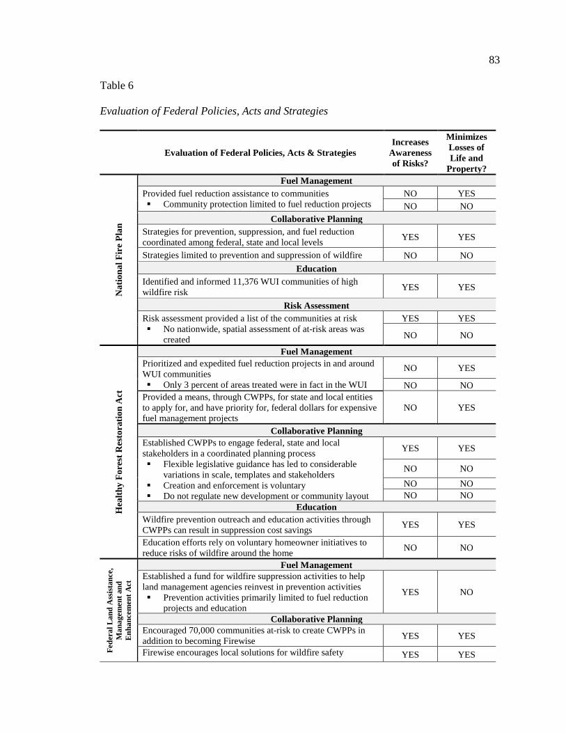
83
Table 6
Evaluation of Federal Policies, Acts and Strategies
Evaluation of Federal Policies, Acts & Strategies Increases
Awareness of Risks?
Minimizes Losses of Life and
Property?
Nat
iona
l Fir
e Pl
an
Fuel Management Provided fuel reduction assistance to communities Community protection limited to fuel reduction projects
NO YES NO NO
Collaborative Planning Strategies for prevention, suppression, and fuel reduction coordinated among federal, state and local levels YES YES
Strategies limited to prevention and suppression of wildfire NO NO Education
Identified and informed 11,376 WUI communities of high wildfire risk YES YES
Risk Assessment Risk assessment provided a list of the communities at risk No nationwide, spatial assessment of at-risk areas was
created
YES YES
NO NO
Hea
lthy
Fore
st R
esto
ratio
n A
ct
Fuel Management Prioritized and expedited fuel reduction projects in and around WUI communities Only 3 percent of areas treated were in fact in the WUI
NO YES
NO NO Provided a means, through CWPPs, for state and local entities to apply for, and have priority for, federal dollars for expensive fuel management projects
NO YES
Collaborative Planning Established CWPPs to engage federal, state and local stakeholders in a coordinated planning process Flexible legislative guidance has led to considerable
variations in scale, templates and stakeholders Creation and enforcement is voluntary Do not regulate new development or community layout
YES YES
NO NO NO NO NO NO
Education Wildfire prevention outreach and education activities through CWPPs can result in suppression cost savings YES YES
Education efforts rely on voluntary homeowner initiatives to reduce risks of wildfire around the home NO NO
Fede
ral L
and
Ass
istan
ce,
Man
agem
ent a
nd
Enha
ncem
ent A
ct
Fuel Management Established a fund for wildfire suppression activities to help land management agencies reinvest in prevention activities Prevention activities primarily limited to fuel reduction
projects and education
YES NO
Collaborative Planning Encouraged 70,000 communities at-risk to create CWPPs in addition to becoming Firewise YES YES
Firewise encourages local solutions for wildfire safety YES YES

84
Table Continues
Fede
ral L
and
Ass
istan
ce,
Man
agem
ent a
nd E
nhan
cem
ent
Act
CWPPs and Firewise do not prevent growth from occurring in wildfire prone areas NO NO
Individual efforts may be inadequate and more coordinated community planning would be more effective NO NO
Education Firewise Communities Program helps educate residents on risk of wildfire YES YES
Firewise provides training to state agencies on educating communities at-risk YES YES
Firewise principles rely on individual homeowner efforts with widely varying perceptions of wildfire risk NO
Nat
iona
l Coh
esiv
e W
ildla
nd F
ire
Man
agem
ent S
trat
egy
Fuel Management Regional risk assessments consider differences in fuel management and suppression strategies NO YES
Considers natural role of wildfire in western landscapes NO YES Collaborative Planning
Brought together federal and state agencies in addition to local governments, landowners, environmental groups, tribal groups, and fire professionals to address complex, regional wildfire issues
YES YES
No clear mandates guiding growth and development were a result of this planning effort NO NO
Risk Assessment Risk assessment listed over 70,000 communities at risk, but did not provide a spatial assessment of areas at-risk YES NO
State Statutes, Codes and Legislation
In recent years, the majority of western states have enacted their own, widely
varying, legislation addressing fire, particularly in the WUI. State mandated land-use
policies are not subject to the approval of local government. This provides the potential
for them to be a key instrument in cohesively addressing wildfire problems across the
state (Gude et al., 2008). The objective of this review and evaluation is to:
1. Review the results of a search of state statues, codes and legislation relevant
to wildfire and development in each of the 11 Western States
2. Summarize and identify the objectives of these state statues, codes and
legislation; and,

85
3. Evaluate the benefits and limitations of current state statues, codes and
legislation in the context of fuel and fire management, wildfire risk
assessment, and regulation of development in at-risk areas. In addition, the
evaluation determines if the state statutes, codes and legislation increase
awareness of wildfire risks and minimize the loss of life and property.
1. Review of State Statutes, Codes and Legislation
Nevada, Washington and Wyoming have not enacted any legislation directly
relevant to wildfire and development. Arizona, Colorado, Idaho and New Mexico have
enacted very flexible wildfire legislation limited in scope. These codes do little to
recommend and encourage standards and practices relevant to wildfire and development
and do not contain much in the way of enforcement. California, Montana, Oregon, and
Utah, on the other hand, have enacted state laws to mitigate or avoid threats to public
health, safety and welfare from wildfire.
Oregon, California, and Utah have established laws that go even further and set
minimum standards for development in high wildfire hazard areas (Gude et al., 2008).
For example, California state law requires homeowners in the WUI clear and maintain
defensible space around structures, communities must provide permanent access to water
supplies, and conduct impact reports evaluating any potentially significant impacts of
development; Utah references the 2006 International Urban Wildland Interface Code to
establish minimum standards for construction materials; and, Oregon has incentivized
growth management in forested areas through a transfer of development rights system.
The following review summarizes the results of a search into the statutes, codes
and limitations relevant to wildfire and development currently in place in each of the 11
86
Western states. See Appendix A for a complete list and language of all codes found
pertinent to wildfire and development.
Arizona. A review of the codes set forth by the Arizona State Legislature did not
uncover any specific codes relevant to the planning or design of communities in wildfire
prone areas. However, the review did reveal some of the explicit duties of the state
forester pertaining to wildfire. Each legislative session, the state forester is asked to
provide updates on the wildland-urban interface, including the effects of county and
municipal zoning policies and wildfire hazards on public and private property. The state
forester is also required to keep a list of communities at risk of wildfire.
California. In contrast to many other Western States, the State of California has
set forth a number of codes pertinent to wildfire. State Codes have been established to
ensure the future design and construction of structures and subdivisions provide for basic
emergency access, signing and building numbering, accessible water supply reserves, and
perimeter wildfire protection measures. These codes are required for State Responsibility
Areas; very-high fire hazard severity zones identified by local agencies; and designated
WUI fire areas.
The state also lists fuelbreaks and defensible space as a special prescription
appropriate in areas to reduce the potential for wildfires. Some timber operations are
exempt from plan preparation and submission requirements as removal of the vertical and
horizontal continuity of vegetation has fuel reduction benefits. Additionally, much of the
language found in the codes on timber harvesting emphasizes fuel management and
silviculture practices, which stress the composition, health and quality of forests to meet
diverse needs and values.

87
Provisions for annual maintenance have also been established in State
Responsibility Areas to ensure continued maintenance of properties occurs. Access and
utilization of defensible space must also be included in the development plan as a
condition of approval. And lastly, wildfire risk areas are listed along with flood plains as
areas susceptible to hazardous conditions. Therefore, they require State Responsibility
Areas to conduct environmental impact reports evaluating any potentially significant
impacts of development.
Colorado. The Code of Colorado Regulations includes very few codes directly
relevant to wildfire. The director of the Division of Wildlife does have the right to
enforce temporary closures of property to the public after a wildfire. Also, intense
wildfire resulting in significant burn areas can be considered to have special floodplain
conditions, due to the threat of landslides and debris flows.
Idaho. Protection of private property rights is common in the language of the
legislation within the State of Idaho. For example, any action taken by the state, city, or
county to control a wildfire is explicitly declared not an unconstitutional taking of private
property. And, the use of exploding targets on private lands during the fire season cannot
be used without the expressed consent of both the landowner and the local fire official.
The state does acknowledge that all owners of forest land must conform to rules and
standards, established by the State Board of Land Commissioners, for protection against
the start or spread of wildfires.
Montana. The State of Montana reserves the right to expand the recognized
wildfire season, and its associated restrictions, in the event of excessive or great fire
danger. State codes also provide for the creation of wildland fire protection districts, and

88
in these districts, it is the expressed duty of the landowner to protect against the starting
or existence of fire and suppress the spread of fire on that land. Additionally, the State
recognizes the water supplies of the most populous cities originate in federally managed
watersheds, which are at risk for catastrophic wildfire. Therefore, it is a State policy to
promote the sustainable uses of all public forests through sound management and
collaboration with local, state and federal entities.
Nevada. No state legislation directly relevant to wildfire and development was
found in the current codified laws of the State of Nevada.
New Mexico. The State of New Mexico has very limited legislation relevant to
wildfire and development. The State does recognize that when warranted by factors
affecting danger of forest fire, the forestry division can impose restrictions governing the
personal access to lands when the danger level poses a threat to public safety, life,
property and the natural resources of the state.
Oregon. Progressive legislation related to wildfire is found in the bills and laws
of the State of Oregon. Many bills and laws related to development in private lands zoned
for agriculture and forest use uphold the statewide land use planning system and its
associated urban growth boundaries, which limit residential development on lands
significant to timber and agricultural operations. Growth is incentivized within
established growth management boundaries through a transferrable development credit
system. Additionally, resort destinations and development of lands classified as Fire
Regime Condition Class 3 are not allowed, unless it is demonstrated that the site can be
developed without being at high risk of fire. And lastly, like many other states in the

89
West, CWPPs are called for through legislation in this State to foster collaborative
wildfire management on federal and state lands.
Utah. The State of Utah recognizes that land management and regulatory policy
may be one of the greatest impediments to efficiently managing landscapes to reduce the
risk of catastrophic wildfires. One such policy impediment to addressing the threat of
wildfire, explicitly recognized by the State, is local government land use decisions
regarding the WUI (State of Utah, 2013). The Utah Codes, however, do little to
comprehensively address land use decisions within the State’s WUI. Utah codes do allow
for the creation of special service districts for fire protection within a county or
municipality using Firewise Communities programs or CWPPs. There is also a financial
incentive to create these special service districts.
The Utah Code is unique in that it does explicitly place additional requirements
for development in two cities in the State. In Park City, the use of wood roof coverings in
areas with high wildfire hazard ratings is prohibited and in Sandy City, buildings and
structures within designated WUI areas must use ignition resistant construction, as
outlined in the 2006 International Wildland-Urban Interface Code. The legislation also
adopts this International Code as a construction code. Local agencies may adopt this code
by local ordinance or other similar action. This is the only reference to the International
Wildland-Urban Interface Code (updated most recently in 2012), which was found in the
review of the codes relevant to wildfire in each of the Western States.
Washington. No state legislation directly relevant to wildfire and development
was found in the current codified laws of the State of Washington.
90
Wyoming. No state legislation directly relevant to wildfire and development was
found in the current codified laws of the State of Wyoming.
2. Summary of State Statutes, Codes and Legislation
Each of the 11 Western States have developed statutes, codes and legislation that
provide regulation at the state level. These systems of law provide accepted rules that
apply equally to all individuals and address a diversity of topics ranging from dogs and
cemeteries to municipal codes. State statutes, codes, and legislations also embody an
enforceable means to coordinate and control current and future growth in the areas at risk
within their jurisdiction. Guiding growth in wildfire prone areas is an important step
toward creating wildfire resilient communities. In order to comprehensively address the
risks of wildfire, state legislation regulating development in wildfire prone areas will be
necessary.
While state statutes, codes, and legislation have the capacity to explicitly address
development and design in wildfire prone areas within the state, through a specific
wildland urban interface statute, not one state has done so. Some states do address
development and growth in wildfire prone areas within a variety of other statutes, codes
and legislation. However, existing state statutes, codes, and legislation in the West are
very limited in their current capacity to regulate development in wildfire prone areas.
Table 7 summarizes the state statute, codes and legislation in the West and identifies the
objectives of statutes, codes and legislation relevant to wildfire and development.

91
Table 7
Summary of State Statutes, Codes and Legislation
Summary of State Statutes, Codes and Legislation Objectives
Ari
zona
• State foresters provide annual updates on the WUI, including effect of county and municipal zoning policies and wildfire hazards on public and private property (37-622; 37-642)
• The state forester maintains a list of communities at risk of wildfire (37-622; 37-642).
• Wildfire risk assessments
Cal
iforn
ia
• Annual maintenance shall be included in the development plans and provided as a condition of the permit, parcel or map approval to ensure continued maintenance of properties in conformance with these standards and measures and to assure continued availability, access, and utilization of the defensible space provided for in these standards during a wildfire (14 CCR § 1272.00).
• Road and street networks, whether public or private, unless exempted, shall provide for safe access for emergency wildland fire equipment and civilian evacuation concurrently, and should provide unobstructed traffic circulation during a wildfire emergency (14 CCR § 1273.00).
• Emergency water for wildfire protection shall be immediately available and accessible in quantities and locations in communities specified in the statute and these regulations, in order to attack a wildfire or defend property from a wildfire (14 CCR § 1275.00).
• To reduce the intensity of a wildfire by reducing the volume and density of flammable vegetation, the strategic siting of fuel modification and greenbelts shall provide increased safety for evacuating civilians and a point of attack or defense from a wildfire (14 CCR § 1276.00)
• Environmental impact reports should evaluate any potentially significant impacts of locating development in other areas susceptible to hazardous conditions (e.g., floodplains, coastlines, wildfire risk areas) as identified in authoritative hazard maps, risk assessments or in land use plans addressing such hazards areas (14 CCR § 15126.2).
• Fuel management • Wildfire risk
assessments • Regulation of
development in at-risk areas
• Fuelbreak/Defensible Space is listed as special prescriptions that are appropriate where some trees and other vegetation and fuels are removed to create a shaded fuel break or defensible space in an area to reduce the potential for wildfires and the damage they might cause (14 CCR §§ 913.4(c), 933.4(c), and 953.4(c)). Also, the cutting or removal of trees, which eliminates the vertical continuity of fuels and the horizontal continuity of tree crowns for the purpose of reducing flammable materials and maintaining a fuelbreak and the removal of trees within one-hundred-fifty feet from any point of an “approved and legally permitted structure” that complies with the California Building Code is exempt from some plan preparation and submission requirements because of the fuel reduction benefits (14 CCR § 1038).
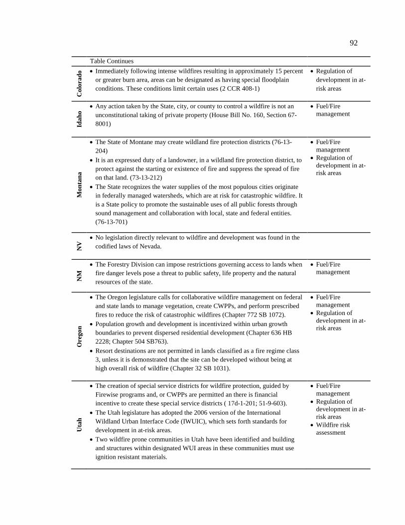
92
Table Continues
Col
orad
o • Immediately following intense wildfires resulting in approximately 15 percent or greater burn area, areas can be designated as having special floodplain conditions. These conditions limit certain uses (2 CCR 408-1)
• Regulation of development in at-risk areas
Idah
o
• Any action taken by the State, city, or county to control a wildfire is not an unconstitutional taking of private property (House Bill No. 160, Section 67-8001)
• Fuel/Fire management
Mon
tana
• The State of Montane may create wildland fire protection districts (76-13-204)
• It is an expressed duty of a landowner, in a wildland fire protection district, to protect against the starting or existence of fire and suppress the spread of fire on that land. (73-13-212)
• The State recognizes the water supplies of the most populous cities originate in federally managed watersheds, which are at risk for catastrophic wildfire. It is a State policy to promote the sustainable uses of all public forests through sound management and collaboration with local, state and federal entities. (76-13-701)
• Fuel/Fire management
• Regulation of development in at-risk areas
NV
• No legislation directly relevant to wildfire and development was found in the codified laws of Nevada.
NM
• The Forestry Division can impose restrictions governing access to lands when fire danger levels pose a threat to public safety, life property and the natural resources of the state.
• Fuel/Fire management
Ore
gon
• The Oregon legislature calls for collaborative wildfire management on federal and state lands to manage vegetation, create CWPPs, and perform prescribed fires to reduce the risk of catastrophic wildfires (Chapter 772 SB 1072).
• Population growth and development is incentivized within urban growth boundaries to prevent dispersed residential development (Chapter 636 HB 2228; Chapter 504 SB763).
• Resort destinations are not permitted in lands classified as a fire regime class 3, unless it is demonstrated that the site can be developed without being at high overall risk of wildfire (Chapter 32 SB 1031).
• Fuel/Fire management
• Regulation of development in at-risk areas
Uta
h
• The creation of special service districts for wildfire protection, guided by Firewise programs and, or CWPPs are permitted an there is financial incentive to create these special service districts ( 17d-1-201; 51-9-603).
• The Utah legislature has adopted the 2006 version of the International Wildland Urban Interface Code (IWUIC), which sets forth standards for development in at-risk areas.
• Two wildfire prone communities in Utah have been identified and building and structures within designated WUI areas in these communities must use ignition resistant materials.
• Fuel/Fire management
• Regulation of development in at-risk areas
• Wildfire risk assessment

93
Table Continues
WA
• No legislation directly relevant to wildfire and development was found in the codified laws of Nevada.
W
Y • No legislation directly relevant to wildfire and development was found in the
codified laws of Nevada.
3. Evaluation of State Statutes, Codes and Legislation
Through the summary of state statutes, codes and legislation, the following were
identified as objectives at the state-level that influence community development in
wildfire prone areas: fuel and fire management; wildfire risk assessments; and, regulation
of development in at-risk areas. Following is an evaluation of the benefits and limitations
of the current State statutes, codes, and legislation and their objectives grouped by states
that have not enacted any legislation relevant to wildfire and development [Nevada,
Washington, Wyoming], states with limited legislation relevant to wildfire and
development [Arizona, Colorado, Idaho, New Mexico], and states with enhanced
legislation relevant to wildfire and development [California, Montana, Oregon, Utah]
(Table 8).
Fuel and Fire Management. Provisions for annual maintenance of fuels has been
established through California State Codes. These codes reduce risk to communities by
ensuring continued maintenance of defensible space in areas with high fire danger and on
lands the State is responsible for. No other state in the West specifically addresses fuel
management around communities in their statutes, codes or legislation. However, this
does not mean fuel management activities do not occur in these states. Fuel management
activities are typically prioritized and carried out by state foresters and federal land

94
managers. However, this system removes the responsibility to manage fuels in and
around homes and communities from those living and developing in areas at-risk and
places the responsibility on fire officials.
Assessment of Wildfire Risk. The State of California provides an example of a
state that has systematically assessed areas at risk of wildfire. This assessment of risk has
informed state-level legislation that addresses fuel management and building codes in
areas with high fire hazards. However, methods for identifying areas at-risk of wildfire
varies from state to state. In most states it is difficult to even find spatially explicit maps
of at-risk areas. One of the major obstacles to comprehensive risk assessments is the
absence of a federally recognized wildfire risk assessment that Western states can use as
a framework to identify areas of high wildfire risk and systematically map all WUI areas.
Developing State legislation specific to areas at risk of wildfire will require a recognized,
cohesive risk assessment that uses GIS to determine spatially explicit areas of high
wildfire risk.
Regulation of Development in At-Risk Areas. Utah, California, and Oregon
have adopted codes that regulate development in areas with wildfire risks. These
additional standards are beneficial to guiding growth in wildfire prone areas and
important steps in creating wildfire resilient communities. These codes reduce risks to
communities through regulation of building materials, growth boundaries and
accessibility. Because compliance with state legislation is mandatory and not subjected to
differences in local perceptions on wildfire, it is a key tool to significantly reduce ever-
increasing suppression costs and damages caused by wildfires (Gude et al., 2008).
However, most Western States have not systematically imposed legislation on

95
community development guidelines requiring municipalities to address wildfire through
local policies, zoning, land use controls and building construction methods.
Not one state explicitly establishes guidelines for development in wildfire prone
areas through legislation, like many states do with other hazardous areas such as flood
plains. The states do not comprehensively require counties and municipalities to regulate
housing densities in high-risk areas or require current and future structures to be
compliant with standards that help protect them from wildfire (Gude et al., 2008). In
much of the West, zoning is controversial. It is often perceived as a regulatory taking of
private property when zoning laws limit how the land can be used. The emphasis on
private property in the State of Idaho statutes shows evidence of this. However, the
increasing costs of wildfire suppression to protect homes and lives make development in
wildfire prone areas a decision that affects all U.S. taxpayers.
Table 8
Evaluation of State Statutes, Codes and Legislation
Evaluation of State Statutes, Codes & Legislation Increases
Awareness of Risks?
Minimizes Losses of Life and
Property?
Nev
ada,
Was
hing
ton
& W
yom
ing
Fuel and Fire Management No statewide provisions for managing fuels in or around communities NO NO
Wildfire Risk Assessments No statewide risk assessment informing land use decisions NO NO
Regulation of Development in at-risk Areas No regulation of development in areas with high wildfire hazards NO NO
Ari
zona
, C
olor
ado,
Id
aho
& N
M Fuel and Fire Management
No statewide provisions for managing fuels in or around communities NO NO
Wildfire Risk Assessments State foresters maintain list of communities at-risk of wildfire [AZ] YES NO

96
Table Continues
Ari
zona
, Col
orad
o, Id
aho
& N
ew M
exic
o
State has right to close areas severely affected by wildfire [CO, NM] YES NO
No statewide risk assessment informing land use decisions NO NO Regulation of Development in at-risk Areas
Provide updates to legislators on the effects of planning, zoning, and wildfire hazards on private property [AZ] YES NO
All forest landowners must conform to rules and standards to prevent start or spread of wildfire [ID] YES YES
No clear regulations guiding growth and development in hazardous areas NO NO
Cal
iforn
ia, M
onta
na, O
rego
n &
Uta
h
Fuel and Fire Management Development plans must include provisions for annual maintenance of vegetation in areas established as high-severity zones as a condition for approval [CA]
YES YES
State promotes sustainable management of all forested land [CA, MT, OR] NO YES
Wildfire Risk Assessments Hazardous areas spatially identified by severity statewide [CA] YES YES
Wildfire risk areas recognized as susceptible to hazardous conditions, similar to floodplains [CA] NO YES
Wildfire risk assessment informs WUI ordinances and standards [CA, UT] NO YES
Regulation of Development in at-risk Areas State codes establish standards for access, signage, water supply, and vegetation management in high risk areas [CA] YES YES
State has adopted IWUIC for hazardous areas [UT] YES YES State codes regulate building construction materials in high risk areas [CA, UT] YES YES
State provides for creation of special wildfire districts [CA, MT, UT] YES YES
State defines urban growth boundary, preventing sprawl and fragmented growth [OR] NO YES
Codes have little influence on land use planning NO NO
Local Ordinances, Standards and the Site Plan Review
Local ordinances, standards, and the final site plan review guide planning and
design decisions at the local level. Community mandated policies are a key instrument in
addressing the problem of growth and development in wildfire prone ecosystems. This
review and evaluation:

97
1. Reviews practices relevant to the commonly used tools of ordinances,
standards, and the site plan review process that guide development in wildfire
prone communities in the West;
2. Summarizes and identifies the objectives of these local ordinances, standards
and the site plan review; and,
3. Evaluates the benefits and limitations of current local ordinances, standards
and the site plan review in terms of assessing wildfire risk, as well as
regulating development and establishing minimal requirements in at-risk
areas.
1. Review of Local Ordinances, Standards and the Site Plan Review
At the local level, planning professionals have two main types of tools to guide
current and future development and influence design: ordinances and standards. In local
government, ordinances and standards can prove extremely useful in guiding community
planning decisions and directing design decisions at both the community and site scale.
Ordinances are the regulatory actions that specify appropriate land uses and regulate
development. Standards establish minimum requirements to preserve and protect the
health safety and welfare of community residents and are adopted through ordinances.
When approving projects and site plans, planning professionals look to ordinances and
standards to guide the review of development proposals. This review will examine:
A. Ordinances
B. Standards
C. Site Plan Review Process

98
A. Ordinances. Ordinances, or regulations, in local government establish
guidelines for existing and future developments. Ordinances that help regulate
development in wildfire prone areas include the comprehensive plan and elements within
the comprehensive plan such as the natural hazard element, land use element and growth
management element; and, codes adopted by communities such as zoning ordinances,
subdivision regulations, building and construction ordinances, and landscaping and
design regulations, which in theory are developed to reflect the vision of the
comprehensive plan. The following review will explore the ways that local ordinances
can influence development in wildfire prone areas.
The Comprehensive Plan. While the comprehensive plan is not typically
understood in terms of being an ordinance, actions supported by the language in a
comprehensive plan are almost always held up in courts because these plans have been
crafted using due process of the law (Solnit, 1988). The goals and policies set forth
within a comprehensive plan can be a powerful tool for guiding and restricting
community growth in wildfire prone areas. Comprehensive plans are the regulatory
documents for communities, guiding growth and development in accordance with a
common vision. Within the comprehensive plans are ordinances that specify land use
patterns, allowable and conditional land uses, densities and so forth.
A local comprehensive plan offers a systematic and enforceable approach to
wildfire planning. The formal legal standing of the comprehensive plan gives this
document a central role in community planning and design decisions and provides an
effective means to implement ordinances that reduce wildfire risks. Most States in the
West require counties and municipalities to adopt a comprehensive plan, and most states

99
provide specific instruction on elements to include within the plan. These elements
typically include: future land use, housing, transportation and infrastructure. Each of
these elements can be informed by best practices to mitigate risk of wildfire.
Alternatively, the comprehensive plan can specifically include a wildfire hazard element.
With the exception of California, current state legislation in the West does not require the
comprehensive plan to include an element addressing wildfire hazards. This review of the
comprehensive plan will examine the following commonly found elements:
1. Natural Hazard Element
2. Land Use Element
3. Growth Management Element
1. Natural Hazard Element. A natural hazard element within the comprehensive
plan can provide an effective means to address wildfire in the development of
communities (Schwab & Meck, 2005). In the natural hazard element of a comprehensive
plan, a community can identify areas of high wildfire hazard and set specific goals and
polices for development in areas at-risk of wildfire. Implementing actions take the form
of adoption of policies, modification of existing codes, public information initiatives,
evacuation plans, enforcement initiatives, land acquisition, and programs of vegetation
removal or thinning (Schwab & Meck, 2005). In order to create a natural hazard element
in a comprehensive plan, however, areas at-risk of wildfire must be identified and this
can be an exhaustive effort for small communities.
One example of an effort at the state level to assist communities in the data
collection needed to identify at-risk areas comes from California. This State does require
local governments to adopt multi-element general plans that contain a safety element,

100
which includes wildfire, and also provides a fire hazard planning guide to help
communities incorporate fire hazard polices into the comprehensive plan. This guide
outlines in detail the type of data that should be collected to assess risk and offers a
suggested language for potential policies (Schwab & Meck, 2005). This guide has helped
the City of Glendale create a safety element in its comprehensive plan that lists goals and
implements policies that address fire hazards (See Table 9).
2. Land Use Element. The land use element within the comprehensive plan
provides guidance for the physical development and redevelopment of communities and
as such, has great potential for protecting future development from wildfire.
Development in wildfire prone areas is a direct consequence of land-use policy. The local
land use element results in a plan that specifies development types at different levels of
density in accordance with the vision and goals established in the other elements of the
Table 9
Wildfire Hazard Element Example
City of Glendale, California Goal 4: Reduce the loss of life, injury, private property damage, infrastructure damage, economic losses, social dislocation, and other impacts resulted from fire hazards. Policy 4-2: The City shall require that all new development in areas with high fire hazard incorporate fire
resistant landscaping and other fire hazard reduction techniques into the project design in order to reduce the fire hazard. Program 4-2.1: The City shall encourage residents to plant and maintain drought-resistant
landscape species to reduce the risk of brush fire and soil erosion in areas adjacent to canyons, and develop stringent site design and maintenance standards for areas with high fire hazard of soil erosion potential.
Program 4-2.5: The City shall consider fire safety issues during revisions to the Zoning Ordinance.
Program 4-2.8: The City shall enforce Class A roofing ordinance or better for residential and commercial developments. Residents with existing wood-shingle or unrated roofing materials shall be encouraged to upgrade to fire-resistant building materials including fire-resistant eaves and awning.
(Schwab & Meck, 2005)
101
comprehensive plan (Schwab & Meck, 2005). Land-uses and density ranges specified in
the land use plan are implemented through the local zoning ordinance, which is described
a section following.
The use of land use planning to mitigate risks of wildfire is only beginning to
receive attention in scientific literature, and the recognition of the potential benefits of
directing development away from the most hazardous locations is growing (Bovio &
Camia, 1997; Buxton, Haynes, Mercer, & Butt, 2011; Gude et al., 2008; Schwab &
Meck, 2005; Bhandry & Muller, 2009; Syphard, Massada, Butsic, & Keeley, 2013).
However, land use planning for wildfire has yet to take hold in practice in the Western
U.S. (Syphard et. al, 2013). The “business as usual” approach to reduce risks in fire-
prone ecosystems is to invest heavily on fire suppression and manipulation of wildland
vegetation after development occurs. Land use planning represents an alternative to this
traditional approach. By thinking beyond the preparation of communities to withstand
fires that are increasingly becoming inevitable, land use planning instead prevents new
communities from being exposed to fire in the first place (Syphard et. al, 2013).
In a recent study, researchers looked at three common types of residential
development: expansion, leapfrog and infill (Syphard et. al, 2013). The simulations of
these development types showed that planning policies based on different growth types
produced substantial differences in the pattern, location and extent of development.
Leapfrog development produced fragmented development with larger numbers of small
patches, lower housing density and larger housing footprints, which generally led to
predictions of highest fire risk. Infill development, on the other hand, produced opposite
development patterns and resulted in the least risk. The most important variables in the

102
fire risk models were pattern and location of structures, with most structure loss occurring
in areas with low housing density and in small, isolated housing clusters (Syphard et. al,
2013).
3. Growth Management Element. Addressing current and future growth in a
comprehensive plan can take many forms. Communities can look to smart growth
principles and create goals that discourage exurbanization by implementing policies that
limit outward expansion, encouraging high density and mixed-use zoning, promoting
alternative transportation options, and revitalizing older areas (Downs, 2013).
Communities can go even further and explicitly limit exurbanization and fragmented
growth through urban growth boundaries.
The State of Oregon has incentivized infill growth within developed areas by
requiring an urban growth management element within the comprehensive plan that
delineates an urban growth boundary. Across the state, cities and counties are required to
create and adopt urban growth boundaries to address anticipated population growth over
a twenty-year period. This legal line is aimed at preserving valuable timber and
agriculture resources, but also helps prevent fragmented development in wildfire prone
areas. In Deschutes County, Oregon an urban growth boundary has been imposed on each
of the major communities to prevent outward and fragmented growth. The cities of Bend,
La Pine, Redmond, and Sisters use this established growth boundary developed at the
county level to maintain their own land use plan within their respective urban growth
boundary. Figure 13 illustrates this urban growth boundary, and the associated goals and
policies can be found in Chapter 4 of the County’s Comprehensive Plan (Deschutes
County, 2010).

103
Figu
re 1
3. E
xam
ple
of a
n U
rban
Gro
wth
Bou
ndar
y (D
esch
utes
Cou
nty,
201
0).

104
Municipal Codes. A comprehensive plan alone cannot enforce land use or
development controls. While the comprehensive plan does establish a clear vision for the
growth of communities and it provides direction for land use, housing, transportation, and
other elements outlined in the plan, the real regulatory power behind a comprehensive
plan is in the municipal codes. Municipal codes and the regulations and provisions they
set forth are examples of the power of ordinance tool to regulate land use and
development. These codes are adopted through local legislative action (Call, 2005). The
unique thing about municipal codes is that they vary among communities, so they can
provide a flexible means for communities to address wildfire specific to their needs. The
following review of municipal codes will examine typical regulations, including:
1. Zoning ordinances
2. Subdivision regulations
3. Building and construction ordinances
4. Vegetation management provisions
1. Zoning Ordinance. Zoning is different from the land use element in that zoning
physically separates communities in to districts and regulates building and structures
whereas the land use element has a broader focus concentrating on development in
relation to the current and future well-being of a community (Solnit, 1988). Zoning
ordinances regulate land use, control density and intensity of development, set
dimensional requirements, limit inappropriate activities, designate institutional uses and
open space, and establish special areas. It is important to coordinate the local zoning
ordinance with the land use plan and the vision established through the community’s
comprehensive plan, but this doesn’t always happen in practice.

105
If areas at high risk of wildfire are identified within a comprehensive plan and it is
a goal of the community to reduce wildfire risks, these areas can be zoned to mitigate
risks. Through zoning, requirements can be imposed that limit large lot development in
favor of clustering homes and restrict development in areas of steep slopes and
flammable vegetation (Schwab & Meck, 2005). Communities can also establish wildfire
overlay districts on top of an adopted zoning map to regulate development. These overlay
districts delineate areas at-risk of wildfire and impose additional mitigation requirements
on future development.
An overlay district is typically applied when there is special public interest in an
area that is not being served by the existing zoning. Since wildfires are usually a hazard
that can affect multiple areas in the community, it is easier to map an overlay district over
several different zoning categories than rewrite each zoning category that is at risk of
wildfire. This allows the underlying zoning to continue while meeting additional
requirements to mitigate risks of wildfire.
In Douglas County, Colorado, areas of potential wildfire hazard have been
identified and planning officials have created a Wildfire Overlay District in these areas.
One of the specific purposes of this Overlay District is to enforce compliance with the
Douglas County Wildfire Mitigation Standards in order to minimize the potential for the
loss of life and property. These standards set forth minimum requirements for road and
street design, driveway design, signage, water supply and structural design. Compliance
with these standards applies in addition to the underlying land uses specified by the
zoning map. Figure 14 is provided to illustrate the concept of a wildfire hazard overlay

106
Figure 14. Example of a Wildfire Hazard Overlay District (Douglas, County, 2001).
district. More detailed descriptions of the ordinances that can be adopted in areas zoned
according to wildfire hazards are in the following discussions of municipal codes.
2. Subdivision Regulations. The purpose of rules, regulations, and specifications
adopted though subdivision ordinances are to regulate and control the subdivision of land
to preserve and enhance the health, safety and welfare of communities. Through a
subdivision ordinance, communities can enforce compliance with density and lot size
requirements as well as standards that minimize risks of wildfire. These standards can
impose minimum safety requirements addressing access, road widths and turning radii to
name a few.

107
The city of Ashland Oregon has developed a Physical and Environmental
Constraints Overlay as part of their land use ordinance in their municipal code. The
purpose and intent of this overlay is to provide for safe, orderly, and beneficial
development within the constraints of physiographic conditions and significant natural
features (Ashland, Oregon, City of, 2013). This overlay provides provisions for
development in flood plains, hillsides and also wildfire lands. All new development
within areas identified as wildfire lands must conform to provisions established within
the code, which include subdivision regulations. Figure 15 illustrates the proactive
planning the City of Ashland has accomplished in establishing wildfire hazard areas
within their community and Table 10 provides an example of this community’s
subdivision regulations.
Figure 15. Example of Wildfire Constraint Overlay Influencing Subdivision
Requirements (Ashland, Oregon, City of, 2015).

108
Table 10
Example of a Subdivision Ordinance in Wildfire Prone Areas
18.3.10.100 Development Standards for Wildfire Lands
A. Requirements for Subdivisions, Performance Standards Developments or Partitions.
1. A Fire Prevention and Control Plan shall be required with the submission of any application for an outline plan approval of a Performance Standards Development, preliminary plat of a subdivision, or application to partition land where the site contains area designated as Wildfire Hazard.
2. The Staff Advisor shall forward the Fire Prevention and Control Plan to the Fire Chief within three days of the receipt of a completed application. The Fire Chief shall review the Fire Prevention and Control Plan, and submit a written report to the Staff Advisor no less than seven days before the scheduled hearing. The Fire Chief's report shall be a part of the record of the Planning Action. 3.The Fire Prevention and Control Plan, prepared at the same scale as the development plans, shall include the following items.
a. An analysis of the fire hazards on the site from wildfire, as influenced by existing vegetation and topography.
b. A map showing the areas that are to be cleared of dead, dying or severely diseased vegetation.
c. A map of the areas that are to be thinned to reduce the interlocking canopy of trees. d. A tree management plan showing the location of all trees that are to be preserved and
removed on each lot. In the case of heavily forested parcels, only trees scheduled for removal shall be shown.
e. The areas of primary and secondary fuel breaks that are required to be installed around each structure, as required by 18.3.10.100.B.
f. Roads and driveways sufficient for emergency vehicle access and fire suppression activities, including the slope of all roads and driveways within the Wildfire Lands area.
4. Approval Criteria. The hearing authority shall approve the Fire Prevention and Control Plan when, in addition to the findings required by this chapter, the additional finding is made that the wildfire hazards present on the property have been reduced to a reasonable degree, balanced with the need to preserve and/or plant a sufficient number of trees and plants for erosion prevention, wildlife habitat and aesthetics. 5. The hearing authority may require, through the imposition of conditions attached to the approval, the following requirements as deemed appropriate for the development of the property.
a. Delineation of areas of heavy vegetation to be thinned and a formal plan for such thinning. b. Clearing of sufficient vegetation to reduce fuel load. c. Removal of all dead and dying trees. d. Relocation of structures and roads to reduce the risks of wildfire and improve the chances
of successful fire suppression.
6. The Fire Prevention and Control Plan shall be implemented during the public improvements required of a subdivision or Performance Standards Development, and shall be considered part of the subdivider's obligations for land development. The plan shall be implemented prior to the issuance of any building permit for structures to be located on lots created by partitions and for subdivisions or Performance Standards developments not requiring public improvements. The Fire Chief, or designee, shall inspect and approve the implementation of the Fire Prevention and Control Plan, and the Plan shall not be

109
Table Continues considered fully implemented until the Fire Chief has given written notice to the Staff Advisor that the plan was completed as approved by the hearing authority. 7. In subdivisions or Performance Standards Developments, provisions for the maintenance of the Fire Prevention and Control Plan shall be included in the covenants, conditions and restrictions for the development, and the City shall be named as a beneficiary of such covenants, restrictions and conditions. 8. On lots created by partitions, the property owner shall be responsible for maintaining the property in accord with the requirements of the Fire Prevention and Control Plan approved by the hearing authority.
3. Building and Construction Ordinance. The provisions of local building and
construction ordinances are typically adopted to promote public safety and general public
welfare, coordinate orderly growth, and establish minimum standards for buildings and
construction. This ordinance can be enhanced to further protect property against loss
from wildfire. The California Building Code has adopted a statewide WUI code requiring
new buildings in State Responsibility Areas, Local Agency Very-High Fire Hazard
Severity Zones, and designated WUI Fire Areas to comply with Chapter 7A: Materials
and Construction Methods for Exterior Wildfire Exposure. This State Code addresses
materials, systems, and methods of construction for buildings in the WUI.
The City of Santa Clarita is one example of a city in California that contains Very
High Fire Hazard Severity Zones identified by the Director of the California Department
of Forestry and Fire Prevention, which can be seen in the City of Santa Clarita Fire Zone
Map (Figure 12). All new buildings and structures located in these areas of high wildfire
hazard risk must conform to the statewide building and construction codes. The city has
also imposed additional requirements, exceeding the statewide requirements. For
example, Class B roofing material is required in the entire City and the use of wood
shingles and wood shakes is restricted within the City’s Fire Hazard Zones (Santa Clarita

110
Figure 16. Example of Fire Hazard Zones Influencing Building and Construction
Ordinances (Santa Clarita Municipal Code, 2013)

111
Municipal Code, 2013). Additional building construction standards for high fire zones,
enforced through the municipality’s building and construction ordinance, are illustrated
for residents in Figure 16.
4. Vegetation Management Regulations. Provisions relevant to vegetation
management can be adopted in the local code, allowing communities regulatory authority
on fuel reduction. Amending local codes to include a vegetation management ordinance
assist communities in controlling accumulation of hazardous fuels near homes and
roadways. Such an ordinance can require developers to carry out fuel management
projects, specify appropriate plants, and require maintenance of defensible space by
homeowners. The local government in Pinetop-Lakeside, Arizona has created the Forest
Health and Fire Protection Code (2003) to protect the health, safety, and welfare of its
residents and promote forest health by mitigating risks of ponderosa pine trees and other
coniferous trees within the town.
This code was developed by the Town’s Forest health Committee and includes
provisions for forest health and fire protection, fuel modification, defensible space and
tree removal. As part of the defensible space requirements, a three-zone plan provides
mandatory and recommended actions for developed parcels and undeveloped parcels less
than two acres. Table 11 illustrates these actions adopted through Pinetop-Lakeside’s
unique vegetation management ordinance.
B. Standards. Planning professionals, with advice from fire officials, can adopt
minimum standards through ordinances, described above, to mitigate risk of wildfires and
require that developers design these standards into projects. Standards are a tool useful to

112
Table 11
Example of a Vegetation Management Ordinance
Pinetop-Lakeside, Arizona Defensible Space Criteria
Required Actions
Recommended Actions
ZONE 1: 0 to 10 feet From Structure 1. Remove all ladder fuels (See 17.96.070 A.1.a.) 2. Reduce flammable vegetation (See 17.96.070.A.1.a.) 3. Remove and destroy all insect infested, diseased and dead trees (See 17.96.070 A.1.b.)
4. Remove all dead plant material from ground (See 17.96.070 A.1.c.)
Table Continues 5. Prune tree limbs overhanging roof (See 17.96.070 A.1.d) 6. Remove branches within 10 (10) feet of chimney (See 17.96.070 A.1.d.)
7. Remove flammable debris from gutters and roof surfaces (See 17.96.070 A.1.e.)
8. Remove all combustible material and vegetation from under decks (See 17.92.070.A.1.f.)
9. Regularly maintain defensible space (See 17.96.070.A.2.a.) 10. Provide adequate hydration (See 17.96.070 A.2.b.) ZONE 2: 10 to 30 feet From Structures 1. Remove all ladder fuels (See 17.96.070.B.1.a.) 2. Remove and destroy all insect infested, diseased and dead trees (See 17.96.070 B.1.b.)
3. Regularly maintain defensible space (See 17.96.B.2.a.) 4. Create separation between trees, tree crowns and other plants based on fuel type, density, slope and other topographical features (See 17.96.070 B.2.b.)
5. Reduce continuity of fuels by creating clear space around brush or planting groups (See 17.96.070 B.1.c.)
6. Control erosion and sedimentation (See 17.96.070.B.2.d.) 7. Remove all but one inch of pine needle or leaf droppings (See 17.96.070.B.2.e.)
ZONE 3: 30 to 72 feet From Structures 1. Remove all ladder fuels (See 17.96.C.1.a.) 2. Maximum density: (Whichever is greater) Ponderosa pine - 60 sq. foot Basal Area OR Average density 100 trees per acre (See 17.96.070.C.1.b.)
100 80
3. Remove and destroy all insect infested, diseased and dead trees (See 17.96.070.C.1.c.)
4. Regularly maintain defensible space (See 17.96.070.C.2.a.)
(Forest Health and Fire Protection Code, 2003)

113
planning and design in areas at risk of wildfire because they allow minimum
requirements to be established that ensure the health, safety, and welfare of local
residents will be adequately met. The following components have been determined to be
important to assessing risks in wildfire prone areas: road infrastructure, building
construction and materials codes, vegetation, topography, water supply and placement of
utilities. Standards for development in the WUI addressing most of these components
currently exist and these standards are available for adoption by fire agencies, land use
planners, landscape architects, architects, developers and local governments.
Who Creates WUI Standards? Standards can be created at many different levels.
In the discussion of ordinances above, county officials, state regulations and even local
jurisdictions played a role in creating standards. Several national and international
standards exist for wildfire risk reduction in the WUI. The goal of these national
standards is to provide model codes to reduce risks of wildfire and minimize losses to life
and property. These standards are intended to facilitate uniformity in the construction and
development industry, but they are not enforceable unless state or local jurisdictions
mandate their use. This review will focus on two of the primary entities creating
standards, the National Fire Protection Association and the International Code Council,
and the codes these entities have created directed at risk reduction in the WUI.
National Fire Protection Association. The National Fire Protection Association
(NFPA) identifies eight factors that contribute to structure ignition: means of access,
vegetation management, slope, topography, roofing materials, building construction
materials, available fire protection accessories, and placement of gas and utilities
(Bhandry & Muller, 2009). These factors are used to rate wildland fire risk for existing

114
and proposed developments (See Appendix B for the NFPA Wildland Fire Risk
Checklist). These factors influence NFPA 1144: Standard for Reducing Structure Ignition
Hazards from Wildland Fire. The NFPA 1144 standards use the rating system to provide
guidance for the construction of residential structures in moderate to extreme wildfire
hazard areas with the goal of increasing the ability of the structure to survive a wildfire
event without the intervention of fire-fighting forces (NFPA, 2013). The NFPA 1144
standards specifically address construction, location, construction design and materials,
roof design and materials, overhanging projections, overhanging buildings, exterior
vertical walls, exterior openings, chimneys and flues, accessory structures, mobile and
manufactured homes, vehicle parking areas and exterior exposure hazards.
The NFPA has also created 1141: Standard for Fire Protection Infrastructure for
Land Development in Wildland, Rural and Suburban Areas. This standard provides
requirements for the development of fire protection and emergency services infrastructure
to ensure land use changes in the wildland, rural, and suburban areas have the minimum
requirements in place to protect lives and property from wildfire (NFPA, 2012). The
NFPA 1141 contains standards and recommended practices for accessibility, building
access, fire protection, water supply, fire protection during construction, and community
safety and emergency preparedness. Even though these standards are easily accessible
online and recognized at the national level, fire agencies, land use planners, architects,
developers, and local governments implement these standards for planning development
in areas at risk of wildfire at their discretion (Bhandry & Miller, 2009).
International Code Council. The International Code Council (ICC) developed the
International Wildland-Urban Interface Codes (IWUIC) to establish minimum regulations

115
to safeguard life and property from wildfire and prevent structures from spreading fires,
even in the absence of fire fighting forces (ICC, 2012). Similar to the NFPA 1144
Standards, the IWUIC provides a fire hazard assessment form to determine the wildfire
hazard so that jurisdictions can adopt appropriate standards for moderate to extreme
hazard areas. (See Appendix C for the IWUIC Fire Hazard Severity Form).
The IWUIC codes are intended to be adopted and used supplemental to the
standards adopted by state and local jurisdictions. This code is designed to be adopted by
reference by legislative action at the state level, like the State of Utah has done, or at the
local level through an ordinance. (See Appendix D for an example of the sample
legislation for the adoption of the International Wildland-Urban Interface Code). This
code establishes standards for the wildland-urban interface that address access, water
supply, building construction, ignition-resistant materials, roofing materials, sprinkler
systems, defensible space and combustible materials.
WUI Standards. Following is a review of standards that have been established by
the NFPA and the IWUIC that communities can adopt in full or with amendments
through their local ordinances.
Road Infrastructure. Access in and out of communities is one of the most
important aspects of land development from a fire protection viewpoint (See Figure 15).
Adequate ingress and egress, road grades, road widths and turning radii are critical for
fire suppression forces to locate, reach, and safely remain at a structure and continue
suppression efforts (Cohen, 1990). The IWUIC and NFPA 1141 contain standards for
appropriate access and road infrastructure. The following are excerpted standards from

116
Figure 15. Example of Inadequate Resident Egress (Oakland North, 2011).
the NFPA 1141 and IWUIC selected to illustrate the specificity of current road
infrastructure standards:
• Access: Land development should have one or more access in accordance with
either number of households or number of parking spaces, depending on which
produces the greatest number. In residential areas, 0 to 100 households or 0 to
1,250 parking spaces require 1 access route; 101 to 600 households or 1,251 to
3,000 parking spaces require 2 access routes; and, more than 600 households or
more than 3,000 parking spaces require 3 access routes (NFPA, 2012).
• Roadways: For each lane of travel, roadways must have a minimum clear width of
12 feet for each lane of travel and at least 13 feet 6 inches of clearance must be
provided over the full width of the roadway (NFPA, 2012).
117
• Turning Radii: A minimum outside turning radius of 60 feet must be constructed
on the roadway (NFPA, 2012).
• Road Grades: Grades must not exceed 10 percent unless mitigation measures can
be agreed upon by the local fire department and road-engineering department
(NFPA, 2012).
• Dead Ends: Every dead-end road more than 300 feet must contain a turnaround at
the closed end with no less than a 120 foot outside diameter of the traveled way
(NFPA, 2012).
• Driveways: Minimum 12 feet with a minimum clearance of 13 feet 6 inches. If a
driveway is in excess of 150 feet, a turnaround with an inside turning radii of no
less than 30 feet and outside turning radii of no less than 45 feet must be
provided. If a driveway is in excess of 200 feet and less than 20 feet in width,
turnouts must be provided in addition to turnarounds. One driveway cannot serve
more than 5 homes (ICC, 2012).
• Signage: All access roads and driveways must be marked with approved signs.
All building must have a permanently posted address at the driveway entrance
(ICC, 2012).
Building Construction and Materials Standards. Building standards can specify
minimum levels of fire resistant materials and practices for new construction. Homes and
structures in wildfire prone ecosystems significantly increase fuel density. The amount of
fuel per cubic foot contained within a home is typically several times that of the
surrounding landscape (Schwab & Meck, 2005). It is important for communities with
areas at-risk of wildfire to mandate fire-resistant materials and construction practices.

118
Figure 16. Example of Building Features to Reduce Wildfire Risk (Florida Department
of Agriculture and Consumer Services, 2010).
Minimum standards have been established to locate, design and construct
buildings to resist wildfire damage and protect life and property. Figure 16 illustrates
typical construction standards found in NFPA and ICC guiding documents for roofs,
exterior materials and projections in the WUI. The following are excerpted standards
selected to illustrate the specificity of current construction standards:
• Roof Design and Materials: The specific class of roof must be consistent with the
hazard assessment. Roof gutters must be non-combustible and covered to prevent
accumulation of debris (NFPA, 2013).
• Exterior Vertical Walls: Where exterior walls are potentially exposed to wildfire,
walls must meet requirements for heavy timber construction, ignition-resistant
material, fire-retardant-treated wood or be a minimum 20-minute fire-rated
assembly (NFPA, 2013).

119
Vegetation. The size and shape, compactness, and arrangement of vegetation
influences the way wildfires burn (Pyne et al., 1996). The changes in characteristics of
vegetation across the West requires unique management strategies so many states in the
West provide guidance to homeowners on fire resistant landscape design, which includes
information on plant selection and maintenance of landscape to reduce risks unique to
that state’s environment. Figure 17 illustrates recommendations for plant selection found
in a publication by Utah State University for the State of Utah. Additionally, the NFPA
and IWUIC provide generic standards for defensible space and vegetation maintenance.
Figure 17. Example of State Recommendations for Plant Selection (Kuhns &
Daniels, 2007).

120
The following are excerpted standards selected to illustrate the specificity of
current vegetation standards:
• Defensible space: In moderate hazard area, fuel modifications must total a
minimum of a 30 feet perimeter around the structure; in high hazard areas, the
fuel modification perimeter must be 50 feet; and, in extreme hazard areas the
perimeter must total 100 feet (ICC, 2012).
• Maintenance: Homeowners are responsible for the maintenance of defensible
space, which includes modifying or maintaining fire-resistant vegetation and
removing leaves, needles and other dead vegetative materials from the roofs of
buildings (ICC, 2012).
Topography. Aspect, barriers, and slope steepness are just some of the topography
variations that can dramatically change the behavior of a wildfire (Pyne, Andrews &
Laven, 1996). South and southwest aspects are prone to more fire ignitions since these
slope directions tend to be hotter and drier. Natural barriers such as rocks, lakes and
streams as well as man-made barrier like roads, greenbelts, and trails can be important
impediments in the front of an advancing fire. Slope steepness can increase the rate of
speed of a wildfire and extend flame lengths. In both the NFPA 1144 Standard and
IWUIC, slope is a factor in assessing wildfire hazard. In NFPA 1144, slopes greater than
41 percent pose the greatest risk, followed closely by slopes between 31 to 40 percent and
21 to 30 percent. Slopes between 10 to 20 percent pose moderate risks and slopes less
than 9 percent pose the least risk. The breakdowns are slightly different in the IWUIC;
slopes greater than 30 percent pose extreme risks, slopes between 20 to 30 percent pose
high risks, and slopes between 8 to 20 percent pose moderate risks. In spite of this
121
recognition of risk, neither standards provide model regulations for development on steep
slopes, nor do they limit development on south and southwest facing slopes or require the
construction of barriers if natural barriers are not present.
Water Supply. Reliable water sources are important to firefighter’s ability to
suppress wildfires and protect homes. Pressurized hydrant systems are critical where
municipal water supplies are present. Lakes, ponds, and other open water sources are
important in communities where pressurized water systems are not present. The
following are excerpted standards selected to illustrate the specificity of current water
supply standards:
• Water Source: Available water source must not be more than 1,000 feet from
the building (ICC, 2012).
• Water Supply: One and two-family dwellings of 3,600 feet or less are required
to have a water supply totaling 1,000 gallons per minute for a minimum
duration of 30 minutes. Dwellings over 3,600 feet must have a water supply
totaling 1,500 gallons per minute instead (ICC, 2012).
Utilities. Utilities placed above ground can be problematic in areas prone to
wildfire. Overhead powerlines can arc when exposed to radiant heat, create clearance
issues for firefighting equipment, and can even cause a wildfire if windblown branches or
lighting comes into contact with live lines (Florida Department of Agriculture and
Consumer Services, Division of Forestry, 2010). Flammable materials such as
aboveground liquid propane tanks can also pose risks and should not be located less than
30 feet from structures. The following are excerpted standards selected to illustrate the
specificity of current utility infrastructure standards:

122
• Combustible materials: Propane tanks and other combustible liquid storage
must conform to NFPA 58, Liquefied Petroleum Gas Code (NFPA, 2013).
C. The Site Plan Review Process. Making site development decisions and taking
planning actions requires a review, often called a site plan review, design review or
project review. Planning professionals use ordinances and standards established by the
municipality when reviewing site plans to approve project proposals, which underscores
the importance of including regulations for development in wildfire prone areas. Project
applications filed with local municipalities are typically required to prepare a site plan
that shows the property and abutting properties and streets; intended location of
structures; location of parking, driveways and all other surface materials; location, size,
and type of all existing trees; landscape areas, fences and retaining walls; location of
signs and lighting; and, grade differences (Solnit, 1988).
In addition to the typical requirements for site plans, the IWUIC recommends site
plans for proposed projects also include topography, width and percent of grade of access
roads, landscape and vegetation details, locations of structures or building envelopes,
existing or proposed overhead utilities, occupancy classification of buildings, types of
ignition-resistant construction of buildings, structures and their appendages, roof
classification of buildings and site water supply systems (ICC, 2012). It is also
recommended that project proposals include vicinity plans in addition to site plans that
include details regarding the vicinity within 300 feet of lot lines, including other
structures, slope, vegetation, fuel breaks, water supply systems and access roads (ICC,
2012).
123
Once project applications have submitted all required materials to the local
planning departments, the review process begins. Planning offices often use checklists
when reviewing site plans to ensure compliance with the comprehensive plan and the
regulations and standards found in the municipal codes. If communities recognize
wildfire hazards in their comprehensive plan and regulations have been adopted placing
restrictions on growth in these hazardous areas, the site plan can be reviewed for
compliance with relevant ordinances. The site plan review represents an important step in
ensuring future development incorporates minimum standards to mitigate risk of
wildfires; failure to meet minimum standards results in denial of the project proposal.
2. Summary of Local Ordinances, Standards and Site Plan Reviews
The previous review exemplifies the regulatory power of ordinances and the
benefits of adopting standards in the language of these ordinances to provide for safe and
orderly development within the constraints of wildfire hazards. All communities in fire
prone ecosystems across the West could benefit from similar development standards. It is
unlikely to expect, however, that all communities in these at-risk areas will voluntarily
adopt ordinances that establish minimum standards according to levels of wildfire risk. It
should be a priority to mandate at the state level that wildfire planning occur in
communities with areas of elevated wildfire risk. Such a mandate would ensure all future
development is reviewed for compliance with local wildfire risk mitigation ordinances.
Current community development planning and design regulations in areas at risk
of wildfire primarily occur as deemed necessary by local governments. At their
discretion, planning professionals use ordinances and standards to guide community
growth in areas at-risk of wildfire. The examples descibed above showed communities
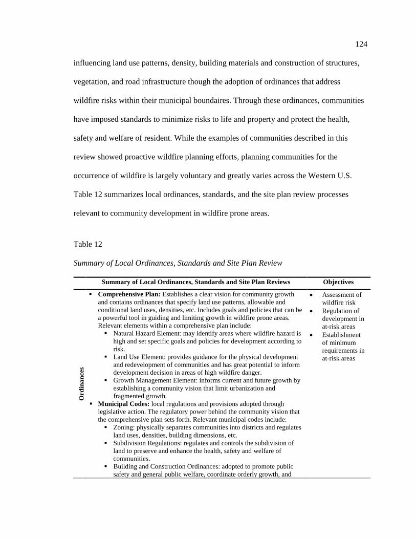
124
influencing land use patterns, density, building materials and construction of structures,
vegetation, and road infrastructure though the adoption of ordinances that address
wildfire risks within their municipal boundaires. Through these ordinances, communities
have imposed standards to minimize risks to life and property and protect the health,
safety and welfare of resident. While the examples of communities described in this
review showed proactive wildfire planning efforts, planning communities for the
occurrence of wildfire is largely voluntary and greatly varies across the Western U.S.
Table 12 summarizes local ordinances, standards, and the site plan review processes
relevant to community development in wildfire prone areas.
Table 12
Summary of Local Ordinances, Standards and Site Plan Review
Summary of Local Ordinances, Standards and Site Plan Reviews Objectives
Ord
inan
ces
Comprehensive Plan: Establishes a clear vision for community growth and contains ordinances that specify land use patterns, allowable and conditional land uses, densities, etc. Includes goals and policies that can be a powerful tool in guiding and limiting growth in wildfire prone areas. Relevant elements within a comprehensive plan include: Natural Hazard Element: may identify areas where wildfire hazard is
high and set specific goals and policies for development according to risk.
Land Use Element: provides guidance for the physical development and redevelopment of communities and has great potential to inform development decision in areas of high wildfire danger.
Growth Management Element: informs current and future growth by establishing a community vision that limit urbanization and fragmented growth.
Municipal Codes: local regulations and provisions adopted through legislative action. The regulatory power behind the community vision that the comprehensive plan sets forth. Relevant municipal codes include: Zoning: physically separates communities into districts and regulates
land uses, densities, building dimensions, etc. Subdivision Regulations: regulates and controls the subdivision of
land to preserve and enhance the health, safety and welfare of communities.
Building and Construction Ordinances: adopted to promote public safety and general public welfare, coordinate orderly growth, and
• Assessment of wildfire risk
• Regulation of development in at-risk areas
• Establishment of minimum requirements in at-risk areas

125
Table Continues
establish minimum standards for building and construction.
Vegetation management provisions: assist communities in controlling accumulation of hazardous fuels.
St
anda
rds
Road Infrastructure: adequate ingress and egress, road grades, road widths and turning radii are critical for suppression forces to locate, reach, and safely remain at a structure and continue suppression. Specify minimums for the following to accommodate suppression: Access: 0 to 100 households require one access route; 101 to 600
households require two access routes; and, more than 600 households require three access routes.
Roadways: minimum road clearance of 12 feet for each lane of travel Turning radii: minimum outside turning radius of 60 feet Road grades: must not exceed 10 percent Dead ends: dead end road more than 300 feet must contain a turn
around Driveways: minimum of 12 feet with minimum clearance 13 feet 6
inches Signage: mark all driveways and access roads
Building construction and materials standards: homes significantly increase fuel density in wildfire prone areas. Minimum levels of fire resistant materials and practices can be specified for new construction.
Vegetation: specify size, shape, compactness, and arrangement of vegetation influence wildlife behavior. Context sensitive fire resistant landscape design standards can be specified to reduce wildfire risks.
• Regulation of development in at-risk areas
• Establishment of minimum requirements in at-risk areas
Topography: Aspect and slope steepness are just some topography variations that can dramatically change wildfire behavior. Standards for development based on slope steepness and aspect can be applied to reduce risks.
Water Supply: Reliable water sources are important to wildfire suppression and home protection. Minimum water supply standards can specify location and amount of available water supply.
Utilities: aboveground utilities can be problematic in areas prone to wildfire. Minimum standards can be established to regulate overhead power lines and above ground propane tanks.
Site
Pla
n R
evie
w
• Site Plan Review Checklist: once project applications have submitted all required materials, the local planning department begins to review the site plan for compliance with local ordinances and standards. A site plan review checklist that ensures site plans comply with relevant ordinances and standards to mitigate wildfire risk may be used in areas where wildfire hazards are high. Failure to meet established ordinances and standards in a community results in denial of the project proposal.
• Assessment of wildfire risk
• Regulation of development in at-risk areas
• Establishment of minimum requirements in at-risk areas
3. Evaluation of Local Ordinances, Standards and Site Plan Reviews
Local ordinances, standards and the site plan review provide regulations and
minimum requirements for development and establish a framework to approve

126
development at the local level. These locally adopted systems have the capacity to
explicitly address development in wildfire prone areas. Through the review of local
ordinances, standards and the site plan review process in communities across the West,
the following objectives at the local-level influencing community development in
wildfire prone areas were identified:
• Assess wildfire risk
• Regulate development in at-risk areas
• Establish minimum requirements in at-risk areas
Using knowledge gained through the literature review and review of current
policies and practices, the benefits and limitations of each of these objectives are
examined below. The results of this evaluation are summarized in Table 13.
Assessment of Wildfire Risk. California’s statewide wildfire risk assessment
enabled the City of Glendale to address wildfire risk in their municipality by providing
guidance on assessing areas at risk. As previously discussed, most other states in the
West do not provide similar guidance to communities to help identify and map areas at
risk. Statewide risk assessments across the West are also nonexistent or difficult to find,
which means spatially detailed statewide assessments of areas at-risk are not widely
available for use by local planning officials.
For example, the State of Utah has an exemplary GIS data steward, the
Automated Geographic Reference Center (AGRC), which hosts a large amount of
statewide data. However, the spatial extent of the WUI GIS data layer does not match the
list of 642 communities identified at risk of wildfire by the Utah Division of Forestry,
Fire and State Lands. The data layer available through the AGRC only shows the WUI

127
communities throughout the State that have made an effort to map the extent of their
communities. So, many WUI areas are missing from the GIS data layer.
This disconnect between well-researched and identified at-risk areas and the
availability of the spatial mapping of these at-risk areas, exemplified by the data available
in the State of Utah, makes it difficult for planners, designers, and developers to locate
the WUI, support inquiries into the effects of housing growth on the environment and
inform local policies and land management concerning the WUI. Communities must then
turn to in-house efforts to identify current wildfire hazards by characterizing fuel loads,
topography and climate, and then modeling potential hazards based on forecasted or
planned development or other types of land conversion.
Planning offices and local jurisdictions are often small and neither adequately
staffed nor contain the expertise needed to identify wildfire hazard areas and address
wildfire risks. Therefore, the likelihood of omission of some high-risk areas or
misidentification of others is increased because accurate identification is data intensive
and scientifically challenging (Gude et al., 2008). The misidentification of areas at high
risk of wildfire puts more lives and home in danger as well as contributes to the
increasing financial burden on taxpayers. One possible solution to the issue of
misidentification of wildfire hazard areas would be for a federal agency to take on the
responsibility of identifying wildfire hazard areas, like the federal government does to
manage floodplains (Gude et al., 2008). The states in the West could then use this
framework to develop a statewide risk assessment that local governments could use to
plan for wildfires. A cohesive framework assessing wildfire risk would also help
coordinate risk assessments across state lines.

128
Regulate Development in At-risk Areas. The example from the City of
Glendale showed that ordinances such as the local comprehensive plans could play a
major role in regulating growth and development in areas prone to wildfires. The
comprehensive plan can effectively address wildfire risk through the regulation of
settlement patterns, transportation, infrastructure and water supplies (Schwab & Meck,
2005). In the process of drafting a comprehensive plan, communities can stop to ask if
development should even be allowed or at least restricted in wildfire-prone areas. One of
the major obstacles in crafting a comprehensive plan and complimentary ordinances that
recognize wildfire hazards is the absence of a risk assessment of wildfire prone areas
within the community.
In spite of coordinated assessment efforts across the West to map areas at risk of
wildfire, some local governments have identified hazardous lands in their jurisdictions
and enforced development limitations in these areas. Examples from Douglas County,
Ashland, Oregon, Santa Clarita, California, and Pinetop-Lakeside, Arizona illustrate the
regulatory power of ordinances in areas of high wildfire risk. The ordinances in these
communities, adopted through local legislative actions, showed the breadth and depth
possible for municipal codes to regulate development in wildfire prone landscapes. The
flexible nature of local codes allows for location-specific regulations that differ according
to the ecosystem.
Establish Minimum Requirements in At-risk Areas. Numerous nationally
recognized standards for development in areas at-risk of wildfire are available for use by
state and local governments. As demonstrated above, these standards describe in detail
minimum requirements for development components important to reducing risk, such as

129
road infrastructure, building and construction, vegetation, water sources and utility
placement. These standards can easily be adopted through the legislative language of
municipal and state codes.
These codes can help communities reduce risks of wildfire, but there is still room
for improvement within the codes themselves. NFPA 1141 has established very minimum
requirements for access, standards specifying ingress and egress are missing from the
IWUIC. Emergency ingress and resident egress is an important inclusion in initial
development proposals because it is often difficult to retrofit existing roads to increase
width of rights-of-way. In 1991, 11 people died in the Tunnel Fire while attempting to
evacuate on the 12 to 14-foot-wide Charring Cross Road. After the fire, all of the homes
were rebuilt and the road remains narrow, having only been widened by a few feet
(Blonsky, Miller, & Rice, 2011).
The site plan review is a powerful tool that can be used to ensure compliance with
established requirements for development in wildfire prone areas in the process of a
development application. Typically, all development proposals are reviewed for their
compliance with local ordinances and standards. This step assures the project promotes
the health, safety and welfare within the community. It also ensures future development
meets relevant ordinances and incorporates all minimum standards that the community
has established. Failure to comply with established ordinances and standards results in
denial of the project proposal. This could make the site plan review an important step in
assuring projects in hazardous areas meet all WUI ordinances and standards. However, if
a community has not identified wildfire risks or enacted ordinances and standards for
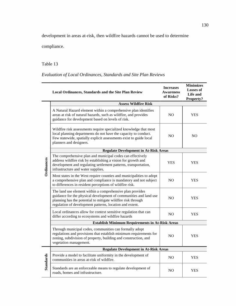
130
development in areas at-risk, then wildfire hazards cannot be used to determine
compliance.
Table 13
Evaluation of Local Ordinances, Standards and Site Plan Reviews
Local Ordinances, Standards and the Site Plan Review Increases
Awareness of Risks?
Minimizes Losses of Life and
Property?
Ord
inan
ces
Assess Wildfire Risk
A Natural Hazard element within a comprehensive plan identifies areas at risk of natural hazards, such as wildfire, and provides guidance for development based on levels of risk.
NO YES
Wildfire risk assessments require specialized knowledge that most local planning departments do not have the capacity to conduct. Few statewide, spatially explicit assessments exist to guide local planners and designers.
NO NO
Regulate Development in At-Risk Areas The comprehensive plan and municipal codes can effectively address wildfire risk by establishing a vision for growth and development and regulating settlement patterns, transportation, infrastructure and water supplies.
YES YES
Most states in the West require counties and municipalities to adopt a comprehensive plan and compliance is mandatory and not subject to differences in resident perceptions of wildfire risk.
NO YES
The land use element within a comprehensive plan provides guidance for the physical development of communities and land use planning has the potential to mitigate wildfire risk through regulation of development patterns, location and extent.
NO YES
Local ordinances allow for context sensitive regulation that can differ according to ecosystems and wildfire hazards NO YES
Establish Minimum Requirements in At-Risk Areas
Through municipal codes, communities can formally adopt regulations and provisions that establish minimum requirements for zoning, subdivision of property, building and construction, and vegetation management.
NO YES
Stan
dard
s
Regulate Development in At-Risk Areas Provide a model to facilitate uniformity in the development of communities in areas at-risk of wildfire. NO YES
Standards are an enforceable means to regulate development of roads, homes and infrastructure. NO YES

131
Table Continues
Stan
dard
s Establish Minimum Requirements in At-Risk Areas
Nationally recognized standards are readily available for adoption by local and state governments. NO YES
Standards can establish minimum requirements for factors that contribute to increased wildfire behavior such as vegetation, topography and placement of utilities.
YES YES
Standards can improve effectiveness of wildfire suppression and reduce likelihood of home ignition through minimum requirements for road infrastructure, building and construction materials, and vegetation guidelines.
NO NO
Site
Pla
n R
evie
w
Assess Wildfire Risk Where risk of wildfire is determined to be high, local planning offices can utilize the site plan review process to ensure compliance with ordinances and standards that mitigate risks.
NO YES
Regulate Development in At-Risk Areas Ensures proposed projects comply with the community vision set forth in the comprehensive plan, local zoning codes, subdivision regulations, and building and construction ordinances.
NO YES
Establish Minimum Requirements in At-Risk Areas Ensures future development incorporates minimum standards that a community has adopted to reduce risk of wildlife. Failure to meet minimum standards results in denial of the development proposal.
YES YES
132
CHAPTER VI
KEY FINDINGS AND COMMUNITY APPLICATION
Current Wildfire Planning Policies and Practices
The wildland fire threat to communities has been a major impetus for U.S.
legislation beginning with the National Fire Plan in 2000 (Gude et al., 2008). Each
successive plan or policy has recognized the need for modifications to existing policies
and practices that integrate social and ecological needs across administrative boundaries
and broad landscapes, but the resource agencies have been slow to respond (Dombeck et
al., 2004). This is evident in the review of current federal policies, acts, and strategies in
the previous chapter, which shows only slight differences from one policy to the next.
Overall, federal policies and practices remain reactive to growth. They prioritize
education and fuel management efforts to mitigate the outcomes of growth in wildfire
prone ecosystems rather than restrict or place limits on continuing growth.
Planning and design decisions in the development of communities across the
West are influenced by policies and legislation at the federal and state levels as well as
actions taken by local governments. Current wildfire planning policies and practices are
being carried out at their respective level with little coordination and cohesion among the
decisions made at the federal, state and local levels. Figure 20 illustrates this conclusion.
This diagram lists the federal policies, state codes and local tools guiding the
development of communities in the Western U.S. and shows the relationships among the
different levels. Solid lines represent direct relationships while dashed lines represent
voluntary or weak relationships.

133
Figure 18. Policies and Practices Guiding Community Development in the Western U.S.
134
Benefits and Limitations of Current Community
Wildfire Planning and Design
The review and evaluation of current community wildfire planning and design
policies and practices identified the primary objectives at the federal, state and local
levels. The summary of federal policies, acts, and strategies identified the following as
the primary federal objectives that influence community development in wildfire prone
areas:
• Fuel management
• Collaborative planning
• Education
• Risk Assessment
Through the summary of state statutes, codes and legislation, the following were
identified as objectives at the state-level that influence community development in
wildfire prone areas:
• Fuel and fire management
• Wildfire risk assessments
• Regulation of development in at-risk areas
A review of local ordinances, standards and the site plan review process in
communities across the West, identified the following objectives at the local-level
influencing community development in wildfire prone areas:
• Assess wildfire risk
• Regulate development in at-risk areas
• Establish minimum requirements in at-risk areas

135
The results of the review and evaluation are discussed in Table 14, which
describes the benefits and limitations of current community wildfire planning and design
policies and practices at the federal, state and local levels.
Table 14
Benefits and Limitations of Current Federal, State and Local Community Wildfire
Planning and Design
Federal Policies, Act and Strategies
Objective Benefits Limitations
Fuel
M
anag
emen
t Decreases wildfire threats to life and property by reducing fuels in and around the community
Reactive response to development; does not prevent growth from occurring in wildfire prone areas
Significant environmental impacts
Col
labo
rativ
e Pl
anni
ng Coordinates and prioritizes fuel reduction
projects in and around communities Does not enforce standards for construction and community layout
Engages federal, state and local stakeholders in a collaborative planning process
Flexible legislative guidance has led to considerable variations in scale, templates and stakeholders
Increases awareness of the risks of wildfire Does not prevent growth from occurring in wildfire prone areas
Provides a means for state and local entities to apply for, and have priority for, federal dollars for expensive work to reduce local wildfire risks
Creation and enforcement of a CWPP is voluntary
Edu
catio
n
Increases homeowner awareness of the risks of wildfire
Targets individual homeowners with widely varying perceptions of wildfire risk
Wildfire prevention outreach and education activities can result in suppression cost savings
Relies on volunteer efforts to reduce risks of wildfire around the home Does not prevent growth from occurring in wildfire prone areas
State Statutes, Codes and Legislation
Objective Benefits Limitations
Fuel
Man
agem
ent
Decreases wildfire threats to communities by ensuring continued maintenance of defensible space
Most states in the West do not addresses fuel management in their statutes, codes or legislation Rely on state and federal fire officials to identify and prioritize fuel management projects
Systematically assesses areas at risk of wildfire
Methods for identifying areas at-risk of wildfire varies from state to state

136
Table Continues
Fuel
M
anag
emen
t Informs state-level legislation addressing development in areas with high fire hazards
It is difficult to find spatially explicit maps of at-risk areas and GIS information is not readily available
Assists counties and municipalities identify hazardous areas
Absence of a federally recognized wildfire risk assessment that’s provides a common framework
WU
I Leg
isla
tion
Compliance is mandatory and not subjected to differences in local perceptions on wildfire
States have not systematically imposed legislation for the WUI requiring municipalities to address wildfire
Reduce risks to communities through regulation Guides growth in at-risk areas and creates wildfire resilient communities
Development regulations are controversial, as they can be perceived as a regulatory taking of private property Reduces suppression costs and damages
caused by wildfires Local Ordinances, Standards and the Site Plan Review
Objective Benefits Limitations
Wild
fire
Ris
k A
sses
smen
t
Systematically assesses areas at risk of wildfire and supports inquiries into the effects of housing growth on the environment and inform local policies and land management concerning the WUI
Detailed statewide assessments of areas at-risk are not widely available for use by local officials Misidentification of areas at high risk of wildfire puts more lives and home in danger as well as contributes to the increasing financial burden on taxpayers
Informs local ordinances and standards in areas with high fire hazards
Planning offices are often small and neither adequately staffed nor contain the expertise needed to address wildfire risks
WU
I Ord
inan
ces
Compliance is mandatory and not subjected to differences in residents wildfire perceptions
Absence of cohesive state or federal guidance in assessing areas of risk within the community
Allow for location-specific regulations that differ according to the ecosystem
Development regulations are controversial, as they can be perceived as a regulatory taking of private property
Creates wildfire resilient communities through the regulation of settlement patterns, transportation, infrastructure and water supplies
States do not mandate WUI ordinances in communities with areas of elevated wildfire risk Primarily occurring as deemed necessary by local governments in the Western U.S.
WU
I Sta
ndar
ds
Nationally recognized standards for development in areas at-risk of wildfire are readily available for adoption into local ordinances
States have not systematically imposed legislation for the WUI requiring minimum standards in areas of elevated wildfire risk
Standards can easily be adopted through the legislative language of municipal and state codes
Unlikely to expect all communities at-risk will voluntarily adopt ordinances that establish minimum standards
Establish minimum requirements for development components important to reducing risk
Current standards need improvement, i.e.: emergency ingress and resident egress standards in NFPA 1144 and IWUIC
Reduce risks and damages caused by wildfires

137
Table Continues
Site
Pla
n R
evie
w Represents an important step in ensuring
future development meets relevant ordinances and incorporates all minimum standards
Ordinances and standards established by the municipality are used to review site plans to approve project proposals, but if WUI ordinances and standards have not been adopted they cannot be used to determine compliance
Routine procedure in the development process Failure to meet WUI requirements results in denial of the project proposal
Community Development in At-Risk Areas Audit
This community wildfire planning and design audit provides a framework to
evaluate a community’s resilience to wildfire by assessing its ability to reduce risks to life
and property. Both the findings from the review of wildfire in the West and the benefits
and limitations identified in the review of current federal, state, and local objectives and
built the foundation for the community wildfire planning and design audit. The audit for
federal policies, acts and strategies is displayed in Table 15. Table 16 displays the state-
level audit for statutes, codes and legislation. Table 17 displays the audit for decisions
made at the local level regarding ordinances, standards and the site plan review. The
intent of each audit is to provide a framework to help community development decision
makers, such as planners, landscape architects, architects and local officials, critically
examine federal, state, and local planning and design policies and practices that are
currently or could be employed in wildfire prone ecosystems. The checklist provided in
Table 19 provides an example of a series of questions that communities can incorporate
in their site plan review process to approve development in wildfire prone areas.

138
Table 15
Federal Policies, Acts and Strategies Audit
Federal Policy, Act and Strategies Objective Community Benefit Yes/No Document
Fuel Management
Were federal fuel treatment projects implemented to reduce vegetation in or around the community?
Collaborative Planning
Did the community engage in a collaborative effort with local, state, and federal stakeholders to create a CWPP?
Education Did the community engage in any wildfire education programs sponsored, at least in part, by the federal government?
Table 16
State Statutes, Codes and Legislation Audit
State Statutes, Codes and Legislation Objective Community Benefit Yes/No Document
Fuel Management
Were State fuel treatment projects implemented to reduce vegetation in or around the community?
Education Did the community engage in any wildfire education programs sponsored, at least in part, by the State?
Does the State provide guidance on appropriate plant selections for landscaping to mitigate risks of wildfire?
Wildfire Risk
Assessment
Are areas of wildfire risk identified at the state level? Does the State maintain a spatially explicit assessment of areas at risk of wildfire? And, is this assessment available for planning and design professional through a GIS database?
Does the State assist communities in locating WUI areas in their jurisdiction and provide guidance on ordinances and standards to guide development in these areas?
Wildfire Legislation
Does the State mandate a wildfire element in the comprehensive plan that addressed development and guides zoning in at-risk areas?
Has the State adopted the IWUIC, NFPA 1144 or NFPA 1141, which establish minimum requirements for development in at-risk areas?

139
Table 17
Local Ordinances, Standards and Site Plan Review Audit
Local Ordinances, Standards and Site Plan Review Objective Community Benefit Yes/No Document
Collaborative Planning
Did the community engage in a collaborative effort with local, state, and federal stakeholders to create a CWPP and prioritize fuel management projects?
Education Does the community sponsor wildfire education programs to inform its residents of the potential wildfire risks in their community?
Wildfire Risk Assessment
Did the community locate WUI areas in their jurisdiction using a spatially explicit assessment of areas at risk of wildfire, provided by the State?
Did the community receive guidance on ordinances and standards to guide development in these WUI areas?
Wildfire Ordinances
Is wildfire specifically addressed in a hazard element within the comprehensive plan?
Does the land use element recognize the areas at risk of wildfire within the community and does this understanding of risk influence the land use plan?
Does the land use plan define barriers to protect the community from adjacent wildlands?
Is intermix development limited or avoided in the land use plan and reinforced through the zoning ordinance?
Is cluster development encouraged in the zoning ordinance?
Do the subdivision regulations regulate and control the subdivision of land to preserve and enhance the health, safety, and welfare of communities in light of wildfire risks?
Do the subdivision regulations require approval by local fire officials in areas at-risk of wildfire?
Do the subdivision regulations require the installation of fuel breaks or other man-made barriers to be installed around the structures?
Do building and construction ordinances promote public safety and general public welfare, coordinate orderly growth, and establish minimum standards for buildings and construction areas at-risk of wildfire?
Have vegetation management regulations been adopted granting the community final authority plant specifications and fuel reduction?
Wildfire Standards
Has the community adopted minimum standards established in the IWUIC, NFPA 1141 or NFPA 1144 for road infrastructure?

140
Table Continues
Wildfire Standards
Has the community adopted minimum standards established in the IWUIC or NFPA 1144 for building construction and materials?
Has the community adopted minimum standards established in the IWUIC for vegetation?
Did the community use the hazard assessment rating in either NFPA 1144 or IWUIC to assess topography hazards?
Has the community adopted minimum standards established in the IWUIC for water supply?
Has the community adopted minimum standards established by the ICC of NFPA for the placement of utilities?
Site Plan Review
Does the community have a site plan review process for development proposals to ensure compliance with wildfire risk mitigation ordinances and standards?
Table 18
Example of a Site Plan Review Checklist for Development in Wildfire Prone Areas
Checklist Yes No
Comprehensive Plan: Is the project in accordance with the comprehensive plan? 1. Has the community created a natural hazard element in their comprehensive plan? 2. If so, is the project in accordance with the natural hazard element of the
comprehensive plan? 3. Has the community established an urban growth boundary in their comprehensive
plan? 4. If so, is the project in accordance with the legal development limit established by this
growth boundary?
Zoning: Is the project in accordance with the local zoning? 1. Has the community created a wildfire overlay zone? 2. If so, is the wildfire overlay zone applicable? 3. Does the land use and proposed density adhere to the local zoning?
Subdivision Regulations: Is the project in accordance with subdivision regulations? 1. Is land division or subdivision required or requested, and if so does it meet the
requirements of the subdivision ordinance?
Building and Construction Ordinance: Is the project in accordance with the building and construction ordinance? 1. Can materials be determined in the site plan? 2. Do the materials and the structure meet or exceed wildfire building construction and
design standards, established by the NFPA 1144 or IWUIC? 3. Are the layout, design and structures proposed sensitive to fire-prone ecosystem? 4. Are structures visibly numbered? 5. Will fencing be required? If so, are inflammable materials specified?

141
Table Continues Vegetation Management Regulations: Is the project in accordance with local vegetation standards? 1. Is the concept plan adequate for the city’s landscape architect, or equivalent, to
determine if vegetation requirements have been met? 2. Is adequate defensible space provided for? 3. Does the plant selection meet local plant specifications for fire-resistant vegetation? 4. Has the developer/homeowner provided a plan for future maintenance of vegetation?
Road Infrastructure: Is the project in accordance with transportation standards? 1. Is adequate emergency ingress and resident egress planned? 2. Is the proposed site adequately served by streets of sufficient width and improved as
necessary to carry traffic in the event of an evacuation? 3. Does the street width and turning radii meet the standards established in the
International Wildland Urban Interface Code? 4. Are loop roads a viable alternative? If not, do dead end roads provide turnarounds? 5. Do driveways provide adequate width and vertical clearance, according to NFPA
1144, for emergency vehicles? 6. Do long driveways provide turnouts and turnarounds for emergency vehicles? 7. Are no more than 5 homes services by one driveway? 8. Are all roadways and driveways adequately signed? 8. Are road grades specified not to exceed 10 percent? 9. Is the on-site, off-site circulation adequate? Are traffic bottlenecks created? Is the
structure an aviation hazard?
Topography: Is the project sensitive to the wildfire prone topography? 1. Does the project avoid placing structures slopes greater than 20 percent, 2. Is development restricted on ridgetops?
Water supply: Does the project provide sufficient access to water sources? 1. Is adequate water supply available no more than 1,000 feet from the structure? 2. Are minimum standards for access to water, found in IWUIC, met?
Utilities: Are utilities found in the project placed to minimize risks in a wildfire event? 1. Will it be possible to place utilities underground as part of this project? 2. If not, are utilities provided with sufficient rights-of-way? 3. Are combustible materials flagged and placed according to NFPA 1144?

142
CHAPTER VII
CASE STUDY VERIFICATION
Stevenson Ranch
Stevenson Ranch is located in the Santa Clarita Valley, in an unincorporated area
outside of the Santa Clarita city limits, located to the north of Los Angeles, California. This
location is said to be one of the most fire prone areas in the U.S. (Zhang, Wollersheim,
Griffiths, & Maddox, 2014). The master-planned community was initially approved in
1987 and contained approximately 3,500 homes in 2003 when the Simi Wildfire occurred
(See Figure 21). This subdivision is recognized for its typical suburban footprint made
famous in the opening song “Little Boxes” on the television show “Weeds.” (Stevenson
Ranch Home Owners Association [HOA], n.d.). Following wildfire events that effected the
subdivision in 1993, the subdivision implemented minimum wildfire regulations to reduce
their risk to wildfire (Schwab & Meck, 2005).
Contextual Information
This affluent, suburban community encompasses about 4,000 acres in Los
Angeles County. The primarily one and two-story homes, occupied by predominantly
Figure 19. Stevenson Ranch, 2004 (Stevenson Ranch HOA, n.d.).

143
white families, are located on the fire-prone foothills of the Santa Susana Mountains. It
has history of wildfire, which helped awaken its residents early to the dangers of wildfire.
Table 19 below provides additional contextual information for this community, including
the impacts of the Simi wildfire in 2003.
Table 19.
Stevenson Ranch Contextual Information
Community
Profile
• Suburban; approximately 4,000 acres • 3,500 homes (2003) • Primarily white families, owner-occupied • Median household income $114,260; Median home value $1,034,600 (2010) (Lindroth, Poudre Fire Authority, & Livermore Fire Protection District, 2005; Stevenson Ranch HOA, n.d.)
Physical
Setting
• Mediterranean Climate: 68℉ average temperature April to Nov. with 17” precipitation annually
• Located in the foothills of the Santa Susana Mountains • California chaparral and woodlands • Moderate to Very High Wildland Fire Potential (USDA Forest Service, 2012)
Wildfire
History
• Primarily Fire Regime Group IV adjacent to Group I (Appendix B) • 10/2007 – Magic Fire (2,824 ac.). Flames came within yards of housing
development within Stevenson Ranch. • 10/2003 – Simi Fire (108,204 ac.). (Described below). • 1993 – Old Topanga, Rocky, Greenmeadow, and Steckle Park Fires destroyed a total
of 391 homes in Los Angeles and Ventura Counties and brought attention to wildfire threats in Stevenson Ranch.
Wildfire
Event
• Simi Wildfire, Oct. 25- Nov. 5, 2003 108,204 acres • Suppression efforts limited due to initial attack resources conducting structure
protection. Red flag conditions through most of event. On Oct. 29 fire made runs into Stevenson Ranch, requiring strong protection efforts (Governor’s Blue Ribbon Fire Commission, 2004).
• No homes or lives were lost in Stevenson Ranch Reaction • Even though the fire burned around the ranch, there was no evacuation of residents,
no loss of life, no loss of property and little fire service intervention (Lindroth et al., 2005).
• Military, federal, and neighboring state resources were called in to support all of the fires burning in Southern California. The local, state, and federal suppression resources across the state totaled 104 fixed wing aircraft, 90 helicopters and 1,898 engines and 15,631 personnel (Governor’s Blue Ribbon Fire Commission, 2004).

144
Wildfire Planning and Design Audit
This audit looked at the degree to which beneficial federal, state and local wildfire
planning initiatives were considered in the development of Stevenson Ranch. The audit
reviews the federal fuel management projects and education efforts and relevant state
codes from 2003. At the local level, the county comprehensive plan and municipal codes
in place in 2003 were also reviewed. Because Stevenson Ranch falls in an unincorporated
area within Los Angeles County, the guiding documents for the community are
developed at the County level. The following audit illustrates the federal, state, and local
wildfire planning initiatives that influenced development in Stevenson Ranch prior to the
2003 Simi Wildfire (Table 20, 21 & 22).
Table 20
Federal Initiatives Relevant to Stevenson Ranch
Federal Objectives Yes/No Document
Fuel Management
Were federal fuel treatment projects implemented to reduce vegetation in or around the community?
N/A N/A
Collaborative Planning
Did the community engage in a collaborative effort with local, state, and federal stakeholders to create a CWPP?
No N/A
Education Did the community engage in any wildfire education programs sponsored, at least in part, by the federal government?
N/A N/A

145
Table 21
State Objectives Relevant to Stevenson Ranch
State Objectives Yes/No Document
Fuel Management
Were State fuel treatment projects implemented to reduce vegetation in or around the community?
N/A
Education Did the community engage in any wildfire education programs sponsored, at least in part, by the State?
N/A
Does the State provide guidance on appropriate plant selections for landscaping to mitigate risks of wildfire?
Yes • Cal Fire, (n.d.)
Wildfire Risk
Assessment
Are areas of wildfire risk identified at the state level?
Yes • Cal Fire, (n.d.)
Does the State maintain a spatially explicit assessment of areas at risk of wildfire? And, is this assessment available for planning and design professional through a GIS database?
No • Cal Fire, (n.d.) In 2007, CAL FIRE developed consistent science-based fire maps.
Does the State assist communities in locating WUI areas in their jurisdiction and provide guidance on ordinances and standards to guide development in these areas?
Yes • Davis, Nichols, Tuttle, & Allshouse, 2000
Wildfire Legislation
Does the State mandate a wildfire element in the comprehensive plan that addressed development and guides zoning in at-risk areas?
Has the State adopted the IWUIC, NFPA 1144, or NFPA 1141 or equivalent standards that establish minimum requirements for development in at-risk areas?
No • The California Code of Regulations (CCR), Title 24, Part 2, known as the California Building Code (CBC) was adopted in 2007.
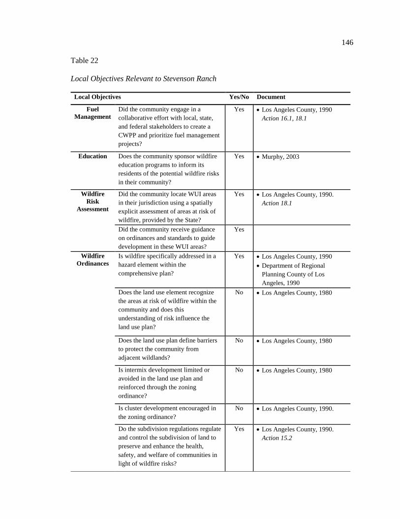
146
Table 22
Local Objectives Relevant to Stevenson Ranch
Local Objectives Yes/No Document
Fuel Management
Did the community engage in a collaborative effort with local, state, and federal stakeholders to create a CWPP and prioritize fuel management projects?
Yes • Los Angeles County, 1990 Action 16.1, 18.1
Education Does the community sponsor wildfire education programs to inform its residents of the potential wildfire risks in their community?
Yes • Murphy, 2003
Wildfire Risk
Assessment
Did the community locate WUI areas in their jurisdiction using a spatially explicit assessment of areas at risk of wildfire, provided by the State?
Yes • Los Angeles County, 1990. Action 18.1
Did the community receive guidance on ordinances and standards to guide development in these WUI areas?
Yes
Wildfire Ordinances
Is wildfire specifically addressed in a hazard element within the comprehensive plan?
Yes • Los Angeles County, 1990 • Department of Regional
Planning County of Los Angeles, 1990
Does the land use element recognize the areas at risk of wildfire within the community and does this understanding of risk influence the land use plan?
No • Los Angeles County, 1980
Does the land use plan define barriers to protect the community from adjacent wildlands?
No • Los Angeles County, 1980
Is intermix development limited or avoided in the land use plan and reinforced through the zoning ordinance?
No • Los Angeles County, 1980
Is cluster development encouraged in the zoning ordinance?
No • Los Angeles County, 1990.
Do the subdivision regulations regulate and control the subdivision of land to preserve and enhance the health, safety, and welfare of communities in light of wildfire risks?
Yes • Los Angeles County, 1990. Action 15.2

147
Table Continues Wildfire
Ordinances Do the subdivision regulations require approval by local fire officials in areas at-risk of wildfire?
No • Los Angeles County, 1990.
Do the subdivision regulations require the installation of fuel breaks or other man-made barriers to be installed around the structures?
Yes • Los Angeles County, 1990. Action 15.2
• Garvey & Pierson, 2007
Do building and construction ordinances promote public safety and general public welfare, coordinate orderly growth, and establish minimum standards for buildings and construction areas at-risk of wildfire?
Yes • Los Angeles County, 1990. Action 15.2, 17.1
Have vegetation management regulations been adopted granting the community final authority plant specifications and fuel reduction?
Yes • Los Angeles County, 1990. Action 15.3
• Department of Regional Planning County of Los Angeles, 1990
• Murphy, 2003 Wildfire
Standards Has the community adopted minimum standards equivalent to those established in the IWUIC, NFPA 1141 or NFPA 1144 for road infrastructure?
Yes • Department of Regional Planning County of Los Angeles, 1990
• Murphy, 2003
Has the community adopted minimum standards equivalent to those established in the IWUIC or NFPA 1144 for building construction and materials?
Yes • Los Angeles County, 1990. Action 15.2, 17.1
• Garvey & Pierson, 2007 • Murphy, 2003
Has the community adopted minimum standards equivalent to those established in the IWUIC for vegetation?
Yes • Los Angeles County, 1990. Action 15.2, 15.3
• Murphy, 2003
Did the community use a hazard assessment rating equivalent to those in either NFPA 1144 or IWUIC to assess topography hazards?
Yes • Department of Regional Planning County of Los Angeles, 1990
Has the community adopted minimum standards equivalent to those established in the IWUIC for water supply?
No • Los Angeles County, 1990.
Has the community adopted minimum standards equivalent to those established by the ICC of NFPA for the placement of utilities?
No • Los Angeles County, 1990.

148
Scripps Ranch
Scripps Ranch is a northern suburban community of the City of San Diego.
Construction of the community began in 1969 on the site of Miramar Ranch, once owned
by E.W. Scripps. The former estate was planted with eucalyptus trees, which are now a
symbol of the Scripps Ranch community, and the community has received awards for its
park-like setting and natural beauty (Todd, 2010). Fifteen years prior to the Cedar Fire,
which destroyed 312 Scripps Ranch homes, the San Diego Fire Department’s fire
inspector said the community was a perfect scenario for a catastrophic wildfire with its
brush and eucalyptus trees, remarking “someday there will be a fire there a mile wide and
no one will be able to stop it.” (See Figure 22). The path of the Cedar Fire was actually 3
miles wide (Todd, 2010).
Figure 20. Scripps Ranch 2003 (Gibbins, 2003).

149
Contextual Information
This affluent bedroom community of San Diego lies in the northern foothills
surrounding the city. The community, which was nearly 20,000 residents in 2003, was
built in to a semi-arid landscape that has moderate to high fire potential due to the hilly
topography and chaparral ecosystem. San Diego County is the only large county in the
State without a countywide fire department and the City of San Diego has a lower ratio of
firefighters to residents than most comparable cities. The fire resources the City does
have are governed by more than twenty fire districts that primarily rely of volunteers and
aging suppression equipment (San Diego Regional Planning Agency, 2003). Table 23
below provides additional contextual information for this community, including the
details of the Cedar wildfire in 2003.
Table 23
Scripps Ranch Contextual Information
Community
Profile
• Suburban • 19,715 Residents • Primarily white families, owner-occupied • Median household income $95,117; Median home value $351,636 [in 2003] (San Diego Regional Planning Agency, 2003)
Physical
Setting
• Semi-arid Climate: 68℉ average temperature April to Nov. with less than 12” precipitation annually
• Sept. through Feb. brings warm desert winds called the “Santa Anas” • Located in the foothills surrounding San Diego • California chaparral and woodlands • Moderate to High Wildland Fire Potential (USDA Forest Service, 2012)
Wildfire
History • Primarily Fire Regime Group IV with interspersed Group I (Appendix B) • 10/2007 – 197,990 ac. Witch Creek Fire. Evacuations ordered in Scripps Ranch, no
homes lost. Became second largest fire in CA history, after Cedar Fire. • 10/2003 – 273,246 ac. Cedar Fire (Described below). • 6/2002– 10 ac. Fire within Scripps Ranch. 10 engines, 3 fixed-wing aircraft and 1
helicopter responded.

150
Table Continues
• 7/1985 – Normal Heights Fire. In the post fire report, it was noted the community was the perfect scenario for another catastrophic wildfire with its brush and eucalyptus trees.
• 7/2003 – Fuelbreak Maintenance Prescribed Burn • 6/2003 – Fuel reduction prescribed burn
Wildfire
Event • The Cedar Fire Oct. 25 – Nov. 4 273,246 acres • The Cedar Fire started 24 miles northeast of Scripps Ranch and quickly spread at an
unprecedented rate of 5,000 acres per hour toward San Diego due to hot, dry winds gusting 40mph. The fire reached Scripps Ranch at 8am Oct. 26th.
• 312 Scripps Ranch homes were lost. In total, the Cedar Fire burned 2,323 homes and killed 14 people (Governor’s Blue Ribbon Fire Commission, 2004).
Reaction • Within 2 hours of the initial smoke report, 300 firefighters from federal, state and local agencies were on site. Additional military, federal, and neighboring state resources were eventually called in to support all of the fires burning in Southern California, totaling 104 fixed wing aircraft, 90 helicopters and 722 engines (Governor’s Blue Ribbon Fire Commission, 2004).
• Two days after the fire, 1,600 people came together to begin the rebuilding effort. Months later, the City Council approved new building code regulations specifying fire resistant construction materials. 15 months after the fire, 90 percent of the fire-affected residents had obtained permits to begin rebuilding (Todd, 2010).
Wildfire Planning and Design Audit
This audit looked at the degree to which beneficial federal, state and local wildfire
planning initiatives were considered in the development of Scripps Ranch. The audit
reviews the federal fuel management projects and education efforts and relevant state
codes from 2003. At the local level, the San Diego City and County comprehensive plan
and municipal codes in place in 2003 were also reviewed. The following audit illustrates
the federal, state, and local wildfire planning initiatives that influenced development in
Stevenson Ranch prior to the 2003 Cedar Wildfire (Table 24, 25 & 26).

151
Table 24
Federal Objectives Relevant to Scripps Ranch
Federal Objectives Yes/No Document
Fuel Management
Were federal fuel treatment projects implemented to reduce vegetation in or around the community?
N/A • 7/2003 – Fuelbreak Maintenance Prescribed Burn
• 6/2003 – Fuel reduction prescribed burn (Scripps Ranch Civic Association, n.d.)
Collaborative Planning
Did the community engage in a collaborative effort with local, state, and federal stakeholders to create a CWPP?
No • The Scripps Ranch CWPP was created in 2006 (Scripps Ranch Community Wildfire Protection Alliance, 2006)
Education Did the community engage in any wildfire education programs sponsored, at least in part, by the federal government?
N/A
Table 25
State Objectives Relevant to Scripps Ranch
State Objectives Yes/No Document
Fuel Management
Were State fuel treatment projects implemented to reduce vegetation in or around the community?
N/A • 7/2003 – Fuelbreak Maintenance Prescribed Burn
• 6/2003 – Fuel reduction prescribed burn (Scripps Ranch Civic Association, n.d.)
Education Did the community engage in any wildfire education programs sponsored, at least in part, by the State?
No
Does the State provide guidance on appropriate plant selections for landscaping to mitigate risks of wildfire?
Yes • Cal Fire, (n.d.)
Wildfire Risk
Assessment
Are areas of wildfire risk identified at the state level?
Yes • Cal Fire, (n.d.)
Does the State maintain a spatially explicit assessment of areas at risk of wildfire? And, is this assessment available for
No • In 2007, CAL FIRE developed consistent science-based fire maps (Cal Fire, n.d.)

152
Table 26
Local Objectives Relevant to Scripps Ranch
Local Objectives Yes/No Document
Fuel Management
Did the community engage in a collaborative effort with local, state, and federal stakeholders to create a CWPP and prioritize fuel management projects?
No • The Scripps Ranch CWPP was created in 2006 (Scripps Ranch Community Wildfire Protection Alliance, 2006)
Education Does the community sponsor wildfire education programs to inform its residents of the potential wildfire risks in their community?
No • The Scripps Ranch Fire Safe Council was formed after the Cedar Wildfire (Todd, 2010)
Wildfire Risk
Assessment
Did the community locate WUI areas in their jurisdiction using a spatially explicit assessment of areas at risk of wildfire, provided by the State?
No • San Diego, City of, 1979
Did the community receive guidance on ordinances and standards to guide development in these WUI areas?
N/A
Table Continues planning and design professional
through a GIS database?
Does the State assist communities in locating WUI areas in their jurisdiction and provide guidance on ordinances and standards to guide development in these areas?
Yes • Davis et al., 2000
Wildfire Legislation
Does the State mandate a wildfire element in the comprehensive plan that addressed development and guides zoning in at-risk areas?
Has the State adopted the IWUIC, NFPA 1144 or NFPA 1141, which establish minimum requirements for development in at-risk areas?
No • The California Code of Regulations (CCR), Title 24, Part 2, known as the California Building Code (CBC) was adopted in 2007.

153
Table Continues Wildfire
Ordinances Is wildfire specifically addressed in a hazard element within the comprehensive plan?
No • San Diego, City of, 1979 • Scripps Miramar Ranch Planning
Committee, Rick Engineering Company & The City of San Diego, 1978
Does the land use element recognize the areas at risk of wildfire within the community and does this understanding of risk influence the land use plan?
No • San Diego, City of, 1979
Does the land use plan define barriers to protect the community from adjacent wildlands?
No • San Diego General Plan, 1979
Is intermix development limited or avoided in the land use plan and reinforced through the zoning ordinance?
Yes • San Diego, City of, 1979
Is cluster development encouraged in the zoning ordinance?
No • Scripps Miramar Ranch Planning Committee et al., 1978
Do the subdivision regulations regulate and control the subdivision of land to preserve and enhance the health, safety, and welfare of communities in light of wildfire risks?
No • San Diego, City of, 1979
Do the subdivision regulations require approval by local fire officials in areas at-risk of wildfire?
No • San Diego, City of, 1979
Do the subdivision regulations require the installation of fuel breaks or other man-made barriers to be installed around the structures?
No • San Diego, City of, 1979
Do building and construction ordinances promote public safety and general public welfare, coordinate orderly growth, and establish minimum standards for buildings and construction areas at-risk of wildfire?
No • Scripps Ranch Community Wildfire Protection Alliance, 2006
• Scripps Miramar Ranch Planning Committee et al., 1978

154
Table Continues Have vegetation management
regulations been adopted granting the community final authority plant specifications and fuel reduction?
No • San Diego, City of, 1979 Scripps Miramar Ranch Planning Committee et al., 1978
Wildfire Standards
Has the community adopted minimum standards established in the IWUIC, NFPA 1141 or NFPA 1144 for road infrastructure?
No • Scripps Miramar Ranch Planning Committee et al., 1978
Has the community adopted minimum standards established in the IWUIC or NFPA 1144 for building construction and materials?
No • Scripps Ranch Community Wildfire Protection Alliance, 2006
• Scripps Miramar Ranch Planning Committee et al., 1978
Has the community adopted minimum standards established in the IWUIC for vegetation?
No • Scripps Miramar Ranch Planning Committee et al., 1978
Did the community use the hazard assessment rating in either NFPA 1144 or IWUIC to assess topography hazards?
No • Scripps Miramar Ranch Planning Committee et al., 1978
Has the community adopted minimum standards established in the IWUIC for water supply?
No • Scripps Miramar Ranch Planning Committee et al., 1978
Has the community adopted minimum standards established by the ICC of NFPA for the placement of utilities?
No • Scripps Miramar Ranch Planning Committee et al., 1978
Design Review
Does the community have a site plan review process for development proposals to ensure compliance with wildfire risk mitigation ordinances and standards?
No • Scripps Miramar Ranch Planning Committee et al., 1978
Summary of the Case Study Evaluation
The guiding documents influencing the development of Stevenson Ranch and
Scripps Ranch are marked with significant differences. Los Angeles County began
mapping wildfire hazard areas in the 1970s. During this time, minimum building
standards were adopted for all future growth in unincorporated areas in the County. The

155
destructive nature of wildfires in the early 1990s encouraged Stevenson Ranch to impose
additional measures to reduce risks of wildfire in the initial phases of the community’s
development. Most homes were constructed with ignition resistant materials, vegetation
in and around the community was maintained to reduce risks of wildfire and streets were
designed to wide right-of ways.
Scripps Ranch, in contrast, encouraged low-density estate-like development to
maintain a desired rural identity. To reinforce this rural identity, the community
encouraged extensive use of wood exteriors and earth tones to maintain visual integrity in
the community. The City of San Diego did not even have countywide fire suppression
available, and instead relied individual fire districts that employed primarily volunteers.
In the end, the Southern California Firestorm of 2003 claimed 312 Scripps Ranch homes
but not a single home was lost in Stevenson Ranch. These two communities exemplify
the difference that decisions made prior to occurrence of development at the federal, state
and local levels can make. The differences in decisions made by the two communities are
highlighted in the following table (Table 28).
Table 27
Decision-making Differences between Stevenson Ranch vs. Scripps Ranch
Stevenson Ranch Scripps Ranch
Fuel Management
Data was not available to determine if fuel treatments had been implemented within the community before the fire.
Data was not available to determine if fuel treatments had been implemented within the community before the fire.
Collaborative Planning
The community did engage in a collaborative planning effort to create a CWPP.
The community did not engage in a collaborative planning effort to create a CWPP
156
Table Continues Education Data was not available to determine if the
community engaged in state or federal wildfire education programs before the fire.
Data was not available to determine if the community engaged in wildfire education programs before the fire.
The community did sponsor wildfire education programs.
The community did not sponsor wildfire education programs.
California did/does provide guidance on appropriate plant selections for at-risk areas.
California did/does provide guidance on appropriate plant selections for at-risk areas.
Wildfire Risk Assessment
California did/does identify at-risk areas and provided guidance to the community on ordinances and standards for development in at-risk areas. In 2003, there was no State maintained wildfire risk map, made available through GIS.
California did/does identify at-risk areas but to community did not receive guidance on ordinances and standards for development in at-risk areas. At the time there was no State maintained wildfire risk map, made available through GIS.
The community did spatially locate WUI areas.
The community did not spatially locate WUI areas.
Wildfire Legislation
California does not mandate a wildfire element in local comprehensive plans. In 2003, the State had not adopted IWUIC, NFPA 1144, or NFPA 1141 or equivalent standards.
California does not mandate a wildfire element in local comprehensive plans. In 2003, the State had not adopted IWUIC, NFPA 1144, or NFPA 1141 or equivalent standards.
Wildfire Ordinances
The community did address wildfire in a hazard element in its comprehensive plan.
The community did not address wildfire in a hazard element in its comprehensive plan.
The land use element did not recognize areas at-risk in the community, nor defined barriers between adjacent wildlands.
The land use element did not recognize areas at-risk in the community, nor defined barriers between adjacent wildlands.
Intermix development was not regulated, nor cluster development encouraged.
Intermix development was regulated through the County, but cluster development was not encouraged.
Subdivision of land was regulated and required approval by local fire officials. Subdivision regulations also required fuel breaks.
Subdivision of land was not regulated and did not require approval by local fire officials. Subdivision regulations also did not require fuel breaks.
Building and construction ordinances did establish minimum standards.
Building and construction ordinances did not establish minimum standards.
Vegetation management regulations were adopted.
Vegetation management regulations were not adopted
Wildfire Standards
The community did adopt IWUIC, NFPA 1144, or NFPA 1141 or equivalent standards for road infrastructure, building construction and materials, vegetation. No standards were adopted for water supply or the placement of utilities.
The community did not adopt IWUIC, NFPA 1144, or NFPA 1141 or equivalent standards for road infrastructure, building construction and materials, vegetation, water supply or the placement of utilities.

157
Table Continues The community did assess topography hazards using a hazard assessment rating.
The community did assess topography hazards using a hazard assessment rating.
Design Review
The community did have a site plan review process in place to ensure compliance with wildfire risk mitigation efforts.
The community did have a site plan review process in place to ensure compliance with wildfire risk mitigation efforts.

158
CONCLUSION
The audit developed in this thesis serves to recognize the policies and practices
that will improve community resilience in a wildfire event and provide a framework for
planners and designers to assess the suitability of planning and design decisions. Such an
evaluation enables practitioners to constructively target the changes that need to be made
in future community wildfire planning and design efforts. With more lives and property
lost each season to wildfires, it is unreasonable to continue to expect fuel reduction
efforts and voluntary planning decisions to solve the growing wildfire problem alone.
Planning and design decisions to improve community resilience must be at the forefront.
While wildfire is a natural process that can only be expected to continue, the
annual area burned by wildfires is increasing across the Country. The most dramatic
increases during the last few decades have been in the fire-prone ecosystems of the
Western United States (Schoennagel, Veblen & Romme, 2004). As the West continues to
witness to increasing numbers of catastrophic wildland fires, the growing number of
people settling in wildland areas places more homes and lives at risk of wildland fires
(Blanchard & Ryan, 2003). This makes the natural wildfire cycle difficult to address
because humans are the dominant source of wildfire ignition (NIFC, 2014; Western
Regional Strategy Committee, 2012).
The expansion of human population and development in wildlands is the single
greatest factor confounding wildfire management (Dombeck, Williams, & Wood, 2004).
The abundance of natural amenities western landscapes has to offer leave little doubt that
housing and population rates will keep on climbing. As growth and development pushes

159
the edge of municipal boundaries in the wildfire prone ecosystems of the West, it will be
imperative that community development takes steps to recognize areas at risk of wildfire
and reduce losses of life and property. States and local jurisdictions can take steps to
ensure development occurs with respect to wildfire hazards by comprehensively
identifying and mapping areas of risk and making this information publicly accessible
through a GIS database. States and local jurisdictions also have the ability to require
development in at-risk areas comply with regulations intended to reduce risk to life and
property.
Planners and designers could play an important leadership role in the wildfire
problem by understanding the natural role of wildfire in the West and planning and
designing communities resilient to wildfire. These professions are in a unique and
influential position to look at the effects of development decisions and rethink the ways
we build wildfire-resilient communities before the need or want for development occurs.
Examination of two communities that took very different approaches to wildfire in their
development highlights the benefits of incorporating wildfire risks into planning and
design decisions. Stevenson Ranch successfully reduced its risk to wildfire by
implementing ordinances and standards to guide growth within the community. Scripps
Ranch did little regulate development in its wildfire prone location and was unsuccessful
in reducing its risks.
It is clear that community wildfire planning and design policies and practices
yield reduced risks. Research is increasingly pointing to planning and design to mitigate
the risks of wildfire in Western communities. As the problem of wildfire continues to
grow and more people move to wildfire prone areas, integration of wildfire risks into

160
community development decision-making will be particularly important to begin to fill
the gaps between best science and practice. This study supports the conclusion that
proactive planning and design policies and practices can improve community resilience
to wildfire.

161
GLOSSARY
This study brings together two fields that are often quite distinct: wildfire
management and planning and design. Because of this, it is important to identify key
terms that will be used in throughout this study. A shared language is imperative to
finding common ground amidst the complexity of the wildfire problem. Table 1 lists the
key terms from these two fields that are found in this study.
Table 28
Key Terms
Term Definition Source
Building Codes The building or construction codes regulating the type of construction methods and material allowable on a project adopted and enforced by the jurisdiction.
(American Society of Landscape Architects [ASLA], n.d.; National Fire Protection Association [NFPA], 2014)
Bureau of Land Management (BLM)
A Federal government agency charged with administering vast areas of public land, primarily in the Western U.S.
(ASLA, n.d.)
Community Resilience
A resilient community is a sustainable network of physical systems and human communities. Physical systems are the constructed and natural environmental components of the city. Human communities are the social and institutional components of the city. A community without resilient physical systems or resilient communities will be extremely vulnerable to disasters.
(Godschalk, 2003)
Comprehensive Plan
Comprehensive planning is an attempt to establish guidelines for the future growth of a community. This is an all-inclusive approach to addressing the issue of a community’s future growth. A comprehensive plan is the formal document produced through this process. The document is official in nature, meaning that it is designed to be adopted into law by some form of local government. The document should then serve as a policy guide to decisions about community development. A comprehensive plan should contain elements addressing existing and future land use, infrastructure and housing, to name a few.
(University of Illinois Extension, n.d.)
162
Table Continues Condition Conditions are one of three types of commonly used tools
to guide planning and design decision but are not the most useful tool for enacting strict development guidelines in wildfire prone areas. Conditions can provide flexibility in the planning process.
(Solnit, 1988)
Design The creative illustration, planning, and specification of space for the greatest possible amount of harmony, utility, value and beauty.
(ASLA, n.d.)
Fire Behavior The manner in which a fire reacts to the influences of fuel, weather and topography.
(National Wildfire Coordinating Group [NWCG], 2014)
Fire Management All activities for the management of wildland fires to meet land management objectives. Fire management includes the entire scope of activities from planning, prevention, fuels or vegetation modification, prescribed fire, hazard mitigation, fire response, rehabilitation, monitoring and evaluation.
(NWCG, 2014)
Fire Management Plan
An agency plan that identifies and integrates all wildland fire management and related activities within the context of approved land/resource management plans. A fire management plan defines a program to manage wildland fires (wildfire and prescribed fire). The plan is supplemented by operational plans, including but not limited to preparedness plans, preplanned dispatch plans, prescribed fire burn plans, and prevention plans. Fire management plans assure that wildland fire management goals and components are coordinated.
(NWCG, 2014)
Fire Prevention Activities such as public education, community outreach, law enforcement, engineering, and reduction of fuel hazards that are intended to reduce the incidence of unwanted human-caused wildfires and the risks they pose to life, property or resources.
(NWCG, 2014)
Fire Risk a. The chance of fire starting, as determined by the presence and activity of causative agents. b. A causative agent. c. A number related to the potential number of firebrands to
which a given area will be exposed during the rating day
(NWCG, 2014)
Fire Season a. Period(s) of the year during which wildland fires are likely to occur, spread, and affect resources values sufficient to warrant organized fire management activities. b. A legally enacted time during which burning activities
are regulated by federal, state or local authority.
(NWCG, 2014)
Fire Suppression All work and activities connected with control and fire-extinguishing operations, beginning with discovery and continuing until the fire is completely extinguished.
(NWCG, 2014)
163
Table Continues Forest Service (USFS)
An agency of the U.S. Department of Agriculture, primarily responsible for planning and overseeing the use of national forest lands by private, commercial and government users.
(ASLA, n.d.)
Fuel Any combustible material, both man-made – such as wood fences, lumber, furniture, plastic, awnings and cloth – and vegetative – such as grass, leaves, ground litter, plants, shrubs and trees – that feeds a fire.
(Carle, 2008; Los Angeles City Fire Department, 2000)
Fuel Management Act or practice of controlling flammability and reducing resistance to control of wildland fuels through mechanical, chemical, biological or manual means or by fire, in support of land management objectives.
(NWCG, 2014)
Fuel Treatment Manipulation or removal of fuels to reduce the likelihood of ignition and/or to lessen potential damage and resistance to control (e.g., lopping, chipping, crushing, piling and burning).
(NWCG, 2014)
Growth Management
Growth management means specific regulatory policies aimed at influencing how growth occurs, mainly within a locality. These affect density, availability of land, mixtures of uses and timing of development. Growth management seeks to accommodate growth rationally, not to prevent or limit it. That is growth control.
(Downs, 2003)
Interface Community
A category of community in the wildland urban interface characterized by structures that abut wildland areas.
(Kostishack & Rana, 2002)
Intermix Community
A category of community in the wildland urban interface characterized by structures scattered throughout a wildland area.
(Kostishack & Rana, 2002)
Landscape Architecture
The science and art of design, planning, management and stewardship of the land. Landscape architecture involves natural and built elements, cultural and scientific knowledge, and concern for resource conservation to the end that the resulting environment serves a useful and enjoyable purpose. Successful landscape architecture maximizes use of the land, adds value to a project and minimizes costs, all with minimum disruption to nature.
(ASLA, n.d.)
Land Use Plan A set of decisions that establish management direction for land within an administrative area; an assimilation of land-use-plan-level decisions developed through the planning process regardless of the scale at which the decisions were developed.
(NWCG, 2014)
Land Use Planning
Rules and Procedures in place that have been defined by statute and ordinance. Once imposed, local governments are required to adopt specific rules and standards that will govern what can be built in the community and what process must be used to get approval to build it.
(Call, 2005)

164
Table Continues Master Plan A preliminary plan showing proposed ultimate site
development. Master plans often comprise site work that must be executed in phases over a long time and are thus subject to drastic modifications.
(ASLA, n.d.)
Occluded Community
A category of community in the wildland urban interface characterized by an island of wildland fuel, such as a park, amidst a matrix of structures.
(Kostishack & Rana, 2002)
Open Space A relatively clear or forested area left untouched in or near a city. It may be active open space, such as a baseball field, or passive open space, such as a natural woodland.
(ASLA, n.d.)
Ordinance One of three tools commonly used to guide planning and design decisions. Examples of local ordinances include: zoning ordinances, building codes, subdivision ordinances and the comprehensive plan.
(Solnit, 1988)
Planning The illustration and description of problem-statements and large scale design solutions that affect extensive areas of land; the anticipation of problems that will be encountered as human use and development of land continues.
(ASLA, n.d.)
Planning and Design Professions
Landscape architects, (civil) engineering, urban designers, urban planners, architects
(ASLA, n.d.)
Preparedness a. Activities that lead to a safe, efficient and cost-effective fire management program in support of land and resource management objectives through appropriate planning and coordination. b. Mental readiness to recognize changes in fire danger and
act promptly when action is appropriate. c. The range of deliberate, critical tasks and activities
necessary to build, sustain, and improve the capability to protect against, respond to and recover from domestic incidents.
(NWCG, 2014)
Prescribed Fire Any fire intentionally ignited by management actions in accordance with applicable laws, policies, and regulations to meet specific objectives.
(NWCG, 2014)
Prevention a. Activities directed at reducing the incidence of fires, including public education, law enforcement, personal contact and reduction of fuels b. Actions to avoid an incident, to intervene for the purpose
of stopping an incident from occurring, or to mitigate an incident's effect to protect life and property. Includes measures designed to mitigate damage by reducing or eliminating risks to persons or property, lessening the potential effects or consequences of an incident.
(NWCG, 2014)
Protection The actions taken to mitigate the adverse effects of fire on environmental, social, political, economic and community values at risk
(NWCG, 2014)
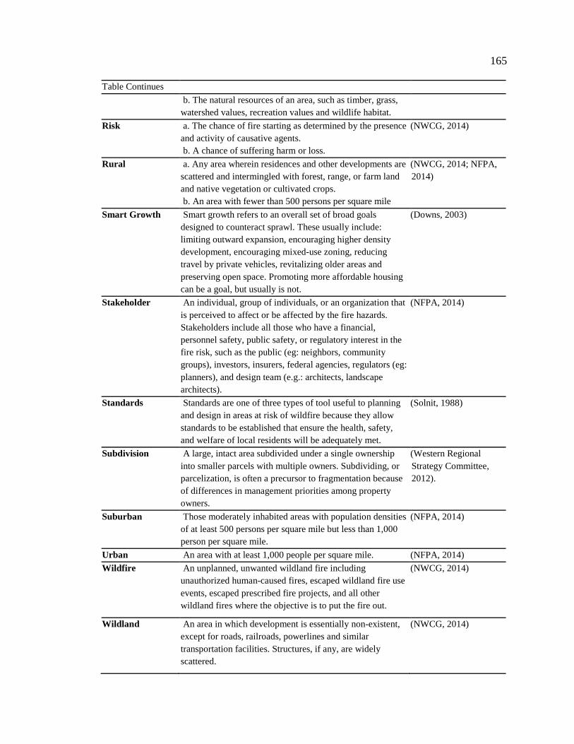
165
Table Continues b. The natural resources of an area, such as timber, grass,
watershed values, recreation values and wildlife habitat.
Risk a. The chance of fire starting as determined by the presence and activity of causative agents. b. A chance of suffering harm or loss.
(NWCG, 2014)
Rural a. Any area wherein residences and other developments are scattered and intermingled with forest, range, or farm land and native vegetation or cultivated crops. b. An area with fewer than 500 persons per square mile
(NWCG, 2014; NFPA, 2014)
Smart Growth Smart growth refers to an overall set of broad goals designed to counteract sprawl. These usually include: limiting outward expansion, encouraging higher density development, encouraging mixed-use zoning, reducing travel by private vehicles, revitalizing older areas and preserving open space. Promoting more affordable housing can be a goal, but usually is not.
(Downs, 2003)
Stakeholder An individual, group of individuals, or an organization that is perceived to affect or be affected by the fire hazards. Stakeholders include all those who have a financial, personnel safety, public safety, or regulatory interest in the fire risk, such as the public (eg: neighbors, community groups), investors, insurers, federal agencies, regulators (eg: planners), and design team (e.g.: architects, landscape architects).
(NFPA, 2014)
Standards Standards are one of three types of tool useful to planning and design in areas at risk of wildfire because they allow standards to be established that ensure the health, safety, and welfare of local residents will be adequately met.
(Solnit, 1988)
Subdivision A large, intact area subdivided under a single ownership into smaller parcels with multiple owners. Subdividing, or parcelization, is often a precursor to fragmentation because of differences in management priorities among property owners.
(Western Regional Strategy Committee, 2012).
Suburban Those moderately inhabited areas with population densities of at least 500 persons per square mile but less than 1,000 person per square mile.
(NFPA, 2014)
Urban An area with at least 1,000 people per square mile. (NFPA, 2014) Wildfire An unplanned, unwanted wildland fire including
unauthorized human-caused fires, escaped wildland fire use events, escaped prescribed fire projects, and all other wildland fires where the objective is to put the fire out.
(NWCG, 2014)
Wildland An area in which development is essentially non-existent, except for roads, railroads, powerlines and similar transportation facilities. Structures, if any, are widely scattered.
(NWCG, 2014)

166
Table Continues Wildland Fire Any non-structure fire that occurs in vegetation or natural
fuels. Wildland fire includes prescribed fire and wildfire. (NWCG, 2014)
Wildland Urban Interface
The location where humans and their developments meet or are intermixed with wildland fuels.
(NFPA, 2014)
Zoning A legal form of land-use control and building regulations usually exercised by a municipal authority; usually involves setting aside of distinct land areas for specific purposes, such as commercial, educational or residential development
(ASLA, n.d.)

167
REFERENCES
Agee, J. K. (1997). Fire management for the 21st century. Creating a forestry for the 21st century. Washington, D.C.: Island Press.
Agee, J. K. (1999). Fire effects on landscape fragmentation in interior west forests. In A.
Rochelle, J. A., Lehmann, L. A., & J., Wisniew. (Eds.), Forest fragmentation: Wildlife and management implications. Leiden, The Netherlands: Brill Academic Publishers.
Ager, A. A., Vaillant, N. M., & Finney, M. A. (2010). A comparison of landscape fuel
treatment strategies to mitigate wildland fire risk in the urban interface and preserve old forest structure. Forest Ecology and Management, 259(8), 1556– 1570.
Alig, R. J., Butler, B. J., & Swenson, J. J. (2000). Fragmentation in private forest lands:
Preliminary findings from the 2000 renewable resources planning act assessment. In L. A., DeCoster & R. N., Sampson. (Eds.), Fragmentation 2000: A Conference on Sustaining Private Forests in the 21st Century (pp. 17–20).
American Society of Landscape Architects. (n.d.). ASLA: Glossary. Retrieved from
http://www.asla.org/nonmembers/publicrelations/glossary.htm Arno, S. F., & Allison-Bunnell, S. (2002). Flames in our forest: Disaster or renewal?
Washington D.C., Island Press. Ashland, Oregon, City of, (2015). Physical and Environmental Constraints Wildfire
Lands. Retrieved from http://www.ashland.or.us/Files/PandE_Overlay_wildfire.pdf
Berke, P. R. (1998). Reducing natural hazards through state growth management. Journal
of the American Planning Association 64, 76–87. Bhandary, U., & Muller, B. (2009). Land use planning and wildfire risk mitigation: An
analysis of wildfire-burned subdivisions using high-resolution remote sensing imagery and GIS data. Journal of Environmental Planning and Management, 52(7), 939–955.
Blanchard, B., & Ryan, R. L. (2003). Community perceptions of wildland fire risk and
fire hazard reduction strategies at the wildland-urban interface in the northeastern United States. Paper presented at the Proceedings of the 2003 Northeastern Recreation Research Symposium. Retrieved from http://www.fs.fed.us/ne/newtown_square/publications/technical_reports/pdfs/2004/317papers/blanchard317.pdf

168
Blonski, K., Miller, C., & Rice, C. (2011). HISTORY: Tunnel Fire, 20 Years After. Wildfire World. Retrieved from http://wildfireworld.org/2011/09/history-tunnel-fire-20-years-after/
Bovio, G., & Camia, A. (1997). Land zoning based on fire history. International Journal
of Wildland Fire, 7(3), 249–258. Bowman, D. M., Balch, J. K., Artaxo, P., Bond, W. J., Carlson, J. M., Cochrane, M. A.,
... & Pyne, S. J. (2009). Fire in the Earth system. Science, 324(5926), 481–484. Retrieved from ftp://ftp.atmos.washington.edu/disk/home/disk/ftp/sarahd/forbrendan/Bowman_Fires_Science_2009.pdf
Bright, A. D., Newman, P., & Carroll, J. (2007). Context, beliefs, and attitudes toward
wildland fire management: An examination of residents of the wildland-urban interface. Human Ecology Review. 14(2), 212–222. Retrieved from http://trangwww.humanecologyreview.org/pastissues/her142/brightetal.pdf
Brown, T. J., Hall, B. L., & Westerling, A. L. (2004). The impact of twenty-first century
climate change on wildfire danger in the western United States: An applications perspective. Climate Change 62, 365–388. Retrieved from http://meteora.ucsd.edu/cap/pdffiles/04CC_BrownHallWesterling.pdf
Brzuszek, R., Walker, J., Schauwecker, T., Campany, C., Foster, M., & Grado, S. (2010).
Planning strategies for community wildfire defense design in Florida. Journal of Forestry, 108(5), 250–257.
Buxton, M., Haynes, R., Mercer, D., & Butt, A. (2011). Vulnerability to bushfire risk at
Melbourne's urban fringe: The failure of regulatory land use planning. Geographical Research, 49(1), 1–12.
Cal Fire. (n.d.). Fire resistant landscaping. Retrieved from
http://www.readyforwildfire.org/landscaping/ Call, C. (2008). A Utah citizen’s guide to land use regulation. Retrieved from
http://wfrc.org/image_library/SupMaterial/UtahLUInst/CitGuidetoLU.pdf Carle, D. (2008). An introduction to fire in California. (California Natural History
Guides). University of California Press, Berkeley. Carroll, M. S., Blatner, K. A., Cohn, P. J., & Morgan, T. (2007). Managing fire danger in
the forests of the US inland northwest: A classic ‘wicked problem’ in public land policy Journal of Forestry (105) 239–44.
Cohen, J. P. (1990, March). A site-specific approach for assessing the fire risk to
structures at the wildland/urban interface. In Proceedings of fire and the

169
environment: Ecological and cultural perspectives symposium. Knoxville, TN (pp. 252–256).
Cohen, J. D. (2000). Preventing disaster: home ignitability in the wildland-urban
interface. Journal of Forestry, 98(3), 15–21. Cohen, J. D. (2001, November). Wildland-urban fire—a different approach. Proceedings
of the firefighter safety summit, International Association of Wildland Fire, Missoula, MT.
Cohen, J. D., & Butler, B. W. (1996, October). Modeling potential structure ignitions
from flame radiation exposure with implication for wildand/urban interface fire management. Proceedings of the 13th conference on fire and forest meteorology Lorne, Australia.
Colburn, J. E. (2008). The fire next time: Land use planning in the wildland/urban
interface. Retrieved from http://www.epubs.utah.edu/index.php/jlrel/article/viewFile/106/96
Cortner, H. J., & Gale, R. D. (1990). People, fire, and wildland environments. Population
and Environment, 11(4), 245–257. Cova, T. J. (2005). Public safety in the urban–wildland interface: Should fire-prone
communities have a maximum occupancy? Natural Hazards Review, 6(3), 99–108.
Czech, B., Krausman, P. R., & Devers, P. K. (2000). Economic associations among
causes of species endangerment in the United States. BioScience, 50(7), 593–601. Davis, G., Nichols, M. D., Tuttle, A. E., & Allshouse, W. (2000). Structural fire
prevention field guide for mitigation of wildland fires. Retrieved from http://osfm.fire.ca.gov/codedevelopment/pdf/firesafetyplanning/structural/structuralfirepreventionguide.pdf
Davis, J. B. (1990). The wildland-urban interface: Paradise or battleground? Journal of
Forestry, 88(1), 26–31. Department of Regional Planning County of Los Angeles. (1990). Santa Clarita Valley
Area Plan. Retrieved from http://planning.lacounty.gov/assets/upl/data/pd_santa-clarita.pdf
Deschutes County (2010). Deschutes County: Comprehensive Plan. Retrieved from
http://www.deschutes.org/cd/page/planning-division Development Standards for Wildfire Lands, Ashland Land Use Ordinance § 18.3.10.100
(2008).

170
Dombeck, M. P., Williams, J. E. & Wood, C. A. (2004). Wildfire policy and public lands:
Integrating scientific understanding with social concerns across landscapes. Conservation Biology, 18(4), 883–889. Retrieved from http://www.sierraforestlegacy.org/Resources/Conservation/FireForestEcology/FireScienceResearch/FireEcology/FireEcology-Dombeck04.pdf
Douglas County. (2001). Wildfire Hazard District Overlay Map. Retrieved from
http://www.douglas.co.us/documents/section-17-wildfire-hazard-overlay-map.pdf Downs, A. (2003, May). Growth management, smart growth, and affordable housing.
Keynote speech given at Brookings Symposium on the relationship between affordable housing and growth management. Retrieved from http://www.brookings.edu/research/speeches/2003/05/29metropolitanpolicy-downs
Ewert, A. W. (1993). The wildland-urban interface: Introduction and overview. Journal
of Leisure Research, 25(1), 1. Federal Land Assistance, Management and Enhancement Act [FLAME]. (2009). Report
to Congress. Retrieved from http://www.forestsandrangelands.gov/strategy/documents/reports/2_ReportToCongress03172011.pdf
Firewise Communities. (n.d.). Retrieved from http://www.firewise.org/ Flannigan, M. D., Krawchuk, M. A., de Groot, W. J., Wotton, B. M., & Gowman, L. M.
(2009). Implications of changing climate for global wildland fire. International Journal of Wildland Fire, 18(5), 483–507. Retrieved from http://www.ualberta.ca/~flanniga/publications/2009Implications%20of%20changing%20climate%20for%20global%20wildland%20fire.pdf
Fleeger, W. E. (2008). Collaborating for success: Community wildfire protection
planning in the Arizona White Mountains. Journal of Forestry, 106(2), 78–82. Retrieved from http://www.mountainsfoundation.org/uploads/media_items/collaborating-for-success-community-wildfire-protection-planning-in-the-arizona-white-mountains.original.pdf
Florida Department of Agriculture and Consumer Services, Division of Forestry (2010).
Wildfire risk reduction in Florida: Home neighborhood, and community best practices. Retrieved from http://freshfromflorida.s3.amazonaws.com/Wildfire_Risk_Reduction_in_FL.pdf
Forest Health and Fire Protection Code, Chapter 17.96 (2003).

171
Fried, J. S., Winter, G. J., & Gilless, J. K. (1999). Assessing the benefits of reducing fire risk in the wildland-urban interface: A contingent valuation approach. International Journal of Wildland Fire, 9(1), 9–20.
Garvey, M., & Pierson, D. (2007). Why Some Averted Disaster. Los Angeles: Los
Angeles Times. Retrieved from http://www.latimes.com/local/la-me-saved24oct24-story.html#page=1
Gibbins, J. (2003). [Photograph]. Available from http://www.srfiresafecouncil.org/ Gill, A. M., & Stephens, S. L. (2009). Scientific and social challenges for the
management of fire-prone wildland–urban interfaces. Environmental Research Letters, 4(3), 034014.
Godschalk, D. R. (2003). Urban hazard mitigation: Creating resilient cities. Natural
Hazards Review, 4(3), 136–143. Retrieved from http://dx.doi.org/10.1061/(ASCE)1527-6988(2003)4:3(136)
Governor’s Blue Ribbon Fire Commission. (2004). Report to the Governor. Sacremento:
State of California. Grayzeck-Souter, S. A., Nelson, K. C., Brummel, R. F., Jakes, P., & Williams, D. R.
(2009). Interpreting federal policy at the local level: The wildland–urban interface concept in wildfire protection planning in the eastern United States. International Journal of Wildland Fire, 18(3), 278–289.
Gude, P., Rasker, R., & van den Noort, J. (2008). Potential for future development on
fire-prone lands. Journal of Forestry, 106(4): 198–205. Retrieved from http://headwaterseconomics.org/wphw/wp-content/uploads/PGude_2008_Forestry.pdf
Hammer, R. B., Stewart, S. I., Winkler, R. L., Radeloff, V. C., & Voss, P. R. (2004).
Characterizing dynamic spatial and temporal residential density patterns from 1940-1990 across the North Central United States. Landscape and Urban Planning, 69(2), 183–199.
Hammer, R. B., Volker, R. C., Freid, J. S., & Stewart, S. I. (2007). Wildland–urban
interface housing growth during the 1990s in California, Oregon, and Washington. International Journal of Wildland Fire. 16(3), 255–265.
Hammer, R. B., Stewart, S. I., & Radeloff, V. C. (2009). Demographic trends, the
wildland–urban interface, and wildfire management. Society and Natural Resources, 22(8), 777–782.
Hansen, A. J., Knight, R. L., Marzluff, J. M., Powell, S., Brown, K., Gude, P. H., &
Jones, K. (2005). Effects of exurban development on biodiversity: Patterns,

172
mechanisms, and research needs. Ecological Applications, 15(6), 1893–1905. Retrieved from http://www.esajournals.org/doi/abs/10.1890/05-5221
Hardy, C. C., Menakis, J. P., Long, D. G., Brown, J. K., & Bunnell, D. L. (1998).
Mapping historic fire regimes for the western United States: integrating remote sensing and biophysical data. Proceedings of the 7th biennial Forest Service remote sensing applications conference (pp. 6–9).
Healthy Forests Restoration Act of 2003 [HFRA]. (2003). Public Law, 108–148. International Code Council. (2012). International Wildland-Urban Interface Code.
International Code Council. Retrieved from https://law.resource.org/pub/us/code/ibr/icc.iwuic.2012.pdf
International Panel on Climate Change. (2007). Climate Change 2007: Synthesis Report
Summary for Policymakers. Retrieved from https://www.ipcc.ch/pdf/assessment-report/ar4/syr/ar4_syr_spm.pdf
Jakes, P., Agrawal, S., & Monroe, M. (2003). The Palm Coast community: Steps to
improve community preparedness for wildfire. St. Paul, MN: U.S. Department of Agriculture, Forest Service, North Central Research Station. Retrieved from http://www.treesearch.fs.fed.us/pubs/11803
Johnson, K. M. (1999). The rural rebound. P. 1–20 in Reports on America, 1(3).
Population Reference Bureau, Washington, D.C. Retrieved from http://scholars.unh.edu/cgi/viewcontent.cgi?article=1078&context=soc_facpub
Johnson, K. M., & Beale, C. L. (1994). The recent revival of widespread population
growth in nonmetropolitan areas of the United States. Rural Sociology, 59(4), 655–667.
Johnson, M. P. (2001). Environmental impacts of urban sprawl: A survey of the literature
and proposed research agenda. Environment and Planning A, 33(4), 717–735. Keeley, J. E. (2009). Ecological foundations for fire management in North American
forest and shrubland ecosystems (General Technical Report, PNW-GTR-779). Pacific Northwest Research Station: USDA Forest Service.
Keeley, J. E. (2010). Fire on California Landscapes. Fremontia, 38(2,3) 2–6. Retrieved
from https://www.cnps.org/cnps/publications/fremontia/Fremontia_Vol38-No2-3.pdf#page=4
Kitzberger, T., Brown, P. M., Heyerdahl, E. K., Swetnam, T. W., & Veblen, T. T. (2007).
Contingent Pacific–Atlantic Ocean influence on multicentury wildfire synchrony over western North America. Proceedings of the National Academy of Sciences, 104(2), 543–548.

173
Kostishack, P., & Rana, N. (2002). An Introduction to the National Fire Plan History,
Structure, and Relevance to Communities. Retrieved from Pinchot Institute for Conservation, Washington, DC.
Kuhns, M. R., & Daniels, B. (2007). Firewise Landscaping for Utah. Logan, UT: Utah
State University Cooperative Extension. Retrieved from http://extension.usu.edu/files/publications/publication/FirewiseLandscaping2012.pdf
Landfire (Cartographer). (2008). Historical Fire Regime Groups. Retrieved from
http://www.landfire.gov/datatool.php Landis, B. (2010). How CNPS developed a policy on native plants and fire safety. Fire on
California Landscapes. Fremontia, 38(2,3) 7–15. Retrieved from https://www.cnps.org/cnps/publications/fremontia/Fremontia_Vol38-No2-3.pdf#page=4
Lang, E. A., Nelson, K. C., & Jakes, P. (2006). Working with community leadership to
promote wildfire preparedness. The public and wildland fire management: Social science findings for managers, 1, 1137. Retrieved from http://www.nrs.fs.fed.us/pubs/gtr/gtr_nrs1.pdf#page=147
Littell, J. S., McKenzie, D., Peterson, D. L., & Westerling, A. L. (2009). Climate and
wildfire area burned in western US ecoprovinces, 1916–2003. Ecological Applications, 19(4), 1003–1021. Retrieved from http://www.jstor.org/stable/40346247?seq=1#page_scan_tab_contents
Lindroth, R., Poudre Fire Authority, & Livermore Fire Protection District. (2005).
Sheltering-in-place During Wildfire, is it a Viable Option? (Applied Research Project). National Fire Academy. Retrieved from http://www.usfa.fema.gov/pdf/efop/efo38568.pdf
Los Angeles City Fire Department. (2000). Los Angeles Fire Department Fire Hazard
Reduction and Safety Guidelines. LAFD Bureau of Fire Prevention and Public Safety, Brush Clearance Unit. Van Nuys, CA.
Los Angeles County. (1980). Los Angeles County General Plan – Land Use Element.
Retrieved from http://planning.lacounty.gov/assets/upl/project/gp_web80-land-use.pdf
Los Angeles County. (1990). Los Angeles County General Plan – Safety Element.
Retrieved from http://planning.lacounty.gov/assets/upl/project/gp_web90-safety-element.pdf
McKenzie, D., Miller, C., & Falk, D. A. (2011). The landscape ecology of fire.

174
McKinney, M. L. (2002). Urbanization, biodiversity, and conservation.
BioScience, 52(10), 883–890. Miller, G. T., & Spoolman, S. E. (2007). Living in the Environment (15th Edition ed.)
Cengage Learning. Morgan, P., Hardy, C. C., Swetnam, T. W., Rollins, M. G., & Long, D. G. (2001).
Mapping fire regimes across time and space: Understanding coarse and fine-scale fire patterns. International Journal of Wildland Fire, 10(4), 329–342.
Morgan, P., Heyerdahl, E. K., & Gibson, C. E. (2008). Multi-season climate
synchronized forest fires throughout the 20th century, northern Rockies, USA.Ecology, 89(3), 717–728. Retrieved from http://www.esajournals.org/doi/abs/10.1890/06-2049.1
Murphy, D. E. (2003). In California’s inferno, an oasis of fire safety planning stands Out.
New York: New York Times. Retrieved from http://www.nytimes.com/2003/11/02/us/in-california-s-inferno-an-oasis-of-fire-safety-planning-stands-out.html
Mutch, R. W. (1994). Fighting fire with prescribed fire: A return to ecosystem
health. Journal of forestry, 92(11). National Association of Counties. (2010). Planning fire-resilient counties in the wildland
urban interface: Guide to wildfire risk and mitigation. Grant Final Report NACo 08-DG- 11132543-175. Washington, DC. 8 p.
National Association of State Foresters [NASF]. (2003). Field Guidance Identifying and
Prioritizing Communities at Risk. Washington D.C.: National Association of State Foresters.
National Association of State Foresters [NASF]. (2010). State foresters by the numbers:
data and analysis from the 2008 NASF state forestry statistics survey. Washington D.C.: QB Consulting and Straight Arrow Consulting.
National Association of State Foresters [NASF]. (2013). Communities at Risk Report.
Washington D.C.: National Association of State Foresters. National Fire Protection Association [NFPA]. (2006). Firewise: community solutions to a
national problem. National Wildland/Urban Interface Fire Program publication FWC-008-06-BK. Quincy, MA. 61 p.
National Fire Protection Association [NFPA]. (2009). Safer from the start: A guide to
Firewise friendly developments. FWC-001-09-BK. Quincy, MA. 39 p.

175
National Fire Protection Association [NFPA]. (2012). NFPA 1141: Standard for fire protection infrastructure for development in wildland, rural, and suburban areas. National Fire Protection Association. Retrieved from http://www.nfpa.org/codes-and-standards/document-information-pages?mode=code&code=1141
National Fire Protection Association [NFPA]. (2013). NFPA 1144: Standard for
protection of life and property from wildfire. National Fire Protection Association. Retrieved from http://www.nfpa.org/codes-and-standards/document-information-pages?mode=code&code=1144
National Fire Protection Association [NFPA]. (2014). Glossary of terms. Retrieved from
http://www.nfpa.org/~/media/Files/Codes%20and%20standards/Glossary%20of%20terms/glossary_of_terms_2014.pdf
National Interagency Fire Center [NIFC]. (2014). Wildland fire statistics. Retrieved from
www.nifc.gov/fire_info/fire_stats.htm National Wildfire Coordinating Group. (2014). Glossary of Wildland Fire Terminology.
Retrieved from http://www.nwcg.gov/pms/pubs/glossary/pms205.pdf Oakland North (Digital News). (2011). Oakland History Room exhibit highlights public
documents, personal memories of Oakland hills fire [Photograph]. Retrieved from https://oaklandnorth.net/2011/09/01/oakland-history-room-highlights-public-documents-personal-memories/
Office of the Inspector General. (2006). Forest service large fire suppression costs.
United States Department of Agriculture Rep. 08601-44-SF. 58 p. Office of the President. (2002). Healthy forests: An initiative for wildfire prevention and
stronger communities. Office of the President, Washington, D.C. Paveglio, T. B., Prato, T., & Hardy, M. (2013). Simulating effects of land use policies on
extent of the wildland urban interface and wildfire risk in Flathead County, Montana. Journal of environmental management, 130, 20–31.
Prestemon, J. P., Butry, D. T., Abt, K. L., & Sutphen, R. (2010). Net Benefits of Wildfire
Prevention Education Efforts. Forest Science, 56(2), 181–192. Pyne, S. J. (2001). Fire: a brief history. Seattle: University of Washington Press. Pyne, S. J., Andrews, P. L., & Laven, R. D. (1996). Introduction to wildland fire (No. Ed.
2). New York: John Wiley and Sons. Radeloff, V. C., Hammer, R. B., Stewart, S. I., Fried, J. S., Holcomb, S. S., & McKeefry,
J. F. (2005). The wildland-urban interface in the United States. Ecological Applications, 15, 799–805. Retrieved from

176
ftp://ftp.nofc.forestry.ca/pub/fire/Alexander/USFS_RD_WildlandFireReview/references/radeloff_hammer_stewart_fried_holcomb_mckeefry_2005.pdf
Rasker, R., & Hansen, A. J. (2000). Natural amenities and populations growth in the
Greater Yellowstone region. Human Ecology Review, 7(2), 30–40. Retrieved from http://www.humanecologyreview.org/pastissues/her72/72raskerhansen.pdf
Ridley, D. (2008). The Literature Review: A Step-by-Step Guide for Students. London:
Sage Publications Ltd. Sampson, R. N. (1999). Primed for a firestorm. Forum for Applied Research and Public
Policy, 14(1). San Diego, City of. (1979). Progress Guide and General Plan. Retrieved from
http://www.sandiego.gov/planning/genplan/pdf/generalplan/gpfullversion.pdf San Diego Regional Planning Agency. (2003). Census 2000 Profile: Scripps Miramar
Community Planning Area. San Diego, CA. Retrieved from http://profilewarehouse.sandag.org/profiles/cen00/sdcpa1434cen00.pdf
Santa Clarita Municipal Code, Ordinance 13–12 § 2 (2013). Schoennagel, T., Veblen, T. T., & Romme, W. H. (2004). The Interaction of fire, fuels,
and climate across Rocky Mountain forests. BioScience, 54(7), 661–676. Schoennagel, T., Nelson, C. R., Theobald, D. M., Carnwath, G. C., & Chapman, T. B.
(2009). Implementation of National Fire Plan treatments near the wildland–urban interface in the western United States. Proceedings of the National Academy of Sciences, 106(26), 10706–10711.
Schwab, J., & Meck, S. (2005). Planning for Wildfires. Planning Advisory Service
529/530. Chicago: American Planning Association. Scripps Ranch Civic Association. (n.d.). Retrieved from http://www.scrippsranch.org/ Scripps Ranch Community Wildfire Protection Alliance. (2006). Scripps Ranch
Community Wildfire Protection Plan. Solnit, A. (1988). The job of the practicing planner. American Planning Association. State of Utah. (2013). Catastrophic Wildfire Reduction Strategy. Utah Department of
Agriculture and Food. Retrieved from http://www.ag.utah.gov/documents/CatFireFinalReport120213.pdf
Stein, S. M., Menakis, J., Carr, M. A., Comas, S. J., Stewart, S. I., Cleveland, H., … &
Radeloff, V. C. (2013). Wildfire, wildlands, and people: Understanding and

177
preparing for wildfire in the wildland-urban interface – a Forests on the Edge report (Gen. Tech. Rep. RMRS-GTR-299). Fort Collins, CO.: U.S. Department of Agriculture, Forest Service, Rocky Mountain Research Station. Retrieved from http://www.fs.fed.us/openspace/fote/reports/GTR-299.pdf
Stephens, S. L., & Ruth, L. W. (2005). Federal forest-fire policy in the United States.
Ecological applications, 15(2), 532–542. Retrieved from http://www.jstor.org/stable/4543372?seq=1#page_scan_tab_contents
Stevenson Ranch Home Owners Association. (n.d.). Retrieved from
http://www.stevensonranch91381.com/ Syphard, A. D., Keeley, J. E., Bar Massada, A., Brennan, T. J., & Radeloff, V. C. (2012).
Housing arrangement and location determine the likelihood of housing loss due to wildfire. PLoS One, 7(3), e33954.
Syphard, A. D., Massada, A. B., Butsic, V., & Keeley, J. E. (2013). Land use planning
and wildfire: development policies influence future probability of housing loss. PLoS one, 8(8), e71708.
Theobald, D. M., Miller, J. R., & Hobbs, N. T. (1997). Estimating the cumulative effects
of development on wildlife habitat. Landscape and urban planning, 39(1), 25–36. Theobald D. M., & Romme, W. H. (2007). Expansion of the US wildland-urban
interface. Landscape and Urban Planning 83(4), 340–354. Todd, J. (2010). Scripps Ranch Through the Years: 1890–2010. Scripps Ranch Civic
Association. Retrieved from http://www.scrippsranch.org/community/history/scripps-ranch-through-the-years.html
University of Illinois Extension. (n.d.). Comprehensive Planning. Retrieved from
http://urbanext.illinois.edu/lcr/comprehensiveplanning.cfm U.S Department of Agriculture Forest Service. (2000). National Fire Plan: Managing the
impact of wildfires on communities and the environment. Washington, D.C.: U.S of Agriculture Forest Service.
U.S. Department of Agriculture Forest Service. (2011). Wildland fire suppression costs:
Ten-year rolling average. Unpublished data provided by the Forest Service Budget Staff. On file with S. Stein, USDA Forest Service, Cooperative Forestry, 1400 Independence Avenue, SW, Mailstop 1123, Washington, DC 20250-1123.
U.S. Department of Agriculture Forest Service. (2014). Wildland Fire Potential.
Retrieved from http://www.firelab.org/project/wildfire-hazard-potential

178
U.S. Department of Agriculture Office of Inspector General. (2006). Audit Report: Forest Service Large Fire Suppression Costs (Report No. 08601-44). Washington, D.C.: USDA Office of Inspector General.
U.S. Department of Agriculture & U.S. Department of Interior. (2001). Urban wildland
interface communities within vicinity of Federal lands that are at high risk from wildfire. Federal Register 66(3), 751–777.
Utah. Division of Forestry, Fire and State Lands (2013). Communities at Risk. Westerling, A. L., Hidalgo, H. G., Cayan, D. R., & Swetnam, T. W. (2006). Warming
and earlier spring increase western US forest wildfire activity. Science, 313(5789), 940–943.
Western Regional Strategy Committee. (2012). The National Cohesive Wildland Fire
Management Strategy: Phase III Western Regional Science-Based Risk Analysis Report. Retrieved from http://www.forestsandrangelands.gov/strategy/documents/reports/phase3/WesternRegionalRiskAnalysisReportNov2012.pdf
Western Regional Strategy Committee. (2013). The National Cohesive Wildland Fire
Management Strategy: Phase III Western Regional Action Plan. Retrieved from http://www.forestsandrangelands.gov/strategy/documents/rsc/west/WestRAP_Final20130416.pdf
Winter, G. J., & Fried, J. S. (2000). Homeowner perspectives on fire hazard,
responsibility, and management strategies at the wildland-urban interface. Society & Natural Resources, 13(1), 33–49.
Winter, G. J., & Fried, J. S. (2001). Estimating contingent values for protection from
wildland fire using a two-stage decision framework. Forest Science, 47:349–360. Retrieved from http://www.jeremyfried.net/jfried/pubs/winter_fried_2001_forest_science.pdf
Winter, G. J., Vogt, C., & Fried, J. S. (2002). Fuel treatments at the wildland-urban
interface: Common concerns in diverse regions. Journal of Forestry, 100(1): 15–21.
Zhang, Q., Wollersheim, M., Griffiths, S., & Maddox, I. (2014). National Fire Risk Map
for Continental USA: Creation and Validation. In IOP Conference Series: Earth and Environmental Science. Vol. 18, No. 1.

179
APPENDICES

180
Appendix A. State Codes Relevant to Wildfire and Development
Table 29
State Codes Relevant to Wildfire and Development
Arizona 37-622; 37-642
Each legislative session, the state forester is asked to provide updates on the wildland-urban interface, including the effects of county and municipal zoning policies and wildfire hazards on public and private property. The state forester is also required to keep a list of communities at risk of wildfire.
California 14 CCR §§ 913.4(c), 933.4(c), and 953.4(c)
Fuelbreak/Defensible Space is listed as special prescriptions that are appropriate where some trees and other vegetation and fuels are removed to create a shaded fuel break or defensible space in an area to reduce the potential for wildfires and the damage they might cause.
14 CCR § 1038
The following timber management operations are exempt from some plan preparation and submission requirements under California law because of fuel reduction benefits: the cutting or removal of trees, which eliminates the vertical continuity of fuels and the horizontal continuity of tree crowns for the purpose of reducing flammable materials and maintaining a fuelbreak and the removal of trees within one-hundred-fifty feet from any point of an “approved and legally permitted structure” that complies with the California Building Code.
14 CCR § 1051.4(a)
Prescribed fuel hazard reduction to promote project area resiliency to wildfire is recognized as an intermediate treatment rather than a regeneration method. Therefore, clearcutting as defined shall not be used, except for legally permitted utility corridors or road construction. Silvicultural methods that may be used are commercial thinning, rehabilitation and fuelbreak/defensible space
14 CCR § 1270.01
These regulations have been prepared and adopted for the purpose of establishing minimum wildfire protection standards in conjunction with building, construction and development. The future design and construction of structures, subdivisions and developments in State Responsibility Area (SRA) shall provide for basic emergency access and perimeter wildfire protection measures. These measures shall provide for emergency access; signing and building numbering; private water supply reserves for emergency fire use; and vegetation modification. These fire protection standards establish the minimums for such measures.
14 CCR § 1272.00
To ensure continued maintenance of properties in conformance with these standards and measures and to assure continued availability, access, and utilization of the defensible space provided for in these standards during a wildfire, provisions for annual maintenance shall be included in the development plans and/or shall be provided as a condition of the permit, parcel or map approval.
14 CCR § 1273.00
Road and street networks, whether public or private, unless exempted, shall provide for safe access for emergency wildland fire equipment and civilian evacuation concurrently, and should provide unobstructed traffic circulation during a wildfire emergency.
14 CCR § 1275.00
Emergency water for wildfire protection shall be immediately available and accessible in quantities and locations in communities specified in the statute and these regulations, in order to attack a wildfire or defend property from a wildfire.
14 CCR § 1276.00
To reduce the intensity of a wildfire by reducing the volume and density of flammable vegetation, the strategic siting of fuel modification and greenbelts shall provide

181
Table Continues increased safety for evacuating civilians and a point of attack or defense from
a wildfire. 14 CCR § 15126.2
Environmental impact reports should evaluate any potentially significant impacts of locating development in other areas susceptible to hazardous conditions (e.g., floodplains, coastlines, wildfire risk areas) as identified in authoritative hazard maps, risk assessments or in land use plans addressing such hazards areas.
Colorado 2 CCR 408-1 Immediately following intense wildfires resulting in approximately 15 percent or
greater burn area can be considered to have special floodplain conditions; floodplain conditions limit certain land uses. Interim flood advisory maps post-wildfire should be made available to assess recovery and the need for this designation.
Idaho House Bill No. 539 Section 38-137
The use of exploding targets is prohibited on public lands during closed fire season. On private lands, exploding targets cannot be used without the expressed consent of the landowner and the local fire official during the closed fire season.
House Bill No. 160 Section 67-8001
Any action taken by the State, city, or county to control a wildfire is not an unconstitutional taking of private property.
Montana 76-13-203 In the event of excessive or great fire danger, the wildfire season may be expanded. 76-13-204 The State of Montana may create wildland fire protection districts. 76-13-212 It is an expressed duty of a landowner, in a wildland fire protection district, to protect
against the starting or existence of fire and suppress the spread of fire on that land. 76-13-701 The management, protection, and conservation of the watersheds in Montana are
critical to the State’s well-being. The water supplies of some of the state's most populous cities and surrounding areas originate in federally managed watersheds that are at risk for catastrophic wildfire, the severity of which could be reduced by proper management; a catastrophic wildfire in any one of those municipal watersheds would result in ash and sediment inundating and degrading the municipal water supply, leaving tens of thousands of residents without drinking water, creating a severe public safety situation, and decimating millions of dollars worth of water infrastructure. Therefore, the legislature declares that it is the policy to promote the sustainable use of all public forests within the state through sound management and collaboration with local, state, and federal entities.
Nevada No state legislation directly relevant to wildfire and development was found in the
current codified laws of the State of Nevada.
New Mexico 19.20.3.6
Whenever warranted by factors affecting danger of forest fire, the forestry division can impose restrictions governing the personal access to lands when the danger level poses a threat to public safety, life, property and the natural resources of the state.
Oregon Chapter 307 Section 2
Economic and property damages as a result of a wildfire, not the result of recklessness or negligence, are identified as recoverable damages. If a wildfire is the result of an individual’s recklessness or negligence, he or she is liable for the full amount of all expense.
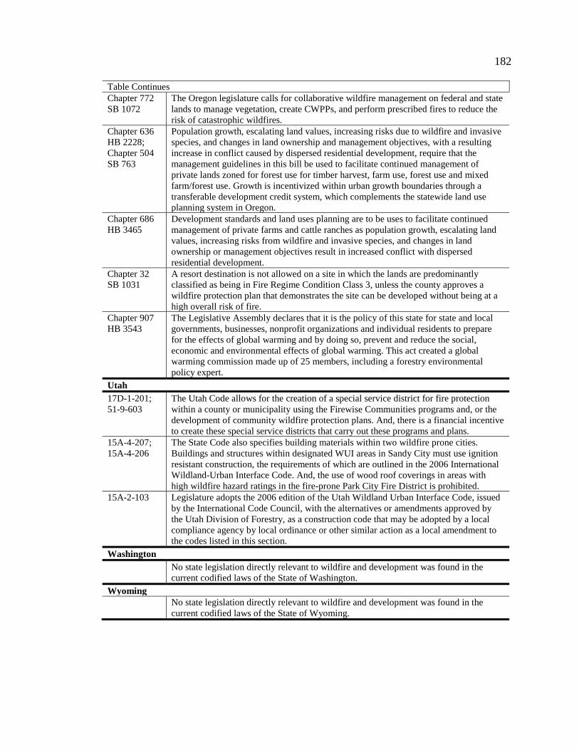
182
Table Continues Chapter 772 SB 1072
The Oregon legislature calls for collaborative wildfire management on federal and state lands to manage vegetation, create CWPPs, and perform prescribed fires to reduce the risk of catastrophic wildfires.
Chapter 636 HB 2228; Chapter 504 SB 763
Population growth, escalating land values, increasing risks due to wildfire and invasive species, and changes in land ownership and management objectives, with a resulting increase in conflict caused by dispersed residential development, require that the management guidelines in this bill be used to facilitate continued management of private lands zoned for forest use for timber harvest, farm use, forest use and mixed farm/forest use. Growth is incentivized within urban growth boundaries through a transferable development credit system, which complements the statewide land use planning system in Oregon.
Chapter 686 HB 3465
Development standards and land uses planning are to be uses to facilitate continued management of private farms and cattle ranches as population growth, escalating land values, increasing risks from wildfire and invasive species, and changes in land ownership or management objectives result in increased conflict with dispersed residential development.
Chapter 32 SB 1031
A resort destination is not allowed on a site in which the lands are predominantly classified as being in Fire Regime Condition Class 3, unless the county approves a wildfire protection plan that demonstrates the site can be developed without being at a high overall risk of fire.
Chapter 907 HB 3543
The Legislative Assembly declares that it is the policy of this state for state and local governments, businesses, nonprofit organizations and individual residents to prepare for the effects of global warming and by doing so, prevent and reduce the social, economic and environmental effects of global warming. This act created a global warming commission made up of 25 members, including a forestry environmental policy expert.
Utah 17D-1-201; 51-9-603
The Utah Code allows for the creation of a special service district for fire protection within a county or municipality using the Firewise Communities programs and, or the development of community wildfire protection plans. And, there is a financial incentive to create these special service districts that carry out these programs and plans.
15A-4-207; 15A-4-206
The State Code also specifies building materials within two wildfire prone cities. Buildings and structures within designated WUI areas in Sandy City must use ignition resistant construction, the requirements of which are outlined in the 2006 International Wildland-Urban Interface Code. And, the use of wood roof coverings in areas with high wildfire hazard ratings in the fire-prone Park City Fire District is prohibited.
15A-2-103 Legislature adopts the 2006 edition of the Utah Wildland Urban Interface Code, issued by the International Code Council, with the alternatives or amendments approved by the Utah Division of Forestry, as a construction code that may be adopted by a local compliance agency by local ordinance or other similar action as a local amendment to the codes listed in this section.
Washington No state legislation directly relevant to wildfire and development was found in the
current codified laws of the State of Washington. Wyoming
No state legislation directly relevant to wildfire and development was found in the current codified laws of the State of Wyoming.

183
Appendix B NFPA 1144 Wildland Fire Risk Checklist

184

185
Figure 21. NFPA 1144 Wildland Fire Risk Checklist

186
Appendix C. International Wildland-Urban Interface
Code Fire Hazard Severity Form
Figure 22. International Wildland-Urban Interface Code Fire Hazard Severity Form

187
Appendix D. Sample Legislation for Adoption of the International
Wildland-Urban Interface Code
Figure 23. Sample Legislation for Adoption of the International Wildland-Urban
Interface Code

188
Appendix E. Pacific Southwest Fire Regime Groups, 2001
Figure 24. Wildfire Context Map of Case Study Communities
Stevenson Ranch
Scripps Ranch