community spaces of kathmandu modifications in building
TRANSCRIPT

The Pennsylvania State University
The Graduate School
College of Arts and Architecture
COMMUNITY SPACES OF KATHMANDU
MODIFICATIONS IN BUILDING BYLAWS TO IMPROVE SOLAR ACCESS
A Thesis in
Architecture
by
Moondeep Pradhananga
© 2013 Moondeep Pradhananga
Submitted in Partial Fulfillment
of the Requirements
for the Degree of
Master of Architecture
December 2013

ii
The thesis of Moondeep Pradhananga was reviewed and approved* by the following:
Rebecca Henn
Assistant Professor of Architecture
Thesis Advisor
Ute Poerschke
Associate Professor of Architecture
Mallika Bose
Associate Professor of Landscape Architecture
Alexandra Staub
Chair, Graduate Program and Associate Professor of Architecture
*Signatures are on file in the Graduate School.

iii
Abstract
Nepal’s adoption of new planning policies in 1976 has led to significant transformation of urban
management practice in Kathmandu. Neglecting issues of larger communal interests, new
planning policies have focused on providing individual homeowners with the right to build
higher structures. These new planning policies depend on generic height restrictions to control
building height in community spaces regardless of their varying shape, size, and orientation.
One outcome of these regulations has been loss of minimum level of solar access in community
spaces. This is particularly important since in Nepal solar access in community spaces is integral
for the socio-cultural functioning of such public places. This thesis proposes the incorporation
of solar access analysis in Nepal’s building bylaws to control the height of buildings in
community spaces. Such policy would ensure minimum level of solar access in community
spaces, which in turn would support community activities and be beneficial to the entire
community.
iv
TABLE OF CONTENTS
LIST OF FIGURES
LIST OF TABLES
ACKNOWLEDGEMENT
1. INTRODUCTION
A. Background..................................................................................................................................1
B. Problem Statement................ .....................................................................................................5
2. LITERATURE REVIEW..................................................................................................................10
A. Urban Morphology.....................................................................................................................11
i. Physical Structure
a. Paths.................. ...........................................................................................................13
b. Edges........................... .................................................................................................15
c. Districts...................... ...................................................................................................16
d. Nodes........................ ....................................................................................................17
e. Landmarks.....................................................................................................................18
i. Social Aspects...................... .................................................................................................19
ii. Cultural Aspects....................................................................................................................22
B. Public Open Space......................................................................................................................26
i. Residential Square.............. ..................................................................................................29
ii. Community Square........... ...................................................................................................30
iii. Palace Square........... ..........................................................................................................31
C. Traditional Built Form.................................. .............................................................................34
D. Traditional Urban Management Practice..................................................................................39
E. New Planning Policies................................ ...............................................................................42

v
F. Solar Access......................... .......................................................................................................48
i. Climate of Kathmandu......................... .................................................................................48
ii. Sun-Based Activities in Public Spaces...... ............................................................................49
iii. Quality of Built Environment...............................................................................................52
iv. International Solar Access Standard...... .............................................................................52
G. Solar envelope..... ................................................................................. ....................................53
i. Daily Solar Path and East-West Facade..................... ...........................................................55
ii. Yearly Limits and North-South Facade...................... ..........................................................56
iii. Periods of Useful Insolation and Cutoff Time..... ...............................................................58
3. RESEARCH QUESTION................ ..............................................................................................60
4. RESEARCH METHODOLOGY............ ........................................................................................59
5. CASE STUDY............... ..............................................................................................................62
A. Reduction in Solar Access Due to New Planning Bylaws
i. Case Study 1: Itum Bahal ........................... ........................................................................66
a. Itum Bahal during 1968.................................................................................................68
b. Itum Bahal during 2012.................................................................................................69
c. Solar Access Analysis in Cultural Infrastructure......... ...................................................70
d. Conclusion ........... .......................................................................... ..........................72
ii. Case Study 2: Te Baha......................... ..................................................................................73
a. Te Baha in Old Condition........................ ......................................................................75
b. Te Baha during 2012......................... ...........................................................................76
c. Solar Access Analysis in Cultural Infrastructure............................................................77
d. Conclusion ................................................................................................................79

vi
B. Modification in Built Environment to Improve Solar Access.......... ..........................................80
i. Itum Bahal
a. Ascertaining Building Enclosure that Meets Solar Access Standard..... .......................81
b. Applying Results................ ..........................................................................................83
ii. Te Baha
a. Ascertaining Building Enclosure that Meets Solar Access standard.............................84
b. Applying Results............... ............................................................................................85
C. Recommendation........... .......................................................................... ................................86
6. CONCLUSION............... .............................................................................................................88
7. FUTURE AREA FOR RESEARCH...... ............................................................................................93
BIBLIOGRAPHY............ ..................................................................................................................95

vii
LIST OF FIGURES
Figure 1 Kathmandu Valley political map (Pradip Raj Pant, 2009)...............................................................2
Figure 2 Urban Transformation in Kathmandu within a decade after the introduction of new planning
policies (source: Neils Gutschow and Hermann Kreutzmann)......................................................................6
Figure 3 Vertical division of property...........................................................................................................7
Figure 4 Taller buildings within historic core after the introduction of new planning policies (UNESCO
2006)............................................................................................................................................................8
Figure 5 Diagrammatic representation of decrease in solar access after the introduction of new planning
policies.........................................................................................................................................................8
Figure 6 Path, Edge, District, Node, Landmark...........................................................................................11
Figure 7 Path, Edge, District, Node, and Landmark in Historic Core of Kathmandu . ..................................12
Figure 8 View of Path P2 (Refer Figure 7 Above).......................................................................................14
Figure 9 View of Path P3 (Refer Figure 7 Above) (Source: http://www.nepal-dia.de/int__England/EK-
Kathmandu-Tal/Ek-Freak_street_Kathmandu_/ek-freak_street_kathmandu_.html)...............................14
Figure 10 View of Path P4 (Refer Figure 7 Above) (Source:
http://www.tumblr.com/tagged/palace%20square?before=17)..............................................................14
Figure 11 Street facade along the edge of new development...................................................................15
Figure 12 Parked motorcycles on the edge of Preserved Monument Zone (Refer Figure 6 above).. ........ 15
Figure 13 Palace complex and Durbar Square............................................................................................16
Figure 14 Yetkha Bahal..................................................................................................................... .......... 16
Figure 15 Node N1 - Indra Chowk (Refer Figure 6 Above)................................................................... ...... 17
Figure 16 Node N2 - Juddha Shalik (Refer Figure 6 Above)........................................................................17
Figure 17 Landmark L1 - Taleju Temple (Refer Figure 6 Above).................................................................18
Figure 18 Landmark L2 - Nine Storey Palace Tower (Refer Figure 6 Above)...............................................18

viii
Figure 19 Zoning of historic city based on occupation................................................................. ............. 19
Figure 20 Chariot Procession of Machhendranath...................................................................... ............... 22
Figure 21 Traditional city boundary defined by nature protector............................................................. 23
Figure 22 Residential Square (Kumari Ghar)........................................................................... ................... 26
Figure 23 Community Square (Yetkha Bahal)............................................................................. ................ 26
Figure 24 Patan Durbar Square............................................................................................... ................. ..26
Figure 25 Diagrammatic layout of traditional town showing interconnection of different type of public
open spaces (Tiwari S., 1988).....................................................................................................................26
Figure 26 Typologies of public open spaces in Kathmandu (Source: Author)................................ ............ 28
Figure 27 Residential court in traditional town (source: Shrestha House, Kathmandu)............... ............. 29
Figure 28 Te Baha, a community square in Kathmandu............................................................... .............. 31
Figure 29 Temples within Te Baha................................................................................................. ............ 31
Figure 30 Kathmandu Durbar Square (Source: Google Map)....................................................... .............. 31
Figure 31 Palace complexes at Kathmandu Durbar Square............................................................. .......... 31
Figure 32 Cultural Infrastructures in Kathmandu Durbar Square................................................. ............. 33
Figure 33 Plan, section and elevation of a typical traditional house (source: Neils Gutschow)...... ........... 35
Figure 34 Modified traditional house during Shah Period (source: Neils Gutschow)..................... ........... 37
Figure 35 Modified traditional house during Rana period (source: Neils Gutschow).................... ............ 37
Figure 36 Changes in building facade from Malla, Shah to Rana period (source: Neils Gutschow).. ......... 38
Figure 37 A typical building enclosure of community space during Rana period (source: Neils
Gutschow)..................................................................................... ............................................................. 38
Figure 38 Mixed Residential Sub-Zone in Kathmandu Municipality's Zoning Map (Source: Kathmandu
Municipality)..................................................................................................................................... ......... 43
Figure 39 Traditional Street Elevation................................................................ ........................................ 44

ix
Figure 40 Impact of planning bylaw on street elevation (source: The P.U.S.H Effect, People, Urban,
Society and Heritage, Rakshya Rayamajhi)....................................................................................... ......... 45
Figure 41 Uniform skyline in traditional built fabric...................................................................................46
Figure 42 Light plane to restrict height of buildings (source: Kathmandu municipality building
bylaws)...................................................................................................................................... ................. 47
Figure 43 Potter carrying sun-dried pots to brick kiln............................................................... ................. 49
Figure 44 Woman drying rice grains in Sun............................................................................... ................. 50
Figure 45 People basking in Sun ........... .....................................................................................................51
Figure 46 Diagrammatic representations of solar rights envelope and solar collection envelope..... ....... 54
Figure 47 Eastern and Western Sun defining solar volume......................................................... .............. 55
Figure 48 Solar path in Kathmandu on summer solstice (source: Ecotect)................................. ............... 56
Figure 49 Solar path defining solar volume on North and South face..................................... .................. 57
Figure 50 Solar path in Kathmandu during winter solstice (source: Ecotect)............................ ................ 57
Figure 51 Community squares selected for solar analysis.........................................................................62
Figure 52 Building profile of the study models used for the case study of Itum Bahal.............................64
Figure 53 Key Map of Itum Bahal...............................................................................................................66
Figure 54 Urban transformation of Itum Bahal..........................................................................................67
Figure 55 Solar hour distribution of Itum Bahal in 1968 ............................................................................68
Figure 56 Solar Hour distribution of Itum Bahal in 2012 ............................................................................69
Figure 57 Solar access analysis around cultural Infrastructure..................................................................70
Figure 58 Solar access for cultural object...................................................................................................71
Figure 59 Key Map of Te Baha....................................................................................................................73
Figure 60 Te Bahal with old building marked in white ...............................................................................74
Figure 61 Distribution of sunlight hours over the analysis grid in old conditions.......................................75

x
Figure 62 Distribution of sunlight hour over the analysis grid in new condition.......................................76
Figure 63 Cultural Object #1 (C1) in Te Baha..............................................................................................77
Figure 64 Map showing cultural objects in Te Bahal..................................................................................77
Figure 65 Solar accesses of cultural objects...............................................................................................78
Figure 66 Solar hour distribution for building enclosure 18 meter high with sloped roof.........................81
Figure 67 Solar hour distribution for building enclosure 15 meter high with sloped roof.........................82
Figure 68 Proposed interventions at Itum Bahal........................................................................................83
Figure 69 Solar hour distribution for building enclosure with 18 meter high building with sloped
roof................................................................... .........................................................................................84
Figure 70 Proposed Interventions at Te Baha............................................................................................85

xi
LIST OF TABLES
Table 1 Building bylaw for various zones (Source: Kathmandu municipality bylaws)...................... 42
Table 2 Solar altitude angle for summer and winter solstice (Source:
http://www.susdesign.com/sunangle/)............................................................................................ 47
Table 3 Hourly temperature variation from 9 am to 3 pm in Kathmandu (Source: Ecotect, refer
appendix)........................................................................................................................................... 48
Table 4 Comparative study of solar access of cultural object in 1968 and 2012............................... 71
Table 5 Comparative study of solar hours in 1968 and 2012 of Itum Bahal...................................... 72
Table 6 Comparative study of solar access for cultural objects......................................................... 78
Table 7 Comparative study of solar access hour in Old and 2012 Condition..................................... 79

xii
ACKNOWLEDGEMENT
This thesis is an output of a combined effort of many people who have been formally as well as
informally involved in the research. This thesis certainly would not have been possible without
continuous guidance from my advisor, Assistant Professor Rebecca Henn. I am also grateful to my
committee members, Associate Professor Ute Poerschke and Associate Professor Mallika Bose, for their
insightful thoughts and feedback through critical periods of the research. I would also like to take this
opportunity to thank the School of Architecture and Landscape Architecture at the Pennsylvania State
University for providing me an opportunity to pursue Master's degree and conduct the research. I would
also like to thank my mother, Lila Kiran Pradhananga, my father, Badri Bhakta Pradhananga, and my
fiancée, Krisha Amatya for providing their emotional support and care throughout the countless days of
being far from home. I would also like to thank my colleagues, Gaurav Tuladhar and Neha Parkar, for
their advice and support, whenever I needed them.

1
1. INTRODUCTION
A. Background
Nepal established democracy in 1960 and adopted a free market economy. Until then,
Kathmandu was largely disconnected with developments in the Western world. Growth until
1960 can be described as closed and organic, undergoing a slow process of self-learning and
doing. This isolation kept Kathmandu from reaping the benefits of numerous technological
advancements occurring in the urbanized world. In contrast, it can also be argued that this self-
containment allowed Kathmandu to protect and flourish its socio-cultural and architectural
heritage and to develop its own indigenous form of urbanization.
Since its beginnings, Kathmandu has been home to an immigrant population from all over the
region. People living in the valley are historically known as "Newar," and they are accredited for
the development of the valley's rich cultural heritage (Slusser 1982, 11). Kathmandu's valley
comprises three living historic cities: Kathmandu, Patan, and Bhaktapur as shown in Figure 1
below. The ways of living and urban setting are part of Kathmandu’s rich cultural heritage. One
of the most remarkable aspects of Kathmandu's historic cities is the close synergy between the
urban built environment and the socio-cultural life of its inhabitants (Korn 1979, 5). Buildings
and its urban fabric are an essential part of this cultural setting. Every aspect of it, from
materiality to aesthetics, from built forms to city structure, reflects the intricacies of a rich
culture. A sense of communal identity is brewed in this synergy, which over the years has been
both the cause and effect of rich the cultural life in the region.

2
Figure 1 Kathmandu Valley political map (Pradip Raj Pant, 2009)

3
Kathmandu thrived as the political, economic, and cultural capital of Nepal for the past 2000
years. The pattern of urbanization was homogeneous for a long period of time, but it is
certainly not a reality today. Urbanization today is not pristine; rather, it is a mix of both
traditional and new development superimposed one over another. While it is remorseful when
one looks into the vestiges of what is left, it is also equally inspirational to explore new
paradigms in current urban problems.
Urbanization brought by the free market economy in the last fifty years has focused more on
promoting economic opportunities. Such urbanization viewed buildings and land as resources
to be capitalized and individual rights received more priority than communal benefits. This
brought a fundamental shift in how people built and how the city of Kathmandu continued to
grow. There has been a constant collision of socio-cultural values and newfound economic
opportunities (Tiwari, 2000, 5). Unfortunately, economic opportunities and individual interests
have weighed in heavily, marring the idea of communal identity and benefits. Due to lack of
proper negotiation between economic and communal benefits, Kathmandu continues to
struggle in managing its urban growth. In Kathmandu, where an indigenous approach to
urbanism is amalgamation of socio-cultural, economic and environmental responses, the
repercussions of disturbing such approach to urban development has manifested in numerous
fronts (Tiwari, 2000, 5).
Environmental aspects were one of the most important considerations in designing the historic
cities of Kathmandu (Tiwari, Kathmandu Valley Urban Capital Region and Historical Urbanism
2000, 4-6). These cities were designed with what we call today passive solar techniques that

4
utilize the sun as an energy source (sensible heat and light). The roof and terrace architecture
of community spaces was also such that it allowed sunlight in the community space for the
larger part of day. As the buildings were low-rise, from two and half to three and half stories,
street width to building height ratio was within 1:1.5; hence the streets received more sunlight
(Shrestha 2011, 8). However, due to development pressure in the last fifty years or so, the
traditional urban fabric has deteriorated drastically. Tall buildings in the historic core have not
only deteriorated the built character of public open space, but have also decreased solar access
of these spaces. This has resulted due to the inability of new planning policies to realize the
essential function of an individual house to not only provide shelter for each household, but
also to constitute a building enclosure in a public open space for the entire community.
Nepal started regulating urban growth through government intervention with "The Physical
Development Plan for the Kathmandu Valley" planning act issued by the Department of
Housing and Physical Planning in 1969. The Department of Housing and Physical Planning later
issued its first building and construction bylaws in 1976 (Duwal 2013, 18). However, these laws
and regulations have not been able to consider the impact that the new development could
have on the historic core of Kathmandu both in terms of the quality of living and loss in socio-
cultural heritage (Joshi 2007, 6). These issues will be discussed in more detail in later chapters.

5
B. Problem Statement
Kathmandu valley adopted its first building and construction regulations in 1976. Nepal then
was in a race to capitalize on the economic boom brought by the opening up of its economy to
the global market. Urban centers like Kathmandu started attracting a rapid influx of migrants,
creating a massive housing demand in the historic city. New planning policies responded to the
housing demand by allowing people to build more within the historic city. As a result,
Kathmandu started growing rapidly. Figure 2 below shows the impact of urbanization on the
historic city of Kathmandu within two decades of the adoption of the new planning policies. In
the last decade, Kathmandu urbanized at an unprecedented rate of 4.7 percent, enabling a
population density of 2,800 per square kilometer (ICIMOD 2007, 11).
Marketing a historic town like Kathmandu to attract tourists was an attractive proposition for
the state government. As Kathmandu promoted tourism, economic opportunities increased in
the historic core. Municipality governments wanted to promote such opportunities and
generate revenue by allowing people to build more. This act to promote tourism has negatively
affected the city’s socio-cultural and architectural heritage, the aspects that attracted tourists
in the first place. Ironically, over the years it has adversely affected the tourism industry, as
Kathmandu's architectural heritage and way of living associated with it have been severely
deteriorated (ICIMOD, MoEST/GoN, UNEP 2007, 20-21).

6
Figure 2 Urban Transformation in Kathmandu within two decades after the introduction of new planning policies (source: Neils Gutschow and Hermann Kreutzmann)

7
Traditional buildings have either been torn down or modified to increase rental area to the
point, where it no longer bears any resemblance to the old fabric. In addition, the social system
of distributing parental properties equally amongst siblings has encouraged vertical division of
houses. Haphazard renovation and reconstruction like removal of sloped roof to add new floor
of different materials; change in floor height, facade details and construction technique for the
addition on top floor; addition of new staircase and toilet in the divided part by destroying part
of existing structure has all destroyed the vernacular architecture and streetscape as shown in
Figure 3 below (Shrestha 2011, 12-13).
Figure 3 Vertical division of property
Source: (UNESCO 2006, 16 & 43)

8
Kathmandu’s current building by-laws are based largely on generic height restrictions that have
allowed proliferation of taller buildings in historic cores (Rai 2008, 6) without providing due
consideration to its low-rise urban context, as shown in Figure 4 below. As buildings in historic
cores have become taller, they have destroyed the scale and proportion of traditional built
forms. As a result, solar access in public plazas and streets has decreased, as diagrammatically
shown in Figure 5 above. Such environmental repercussions have resulted in unhygienic living
conditions in historic cores. "Reduction in sunlight due to high rise construction has destroyed
the social use value of community spaces to parking lots, dumping sites, and stranger's place"
(Shrestha 2011, 13). New developments in Kathmandu do not follow vocabulary of traditional
Figure 4 Taller buildings within historic core after the introduction of new planning policies (UNESCO 2006)
Figure 5 Diagrammatic representation of decrease in solar access after the introduction of new planning policies

9
architecture, and have made the built environment of the historic core unsystematic and
unhygienic. In addition, they are not climate responsive and have not been able to provide
quality living environment as the traditional settlements were able to provide (B. Shrestha
2008, 70-73). Kathmandu lies in an earthquake prone zone and in the traditional settlement,
community squares were used as a place of refuge during earthquakes. However, with tall
buildings, these squares have become death traps, as the addition of floors onto the old
foundation have made them vulnerable against the seismic forces (Shrestha B. K., 2002, 36-41).
In recognition of these urban problems, Assistant Professor Rajjan Man Chitrakar at Pokhara
University, Nepal authored a research entitled "Public open spaces in Kathmandu Valley: A
review of contemporary problems and historic precedents," which identified a set of
recommendations to improve public open spaces in Kathmandu (Chitrakar 2011, 95). One of
those recommendations entitled "built form and scale", states "height [of] the enclosing
building should be proportionate to the length of open space." However, this recommendation
does not address what exactly could define such proportion. This research proposes the use of
minimum solar access standards to define the proportion between building height and the scale
of open space. The research will refer to international solar standards, as it will be discussed in
later chapters to define the minimum solar access standard in community spaces.

10
2. LITERATURE REVIEW
The literature review consists of seven sub-sections which are Urban Morphology, Public Open
Space, Traditional Built Form, Traditional Urban Management Practice, New Planning Policies,
Solar Access, and Solar Envelope. The section 'Urban Morphology' develops an understanding
of the physical structure, social issues and cultural aspects associated with the historic core of
Kathmandu. It helps in understanding how public spaces fit into the overall city fabric. The next
section 'Public Open Space' elaborates on different types of public spaces found in the historic
core of Kathmandu and why it is important in physical structure of the city and socio-cultural
life of the community. The section following 'Public Open Space' is entitled 'Traditional Built
Form' which describes the traditional built forms existing in the historic core of Kathmandu and
how it evolved, maintaining consistency in scale and form through Malla, Shah and Rana period
when Guthi was active. It is then followed by the section entitled 'Traditional Urban
Management Practice' which talks about Guthi and how it influenced the urban management
practice before new planning by laws were introduced in 1976. This section helps to develop an
understanding of ways in which traditional urban management practice has been able to
safeguard issues of larger communal benefits in the urban fabric. The next section entitled 'New
Planning Policies' elaborates on the impact of new planning policies on the built environment of
the historic core and points out its inability to consider issues of larger communal benefit like
solar access in community spaces. The next section 'Solar Access,' describes ways in which solar
access is important for the community and establishes the need for solar access in public
spaces. The last section entitled 'Solar Envelope' develops a theoretical understanding required
for solar access analysis, which is then utilized on two case studies later in the thesis.

11
A. Urban Morphology
i. Physical Structure
Traditional architecture and settlement patterns of the Kathmandu valley have been heavily
influenced by "Mandala." Mandala is a traditional way of spatial organization, which organizes
space ritually and socially based on the three principles of boundary, hierarchy, and center
(Gellner 1992, 5). In a traditional town, the "Palace" is the center of the town boundary, which
was articulated with entry gates and various temples to protect the city from any evil.
Agricultural farmlands were beyond this boundary in low-lying lands. This pattern of settlement
lasted in Kathmandu until the end of the Malla period in 1768 A.D. Later, with the beginning of
urbanization in Kathmandu in 1960 A.D., the historic city structure of Kathmandu transformed
drastically.
The city no longer follows the planning principles of Mandala, as the city has transformed well
beyond the three principles propounded by Mandala. This section of the literature review uses
Kevin Lynch's theory in the book "The City Image and its Elements (Lynch 1960, 47-48)," to
dissect and develop an understanding of Kathmandu’s urban morphology. Kevin Lynch uses five
elements to define the physical constituent of the image or perception that an urban dweller
has of a city. These elements are Path, Edges, Districts, Nodes, and Landmarks, as shown in
Figure 6 below.
Figure 6 Path Edge District Node Landmark
(Lynch 1960)

12
These five elements are further illustrated in a section of the historic core, which is Kathmandu
durbar square as shown in Figure 7 below. These five elements of Path, Edge, District, Node,
and Landmark will be discussed in more detail in the following chapters using the map and
reference images.
Figure 7 Path, Edge, District, Node, and Landmark in Historic Core of Kathmandu

13
a. Path
Kevin Lynch states "Paths are the channels along which the observer customarily, occasionally,
or potentially moves (Lynch 1960, 47)." These paths connect diverse elements and
environmental conditions of a city, giving a sequence of imagery to the observer. Such imagery
forms the essential part of the observer’s visual memory.
Beautifully carved streets are the paths in a dense urban settlement of Kathmandu’s historic
core. These streets are for circulation and conglomeration and provide a unique character to
the urban form. The historic towns have non-axial streets, which rarely meet at right angles
(Chitrakar 2011, 8), as shown in Figure 7 above. However, the streets are never curvilinear;
instead, short segment of streets join at nodal spaces and take an angular turn. Such
continuous segmentation of streets provides changing views and vistas to pedestrians, which
makes walking in these streets enjoyable.
Streets also act as a connector of various public spaces and residential neighborhoods. Like
blood vessels that branch to supply blood to each cell, streets in the historic core of Kathmandu
branch from the main street to reach each residential neighborhood and further to each house.
The main street in the historic core can be as wide as 20 feet, as shown in Figures 8 and 10
below, while those connecting individual houses can be as narrow as a 3 foot underpass
through another building, as shown in Figure 9 below.

14
Figure 9 View of Path P3 (Refer Figure 7 Above)
(Source: http://www.nepal-dia.de/int__England/EK-
Kathmandu-Tal/Ek-Freak_street_Kathmandu_/ek-
freak_street_kathmandu_.html)
Figure 10 View of Path P4 (Refer Figure 7 Above)
(Source: http://www.tumblr.com/tagged/palace%20square?before=17)
Figure 8 View of Path P2 (Refer Figure 7 Above)
15
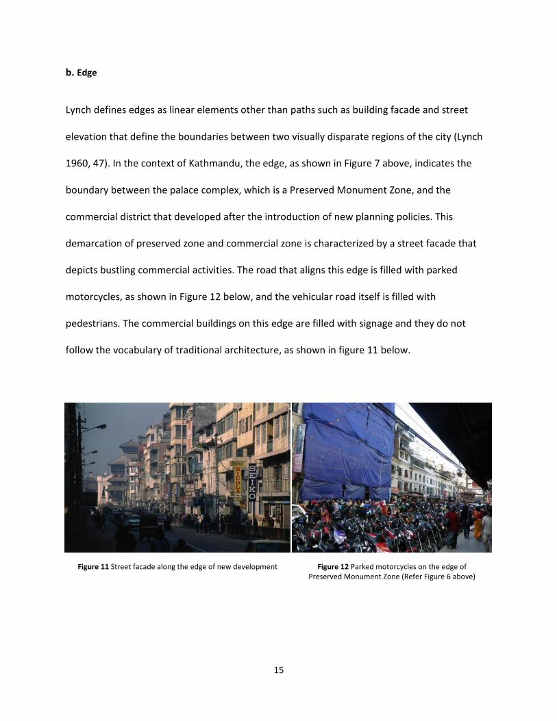
b. Edge
Lynch defines edges as linear elements other than paths such as building facade and street
elevation that define the boundaries between two visually disparate regions of the city (Lynch
1960, 47). In the context of Kathmandu, the edge, as shown in Figure 7 above, indicates the
boundary between the palace complex, which is a Preserved Monument Zone, and the
commercial district that developed after the introduction of new planning policies. This
demarcation of preserved zone and commercial zone is characterized by a street facade that
depicts bustling commercial activities. The road that aligns this edge is filled with parked
motorcycles, as shown in Figure 12 below, and the vehicular road itself is filled with
pedestrians. The commercial buildings on this edge are filled with signage and they do not
follow the vocabulary of traditional architecture, as shown in figure 11 below.
Figure 11 Street facade along the edge of new development Figure 12 Parked motorcycles on the edge of
Preserved Monument Zone (Refer Figure 6 above)

16
c. District
Kevin Lynch states "districts are the medium-to-large sections of the city, conceived of as
having two dimensional extents, which the observer mentally enters "inside of," and which are
recognizable as having some common, identifying character" (Lynch 1960, 47). In the context of
Kathmandu’s historic core, the palace complex and durbar square that adjoin it hold a central
position. This section of the palace complex creates a prominent visual impact on the observer
with its scale and grandeur, as shown in Figure 13 below. While, there are residential
neighborhoods like Yetkha Bahal that are smaller in scale but have distinct visual and spatial
qualities, as shown in Figure 14 below. The two districts, palace complex, and Yetkha Bahal are
different in terms of their scale, use, and status as heritage. The palace complex is in a
Protected Monument Zone, which is used as a museum to display heritage from the monarchial
times of Nepal. People no longer live in these courtyards. On the other hand, communities still
live in Yetkha Bahal, which has buildings used mostly for residential purpose. It has a limited
cultural infrastructure with one central stupa, unlike the palace complex which has numerous
temples.
Figure 13 Palace complex and Durbar Square
(Refer D2 in figure 6 above)
Figure 14 Yetkha Bahal
(Refer D1 in figure 6 above)

17
d. Node
Lynch defines "nodes are points, the strategic spots in a city into which an observer can enter,
and which are the intensive foci to and from which he is travelling" (Lynch 1960, 47). Nodes can
be anything from an intersection of two paths, a hangout place, or a place where the physical
nature of the district change. Figure 7 above shows the location of two nodes, which, in the
case of the historic city, are the intersection of paths. In the context of the historic core of
Kathmandu, the intersections of major streets develop into public open spaces with important
cultural elements like temples, statues, etc. making the space more legible. Figure 15 below
depicts the temple as a cultural element in the intersection of paths to form a node, while,
Figure 16 below shows the vehicular roundabout with the statue of a former king. Other than
these examples, cultural elements like pati (public rest house), chhaitya (miniature Buddhist
shrines in the form of stupa), dabali (open elevated platforms) or dhunge dhara (waterspouts)
can also add legibility to a node (Tiwari, Tiered Temples of Nepal 1988). Streets as paths and
open spaces as nodes define the streetscape in the historic core of Kathmandu.
Figure 15 Node N1 - Indra Chowk (Refer Figure 6 Above) Figure 16 Node N2 - Juddha Shalik (Refer Figure 6 Above)

18
e. Landmark
Lynch states "landmarks are another type of point-reference, but in this case the observer does
not enter within them, they are external (Lynch 1960, 48)." They can be anything, from an
important building, a tower, or a temple, that stands out from its setting. Such urban elements
provide a visual reference to the observer, establishing a pattern to navigate through the city
and recall the "Path."
In the case of the historic core of Kathmandu, cultural infrastructures like temples, the palace
building, large iron bells, etc. constitute the landmarks. The temples stand out from their
physical context due to their form, architectural feature, scale, and materiality. Temples are laid
on a stepped platform with a circumambulatory around it. People use temples as place to meet,
hangout, and enjoy activities in public spaces. Some of the temples can be very high, like Taleju
(Goddess of Power), which is 115 feet high, as shown in Figure 17 below. The palace complex
also has multiple towers overlooking the durbar square. The nine-storey tower is the highest
tower in the palace complex and dominates the entire public space with its towering effect, as
shown in Figure 18 below.
Figure 17 Landmark L1 - Taleju Temple (Refer Figure 6 Above) Figure 18 Landmark L2 - Nine Storey Palace Tower
(Refer Figure 6 Above)

19
i. Social Aspects
Community living in Kathmandu is called "Newar," and the community was organized on the
basis of caste system during the traditional times. King Jayasthiti Malla introduced the caste
system in the 15th century. The occupation of people is the basis for caste system, which
attributes people to fixed social strata. Zoning assigned people a fixed place in the urban
structure depending upon their occupation, as shown in Figure 19 below (Rayamajhi 2012, 8).
People were allowed to live closer to the palace depending upon the importance of their
occupation, which was judged based on the frequency of consultation by palace or the state.
Hence, zoning by caste had socio-cultural, political, and economic connotations. While such a
system developed strong neighborhoods, it was also the cause for social discrimination within
Figure 19 Zoning of historic city based on occupation

20
the "Newar" society.
Social structure forms the basic principles that drove the development and articulation of urban
morphology in Kathmandu. Hierarchy in society is also evident through the location of
important urban elements like the palace, temples, waterspouts, and squares in the city.
Important temples, like the temple of Durga (goddess of power), and large water spouts were
located close to the palace. The cremation grounds were located on the city outskirts, where
people of lower occupation levels lived. The royal palace, locally known as "Durbar" with its
series of courtyards, big open spaces and temples, occupied a central position in the city. The
immediate areas surrounding the palace were allocated for the priests, nobleman, and people
belonging to high occupation level or "Caste" (N. Gutschow 1993, 163-183).
Newars are communal people with a strong belief in social norms and values. Social institutions
like Guthi are a testament to this. The meaning of the word "Guthi" is derived from the Sanskrit
word "Gosthi" meaning an "association" or an "assembly" (Müller-Böker 1988, 28). Guthi refers
to a communal institution, which played a huge role in maintaining the physical structure of the
city and socio-cultural life of the community. Guthi is composed of the members of the
community itself and is based on the socio-cultural values of the community. Newars lived in
extended families in closed quarters around a courtyard. The idea of looking after each other
and being together drove their social values. It is this value that has made public life and the
public realm very important to the community. Guthi looked after each member of the
community, regardless of their social strata, as long as they abided by the social norms.

21
However, a community member or a family who did not abide such norms would be declared
an outcast and would be deprived from benefits provided by the Guthi.
Public spaces were celebrated through various festivals and through monuments that added to
its grandeur. Guthi took care of public buildings like Pati (rest house), Chappas or Digis (public
party venue), and Ashram (place of refuge for homeless), providing a great service to society.
However, Guthi was not all-inclusive, as it did not allow people from other ethnicities to be part
of it. As more people migrated into the city after the political transition, the role of Guthi
started being questioned. As Guthi was not able to transform itself with changing
demographics, its roles and responsibilities were curtailed by the state government. Today,
Guthi is limited only to the preservation of temples and few public buildings. However, it still
plays an important role in organizing major religious festivals and social celebrations. As Guthi
no longer plays a role in the larger part of urban management, communal interests protected
by it in the city have also been neglected in the process. This in turn has led to massive
degradation in urban structures (Selter, Pradhananga, 2007, 4). It would have been very fruitful
if the new planning policies could have reflected upon these old practices and incorporated
value for communal gain in their approach.

22
ii. Cultural Aspects
Cultural activities are an essential part of the annual life-cycle in Kathmandu. These cultural
activities have deep social and cultural meanings that had a huge impact on urban morphology
of traditional towns. For instance, there is a chariot procession of "Machhendranath" as shown
in Figure 20 below, which travels through the historic town boundary and plays a vital role in
controlling urban sprawl.
Figure 20 Chariot Procession of Machhendranath
Ancient settlements relied heavily on local agriculture to feed its population. In order to protect
agricultural land, the historic town created a city boundary defined by nature protectors, which
are numbered from 1 to 8 in Figure 21 below. It was religiously established that anyone who
lived beyond the city boundary would not be protected from evil powers. It was given a
religious imagery and was mediated through rituals so that it could be easily followed by a

23
religiously devout community. This had profound social implications, as residents were forced
to live close to each other. Consequently, the dependency of the city on its surrounding natural
ecology was protected, which added greatly to the sustainability of these historic towns (Tiwari,
2000, 4).
The urban structure of the historic town was articulated so that it was able to host various kinds
of cultural activities. Some of these cultural activities are Jatra (chariot procession), ritual
dances, and public feasts. The streets were designed to allow for public processions, and they
had important stopping points at various public open spaces to allow inhabitants of specific
neighborhoods to do their ritual prayers. As the procession moved through open spaces of
various neighborhoods along the path, as shown in Figure 21 below, it collected and brought
people together, adding mass to the procession.
Figure 21 Traditional city boundary defined by nature protector
24
Numerous cultural activities were devised to improve social life and were given religious
connotation, so that they were readily followed by the community. In addition, these cultural
activities brought communities of all castes together, which helped in maintaining communal
integrity.
Knowledge and building practices adopted by traditional towns were also consciously built in
cultural practices. They were not universal and were instead specific to the region, developed
slowly over time. For example, an important temple in a neighborhood was often used as a
reference to control building height. The roof overhang was designed precisely to deal with the
environmental condition of Kathmandu, which was sufficient to protect the facade from
monsoon rain and summer sun, but allow winter sun into the rooms (Shrestha 2011, 7). In
addition, interior courtyards, locally known as "Saghas" formed by groups of houses, were used
to compost organic wastes, which were later used in kitchen gardens. Cleaning of "Saghas" was
built into cultural practice, so that voluntary labor from society was readily available whenever
required. These practices were developed by people responsible for directing urban
development. "Cultural mediation ensconced indigenous knowledge transmission mode, and
was able to forestall negative individual action likely to damage the community life, the city and
its ecological dependencies (Tiwari, 2000, 6)."
The traditional town followed this culturally mediated development approach until 1960. Then,
western mode of cultural practice gained prominence, especially in urban centers like
Kathmandu. When Nepal adopted democracy in 1960, new planning policies replaced the old
cultural practices. These planning policies were driven by economic opportunities, and adopted

25
generic bylaws without considering the local context and variations. The physical structure of
the traditional town represented the hierarchical arrangement of society. The typology of
residential buildings remained consistent throughout the traditional city, while the public realm
consisted of spaces that ranged widely in terms of its shape, size, and orientation. The
development pattern that followed after the introduction of generic bylaws destroyed the
intricate variations of the public realm.
With rapid in-migration, local people and local culture were reduced to a minority. Soon, "local
culture was considered old and irrelevant, not understanding that it had resulted from
hundreds of year of interaction with natural ecology, local economy and social
relationship"(Tiwari, 2000, 2). Place specificity and place relevance were neglected by new
urban managers in order to take ownership of the place from locals. All the communal
properties owned by Guthi which funded its operation were taken over by the government.
This consequently rendered Guthi powerless over the course of time. Besides, the right to
develop property was solely provided to individual homeowners, provided that they complied
with generic building bylaws. In this process, traditional norms of building practice that
encapsulated socio-cultural values were largely abandoned. In the context of Kathmandu,
safeguarding indigenous cultural values would have simultaneously protected the natural and
urban ecological balance of the place. Unfortunately, the contemporary urban management
practice has neglected existing cultural practices and physical built environment, which has
diminished the inherent environmental responsiveness of the traditional city.

26
B. Public Open Space
Public spaces in historic towns have a strong hierarchy ranging in scale and function. Such
hierarchy corresponds to the hierarchy built into the social structure. Broadly, there are three
types of public spaces in the historic core: Chowk (small and private residential courts), Baha or
Bahal (community squares), and Durbar Square (larger palatial squares) (Tiwari, 1988, 95-98) as
shown in Figures 22, 23, and 24 below. These different scales of public spaces form a network
Figure 22 Residential Square (Kumari
Ghar)
Figure 23 Community Square (Yetkha
Bahal)
Figure 24 Patan Durbar Square Figure 25 Diagrammatic layout of traditional town showing interconnection of
different type of public open spaces (Tiwari S., 1988)

27
of public realm in the traditional city, as diagrammatically shown in Figure 25 above, allowing
for social and cultural exchange within and amongst different neighborhoods.
The traditional town of Kathmandu developed from small hamlets surrounded by farmlands. It
was part of the daily livelihood of people to walk from their village to the farmland in the
morning and return back in the evening. City inhabitants used numerous routes radiating from
the center of settlement, which took them from their residential neighborhoods to their
respective farms. These routes later developed into streets, which all converged into the durbar
square. At some instances these streets intersected each other to form nodal points that later
developed into public spaces. The social importance of these public spaces was higher as it got
closer to the durbar square, establishing a strong hierarchy amongst these open spaces (Tiwari,
Tiered Temples of Nepal 1988). These public spaces, along with private residential quarters,
were interconnected by narrow streets to form a dense urban fabric, as shown in Figure 26
below.

28
Figure 26 Typologies of public open spaces in Kathmandu (Source: Author)

29
i. Residential Squares
Residential square are small scaled private quarter bounded by two to three storey sloped roof
buildings, as shown in Figure 27 below. The traditional city comprises numerous residential
squares, which are known as "Chowks" in the local language. These residential squares are
densely compacted to form the larger neighborhood. These residential squares are small and
private in nature, historically catering to an extended family or people of the same caste.
Residents use these courts for social interactions, marriage and personal celebrations, and
recreational activities. Built structures around these courts are mostly residential in nature,
while the structures having direct access to roads sometimes have commercial shops. Narrow
alleys that interconnect these small courts eventually lead to a major street or a larger
community square. These squares are independent and are a complete social entity in
themselves, as they have their own central open space with public amenities like temples, rest
houses, water spouts, etc. (Gutschow 1993, 163-183).
Figure 27 Residential court in traditional town (source: Shrestha House, Kathmandu)

30
ii. Community Squares
Community squares are larger open spaces, as shown in Figure 28 below. A Community square
is inhabited by multiple families and allows inhabitants of a particular neighborhood to
congregate on a daily basis. These spaces are also used by residents from surrounding
neighborhoods as they have important temples and public infrastructures like wells, and rest
houses. Communities use this space to celebrate various festivals and rituals from life to death.
It also encourages social interaction amongst neighbors on a daily basis. The daily livelihoods of
people living around these squares extend out to these spaces in the form of buying vegetables,
cleaning clothes, and so on. A community space is the stage for interaction between different
age groups at different periods of time and seasons. It is a place to worship for old people in the
early morning, a place to dry grain and clothes in the afternoon, a playing area for children and
conversation place for adults in the evening. In fact, these public spaces were extension of
private houses, merging private and public realm. "Such social system had communal integrity,
diversification and security all contributing towards town sustainability (Shrestha 2011, 10)."
Community squares are mostly comprised of residential buildings but often have one or more
temples within the space or as a part of the built structure defining its perimeter. These squares
also have other social amenities such as wells, ponds, rest houses, and cultural infrastructures
such as stupa and temples as part of its content. Figure 29 below indicates the distribution of
various temples within Te Baha (Chitrakar 2011, 53-70).

31
iii. Palace Squares
Palace squares are the largest of all squares. The palace buildings characterize these squares, as
they dominate the entire public space through their scale, geometry, and grandeur as shown in
Figure 31 below. The palace complex comprises multiple courtyards and larger built forms as
compared to community squares, as shown in Figure 30 below. The built forms are rectilinear in
plan with a strong symmetry in plan and elevation (Chitrakar 2011, 65).
Figure 28 Te Baha, a community square in Kathmandu Figure 29 Temples within Te Baha
Figure 30 Kathmandu Durbar Square (Source: Google Map) Figure 31 Palace complex at Kathmandu Durbar Square

32
Today, the palace complex has been converted into a museum that is heavily guarded for
security purposes. However, the public space that surrounds the palace complex is bustling
with socio-cultural and economic activities. The palace complex has a central public square
highlighted in red on Figure 32 below. The palace square has numerous temples, platforms, and
rest houses, creating informal spaces within and around them. These informal spaces function
as a place where people meet and hang out enjoying the sun, especially during winter.

33
Figure 32 Cultural Infrastructures in Kathmandu Durbar Square

34
C. Traditional Built Form
The traditional towns of Kathmandu gained full maturity during the Malla period. After the
Malla period, two more dynasties, Rana and Shah, ruled Nepal until Nepal adopted a
democratic form of governance. The urban history of Nepal consists of three periods: the Malla
period (1200 to 1768 AD), the Shah period (1768 to 1867 AD), and the Rana period (1867 to
1934 AD), before the new planning policies were adopted by the democratic government.
Built forms in the historic town included low-rise buildings of no more than four stories in a
dense mosaic that made the scale very anthropometric. All built structures in the traditional
town had sloped roofs covered with clay roof tiles. These slopes ended into eaves that
protected the building's walls from rain, shaded windows, or provided shelter to the people on
streets below. However, stone structures like Chhaitya (Buddhist shrine) did not have sloped
roofs. All other buildings, including the palace, common residences, and community buildings,
were made up of brick walls. These walls were two and half bricks wide comprising of outer sun
dried brick, and inner adobe brick with mud plaster. The inner adobe wall helped in absorbing
moisture, which is extremely beneficial in the humid environment of Kathmandu. The
composite wall also has good insulation properties, which stores heat from sun during daytime
and dissipates it into interior environment during night. In addition, the sloped roof had clay
tiles over a thick layer of mud, which also increased the thermal lag of the roof (Shrestha, 2011,
7). While, the windows were made up of wood and were latticed to allow sunlight to enter into
the rooms, maintaining privacy as well (Korn 1979, 12).

35
i. Malla Period
Buildings from the Malla period are the traditional houses seen in the historic core of
Kathmandu. Some of them are still in their original form, while some have been modified by the
homeowners. A traditional house in its original form, as shown in Figure 33 below, is usually
three stories high. The buildings are simple and rectangular in plan with three load bearing
walls running parallel to the length of rectangle. It uses local materials like brick, clay, and wood
as materials for construction. The construction of each unit is independent, which are four to
Figure 33 Plan, section and elevation of a typical traditional house (source: Neils Gutschow)

36
eight meters wide and of variable length. However, all buildings were of similar height and
followed the same architectural vocabulary, including window design, floor height, roof design,
and so on. Because of this, even though each building is structurally separate, together they
form a harmonious facade. Decorative timber columns replace the masonry wall, opening up
the first floor to street level, which homeowners use for commercial activities. For instance, a
metalworker would use this space to work on utensils and to sell product. The second floor
includes private bedrooms with small lattice windows. The third floor is a multifunction room
used for recreational purpose as well as for drying farm products. It has large sun window for
this purpose. The top floor or attic is used as kitchen and has eating areas as well as a family
chapel (Shrestha 2011, 6). Clay roof tiles over the wood truss cover the sloped roof, while the
decorative sun window with lattice structure called San Jhya (Sun-window) forms the focal
point of house.
ii. Shah Period
During the Shah period, houses continued to follow Malla style and proportions. However, the
scale of buildings slightly increased. During this period, new materials and technology were
introduced as economic base shifted from agriculture to service and commerce. Service and
commerce based industries were economically more lucrative than craft based industries. As a
result, intricate craftwork associated with traditional houses started decreasing, which led to
the simplification of building facade as shown in Figure 34 below (Shrestha 2011, 3). Facades
were stucco plastered instead of being exposed brick to protect the brick facade from the
effects of weather. Windows became simpler with less ornamentation, but they continued to

37
have a lattice structure. Despite these changes, the overall built form was not a severe
deviation from the traditional Malla form. Houses from the Shah period were still able to fit the
scale and proportion of traditional street facade.
iii. Rana Period
During the Rana period, the overall style of the Malla period was followed, but the level of
detailing decreased even more than the Shah Period. Facade finishes were comprised of stucco
plaster, while windows started becoming larger and simpler and avoided the lattice structure as
Figure 34 Modified traditional house during Shah Period (source: Neils Gutschow)
Figure 35 Modified traditional house during Rana period (source: Neils Gutschow)

38
shown in Figure 35 above. San Jhya (sun-window) was replaced with regular sized window.
During these periods, there were some changes in original built forms. However, the overall
scale and form of the buildings remained the same, as shown in Figure 36 below. This also is
accounted to the fact that Guthi, driven by socio-cultural values, was still in charge of managing
building practices. There were few changes in building façade, especially with the articulation of
windows, but it maintained its proportion and was contextual. It represented the idea of
communal living, where similar architectural vocabulary was used by all. Remarkably, these
houses from different time-periods were able to co-exist together to form a harmonious
elevation at community spaces as shown in Figure 37 below (Korn 1979, 21).
Figure 36 Changes in building facade from Malla, Shah to Rana period (source: Neils Gutschow)
Figure 37 A typical building enclosure of community space during Rana period (source: Neils Gutschow)
39
D. Traditional Urban Management Practice
Traditional modes of urban management were practiced in Kathmandu until the political
transition occurred in 1960. Until then, local communities played an active role in the growth
and management of the settlements in Kathmandu Valley. The social institution locally known
as Guthi was established for the management of urban infrastructures. Rulers from the Malla
dynasty first introduced this institution in Kathmandu around 1,200 years ago. It was comprised
of people from the local community and was a bottom-up planning process (Dee, Pradhananga
and Shrestha, 2009, 5).
Guthi looked after every aspect of living from managing urban growth, conserving heritage, to
promoting socio-cultural life. Guthi managed urban growth by implementing zoning based on
the caste system in order to promote a building culture that closely related to social and
cultural life. Public space was also an essential part of its jurisdiction, as it was a stage for all
social and cultural activities. Guthi also played a huge role in social welfare and made sure that
each family was well supported in times of need from birth to death (Selter 2007, 3).
Guthi strictly operated on the basis of the caste system and was very successful in ensuring
welfare amongst particular castes. However, it was not successful in promoting permeability
within different castes. For instance, if someone married a person from lower caste, they would
be declared an outcast and would not have access to the benefits offered by Guthi. Even within
Guthi, people from a particular caste held powerful positions, which meant that the voices of
certain castes were heard more than others. Hence, Guthi, despite being a grass root level

40
institution, was not entirely democratic. Often caste and social dogma were used as a means of
social discrimination within the community.
Communities in Kathmandu before the political transformation were closed and homogeneous.
After the political transformation, people from all over Nepal migrated into the city, and the
community rapidly started to become heterogeneous. Guthi was not able to adjust to this
change. Therefore, the roles and responsibilities of Guthi were severely reduced over time.
Guthi owned land and buildings as part of its property. As opposed to tax system, which is
practiced now, Guthi gathered funds from wealth donated by community as a philanthropic
endeavor. Religious imagery such as whoever donates more will have better life after death,
motivated people to donate more to Guthi. Endowment trusts were established to look after
such properties, which were managed by the community themselves (Tiwari, 2000, 8-9).
However with political transition, properties that once belonged to Guthi and were major
source of its income were nationalized and redistributed amongst the new population.
A lack of financial resources and new legal framework curtailed Guthi's jurisdiction, limiting its
functioning today to the maintenance of temples and monuments only. Positive aspects of
Guthi that ensured communal welfare were also lost in this process. The communal approach
to planning was replaced by the top-down approach with layers of bureaucracy that failed to
safeguard the urban amenities that benefitted the entire community (Dee, Pradhananga,
Shrestha, 2009, 5-7).
There were certainly some missed opportunities in learning from the traditional practice in
regards to identifying the elements of greater communal interest and devising policies to

41
safeguard them. For instance, in traditional times Hitti, which is a traditional water spout, was
the chief source of water for the community; therefore, it was essential for the community to
maintain it. Guthi ensured that Hittis were well maintained and functioning. However, today
water is delivered to each house through municipality pipelines. As a result, these public
waterspouts have been neglected. Very recently, there has been a scarcity of water in the
Kathmandu valley, and people are reverting back to public water spouts for their source of
water. Unfortunately, now there is no institution that makes sure these water spouts are well
maintained and functional.

42
E. New Planning Policies
The planning bylaws of 1976 zoned Kathmandu not based on social structure, but based on
economic opportunities (Tiwari, 2000, 2). These bylaws divided the entire city into zones, such
as the Old Settlement Zone, the New Residential Zone, the Industrial Zone, the Institutional
Zone, the City Extension Zone, etc. The planning bylaws of 1976 demarked the historic core as
the Mixed-Old Settlement Sub-Zone in Kathmandu’s zoning map as shown in Figure 38 below.
The economic opportunities and development pressures were highest in this zone, and,
subsequently, the municipality treated this sub-zone as a commercial zone to allow for
maximum building flexibility. The total amount of area allowed to build per square foot of land
in this zone is the highest anywhere in Kathmandu as shown in Table 1 below (F.A.R. is 4.5 for
this zone). The height restriction applied in the Mixed Old Residential Sub-Zone is also highest
for any zone in Kathmandu. People could build as high as 18 meters (59 feet including the
staircase cover) as long as the F.A.R. allowed them, covering as much as 100 percent of their
land. Compared to new residential zones, where the F.A.R. is as low as 1.75, the transformation
brought by this new bylaws is unprecedented anywhere in Nepal.
Table 1. Building bylaw for various zones (Source: Kathmandu municipality bylaws)

43
Figure 38 Mixed Residential Sub-Zone in Kathmandu Municipality's Zoning Map (Source: Kathmandu Municipality)

44
Disregard for shared identity and individual gain replaced the idea of communal identity and
building as socio-cultural practice with the adoption of new planning policies (Selter,
Pradhananga 2007, 4). The planning policies adopted by the state government allowed
property owners to build freely without considering the physical character of the surrounding
built environment. In the town, where buildings were three to four stories high, people were
allowed to build as tall as six and seven storey, as they adopted higher height restrictions as
shown in Table 1 above. Considering that the original built fabric was comprised of houses only
as high as four stories or 12 meters (39.3 feet) as shown in Figure 39 below, it affected the town
in many ways. Not only there was a severe overuse of the public infrastructure, but public open
spaces also lost their original character. As one homeowner added floors, it shaded adjacent
buildings and blocked views for others, forcing adjacent building to add floors as well. Soon, it
was a race to build taller. As the size and scale of public spaces was a constant in the historic
core and the buildings surrounding it got taller, there was a loss in the proportion between the
size of open space and the building enclosure.
Building taller allowed inhabitants to capitalize their land ownership to the maximum, but in
the process it destroyed the Kathmandu's traditional built fabric. Taller buildings violated the
Figure 39 Traditional Street Elevation
45
scale and proportion of the open spaces. As open spaces were an intricate part of socio-cultural
life, changes in the built fabric had adverse effects in these activities. Access to sun in these
spaces was very important, but new planning policies neglected this requirement. In turn, it
relied on generic height restriction regardless of the size, scale and shape of the open space.
This approach was not at all useful in assuring solar access, and consequently there was a
considerable loss of activities that relied on the sun (ICIMOD, 2007).
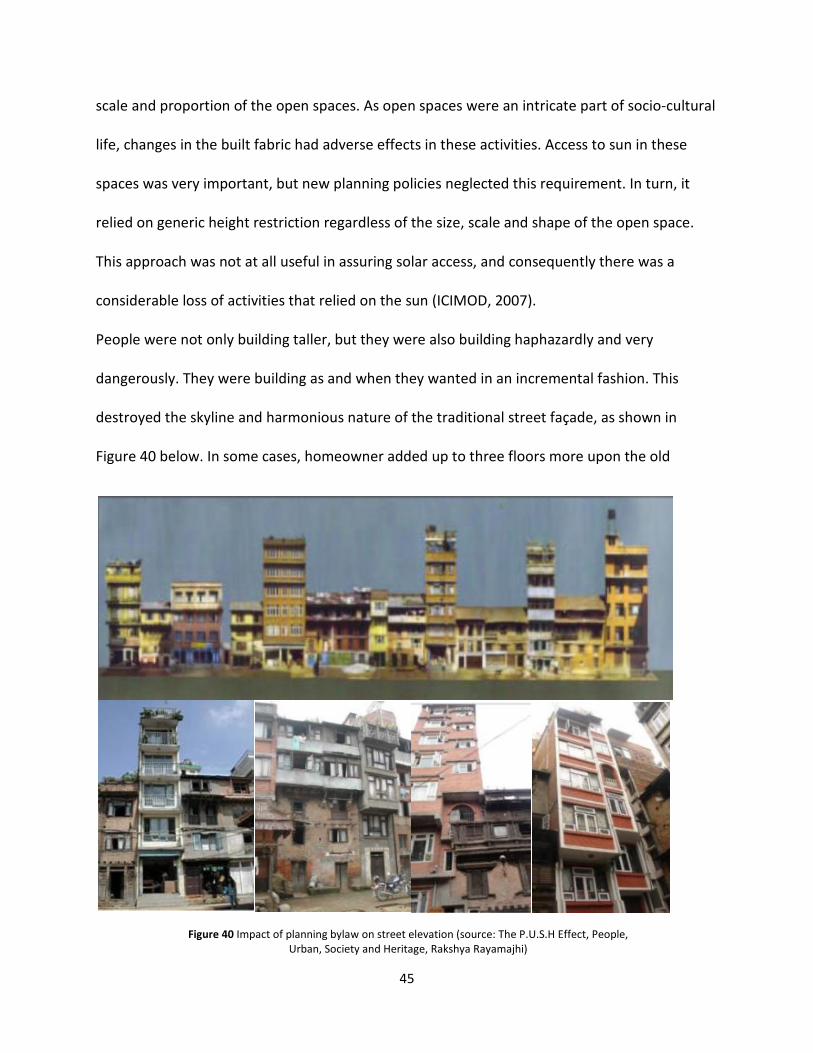
People were not only building taller, but they were also building haphazardly and very
dangerously. They were building as and when they wanted in an incremental fashion. This
destroyed the skyline and harmonious nature of the traditional street façade, as shown in
Figure 40 below. In some cases, homeowner added up to three floors more upon the old
Figure 40 Impact of planning bylaw on street elevation (source: The P.U.S.H Effect, People,
Urban, Society and Heritage, Rakshya Rayamajhi)

46
foundation originally designed to take only the load of a three to four storey building. This is
very problematic, since Kathmandu lies in Zone V for earthquake vulnerability.
The skyline is an integral part of the built character of traditional towns. The residential
buildings in Kathmandu’s historic core are three to four stories high with a sloped roof
structure, creating a harmonious built fabric and uniform skyline. In a traditional town,
residential buildings were never taller than temples, which was one of the measures of height
restriction. Even though there were no written bylaws, people abided by such building
practices, as it was established as a social norm. As all buildings had similar height, they created
a uniform skyline and a built fabric that was homogeneous, appearing as a single entity as
shown in Figure 41 below (UNESCO 2006, 13). Uniformity in skyline also represented
unanimous adoption of singular building practice by all community members and common
lifestyle of all city dwellers. It reflected the strong communal identity of the town, where each
building was an integral part of the larger urban fabric, and each household was an integral part
of the larger social fabric (Shrestha 2011, 8).
With new planning policies, municipality adopted the Light plane concept, as shown in Figure
42 below, to control the building height at open space in new residential zones and other zones
except in the historic core. This concept was not applied to the historic core, as it would have
significantly reduced the development potential in the historic core. With the Light Plane
Figure 41 Uniform skyline in traditional built fabric

47
Concept, the municipality would not have been able to achieve a floor-area-ratio of 4.5 in the
historic core. The Light plane concept provides the possibility of defining the proportion
between building height and width of the street, but it too has a major drawback. The Light
plane concept only considers diffused daylighting and neglects thermal gain associated with
solar access. Hence, it does not take into account the dynamic nature of the sun and applies it
for all orientations (Kathmandu Valley Town Development Committee 1993). In the context of
Kathmandu, it uses an obstruction angle (angle made by top of one building to the base of
opposite building) of 63.5 degrees.
A study of solar altitude angle during summer and winter solstice through 9 am, 12 pm, and 3
pm, as shown in Table 2 below, indicates that the solar altitude angles through winter period is
less than the obstruction angle of 63.5 degrees. This shows that the building height that follows
light plane concept would not have been able to ensure solar access at public open space
during winter, when solar access is required the most.
Figure 42 Light plane to restrict height of buildings (source: Kathmandu municipality building bylaws)
Table 2 Solar altitude angle for summer and winter solstice (Source: http://www.susdesign.com/sunangle/)

48
F. Solar Access
i. Climate of Kathmandu
A study of hourly temperature variation through a period from 9 am to 3 pm, as indicated in
Table 3 below, showed that through the months of January, February, and March, temperature
ranged from a minimum of 34 F to 67 F. The study also showed that there was a direct solar
radiation available in this period, which provides evidence for the use of public open spaces for
sun based activities. In addition, for the months of April, May, November, and December, the
temperature ranged from a minimum of 52 F to a maximum of 75 F, which is close to
comfortable range. This shows it is comfortable for people to be outside in the open space
during these periods. The months of June, July, August, September, and October indicate that
the temperature ranges from 71 F to 87 F. The temperature is slightly above comfortable range,
but it seems appropriate enough for people to be out in open space.
Table 3 Hourly temperature variation from 9 am to 3 pm in Kathmandu (Source: Ecotect, refer appendix)

49
ii. Sun -Based Activities in Public Open Spaces
There are many activities in public open spaces that rely completely on the sun. Some of these
activities range from drying clothes, grains, vegetables, making clay utensils, etc. (Chitrakar
2011, 80). People enjoy sitting on building steps to bask in the sun and socialize during winter.
Even during summer it is not too hot to sit outside and there is presence of summer breeze.
Besides, the buildings on southern end of community space provide shaded area to avoid sun
during hottest days of summer. Cottage industries, like pottery, rely on the sun to complete an
essential part of its production process, as shown in Figure 43 below. After skillfully carving out
a beautiful vessel from a lump of clay, the potter leaves it in the openness of the square to dry
in sun for days. If the clay pot does not receive adequate sunlight, it cracks while baking in the
kiln. Besides pots, many building materials like roof and roof tiles, decorative terracotta, and
coal based space heaters are made using a similar process. Hence, it is very essential for the
pottery industry to have sun access (Harvey 2003, 1).
Figure 43 Potter carrying sun-dried pots to brick kiln

50
Kathmandu Valley has very fertile land, which is considered one of the reasons why settlement
first started in Kathmandu. Rice is one of the staple foods in the valley and is prepared either in
the form of beaten rice or normal rice. Preparation of both types of rice requires drying the
sheave in the sun. When monsoon season ends in October, the harvesting season begins. After
the rice is harvested, the sheaves are left to dry in sun for several days, as shown in Figure 44
below. Then the rice grain is separated from sheave by beating it onto the ground. Drying
grains, beating sheaves, and winnowing is a regular sight in open spaces during October, which
creates a festive atmosphere in these open spaces. Hence for the production of rice, which is a
staple diet in Nepal, sun is necessary.
Figure 44 Woman drying rice grains in Sun
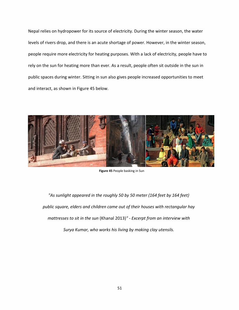
51
Nepal relies on hydropower for its source of electricity. During the winter season, the water
levels of rivers drop, and there is an acute shortage of power. However, in the winter season,
people require more electricity for heating purposes. With a lack of electricity, people have to
rely on the sun for heating more than ever. As a result, people often sit outside in the sun in
public spaces during winter. Sitting in sun also gives people increased opportunities to meet
and interact, as shown in Figure 45 below.
"As sunlight appeared in the roughly 50 by 50 meter (164 feet by 164 feet)
public square, elders and children came out of their houses with rectangular hay
mattresses to sit in the sun (Khanal 2013)" - Excerpt from an interview with
Surya Kumar, who works his living by making clay utensils.
Figure 45 People basking in Sun
52
iii. Quality of Built Environment
Since the building bylaws do not incorporate solar considerations, they not only undermine the
access of sun to public spaces, but also affect the access of sun to individual houses and their
interior environment. UV rays kill harmful viruses in the air (Lee 2007, 1). Shaded open spaces
and built environments in a humid environment like Kathmandu can lead to an unhygienic
public realm and interior living environment. In addition, our body requires sunlight to naturally
produce vitamin D (Lee 2007, 1), which is very important in maintaining our immune system.
Therefore, solar access is also equally important to maintain the quality of the urban built
environment and our health.
iv. International Solar Access Standards
Research conducted by Maria Jose Leveratto, a faculty member of Architecture, Design and
Urbanism at the University of Buenos Aires, Argentina, in the article "Urban planning
instruments to improve solar access in open public spaces" recommends four hours of solar
access from a period of 10 am to 2 pm in open public spaces during winter (Leveratto 2002, 3).
In "Solar Access and Overshadowing" a paper presented at NEERG Seminars (Continuing
Education for the Management of the Built Environment) by Steve King, a faculty member of
Built Environment at the University of New South Wales, recommends that three hours of solar
access in mid-winter is acceptable (King 2006, 2).
Based on this research, this study adopts three hours as a minimum solar access required in
public open space during winter.

53
G. Solar Envelope
Ralph Knowles (1981) developed the solar envelope concept during the 1970s energy crisis. The
solar envelope is “the volumetric limits of building that will not shadow surrounding buildings
or open spaces at specified times (Knowles 1981, 51-57)." The solar envelope defines the
maximum building height for a site that does not compromise the neighboring building's solar
accessibility. Solar accessibility is the preset number of hours of sun during critical periods of
the day and year that a space should have access. This data translates into a volumetric
description of the solar envelope. Specifically, the daily and seasonal paths of the sky describe
the east, west, north and south limits for development within a solar envelope. The idea of the
solar envelope is different than conventional zoning approach because it is dynamic,
responding to the seasonal and daily variation of the sun, while conventional zoning is static in
respect to dealing with the annual solar cycle (Knowles 1981, 42).
California adopted these regulations during the 1970s energy crisis, which forced new
construction to respect solar rights of surrounding buildings. The concept of the solar envelope
was further refined with the distinction between part of the envelope that has ensured access
to sun and the envelope that ensures solar access of surrounding building and open spaces. The
solar collection envelope (SCE) is the lowest possible surface on a building envelope to locate
windows and solar collectors so that neighboring buildings do not obstruct them during a
specified period of year. It describes the overshadowing of a building on a given site or
envelope. On the other hand, the solar rights envelope (SRE) is the highest part of building
envelope that does not block solar access of surrounding building and open space through
critical periods of the year. The solar right envelope (SRE) and the solar collection envelope
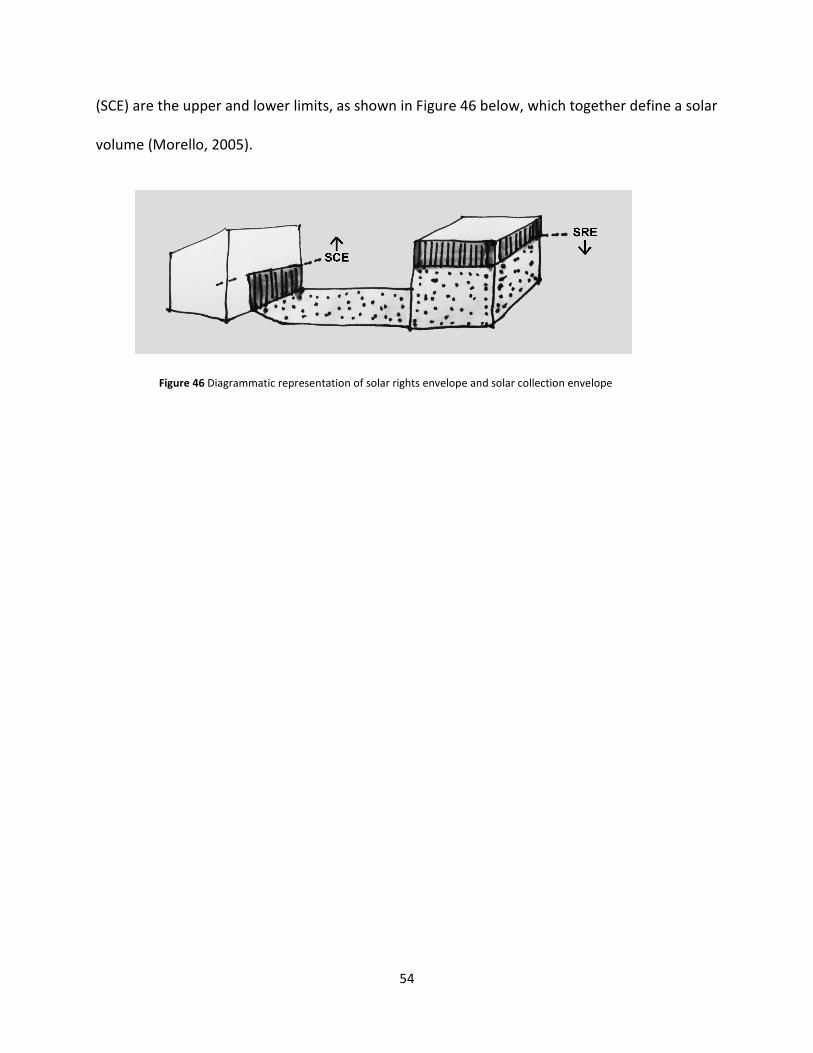
54
(SCE) are the upper and lower limits, as shown in Figure 46 below, which together define a solar
volume (Morello, 2005).
Figure 46 Diagrammatic representation of solar rights envelope and solar collection envelope

i. Daily Solar Path and East-West Façade
The daily solar path governs the shadow casting and solar access on the east and west
building. The shadow cast by a building on its west side during the morning and on its east side
during the evening defines its east and west geometry, as shown
required amount of solar access on western end of open space during morning defines the
geometry of buildings on eastern end of open space. On the other hand, required amount of
solar access on eastern end of open space during even
the western end of open space.
in the afternoon for its study. The case study will look to define the building enclosure that
satisfies minimum solar access standard through this period
55
West Façade
The daily solar path governs the shadow casting and solar access on the east and west
shadow cast by a building on its west side during the morning and on its east side
during the evening defines its east and west geometry, as shown in Figure 47 below.
required amount of solar access on western end of open space during morning defines the
geometry of buildings on eastern end of open space. On the other hand, required amount of
solar access on eastern end of open space during evening define the geometry of buildings on
This research uses a cut off time of 9 am in morning and 3 pm
in the afternoon for its study. The case study will look to define the building enclosure that
ss standard through this period.
Figure 47 Eastern and Western Sun defining solar volume
(Source: Ralph Knowles, Sun, Rhythm, Form)
The daily solar path governs the shadow casting and solar access on the east and west side of a
shadow cast by a building on its west side during the morning and on its east side
below. The
required amount of solar access on western end of open space during morning defines the
geometry of buildings on eastern end of open space. On the other hand, required amount of
ing define the geometry of buildings on
This research uses a cut off time of 9 am in morning and 3 pm
in the afternoon for its study. The case study will look to define the building enclosure that
Eastern and Western Sun defining solar volume
(Source: Ralph Knowles, Sun, Rhythm, Form)

56
ii. Yearly Limits and North – South Facade
In summer, most of the solar path is north of east-west axis as shown in Figure 48 below, so it
casts shadow to the south side. Hence, the buildings and cultural objects in the open space will
be casting shadow on its southern side. However, these cultural objects and building enclosures
will cast minimum shadow, since the sun has a highest altitude through the study period of 9
am to 3 pm during summer.
Figure 48 Solar path in Kathmandu on summer solstice
(source: Ecotect)

On the other hand, the winter sun rises and sets on the southern side of east
shown in Figure 49 below, which means it will cast shadows on the northern
building. It affects the buildings on the
angle is gentler, as shown in Figure
this reason, the solar access of public open space will be investigated through the winter
period, which in the case of Kathmandu is from D
which will satisfy solar access standard through the winter period will also satisfy it through the
summer period. Daily limits of 9 am to 3 pm through the winter period will be used to
investigate whether the building enclosure meets solar access standards or not
Figure 49. Solar path defining solar volume on North
and South face
57
On the other hand, the winter sun rises and sets on the southern side of east-west axis, as
below, which means it will cast shadows on the northern side
buildings on the southern end of the open space. Since the winter solar
angle is gentler, as shown in Figure 50 below, it has a larger impact on the solar envelope. For
this reason, the solar access of public open space will be investigated through the winter
period, which in the case of Kathmandu is from December 1 to February 28. The built form
which will satisfy solar access standard through the winter period will also satisfy it through the
summer period. Daily limits of 9 am to 3 pm through the winter period will be used to
ing enclosure meets solar access standards or not.
Figure 50 Solar path in Kathmandu during winter
solstice (source: Ecotect) Solar path defining solar volume on North
west axis, as
side of the
ce the winter solar
below, it has a larger impact on the solar envelope. For
this reason, the solar access of public open space will be investigated through the winter
ecember 1 to February 28. The built form
which will satisfy solar access standard through the winter period will also satisfy it through the
summer period. Daily limits of 9 am to 3 pm through the winter period will be used to
.
Solar path in Kathmandu during winter

58
iii. Periods of useful Insolation and Cutoff Time
The insolation period through various times of day and through various seasons is critical in
controlling the usability of solar energy in people’s daily livelihoods. Access to the sun is critical
through winter from morning to afternoon due to anthropometric and climatological reasons.
Maintaining access to sun in public spaces through this period is critical for an open space to
enhance public life. The sun’s energy varies annually as it moves through its solar path. The sun
assumes different positions in the sky and gives off different heat and light intensities. A clear
understanding of the solar path and climate patterns is helpful in designing built environments,
particularly for these uncomfortable periods of the year. Six hours of sunlight from 9 am to 3
pm is the period where solar insolation is highest. Access to sun through this period in winter is
very desirable; however, in dense urban conditions, such standards are hard to achieve
(Knowles 1981). Studies by Maria Levaratto and Steve King recommend need of 3 to 4 hours of
sunlight in public spaces. Hence, this study will use a period of 9 am to 3 pm to investigate,
whether the public spaces get minimum three hours of sunlight or not.
Cut off time is the local time of a place that determines the various faces of the solar envelope.
In the context of an open space, daily limits determine the geometry of buildings on east and
west end of an open space, while yearly limits determine the geometry of buildings on southern
end of an open space. The solar envelope controls the impact of shadow the built environment
projects onto its surrounding. Cut off time considers various time of the day where the
shadowing impact is critical to its surrounding. For buildings on eastern and western end of an
open space, the sun setting and sun rising time periods are critical respectively. While the
buildings on southern end of an open space, solar position at noon during winter is critical.

59
These cut off time periods can be used to determine the geometry of buildings around public
open space.
3. RESEARCH QUESTION
What modification in Kathmandu's planning bylaws can improve solar access in community
spaces?
SUB-QUESTIONS
1) How did traditional urban management practice impact solar access in community spaces?
2) How did new planning bylaws affect solar access in community spaces?
3) What modifications can be made to new planning bylaws to improve solar access in
community spaces?

60
4. RESEARCH METHODOLOGY
The literature review established the existence of three types of public open spaces in
Kathmandu: residential square, palace square, and community square. Relatively few families
live around residential squares compared to community squares while the Palace square has
been converted into a museum with no residential land use around it. Hence, solar access in
community spaces provides benefits to a larger section of people and for this reason
community spaces are selected for further investigation.
The research uses a case study approach, where two case studies are used to investigate how
urban transformation brought by the change in urban management practice has affected the
solar access of community spaces. The solar access of a community space varies with its
orientation, size, proportion, and the height, and geometry of buildings surrounding it. The
thesis proposes solar access analysis to be conducted for each community space to ascertain
allowable building height. However, for this research, two case studies Itum Bahal and Te Bahal
are selected as they have varying geometry and orientation. Itum Bahal is oriented north-south,
while Te Bahal is oriented east-west.
Case studies are also used to establish maximum building height, which can ensure a minimum
level of solar access through critical periods of the year in community spaces. Based on these
results, recommendations are made accordingly to modify Kathmandu's planning bylaws to
improve and ensure minimum level of solar access in community spaces. This research uses the
following steps to meet its objectives:

61
Step I: This step uses Ecotect 2011 to conduct modeling and solar access analysis of community
spaces. Only the buildings having a shading effect on community space are modeled. The model
uses image, city maps, and planning bylaws to reference the building height. Two existing
conditions, one before and one after the adoption of the 1976 planning bylaws are modeled, to
document the changes brought by new planning policies on solar access of community spaces.
Step II: This step uses solar access analysis for building enclosure of various heights. Building
enclosure with height decreasing from 18 meters (59 feet) is analyzed simultaneously to
ascertain building enclosure, which can provide minimum level of solar access in community
spaces.
Step III: This step will propose modifications based on results from Step I and II to
contemporary building bylaws, such that it can improve solar access in community spaces.

62
5. CASE STUDY
1. Reduction in solar access due to New Planning Bylaws
This part of the research includes two case studies to understand the impact of urban
transformation on solar access of community spaces. The two case studies are Itum Bahal and
Te Bahal, which belong to the Mixed-Residential Sub-Zone in the Old Residential Zone of
Kathmandu. Itum Bahal lies north of Kathmandu Durbar square, while Te Bahal lies south of it.
The selected community squares have different geometry and orientation, as shown in Figure
51 below.
Figure 51 Community squares selected for solar analysis
63
Study Period
The solar access analysis investigates community spaces during the winter period from
December 1 to February 28 for a total of 90 days. The period from 9 am to 3 pm is the daily
study period owing to the highest insolation value of sun and the need for solar access during
this period. The daily study includes a 6-hour period, which totals to 540 hours over the 90-day
period.
Modeling Parameters
The shading and solar study is done with Autodesk Ecotect Analysis, which uses an analysis grid
of 5 by 5 meters (16 feet 5 inches by 16 feet 5 inches) over the open space. The study includes
buildings only around the community space. The modeling of the buildings includes a minimum
level of detail, where only the volume containment of each building that affects solar access of
community space is considered. Actual buildings on the open spaces are not modeled; instead
volume containment defined by building regulations before and after 1976 is modeled.
All buildings built before 1976 have sloped roofs, which allow for increased solar access into
these public spaces, while the buildings built after 1968 have flat roofs. Therefore, the buildings
in 1976 conditions are modeled with a sloped roof at an angle of 30 degrees, which is the slope
used while constructing a traditional roof structure. The average floor-to-floor height in a
traditional building is 2.7 to 3 meters (8 feet 10 inches to 9 feet 10 inches). Therefore, buildings
from 1976 are modeled with a 12-meter (39 feet 4 inches) height including the sloped roof. On
the other hand, height restriction applied by new planning bylaws is 18 meters (59 feet), so

64
buildings from new conditions are modeled with 18-meter (59 feet) height. The Figure 52 below
shows the building profile used for creating the model before and after 1976.
Figure 52 Building profile of the study models used for the case study of Itum Bahal

65
Comparative Study
The study includes two periods, one when traditional mode of urban management is active in
Kathmandu before the political transition of 1960 and one after the political transition when
new planning policies is introduced to manage urban development. The case study documents
the impact of urban transformation on the solar access of open space and compares these
results with the study derived from the international standard on solar access, which
establishes three hours as a minimum solar access required in a public open space.

66
Case Study 1: Itum Bahal
Summary of findings:
• Solar access in open spaces decreased by 32 percent to an average of 2.04 hours per
day. 58 minutes below 3-hour standard on an average over the entire open space.
• Solar access for cultural objects decreased by 68.5 percent to 1.41 hours.
• Cultural objects have solar access 1 hour 35 minutes below the 3-hour standard.
Figure 53 Key Map of Itum Bahal

67
i. Itum Bahal
Itum Bahal is one of the community squares in Kathmandu’s historic core. It is oriented north-
south with a tilt angle of 11 degrees. Historic photographs of Itum Bahal, as shown in Figure 54
below, show traditional buildings of mostly three to four stories, while the photograph from
2012 shows buildings with six to seven stories. Therefore, the study uses a building height of 12
meter (39 feet 4 inches) including slope roof and 18 meter (59 feet) with flat roof for 1968, and
2012 conditions respectively.
Figure 54 Urban transformation of Itum Bahal
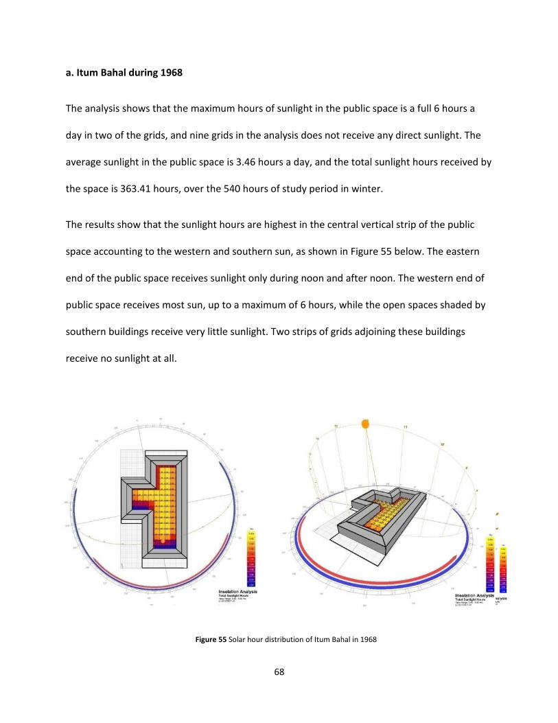
68
a. Itum Bahal during 1968
The analysis shows that the maximum hours of sunlight in the public space is a full 6 hours a
day in two of the grids, and nine grids in the analysis does not receive any direct sunlight. The
average sunlight in the public space is 3.46 hours a day, and the total sunlight hours received by
the space is 363.41 hours, over the 540 hours of study period in winter.
The results show that the sunlight hours are highest in the central vertical strip of the public
space accounting to the western and southern sun, as shown in Figure 55 below. The eastern
end of the public space receives sunlight only during noon and after noon. The western end of
public space receives most sun, up to a maximum of 6 hours, while the open spaces shaded by
southern buildings receive very little sunlight. Two strips of grids adjoining these buildings
receive no sunlight at all.
Figure 55 Solar hour distribution of Itum Bahal in 1968

69
b. Itum Bahal during 2012
Increased building height has resulted in the loss of solar access in open space, as shown in
Figure 56 below. The maximum solar exposure is 4 hours in one grid. Most areas of public space
on the southern end have zero to one hour of solar exposure, which is shaded in blue. The
average daily solar hours in this condition is 2.04 hours, which is a decrease in 0.98 hours as
compared to the 12-meter (39 feet 4 inches) high condition of 1968. It is 0.96 hours short of the
minimum number of solar hours required for public space during winter (Refer International
Solar Access Standards). There is a 32.43 percent decrease in the total average daily solar hours
from 1968 conditions. The total solar hours have decreased from 317.09 hours to 177.53 hours
through the study period. This goes to show that there is a severe decrease in available solar
hours in the public space due to the additional floors in the built environment.
Figure 56 Solar Hour distribution of Itum Bahal in 2012

70
c. Solar Access Analysis in Cultural Infrastructure
A typical day in public space in Kathmandu starts at around 9 am. Therefore, solar access from 9
am onwards is important in public spaces, as the solar insolation is also highest in this period.
Figure 57 below is the image of Itum Bahal taken from its southern end. It shows that people
are sitting, playing, and interacting on the eastern side of public space. The eastern side of
public space in the photo has access to sun, which suggests the photo is taken sometime during
the afternoon. It also correlates with the day-to-day life of inhabitants where there is the
possibility of an increased use of public space during the afternoon. People on the eastern side
of the public space seem stationed at a place, either interacting or playing. People on the
shaded western side seem to be mostly travelling and do not exhibit any social interaction. This
also proves the value of solar access in public open spaces of Kathmandu and role it can play to
enhance social interaction in an open space.
Figure 57 Solar access analysis around cultural Infrastructure
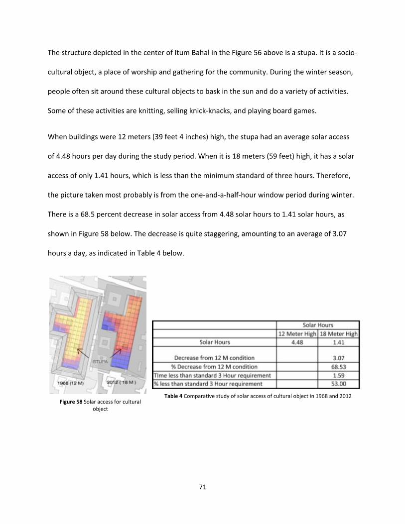
71
The structure depicted in the center of Itum Bahal in the Figure 56 above is a stupa. It is a socio-
cultural object, a place of worship and gathering for the community. During the winter season,
people often sit around these cultural objects to bask in the sun and do a variety of activities.
Some of these activities are knitting, selling knick-knacks, and playing board games.
When buildings were 12 meters (39 feet 4 inches) high, the stupa had an average solar access
of 4.48 hours per day during the study period. When it is 18 meters (59 feet) high, it has a solar
access of only 1.41 hours, which is less than the minimum standard of three hours. Therefore,
the picture taken most probably is from the one-and-a-half-hour window period during winter.
There is a 68.5 percent decrease in solar access from 4.48 solar hours to 1.41 solar hours, as
shown in Figure 58 below. The decrease is quite staggering, amounting to an average of 3.07
hours a day, as indicated in Table 4 below.
Figure 58 Solar access for cultural
object
Table 4 Comparative study of solar access of cultural object in 1968 and 2012

72
d. Conclusion
The building bylaws allow a maximum building height of 18 meters (59 feet) in mixed
residential zones of Kathmandu’s Old Settlement Zone. The F.A.R. allowed is 4.0 for new
development and 4.5 for building on old development. The solar analysis study of Itum Bahal
shows that these bylaws have resulted in a severe loss in solar access to the point where it does
not even meet the minimum solar standard. This urban transformation has resulted in a 32
percent decrease in solar hours of the public space, as shown in Table 5 below. Itum Bahal
currently has only 2.04 hours of sunlight during the study period, which is 58 minutes below the
minimum standard of 3.0 hours.
Table 5 Comparative study of solar hours in 1968 and 2012 of Itum Bahal

73
Case Study 2: Te Baha
Summary of findings:
• Solar access in open space decreased by 46.03 percent to 2.22 hours.
• 47 minutes below the 3-hour standard on an average over the entire open space.
• Solar access for cultural object #1 decreased by 95.99 percent to 0.16 hours.
• Cultural object # 1 has solar access 2 hours 50 minutes below the 3-hour standard.
Figure 59 Key Map of Te Baha

74
ii. Te Baha
Te Baha is a community square in the south part of the mixed residential zone. It is rectangular
in shape and is oriented east-west with an extended south-west pocket. Te Baha historically
had buildings of three to three-and-a-half stories (Korn, 1979). A current photograph of Te
Baha, as shown in Figure 60 below, depicts two buildings with original floor conditions on the
picture below on the right. However, these building owners have replaced the sloped roofs with
flat roofs. Most of the other old buildings have additional floors.
Figure 60 Te Bahal with old building marked in white box

75
a. Te Baha in Old Condition
The analysis shows that 59 grids receive a full 6 hours of sunlight during the study period, while
19 grids do not receive any sunlight at all. The average sunlight for the public space is 4.11
hours, with a total sunlight hours of 608.84 over the entire analysis grid. The results, as
indicated in Figure 61 below, show that the sunlight hours are highest at the northern end of
the public space accounting to the southern, eastern, and western sun. As the space is
elongated east-west, it receives an ample amount of sunlight during the afternoon, when the
sun has reached higher altitude. The western end of the public space receives a comparatively
lesser amount of sunlight hours accounting to the solar path of the eastern sun, while the
eastern part of the public space receives a minimum of 5 hours of sunlight. On the other hand,
three grids aligning to the southern end of the public space receive no sunlight at all, as it
remains shaded by the southern buildings over the course of the day.
Figure 61 Distribution of sunlight hours over the analysis grid in old conditions

76
b. Te Baha in 2012
Solar access analysis showed that only seven grids received a full 6 hours of sunlight during the
study period, while 50 grids received close to zero solar hours on the southern end of the public
space. Most of the public space on the southern part had zero hours of solar exposure. The
public space on the eastern and western ends also received a reduced number of sunlight
hours. Only the northern central section of the public space continued to receive a considerable
amount of sunlight hours, as seen in Figure 62 below. The average daily solar hours in this
condition are 2.21 hours, which is a decrease of 1.9 hours when compared to old conditions.
There is a 46.22 percent decrease in the total average daily solar hours. The total solar hours
have decreased from 535 to 399 hours.
Figure 62 Distribution of sunlight hour over the analysis grid in new condition

77
c. Solar Access Analysis in Cultural Infrastructure
Te Bahal has six cultural objects within it. People like sitting around these cultural objects, like
the one shown in Figure 64 below. Because of this, solar access during winter would be an
added amenity. These cultural objects are tagged C1 to C6 in Figure 63 below.
Cultural objects C2, C3, C4, C5, and C6 lie on the northern end of the public space. They all
receive 6 full hours of solar access during winter in old conditions. After urban transformation,
solar access in these cultural infrastructures has decreased by a range of 12 to 40.33 percent, as
indicated in Table 6 and Figure 65 below. Cultural object #2 received 5.07 solar hours, cultural
object #3 received 3.58 solar hours, cultural object #4 received 6 full hours, cultural object #5
received five solar hours, and cultural object #6 received 5.28 solar hours before urban
transformation. After urban transformation, solar access decreased for all cultural objects
except cultural object #4, where solar hours remained at 6 full hours. Cultural object #1, which
Figure 63 Map showing cultural objects in Te Bahal Figure 64 Cultural Object #1 (C1) in Te Baha

78
lies on the southern end of the public space, was most affected due to the transformation.
Cultural object #1 received 3.99 solar hours during the winter in old conditions. After urban
transformation, it received only 0.16 solar hours, which is 2.84 hours (2 hours 48 minutes)
below the standard 3-hour requirement.
Figure 65 Solar access of cultural objects
Table 6 Comparative study of solar access for cultural objects

79
d. Conclusion
The case study of Te Baha showed that solar access for cultural objects remained above the 3-
hour standard requirement even after urban transformation, except for cultural object #1 on
the southern end of the public space. However, the average solar hours received by the public
space have decreased from 4.11 to 2.22 hours from old to current conditions, which is a net
decrease of 46.03 percent. More importantly, after urban transformation, the public space
receives sunlight lower than the standard 3-hour requirement. The solar access in 2012 falls
0.98 hours short of the standard 3-hour requirement, as indicated in Table 7 below. This
illustrates that the current building bylaws have not been able to ensure the minimum 3-hour
solar access in Te Baha, as was the case in Itum Bahal.
Table 7 Comparative study of solar access hour in Old and 2012 Condition

80
2. Modification in built environment to Improve Solar Access
This section of the solar study investigates the height for building enclosures that allows for the
minimum three hours of solar access into the open space. Sloped roofs are an essential part of
traditional built forms, which allows homeowners with additional built space without hindering
solar access. It is highly desirable to incorporate sloped roofs into built form. Hence, all
proposed building enclosures are modeled with sloped roofs. In addition, following the
recommendation proposed by Rajjan Chitrakar, developing a uniform skyline will correlate with
traditional built forms, where all houses in a public open space have similar height. Building
enclosure is simultaneously modeled through one-meter (3 feet 3 inches) intervals to find the
maximum height that can meet minimum solar access standard in the open space.

81
i. Itum Bahal
a. Ascertaining Building Enclosure that Meets Solar Access Standard
Building enclosure with 18-meter height (59 feet or 6-storey) including sloped roof
The open space receives 282.20 solar hours with this configuration at an average of 2.69 solar
hours a day. It is 0.31 hours (18 minutes) below the 3-hour minimum solar standard.
Figure 66 Solar hour distribution for building enclosure 18 meter high with sloped roof

82
Building enclosure with 15 meter height (5-storey or 49 feet 4 inches) including sloped roof
The open space receives 319.56 solar hours with this configuration at an average of 3.04 solar
hours a day. It is 0.04 hours (2 minutes) above the 3-hour minimum solar standard. Therefore,
the building enclosure at 15 meters (49 feet 4 inches) high, including a sloped roof, is able to
meet the solar standard. Hence, the results of the study indicate that Itum Bahal needs to
adopt 15-meter (49 feet 4 inches) building height, including sloped roofs to maintain minimum
level of solar access.
Figure 67 Solar hour distribution for building enclosure 15 meter high with sloped roof

83
b. Applying Results
This study indicates retaining only five stories of the building or 15 meters (49 feet 4 inches) of
the total height of building, whichever is more. Floors above the fifth floor, such as the sixth or
seven floors are to be avoided. The fifth floor needs to be modified to accommodate a sloped
roof at an angle of 30 degrees, as indicated in Figure 68 below. The space beneath the roof can
be developed as useable space.
Figure 68 Proposed intervention at Itum Bahal

84
ii. Te Baha
a. Ascertaining Building Enclosure that Meets Solar Access Standard
Building enclosure with 18-meter height (59 feet or 6-storey) including sloped roof
The open space receives 482.29 solar hours with this configuration at an average of 3.24 solar
hours a day. It is 0.24 hours (14 minutes) above the 3-hour minimum solar standard.
Figure 69 Solar hour distribution for building enclosure with 18 meter high building with sloped roof

85
b. Applying Results
This study indicates that a building enclosure with an 18-meter (59 feet) height or 6 stories,
including a sloped roof, can allow a 3-hour minimum solar access in the open space. This
requires buildings of 18 meters (59 feet) in height already to have their top floor modified to
incorporate a sloped roof, as indicated in Figure 70 below.
Figure 70 Proposed Interventions at Te Baha

86
C. Recommendation
By making a minimum solar access of 3 hours mandatory, building enclosures can be defined to
ensure it as a public right in community spaces. In Itum Bahal, building enclosure of 15-meter
(49 feet 4 inches) height including the sloped roof structure, while, in Te Baha, building
enclosure of 18-meter (59 feet) height including sloped roof are able to meet the solar
standard. These results also illustrates that the orientation and geometry of the open space
plays a vital role in solar access of community spaces. Itum Bahal is narrow rectangular in
shape, which is oriented North-South. On the other hand, Te Bahal is more or less square,
which is slightly elongated in East-West direction. Results showed that Te Baha had better solar
access in compared to Itum Bahal.
During solar access analysis, it was also found that only buildings on the southern, eastern, and
western ends of community space affect solar access during winter, while, buildings on the
northern end do not affect solar access of the community space. Therefore, it is necessary to
adopt the height restriction only on the southern, eastern, and western end of the community
space, while buildings on the northern end can be freed from solar restriction. Buildings on
northern end can be allowed to be built to the maximum of current height restriction of 18
meters (59 feet). However it is recommended for all buildings to have sloped roof, which
maintains the visual congruency of entire building enclosure around the community space.
Through the two case studies it is seen that, generic height restrictions for all buildings
encompassing community space have not been able to ensure minimum hours of solar access
in the community space; hence, the municipality should reconsider this practice. Instead, the

87
municipality should incorporate solar access analysis as part of the planning approach and
conduct solar access analysis for each community space in order to define the building
enclosure around it. Allowable building height should be generated from such analysis and
should be implemented specific to the community space for which it is generated for.

88
6. CONCLUSION
Contemporary planning policies of Nepal have focused more on promoting economic
opportunities and in the process have neglected issues of larger communal gain. Such a myopic
approach has allowed people to build freely in the historic cores without providing due
consideration to the existing urban context. This has led to severe degradation in the quality of
the urban environment in the historic cores. The effects are even more serious in the
community spaces, as it is a hub of socio-cultural and economic life of Kathmandu.
This thesis critiques the "one size fits all" policy adopted by the Kathmandu Municipality in
adopting generic height restrictions for buildings in community spaces, regardless of its varying
shape, size, and orientation. This research does not include behavioral study to investigate how
changes in built environment have affected the daily livelihood of community. Instead, this
research uses solar studies to analyze the change in physical environment brought by such
urban transformation. During the case studies, it was observed that the current planning
approach has not been able to ensure minimum solar access in community space. This thesis
outlines a process to compute building heights in community space such that they can ensure
minimum three hours of solar access in community space. It provides an alternative to generic
height restriction by proposing solar access as a parameter that can define the relation
between community space and building height.
While configuration of public open space calls for cooperative action such that each house
functions as an integral part of the whole; in the current reality it is not the case. Buildings
encompassing community space and the community space itself stand in contradiction

89
between individual and communal identity. The houses no longer realize a collective identity
for the community; instead, it seeks its own identity to meet the varying needs of each
household. Often, the cost of aspiration to build more by one individual has to be paid by the
entire community. For instance, as one homeowner builds tall on the southern end of the open
space, the public space used by all is shaded. In lack of proper negotiation between individual
and communal gain, the quality of urban built environment has suffered a lot.
Built environment represents how the society is organized and how it functions. In traditional
times, city fabric was homogeneous as the communities unanimously followed singular building
practice and construction technology. It also represented similar lifestyle of larger section of
community and the strong communal bond. In traditional town, each building was an integral
part of the larger urban fabric, and each household was an integral part of the larger social
fabric. Such part to whole relation has been lost with the onset of urbanization in Kathmandu. It
is in part due to the inability of new planning policies to manage the rising heterogeneity
brought by in-migration in Kathmandu. New planning policies have failed to identify issues of
larger communal interest amidst increasing heterogeneity, and develop a building practice to
ensure communal gain for all.
The municipality can improve the existing planning policies by identifying issues of larger
communal gain and devising policies to ensure such benefits. Valuable lessons can be learnt
from Guthi in this regard, which was able to formulate building practice to realize greater
communal aspiration and in the process help in organizing the society. However as with any
system, Guthi had its own pros and cons. While, it was able to ensure issues of larger communal
90
gain, it was not totally a democratic and socially just system. Instead of romanticizing Guthi, the
municipality should critically review the urban management practice adopted by Guthi and
explore ways in which it was able to identify and ensure communal values in the planning
process.
One of the positive aspects of Guthi was its ability to engage community in public development
works. Such public participation is an important means of gathering public opinion on new
planning policies. It would ensure that new policies are developed through a participatory
process and as a result accepted by the community, leading to successful implementation.
Before implementing the recommendations proposed by this thesis, it should be presented to
the community and public opinion on it should be gathered. Such public participation would
collect valuable opinions on how such policies can be successfully implemented. This stage of
gathering public opinion is beyond the scope of this project, however it is highly recommended.
An exploration of the intricate relationships between the natural environment, built
environment, and daily livelihood of the community can help in identification of issues of
greater communal gain. Such planning approaches not only identify contesting realities in a
heterogeneous urban landscape, but also help in negotiating a balance between them. Solar
access is one such urban amenity, which is beneficial to entire community. By promoting it as a
public right, building bylaws can take a valuable step in prioritizing communal interest over
individual gain. As each homeowner builds to address issues of larger communal benefits, a
greater sense of communal responsibility and cooperation can be established, which can in turn
lay the foundation for a strong and resilient community.

91
This thesis proposes the incorporation of solar access analysis to be part of building bylaws of
Kathmandu. Solar access analysis should be conducted for each community space to determine
the height of buildings that could ensure minimum three hours of solar access in these open
spaces. Building heights ascertained through solar access analysis should be enlisted in the
building codes specific to each community space. Maintenance and rebuilding is a continuous
process in the historic core of Kathmandu. Whenever a homeowner maintains or rebuilds their
building, building heights ascertained through solar access analysis should be applied to such
renovation works. On the other hand, height of buildings on the northern end of community
space that do not impact solar access should be regulated through generic height restriction, as
adopted by current building bylaws. However, these buildings should not exceed the generic
height restriction as it would negatively affect the visual congruency of the building enclosure
around the community space.
This also brings a situation where homeowners at different ends of community space will have
the right to build up to different heights. Since the community space is used by all regardless of
which end of the community space they live in; benefits brought by solar access will be reaped
by all. However, such inequality in building rights can be adjusted through compensatory
policies such as higher taxes for additional floor on the blocks at the northern end of
community space. Homeowners, who do not want to build as tall as the height restriction
allows for, should have the right to do so. However, there could be a legal provision where such
homeowner can sell their building right for the remainder of height restriction to another
homeowner. Such provision would encourage homeowner to attain maximum building
potential in each plot and in turn help to maintain urban density in the historic core. It would
92
also help in maintaining uniform skyline and visual congruency of the built forms in community
spaces. There are many houses in the historic core, which exceeds the height restriction
prescribed by solar access analysis. Portion of such buildings, which do not comply with solar
access standard should be subjected to taxes higher than the ones imposed on additional floors
at northern end of community space. Money collected from such additional taxes could be used
to maintain the community space, which would be beneficial to the entire community.

93
7. FUTURE AREA FOR RESEARCH
This study has opened numerous areas of investigation for future research. One area of
research is the creation of solar performance based building bylaws for Kathmandu. This would
involve the development of a regulatory framework that is dynamic and capable of taking into
consideration height, orientation, and location of buildings to achieve acceptable levels of solar
access in community spaces. Such a framework would help restore visual congruency to the
historic core, support tourism and accommodate community use of public spaces.
The urban transformation of 1960 has affected the city of Kathmandu in many ways. Along with
the physical environment, the way of living has also changed drastically in Kathmandu.
Behavioral study of the effects of urban transformation brought by new planning policies on the
inhabitants of community spaces would also be a useful area for investigation. Such a study
would be invaluable in understanding how the daily livelihood, quality of living, social
relationship, and cultural values have changed due to the environmental consequences of
urban transformation. Such a study would be extremely beneficial in developing environmental
indicators for pursuing sustainable planning approach in the context of Kathmandu.
Solar studies should also be extended to the new developments around the historic core of
Kathmandu. A different pattern of development has ensued around the historic core and solar
studies would be very beneficial in understanding the pattern of this development and its
environmental consequences. In addition, solar studies of the community spaces of different
shape, size, and orientations can be useful in determining the optimum geometry of community

94
space for increased solar access. The results from such study would be invaluable in designing
the community spaces for future developments of Kathmandu.

95
BIBLIOGRAPHY
Adams, Mike. The Healing Power of Sunlight & Vitamin D: An Exclusive Interview with Dr. Michael Holick,
Page 15. Truth Publishing, 2009.
Adhikari, A. P. Urban and Environmental Planning in Nepal. Kathmandu: IUCN, 1998.
Chitrakar, Rajjan Man. Public Open Spaces in Kathmandu Valley: A Review of Contemporary Problems
and Historic Precedents. Lambert Academic Publishing, 2011.
Dee John, Pradhananga Neelam, and Shrestha Krishna K. "Sustaining Indigenous Heritage: Learning from
the Guthi System in Nepal." Guthi Australia, November 2009: 5.
Duwal, Sunita. Modeling Urban Growth in Kathmandu Valley. Enschede: University of Twente, 2013.
Gellner, David N. "Monk, Householder and Tantric Priest: Newar Buddhism and its hierarchy of ritual."
Pg. 5. Cambridge University Press, 1992.
Gutschow, Neils. "Bhaktapur: Sacred Patterns of a Living Urban Tradition." In Urban Form and Meaning
in South Asia, by H. and Srnivasan D.M. Spodek, 163-183. Washington: National Gallery of Arts, 1993.
Harvey, Reid. "A Ceramist's Eye View of the Thimi, Nepal Potters Community." www.purifier.com, March
2003: 1.
ICIMOD, UNEP and Government of Nepal. “Kathmandu Environment Outlook.” 45. Hillside Press, 2007.
Joshi, Anju. “Role of Building Bylaws and Regulations in Shaping Urban Form: A Case of Kathmandu.”
Page 20. University of Hong Kong, 2007.

96
Kathmandu Valley Town Development Committee. "Construction Guidelines for the Development in
Kathmandu and Lalitpur Municipality and for the extended development areas in Kathmandu Valley”
KVTDC, 1993
Khanal, Prem. “Loosing a Fight for Survival?” Republica, 2013 20-January: 1-4.
King, Steve. “Daylight & Solar Access.” NEERG Seminars, 2006: 2.
King, Steve. “Solar Access and Overshadowing.” NEERG Seminars, 2008: 5.
Knowles, Ralph. “Solar Envelope, Sun, Rhythm, Form.” London: MIT Press, 1981.
Korn, Wolfgang. The Traditional Architecture of Kathmandu Valley. Kathmandu: Ratna Pustak Bhandar,
1979.
Lee, Jenny. “Light and air key ingredients of healthy living.” Times Colonist, 2007: 1.
Leveratto, Maria. “Urban Planning Instruments to Improve Winter Solar Access in Open Public Spaces.”
Environment, Management and Health (Environment, Management and Health), 2002: 366.
Lynch, Kevin. The Image of the City. Boston: MIT Press, 1960.
Morello, Carlo Ratti and Eugenio. "SunScapes: extending the "solar envelopes" concept through "iso-
solar surfaces" PLEA, 2005: 3.
Müller-Böker. "Spatial Organization of a Caste Society: The Example of the Newar in the Kathmandu
Valley, Nepal." Mountain Research and Development (International Mountain Society), 1988: 23-31.
Nepal, Government of. Nepal Population Report. Kathmandu: Ministry of Health and Population,
Population Division, 2011.
97
Pant Pradip Raj, Dongol Devendra. Kathmandu Valley Profile. Kathmandu: Kathmandu Metropolitan City,
2009.
Rai, Ruprama. "Threats to the Spirit of the Place: Urban Space and Squares, Historic City Core,
Kathmandu." Scientific Symposium (ICOMOS General Assemblies). ICOMOS, 2008. 6.
Rayamajhi, Rakshya. The P.U.S.H Effect: People, Urban, Society, and Heritage. Thesis, Anhalt: Anhalt
University of Applied Science, 2012.
Selter Elke, Pradhananga Neelam. "Heritage Management in the Kathmandu Valley (Nepal),
Participatory approach towards heritage management." Interpretation: From Monument to Living
Heritage. Thailand: ICOMOS Thailand International Symposium 2007, 2007. 3.
Shrestha, B.K. "Post Mortem of Contemporary Architecture of the Kathmandu Valley." VAASTU, 2008:
70-73.
Shrestha, B.K. "Cultural Meaning of Traditional Houses in Kathmandu." Administration and
Management Review, 2011: 3.
Shrestha, B.K. "Reducing Earthquake Vulnerability in Kathmandu Metropolitan City." Development
Insight, 2002: 36-41.
Slusser, Mary Shepher. Nepal Mandala: A Cultural Study of the Kathmandu Valley. New Jersey: Princeton
University Press, 1982.
Thapa, Rajesh Bahadur. City Profile: Kathmandu. Tsukuba: Graduate School of Life and Environmental
Sciences, University of Tsukuba, 2011.
Tiwari, S.R. Tiered Temples of Nepal. Kathmandu: Mrs. Sunita Tiwari, 1988.

98
Tiwari, Sudarshan Raj. "Sustainable Urban Development: Lessons from Historic Asian Cities."
http://kailashkut.com/, 2000: 4.
Tiwari, Sudrashan Raj. "Kathmandu Valley Urban Capital Region and Historical Urbanism." URBANE
Vol.1, 2000: 6.
UNESCO. "Kathmandu Valley World Heritage Site." 6. Kathmandu: UNESCO, 2006.
University, Washington State. “Understanding Human Comfort...More than Just Temperature and
Humidity.” IAQ News, 2010: 4.