community based disaster management planning: case studies...
TRANSCRIPT

International Journal of Humanities and Social Science Invention
ISSN (Online): 2319 – 7722, ISSN (Print): 2319 – 7714
www.ijhssi.org
Volume 1 Issue 1 ‖‖ December. 2012 ‖‖ PP.34-44
www.ijhssi.org 34 | P a g e
Community Based Disaster Management Planning: Case Studies
From Uttarakhand, India
Priyanka Tyagi1 & Ravindra K Pande
2
1Department of Geography, DSB Campus, Kumaun University, Nainital 2 (India) 2Professor in Geography, DSB Campus, Kumaun University, Nainital 2 (India)
ABSTRACT: This paper deals with the concept of community based disaster management (CBDM) and
explains causes and effects of different disasters and their risk assessment in Baliya nala catchment of
Uttarakhand. For the data collection author has used PRA (Participatory Rural Appraisal) tools and secondary
data. This paper captures disaster assessment, vulnerability assessment, capacity assessment and risk
assessment and interpretations of the variations in various disasters attributes on the basis of risk assessment.
Keywords––Community participation, Disasters, PRA tools, Case study, Hazard Assessment, Vulnerability
Assessment, Management Assessment, Risk assessment, Uttarakhand.
I. INTRODUCTION In case of disasters, the people at the community level have more to lose because they are the ones
directly hit by disasters, whether major or minor. They are the first ones to become vulnerable to the effects of
such hazardous events. On the other hand, they have the most to gain if they can reduce the impact of disasters
on their community. This concept gave rise to the idea of community-based disaster management where
communities are put at the forefront. Through the CBDM, the people’s capacity to respond to emergencies can
be increased by providing them more access and control over resources and basic social services. Using a
community-based approach to manage disasters certainly has its advantages. Through CBDM, it is hoped that
communities will be strengthened to enable them undertake any programmes of development including disaster
preparedness and mitigation.
II. OBJECTIVE 1. To study the region in reference to different disasters.
2. To find the exposure, vulnerability, disaster, capacity management and risk assessment with the help of
PRA (Participatory Rural Appraisal) tools.
3. To investigate the maximum risk assessed in the area and,
4. Finally suggesting a management plan for the region.
III. RESEARCH METHODOLOGY
1. Collection of primary data by using PRA tools and conducting interviews for ground reality.
2. Study the region and assess different disasters.
3. Collection of secondary data for analyzing, explaining, and combining the information from the
primary source with additional information.
VI. BALIYA NALA (UTTRAKHAND) AND DISASTERS The Study area is a natural unit of catchment of the Baliya nala stream which is a tributary of the Gola
River that drains a major portion of Nainital town of Uttarakhand. The total area of Baliya catchment is 76.79
sq.km .The total length of Baliya river is 14.84km from Nainital to Ranibagh where it confluences with the Gola
river. It lies between Lesser Himalaya and lower Shiwalik, between 29° 16' 10" N to 29° 24' 11" N latitudes
and 79° 41' 21" to 79° 48' 13" E longitudes.

Community Based Disaster Management Planning: Case Studies From Uttarakhand, India
www.ijhssi.org 35 | P a g e
GENERAL INFORMATION
a. GEOMORPHOLOGY & LANDUSE
GROUND ZONE LAND USE
ZONE OF RIDGES AND
STEEP SLOPE
Forest and grazzing
MODERATE ZONE Agriculture, grazing
land
ZONE OF MINIMUM
ELEVATION
Agriculture
The zone of ridges and steep slope includes major portion in north of the river. It lies in altitudinal zone
of 1400 m. thus subjected to high erosion. It covers 45% area of the total area of the basin. The zone of
moderate slope lies between altitude of 900mts to 1200mts, thus erosion is also comparatively less. This zone
also characterised by fault and a dissected topography. This zone involves maximum anthropogenic interference
thus contributes in maximum silt discharge to the principal stream. This zone covers 35% area of the total area
of river. The zone of minimum elevation varies from 545mts to 1400nts thus erosion is low. The soil is enriched
with silt and thus it is potentially fertile, this covers roughly 20% area of total river basin.
b. MORPHOLOGY(ROCKS):
The terrain to the south of Baliya River, constituted of sandstone, clay stone and shales of lower
shiwalik belt, exhibits a youthful morphology characterised by sharp, jagged peaks and Steep slopes. The
Shiwalik has been thrust over by a huge synclinal fold succession of Palaeozoic sediments of Nagthat Blaini and
Krol formation constituting, known as Krol nappe. The synclinal thrust sheet has been truncated by the main
boundary fault.
C. CLIMATE:
Amount of rainfall is high towards north and west in thickly forested area. Further northward increase
in altitude has marked effect in lowering the temperature. Climate data for the Balia nala could be available only
for two recording stations maintained by the forest department.
D. VEGETATION:
In a large measure, the natural vegetation is an index of such basic physical conditions in any area, as
rainfall, altitude, temperature and soils.
The principal vegetation is Chir (Pinus roxbughii ) while Oak (Quercus lceucotrichophora) is also a
prominent species but relatively a smaller area in Ranibagh and Jeolikot area. We find an area of dense mixed
forest of Sal (Shorea robusta ),Chir (Pinus roxbughii ),Khair (Acacia catechu) and grass but in Jeolikot and
Nainital ,the principal species is Pine. The main shrubs that occur in this area include Ghingaru, Kilmora
(Berberis vulgaris) and Hishalu (Rubus ellipticus). There are few patches of deciduous forest also.
Krol Formation Dolomite and
limestone
Blaini Formation Bleached and grey
slate
Naghat Formation purple and white
quartzite with
volcanic green and
purple slate
Salari Thrust
Amritpur Granite granite and quartz
porphyry
Main Boundary
Faulty(Lower
Shiwalik)
sandstone ,Shale and
clay

Community Based Disaster Management Planning: Case Studies From Uttarakhand, India
www.ijhssi.org 36 | P a g e
CASE STUDY OF VILLAGES:
Table -1. General Information of Selected Village
NAME
OF
VILLA
GE
NO.
OF
FAM
I-LY
TOTAL
POPUL
ATO-N
POPULA
TI-ON
LIVEST
OC-K
NO.
OF
SCH
OOL
NO.
PANCHA
YA-T
MEMBE
RS
NO. OF
SOCIAL
ORGANI
ZA-TION
MEDIUM
OF
COMMU
NIA-
TION
MAIN
DISAST
ER
NO.OF
BANK
SURYA
JALA
140 800 250 02
(Prima
ry)
03(01
MEN and
02
Female)
02 Radio,
Television
,
Telephone
,
Newspape
r
Flood,
Landslide
, Forest
Fire,
Heavy
Rain
NIL
DAUGAR
A
30 254 52 NIL NIL NIL Radio,
Television
,
Telephone
,
Newspape
r
Flood,
Landslide
, Heavy
Rain
NIL
BHAURJ
ALA
12 95 45 NIL NIL NIL Radio,
Television
,
Telephone
,
Newspape
r
Flood,
Landslide
, Heavy
Rain
NIL
LAMJAL
A
25 150 85 NIL NIL NIL Radio,
Television
,
Telephone
,
Newspape
r
Flood,
Landslide
, Heavy
Rain
NIL
RUSI
MALLA
45 175 66 01 NIL NIL Radio,
Television
,
Telephone
,
Newspape
r
Flood,
Landslide
, Heavy
Rain
NIL
RANIBAG
H
60 320 125 02
(1Pri
mary
and
1High
Schoo
l)
NIL NIL Radio,
Television
,
Telephone
,
Newspape
r
Heavy
Rain
01
(State
Bank
of
India)
The village Suryajala has the highest population. The main livestock are-buffalos, cows, bulls, goats,
hens, and dogs. The main occupation of villagers is agriculture and other occupations are poultry farming, dairy
farming and bee-keeping. There are no means of education except Suryajala and Ranibagh. The means of
villages are good in all these villages. The banking facility is only in Ranibagh. The main disasters in these
villages are flood, landslide, forest fire, and heavy rain.

Community Based Disaster Management Planning: Case Studies From Uttarakhand, India
www.ijhssi.org 37 | P a g e
V. RESULTS Table-2.Hazard Assessment
NAME OF
VILLAGE
NAME OF
DISASTER
HAZARD
FREQUENCY EFFECT RANKING AVERA
GE DEFI
NITE
CHA
NCE
NO
CHA
NCE
HIG
H
MED
I-UM
LO
W
HI
GH
MED
-IUM
L
O
W
SURYAJAL
A
FLOOD 3 - - 3 - - 3 - - 9/3=3
FORESTFIR
E
3 - - - 2 - - - 1 6/3=2
LANDSLIDE 3 - - 3 - - - 2 - 8/3=2.7
DAUGARA FLOOD 3 - - 3 - - 3 - - 9/3=3
LANDSLIDE 3 - - 3 - - - 2 - 8/3=2.7
BHAURJA
LA
FLOOD 3 - - 3 - - 3 - - 9/3=3
FORESTFIR
E
- 2 - - - 1 - 2 - 5/3=1.7
LANDSLIDE 3 - - - 2 - - 2 - 7/3=2.3
LAMJALA FLOOD 3 - - 3 - - 3 - - 9/3=3
FORESTFIR
E
3 - - - - 1 - - 1 5/3=1.7
LANDSLIDE 3 - - 3 - - - 2 8/3=2.6
RUSI
MALLA
HEAVY
RAINFALL
3 - - 3 - - 3 - - 9/3=3
LANDSLIDE 3 - - 3 - - - 2 - 8/3=2.7
RANIBAG
H
HEAVY
RAINFALL
3 - - - - 1 -
-- 1 5/3=1.7
The average of frequency, effect and ranking of flood in Suryajala, Daugara, Bhaurjala and Lamjala is
3 and forestfire registers 2, 1.7 and 1.7 respectively Suryajala, Bhaurjala and Lamjala villages. Landslide in
Suryajala, Daugara and Rusi Malla records 2.7, while in Bhaurjala and Lamjala, it is respectively 2.3 and 2.6.
From it, this is clear that the effect of landslide in Suryajala, Lamjala and Russi Malla is very high. The average
of rainfall disaster in Rusi Malla and Ranibagh is 3 and 1.7. Thus we see that the chances of flood disaster in
first 4 villages is very frequent and effective while landslide is very much effective and frequent disaster in all
six villages along Baliya nala.
Table-3.Vulnerability Assessment
NAME
OF
VILLA
GE
DISAST
ER
POPULATIO
N
BUILDING INFRASTRUC
TURE
RESOUR
CE
ECONO
MY
AVER
AGE
HI
G
H
ME
DI
UM
L
O
W
HI
GH
ME
DI
UM
L
O
W
HI
GH
ME
DI
UM
L
O
W
H
I
G
H
M
E
D
I
U
M
L
O
W
H
I
G
H
M
E
D
I
U
M
L
O
W
SURYA
JALA
FLOOD - 2 - - 2 - - 2 - 3 - - 3 - - 12/5=2.
4
FOREST
FIRE
- - 1 - - 1 - - 1 3 - - - 2 - 8/5=1.6
LANDS
LIDE
- 2 - - 2 - 3 - - 3 - - 3 - - 13/5=2.
6
DAUG
ARA
FLOOD - 2 - - 2 - - 2 - - 2 - - 2 - 10/5=2
LANDS
LIDE
- 2 - - 2 - 3 - - - 2 - - 2 - 11/5=2.
2
BHAU
RJALA
FLOOD 3 - - 3 - - 3 - - - - 1 - - 1 11/5=2.
2
FOREST
FIRE
- - 1 - - 1 - - 1 - - 1 - - 1 5/5=1

Community Based Disaster Management Planning: Case Studies From Uttarakhand, India
www.ijhssi.org 38 | P a g e
LANDS
LIDE
- 2 - 3 - - - - 1 - - 1 - - 1 8/5=1.6
LAMJ
ALA
FLOOD 3 - - 3 - - 3 - - 3 - - 3 - - 15/5=3
FOREST
FIRE
- - 1 - - 1 - - 1 3 - - 3 - - 9/5=1.8
LANDS
LIDE
- - 1 - - 1 3 - - 3 - - 3 - - 11/5=2.
2
RUSI
MALL
A
HEAVY
RAINFA
LL
3 - - 3 - - 3 - - 3 - - 3 - - 15/5=3
LANDS
LIDE
3 - - - - 1 - - 1 - 2 - - - 1 9/5=1.8
RANIB
AGH
HEAVY
RAINFA
LL
- - 1 - 2 - - 1 - - 1 - - 1 6/5=1.2
In Suryajala the vulnerability of landslide of population, building, infrastructure, resource, and
economy is 2.6 in average. It also records highest frequency of forest fire is 1.6 and of flood is 2.4, thus we see
that major disaster at this village is landslide. In Daugara the vulnerability by landslide is 2.2 and by floods 2 in
averages. While in Bhaurjala flood is major disaster which is 2.2 in average and forest fire is 1 and of landslide
is 1.6 in average. In Lamjala the vulnerability of flood is 3 in average and of landslide are 2.2 and of forest fire
is 1.8 in average. In Rusi Malla major disaster is heavy rainfall and its average is 3 while landslide is 1.8. In
Ranibagh heavy rainfall is major disaster and its average is 1.2.
Table-4(A).Management Assessment
NAME
OF
VILLAGE
DISAS
TER
LEVEL OF
AWARENESS
: Government
and
community
According to act
level of provision
for management
of disaster
EFFECT OF
REGULATI
ON for
disaster
REACTIO
N OF
GOVERN
MENT
:after
disaster
occurs
FORECA
STING:
effective
level by
Governme
nt
LO
W
ME
DI
UM
H
I
G
H
LOW ME
DI
UM
HI
G
H
L
O
W
ME
DI
UM
H
I
G
H
LO
W
M
E
D
I
U
M
H
I
G
H
L
O
W
M
E
DI
U
M
H
I
G
H
SURYAJA
LA
FLOOD 3 - - - 2 - - 2 - 3 - - 3 - -
FORES
TFIRE
3 - - 3 - - - - 1 3 - - 3 - -
LANDS
LIDE
3 - - - 2 - 3 - - 3 - - - 2 -
DAUGAR
A
FLOOD - - 1 - - 1 3 - - - 2 - 3 - -
LANDS
LIDE
- - 1 - - 1 3 - - - 2 - 3 - -
BHAURJ
ALA
FLOOD 3 - - 3 - - 3 - - 3 - - 3 - -
FORES
TFIRE
3 - 3 - - 3 - - 3 - - 3 - -
LANDS
LIDE
3 - - 3 - - 3 - - 3 - - 3 - -
LAMJAL
A
FLOOD 3 - - 3 - - 3 - - 3 3
FORES
TFIRE
3 - - 3 - - 3 - - 3 - - 3 - -
LANDS
LIDE
3 - - 3 - - 3 - - 3 - - 3 - -
RUSI HEAV 3 - - 3 - - 3 - - 3 - - 3 - -

Community Based Disaster Management Planning: Case Studies From Uttarakhand, India
www.ijhssi.org 39 | P a g e
MALLA Y
RAINF
ALL
LANDS
LIDE
- 2 - 3 - - 3 - - - - 1 - - 1
RANIBA
GH
HEAV
Y
RAINF
ALL
- - 1 - - 1 - - 1 - - 1 - - 1
The level of awareness in Daugara and Ranibagh is very high while in other villages it is very low and
the provision for management of disaster in Daugara and Ranibagh is very high but at other villages it is very
low or medium. The effect of regulation in Suryajala for forestfire and in Ranibagh for heavy rainfall is very
high while at other places it is very low. The reaction of government is very low except Ranibagh for rainfall
and Rusi Malla for landslide. The forecasting of landslide in Russi Malla and heavy rainfall in Ranibagh is
highly effective while at other villages it is very low or medium.
Table-4(B).Management Assessment
NAME
OF
VILLAG
E
DISAST
ER
LEVEL OF
WARNING
: before
occurring
disaster
PREVEN
TION &
MITIGAT
ION OF
DISASTE
R
LEVEL
PARTICIP
ATION: of
community
disaster
managemen
t
LEVEL
OF
PARTIC
IPATI-
ON: of
non-
governm
ental in
disaster
managem
ent
LEVEL
OF
PARTI
CIPA
TION:
Govern
ment in
disaster
manage
ment
AVER
AGE
L
O
W
M
E
DI
U
M
H
I
G
H
L
O
W
M
E
DI
U
M
H
I
G
H
L
O
W
M
E
DI
U
M
HI
G
H
L
O
W
M
E
D
I
U
M
H
I
G
H
L
O
W
M
E
D
I
U
M
H
I
G
H
SURYAJ
ALA
FLOOD - 2 - - - 1 3 - - - 2 - - 2 - 23/10=
2.3
FOREST
FIRE
- 2 - - - 1 3 - - - 2 - - 2 - 25/10=
2.5
LANDSL
IDE
- 2 - - - 1 3 - - - 2 - - 2 - 22/10=
2.2
DAUGA
RA
FLOOD - - 1 - - 1 3 - - - 2 - 3 - - 20/10=
2
LANDSL
IDE
- - 1 - - 1 3 - - - 2 - 3 - - 20/10=
2
BHAURJ
ALA
FLOOD 3 - - - 2 - - 1 3 - - - 2 - 26/10=
2.6
FOREST
FIRE
3 - - 3 - - 3 - - 3 - - 3 - - 30/10=
3
LANDSL
IDE
3 - - - 2 - - - 1 3 - - - 2 - 26/10=
2.6
LAMJA
LA
FLOOD 3 - - 3 - - 3 - - 3 - - 3 - - 30/10=
3
FOREST
FIRE
3 - - 3 - - 3 - - 3 - - 3 - - 30/10=
3
LANDSL
IDE
3 - - - 2 - 3 - - 3 - - 3 - - 29/10=
2.9
RUSI HEAVY 3 - - 3 - - 3 - - 3 - - 3 - - 30/10=

Community Based Disaster Management Planning: Case Studies From Uttarakhand, India
www.ijhssi.org 40 | P a g e
MALLA RAINFA
LL
3
LANDSL
IDE
- - 1 - 2 - - 2 - 3 - - - 2 - 20/10=
2
RANIBA
GH
HEAVY
RAINFA
LL
- - 1 - - 1 - - 1 - - 1 - - 1 10/10=
1
The level of warning (before occurring disaster) is low in Bhaurjala , Lamjala , Russi Malla while
medium in Suryajala and high in Daugara and Ranibagh. Prevention and mitigation of disaster is high in
Suryajala , Daugara and Ranibagh , and low to medium in Bhaurjala , Lamjala and Russi Malla. The level of
participation of community in disaster management is low in Suryajala , Daugara , Lamjala regarding all
disaster while in Ranibagh it is low in case of heavy rainfall and in Ranibagh it is low in case o heavy rainfall
and medium in landslide. In Ranibagh level of community participation in disaster management is high.
The level of participation of non-governmental organizations in Bhaurjala , Lamjala , Russimalla and Ranibagh
is medium while,high in Ranibagh. The level of participation of government is low in Daugara, Lamjala ,
Bhaurjala (medium in flood and forest fire) and in Russi Malla (medium in landslide). In case of Ranibagh level
of participation of government is high.
Table -5. Risk assessment
NAME OF
VILLAGE
DISASTER HAZARD
ASSESSMEN
T
VANURABILIT
Y
ASSESSMENT
MANAGEMEN
T
ASSESSMENT
RISK
ASSESSMEN
T
SURYAJALA FLOOD 3 2.4 2.3 3.13
FORESTFIR
E
2 1.6 2.5 1.28
LANDSLIDE 2.67 2.6 2.2 3.16
DAUGARA FLOOD 3 2 2 3
LANDSLIDE 3 2.2 2 3.3
BHAURJAL
A
FLOOD 3 2.2 2.5 2.64
FORESTFIR
E
1.67 1 3 0.557
LANDSLIDE 2.33 1.6 2.5 1.49
LAMJALA FLOOD 3 3 3 3
FOREST
FIRE
1.67 1.8 3 1.002
LANDSLIDE 2.67 2.2 2.9 2.025
RUSIMALL
A
FLOOD 3 3 3 3
LANDSLIDE 2.67 1.8 1.9 2.53
RANIBAGH HEAVY
RAINFALL
1.67 1 1 1.67
The risk assessment of disasters show, risk of landslide in Suryajala, Daugara, Bhaurjala, Lamjala and
Russi Malla is respectively 3.16, 3.3, 1.49, 2.025 and 2.53 while of flood in Suryajala (3.13), Daugara (3),
Bhaurjala (2.64), Lamjala (3) and Russimall (3).Risk assessment of forest fire in Suryajala , Bhaurjala and
Lamjala is respectively 1.28, 0.557 and 1.002 and of heavy rainfall 1.67 in Ranibagh.
Thus this table shows risk of Landslide and flood disasters are very high in all six villages along Baliya nala.
VI. CONCLUSION Baliya stream region is very susceptable for disasters (Figs A to J). As per case studies it is proved that
disaster occurs frequently in this area. Most occurring disasters in this area are: landslide, flood and in some
areas forest.
RISK ASSESSMENT=HAZARD ASSESSMENT X VANURABILITY
ASSESSMENT/ MANAGEMENT ASSESSMENT

Community Based Disaster Management Planning: Case Studies From Uttarakhand, India
www.ijhssi.org 41 | P a g e
Fig. A. Show’s landslide process along Baliya Nala.
Fig. B. Presents soil creeping through crack in roads.
Fig. C. Shows bad condition of retaining walls.
Community Based Disaster Management Planning: Case Studies From Uttarakhand, India
www.ijhssi.org 42 | P a g e
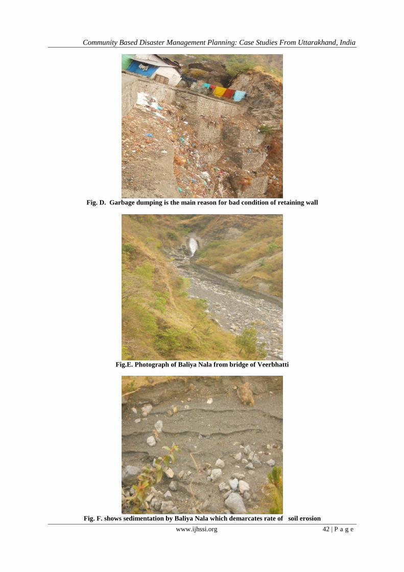
Fig. D. Garbage dumping is the main reason for bad condition of retaining wall
Fig.E. Photograph of Baliya Nala from bridge of Veerbhatti
Fig. F. shows sedimentation by Baliya Nala which demarcates rate of soil erosion

Community Based Disaster Management Planning: Case Studies From Uttarakhand, India
www.ijhssi.org 43 | P a g e
Fig. G. Show’s contribution of government to reduces rate of landslide.
Fig. H. shows plantation of Ram Bass which Protect Baliya Nala.
Fig. I. Method of protecting roof of houses from heavy rainfall by communit

Community Based Disaster Management Planning: Case Studies From Uttarakhand, India
www.ijhssi.org 44 | P a g e
Fig. J. Here Baliya Nala confluences to Gola river.
About 320.72 hector of the Baliya catchment is found environmentally highly sensitive and fragile.
Due to the presence of Main Boundary Thrust (MBT) and others fault this zone is geotectonically very instable
and thus consequently vulnerable to the process of mass movement and surface removal. Besides anthropogenic
process of resource development, specifically construction of road along sensitive slopes, expansion of
settlement zone and agriculture on forests and upslope areas, overgrazing etc. have further rendered this entire
zone prone to frequent and widespread land sliding and excessive erosion.( Bartarya, S.K. and Valdiya, K.S.
(1989).
The role of community is very insignificant to mitigate and manage disasters in Baliya nala catchment area, as
well the role of Government authorities is also less. Although by the efforts of government, in some areas
retaining wall to prevent landslides have been erected, but these means are not helpful to that extent due to lack
of maintenance.
ACKNOWLEDGMENT I feel immense pleasure to express my deep sense of gratitude and indebtedness to my respected
supervisor Dr. R.K.Pande for suggesting me to publish this paper and for his guidance related to this paper. I
am also thankful to him providing me necessary information and helping me for identification of collected
information from the field area.
I also great full to my parents who gave me full support in this paper and I am very great full to Ms. Vedika
Pant for her guidance.
I am also obliged to all my classmates.PRIYANKA TYAG
REFERENCE [1]. Bartarya, S.K. and Valdiya, K.S. (1989). Landslides and erosion in catchment of the Gaula river, Kumaun Lesser Himalaya,
India, Mountain Research and Develpoment,Vol.9.No.04,P.no.409. [2]. Valdiya, K.S., Joshi,D.D., Sanwal, R. and Tondon, S.K.(1984). Geology of kumaun Geomorphic development along the active
main boundary thrust-an example from nainital hill in kamaun Himalaya- vol25.
[3]. Village level disaster management by Disaster mitigation & management centre, Uttrakhand Government, Deharadun. [4]. Bahuguna, V.K. and Saklani, P.S. (1988). Tectonics of the main Central thrust in Garhwal Himalaya, U.P. Jour., Geo. Soc.
India, 31(2): 179-209.
[5]. Chanddha, S.K. (1989). Environmental hazard in Himalaya. In S.K. Chaddha (ed.), Environmental, Holocaust in Himalaya, Ashish Publishing House, New Delhi, p.1-10.
[6]. Pachauri, A.K., Gupta, P.V. and Chander, R. (1998). Landslide zoning in part of Garhwal Himalaya, Environment Geology, 36,
325-334. [7]. Bamdad, N. the Role of Community Knowledge in Disaster Management. The Bam Earthquake: Lesson in Iran.
www.engagingcommunities2005.org/abstracts/Bamdad-Nasser-final.pdf.
[8]. Study material of Indira Gandhi Open University on Disaster Management. [9]. Pant, V. & Pande, R.K. (2012).Global General of Human Social Science, CBDRA.
[10]. www.google.com website (ACCESSED ON 1, may.2012 to 30, june.2012).