commissioned report€¦ · geodiversity is the variety of rocks, minerals, fossils, landforms...
TRANSCRIPT

COMM ISS IONED REPORT
Commissioned Report No. 417
Scotland’s Geodiversity: Development
of the Basis for a National Framework
For further information on this report please contact:
John Gordon
Scottish Natural Heritage
SilvanHouse
231 Corstorphine Road
Edinburgh
EH12 7AT
Telephone: 0131-316-2611
E-mail: [email protected]
This report should be quoted as:
Gordon, J.E. & Barron, H.F (2011). Scotland’s geodiversity: development of the basis
for a national framework. Scottish Natural Heritage Commissioned Report No. 417.
This report, or any part of it, should not be reproduced without the permission of Scottish Natural
Heritage. This permission will not be withheld unreasonably. The views expressed by the author(s)
of this report should not be taken as the views and policies of Scottish Natural Heritage.
© Scottish Natural Heritage 2011.
PE1277/H

ii
PE1277/H
iii
COMMISSIONED REPORT
Summary
Scotland’s Geodiversity: Development of the Basis for a
National Framework
Commissioned Report No. 417
Contractor: Scottish Natural Heritage and the British Geological Survey
Year of publication: 2011
Background
Geodiversity is the variety of rocks, minerals, fossils, landforms sediments and soils, together with the natural processes which form and alter them. It delivers important ecosystem services through its influence on landscape, habitats and species, economic activities, historical and cultural heritage and people’s health and well-being. Understanding of geodiversity also has a key part to play in climate change adaptation and in sustainable management of the land, river catchments and the coast. The aim of this study was to undertake an assessment of the value and status of geodiversity in Scotland and to develop the basis for a national framework to enable better integration of geodiversity within relevant policy areas, including helping to deliver the Scottish Government’s Strategic Objectives.
Main findings
• The geological development of Scotland has given rise to a remarkable geodiversity for a country of its size. Many sites in Scotland are of great importance to geoscience for their rocks, fossils and landforms, demonstrating important geological processes or events. Scotland’s marine geodiversity is less well known, but also includes outstanding features.
• Geodiversity is important both as an intrinsic part of the natural heritage and because it provides ecosystem services and functions for the benefit of Scotland’s people and environment. In doing so, it contributes to the delivery of the Scottish Government’s 5 Strategic Objectives, National Outcomes and the 5 key themes for a Greener Scotland. The ‘ecosystem approach’ provides a potentially powerful framework for developing better integration of geodiversity and biodiversity, as well as a means of demonstrating the wider values and benefits of geodiversity through its contribution to delivering ecosystem services.
• Understanding geodiversity has a key part to play in adapting to climate change and sea-level rise. Changes in geomorphological processes are likely to have significant implications for most ecosystems. Effective conservation strategies for managing ecosystem responses will need to work in sympathy with natural processes. The
PE1277/H

iv
concepts of working with nature and making space for natural processes have broader value to society as a whole.
• Pressures on geodiversity arise principally from planning developments and land-use changes. These may damage key features, impair their visibility and accessibility or fragment the interest. Sites located on the coast, adjacent to rivers or on active slopes are most likely to be impacted by climate change, sea-level rise and increased erosion or flooding. The human responses to these changes, in the form of ‘hard’ coastal protection or river and slope engineering are, however, likely to have the greatest impact on geodiversity.
• A separate commissioned review of the current Scottish policy environment concluded that there was limited recognition of the value of geodiversity in a range of relevant key areas such as economic development, landscape, climate change adaptation, health, recreation and education.
The following conclusions were reached:
• There is a responsibility to ensure that the best geodiversity sites and features continue to be protected not only as part of our geoheritage, but also as an essential resource for field education, training and lifelong learning.
• The concept of biodiversity and our need to protect this component of the natural heritage at local, national and global scales is relatively well developed and understood at a strategic level. It forms the basis for much of the effort and activities in nature conservation and is relatively well integrated into the wider policy framework. Conversely, the concept and values of geodiversity are less well appreciated and, by comparison, relatively undervalued and poorly integrated.
• Proposals for the vision, aim and outcomes for a ‘Scottish Geodiversity Framework’ are set out for discussion. Such a framework would help to ensure that geodiversity is recognised as an integral and vital part of our environment, economy and heritage to be safeguarded for existing and future generations. It would instigate a process through which key stakeholders would work together to identify strategic priorities for geodiversity action, in a similar way to ‘The Scottish Soil Framework’. It would help to achieve an environment in which the rich geodiversity of Scotland can be understood, valued and conserved, and make geodiversity relevant to the way we work and live, as well as the decisions we make about a sustainable future for our environment, for both people and nature. In doing so, it should contribute to delivering the Scottish Government’s National Outcome on Natural Resource Protection and Enhancement.
• It is proposed that a ‘Scottish Geodiversity Framework’ covers the following areas of activity:
1. ‘Future-proofing’ ecosystem services, particularly in a context of climate change and sea-level rise.
2. Integration of geodiversity into all relevant policies. 3. Sustainable management of geodiversity for the wider benefit of Scotland’s
people, environment and economy. 4. Conservation of geodiversity. 5. Raising awareness of the values and benefits of geodiversity and their
contribution to ecosystem services. 6. Improving understanding of geodiversity and key knowledge gaps.
• Promoting wider awareness, understanding and involvement is also crucial. At policy, planning and decision-making levels, there is a need to make understanding
PE1277/H

v
of the way the Earth works one of the cornerstones of sustainable development. Improving public awareness and engagement at a community level is also essential.
• In the present economic climate there is a need to strengthen links with the business community to generate financial returns as well as real benefits for geodiversity from geoconservation and use of the Earth’s resources in a sustainable way.
• It is recommended that the framework outlined in this report provides a starting point and should be developed and formalised through the mechanism of a ‘Scottish Geodiversity Forum’ or Working Group, set up with the support of the Scottish Government with clear leadership and appropriate convening power and involving appropriate partners and stakeholders. This should also be tasked with preparing a prioritised implementation plan, targets and actions.
For further information on this project contact:
John Gordon, Scottish Natural Heritage, Silvan House, 231 Corstorphine Road,
Edinburgh EH12 7AT
Tel: 0131–316–2611
For further information on the SNH Research & Technical Support Programme contact:
Policy & Advice Directorate Support, SNH, Great Glen House, Leachkin Road, Inverness, IV3 8NW.
Tel: 01463 72500 or [email protected]
PE1277/H

vi
Acknowledgements
We thank the following colleagues for extensive discussions and contributions – Patricia Bruneau, Nick Everett, Vanessa Kirkbride, Colin MacFadyen, Greg Mudge, Alistair Rennie and Rachel Wignall (all SNH); Mike Browne, Diarmad Campbell, Sarah Hannis, Ewan Hyslop and David Lawrence (all BGS); and Eleanor Brown (Natural England) for discussion on ecosystem services.
PE1277/H

vii
Table of Contents Page
1. INTRODUCTION................................................................................................. 1 1.1. Background ................................................................................................................1
1.2. Aims and objectives...................................................................................................4
1.3. Methodology..............................................................................................................5
1.4. Structure of the report ................................................................................................5
2. WHY GEODIVERSITY MATTERS: INTRINSIC VALUES .................................. 6 2.1. Scotland’s geodiversity..............................................................................................6
2.2. Scientific value...........................................................................................................6
2.3. Applied and educational value...................................................................................9
2.4. Conclusion ...............................................................................................................16
3. WHY GEODIVERSITY MATTERS: DELIVERING ECOSYSTEM SERVICES AND BENEFITS....................................................................................................... 17
3.1. Geodiversity and Ecosystem Services .....................................................................17
3.2. Provisioning services ...............................................................................................19
3.2.1 Fresh water..................................................................................................................19
3.2.2 Mineral resources and construction materials.............................................................27
3.2.3 Waste disposal and water storage ...............................................................................29
3.2.4 Renewable energy.......................................................................................................29
3.2.5 Ornamental resources..................................................................................................31
3.3. Regulating services ..................................................................................................31
3.3.1 Climate regulation.......................................................................................................31
3.3.2 Water regulation, water purification and waste treatment ..........................................32
3.3.3 Erosion and natural hazard regulation ........................................................................32
3.4. Cultural services.......................................................................................................34
3.4.1 Educational values ......................................................................................................35
3.4.2 Cultural diversity, inspiration and aesthetic values ....................................................35
3.4.3 Sense of place and cultural heritage: geodiversity and the built landscape................36
3.4.4 Recreation and ecotourism..........................................................................................38
3.4.4.1 Geodiversity and tourism.........................................................................................39
3.4.4.2 Recreation, health and well-being............................................................................40
3.4.5 Landscape character....................................................................................................41
3.5. Supporting services..................................................................................................45
3.5.1 Habitat support............................................................................................................45
3.5.2 Soil formation .............................................................................................................48
3.5.3 Nutrient cycling ..........................................................................................................48
3.5.4 Water cycling ..............................................................................................................49
3.5.5 Knowledge support .....................................................................................................49
3.6. Conclusion ...............................................................................................................51
4. WHY GEODIVERSITY MATTERS: ADAPTING TO CLIMATE CHANGE ....... 53 4.1. Introduction..............................................................................................................53
4.2. Climate change and sea-level rise projections .........................................................53
4.3. Responses of geomorphological processes ..............................................................54
4.4. Changing process environments and what we might expect to see .........................55
4.4.1 Coasts..........................................................................................................................55
4.4.2 Rivers ..........................................................................................................................58
4.4.3 Slopes and uplands......................................................................................................58
4.4.4 Soils.............................................................................................................................59
4.5. Implications for biodiversity and ecosystems..........................................................60
PE1277/H

viii
4.6. Implications for land management...........................................................................62
4.7. Allowing space for natural processes ......................................................................63
4.8. Conclusions..............................................................................................................64
5. GEODIVERSITY: PRESSURES AND THREATS ............................................ 65 5.1. Introduction..............................................................................................................65
5.2. Mineral extraction....................................................................................................68
5.3. Landfill and restoration of quarries..........................................................................69
5.4. River engineering.....................................................................................................69
5.5. Coast protection .......................................................................................................69
5.6. Fossil collecting and geological sampling ...............................................................70
5.7. Conflicts between public safety and conservation...................................................71
5.8. Climate change.........................................................................................................72
5.8.1 Impacts of climate change on geodiversity.................................................................72
5.8.2 Urban geology and climate change – stone-built heritage..........................................74
5.8.3 What needs to be done? ..............................................................................................74
5.9. Pressures on marine geodiversity.............................................................................75
5.10. Conclusions..........................................................................................................75
6. CONSERVATION OF GEODIVERSITY AND LINKS TO THE WIDER POLICY FRAMEWORK ......................................................................................................... 77
6.1. Legislative drivers for geodiversity .........................................................................77
6.2. Site Protection..........................................................................................................77
6.2.1 Terrestrial sites of national and international importance...........................................77
6.2.2 Marine areas of national and international importance...............................................78
6.2.3 Sites of regional and local importance........................................................................81
6.2.4 Geoparks .....................................................................................................................81
6.3. Links to the wider policy framework.......................................................................85
6.4. Conclusion ...............................................................................................................86
7. TOWARDS A GEODIVERSITY FRAMEWORK FOR SCOTLAND.................. 88 7.1. Introduction..............................................................................................................88
7.2. Vision, aims and outcomes for a geodiversity framework ......................................88
7.3. Delivering the outcomes ..........................................................................................89
7.3.1 Strategic level..............................................................................................................89
7.3.2 Local level: geodiversity audits and action plans .......................................................92
7.3.3 Monitoring progress....................................................................................................95
7.4. Developing an integrated approach to biodiversity and geodiversity conservation 95
7.5. Conclusions..............................................................................................................96
8. CONCLUSIONS, CHALLENGES AND RECOMMENDATIONS...................... 98 8.1. Geodiversity benefits everyone................................................................................98
8.2. Geodiversity and the policy environment ................................................................99
8.3. Promoting awareness, understanding and involvement.........................................100
8.4. Research needs and evidence gaps ........................................................................101
8.5. Future priorities for action .....................................................................................101
9. REFERENCES................................................................................................ 102
APPENDIX 1. LINKS BETWEEN GEODIVERSITY-BASED SERVICES AND EUROPEAN/NATIONAL POLICY OBJECTIVES OR TARGETS ......................... 122 APPENDIX 2. LINKS BETWEEN GEODIVERSITY AND BIODIVERSITY AT THE CATCHMENT SCALE: CAIRNGORMS CASE STUDY ........................................ 137 APPENDIX 3. ‘A LAND OF STONE’: GEODIVERSITY AND BUILDING STONE IN SCOTLAND ........................................................................................................... 143
PE1277/H

ix
APPENDIX 4. URBAN GEOLOGY – MAINTAINING SCOTLAND’S STONE-BUILT HERITAGE............................................................................................................. 149
APPENDIX 5. GEOLOGICAL CONSERVATION REVIEW SITE SELECTION BLOCKS AND NUMBERS OF SCOTTISH SITES................................................ 152
APPENDIX 6. SITE SELECTION BLOCKS FOR MARINE GEODIVERSITY IN SCOTTISH OFFSHORE AND TERRITORIAL WATERS AND NUMBERS OF KEY INTEREST FEATURE AREAS .............................................................................. 154
APPENDIX 7. THE EUROPEAN AND GLOBAL GEOPARKS NETWORK.......... 155
List of Figures Page Figure 2.1 The major geological features and terrains of Scotland. OHFZ: Outer Hebrides
Fault Zone. MTZ: Moine Thrust Zone. WBF: Walls Boundary Fault. GGF: Great Glen Fault. HBF: Highland Boundary Fault. SUF: Southern Upland Fault. IS: Iapetus Suture. (Sources: Emeleus & Gyopari, 1992; Trewin, 2001). ..................................................... 7
Figure 2.2 The Eildon Hills are the eroded remnants of igneous intrusions. Their resistant igneous rocks form a distinctive landscape that has strong archaeological, historical and literary associations. These include connections with the builders of a Bronze Age fort, the Romans and Sir Walter Scott. According to Scott, a local wizard "cleft the Eildon hills in three and bridled the river Tweed with a curb of stone." (Photo: L. Gill/SNH). ...................................................................................................................... 8
Figure 2.3 Hutton’s section at Salisbury Crags, Edinburgh. (Photo: Colin MacFadyen)....... 13 Figure 2.4 Cailleach Head, Sutherland. (Photo: Colin MacFadyen)..................................... 14 Figure 2.5 Achanarras Quarry, Caithness, is a world-class locality for Devonian (Old Red
Sandstone) fossil fish. (Photo: R. Davidson)................................................................ 15 Figure 3.1 Ecosystem services (from Millennium Ecosystem Assessment, 2005). .............. 18 Figure 3.2 Bedrock aquifer productivity across Scotland. (Reproduced with the permission of
the British Geological Survey ©NERC. All rights Reserved). ....................................... 25 Figure 3.3 Superficial deposits aquifer productivity across Scotland. (Reproduced with the
permission of the British Geological Survey ©NERC. All rights Reserved). ................. 26 Figure 3.4 Minerals produced in Scotland in 2008 (Source: British Geological Survey, 2009).
(Reproduced with the permission of the British Geological Survey ©NERC. All rights Reserved).................................................................................................................... 28
Figure 3.5 Value of minerals produced in Scotland in 2008. (Source: British Geological Survey, 2009). (Reproduced with the permission of the British Geological Survey ©NERC. All rights Reserved). ..................................................................................... 28
Figure 3.6 Birkhill Fireclay Mine. (Photos: Mike Browne)..................................................... 30 Figure 3.7 Ballachulish Slate Quarries. (Photo: John Gordon). ........................................... 30 Figure 3.8 Glasgow’s subsurface Quaternary. (Reproduced with the permission of the British
Geological Survey ©NERC. All rights Reserved)......................................................... 33 Figure 3.9 The nature of the Scottish coastline (Source: EUrosion, 2004)........................... 34 Figure 3.10 Buchannan Street, Glasgow, one of the great northern European sandstone
cities, with a mixture of local ‘blonde’ Carboniferous sandstone and red Permo-Triassic sandstones imported from southwest Scotland. (Reproduced with the permission of the British Geological Survey ©NERC. All rights Reserved). ............................................. 38
Figure 3.11 The extension of the Appalachian Trail to Scotland. (Photo: Paul Wylezol, IAT)..................................................................................................................................... 42
Figure 3.12 Cairngorms National Park bedrock character. (Reproduced with the permission of the British Geological Survey ©NERC. All rights Reserved). ................................... 44
Figure 3.13 Cairngorms National Park superficial deposits and geomorphology. (Reproduced with the permission of the British Geological Survey ©NERC. All rights Reserved). .... 44
PE1277/H

x
Figure 3.14 Outline of the links between geodiversity and biodiversity. The arrows represent process linkages, including fluxes of sediment and water. (Source: Scottish Natural Heritage). .................................................................................................................... 45
Figure 3.15 Understanding the links between geodiversity and biodiversity is fundamental to integrated conservation management in the uplands. Upland habitats are generally of high value for nature conservation but are dynamic and often fragile, as here in the Cairngorms. This dynamism and fragility result from the properties of the soils and vegetation, geomorphological processes and the extreme climate. Landscape sensitivity and thresholds for change (e.g. acceleration of soil erosion and consequent loss of habitats) depend on the interactions of these factors and human pressures. (Photo: John Gordon).................................................................................................. 46
Figure 3.16 Integrated swath bathymetric image and NextMap digital terrain model of the Summer Isles region, Loch Broom and Little Loch Broom reveals a detailed pattern of moraines and other landforms on the seabed. These landforms not only record the pattern of retreat of the last glaciers, but also provide a range of topographic situations and sediments for marine habitats in an area that is a strong candidate for Marine Protected Area status. (Source: Stoker et al., 2009). (Reproduced with the permission of the British Geological Survey ©NERC. All rights Reserved). ................................... 47
Figure 3.17 The hydrological cycle. (Reproduced with the permission of the British Geological Survey ©NERC. All rights Reserved)......................................................... 49
Figure 4.1 Relative sea level rise projections for 2010, 2050 & 2100, based on a High Emission Scenario, above 1990 levels. (Source: Scottish Natural Heritage)................ 57
Figure 4.2 Morrich More on the Dornoch Firth is important for its geodiversity and biodiversity. The 32km2 coastal strandplain comprises a series of beach ridges that have accumulated over the last c.7000 years under conditions of initially abundant sand supply and falling relative sea-level. Over the last few thousand years, sediment supply has reduced and over the last decade, there has been a shift from progradation to erosion of the eastern coastal edge, reflecting the onset of rising relative sea-level. Understanding these long- and short-term processes is crucial to inform future management of the site. (Photo: P&A Macdonald/SNH).............................................. 61
Figure 5.1 Stannergate Shore Local Geodiversity Site, Dundee. The emergency replacement of hard landscaped sea defences carrying the coastal footpaths over rock outcrop partially destroyed exposures of lava breccia, which are valuable for education. (Photos: Mike Browne). ............................................................................................... 71
Figure 5.2 Recent engineering works designed to protect the public from rockfalls from Edinburgh’s Castle Rock demonstrate the conflict between provision of a safe environment and the conservation of iconic landscapes.(Photo: Mike Browne). .......... 72
Figure 6.1 The bar at Culbin, Moray has been extending westwards at c. 15 metres per year through the accretion of shingle ridges. (Photo: P&A Macdonald/SNH)....................... 80
Figure 6.2 Geodiversity audits in Scotland conducted by BGS. (Reproduced with the permission of the British Geological Survey ©NERC. All rights Reserved). ................. 83
Figure 6.3 Geoparks in Scotland (Reproduced with the permission of the British Geological Survey ©NERC. All rights Reserved). ......................................................................... 83
Figure 6.4 Key links between geodiversity and the Scottish Government’s Strategic Objectives and Related Key Policy Areas. (Source: Natural Capital, 2011). ................ 85
Figure 7.1 Vision, aim and outcomes for a Scottish Geodiversity Framework...................... 90
PE1277/H

xi
List of Tables Page
Table 2.1 Geodiversity features and localities of exceptional value on a world scale and
contributions of Scottish geology and geologists to the development of geoscience. (See also Box 2.1)....................................................................................................... 10
Table 3.1 Inventory of geodiversity’s contribution to ecosystem services. Items in bold and underlined are additional services provided by geodiversity. They are classed as non-renewable capital assets in the Millennium Ecosystem Assessment. (Adapted from from Millennium Ecosystem Assessment, 2005; Myall et al., 2011). .................................... 20
Table 3.2 The regulating ecosystem services associated with individual hazards. (From Smith et al., in prep.). .................................................................................................. 32
Table 4.1 Scottish climate projections by the 2080s under a medium global emissions scenario (from Scottish Government, 2009b, based on UKCP09) ............................... 54
Table 4.2 Potential responses of dynamic land forming processes to climate change in Scotland ...................................................................................................................... 56
Table 5.1 Pressures on the terrestrial geodiversity interests (Adapted from Gordon & MacFadyen 2001). ...................................................................................................... 66
Table 5.2 Impacts of climate change on geodiversity sites.................................................. 73 Table 6.1 Geodiversity audits in Scotland ........................................................................... 84
PE1277/H
1
1. INTRODUCTION
1.1. Background Geodiversity is the variety of rocks, minerals, fossils, landforms sediments and soils, together with the natural processes which form and alter them (cf. Gray, 2004, 2008). Geodiversity also links people, landscapes and their culture through the interactions of biodiversity, soils, minerals, rocks, fossils, active processes and the built environment (Stanley, 2004). For its size, Scotland has a remarkable geodiversity, reflecting a rich and varied geological history that spans some 3 billion years of the Earth’s existence. This has stimulated the development of many of the fundamental principles that underlie geoscience today. Consequently, Scotland’s geodiversity is an asset of national and international importance for interpreting past geological processes of global significance, such as volcanism, plate tectonics and glaciation. Equally, some of Scotland’s rocks contain a rich variety of fossils that have greatly elucidated the evolution of the plant and animal kingdoms. From a more applied viewpoint, Scotland’s geodiversity has also played a critical role in the exploration and production of minerals, development of new technologies (such as Carbon Capture and Storage), geotechnical engineering, waste storage, mining and land remediation, and has thus made an immense contribution to Scotland’s financial wealth. The key supporting role that terrestrial geodiversity provides to Scotland’s economy is also demonstrated offshore, where there are clear functional relationships between marine geodiversity and ecosystems services, healthy diverse seas and offshore development (oil, gas and renewables). Geodiversity is not the same as geoconservation, although the terms are sometimes used synonymously; understanding the geodiversity of an area is a pre-requisite to geoconservation (Scott et al., 2008). Traditionally, geoconservation activities in Scotland, and elsewhere in the UK, have focused mainly on the assessment and management of statutory protected sites (e.g. Ellis et al., 1996; Prosser et al., 2006) and interpretation of the links between geology and landscape (e.g. Gordon et al., 2004). Geodiversity is, however, now increasingly recognised to have much wider relevance in a number of key policy areas and, in effect, to form a core element of ecosystem services (e.g. Gordon & Leys, 2001; Gray, 2004; Stanley, 2004; Stace & Larwood, 2006; Birch et al. 2010). For example, it provides:
• the physical underpinning of our varied landscapes (both rural and urban) and scenery, and has a profound influence on ecosystems, habitats and wildlife;
• the knowledge base for society to develop adaptations to climate change and to mitigate natural hazards through better understanding of natural processes;
• the basis for many aspects of economic development, including tourism-based activities;
• a strong influence on our cultural heritage as a source of inspiration for art, sculpture, music, poetry and literature, and on the character of our urban areas through the use of different building stones;
• a resource for a variety of recreation and outdoor activities, and therefore delivers benefits for people’s health and well-being; and
• the physical basis for sustainable management of the land, river catchments and the coast.
In this wider context, geodiversity delivers important benefits for Scotland and further afield. It has a fundamental bearing on the wealth, health and wellbeing of Scotland’s people and
PE1277/H

2
therefore can make a significant contribution in delivering the Scottish Government’s Strategic Objectives (for a smarter, safer and stronger, wealthier and fairer, greener, and healthier Scotland) and National Outcomes. From a natural heritage perspective, these benefits of geodiversity link directly to Scottish Natural Heritage (SNH)’s Corporate Strategy and 5 strategic priorities which in turn map across to the Government’s Strategic Objectives. Fundamental to the SNH strategy is a vision for the natural heritage for the year 2025 articulated within the Natural Heritage Futures prospectuses1. These present SNH’s “view of how the natural heritage can contribute to sustainable development in practice. They reflect the two founding principles upon which the Scottish sustainable development strategy Choosing Our Future2 is based – ‘living within environmental limits’ and ‘ensuring a strong, healthy and just society’ ” (Scottish Natural Heritage, 2008a, p. 6). In the past, a sectoral approach to conservation has tended to treat biodiversity and geodiversity as separate entities, with a dominant focus on the former. However, the value of more integrated approaches is now becoming widely recognized at a strategic level; for example, the Convention on Biodiversity and the European Landscape Convention call for a more integrated approach to the conservation of natural resources and landscapes, both within and beyond protected areas. This is reflected in the growing emphasis on an ‘ecosystem approach’ in conservation management and, at a more practical level, in Integrated Coastal Zone Management and Integrated Catchment Management/Sustainable Flood Management. Increasingly, too, soil conservation and sustainable management of soil resources have become a priority issue through the European Soil Thematic Strategy and the proposed Soil Framework Directive. Scotland’s geodiversity forms the essential foundation upon which plants, animals and human beings live and interact. The active geomorphological processes that shape our mountains, rivers and coasts also maintain dynamic habitats and ecosystems. Scotland’s biodiversity depends on the continued operation of these processes. It is increasingly recognised, therefore, that conservation management of the non-living parts of the natural world is crucial for sustaining living species and habitats. At an international level, there is also growing awareness of the importance of the conservation of geodiversity and its wider links. The geoscience community and the voluntary sector, including the European Federation of Geologists, International Union of Geological Sciences and the International Geographical Union, published a ‘European Manifesto on Earth Heritage and Geodiversity’3 in 2004. This recommended that unique Earth heritage sites and landscapes should be given protected status and that sustainable development and restoration should respect and reflect geology, geomorphology and soils. In 2004, also, the Committee of Ministers of the Council of Europe adopted Recommendation Rec(2004)3 on conservation of the geological heritage and areas of special geological interest4. This recognises the wider value of geodiversity, stating that “geological heritage constitutes a natural heritage of scientific, cultural, aesthetic, landscape, economic and intrinsic values, which needs to be preserved and handed down to future generations” and noting “the important role of geological and geomorphological conservation in maintaining the character of many European landscapes”. In relation to the European Landscape Convention (2002), Recommendation Rec(2004)3 also noted that “[g]eological and geomorphological features form the structural framework for all landscapes, and are
1 http://www.snh.gov.uk 2 Scottish Government (2005). Choosing our Future: Scotland’s Sustainable Development Strategy. http://www.scotland.gov.uk/Publications/2005/12/1493902/39032 3http://www.eurogeologists.de/images/content/panels_of_experts/soil_protection_geological_heritage/ManifestoEarthHeritage_Geodiversity.pdf 4 https://wcd.coe.int/ViewDoc.jsp?id=740629&Lang=en
PE1277/H

3
essential characteristics of landscapes that need to be considered when applying the Landscape Convention. Landscape assessments made in this way will take account of the particular values assigned to them by populations concerned, and in many instances these values will relate directly to the geological features of the landscape and their heritage value.” In 2008, the General Assembly of the IUCN, at the 4th World Conservation Congress in Barcelona, approved Resolution 4.040 on Conservation of geodiversity and geological heritage5. This places geodiversity on the agenda of the IUCN and acknowledges, inter alia:
• that geodiversity is an important natural factor underpinning biological, cultural and landscape diversity, as well as an important parameter to be considered in the assessment and management of natural areas;
• that geological heritage constitutes a natural heritage of scientific, cultural, aesthetic, landscape, economic and/or intrinsic values, which needs to be preserved and handed down to future generations;
• the escalating impact of development, that is frequently unsustainable, upon the world's geodiversity and geological heritage;
• that in planning such development, the intrinsic values, both material and intangible, of the geodiversity, geoheritage and geological processes present at natural areas are often underestimated or even ignored;
• that the conservation of geodiversity and geological heritage contributes to dealing with species loss and ecosystem integrity;
• the important role of geological and geomorphological conservation in maintaining the character of many landscapes.
In Scandinavia, the Nordic Council of Ministers has supported collaborative geodiversity activities, including a report on Geodiversity in Nordic Nature Management (Johansson, 2000), an associated popular leaflet and a Conference on Soils, Society and Global Change in 2007 (Bigas et al., 2009). Geodiversity also links the Earth, its people and their culture. Through the Global Geoparks Network, the cultural and economic importance of geodiversity is being increasingly adopted by UNESCO as a means to deliver geoconservation as part of a wider strategy for regional sustainable socio-economic and cultural development that safeguards the environment (Eder & Patzak, 2004). There is therefore growing acceptance that geodiversity has much greater relevance to society than simply the conservation of geological sites or features: it has a vital place in all aspects of the natural heritage and impacts on many sectors in economic development and historical and cultural heritage. This is highlighted, for example, in the award of European Geopark status to the North West Highlands, Lochaber and Shetland. Geodiversity also has significant relevance for other strategic issues and programmes, most notably climate change. Potential key contributions relate to the development of: 1) adaptive management of coastal habitats, landforms and land uses in response to rising sea-level, changes in sediment dynamics and storminess, and ‘coastal squeeze’; 2) river basin management plans and sustainable flood management through restoration of natural processes and an understanding of floodplain histories from sedimentary records; and 3) understanding carbon dynamics in organic (peat) soils (Scotland’s soils contain the majority of the UK soil carbon stock – Chapman et al., 2009).
5http://intranet.iucn.org/webfiles/doc/IUCNPolicy/Resolutions/2008_WCC_4/English/RES/res_4_040_conservation_of_geodiver
sity_and_geological_heritage.pdf
PE1277/H

4
The potential role of geodiversity in the wider policy environment and in delivering the Scottish Government’s Strategic Objectives and National Outcomes now deserves greater attention. It is therefore timely and essential for an assessment of the value and status of Scotland’s geodiversity and the development of a strategic national framework that embraces the wider links between geodiversity and sustainable development and the integration of geodiversity more closely with key policy areas and guidance (e.g. in relation to development planning guidance, minerals policy, landscape, National Scenic Areas, National Parks, sustainable rural development, adaptation to climate change, and sustainable coastal and river management). Such a national framework would also provide a strategic context for the development at a regional and local level of geodiversity auditing and local geodiversity action plans (LGAPs). These are now well established in England; as yet, only three studies have been completed in Scotland for West Lothian, Edinburgh and East Dunbartonshire councils, but others are proposed for the Cairngorms and Loch Lomond & The Trossachs National Parks and the North West Highlands and Lochaber Geoparks. Such audits and plans provide a means to establish best practice and evaluate the geodiversity knowledge baseline, both in relation to designated sites and in the wider countryside. By raising awareness of geodiversity, they are contributing to building greater capacity among local authorities and other stakeholders. This should help to underpin work on development planning, Strategic Environmental Assessment (SEA), Environmental Impact Assessment (EIA), Local Biodiversity Action Plans and tourism-based activities, and lead to a better understanding of the links between geodiversity and landscape character. However, there is no overall framework for such plans at a national (Scotland) level and no strategic national objectives, targets and indicators for reporting. Many different sectors and activities thus interact with geodiversity and have an impact on the resource – agriculture, forestry, industry, transport, recreation, tourism, development planning and flood protection at the coast and along rivers. The challenge is to raise wider understanding and awareness of geodiversity and that its protection, enhancement and sustainable management are relevant to the people of Scotland and, through the provision of a range of vital ecosystem services and other benefits, how they live their lives.
1.2. Aims and objectives The aim of this partnership project between Scottish Natural Heritage (SNH) and the British Geological Survey (BGS) was to undertake an assessment of the value and status of geodiversity in Scotland and to develop the basis for a national strategic framework to enable better recognition and integration of geodiversity within relevant policy areas and to indicate how this might be taken forward.
The principal objectives of this report are to:
• assess the intrinsic values of geodiversity and the benefits it delivers for the people of Scotland through its contribution to ecosystem services;
• identify the pressures and threats affecting geodiversity in Scotland;
• outline the vision, aims and outcomes for a national framework for geodiversity, and to indicate how these might be delivered within the existing policy and development planning framework.
The focus of the project was primarily on the geological and geomorphological aspects of geodiversity. Although soils are an integral component of geodiversity, they are largely addressed elsewhere in SEPA’s State of the Environment Report on Soil Quality (SEPA,
PE1277/H
5
2001), the Scottish Government’s ‘State of Soil’ report (Towers et al., 2006) and in the Scottish Soil Framework (Scottish Government, 2009a).
1.3. Methodology The study was undertaken through a desk-based review by SNH and BGS staff. In addition, three separate studies were commissioned by SNH to inform the work:
• the identification of geodiversity attributes and indicators, which can be used to monitor key aspects of the state of geodiversity, and additional parameters which can be used as part of a surveillance framework designed to monitor changes over time in geodiversity-based ecosystem services (Birch et al., 2010);
• an assessment of potential approaches to the economic and social evaluation geodiversity-based ecosystem services (Myall et al., 2011);
• an analysis of the wider links between geodiversity and sustainable development and the opportunities to integrate geodiversity with existing key policy areas and guidance, including the development of model policies for geodiversity in a format that local authorities and other agencies can use as a working tool (Natural Capital, 2011).
1.4. Structure of the report
The report first reviews the evidence base for why geodiversity matters for people and nature in Scotland. It examines the intrinsic value of Scotland’s geoheritage (Chapter 2) and the contribution of geodiversity to delivering ecosystem services for society (Chapter 3). It then considers the role of geodiversity and geoscience understanding for developing adaptation to climate change (Chapter 4). This is followed by a review of the pressures and threats affecting geodiversity (Chapter 5), current conservation measures and links to the wider policy framework (Chapter 6). The report then presents a proposal for an outline geodiversity framework for Scotland (Chapter 7) and concludes with an overview and recommendations (Chapter 8).
PE1277/H
6
2. WHY GEODIVERSITY MATTERS: INTRINSIC VALUES
2.1. Scotland’s geodiversity The geological development of Scotland has given rise to a remarkable geodiversity for a country of its size and has played a fundamental part in shaping the landforms and landscape today (e.g. Trewin, 2002; Gillen, 2003; McKirdy et al., 2007). This has arisen for a number of reasons (Gordon, 2010). First, the broad geological and topographic framework of Scotland (Figure 2.1) is the result of several major global tectonic events, including the repeated formation and break-up of supercontinents (a supercontinent is a landmass comprising a large proportion of the continental area of the Earth), the closure of the Iapetus Ocean and the associated crustal shortening and uplift during the Caledonian Orogeny, the Mesozoic rifting and subsidence in the North Sea and the Minches, and finally the opening of the North Atlantic Ocean in the Palaeogene. The effects of these global-scale events also imparted more local geological influences on landforms, in the form of faults, shatter zones, structural grain and juxtaposition of resistant and weaker rocks, all of which have been exploited by surface processes of differential weathering and erosion, particularly during the Palaeogene, Neogene and Quaternary. Second, the position of Scotland near active plate margins at various times during its history has resulted in episodes of mountain building, volcanism, large-scale crustal deformation, uplift and erosion, all of which have left a legacy both in the rock record and ultimately in the present landscape. Third, as a result of plate tectonics, the Scottish landmass has drifted across the surface of the globe and through different climatic zones and morphogenetic and sedimentary environments, ranging from near-polar to tropical, further enhancing the geodiversity. Fourth, long-term global climate change (Williams et al., 2007) has influenced surface processes, particularly the overall global cooling from the Early Eocene climate optimum to the Quaternary glaciations. Fifth, long-term changes in eustatic sea level (Haq & Schutter, 2008; Müller et al., 2008), arising from tectonic processes and the growth and decay of continental ice sheets, have resulted in significant changes in the position of the coastline. Consequently, Scotland comprises rock types that range from among the oldest in the world to the most recent, and with a wide variety of igneous, metamorphic and sedimentary origins. As a result of the effects of weathering and erosion over long periods of time, the characteristics of the different rocks and their geological histories are expressed today at a variety of scales in the diversity of landscapes, landforms and coastal configuration (Figure 2.1 and Figure 2.2).
2.2. Scientific value Scotland’s rocks, landforms and fossils are assets of not only national but also international importance. They provide an exceptional record of long-term landscape evolution extending back over much of the Earth’s history (Gordon, 2010). As recognised and amply demonstrated in the volumes of the Geological Conservation Review (Ellis et al., 1996), the definitive assessment of key earth science localities in Great Britain, many of the features are of exceptional importance on a world scale (Table 2.1). Scotland’s geology and geologists have also played a fundamental part in the development of the principal concepts in geoscience (Table 2.1). In particular, they have provided crucial evidence for interpreting geological events and processes of global significance associated with recognition of the duration of geological time, plate movements, crustal deformation, volcanism and ice ages.
PE1277/H

7
For example, the closure of the Iapetus Ocean and the formation of the Caledonian mountains, volcanism, events associated with the opening of the North Atlantic Ocean, and glaciation have all been instrumental in achieving fundamental advances in our understanding of geology [Box 2.1]. Equally, Scotland’s fossil heritage has had an influential role in development of the standard units of time and studies of the evolution of the plant and animal kingdoms. Evidence from Scotland also proved vital in the development of the Ice Age theory and the concept of continental-scale glaciation in the Northern Hemisphere by the Swiss geologist, Louis Agassiz.
Figure 2.1 The major geological features and terrains of Scotland. OHFZ: Outer Hebrides Fault Zone. MTZ: Moine Thrust Zone. WBF: Walls Boundary Fault. GGF: Great Glen Fault. HBF: Highland Boundary Fault. SUF: Southern Upland Fault. IS: Iapetus Suture. (Sources: Emeleus & Gyopari, 1992; Trewin, 2001).
PE1277/H

8
Figure 2.2 The Eildon Hills are the eroded remnants of igneous intrusions. Their resistant igneous rocks form a distinctive landscape that has strong archaeological, historical and literary associations. These include connections with the builders of a Bronze Age fort, the Romans and Sir Walter Scott. According to Scott, a local wizard "cleft the Eildon hills in three and bridled the river Tweed with a curb of stone." (Photo: L. Gill/SNH).
Scotland's geological narrative extends far beyond the low water mark. In the marine environment, features of particular interest in Scottish territorial and offshore waters include remarkably well preserved bedforms associated with the ice streams of the last British-Irish Ice Sheet (e.g. Bradwell et al., 2008; Stoker et al., 2009). These depict the footprint of the ice sheet and its pattern of wastage. This is not merely of academic interest because the behaviour and collapse of the last Scottish ice sheet is relevant for understanding the future response to climate change of modern marine-based ice sheets such as the West Antarctic Ice Sheet. In addition, there are large submarine mass movement features (submarine slides), a range of dynamic bedforms (including sand and gravel waves and gas seepage forms) and areas of carbonate production that underpin onshore features such as the dunes and machair of the Western Isles and Northern Isles of Orkney (Brooks et al., 2011). These seabed landforms also provide a diversity of habitats for marine species (ABP Marine Environmental Research, in prep.) and have been the focus of more recent attention from the marine renewables industry. As well as for its scientific importance, Scotland’s geodiversity is also significant in the context of our scientific and cultural heritage. The birth of modern geology took place in Scotland over 200 years ago when James Hutton, a leading figure in the Scottish Enlightenment, investigated the rocks around Edinburgh and further afield. Hutton’s discoveries laid the foundations of modern geoscience (McIntyre and McKirdy, 2001). In particular, he showed that the processes shaping the Earth today are the same as those that operated in the past and that the rocks on the surface of the Earth have been recycled many times through erosion, sedimentation on the ocean floors, consolidation and uplift. Hutton’s greatest and most influential insight was that the break or ‘unconformity’ between two sets of strata at Siccar Point represented an immense period of ‘missing’ geological time (Figure 2.3). In revealing the vast immensity of geological time, he freed geology from the constraints of a literal interpretation of the Bible and Archbishop Ussher’s calculated age of
PE1277/H

9
4004 BC for the formation of the Earth. Hutton’s discoveries paved the way for a long line of distinguished Scottish geologists, including Charles Lyell, Roderick Murchison, James Nicol, Hugh Miller and others (e.g. Oldroyd & Hamilton, 2002; McKirdy et al., 2007). Many of the fundamental principles of earth science were developed by these and later pioneers, based on rocks and fossils from Scottish localities, and have since been applied worldwide (Table 2.1). There is thus a long-established tradition of world-class scholarship in geoscience in Scotland which continues to the present day, prompted not least by ready access to the extraordinary wealth of Scotland’s geodiversity.
Figure 2.3 Hutton’s classic section at Siccar Point, Berwickshire, showing the unconformity between steeply dipping Silurian strata and the overlying Devonian (Old Red Sandstone) rocks. (Photo: John Gordon).
2.3. Applied and educational value In its strategic framework for science in Scotland, Science for Scotland, the Scottish Government envisages science as key to delivering its Strategic Objectives and increasing sustainable economic growth (Scottish Government, 2008). Geoscience is well-placed to meet these objectives in the following four overarching areas of particular relevance to society today, as identified at a workshop on ‘Earth Sciences in the 21st Century’ co-ordinated by the Geological Society of London, the British Geological Survey and the Natural Environment Research Council in January 20106:
• Earth and environmental sensitivity: enabling prediction and adaptation for the future;
• Resource Security & Waste Management;
• Forcing, Fluxes & Feedbacks: the Deep Earth - surface interaction. What the Deep Earth does for us;
• Origins: How did the atmosphere, oceans, continents, core and life itself originate? And how do they influence / have they influenced each other?
6 Earth Sciences in the 21
st century: A Forward Look. http://www.bgs.ac.uk/ukgeoscience/home.html
PE1277/H

10
Table 2.1 Geodiversity features and localities of exceptional value on a world scale and contributions of Scottish geology and geologists to the development of geoscience. (See also Box 2.1)
Field Exceptional features Key localities Major Scottish contributions and features
Unconformity (historical significance)
Siccar Point, Jedburgh
James Hutton (1726 - 1797): ‘The father of modern geology’. Recognition of the immensity of geological time. His ‘Theory of the Earth’ (1788) proposed the idea of a rock cycle in which weathered rocks form new sediments and that granites were of volcanic origin.
John Playfair (1748 - 1819): His book ‘Illustrations of the Huttonian Theory of the Earth’ (1802) summarized Hutton’s work and brought Hutton's principle of uniformitarianism to a wide audience.
Sir Charles Lyell (1797 - 1875): His ‘Principles of Geology’ (1830) built on Hutton's ideas, developing further the theory of uniformitarianism, where the Earth's history can be explained by gradual change over time. He also proposed the idea that different periods of geologic time could be established by reference fossils. Lyell was a powerful influence on the young Charles Darwin.
Moine Thrust
Moffat Shale sequence (historical significance)
NW Highlands
Dob’s Linn: the global Ordovician – Silurian boundary stratotype
Sir Roderick Murchison (1792 - 1871): Second Director General of the Geological Survey. Wrongly thought Moine schists were not older than Silurian as they were above the Durness Limestone.
James Nicol (1810 - 1879): The first clear account of the succession of the fossiliferous Lower Palaeozoic rocks of the Southern Uplands.
Charles Lapworth (1842 - 1920): Unravelled the structural complexity of the Southern Uplands using graptolite assemblages. In the NW Highlands he was the first to propose the controversial theory that here older rocks were found lying above younger, suggesting complex folding or faulting as a cause. Later Peach and Horne surveyed the area and their monumental memoir proved Lapworth correct.
Benjamin Peach (1842 - 1926) and John Horne (1848 - 1928): Provided the first major synthesis of thrust belt structure and the basis for descriptions of fault and shear zone processes and deductive methods for unravelling tectonic histories. Wrote the classic memoir ‘The Geological Structure of the North-West Highlands of Scotland’ (Peach et al., 1907).
Stratigraphy and structural geology
John MacCulloch (1773 - 1835): Surveyed and compiled the first large-scale geological map of Scotland, published posthumously in 1836.
William Nicol (1771 - 1851): Inventor of the Nicol prism and the thin section. Mineralogy
Many mineral species first identified in Scotland
Leadhills, Strontian, Tyndrum
Matthew Heddle (1828 - 1897): Published ‘Mineralogy of Scotland’, helped create the Mineralogical Society, and as President of the Edinburgh Geological Society he helped to convince the government to set up the Geological Survey of Scotland in 1855.
Lewisian and Torridonian rocks
Western Isles, NW Highlands
John Sutton (1919 - 1992) and Janet Watson (1923 - 1985): Unravelled the geological history of a polydeformed high-grade gneiss complex, which was a world first (Sutton & Watson, 1951).
Metamorphic geology
Barrovian metamorphic Glen Clova, Glen Esk George Barrow (1853 - 1932): Discovery of metamorphic zones.
PE1277/H

11
zones
Palaeogene layered intrusions
Cuillin of Skye and Rum
Alfred Harker (1859 - 1939): Pioneered the use of the petrological microscope and the thin section in interpretive petrology; ground-breaking work on layered intrusions in Skye and Rum.
Lawrence Wager (1904 - 1965) and Sir Malcolm Brown (1925–1997): The first to study layered intrusions in detail and understand magma chamber processes (Wager & Brown, 1968).
Cauldron subsidence
Glen Coe, Rum
Sir Edward Bailey (1881 - 1965): Recognition of cauldron subsidence in Glencoe (Clough et al. 1909).
Igneous geology
Igneous intrusion relationships
Salisbury Crags, Glen Tilt
Recognition that igneous rocks formed from magma – end of the Neptunian doctrine. At Glen Tilt, James Hutton showed that granite formed from the cooling of molten rock, not precipitation out of water as the Neptunists of the time believed.
William Thomson (Lord Kelvin) (1824 - 1907): The first to calculate the age of the earth and contributed to the understanding of the internal structure of the Earth.
Geochronology
Arthur Holmes (1890 - 1965): A pioneer of geochronology – performed the first uranium-lead
radiometric dating of a rock.
Glacial landforms and processes
Glen Roy, Cairngorms, the Cuillin, Carstairs Kames, NW Highlands
James Forbes (1809 - 1868): Made a major contribution to the emerging science of glaciology through his work in the Alps. Published one of the first detailed studies of glacier landforms in Scotland in his classic paper ‘Notes on the topography and geology of the Cuchullin Hills in Skye, and on the traces of ancient glaciers which they present’ (1846).
Sir Andrew Ramsay (1814 - 1891): Played a key part in developing ideas on landscape modification by glacial erosion.
Sir Archibald Geikie (1835 - 1924): In his 1863 paper ‘On the phenomena of the glacial drift of Scotland’, the effects of ice action in Scotland were for the first time clearly and systematically demonstrated.
James Geikie (1839 - 1915): Contribution to the advancement of glaciation, and was described as one of "the most eminent glacialists of his day". During his geological survey activities, he found evidence of warmer, inter-glacial periods. He suggested that the existence of river terraces at different levels might indicate climatic cycles during the Pleistocene, as opposed to Agassiz's theory of a single great Ice Age.
Land- and sea-level changes
Forth Valley, Islay, Jura
Charles Maclaren (1782 - 1866): Development of the concept of eustasy.
Thomas Jamieson (1829 - 1913): Development of the concept of isostasy.
Brian Sissons (1926 - ): Demonstrated the isostatic tilting of shorelines in Scotland and published numerous classic papers on the patterns of former relative sea-level changes in an isostatically uplifted area.
Machair Outer Hebrides Landform and habitat assemblage unique to Scotland and Ireland.
Quaternary geology and geomorphology
Dynamic coastal landforms
West coasts of Shetland and Orkney, Spey Bay, Sands of Forvie, Morrich More
Features associated with high-energy, exposed environments; blown-sand features; extensive areas of sand coast progradation; features associated with glaciated coasts.
Palaeontology Devonian fossil fish faunas
Moray Firth, Cromarty, Caithness
Hugh Miller (1802 - 1856): Stonemason and self-taught geologist, writer, theologian and palaeontologist. His study of the fossil fishes of the Old Red Sandstone (Devonian), led to his writing of three best-selling books: ‘The Old Red Sandstone’; ‘Footprints of the Creator’; and
PE1277/H

12
‘Testimony of the Rocks’.
Rev David Ure (1750-1798): The ‘Father of Scottish Palaeontology’, published ‘The History of Rutherglen and East-Kilbride’, with the first images and description of ostracods and rhizodont fish.
John Young (1823-1900): Immense contribution to the understanding of Carboniferous fossils of the West of Scotland.
Elizabeth Anderson Gray (1831-1924): Extensive and meticulous collector of Ordovician and Silurian fossils of the Girvan area of Ayrshire.
Robert Kidston (1852-1924): The most influential palaeobotanist of his day; published more than 180 papers on the taxonomy and distribution of floras of the Carboniferous, Permo-Carboniferous and Devonian. The first to use a microscope to study fossil spores.
Early Devonian plants and animals
Rhynie
The Rhynie chert is an Early Devonian Lagerstätte containing exceptionally preserved plant, fungus, lichen and animal material, study of which is important in the understanding the development of some of the earliest terrestrial life on Earth.
Carboniferous shark fauna
Bearsden
Discovery of specimens that have led to advances in shark evolution (S.P. Wood).
Middle Jurassic dinosaur footprints
Skye
Discovery and study of globally rare trackways (N. Clark).
Conodont animals (Clydagnathus windsorensis)
Granton foreshore, Edinburgh
The world’s first specimen of a conodont animal (Briggs et al., 1983; Aldridge et al., 1993).
Westlothiana lizziae East Kirkton Quarry, Bathgate
One of the oldest reptile-like animals ever discovered (Smithson et al., 1994).
Continental drift Arthur Holmes (1890–1965): Championed the theory of continental drift, proposing that the Earth's mantle contained convection cells that dissipated radioactive heat and moved the crust at the surface. His famous book ‘Principles of Physical Geology’ (1944), ended with a chapter on continental drift; part of this model was the origin of the seafloor spreading concept (Vine, 1966).
Climate change James Croll (1821–1890): Self-educated scientist who developed a theory of climate change based on changes in the Earth's orbit. His work was widely discussed but his theory was generally disbelieved. However, the basic idea of orbitally-forced insolation variations influencing terrestrial temperatures was further developed by Milutin Milankovitch in the 1920s and 1930s.
Geoconservation John Muir (1838–1914): ‘The Father of National Parks’.
PE1277/H

13
BOX 2.1 Scientific Value of Scotland’s Geodiversity
7
Scotland’s rocks and landforms are a key asset of national and international importance for a number of reasons:
• geological diversity - reflecting the length of the preserved geological record, plate tectonic history and diversity of palaeogeographies, palaeoenvironments and geological processes and the extent to which these phenomena are exposed at surface and so accessible for observation and study;
• Scotland’s role in the history of geology;
• understanding past geological processes (e.g. volcanism, crustal deformation) and their modern counterparts;
• records of palaeoenvironmental conditions, palaeogeography, and structural and metamorphic evolution now preserved in sedimentary, igneous and metamorphic rock units covering the last billion years;
• rich and diverse fossil record that spans critical moments in evolution;
• ice age environmental change and landscape modification;
• postglacial and contemporary geomorphological processes, including soil formation. Areas such as the NW Highlands, Glen Coe, Rum and Arthur’s Seat in Edinburgh have all provided crucial evidence for interpreting past geological processes of global significance. In the NW Highlands, the work of Sutton & Watson (1951) on the Lewisian Gneiss Complex laid much of the groundwork for unravelling the geological history of poly-deformed gneissic terrains. Following Lapworth’s recognition that thrusting could occur on a crustal scale in the Loch Eriboll area, Peach & Horne (Peach at al., 1907) mapped and described the Moine Thrust Belt, probably, the most famous of the major Caledonian structures. Geological mapping of the Glen Coe area, early in the 20th century, revealed volcanic rocks of Devonian age attributable to cauldron subsidence, the first example of this volcanic feature to be identified and described in the older geological record (Clough et al., 1909). The Tertiary volcanic geology of Rum has yielded much information on the processes taking place in the environment of the magma chamber, with the development of theories relating to the origin of layering in igneous rocks (e.g. Wager & Brown, 1968). The Arthur’s Seat volcanic complex (Figure 2.3) provided key evidence supporting the theories of James Hutton, who demonstrated that igneous rocks were emplaced as a hot fluid magma, rather than being formed as sedimentary deposits. Such evidence laid the foundations for the development of modern geology. Arthur’s Seat is still regarded as an excellent example of a dissected ancient volcano (Upton, 2003) and one which attracts geologists from around the world; as do the other examples cited above and many others.
Figure 2.3 Hutton’s section at Salisbury Crags, Edinburgh. (Photo: Colin MacFadyen).
7 Adapted from Gordon & MacFadyen (2001).
PE1277/H

14
Scotland’s rocks also provide outstanding records of palaeoenvironmental conditions and palaeogeography preserved in sedimentary rock formations covering the last billion years. For example, at Cailleach Head in Sutherland (Figure 2.4), a section through the youngest sediments of the ‘Torridonian’ succession represents the best example of cyclothemic sedimentation in Britain (Stewart, 2002). These c. 1000 million year old sedimentary rocks comprise around 20 units of lake-bed shales and silts, interspersed with alluvial fan deposits.
Figure 2.4 Cailleach Head, Sutherland. (Photo: Colin MacFadyen).
The Highlands and Islands and the Southern Uplands form the type area of the Caledonide orogeny and provide evidence of their complex structural and metamorphic evolution between 1000 and 400 million years ago. This occurred when Scotland lay near to, or on, the margin of a large continental mass called Laurentia, which included Greenland and North America. Equally, Scotland’s fossil heritage has had a crucial role in studies of the evolution of the plant and animal kingdoms. Although metamorphic and igneous rocks underlie more than half of Scotland’s area, the remaining sedimentary rocks, especially the Palaeozoic and Jurassic sequences, contain rich fossil assemblages of immense diversity, some of which are unique. These have yielded the world’s oldest known vertebrate (Dineley & Metcalf, 1999), a rich diversity of early amphibian remains (Milner & Sequeira, 1994), one of the earliest known reptilians – Westlothiana lizziae (Smithson et al., 1994), the oldest known example of an in situ fossilized terrestrial ecosystem (hot spring), in the form of the Rhynie Chert (Cleal & Thomas, 1995), and some of the earliest mammal remains (Waldman & Savage, 1972). Scotland is also of great importance in the history and development of palaeontology through the work and publications, for example, of Louis Agassiz and Hugh Miller on the fossil fishes of the Old Red Sandstone (Agassiz, 1835; Miller, 1840) (Figure 2.5). Evidence from Scotland is crucial for studies of Quaternary glaciation (the Ice Age of the last 2.6 million years). Scotland lies at the maritime fringe of NW Europe, in a region that is climatically sensitive due to its proximity to the atmospheric and marine polar fronts and the North Atlantic Drift. The diverse landform and depositional records of Scotland and the adjacent continental shelves are potentially of great value for understanding the coupling of the atmosphere, oceans, ice sheets and biosphere during periods of rapid climate change in this region (Gordon & Sutherland, 1993; Bradwell et al., 2008; Stoker et al., 2009). In particular, there is the opportunity to link terrestrial and offshore
PE1277/H

15
Figure 2.5 Achanarras Quarry, Caithness, is a world-class locality for Devonian (Old Red Sandstone) fossil fish. (Photo: R. Davidson).
evidence with the high resolution Greenland ice core and deep-sea records (e.g. Scourse et al., 2009). The wealth of information relating to the period following the Last Glacial Maximum and the termination of the last glacial cycle, a time of remarkably rapid environmental change, now provides unprecedented opportunities to reconstruct climate change and to assess the sensitivity of geomorphological and biological systems, as reflected in glacier dynamics, sea-level fluctuations and changes in terrestrial and marine biota (Lowe & Walker, 1997). Quaternary palaeoenvironmental records preserved in loch sediments, peat bogs and coastal and estuarine sediments are important in setting current environmental changes into a longer-term context, particularly the effects of climate variability on the landscape, sea level and ecosystems, and in assessing scenarios of future change (e.g. Edwards & Whittington, 2003; Walker & Lowe, 2007). From these records it is possible to understand how climate, physical processes, sea level and habitats have changed in the past and hence evaluate current observed or anticipated changes in both geomorphological and ecological systems in that context (cf. Birks, 1997; Werritty & Leys, 2001; Willis & Birks, 2006; Willis et al., 2007, 2010a, b; Froyd & Willis, 2008; Davies & Bunting, 2010; Geherls, 2010). In turn, this may help inform conservation management and the potential for recovery from human impacts. For example, such records should allow an assessment of the extent to which projected changes arising from global warming and sea-level rise are likely to lie within the range of natural changes that have occurred within the Holocene, or to what extent significant thresholds are likely to be crossed, which may have economic and social costs as well as environmental implications through increased frequency of storm events or flooding.
In a parallel exercise in Scotland,8 participants at a workshop in Edinburgh in February 2010 highlighted topics of direct societal benefit in the medium term:
• Resource security – including the diversity of energy production (enhanced recovery of oil & gas; unconventional hydrocarbons such as coal-bed methane, shale-gas, hydrates; nuclear); economic minerals; water.
8 Earth Sciences in the 21st Century: a Scottish Perspective. http://www.bgs.ac.uk/ukgeoscience/docs/meetingreport.pdf; see also http://www.abdn.ac.uk/geology/events/events/c21scotland.php
PE1277/H

16
• Waste management – including containment of rad-waste, other toxins (and securing water quality), carbon capture and storage.
• Hazards – understanding risk and uncertainty in the Earth (including those of tectonic origin but also related to the consequence of climate change, including sea-level rise).
• Development of holistic Earth models for climate change. Addressing these issues requires not only fundamental research, but also high quality training for future generations of geoscientists. As noted at the Edinburgh workshop, the latter is heavily dependent on the former. Education, however, extends more widely both to schools and wider public awareness of geoscience. The Scottish Earth Science Education Forum (SESEF) states on its website that “[w]e believe an understanding of how planet Earth works should be an essential part of every young person's education”9. SESEF has been instrumental in integrating geoscience and its wider relevance across a number of key areas of the Curriculum for Excellence. Fundamental to such training and education is the availability of sites for field study, which links directly to the need for effective geoconservation. Since geology and its allied disciplines are to a large degree site-based, field sites with features exposed and accessible are essential for continued scientific research and education.
2.4. Conclusion Many sites in Scotland are of great importance to geoscience for their rocks, fossils and landforms, demonstrating nationally and internationally significant geological processes or events. There is a responsibility to future generations to ensure that the best sites and features continue to be protected not only as part of our geoheritage, but also as an essential resource for field education, training and lifelong learning. Many also have a key part to play in raising wider public awareness and appreciation of geodiversity and its wider values (Chapter 3). There is growing awareness of the significance of Scotland’s marine geodiversity, both for its intrinsic scientific value and its value in supporting marine biodiversity.
9 Scottish Earth Science Education Forum. http://www.sesef.org.uk/
PE1277/H
17
3. WHY GEODIVERSITY MATTERS: DELIVERING ECOSYSTEM SERVICES AND BENEFITS
Knowledge of the Earth system is humankind’s insurance policy for the future. (de Mulder et al., 2008)
Geodiversity is important not only as an intrinsic part of the natural heritage but also because it provides a foundation for biodiversity and many aspects of our cultural heritage, contributes to sustainable economic development through local community involvement in ecotourism and confers public health benefits through opportunities for outdoor recreation and enjoyment of the natural world. Geodiversity also underpins the aesthetic value of landscapes and is a fundamental consideration in sustainable management of the land, rivers and the coast and the assessment of likely habitat responses to climate change through alterations in water flows and sediment transport. Geodiversity therefore provides many benefits for people, contributing significantly to the ‘ecosystem services’ outlined in the Millennium Ecosystem Assessment (2005). This chapter outlines in qualitative terms the contribution of geodiversity to these services. In particular, it focuses in most detail on those geodiversity contributions that are not explicitly addressed elsewhere (e.g. in the forthcoming National Ecosystem Assessment). Hence there is more emphasis on certain provisioning and cultural services, and less on others such as biogeochemical (nutrient) cycling and hydrological cycling where the role of geodiversity (including soils) is more explicit or addressed elsewhere.
3.1. Geodiversity and Ecosystem Services By definition, an ecosystem includes the living (biotic) and non-living (abiotic) elements of an interdependent system (e.g. Campbell et al., 2009). The emerging ‘Ecosystem Approach’ is a concept that seeks to achieve a more holistic way of looking after the natural environment and of delivering more sustainable development. The Ecosystem Approach is defined under the Convention on Biological Diversity (CBD)10 as “…a strategy for the integrated management of land, water and living resources that promotes conservation and sustainable use in an equitable way.” Importantly, this means the inclusion of all biotic and abiotic features of a natural system. National commitments to the CBD mean all signatory states are required to develop and apply the CBD’s Ecosystem Approach. The Ecosystem Approach is used as a tool to meet the guiding principle of ‘Living Within Environmental Limits’11 which, combined with four other complementary principles, form the basis of the UK Government Sustainable Development Strategy (UK Government, 2005). External pressures on natural resource systems, such as over-use or pollution may diminish the level of benefits they provide. An environmental limit can be described as the level at which ‘eventually people may judge that a critical point has been reached, and that the reduction in benefit [provided by natural resource systems] is no longer acceptable or tolerable.” (Haines-Young et al., 2006). Adopting an Ecosystem Approach in policy- and decision-making (for example in land use planning) can help put the principle of living within environmental limits into operation. It means recognising and taking into account the value of the many different services that an ecosystem can provide. This can help to ensure that an appropriate balance between social, economic and environmental factors is maintained, or even improved, as an integral part of sustainable development and sustainable land management solutions.
10 http://www.cbd.int/ecosystem/
11 Living Within Environmental Limits: “respecting the limits of the planet’s environment, resources and biodiversity – to improve
our environment and ensure that the natural resources needed for life are unimpaired and remain so for future generations.” (Source – UK Government, 2005, p. 16).
PE1277/H

18
Within the Ecosystem Approach, ‘ecosystem goods and services’ are described as the aspects of an ecosystem that have value to people. These extend far beyond ‘ecological’ issues, and are typically grouped into four main categories: provisioning, regulating and cultural services that directly affect people and supporting services needed to maintain the other services (Figure 3.1).
Figure 3.1 Ecosystem services (from Millennium Ecosystem Assessment, 2005).
Geodiversity underpins many different types of ecosystem service (Table 3.1). It is a fundamental component of ‘supporting’ services, but also contributes to each of the other three categories. Ecosystem services therefore also include those provided by geodiversity (the abiotic component) and are not solely ecological (biotic). In some cases the benefit from geodiversity is direct (e.g. in the case of the aesthetic quality of the landscape), whilst in others it is achieved through the influence that geological, hydrogeological or geomorphological factors and processes have on biodiversity. Geodiversity-based services and benefits map across directly to delivering the Scottish Government’s Strategic Objectives and also to European/national policy objectives or targets (Appendix 1). In addition, geodiversity provides essential goods and services for society that are not considered ecosystem services as such (e.g. minerals, aggregates and fossil fuels). The Millennium Ecosystem Assessment (2005) viewed these as non-renewable capital assets, and Gray (in press) describes them as ‘geosystem services’. Campbell et al. (2009) define the abiotic elements of an ecosystem as those parts with which organisms interact, including the passage of energy and the cycling of materials through the system. Hence it is probably better to regard these non-renewable resources as additional ‘geosystem services’. In the sense that they provide benefits for society, and therefore also require sustainable management, they are included in Table 3.1 and discussed below.
PE1277/H

19
There is a growing body of studies on environmental valuation methods and their applications, particularly in relation to biodiversity (e.g. Jacobs et al., 2004) and the natural heritage (RPA & Cambridge Econometrics, 2008), but also in one case to geodiversity (Webber et al., 2006). However, a study on the potential application of such methods to geodiversity found that “the process of monetary valuation of environmental goods and services has not yet reached the point at which credible values for most of the ecosystem services provided by geodiversity could be drawn from the existing literature, either directly or through a process of value transfer” (Myall et al., 2011). In addition, “such challenges are magnified by the fact that the services themselves are complex and subtle, and inextricably tangled up with other non-geological, environmental systems. Whereas monetary valuation techniques, which have been in use for many years and in many countries, have tended to concentrate on putting values on items which are a part of, or substitute for, conventionally marketed goods and services (such as clean water supplies or wild fish stocks), geodiversity services are very difficult to define in such direct terms” (Myall et al., 2011). In the light of these difficulties, and until further progress is made in economic and social valuation of the natural heritage, we consider here the qualitative contribution of geodiversity to ecosystem services.
3.2. Provisioning services The principal contributions of geodiversity in the provisioning category in Scotland are through the supply of fresh water, mineral resources and construction materials, facilities for waste disposal and water storage, and renewable energy (Table 3.1). Other contributions to food, fibre, fuel, genetic resources and biochemicals are principally delivered indirectly through services provided by soils (cf. Aspinall et al., in prep.) and are not discussed further here.
3.2.1 Fresh water
Water is vital to maintain healthy ecosystems and is essential for human health. It is also necessary for agriculture, forestry and industry, and for energy production. Natural sources of freshwater derive from surface water or groundwater. Geology provides the fabric for aquifers and supports surface water systems. The integrity of the service may be compromised by removal or reduction in thickness of an aquifer through quarrying or pre-development excavation and through reduction in infiltration as a result of urbanisation. Soils, subsurface geology and topography all influence surface water storage potential, while aquifer properties can influence the potential for groundwater storage and yield. When rain falls onto the land surface, a component infiltrates the soil, with the remainder evaporating, or running off to rivers. Water stored as soil moisture can be taken up by plants and transpired, or flow quickly (a few days to a year) as interflow to a river channel. However, some of the water will infiltrate more deeply, eventually accumulating above aquitards, saturating available pore space and forming groundwater. Groundwater is rarely static, but flows slowly towards rivers or the sea to discharge to rivers or through springs. Groundwater is an important national resource in Scotland. It is an essential, but often overlooked, part of Scotland's environment and economy. It sustains river flow and plays an important role in maintaining many fragile wetland ecosystems, water quality and habitat availability (see Appendix 2); groundwater also provides high quality, reliable and inexpensive public and private water supplies and dilutes and removes many of society's contaminants. Groundwater can also play a significant role in annual runoff in river catchments (Soulsby et al. 2005).
PE1277/H

20
Table 3.1 Inventory of geodiversity’s contribution to ecosystem services. Items in bold and underlined are additional services provided by geodiversity. They are classed as non-renewable capital assets in the Millennium Ecosystem Assessment. (Adapted from from Millennium Ecosystem Assessment, 2005; Myall et al., 2011).
MEA1
Category Ecosystem Service
Service Detail from MEA Contribution from Geodiversity Features and/or Processes, with indication of Direct, Indirect or Non-Use Benefit(s) of the Geodiversity Contribution
Food Food products derived from plants, animals and microbes. Indirect: through nutrients provided by soils
Fibre Fibre products, including wood, jute, cotton, hemp, silk and wool. Indirect: through nutrients provided by soils
Fuel Wood, dung and other biological materials. Indirect: through nutrients provided by soils
Genetic resources Includes genes and genetic information used for animal and plant breeding and biotechnology.
Indirect: through nutrients provided by soils
Biochemicals, natural medicines, pharmaceuticals
Many medicines, biocides, food additives such as alginates, and biological materials are derived from ecosystems.
Indirect through nutrients provided by soils
Ornamental resources
Animal and plant products, such as skins, shells, and flowers, are used as ornaments, and whole plants are used for landscaping and ornaments.
Direct: Supply of rocks, fossils, minerals and aggregates used for decoration and landscaping.
Fresh water People obtain fresh water from ecosystems and thus the supply of fresh water can be considered a provisioning service.
Direct: Natural sources of freshwater from surface water or groundwater. Abstraction of surface water or ground water for public water supplies, industrial supplies or private domestic supplies. Geology provides the fabric for aquifers and supports surface water systems. Soils, subsurface geology and topography influence surface water storage potential, while aquifer properties influence the potential for groundwater storage and yield. Indirect: a source to support water-dependent habitats and maintain base flow to rivers.
Minerals
Supply of essential non-renewable mineral resources, including energy and non-energy minerals. Examples include dimension stones; construction aggregates; brick and ceramic clays; oil, coal and gas; industrial minerals (chemicals and pharmaceuticals); metals (precious or otherwise); and abrasives.
Direct: mining and quarrying provide direct economic benefits through the provision of essential construction materials, fuels and other products, and through associated employment. Indirect: legacy quarry/mine sites, when properly managed, provide a range of other benefits, ranging from geodiversity and biodiversity to geotourism, amenity provision, surface water storage and flood regulation, nature conservation, development potential and contributions to local distinctiveness.
Waste disposal & water storage
Geological formations and topography can provide suitable locations for waste disposal or storage and water storage (nuclear waste; carbon capture and storage).
Indirect: a location to dispose of waste (and as such reduce the risks to human health), and provide an accessible store for water supply.
Provisioning
Renewable energy
Geology, topography and natural processes help to provide renewable forms of energy (HEP, tidal power, wind power, geothermal power).
Direct: provision of energy for use.
Air quality regulation
Ecosystems both contribute chemicals to and extract chemicals from the atmosphere, influencing many aspects of air quality.
Indirect: through services provided by soils
Regulating
Climate Regulation
Ecosystems influence climate both locally and globally. At a local scale, for example, changes in land cover can affect both temperature and precipitation. At the global scale, ecosystems play an important role in climate by either sequestering or emitting greenhouse gases.
Indirect: carbon sequestration through natural processes has the potential to mitigate the adverse effects of human society on global climate change and sea level rise. At a local scale, this could equate to a reduction in natural hazard extreme events.
PE1277/H

21
MEA1
Category Ecosystem Service
Service Detail from MEA Contribution from Geodiversity Features and/or Processes, with indication of Direct, Indirect or Non-Use Benefit(s) of the Geodiversity Contribution
Water regulation
The timing and magnitude of runoff, flooding, and aquifer recharge can be strongly influenced by changes in land cover, including, in particular, alterations that change the water storage potential of the system, such as the conversion of wetlands or the replacement of forests with croplands or croplands with urban areas.
Indirect: Benefits include detoxification / purification, drinking water and provision of habitats and species, fisheries and recreation (e.g. water sports).
Erosion regulation Vegetative cover plays an important role in soil retention and the prevention of landslides. Knowledge of geological factors, past activity and soil properties contribute to the assessment of erosion risk.
Water purification and waste treatment
Ecosystems can be a source of impurities (for instance, in fresh water) but also can help filter out and decompose organic wastes introduced into inland waters and coastal and marine ecosystems and can assimilate and detoxify compounds through soil and subsoil processes.
Both superficial and bedrock geology provide the ‘fabric’ for water quality regulation. The unsaturated zone (soil and subsurface geology which purifies percolating water) filters out particulates, organic waste and other pollutants before reaching groundwater storage. This service recognises the ability of geodiversity features and processes to contain, dilute, attenuate and breakdown pollutants. Direct: economic benefits through reducing subsequent requirements for water treatment of supplies. Indirect: ‘cleaner’ water for inland aquifers and surface water bodies, and their dependent habitats. Non-use: aesthetic benefits of non-polluted water bodies.
Disease regulation Changes in ecosystems can directly change the abundance of human pathogens, such as cholera, and can alter the abundance of disease vectors, such as mosquitoes.
Pest regulation Ecosystem changes affect the prevalence of crop and livestock pests and diseases.
Pollination Ecosystem changes affect the distribution, abundance, and effectiveness of pollinators. Indirect: Exposures in sand and gravel deposits provide valuable nesting sites for burrowing bees and wasps.
Natural hazard regulation
The presence of coastal ecosystems such as mangroves and coral reefs can reduce the damage caused by hurricanes or large waves.
Indirect: Protection of people, property and land from natural hazards, e.g. by means of:
• Fluvial flood regulation through natural forms of flood defence and inundation of natural floodplains and/or man-made excavations (such as quarries);
• River and floodplain erosion protection and sediment deposition protection through maintenance of natural channel flow and sediment regimes;
• Coastal flood regulation through natural inland migration of the sea and protection by natural forms of flood defence;
• Coastal erosion protection through maintenance of dunes and beach elevations and natural sediment circulation; and
• Hillslope and soil erosion protection and risk assessment through analysis of rock and soil properties, slope stability and past patterns of process activity.
Cultural diversity The diversity of ecosystems is one factor influencing the diversity of cultures. Influence of the physical environment and natural features on literature, poetry, art and music.
Cultural
Spiritual & Religious Values
Many religions attach spiritual and religious values to ecosystems or their components.
Many religions associate spiritual values with natural rock formations and landforms. Direct: health and welfare benefits to individuals and communities. Non-use: welfare benefits to individuals through the knowledge of the existence of sites with spiritual and/or religious connections and their conservation for future generations
PE1277/H

22
MEA1
Category Ecosystem Service
Service Detail from MEA Contribution from Geodiversity Features and/or Processes, with indication of Direct, Indirect or Non-Use Benefit(s) of the Geodiversity Contribution
Knowledge systems
Ecosystems influence the types of knowledge systems developed by different cultures.
Links with the past: human society benefits from understanding links with previous generations, cultures, civilisations and palaeoenvironments, as preserved in historical buildings, monuments archaeological remains, industrial archaeological remains (i.e. those associated with mineral extraction) and the geological record. Direct: Welfare and educational benefits to individuals and communities. Indirect: Can also provide benefit to other services such as tourism and recreation.
Educational values Ecosystems and their components and processes provide the basis for both formal and informal education in many societies.
Geodiversity features and processes provide the basis for both formal and informal education for people of all ages and across a wide range of disciplines, through desk-based learning and field visits. Direct: personal development for individuals, improving our knowledge of natural processes and their linkages / interdependency and influencing community development.
Inspiration Ecosystems provide a rich source of inspiration for art, folklore, national symbols, architecture, and advertising.
Geodiversity features can provide individuals with a source of inspiration for artistic work, literature, architecture/built heritage and folklore/legends, or a peaceful haven in which to relax and reflect. Non-use: benefits to individuals utilising inspirational sources of geodiversity in their work; and the end users who benefit from the work.
Aesthetic values Many people find beauty or aesthetic value in various aspects of ecosystems, as reflected in the support for parks, scenic drives, and the selection of housing locations.
Many people find natural beauty and aesthetic value in various aspects of the natural environment, as reflected in the popularity of National Parks, AONBs, nature reserves, country parks, ‘scenic drives’, and the selection of housing locations. Non-use: health and welfare benefits to individuals and communities. Non-use: increased value of residential and commercial properties.
Social relations Ecosystems influence the types of social relations that are established in particular cultures.
Sense of place Many people value the “sense of place” that is associated with recognized features of their environment, including aspects of the ecosystem.
Many people value the ‘sense of place’ that is associated with recognised features of their environment, such as natural rock formations and landscapes, and the perceived ‘feeling of security’ and character created by those features. Non-use: health and welfare benefits to individuals and communities. Non-use: increased value of residential properties
Cultural heritage values
Many societies place high value on the maintenance of either historically important landscapes (“cultural landscapes”) or culturally significant species.
The use of local or traditional stone and other geological materials within the built environment (e.g. vernacular buildings, stone walls) and conservation of cultural landscapes (e.g. machair; central Edinburgh) can contribute to the cultural heritage of an area. Non-use: Welfare benefit to individuals and communities
PE1277/H

23
MEA1
Category Ecosystem Service
Service Detail from MEA Contribution from Geodiversity Features and/or Processes, with indication of Direct, Indirect or Non-Use Benefit(s) of the Geodiversity Contribution
Recreation and ecotourism
People often choose where to spend their leisure time based in part on the characteristics of the natural or cultivated landscapes in a particular area.
The landscape provides opportunities for outdoor recreation of various kinds, from walking and cycling to rock climbing, caving, skiing, orienteering, rowing, sailing, motorsports, camping and simple outdoor adventure. Opportunities may be enhanced by the characteristics of the scenery, purpose-built facilities, public transport or proximity to/distance from urban areas.
Natural (biodiversity, geodiversity) heritage and cultural heritage features all offer potential for supporting tourism, which in turn provides a source of employment for some, and a source of enjoyment and recreation for many others (linked to Recreation service above). Employment opportunities are also provided through geodiversity conservation and the mineral industry, for example. Direct: health and welfare benefits to individuals utilising opportunities for recreation. Indirect: benefits to communities through re-investment of income generated by recreational activities into local amenities and infrastructure. Direct: range of employment opportunities for local people or specialists. Indirect: benefits to communities through re-investment of income generated by tourism into local amenities and infrastructure.
Landscape Character
Geodiversity features and processes underpin landscape character. As well as being of intrinsic value to an ecosystem itself, the conservation of important habitats, geological features and historic remains provides a wealth of learning (and other) resources for current and future generations whilst contributing to landscape character.
Direct: Educational and life-long learning benefits influence community development and personal development for individuals, improving knowledge of natural or historic processes. Indirect: good quality designated and local geological sites provide a range health, welfare, recreation, personal development and employment benefits to communities (see categories above).
Soil Formation Because many provisioning services depend on soil fertility, the rate of soil formation influences human well-being in many ways.
Weathering of rocks and other parent materials (including those derived from erosion and sediment deposition) provides a medium for plant growth, to support habitat creation. Indirect: support to the function and integrity of other geodiversity services.
Photosynthesis Photosynthesis produces oxygen necessary for most living organisms. Indirect: through nutrients provided by soils
Primary production The assimilation or accumulation of energy and nutrients by organisms. Indirect: through nutrients provided by soils
Nutrient cycling Approximately 20 nutrients essential for life, including nitrogen and phosphorus, cycle through ecosystems and are maintained at different concentrations in different parts of ecosystems.
Biogeochemical Cycling The continuous natural circulation of vital elements e.g. carbon and nitrogen, comprising exchanges between the atmosphere, oceans and ice sheets, surface water, groundwater and living organisms. Indirect: support to the function and integrity of other geodiversity services.
Water cycling Water cycles through ecosystems and is essential for living organisms.
Hydrological Cycle This service describes the continuous natural circulation of water comprising exchanges between the atmosphere, oceans, ice sheets, surface water and groundwater, to support a wealth of other geodiversity services. Indirect: support to the function and integrity of other geodiversity services.
Supporting
Habitat Creation & Maintenance
Minerals, nutrients for plants; landform mosaics to support a diverse range of habitats and species; geology landforms and geomorphological processes (weathering, erosion, transport, deposition) influence habitat type (such as caves and geological features for cliff-nesting , condition and diversity.
Indirect: support to the function and integrity of other geodiversity services.
PE1277/H

24
MEA1
Category Ecosystem Service
Service Detail from MEA Contribution from Geodiversity Features and/or Processes, with indication of Direct, Indirect or Non-Use Benefit(s) of the Geodiversity Contribution
Geology, topography & geomorphological processes
This service relates to geological conditions and their diversity, including aquifer characteristics, together with the landforms, cave systems and the general topography of an area, and the operation of geomorphological processes (e.g. erosion, dissolution, sediment transport, mass movement, sediment deposition and chemical precipitation). All of these influence the existence and operation of many other services, from soil formation and habitat creation to groundwater and surface water resources, mineral provision, flood regulation, water purification, agricultural productivity and the aesthetic, recreational and cultural value of the landscape. Landscape inheritance and geomorphological sensitivity affect catchment processes (including slope stability, the connectivity of slopes, rivers and coast, sediment transfer).
Indirect: support to the function and integrity of other geodiversity services.
Knowledge support
Geological knowledge of how the Earth systems work underpins understanding of ecosystems and provides a long-term perspective on status, trends, rates of change and future trajectories.
Records of past climate and environmental changes are preserved in archives such as ice cores, deep-sea sediments and terrestrial sediments, making these features key in understanding the past and predicting the future climate. Indirect: support to the function and integrity of other geodiversity services.
1 Millennium Ecosystem Assessment www.millenniumassessment.org
PE1277/H

25
Groundwater is present both in the bedrock, where much of the flow is through fractures, and in the superficial deposits, where flow within pore space (intergranular) dominates. The most important and productive bedrock aquifers are the Permian sandstones and breccia in south-west Scotland and the Devonian sandstones in Fife, Strathmore and Morayshire (Figure 3.2). Carboniferous sandstones, especially the Passage Group are also important. Alluvium and fluvio-glacial sands and gravels can also form important aquifers and provide some of Scotland's most highly yielding water boreholes. Thick sand and gravel sequences in buried valleys are particularly important locally, especially within the Midland Valley (Figure 3.3).
Figure 3.2 Bedrock aquifer productivity across Scotland. (Reproduced with the permission of the British Geological Survey ©NERC. All rights Reserved).
PE1277/H

26
Figure 3.3 Superficial deposits aquifer productivity across Scotland. (Reproduced with the permission of the British Geological Survey ©NERC. All rights Reserved).
Water from boreholes and springs contributes to public, industrial and agricultural water supply as well as supporting many rural properties. Many farmhouses and rural dwellings built before the twentieth century possessed a well beneath the kitchen floor or in the yard outside. The arrival of the steam drilling machine in the late Victorian era provided industry with access to groundwater, but it was interest in dewatering the particularly wet coal mines of central Scotland that first brought groundwater investigation to the fore (Robins et al., 2004).
PE1277/H

27
Groundwater forms the basis of the growing mineral water industry in Scotland and is also used to produce, and market, whisky. However, despite the obvious importance of groundwater, it is often undervalued and overlooked as a national asset, probably because of high rainfall and a perception of adequate surface water resources. The importance of groundwater to Scotland is becoming more appreciated by a broad audience, largely as a consequence of several pieces of European legislation, most notably the Water Framework Directive 2000/60/EC (WFD) and the Groundwater Daughter Directive 2006/118/EC.
3.2.2 Mineral resources and construction materials
“The availability of minerals is essential to support economic development and prosperity. The minerals industry provides the raw materials for construction, manufacturing, agriculture and other specialist sectors” (Scottish Planning Policy 4, para. 2) (Scottish Government, 2006).
Minerals are essential to maintaining our modern economy and lifestyle. They are the basic raw materials required for manufacturing, construction, energy and agriculture. Minerals underpin many aspects of our daily lives. A local supply of construction aggregates is vital for the building and maintenance of our infrastructure. Energy minerals including coal are used to generate a constant supply of electricity. In the UK, each person uses an average of over 10 tonnes of minerals and metals annually (British Geological Survey, 2008). Mineral resources are finite and they can only be worked where they occur. It is therefore essential that we use minerals in the most efficient and sustainable manner. Scotland is fortunate to host significant useful mineral resources, which provide for local, regional, national and international needs. Resources include coal, igneous rock, sand and gravel, limestone, sandstone, silica sand, brick clay and peat (Hannis & Bee, 2008). In 2007, 80% of the 46 million tonnes of minerals extracted in Scotland (Office for National Statistics, 2007) were construction aggregates (crushed hard rock and sand and gravel) (Figure 3.4). Half of Great Britain’s igneous rock comes from Scottish quarries, many of which produce important high specification aggregates. 70% of the coal extracted in Britain comes from Scotland: over half of that from the surface mining sites in East Ayrshire (The Coal Authority, 2008). Scotland also hosts nationally-significant resources of silica sand that are used for glass making and various industrial purposes (The Scottish Government & British Geological Survey, 2006).
3.2.2.1 Value of minerals to the Scottish economy
Minerals are vital for underpinning economic growth. In 2008 the total value of minerals produced in Scotland was approximately £684 million. This represents 20% of the value of land-won minerals produced in the whole of the UK (British Geological Survey, 2009). The minerals industry is also vital in supporting many downstream industries such as construction, energy production and chemicals manufacture, key sectors of both the Scottish and British economy. The construction industry is heavily dependent on locally-sourced raw materials to reduce transport costs and maintain competitiveness. Construction aggregates amount to half the value of all minerals produced in Scotland (Figure 3.5). Coal amounts to around 40% of the total value used for local and national electricity generation. The economy gains not only from the value of the indigenous mineral production itself but also from the much greater value of the downstream industries that consume these raw materials. Employment is also an economic indicator of the importance of minerals. Mineral extraction provides 3700 direct jobs (Office for National Statistics, 2007), many of which are in rural areas. Downstream industries, which partly depend on locally sourced minerals, employ a further 359,000 people.
PE1277/H

28
Figure 3.4 Minerals produced in Scotland in 2008 (Source: British Geological Survey, 2009). (Reproduced with the permission of the British Geological Survey ©NERC. All rights Reserved).
Figure 3.5 Value of minerals produced in Scotland in 2008. (Source: British Geological Survey, 2009). (Reproduced with the permission of the British Geological Survey ©NERC. All rights Reserved).
PE1277/H

29
3.2.2.2 Value of active and disused quarries to geodiversity and biodiversity
Active and disused quarries can play an important role in enhancing biodiversity and geodiversity in an area. With careful planning and monitoring through the operational life and restoration of a quarry, environmental impacts can be minimised and geodiversity and biodiversity opportunities maximised (e.g. Spalding et al., 2002; Davies, 2006; Goodquarry, 2008; Whitehouse, 2007, 2008). Active quarries can often be worked in such a way as to maximise habitat creation. For example, sand and gravel pits are often worked in stages, so finished faces may be left at a steep angle to encourage bank-nesting birds, such as sand martins, and invertebrates (Whitehouse, 2008). Deposits worked out below the water table can be shaped with shallow banks that will promote wildlife establishment if the pits are to be restored to wetlands. Hard rock quarries are often worked in benches, which may provide a habitat for cliff-nesting birds and plant species. Quarries can be restored to suitable land forms for wetlands, woodlands, grasslands and other types of natural habitats for plants and animals which increase biodiversity. Examples of successful quarry restoration can be found in the case study section of Planning Advice Note 64: Reclamation of Surface Mineral Workings (Scottish Government, 2003).
During quarrying for mineral resources, important geological finds are often unearthed. In many cases fossils, sequences of certain rocks or geological structures (such as folds and faults) are exposed in quarry faces. The best examples may be preserved in geological Sites of Special Scientific Interest (SSSIs). These preserved sections and features in disused quarries can lead to greater understanding of the geology of an area and enhanced local geodiversity. Conservation sections can be included in the restoration of mineral workings, such as at Spireslack Opencast Coal Site in East Ayrshire, now a Local Geodiversity Site [Box 3.1]. Other sites provide opportunities for interpreting industrial heritage [Box 3.1] or opportunities for recreation, such as climbing at Traprain Law quarry and the Edinburgh International Climbing Arena at Ratho.
3.2.3 Waste disposal and water storage
Geological formations and topography can provide suitable locations for waste disposal or storage and water storage. Examples of the former include storage of nuclear waste and carbon capture and storage in suitable geological repositories. Scotland’s glaciated glens with their deep rock basins provide excellent topographic locations for water storage, often facilitated by dams. For example, several of the glaciated glens and loch basins in the Loch Lomond and The Trossachs area have been dammed to provide both drinking water and hydro-electric power - Lochs Katrine, Arklet, Finglas, Sloy and Venachar have all been enlarged or created by dams and the level of Loch Lomond has been raised by a barrage across its outlet, the River Leven. The Loch Katrine scheme to supply Glasgow with clean drinking water was opened by Queen Victoria in 1859 and has since been expanded.
3.2.4 Renewable energy
As part of the post-war expansion of hydro-electric power in Scotland, many glens were dammed to provide a head of water to drive generating stations. The Cruachan pumped storage scheme exploits the natural storage facility provided by Corrie Cruachan on Ben Cruachan. Fresh water in rivers is a source of renewable energy. Many opportunities potentially exist in Scotland for small-scale run-of-river hydro-electric schemes due to the suitability of the
PE1277/H
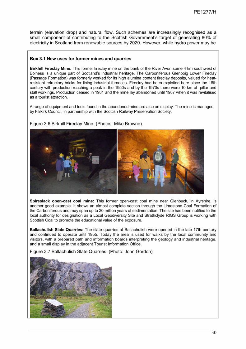
30
terrain (elevation drop) and natural flow. Such schemes are increasingly recognised as a small component of contributing to the Scottish Government’s target of generating 80% of electricity in Scotland from renewable sources by 2020. However, while hydro power may be
Box 3.1 New uses for former mines and quarries Birkhill Fireclay Mine: This former fireclay mine on the bank of the River Avon some 4 km southwest of Bo'ness is a unique part of Scotland’s industrial heritage. The Carboniferous Glenboig Lower Fireclay (Passage Formation) was formerly worked for its high alumina content fireclay deposits, valued for heat-resistant refractory bricks for lining industrial furnaces. Fireclay had been exploited here since the 18th century with production reaching a peak in the 1950s and by the 1970s there were 10 km of pillar and stall workings. Production ceased in 1981 and the mine lay abandoned until 1987 when it was revitalised as a tourist attraction. A range of equipment and tools found in the abandoned mine are also on display. The mine is managed by Falkirk Council, in partnership with the Scottish Railway Preservation Society.
Figure 3.6 Birkhill Fireclay Mine. (Photos: Mike Browne).
Spireslack open-cast coal mine: This former open-cast coal mine near Glenbuck, in Ayrshire, is another good example. It shows an almost complete section through the Limestone Coal Formation of the Carboniferous and may span up to 20 million years of sedimentation. The site has been notified to the local authority for designation as a Local Geodiversity Site and Strathclyde RIGS Group is working with Scottish Coal to promote the educational value of the exposure. Ballachulish Slate Quarries: The slate quarries at Ballachulish were opened in the late 17th century and continued to operate until 1955. Today the area is used for walks by the local community and visitors, with a prepared path and information boards interpreting the geology and industrial heritage, and a small display in the adjacent Tourist Information Office.
Figure 3.7 Ballachulish Slate Quarries. (Photo: John Gordon).
PE1277/H

31
considered low priority in terms of additional contribution to the target, in comparison with wind-generation schemes, nevertheless it is important economically for rural diversification and local energy security, with significant potential for local job creation (Scottish Government, 2009c; Forrest & Wallace, 2009). Although Scotland's marine resources have been exploited since the Mesolithic, it was not until the 1970s that the oil and gas industry attempted to extract energy from Scotland’s seas. More recently, a second energy revolution has occurred and exploitation of marine renewables is now one of the Scottish Government’s highest priorities. Currently (in 2010) there is 2.8GW of installed capacity, mainly from existing onshore wind farms and hydro schemes (via reservoirs). A further 3.8GW has already been consented and is in the process of being developed. Although onshore schemes may contribute a further 5.5GW, offshore schemes are likely to be even more important. In 2010 there are leases for 6GW of capacity for windfarms in territorial waters (up to 12 nm), with between 2-6GW expected further offshore (outwith 12 nm). The tidal rapids within the Pentland Firth alone are expected to generate 1.2GW through wave and tidal devices.
3.2.5 Ornamental resources
Another small but notable contribution is the supply of rocks, fossils and minerals that are commonly used as ornaments and for landscaping. Examples of the diversity of uses include the Hutton Memorial Garden at St. John's Hill in Edinburgh, granite worktops and slate floors in kitchens, rocks and river stones in gardens, Caithness flagstones which have been widely used as paving slabs, and slate, fossils, polished stones and minerals for household ornaments.
3.3. Regulating services The principal contributions of geodiversity in this category in Scotland are through climate regulation, water regulation, water purification and waste treatment, and the regulation of erosion and natural hazards. Other contributions to air quality regulation, disease and pest regulation are principally delivered indirectly through soil processes (cf. Aspinall et al. in prep.) and are not discussed further here. Of note in relation to regulating the distribution of pollinators is the value of exposures in soft sediments that provide nesting sites for burrowing bees and wasps (Whitehouse, 2007, 2008).
3.3.1 Climate regulation
At a global scale, climate is modulated by a range of natural processes and perturbations, including variations in the Earth’s orbital parameters, volcanic eruptions, plate tectonics and mountain building. Geological processes play a key part in the carbon cycle and regulation of greenhouse gases in the atmosphere. Regulation of carbon dioxide is affected by rock weathering and storage in sedimentary rocks and peat bogs. Variations in topography also affect climate at global to local scales. This is particularly applicable to Scotland where regional scale patterns in temperature and rainfall reflect the geographical variations in relief (e.g. McClatchey, 1996). At a smaller scale, the combination of relief, wind exposure, precipitation gradients and other climatic factors produce strong local changes in climate (e.g. between valley bottoms and mountain tops), which in turn is reflected in the diversity of hydrology, soils and habitats. Ecosystems also regulate climate through biogeochemical and biophysical effects (Smith et al., in prep.). Scotland’s organic soils play a major role as a terrestrial sink of carbon (Chapman et al., 2009) and can contribute to climate change mitigation and adaptation (Smith et al., in prep.; Bardgett et al., in prep.).
PE1277/H
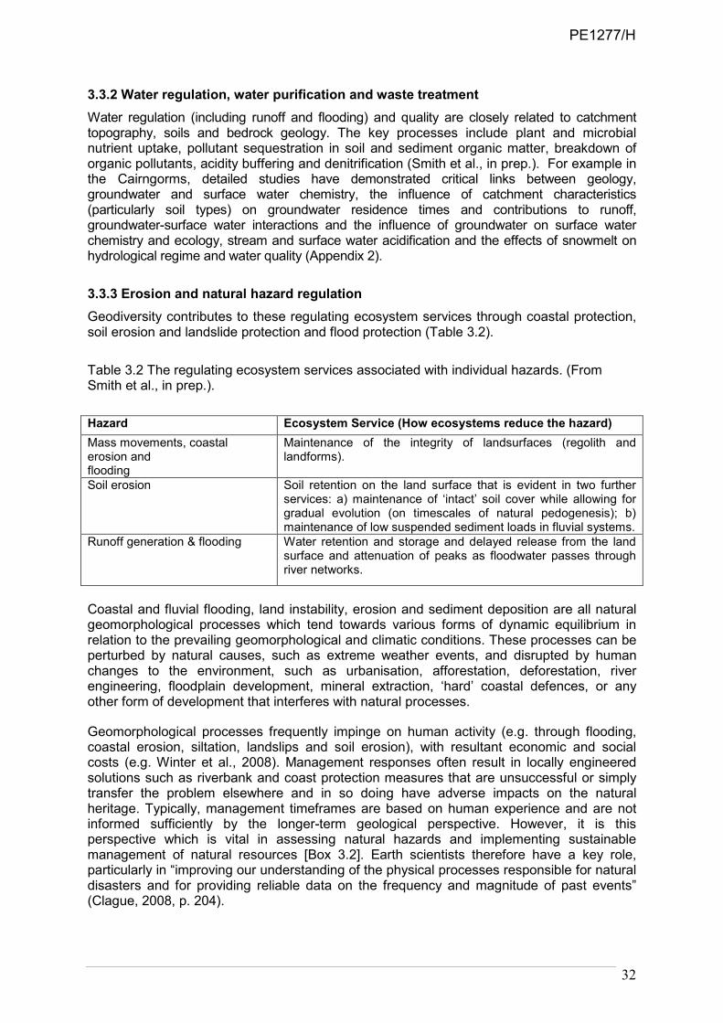
32
3.3.2 Water regulation, water purification and waste treatment
Water regulation (including runoff and flooding) and quality are closely related to catchment topography, soils and bedrock geology. The key processes include plant and microbial nutrient uptake, pollutant sequestration in soil and sediment organic matter, breakdown of organic pollutants, acidity buffering and denitrification (Smith et al., in prep.). For example in the Cairngorms, detailed studies have demonstrated critical links between geology, groundwater and surface water chemistry, the influence of catchment characteristics (particularly soil types) on groundwater residence times and contributions to runoff, groundwater-surface water interactions and the influence of groundwater on surface water chemistry and ecology, stream and surface water acidification and the effects of snowmelt on hydrological regime and water quality (Appendix 2).
3.3.3 Erosion and natural hazard regulation
Geodiversity contributes to these regulating ecosystem services through coastal protection, soil erosion and landslide protection and flood protection (Table 3.2).
Table 3.2 The regulating ecosystem services associated with individual hazards. (From Smith et al., in prep.).
Hazard Ecosystem Service (How ecosystems reduce the hazard)
Mass movements, coastal erosion and flooding
Maintenance of the integrity of landsurfaces (regolith and landforms).
Soil erosion Soil retention on the land surface that is evident in two further services: a) maintenance of ‘intact’ soil cover while allowing for gradual evolution (on timescales of natural pedogenesis); b) maintenance of low suspended sediment loads in fluvial systems.
Runoff generation & flooding
Water retention and storage and delayed release from the land surface and attenuation of peaks as floodwater passes through river networks.
Coastal and fluvial flooding, land instability, erosion and sediment deposition are all natural geomorphological processes which tend towards various forms of dynamic equilibrium in relation to the prevailing geomorphological and climatic conditions. These processes can be perturbed by natural causes, such as extreme weather events, and disrupted by human changes to the environment, such as urbanisation, afforestation, deforestation, river engineering, floodplain development, mineral extraction, ‘hard’ coastal defences, or any other form of development that interferes with natural processes.
Geomorphological processes frequently impinge on human activity (e.g. through flooding, coastal erosion, siltation, landslips and soil erosion), with resultant economic and social costs (e.g. Winter et al., 2008). Management responses often result in locally engineered solutions such as riverbank and coast protection measures that are unsuccessful or simply transfer the problem elsewhere and in so doing have adverse impacts on the natural heritage. Typically, management timeframes are based on human experience and are not informed sufficiently by the longer-term geological perspective. However, it is this perspective which is vital in assessing natural hazards and implementing sustainable management of natural resources [Box 3.2]. Earth scientists therefore have a key role, particularly in “improving our understanding of the physical processes responsible for natural disasters and for providing reliable data on the frequency and magnitude of past events” (Clague, 2008, p. 204).
PE1277/H

33
BOX 3.2 Enhancing our knowledge of geodiversity to mitigate hazards Recently BGS has developed attributed 3D subsurface Quaternary geomorphology and bedrock models of Glasgow and its surrounding area to enhance the understanding of geological and hydrogeological processes (Figure 3.8). Designed to assist planners and engineers to develop strategies for mitigating pollution, controlling flooding and providing the geological basis for regeneration, the model will also aid the identification and management of geodiversity conservation sites.
Figure 3.8 Glasgow’s subsurface Quaternary. (Reproduced with the permission of the British Geological Survey ©NERC. All rights Reserved).
This attributed 3D engineering geology model of the superficial deposits of the Clyde Valley through the eastern part of Glasgow was constructed with modelling software interrogating thousands of borehole records and field data (Entwistle et al., 2008). Draped on a digital terrain model, it aims to provide developers and planners with better understanding of near-surface ground conditions, physical and lithological properties of sediments, groundwater flow pathways and surface drainage. Models such as these can also assist in identifying ground which is prone to flooding and, when linked to spatial datasets of buildings, monuments and key geodiversity exposure sites, may prove valuable in planning the safeguard of these features.
Sustainable solutions involve working with natural processes (e.g. sustainable flood management for rivers under the Flood Risk Management (Scotland) Act 2009 and managed realignment at the coast) and depend on the effective application of earth science knowledge as part of the development of more integrated approaches, such as the maintenance of sediment transport at the coast or natural flow regimes in rivers. This
PE1277/H

34
emphasis on natural approaches and non-structural measures was highlighted in the recommendations of the Millennium Ecosystem Assessment report on Policy Responses Assessment (Mirza et al., 2005) and is well exemplified in shoreline management plans and integrated river catchment management. For example, only a small proportion (2%) of Scotland's coast is artificially defended (Figure 3.9) (EUrosion, 2004). This emphasises the important role the natural coast has as a form of coastal defence. Although the hard coast is likely to remain resilient to accelerations in sea-level rise, the soft coast is likely to be more dynamic. Land uses behind these soft coasts are more vulnerable to rises in sea level. The internal reorganisation of sediment within coastal cells is critical to the health of the soft coast. Any intervention which locks-up or restricts sediment movement is likely to propagate erosion on down-drift sections of coast. Good sediment husbandry informed by coastal sediment budgets is therefore key to managing these dynamic landforms (Orford & Pethick, 2006). Understanding the natural evolution and dynamics of our coastline will become ever more important in the future, as the significant costs and limited life expectancy of traditional coastal defence will increasingly mean that landowners look towards adaptation as the sustainable approach to managing and avoiding the impacts of sea-level rise in many coastal locations (Cooper & McKenna, 2008).
Figure 3.9 The nature of the Scottish coastline (Source: EUrosion, 2004).
3.4. Cultural services The diversity of rocks and landforms is the basis for most of Scotland’s landscapes and scenery that are highly valued by visitors and the tourism industry. It has been a source of inspiration for art, sculpture, music and literature and also provides a resource for a variety of recreation and leisure activities. Even within Scotland’s cities, there are close links between urban landscapes, architectural heritage and geology. Scotland’s geodiversity is therefore an asset to society, creating the basis for our scenery and aspects of our culture, and it has the potential to contribute increasingly to economic development, for example through tourism-based activities providing a vehicle for more integrated interpretation, linking geology, landscape and human activities. Although such activities are usually linked with sustainable rural development, urban geodiversity also offers exciting opportunities for raising public awareness, for example through exploration and re-establishing of the links between geology, use of building and paving stones and architectural heritage and industrial archaeology. Geodiversity is also closely linked with many aspects of the cultural landscape (e.g. Geikie, 1905; Carter & Badman, 1994; Stanley, 2004; Gordon, 2009; Gordon, submitted; Gordon & Kirkbride 2009a, 2009b). As noted by modern writers such as Neal Ascherson (2003), James Hunter (1995, 2006), Alastair McIntosh (2001) and Kenneth White (1998), people in
PE1277/H

35
Scotland have a deep spiritual attachment to the landscape, hence “so much of what we call Highland culture – poems, songs, stories, novels, visual art – consists of celebrating, by one means or another, our physical surroundings” (Hunter, 2006, p.8). The creative influence of geodiversity through literature, poetry and art demonstrates the strong level of cultural engagement with landscape and the deep connections between people and the natural world, highlighting the continuity between the present and the past, and helping to link people today with their cultural roots and to provide a sense of place. Geodiversity relates to cultural services in Scotland in many ways (Table 3.1). The principal contributions of geodiversity in this category are through cultural diversity, educational values, inspiration, aesthetic values, sense of place, cultural heritage, and recreation and ecotourism. In addition, geodiversity contributes significantly to landscape character. As many of these contributions are interlinked, they are considered under 5 main headings. 3.4.1 Educational values
The educational values of geodiversity are reviewed in Chapter 2.
3.4.2 Cultural diversity, inspiration and aesthetic values
3.4.2.1 Literary landscapes
Landscapes and their geological features have been a powerful source of inspiration for literature and poetry in Scotland, notably in the novels of Sir Walter Scott, Robert Louis Stevenson, Lewis Grassic Gibbon, George Mackay Brown, Neil Gunn and others and in the poetry of Norman MacCaig, Sorley MacLean and Hugh MacDiarmid. For Gibbon, people are an integral part of the landscape, living and working on the “coarse” land on the “long, stiff slopes of dour clay”- the red, stony soils on the Old Red Sandstone glacial till in NE Scotland (Gibbon, 1932). In contrast, Nan Shepherd (1977, p. 93) expresses a more aesthetic appreciation of the energies and forces that have shaped the granite massif of the Cairngorm Mountains, highlighting the integrity between the geological past and the present landscape, and between the natural processes and the plants and animals: “So there I lie on the plateau, under me the central core of fire from which was thrust this grumbling grinding mass of plutonic rock, over me blue air, and between me the fire of the rock and the fire of the sun, scree, soil and water, moss, grass, flower and tree, insect, bird and beast, wind, rain and snow - the total mountain.” Gaelic poetry traditionally has a strong affinity with the natural world, historically exemplified in the work of Duncan Ban MacIntyre and the Ossianic poetry of James Macpherson (Hunter, 1995). In more modern work, Norman MacCaig and Sorley MacLean both used geology and landscape to express their feelings about the history of human suffering in the Highlands and Islands and as a means to reflect on the wider human condition. Such literary sources reveal a deep human affinity with the landscape. MacCaig was strongly influenced by the stark beauty of the landscapes of NW Scotland, shaped by the rocks and the glaciers. For MacLean (1999) in his epic poem, An Cuilitheann/The Cuillin, the mountains become a symbol for human oppression throughout the world. But in the end, the human spirit breaks through the dark despair. The importance of the links between human beings and the natural world is also emphasised in the field of geopoetics, which offers a means of reconnecting with the Earth, including its geological foundations. Developed by the Scottish poet and writer, Kenneth White, geopoetics reflects a need for radical cultural renewal arising from our loss of connection with the landscape (White, 1998; McManus, 2007). Alastair McIntosh (2001) echoes a similar view, arguing passionately for a grounding that connects the land, community and the human spirit.
PE1277/H

36
3.4.2.2 Landscape art
There is a strong tradition of landscape art in Scotland. The radical change in perception of wild landscapes, from inhospitable places to be avoided, to awe-inspiring places to be experienced, was encouraged by the romantic painters of the late 18th and early 19th centuries, such as John Knox, Horatio McCulloch, Alexander Nasmyth and the English painters, Edwin Landseer and William Turner (Holloway & Errington, 1978). Many of their landscapes show wild, unspoiled scenery with bleak, towering mountains and native wildlife, creating a sublime vision of Scotland still popular with visitors today. Turner’s work was brought to a wider audience through his links with Sir Walter Scott. His depictions of light, cloud and atmospheric skies highlighted the natural grandeur that other artists and poets of the time were also expressing. This is well illustrated by his images of Loch Coruisk, Glen Coe and Staffa. However, Turner also had a keen eye for geological details and their realistic representation (Ruskin, 1846). This popularising of interest in wild landscapes and natural features helped drive the early development of tourism in Scotland (see below). The creative influence of geodiversity is also continued in more modern landscape art, for example, in the associations of the Scottish Colourists with the landscapes of the West Coast, and particularly Iona, Joan Eardley with the Kincardineshire coast at Catterline and John Lowrie Morrison with the Hebrides. A strong sense of connection with nature, geology and the landscape is also central to the modern genre of land art (Tufnell, 2006). Although it often has a strong basis in locating sculpture in the landscape (e.g. Goldsworthy, 1994), it goes further in emphasising the connectedness of the installations with the landscape and wider cultural influences. This is particularly well illustrated in the work of Andy Goldsworthy and Matt Baker (Bielinski, 2010; Coombey & McArthur, 2010). It includes the American earthworks tradition (e.g. Charles Jencks’ ‘Landform’ in the entrance grounds of the Scottish National Gallery of Modern Art in Edinburgh). In 2005, a production by nva, ‘The Storr: the unfolding landscape’ brought together the interaction of music, poetry and light against the remarkable backdrop of the cliffs and weird pinnacles of the Storr landslide in Skye (Farquhar, 2005).
3.4.3 Sense of place and cultural heritage: geodiversity and the built landscape
Historically, geodiversity has been an integral factor in human activity in Scotland, influencing land use, sites for settlements and sources of water and building stone, and imposing constraints on vernacular architectural style, which has evolved as technology and innovation have enabled greater diversity of expression through use of natural materials. The use of stone for monuments and buildings, in particular, is one of the clearest expressions of the links between geology and cultural landscapes, both in the countryside and in the city (Naismith, 1985; Edwards & Ralston, 2003; McMillan et al., 1999; Wilson, 2005; Hyslop et al., 2006). Many parts of Scotland, notably Orkney, the Outer and Inner Hebrides, Argyll and NE Scotland, all have remarkable archaeological records in the form of Neolithic and later stone monuments, burial sites and historic settlements that demonstrate these evolving links and the inter-connections between people, place and geological landscapes through time (e.g. Edwards & Ralston, 2003; Farquhar et al., 2007). The modern urban landscape is also an intimate blend of geodiversity and cultural influences. In some cases, such as Edinburgh and Stirling, the dominant features of the physical landscape are shaped by the legacy of volcanic rocks and the effects of Ice Age glaciation; in others, the influence is more subtle but nevertheless apparent, for example in the hilly, drumlin landscape of Glasgow. Geology is also closely woven through the built fabric and history of architectural fashions in many towns and cities, as well as in rural areas, notably in the types of stone used for buildings and paving. For example, in Edinburgh, Craigleith Quarry was one of the principal sources of building stone during the 18th and 19th
PE1277/H

37
centuries and its sandstone features prominently in the buildings of the New Town (McMillan et al., 1999). More recent building works have involved the use of stone from further afield in Scotland, notably the extension to the National Museum of Scotland (Clashach sandstone from Morayshire) and the Scottish Parliament (Kemnay granite from Aberdeenshire and Caithness flags), adding to the urban geodiversity. The sense of place derived from the underlying landscape form, vernacular and modern architectural styles and building materials, especially stone, is also relevant for the modern built environment. Such influences can help connect the built and natural heritage in people’s minds (MacFadyen & McMillan, 2004). Natural stone is the principal construction material of the pre-1919 building stock. Traditionally, locally sourced stone was used so that the varied geology of the country has had a profound influence on the nation’s built heritage (Appendix 3). This remains as one of the most obvious expressions of the geodiversity, with changing materials and architectural styles in different parts of the country, in buildings and monuments still used and appreciated by the majority of the population and visitors. In a country often referred to a ‘land of stone’ the geodiversity as seen in the built heritage forms a part of the nation’s cultural identity. Stone has been used for a wide variety of construction and decorative purposes, including strategically important medieval defences (e.g. castles, towers, walls) and simple dwellings and farms. From the 16th century onwards there was a growing requirement for stone to supply villages, towns and cities. The demand for stone reached a peak during the 19th century with the expansion of Scottish cities and their extensive tenement developments, and the requirement for stone for industrial buildings and the growing transport infrastructure. Stone was supplied for bridges, harbours and lighthouse construction. At the same time, Scottish stone, particularly granite and flagstone, was exported to the continent, the eastern seaboard of America and beyond. At the height of its production in the middle of the 19th century, stone was supplied from over 700 quarries across Scotland. From the end of the 19th century, improvements in transport and increasing architectural requirements encouraged the importation of stone from larger mechanised quarries, and especially sandstone from the north of England. From this time, the indigenous stone industry underwent a rapid decline as cheaper manufactured materials, including brick and concrete, supplanted the use of stone. The wholesale demolition of historic properties in Scottish cities during the 1960s stimulated a vigorous conservation response from the public and over the following decades planning requirements to maintain the local character of cities, towns and villages created a demand for more local stone. Initially this demand was satisfied by recovery from demolition, but as the requirement for repair and conservation has increased, there has been a need for renewed supplies. In recent decades there has been an increased interest in indigenous stone, partly as a growing awareness of the importance of issues such as ‘sense of place’ and ‘local distinctiveness’, and also an increasing appreciation of natural stone as a modern architectural material. Many new buildings are using stone to create a sense of belonging to a place and stone is perceived as adding a sense of prestige. This has been reflected in a resurgence in several parts of the industry in Scotland, and a growing awareness of the importance of stone to the nation’s cultural identity. In terms of the stone-built heritage of Scotland, the geological diversity has resulted not only in a diversity of materials, but also of architectural style. The fundamental geological properties of a particular rock type in an area determine how that material can be shaped and used, so that different rock types have been put to different uses. The earliest builders simply used the materials at hand; typically from whatever stone type could be found locally. Field or river boulders were used whole or roughly split, or crudely extracted from local exposures and used as random rubble walling. In areas where the stone was not particularly resilient or was difficult to shape, the buildings were commonly lime harled. Larger pieces of
PE1277/H

38
stone to provide spans for window and door surrounds (e.g. sills and lintels) were often quarried and transported over longer distances. This tradition lasted for centuries in almost every part of Scotland, whereby stone buildings consist of a combination of local stone in walling with better quality stone dressings. Only with the urban expansion during the 19th century did significant numbers of larger scale quarries start producing large quantities of high quality dimension stone for ashlar block. Over time, the growing industrial and commercial wealth of the nation was reflected in the prestigious buildings and monuments, culminating in the spectacular Victorian architecture that makes cities such as Glasgow unique in terms of their architectural legacy (Figure 3.10).
Figure 3.10 Buchannan Street, Glasgow, one of the great northern European sandstone cities, with a mixture of local ‘blonde’ Carboniferous sandstone and red Permo-Triassic sandstones imported from southwest Scotland. (Reproduced with the permission of the British Geological Survey ©NERC. All rights Reserved).
3.4.4 Recreation and ecotourism
Rocks and landforms are the basis for most of Scotland’s famous landscapes and scenery and they also represent an asset for a variety of recreation and leisure activities. Visitors to Scotland rank scenery as the main attraction of Scotland as a tourist destination, ahead of history and culture (VisitScotland & Scottish Natural Heritage, 2002). The country’s economy benefits by £17.2 billion a year from sustainable use of the natural environment (RPA & Cambridge Econometrics, 2008). The environment also supports 242,000 jobs, or 14% of all full-time jobs in Scotland. However, the Scottish environment is much more than an asset for tourism-based activities. It provides opportunities for development of new technologies such as renewable energy, as well as an attractive environment in which to live and do business. For example, the study shows that 20% of our industries depend to a large extent on the environment, including not only agriculture, fishing and forestry, but also food and drink production, water supplies, renewable energy, tourism, timber processing and recreation. The report also shows that 66% of existing businesses benefit from the environment.
In 2007, almost 16 million tourists took overnight trips to Scotland. Their annual spend was over £4.2 billion, supporting over 9% of all jobs in Scotland. People from overseas made up 18% of tourism trips to Scotland, or about £1.4bn in 2007 (Dear, 2009). Results of
PE1277/H
39
VisitScotland’s Visitor Experience Survey12 show that the scenery and nature are the main reasons that visitors choose to holiday in Scotland and that Scotland is ranked the top European eco-destination and ninth in the world, with wildlife tourism generating around £210 million for the Scottish economy in 2006 (Dear, 2009). The natural heritage, along with cultural heritage, is a key theme in VisitScotland marketing initiatives (Dear, 2009).
3.4.4.1 Geodiversity and tourism
Geotourism is a growing component of the tourism industry, both globally and in Scotland, as recognised by the activities of local communities to develop geoparks and to provide interpretation of local geological landscapes and landmarks (e.g. Dowling & Newsome, 2006, 2010; McKeever, et al., 2006; Hose, 2008; Neto de Carvalho & Rodrigues, 2009; Newsome & Dowling, 2010). In Scotland, a notable success has been the level of collaboration and partnerships between organisations, for example in the delivery of the Scottish Geology Festival programme. There is now a strong momentum across a range of organisations in Scotland to promote geodiversity and develop new initiatives. At a strategic level, one such initiative would be development of the networking concept (e.g. McKirdy et al., 2001), using national gateways both real (e.g. Our Dynamic Earth and the museums) and virtual (e.g. the scottishgeology.com website) linked to a network of regional hubs (e.g. Knockan Crag, Skye, Arran and Glen Coe) each with its own satellite sites. Where appropriate, such hubs could integrate with existing visitor facilities and the National Parks and Geoparks. They could offer important opportunities for more holistic interpretation linking rocks, landforms, soils, habitats, biodiversity, land use, environmental resources and human activity. Involvement with the tourism industry at a strategic level will be crucial, as indicated by the success of the ‘Landscapes from Stone’ programme in Ireland (McKeever and Gallacher, 2001). The geology of Scotland’s built landscapes should also play a significantly greater role in helping to raise earth heritage awareness. Geoparks (see Chapter 6) can also provide opportunities for local people to use the resource of their landscapes and their geological stories in creative ways of interpreting geological heritage, without always adopting the well-trodden path of the didactic “let’s teach you something about this place” approach. The most significant element is the fact that Geopark status is something local people want for their own areas. There are opportunities for development of geotourism-based activities (cf. Neto de Carvalho & Rodrigues, 2009), but fundamentally they rely on community engagement and support. From a geological heritage perspective, this is a particularly positive sign that people are interested in and care about their landscapes. Through the Geoparks initiative, geodiversity may be viewed as a catalyst, or ‘vital spark’, to promote better integration of Earth heritage, landscape history, archaeology and local culture in a framework that also supports sustainable economic development, particularly in remote areas. The 2007 European Geoparks Conference, held in Ullapool in the North West Highlands Geopark, provided an opportunity to explore and develop these links (Morrison & MacPhail, 2009). This was reflected in the overall conference theme of ‘Landscapes and People: Earth Heritage, Culture and Economy’ and the corresponding sub-themes - ‘geology, culture and environment’, ‘geoparks and economy’, ‘sustainable tourism’, and ‘geology and natural heritage’. Geotourism is not a recent phenomenon and the development of tourism in Scotland in the mid-18th century was closely linked to the landscape, its geological features and how these were portrayed in contemporary literature and art (Smout, 1982) when ideas of sublime and picturesque landscapes were popularised through contemporary literature and art (Gordon, submitted). The publication of Macpherson’s Ossianic poetry in the 1760s began a period of fascination with the Highlands. Visitors wanted to see and be awed by places described in the accounts of travellers, including those of Pennant, Johnson and Boswell and the
12 http://www.visitscotland.org/pdf/visitor_experience-scotland-2008.pdf
PE1277/H

40
Wordsworths, with their illustrations of geological wonders such as Fingal’s Cave and Loch Coruisk. Such landscapes inevitably had strong geological connections as ‘wonders of nature’, and places such as the Falls of Clyde, Loch Lomond, The Trossachs, Staffa and Loch Coruisk became essential Romantic tourist destinations. Contemporary landscape painters, including Paul Sandby, Horatio McCulloch, John Knox, Alexander Nasmyth, Edwin Landseer and JMW Turner, reinforced romantic notions of untamed wilderness, depicting wild, unspoiled scenery and mountains (Holloway & Errington, 1978; Campbell, 1993). Sir Walter Scott, in particular, played a key role in bringing the attractions of the Scottish landscape to a wider audience through popular literature in the early 19th century and inspiring the idea of the Scottish romantic tour. In his poetry and novels, the Highlands became a place of romance and adventure. Scott’s volumes of poetry and prose were accompanied by engravings by Turner that closely reflected the mood of his writing. Later in the 19th century, Thomas Cook began organising what were arguably geology-based tours to Scotland with itineraries that included ‘picturesque’ locations such as The Trossachs, Loch Lomond, Loch Katrine and steamboat trips to Staffa and Iona. During Victorian times, as many as 300 passengers a day landed on Staffa from paddle steamers, following the travels of Scott, Turner, Keats, the Wordsworths, Mendelssohn and Queen Victoria. There is a strong tradition of geoheritage interpretation in Scotland based on ’reading the landscape’ (Gordon et al., 2004), with numerous booklets, leaflets, explanatory boards produced by government agencies, Local Geodiversity Groups and others (cf. Gordon & Kirkbride, 2009a). However, the close links between geodiversity, landscape, archaeology, history, culture and tourism provide new opportunities for interpreting Scotland’s Earth heritage, complementing more traditional didactic, ‘geological evangelism’ approaches (Gordon & Kirkbride 2009a, b). For example, some of these cultural and landscape elements were brought together in the visitor attraction at Knockan Crag National Nature Reserve, in one of the classic areas of Scottish geology and now within the North West Highlands Geopark (Scottish Natural Heritage, 2002). They add to the visitor experience and encourage people with little previous knowledge of geology to experience rocks and landscape in different ways. The interpretation includes rock art, sculptures, and quotations and poetry inscribed in rock along waymarked trails. Similarly, to enhance visitor appreciation in the Galloway Hills and at Cairnsmore NNR, art by Sylvana McLean, sculpture by Matt Baker and poetry by Mary Smith have been combined with the stories and memories of the people who lived and worked in the area (McLean & Smith, 2008; Bielinski 2010). Such approaches “open new doors” for people to connect with geology through different forms of personal experience.
3.4.4.2 Recreation, health and well-being
Scotland’s natural heritage makes an important contribution to people’s physical and mental health and well-being. This can be delivered through participation in outdoor recreation, volunteering and outdoor learning, and support for the provision of local greenspace, path networks and attractive landscapes (Scottish Natural Heritage, 2009a). Regular exercise in the form of walking is an excellent way to improve health and to explore geology and landscape (Stinton, 2009). There are many opportunities for walking through existing geotrails (e.g. British Geological Survey, 2004; Scottish Natural Heritage, 2004) and through visits to Local Geodiversity sites13 and Geoparks14. There is also significant potential for
13 For example, see the leaflets produced by Scottish RIGS Groups -
http://www.scottishgeology.com/findoutmore/rigs_in_scotland/L&Binterpretive_lflts.html 14 For example, see the Geotrails leaflets produced by Lochaber Geopark -
http://www.lochabergeopark.org.uk/pages/Geotrails.asp
PE1277/H

41
integrating geology into existing long and short distance trails and into the many walking festivals now taking place annually in Scotland and during the Scottish Geology Festival. The extension of existing mega trails such as the International Appalachian Trail to Scotland and other European countries is encouraging15 [Box 3.4] (Figure 3.10), in terms promoting Scotland as a walking destination based on its geological heritage and landscapes. In addition, there are opportunities to promote BTCV (formerly British Trust for Conservation Volunteers) Green Gym volunteering both for people’s fitness and improvement of the geodiversity assets by site works such as path making and clearance of low biodiversity value vegetation. There are also new opportunities to integrate geodiversity within the Central Scotland Green Network (CSGN)16 that forms part of the Scottish Government’s Second National Planning Framework published in July 200917. This is one of 14 National Developments considered to be essential elements of the strategy for Scotland's long-term development. The CSGN aims to build on the work of a number of existing regional and local initiatives to improve the environmental quality in an area stretching from Ayrshire and Inverclyde in the west to East Lothian and Fife in the east. This will make the post-industrial landscape a more attractive place in which to live, visit and do business. It reflects a growing recognition by Government, public agencies and local authorities of the contribution that high-quality greenspace can make to a range of outcomes - from supporting sustainable economic growth and improving quality of life, to protecting biodiversity and helping Scotland mitigate and adapt to climate change. Local Geodiversity Sites and activities undertaken by local geodiversity groups clearly have a part to play in this process.
3.4.5 Landscape character
From the agricultural heartlands of the eastern coastal lowlands to the remote mountains of Wester Ross, Scotland has a great variety of landscapes underpinned by its geodiversity. This variety results from the interaction over different timescales of both natural and human influences on the land. Landscape is about the relationship between people and place. It provides the setting for our day-to-day lives. It results from the way that different components of our environment - both natural (geology, soils, climate, flora and fauna) and cultural (the historical and current impact of land use, settlement, enclosure and other human interventions) - interact together and are perceived by us. People's perceptions turn land into the concept of landscape. Landscape character is the pattern that arises from particular combinations of the different components (Swanwick & Land Use Consultants, 2002, para 7.8). For example, at a macro-scale, the character of the landscape of the North West Highlands reflects the underlying geology, perhaps more strikingly than in any other part of Scotland. This is clearly seen in the present landscape expression of the main geological elements - Lewisian plateau surfaces, Torridonian Sandstone mountains and the Moine Thrust Zone. The action of geological and geomorphological processes over long timescales, involving large-scale earth movements, weathering and erosion has emphasised the lines of geological weakness, giving a strong ‘grain’ to the landscape, seen for example in the orientation of the main sea lochs and the fjord-like coast. Weathering and erosion have also acted on the bedrock to shape the distinctive character of individual mountains. Successive Quaternary glaciations and post-glacial processes, including the formation of extensive peat
15 http://www.bgs.ac.uk/research/highlights/scotlandInIAT.html
16 http://www.centralscotlandgreennetwork.org/
17 http://www.scotland.gov.uk/Resource/Doc/278232/0083591.pdf
PE1277/H

42
BOX 3.4 Extending the International Appalachian Trail to Scotland On 5 June 2010, at the opening of the Appalachian Trail Museum in Pennsylvania, International Appalachian Trail (IAT) President Paul Wylezol, Appalachian Trail Conservancy Executive Director Dave Startzell and Pennsylvania Secretary of Conservation and Natural Resources John Quigley officially welcomed Scotland and the West Highland Way (WHW) as the first European Chapter of the IAT (Figure 3.11).
Figure 3.11 The extension of the Appalachian Trail to Scotland. (Photo: Paul Wylezol, IAT).
This official welcome came nearly a year to the day after the British Geological Survey (BGS) invited an IAT delegation from Maine and Newfoundland to visit Scotland. The visit was the first step in fulfilling an IAT vision to extend the existing 1350 miles of IAT trails in the USA and Canada with trails in Greenland, Scotland and other countries on the western seaboard of Europe and on through to Morocco. As well as cultural links, Scotland shares an older geological heritage with this region, having once been close neighbours on ancient continents, shared in the building of the Caledonian – Appalachian mountain chain, and only (geologically) recently separated by the opening of the North Atlantic Ocean. The opening of the Atlantic Ocean separated the Appalachians from Scotland, but extending the IAT to Scotland restores some of these ancient links by celebrating our common geological heritage through long-distance walking routes. The WHW is only the beginning in Scotland – the Ayrshire Coastal Path, Loch Ryan Coastal Path and the Cape Wrath Trail (CWT) joined IAT Scotland in October 2010
18, and trails in Shetland are likely to become part of the network in 2011. This could
provide valuable tourism interest from the North American market. The WHW and the CWT would also link the Lochaber and North West Highlands Geoparks.
Linking-up with the renowned Appalachian Trail brand provides opportunities for friendly ties between Scotland and North America and will help renew and expand cultural links. IAT trails help expand local adventure tourism industries, and, in particular, to create employment and business opportunities in rural areas, including accommodation, transportation, guiding and interpretation, and retail sales, including local arts and crafts. The existing North American IAT stretches from the northern terminus of the Appalachian Trail at Mount Katahdin in the state of Maine to the Canadian provinces of New Brunswick, Quebec, Prince Edward Island, Nova Scotia and Newfoundland/ Labrador. It connects two countries, five provinces, one state, and the English, French and Celtic cultures of North America.
18 http://www.iatnl.ca/index.php/news/60/26/IAT-Welcomes-9-New-European-Chapters/
PE1277/H

43
bogs, have left an equally distinctive imprint. All these patterns are well-illustrated on a geomorphological map of the area which shows a great diversity of landform types (Kirkbride et al., 2001). There are also many close links between geology and biodiversity, expressed for example in the range of habitats present (a complex of wet heath, blanket mire and open water bodies on the ice-scoured Lewisian plateaux, grass and moss heaths on the drier Torridonian mountains and calcareous plant communities on the Durness Limestone). The human element in the landscape here is a relatively recent one, predominantly in the last 5000 years, but the impact on landscape character has been significant, especially in terms of patterns of landuse and settlement. This is evident when examining, for instance, the successive extent and patterns of past woodland clearance, plantation forestry and native woodland regeneration. North West Scotland therefore illustrates many fundamental interdependencies, both direct and indirect, between geodiversity, human activity and the landscape of today. The closer integration of information about geology and geomorphology into the landscape character assessment process would help to develop a more holistic approach. In particular, this information should help to inform both the categorisation process and the analysis and explanation of individual character types. The Cairngorm National Park Authority have recognised the importance of this closer integration and recently commissioned a new Landscape Character Assessment of the Park in which geology and geomorphology played a fundamental part [Box 3.5].
BOX 3.5 Cairngorms National Park Landscape Character Assessment In June 2009, the Cairngorms National Park Authority (CNPA) commissioned a Landscape Character Assessment (LCA) in partnership with the British Geological Survey (BGS).
The aims of this LCA were to:
• produce an accurate and detailed description of the landscape types (LCTs) and areas (LCAs) within the Cairngorms National Park (CNP) that encompass the many formative influences upon that landscape;
• make the description clear and understandable to a wide range of users; and
• be able to utilise the Landscape Character Assessment (LCA) as a fundamental building block for all policy and activity of the CNPA and its partners in delivering the four aims of the National Park.
The CNPA commissioned landscape consultants to prepare the LCA and requested that they work closely with BGS to evaluate how BGS geological and geomorphological information could be incorporated usefully within the LCA. The CNPA also wished the consultants to utilise the Historic Landuse Assessment (HLA) from The Royal Commission on the Ancient and Historical Monuments of Scotland (RCAHMS) within the LCA. The project was managed by the CNPA and overseen by a steering group with members drawn from CNPA (Chair), Aberdeenshire Council, Angus Council, BGS, Forestry Commission Scotland (FCS), Highland Council, John Muir Trust and RCAHMS. To enable the landscape consultants to use geological and geomorphological information to underpin their assessment and description of landscape character areas, BGS provided bespoke bedrock (Figure 3.12) and superficial deposits/geomorphological (Figure 3.13) ‘character’ maps of the CNP. To show these in relation to the topography, these were draped over hill-shaded Digital Surface Models (DSMs) derived from NEXTMap Britain elevation data from Intermap Technologies and plotted at 1:50 000 scale. Descriptions were added to the maps. These were using during steering group field meetings to aid discussion of landscape character area boundaries.
PE1277/H

44
Figure 3.12 Cairngorms National Park bedrock character. (Reproduced with the permission of the British Geological Survey ©NERC. All rights Reserved).
Figure 3.13 Cairngorms National Park superficial deposits and geomorphology. (Reproduced with the permission of the British Geological Survey ©NERC. All rights Reserved).
PE1277/H

45
3.5. Supporting services The principal contributions of geodiversity in this category in Scotland are through the broad area of habitat support, including the specific services of soil formation, biogeochemical (nutrient) cycling and water cycling. In addition, geodiversity knowledge underpins many aspects of ecosystem services, including provision of supporting knowledge and understanding of past climates, palaeoenvironments and trends in environmental conditions over different timescales.
3.5.1 Habitat support
Geodiversity has a fundamental role in supporting habitats, species and landscape character, and in providing essential ecosystem and environmental services. Scotland’s rocks landforms and soils form the foundations upon which plants, animals and human beings live and interact. Geodiversity is the foundation of all terrestrial ecosystems and delivers key biogeochemical processes, mass and energy flows and exchanges with atmospheric and hydrological systems (Figure 3.14). The geomorphological processes that shape our mountains, rivers and coasts also maintain dynamic habitats and ecosystems. Scotland’s biodiversity depends on the continued operation of these processes. Management of sites for biodiversity therefore requires an understanding of their geological and geomorphological setting and current process dynamics. Many habitats owe their origins to geological and geomorphological processes (e.g. coastal sand dune/machair systems, the estuaries and salt marshes which provide the wintering sites for internationally important goose populations, and limestone pavements) (cf. Cottle, 2004). Active geomorphological processes also maintain dynamic habitats and ecosystems through sediment and water flows, nutrient cycling and hydrology. Maintaining natural process systems is a key part of conserving biodiversity as well as maintaining the natural landscape. Scotland’s biodiversity (and the services it provides) depend on the continued operation of these processes. In the past, this functional role has tended to be overlooked in conservation management. However, it is increasingly recognised that conservation management of the non-living parts of the natural world is crucial for sustaining living species and habitats (Hopkins et al., 2007). From a natural heritage viewpoint, therefore, this requires more integrated approaches to nature conservation and the management of sites and landscapes, recognising: i) the value of geodiversity as an intrinsic constituent of the natural heritage alongside other aspects of biodiversity and landscape character; and ii) the role of geodiversity in supporting and regulating a wide range of environmental and ecological services essential for supporting habitats and species. Geodiversity should be valued at least as much for the latter as for the former.
Figure 3.14 Outline of the links between geodiversity and biodiversity. The arrows represent process linkages, including fluxes of sediment and water. (Source: Scottish Natural Heritage).
PE1277/H
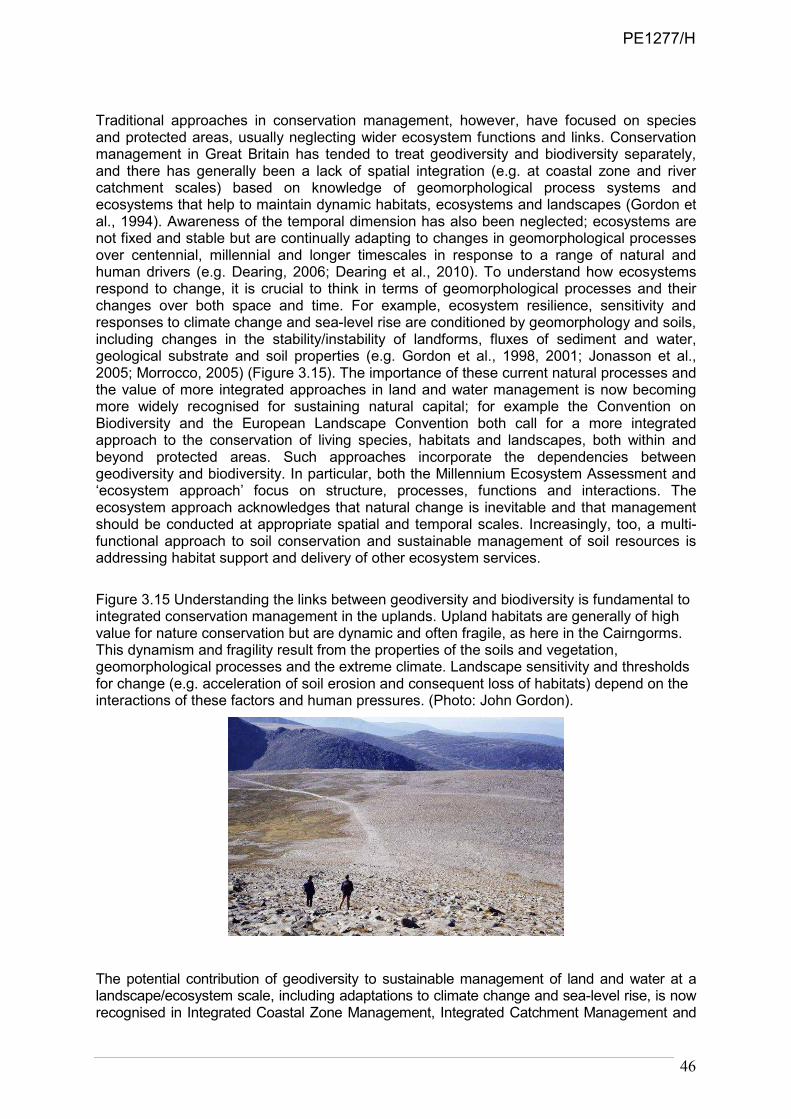
46
Traditional approaches in conservation management, however, have focused on species and protected areas, usually neglecting wider ecosystem functions and links. Conservation management in Great Britain has tended to treat geodiversity and biodiversity separately, and there has generally been a lack of spatial integration (e.g. at coastal zone and river catchment scales) based on knowledge of geomorphological process systems and ecosystems that help to maintain dynamic habitats, ecosystems and landscapes (Gordon et al., 1994). Awareness of the temporal dimension has also been neglected; ecosystems are not fixed and stable but are continually adapting to changes in geomorphological processes over centennial, millennial and longer timescales in response to a range of natural and human drivers (e.g. Dearing, 2006; Dearing et al., 2010). To understand how ecosystems respond to change, it is crucial to think in terms of geomorphological processes and their changes over both space and time. For example, ecosystem resilience, sensitivity and responses to climate change and sea-level rise are conditioned by geomorphology and soils, including changes in the stability/instability of landforms, fluxes of sediment and water, geological substrate and soil properties (e.g. Gordon et al., 1998, 2001; Jonasson et al., 2005; Morrocco, 2005) (Figure 3.15). The importance of these current natural processes and the value of more integrated approaches in land and water management is now becoming more widely recognised for sustaining natural capital; for example the Convention on Biodiversity and the European Landscape Convention both call for a more integrated approach to the conservation of living species, habitats and landscapes, both within and beyond protected areas. Such approaches incorporate the dependencies between geodiversity and biodiversity. In particular, both the Millennium Ecosystem Assessment and ‘ecosystem approach’ focus on structure, processes, functions and interactions. The ecosystem approach acknowledges that natural change is inevitable and that management should be conducted at appropriate spatial and temporal scales. Increasingly, too, a multi-functional approach to soil conservation and sustainable management of soil resources is addressing habitat support and delivery of other ecosystem services.
Figure 3.15 Understanding the links between geodiversity and biodiversity is fundamental to integrated conservation management in the uplands. Upland habitats are generally of high value for nature conservation but are dynamic and often fragile, as here in the Cairngorms. This dynamism and fragility result from the properties of the soils and vegetation, geomorphological processes and the extreme climate. Landscape sensitivity and thresholds for change (e.g. acceleration of soil erosion and consequent loss of habitats) depend on the interactions of these factors and human pressures. (Photo: John Gordon).
The potential contribution of geodiversity to sustainable management of land and water at a landscape/ecosystem scale, including adaptations to climate change and sea-level rise, is now recognised in Integrated Coastal Zone Management, Integrated Catchment Management and
PE1277/H

47
Sustainable Flood Management. Functional links between soil and other aspects of geodiversity are also included in recent development of the EU and national soil strategies. In particular, this involves understanding and working with natural processes, not against them, in a sustainable, spatially integrated manner. For example, this may include options for adapting to climate change through natural flood management techniques, including ‘creating room for rivers’ and ‘managed realignment’ at the coast. Similarly in the marine environment, Scotland's marine geodiversity also supports important marine life and fisheries. Many of our key fishing grounds are associated with important geodiversity features (Wee Bankie, Rockall and the Southern Trench, for example). Collaborative work in progress between SNH, BGS, JNCC and Marine Scotland Science is establishing the supportive relationships between Scotland's marine geodiversity and biodiversity (Figure 3.16). It is becoming clear that conservation management for habitats and species cannot succeed without reference to the underlying geology, soils and geomorphological processes. Understanding the functional links between geodiversity and biodiversity is particularly important in dynamic environments, where natural processes (e.g. floods, erosion and deposition) maintain habitat diversity and ecological functions (e.g. Gordon & Leys, 2001; Hopkins et al., 2007; Wignall, 2007; Vaughan et al., 2009) (Appendix 2). This is fundamental at a time when many dynamic systems are expected to respond to climate change and rising sea level (e.g. as coastlines retreat and flood magnitudes and frequencies increase) (see
Figure 3.16 Integrated swath bathymetric image and NextMap digital terrain model of the Summer Isles region, Loch Broom and Little Loch Broom reveals a detailed pattern of moraines and other landforms on the seabed. These landforms not only record the pattern of retreat of the last glaciers, but also provide a range of topographic situations and sediments for marine habitats in an area that is a strong candidate for Marine Protected Area status. (Source: Stoker et al., 2009). (Reproduced with the permission of the British Geological Survey ©NERC. All rights Reserved).
PE1277/H

48
Chapter 4). In Conserving Biodiversity in a Changing Climate: Guidance on Building Capacity to Adapt, Hopkins et al. (2007) recommend that:
………allowing natural processes to shape the ecology and structure of whole landscapes, will create the best possible chance for conserving the greatest amount of biodiversity (p. 14);
and in relation to site conservation:
[T]here is a need to move from management largely focused on selected species and habitats towards much greater emphasis on the underlying physical processes that are essential to the maintenance of biodiversity on the site (p. 22).
These links are explicit in the ‘ecosystem approach’. Such an approach linking geodiversity and biodiversity is timely and potentially applicable to a number of cross-cutting issues, including the management of habitats and natural system responses for adaptations to climate change, river/floodplain restoration for sustainable flood management, coastal management and habitat/landform adaptation to projected sea-level rise, soils and habitat restoration and multifunctional management of peatlands for habitat and carbon sequestration interests. Geodiversity processes strongly influence the condition of many habitats and species and their abilities to adapt to the impacts of climate change and other anthropogenic pressures and land-use changes. Better understanding of the dynamic relationships between geodiversity and biodiversity will help to inform management and/or restoration options for mitigation and adaptation to such changes (e.g. through ‘opportunity mapping’ as in the Wetland Vision19). Therefore, more joined-up working is required to develop better understanding of the linkages between geodiversity and biodiversity, particularly with regard to managing ecosystems in the context of climate change and sea-level rise, which are likely to have far-reaching effects on our landscapes if current projections are borne out. We have to understand and work with natural processes in a much more effective way than we have in the past. Changes in dynamic geomorphological and soil processes are likely to have fundamental implications on all terrestrial, coastal and water ecosystems.
3.5.2 Soil formation
Geodiversity is a key factor influencing the formation of soils. The soils of Scotland have formed over many millennia since the end of the last glaciation, through the weathering of rocks and minerals and the accumulation of organic materials. The combination of geology, climate and topography has given rise to a wide range of soil types and properties (e.g. Langan et al., 1996). Towers et al. (2006) note that because of the strongly maritime climate with cool temperatures and rocks which are generally resistant to weathering and deficient in base cations, Scottish soils are in general more organic, more leached and wetter than those of most other European countries. They also note that the Midland Valley is dominated by mineral soils, whereas the Highlands and Southern Uplands are dominated by peaty soils (peat, peaty gleys and peaty podzols) especially in the west. The former generally underpin most of Scotland’s agricultural production; the latter support many nationally and internationally important habitats, forest production and store the major part of the UK’s terrestrial carbon (Chapman et al., 2009). Bardgett et al. (in prep.) provide a detailed assessment of these important supporting services delivered by soil formation.
3.5.3 Nutrient cycling
A number of global biogeochemical cycles are essential for all life on Earth. They include the Carbon, Oxygen, Nitrogen, Sulphur and Phosphorus cycles, as well as the hydrological cycle
19 http://www.wetlandvision.org.uk/dyndisplay.aspx?d=home
PE1277/H

49
(section 3.5.4). These cycles are pathways in which chemical elements or molecules move through the lithosphere, biosphere, atmosphere and hydrosphere. In effect, the elements are recycled, although in some cycles there may be places (called ‘reservoirs’) where the element is accumulated or held for a long period of time. Elements, chemical compounds, and other forms of matter are passed from one organism to another and from one part of the biosphere to another through the biogeochemical cycles. Geodiversity is a key factor influencing the availability of the main types of nutrients and trace elements through the weathering of rocks and other soil parent materials. This is discussed further by Bardgett et al. (in prep.).
3.5.4 Water cycling
The hydrological or water cycle is driven by the energy of the sun and takes water from the large reservoir of the oceans and transfers it through the atmosphere back to the oceans through various routes (Figure 3.17). The water undergoes evaporation, condensation, and precipitation, falling back to Earth clean and fresh.
Figure 3.17 The hydrological cycle. (Reproduced with the permission of the British Geological Survey ©NERC. All rights Reserved).
3.5.5 Knowledge support
The Millennium Ecosystem Assessment (2005) highlights the importance of understanding the direction and speed of change. It acknowledges that “[p]rojected changes in climate during the twenty-first century are very likely to be without precedent during at least the past 10,000 years and, combined with land use change and the spread of exotic or alien species, are likely to limit both the capability of species to migrate and the ability of species to persist in fragmented habitats (p. 79). It also notes that “[d]ifferent categories of ecosystem services tend to change over different time scales, making it difficult for managers to evaluate trade-offs fully” (p. 88), and that changes may be non-linear. Geological knowledge is particularly crucial in this respect. It underpins understanding of ecosystems and provides a long-term perspective on status, trends, rates of change and future trajectories (see Box 2.1 for
PE1277/H
50
selected references). Proxy data from sedimentary archives (e.g. lake sediments, peat bogs, floodplains, coastal sediments) can help fill gaps in understanding and validate models of future projections of changes in drivers and services. This is particularly well exemplified in the case of climate change: “[t]he geological record contains abundant evidence of the ways in which Earth’s climate has changed in the past. That evidence is highly relevant to understanding how it may change in the future” (Geological Society of London, 2010). Details of climate change over timescales from annual to millions of years are preserved in a variety of geological records, including tree rings, ice cores and marine sediments (Jansen et al., 2007). These records of climate change are used to learn from the past and have considerable value to inform and understand future changes, for example by revealing natural variability and rates of change. While there are unlikely to be any exact geological analogues for a future warmer world, Earth system science can provide the understanding and data for testing possible scenarios for change and trends over different temporal and spatial scales, in effect “learning from the past” (e.g. Anderson et al., 2006; Dearing, 2006; Dearing et al., 2006; Edwards et al., 2007; McCarroll, 2010; Newman et al., 2010). It should therefore help in planning for the future. Climate change and sea-level rise are happening now. We are already locked into future changes as a result of past anthropogenic emissions of greenhouse gases. Recent increases in CO2 emissions have not yet been fully reflected in increases in atmospheric temperatures. The geological record reveals how past environments responded to broadly comparable climate changes. The mid-Pliocene (~3-5 million years ago) is perhaps the closest geological analogue for a future warmer world (cf. Williams et al., 2007). Geological records (Dowsett et al., 1994; Jansen et al., 2007) show CO2 levels in the atmosphere then were ~360-400ppmv (compared with 389ppmv today and rising at ~2ppmv per year), global temperatures were ~3°C higher and sea level was up to 25m higher due to reduced polar ice sheet volumes and thermal expansion of the oceans. The earlier Palaeocene-Eocene thermal maximum (55 million years ago) provides a salutary reminder of the effects of extreme global warming – some estimates of greenhouse gas release then are comparable to the estimated release from anthropogenic activities in the next few hundred years if present trends continue unabated. Ice cores show that greenhouse gas levels and temperature co-vary and that current atmospheric CO2 levels now far exceed those of previous interglacials during the last 700,000 years (EPICA community members, 2004; Siegenthaler et al., 2005). Over a longer geological timescale, earlier climate shifts during the Palaeozoic, Mesozoic and early Cenozoic (approx the last 500 million years) have also been linked with changes in atmospheric CO2 (Came et al., 2007; Fletcher et al., 2007). Jansen et al. (2007) estimated that 20th century climate warming was 10 times faster than the warming since the Last Glacial Maximum. Palaeoclimate records indicate that the Earth’s climate system is very sensitive to natural changes in radiation budget. So there is every reason to believe it will respond strongly to the growing perturbation from greenhouse gas emissions. Because of lags in the climate system, recent increases in CO2 emissions have not yet been fully reflected in increases in atmospheric temperatures. We are already locked into future changes as a result of past anthropogenic emissions of greenhouse gases. Such warming in the pipeline is now ~2oC and approaching the 2-3oC level considered to represent a threshold for dangerous risks (e.g. leading to irreversible melting of the Greenland and West Antarctic ice sheets) (Schellnhuber et al., 2006). In terms of risk assessment, we should therefore be considering and planning now for impacts arising from the higher IPCC emissions scenarios. Quaternary studies, in particular, have a vital role to play in interpreting evidence of past environmental changes, particularly the effects of climate change on the landscape, and in assessing scenarios of future change (Walker & Lowe, 2007; Clague, 2008). The proxy records
PE1277/H

51
for this period of geological time, covering the last 2.6 million years, are generally more detailed, better dated and show greater resolution than those for earlier time periods. This should enable current observed or anticipated changes in both geomorphological and ecological systems to be evaluated in the context of the record of past environmental change (See references in Box 2.1), which may in turn also provide information on the potential for recovery from human impacts. An important aspect of palaeoenvironmental research therefore concerns human interactions and environmental change and how these impact on the landscape in terms of changes in geomorphological processes, soils, habitats, species and vegetation communities. Some of the more far-reaching effects of climate change are likely to be at the coast. IPCC projections of future sea-level rise (Solomon et al., 2007) are considered to be conservative in the light of observational data and since the possible dynamic responses of the ice sheets were not incorporated (e.g. Pfeffer, et al. 2008; Vermeer & Rahmstorf 2009). During the latter part of the last interglacial (~120,000-115,000 years ago), which was slightly warmer than present, sea levels were 6-9m above present (Hearty et al., 2007; Rohling et al., 2008), probably in response to significant melting of the Greenland Ice Sheet and breakup of the West Antarctic Ice Sheet possibly over a timescale of centuries rather than thousands of years. In terms of risk assessment, we may therefore need to consider a greater envelope of uncertainty. Records of Holocene sea-level change are a critical source of data to help inform future sea-level rise scenarios, particularly to test and validate glacio-isostatic adjustment models (e.g. Geherls, 2010). Comparisons between Holocene, recent and present rates of sea-level change can also provide an important context. Recent tidal observations (since 1992) at Scottish ports (Lerwick, Wick, Inverness, Aberdeen, Leith, Dunbar, Portpatrick, Millport, Islay, Fort William, Stornoway, Ullapool and Kinlochbervie) show that all are experiencing relative sea-level rise between 2 and 6 mm/yr (Rennie & Hansom, 2011). The latest projections from UKCP09 show net regional sea-level rise between 5 and 7mm/yr in Scotland in the next few decades, outstripping rates seen in the last 7000 years (Rennie & Hansom, 2011). The resulting effects are likely to be exacerbated by continued sediment deficit (Hansom, 2001), fluctuating levels of storminess and adjacent coastal defences. The implications of this are examined in Chapter 4.
3.6. Conclusion Geodiversity, in its widest sense, helps to provide or influence many different types of ecosystem service. It is a fundamental component of regulating, supporting and cultural services, but also contributes to provisioning services, particularly through non-renewable resources. Geodiversity provides many underpinning ecosystem services that support and influence biodiversity, such as the formation of different types of soils and hydrological cycling. The Millennium Ecosystem Assessment (2005) noted that “both the supply and resilience of ecosystem services are affected by changes in biodiversity” (p. 46). The same may be said for changes in geodiversity. There is also growing awareness that geodiversity has a vital place in all aspects of the natural heritage and delivers benefits in many sectors in economic development and historical, cultural and landscape heritage, including people’s quality of life, and their sense of identity and belonging. Geological landscapes and features, and their links with cultural, historical and ecological heritage, therefore offer a real basis for development of sustainable tourism, education, community recreation, biodiversity support and landscape appreciation. Wider awareness of these links and the opportunities they provide, however, generally remains limited in the wider community, although the Geoparks initiative represents encouraging progress. The position regarding awareness of these links within the policy environment is examined in Chapter 6.
PE1277/H

52
The ecosystem approach is now being adopted in the UK and provides both a potentially powerful framework for developing much better integration of geodiversity and biodiversity, as well as a means of demonstrating the wider values and benefits of geodiversity through its contribution to delivering ecosystem services. Adopting an ecosystem approach means looking at whole ecosystems, including geodiversity as well as biodiversity, during decision-making and valuing the ecosystem services they provide. This chapter has reviewed the relevance of geodiversity to the ecosystem approach and shown where and how geodiversity can be integrated into the National Ecosystem Assessment. Therefore, it is not only the intrinsic value of geodiversity that we should value, but also the potential functionality of geodiversity as part of a natural ecosystem. Protecting geodiversity (especially natural processes) contributes to maintaining the resilience and adaptive capacity of biodiversity and supports critical ecosystem services. In addition, learning from the past through analysis palaeoenvironmental archives and geomorphological records provides a long-term perspective on trends, rates of change and future trajectories in ecosystems and service delivery, a gap acknowledged in the Millennium Ecosystem Assessment (2005). The challenges now are for the geodiversity and biodiversity communities to work more closely together to achieve that integration both at national and local levels – at a national level in terms of the analysis and evaluation of geodiversity’s contribution, and at a local level in terms of practical implementation to demonstrate how investment in the natural environment can result in enhanced service provision and benefits for communities. This is also directly relevant to the Scottish Government’s Strategic Research 2011-2016 Theme on Ecosystem services20. Finally, given the inter-connectedness of the biotic and abiotic components of ecosystems, it is axiomatic that any robust applications of the ecosystems approach and ecosystems services must consider the role of geodiversity and involve multidisciplinary analysis including appropriate geoscience expertise.
20 http://www.scotland.gov.uk/Topics/Research/About/EBAR/StrategicResearch/future-research-strategy/Themes/Theme1
PE1277/H
53
4. WHY GEODIVERSITY MATTERS: ADAPTING TO CLIMATE CHANGE
4.1. Introduction Scotland’s Climate Change Adaptation Framework (Scottish Government, 2009b), recognises that “effects of climate change caused by past and present emissions will impact on the way we work and live in Scotland. How disruptive this change is will be determined by our preparedness.” The Framework sets out the ‘adaptive management’ approach that should be adopted and a series of sectoral plans. The SNH Climate Change Action Plan (Scottish Natural Heritage, 2009b) recognises that “[e]cosystem responses to climate change and sea-level rise are conditioned by geomorphological processes” and that this requires an integrated approach to the development of adaptive management of change, based on working with natural processes. This chapter addresses how understanding the role of geodiversity can help in adapting to climate change, with a focus on making best use of natural processes and ideally working with, rather than against, them (Scottish Natural Heritage, 2009b). The impacts of climate change on geodiversity features and sites are considered in Chapter 5. It is widely appreciated that landforms and their component deposits have provided evidence for past climate change and its causes. There is, therefore, considerable value in conserving such evidence, or (at the very least) capturing it before it is lost to new development or the elements. It is equally important and considerably more urgent, however, that attention is given to the effects of future climate change on geomorphological processes, so that the consequences of those changes can be assessed and either mitigated or adapted to. The processes involved include surface runoff, slope instability, fluvial and coastal flooding, fluvial and coastal erosion and deposition, groundwater movement, dissolution of soluble strata, subsidence, heave, settlement and both mechanical and chemical weathering. Changes to these processes and to ground conditions, as a result of climate change, may give rise to changes in the magnitude and frequency of natural hazards, and consequent changes in the level of risk to existing or planned development and land uses (including habitats and geodiversity features). Monitoring of these various responses will be necessary to inform future development and management plans; to inform environmental assessments and mitigation/adaptation proposals; and also to improve our understanding of the geomorphological responses themselves. Examples of the way in which such understanding can contribute to the development of adaptive management strategies include coastal habitat migration / replacement in the face of sea-level rise; sustainable flood management through the restoration of natural floodplains and processes; and maintenance (or increased sequestration) of carbon in peat soils. Other examples include spatial planning to accommodate the effects of natural hazards, and the implications of changing environmental conditions for meeting obligations under the EU Water Framework Directive.
4.2. Climate change and sea-level rise projections The UK Climate Projections 2009 (UKCP09) set out the changes that can be expected during the rest of this century. Projections are available for different global scenarios for the emissions of greenhouse gases. For example, the projections for the 2080s under a medium emissions scenario are illustrated in Table 4.1. A medium emissions scenario is
PE1277/H

54
conventionally used, but recent global greenhouse gas emission estimates suggest we are presently on a High Emission Scenario21.
Table 4.1 Scottish climate projections by the 2080s under a medium global emissions scenario (from Scottish Government, 2009b, based on UKCP09)
2080s MEDIUM EMISSIONS
EASTERN SCOTLAND
NORTHERN SCOTLAND
WESTERN SCOTLAND
Summer average Temperature
+3.5ºC (+1.8ºC to +5.7ºC)
+3.0ºC (+1.5ºC to +4.9ºC)
+3.5ºC (+1.8ºC to +5.4ºC)
Winter average temperature
+2.3ºC (+1.0ºC to +3.7ºC)
+2.2ºC (+0.9ºC to +3.6ºC)
+2.6ºC (+1.4ºC to +4.0ºC)
Summer average precipitation
-16% (-33% to 0%)
-11% (-29% to +4%)
-15% (-33% to +1%)
Winter average precipitation
+12% (+1% to +25%)
+17% (+4% to +35%)
+21% (+6% to +42%)
Note. The numbers in bold represent the mid-points of the probability ranges, which have an equal chance of being an under-estimate as an over-estimate. The figures in brackets show the ranges within which the actual changes are likely to be.
Overall, by the end of the present century, Scotland as a whole is likely to experience
warmer, wetter winters and hotter, drier summers. There are likely to be more extreme weather events: more extended hot periods; major increases in maximum temperatures nationwide; longer periods of dry weather in the summer; and more intense rainfall so that the wettest days of the year are likely to be considerably wetter than at present. There will also be fewer days of frost and snow. Possible changes in storminess are unknown, but storminess may increase if projections of a stronger westerly circulation are realised. Effects will include the increased frequency of floods and landslides, and enhanced rates of coastal erosion and retreat. All these processes will impact to varying degrees on the natural heritage. Management action to adapt to, and mitigate, the effects will also impact on the natural heritage and will require to be informed by an understanding of geomorphological processes and responses. Over the same period, sea level is likely to rise, and the effects will be exacerbated if changes in weather patterns result in more frequent storm surges and higher waves (See Section 4.4.1).
4.3. Responses of geomorphological processes Climate change will affect ecosystems directly, and also indirectly by impacting the substrate supporting them. Therefore how ecosystems respond to climate change and sea-level rise will
21 Le Quéré, C. et al. (2010). Recent trends in CO2 emissions. http://www.realclimate.org/index.php/archives/2010/06/recent-
trends-in-co2-emissions/
PE1277/H

55
be conditioned by how geomorphological processes respond to climate and sea-level changes. In particular, we are concerned with three aspects:
• possible changes in the magnitude and frequency of processes;
• changes in process rates; and
• changes in the type of processes.
Landscape change occurs when the balance between forces of resistance to change and forces promoting change is unevenly weighted (Gordon et al., 2001). So, for example in rivers, threshold behaviour may be caused by a change in sediment calibre or rate of supply, a change in runoff regime, which may reflect external changes due to climate, or may partially reflect the role of human interference (Church, 2002). The concept of geomorphic sensitivity (Werritty & Brazier, 1994; Werritty & Leys, 2001) provides a useful starting point from which to consider landscape sensitivity, which we define in terms of the response to externally imposed change, like climate change. Whether or not a significant change will occur depends on the thresholds which determine the behaviour of the geomorphological system. Robust behaviour is characteristic of land forming systems where current processes are able to self-correct or absorb the impact in a relatively short time period. Active geomorphological systems are defined as sensitive where a fundamental change in the nature and rate of the way they form and reform occurs and they are susceptible to cross a limiting threshold into a new process regime. For example, a dynamic gravel-bed river switching from meandering to braided channel pattern would indicate a significant change in river discharge or sediment availability. A complicating factor in looking for trends associated with climate change is that many geomorphological processes only occur during extreme weather events, such as floods, storm surges and landslides. The episodic nature of these processes poses two challenges: 1) being able to identify what is a significant departure from normally variable trends in activity; and 2) how to respond both sensitively and environmentally effectively to the public reaction to often hazardous land forming events (Cooper & McKenna, 2008). Therefore, interpreting the significance of landscape change is complex. We have to consider whether:
• the land forming environment would be able to recover to its former state (and therefore able to absorb any impacts);
• the land forming system would be set into a prolonged period of attempted readjustment; or
• the land forming system would ultimately change its nature and not recover its original character.
4.4. Changing process environments and what we might expect to see Climate change may alter the magnitude, frequency, nature and spatial distribution of earth surface processes. This may result in enhanced rates of process activity, including less recovery time between extreme events, which in turn may impact on habitats (e.g. Gordon et al., 1998). A number of factors will influence the responses of dynamic sites such as coastal, fluvial and slope forming geomorphological processes to climate change (Table 4.2), which may result in the scenarios summarised in the following sections.
4.4.1 Coasts
A widely held belief persists that rising land levels (since the latter part of the last glaciation) will help safeguard much of the Scottish coast from the impact of global sea-level rise. Although the landforms of much of Scotland's coast reflect long-term land uplift, recent investigations show
PE1277/H

56
Table 4.2 Potential responses of dynamic land forming processes to climate change in Scotland
Location Key properties Key weather variables Key human impacts Potential effects
Soft
sediment
coast
• Sediment type
and availability
• Wave energy
• Beach profile
• Sea-level rise
• Wind direction and
speed (affecting both
wave energy and sand
movement)
• Interruption of
sediment movement
• Sea walls –’coastal
squeeze’
• Development in flood-
prone areas
• Increased erosion
• Increased flooding
• Changes to salinity of
brackish waters
• Increased conflict
between coastal land-
uses
Rivers • Sediment type
and availability
• Runoff
• Changes in
slope
• Precipitation duration
and intensity
• Antecedent conditions
• Drought
• Interruption of
sediment movement
• Re-profiling channels
• Development in flood-
prone areas
• Increased erosion
• Increased flooding
Regolith:
soils, slopes
& summits
• Sediment type
– friction and
cohesion
• Slope
• Soil moisture
• Soil organic
matter
• Precipitation duration
and intensity
• Antecedent conditions
• Drought
• Wind direction
• Snow cover
• Temperature regime
• Land use change
altering vegetation
cover, drainage,
overuse of soils.
• Over-steepening of
slopes / cuttings
• Trampling during
dry conditions
• Increased erosion by
water and deflation
• Loss of soil fertility
• Loss of soil organic
carbon
that uplift rates are now modest and are less than rising sea levels. When comparisons are made between long-term land-level changes using glacio-isostatic adjustment models, representative of the last few thousand years (Shennan & Horton, 2002; Shennan et al., 2009), and recent land-level changes using Continuous GPS records, representative of the last decade (Bradley et al., 2009), it is apparent that recent rates of uplift are slower than longer-term averages. This is corroborated by tidal records which show marked increases over recent decades (Rennie & Hansom, 2011), although the extent to which these are part of a longer-term trend is uncertain, and by changes in estuarine sedimentation in western Scotland (Teasdale et al., 2011). When considered alongside the UKCP09 climate impact projections, these tidal observations are of value in narrowing or calibrating the wide choice of sea-level projections under various climate change scenarios. It appears that Scotland's recent observed tidal record now lies close to the 95% projection of the UKCP09 High Emission Scenario and isostatic uplift now contributes little towards mitigating the effect of relative sea-level rise on the Scottish coast. If the observed recent patterns are maintained, this has significant implications for the natural heritage, strategic planning, flood risk management and sustainable development on Scotland's coast, and particularly on low-lying coastal zones around the major cities. Geographical variations reflect the diminishing relative influence of isostatic uplift and increasing influence of regional eustatic sea-level rise. Relative sea-level rise projections, based on High Emission Scenario above 1990 levels are shown in Figure 4.1 . Most of Scotland is presently experiencing sea-level rise, which is set to accelerate to rates not seen in the last 7,000 years (Rennie & Hansom, 2011). Relative sea-level rise is only one of a number of key variables which are changing. In addition, coastal sediment supply is at an all-time low due to coast and riverbank protection and modern land-use practices. These practices reduce the natural capacity of our soft coastline to adapt. Intertidal gradients are also steepening, particularly on defended coasts (Taylor et al., 2004). Consequently, coastal erosion is likely to quicken and become more widespread, whilst coastal flood risk increases. Development continues to expand into areas that will become increasingly unsustainable in the coming decades.
PE1277/H

57
Figure 4.1 Relative sea level rise projections for 2010, 2050 & 2100, based on a High Emission Scenario, above 1990 levels. (Source: Scottish Natural Heritage).
The effects on the natural heritage will be complex and variable. Increased mean and extreme sea levels, reduced sediment supply and insensitive/unsustainable developments are likely to result in:
• enhanced coastal retreat and steepening through enhanced erosion due to a combination of rising sea level, storms, and long-term sediment deficit (cf. Hansom, 2001);
• changes in the pattern, magnitude and frequency of erosion and deposition, creating more dynamic environments that will be challenging to live near; for example, there may be more frequent disruption of transport routes, through erosion and flooding;
• coastal squeeze, where landward migration of landforms and habitats is impeded by hard structures (such as coast defences) or natural features (such as cliffs);
• enhanced landslide activity on susceptible coasts as a consequence of undercutting of the toe of cliffs by the sea or changes in the groundwater hydrology of the cliff slopes;
• changed distributions of coastal landforms and sediments as patterns of erosion and deposition adjust to changes in wave and wind energy and sediment transfer and cycling;
• effects on most coastal habitats as they are intimately linked to these changing processes; more common coastal habitats may replace some of our rarer ones (e.g. saltmarsh may replace machair);
• increased conflict between dynamic coastal landforms and the static land uses which occupy them and ‘knock-on’ effects of human responses (e.g. demands for new or extended coast defences that reduce sediment supply, leading to beach loss, coastal steepening and enhanced erosion down-drift).
The combined influence of these changing geomorphological processes, ecological processes and the influence of legacy management are likely to be complex and spatially variable. Given the scale of the process changes, it is likely that our future soft and low gradient coastline is unlikely to be located within the recognised limits of the present
PE1277/H

58
coastline. This presents natural heritage managers with considerable questions over the management of designated sites within the coastal zone, including lower reaches of our rivers. Considerable conflict is anticipated in the medium term, whilst the coastal zone is in flux as it is surrounded by static land-uses being managed through traditional approaches. This raises significant questions about sustainability and land-use and the practicalities of applying concepts like ‘working with nature’.
4.4.2 Rivers
If the trends in weather observed over the last 40 years continue into the future (Barnett et al., 2006), changes in the pattern, magnitude and frequency of erosion and deposition are likely, creating more dynamic environments and habitats. Increased frequency of high flows and flooding are also likely, with consequent enhanced channel processes (higher rates of bed and bank erosion), increased connectivity between slopes and rivers, increased sediment transport, and greater channel mobility. Increased winter precipitation and more frequent storms (e.g. intense rainfall events especially in the west), are likely to result in:
• more dynamic environments that will be challenging to live near; for example, there may be more frequent disruption of transport routes, through flooding and bank collapse and erosion;
• changes in water quality due to accelerated rates of soil erosion during very wet conditions (in both exposed upland environments and lowland arable environments) leading to increased amounts and duration of suspended and sediment loads in rivers and burns;
• changes in water and sediment discharges in rivers, resulting in enhanced channel mobility and readjustments in channel positions that have been stable in living memory;
• changes in seasonal flows, including increased occurrence and duration of droughts and low flows exacerbated by demand for increased abstraction (irrigation and utility);
• changes in antecedent conditions, resulting in more flash floods in summer and more frontal long-duration flooding in winter (summer convectional storms can be more effective following a drought, as runoff from compacted soils is enhanced and rainfall intensity exceeds absorption; winter frontal rainfall and snowmelt events can be enhanced following very wet antecedent conditions);
• insufficient time between floods for rivers to readjust (increased rates of channel instability, increased susceptibility to water erosion by the next flood event);
• changes in land use and catchment management (e.g. urban runoff enhancing flash-flood peaks);
• increased likelihood of conflict between dynamic rivers and static land uses and existing development, and ‘knock-on’ effects of human responses (e.g. demands for new or extended flood defences and bank protection that sterilise feeder bluffs, reduce sediment supply and enhance erosion downstream).
4.4.3 Slopes and uplands
If the trends in weather observed over the last 40 years continue into the future, then the following process changes are possible:
• changes in the magnitude and/or frequency of slope failures and potential consequent increased slope-river connectivity and increased rates of sediment transport and deposition;
PE1277/H

59
• long readjustment time of gullied slopes following mass movements, thereby increasing the risk of further slope instability;
• changes in the rates and patterns of soil erosion due to both wind stress and/or storm runoff;
• shorter snow-lie, increased frequency of snowmelt events, but a reduction in higher magnitude snowmelt events;
• enhanced frost processes on the highest mountains due to increased frequency of fluctuations around freezing point, but decreased periglacial activity on some lower mountains.
Such changes are likely to result in:
• more dynamic and diverse environments on exposed summits and slopes;
• accelerated rates of soil erosion and slope failures, especially during windy or very wet conditions;
• destabilisation of carbon-rich soils by changes in soil biochemical processes, leading to increased release of greenhouse gases and loss of carbon - this is of particular concern since Scotland’s soils contain the majority of the UK soil carbon stock;
• changes in the pattern, depth and duration of snow-lie, and consequent snowmelt floods and water recharge of high summits and slopes;
• a combination of reduced magnitude of snowmelt season and pronounced spring drought may increase subsequent wind and water erosion of vulnerable upland soils;
• loss of semi-permanent snow beds and some loss of niche environments associated
with late-lying snow beds.
4.4.4 Soils
Recognition that soils perform various roles and services in the natural, cultural and built environments has changed the focus of soil protection from the view of soil as primarily a growth medium for biomass and food production towards a new approach. This recognises the wider multiple benefits of soil functions and the management of soil as a carbon sink, environmental buffer and economic asset in its own right. The rate of soil formation and delivery of soil functions are fundamental to ecosystem services. Soil organisms actively modify soil structure and composition, and hence they largely determine soil function and affect plant growth and crop yields. Protecting soil biodiversity is as important for preserving healthy natural habitats as for maintaining productive farmland. Soil functions will be affected by any changes in climatic factors and ecosystem and societal responses to such changes. Soils in Scotland are relatively undisturbed, acidic and highly organic. They constitute a rich repository of carbon (Chapman et al., 2009), amounting to more than 65 times the total carbon held in all Scotland’s vegetation (including trees). If degraded, this carbon sink can become a significant source of greenhouse gas and carbon loss. Climate change is likely to have an impact on:
• the nature and rate of soil-forming processes;
• soil organic matter and nutrient turnover;
• soil organic carbon levels, and emission of greenhouse gases;
• soil biochemical processes (e.g. degradation of pollutants and carbon sequestration);
• land management at crucial times of the year, leading to structural soil damage (compaction) and reduced productivity;
PE1277/H

60
• the likelihood of soils remaining saturated for longer periods of time (due to higher rainfall), with increased risk of erosion, pollution and flooding.
• the risk of enhanced erosion from intense rainfall events and following periods of drought;
• desiccation and enhanced risk of wind erosion during periods of drought;
• soil biodiversity.
4.5. Implications for biodiversity and ecosystems Habitats and species are fundamentally dependent on the properties of their supporting physical environments, which include: the relative stability of landforms; soil and substrate physical, chemical and biological properties; and fluxes of sediment and water. Ecosystem sensitivity and response to climate change impacts and sea-level rise will be conditioned by how the underlying geomorphological and soil processes respond. Ecosystem responses will depend in part on geomorphological processes and their ability to resist change. Changes in dynamic geomorphological processes and soil processes are likely to have implications for all terrestrial, coastal and water ecosystems. Some habitats may become more dynamic as a result of changes in the nature and rate of geomorphological processes. Increased rates of geomorphological activity may be too fast for some habitats and species to adapt. Increased incidence of flooding, and consequent enhanced erosion and rates of sediment movement, will affect the quality of freshwater and brackish habitats. Similarly, any changes in seasonal flows (e.g. in the timing and duration of droughts) will have implications for these habitats. Overall, there may also be less recovery time between extreme events, such as wash-out of spawning areas. Geomorphological constraints on species adaptation therefore centre on the speed of landscape readjustment and the length of time an area remains potentially unstable. Ecosystems are continually adapting to change over different timescales in response to different levels of disturbance. They are conditioned by changes in the past which are still causing a response today and will continue to impact into the future, although possibly in different ways and at different rates (e.g. most of the present coastal ecosystems of Scotland have been conditioned by isostatic uplift, but this is likely to be progressively overtaken by sea-level rise) (Figure 4.2). The legacy of past human interventions (e.g. large-scale reclamation of estuaries affecting sediment processes), which have modified natural processes will also have an impact in the future. Such interventions may obstruct natural process responses and limit options for ecosystem management through working with natural processes. Awareness of past changes is therefore essential to understand future ecosystem changes. However, palaeoenvironmental data can provide a detailed understanding of these changes and the range of potential options for management and/or restoration (See Box 2.1). Physical processes operate at wider scales than the boundaries of designated sites that only encompass very limited parts of functioning ecosystems. Consequently, changes in the wider catchment or landscape may significantly impact on the condition of designated features, while some features may be driven to shift their spatial locations outside existing designated areas. For example, sea-level rise will not only influence the tidal immersion of coastal habitats, but also rates of erosion, sediment transport and accretion. These are real issues for some coastlines where there will be shifts in locations of features in SSSIs (including geodiversity features). Interactions between geodiversity and biodiversity occur across a range of scales from the microscopic to the catchment and wider landscape scale. However, from a conservation management perspective, spatially integrated approaches at the catchment or whole
PE1277/H

61
Figure 4.2 Morrich More on the Dornoch Firth is important for its geodiversity and biodiversity. The 32km2 coastal strandplain comprises a series of beach ridges that have accumulated over the last c.7000 years under conditions of initially abundant sand supply and falling relative sea-level. Over the last few thousand years, sediment supply has reduced and over the last decade, there has been a shift from progradation to erosion of the eastern coastal edge, reflecting the onset of rising relative sea-level. Understanding these long- and short-term processes is crucial to inform future management of the site. (Photo: P&A Macdonald/SNH).
landscape scale are critical in a changing world. Such approaches are also fundamental to the Water Framework Directive and Integrated Coastal Zone Management. We need to be aware of the wider implications of climate change on habitats in general, and perhaps not focus too much on protected species. How changes in soils and geomorphological processes will affect ecosystem processes, the resilience of habitats and their spatial distributions and responses, and the propagation of effects across the landscape at the catchment scale, will therefore be complex and there are many uncertainties and questions. For example:
• How adaptable and resilient are habitats or species if there is a change in the type of geomorphological and soil processes operating, or a change in the magnitude and frequency of activity? What are the implications for ecosystem adaptation or resilience, especially where the frequency and speed of disruption in some locations may mean habitat recovery is never fully established?
• There may not be time for habitats and species to adjust in situ or suitable space for them to move to. Consequently, there is potential for major irreversible changes on human timescales if thresholds in dynamic systems are crossed.
• Do we know enough about species tolerances and thresholds in terms of habitat requirements (soils, hydrology, landform mosaics) for restoration or managed relocation?
• It may not be practical (or appropriate) to maintain species and habitats already at the edge of their European distributions, especially in increasingly dynamic environments.
Climate change scenarios suggest that some landforming processes that are also hazardous (such as coastal flooding and erosion, flash floods and landslips) are likely to occur more frequently. The response to hazards often results in expensive site-by-site geotechnical solutions. Many of these approaches are not sustainable, and may exacerbate or transfer the
PE1277/H

62
problem elsewhere in the catchment or along the coast, with consequent impacts on natural heritage interests. For dynamic landscapes (rivers, coasts and steep hillsides), sustainable adaptation measures require giving space for natural processes to operate, and minimising interventions that work against natural process regimes. To be effective, management decisions need to be made at appropriate spatial scales (e.g. catchments and coastal zones), and not on an ad hoc case by case basis. Management responses to sea-level rise (e.g. more coast protection) may also have significant knock-on effects for the natural heritage (e.g. reduced sediment supply to maintain beaches, machair and saltmarshes). From a land management point of view, it will be important to protect soil carbon stocks in peat and other organic soils against accelerated losses to the atmosphere and drainage systems. Knowledge of soils and soil processes and how they respond to climate change will be fundamental for management and restoration of wildlife habitats.
4.6. Implications for land management Agriculture, industrial development, housing and infrastructure have encroached on river floodplains. Flood embankments have been created and progressively extended, disconnecting rivers from their floodplains, and floodplain wetlands have been drained. River managers are now looking at developing more natural solutions to implement ‘sustainable flood management’, involving integrated catchment solutions and the restoration of the natural function of floodplains as flood buffers, with concomitant benefits for the natural heritage. Such solutions will be heavily dependent on understanding the geomorphological processes and interpretation of floodplain histories from sedimentological, geomorphological and other records. Low-lying, ‘soft’ coasts face the greatest risk of increased flooding, erosion and loss of habitats. As the coast retreats, beaches and dunes and their associated habitats will become ‘squeezed’ out against hard barriers inland. The loss of these natural forms of coast defence will place additional pressure on existing sea defences and require a significant degree of adaptation elsewhere, including assessment of options for managed realignment. Understanding and valuing the role of landforms and habitats, such as beaches and salt marshes, as natural forms of coast defence and the need to maintain sediment supply to them has to underpin sustainable use of coastal areas where natural processes are given sufficient space to evolve. Adaptive management strategies will not only help safeguard features of geodiversity importance but also enable the delivery of wider ecosystem services and benefits (e.g. natural forms of flood protection) through the restoration of natural landform functions and help to maximise nature conservation outcomes. They may involve:
• creating room for rivers and ‘natural’ forms of flood management (e.g. floodplain
/ wetland restoration and increasing floodplain storage);
• managing coastal adaptation and restoration of coastal landforms and habitats
(e.g. saltmarsh, mudflats and sand dunes);
• taking an inter-generational view of adaptive management;
• adopting new approaches to ‘sediment husbandry’ in the face of sediment deficit
at the coast (Orford & Pethick, 2006);
• Applying management solutions at appropriate spatial scales (e.g. catchments
and coastal zones).
As noted above, peat and other organic soils represent a hugely important carbon store. Many areas of peat are undergoing severe erosion in the Grampian Highlands and elsewhere due to the harsh climate and grazing and trampling pressures by domestic and wild animals (Lilly et al., 2009). This is a cause for concern, since erosion and oxidation of peat release greenhouse gases. Also, there is an impact on the quality of fresh waters downstream through increasing concentrations of dissolved organic carbon. Equally there
PE1277/H
63
are concerns about how climate change may impact on the soil carbon resource and the implications for greenhouse gas emissions. Good stewardship of carbon-rich ecosystems (peatlands and other carbon-rich soils) can therefore play an important part in both mitigation and adaptation responses in Scotland’s Climate Change Programme (Scottish Executive, 2006; Scottish Government, 2009b). From a land-use and management point of view, it will be important to protect soil carbon stocks in peat and other organic soils against accelerated losses to the atmosphere and drainage systems. Knowledge of soils and soil processes and how they respond to climate change will also be fundamental in adaptive management and restoration of habitats.
4.7. Allowing space for natural processes Changes in geomorphological processes are likely to have significant implications for most ecosystems. Conservation strategies for managing ecosystem responses to climate change and sea-level rise need to be informed by understanding of the spatial and temporal dynamism of natural processes, and to allow space for natural processes. Understanding Earth surface processes will help us to:
• anticipate and adapt to the geomorphological and soils responses to climate change and sea-level rise:
• inform appropriate policies and guidance for sustainable adaptive management; and
• contribute to restoration of ecosystems already damaged by human activities. As part of sustainable environmental management, it will be essential to allow space for natural processes, through creating room for rivers, floodplain restoration, adaptive strategies for increased landslide risk and adaptive strategies at the coast. If sustainability is the overall aim (cf. Scottish Executive, 2006; Scottish Government, 2009b), avoidance and adaptation must be the preferred approach. All forms of engineering (hard or soft) interfere with natural systems. Seawalls do not support the same range of species as rocky shores; nourished beaches do not support the same range of species as natural beaches (Cooper & McKenna, 2008). At best, soft engineering approaches resist and manipulate natural processes with less undesirable consequences than other traditional approaches. Although full-life costings are routinely undertaken in planning applications for new properties, commentators are increasingly expecting full-life costing to support adaptation, instead of holding the line, once the longer-term implications of climate change are considered. Considerable societal and legal hurdles will need to be addressed in a paradigm shift which embraces sustainability rather than fixed property rights. The prospect of near unending sea-level rise compounds this problem, whilst highlighting the need for society to start to manage these risks differently. Until this happens, landowners whose property is at risk will continue to demand defences funded by the tax-payer. This simultaneously degrades the long-term public coastal resource, but does not address the underlying long-term problems (namely land uses not in balance with their environment). As experience in the Netherlands shows (Delta Committee, 2008; Kabat et al., 2009), building ever higher sea walls does not work. There, large-scale manipulation of whole ecosystems (through beach feeding) provides a temporary stay of execution. Providing alternatives to reliance on engineering solutions to natural hazards like coastal flooding and landsliding requires a shift in focus, from a ‘fix it’ to a ‘forecast it and adapt’ approach (e.g. Winter et al., 2008). Only if avoidance and adaptation are not possible, and assuming this has been evaluated through a full-life costing, then soft engineering techniques involving minimal intervention should be deployed, where possible, to maximise nature conservation outcomes and reduce flooding risk. However, this is not a simple panacea and will require sediment supply to be
PE1277/H

64
maintained from 'sacrificial' areas. This is likely to be acute at the coast if recent projections of the rate of sea-level rise are realised, so that some habitats may need to be sacrificed to maintain others. The availability (and perhaps cost) of sediment for feeding programs may be a limiting factor. As our perception of the coast is changing from a fixed shoreline where the land ends and the sea starts, to an integrated ecosystem where terrestrial landscapes merge into marine sea-scapes, it is increasingly clear that processes need to be managed at appropriate spatial and temporal scales. As sea level continues to rise (and at faster rates) the longevity of managed realignment sites becomes questionable. At present, all managed realignment sites in the UK have a limited lifetime and do not include subsequent phases of realignment designed-in to conserve the habitats in the long-term. This shortcoming reflects an unwillingness to plan too far ahead, perhaps to avoid raising broader local concerns. This can be resolved by taking an inter-generational approach and planning for the next generation of sites. The reality, in terms of understanding the natural processes and the politics of such approaches, will be complex. A significant challenge will be to explain the value of such an approach and how to respond both sensitively and environmentally effectively to the public reaction to often hazardous natural events.
4.8. Conclusions Sustainable adaptive management for climate change (Scottish Executive, 2006; Scottish Government, 2009b) will need to incorporate understanding of the links between geodiversity and biodiversity so that people can make best use of natural processes in preparing for such change (Scottish Natural Heritage, 2009b). Fortunately, a lot is already known about the relationships between active land forming and soil forming processes, biodiversity and climate factors. In addition, the recent geological archive documents the relationships between past changes in climate and changes in habitat and species distributions, changes in slope stability and sediment availability, floodplain and wetland histories and coastline changes. This knowledge needs to be systematically drawn together in scenario modelling, incorporating geomorphological and ecological resilience and sensitivity, to help inform ecosystem management and legislative and regulatory decisions. Although we still need more information on a number of key issues, uncertainty should not be an excuse for inaction. The immediacy of climate change and its implications for the natural heritage require that we start now with existing knowledge to develop policy and to plan sustainable conservation and landscape management. Key challenges are to:
• raise awareness of Earth surface processes, particularly in relation to allowing space for natural processes in the face of climate change, flooding and sea-level rise;
• develop better integration of geodiversity into relevant policy areas for nature conservation, planning, landscape, environment, education, sustainable rural development and quality of life/national well-being. A priority is the inclusion of geodiversity and climate change in strategic action plans (see Chapters 7), and to include actions to manage change not only in designated sites but also in the wider countryside. This applies also to the UK Geodiversity Action Plan and Local Geodiversity Action Plans and Biodiversity Action Plans.
PE1277/H

65
5. GEODIVERSITY: PRESSURES AND THREATS
5.1. Introduction It is a common misconception that geological and landscape features, other than those already afforded some measure of protection as SSSIs, are sufficiently robust not to require active management or action planning. All geological features are vulnerable to unsuitable activities. In addition to obvious threats posed by inappropriate site development (such as the infilling of quarries), the encroachment of vegetation, irresponsible specimen collecting and general deterioration with time all threaten to damage or remove features of significant value. This chapter highlights some of the key issues, based in part on the review by Gordon & MacFadyen (2001). The pressures and threats facing geodiversity are varied but generated largely by development activities and land-use pressures (Table 5.1 ) at both site and wider landscape scales (Werritty & Brazier, 1991; Gordon & Campbell, 1992; Werritty et al., 1994; Lees et al., 1998; McKirdy, 2002). For example, these may arise through economic forces that determine the demand for minerals and changes in agri/forestry support measures that affect land use decisions. Other impacts may arise from the effects of global processes (e.g. climate change and sea-level rise) (e.g. Gordon et al., 1998; Pethick, 1999; Prosser et al., 2010). These can act directly through enhanced erosion of coastal or riverbank exposures, or indirectly through demands for coastal protection or river management. The types of impact that can arise are physical damage, loss of visibility or access, fragmentation of the interest and loss of relationships between features, and interruption of natural processes. Wider off-site impacts on the natural heritage may also occur; for example, erosion downdrift of coastal defences (Lees et al., 1998). The more dynamic elements of the landscape are also subject to natural perturbations of varying frequency and magnitude, which produce responses in the landforms and sediments (e.g. floods, landslides, soil erosion). It is generally not easy to decouple the effects of natural change and human impacts (Ballantyne, 1991). In considering the state of the resource and its changes, it is important to distinguish between different categories of site (Prosser et al., 2006). Exposure (or extensive) sites include disused quarries and river, coastal cliff and foreshore exposures. They display rock units which are spatially extensive and for which a number of potentially representative sites exist or could be created by excavation. Removal of material generally does not damage the resource as new exposures of the same type will be exposed. Integrity sites are geomorphological sites that require holistic management as damage to one part of a site may adversely affect the whole site. Finite sites contain features that are limited in extent (e.g. fossil beds), so that removal of material may damage or destroy the resource since it cannot be reinstated or recreated. Geomorphological sensitivity is an important concept in evaluating the response of active geomorphological sites to external disturbance (Werritty & Brazier, 1994; Werritty & Leys, 2001; Kirkbride & Gordon, 2010). They may be regarded as ‘robust’ where current processes are able to absorb the impact or self-repair in a relatively short time period through feedback mechanisms and continued operation of the processes (e.g. the reforming of a gravel bar following a flood). In sensitive (or responsive) systems, a fundamental change in the nature and rate of the landforming processes occurs (e.g. deflation of soil cover following break up of surface vegetation). The distribution and impact of these threats reflect the diverse nature of geodiversity and land use in Scotland. For example, the loss of geodiversity arising from development pressures is a more pressing issue in the Central Belt.
PE1277/H
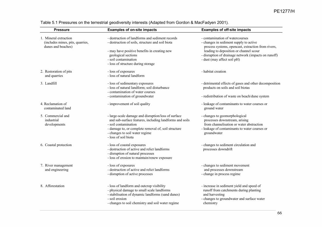
66
Table 5.1 Pressures on the terrestrial geodiversity interests (Adapted from Gordon & MacFadyen 2001).
Pressure Examples of on-site impacts Examples of off-site impacts
1. Mineral extraction - destruction of landforms and sediment records - contamination of watercourses
(includes mines, pits, quarries, - destruction of soils, structure and soil biota - changes in sediment supply to active
. dunes and beaches) process systems, opencast, extraction from rivers,
- may have positive benefits in creating new leading to deposition or channel scour
geological sections - disruption of drainage network (impacts on runoff)
- soil contamination - dust (may affect soil pH)
- loss of structure during storage
2. Restoration of pits - loss of exposures - habitat creation
and quarries - loss of natural landform
3. Landfill - loss of sedimentary exposures - detrimental effects of gases and other decomposition
- loss of natural landform; soil disturbance products on soils and soil biotas
- contamination of water courses
- contamination of groundwater - redistribution of waste on beach/dune system
4. Reclamation of - improvement of soil quality - leakage of contaminants to water courses or
contaminated land ground water
5. Commercial and - large-scale damage and disruption/loss of surface - changes to geomorphological
industrial and sub-surface features, including landforms and soils processes downstream, arising
developments - soil contamination from channelisation or water abstraction
- damage to, or complete removal of, soil structure - leakage of contaminants to water courses or
- changes to soil water regime groundwater
- loss of soil biota
6. Coastal protection - loss of coastal exposures - changes to sediment circulation and
- destruction of active and relict landforms processes downdrift
- disruption of natural processes
- loss of erosion to maintain/renew exposure
7. River management - loss of exposures - changes to sediment movement
and engineering - destruction of active and relict landforms and processes downstream
- disruption of active processes - change in process regime
8. Afforestation - loss of landform and outcrop visibility - increase in sediment yield and speed of
- physical damage to small scale landforms runoff from catchments during planting
- stabilisation of dynamic landforms (sand dunes) and harvesting
- soil erosion - changes to groundwater and surface water
- changes to soil chemistry and soil water regime chemistry
PE1277/H

67
- changes to soil biodiversity
9. Agriculture - landform damage through ploughing, ground levelling - changes in runoff response times
and drainage arising from drainage
- soil compaction, loss of organic matter, reduction - episodic soil erosion leading to
in biodiversity increased sedimentation
- effects of excess fertiliser applications on soil chemistry and chemical contamination in lochs
and biodiversity; changes to nutrient status and river systems
- effects of pesticides on soil biodiversity - pollution of groundwater
- soil erosion
10. Other land - degradation of exposures and landforms - changes in runoff and sediment
management changes - oxidation of soil organic material supply
(e.g. drainage, dumping, - changes to soil water regime - drying out of wetlands through local and distal
construction of tracks) - soil contamination drainage
11. Recreation - physical damage to landforms, processes
(infrastructure, and soils (compaction)
footpath development, - localized soil erosion
use of all-terrain vehicles, - loss of soil organic matter
golf courses) - loss of access or access problems
12. Irresponsible fossil collecting - loss of fossil record
13. Soil pollution - acidification of soils - downstream impacts on watercourses
- accumulation of heavy metals - contamination of groundwater
- effects on soil biodiversity
14. Soil erosion - deterioration of landforms - enhanced sedimentation in streams and lakes
- loss of organic matter - changes in water chemistry
15. Climate change - changes in active system processes - changes in flood frequency
- changes in system state (reactivation or - changes in sensitivity of landforming environments
fossilization) (rivers, coasts, etc) leading to changes in types and
rates of geomorphological processes (e.g. erosion,
flooding)
16. Sea-level rise - changes in coastal exposures and landforms - changes in wider patterns of erosion and deposition
- enhanced flooding
17. Renewable energy - terrestrial: damage to soils, particularly peat; loss
of exposures
- marine: physical damage to landforms; disruption of - changes to sediment movements and hydrodynamic
Processes processes
PE1277/H

68
5.2. Mineral extraction Mineral extraction can have positive and negative impacts. On the positive side, many key sites are in former quarries where the geological interest would not otherwise have been exposed; for example at Boyne Limestone Quarry, near Banff, stripping of the overburden has revealed important sections in Quaternary deposits. The main negative impacts tend to be on integrity interests that cannot be replaced; for example the removal of an esker through sand and gravel quarrying. While there are benefits in terms of being able to examine the 3D sedimentary architecture of the deposits, these are offset by the permanent loss of the landforms. A more systematic approach, involving inventories and conservation assessment of the value of different components of the geodiversity resource at a regional scale, would allow the more important sites to be given appropriate recognition along with other conservation interests in strategic minerals planning. A start has been made by SNH in developing a GIS-based approach to evaluating the sensitivity of different components of the natural heritage to mineral extraction in the Midland Valley where development pressures are greatest (Scottish Natural Heritage, 2000). Quarry operators should be encouraged to include creation of conservation sections as part of their development brief for site restoration. Listed geodiversity sites, both SSSIs and Local Geodiversity Sites (LGS), enjoy measures of protection and consideration in the planning and development process; protection of the former is provided by statute, the latter by individual local authority adopted planning policies for nature conservation (Chapter 6). The recent decision by the Scottish Government to allow development of the Menie Dunes SSSI for a golf course and related development is not without earlier precedent. Around 1950, the plan to develop a ‘modern’ Colliery at Bilston Glen, Midlothian, produced an outcry from many quarters concerned about geoconservation of a nationally important geological site. The key issue was the proposed culverting of the Bilston Burn and disposal of mine waste to infill much of the picturesque wooded Bilston Glen and form a bing on this and adjacent land. This would result in the burial of at least half of the bedrock section then visible of the Upper Carboniferous sedimentary rocks of the Midlothian Coalfield. The protests were even voiced in the leading scientific journal, Nature (22 November, 1952), and the site was also defended by the then Nature Conservancy as a Site of Special Scientific Interest of value not just in Scotland but also even to scientists in the USA because of its fossil beds. In the end, all this was to no avail as the Minister of State for Scotland gave consent to the project. Although the colliery lasted nothing like the planned 100 years, in its working life the spoil did obscure almost all the strata as planned and, ironically, including the surface exposures of the coal seams in the Limestone Coal Formation that were the colliery’s main target for the deep mining. It should be recorded that attempts were made at the time to identify an alternative conservation site, with the nearby Vogrie Burn section a possibility. However, although Vogrie has now been proposed for designation as a Local Geodiversity Site, it largely lacks the credentials for it to have been substituted for the Bilston Burn SSSI. The original quality of the Bilston site is further indicated by the fact that the recent Joint Nature Conservation Council’s Geological Conservation Review retained the remaining parts of the section as a GCR Site and it is also listed as a Midlothian LGS. More recently, the High Smithstone SSSI, designated for its exposures of the once commercially important Ayrshire Bauxitic Clay, required a replacement site to be identified, if possible. This was due to extant planning permission to landfill this former quarry and mine dating from before the selection of the site by the Geological Conservation Review. In these circumstances, the retention of the section could have depended on substantial compensation being paid for loss of revenue. A substitute locality has been identified that displays the bauxitic clay well enough to represent a replacement section and potential new
PE1277/H

69
GCR site, although it lacks some of the features of what was the best available, and type, section at High Smithstone.
5.3. Landfill and restoration of quarries Quarries represent a significant geological resource. Planning conditions normally require restoration and landscaping, and frequently involve landfill. The economic value of landfill space frequently results in the loss of geological exposures. Much earlier dialogue between interested parties (e.g. quarry operators, local authorities, academics, and the conservation bodies) would help to ensure that, where practical, geological interests are incorporated into restoration schemes (See Box 3.1). This applies equally to sites of local importance, representing a resource for education and interpretation that could be developed through the Local Geodiversity Sites (LGS) (formerly Regionally Important Geological/Geomorphological Sites or RIGS) programme. Securing the geological interest in this way could form an integral part of a wider package of enhancement measures for restoration of mineral sites following the kind of guidance produced recently for England (English Nature et al., 1999). Planning sustainable management of after-use through such partnerships can create opportunities for geodiversity interpretation, habitat enhancement, contributions to Local Biodiversity Action Plans (LBAPs) and recreation (Bate et al., 1998; Spalding et al., 2002; Bell, 2007; Davies, 2006, 2007; Goodquarry, 2008; Whitehouse, 2008).
5.4. River engineering Dynamic river systems are a key part of the natural heritage both for the study of physical processes and for the habitats they provide (Soulsby & Boon, 2001; Leys, 2001). Traditional approaches to river management have often involved heavy engineering, usually leading to channelisation of the river through the use of rock armour or gabions. Such approaches not only constrain the natural dynamics of the river system, but can also damage river bank and in-channel species, as well as the habitats they support (Leys, 2001; Soulsby & Boon, 2001), and may lead to transfer of problems downstream. From a conservation viewpoint, they should be restricted to protecting essential utilities, buildings and infrastructure. The true costs of intervention in river channel form are rarely considerd within the costs of flood alleviation schemes. New and innovative approaches such as the White Cart Flood Alleviation Scheme22 seek to redress the balance that has favoured quick evacuation of floodwaters downstream, to one of floodwater retention. Scottish Government has lent encouraging support to more natural flood management approaches that reinstate and protect floodplains (e.g. instigation of the Natural Flood Management Group23). With the prospect of increased frequency of flooding as a result of climate change, there needs to be a re-examination of how flood risk is managed, and how the benefits of floodplains for flood storage are protected within the planning system. In particular, it is widely understood (e.g. Scottish Government, 2010b) that development of floodplains is incompatible with sustainable land use in a changing climate, but local planning decisions continue to allow new developments on floodplains. This means there will continue to be demand for flood alleviation. It is time for a new approach to the true cost of flooding, erosion and river channel change that gives rivers sufficient space to operate in a natural or semi-natural manner.
5.5. Coast protection In the past, coast protection has typically involved a similar heavy engineering approach. This leads to well known effects, notably interruption of sediment supply and enhanced erosion downdrift, along with beach lowering and eventual increased wave exposure (Taylor et al.,
22 http://www.whitecartwaterproject.org/index.htm
23 http://www.scotland.gov.uk/Topics/Environment/Water/Flooding/advisory-groups/saif/NFMG/
PE1277/H

70
2004), affecting both landforms, habitats and adjacent land uses. In recent years, a fundamental shift in thinking in the UK, particularly in England, has led to solutions that are more in harmony with natural processes (e.g. Pethick & Burd, 1995; Hooke, 1998, 1999). Such approaches are now being considered and followed in Scotland. Several local authorities, including Fife, Angus and Aberdeen City Councils, have undertaken strategic studies that include assessment of environmental impacts and alternative solutions prior to embarking on coast protection. Crucially, such studies are undertaken at an appropriate scale that incorporates the natural dynamics of the whole coastal system or coastal cell concerned. Consequently, possible wider adverse effects can be considered, areas of conflict identified and recommendations made on how more integrated management should be progressed. Such studies have been undertaken at Montrose Bay and Aberdeen Bay (Halcrow Crouch, 1998, 1999). Serious consideration is also being given to alternative forms of coast defence, both on environmental and cost grounds. These include managed retreat (e.g. Hansom et al., 2001) and beach recharge and dune re-profiling (HR Wallingford, 2000). For example, at Montrose, a policy of managed retreat between artificial rock headlands has already been adopted for the dunes fronting a golf course, where sea-level rise and a shift in wind patterns has led to enhanced erosion. Installation of more extensive hard coast protection, which would have impacted significantly on dune systems downdrift if the sediment supply was reduced, was rejected on grounds of costs and environmental impacts. At Gairloch, a combination of sand fencing, dune reprofiling, dune grass planting and recycling of sand from the foreshore has successfully halted rapid erosion of the dune ridge behind the beach and has helped to maintain the natural landform and habitat, which would not have been the case had hard defences been employed (Lees et al., 1998). Beach nourishment (in isolation and in combination with other approaches) is being increasingly used around Scotland's coast (Eden Estuary and West Sands, St Andews).
5.6. Fossil collecting and geological sampling Irresponsible fossil collecting is a perennial problem at many palaeontological and stratigraphical sites. Mechanical excavators, explosives, crow bars and rock saws have all been used irresponsibly to excavate and remove fossil material, which has resulted in the destruction and loss of fossil specimens and irreplaceable fossil-bearing rock exposure. However, the consensus opinion is that fossil collecting can promote the science of palaeontology and should be encouraged, provided that it is undertaken responsibly (MacFadyen, 1999) and that total prohibition of collecting at any site is unjustified (Wimbledon, 1988). The Nature Conservation (Scotland) Act 2004 included provision for Scottish Natural Heritage to prepare the Scottish Fossil Code. The Code (Scottish Natural Heritage, 2008b) was produced with assistance from palaeontological researchers, land managers, collectors and others with an interest in Scotland’s fossil heritage. It provides best practice guidance in the collection, identification, conservation and storage of fossil specimens found in Scotland. The Code aims to help safeguard Scotland’s irreplaceable fossil resource whilst enhancing public interest in the fossil heritage of Scotland and promoting responsible use of this resource for scientific, educational and recreational purposes. There is particular encouragement for collaboration and partnerships involving academics, collectors, museum curators, landowners and others to maximise the scientific gain from vulnerable fossil sites where there is a limited resource of high scientific and heritage value. Generally it is hoped that following the Code will increase the personal interest and satisfaction that can be gained from forming a fossil collection.
PE1277/H

71
5.7. Conflicts between public safety and conservation The coastal path at Stannergate Shore, in east Dundee, is an exemplar of the problem of conserving good local geodiversity (Figure 5.1). Part of the shore is listed with Dundee Council as a Local Geodiversity Site. When the site was in the process of designation and listing, a major sewer pipe was planned along the shore. Fortunately, the company carrying out the major project agreed to design the alignment to avoid the geodiversity interest. A site inspection ensured that when the work took place the key exposures of the Lower Devonian lava breccias and other associated rocks remained intact. The planning system had worked well for conserving this LGS even before it was finally listed. However, several years later the Council decided that on urgent safety grounds it had to make major repairs to the local coastal path that included a section in concrete forming a flyover above the best part of the listed section. It is now accepted that the Council failed to consult its own planners about the LGS. The new concrete works obscure much of the best geology, and indeed the upper half of the best exposure was destroyed. Another feature of the new path and associated sea wall seems to be that the waves impact differently, with the result that beach gravels now cover more of the rocks on the shore.
Figure 5.1 Stannergate Shore Local Geodiversity Site, Dundee. The emergency replacement of hard landscaped sea defences carrying the coastal footpaths over rock outcrop partially destroyed exposures of lava breccia, which are valuable for education. (Photos: Mike Browne).
Before After
It is recognised that work in emergency incidents may well result in damage to, or loss of, geodiversity and that such work is not subject to planning and development regulations. However, it is important where there is a time lag in treatment of the problem, as in the case of the steel mesh recently installed on the iconic Edinburgh Castle Rock (Figure 5.2), on Wester Craiglockhart, Edinburgh, and on the many road (and rail) cuttings, that the principle of consultation with interested parties should take place. It may well be that conservation is only acceptably achievable in some or all of these instances by scientific and photographic recording before the installation of the chosen method of safety protection. There is a risk associated with public and political perception if, as the projections suggest, rates of landscape change increase substantially. There is likely to be growing tension between those who want to hold the line and maintain the status quo; and those who believe adaptation provides a more sustainable approach in the medium- and long-term. This tension is already evident in golf course management at the coast, but is likely to become more widespread for other land uses. Similarly, on the lower reaches of the River Spey, it is hard to conceive of effective flood defences on such a dynamic river in terms of a cost-benefit appraisal. Knock-on
PE1277/H

72
Figure 5.2 Recent engineering works designed to protect the public from rockfalls from Edinburgh’s Castle Rock demonstrate the conflict between provision of a safe environment and the conservation of iconic landscapes.(Photo: Mike Browne).
consequences of ill considered approaches could be catastrophic for adjacent land uses. As residents voice their justifiable anger at the situation, the folly of planning consent for housing on the floodplain of such a dynamic river is apparent. Making space for natural processes and ensuring that land uses are in balance with their environment is the long-term goal.
5.8. Climate change This section deals with the impacts of climate change on geodiversity sites. Wider implications for biodiversity and society are addressed in Chapter 4.
5.8.1 Impacts of climate change on geodiversity
Prosser et al. (2010) have reviewed the likely impacts of climate change, and the human responses to it, on a wide range of geodiversity features and sites. It is not only the direct impacts that are of concern, but also the effects from human responses to hazards/risks (e.g. increased demand for hazard mitigation, such as flood protection and coast protection) and responses to new opportunities (e.g. land-use changes). All types of geodiversity site (exposure sites, integrity and finite sites, and active process sites) will be impacted to some extent by changes in geomorphological processes. It appears, however, that sites located on the coast, adjacent to rivers or on active slopes, together with the associated geomorphological processes, are most likely to experience the greatest changes, particularly from sea-level rise, increased erosion or flooding. The human responses to these changes, in the form of ‘hard’ coastal protection or river and slope engineering are, however, likely to have the greatest impact on geodiversity.
Climate change may have both negative and positive impacts on geodiversity (Table 5.2). Rock and sediment exposures could be sealed behind coast defences and river-bank protection. Unique exposures may be lost through erosion, or access prevented through submergence or burial as a result of changes in sedimentation or landslides. Conversely, erosion may reveal new exposures that replace existing sites or reveal new interests. Indirectly, changes in land
PE1277/H

73
use arising from increased demands for food and energy crops could also impact on access to rock exposures or obscure the visibility of landforms.
Table 5.2 Impacts of climate change on geodiversity sites
Impacts on exposure, integrity and finite sites – accelerated weathering, erosion and vegetation growth, requiring increased
frequency of management intervention – loss of features through erosion – sealing of exposures by coast/river defences – submergence of exposures – changes in land use – visibility, access + new exposures +/– repositioning of exposures due to changing patterns of erosion
Impacts on active process sites – human responses to hazards disrupt natural processes – changes in land use affect sediment/water discharges + enhanced rates of process activity – greater dynamism and diversity +/– repositioning of features due to changing patterns of erosion
- negative impact; + positive impact
Dynamic sites will respond to changes in the nature, magnitude and frequency of geomorphological processes (See Table 5.2). In turn, this may result in the following scenarios:
• Changed distributions of coastal and river landforms in response to altered patterns of erosion and deposition – this could cause readjustments in channel and coastline positions that have been stable in living memory, with the result that the notified scientific interests shift outside of existing designated sites.
• Changes in seasonality of river flows, including: increased occurrence and duration
of droughts and low flows; and increased frequency of flooding, enhancing rates of
erosion, deposition and channel adjustment.
• Enhanced coastal retreat and steepening, coastal squeeze (where landward
migration of landforms and habitats is impeded) and enhanced landslide activity on
susceptible coasts.
• Increased likelihood of conflict between coastal change and existing development as
a result of a combination of rising relative sea level, varying storminess and river
bank and coastal protection works (sterilising feeder bluffs).
• Decreased periglacial activity on some mountains, including loss of semi-permanent
snow beds and related processes, shorter snow-lie, increased frequency of snowmelt
events, and a reduction in higher magnitude snow-melt events.
• The possibility of accelerated soil erosion in both arable and upland environments,
especially during windy or very wet conditions, as a result of land use changes and
increased recreation pressures.
• Changes in the magnitude and/or frequency of slope failure, and potential
consequent increase in slope-channel coupling and increased rates of sediment
transport and deposition.
PE1277/H

74
• Changes in soil biochemical processes leading to increased release of greenhouse gases and loss of carbon – this is of particular concern for organic soils.
• Greater geomorphological heterogeneity and changes in landscape character (e.g. more bare slopes as a result of accelerated erosion).
The repositioning of exposures and geomorphological features in response to active geomorphological processes will provide increasing conservation challenges. Exposure sites are likely to migrate as a result of erosion, and some coastal and river features may shift their spatial locations and migrate outside existing designated areas; for example the landwards or long-shore migration of coastal landforms (Pethick, 2001). This will provide challenges if new and damaging engineering schemes are initiated to restrict movement of features where people or property are affected and in terms of spatially defining features and designations for conservation purposes.
Climate change will also lead to changes in land use and land management practices as a result of changes in land suitability for agriculture, forestry and renewable energy production and indirect pressure from population growth (e.g. food policy) and displacement (planning development away from flood-prone areas). The consequences for geodiversity (and hence habitats and species) of such increased pressures on the land bank are unclear. Overall, there may be greater dynamism and geomorphological heterogeneity (variety of features) and changes in landscape character (e.g. more bare slopes as a result of accelerated soil erosion). There are also likely to be changes in the distribution of coastal and river landforms in response to altered patterns and rates of both erosion and deposition. Landform readjustment times to extreme events may be longer due to reactivation by subsequent events. In some circumstances, geomorphological processes and soils may become especially vulnerable to irreversible changes or changes in process regimes, so that an understanding of geomorphological sensitivity and the capacity of the system to absorb externally imposed stresses is a key consideration.
5.8.2 Urban geology and climate change – stone-built heritage
The built fabric of Scotland’s cities and towns, in which 80% of the population live, is potentially vulnerable to climate change. The pre-1919 Scottish building stock is mainly stone-built; most Scottish cities are built mainly of sandstone, which is particularly susceptible to environmental change. Changing climate is likely to have a significant effect on the rate and style of stone erosion and hence on this aspect of Scotland’s geodiversity and geoheritage (Chapter 3.4.3). Safeguarding indigenous resources which were once extensively used is crucial to ensure that appropriate stone is available for repairs and new-build, as is the application of geological expertise and skills (Appendix 4).
5.8.3 What needs to be done?
Prosser et al. (2010) considered the responses to the management challenges presented by climate change and the evidence needs. As a starting point, we need to assess the vulnerability of different types of geodiversity site and develop appropriate evidence-based management strategies to enable adaptation. These are likely to include:
1. Demonstrating and raising wider awareness of the dynamic nature of landscapes and of the need to accept and work with changing natural processes.
2. Promoting a ‘conservation’ rather than ‘preservation’ approach.
PE1277/H

75
3. Developing and applying new conservation techniques to allow for the conservation of geodiversity in the face of increased rates of process activity, more frequent extreme events and new process regimes.
4. Improving our understanding of natural processes and their sensitivity to change.
5. Developing strategies to enable features of geodiversity importance to be identified, safeguarded and managed in situations where the features are likely to be increasingly mobile. They may involve, for example, ‘creating room for rivers’ and ‘natural’ forms of flood management, and managing coastal realignment and restoration of coastal landforms and habitats (See Section 4.7).
6. Working with government, policy makers, the planning system and affected communities to consider and plan for the conservation of geodiversity as part of planning for adaptation to climate change. This should seek to include the needs of geodiversity conservation within strategic visions, spatial planning and development planning.
7. Addressing the potential conflict between geoconservation and social demands; for example, in relation to river and coastal management.
8. Recognising that there will always be difficult choices and trade-offs to make.
5.9. Pressures on marine geodiversity Human activities and development in the marine environment have the potential to impact upon both geomorphological and geological features at the seabed (Brooks et al., 2009). They include: fishing (dredge and trawling), aggregate extraction, hydrocarbons (oil and gas installations), renewable energy installations, cables and pipelines, navigational dredging, dredge waste disposal and military activity. The impacts may be categorised into three generic types:
• activities or installations that remove or disturb the seabed (e.g. aggregate dredging);
• activities that dispose of material onto the seabed (e.g. dredge waste disposal); and
• installations that sit on the seabed (e.g. cables and pipelines). Given the dynamic nature of the marine environment, all of these activities have the ability to cause near and far-field effects through the interruption of existing sediment transport pathways and hydrodynamic processes. Furthermore, any disturbance of soft sediments on the seabed will also give rise to the suspension of fine particles in the water column, potentially altering local-regional sedimentation patterns. Brooks et al. (2009) outlined a vulnerability assessment of the main types of geodiversity feature to different activities. The potential impacts of marine activities on the seabed are discussed in more detail in ‘Charting Progress II: Productive Seas Report’ (Defra, forthcoming). The planned nearshore expansion of large windfarms is a relatively new pressure, with uncertain impacts on marine geomorphological processes.
5.10. Conclusions Pressures on geodiversity arise principally from planning developments and land-use changes. These may damage key features, impair their visibility and accessibility or fragment the interest. There is a need for better application of existing knowledge to enable the development of more integrated strategies and policies for sustainable management, based on working with, rather than against, natural processes. Equally there is a need for raised awareness of the benefits of such approaches among key interest groups and their advisors.
PE1277/H

76
Climate change presents particular management challenges. This will require working with government, planners, decision makers and local communities to ensure that geodiversity interests are managed sustainably as part of wider, long-term adaptation strategies.
PE1277/H

77
6. CONSERVATION OF GEODIVERSITY AND LINKS TO THE WIDER POLICY FRAMEWORK
6.1. Legislative drivers for geodiversity In contrast with biodiversity protection, there is no international legislation covering geodiversity. However, the effective practical implementation of several European Directives and Conventions depends to a significant degree on understanding the functional support and underpinning that geodiversity provides for biodiversity and landscape (see Chapter 3). These include the Habitats and Species Directives, the Water Framework Directive, the Floods Directive and the European Landscape Convention. The related existing domestic legislation, although focused primarily on biodiversity and environmental outcomes, should provide opportunities to deliver a more integrated approach to the benefit of both biodiversity and geodiversity, but these opportunities have not been developed to the extent that they might have been. In addition, as noted in Chapter 1, several international organisations, including the Committee of Ministers of the Council of Europe, IUCN, the Nordic Council of Ministers and UNESCO, have all addressed the need for wider recognition of the role of geodiversity in underpinning biological, cultural and landscape diversity, and hence the need for greater attention to its conservation. At a UK level, although it has no statutory status, the draft UK Geodiversity Action Plan (UKGAP) [Box 6.1] provides a broad framework for geodiversity activities, reflecting the concern of the wider UK geoconservation community about the widening gap between the conservation of geodiversity and biodiversity. In terms of domestic legislation, the importance of Scotland’s geodiversity is recognised in the Nature Conservation (Scotland) Act 2004, with a focus on the assessment and management of statutory protected sites (SSSIs). The Marine (Scotland) Bill allows for conserving of features of geological or geomorphological interest through designation as Nature Conservation MPAs, and the draft guidelines for the selection of MPAs include conserving features of geological or geomorphological interest alongside the conservation of marine flora and fauna.
6.2. Site Protection 6.2.1 Terrestrial sites of national and international importance
As outlined in Chapter 2, many sites in Scotland are of great importance to earth science for their rocks, fossils and landforms, demonstrating important geological processes or events. Mostly, they are non-renewable assets that exist in a variety of forms, including rock exposures and landforms, and span a variety of geographical scales from small rock outcrops with single interests to landscapes comprising assemblages of rocks, landforms and soils. Statutory conservation of nationally and internationally important Earth heritage features in Great Britain is addressed through the SSSI system, which is based on the Geological Conservation Review (GCR) site assessment protocols (Ellis et al., 1996) [Box 6.2]. The GCR represents the national (Great Britain) database of key terrestrial features and localities. It provides the essential scientific underpinning for the notification of earth science features in SSSIs. GCR sites must have special interests that are either representative nationally of the diversity and range of similar features, have exceptional features in their own right and/or be of international importance. Scientific results of the GCR are being
PE1277/H

78
published in a series of volumes by the Joint Nature Conservation Committee (Ellis et al., 1996; Ellis, 2008).
BOX 6.1 UK Geodiversity Action Plan (UKGAP)
The UK Geodiversity Action Plan (UKGAP)24 has been developed through wide consultation and
dialogue with organisations, groups and individuals currently engaged in geoconservation across England, Scotland, Wales and Northern Ireland. The current draft (July 2010) sets out a framework for geodiversity action across the UK. The UKGAP is split into six themes encompassing how we understand and care for our geodiversity, how geodiversity can inspire people and the importance of carefully planning for our geodiversity. Each theme is then further divided into one or more objectives. The objectives set out in more detail what each theme is aiming to achieve. The themes are:
• Furthering the frontiers of geoscience;
• Influencing planning, environmental policy and development design;
• Gathering and maintaining information on our geodiversity;
• Conserving and managing our geodiversity;
• Inspiring people to value and care for our geodiversity; and
• Sustaining resources for our geodiversity.
In addition, there are a number of indicators that can be used as a mechanism for monitoring and measuring the progress being made under the six UKGAP themes.
The UKGAP is not an action plan as such but rather a framework to provide a focus and help integrate existing geoconservation activities at a UK level, as well as to raise awareness and promote geodiversity and geoconservation and to highlight what still needs to be done.
The scientific importance of Scotland’s geodiversity is reflected in the national series of earth heritage sites identified in the GCR. In total, over 850 features of national (Great Britain) or international interest have been identified in Scotland (Appendix 5). To date in Scotland from the current list of GCR sites, 607 have been notified as SSSIs, 17 are partly notified and 257 have not been notified. SNH’s current approach is to notify new SSSIs to underpin international designations and where a natural feature of national importance is under immediate threat of damage or destruction. Additionally, through the programme of reviewing SSSI documentation, SNH is adding GCR sites that lie within existing SSSIs (about 60 in total) as notified features of the relevant SSSIs. Where only part(s) of a GCR site lie within an SSSI, these parts may also added to the list of natural features for that site. Although soils were not considered in the GCR, representative examples of most of the important soils types in Scotland occur in existing SSSIs (Gauld & Bell, 1997). There is no statutory protection for un-notified GCR sites and they are not addressed in the new Scottish Planning Policy (SPP). However, their importance is recognised in SNH’s ‘Guidance – Identifying natural heritage issues of national interest in development
proposals’.25 This notes that geodiversity interests identified to be of outstanding conservation importance in Scotland include un-notified GCR sites, and that proposals with significant implications for such sites may merit an objection.
6.2.2 Marine areas of national and international importance
Such a comprehensive exercise as the GCR has not been undertaken for the marine geodiversity of Great Britain. However, the value of marine geodiversity is recognised in the
24 http://www.ukgap.org.uk/draft2/home.asp
25 http://www.snh.gov.uk/docs/C271039.pdf
PE1277/H
79
BOX 6.2 Geoconservation
Identification and protection of key localities for research and education has been a core activity of geoconservation. This approach is based on selection of special or representative sites using scientific or other criteria and has been implemented in different ways in different countries through a variety of measures and instruments, including national parks, natural monuments, and other categories of protected site (e.g. Gray, 2004; Brocx, 2008). It is particularly well developed in the case of Great Britain through the system of national assessment, documentation and protection of geological and geomorphological sites. Historically, this type of approach dates back to the mid-19th century, early examples being the enclosure of the stumps of a former forest of Carboniferous lycopods at Fossil Grove in Glasgow in 1887 and the listing of erratic boulders in Scotland in the 1870s (Milne Home, 1884). Formal identification of key sites in Britain began in the 1940s supported by nature conservation legislation first passed in 1949 and subsequently updated (Prosser, 2008). This work produced a series of site lists that were then added to in an ad hoc way (Gordon, 1992). This process was superseded by the Geological Conservation Review (GCR), a major programme of systematic assessment of the conservation value of geological and geomorphological sites throughout Great Britain (Ellis, 2008); a parallel system has been implemented in Northern Ireland (Enlander, 2001). Site assessment was undertaken between 1977 and 1990 and is the most comprehensive review of sites in any country. It was designed to reflect the full diversity of earth heritage in Great Britain, spanning all the major time periods from the Precambrian to the Quaternary. Publication of the results in a series of 42 scientific volumes is now nearing completion. These describe the interests of individual sites and provide the scientific justification for their selection. Over 3000 individual localities were identified and form the basis for a network of Sites of Special Scientific Interest (SSSIs). These are accorded a measure of legal protection, including a requirement for consultation with the statutory conservation agencies over developments requiring planning consent and other activities requiring consent. The aim of the GCR was to identify the sites of national and international importance for geoscience in Great Britain, based on a set of site selection criteria and guidelines and extensive consultations within the geoscience community (Ellis et al., 1996). Site selection is based on a concept of networks of sites representing the main features and spatial variations of geological events and processes during the main time periods. Three categories of site have been identified: those of international importance, exceptional features and representative features. Many sites are of fundamental importance as international reference sites (e.g. stratotypes, type localities for biozones and chronozones, and type localities for rock types, minerals or fossils), providing the building blocks for stratigraphy and the essential reference standards for global correlation of rocks (e.g. Dob’s Lin in the Scottish Borders, the boundary stratotype between the Ordovician and Silurian). From a historical perspective, many sites are also internationally important classic localities in the development of geoscience, where features were first recognised or key concepts developed; for example, sites in the Northwest Highlands, Glen Coe, the island of Rum and Siccar Point (Figure 2.3) have all provided crucial evidence for interpreting geological processes of global significance – respectively, the Moine Thrust, cauldron subsidence, magmatic processes and the origins of layering in igneous rocks, and a classic unconformity that provided crucial evidence on which James Hutton developed the foundations of modern geology (See Table 2.1). Some sites demonstrate unique or exceptional features; for example the Rhynie chert in Aberdeenshire contains some of the oldest known fossils of plants and insects, while other sites demonstrate classic landforms or textbook examples of particular features, such as the Parallel Roads of Glen Roy. Many more sites have nationally important representative examples of particular geological processes, environments or events that are essential for teaching and demonstration purposes and fundamental for understanding the geological history of Great Britain. Sedimentary rocks provide a valuable record of past environmental changes and many contain valuable fossil remains that have helped elucidate patterns of evolution of life on Earth. Other sites are important for demonstrating and understanding dynamic geomorphological processes at the coast and in river catchments (Figure 6.1).
PE1277/H

80
Figure 6.1 The bar at Culbin, Moray has been extending westwards at c. 15 metres per year through the accretion of shingle ridges. (Photo: P&A Macdonald/SNH).
At a local level, geoconservation is pursued through the voluntary sector and the Local Geodiversity Sites (formerly Regionally Important Geological/Geomorphological Sites) movement. Sites of local importance are selected on the basis of their scientific and educational importance, historic interest and aesthetic and cultural values, reflecting local rather than national values. Although these sites do not have statutory protection, many local authorities now have conservation policies for LGS as well as other local biodiversity (wildlife) sites. An important recent initiative has been the preparation of Local Geodiversity Action Plans in some areas. These should help ensure greater protection for geodiversity as well as encouraging local awareness and involvement. At an international level, many individual countries have compiled lists of geosites, particularly in Europe where there is a strong lead from ProGEO, the European Association for the Conservation of the Geological Heritage. Work is also in progress to develop international lists of sites under the auspices of the International Union of Geological Sciences, including a European initiative by ProGEO. In North America and Australasia, many geological and geomorphological features are protected by a variety of existing designations, including national and state parks, National Natural Landmarks and provincial parks and nature reserves, although with few exceptions (e.g. Ontario, Tasmania, New Zealand), geological features have not been systematically assessed. A number of World Heritage Sites are designated for geological features or have significant geodiversity interests, but the list is not comprehensive or representative. Moreover, there are no international conventions or regional instruments for geodiversity comparable to those for biodiversity (e.g. the Convention on Biological Diversity or the EU Habitats Directive).
The Marine (Scotland) Bill26. Paragraph 59 allows for conserving of features of geological or geomorphological interest inside 12 nautical miles through designation as Nature Conservation Marine Protected Areas (MPAs). The UK Marine and Coastal Act 200927 includes equivalent provisions for Scottish Ministers to designate MPAs for biodiversity and geodiversity features in offshore waters adjacent to Scotland. The draft Scottish guidelines for the selection of search locations containing priority marine natural features include
26 Scottish Government 2010. Marine (Scotland) Bill. http://www.scottish.parliament.uk/s3/bills/25-MarineScot/b25bs3-
aspassed.pdf 27 UK Government (2009). http://www.legislation.gov.uk/ukpga/2009/23/pdfs/ukpga_20090023_en.pdf
PE1277/H

81
geodiversity interests alongside the conservation of marine flora and fauna (Scottish Government, 2010a). These guidelines include analogous ‘criteria’ to those of the GCR but are integrated with the biodiversity guidelines. Scotland’s marine geodiversity is important for a number of reasons (Chapter 2). A pioneering desk-based survey using existing published and unpublished information has identified 32 key interest feature areas within Scottish territorial waters and within offshore waters adjacent to Scotland related to 8 principal themes or interest ‘blocks’ (Brooks et al., 2011) (Appendix 6). The recognition of geodiversity in the draft Scottish guidelines for identifying search areas for Marine Protected Areas and the completion of an initial assessment of key features is probably a global ‘first’.
6.2.3 Sites of regional and local importance
Sites of regional and local importance for geodiversity are known as Local Geodiversity Sites (LGS) (formerly known as Regionally Important Geological/geomorphological Sites - RIGS). They form an integral part of the system of Local Nature Conservation Sites in Scotland (Scottish Natural Heritage, 2006). They are non-statutory sites selected by local voluntary groups (cf. Burek, 2008) based on nationally agreed criteria applied at a local level. Formal designation comes from local authorities through the planning system. The four principal criteria for site selection are: educational value (including lifelong learning), intrinsic scientific interest, aesthetic value and historical context. Only limited progress has so far been made in Scotland in formally identifying networks of LGS sites, although many candidate sites exist. Local Geoconservation Groups (formerly RIGS Groups) are also closely involved in local geodiversity action planning in partnership with local authorities and other bodies. Local Geodiversity Action Plans (LGAPs) set out guiding principles and priorities to ensure conservation of the geological heritage for the benefit of all (e.g. Burek & Potter, 2004). Local Geodiversity Action Plans have been launched, or are in the process of development, across many parts of England and in Wales. A review of progress for 41 Local Geodiversity Action Plans in England (Haffey, 2008) recognized these as being a very effective mechanism for raising the profile of geoconservation and promoting a structured partnership approach to the protection, management and interpretation of geological features. However, it also noted a wide variation in quality and identified a key problem in the lack of resources for implementation of plans. The draft UKGAP) includes a number of indicators that might be used for monitoring the effectiveness of LGAP implementation.
The City of Edinburgh Council now has an LGAP contained within the latest version of its LBAP and there is one other (draft) LGAP in Scotland, for West Lothian. In addition, both of Scotland’s National Parks have identified the production of an LGAP as an action in their Park Plans (Cairngorms National Park Authority, 2007; Loch Lomond & The Trossachs National Park Authority, 2007). A prerequisite for the preparation of an LGAP is the compilation of a geodiversity audit of the relevant area [Box 6.2]. To date, a number of such audits have been completed in Scotland by BGS (Figure 6.2 and Table 6.1).
6.2.4 Geoparks
Geoparks represent an important recent development in promoting the wider appreciation of earth heritage and provide a means to integrate geodiversity conservation, landscape, people and culture within a framework of sustainable development (Eder & Patzak, 2004) (Appendix 7)). In Scotland, three areas have been awarded European Geopark status - the North West Highlands, Lochaber and Shetland (Figure 6.3). The aims of Lochaber and Shetland Geoparks, for example, clearly reflect the wider aspirations for Geoparks as set out in the European Geoparks Charter (Tables 6.2 and 6.3, Appendix 7). Geopark status may be regarded as an accolade and does not include any additional statutory measures for geoconservation. However, there must be an existing protection and management framework in place. As well as geoconservation, the Geoparks have the potential to deliver
PE1277/H

82
important cultural services (Chapter 3) through enhanced funding leverage, awareness raising and educational initiatives, tourism development, and opportunities for niche branding of local products and services (Hambrey Consulting, 2007). BOX 6.2 East Dunbartonshire Geodiversity Audit In its recent Local Plan, East Dunbartonshire Council (EDC) identified a number of strategic aims for all services. One of those was enhancement of the quality of life and protection of the local environment. More specifically, the Council is dedicated to furthering the cause of geodiversity by protecting landscape features and, in particular, those geological features that are designated as Local Geodiversity Sites (formerly termed Regionally Important Geological and Geomorphological Sites or RIGS) and those protected in East Dunbartonshire’s Greenspace Strategy. Nationally designated sites such as SSSIs protect only a limited part of the area’s geodiversity. EDC wished to evaluate their Local Nature Conservation Sites (LNCS). These are non-statutory sites selected for their local geodiversity (LGS) or biodiversity and ecological importance (LBS or formerly SINCs). EDC also wish to explore the potential for enhancing the quality and quantity of their geological sites, particularly those of educational value. A survey of these sites will assist EDC with writing Local Plan 2 and form the basis of a Local Geodiversity Action Plan (LGAP). In 2009, EDC commissioned the British Geological Survey to carry out a geodiversity audit. This began with a review of the available documentation, including BGS field maps, databases, digital aerial photography and publications, SNH’s SSSI and GCR documentation, and site information from the Strathclyde RIGS Group. An initial list of 59 sites with potential for geodiversity value was compiled from this information. A total of 36 sites from the initial list were visited and audited, most during March and April 2009. Information was recorded on the GeoDiversitY scoring system, developed by BGS. Using this system, geological scientific merit, education value, community site value, cultural/heritage/economic importance, access, site fragility and potential site use were assessed. The GeoDiversitY system was accessed via digital data entry forms on the BGS SIGMAmobile system running on a ruggedized field notebook PC. Of the 36 sites visited, 34 were recommended as Local Geodiversity Sites. These sites have a good geographical spread across East Dunbartonshire, encompassing both urban and rural areas. Together they show typical geological strata, structure and features of all the geological units present at and immediately beneath the surface of East Dunbartonshire and are representative examples of the Carboniferous sequence that underlies much of Central Scotland. The sites, chosen primarily for their geology, have revealed numerous links to the character of the landscape, historical structures, ecology, and the economic and cultural history of the area. Many of these sites could be enhanced to encourage local people, visitors and students to learn more about the geology beneath their feet and how the geology, as the foundation of our landscape, has influenced the form and nature of what lies at the surface; from the inter-drumlin depressions which have created a wetland habitat to the ironstones and fireclays which were exploited as raw materials for the heavy industry which flourished around Glasgow, resulting in the development of the large conurbation. This audit and accompanying report (Arkley et al., 2010) will assist future planning, development and conservation issues within East Dunbartonshire and form the basis of a Local Geodiversity Action Plan (LGAP).
PE1277/H

83
Figure 6.2 Geodiversity audits in Scotland conducted by BGS. (Reproduced with the permission of the British Geological Survey ©NERC. All rights Reserved).
Figure 6.3 Geoparks in Scotland (Reproduced with the permission of the British Geological Survey ©NERC. All rights Reserved).
PE1277/H

84
Table 6.1 Geodiversity audits in Scotland
Title Date Prepared for Type BGS Report number
Edinburgh 2009 Edinburgh City Council
Desk study and field investigation
GIS files only
East Dunbartonshire
2009 East Dunbartonshire Council
Desk study and field investigation
OR/09/019
Applecross 2007 Applecross Estate Trust
Desk study OR/07/020
Isle of Harris 2007 Harris Development Ltd.
Desk Study CR/07/032N
Loch Lomond and the Trossachs National Park
2007 Loch Lomond and The Trossachs National Park Authority
Desk Study OR/07/036
Broadford and Strath
2006 Broadford and Strath Landscape Partnership scheme
Desk Study CR/06/075N
West Lothian 2006 West Lothian Council Desk study and field investigation
CR/06/008N
Table 6.2 Aims of Lochaber Geopark
• to raise awareness of Lochaber's outstanding geology and geomorphology, both locally and outwith the area;
• to encourage and support the sensitive interpretation of Lochaber's geological heritage;
• to encourage and support economic and social development based on Lochaber's geological heritage;
• to promote awareness and appreciation of the links between the geological heritage, the natural heritage, the cultural heritage, the landscape and land use in Lochaber;
• to encourage educational initiatives, training opportunities and research activities that relate to Lochaber's geological heritage;
• to encourage and promote the sustainable use of geological resources in Lochaber.
Table 6.3 Aims of Shetland Geopark
• conserve Shetland’s rich geological heritage and demonstrate its clear links with natural and cultural heritage;
• raise awareness and increase understanding of Shetland’s geological heritage; and
• enhance the image of Shetland and promote sustainable development linked to geological heritage and geotourism.
PE1277/H

85
6.3. Links to the wider policy framework High-level national policy drivers are set out in the Scottish Government’s Purpose and National Performance Framework and are reflected in SNH’s Corporate Strategy. Examples of some key links between geodiversity and the Scottish Government’s Strategic Objectives and related key policy areas are indicated in Figure 6.4, and Appendix 1 illustrates links between geodiversity-based services and European/national policy objectives or targets.
Figure 6.4 Key links between geodiversity and the Scottish Government’s Strategic Objectives and Related Key Policy Areas. (Source: Natural Capital, 2011).
Geodiversity therefore has much wider relevance and underpinning across a range of policy areas than simply the conservation of geosites. A review by Natural Capital (2011) demonstrated important linkages in the following key areas:
• sustainable development and Scotland’s Strategic Objectives;
• planning guidance;
• sustainable rural development;
• landscape;
• biodiversity and nature conservation;
• greenspace strategies;
• National Parks, Coastal and Marine National Parks and Geoparks;
• historic environment, cultural heritage and World Heritage Sites;
• climate change;
• marine and coastal strategy;
• river management and sustainable flood management;
PE1277/H

86
• agriculture and forestry policy; and
• Single Outcome Agreements.
The Natural Capital (2011) study also identified significant gaps concerning the integration of geodiversity in these areas:
• Current sustainable development policy has significant gaps with regard to the recognition of the importance and value of geodiversity and does not give a clear steer towards protecting and conserving this resource.
• There is no clear recognition of the wider links that geodiversity has to a range of policy areas such as its economic contribution, its role in health, recreation and education, and its important role in climate change adaptation. Its contribution to a wide array of ecosystem services and benefits receives little mention in current Scottish policy.
• The Scottish Government Strategic Objectives do not clearly identify geodiversity (along with biodiversity) as a strategic element of the natural heritage even though a clear link can be established that demonstrates the contribution that geodiversity can make to these objectives and the consequent need for the protection and conservation of this resource.
• Current planning policy has significant gaps with regard to geodiversity:
o there is little if any mention or reference to geology, geodiversity or geological conservation within planning policy and planning guidance;
o no strong links have been made between the importance of geodiversity and other policy areas such as biodiversity conservation, greenspaces, tourism, recreation and amenity and cultural heritage;
o there is a clear lack of adequate planning policy objectives and associated policy measures for the protection and conservation of geodiversity
o there is generally little recognition of ensuring that developments in dynamic environments (such as river floodplains and at the coast) form part of a strategic plan (such as a Shoreline Management Plan), based on a sound understanding of natural processes and taking into account the wider effects on natural processes and ecosystems (e.g. like steering development away from geomorphologically active and hazardous areas).
• With the exception of policies for National Parks and Geoparks, the important links between geodiversity and other key policy areas have not been adequately drawn out, and so opportunities to include policy measures and clauses for the protection and conservation of geodiversity and geodiversity services within the policy agenda for these other topic areas (e.g. biodiversity, amenity and recreation, tourism and cultural heritage) have not been taken.
The review by Natural capital highlights the need for a clear strategic framework in Scotland that will ensure that geodiversity and its valuable contributions and support to other policy areas are fully recognised and hence that it is suitably protected and where appropriate enhanced for future generations.
6.4. Conclusion Many, but not all, of the nationally/internationally important geodiversity sites in Scotland have statutory protection as SSSIs. On the non-statutory front, although Local Geodiversity Sites are recognised under the new consolidated Scottish Planning Policy, few have been
PE1277/H

87
adopted and relatively few systematic surveys or audits of potential sites have been undertaken. In comparison with England and Wales, progress on geodiversity auditing and preparation of LGAPS has also been very limited, this largely being the result of lack of funding. The recognition of marine geodiversity, and its value in supporting marine biodiversity, in the Marine (Scotland) Bill and the draft guidelines for the selection of search locations containing priority marine natural features is particularly encouraging and far-sighted. The concept of biodiversity and our need to protect this component of the natural heritage at local, national and global scales is relatively well developed and understood at a strategic level. It forms the basis for much of the effort and activities in nature conservation and is relatively well integrated into the wider policy environment. Conversely, the concept and values of geodiversity are less well appreciated and, by comparison, relatively undervalued and poorly integrated. The challenge, then, is to address how geodiversity might be more closely integrated in the existing policy environment, both to the benefit of geodiversity and to the primary policy aims that contribute to the National Outcomes. It is proposed that this is approached through a geodiversity framework for Scotland. The purpose of such a framework should be not only to make a difference for the conservation of geodiversity, but also to realise wider benefits and outcomes for Scotland’s people, environment and economy as outlined in Chapters 3 and 4. 4. Such a framework is now timely because geodiversity provides:
• the knowledge base for society to develop adaptations to climate change and to mitigate natural hazards through better understanding of natural processes;
• the physical underpinning of our ecosystems and the services and benefits they provide;
• a profound influence on our habitats, wildlife, varied landscapes (both rural and urban) and many of our land uses and it and scenery;
• support to many aspects of economic development, including tourism;
• a resource for a variety of recreation and outdoor activities, and therefore delivers benefits for people’s health and well-being;
• a creative influence on our cultural heritage as a source of inspiration for art, sculpture, music, poetry and literature.
PE1277/H

88
7. TOWARDS A GEODIVERSITY FRAMEWORK FOR SCOTLAND
7.1. Introduction This chapter sets out for discussion a model for a national framework for geodiversity that aims to address ultimately not only the protection and conservation of geodiversity, but also the integration of geodiversity into wider relevant policies and guidance (including planning guidance, minerals, landscape, National Scenic Areas, National Parks, sustainable rural development, adaptation to climate change, and sustainable coastal and river management).
It presents:
• a vision, aims and outcomes of a ‘Scottish Geodiversity Framework’;
• an outline of how these might be delivered at different levels, including local geodiversity auditing and action planning;
• recommendations for a more integrated approach to the conservation of biodiversity and geodiversity at a strategic level.
7.2. Vision, aims and outcomes for a geodiversity framework A ‘Scottish Geodiversity Framework’ (Figure 7.1) should identify strategic priorities and provide a framework for geodiversity action, in a similar way to The Scottish Soil Framework. Our proposed vision is that:
The main aim is to promote the sustainable management and protection of geodiversity consistent with the economic, social and environmental needs of Scotland. This aim aligns with, and supports, the Scottish Government’s National Outcome on Natural Resource Protection and Enhancement. It also supports the Scottish Government’s 5 Strategic Objectives, in particular the Greener objective, but it also contributes to the Wealthier & Fairer, Healthier, Safer & Stronger and Smarter objectives. A ‘Scottish Geodiversity Framework’ would recognise the value of geodiversity for its:
• intrinsic interest as part of Scotland’s natural heritage;
• role in supporting Scotland’s habitats and species, and providing ecosystem/environmental services;
• contribution to Scotland’s valued landscapes and cultural heritage;
• contribution to sustainable economic development;
• role in sustainable (integrated) management of land and water at a landscape/ecosystem scale, including management and adaptation to climate change and sea-level rise;
• contribution to public health/quality of life/national well being.
It would instigate a process through which key stakeholders would work together to achieve better public awareness of geodiversity, its protection and better integration in policy and
Geodiversity is recognised as an integral and vital part of our environment, economy and heritage to be safeguarded for existing and future generations in Scotland.
PE1277/H

89
guidance to deliver sustainable management of land and water, consistent with the economic, social, cultural and environmental needs of Scotland. The Framework should also follow the principles for sustainable development in the UK framework – One Future, Different Paths (Defra, 2005):
• Living within environmental limits
• Ensuring a strong, healthy and just society
• Achieving a sustainable economy
• Promoting good governance
• Using sound science responsibly
The Framework would also align with the developing UK Geodiversity Action Plan (UKGAP) which sets an overall context for geodiversity action in the UK. In line with the UKGAP, a ‘Scottish Geodiversity Framework’ would provide an environment in which the rich geodiversity of Scotland can be understood, valued and conserved. It would also help to make geodiversity relevant to the way we work and live, providing a sense of place and contributing to the decisions we make about a sustainable future for our environment, for both people and nature. It would ensure not only the conservation of geodiversity, but also ensure wider benefits for Scotland. It is proposed that a Scottish Geodiversity Framework should cover the following 6 areas of activity that align with the Scottish Government’s 5 Strategic Objectives: 1. ‘Future-proofing’ ecosystem services, particularly in a context of climate change and
rising sea-levels, through the implementation of more integrated approaches in the management of the natural heritage, land and water at a landscape/ecosystem scale.
2. Integration of geodiversity into all relevant policies; this is a cross-cutting area of activity
but is essential at a high level. 3. Sustainable management of geodiversity for the wider benefit of Scotland’s people,
environment and economy.
4. Conservation of geodiversity to maintain and enhance the special character, qualities
and diversity of Scotland’s rocks, landforms, soils and natural processes, both in designated sites and in the wider countryside.
5. Raising awareness of the values of geodiversity and its wider links with landscape,
culture and sense of place, and encouraging a sense of pride through appropriate interpretation, promotional and educational activities, and public enjoyment.
6. Improving understanding of geodiversity and key knowledge gaps, including the key area
of the linkages between geodiversity and biodiversity. The outcomes from these activities are listed in Figure 7.1.
7.3. Delivering the outcomes 7.3.1 Strategic level
The report by Natural Capital (2011) reviews the extent to which geodiversity issues are addressed within the existing policy framework and identifies potential opportunities to address the main gaps at a future date, as and when policies are reviewed or revised. It reviews:
PE1277/H

90
Figure 7.1 Vision, aim and outcomes for a Scottish Geodiversity Framework
NATIONAL OUTCOME
We value and enjoy our built and natural environment and protect it and enhance it for future generations
The Scottish Geodiversity Framework
Vision Geodiversity is recognised as an integral and vital part of our environment, economy and heritage to be safeguarded for existing and
future generations in Scotland
Aim To promote the sustainable management and protection of geodiversity consistent with the economic, social and environmental needs
of Scotland
Activity areas Geodiversity outcomes
► Vital contributions to ecosystem services are safeguarded for society
Area 1 Future-proofing ecosystem services, particularly in a context of
climate change and sea-level rise ► Climate change adaptation is informed by understanding of natural processes to enable future
proofing
► Space is made for natural processes to allow adaptation to climate change and sea-level rise
Area 2 Integration of geodiversity into all relevant policies* ► Geodiversity is integrated with relevant policies
► Non-renewable resources are used sustainably
Area 3 Sustainable management of geodiversity ► Geodiversity makes a positive contribution to sustainable flood management and adaptation
to sea-level rise
► Economic benefits are delivered through tourism developments (e.g. in Geoparks)
Area 4 Conservation of geodiversity ► The geo-archives in Scotland's rocks and landforms are protected and continue to underpin
understanding of environmental change
► The wider benefits of geodiversity are recognised and protected
Area 5 Raising awareness of the values of geodiversity and its contribution
to ecosystem services ► Communities are better aware of, and take pride in, their geoheritage (inc. built heritage)
► Educational benefits are delivered through provision of resources for learning for schools,
universities and lifelong learning
Area 6 Improving understanding of geodiversity and key knowledge gaps ► Public health benefits from access to local geosites for outdoor activities as part of greenspace
► Links between geodiversity and biodiversity are better understood, particularly at the
catchment scale
* This is a cross-cutting area of activity, but it is identified separately as it is at high-level.
PE1277/H

91
• existing policies and measures relevant to mitigating the pressures and threats to geodiversity;
• potential opportunities to incorporate geodiversity into any new drafts of these policies; and
• the relevance of geodiversity to supporting other key wider policy areas and guidance.
In addition, it shows how geodiversity fits into the Strategic Environmental Assessment (SEA) framework. The report identified the following opportunities for incorporating geodiversity:
Protection and Conservation Policies
• One of the most important opportunities to include references to geodiversity protection and conservation is within the Scottish Planning Policy (the consolidated SPP), particularly in relation to the natural heritage.
• Another is within the Scottish Biodiversity Strategy to make more positive connections/links to geodiversity and in effect to develop a more integrated strategy (see section 7.4).
Wider Policy Context
• Some notable examples of policy areas where references to geodiversity as a contributory factor would help to better address its sustainable use and management are:
o landscape policy;
o biodiversity policy;
o greenspace strategy; and
o cultural heritage policy.
• There are also significant opportunities to develop the important role of geodiversity in helping to deliver ecosystem services, through closer integration in key policies and supporting frameworks.
In order to show how geodiversity could be more closely integrated into the wider policy framework, Natural Capital (2011) then prepared outline objectives at a strategic level and developed model policies for geodiversity at three levels:
• Regional – equivalent to Strategic Development Plan (SDP);
• Local – equivalent to Local Development Plan (LDP); and
• Supplementary Planning Guidance (SPG).
Their report also presented suites of model geodiversity objectives and policies as a ‘practical toolbox’ to provide examples that can be used directly or adapted by those drafting new development plan policies. However, in most cases there is no need for a raft of separate new geodiversity policies. Instead, the development of more integrated existing policies is advocated, with balanced wording so that the clauses within a policy apply coherently for both biodiversity and geodiversity where it is appropriate for joint measures to be applied, or to each individually where this makes better sense. The next step would be to prioritise those policies where the inclusion of geodiversity would make a real difference both for geodiversity interests and for the environment and society more generally.
PE1277/H

92
Natural Capital considered that the development of supplementary guidance to support Scottish Planning Policy (SPP) was a high priority. It should include a clear definition of geodiversity and a statement emphasising the scope of interests, the links with biodiversity and the wider natural heritage, economic, social and cultural values. It should highlight the international scientific value of Scotland’s Earth heritage and also that geodiversity is an important part of our natural and cultural heritage and contributes to Scotland’s national and regional identity, people’s local sense of place, quality of life and well-being, as well as economic activities, notably through geotourism. It should also include links to the Scottish Government’s Strategic Objectives. Consequently, its care and management should be fully integrated into the planning system, which has a significant part to play in meeting the the Scottish Governments’s policies. A ‘geodiversity duty’
A ‘geodiversity duty’, analogous to the concept of the biodiversity duty, could also form part of any strategy to implement a ‘Scottish Geodiversity Framework’. Although non-statutory, this would provide a policy reference and lever. It could be defined as a means to place a duty on all local authorities, agencies and other public bodies to further the conservation and enhancement of geodiversity and to recognise its wider economic, social, cultural and environmental values. This would help bridge the gap between the current focus on statutory protected sites and Scotland’s wider geodiversity interests as well providing a more effective linkage with the 5 strategic objectives of Government. However, a geodiversity duty should not be regarded as a sine qua non for the development and implementation of a geodiversity framework. At a strategic level, the objectives of a geodiversity duty could focus on what all public bodies, local authorities and agencies could do to:
1. maintain and enhance the quality of Scotland’s geodiversity and its contribution to ecosystem services;
2. integrate geodiversity, nature, landscape and natural processes into policy and development planning to inform mitigation and adaptation to climate change, delivering sustainable development and enhancing the quality of life for Scotland’s people; and
3. help to connect people better with landscapes, nature and the geological heritage.
7.3.2 Local level: geodiversity audits and action plans
The review of steps taken in other parts of the UK to raise the profile of geodiversity in the policy framework (Natural Capital, 2011) suggests that at a local level, the process of geodiversity auditing and action planning would provide a key foundation. In England, geodiversity audits and action plans are increasingly seen as important mechanisms to enable delivery of geodiversity objectives at regional and local levels [Box 7.1]. A vital starting point in understanding an area’s geodiversity is an audit of the most up-to-date available knowledge of its geology, soils, landforms and landscapes, together with the processes and phenomena that have formed them and continue to influence them. Geodiversity audits recognise the value of a wide range of sites and also the importance of landscape elements that are not site bounded. Geological formations and geomorphological features can be accommodated, along with elements such as museum collections, evidence of mining activity and quarrying (e.g. see Lawrence et al., 2004, 2007; Mayor of London, 2009). This provides the basis for developing Local Geodiversity Action Plans (Burek & Potter, 2002, 2004). A geodiversity action plan builds upon an audit to determine management requirements for the different geodiversity elements [Box 7.1]. The 'action plan' process defines long-term objectives
PE1277/H

93
and short-term targets and identifies human and financial resources necessary to achieve these. It is based on clear aims and objectives with measurable targets and actions to conserve and enhance the geodiversity of a particular area. Geodiversity Action Plans have, in part, developed from the model of Biodiversity Action Plans (BAPs).
BOX 7.1 Regional Geodiversity Audits and Action Plans
The Northumberland National Park Geodiversity Audit and Action Plan (Lawrence et al., 2007) are a good example of the development of a framework and objectives for the protection and conservation of geodiversity at a regional level. They were developed to provide a framework for informing the sustainable management, planning, conservation and interpretation of all aspects of the geodiversity of the Northumberland National Park and surrounding area. This Geodiversity Action Plan and the objectives it includes offer a good practice example for the development of policy measures for conserving and enhancing geodiversity in Scotland. It includes a number of potentially useful objectives that have wider application. These include to:
• encourage local interest in geology;
• designate and maintain data on important geological sites;
• monitor condition of sites;
• ensure that policies protecting geodiversity are included in local and regional policies and strategies;
• identify and prioritise sites in need of practical conservation management;
• encourage quarry operators to prepare quarry specific GAPs and seek opportunities to report, record, conserve and enhance geodiversity in active quarries;
• encourage awareness and use of local materials for repair and new-build;
• increase public awareness of geodiversity through a range of approaches, including maps and guides, geotourism, guided walks and events, etc;
• provide education and training opportunities for local schools, higher education, builders and architects, local tourist guides, etc;
• promote research into local geodiversity; and
• investigate funding opportunities to sustain the LGAP.
These ‘action-orientated’ objectives provide pointers as to the breadth of coverage of such plans.
Geodiversity audits and Local Geodiversity Action Plans can then be incorporated into the planning system through integration with Local Biodiversity Action Plans. Development plan policies and development control planning decisions could then be based upon up-to-date information about the geodiversity of an area derived from the audit and LGAP. The number of Local Geodiversity Action Plans (LGAPs) in England is rapidly increasing (see Annex B of Natural Capital 2010 for examples). In Scotland, a pilot audit and draft action plan have been prepared for West Lothian Council (Barron et al., 2006), and the two National Parks have included similar initiatives as part of their Park Plans. City of Edinburgh Council has incorporated a geodiversity plan into the Local Biodiversity Plan working in collaboration with Lothian and Borders GeoConservation. The Geoparks are also considering a similar approach (e.g. North West Highlands Geopark, 2008). The West Lothian draft action plan notably includes recommendations to implement a soil sustainability policy, soil management procedures within the Development Control process and a soil action plan. This is clearly an area that could be developed more widely and include appropriate liaison with the British Geological Survey and Local Geoconservation Groups. Similarly, there is scope for the development of company Geodiversity Action Plans (cGAPS), as in parts of the minerals industry in England where there is published guidance (Thompson et al., 2006). For the
PE1277/H

94
voluntary sector, the Scottish Wildlife Trust Geodiversity Policy (Scottish Wildife Trust, 2002) and the National Trust’s Geology Policy (National Trust, 2007) provide model approaches [Box 7.2 and Box 7.3].
BOX 7.2 Scottish WildlifeTrust Geodiversity Policy
The Scottish Wildlife Trust (SWT) recognises that geodiversity is closely linked to biodiversity through the relationship between rocks, soils, habitats and species. The relationship is fundamental - most habitats cannot exist without the supporting medium of soils, and soil cannot form without weathering processes acting on the underlying subsoils and rocks. Rocks, soils and landforms are resources that provide essentials for life. Maintaining geodiversity is therefore as important as maintaining biodiversity, since both are fundamentally linked.
The Trust aims to promote the conservation of geodiversity through its work on its reserves and its support for the Local Geodiversity Sites system (formerly RIGS). In particular:
1. Scottish Wildlife Trust recognises Geodiversity as an essential component of our natural heritage.
2. Scottish Wildlife Trust believes that land management practices should recognise conservation of geodiversity as a major aim and attribute high value and importance to this.
3. Scottish Wildlife Trust will promote education about Geodiversity by raising awareness by means of interpretation on appropriate Reserves and through the promotion of ‘Rockwatch’, the Wildlife Watch club for young geologists.
4. Scottish Wildlife Trust will promote the conservation of Geodiversity through its work on its reserves and its support for the Regionally Important Geological and Geomorphological Sites system (RIGS).
BOX 7.3 National Trust Geology Policy
The National Trust in England and Wales has developed a geology policy (National Trust, 2007). This includes 3 key principles:
• The Trust will care for the natural and cultural geological significance of all its properties.
• The Trust will inform conservation and manage change in the geological environment and its features through learning, identifying, recording, understanding and communicating its significance.
• The Trust will share the geological significance of its properties with members, visitors and stakeholders for all to appreciate and enjoy.
The policy is linked with the Trust’s nature conservation policy and includes a number of management principles that the Trust will adopt on its properties. The Trust’s policy and approach provide a model for other non-statutory land-owning bodies.
Preparation of Local Geodiversity Action Plans will include the identification of Local Geodiversity Sites (LGS) and set out other mechanisms for promoting geodiversity conservation. As well as conserving important examples of local geodiversity and providing a resource for Earth science education, LGS have the potential to contribute to the enjoyment and understanding of local people and to the quality of life of local communities, for example through the Community Planning process which has introduced a new emphasis on community well-being and regeneration. As part of open space or habitat networks, LGS can contribute to the quality of local environments and provide opportunities for informal recreation and wellbeing. Community involvement in the care and enjoyment of LGS will also help to ensure that local people appreciate and take pride in their local geodiversity and thereby help to conserve it and maintain environmental quality.
PE1277/H

95
7.3.3 Monitoring progress
To help develop a robust understanding of the state and value of geodiversity in Scotland and its changes, specific attributes relating to the natural heritage interest of geodiversity need to be identified. In a supporting report, Birch et al. (2010) recommended the development of indicators and appropriate measurement techniques for identified geodiversity attributes to enable changes and trends in geodiversity to be observed. They also set out a scheme for the identification of additional parameters that can be used as part of a surveillance framework, designed to monitor changes over time in geodiversity-based ecosystem services. Together, these provide a means of assessing both the changes that are taking place in the resource and the performance of relevant policies.
7.4. Developing an integrated approach to biodiversity and geodiversity conservation
Scotland’s natural and cultural heritage (and the elements that make up this heritage) are so inextricably linked that the value of an integrated strategy to their protection and conservation should be evident. Conservation management in Great Britain has tended to treat geodiversity and biodiversity separately, and there has generally been a lack of spatial integration (e.g. at coastal zone and river catchment scales) based on knowledge of geomorphological and ecological processes that help to maintain dynamic habitats, ecosystems and landscapes. The review of the current policy framework in Scotland (Natural Capital, 2011) points to strong reasons why policies and measures for protecting and conserving geodiversity could and should be integrated with those of biodiversity, where this is appropriate. Just as biodiversity and geodiversity are jointly covered within the term ‘natural heritage’, there are good reasons why they could be combined within a joint national strategy that would provide a clear policy framework to steer future development planning:
• they are currently both integrated within the concepts of the ‘natural heritage’ and the ‘ecosystem’;
• there are inextricable linkages between biodiversity and geodiversity;
• each offers very similar social and economic benefits;
• there are close associations in terms of national and local natural heritage designations (SSSIs and LNCS);
• there are close links in terms of spatial planning (e.g. urban regeneration, greenspaces);
• they have complementary scientific and educational values;
• they have complementary value in terms of sustainable tourism; and
• there would be efficiencies in generated paperwork in terms of less individual strategy and policy documents required to deal with these two complementary areas.
If we examine the aims and objectives in the Scottish Biodiversity Strategy (Scottish Executive, 2004) and slightly amend them to include geodiversity (Box 7.4), it can be seen how well they fit together and that there is a sound logic in developing an integrated strategy. Therefore, more joined-up working is required to develop better integration of the linkages between geodiversity and biodiversity, particularly with regard to managing ecosystems in the context of climate change and sea-level rise, which are likely to have far-reaching effects
PE1277/H

96
on our landscapes if current projections are borne out. We have to understand and work with natural processes in a much more effective way than we have in the past. Changes in dynamic geomorphological processes and soil processes are likely to have fundamental implications on all terrestrial, coastal and water ecosystems.
It is concluded, therefore, that there is a very strong case for Scotland to move ahead and become perhaps one of the first countries to produce a combined strategy document. There would be scope beneath this to develop supporting ‘Action Plans’ (both biodiversity and geodiversity action plans) that might have different but complementary objectives, targets and specific action plans, but the approach would be to integrate these where possible.
BOX 7.4 Illustration of how current Scottish Biodiversity Strategy Objectives could include geodiversity in the context of a combined ‘Natural Heritage Strategy’
Setting out our aim and objectives The overall aim of this strategy is: to conserve biodiversity and geodiversity for the health, enjoyment and wellbeing of the people of Scotland now and in the future. The foregoing analysis suggests the need for balanced action across a range of areas to meet this broad aim. The required actions can be grouped under five major strategic objectives: Natural heritage: To halt the loss of biodiversity and geodiversity and continue to reverse previous losses through targeted action for species, habitats, rock exposures, landforms and soils; To manage and conserve biodiversity and geodiversity to maintain and enhance their value and to deliver wider benefits for people and the environment People: To increase awareness, understanding and enjoyment of biodiversity and geodiversity, and engage many more people in conservation and enhancement. Landscapes & Ecosystems: To restore and enhance biodiversity and conserve and enhance geodiversity in all our urban, rural and marine environments through better planning, design and practice. Integration & Co-ordination: To develop an effective management framework that ensures biodiversity and geodiversity are taken into account in all decision making. Knowledge: To ensure that the best new and existing knowledge on biodiversity and geodiversity is available to all policy makers and practitioners.
7.5. Conclusions Geodiversity either supports or helps to deliver the Scottish Government’s Strategic Objectives in many and varied ways, which serves to demonstrate the important role that it can play in future sustainable economic development within Scotland through its contribution to key ecosystem services. A strategic framework would provide a means to highlight the wider role and benefits of geodiversity and provide an impetus towards its better integration in key policy areas such as health (recreational resource, artistic inspiration), education (scientific discovery and
PE1277/H

97
evolutionary processes), economy (employment and products) and environment (flood protection, global processes). Such integration would benefit not only geodiversity but also the delivery of the relevant primary policy aims through geodiversity’s supporting links. A prioritisation process is required to identify where the inclusion of geodiversity would make a real difference both for geodiversity interests and for the environment and society more generally. The recognition of a non-statutory geodiversity duty could assist by providing a high-level policy reference and lever. There are strong links with the biodiversity policy framework. Habitats and species are fundamentally dependent on the availability of appropriate physical environments and natural processes, and ecosystem sensitivity and responses to climate change impacts and sea-level rise will be conditioned by how the underlying geomorphological and soil processes respond. The ecosystem approach provides a timely opportunity to develop a more co-ordinated and holistic approach, at both a strategic and practical level, to the conservation of biodiversity and geodiversity.
PE1277/H
98
8. CONCLUSIONS, CHALLENGES AND RECOMMENDATIONS
8.1. Geodiversity benefits everyone 1. Scotland’s geodiversity is demonstrably an asset of national and international importance for geoscience research and education. It represents an essential and intrinsic part of the geoheritage of Great Britain. This intrinsic value is encapsulated in the national (Great Britain) system for the designation of Sites of Special Scientific Interest, although not all geodiversity sites of national importance are included. 2. Scotland’s geodiversity is also an integral part of the wider diversity in nature. A major challenge is to develop a more holistic approach that recognises the services and benefits to society of protecting and enhancing geodiversity and working with natural processes at a time of likely unprecedented changes in the natural world as a result of climate change and sea-level rise. It is vital for the welfare of society today and for future generations to maintain these services and to ensure recognition of geodiversity in the Ecosystem Approach. Consequently, there is a clear need for much better integration of geodiversity into the Ecosystem Approach and ecosystem services assessment activities, for example in the National Ecosystem Assessment. The challenge now is for the geodiversity and biodiversity communities to work more closely together to achieve that integration, both at a strategic and practical level. 3. Geology is not just something that happened in the distant past - it is relevant today. The geological record clearly demonstrates the inevitability of change. It reveals how the Earth’s natural systems have evolved in the past and can show how they might behave in the future. A major challenge lies in understanding the effects of global climate and environmental change on Earth systems and developing appropriate responses and mitigation. In doing so, it is important to link the geological evidence of past changes with studies of modern processes, for example in relation to rivers and flooding. Typically, management timeframes are based on human experience and are not yet informed sufficiently by the longer-term geological perspective. However, it is this perspective which is vital in assessing natural hazards, such as flood risk and sea-level changes. 4. Managing environmental resources sustainably means doing so within their capacity to absorb activity and to cope with change. Not only is the rate at which many resources are being used greater than their rate of replenishment (where this is possible), there are also many uncertainties about, for example, the long-term environmental effects of the disposal of waste from human activities. Humanity is now an important ‘geological force’, re-shaping the surface of the Earth through movement of rock and soil, building cities, motorways and dams, fixing the coast through concrete barriers, deforestation and soil erosion, and causing extinctions of species. Human activity is also having a potentially significant impact on global climate, through interfering with the carbon cycle. A major challenge is to use our understanding of the Earth’s processes to mitigate future human impacts and to find the means to restore areas already damaged by human activities. 5. Geomorphological processes continue to shape our mountains, river valleys, coasts and hillslopes. Instability is an inherent part of this natural order and can be of value in maintaining biodiversity. Such natural instability, however, is usually unacceptable to land and water managers, impinging on human activity through flooding, coastal erosion and soil erosion, with resultant economic and social costs. This often results in ad hoc riverbank and coast protection measures that are unsuccessful or simply transfer the problem elsewhere. It is therefore essential to understand the sensitivity of natural systems and as far as possible to work with natural processes, rather than against them. Such integrated land and water management is heavily dependent on a better understanding of these processes, for example the maintenance
PE1277/H

99
of sediment transport at the coast or natural flow regimes in rivers. Shoreline Management Plans and integrated river catchment management have a crucial role to play, but must be informed by understanding of how the natural systems function. 6. A clear message is that sustainable management and use of natural resources and natural systems depends on the effective application of Earth science knowledge and skills as part of the development of more integrated approaches. Seven guiding principles are fundamental:
• the inevitability of natural change should be recognised;
• management and intervention should work with, rather than against, natural processes;
• natural systems should be managed within the limits of their capacity, recognising the potential for irreversible changes if tipping points are crossed;
• natural systems should be managed to maintain natural rates and magnitudes of change and their capacity to evolve through natural processes;
• natural systems should be managed in a spatially integrated manner (e.g. at a catchment or coastal zone level);
• the multifunctionality of soils should be protected; and
• the precautionary principle should be applied, so that risks and other options are considered.
The challenge remains, however, to demonstrate the value of these principles more effectively to policy makers, planners, land managers and their advisors and to ensure that they are embedded both in policies and strategies and in their practical implementation.
8.2. Geodiversity and the policy environment 7. The concept of biodiversity and the need to protect this component of the natural heritage at global, national and local scales is relatively well developed and understood at a strategic level, whereas the concept of geodiversity is less well appreciated, particularly to date in Scotland. In England, geodiversity conservation is increasingly seen as important in its own right and an essential support to biodiversity and cultural heritage conservation programmes. 8. Geodiversity-related activities are directly relevant to delivering the Scottish Government’s Strategic Objectives. Consequently, a key message is that Scotland’s geodiversity is an important asset that makes a significant contribution to many aspects of Scotland’s economy and society, and where appropriate, its care and management should be fully integrated into the planning system, and into emergency responses such as rockfalls etc, which has a significant part to play in meeting the Scottish Government’s policies. In particular, geodiversity relates directly to a number of existing policy and guidance areas, including economic development, landscape, health, recreation, education and climate change mitigation and adaptation. 9. This report and the accompanying report by Natural Capital (2011) have identified significant opportunities concerning the integration of geodiversity in the existing policy framework. This reinforces the need for a clear strategy to ensure that geodiversity and its valuable contributions and support to other policy areas are fully recognised, both to the benefit of geodiversity and also to the benefit of the primary policy aims through geodiversity’s supporting links. It is proposed that this be addressed through an overarching geodiversity framework for Scotland. A proposed vision, aims and outcomes for such a framework are set out in Chapter 7.2.
PE1277/H

100
8.3. Promoting awareness, understanding and involvement 10. Promoting wider awareness and involvement is crucial. It applies equally to dissemination of current knowledge of natural processes to policy makers, planners, land managers, their advisors and those in other professions, as well as to enhancing public understanding of the cultural value of our Earth heritage and the links with landscape and biodiversity. 11. At policy, planning and decision-making levels, there is a need to make understanding the way the Earth works one of the cornerstones of sustainable development. Better awareness and application of existing knowledge will enable the development of more integrated strategies and policies for sustainable management of natural resources, based on the six guiding principles outlined above. 12. Environmental education needs to provide society with a better understanding of how the environment works. This is essential to help inform public debate about issues such as the implications of global change, disposal of waste, alternative energy strategies, natural hazards and the wider consequences of engineering in the environment. It is crucial that scientific uncertainty and the nature of risk are explained in understandable terms. Again, in the longer term, this should help to lead to more integrated strategies and policies. 13. There is a great wealth of existing knowledge and understanding of Earth systems, and also how this might be applied to sustainable management of our natural resources. However, a fundamental message is that this knowledge and understanding have not been communicated to decision makers and the general public in terms that they can understand and act upon. There is also a need remind academics and consultants working on biodiversity and ecosystem services of the role of geodiversity in underpinning ecosystems, particularly given the lack of recognition of geodiversity in the National Ecosystem Assessment. 14. Principal priorities for action therefore centre on improved communication, in particular the promotion of:
• better understanding of how Earth systems work, targeting key decision makers, policy makers, their advisors, and land and water managers;
• better application of this understanding in integrated management of the landscape (e.g. at a catchment level);
• a campaign to raise awareness of Earth heritage with policy makers and their advisors, planners, the education sector, the voluntary movement, ranger services and the tourist industry and to promote greater public involvement.
New initiatives and approaches will be required to tackle these priorities, for example through the development of existing and new partnerships between different interest groups and sectors. This could be taken forward through a geodiversity promotions campaign. 15. Strengthening the links between business and biodiversity is part of EU biodiversity policy. An EU Business and Biodiversity Initiative was launched at a conference in Lisbon in 2007. ‘The Message from Athens’28 lays down the first principles of the future EU biodiversity policy and is the outcome of the high-level conference ‘Biodiversity Protection – Beyond 2010’ (27-28 April, 2009, Athens, Greece)29. It states that enhancement of business and financial sector engagement is one of the key biodiversity policy priorities for the Commission. Recognising that geodiversity and its contribution to ecosystem services play a key role in the wellbeing of society including the business sector, there is a need to find ways
29 http://ec.europa.eu/environment/nature/biodiversity/conference/index_en.htm
PE1277/H

101
to make a stronger business case along the lines of biodiversity (Bishop et al., 2008) to generate financial returns as well as real benefits for geodiversity from geoconservation and use of earth resources in a sustainable way. We need to explore and develop opportunities, where appropriate, in partnership with biodiversity interests.
8.4. Research needs and evidence gaps 16. In terms of evidence needs, a fundamental gap is a baseline assessment of the state of Scotland’s geodiversity to provide a basis for evaluating future changes and trends and their underlying causes. This should form an essential part of ‘state of the environment’ reporting and provide a means of assessing the effectiveness of a national geodiversity framework and its delivery through environmental and planning policies. 17. In terms of research needs, a major gap is in the cross-cutting area of the links between biodiversity and geodiversity. There are four immediate aspects to this. The first is a basic inventory of geodiversity at a local and national level and an analysis of the links with biodiversity. The second is about developing a better understanding of the functional dependencies, including those with geomorphological processes and soils, and more integrated monitoring of changes (but this is only possible where the baseline has been surveyed). The third is about developing best-practice guidance on habitat restoration and re-creation that is properly founded on an understanding of the role of soils and geomorphological processes. The fourth concerns research (or application of existing research) to inform management options to prepare for the effects of projected climate change and sea-level change on habitats, including natural flood management, mitigating the effects of coastal squeeze and habitat loss through approaches such as managed realignment or beach feeding.
8.5. Future priorities for action 18. It is recommended that the framework in this report provides a starting point and should be developed and formalised through the mechanism of a ‘Scottish Geodiversity Forum’ or Working Group, set up with the support of the Scottish Government with clear leadership and appropriate convening power and involving appropriate partners and stakeholders. This body should also be tasked with preparing a prioritised implementation plan, targets and actions based on a Benefits Realisation assessment.
PE1277/H

102
9. REFERENCES
ABP Marine Environmental Research (2009). Accessing and developing the required biophysical datasets and datalayers for Marine Protected Areas network planning and wider marine spatial planning purposes. Report No 8 Task 2A. Mapping of Geological and Geomorphological Features. Report to Defra and partners. ABP Marine Environmental Research (2011 in prep.). The characterisation of Scotland's marine environment: defining search locations for new Marine Protected Areas. Scottish Natural Heritage Commissioned Report, No. XXX. Agassiz, J.L.R. (1835). On the fossil fishes of Scotland. Report of the British Association for the Advancement of Science, No. 4, 646-649. Aldridge, R.J., Briggs, D.E.G., Smith, M.P., Clarkson, E.N.K. & Clark, N.D.L. (1993). The anatomy of conodonts. Philosophical Transactions of the Royal Society of London, Series B, 340, 405-421. Aldridge, R.J., Siveter, D.J., Siveter, D.J., Lane, P.D., Palmer, D. & Woodcock, N.H. (2000). British Silurian Stratigraphy. Geological Conservation Review Series No. 19. Joint Nature Conservation Committee, Peterborough. Anderson, N.J., Bugmann, H., Dearing, J.A. & Gaillard, M.-J. (2006). Linking palaeoenvironmental data and models to understand the past and to predict the future. Trends in Ecology and Evolution, 21, 686-704. Arkley, S.L.B., Browne, M.A.E., Albornoz-Parra, L.J. & Barron, H.F. (2010). East Dunbartonshire Geodiversity Audit. 2 vols. British Geological Survey Open Report, OR/09/019. Ascherson, N. (2003). Stone Voices. The Search for Scotland. Granta Books, London. Ballantyne, C.K. (1991). Late Holocene erosion in upland Britain: climatic deterioration or human influence? The Holocene, 1, 81-42. Barclay, W.J., Browne, M.A.E., McMillan, A.A., Pickett, E.A., Stone, P. & Wilby, P.R. (2005). The Old Red Sandstone of Great Britain. Geological Conservation Review Series No. 31. Joint Nature Conservation Committee, Peterborough. Barnett, C., Hossell, J., Perry, M., Procter, C. & Hughes, G. (2006). A Handbook of Climate Trends Across Scotland. SNIFFER project CC03, Scotland and Northern Ireland Forum for Research, Edinburgh. Barron, H.F., Browne, M.A.E. & Finlayson, A. (2006). West Lothian Geodiversity. 3 Vols. British Geological Survey. (CR/06/008N) (Unpublished). Available at http://nora.nerc.ac.uk/7429/# Bate, R., Bate, J., Bradley, C., Peel, H. & Wilkinson, J. (1998). The potential contribution of the mineral extraction industries to the UK Biodiversity Action Plan. English Nature Research Report, No. 279. Bell, L. (2007). Our nature with aggregates. Mineral Planning, 113, 3.
PE1277/H

103
Benton, M.J. & Spencer, P.S. (1995). Fossil Reptiles of Great Britain. Geological Conservation Review Series No. 10. Chapman & Hall, London. Benton, M.J., Cook, E. & Turner, P. (2002). Permian and Triassic Red Beds and the Penarth Group of Great Britain. Geological Conservation Review Series No. 24. Joint Nature Conservation Committee, Peterborough. Benton, M.J., Cook, E. & Hooker, J.J. (2005). Mesozoic and Tertiary Fossil Mammals and Birds of Great Britain. Geological Conservation Review Series No. 32. Joint Nature Conservation Committee, Peterborough. Bielinski, A. (2010). Geodiversity and the cultural landscape in Scotland: poetic licence at Cairnsmore of Fleet. Earth Heritage, 33, 14-15. Bigas, H., Gudbrandsson, G.I., Montanarella, L. & Arnalds, A. (2009). Soils, Society & Global Change. Office for Official Publications of the European Communities, Luxembourg. Birch, J., Poole, J.S., Thompson, A. & Higgs, J. (2010). Strategic assessment of the value and state of Scotland’s geodiversity: development of an attributes framework for monitoring and surveillance. Scottish Natural Heritage Commissioned Report, No. 373. Birks, H.J.B. (1997). Scottish biodiversity in a historical context. In: Fleming, L.V., Newton, A.C., Vickery, J.A. & Usher, M.B. (eds), Biodiversity in Scotland: Status, Trends and Initiatives. The Stationery Office, Edinburgh, 21-35. Bishop, J., Kapila, S., Hicks, F., Mitchell, P. & Vorhies, F. (2008). Building Biodiversity Business. Shell International Limited and the International Union for Conservation of Nature: London, UK, and Gland, Switzerland. Available at http://data.iucn.org/dbtw-wpd/edocs/2008-002.pdf Bradwell, T., Stoker, M.S., Golledge, N.R., Wilson, C.K., Merritt, J.W., Long, D., Everest, J.D., Hestvik, O.B., Stevenson, A.G., Hubbard, A.L., Finlayson, A.G. & Mathers, H.E. (2008). The northern sector of the last British Ice Sheet: maximum extent and demise. Earth-Science Reviews, 88, 207-226. Bradley, S., Milne, G.A., Teferle, F.N., Bingley, R.M., & Orliac, E.J. (2009). Glacial isostatic adjustment of the British Isles: new constraints from GPS measurements of crustal motion. Geophysical Journal International, 178, 14-22. Briggs, D.E.G., Clarkson, E.N.K. & Aldridge, R.J. (1983). The conodont animal. Lethaia, 16, 1-14. British Geological Survey (2004). Exploring the Landscape of Assynt. A Walkers’ Guide and Map Showing the Rocks and Landscape of Assynt and Inverpolly. Map at 1:50 000 scale. British Geological Survey, Keyworth, Nottingham. British Geological Survey (2008). Minerals and you. Available at http://www.bgs.ac.uk/mineralsuk/mineralsyou/home.html British Geological Survey (2009). United Kingdom Minerals Yearbook 2009. British Geological Survey, Keyworth. Available at http://194.66.252.148/downloads/browse.cfm?sec=12&cat=132 Brocx, M. (2008). Geoheritage: from Global Perspectives to Local Principles for Conservation and Planning. Western Australia Museum, Perth.
PE1277/H

104
Brooks, A.J., Roberts, H., Kenyon, N.H. & Houghton, A.J. (2009). Assessing and developing the required biophysical datasets and datalayers for marine Protected Areas network planning and wider marine spatial planning purposes. Report No.8 task 2A. Mapping of geological and geomorphological features. Unpublished report to Defra by ABPmer for Project MB102. Brooks, A.J., Kenyon, N.H., Leslie, A. & Long, D. (2011). The identification of key geodiversity landscapes in Scottish waters. Scottish Natural Heritage Commissioned Report, No. XXX. Burek, C. (2008). The role of the voluntary sector in the evolving geoconservation movement. In: Burek, C.V. & Prosser, C.D. (eds), The History of Geoconservation. Geological Society, London, Special Publications, 300, 61-89. Burek, C. & Potter, J. (2002). Minding the LGAPs. Geoscientist, 12(9), 16-17. Burek, C. & Potter, J. (2004). Local Geodiversity Action Plans: sharing good practice workshop. English Nature Research Report, No. 601. Available at www.english-nature.org.uk/pubs/publication/pdf/601.pdf Cairngorms National Park Authority (2007). Cairngorms National Park Plan 2007. Cairngorms National Park Authority, Grantown-on-Spey. Available at http://www.cairngorms.co.uk/resource/docs/publications/CNPA.Paper.301.National_Park_Plan_2007.pdf Came, R.E., Eiler, J.M., Veizer, J., Azmy, K., Brand, U. & Weidman, C.R. (2007). Coupling of surface temperatures and atmospheric CO2 concentrations during the Palaeozoic era. Nature, 449, 198-202. Campbell, M. (1993). The Line of Tradition. Watercolours, Drawings & Prints by Scottish Artists 1700-1990. National Galleries of Scotland, Edinburgh. Campbell, N.A., Reece, J.B., Taylor, M.R., Simon, E.J. and Dickey, J.L. (2009). Biology: Concepts and Connections. 6th Edition. Benjamin Cummings, San Francisco & London. Carter, J. & Badman, T. (1994). Rock poems, rock music: using poetry and the arts to interpret geology. In: O’Halloran, D., Green, C., Harley, M., Stanley M. & Knill J. (eds), Geological and Landscape Conservation. The Geological Society, London, 493-495. Chapman, S.J., Bell, J., Donnelly, D. & Lilly, A. (2009). Carbon stocks in Scottish peatlands. Soil Use and Management, 25, 105-112. Church, M. (2002). Geomorphic thresholds in riverine landscapes. Freshwater Biology, 47, 541–557. Clague, J.J. (2008). Importance of Quaternary research to society. Episodes, 31, 203-206. Cleal, C.J. & Thomas, B.A. (1995). Palaeozoic Palaeobotany of Great Britain. Geological Conservation Review Series Series No. 9, Joint Nature Conservation Committee, Peterborough. Cleal, C.J. & Thomas, B.A. (1996). British Upper Carboniferous Stratigraphy. Geological Conservation Review Series No. 11. Chapman & Hall, London.
PE1277/H

105
Cleal, C.J., Thomas, B.A., Batten, D.J. & Collinson, M.E. (2001). Mesozoic and Tertiary Palaeobotany of Great Britain. Geological Conservation Review Series No. 22. Joint Nature Conservation Committee, Peterborough. Clough, C.T., Maufe, H.B. & Bailey, E.B. (1909). The cauldron-subsidence of Glencoe and associated igneous phenomena. Quarterly Journal of the Geological Society of London, 65, 611- 676. Coal Authority (2008). Great Britain: Saleable Opencast Coal Production in 2006-2008. Coombey, N. & McArthur, J. (2010). Geodiversity and the cultural landscape in Scotland: Striding Arches and resilient rocks. Earth Heritage, 33, 12-13 & 15. Cooper, J.A.G. & McKenna, J. (2008). Working with natural processes: the challenge for coastal protection strategies. Geographical Journal, 174, 315-331. Cooper, R. G. (2007). Mass Movements in Great Britain. Geological Conservation Review Series No. 26. Joint Nature Conservation Committee, Peterborough. Cossey, P.J., Adams, A.E., Purnell, M.A., Whiteley, M.J., Whyte, M.A. & Wright, V.P. (2004). British Lower Carboniferous Stratigraphy. Geological Conservation Review Series No. 33. Joint Nature Conservation Committee, Peterborough. Cottle, R. (2004). Linking geology and biodiversity. English Nature Research Report, No. 562. Available at http://www.goodquarry.com/documents/Rep562LinkGeoBio.pdf Cox, B.M. & Sumbler, M.G. (2002). British Middle Jurassic Stratigraphy. Geological Conservation Review Series No. 26. Joint Nature Conservation Committee, Peterborough. Davies, A. (2006). Nature after Minerals: How Mineral Site Restoration can Benefit People and Wildlife. RSPB, Sandy. Available at http://www.afterminerals.com/docs/Nature%20After%20Minerals%20report%20-%205MB.pdf Davies, A. (2007). Nature after minerals: the important role of mineral planning in securing the future of wildlife. Mineral Planning, 112, 3-6. Davies, A.L. & Bunting, M.J. (2010). Applications of palaeoecology in conservation. The Open Ecology Journal, 3, 54-67. Dear, S. (2009). As others see us. The Nature of Scotland, Spring 2009, 16-21. Dearing, J.A. (2006). Climate-human-environment interactions: resolving our past. Climate of the Past, 2, 187-203. Dearing, J.A., Battarbee, R.W., Dikau, R., Larocque, I. & Oldfield, F. (2006). Human-environment interactions: learning from the past. Regional Environmental Change, 6, 1-16. Dearing, J.A., Braimoh, A.K., Reenberg, A., Turner, B.L. & van der Leeuw, S. (2010). Complex land systems: the need for long time perspectives to assess their future. Ecology and Society, 15(4):21. [online] URL: http://www.ecologyandsociety.org/vol15/iss4/art21/ Defra (2005). One Future - Different Paths: the UK’s Shared Framework for Sustainable Development. Defra, London. Available at http://www.defra.gov.uk/sustainable/government/documents/SDFramework.pdf
PE1277/H

106
Delta Committee (2008). Working Together With Water: A Living Land Builds for Its Future. Available at http://bit.ly/bEOSNs Dineley, D.L. & Metcalf, S.J. (1999). Fossil Fishes of Great Britain. Geological Conservation Review Series, No. 16, Joint Nature Conservation Committee, Peterborough. Dowling, R.K. & Newsome, D. (2006). Geotourism: Sustainability, Impacts and Management. Elsevier, Amsterdam. Dowling, R.K. & Newsome, D. (2010). Global Geotourism Perspectives. Goodfellow Publishers, Oxford. Dowsett, H., Thompson, R., Barron, J., Cronin, T., Fleming, F., Ishman, S., Poore, R., Willard, D. & Holtz Jr, T. (1994). Joint investigations of the Middle Pliocene climate I: PRISM paleoenvironmental reconstructions. Global & Planetary Change, 9, 169-195. Eder, W. & Patzak, M. (2004). Geoparks - geological attractions: a tool for public education, recreation and sustainable economic development. Episodes, 27, 162-164. Edwards, K.J. & Ralston, I.B.M. (2003). Scotland After the Ice Age: Environment, Archaeology and History. 8000BC-AD1000. Edinburgh University Press, Edinburgh. Edwards, K.J. & Whittington, G. (2003). Vegetation change. In: Edwards, K.J. & Ralston, I.B.M. (eds), Scotland. Environment and Archaeology, 8000BC-AD1000. Wiley, Chichester, 63-82. Edwards, T.L., Crucifix, M. & Harrison, S.P. (2007). Using the past to constrain the future: how the palaeorecord can improve estimates of global warming. Progress in Physical Geography, 31, 481-500. Ellis, N.V. (2008). A history of the Geological Conservation Review. In: Burek, C.V. & Prosser, C.D. (eds), The History of Geoconservation. Geological Society, London, Special Publications, 300, 123-135. Ellis, N.V., Bowen, D.Q., Campbell, S., Knill, J.L., McKirdy, A.P., Prosser, C.D., Vincent, M.A. & Wilson, R.C.L. (1996). An Introduction to the Geological Conservation Review. Joint Nature Conservation Committee, Peterborough. Emeleus, C.H. & Gyopari, M.C. (1992). British Tertiary Volcanic Province. Geological Conservation Review Series No. 4. Chapman & Hall, London. English Nature, Quarry Products Association and Silica & Moulding Sands Association (1999). Biodiversity and Minerals. Extracting the Benefits for Wildlife. Entec UK Ltd. Enlander, I.J. (2001). The Earth Science Conservation Review: conserving the Earth heritage resources of Northern Ireland. Irish Journal of Earth Sciences, 19, 103-112. EPICA Community Members (2004). Eight glacial cycles from an Antarctic ice core. Nature, 429, 623-628. Entwisle, D.C., Wildman, G., Reeves, H.J., Campbell, S.D.G., Merritt, J.E. & Monaghan, A.A. (2008). 3D modelling and GIS for planning and development: an example from Glasgow, UK. In: European eConference of the International Association for Engineering Geology, Madrid, Spain, 15-20 September 2008, 6pp.
PE1277/H

107
EUrosion (2004). Coastal erosion – Evaluation of the Need for Action. European Commission (Directorate General Environment), Service Contract B4- 445 3301/2001/329175/MAR/B.3. Farquhar, A. (2005). The Storr. Unfolding Landscape. Luath Press, Edinburgh. Farquhar, A., McLachlan, E., Sanderson, C. & West. T. (eds) (2007). Half Life. Luath Press, Edinburgh.
Fletcher, B.J., Brentnall, S.J., Anderson, C.W., Berner, R.A. & Beerling, D.J. (2007). Atmospheric carbon dioxide linked with Mesozoic and early Cenozoic climate change. Nature Geoscience, 1, 43-48. Forbes, J.D. (1846). Notes on the topography and geology of the Cuchullin Hills in Skye, and on the traces of ancient glaciers which they present. Edinburgh New Philosophical Journal, 40, 76-99. Forrest, N. & Wallace, J. (2009). The Employment Potential of Scotland’s Hydro Resource. Nick Forrest Associates Ltd, Edinburgh. Available at http://www.scotland.gov.uk/Resource/Doc/299322/0093327.pdf Froyd, C.A. & Willis, K.J. (2008). Emerging issues in biodiversity & conservation management: the need for a palaeoecological perspective. Quaternary Science Reviews, 27, 1723-1732. Gauld, J.H. & Bell, J.S. (1997). Soils and nature conservation in Scotland. Scottish Natural Heritage Review, No. 62. Gehrels, W.R. (2010). Late Holocene land- and sea-level changes in the British Isles: implications for future sea-level predictions. Quaternary Science Reviews, 29, 1648-1660. Geikie, A. (1863). The glacial drift of Scotland. Transactions of the Geological Society of Glasgow, 1, 1-190. Geikie, A. (1905). Landscape and literature. In: Geikie A., Landscape in History and Other Essays. Macmillan, London, 76-129. Geological Society of London (2010). Climate change: evidence from the geological record. A Statement from the Geological Society of London. Available at http://www.geolsoc.org.uk/webdav/site/GSL/groups/ourviews_edit/public/Climate%20change%20-%20evidence%20from%20the%20geological%20record.pdf Gibbon, L.G. (1932). Sunset Song. Jarrolds, London. Gillen, C. (2003). Geology and Landscapes of Scotland. Terra Publishing, Harpenden. Goldsworthy, A. (1994). Stone. Viking, London. Goodquarry (2008). Geodiversity. University of Leeds School of Process, Materials and Environmental Engineering and the Mineral Industry Research Organisation. Available at http://www.goodquarry.com/article.aspx?id=138&navid=18 Gordon, J.E. (1992). Conservation of geomorphology and Quaternary sites in Great Britain: an overview of site assessment. In: Stevens, C., Gordon, J.E., Green, C.P. & Macklin, M. (eds), Conserving our Landscape: Evolving Landforms and Ice-age Heritage. Peterborough,
PE1277/H

108
Proceedings of the Conference on Conserving Our Landscape: Evolving Landforms and Ice-Age Heritage, Crewe 1992, 11-21. Gordon, J.E. (2009). “Stone voices”: geodiversity, geoparks and cultural landscapes in Scotland. In: Morrison, A. & MacPhail, I. (eds), Landscapes & People: Earth Heritage, Culture & Economy. Conference Report, 7th European Geoparks Network Conference, 13 – 16 September 2007, Ullapool, Scotland, UK. North West Highlands Geopark, Lochinver, 28-32. Available at http://www.northwest-highlands-geopark.org.uk/downloads/conferencereport2007.pdf Gordon, J.E. (2010). The geological foundations and landscape evolution of Scotland. Scottish Geographical Journal, 126, 41-62. Gordon, J.E. (submitted). Engaging with geodiversity: ‘stone voices’, creativity and cultural landscapes in Scotland. Gordon, J.E. & Campbell, S. (1992). Conservation of glacial deposits in Great Britain: a framework for assessment and protection of Sites of Special Scientific Interest. Geomorphology, 6, 89-97. Gordon, J. E. & Kirkbride, V. (2009a). Reading the landscape: unveiling Scotland’s Earth stories. Proceedings, Vital Spark Conference, Aviemore, October, 2007. Available at www.ahi.org.uk/include/pdf/TVSpapers/Gordon_J_and_Kirkbride_V.pdf Gordon, J.E. & Kirkbride, V. (2009b). Opening new doors: geodiversity and the cultural landscape in Scotland. Earth Heritage, 32, 12-14. Gordon, J.E. and Leys, K.F. (eds) (2001). Earth Science and the Natural Heritage. Interactions and Integrated Management. The Stationery Office, Edinburgh. Gordon, J.E. & Leys, K.M. (2001). Earth science and the natural heritage: developing a more holistic approach. In: Gordon, J.E. & Leys, K.M. (eds), Earth Science and the Natural Heritage. Interactions and Integrated Management. The Stationery Office, Edinburgh, 5-18. Gordon, J.E. & MacFadyen, C.C.J. (2001). Earth heritage conservation in Scotland: state, pressures and issues. In: Gordon, J.E. & Leys, K.M. (eds), Earth Science and the Natural Heritage. Interactions and Integrated Management. The Stationery Office, Edinburgh, 130-144. Gordon, J.E. & Sutherland, D.G. (1993). Quaternary of Scotland. Geological Conservation Review Series No. 6. Chapman & Hall, London. Gordon, J.E., Brazier, V. & Lees, R.G. (1994). Geomorphological systems: developing fundamental principles for sustainable landscape management. In: O’Halloran, D., Green, C., Harley M., Stanley M. & Knill, J. (eds), Geological and Landscape Conservation. Geolocial Society, London, 185-189. Gordon, J.E., Thompson, D.B.A., Haynes, V.M., MacDonald, R. & Brazier V. (1998). Environmental sensitivity and conservation management in the Cairngorm Mountains, Scotland. Ambio, 27, 335- 344. Gordon, J.E., Brazier, V., Thompson, D.B.A. and Horsfield, D. (2001). Geo-ecology and the conservation management of sensitive upland landscapes in Scotland. Catena, 42, 323-332.
PE1277/H

109
Gordon, J.E., Brazier, V. & MacFadyen, C.C.J. (2004). Reading the landscapes of Scotland: raising earth heritage awareness and enjoyment. In: Parkes, M. (ed.), Natural and Cultural Landscapes – the Geological Foundation. Royal Irish Academy, Dublin, 227-234. Gray, J.M. (2004). Geodiversity: Valuing and Conserving Abiotic Nature. Wiley & Sons, Chichester. Gray, J.M. (2008). Geodiversity: the origin and evolution of a paradigm. In: Burek, C.V. & Prosser, C.D. (eds), The History of Geoconservation. Geological Society, London, Special Publications, 300, 31-36. Gray, J.M. (in press). Other nature: geodiversity and geosystem services. Environmental Conservation. Haines-Young, R., Potschin, M. & Cheshire, D. (2006). Defining and Identifying Environmental Limits for Sustainable Development. A Scoping Study. Final Full Technical Report to Defra, Project Code NR0102. Available at http://randd.defra.gov.uk/Document.aspx?Document=NR0102_4078_FRP.pdf Haffey, D. (2008). Local Geodiversity Action Plans: a review of progress in England. Natural England Research Reports, No. 027. Halcrow Crouch (1998). Montrose Bay Shoreline Management Study. Unpublished report to Angus Council and Glaxo Wellcome (2 vols). Halcrow Crouch (1999). Aberdeen Bay Coastal Protection Study. Final Report. Unpublished report to Aberdeen City Council, Scottish Natural Heritage and Grampian Enterprise. Hambrey Consulting (2007). Social, economic and environmental benefits of World Heritage Sites, Biosphere Reserves, and Geoparks. Scottish Natural Heritage Commissioned Report, No.248 (ROAME No. F06NC05). Available at http://www.snh.org.uk/pdfs/publications/commissioned_reports/Report%20No248.pdf Hannis, S. & Bee, E. (2008). Guide to mineral information in the Central Belt of Scotland. British Geological Survey Open Report OR/08/011. Hansom, J.D. (2001). Coastal sensitivity to environmental change: a view from the beach. Catena, 42, 291-305. Hansom, J.D., Lees, R.G., Maslen, J., Tilbrook, C. & McManus, J. (2001). Coastal dynamics and sustainable management: the potential for managed realignment in the Forth Estuary. In: Gordon, J.E. & Leys, K.M. (eds), Earth Science and the Natural Heritage. Interactions and Integrated Management. The Stationery Office, Edinburgh, 148-160. Haq, B.U. & Schutter, S.R. (2008). A chronology of Paleozoic sea-level changes. Science, 322, 64-68. Hearty, P.J., Hollin, J.T., Neumann, A.C., O’Leary, M.J. & McCulloch, M. (2007). Global sea-level fluctuations during the Last Interglaciation (MIS 5e). Quaternary Science Reviews, 26, 2090-2112. Holloway, J. & Errington, L. (1978). The Discovery of Scotland. The Appreciation of Scottish Scenery Through Two Centuries of Scottish Painting. National Gallery of Scotland, Edinburgh.
PE1277/H

110
Hooke, J. (ed.) 1998. Coastal Defence and Earth Science Conservation. The Geological Society, London. Hooke, J. (1999). Decades of change: contributions of geomorphology to fluvial and coastal engineering and management. Geomorphology, 31, 373-389. Hopkins, J.J., Allison, H.M., Walmsley, C.A., Gaywood, M. & Thurgate, G. (2007). Conserving Biodiversity in a Changing Climate: Guidance on Building Capacity to Adapt. Defra, London. 26pp. Available at http://www.ukbap.org.uk/Library/BRIG/CBCCGuidance.pdf Hose, T.A. (2008). Towards a history of geotourism: definitions, antecedents and the future. In: Burek, C.V. & Prosser, C.D. (eds), The History of Geoconservation. Geological Society, London, Special Publications, 300, 37-60. HR Wallingford (2000). A Guide to Managing Coastal Erosion in Beach/Dune Systems. Scottish Natural Heritage, Perth. Hunter, J. (1995). On the Other Side of Sorrow. Nature and People in the Scottish Highlands. Mainstream Publishing, Edinburgh & London. Hunter, J. (2006). The Scottish Highlands: a contested country. In: Fonn’s Duthchas: Land and Legacy. NMS Enterprises Limited - Publishing, Edinburgh, 1-59. Hyslop, E.K. & Albornoz-Parra, L. (2009). Developing a future repairs strategy for a sandstone city: a petrographic investigation of building stone in Glasgow, Scotland. Materials Characterisation, 60, 636-643. Hyslop, E.K., McMillan, A.A. & Maxwell, I. (2006). Stone in Scotland. UNESCO, Paris. IUCN (2008). Resolutions and Recommendations adopted at the 4th IUCN World Conservation Congress. Resolution 4 040: Conservation of geodiversity and geological heritage. http://intranet.iucn.org/webfiles/doc/IUCNPolicy/Resolutions/2008_WCC_4/English/RES/res_4_040_conservation_of_geodiversity_and_geological_heritage.pdf
Jacobs, in association with NFO World Group, Gibson, H., Hanley, N., Wright, R., Coulthard, N. & Oglethorpe, D. (2004). An Economic Assessment of the Costs and Benefits of Natura 2000 Sites in Scotland. Scottish Executive Environment Group Research Report 2004/05. Jansen, E., Overpeck, J., Briffa, K.R., Duplessy, J.-C., Joos, F., Masson-Delmotte, V., Olago, D., Otto-Bliesner, B., Peltier, W.R., Rahmstorf, S., Ramesh, R., Raynaud, D., Rind, D., Solomina, O., Villalba R. & Zhang, D. (2007). Palaeoclimate. In: Solomon, S., Qin, D., Manning, M., Chen, Z., Marquis, M., Averyt, K.B., Tignor M. & Miller H.L. (eds), Climate Change 2007: The Physical Science Basis. Cambridge University Press, Cambridge. Jarzembowski, E.A., Siveter, D.J., Palmer, D. & Selden, P.A. (2010). Fossil Arthropods of Great Britain. Geological Conservation Review Series No. 35. Joint Nature Conservation Committee, Peterborough. Johansson, C.E. (ed.) (2000). Geodiversitet I Nordisk Naturvård. Nordic Council of Ministers, Copenhagen.
PE1277/H

111
Jonasson, C., Gordon, J.E., Kociánová, M., Josefsson, M., Dvorák, I.J. and Thompson, D.B.A. (2005). Links between geodiversity and biodiversity in European mountains: case studies from Sweden, Scotland and the Czech Republic. In: Thompson, D.B.A, Galbraith, C. & Price, M. (eds), The Mountains of Europe: Conservation, Management and Initiatives. The Stationery Office, Edinburgh. Kabat, P., Fresco, L.O., Stive, M.J.F., Veerman, C.P., van Alphen, J.S.L.J., Parmet, B.W.A.H., Hazeleger, W. & Katsman, C.A. (2009). Dutch coasts in transition. Nature Geoscience, 2, 450-452. Kirkbride, M.P., Duck, R.W., Dunlop, A., Drummond, J., Mason, M., Rowan, J.S. & Taylor, D. (2001). Development of a geomorphological database and geographical information system for the North West seaboard: pilot study. Scottish Natural Heritage
Commissioned Report, F98AC114 (BAT/98/99/137). Kirkbride, V. & Gordon, J.E. (2010). The geomorphological heritage of the Cairngorm Mountains. Scottish Natural Heritage Commissioned Report, No. 348 (ROAME No. F00AC104). Available at http://www.snh.org.uk/pdfs/publications/commissioned_reports/348.pdf Langan, S.J., Paterson, E. & Taylor, A.G. (1996). The Scottish soil resource: current status and future priorities for management. In: Taylor, A.G., Gordon, J.E. & Usher, M.B. (eds), Soils Sustainability and the Natural Heritage. HMSO, Edinburgh, 69-91. Lawrence, D.J.D., Vye, C.L. & Young, B. (2004). Durham Geodiversity Audit. Durham County Council, Durham. Available at http://www.durham.gov.uk/PDFApproved/County_Durham_Geodiversity_Audit.pdf; Lawrence, D.J.D., Arkley, S.L.B., Everest, J.D., Clarke, S.M., Millward, D., Hyslop, E.K., Thompson, G.L. & Young, B. (2007). Northumberland National Park Geodiversity Audit and Action Plan. British Geological Survey Commissioned Report CR/07/037N http://www.northumberlandnationalpark.org.uk/geodiversityaudit_lo.pdf Lees, R.G., Gordon, J.E. & McKirdy, A.P. (1998). Coastal erosion, coastal defences and the Earth heritage in Scotland. In Hooke, J. (ed), Coastal Defence and Earth Science Conservation. The Geological Society, London, 133-150. Leys, K. (2001). The sustainable use of freshwater resources: a case study from the River Spey. In: Gordon, J.E. & Leys, K.M. (eds), Earth Science and the Natural Heritage. Interactions and Integrated Management. The Stationery Office, Edinburgh, 169-179. Lilly, A., Grieve, I.C., Jordan, C., Baggaley, N.J., Birnie, R.V., Futter, M.N., Higgins, A., Hough, R., Jones, M., Noland, A.J., Stutter, M.I. & Towers W. (2009). Climate change, land management and erosion in the organic and organo-mineral soils in Scotland and Northern Ireland. Scottish Natural Heritage Commissioned Report, No. 325 (ROAME No. F06AC104 - SNIFFER UKCC21). Available at http://www.snh.org.uk/pdfs/publications/commissioned_reports/325.pdf Loch Lomond & The Trossachs National Park Authority (2007). Loch Lomond & The Trossachs National Park Plan 2007-2012. Loch Lomond & The Trossachs National Park Authority, Balloch. Available at http://www.lochlomond-trossachs.org/looking-after/national-park-plan/menu-id-413.html Lowe, J.J. & Walker, M.J.C. (1997). Reconstructing Quaternary Environments. (2nd edition). Addison Wesley Longman, Harlow.
PE1277/H

112
MacFadyen, C.C.J. (1999). Fossil collecting in Scotland. SNH Information and Advisory Note, No. 110. Scottish Natural Heritage, Battleby. MacFadyen, C.C.J. & McMillan, A.A. (2004). The links between our natural and built heritage: how we can use urban landscape and geological resources to aid understanding and appreciation of the wider landscape. In: Parkes, M. (ed.), Natural and Cultural Landscapes – the Geological Foundation. Royal Irish Academy, Dublin, 245-248. MacLean, S. (1999). O Choille gu Bearradh/From Wood to Ridge. Carcanet/Birlinn, Manchester & Edinburgh. May, V.J. & Hansom, J.D. (2003). Coastal Geomorphology of Great Britain. Geological Conservation Review Series No. 28. Joint Nature Conservation Committee, Peterborough. Mayor of London (2009). London’s Foundations: Protecting the Geodiversity of the Capital. London, Greater London Authority. Available at http://www.london.gov.uk/mayor/planning/docs/geodiversity.pdf McCarroll, D. (2010). Future climate change and the British Quaternary research community. Quaternary Science Reviews, 29, 1661-1672. McClatchey, J. (1996). Spatial and altitudinal gradients of climate in the Cairngorms – observations from climatological and automatic weather stations. Botanical Journal of Scotland, 48, 31-49. McIntosh, A. (2001). Soil and Soul. People Versus Corporate Power. Aurum Press, London. McIntyre, D.B. & McKirdy, A.P. (2001). James Hutton – the Founder of Modern Geology. National Museums of Scotland, Edinburgh. McKeever, P.J. & Gallacher, E. (2001). Landscapes from Stone. In: Gordon, J.E. and Leys, K.F. (eds), Earth Science and the Natural Heritage. Interactions and Integrated Management. The Stationery Office, Edinburgh, 262-270. McKeever, P.J., Larwood, J. & McKirdy, A.P. (2006). Geotourism in Ireland and Britain. In: Dowling, R.K. & Newsome, D. (eds), Geotourism: Sustainability, Impacts and Management. Elsevier, Amsterdam, pp. 180-198. McKirdy, A.P. (2002). Environmental geology. In: Trewin, N.H. (ed.), Geology of Scotland. (4th edition). The Geological Society, London, 473-483. McKirdy, A.P., Threadgould, R. & Finlay, J. (2001). Geotourism: an emerging rural development opportunity. In: Gordon, J.E. and Leys, K.F. (Eds), Earth Science and the Natural Heritage. Interactions and Integrated Management. The Stationery Office, Edinburgh, 255-261. McKirdy, A.P., Gordon, J.E. & Crofts, R. (2007). Land of Mountain and Flood. The Geology and Landforms of Scotland. Birlinn, Edinburgh. McLean, S. & Smith, M. (2008). Voices from Glentrool & Merrick. Scottish Natural Heritage, Newton Stewart. McManus, T. (2007). The Radical Field. Sandstone Press, Dingwall.
PE1277/H

113
McMillan, A.A., Gillanders, R.J. & Fairhurst, J.A. (1999). Building Stones of Edinburgh. Edinburgh Geological Society, Edinburgh. Mendum, J.R., Barber, A.J., Butler, R.W.H., Flinn, D., Goodenough, K.M., Krabbendam, M., Park, R.G. & Stewart, A.D. (2009). Lewisian, Torridonian and Moine Rocks of Scotland. Geological Conservation Review Series No. 34. Joint Nature Conservation Committee, Peterborough. Millennium Ecosystem Assessment (2003). Ecosystems and Human Well-being: A Framework for Assessment. Island Press, Washington. Millennium Ecosystem Assessment (2005). Ecosystems and Human Well-being: Current State and Trends, Volume 1. Island Press, Washington. Miller, H. (1840). The Old Red Sandstone. The Witness, series of seven articles on 9, 12 and 16 September, and 3, 10, 14 and 17 October, 1840. Milne Home, D. (1884). Tenth and final report of the Boulder Committee; with Appendix, containing an abstract of the information in the nine annual reports of the Committee; and a summary of the principal points apparently established by the information so received. Proceedings of the Royal Society of Edinburgh, 12, 765-926. Milner, A.R. & Sequeira, S.E.K. (1994). The temnospondyl amphibians from the Visean of East Kirkton, West Lothian, Scotland. Transactions of the Royal Scociety of Edinburgh: Earth Sciences, 84, 331-361. Mirza, M.M.Q. et al. (2005). Flood and storm control. In: Chopra, K., Leemans, R., Kumar, P. & Simons, H. (eds), Ecosystems and Human Well-being: Policy Responses, Volume 3. Island Press, Washington DC, 335-352. de Mulder, E., Derbyshire, E. & Nield, T. (2008). Global launch event of the International Year of Planet Earth. Episodes, 31, 268-269. Morrison, A. & MacPhail, I. (2009). Landscapes & People: Earth Heritage, Culture & Economy. Conference Report, 7th European Geoparks Network Conference, 13 – 16 September 2007, Ullapool, Scotland, UK. North West Highlands Geopark, Lochinver. Available at http://www.northwest-highlands-geopark.org.uk/downloads/conferencereport2007.pdf Morrocco, S. (2005). Terrain sensitivity on high plateaux in the Scottish Highlands. Unpublished PhD thesis, University of St Andrews. Mortimore, R.N., Wood, C.J. & Gallois, R.W. (2001). British Upper Cretaceous Stratigraphy. Geological Conservation Review Series No. 23. Joint Nature Conservation Committee, Peterborough. Müller, R.D., Sdrolias, M., Gaina, C., Steinberger, B. & Heine, C. (2008). Long-term sea-level fluctuations driven by ocean basin dynamics. Science, 319, 1357-1362. Myall, D., Birch, J. & Knapman, D. (2011). Strategic assessment of the value and state of Scotland’s geodiversity: an assessment of potential approaches to the economic and social evaluation of geodiversity and geodiversity services. Scottish Natural Heritage Commissioned Report, No. XXX. Naismith, R.J. (1985). Buildings of the Scottish Countryside. Victor Gollancz, London.
PE1277/H
114
National Trust (2007). The National Trust Geological Policy. Available at http://www.nationaltrust.org.uk/main/w-geological_policy-2.pdf Natural Capital (2011). Strategic assessment of the value and state of Scotland’s geodiversity: links with the current policy framework. Scottish Natural Heritage Commissioned Report, No. 416. Neto de Carvalho, C. & Rodrigues, J. (eds) (2009). New Challenges with Geotourism. Proceedings of the VIII European Geoparks Conference, Idanha-a-Nova, Portugal. http://www.naturtejo.com/conteudos/pt/images/livros/challenges.pdf Newman, L., Kiefer, T., Otto-Bliesner, B. & Wanner, H. (2010). The science and strategy of the Past Global Changes (PAGES) project. Current Opinion in Environmental Sustainability, 2, 193-201. Newsome, D. & Dowling, R.K. (2010). Geotourism: the Tourism of Geology and Landscape. Goodfellow Publishers, Oxford. North West Highlands Geopark (2008). Development & Action Plan 2009-2012.
Office for National Statistics (2007). Mineral Extraction in Great Britain, Business Monitor PA1007. Available at www.statistics.gov.uk Oldroyd, D.R. & Hamilton, B.M. (2002). Themes in the early history of Scottish geology. In: Trewin, N.H. (ed.), The Geology of Scotland. (4th edition). The Geological Society, London, 201–211. Orford, J.D. & Pethick, J. (2006). Challenging assumptions of future coastal habitat development around the UK. Earth Surface Processes and Landforms, 31, 1625-1642. Peach, B.N., Horne, J., Gunn, W., Clough, C.T., Hinxman, L.W. & Teall, J.J.H. (1907). The Geological Structure of the North-west Highlands of Scotland. Memoir of the Geological Survey of Great Britain. HMSO, Glasgow. Pethick, J. (1999). Future sea-level changes in Scotland: options for coastal management. In: Baxter, J.M., Duncan, K., Atkins, S.M. & Lees, R.G. (eds), Scotland’s Living Coastline. The Stationery Office, London, 45-62. Pethick. J. (2001). Coastal management and sea-level rise. Catena, 42, 307–322. Pethick, J. & Burd, F. (1995). Coastal Defence and the Environment. A Guide to Good Practice. Ministry of Agriculture Fisheries and Food, London.
Pfeffer, W.T., Harper, J.T. & O'Neel, S. (2008). Kinematic constraints on glacier contributions to 21st-century sea-level rise. Science, 321, 1340-1343.
Prosser, C.D. (2008). The history of geoconservation in England: legislative and policy milestones. In: Burek, C.V. & Prosser, C.D. (eds), The History of Geoconservation. Geological Society, London, Special Publications, 300, 113-122. Prosser, C.D., Murphy, M. & Larwood, J. (2006). Geological Conservation: a Guide to Good Practice. English Nature, Peterborough. Available at http://naturalengland.communisis.com/NaturalEnglandShop/product.aspx?ProductID=712db525-75de-4079-862e-5b654546ea56
PE1277/H

115
Prosser, C.D., Burek, C.V., Evans, D.H., Gordon, J. E., Kirkbride, V., Rennie, A.F. & Walmsley, C.A. (2010). Conserving geodiversity sites in a changing climate: management challenges and responses. Geoheritage, 2, 123-136. Rennie, A.F. & Hansom, J.D. (2011). Sea level trend reversals: land uplift outpaced by sea level rise on Scotland’s coast . Geomorphology, 125, 193-202. Robins, N.S., Bennett, J.R.P. & Cullen, K.T. (2004). Groundwater versus surface water in Scotland and Ireland - the formative years. In: Mather, J.D. (ed.), 200 Years of British Hydrogeology. Geological Society, London, Special Publications, 225, 183-191. Rohling, E.J., Grant, K., Hemleben, Ch., Siddall, M., Hoogakker, B.A.A., Bolshaw, M. & Kucera, M. (2008). High rates of sea-level rise during the last interglacial period. Nature Geoscience, 1, 38-42. RPA & Cambridge Econometrics (2008). The economic impact of Scotland’s natural environment. Scottish Natural Heritage Commissioned Report, No. 304. Available at http://www.snh.org.uk/pdfs/publications/commissioned_reports/ValuingourEnvironment.pdf Ruskin, J. (1846). Modern Painters. Vol. 1. Smith, Elder & Co, London. Rushton, A.W.A., Owen, A.W., Owens, R.M. & Prigmore, J.K. (1999). British Cambrian to Ordovician Stratigraphy. Geological Conservation Review Series No. 18. Joint Nature Conservation Committee, Peterborough. Schellnhuber, H.J. et al. (eds) 2006. Avoiding Dangerous Climate Change. Cambridge University Press, Cambridge. Scott, P., Roche, D., Nicholas, C., Lawrence, D.J.D. & Ambrose, K. (2008). Creating Environmental Improvements through Geodiversity. Review report for the Minerals Industry Research Organisation. Available at http://www.sustainableaggregates.com/docs/revs/t3b_geodiversity.pdf Scottish Executive (2004). Scotland's Biodiversity: It's in Your Hands - A strategy for the conservation and enhancement of biodiversity in Scotland. Available at http://www.scotland.gov.uk/Resource/Doc/25954/0014583.pdf Scottish Executive (2005). Choosing our Future: Scotland’s Sustainable Development Strategy. Available at http://www.scotland.gov.uk/Publications/2005/12/1493902/39032 Scottish Executive (2006). Changing Our Ways: Scotland’s Climate Change Programme. Scottish Executive, Edinburgh. Available at http://www.scotland.gov.uk/Resource/Doc/100896/0024396.pdf Scottish Government (2003). Planning Advice Note PAN 64: Reclamation of Surface Mineral Workings. Available at http://www.scotland.gov.uk/Resource/Doc/47021/0026442.pdf Scottish Government (2006). Scottish Planning Policy 4 (SPP4). Available at http://www.scotland.gov.uk/Publications/2006/08/30152427/0 Scottish Government (2008). Science for Scotland. Scottish Government, Edinburgh. Available at http://www.scotland.gov.uk/Publications/2008/11/24143207/0
PE1277/H

116
Scottish Government (2009a). The Scottish Soil Framework. Scottish Government, Edinburgh. Available at http://www.scotland.gov.uk/Publications/2008/06/27092711/0 Scottish Government (2009b). Scotland’s Climate Change Adaptation Framework. Scottish Government, Edinburgh. Available at http://www.scotland.gov.uk/Resource/Doc/295110/0091310.pdf Scottish Government (2009c). Renewables Action Plan. Available at http://www.scotland.gov.uk/Resource/Doc/278424/0083663.pdf
Scottish Government (2010a). Marine Protected Areas in the Seas around Scotland. Guidelines on the selection of MPAs and development of the MPA network. Scottish Government. Available at http://www.scotland.gov.uk/Topics/marine/marine-environment/mpanetwork/draftmpaguide Scottish Government (2010b). Scottish Planning Policy. Available at http://www.scotland.gov.uk/Resource/Doc/300760/0093908.pdf
Scottish Government & British Geological Survey (2006). Geology and mineral planning factsheets for Scotland. Available for silica sand; natural building, paving and roofing stone; brick clay; and igneous rock. Available at http://www.scotland.gov.uk/Publications/Recent Scottish Natural Heritage (2000). Minerals and the Natural Heritage in Scotland’s Midland Valley. Scottish Natural Heritage, Perth. Scottish Natural Heritage (2002). Knockan Crag – an interpretive case study. Available at http://www.snh.org.uk/wwo/Interpretation/casestud.html Scottish Natural Heritage (2004). Trails Through Time. Scottish Natural Heritage, Battleby. Scottish Natural Heritage (2006). Guidance on Establishing and Managing Local Nature Conservation Site Systems in Scotland. Scottish Natural Heritage, Battleby. Scottish Natural Heritage (2008a). Corporate Strategy 2008-2013. Scottish Natural Heritage, Battleby. Scottish Natural Heritage (2008b). Scottish Fossil Code. Available at http://www.snh.org.uk/pdfs/fossil_code/fossilcode_08.pdf Scottish Natural Heritage (2009a). Developing the Contribution of the Natural Heritage to a Healthier Scotland. Scottish Natural Heritage, Battleby. Available at http://www.snh.org.uk/pdfs/strategy/HealthierScotland.pdf Scottish Natural Heritage (2009b). Climate Change and the Natural Heritage. SNH’s Approach and Action Plan. Scottish Natural Heritage, Battleby. Available at http://www.snh.org.uk/pdfs/publications/corporate/ClimateChange.pdf SEPA (2001). State of the Environment. Soil Quality Report. Available at http://www.sepa.org.uk/pdf/publications/state_of/soil/soil_report.pdf Scottish Stone Liaison Group (2006). Safeguarding Glasgow's Stone-built Heritage, Skills and Materials Requirements. Executive Summary. In: Urquhart, D. 2007. Stonemasonry materials and skills: a methodology for surveys of sandstone building facades. Historic Scotland Technical Advice Note No. 31.
PE1277/H

117
Scottish Wildlife Trust (2002). Scottish Wildlife Trust Policy. Geodiversity. Available at http://www.swt.org.uk/docs/002_001_general_Geodiversity2002colour_1250595044.pdf Scourse, J.D., Haapaniemi, A.I., Colmenero-Hidalgo, E., Peck, V.L., Hall, I.R., Austin, W.E.N., Knutz, P.C. & Zahn, R. (2009). Growth, dynamics and deglaciation of the last British-Irish ice sheet: the deep-sea ice-rafted detritus record. Quaternary Science Reviews, 28, 3066-3084. Shennan, I. & Horton, B. (2002). Holocene land- and sea-level changes in Great Britain. Journal of Quaternary Science, 17, 511-526. Shennan, I., Milne, G. & Bradley, S. (2009). Late Holocene relative land- and sea-level changes: providing information for stakeholders. GSA Today, 19, 52-53. Shepherd, N. (1977). The Living Mountain. A Celebration of the Cairngorm Mountains of Scotland. Aberdeen University Press, Aberdeen. Siegenthaler, U., Stocker, T.F., Monnin, E., Lüthi, D., Schwander, J., Stauffer, B., Raynaud, D., Barnola, J-M., Fischer, H., Masson-Delmotte, V. & Jouzel, J. (2005). Stable carbon cycle - climate relationship during the late Pleistocene. Science, 310, 1313-1317. Simms, M.J., Chidlaw, N., Morton, N. & Page, K.N. (2004). British Lower Jurassic Stratigraphy. Geological Conservation Review Series No. 30. Joint Nature Conservation Committee, Peterborough. Smith, G. & Livingstone, A. (in prep.). Mineralogy of Scotland. Geological Conservation Review Series. Joint Nature Conservation Committee, Peterborough. Smithson T.R., Carroll, R.L., Panchen, A.L. & Andrews, S.M. (1994). Westlothiana lizziae from the Visean of East Kirkton, West Lothian, Scotland, and the amniote stem. Transactions of the Royal Society of Edinburgh Earth Sciences, 84, 383-412. Smout, C. (1982). Tours in the Scottish Highlands from the eighteenth to the twentieth centuries. Northern Scotland, 5, 99-121. Solomon, S., Qin, D., Manning, M., Chen, Z., Marquis, M., Averyt, K.B., Tignor, M. & Miller, H.L. (eds) (2007). Climate Change 2007: The Physical Science Basis. Contribution of Working Group I to the Fourth Assessment Report of the Intergovernmental Panel on Climate Change. Cambridge University Press, Cambridge. Soulsby, C. & Boon, P.J. (2001). Freshwater environments: an earth science perspective on the natural heritage of Scotland’s rivers. In: Gordon, J.E. and Leys, K.F. (Eds), Earth Science and the Natural Heritage. Interactions and Integrated Management. The Stationery Office, Edinburgh, 82-104. Soulsby, C., Malcolm, I.A., Youngson, A.F., Tetzlaff, D., Gibbins, C.N. & Hannah, D.M. (2005). Groundwater–surface water interactions in upland Scottish rivers: hydrological, hydrochemical and ecological implications. Scottish Journal of Geology, 41, 39-49. Spalding, A., Hartgroves, S., Macadam, J. & Owens, D. (eds) (2002). The Conservation Value of Abandoned Pits and Quarries in Cornwall. Cornwall County Council, Truro. Available at http://www.ex.ac.uk/cornwall/academic_departments/csm/staff/robin-shail/documents/Pits-Quarries.pdf
PE1277/H

118
Stace, H. & Larwood, J. (2006). Natural Foundations: Geodiversity for People, Places and Nature. English Nature, Peterborough. Stanley, M. (2004). Geodiversity – linking people, landscapes and their culture. In: Parkes, M. (ed.), Natural and Cultural Landscapes – the Geological Foundation. Royal Irish Academy, Dublin, 45-52. Stephenson, D., Bevins, R.E., Millward, D. Highton, A.J., Parsons, I., Stone, P. & Wadsworth, W.J. (1999). Caledonian Igneous Rocks of Great Britain. Geological Conservation Review Series No. 17. Joint Nature Conservation Committee, Peterborough. Stephenson, D., Loughlin, S.C., Millward, D., Waters, C.N. & Williamson, I.T. (2003). Carboniferous and Permian Igneous Rocks of Great Britain. Geological Conservation Review Series No. 27. Joint Nature Conservation Committee, Peterborough. Stephenson, D., Leslie, A.G., Tanner, P.W.G. & Treagus, J.E. (in press). The Dalradian Rocks of Scotland. Geological Conservation Review Series No. xx. Joint Nature Conservation Committee, Peterborough. Stewart, A.D. (2002). The Later Proterozoic Torridonian Rocks of Scotland: their Sedimentology, Geochemistry and Origin. Geological Society, London, Memoir 24. Stinton, A. (2009). Walking for health using geology and landscape. Earth Heritage Trust News, 24, 6-7. Stoker, M.S., Bradwell, T., Howe, J.A., Wilkinson, I.P. & McIntyre, K. (2009). Lateglacial ice-cap dynamics in NW Scotland: evidence from the fjords of the Summer Isles region. Quaternary Science Reviews, 28, 3161-3184. Sutton, J. & Watson, J. (1951). The pre-Torridonian metamorphic history of the Loch Torridon and Scourie areas in the North-west Highlands and its bearing on the chronological classification of the Lewisian. Quarterly Journal of the Geological Society of London, 106, 241-307. Swanwick, C. & Land Use Consultants (2002). Landscape Character Assessment. Guidance for England and Scotland. The Countryside Agency, Cheltenham & Scottish Natural Heritage, Edinburgh. Available at http://www.landscapecharacter.org.uk/files/pdfs/LCA-Guidance.pdf Taylor, J.A., Murdock, A.P. & Pontee, N.I., (2004). A macroscale analysis of coastal steepening around the coast of England & Wales. The Geographical Journal, 170, 179- 188. Teasdale, P.A., Collins, P.E.F., Firth, C.R. & Cundy, A.B. (2011). Recent estuarine sedimentation rates from shallow inter-tidal environments in western Scotland: implications for future sea-level trends and coastal wetland. Quaternary Science Reviews, 30, 109-129. Thompson, A., Poole, J., Carroll, L., Foweraker, M., Harris, K. & Cox, P. (2006). Geodiversity Action Plans for Aggregate Companies: a Guide to Good Practice. Report to the Mineral Industry Research Organisation. Capita Symonds Ltd, East Grinstead. Available at http://www.cgaps.org.uk/ Towers, W., Grieve, I.C., Hudson, G., Campbell, C.D., Lilly, A., Davidson, D.A., Bacon, J.R., Langan S.J. & Hopkins, D.W. (2006). Scotland's Soil Resource - Current State and Threats. Scottish Government Environmental Research Report 2006/01. Available at
PE1277/H

119
http://www.scotland.gov.uk/Publications/2006/09/21115639/0 Treagus, J.E. (1992). Caledonian Structures in Britain. Geological Conservation Review Series No. 3. Chapman & Hall, London. Trewin, N.H. (2001). Scotland’s foundations: our geological inheritance. In: Gordon, J.E. & Lees, K.F. (eds), Earth Science and the Natural Heritage. Interactions and Integrated Management. The Stationery Office, Edinburgh, pp. 59-67. Trewin, N.H. (ed.) (2002). The Geology of Scotland. (4th edition). The Geological Society, London. Tufnell, B. (2006). Land Art. Tate Publishing, London. UK Government (2005). The UK Government Sustainable Development Strategy. The Stationery Office, Norwich. Available at http://www.defra.gov.uk/sustainable/government/publications/uk-strategy/documents/SecFut_complete.pdf Upton, B.G.J. (2003). Arthur’s Seat Volcano, City of Edinburgh. In: Stephenson, D., Loughlin, S.C., Millward, D., Waters, C.N. & Williamson, I.T., Carboniferous and Permian Igneous Rocks of Great Britain North of the Variscan Front. Geological Conservation Review Series No. 27. Joint Nature Conservation Committee, Peterborough, pp. 64–74. Urquhart, D. (2007). Stonemasonry materials and skills: a methodology for surveys of sandstone building facades. Historic Scotland Technical Advice Note, No. 31. Vaughan, I.P., Diamond, M., Gurnell, A.M., Hall, K.A., Jenkins, A., Milner, N.J., Naylor, L.A., Sear, D.A., Woodward, G., & Ormerod, S.J. (2009). Integrating ecology with hydromorphology: a priority for river science and management. Aquatic Conservation: Marine and Frehwater Ecosystems, 19, 113-125. Vermeer, M & Rahmstorf, S. (2009). Global sea level linked to global temperature. Proceedings of the National Academy of Sciences, 106, 21527-21532. Vine, F.J. (1966). Spreading of the ocean floor: new evidence. Science, 154, 1405-1415. VisitScotland & Scottish Natural Heritage (2002). Tourism Attitudes Surveys, 1999 and 2001. Available at www.scotexchange.net Wager, L.R. & Brown, G.M. (1968). Layered Igneous Rocks. Oliver and Boyd, Edinburgh. Waldman, M. & Savage, R.J.G. (1972). The first Jurassic mammal from Scotland. Journal of the Geological Society, 128, 119-125. Walker, M.J.C. & Lowe, J.J. (2007). Quaternary science 2007: a 50-year retrospective. Journal of the Geological Society, London, 164, 1073-1092. Waltham, A.C., Simms, M.J., Farrant, A.R. & Goldie, H.S. (1997). Karst and Caves of Great Britain. Geological Conservation Review Series No. 12. Chapman & Hall, London. Webber, M., Christie, M. & Glasser, N. (2006). The social and economic value of the UK’s geodiversity. English Nature Research Report, 709. Available at http://naturalengland.communisis.com/naturalenglandshop/docs/R709%20part%201.pdf
PE1277/H

120
Werritty, A. & Brazier, V. (1991). The Geomorphology, Conservation and Management of the River Feshie SSSI. Unpublished Report for the Nature Conservancy Council, Peterborough. Werritty, A. & Brazier, V. (1994). Geomorphic sensitivity and the conservation of fluvial geomorphology SSSIs. In: Stevens, C., Gordon J.E., Green, C.P. & Macklin M. (eds), Conserving our Landscape: Evolving Landforms and Ice-age Heritage. Peterborough, Proceedings of the Conference on Conserving Our Landscape: Evolving Landforms and Ice-Age Heritage, Crewe 1992, 100-109. Werritty A. & Leys, K.F. (2001). The sensitivity of Scottish rivers and upland valley floors to recent environmental change. Catena, 42, 251-274. Werritty, A., Brazier, V., Gordon, J.E. & McManus, J. (1994). The freshwater resources of Scotland: a geomorphological perspective. In: Maitland, P.S., Boon, P.J. & McLusky, D.S. (eds), The Freshwaters of Scotland: a National Resource of International Significance. John Wiley, Chichester, 65-88. White, K. (1998). On Scottish Ground. Selected Essays. Polygon, Edinburgh. Whitehouse, A.T. (2007). Managing Coastal Soft Cliffs for Invertebrates: Summary Report. Buglife - The Invertebrate Conservation Trust, Peterborough. Available at http://www.buglife.org.uk/Resources/Buglife/Documents/PDF/Managing%20Soft%20Cliffs%20for%20Invertebrates_Summary.pdf Whitehouse, A.T. (2008). Managing Aggregates Sites for Invertebrates – a Best Practice Guide. Buglife - The Invertebrate Conservation Trust, Peterborough. Available at http://www.buglife.org.uk/NR/rdonlyres/268D6135-9455-4DD3-B665-1963453C9F22/0/ManagingAggregatesSitesforInvertebrates.pdf Wignall, R. (2007). Making the links between biodiversity and geodiversity. Scottish Biodiversity Forum Newsletter, 23, 6. Williams, M., Haywood, A.M., Gregory, F.J. & Schmidt, D.N. (eds) (2007). Deep-time Perspectives on Climate Change: Marrying the Signal from Computer Models and Biological Proxies. The Micropalaeontological Society, Special Publications. The Geological Society, London. Willis, K.J. & Birks, H.J.B. (2006). What is natural? The need for a long-term perspective in biodiversity conservation. Science, 314, 1261-1265. Willis, K.J., Araújo, M.B., Bennett, K.D., Figueroa-Rangel, B.L., Froyd, C.A. & Meyers, N. (2007). How can a knowledge of the past help to conserve the future? Biodiversity conservation and the relevance of long-term ecological studies. Philosophical Transactions of the Royal Society B, 362, 175-186. Willis, K.J., Bennett, K.D., Bhagwat, S.A. & Birks, H.J.B. (2010a). 4oC and beyond: what did this mean for biodiversity in the past? Systematics and Biodiversity, 8, 3-9. Willis, K.J., Bailey, R.M., Bhagwat, S.A. & Birks, H.J.B. (2010b). Biodiversity baselines, thresholds and resilience: testing predictions and assumptions using palaeoecological data. Trends in Ecology and Evolution, 25, 583-591. Wilson, P. (ed.) (2005). Building with Scottish Stone. Arcamedia, Edinburgh.
PE1277/H

121
Wimbledon, W.A. (1988). Palaeontological site conservation in Britain: facts, form, function and efficacy. In: Crowther, P.R. & Wimbledon, W.A. (eds), The Use and Conservation of Palaeontological Sites. Special Papers in Palaeontology, No. 40, 40-54. Winter, M. G., Macgregor, F. & Shackman, L. (2008). Scottish Road Network Landslides Study: Implementation. Transport Scotland, Edinburgh. Available at http://www.transportscotland.gov.uk/files/documents/reports/j10107/j10107.pdf Wright, J.K. & Cox, B.M. (2001). British Upper Jurassic Stratigraphy. Geological Conservation Review Series No. 21. Joint Nature Conservation Committee, Peterborough.
PE1277/H

122
APPENDIX 1. LINKS BETWEEN GEODIVERSITY-BASED SERVICES AND EUROPEAN/NATIONAL POLICY OBJECTIVES OR TARGETS (after Birch et al., 2010)
Geodiversity based services
relevant to European / national
policy objectives or targets
Possible nature and causes of
changes to geodiversity based service
or sub-service
European / national legislation or policy objectives or targets
Geodiversity
Based Service
(& MEA ecosystem
services category)
Geodiversity
Based sub-
service (where
applicable)
Benefit of geodiversity service in
supporting biodiversity and habitats
to meet European / national policy
objectives or targets
Water Resource
Storage
(Provisioning
Services)
Groundwater
Resources
The storage of groundwater resources depends on
geodiversity factors relating to the existence and
characteristics (thickness, transmissivity, porosity and specific yield) of aquifers.
As with the closely related service of
groundwater purification (see above), this ability may be compromised if any of the strata are:
• removed or reduced in thickness (e.g. by quarrying or pre-development excavation) -
although in most cases, quarry voids which
become flooded with groundwater after dewatering has ceased, provide substantially
greater storage volume than that previously
provided by the porosity of the aquifer which they replace;
• replaced (e.g. by backfilling or landfilling
operations); or
• contaminated (e.g. by industrial operations,
diffuse agricultural pollution, landfill leakage or chemical spillages at the surface)
– although this relates primarily to
groundwater quality, if the contamination cannot be remedied, this will also affect the
quantity of useable water which the aquifer
is able to supply and will impact (possibly long-term) upon recipient soils and
EU Water Framework Directive 2000/60/EC. See below.
EU Groundwater Directive 2006/118/EC. See below.
EU Habitats Directive 92/43/EEC. See below.
EU Birds Directive 79/409/EEC. See below.
Careful management of aquifers, through
sustainable land use and minerals planning, not
only provides direct societal benefits relating to public water supply, but also helps to ensure the
maintenance of groundwater inputs to water-
dependent habitats and the species which thrive in them. The benefits here link to the EU
requirements for water bodies to reach ‘good
status’ (chemical and ecological) (Article 4(1)(a) of the Water Framework Directive and Article
4(1)(b)(ii) of the Groundwater Directive); and to
the conservation of biodiversity, in connection with Articles 2(2), 3(2) and 3(3) of the Habitats
Directive; and Articles 2 and (3(2) of the Birds
Directive.
PE1277/H

123
Geodiversity based services
relevant to European / national
policy objectives or targets
Possible nature and causes of
changes to geodiversity based service
or sub-service
European / national legislation or policy objectives or targets
Geodiversity
Based Service
(& MEA ecosystem
services category)
Geodiversity
Based sub-
service (where
applicable)
Benefit of geodiversity service in
supporting biodiversity and habitats
to meet European / national policy
objectives or targets
geological strata.
Water Resource
Storage
(Provisioning
Services)
Surface Water
Resources
The temporary storage of rainfall and surface runoff within natural surface water features
(rivers, floodplains, lakes and ponds) increases
the supply of water to natural vegetation, crops and a wide variety of freshwater aquatic, riparian
and terrestrial habitats and species, compared
with the situation that would occur if rainfall ran off directly into the oceans or percolated wholly
into the ground.
The same natural storage facility also helps to regulate flood risk (see above).
Any changes which reduced this storage capacity (e.g. through the infilling of ponds, the breaching
of natural dams, the draining of wetlands, the
construction of floodplain defences or the reduction of river channel capacity), may reduce
the supply of water to dependent habitats and
species, possibly resulting in a catchment-wide change of land use to reflect a progression to less
water-dependent habitats.
In other circumstances, surface water storage capacity may be enhanced by opposite effects
such as the creation of ponds and lakes (e.g.
through quarrying), the construction of purpose-built surface water reservoirs, and the re-
establishment of natural channels and functional
floodplains in areas previously affected by channelisation and inappropriate floodplain
EU Water Framework Directive 2000/60/EC. See below.
EU Groundwater Directive 2006/118/EC. See below.
EU Habitats Directive 92/43/EEC. See below.
EU Birds Directive 79/409/EEC. See below.
EU Floods Directive 2007/60/EC (reflected in the provisions of the Flood Risk
Management (Scotland) Act 2009. See below.
Careful management of surface water storage once again provides direct benefits to the human
population in terms of water supply and flood
regulation, but also helps to maintain diverse and healthy water-dependent habitats and species.
This contributes to meeting the requirements set
out in Articles 2(2), 3(2) and 3(3) of the Habitats Directive; Articles 2 and (3(2) of the Birds
Directive; and Article 4(1)(a) of the Water
Framework Directive.
PE1277/H

124
Geodiversity based services
relevant to European / national
policy objectives or targets
Possible nature and causes of
changes to geodiversity based service
or sub-service
European / national legislation or policy objectives or targets
Geodiversity
Based Service
(& MEA ecosystem
services category)
Geodiversity
Based sub-
service (where
applicable)
Benefit of geodiversity service in
supporting biodiversity and habitats
to meet European / national policy
objectives or targets
development.
Minerals Provision
(Provisioning
Services)
n/a The provision of minerals (including both energy
minerals such as coal, oil, gas, and non-energy
minerals such as construction aggregates, metals and industrial minerals) is a vitally important
geodiversity service which is directly relevant to
the economic prosperity of the country.
Mineral extraction also has implications in terms
of adverse environmental effects, however,
although these can often be overcome or mitigated by good practice, or by considering the
use of alternatives. In the case of fossil fuels, including Scottish offshore oil and gas,
significant effort is being focused upon
renewable energy alternatives (see ‘Climate Regulation’ above). For non-energy minerals,
however, the alternatives are more limited. Of
these, the extraction of construction aggregates is by far the most significant in terms of the
quantities involved.
The economic benefit provided by the quarrying of construction aggregates is not generally
constrained by the availability of resources, but is
crucially dependent upon the availability of
EU Habitats Directive 92/43/EEC. See below.
EU Birds Directive 79/409/EEC. See below.
Scottish Planning Policy (SPP) states that “Planning authorities should ensure a landbank of permitted reserves for construction aggregates of a minimum 10 years
extraction is available at all times in all market areas” (para. 227).
UK Biodiversity Action Plan. Under the Biodiversity Action Reporting System linked to the UKBAP, ‘quarries, mines and gravel pits’ are listed as Target Habitats. Targets
for mineral excavations within Local Biodiversity Action Plans in Scotland (as
identified in the Clackmannanshire Local Biodiversity Action Plan30) include objectives such as:
• “To ensure that all mineral developments include the protection of existing natural heritage resources and actively pursue environmental benefits to improve
biodiversity as part of the planning proposal, Environmental Impact Assessment
(EIA) and during the life of the development;
• To ensure that all mineral developments have a plan for the long term
management of habitats and species of conservation value and or newly created habitats;
• To recognise that soil is one of the most important features of a site; and
The careful restoration of legacy minerals sites
can contribute significantly to biodiversity and
geodiversity opportunities, in addition to providing direct social benefits or services such
as recreational and learning opportunities. The
creation of new habitats and maintenance or development of geological or geomorphological
features important for wild flora and fauna
through habitat creation schemes within site restoration plans links to Article 3(3) of the
Habitats Directive; and supporting species populations in relation to Article 2 of the Birds
Directive.
This also links to meeting national or local targets stemming from the UK Biodiversity
Action Plan and the Scottish Biodiversity
Strategy, where Priority Habitats are created as part of restoration or natural colonisation, for
example.
30 Biodiversity Action Reporting System website: Clackmannanshire Biodiversity Partnership pages for Mineral Excavations http://www.ukbap-
reporting.org.uk/plans/lbap_complete_plan.asp?NI=&X=%7B37B535FA%2D8E19%2D412D%2DBCFB%2DAF12E03E23FA%7D&LBAP=%7B85590CAE%2DCB55%2D4B19%2D8FC3%2D3AD972C0AC97%7
D&CO=
PE1277/H
125
Geodiversity based services
relevant to European / national
policy objectives or targets
Possible nature and causes of
changes to geodiversity based service
or sub-service
European / national legislation or policy objectives or targets
Geodiversity
Based Service
(& MEA ecosystem
services category)
Geodiversity
Based sub-
service (where
applicable)
Benefit of geodiversity service in
supporting biodiversity and habitats
to meet European / national policy
objectives or targets
permitted reserves (i.e. workable deposits which have planning permission for extraction).
Significant changes to the continuity of supply of
aggregates can thus be measured in terms of the ‘landbank’ of permitted reserves (linked to the
SPP policy requirement for this to be maintained
at a minimum of 10 years), and by the extent to which resources for future use are protected
against sterilisation by other development in
Local Development Plans.
Quarry restoration also has the ability to provide
a wide range of ecosystem benefits, from the
creation of specific habitats in line with Biodiversity Action Plan objectives to the
creation or enhancement of countryside access
and amenity of various kinds.
• Where habitat is created as a result of operations and will be lost on cessation of operations to consider ways in which the species may be accommodated in the
final restoration.”
Climate Regulation
(Regulating Services)
Climate Regulation On a global scale, climate regulation is achieved
by maintaining consistent average conditions within the dynamic equilibrium that reflects the
composition of the Earth’s atmosphere. That
equilibrium can be disturbed by natural factors, ranging from orbital perturbations and sunspot
cycles to meteorite impacts and volcanic
eruptions, but also by human effects such as the burning of fossil fuels. Although the provision of
these energy minerals (oil, natural gas, coal,
lignite and peat) is an important geodiversity service in its own right, their combustion causes
the release of carbon and greenhouse gases into
the atmosphere, thereby disturbing the equilibrium and contributing to climate change.
Climate Change (Scotland) Act 2009. Scotland is to reduce its net Kyoto Protocol
greenhouse gas emissions by at least 42% by 2020 and by at least 80% by 2050, with annual targets (in secondary legislation) from 2010 – 2050 to be set by the Scottish
Ministers to help achieve this long term target. (Sections 1 – 3).
Scottish Government National Indicator. 50% of gross electricity consumed in Scotland to come from renewable sources by 2020 (interim target of 31% by 2011).
EU Habitats Directive 92/43/EEC. See below.
EU Birds Directive 79/409/EEC. See below.
Maintaining and regenerating vegetation cover
through sustainable resource management and spatial planning will optimise the geodiversity
service potential in contributing to reducing net
greenhouse gas emissions in line with the targets set by the Act.
Minimisation of net greenhouse gas emissions
has direct benefit to the ecosystem as a whole, including the human population. In addition, the
protection and enhancement of natural peat bogs
increases the capability of those habitats to support a wide range of species. This links to
Articles 2(3) and 3(2) of the Habitats Directive;
PE1277/H

126
Geodiversity based services
relevant to European / national
policy objectives or targets
Possible nature and causes of
changes to geodiversity based service
or sub-service
European / national legislation or policy objectives or targets
Geodiversity
Based Service
(& MEA ecosystem
services category)
Geodiversity
Based sub-
service (where
applicable)
Benefit of geodiversity service in
supporting biodiversity and habitats
to meet European / national policy
objectives or targets
This adverse effect can be reduced by minimising the extraction and use of hydrocarbons (including
Scottish offshore oil and gas), but with
corresponding adverse economic implications unless alternative renewable energy sources are
developed. But it can also be mitigated by
increasing the opportunities for carbon sequestration by sustainable land use and
management, including tree planting in
appropriate locations and by encouraging the regeneration of degraded peat bogs – both of
which, if done correctly, can also help to achieve
Biodiversity Action Plan targets. Protection of the substantial existing carbon stocks in
Scotland’s organic soils (including peat, is also
crucial.
and Article 3(2) of the Birds Directive. Increased planting of trees may have similar benefits,
though not in the case of forestry plantations
which in some cases may reduce local biodiversity.
Water Quality
Regulation
(Regulating Services)
Groundwater
Purification
Geological strata, including natural soils,
artificial ‘made’ ground, superficial Quaternary
deposits and underlying rocks provide a vital service in the purification of groundwater as it
percolates through the system. This ability may
be compromised if any of the strata are:
• removed or reduced in thickness (e.g. by
quarrying or pre-development excavation);
• replaced (e.g. by backfilling or landfilling operations); or
• contaminated (e.g. by industrial operations, diffuse agricultural pollution, landfill
leakage or chemical spillages at the surface).
EU Water Framework Directive 2000/60/EC. See below.
EU Groundwater Directive 2006/118/EC. See below.
EU Habitats Directive 92/43/EEC. See below.
EU Birds Directive 79/409/EEC. See below.
Naturally occurring hydrogeological processes,
such as water purification, offer the potential to
contribute to water quality improvements for both groundwater and surface water bodies
through the dispersal or removal of polluting
substances.
This will aid the move towards, or maintenance
of, ‘good’ groundwater status under the
requirements of the Water Framework Directive.
This will also be beneficial in maintaining and
improving the health of water-dependent habitats
and species, linked to achieving ‘favourable conservation status’ under Article 2(2) of the
Habitats Directive and Article 3(2) of the Birds
PE1277/H

127
Geodiversity based services
relevant to European / national
policy objectives or targets
Possible nature and causes of
changes to geodiversity based service
or sub-service
European / national legislation or policy objectives or targets
Geodiversity
Based Service
(& MEA ecosystem
services category)
Geodiversity
Based sub-
service (where
applicable)
Benefit of geodiversity service in
supporting biodiversity and habitats
to meet European / national policy
objectives or targets
Directive.
Regulation of
Natural Hazards
(Regulating Services)
Flooding
River erosion
Coastal erosion
Soil erosion
Slope instability
Subsidence
Sediment
deposition
These are all natural ecosystem processes which, in the absence of human intervention, tend to
achieve various forms of dynamic equilibrium in
relation to the prevailing climatic conditions. Regulation (i.e. maintenance of equilibrium and
minimisation of extremes) is partly achieved in
the long term by the geomorphological processes themselves (e.g. the formation of river
floodplains and river channel capacity adjustment
to changes in dominant discharge). In the shorter term, regulation of many of these hazards is
achieved by other aspects of the ecosystem, notably vegetation growth which attenuates
surface runoff, stabilises slopes, reduces river
bank erosion and (in the case of saltmarsh) provides natural coastal defence mechanisms.
In all cases these processes can be disrupted and
adversely affected (in magnitude, frequency and location) by man-made changes to the
environment, such as urbanisation, afforestation,
deforestation, river engineering, floodplain development, ‘hard’ coastal defences, mineral
extraction, changes of land use or any other form
of development which interferes with natural processes.
EU Floods Directive 2007/60/EC (reflected in the provisions of the Flood Risk Management (Scotland) Act 2009. See below.
Flood Risk Management (Scotland) Act 2009. Section 20. See below.
EU Water Framework Directive 2000/60/EC. See below.
EU Habitats Directive 92/43/EEC. See below.
EU Birds Directive 79/409/EEC. See below.
Scottish Planning Policy (SPP). See above.
The regulation of flooding clearly has implications for human health and safety, and is
thereby linked to the underlying purpose (if not
specific objectives and targets) of the Floods Directive and the Flood Risk Management
(Scotland) Act.
More generally, the regulation of other natural hazards, whilst also having health and safety
benefits, is not currently reflected in European or
national policy objectives relating to Scotland.
Greater priority is therefore given, in Scotland, to
the concept of allowing natural processes to continue. This recognises that such processes are
important for the functioning of a balanced
dynamic system capable of creating and maintaining geomorphological and landscape
features (such as floodplains, eroding cliffs,
beaches, sand dunes etc) which, in turn, may be important for supporting habitats and species
(Article 3(3) of the Habitats Directive and Article
3(2) of the Birds Directive).
Quality of Life Aesthetic, Spiritual
and Cultural
Many people find natural beauty and aesthetic
value in various aspects of ecosystems, including
the landscape, as reflected in the popularity of
European Landscape Convention CETS No. 176. See below
Scottish Planning Policy (SPP) notes that “the coast of Scotland is of national, and in
Monitoring of landscape degradation (and
enhancement, where this is being achieved) links
directly into the European Landscape
PE1277/H

128
Geodiversity based services
relevant to European / national
policy objectives or targets
Possible nature and causes of
changes to geodiversity based service
or sub-service
European / national legislation or policy objectives or targets
Geodiversity
Based Service
(& MEA ecosystem
services category)
Geodiversity
Based sub-
service (where
applicable)
Benefit of geodiversity service in
supporting biodiversity and habitats
to meet European / national policy
objectives or targets
(Cultural Services) Values of the
Landscape
National Parks, AONBs, nature reserves, country parks etc. Many religions associate spiritual
values with certain aspects or features of the
landscape, and more generally such features may provide individuals with a ‘sense of place’, a
source of inspiration for artistic work and/or a
peaceful haven in which to relax and reflect.
Changes which lead to degradation of the
landscape include:
• the spread of built development, industry and infrastructure, including highways,
electricity transmission lines, pipelines reservoirs and wind farms;
• quarrying activity (although this can also
generate beneficial landscape and geodiversity results through well-designed
restoration); and
• visitor pressure which can lead, for example, to overcrowding and footpath
erosion, as well as to the degradation of specific geodiversity sites.
some parts international significance, containing many areas of special landscape and ecological significance” (para. 98). It also notes that the isolated sections of the
Scottish coast are of “very significant environmental, cultural and economic value”
and should be protected by means of a general presumption against development (para. 102).
Convention’s requirement for analysing landscape characteristics and pressures, and for
assessing change (Article 6 (C)). Measurement
of change is also integral to the planning policy objectives for protecting and enhancing the
natural environment.
Amenity and
Life Long Learning
Geotourism,
education, training
and research
Geodiversity and landscape features offer
potential for supporting both tourism and education. These are properly regarded as
separate geodiversity based services, but there
are significant overlaps and both contribute to the wider appreciation of the natural environment,
European Landscape Convention CETS No. 176. See below.
Scottish Planning Policy (SPP). See below.
Geotourism and educational initiatives provide
benefits which are directly in line with Article 6 (A) and (B) of the European Landscape
Convention, and with the Scottish Government’s
strategic objectives for the natural environment,
PE1277/H

129
Geodiversity based services
relevant to European / national
policy objectives or targets
Possible nature and causes of
changes to geodiversity based service
or sub-service
European / national legislation or policy objectives or targets
Geodiversity
Based Service
(& MEA ecosystem
services category)
Geodiversity
Based sub-
service (where
applicable)
Benefit of geodiversity service in
supporting biodiversity and habitats
to meet European / national policy
objectives or targets
(Cultural Services) and of the intrinsic links between geodiversity, landscape, biodiversity and (in many cases)
cultural heritage.
The potential for both tourism and education can be diminished by many of the activities
associated with landscape degradation, as
outlined above, but it can be greatly enhanced by geodiversity conservation initiatives, including
site designations and the provision of
interpretative boards etc, and by a variety of other activities. Examples include the publication
of maps and guides for a non-specialist audience,
the promotion of geotourism and recognition of educational opportunities within Local and
Company-based Geodiversity Action Plans, the
creation of geodiversity trails and the achievement of European Geopark status.
as referred to in the SPP.
Hydrological Cycle
(Supporting Services)
Groundwater Flow The rate and direction of groundwater flow
within a given aquifer are controlled by the hydraulic gradient between different points.
This, in turn, reflects differences in the height of
the water table or piezometric surface at those points. Changes in groundwater flow are
therefore caused either by factors which affect
groundwater levels, or (in some cases) by physical changes to the aquifer itself.
Groundwater levels are influenced by the
quantity of rainfall, surface water and other forms of recharge available for infiltration into
the aquifer, and by the rates, locations and
EU Water Framework Directive 2000/60/EC. See below.
EU Groundwater Directive 2006/118/EC. All groundwater bodies to reach ‘good groundwater status’ (ecological and chemical) by 2015 (Article 4 (1)(b)(ii)), in
connection with requirements of the Water Framework Directive.
All surface water bodies are also required to reach ‘good surface water status’ by 2015 (Article 4 (1)(a)(ii)).
EU Habitats Directive 92/43/EEC. See below.
The continual exchange of water between the
surface environment and the groundwater environment provides support to maintain and
develop healthy and diverse water-dependent
habitats and species:
This is important for objectives under EU
Groundwater Directive Articles 4(1)(a and
b)(ii)); EU Habitats Directive Articles 2(2) and 3 (3)); and to water supply systems. The continual
operation of hydrogeological processes as
supporting services will underpin other geodiversity based services in addition to
PE1277/H

130
Geodiversity based services
relevant to European / national
policy objectives or targets
Possible nature and causes of
changes to geodiversity based service
or sub-service
European / national legislation or policy objectives or targets
Geodiversity
Based Service
(& MEA ecosystem
services category)
Geodiversity
Based sub-
service (where
applicable)
Benefit of geodiversity service in
supporting biodiversity and habitats
to meet European / national policy
objectives or targets
elevations of groundwater discharge, including artificial abstraction for water supply and for the
dewatering of quarries and other excavations.
Changes in any of these factors, as a result of climatic change, land use change or
development, or as a result of base level changes
(e.g. sea-level rise), can therefore influence the directions and rates of groundwater flow.
Aquifers have the capacity to store very large
volumes of water which can provide a buffer to water resource supply during times of drought,
when surface water features are experiencing a
reduction in water volume. Aquifers are affected by changes in recharge (as described above) but
generally store significantly larger volumes of
water than the over-lying surface water features, therefore buffering the short-term impacts of
drought periods. Conversely, in times of heavy
rainfall on already saturated ground, infiltration is impeded and the storage capacity of aquifers
can be exceeded, potentially leading to
significant groundwater flooding.
Groundwater flow can also be influenced by
physical changes to the aquifer itself, for
example as a result of quarrying, landfill and other forms of development which involve
permanent changes in the aquifer and/or in
surface topography. In some cases, this may also include changes (through dissolution or
precipitation) brought about by changes in
contributing to meeting EU targets.
PE1277/H

131
Geodiversity based services
relevant to European / national
policy objectives or targets
Possible nature and causes of
changes to geodiversity based service
or sub-service
European / national legislation or policy objectives or targets
Geodiversity
Based Service
(& MEA ecosystem
services category)
Geodiversity
Based sub-
service (where
applicable)
Benefit of geodiversity service in
supporting biodiversity and habitats
to meet European / national policy
objectives or targets
groundwater quality.
Geology and
Topography
(Supporting Services)
n/a Geological and topographic conditions literally underpin all other aspects of the landscape and
the natural environment.
They also influence the existence and operation of many other ecosystem services, from soil
formation and habitat creation to groundwater
and surface water resources, mineral provision, flood regulation, water purification, agricultural
productivity and the aesthetic, recreational and
cultural value of the landscape.
Recognition of the importance of landscape and
natural heritage within the European Landscape Convention, and the need for protection and
enhancement of natural heritage set out in
Scottish Planning Policy, both underpin the case for monitoring changes in geodiversity
parameters.
Further details of the nature and causes of changes to individual geodiversity based
services, where they can be linked to more
specific European Directives, national legislation or policy objectives are considered separately
below.
European Landscape Convention CETS No. 176 Each Member State is required to undertake specific measures, as detailed in Article 6 of the Convention:
A- Awareness-raising: increase awareness among the civil society, private
organisations, and public authorities of the value of landscapes, their role and changes to them.
B - Training and education: promote specialist training, multidisciplinary training
programmes and school and university courses that address the values attaching to landscapes and the issues raised by their protection, management and planning.
C - Identification and assessment: identify landscapes throughout its territory;
analyse their characteristics and pressures upon them; and assess and take note of changes.
D - Landscape quality objectives: define landscape quality objectives for the landscapes identified and assessed, after public consultation in accordance with Article
5.c.
E – Implementation: introduce instruments aimed at protecting, managing and/or planning the landscape.
Scottish Planning Policy (SPP) devotes considerable attention to landscape and natural
heritage, noting that: “Improving the natural environment and the sustainable use and enjoyment of it is one of the Government's national objectives” (para. 125). It also notes that “The natural and cultural components of the landscape should be considered
together, and opportunities for enhancement or restoration of degraded landscapes, particularly those affecting communities, should be promoted through the development
plan where relevant” (para. 127). It advocates a “strategic approach to natural heritage
in which wildlife sites and corridors, landscape features, watercourses, and areas of open space are linked together in an integrated habitat network”, noting that this “can
make an important contribution to the maintenance and enhancement of local
biodiversity and to allowing ecosystems and natural processes to adapt and respond to
Geological conditions and their diversity, together with the landforms, cave systems and
the general topography of an area, including the
nature and distribution of surface water bodies, all influence the range of biodiversity on land, in
water and in the air.
The fundamental importance of the landscape, underpinned directly by geology and topography,
is reflected in the European Landscape
Convention, which identifies the need for assessing landscape characteristics and
monitoring change.
The links between landscape and the natural
heritage (including geodiversity and biodiversity)
are also recognised within the new Scottish Planning Policy, which emphasises the need for
protection and enhancement.
There are similar themes within the Scottish Biodiversity Strategy which makes more explicit
connection between landscapes and ecosystems,
and also provides direct links with the Convention on Biological Diversity and the
introduction of the Ecosystem Approach.
PE1277/H

132
Geodiversity based services
relevant to European / national
policy objectives or targets
Possible nature and causes of
changes to geodiversity based service
or sub-service
European / national legislation or policy objectives or targets
Geodiversity
Based Service
(& MEA ecosystem
services category)
Geodiversity
Based sub-
service (where
applicable)
Benefit of geodiversity service in
supporting biodiversity and habitats
to meet European / national policy
objectives or targets
changes in the climate” (para. 126).
The Scottish Biodiversity Strategy. This aims to conserve biodiversity for the health,
enjoyment and wellbeing of the people of Scotland now and in the future, through the
following objectives:
1. Species & Habitats: To halt the loss of biodiversity and continue to reverse
previous losses through targeted action for species and habitats.
2. People: To increase awareness, understanding and enjoyment of biodiversity, and engage many more people in conservation and enhancement.
3. Landscapes & Ecosystems: To restore and enhance biodiversity in all our urban,
rural and marine environments through better planning, design and practice.
4. Integration & Co-ordination: To develop an effective management framework that
ensures biodiversity is taken into account in all decision making.
5. Knowledge: To ensure that the best new and existing knowledge on biodiversity is available to all policy makers and practitioners.
Geomorphological
Processes
(Supporting Services)
Fluvial processes
including the flow of surface water,
bank erosion,
sediment transport, sediment deposition,
and the interaction
between surface water and
groundwater within
the ‘hyporheic zone’ directly beneath
surface water
features.
Fluvial processes, among the wide range of
geomorphological processes which affect the landscape, are directly relevant to European
Directives and national legislation or policy
relating to the protection of the natural environment. (Coastal processes are also
relevant in this respect (see below), and both of
these and others are specifically relevant in terms of their potential direct impacts on people
in the form of natural hazards (see below).
Fluvial processes vary in response to a wide range of natural and anthropogenic influences,
from hydrological conditions to land use and land
management activities.
Continuous change is a natural characteristic of
EU Water Framework Directive 2000/60/EC. This requires all water bodies
(groundwater and surface water) to reach ‘good status’ (chemical and ecological) by 2015, with hydromorphology being a key component of river health (Article 4 (1) (a)).
The Directive also requires that an integrated programme of monitoring be established
in each river basin district, in order that progress towards achieving good status can be assessed (Article 8(1)).
The Directive has been implemented in Scotland by the Water Environment and Water
Services (Scotland) Act 2003, which gives Scottish Ministers and SEPA the responsibility for implementing WFD requirements, including monitoring of the status
of the water environment and analysis of the information obtained. This includes
monitoring physico-chemical, hydrological and morphological characteristics of the selected monitoring sites. The forthcoming River Basin Management Plans (a
requirement of the EU Water Framework Directive) will outline policies and
programmes of measures to be taken into account, including such monitoring of fluvial processes.
A naturally functioning fluvial system provides a
variety of habitats (including areas for shelter and spawning) for fauna and flora.
This is important for working towards achieving
‘good status’ in terms of ecology for water bodies, as defined by the Water Framework
Directive, by conserving the hydromorphological
characteristics of the river system. Specific geodiversity-related quality elements for the
classification of the ecological status of water
bodies include: quantity and dynamics of water flow; river continuity; morphological conditions;
river/lake width and depth variation; and
structure and substrate of the river/lake bed (Annex V).
PE1277/H

133
Geodiversity based services
relevant to European / national
policy objectives or targets
Possible nature and causes of
changes to geodiversity based service
or sub-service
European / national legislation or policy objectives or targets
Geodiversity
Based Service
(& MEA ecosystem
services category)
Geodiversity
Based sub-
service (where
applicable)
Benefit of geodiversity service in
supporting biodiversity and habitats
to meet European / national policy
objectives or targets
river systems, with rates of change varying according to the prevailing flow regime, gradient,
sediment type and bank conditions. Despite such
natural variation, certain characteristics, such as channel pattern, channel capacity, bed elevation
and rates of erosion will generally display a
degree of consistency over time, representing a form of dynamic equilibrium. Where sudden or
progressive shifts in any of these characteristics
occur, these are likely to be indicative of significant changes in the external controlling
factors. These may include, for example, climate
change, afforestation, deforestation, urbanisation and mineral extraction, as well as direct
interference through river engineering.
The resulting changes may vary from river channels becoming silted up (leading to changes
in channel pattern and increased risk of flooding)
to increased rates of bank erosion and/or scour of the channel bed, resulting perhaps in the
undermining of bridges and riverside structures,
and more general changes in channel morphology (‘hydromorphology’) which may
alter the range of habitats and species supported
by the river and may thereby have a direct influence on the ecological status of the
watercourses involved.
EU Habitats Directive 92/43/EEC. The aim of the Directive is “to contribute towards ensuring bio-diversity through the conservation of natural habitats and of wild fauna
and flora.” The Directive requires Member States to:
• “maintain or restore, at ‘favourable conservation status’, natural habitats and species of wild fauna and flora of Community interest” (Article 2 (2)), taking
account of “economic, social and cultural requirements and regional and local characteristics” (Article 2 (3));
• contribute to the creation of, and encourage the ecological coherence of Natura
2000 through the designation of sites of importance for species and habitats listed in Annex I and Annex II of the Directive as ‘special areas of conservation’
(Article 3(1 & 2));
• maintain and develop (where appropriate) “features of the landscape which are of major importance for wild fauna and flora.” (Article 3(3));
• “undertake surveillance of the conservation status of the natural habitats and species referred to in Article 2 with particular regard to priority natural habitat
types and priority species.” (Article 11).
EU Birds Directive 79/409/EEC The Directive requires Member States to “maintain
the population of [naturally occurring birds in the wild state] at a level which
corresponds in particular to ecological, scientific and cultural requirements, while taking account of economic and recreational requirements, or to adapt the population
of these species to that level.” (Article 2).
The “preservation, maintenance and re-establishment of biotopes and habitats” should mainly comprise “(a) creation of protected areas [special protection areas]; (b) upkeep
and management in accordance with the ecological needs of habitats inside and outside
the protected zones; (c) re-establishment of destroyed biotopes; and (d) creation of biotopes.” (Article 3 (2)). The Directive applies to the birds, their eggs, nests and
habitats (Article 1 (2)).
This is also important for maintaining or restoring, “at favourable conservation status,
natural habitats and species of wild fauna and
flora of Community interest” (Article 2 (2)) of the Habitats Directive, and “maintaining, and
where appropriate developing, features of the
landscape which are of major importance for wild fauna and flora” (Article 3(3)) of the
Habitats Directive, by conserving the
hydromorphological characteristics of the river system.
This is also important for maintaining naturally
occurring bird populations (Article 2 of the Birds Directive) and the habitats in which they thrive.
PE1277/H

134
Geodiversity based services
relevant to European / national
policy objectives or targets
Possible nature and causes of
changes to geodiversity based service
or sub-service
European / national legislation or policy objectives or targets
Geodiversity
Based Service
(& MEA ecosystem
services category)
Geodiversity
Based sub-
service (where
applicable)
Benefit of geodiversity service in
supporting biodiversity and habitats
to meet European / national policy
objectives or targets
EU Floods Directive 2007/60/EC (reflected in the provisions of the Flood Risk Management (Scotland) Act 2009. The Directive requires Member States to:
• produce preliminary flood risk assessments (deadline – 22 December 2011)
(Article 4(4));
• produce flood hazard maps and flood risk maps (deadline – December 2013)
(Article 6(5)); and
• produce flood risk management plans (deadline – 22 December 2015) (Article 7
(5)), to complement the development of river basin management plans under the Water Framework Directive.
Flood Risk Management (Scotland) Act 2009. The Act also requires SEPA to “assess
whether alteration (including enhancement) or restoration of natural features and characteristics of any river basin or coastal area in a flood risk management district
could contribute to the management of flood risk for the district” (Section 20).
Geomorphological
Processes
(Supporting Services)
Coastal Processes
including coastal
erosion, landslips and rockfalls,
coastal sediment
transportation within nearshore sediment
cells, sediment
deposition on beaches, sandbanks
and mudflats, and
the development of saltmarsh.
Coastal processes, (along with fluvial processes –
see above) are directly relevant with respect to
legislation and policy relating to the protection of the natural environment.
Coastal processes are driven by the interaction of
marine and terrestrial conditions (the power of the sea and the resistance to erosion of the cliffs),
but are also strongly influenced in some areas by
human interference. Such interference includes the construction of ‘hard’ coastal protection
works and/or sea defences in developed coastal
areas which are low-lying and/or where the cliffs are made of Quaternary superficial deposits
rather than hard rocks. This applies especially to
parts of the east coast of Scotland and around the
EU Water Framework Directive 2000/60/EC. See above.
EU Habitats Directive 92/43/EEC. See above.
EU Birds Directive 79/409/EEC. See above.
EU Floods Directive 2007/60/EC (reflected in the provisions of the Flood Risk
Management (Scotland) Act 2009. See above.
Flood Risk Management (Scotland) Act 2009. (Section 20). See above.
Scottish Planning Policy (SPP) notes that Development Plans should identify areas at
risk from coastal erosion and flooding. The suggested surveillance approach would
usefully contribute to these initiatives and (in some cases) may be able to draw upon
As noted opposite, a naturally functioning coastal
system provides a variety of habitats and
supports a great variety of terrestrial, intertidal and marine species.
This is important for maintaining or restoring, at
“favourable conservation status, natural habitats and species of wild fauna and flora of
Community interest” (Article 2 (2)) of the
Habitats Directive, and “maintaining and developing (where appropriate) features of the
landscape which are of major importance for
wild fauna and flora” (Article 3(3)) of the Habitats Directive.
This is also important for maintaining, preserving
and, where necessary, re-establishing naturally-
PE1277/H

135
Geodiversity based services
relevant to European / national
policy objectives or targets
Possible nature and causes of
changes to geodiversity based service
or sub-service
European / national legislation or policy objectives or targets
Geodiversity
Based Service
(& MEA ecosystem
services category)
Geodiversity
Based sub-
service (where
applicable)
Benefit of geodiversity service in
supporting biodiversity and habitats
to meet European / national policy
objectives or targets
estuaries and firths.
Engineering works of these kinds can disrupt the
natural patterns of coastal sediment circulation,
including the delivery of sediment into the sea from cliff erosion (often leading to increased
erosion elsewhere), and can also inhibit the
natural evolution of the coast in response to external changes such as sea-level rise. This can
lead, in lowland coastal areas to the phenomenon
of ‘coastal squeeze’, where important coastal habitats such as intertidal mudflats and saltmarsh
are squeezed out of existence instead of being
able to migrate inland as would otherwise be the case.
In many (but not all) cases, the habitats
concerned are protected by European legislation (Habitats and Birds Directives and the Ramsar
Convention), which requires threatened habitats
to be replaced (e.g. through ‘managed retreat’ of sea defences in nearby low-lying coastal areas).
monitoring work already being undertaken. occurring bird populations and the habitats in which they thrive (Articles 2 and 3(2) of the
Birds Directive).
The monitoring of coastal processes, and of human interference with these, also has relevance
to the EU Water Framework Directive Articles
4(1)(a) (water bodies reaching ‘good status’ by 2015) and 8(1) (monitoring requirements for
waters and designated areas).
PE1277/H

136
PE1277/H

137
APPENDIX 2. LINKS BETWEEN GEODIVERSITY AND BIODIVERSITY AT THE CATCHMENT SCALE: CAIRNGORMS CASE STUDY31
Introduction
The Cairngorms region is of great importance for nature conservation. At an international level, a large part qualifies for designation under the European Habitats Directive and the European Birds Directive. Much of the montane zone is incorporated within SSSI and NNR designations, as well as forming part of Scotland's second National Park declared in 2003. Geodiversity constitutes a significant part of the natural heritage interest and formed the basis for the inclusion of the area in the UK Tentative List of proposals for World Heritage status. The River Spey is designated as an SAC on account of its freshwater pearl mussel, salmon, otter and sea lamprey populations. Its floodplain also includes the internationally important River Spey – Insh Marshes Ramsar site. The Cairngorm region has been the focus of considerable research effort on environmental processes, including the Allt a’ Mharcaidh ECN site (Conroy & Johnston, 1996; Bayfield et al., 2005), which has demonstrated a strong hydro-geomorphological connectivity. In this case study, we examine two key issues:
• terrain sensitivity and montane landscape responses to climate change; and
• the role of catchment characteristics, connectivity and natural processes on water quality and habitat availability, condition and restoration (including sustainable flood management).
Terrain sensitivity and montane landscape responses to climate change
The higher Cairngorm plateaux are almost entirely covered by gravelly regolith. Soils are typically alpine podzols, although where vegetation cover is disturbed or absent, there is an absence of an upper organic horizon and lack of consistent profile development. There is a close interdependence of regolith, soils, ephemeral landforms and the vegetation they support (e.g. Haynes et al., 1998; Gordon et al., 1998). The wet, windy climate, with cool, short summers and rather patchy winter snow cover, combined with a potentially well drained and base-poor, gravelly substrate, creates what are possibly some of the most hostile environments in Europe for the establishment, growth and survival of plants. Soil disturbance is common and is most intense in the surface layers where plant roots are concentrated and also where the establishment of seedlings takes place. Roots can be broken and plants partly overturned by heaving associated with freezing, and in suitable regolith by the development of lenses of segregation ice. Many of the plants need to be able to survive extreme variations of soil moisture. For a few days or even weeks in spring, soil moisture may approach or exceed the liquid limit, but by the late summer, strong winds and intense insolation can create surface drought, especially since the Cairngorm regolith has a poor water holding capacity. Seedlings which succeed in germinating in soil disturbed by needle ice activity may be killed by later desiccation. Watt & Jones (1948) related the broad-scale pattern of vegetation distribution to altitude, exposure and snow duration. These factors are all linked; for example altitude affects temperature, exposure and snow duration, but topography (and thus geomorphology) also exerts control on all these, especially in relation to the climate on the ground. Within each
31 From: Kirkbride, V. & Gordon, J.E. (2010). The geomorphological heritage of the Cairngorm Mountains. Scottish Natural
Heritage Commissioned Report, No. 348 (ROAME No. F00AC104).
PE1277/H

138
broad vegetation zone, minor variations in type of vegetation as well as in the vigour and habit of species within the same community are determined by variations in microclimate and substrate. These are often themselves controlled by the presence of geomorphological features such as geliflucted boulder lobes and solifluction terraces. There are also generally very striking differences in soil moisture content between exposed ridge crests and areas surrounding late-lying snow patches in topographic hollows. Wind is also an important limiting factor for vegetation at altitude, and local topography assumes increasing importance. Terrain sensitivity and the proportion of bare to vegetated ground also increase with altitude and are also fundamentally linked to the physical properties of the vegetation and regolith, in particular the shear strength of the vegetation mat and the compressional strength of the regolith (Morrocco, 2006). All these factors combine to create the detailed mosaic of vegetation, which is closely bound up with the geomorphology on both a large and small scale. Consideration of these factors has allowed provisional indicative assessments of landscape sensitivity as geomorphological processes respond to changing climate conditions and other pressures (Gordon et al., 2002; Jonasson et al., 2005). Climate change and atmospheric pollution also have potential effects on the landscape, both through direct changes in physical processes affecting soil formation and erosion (e.g. increased erosion from greater frequency of intense rainstorms), chemical and biochemical processes (e.g. nutrient and contaminant deposition, changes in soil microbial activity from higher temperatures) and through possible changes in vegetation cover. The functional links between geodiversity and biodiversity therefore require an integrated approach. In particular, the montane environment is episodically dynamic in space and time, in response to geomorphological processes of different magnitudes and frequencies. The dynamic equilibrium of terrestrial environments can be disturbed by human pressures and natural changes and there is potential for irreversible changes on human timescales if thresholds crossed. Integrated management needs to recognise and incorporate the links between process dynamics and terrain sensitivity. River catchments and floodplains: the role of catchment characteristics, connectivity and natural processes on water quality and habitat availability and condition
The fresh waters of the Cairngorms region provide high-quality habitats for many species, which in turn depend on the underlying geology and geomorphological processes (Leys, 2001; Soulsby & Boon, 2001). Many rivers have abundant populations of salmon and trout, and some are renowned for their salmon fisheries. Other fish species that frequently occur include eels, brook lamprey, river lamprey and sea lamprey. Both the Dee and Spey hold important populations of freshwater pearl mussel located further downstream. Maintenance of natural flow regimes and processes such as erosion and deposition are crucial for habitats and species diversity. For example, the spawning activity of the Atlantic salmon relies on the hydrological connectivity of the catchment, the availability of river channel features such as pools, riffles and glides, and on local hydrological, hydraulic and sedimentary characteristics (Soulsby et al., 1998b; Moir et al., 1998, 2002, 2004; Webb et al., 2001; Malcolm et al., 2005; Tetzlaff et al., 2007b, 2008). Catchment characteristics, including geology, soils and hydrological pathways, and river channel geomorphology, sedimentary properties and flow characteristics are a fundamental control on water quality and habitat availability (Gilvear et al., 2002; Soulsby et al., 2002; Tetzlaff et al., 2007a, 2007b). More specifically, detailed process studies have demonstrated critical links between geology, groundwater and surface water chemistry (Soulsby et al., 2004, 2005, 2007), the influence of catchment characteristics, and particularly soil types, on groundwater residence times and contributions to runoff (Soulsby et al., 1998a, 2004, 2006a, 2006b; Rodgers et al. 2005; Tetzlaff et al., 2007a), groundwater-surface water interactions and
PE1277/H

139
the influence of groundwater on surface water chemistry and ecology (Soulsby et al., 1998a, 2000, 2003; Rodgers et al., 2004), stream and surface water acidification (Soulsby et al. 1997a, 1997b) and the effects of snowmelt on hydrological regime and water quality (Jenkins et al., 1993; Soulsby et al., 1997c, 2001; Helliwell et al., 1998). The area has also been susceptible to heavily contaminated snowfall (Davies et al., 1984, 1992) and high concentrations of pollutants have been recorded during the early spring melt (Morris & Thomas, 1985). As well as hydrological connectivity, there is also geomorphological connectivity between the montane slopes and the rivers in the form of sediment availability and transfer through the catchments. Catchment sensitivity to climate changes, in particular to changes in intensity and duration of precipitation, is likely to be accompanied by spatial and temporal changes in sedimentation patterns with consequent impacts on habitat condition and quality. There is therefore a considerable body of existing hydro-geomorphological knowledge to help inform the modeling and prediction of potential habitat responses and shifts to future changes at a catchment scale. Managing ecological adaptation and restoration for nature conservation and sustainable flood management will need to be informed by this knowledge. References
Bayfield, N., Brooker, R. & Turner, L. (2005). Some lessons from the ECN, GLORIA and SCANNET networks for international environmental monitoring. In: Thompson, D.B.A., Galbraith, C. & Price, M. (eds), Mountains of Northern Europe: Conservation, Management, People and Nature. The Stationery Office, Edinburgh, 55-70. Conroy, J.W.H. & Johnston, R.C. (1996). The Cairngorms in relation to the UK Environmental Change Network (ECN). Botanical Journal of Scotland, 48, 137-154. Davies, T.D., Abrahams, P.W., Tranter, M., Blackwood, I.L., Brimblecombe, P. & Vincent, C.E. (1984a). Black acid snow in the remote Scottish Highlands. Nature, 312, 58-61. Davies, T.D., Brimblecombe, P., Tranter, M., Abrahams, P.W. & Blackwood, I.L. (1984b). Chemical composition of snow in the remote Scottish Highlands. In: Unsworth, M.H. & Fowler, D. (eds), Deposition Processes at High Elevation Sites. Kluwer Academic, Dordrecht, 181-204. Davies, T.D., Tranter, M., Jickells, T.D., Abrahams, P.W., Landsberger, S., Jarvis, K. & Pierce, C.E. (1992). Heavily-contaminated snowfalls in the remote Scottish Highlands: a consequence of regional-scale mixing and transport. Atmospheric Environment, 26A, 95-112. Gilvear, D.J., Heal, K.V. & Stephen, A. (2002). Hydrology and the ecological quality of Scottish river ecosystems. The Science of the Total Environment, 294, 131-159. Gordon, J.E., Thompson, D.B.A., Haynes, V.M., Brazier, V. & Macdonald, R. (1998). Environmental sensitivity and conservation management in the Cairngorm Mountains, Scotland. Ambio, 27, 335-344. Gordon, J.E., Brazier, V., Haynes, V.M. & Grieve, I.C. (2002a). Geomorphological heritage and sensitivity in the uplands: a case study from the Cairngorm Mountains, Scotland. In: Burt T.P., Thompson, D.B.A. and Warburton, J. (eds), The British Uplands: Dynamics of Change. JNCC Report, No. 319. JNCC, Peterborough, 67-77.
PE1277/H

140
Gordon, J.E., Dvorák, I.J., Jonasson, C., Josefsson, M., Kociánová, M. & Thompson,
D.B.A. (2002b). Geo-ecology and management of sensitive montane landscapes. Geografiska Annaler, 84A, 193-203. Haynes, V.M., Grieve, I.C., Price-Thomas, P. & Salt, K. (1998a). The geomorphological sensitivity of the Cairngorm high plateaux. SNH Research Survey and Monitoring Report, No. 66. Helliwell, R.C., Soulsby, C., Ferrier, R. & Jenkins, A. (1998). Influence of snow on the hydrology and hydrochemistry of the Allt a’ Mharcaidh catchment, Western Cairngorms. The Science of the Total Environment, 217, 59-70. Jenkins, A., Ferrier, R.C. & Waters, D. (1993). Melt water chemistry and its impact on stream water quality. Hydrological Processes, 7, 193-203. Jonasson, C., Gordon, J.E., Kociánová, M., Josefsson, M., Dvorák, I.J. & Thompson, D.B.A. (2005). Links between geodiversity and biodiversity in European mountains: case studies from Sweden, Scotland and the Czech Republic. In: Thompson, D.B.A., Galbraith, C. & Price, M. (eds), Mountains of Northern Europe: Conservation, Management, People and Nature. The Stationery Office, Edinburgh, 55-70. Leys, K.F. (2001). The sustainable use of freshwater resources: a case study from the River Spey. In: Gordon, J.E. & Leys, K.F. (eds), Earth Science and the Natural Heritage: Interactions and Integrated Management. The Stationery Office, Edinburgh, 169-179. Malcolm, I.A., Soulsby, C., Youngson, A.F. & Hannah, D.M. (2005). Catchment-scale controls on groundwater-surface water interactions in the hyporheic zone: implications for salmon embryo survival. River Research and Applications, 21, 977-989. Moir, H.J., Soulsby, C. & Youngson, A.F. (1998). Hydraulic and sedimentary characteristics of habitat utilized by Atlantic salmon for spawning in the Girnock Burn, Scotland. Fisheries Management and Ecology, 5, 241-254. Moir, H.J., Soulsby, C. & Youngson, A.F. (2002). Hydraulic and sedimentary controls on the availability and use of Atlantic salmon (Salmo salar) spawning habitat in the River Dee system, north-east Scotland. Geomorphology, 45, 291-308. Moir, H.J., Gibbins, C.N., Soulsby, C. & Webb, J. (2004). Linking channel geomorphic characteristics to spatial patterns of spawning activity and discharge use by Atlantic salmon (Salmo salar L.). Geomorphology, 60, 21-35. Morris, E.M. and Thomas, A.G. (1985). Preferential discharge of pollutants during snowmelt in Scotland. Journal of Glaciology, 31, 190-193. Morrocco, S.M. (2006). Terrain sensitivity on high plateaux in the Scottish Highlands. Unpublished PhD thesis, University of St Andrews. Rodgers, P., Soulsby , C. Petry, J., Malcolm, I., Gibbins, C. & Dunn S. (2004). Groundwater-surface-water interactions in a braided river: a tracer-based assessment. Hydrological Processes, 18, 1315-1332. Rodgers, P., Soulsby, C. & Waldron, S. (2005). Stable isotope tracers as diagnostic tools in upscaling flow path understanding and residence time estimates in a mountainous mesoscale catchment. Hydrological Processes, 19, 2291-2307.
PE1277/H

141
Soulsby, C. & Boon, P.J. (2001). Freshwater environments: an Earth science perspective on the natural heritage of Scotland’s rivers. In: Gordon, J.E. & Leys, K.F. (eds), Earth Science and the Natural Heritage: Interactions and Integrated Management. The Stationery Office, Edinburgh, 82-104. Soulsby, C., Turnbull, D., Hirst, D., Langan S.J. & Owen R. (1997a). Reversibility of stream acidification in the Cairngorm region of Scotland. Journal of Hydrology, 195, 291-311. Soulsby, C., Turnbull, D., Langan, S.J., Hirst, D. & Owen, R. (1997b). Reversibility of surface water acidification in the Cairngorm Mountains, Scotland. IAHS Publication, No. 243, 15-26. Soulsby, C., Helliwell, R.C., Ferrier, R., Jenkins, A. & Harriman, R. (1997c). Seasonal snowpack influence on the hydrology of a sub-arctic catchment in Scotland. Journal of Hydrology, 192, 17-32. Soulsby, C., Malcolm, R., Helliwell, R., Ferrier, R.C. & Jenkins A. (2000). Isotope hydrology of the Allt a' Mharcaidh catchment, Cairngorms, Scotland: implications for hydrological pathways and residence times. Hydrological Processes, 14, 747-762. Soulsby, C., Malcolm, R., Gibbins, C. & Dilks, C. (2001) Seasonality, water quality trends and biological responses in four streams in the Cairngorm Mountains, Scotland. Hydrology and Earth System Sciences, 5, 433-450. Soulsby, C., Gibbins, C., Wade, A. J., Smart, R. & Helliwell, R. (2002). Water quality in the Scottish uplands: a hydrological perspective on catchment hydrochemistry. The Science of the Total Environment, 294, 73-94. Soulsby, C., Rodgers, P., Smart, R. & Dunn, S. (2003). A tracer-based assessment of hydrological pathways at different spatial scales in a mesoscale Scottish catchment. Hydrological Processes, 17, 759-777. Soulsby, C., Rodgers, P.J., Petry, J., Hannah, D.M., Malcolm, I.A. & Dunn S.M. (2004). Using tracers to upscale flow path understanding in mesoscale mountainous catchments: two examples from Scotland. Journal of Hydrology, 291, 174-196. Soulsby, C., Malcolm, I.A., Youngson, A.F., Tetzlaff, D., Gibbins, C.N. & Hannah, D.M. (2005). Groundwater–surface water interactions in upland Scottish rivers: hydrological, hydrochemical and ecological implications. Scottish Journal of Geology, 41, 39-49. Soulsby, C., Tetzlaff, D., Dunn, S.M. & Waldron, S. (2006a). Scaling up and out in runoff process understanding: insights from nested experimental catchment studies. Hydrological Processes, 20, 2461-2465. Soulsby, C., Tetzlaff, D., Rodgers, P., Dunn, S. & Waldron, S. (2006b). Runoff processes, stream water residence times and controlling landscape characteristics in a mesoscale catchment: an initial evaluation. Journal of Hydrology, 325, 197-221. Soulsby, C., Tetzlaff, D., van den Bedem, N., Malcolm, I.A., Bacon, P.J. & Youngson, A.F. (2007). Inferring groundwater influences on surface water in montane catchments from hydrochemical surveys of springs and streamwaters. Journal of Hydrology, 333, 199-213.
PE1277/H

142
Soulsby, C., Chen, M., Ferrier, R.C., Helliwell, R.C., Jenkins, A. & Harriman, R. (1998a). Hydrogeochemistry of shallow groundwater in an upland Scottish catchment. Hydrological Processes, 12, 1111-1127. Soulsby, C., Moir, H., Chen, M., & Gibbins, C. (1998b). Impact of groundwater development on Atlantic salmon spawning habitat in a Scottish river. In: Wheater, H. & Kirby, C. (eds), Hydrology in a Changing Environment. Wiley, Chichester, 269-280. Tetzlaff
, D., Soulsby, C., Waldron
S., Malcolm, I.A., Bacon, P.J., Dunn, S.M., Lilly, A. &
Youngson, A.F. (2007a) Conceptualization of runoff processes using a geographical information system and tracers in a nested mesoscale catchment. Hydrological Processes, 21, 1289-1307. Tetzlaff, D., Soulsby, C., Bacon, P.J., Youngson, A.F. & Malcolm, I.A. (2007b). Connectivity between landscapes and riverscapes – a unifying theme in integrating hydrology and ecology in catchment science? Hydrological Processes, 21, 1385-1389. Tetzlaff, D., Gibbins, C., Bacon, P.J., Youngson, A.F. & Soulsby, C. (2008). Influence of hydrological regimes on the pre-spawning entry of Atlantic salmon (Salmo salar L.) into an upland river. River Research and Applications, 24, 528-542. Watt, A.S. & Jones, E.W. (1948). The ecology of the Cairngorms. Part I. The environment and the altitudinal zonation of the vegetation. Journal of Ecology, 36, 283-304.
Webb, J.H., Gibbins, C.N., Moir, H. & Soulsby, C. (2001). Flow requirements of spawning Atlantic salmon in an upland stream: implications for water-resource management. Journal of the Chartered Institute of Water and Environmental Management, 15, 1-8.
PE1277/H

143
APPENDIX 3. ‘A LAND OF STONE’: GEODIVERSITY AND BUILDING STONE IN SCOTLAND The Precambrian rocks of the Highlands and Islands are generally difficult to work as building stone, and were typically used only for local building purposes. Metamorphic schists and gneisses are commonly seen as rubble walling in combination with more easily worked sandstones spanning corners, doors and windows. Initially, these sandstones were often brought by sea from nearby coastal sources, and latterly imported from quarries in the Midland Valley. Some metamorphic rocks proved more workable, such as the ‘Green Beds’ of the southern Grampian Highlands that outcrop in a southwest to northeast belt running from Argyll to Banff. These uniform chlorite-rich metavolcanic rocks occur as thick beds and are easily carved. They were used extensively in places such as Inverary and Taymouth Castle, and in Aberfeldy a large quarry supplied the town using an aerial cableway from a quarry in the hills to the south (Figure A3.1).
Figure A3.1 Aberfeldy, built from local Dalradian metavolcanic rocks (‘Green Beds) with imported sandstone dressings imported from Stirlingshire, giving a distinctive character to the town. (Reproduced with the permission of the British Geological Survey ©NERC. All rights Reserved).
Some metamorphic rocks have specific properties that made them valuable. Slates were extensively quarried in parts of the Grampian Highlands, notably at Ballachulish and Easdale, in the northeast (e.g. Hills of Foudland) and along the Highland Boundary (e.g. Aberfoyle, Luss). These quarries supplied the growing markets caused by rapid urban expansion in the Central Belt (Figure A3.2). Locally, schistose rocks that could be easily split into thin sheets were used for roofing such as mica schists in Tomintoul. Marble from several areas, most notably Iona and Skye, was exploited for decorative purposes. For example on Skye, marble was transported from the quarries at Torrin by a wagonway to Broadford, where it was exported by sea to supply the London market in Edwardian times for decorative washstands.
Figure A3.2 Highland Border slates from a local quarry, used in Roseneath, showing the typical Scots slate style with a ‘rough’ surface texture and variable sizes, with the largest slates used at the base of the roof, gradually diminishing in size towards the top. (Reproduced with the permission of the British Geological Survey ©NERC. All rights Reserved).
PE1277/H

144
The greywacke sandstones of the Southern Uplands were extensively exploited as rubble and characterise buildings throughout much of the Southern Uplands (e.g. Peebles, Lauder and Galasheils). The stone was difficult to work with a small block size, typically used only for random rubble or roughly squared block in combination with imported sandstone dressings (Figure A3.3). Fissile siltstones provided reasonable stone ‘slates’ for roofing, and large quarries existed for this purposes in several areas (e.g. Stobo, near Peebles).
Figure A3.3 Typical late 19th century house in Peebles, constructed using roughly squared rubble from local greywacke sandstones, combined with pale coloured Carboniferous sandstones imported from the Central Belt. (Reproduced with the permission of the British Geological Survey ©NERC. All rights Reserved).
The major granite plutons of Palaeozoic and Tertiary (Palaeocene) ages were much exploited, with stone exported by sea to all parts of the British Isles and beyond. For example granites from Aberdeenshire and Ross of Mull were much used in London, and the Creetown granite from Dumfries and Galloway was used for harbour construction throughout the west coast. In Aberdeenshire, the silver-grey Kemnay, salmon-pink Corrennie and reddish-brown Peterhead granites are examples of three world-renowned granites. Kemnay was used for the spectacular Marischal College and buttresses of the Forth Rail Bridge, as well as for road setts and ornamental work (Figure A3.4). Correnie was much favoured for polished monumental work, as was the coarse-grained Peterhead granite which was also used as block for heavy engineering work. The Ross of Mull granite was exploited for lighthouses and was used in London for Westminster Bridge and sent to America.
Figure A3.4 Marischal College, Aberdeen, completed in 1906 is the largest granite building in the United Kingdom, built using local Kemnay granite. (Reproduced with the permission of the British Geological Survey ©NERC. All rights Reserved).
Igneous rocks of the Midland Valley of Scotland, mostly basic dykes and sills of Devonian to early Permian age, are extensively quarried today as crushed aggregate for concrete and construction fill, but were once exploited for setts and kerbstones and locally for squared rubble masonry (Figure A3.5). Many of the kerbstones still used today in most Scottish towns and cities are from this source.
PE1277/H

145
Figure A3.5 House in Rothesay, constructed using local dolerite rubble in a masonry style known as ‘squared and snecked’, with blonde sandstone dressings. Where large amounts of good quality sandstone were lacking, basic igneous intrusions were often used as building stone. (Reproduced with the permission of the British Geological Survey ©NERC. All rights Reserved).
Sandstones are typically relatively easily worked as building stone, and were exploited almost everywhere they occur where people required stone for building. Thickly bedded uniform sandstones were particularly prized for freestone, and where these occur quarries of considerable size were often developed. A very large number of small quarries extracted poorer quality sandstone or smaller block sizes, used locally for rubble building. More thinly bedded sandstones (or flagstones) were exploited for paving or as specialist masonry such as copestones, cornices or lintels. In some areas, flaggy sandstones were used as stone slates for roofing (e.g. Caithness and Orkney; Angus). Carboniferous sandstones crop out in the Midland Valley in the area where the bulk of Scotland’s population lives and the major urban centres have developed. These resources provided a convenient local source of good quality building stone, much of it quartz-rich sandstones occurring in beds able to supply large blocks that could be relatively easily extracted and dressed for masonry work. In the 19th century, Carboniferous sandstone from the Midland Valley was exported by sea from both the east and west coasts to supply areas such as the Scottish Highlands and Ireland. The stone is typically pale in colour, giving a distinctive appearance to the stone buildings of towns and cities throughout the Central Belt (for example, the grey siliceous sandstones of Edinburgh, and the ‘blonde’ carbonate-cemented sandstone of the Glasgow area). Even across the Midland Valley the Carboniferous sandstones show significant variation which is reflected in the built heritage; for example the ripple bedded orange-weathering sandstones from Kingscavil Quarry near Linlithgow which characterise the older buildings of the town, and the pink gritstones of the Upper Coal Measures rock of southeast Ayrshire which typify villages such as Auchinleck (Figure A3.6). The large tract of Devonian sandstone present along the north and eastern fringe of the Midland Valley provided a source of dark red and brown sandstones that were used extensively in cities such as Dundee and Perth and many surrounding towns and villages. Close to the Highland Boundary Fault many of these rocks contain quartz pebbles, and
PE1277/H

146
these conglomerates characterise villages such as Edzell and Callander, where the local ‘puddingstone’ gives a distinctive appearance to the buildings (FifureA3.7).
Figure A3.6 Local pink gritstone from the Upper Coal Measures used for early buildings in Auchinleck, Ayrshire. Two local quarries on the edge of the village supplied this distinctive stone, now both infilled. (Reproduced with the permission of the British Geological Survey ©NERC. All rights Reserved).
Figure A3.7 Terraced houses in Callander, constructed from locally quarried Devonian quartz microconglomerate, known as ‘puddingstone’, with pale sandstone dressings imported from the central belt. (Reproduced with the permission of the British Geological Survey ©NERC. All rights Reserved).
Red sandstones of Permian and Triassic ages were quarried from the earliest times in parts of Ayrshire and Dumfriesshire. These brightly coloured freestones give a strong character to buildings in these areas, and became widely available to other parts of the country as the railway network expanded in the second part of the 19th century (Figure A3.8).
Figure A3.8 Permo-Triassic red sandstone from the Mauchline Sandstone Formation, used in Kilmarnock for late Victorian commercial development. The Ballochmyle quarries were directly linked by railway and supplied large amounts of sandstone to the developing urban areas of Central Scotland. (Reproduced with the permission of the British Geological Survey ©NERC. All rights Reserved).
Initially the stone was favoured for dressings in combination with local walling stone, but over time the red sandstone was used for prestigious developments and public buildings throughout the country (e.g. schools, town halls, churches). Pale coloured Triassic sandstones have been quarried in the Moray Firth for hundreds of years, initially exported by sea. The distinctive, ‘Hopeman Sandstones’ also have white, orange and pink varieties that
PE1277/H

147
were used throughout Scotland, and are still favoured today for modern construction (Figure A3.9). In Caithness and Orkney, Devonian sandstones and siltstones provided excellent building materials and a number of quarries supplied high quality building stone. In Orkney, distinctive sandstone freestone was quarried on the islands of Eday and Hoy, and transported by sea to the towns of Kirkwall and Stromness (Figure A3.10). The more thinly bedded flagstones were locally used for walling and roofing, and became renowned for paving throughout the UK and beyond, exported by sea and railway. Today the Caithness flagstone industry stills supplies high quality paving material to towns and cities across the UK.
Figure A3.9 Museum of Scotland, Edinburgh, constructed in 1998 using Clashach sandstone from the Moray Firth. (Reproduced with the permission of the British Geological Survey ©NERC. All rights Reserved).
Figure A3.10 Entranceway to St Magnus Cathedral in Orkney, constructed using various local Devonian sandstones, including red sandstones from the nearby island of Eday. (Reproduced with the permission of the British Geological Survey ©NERC. All rights Reserved).
PE1277/H

148
Other sandstones throughout Scotland were important locally. For example, the use of dark red Precambrian Torridonian sandstone in the Northwest Highlands has had an impact on local building styles as its crystalline nature makes it very difficult to work and suitable mostly for rubble work. The inliers of Jurassic and Cretaceous age around the coastal fringes of the Highlands and Islands, such as on Skye, Raasay, Mull and in the Brora area, contained sandstones that were highly valued as one of the few sources of workable freestone in the Highlands (Figure A3.11). Their value was recognised early on, and they were transported around the coast since Medieval times for carving and castle-building.
Figure A3.11 Raasay House, constructed in 1805 and extended in 1848, using distinctive white local Jurassic carbonate sandstone. (Reproduced with the permission of the British Geological Survey ©NERC. All rights Reserved).
PE1277/H

149
APPENDIX 4. URBAN GEOLOGY – MAINTAINING SCOTLAND’S STONE-BUILT HERITAGE Research on Scotland’s stone-built heritage conducted by BGS, Historic Scotland and the Scottish Stone Liaison Group (SSLG) has concluded that:
• maintenance, repair and conservation are crucial for a safe working and living environment;
• local/national planning and cultural guidance requires the built heritage to be cared for;
• tourism forms an important economic driver to maintain the architectural and aesthetic stone built character of cities, towns and villages;
• selection, based on petrographical criteria, of appropriate stone for repair is essential;
• safeguarding indigenous resources which were once extensively used is crucial to ensure appropriate stone is available;
• increased use of indigenous stone encourages a growth of the industry to supply both UK and overseas markets;
• maintaining skills to work and use stone in traditionally constructed buildings is a key challenge for the 21st century.
There is an urgent need to identify appropriate indigenous resources to meet repair and conservation requirements (Figure A4.1 and Figure A4.2). Skills and knowledge of the traditional use of stone need to be encouraged. The key issues are:
• lack of awareness of repair requirements;
• lack of building maintenance;
• effects of climate change on buildings and stone;
• declining traditional skills base.
These can be addressed by:
• quantifying and qualifying repair and maintenance requirements;
• identifying types of stone decay;
• raising public/political awareness and change perceptions;
• providing professionals with impartial advice to allow best practice specification.
The application of geological skills and expertise is also crucial, as illustrated in Box A4.1.
PE1277/H
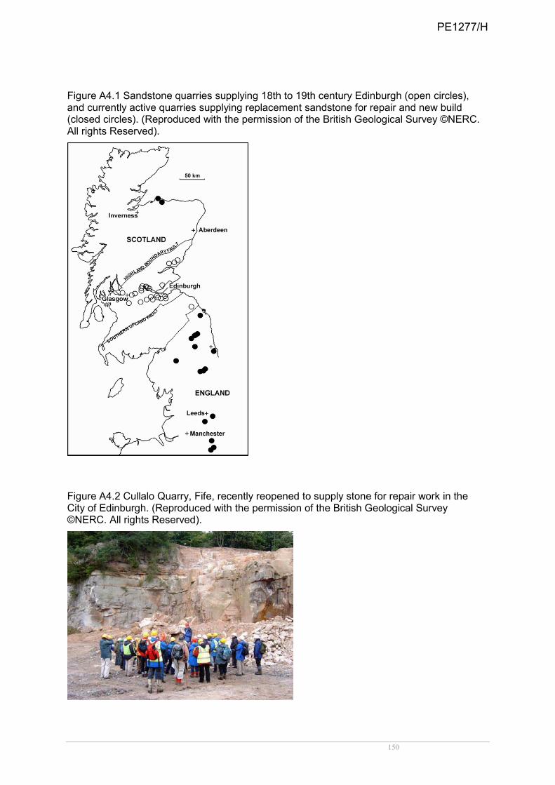
150
Figure A4.1 Sandstone quarries supplying 18th to 19th century Edinburgh (open circles), and currently active quarries supplying replacement sandstone for repair and new build (closed circles). (Reproduced with the permission of the British Geological Survey ©NERC. All rights Reserved).
Figure A4.2 Cullalo Quarry, Fife, recently reopened to supply stone for repair work in the City of Edinburgh. (Reproduced with the permission of the British Geological Survey ©NERC. All rights Reserved).
PE1277/H

151
BOX A4.1 Safeguarding Glasgow’s stone-built heritage The Scottish Stone Liaison Group’s Glasgow Project (SSLG, 2006) involved:
• stone condition surveys of 230 traditional stone facades and petrographic analysis by the British Geological Survey (BGS) of stone samples from 100 buildings (Hyslop & Albornoz-Parra, 2009);
• development of a facade survey methodology (Urqhuart, 2007);
• quantification of stone decay;
• identification of principal causes of stone decay;
• quantification of future repair work;
• identification of matching stone (quarry sources); The BGS is currently preparing a nationwide database of historic quarries. The database of geological data, presented in a GIS application, aims to identify potential resources of indigenous stone, and to aid minerals planning. In Scotland, over 700 major quarries supplied stone in 1858. Today, there are less than 30. Some sandstone types used in Glasgow are currently unavailable. Reopening former quarries is necessary to meet the demand for appropriate repair.
Figure A4.3 SSLG’s Glasgow Project: georectified photograph of a façade, colour-coded to indicate the condition of the stone. From this assessment, both stone repair needs and mason-hours can be quantified. Red - stone requiring immediate replacement. Yellow - stone requiring replacement within 20 years.
(Reproduced with the permission of the British Geological Survey ©NERC. All rights Reserved).
PE1277/H

152
APPENDIX 5. GEOLOGICAL CONSERVATION REVIEW SITE SELECTION BLOCKS AND NUMBERS OF SCOTTISH SITES
GCR block
No. of Scottish sites GCR volume
1. Structural and metamorphic geology
Lewisian 24 Mendum et al. (2009)
Torridonian 11 Mendum et al. (2009)
Moine 81 Mendum et al. (2009)
Dalradian 84 Stephenson et al. (in press)
Caledonian Structures 2 N/A Caledonian Structures of the Southern Uplands 8 Treagus (1992)
2. Igneous petrology and mineralogy
Caledonian Igneous 49 Stephenson et al. (1999)
Old Red Sandstone Igneous 11 Stephenson et al. (1999)
Ordovician Igneous 24 Stephenson et al. (1999)
Tertiary Igneous 50 Emeleus & Gyopari (1992)
Carboniferous-Permian Igneous 31 Stephenson et al. (2003)
Mineralogy of Scotland 48 Smith & Livingstone (in prep.)
3. Palaeozoic stratigraphy
Arenig-Llanvirn 4 Rushton et al. (1999)
Cambrian 4 Rushton et al. (1999)
Cambrian-Tremadoc 2 Rushton et al. (1999)
Caradoc Ashgill 6 Rushton et al. (1999)
Dinantian of Scotland 33 Cossey et al. (2004)
Llandeilo 2 Rushton et al. (1999)
Llandovery 9 Aldridge et al. (2000)
Non-Marine Devonian 22 Barclay et al. (2005)
Permian-Triassic 11 Benton et al. (2002)
Wenlock 5 Aldridge et al. (2000)
Westphalian - Namurian 9 Cleal & Thomas (1996)
4. Mesozoic-Tertiary Stratigraphy
Aalenian-Bajocian 2 Cox & Sumbler (2002)
Bathonian 7 Cox & Sumbler (2002)
Callovian 4 Cox & Sumbler (2002)
Cenomanian-Maastrichtian 2 Mortimore et al. (2001)
Hettangian, Sinemurian and Pliensbachian 8 Simms et al. (2004)
Kimmeridgian 2 Wright & Cox (2001)
Oxfordian 3 Wright & Cox (2001)
Toarcian 1 Simms et al. (2004)
5. Palaeontology
Arthropoda 9 Jarzembowski et al. (2010)
Permian-Carboniferous Fish/Amphibia 9 Dineley & Metcalfe (1999)
Jurassic-Cretaceous Reptilia 2 Benton & Spencer (1995)
Mesozoic Mammalia 1 Benton et al. (2005)
Palaeozoic Palaeobotany 20 Cleal & Thomas (1995)
PE1277/H
153
Permian-Triassic Reptilia 5 Benton & Spencer (1995)
Mesozoic Palaeobotany 4 Cleal et al. (2001)
Palaeoentomology 2 Jarzembowski et al. (2010)
Pleistocene Vertebrata 2 N/A
Silurian-Devonian Chordata 31 Dineley & Metcalfe (1999)
Tertiary Palaeobotany 1 Cleal et al. (2001)
6. Quaternary geology and geomorphology
Quaternary of Scotland 139 Gordon & Sutherland (1993)
7. Geomorphology
Caves 2 Waltham et al. (1997)
Coastal Geomorphology of Scotland 41 May & Hansom (2003) Fluvial Geomorphology of Scotland 28 Gregory (1997)
Karst 1 Waltham et al. (1997)
Mass Movement 15 Cooper (2007)
PE1277/H

154
APPENDIX 6. SITE SELECTION BLOCKS FOR MARINE GEODIVERSITY IN SCOTTISH OFFSHORE AND TERRITORIAL WATERS AND NUMBERS OF KEY INTEREST FEATURE AREAS (Source: Brooks et al., 2011)
Block Number of key feature areas*
Quaternary of Scotland 10
Submarine Mass Movement 4
Marine Geomorphology of the Scottish Deep Ocean Seabed
5
Seabed Fluid and Gas Seep Features 2
Cenozoic Structures of the Atlantic Margin 2
Marine Geomorphology of the Scottish Shelf Seabed
6
Coastal Geomorphology of Scotland 2
Biogenic Structures of the Scottish Seabed 1
Total 32
*Some areas contain assemblages of individual features or multiple interests.
PE1277/H
155
APPENDIX 7. THE EUROPEAN AND GLOBAL GEOPARKS NETWORK A Geopark is an area with a geological heritage of significance, with a coherent and strong management structure and where a sustainable economic development strategy is in place. A Geopark creates enhanced employment opportunities for the people who live there bringing sustainable and real economic benefit, usually through the development of sustainable tourism. In the framework of a Geopark, geological heritage and geological knowledge are shared with the public and linked with broader aspects of the natural and cultural environment, which are often closely related to geology and landscape. In October 2010 the European Geoparks Network comprised 42 Geoparks in 13 European countries, and the Global Network comprised 77 National Geoparks (including those from Europe). The European Geoparks charter was officially accepted on June 5, 2000 in Lesvos, Greece. http://www.europeangeoparks.org/isite/page/8,1,0.asp?mu=4&cmu=26&thID=0 The Charter states: “1. A European Geopark is a territory that includes a particular geological heritage and a sustainable territorial development strategy supported by a European programme to promote development. It must have clearly defined boundaries and sufficient surface area for true territorial economic development. European Geoparks must comprise a certain number of geological sites of particular importance in terms of their scientific quality, rarity, aesthetic appeal or educational value. The majority of sites present on the territory of a European Geopark must be part of the geological heritage, but their interest may also be archaeological, ecological, historical or cultural. 2. The sites in a European Geopark must be linked in a network and benefit from protection and management measures. The European Geopark must be managed by a clearly defined structure able to enforce protection, enhancement and sustainable development policies within its territory. No loss or destruction, directly or via sale, of the geological values of a European Geopark may be tolerated. In this respect European Geoparks are managed within the framework established by the Global Geoparks Network Charter (see below). 3. A European Geopark has an active role in the economic development of its territory through enhancement of a general image linked to the geological heritage and the development of geotourism. A European Geopark has direct impact on the territory by influencing its inhabitants' living conditions and environment. The objective is to enable the inhabitants to re-appropriate the values of the territory's heritage and actively participate in the territory's cultural revitalization as a whole. 4. A European Geopark develops, experiments and enhances methods for preserving the geological heritage. 5. A European Geopark has also to support education on the environment, training and development of scientific research in the various disciplines of the Earth Sciences, enhancement of the natural environment and sustainable development policies. 6. A European Geopark must work within the European Geopark Network to further the network's construction and cohesion. It must work with local enterprises to promote and
PE1277/H

156
support the creation of new by-products linked with the geological heritage in a spirit of complementarity with the other European Geoparks Network members. The Global Network of National Geoparks assisted by UNESCO provides a platform of active cooperation between experts and practitioners in geological heritage (http://www.globalgeopark.org/publish/portal1/tab190/). Under the umbrella of UNESCO, and through exchange between the global network partners, important national geological sites gain worldwide recognition and profit through the exchange of knowledge, expertise, experience and staff with other Geoparks.”
The Global Geoparks Network Charter
“A Geopark must respect local and national laws relating to the protection of geological heritage. In order to be seen to be impartial in its management of the geological heritage, its managing body must not participate directly in the sale of geological objects within the Geopark (no matter from where they are) and should actively discourage unsustainable trade in geological materials as a whole, including shortsighted selling of Earth heritage, minerals and fossils. Where clearly justified as a responsible activity and as part of delivering the most effective and sustainable means of site management, it may permit sustainable collecting of geological materials for scientific and educational purposes from naturally renewable sites within the Geopark. Trade of geological materials based on such a system may be tolerated in exceptional circumstances, provided it is clearly and publicly explained, justified and monitored as the best option for the Geopark in relation to local circumstances. Such circumstances will be subject to debate and approval by the Global Geopark Network / European Geopark Network on a case by case basis.
PE1277/H