comment: soil types impact stormwater land needs … · ridgefield are puds and we do not know the...
TRANSCRIPT
Page 1
TO: Clark County Buildable Lands Project
Advisory Committee DATE: July 2, 2020
FROM: Nicole Stickney, AICP Tri-Cities - (509) 380-5883
PROJECT NO.: 2190628.30
PROJECT NAME: Clark County Buildable Lands Program
SUBJECT: VBLM Infrastructure Deductions and Stormwater Facilities Analysis
The purpose of this memo is to follow up on comments and feedback provided by committee members during the June 2020 BLPAC meeting related to our presentation. This memo accompanies additional materials prepared by ECONorthwest and county staff on the various topics.
COMMENT: SOIL TYPES IMPACT STORMWATER LAND NEEDS AND FUTURE DEVELOPMENT WILL BE ON MORE CHALLENGING SOILS
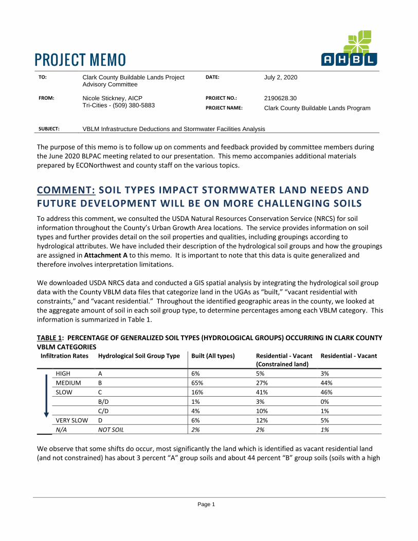
To address this comment, we consulted the USDA Natural Resources Conservation Service (NRCS) for soil information throughout the County’s Urban Growth Area locations. The service provides information on soil types and further provides detail on the soil properties and qualities, including groupings according to hydrological attributes. We have included their description of the hydrological soil groups and how the groupings are assigned in Attachment A to this memo. It is important to note that this data is quite generalized and therefore involves interpretation limitations. We downloaded USDA NRCS data and conducted a GIS spatial analysis by integrating the hydrological soil group data with the County VBLM data files that categorize land in the UGAs as “built,” “vacant residential with constraints,” and “vacant residential.” Throughout the identified geographic areas in the county, we looked at the aggregate amount of soil in each soil group type, to determine percentages among each VBLM category. This information is summarized in Table 1. TABLE 1: PERCENTAGE OF GENERALIZED SOIL TYPES (HYDROLOGICAL GROUPS) OCCURRING IN CLARK COUNTY VBLM CATEGORIES
Infiltration Rates Hydrological Soil Group Type Built (All types) Residential - Vacant (Constrained land)
Residential - Vacant
HIGH A 6% 5% 3%
MEDIUM B 65% 27% 44%
SLOW C 16% 41% 46%
B/D 1% 3% 0%
C/D 4% 10% 1%
VERY SLOW D 6% 12% 5%
N/A NOT SOIL 2% 2% 1%
We observe that some shifts do occur, most significantly the land which is identified as vacant residential land (and not constrained) has about 3 percent “A” group soils and about 44 percent “B” group soils (soils with a high

Project Memo Page 2 Clark County Buildable Lands Program 2190628.30 July 2, 2020
or medium infiltration) whereas the lands which are built-out1 feature 6 and 65 percent of “A” and “B” soils, respectively; the vacant residential lands have a smaller overall share of high or medium infiltration soils.
This information is also shown on maps and depicted in figures in Attachment A; the maps illustrate the geographical differences and volumes between different communities. In reviewing the maps and the data, we find that the built areas and the vacant areas for each jurisdiction are fairly similar, though there are some variations observed. In other words, within most UGAs, there appears to be less difference between the built and vacant residential land than there is when aggregating all UGAs together. The Vancouver UGA contains a large amount of built land with “A” and “B” soils, while some smaller jurisdictions have largely “C” and “D” soils throughout both the built and vacant land. Because the built acreage in Vancouver is so much larger than in other jurisdictions but the vacant acres are somewhat more evenly distributed among different UGAs, this skews the overall results. However, we caution that since the data is quite generalized there are some practical restrictions for what conclusions may be drawn; moreover, when stormwater facilities are designed there are multiple site-specific factors that this data does not account for such as topography, the presence of wetlands, and so forth. Additionally, the soils data that we have used cannot account for factors such as depth to water tables, due to its highly generalized nature.
Recommendation: Continue to be mindful of the many factors which influence stormwater facilities design sizing when making periodic adjustments to the VBLM. However, due to data constraints and in recognition of site variability, do not make any adjustments to the County’s VBLM accounting for soil types at this time.
COMMENT: IN THE CITY OF RIDGEFIELD HALF OF ALL OPEN SPACE MUST BE OUTSIDE OF CRITICAL AREAS
Background: In our previous memo to the Buildable Lands Project Advisory Committee, we reported on the share of land area in plats in Ridgefield that is identified as open space. We found that 15.5 percent of the land area within plats in the City (recorded between 2002 and 2019) was open space, but that the vast majority of this open space overlapped with lands mapped as critical areas. Our memo further identified that in examining the requirements for Planned Unit Developments (PUDs) for Ridgefield, we discovered that their current code (last amended via Ord. No. 1290, § 2 in April 2019) requires a minimum of twenty-five percent of the gross site area for common open space. When we reported that 15.5 percent of the platted lands was in open space, this data point raised questions in the committee, given that Ridgefield is known to have a requirement for a great deal of open space to be dedicated outside of critical areas. Analysis: Development via a PUD in Ridgefield is quite common; whereas many communities throughout the state do not require developers to use a PUD process but only provide it as an option, Ridgefield has specific triggers for a PUD
1 We included residential land as well as other categories

Project Memo Page 3 Clark County Buildable Lands Program 2190628.30 July 2, 2020
which results in higher instances of PUDs2. Despite this, it is important to note that not all of the plats in Ridgefield are PUDs and we do not know the ratio of plats that were processed as PUDs verses those that were not. To respond to the comment, we examine RMC Section 18.401.080 (B) which describes open space requirements for PUDs. We reproduced the code in Attachment B for quick reference and convenience (with our emphasis added for clarification).
• We find the code requires that at least half of a “main facility” (which itself must comprise at least half of the required open space) must be sited on buildable land, “suitable for development of active recreation uses and critical areas buffers proposed for passive recreation facilities.”
• The remaining 50% (or less) may be situated “in critical areas and buffers that are not proposed for passive recreation.”
Once we examine maps depicting open space included in Ridgefield plats for the years 2002-2019 it becomes clear that the majority of the open space areas are considered “constrained land” as defined in the VBLM. (As a reminder, the “constrained land” inventory includes critical area buffers.) This observation, in turn, provides a valid explanation for one factor that influences the findings: critical area buffers are used extensively by developers to fulfill open space requirements. Moreover, as discussed earlier, not all plats require open space (only those that are PUDs trigger the need), also driving down the overall percentage of open space in plats from the 25 percent share scenario. Finally, we also emphasize that the open space requirements can be satisfied through the dedication of developed parks and trails to the City; in cases where this process may have occurred, our calculations will not account for land that has been accepted by the City as park land, as the assessor’s data would have that land included under a category not captured in our analysis.
Recommendation: Continue to consider how differences between jurisdiction requirements and permitting processes influence development patterns when making periodic adjustments to the VBLM. Use the observed data as presented previously to adjust the VBLM for off-site infrastructure deductions to account for open space.
COMMENT : OFF-SITE INFRASTRUCTURE, INCLUDING SCHOOLS, PARKS, ROADS, COMMUNITY FACILITIES NEED TO BE ADDRESSED
Off-site public facilities for schools and parks should be accounted for in the VBLM to estimate the amount of land needed to accommodate the 20-year population projection. For transparency, this investigation should be performed separately from the on-site infrastructure deduction. The VBLM deducts publicly owned land and therefore the existing inventory of vacant park and school land should be deducted from the calculated need for additional park and school land to avoid double counting.
2 In Ridgefield, a PUD is required “for all developments in the RLD or RMD zones that create ten or more lots through a subdivision process and include critical areas within the project boundaries, except for sites zoned RMD being developed under the RMUO overlay, which is exempt from the PUD process.” (RMC 18.401.020(A))

Project Memo Page 4 Clark County Buildable Lands Program 2190628.30 July 2, 2020
The adopted Capital Facilities Plans (CFP) for school districts or Park Recreation and Open Space (PROS) plans should be used to estimate the amount of land needed to accommodate the 20-year population projection and the inventory of undeveloped land.
Recommendation: County staff has proposed the following methodology for the investigation of parks:
• Calculate the need for new buildable park land at a ratio of X acres per 1,000 population standard
from either adopted PROS or CFPs. (These standards range by jurisdiction from 3.29 to 8 acres per 1,000/population)
• Subtract existing undeveloped parks based on parks CFP inventories. • Convert to a ratio of remaining needed acres to vacant acres and apply to the VBLM after critical
land and market factor deductions, but before on-site infrastructure deductions.3
County staff’s proposed school methodology would be to: • Calculate the need for new buildable school land from the adopted school capital facility plans on
an acre/household formula by school type. (See formula below) • Subtract existing undeveloped school land based on school CFP inventories. • Convert to a ratio and apply to the VBLM after critical land and market factor deductions, but
before on-site infrastructure deductions.3
Existing 20 year plan = 50,281 Households Grades K-5 = 50,281 households * 0.048 student/ grade/ household X 6 = 14,481 new students Grades 6-8 = 50,281 households * 0.043 0.048 student/ grade/ household X 3 = 6,486 new students Grades 9-12 = 50,281 households * 0.037 0.048 student/ grade/ household X 4 = 7,441 new students Grades K-5 = 14,481 new students @ 600 / school = 24.1 schools @ 10 acres = 241 total acres needed Grades 6-8 = 6,486 new students @ 1,000 / school = 6 schools @ 20 acres = 130 total acres needed Grades 9-12 = 7,441 new students @ 2,000 / school = 8 schools @ 40 acres = 149 total acres needed Each household requires 0.0135 acres, and each net acre needs 0.062 to 0.083 acres, depending on density Schools = 6.2 to 8.3 percent of net developable land *ESD 112 and Evergreen School District verified that these are still valid numbers to use
Finally, while widening existing roads and construction of new arterials and highways does occur, new major roads are built infrequently and road widenings have a fairly small impact on the overall supply of buildable land. An additional deduction for additional major road right-of-way would likely be very small and have minimal impact on the model but would require additional detailed analysis to establish an appropriate assumption; therefore, it is not recommended at this time.
3 This sequence is proposed so that school and park lands are assumed to come from buildable land that is available for development within the 20-year planning horizon, but does not assume plat deductions as are applied for residential development.
Project Memo Page 5 Clark County Buildable Lands Program 2190628.30 July 2, 2020
COMMENT : THE STORMWATER ANALYSIS DID NOT ADDRESS MULTIFAMILY
The observation that AHBL did not separately study the stormwater sizing requirements for multifamily development is correct. Multifamily development throughout Clark County takes many different possible forms. When multifamily development occurs, it is not uncommon for stormwater facilities to be constructed within the same parcel as the development. As a result, the overall achieved development density accounts for these infrastructure elements and therefore no infrastructure deduction is necessary.
Recommendation: Consider applying the on-site infrastructure deductions only to vacant Low Density residential land since High Density residential land is more likely to be developed as multifamily.
COMMENT: DEVELOPMENT ENGINEERING ADVISORY BOARD EXAMPLE PLATS SHOW HIGHER PERCENTAGES FOR ON-SITE INFRASTRUCTURE
A committee member shared a document prepared by the Responsible Growth Forum of the Building Industrial Association of Clark County several years ago, which includes a table of various plats constructed prior to 2016. The table details the amount of land dedicated to infrastructure, among other features and data. A weighted average of infrastructure is shown, at 36.3 percent. The information is interesting, and we greatly appreciate the value of sharing past analyses and data collections. While it would be handy to compare the data to the findings identified in our last memo, we caution that we don’t know the background or contextual aspects for the previous data collection and synthesis. For example, it is unclear how critical areas where considered when the table was compiled. Moreover, we emphasize that for the purposes of using an infrastructure deduction in the VBLM, any “infrastructure deduction” value is not meant to separately and wholly represent the actual amount of land that is infrastructure that is included in plats. To the contrary, the deduction is a model input to represent an adjustment that must be made, in relation to other deductions and factors, such as constrained lands.
COMMENT: OTHER JURISDICTIONS USE HIGHER ASSUMPTIONS
ECONorthwest has compiled information on the assumptions in use by several other Buildable Lands counties, including Snohomish, Thurston, and Pierce Counties. See Attachment D. Cc: Oliver Orjiako, Clark County
Jose Alvarez, Clark County Bob Pool, Clark County
Becky Hewitt, ECONorthwest Wayne E. Carlson, AHBL
Q:\2019\2190628\30_PLN\Working_Files\20200702_Follow Up Memo for BLPAC_2190628.docx

Project Memo Attachment A Page A-1 Clark County Buildable Lands Program 2190628.30 July 2, 2020
ATTACHMENT A: HYDROLOGICAL SOIL GROUPS
Soil Types:
A
B
C
B/D
C/D
D
NOT SOIL

Project Memo Attachment A Page A-2 Clark County Buildable Lands Program 2190628.30 July 2, 2020
Project Memo Attachment A Page A-3 Clark County Buildable Lands Program 2190628.30 July 2, 2020
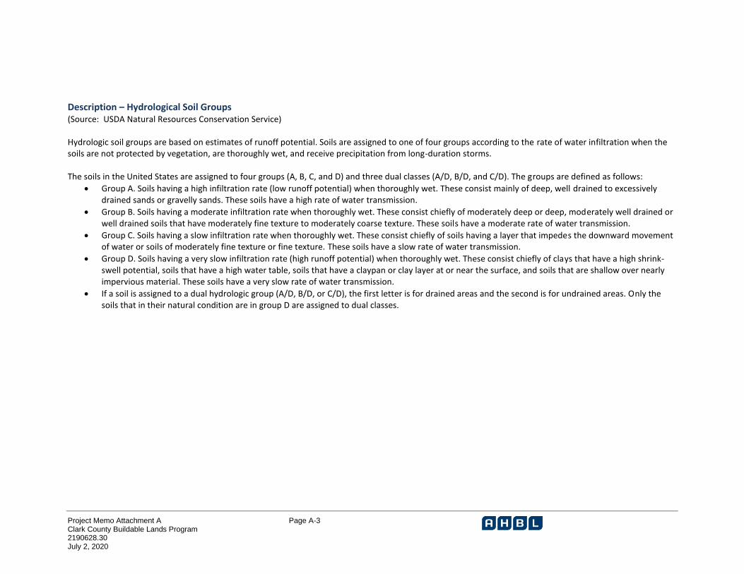
Description – Hydrological Soil Groups (Source: USDA Natural Resources Conservation Service) Hydrologic soil groups are based on estimates of runoff potential. Soils are assigned to one of four groups according to the rate of water infiltration when the soils are not protected by vegetation, are thoroughly wet, and receive precipitation from long-duration storms. The soils in the United States are assigned to four groups (A, B, C, and D) and three dual classes (A/D, B/D, and C/D). The groups are defined as follows:
• Group A. Soils having a high infiltration rate (low runoff potential) when thoroughly wet. These consist mainly of deep, well drained to excessively drained sands or gravelly sands. These soils have a high rate of water transmission.
• Group B. Soils having a moderate infiltration rate when thoroughly wet. These consist chiefly of moderately deep or deep, moderately well drained or well drained soils that have moderately fine texture to moderately coarse texture. These soils have a moderate rate of water transmission.
• Group C. Soils having a slow infiltration rate when thoroughly wet. These consist chiefly of soils having a layer that impedes the downward movement of water or soils of moderately fine texture or fine texture. These soils have a slow rate of water transmission.
• Group D. Soils having a very slow infiltration rate (high runoff potential) when thoroughly wet. These consist chiefly of clays that have a high shrink-swell potential, soils that have a high water table, soils that have a claypan or clay layer at or near the surface, and soils that are shallow over nearly impervious material. These soils have a very slow rate of water transmission.
• If a soil is assigned to a dual hydrologic group (A/D, B/D, or C/D), the first letter is for drained areas and the second is for undrained areas. Only the soils that in their natural condition are in group D are assigned to dual classes.

Project Memo Attachment B Page B-1 Clark County Buildable Lands Program 2190628.30 July 2, 2020
ATTACHMENT B: RIDGEFIELD MUNICIPAL CODE (EXCERPT)
18.401.080 - General conditions. B. Open Space. Every PUD shall provide a minimum of twenty-five percent of the gross site area for common open space which shall be used for the collective enjoyment of occupants of the development. Open space shall not include public or private streets or rights-of-way, driveways, above-ground utility facilities including stormwater facilities, parking areas unless developed as part of park or trail facility consistent with standards in the Ridgefield Parks and Recreation Comprehensive Plan, or the required yards for buildings or structures. Open space areas may include critical areas and buffers, but shall not be computed to include any submerged lands.
1. Main Facility. At least fifty percent of the required common open space, or twelve and one-half percent of the gross site area, shall be located on a single parcel to provide a larger, central facility for the PUD. A minimum of fifty percent of the main facility shall be a combination of buildable land suitable for development of active recreation uses and critical areas buffers proposed for passive recreation facilities consistent with RDC [Chapter] 18.280, limited to the portion of the buffer area proposed for improvements such as a trail or wildlife viewing structure. The remaining fifty percent or less of the main facility may include critical areas and buffers not proposed for passive recreation improvements.
a. If the main facility is two acres or larger, meets the standards for a neighborhood or community park in the Ridgefield Parks and Recreation Comprehensive Plan, is listed as a system-wide project on the Ridgefield Parks Capital Facilities Plan, and is dedicated to the City, the value of the land dedication shall be credited against the amount charged for city park impact fees, pursuant to Chapter 18.070. The developer may elect to provide more than twelve and one-half percent of the site in a single parcel in order to create a two-acre parcel eligible for PIF credits. b. If the main facility is less than two acres in size and is eligible for future development as a neighborhood or community park consistent with the Parks and Recreation Comprehensive Plan, the parcels should be located adjacent to the perimeter of the PUD such that it would be feasible to expand the open space area onto the adjacent property. If there are existing open space parcels adjacent to a proposed PUD, the open space in the proposed PUD should be located adjacent to existing open space parcels in order to facilitate creation of larger facilities that meet sizing requirements for park facilities in the Parks and Recreation Comprehensive Plan. The value of the land may be credited against the amount charged for city park impact fees, pursuant to Chapter 18.070, if the planning director determines that the parcel can be used as part of a future park facility that meets the standards for a neighborhood or community park in the Ridgefield Parks and Recreation Comprehensive Plan and the park is listed as a system-wide project on the Ridgefield Parks Capital Facilities Plan, and the parcel is dedicated to the city. c. Improvement of facilities created under subsections (a) and (b) will not be required. However, the cost of improvements may be eligible for PIF credits if the developer elects to construct park improvements that meet the standards for a neighborhood or community park in the Ridgefield Parks and Recreation Comprehensive Plan. d. If the main facility is less than two acres in size or does not meet the requirements of subsections (a) or (b), it shall be developed consistent with the requirements for dispersed facilities in RDC [Section] 18.401.080.B.2.
2. Dispersed facilities. a. A minimum of fifty percent of the total dispersed facilities shall be a combination of buildable land suitable for development of active recreation uses and critical areas buffers proposed for passive recreation facilities consistent with RDC [Chapter] 18.280, limited to the

Project Memo Attachment B Page B-2 Clark County Buildable Lands Program 2190628.30 July 2, 2020
portion of the buffer area proposed for improvements such as a hard surface trail. The remaining fifty percent or less of the dispersed facilities may include critical areas and buffers not proposed for passive recreation improvements. A minimum of fifty percent of the area reserved for active and passive recreation facilities, or twenty-five percent of total required dispersed facilities, shall be improved with irrigated lawn area and landscaping, playfields, pedestrian paths, picnic tables and seating areas, play equipment and swings, pedestrian-scale lighting along paths, sport courts, other active recreation facilities, trails, wildlife viewing structures, or similar amenities approved by the planning director. b. Parcels shall meet a minimum size of ten thousand square feet with the exception of trail facilities required by RDC [Section] 18.401.090.R or the Ridgefield Parks and Recreation Comprehensive Plan.
3. Open space within the PUD is to be designed as an integrated part of the project rather than an isolated element of the project. It should be located within the development such that it is available for the enjoyment of the residents in an equitable manner. 4. Open space may contain such structures and improvements as are necessary and appropriate for the out-of-doors enjoyment of the residents of the PUD. 5. All dwelling units within the PUD must have legal access to the proposed area for dedication at the time of final PUD approval. Private or access roads, trees or other landscaping may separate the area proposed for dedication. However, access should not be blocked by major obstacles such as arterials or collectors, canyons, ravines or other obstructions. 6. Areas developed for active recreational use shall have reasonable access from street frontages. Design measures should accomplish the purposes of access and security. 7. The developer shall provide a bond or other financial assurance acceptable to the city council that any improvements made in the common open space will be completed. The city shall release the bond or other assurance when the improvements have been completed in accordance with the development plan. (See Section 18.401.120.) 8. All developed open space areas shall be landscaped in accordance with the landscaping plan submitted by the applicant and approved by the city. Natural landscape features which are to be preserved, such as existing trees, drainage ways, etc., may be accepted as part of the landscaping plan. 9. The city may accept dedication of open space and recreation areas built to city standards for parks and trails adopted in the Ridgefield Parks and Recreation Comprehensive Plan at its discretion. 10. In the event that parks, open space or trails created under this Title are owned by the developer or a homeowners' association, the facilities shall be made available for public use and be maintained by the developer or homeowners' association. The city shall be granted the right of third-party enforcement to ensure that the parks, open space and trails are maintained to standards under which they were approved and created. 11. At the applicant's discretion, the applicant may elect to include or exclude the buildable portion of parcels designated as main or dispersed facilities under this section in the calculation of net developable acres for the purposes of calculating minimum and maximum density for the project. If the applicant elects to include the buildable acres in the density calculation, the applicant may reduce the minimum lot size and minimum lot width and depth dimensions for the zone by up to twenty percent in order to accommodate the additional lots allowed. Any further reduction to lot size, width or depth greater than twenty percent shall comply with RDC [Section] 18.401.100.A.

Project Memo Attachment C Page C-1 Clark County Buildable Lands Program 2190628.30 July 2, 2020
ATTACHMENT C: RIDGEFIELD PLATS AND OPEN SPACE LOCATIONS

Project Memo Attachment D Page D-1 Clark County Buildable Lands Program 2190628.30 July 2, 2020
ATTACHMENT D: SUMMARY OF INFRASTRUCTURE SET-ASIDES BUILDABLE LANDS REPORT ASSUMPTIONS IN SNOHOMISH, PIERCE, AND THURSTON COUNTIES

ECONorthwest | Portland | Seattle | Los Angeles | Eugene | Boise | econw.com 1
DATE: July 2, 2020 TO: Clark County Buildable Lands Project Advisory Committee FROM: Margaret Raimann and Becky Hewitt, ECONorthwest SUBJECT: Summary of infrastructure set-asides buildable lands report assumptions, Snohomish,
Pierce, and Thurston Counties
The table below summarizes the infrastructure deductions in place in Snohomish, Pierce, and Thurston Counties.
Jurisdiction Deduction/set-aside types Set aside % Snohomish County Removes major utility easements (e.g., transmission lines) and specific
lands needed for new capital facilities, and includes a 5% reduction for potential public/institutional uses, public facilities, or stormwater facilities whose locations are unknown.
Pierce County Varies by jurisdiction. May include “land reserved for roads, critical areas, parks and recreation, or storm water facilities”
Varies
City of Auburn Plat deductions: Roads, critical areas, parks and open space Public facility/institutional
Roads: 7% Critical areas (GIS data for wetlands and steep slopes) Parks: 2% Public facilities: 1%
City of Bonney Lake
Plat deductions: Roads, critical areas, stormwater Public facility/institutional
Roads: 15% Critical areas: GIS data Stormwater: 5% (R-1, R-2, R-3)
City of Buckley Plat deductions: Roads, critical areas, recreation / parks Public facility/institutional
Roads: 10% Critical areas: GIS data for wetlands and steep slopes Recreation / parks: 3% Public facilities: P zone
Town of Carbonado
Roads Public facility/institutional
Parcel specific
City of DuPont Public facility/institutional Public facilities: 6.36% Town of Eatonville
Plat deductions: Roads, critical areas Public facility/institutional
Roads: 15% Critical areas: GIS data for wetlands (adjusted) Public facilities: Parcel specific
City of Edgewood
Plat deductions: Roads, critical areas, recreation / parks Public facility/institutional
Roads: 9.80% Critical areas: GIS data for steep Slopes, 35 foot buffer Wetlands, 75 foot buffer Category III Wetlands, 50 foot buffer Recreation / parks: 5% Public facilities: 1.9%
City of Fife Plat deductions: Roads, critical areas, recreation / parks Public facility/institutional
Roads: 20% Critical areas: 16% Recreation / parks: 10% Public facilities: 5%

ECONorthwest 2
Jurisdiction Deduction/set-aside types Set aside % City of Fircrest N/A N/A City of Gig Harbor
Plat deductions: Roads, critical areas Public facility/institutional
Roads: 15% Critical areas: GIS data of wetlands, ravine sidewalls/bluffs and Tidelands Public facilities: Parcel specific
City of Lakewood
Public facility/institutional Parcel Specific: WSH, colleges, hospital, schools, community centers, City Hall, and Pierce Transit.
City of Milton Plat deductions: Roads, critical areas, recreation / parks
Critical areas: GIS data from Milton Critical Area Mapping Roads: 15% Recreation / parks: 15%
City of Orting Plat deductions: Roads, critical areas, recreation / parks Public facility/institutional
Roads: 10% Critical areas: 7.5% Recreation / parks: 6.20% Public facilities: 25%
City of Pacific Public facility/institutional Public facilities: Parcel specific Unincorporated Urban Pierce County
Plat deductions: Roads, critical areas Public facility/institutional
Roads: 15% Critical areas: GIS data of County Wetland Inventory, Supplemental Wetland Inventory, Rivers/Streams, Floodways, Channel Migration Zone, and Steep Slopes Public facilities: Parcel specific
City of Puyallup Plat deductions: Roads, critical areas Public facility/institutional
Roads: 20% CBD, CBD (Core), RM (Core): 0% Critical areas: GIS data of Wetland (2003), Steep Slopes, Category 1 Stream (150 ft. buffer) and Category 2 Stream (100 ft. buffer) Public facilities: Parcel specific
City of Roy Plat deductions: Roads, critical areas, recreation / parks Public facility/institutional
Roads: 15% Critical areas: GIS data of steep slopes, wetlands, 150' wetland buffers, and 100 yr. floodplains Recreation / parks: 5% Public facilities: Parcel Specific: 2 acres for future park
City of Ruston Plat deductions: Roads, critical areas Public facility/institutional
Roads: MPD 20% Critical areas: GIS data of wetlands (150ft buffers), landslide hazard areas (slope >15%), and fish and wildlife habitat area. Public facilities: Parcel specific
Town of South Prairie
Plat deductions: Roads, critical areas, recreation / parks Public facility/institutional
Roads: 30% Critical areas: 35% Recreation / parks: 10% Public facilities: 3%
Town of Steilacoom
Plat deductions: Roads, critical areas, recreation / parks Public facility/institutional
Roads: 12% Critical areas: 10% Recreation / parks: 5% Public facilities: Parcel specific

ECONorthwest 3
Jurisdiction Deduction/set-aside types Set aside % City of Sumner Plat deductions: Critical areas
Public facility/institutional
Critical areas: GIS data of wetlands, slopes (>25%), floodways, rivers and streams (types 3,4,5), 1987 Flood Maps. Buffers: wetlands 75ft, rivers 50, 100, and 150ft, streams 25ft (type 5), 50ft (type 4), and 100ft (type 3). Public facilities: Parcel specific
City of Tacoma Plat deductions: Roads, critical areas, recreation / parks Public facility/institutional
Roads: 25% for parcels over 1 acre. Critical areas: R1, R2, R2-SRD, HMR-SRD: Vacant 15%, Underutilized 5% Mixed Use Zones: 0% All Other Zones: Vacant 5%, Underutilized 0% Recreation / parks: Parcel Specific: Federal, State, County, Metro Parks, School District, and City of Tacoma owned Public facilities: Parcel Specific: Federal, State, County, Metro Parks, School District, and City of Tacoma owned
City of University Place
Plat deductions: Roads, critical areas, recreation / parks Public facility/institutional
Roads: R-1: 15% for parcels over 1 acre R-2: 15% for parcels over .7 acre Critical areas: 10% TC/TC-Overlay: 0% Recreation / parks: R-1: 7% for parcels over 1 acre R-2: 7% for parcels over .7 acre Public facilities: Parcel specific
Town of Wilkerson
Plat deductions: Roads, critical areas, recreation / parks Public facility/institutional
Roads: 20% Critical areas: 35% Recreation / parks: 20% Public facilities: Parcel specific
Thurston County Varies by jurisdiction. May include land reserved for open space / tree tracts, stormwater, and roads
Varies
Lacey Plat deductions: Open space / tree tract, stormwater, roads
Open space / tree tract: 10% or 10% plus critical Stormwater: 10% Roads: 20%
Tumwater Plat deductions: Open space / tree tract, stormwater, roads
Open space / tree tract: 10% or 5% plus critical Stormwater: 10% Roads: 20%
Olympia Plat deductions: Open space / tree tract, stormwater, roads
Open space / tree tract: 5% or critical Stormwater: 10% Roads: 25%
Yelm Plat deductions: Open space / tree tract, stormwater, roads
Open space / tree tract: 5% or critical Stormwater: 5% Roads: 22%
Bucoda N/A N/A Rainier N/A N/A Tenino N/A N/A

ECONorthwest 4
Jurisdiction Deduction/set-aside types Set aside % Unincorporated Growth Areas
Plat deductions: Open space / tree tract, stormwater, roads
Open space / tree tract: 5% or 2.5% plus critical Stormwater: 10% Roads: 22%