collot 2004 jgr rupturelimits
TRANSCRIPT

7/29/2019 Collot 2004 JGR Rupturelimits
http://slidepdf.com/reader/full/collot-2004-jgr-rupturelimits 1/15
Are rupture zone limits of great subduction earthquakes
controlled by upper plate structures? Evidence from multichannel
seismic reflection data acquired across the northern Ecuador– southwest Colombia margin
Jean-Yves Collot,1 Boris Marcaillou,2 Francoise Sage,2 Francois Michaud,2
William Agudelo,2 Philippe Charvis,1 David Graindorge,2 Marc-Andre Gutscher,3
and George Spence4
Received 2 March 2004; revised 18 June 2004; accepted 29 July 2004; published 18 November 2004.
[1] Subduction of the Nazca plate beneath the Ecuador-Colombia margin has producedfour megathrust earthquakes during the last century. The 500-km-long rupture zone of the1906 ( M w = 8.8) event was partially reactivated by three thrust events, in 1942( M w = 7.8), 1958 ( M w = 7.7), and 1979 ( M w = 8.2), whose rupture zones abut one another.
Multichannel seismic reflection and bathymetric data acquired during the SISTEUR cruiseshow evidence that the margin wedge is segmented by transverse crustal faultsthat potentially correlate with the limits of the earthquake coseismic slip zones. ThePaleogene-Neogene Jama Quininde and Esmeraldas crustal faults define a $200-km-longmargin crustal block that coincides with the 1942 earthquake rupture zone. Subductionof the buoyant Carnegie Ridge is inferred to partially lock the plate interface along centralEcuador. However, coseismic slip during the 1942 and 1906 earthquakes may haveterminated against the subducted northern flank of the ridge. We report on a newlyidentified Manglares crustal fault that cuts transversally through the margin wedge andcorrelates with the limit between the 1958 and 1979 rupture zones. During the earthquakecycle the fault is associated with high-stress concentration on the plate interface. Anouter basement high, which bounds the margin seaward of the 1958 rupture zone, may act
as a deformable buttress to seaward propagation of coseismic slip along a megathrust splay fault. Coseismic uplift of the basement high is interpreted as the cause for the 1958tsunami. We propose a model of weak transverse faults which reduce coupling betweenadjacent margin segments, together with a splay fault and an asperity along the plateinterface as controlling the seismogenic rupture of the 1958 earthquake. I NDEX T ERMS :
8105 Tectonophysics: Continental margins and sedimentary basins (1212); 8020 Structural Geology:
Mechanics; 8005 Structural Geology: Folds and folding; 3025 Marine Geology and Geophysics: Marine
seismics (0935); 7209 Seismology: Earthquake dynamics and mechanics; K EYWORDS : Ecuador-Colombia,
subduction earthquakes, active margin structures, multichannel seismic reflection, morphology
Citation: Collot, J.-Y., B. Marcaillou, F. Sage, F. Michaud, W. Agudelo, P. Charvis, D. Graindorge, M.-A. Gutscher, and G. Spence
(2004), Are rupture zone limits of great subduction earthquakes controlled by upper plate structures? Evidence from multichannel
seismic reflection data acquired across the northern Ecuador–southwest Colombia margin, J. Geophys. Res., 109, B11103,
doi:10.1029/2004JB003060.
1. Introduction
[2] Great subduction earthquakes nucleate along the seis-mogenic zone, a relatively shallow portion of the plate bound-
ary interface where subducting and overriding plates aresufficiently coupled to accumulate elastic stress [ Pacheco et al., 1993; Scholz , 1988]. The occurrence of subduction mega-thrust events depends mainly on the rheology of the forearc[ McCaffrey, 1993], the transient shear stress magnitude onthe fault [Wang et al., 1995], the thermal structure and widthof the coupled zone [ Hyndman and Wang , 1995; Kanamori,1986], the asperity distribution [ Ruff and Kanamori, 1983;Thatcher , 1990] and physical properties of interplate rocks[Vrolijk , 1990; Moore and Saffer , 2000]. However, themechanical factors that control the length and therefore thelateral limits of the brittle rupture are still poorly understood.
[3] Mounting evidence suggests that subducting topo-graphic features, which locally increase interplate coupling
JOURNAL OF GEOPHYSICAL RESEARCH, VOL. 109, B11103, doi:10.1029/2004JB003060, 2004
1Geosciences Azur, Institut de Recherche pour le Developpement,Villefranche sur Mer, France.
2Geosciences Azur, Universite Pierre et Marie Curie, Villefranche sur Mer, France.
3Centre National de la Recherche Scientifique, Universite de BretagneOccidentale, UMR 6538 Domaines Oceaniques, Plouzane, France.
4School of Earth and Ocean Sciences, University of Victoria, Victoria,British Columbia, Canada.
Copyright 2004 by the American Geophysical Union.0148-0227/04/2004JB003060$09.00
B11103 1 of 14
7/29/2019 Collot 2004 JGR Rupturelimits
http://slidepdf.com/reader/full/collot-2004-jgr-rupturelimits 2/15
[Cloos and Shreve, 1996; Kelleher and McCann, 1976; Mogi, 1969; Scholz and Small , 1997], may act as stronginterplate asperities rupturing during earthquakes, asrecently exemplified along the Costa Rica margin [ Bilek et al., 2003; Husen et al., 2002]. Subducting bathymetrichighs may also present a barrier to the lateral propagation of a brittle rupture, as shown by a subducting seamount that correlates with the western boundary of the 1946 Nankaido
earthquake brittle rupture zone [ Kodaira et al., 2000] andan interpreted tear fault in the Philippine Sea Plate that coincides with the eastern boundary of the same event [Cummins et al., 2002]. In addition to subducting featuresinhibiting lateral rupture propagation, Mogi [1969], Stauder [1972], and Sykes [1971] pointed out that the along-strike boundaries of Japanese and Alaska-Aleutian rupture zonesappear to coincide with margin transverse structures.
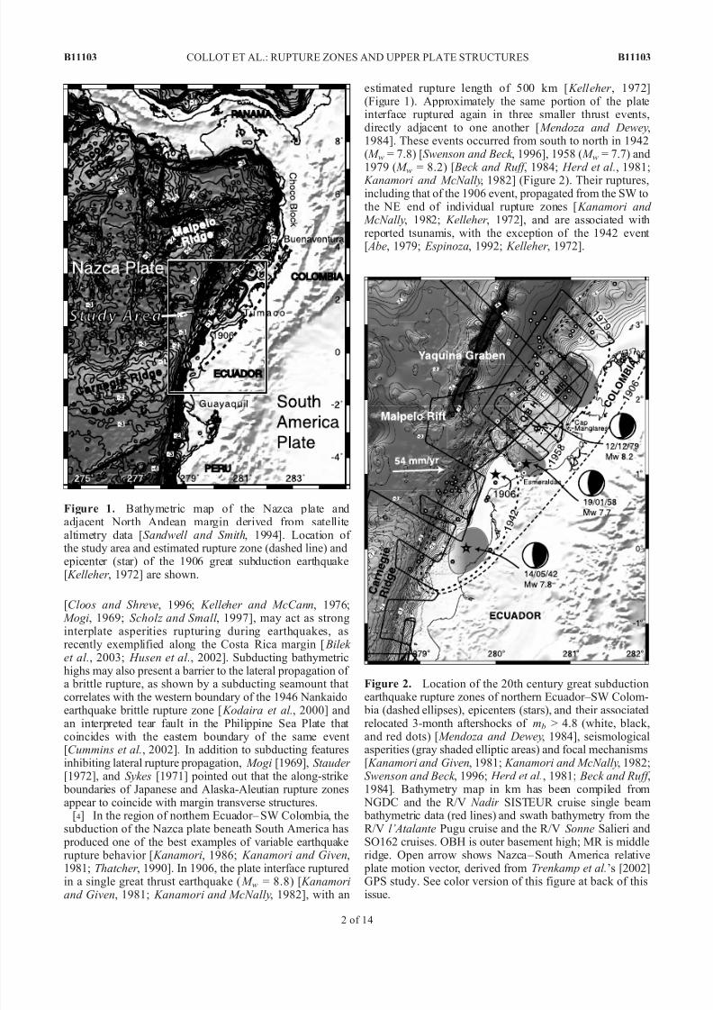
[4] In the region of northern Ecuador– SW Colombia, thesubduction of the Nazca plate beneath South America has produced one of the best examples of variable earthquakerupture behavior [ Kanamori, 1986; Kanamori and Given,1981; Thatcher , 1990]. In 1906, the plate interface ruptured
in a single great thrust earthquake ( M w = 8.8) [ Kanamoriand Given, 1981; Kanamori and McNally, 1982], with an
estimated rupture length of 500 km [ Kelleher , 1972](Figure 1). Approximately the same portion of the plateinterface ruptured again in three smaller thrust events,directly adjacent to one another [ Mendoza and Dewey,1984]. These events occurred from south to north in 1942( M w = 7.8) [Swenson and Beck , 1996], 1958 ( M w = 7.7) and1979 ( M w = 8.2) [ Beck and Ruff , 1984; Herd et al., 1981;
Kanamori and McNally, 1982] (Figure 2). Their ruptures,including that of the 1906 event, propagated from the SW tothe NE end of individual rupture zones [ Kanamori and
McNally, 1982; Kelleher , 1972], and are associated withreported tsunamis, with the exception of the 1942 event [ Abe, 1979; Espinoza, 1992; Kelleher , 1972].
Figure 1. Bathymetric map of the Nazca plate andadjacent North Andean margin derived from satellitealtimetry data [Sandwell and Smith, 1994]. Location of the study area and estimated rupture zone (dashed line) andepicenter (star) of the 1906 great subduction earthquake[ Kelleher , 1972] are shown.
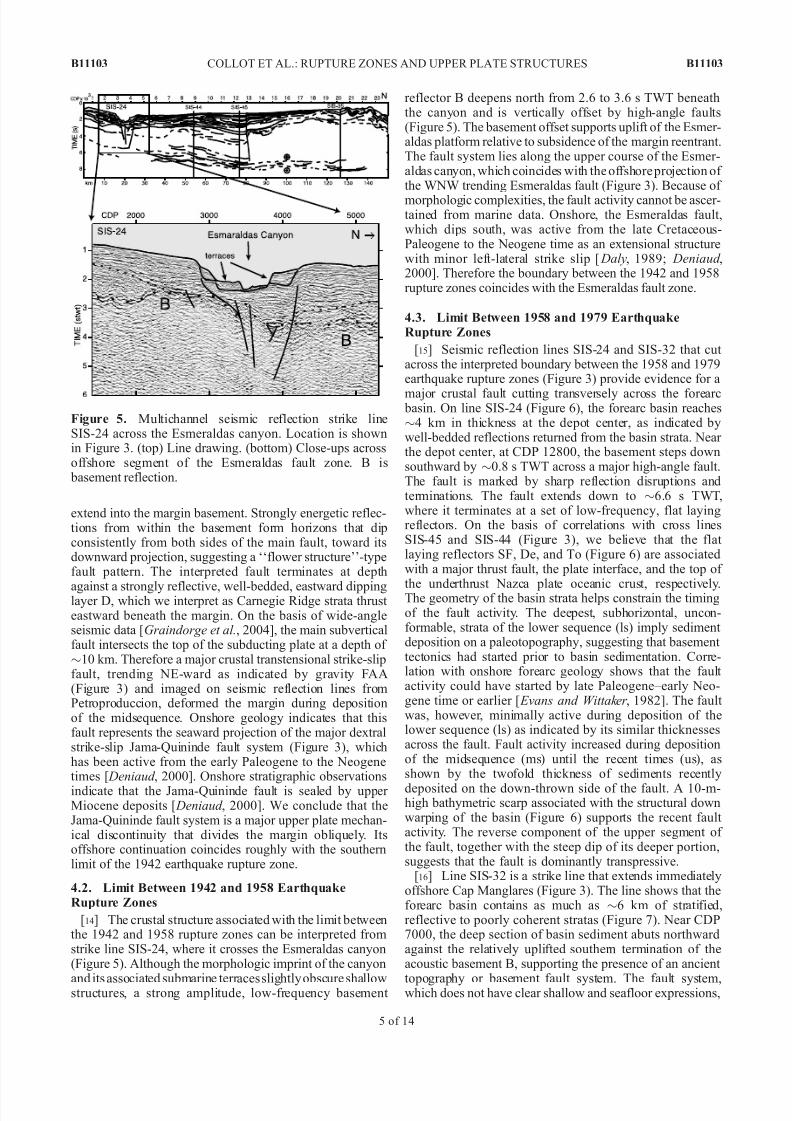
Figure 2. Location of the 20th century great subductionearthquake rupture zones of northern Ecuador–SW Colom-
bia (dashed ellipses), epicenters (stars), and their associatedrelocated 3-month aftershocks of mb > 4.8 (white, black,and red dots) [ Mendoza and Dewey, 1984], seismologicalasperities (gray shaded elliptic areas) and focal mechanisms[ Kanamori and Given, 1981; Kanamori and McNally, 1982;Swenson and Beck , 1996; Herd et al., 1981; Beck and Ruff ,1984]. Bathymetry map in km has been compiled from NGDC and the R/V Nadir SISTEUR cruise single beam bathymetric data (red lines) and swath bathymetry from theR/V l’Atalante Pugu cruise and the R/V Sonne Salieri andSO162 cruises. OBH is outer basement high; MR is middleridge. Open arrow shows Nazca – South America relative plate motion vector, derived from Trenkamp et al.’s [2002]
GPS study. See color version of this figure at back of thisissue.
B11103 COLLOT ET AL.: RUPTURE ZONES AND UPPER PLATE STRUCTURES
2 of 14
B11103

7/29/2019 Collot 2004 JGR Rupturelimits
http://slidepdf.com/reader/full/collot-2004-jgr-rupturelimits 3/15
[5] On the basis of the complexity of the body waveforms produced by large earthquakes, Kanamori and McNally[1982] used the simple asperity model of Lay et al.[1982] to account for the observed rupture pattern.
Kanamori and McNally [1982] modeled the 20th centuryColombia-Ecuador earthquake sequence by two relativelysmall asperities (1942, 1958) and a larger one (1979)
located respectively at latitudes 0°, 1°150 N, and 2°200 N(Figure 2). This asperity model applies to the rupture zoneof the 1942 event within the uncertainty of the teleseismi-cally located aftershocks [ Mendoza and Dewey, 1984]. Theasperity of the 1942 event lies mainly in the southern part of the rupture zone as indicated by the high moment release and observed intensities [Swenson and Beck , 1996](Figure 2). The northern limit of the aftershocks suggeststhat the 1942 rupture was blocked by the asperity of the1958 event [ Mendoza and Dewey, 1984], which indeedacted as a barrier to lateral rupture propagation. In contrast,the asperity model fails to explain the 1958 earthquake because the northward rupture propagation, as defined by
relocated aftershocks [ Mendoza and Dewey, 1984] as wellas source time modeling of the 1958 and 1979 earthquakes,indicates rupture was not blocked at the large asperity of the1979 event but instead ended midway between the twoasperities [ Beck and Ruff , 1984] (Figure 2). This raises thequestion of the nature of the boundary between the 1958and 1979 rupture areas and more generally of the boundary between 1942 and 1958 events and extremities of largerupture areas. An additional question relates to the nature of the seaward limit of the 1958 rupture, which, according tomodeling of spatial variations in moment release [ Beck and
Ruff , 1984] and the paucity of aftershocks near the trench[ Mendoza and Dewey, 1984], ceased $25 km landwardfrom the trench, near the summit of a gentle, outer forearctopographic rise (Figure 2).
[6] In this paper, we address the structural nature of the barriers that potentially block brittle, interplate rupture propagation. Recently acquired marine geophysical datafrom the rupture zone of the 1906 subduction earthquakeare presented here and offer compelling evidence that thenorthern Ecuador–SW Colombia margin is segmented bytransverse crustal faults. We further suggest that, in addi-tion to the subduction of the Carnegie Ridge, a large buoyant oceanic asperity that appears to control the south-ern limit of the 1906 and 1942 rupture zones, a keytransverse crustal fault may be responsible for blockingthe lateral propagation of the 1958 brittle rupture zone, and
for triggering the 1979 earthquake. Finally, we propose that a major landward dipping, crustal discontinuity of themargin wedge provided a seaward boundary to ruptureduring the 1958 earthquake.
2. Geophysical Data
[7] Conventional single beam bathymetry data wereacquired along the Ecuador-Colombia margin during theSISTEUR experiment conducted during autumn 2000 on board the R/V Nadir . We integrate these data with digital bat hym etr y from Nat ion al Geo phy sic al Data Cen ter (NGDC) and a few multibeam swath bathymetric lines to
produce a new bathymetric compilation (Figure 2), whichreveals the general morphology of the entire study area.
[8] Deep penetration multichannel seismic reflection(MCS) data were obtained across the Ecuador-Colombiamargin during the SISTEUR cruise [Collot et al., 2002](Figure 2). MCS data were recorded using a 45-L air gun seismic source tuned in a single bubble mode, and a360-channel, 4.5-km-long streamer. Shots were fired every50 m, providing 45-fold coverage. Seismic reflection data
were processed using Geovecteur 2 seismic processingsoftware to obtain time migrated sections. Processingincluded common depth point (CDP) gather, high-passfilter, velocity-dependent gain restitution, multiple attenua-tion in the frequency-wave number (FK) domain, minimum- phase conversion of the signal, external mute, deconvolu-tion, dip move out correction and/or normal moveout correction, internal mute, time variant band-pass filter,stack, deconvolution, and Kirchhoff migration. The final plots included a filter in the FK domain, and a time variant dynamic equalization. Depth values are given for specificreflectors on the basis of velocities derived from wide-angleseismic data collected during the SISTEUR cruise [ Agudelo
et al., 2002; Graindorge et al., 2004].
3. Morphology of the Northern Ecuador--SWColombia Margin and Its Correlation to LimitsBetween Great Earthquake Rupture Zones
[9] Previous studies have shown that the Ecuador marginis erosional [Collot et al., 2002; Moberly et al., 1982] and issegmented on a large scale as a result of the Carnegie Ridgesubduction [Gutscher et al., 1999], whereas the Colombiamargin is dominantly accretionary [Westbrook et al., 1995;
Marcaillou, 2003]. Near latitude 1°300 N, the Ecuador– SWColombia margin shows a sharp along-strike change in
morphology [Gutscher et al., 1999] (Figure 2) and gravityanomalies (Figure 3) at the Esmeraldas canyon. This activecanyon deeply incises the margin along its N140°E trendingupper course that separates margin segments with stronglycontrasting morphologies. South of the canyon, the marginsegment shows a shallow (<100 m), up to 50-km-widecontinental shelf, a steep ($14°) and short (20–30 km) inner trench slope, near zero free-air gravity anomalies, and anuplifted coastline documented by Quaternary marine terraces[ Pedoja, 2003]. At the junction with the Carnegie Ridge, theEcuador trench shallows to 2880 m and contains only fewmeters of turbidite [ Lonsdale, 1978], whereas it deepens to4000 m and contains up to 500 m of sedimentary fill west of the Esmeraldas canyon [Collot et al., 2002]. Although there
is no clear evidence for a correlation between the morphologyof this margin segment and the southern limit of the 1906– 1942 rupture zones, it is worth noting that this limit correlatesclosely with the shallowest trench segment (Figure 2) andwith a N65°E trending gravity low (Figure 3), which outlinesthe transition from the shelf near-zero free-air anomaly(FAA) to >50 mGal gravity values farther south.
[10] North of the Esmeraldas canyon, the margin ismarked by a narrow (5–20 km) shelf, and a remarkable,up to 80-km-wide, 800- to 1000-m-deep morphologicreentrant, containing a sedimentary forearc basin. Theforearc basin is bounded seaward by a 50-km-long outer basement high overhanging the trench at longitude 280° 250,
and a middle ridge at longitude 280°
500
that rises to awater depths of 60 m [ Marcaillou, 2003]. The reentrant and
B11103 COLLOT ET AL.: RUPTURE ZONES AND UPPER PLATE STRUCTURES
3 of 14
B11103

7/29/2019 Collot 2004 JGR Rupturelimits
http://slidepdf.com/reader/full/collot-2004-jgr-rupturelimits 4/15
ridges are associated with À70 mGal and +20 mGal FAA,respectively. The Colombia trench, which locally containsup to 3.5 km of turbidites [Collot et al., 2002; Marcaillou,2003], bounds the margin seaward, whereas a subsidingcoast dominated by mangroves and estuarine deposits flank the margin landward [ Deniaud , 2000].
[11] The boundary between the margin segments northand south of the Esmeraldas canyon is outlined by a NEfacing, 1000-m-high morphologic scarp characterized by asteep gravity gradient (5 mGal/km). This major scarpcoincides with the area where 1942 and 1958 earthquakerupture zones abut one another. Only minor morphologicand gravity anomaly changes (Figures 2 and 3) characterizethe boundary between the 1958 and 1979 earthquakerupture zones.
4. Crustal Structures at the Boundaries BetweenGreat Earthquake Rupture Zones
[12] Deep seismic reflection lines are used to image thecrustal structure of the Ecuador-Colombia margin wedge
near the interpreted rupture boundaries between the great subduction earthquakes of the 20th century.
4.1. Southern Limit of 1942 and 1906 Earthquakes
[13] Seismic profile SIS-58 cuts across the Ecuador margin near the southern limit of the 1942 rupture zone,which potentially coincides with that of the 1906 earthquake
(Figure 4). The line shows that the margin is underlain by ahighly irregular and strongly reflective horizon B, whichunderlines the base of a well-developed sedimentary basinextending across the continental shelf. The basin consistsof three reflective and well-stratified sequences separated by unconformities and overlain by a thin blanket of recent sediments. At CDP 7300, the lower sequence (ls) is verti-cally offset by $500 m along a steeply dipping fault. Thefault activity has been recorded on its down-thrown side bya rotational sedimentary basin (ms). This activity stopped prior to deposition of the upper sequence (us), as indicated by the undisturbed strata overlaying a major unconformity.Secondary faults appear to have deformed the lower and
middle sequences landward of the main fault. Seismicevidence indicates that the faults coalesce downward and
Figure 3. Satellite-derived free-air gravity anomaly alongthe northern Ecuador–SW Colombia margin [Sandwell and Smith, 1994]. Contours are every 10 mGal. Stars and dashed
lines are locations of great subduction earthquake epicentersand rupture zones. OBH is outer basement high; MR ismiddle ridge. Main fault systems are shown onshore[ Deniaud , 2000; Zamora et al., 1993]. Thin lines are shiptracks of the SISTEUR cruise. MCS data used in this studyare shown as heavy dark lines with labels.
Figure 4. Multichannel seismic reflection line SIS-58across the Ecuador margin, where the Carnegie Ridge crest is being subducted. Location is shown in Figure 3. (top)Line drawing. The 1942 focal mechanism, situated at adepth of $14 km [Swenson and Beck , 1996], has been projected onto the line, where it matches well with the$13 km depth of the plate interface according to seismicreflection and wide-angle data. (bottom) Seismic reflectiondata showing the shelf basin and crustal strike-slip fault system. Abbreviations are as follows: ls is lower sedimen-tary sequence, ms is middle sequence, and us is upper
sequence. B is top of margin basement. D is reflective stratafrom the top of underthrust Carnegie Ridge.
B11103 COLLOT ET AL.: RUPTURE ZONES AND UPPER PLATE STRUCTURES
4 of 14
B11103
7/29/2019 Collot 2004 JGR Rupturelimits
http://slidepdf.com/reader/full/collot-2004-jgr-rupturelimits 5/15
extend into the margin basement. Strongly energetic reflec-tions from within the basement form horizons that dipconsistently from both sides of the main fault, toward itsdownward projection, suggesting a ‘‘flower structure’’-typefault pattern. The interpreted fault terminates at depth
against a strongly reflective, well-bedded, eastward dippinglayer D, which we interpret as Carnegie Ridge strata thrust eastward beneath the margin. On the basis of wide-angleseismic data [Graindorge et al., 2004], the main subverticalfault intersects the top of the subducting plate at a depth of $10 km. Therefore a major crustal transtensional strike-slipfault, trending NE-ward as indicated by gravity FAA(Figure 3) and imaged on seismic reflection lines fromPetroproduccion, deformed the margin during depositionof the midsequence. Onshore geology indicates that thisfault represents the seaward projection of the major dextralstrike-slip Jama-Quininde fault system (Figure 3), whichhas been active from the early Paleogene to the Neogenetimes [ Deniaud , 2000]. Onshore stratigraphic observationsindicate that the Jama-Quininde fault is sealed by upper Miocene deposits [ Deniaud , 2000]. We conclude that theJama-Quininde fault system is a major upper plate mechan-ical discontinuity that divides the margin obliquely. Itsoffshore continuation coincides roughly with the southernlimit of the 1942 earthquake rupture zone.
4.2. Limit Between 1942 and 1958 EarthquakeRupture Zones
[14] The crustal structure associated with the limit betweenthe 1942 and 1958 rupture zones can be interpreted fromstrike line SIS-24, where it crosses the Esmeraldas canyon(Figure 5). Although the morphologic imprint of the canyon
and its associated submarine terraces slightly obscure shallowstructures, a strong amplitude, low-frequency basement
reflector B deepens north from 2.6 to 3.6 s TWT beneaththe canyon and is vertically offset by high-angle faults(Figure 5). The basement offset supports uplift of the Esmer-aldas platform relative to subsidence of the margin reentrant.The fault system lies along the upper course of the Esmer-aldas canyon, which coincides with the offshore projection of the WNW trending Esmeraldas fault (Figure 3). Because of
morphologic complexities, the fault activity cannot be ascer-tained from marine data. Onshore, the Esmeraldas fault,which dips south, was active from the late Cretaceous-Paleogene to the Neogene time as an extensional structurewith minor left-lateral strike slip [ Daly, 1989; Deniaud ,2000]. Therefore the boundary between the 1942 and 1958rupture zones coincides with the Esmeraldas fault zone.
4.3. Limit Between 1958 and 1979 EarthquakeRupture Zones
[15] Seismic reflection lines SIS-24 and SIS-32 that cut across the interpreted boundary between the 1958 and 1979earthquake rupture zones (Figure 3) provide evidence for a
major crustal fault cutting transversely across the forearc basin. On line SIS-24 (Figure 6), the forearc basin reaches$4 km in thickness at the depot center, as indicated bywell-bedded reflections returned from the basin strata. Near the depot center, at CDP 12800, the basement steps downsouthward by $0.8 s TWT across a major high-angle fault.The fault is marked by sharp reflection disruptions andterminations. The fault extends down to $6.6 s TWT,where it terminates at a set of low-frequency, flat layingreflectors. On the basis of correlations with cross linesSIS-45 and SIS-44 (Figure 3), we believe that the flat laying reflectors SF, De, and To (Figure 6) are associatedwith a major thrust fault, the plate interface, and the top of
the underthrust Nazca plate oceanic crust, respectively.The geometry of the basin strata helps constrain the timingof the fault activity. The deepest, subhorizontal, uncon-formable, strata of the lower sequence (ls) imply sediment deposition on a paleotopography, suggesting that basement tectonics had started prior to basin sedimentation. Corre-lation with onshore forearc geology shows that the fault activity could have started by late Paleogene–early Neo-gene time or earlier [ Evans and Wittaker , 1982]. The fault was, however, minimally active during deposition of thelower sequence (ls) as indicated by its similar thicknessesacross the fault. Fault activity increased during depositionof the midsequence (ms) until the recent times (us), asshown by the twofold thickness of sediments recently
deposited on the down-thrown side of the fault. A 10-m-high bathymetric scarp associated with the structural downwarping of the basin (Figure 6) supports the recent fault activity. The reverse component of the upper segment of the fault, together with the steep dip of its deeper portion,suggests that the fault is dominantly transpressive.
[16] Line SIS-32 is a strike line that extends immediatelyoffshore Cap Manglares (Figure 3). The line shows that theforearc basin contains as much as $6 km of stratified,reflective to poorly coherent stratas (Figure 7). Near CDP7000, the deep section of basin sediment abuts northwardagainst the relatively uplifted southern termination of theacoustic basement B, supporting the presence of an ancient
topography or basement fault system. The fault system,which does not have clear shallow and seafloor expressions,
Figure 5. Multichannel seismic reflection strike lineSIS-24 across the Esmeraldas canyon. Location is shownin Figure 3. (top) Line drawing. (bottom) Close-ups acrossoffshore segment of the Esmeraldas fault zone. B is basement reflection.
B11103 COLLOT ET AL.: RUPTURE ZONES AND UPPER PLATE STRUCTURES
5 of 14
B11103

7/29/2019 Collot 2004 JGR Rupturelimits
http://slidepdf.com/reader/full/collot-2004-jgr-rupturelimits 6/15
may have been dominantly active prior or during depositionof the oldest basin strata. Recent motion of low amplitude isnot, however, to be excluded because of sharp basinreflector terminations, small vertical offsets and patches of fuzzy reflections in the sediments overlaying the buried basement fault scarp.
[17] Taken collectively seismic lines SIS-24 and SIS-32 provide evidence for a major, N106°E trending inheritedcrustal fault, that we named the Manglares fault (Figure 3).The westernmost part of the fault has remained active withan apparent transpressive component on line SIS-24. TheManglares fault, which appears to project seaward from CapManglares, at the extremity of a N105°E rectilinear coast-line segment, coincides roughly with the limit between therupture zones of the 1958 and 1979 earthquakes.
4.4. Seaward Limit of 1958 Rupture Zone
[18] Line SIS-44 cuts across the margin wedge rupturedduring the 1958 earthquake. Near CDP 9500, the line shows
a summit graben that is associated with a gentle rise of boththe seafloor and the underlying basement (B in Figure 8).Forearc basin strata beneath the flanks of the seafloor risedip away from the rise summit and are down dropped alongnormal faults in the graben. These pieces of evidencedemonstrate that the rise and associated deformation result from a compressive upward bulging of the underlying
basement, followed by summit extensional collapse. Therough topography of the graben and its absence of sediment fill support active deformation. Compressive deformationmay, however, be associated with thinning of the foremargin crust as reflected by the trenchward tilt of the basinsection located seaward of the graben.
[19] At depth, line SIS-44 reveals two low-frequency,discontinuous reflections (De and To in Figure 8) that can be traced landward for $45 km from the deformationfront, where they meet each other at a depth of $7.5 sTWT ($14 km). According to their geometry and depths,these reflections are interpreted as the plate interface (De)and the top of subducted oceanic crust (To). The line also
shows a drastic change in the seismic character of thereflections returned from the margin basement across thediscontinuous, steeply landward dipping reflector SF.The seismic character changes from subcontinuous, reflec-tive and landward dipping in a wedge of rock underlyingreflector SF between CDPs 6500 and 8800, to largelyincoherent east of SF (approximately CDP 5000) and west of the wedge (approximately CDPs 8800– 9400). Somehigh-frequency, shallow, landward dipping events areinterpreted as multiple (Mu) that could not be removed by multiple attenuation in the FK domain, the apparent velocities of the multiple events being in this case close toapparent velocities of the real ones located at the samedepth. We interpret reflector SF as a major crustal discon-tinuity between margin rocks of different nature or physical properties. SF appears to be branching upward from the plate interface at a depth of $13 km beneath the seafloor and a distance of $42 km from the trench. The seawardextent of SF within the compressively deformed, upward bulging basement, supports activation of the SF crustaldiscontinuity as a thrust fault. SF could thus act as amegathrust splay fault that would decouple the bulk of the margin basement from its frontal part during great earthquake rupture.
Figure 6. Multichannel seismic reflection strike lineSIS-24 across the Manglares fault. Location is shown inFigure 3. (top) Line drawing. (middle and bottom) Close-upacross the high-angle Manglares fault. Abbreviations are asfollows: ls is lower sedimentary sequence, ms is middlesequence, and us is upper sequence. SF is a splay fault,De is the interplate decollement, and TO is top of oceaniccrust as interpreted from cross-seismic lines. Inset is narrow beam bathymetric profile showing a 10-m vertical offset associated with the fault.
Figure 7. Multichannel seismic reflection strike lineSIS-32 along the forearc basin. Location is shown in
Figure 3. The line shows a thick sedimentary fill overlyinga deformed basement B.
B11103 COLLOT ET AL.: RUPTURE ZONES AND UPPER PLATE STRUCTURES
6 of 14
B11103

7/29/2019 Collot 2004 JGR Rupturelimits
http://slidepdf.com/reader/full/collot-2004-jgr-rupturelimits 7/15
[20] Although the chronology is uncertain, the geometricrelationships between deformed forearc basin units mayhelp to pinpoint SF tectonic activity. The area of the basement bulge was a dual depot center during depositionof the basin lower sequence (ls), as indicated by twoadjacent depot centers now tilted away from the bulge
axis (approximately CDPs 8200 and 10800). By the timeof the middle sequence (ms) deposition, the eastern depot center had migrated landward as indicated by the gentleeastward thickening of the unit, suggesting that bulginghad likely started during deposition of the ms unit. Theabsence of a strong unconformity between ls and msindicates, however, that the uplift had been moderate. Ashallow unconformity between the middle (ms) and upper (us) sequences beneath the present-day depot center sup- ports recent uplift at the seafloor rise, possibly related toSF fault activity.
[21] Seismic reflection line SIS-45 provides evidence for a major subvertical crustal fault ‘‘VF’’ and possibly for
fault SF near the junction between the 1958 and 1979earthquake rupture zones (Figure 9). The line shows the
massive outer basement high adjacent to the subsidingforearc basin containing up to 3.4 km of reflective andwell-bedded sedimentary strata. The strata are gently tiltedeastward, and terminate abruptly westward at a subverticalacoustic boundary, against which they are upwarped. Weinterpret the acoustic boundary at CDP 7500 as the high-
angle active fault VF, which pushed up the outer basement high, and depressed and tilted eastward the forearc basin.Although diffracted energy partially obscures the acousticsignal at depth beneath the interpreted fault, variablereflectivity and discontinuous reflections returned fromwithin the basement underlying the western boundary of the forearc basin is evidence for the downward projectionof the fault. Fault VF extends at depth, possibly down to$5.5 s TWT, where it encounters gently landward dippingreflections. From correlation with strike line SIS-24(Figure 6) and line SIS-44 (Figure 8), we interpret thedeep reflections as the plate interface ‘‘De’’ and top of subducting oceanic crust ‘‘To’’. A steeper subdued reflec-
tion, shallower than reflector De beneath the basin, crossesline SIS-24 at 6.5 s TWT and is therefore tentatively
Figure 8. Multichannel seismic reflection line SIS-44 across the margin wedge. Location is shown in
Figure 3. (top) Line drawing. Note that the seaward extent of 1958 coseismic slip matches with the frontal bulge and interpreted splay fault. The 1958 focal mechanism, which is similar to that of the 1979 event [ Mendoza and Dewey, 1984] is projected onto the line at a depth chosen to coincide with the plateinterface observed in seismic reflection profiles. (bottom) Close-up showing the forearc basin summit graben associated with a gentle rise of seafloor and underlying basement B. Note difference in basement reflectivity across SF fault. Mu is multiples; ls, ms, us, De, and TO are as in Figure 6.
B11103 COLLOT ET AL.: RUPTURE ZONES AND UPPER PLATE STRUCTURES
7 of 14
B11103

7/29/2019 Collot 2004 JGR Rupturelimits
http://slidepdf.com/reader/full/collot-2004-jgr-rupturelimits 8/15
correlated with fault SF. Fault VF would have experienced
transpressive motion with regards to its high-angle dip and basin tilt away from the fault.
4.5. Section Across the 1979 Asperity
[22] Seismic reflection line SIS-35 cuts across the mid-dle ridge and 1979 earthquake rupture zone (Figure 3).The line shows that the bathymetry and internal structuresdiffer markedly from those observed farther south on linesSIS-44 and SIS-45. On line SIS-35, the middle ridgeculminates at a water depth of 250 m, 42 km from thetrench (Figure 10). Folds and high-angle landward dippingreverse faults deform the uppermost basement and theoverlying sedimentary forearc basin units, which have been tilted significantly landward. The overall structure
supports ridge uplift by strong tectonic shortening distrib-uted across most of the outer forearc. Tectonic activity persists, as indicated by a deformed, recent unconformity(Er in Figure 10) and the bumpy topography associatedwith anticline axis.
5. Discussion
[23] On a larger scale, although the 500-km rupture lengthof the 1906 earthquake is subject to some uncertainty,
Kelleher [1972] and Kanamori and McNally [1982] reportedthat the rupture extended to the Carnegie Ridge-trenchintersection, and to the sharp bend of the trench at 4° N
(Figure 1). This change in trench orientation from NE tonorth results from the accretion of the Choco island arc
block [ Duque-Caro, 1990; Taboada et al., 2000] and reflects
a change in stress field along the plate interface, capableof blocking the coseismic slip. These characteristicsdefine a geometric barrier such as defined by Aki[1979]. Kelleher ’s [1972] and Kanamori and McNally’s[1982] observations also suggest that the rupture propa-gation of a megathrust earthquake can alternatively bestopped by strong interplate coupling related to subductionof a large feature, such as the Carnegie Ridge. However,for subduction earthquakes of M w 7.7 to 8.2, structuraldata presented above demonstrate that their rupture zonelimits correlate with interplate seismological asperitiesand/or barrier-like transverse crustal faults that segment the margin into 100- to 200-km-long blocks (Figure 11).In the sections below, we discuss the influence of theCarnegie Ridge subduction and margin wedge crustalfaults on the spatial distribution of earthquake brittlerupture, and propose a model, which accounts for delim-iting the rupture propagation of an earthquake of M w up to7.7, by a mega thrust splay fault and crustal faultstransverse to the margin wedge.
5.1. Carnegie Ridge: A Mega-asperity BoundingMegathrust Ruptures
[24] The Carnegie ridge is a $300-km-wide Neogeneoceanic plateau that resulted from the interaction betweenthe Galapagos hot spot and the Cocos-Nazca spreadingcenter [ Lonsdale, 1978]. Immediately west of the trench,
the ridge is asymmetric in a N-S cross section. Withrespect to the ridge crest, the ridge shows a 100-km-wide,
Figure 9. Multichannel seismic reflection line SIS-45 across the outer basement high and forearc basin.Location is shown in Figure 3. (top) Line drawing. (bottom) Close-up showing the flat-topped outer basement high separated from the thick forearc basin by steep fault VF. Mu is a multiple; ls, ms, us, SF,De, and TO are as in Figure 6.
B11103 COLLOT ET AL.: RUPTURE ZONES AND UPPER PLATE STRUCTURES
8 of 14
B11103

7/29/2019 Collot 2004 JGR Rupturelimits
http://slidepdf.com/reader/full/collot-2004-jgr-rupturelimits 9/15
steep northern flank, and a $200-km-wide body and moregentle southern flank. On the basis of wide-angle seismic
data, the crust beneath the ridge crest is 19 km thick [Sallares et al., 2002] and 14 km at its southern flank. Thisthickened oceanic crust can be imaged underthrustingthe margin as far as the coast line [Graindorge et al.,2004]. The ridge crest can be traced landward through thetrench saddle at 0°20s, toward the onshore drainage divide,allowing us to extrapolate the ridge northern flank beneaththe Ecuador margin (Figure 11). Seismic reflection dataconfirm that, near the northern flank of the CarnegieRidge, the plate interface shallows southward by $1.3 km(0.9°) between lines SIS-22 and SIS-58 (Figure 3). Hencethis segment of the plate interface is consistent with asouthward verging ramp fault that separates volcanic basement rocks of the margin [ Reynaud et al., 1999] from
subducting ridge sediment dominated by Pleistoceneforaminifer and nannofossil ooze, and ash [Shipboard Scientific Party, 2002] (Figure 4). The ramp fault andassociated buried ridge crest would contribute to blockingthe southward propagation of great interplate ruptures. GPSmeasurements suggest that the margin segment facing theCarnegie Ridge is 50% locked [Trenkamp et al., 2002].Higher interplate pressure due to the buoyancy of the bulk of the subducted ridge would be responsible for partiallocking of the plate interface [Graindorge et al., 2004] andfor stopping the 1906 and 1942 rupture zones propagationnear the subducted ridge crest. Notwithstanding the maininfluence of the Carnegie Ridge, the offshore extension of
the Jama-Quininde fault (Figure 11) may contribute to blocking the southward rupture propagation along the
plate interface by a mechanism discussed below for theManglares fault.
5.2. Manglares Fault: A Barrier Between the 1958 and1979 Earthquake Rupture Zones
[25] The N106°E trending Manglares fault is a major crustal transfer fault that separates margin segmentswith drastically different tectonic regimes as expressed by the wide and largely nondeforming forearc basin southof the fault (line SIS-45, Figure 9) and the severelyshortened margin north of the fault (SIS-35, Figure 10).As suggested by seafloor reflectivity (Figure 12, courtesyG. Westbrook), the Manglares fault appears, however, toterminate abruptly westward against the N30°E trendingfaulted eastern flank of the outer basement high (fault VFin Figure 9) Indeed, GLORIA-derived seafloor reflectivity
clearly indicates the trace fault VF but does not image that of the Manglares fault, perhaps because it is associatedwith a gentle, only 10-m-high variation in seafloor depth(Figure 6).
[26] The Manglares fault is located with 100-m precisionon the GPS-calibrated SISTEUR seismic lines. The 1979epicenter, and the 1958 aftershocks of mb > 5.2 that definethe barrier between the 1958 and 1979 rupture zones, appear to cluster along a N100°E direction,10–15 km south of theinferred Manglares fault. The aftershocks were relocated by using the joint hypocenter determination method tominimize errors in the relative locations of the hypocenters[ Mendoza and Dewey, 1984]. Their 90% confidence error
ellipses relative to a calibration event show semiaxessmaller than 20 km. On the basis of this precision and the
Figure 10. Multichannel seismic reflection line SIS-35 across the middle ridge and forearc basin.Location is shown in Figure 3. (top) Line drawing with cross-margin extent of 1979 coseismic slip. The1979 focal mechanism [ Kanamori and McNally, 1982] has been projected onto the line at a depth chosento coincide with the plate interface according to seismic reflection data. (bottom) Close-up showingshortening distributed across the margin wedge and forearc basin. Er is a recent unconformity; ls, ms, us,De, and TO are as in Figure 6.
B11103 COLLOT ET AL.: RUPTURE ZONES AND UPPER PLATE STRUCTURES
9 of 14
B11103

7/29/2019 Collot 2004 JGR Rupturelimits
http://slidepdf.com/reader/full/collot-2004-jgr-rupturelimits 10/15
distance between the hypocenters and the Manglares fault,we consider that the northernmost 1958 aftershocks and the
Manglares fault are geographically related. However, basedon P wave first motions, the 1958 aftershocks occurredalong the plate interface that was ruptured during the1979 event [ Mendoza and Dewey, 1984], and not on theManglares fault itself.
[27] On the basis of the spatial association of the bound-ary between the 1958 and 1979 rupture zones with theadjacent extinct Malpelo rift and associated Yaquina grabentransform fault (Figure 2) [ Lonsdale, 1978; Lonsdale and
Klitgord , 1978], Mendoza and Dewey [1984] interpretedthe seismological barrier as resulting from heterogeneities inthe subducting Nazca plate. Our bathymetric compilation(Figure 2) shows that a relative seafloor high, involving
small-sized seamounts and oceanic horsts, extends betweenthe trench and Malpelo rift, suggesting that minor oceanic
relief is being subducted beneath the margin segment ruptured in 1958. Similar seamounts might be responsiblefor the 1958 earthquake asperity. However, source timefunctions models for the 1958 and 1979 events do not require a major fault plane asperity associated with their common rupture boundary (Figure 2) [ Beck and Ruff ,1984], and seismic reflection data do not provide support
for a large subducting seamount near the Manglares fault [ Marcaillou, 2003]. Alternatively, Mendoza and Dewey[1984] suggested that the barrier could result from a minor vertical offset between two fault planes of similar orienta-tions. Considering that the fault planes belong to the plateinterface, such an offset could reflect a tear in the downgoing plate. A tear separating a steeper plate interface southof the Manglares fault from a shallower one to the northcould account for the observed deformations at the Man-glares fault. Our seismic data, however, do not showevidence for slab distortion or slab tear, neither at depthin the region of the Manglares fault nor beneath the trench.Thus, notwithstanding the key role played by lower plate
relief on earthquake ruptures [ Bilek et al., 2003; Dominguez et al., 1998; Scholz and Small , 1997], we believe that theupper plate transverse Manglares fault may act as a barrier to rupture propagation of subduction earthquakes. The juxtaposition of both, subducting oceanic relief and the
Figure 11. Structural relationships between transversecrustal faults and great earthquake rupture zones. Faultsare from Zamora et al. [1993] and Santana and Dumont
[2002]. Crosses represent the Carnegie Ridge crest, which isassociated with the offshore extension of the Jama Quinindefault and the southern termination of the 1906 and 1942earthquake rupture zones. Note that the 1958 earthquakerupture zone is bounded by the Esmeraldas fault, theManglares fault, and the outer basement high (OBH).Discrepancy between Manglares fault and limit between1958 and 1979 rupture zones is discussed in text. Thelocation of the Malpelo GPS vector (54 mm/yr) has beenshifted to fit in figure.
Figure 12. (top) GLORIA side-scan sonar imagery west of Cap Manglares (G. Westbrook personal communication,2003) with track lines of SISTEUR cruise. White is highreflective seafloor. (bottom) Structural interpretation and bathymetry in km overlay of side-scan sonar imagery. Notethat the deformation front, the Esmeraldas canyon/channel,and the fault scarp VF are reflective, whereas the seafloor
expression of the Manglares fault is not clearly visible onGLORIA imagery.
B11103 COLLOT ET AL.: RUPTURE ZONES AND UPPER PLATE STRUCTURES
10 of 14
B11103

7/29/2019 Collot 2004 JGR Rupturelimits
http://slidepdf.com/reader/full/collot-2004-jgr-rupturelimits 11/15
Manglares fault would however increase the effect of thefault on the separation on the rupture zones.
5.3. Faulted Outer Basement High: A Frontal Buttressto Earthquake Rupture Propagation
[28] The outer basement high located between the trenchand the seaward limit of the 1958 earthquake rupture zone
consists of a $9-km-thick, crustal block bounded by activecrustal faults (Figure 11). The block, which appears to bemassive on line SIS-45 (Figure 9), has undergone uplift andsubsidence. Its flat top, which resembles a wave-cut terrace,and its thin and reflective sedimentary cap suggest that the block was uplifted to sea level and eroded. Uplift may have been accomplished along transpressive fault VF, relative tothe subsiding landward margin basement. The block thensubsided by $700– 1000 m, as indicated by its present-daywater depth. The block subsidence accompanied the overallmargin subsidence recorded in the forearc basin. Theseobservations show that, although the outer basement highand adjacent margin basement experienced a complex
history of vertical motions, they remained strongly coupledacross fault VF and accommodated little shortening. On the basis of the gravity anomaly map (Figure 3), the outer basement high can be extended southward in the regionadjacent to the 1958 earthquake rupture zone (Figure 11).On line SIS-44 (Figure 8), the block becomes buried beneath forearc basin strata, undergoes transverse compres-sion and is potentially detached from the margin along theinterpreted splay fault acting as a roof thrust. Such a crustalsplay fault has been interpreted to accommodate elasticstrain of the 1944 Tonankai earthquake [ Park et al.,2002]. The spatial correlation between the seaward limit of the 1958 earthquake rupture zone (Figure 8), the splayfault, and the conspicuous seafloor bulge suggests that theouter basement high had remained coupled to the down-going plate during the preseismic and coseismic periods sothat it had behaved as a deformable frontal buttress con-trolling the seaward rupture propagation along the splayfault. In this scenario, the rupture propagation would have produced instantaneous seafloor uplift above the splay fault,thus designating the shallow seafloor doming/graben area of the outer basement high as the primary tsunamogenic sourceduring the 1958 earthquake.
5.4. Decoupling the Interplate Slip Across a MarginWedge Transverse Fault
[29] Cross margin elastic stress accumulates irregularly
along subduction zones as indicated by the distributionand timing of great subduction ruptures along the southAmerican margin [ Kelleher , 1972] and by the complexdistribution of asperities in a single rupture zone [ Layet al., 1982]. Geodetic or tide gage data from Chile[ Barrientos and Plafker , 1992], Japan-Nankai [ Hyndmanet al., 1995], and Alaska [Savage and Plafker , 1991] showthat during interseismic periods, elastic strain accumulatesacross large regions of the forearc producing shortening andsubsidence above the interplate locked zone and uplift landward. GPS measurements along the Ecuador margin(Figure 11) indicate elastic strain accumulation, supportinga locked portion of the plate interface [Trenkamp et al.,2002; White et al., 2003]. During the coseismic rupture, the pattern of deformation approximately reverses [ Hyndman
and Wang , 1995], producing uplift and forward reboundabove the previously locked zone, and subsidence further landward. In the asperity model of Lay et al. [1982], theinterplate fault zone is held by a discrete distribution of high strength asperities separated by weak zones. Failure of one asperity produces a rupture, which propagates throughthe neighboring weak zones and is pinned at both ends
by adjacent asperities. Although asperities can physicallyrelate to subducting seamounts [Cloos, 1992; Cloos and Shreve, 1996] or possible variations in sediment input, fluidcontent and pressure gradient along the subduction channel[Cloos and Shreve, 1988], physical characteristics proper toeach margin segment may place additional stress on thecoseismic slip area. According to wide-angle velocities[ Agudelo et al., 2002], the thickness of the margin basement appears to decrease from $10 km on line SIS-35 to$7 km on lines SIS-44 and SIS-45, 30–35 km fromthe trench. Such basement thinning accompanied by a1- to 3-km thickening of overlying low-velocity sediment may contribute to variable interplate lithostatic pressure
across the Manglares fault. Because the margin basement is a mosaic of heterogeneous, tectonically accreted oceanic blocks [ Baldock , 1983; Reynaud et al., 1999], its physical properties are expected to vary across the oceanic terranes,and influence the margin strength and interplate frictionas well.
[30] In addition to downgoing plate structures and phys-ical parameters of individual margin segments, a major tectonic structure transverse to the margin may equallydelimit the coseismic slip zone by partially decoupling afault block from adjoining sections of the fault [ Kelleher and Savino, 1975]. Such a process depends on the relativefault strength and local stress field. Decoupling is likely tooccur when the strength of the transverse fault is less thanthat of the plate interface. Thus the fault may act as amechanical discontinuity to coseismic elastic rebound.Decoupling is also favored if the fault orientation is near that of the regional stress field. The N106°E orientation of the Manglares fault relative to the plate convergence vector [Trenkamp et al., 2002] provides a smaller normal stressthan that at the N150°E trending Esmeraldas fault, support-ing an easier decoupling at the Manglares fault.
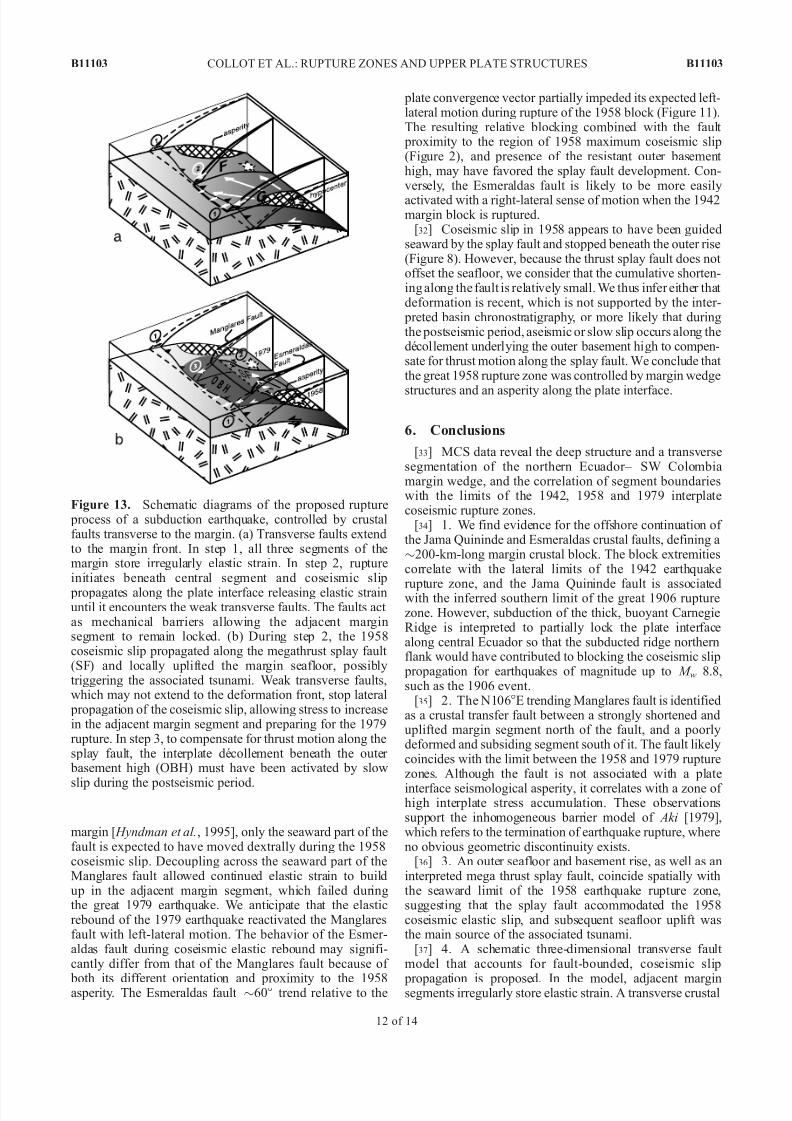
[31] In the simple transverse fault model of Figure 13a, allmargin segments store elastic strain during the interseismic period. Coseismic slip then releases elastic strain and it propagates along the plate interface to the weak transversefault zones F and G. Because of their low strength and stress
field orientation, the faults prevent interplate elastic strainfrom propagating into the adjacent margin segments, whichremain coupled and continue to accumulate strain untilthe next great subduction earthquake. We suggest that thetransverse faults F and G in Figure 13a accommodated thecoseismic elastic rebound with respectively a dextral and asinistral strike-slip component. In the case of the 1958earthquake rupture, the presence of the outer basement highand the interpreted megathrust splay fault added an outer structural constraint on the rupture propagation. Rupture of the 1958 asperity propagated north up to the Manglaresfault (Figure 13b), where intense and very localized after-shock activity (Figure 2) implies high stress concentration at the plate interface [ Mendoza and Dewey, 1984]. Becauseelastic strain accumulation decreases landward across the
B11103 COLLOT ET AL.: RUPTURE ZONES AND UPPER PLATE STRUCTURES
11 of 14
B11103
7/29/2019 Collot 2004 JGR Rupturelimits
http://slidepdf.com/reader/full/collot-2004-jgr-rupturelimits 12/15
margin [ Hyndman et al., 1995], only the seaward part of thefault is expected to have moved dextrally during the 1958coseismic slip. Decoupling across the seaward part of theManglares fault allowed continued elastic strain to buildup in the adjacent margin segment, which failed duringthe great 1979 earthquake. We anticipate that the elasticrebound of the 1979 earthquake reactivated the Manglaresfault with left-lateral motion. The behavior of the Esmer-aldas fault during coseismic elastic rebound may signifi-cantly differ from that of the Manglares fault because of
both its different orientation and proximity to the 1958asperity. The Esmeraldas fault $60° trend relative to the
plate convergence vector partially impeded its expected left-lateral motion during rupture of the 1958 block (Figure 11).The resulting relative blocking combined with the fault proximity to the region of 1958 maximum coseismic slip(Figure 2), and presence of the resistant outer basement high, may have favored the splay fault development. Con-versely, the Esmeraldas fault is likely to be more easily
activated with a right-lateral sense of motion when the 1942margin block is ruptured.
[32] Coseismic slip in 1958 appears to have been guidedseaward by the splay fault and stopped beneath the outer rise(Figure 8). However, because the thrust splay fault does not offset the seafloor, we consider that the cumulative shorten-ing along the fault is relatively small. We thus infer either that deformation is recent, which is not supported by the inter- preted basin chronostratigraphy, or more likely that duringthe postseismic period, aseismic or slow slip occurs along thedecollement underlying the outer basement high to compen-sate for thrust motion along the splay fault. We conclude that the great 1958 rupture zone was controlled by margin wedge
structures and an asperity along the plate interface.
6. Conclusions
[33] MCS data reveal the deep structure and a transversesegmentation of the northern Ecuador– SW Colombiamargin wedge, and the correlation of segment boundarieswith the limits of the 1942, 1958 and 1979 interplatecoseismic rupture zones.
[34] 1. We find evidence for the offshore continuation of the Jama Quininde and Esmeraldas crustal faults, defining a$200-km-long margin crustal block. The block extremitiescorrelate with the lateral limits of the 1942 earthquake
rupture zone, and the Jama Quininde fault is associatedwith the inferred southern limit of the great 1906 rupturezone. However, subduction of the thick, buoyant CarnegieRidge is interpreted to partially lock the plate interfacealong central Ecuador so that the subducted ridge northernflank would have contributed to blocking the coseismic slip propagation for earthquakes of magnitude up to M w 8.8,such as the 1906 event.
[35] 2. The N106°E trending Manglares fault is identifiedas a crustal transfer fault between a strongly shortened anduplifted margin segment north of the fault, and a poorlydeformed and subsiding segment south of it. The fault likelycoincides with the limit between the 1958 and 1979 rupturezones. Although the fault is not associated with a plate
interface seismological asperity, it correlates with a zone of high interplate stress accumulation. These observationssupport the inhomogeneous barrier model of Aki [1979],which refers to the termination of earthquake rupture, whereno obvious geometric discontinuity exists.
[36] 3. An outer seafloor and basement rise, as well as aninterpreted mega thrust splay fault, coincide spatially withthe seaward limit of the 1958 earthquake rupture zone,suggesting that the splay fault accommodated the 1958coseismic elastic slip, and subsequent seafloor uplift wasthe main source of the associated tsunami.
[37] 4. A schematic three-dimensional transverse fault model that accounts for fault-bounded, coseismic slip
propagation is proposed. In the model, adjacent marginsegments irregularly store elastic strain. A transverse crustal
Figure 13. Schematic diagrams of the proposed rupture process of a subduction earthquake, controlled by crustalfaults transverse to the margin. (a) Transverse faults extendto the margin front. In step 1, all three segments of themargin store irregularly elastic strain. In step 2, ruptureinitiates beneath central segment and coseismic slip
propagates along the plate interface releasing elastic strainuntil it encounters the weak transverse faults. The faults act as mechanical barriers allowing the adjacent marginsegment to remain locked. (b) During step 2, the 1958coseismic slip propagated along the megathrust splay fault (SF) and locally uplifted the margin seafloor, possiblytriggering the associated tsunami. Weak transverse faults,which may not extend to the deformation front, stop lateral propagation of the coseismic slip, allowing stress to increasein the adjacent margin segment and preparing for the 1979rupture. In step 3, to compensate for thrust motion along thesplay fault, the interplate decollement beneath the outer basement high (OBH) must have been activated by slow
slip during the postseismic period.
B11103 COLLOT ET AL.: RUPTURE ZONES AND UPPER PLATE STRUCTURES
12 of 14
B11103

7/29/2019 Collot 2004 JGR Rupturelimits
http://slidepdf.com/reader/full/collot-2004-jgr-rupturelimits 13/15
fault, oriented subparallel to the stress field and with afriction lower than that of the plate interface, is consideredas a weak mechanical barrier to elastic strain release alongstrike the margin wedge. The seaward section of the fault should alternatively be reactivated by right- and left-lateralmotion during successive subduction earthquakes rupturingadjacent margin segments.
[38] 5. We conclude that during the elastic reboundfollowing a subduction earthquake of magnitude up to
M w 7.7, a weak subvertical transverse fault, properly ori-ented, can decouple adjacent margin segments, thus placinga limit on the lateral propagation of the coseismic slip.
[39] Acknowledgments. We are grateful to the Institut de Recherche pour le Developpeme nt (IRD), the Centre National de la RechercheScientifique (CNRS), the Universite Pierre et Marie Curie, and theGEOMAR Data Processing Center through the European Community(contract HPRI-CT-1999-00037) for funding and to IFREMER andGENAVIR for providing ship time, seismic equipment, and technicians.We thank the French Embassies in Bogota and Quito for help in obtainingresearch permits and for other logistics; G. Westbrook for kindly providingus with GLORIA data from the Charles Darwin cruise 40; and N. Bethoux,
R. von Huene, P. Huchon, and G. Abers for helpful reviews. Maps weregenerated using GMT software [Wessel and Smith, 1998]. UMR 082-6526Geosciences Azur contribution 671.
ReferencesAbe, K. (1979), Size of great earthquakes of 1837– 1974 inferred from
tsunami data, J. Geophys. Res., 84, 1561–1568.Agudelo, W., P. Charvis, J.-Y. Collot, B. Marcaillou, and F. Michaud
(2002), Structure of the southwestern Colombia convergent margin fromthe SISTEUR seismic reflection-refraction experiment, paper presented at EGS XXVII General Assembly, Eur. Geophys. Soc., Nice, France.
Aki, K. (1979), Characterization of barriers on an earthquake fault, J. Geophys. Res., 84, 6140–6148.
Baldock, J. W. (1983), The northern Andes: A review of the EcuadorianPacific Margin, in The Ocean Basins and Margins: The Pacific Ocean,edited by A. E. Nairn, F. G. Stehli, and S. Uyeda, pp. 181–217, Plenum, New York.
Barrientos, S. E., and G. Plafker (1992), Postseismic coastal uplift in south-ern Chili, Geophys. Res. Lett., 19, 701–704.
Beck, S. L., and L. J. Ruff (1984), The rupture process of the great 1979Colombia earthquake: Evidence for the asperity model, J. Geophys. Res.,89, 9281–9291.
Bilek, S. L., S. Y. Schwartz, and H. R. DeShon (2003), Control of seafloor roughness on earthquake rupture behavior, Geology, 31(5), 455–458.
Cloos, M. (1992), Thrust-type subduction-zone earthquakes and seamount asperities: A physical model for seismic rupture, Geology, 20, 601– 604.
Cloos, M., and R. L. Shreve (1988), Subduction-channel model of prismaccretion, melange formation, sediment subduction, and subduction ero-sion at convergent plate margins: 2. Implications and discussion, Pure Appl. Geophys., 128(3/4), 501–545.
Cloos, M., and R. L. Shreve (1996), Shear-zone thickness and seismicity of Chilean- and Marianas-type subduction zones, Geology, 24(2), 107–110.
Collot, J.-Y., P. Charvis, M. A. Gutscher, and S. Operto (2002), Exploring
the Ecuador-Colombia active margin and inter-plate seismogenic zone, Eos Trans. AGU , 83(17), 189–190.Cummins, P. R., T. Baba, S. Kodaira, and Y. Kaneda (2002), The 1946
Nankai earthquake and segmentation of the Nankai Trough, Phys. Earth Planet. Inter., 132, 75– 87.
Daly, M. (1989), Correlations between Nazca/Farallon plate kinematics andforearc basin evolution in Ecuador, Tectonics, 8, 769–790.
Deniaud, Y. (2000), Enregistrements sedimentaire et structural de l’evolu-tion geodynami que d es Andes Equatorienn es au cours du Neogene:Etude des bassins d’avant-arc et bilans de masse, Ph.D. thesis, Univ.Joseph Fourier, Grenoble, France.
Dominguez, S., S. Lallemand, J. Malavieille, and R. von Huene (1998),Upper plate deformation associated with seamount subduction, Tectono- physics, 293, 207–224.
Duque-Caro, H. (1990), The Choco block in the northwestern corner of south Alerica: Structural, tectonostratigrahic and paleogeographicimplications, J. S. Am. Earth Sci., 3, 71– 84.
Espinoza, J. (1992), Terremotos tsunamigenicos en el Ecuador, ActaOceanogr. Pac., 7 (1), 21 –28.
Evans, C. D. R., and J. E. Wittaker (1982), The geology of the western part of the Borbon Basin, northwest Ecuador, in Trench-Forearc Geology:Sedimentation and Tectonics on Modern and Ancient Active Plate Margins, edited by J. K. Leggett, Geol. Soc. Spec. Publ., 10, 191–200.
Graindorge, D., A. Calahorrano, P. Charvis, J.-Y. Collot, and N. Bethoux(2004), Deep structures of the Ecuador convergent margin and theCarnegie Ridge, possible consequence on great earthquakes recurrenceinterval, Geophys. Res. Lett., 31, L04603, doi:10.1029/2003GL018803.
Gutscher, M. A., J. Malavieille, S. Lallemand, and J. Y. Collot (1999),
Tectonic segmentation of the North Andean margin: Impact of theCarnegie Ridge collision, Earth Planet. Sci. Lett., 168, 255–270.
Herd, D. G., T. L. Youd, H. Meyer, J. L. Arango C., W. J. Person, andC. Mendoza (1981), The Great Tumaco, Colombia earthquake of 12 December 1979, Science, 211, 441–445.
Husen, S., E. Kissling, and R. Quintero (2002), Tomographic evidence for asubducted seamount beneath the Gulf of Nicoya, Costa Rica: The causeof the 1990 M w = 7.0 Gulf of Nicoya earthquake, Geophys. Res. Lett.,29(8), 1238, doi:10.1029/2001GL014045.
Hyndman, R. D., and K. Wang (1995), The rupture zone of the Cascadiagreat earthquakes from current deformation and the thermal regime, J. Geophys. Res., 100, 22,133–22,154.
Hyndman, R. D., K. Wang, and M. Yamano (1995), Thermal constraintson the seismogenic portion of the southwestern Japan subduction thrust, J. Geophys. Res., 100, 15,373–15,392.
Kanamori, H. (1986), Rupture process of subduction zone earthquakes, Annu. Rev. Earth Planet. Sci., 14, 293–322.
Kanamori, H., and J. W. Given (1981), Use of long-period surface wavesfor rapid determination of earthquake-source parameters, Phys. Earth Planet. Inter., 27 , 8–31.
Kanamori, H., and K. C. McNally (1982), Variable rupture mode of thesubduction zone along the Ecuador-Colombia coast, Bull. Seismol. Soc. Am., 72(4), 1241–1253.
Kelleher, J. (1972), Rupture zones of large South American earthquakesand some predictions, J. Geophys. Res., 77 , 2087–2103.
Kelleher, J., and W. McCann (1976), Buoyant zones, great earthquakes,and unstable boundaries of subduction, J. Geophys. Res., 81, 4885– 4896.
Kelleher, J., and J. Savino (1975), Distribution of seismicity before largestrike-slip and thrust-type earthquakes, J. Geophys. Res., 80, 260–271.
Kodaira, S., N. Takahashi, A. Nakanishi, S. Miura, and Y. Kaneda (2000),Subducted seamount imaged in the rupture zone of the 1946 Nankaidoearthquake, Sciences, 289, 104–106.
Lay, T., H. Kanamori, and L. Ruff (1982), The asperity model and thenature of large subduction zone earthquakes, Earthquake Predict. Res.,
1, 3–71.Lonsdale, P. (1978), Ecuadorian Subduction System, AAPG Bull., 62(12),
2454–2477.Lonsdale, P., and K. D. Klitgord (1978), Structure and tectonic history of
the eastern Panama Basin, Geol. Soc. Am. Bull., 89, 981–999.Marcaillou, B. (2003), Regimes tectoniques et thermiques de la marge Nord
Equateur- Sud Colombie (0° – 3.5° N)—Implications sur la sismogenese,Ph.D. thesis, Univ. Pierre et Marie Curie, Paris.
McCaffrey, R. (1993), On the role of the upper plate in great subductionzone earthquakes, J. Geophys. Res., 98, 11,953– 11,966.
Mendoza, C., and J. W. Dewey (1984), Seismicity associated with the great Colombia-Ecuador earthquakes of 1942, 1958 and 1979: Implications for barrier models of earthquake rupture, Bull. Seismol. Soc. Am., 74(2),577–593.
Moberly, R., G. L. Shepherd, and W. T. Coulbourn (1982), Forearc andother basins, continental margin of northern and southern Peru andadjacent Ecuador and Chile, in Trench-Forearc Geology: Sedimentation
and Tectonics on Modern and Ancient Active Plate Margins, edited byJ. K. Leggett, Geol. Soc. Spec. Publ., 10, 245–258.Mogi, K. (1969), Relationship between the occurrence of great earthquakes
and tectonic structures, Bull. Earthquake Res. Inst., 47 , 429–451.Moore, J. C., and D. Saffer (2000), Up-dip limit of the seismogneic zone
beneath the accretionary prism of southwest Japan: An effect of diage-netic to low-grade metamorphic processes and increasing effective stress,Geology, 29, 183–186.
Pacheco, J. F., L. R. Sykes, and C. H. Scholz (1993), Nature of seismiccoupling along simple plate boundaries of the subduction type, J. Geo- phys. Res., 98, 14,133–14,159.
Park, J.-O., T. Tsuru, S. Kodaira, P. R. Cummins, and Y. Kaneda (2002),Splay fault branching along the Nankai subduction zone, Science, 297 ,1157–1160.
Pedoja, K. (2003), Les terrasses marines de la marge nord andine (Equa-teur-Nord Perou): Relations avec le contexte geodynamique, Ph.D. thesis,Univ. Pierre et Marie Curie, Paris.
Reynaud, C., E. Jaillard, H. Lapierre, M. Mamberti, and G. H. Mascle(1999), Oceanic plateau and island arcs of southwestern Ecuador: Their
B11103 COLLOT ET AL.: RUPTURE ZONES AND UPPER PLATE STRUCTURES
13 of 14
B11103

7/29/2019 Collot 2004 JGR Rupturelimits
http://slidepdf.com/reader/full/collot-2004-jgr-rupturelimits 14/15
place in the geodynamic evolution of northwest ern South America,Tectonophysics, 307 , 235–254.
Ruff, L. J., and H. Kanamori (1983), The rupture process and asperitydistribution of three great earthquakes from long-period diffracted P -waves, Phys. Earth Planet. Inter., 31, 202– 230.
Sallares, V., P. Charvis, E. R. Flueh, J. Bialas, and C. Wahlter (2002),Wide-angle seismic constraints on the evolution of Galapagos hotspot-Cocos-Nazca spreading center interaction, paper presented at EGSXXVII General Assembly, Eur. Geophys. Soc., Nice, France.
Sandwell, D. T., and W. H. F. Smith (1994), New global marine gravitymap/grid based on stacked ERS-1, Geosat and Topex altimetry, EosTrans. AGU , 75(16), Spring Meet. Suppl., S321.
Santana, E., and J. F. Dumont (2002), The San Lorenzo fault, a new activefault in relation to the Esmeraldas-Tumaco seismic zone, paper presentedat 5th International Symposium on Andean Geodynamics, IRD, Univ.Paul Sabatier, Toulouse, France.
Savage, J. C., and G. Plafker (1991), Tide gage measurements of uplift along the south coast of Alaska, J. Geophys. Res., 96 , 4325–4335.
Scholz, C. H. (1988), The brittle-ductile transition and the depth of seismicfaulting, Geol. Rundsch., 77 , 319–328.
Scholz, C. H., and C. Small (1997), The effect of seamount subduction onseismic coupling, Geology, 25, 487–490.
Shipboard Scientific Party (2002), Leg 202 preliminary report, southeast Pacific paleoceanographic transects, Ocean Drill. Program, Tex. A&MUniv., College Station, Tex.
Stauder, W. (1972), Fault motion and spatially bounded character of
earthquakes in Amchitka pass and the Delarof islands, J. Geophys. Res., 77 , 2072–2080.Swenson, J. L., and S. L. Beck (1996), Historical 1942 Ecuador and 1942
Peru subduction earthquakes, and earthquake cycles along Colombia-Ecuador and Peru subduction segments, Pure Appl. Geophys., 146 (1),67–101.
Sykes, L. R. (1971), Aftershock zones of great earthquakes, seismicitygaps, and earthquake prediction for Alaska and the Aleutians, J. Geophys. Res., 76 , 8021–8041.
Taboada, A., L. A. Rivera, A. Fuenzalida, A. Cisternas, H. Philip,H. Bijwaard, and J. Olaya (2000), Geodynamics of the northern Andes:Subductions and intracontinental deformation (Colombia), Tectonics, 19,787–813.
Thatcher, W. (1990), Order and diversity in the modes of circum-Pacificearthquake recurrence, J. Geophys. Res., 95, 2609–2623.
Trenkamp, R., J. N. Kellogg, J. T. Freymueller, and P. Mora (2002), Wide plate margin deformation, southern Central America and northwesternSouth America, CASA GPS observations, J. S. Am. Earth Sci., 15,157–171.
Vrolijk, P. (1990), On the mechanical role of smectite in subduction zones,Geology, 18, 703–707.
Wang, K., R. D. Hyndman, and M. Yamano (1995), Thermal regime of the
southwest Japan subduction zone: Effects of age history of the subducting plate, Tectonophysics, 248, 53– 69.
Wessel, P., and W. D. Smith (1998), New, improved version of GenericMapping Tools released, Eos Trans. AGU , 79(47), 579.
Westbrook, G. K., N. C. Hardy, and R. P. Heath (1995), Structure andtectonics of the Panama-Nazca plate boundary, Spec. Pap. Geol. Soc. Am., 295, 91–109.
White, S. M., R. Trenkamp, and J. N. Kellogg (2003), Recent crustaldeformation and the earthquake cycle along the Ecuador-Colombia sub-duction zone, Earth Planet. Sci. Lett., 216 , 231–242.
Zamora, A., et al. (1993), Mapa Geologico de la Republica del Ecuador,Brit. Geol. Surv., Keyworth, U.K.
ÀÀÀÀÀÀÀÀÀÀÀÀÀÀÀÀÀÀÀÀÀÀÀ
W. Agudelo, D. Graindorge, B. Marcaillou, F. Michaud, and F. Sage,Geosciences Azur, Universite Pierre et Marie Curie (UPMC), BP 48,F-06235 Villefranche sur Mer, France.
P. Charvis and J.-Y. Collot, Geosciences Azur, Institut de Recherche pour le Developpement (IRD), BP 48, F-06235 Villefranche sur Mer, France.([email protected])
M.-A. Gutscher, Centre National de la Recherche Scientifique (CNRS),Universite de Bretagne Occidentale, UMR 6538 Domaines Oceaniques,Place Nicolas Copernic, F-29280, Plouzane, France.
G. Spence, School of Earth and Ocean Sciences, University of Victoria, PO Box 3055 STN CSC, Victoria, British Columbia, CanadaV8W 3P6.
B11103 COLLOT ET AL.: RUPTURE ZONES AND UPPER PLATE STRUCTURES
14 of 14
B11103
7/29/2019 Collot 2004 JGR Rupturelimits
http://slidepdf.com/reader/full/collot-2004-jgr-rupturelimits 15/15
Figure 2. Location of the 20th century great subduction earthquake rupture zones of northern Ecuador– SW Colombia (dashed ellipses), epicenters (stars), and their associated relocated 3-month aftershocks of mb > 4.8 (white, black, and red dots) [ Mendoza and Dewey, 1984], seismological asperities (gray shadedelliptic areas) and focal mechanisms [ Kanamori and Given, 1981; Kanamori and McNally, 1982;Swenson and Beck , 1996; Herd et al., 1981; Beck and Ruff , 1984]. Bathymetry map in km has beencompiled from NGDC and the R/V Nadir SISTEUR cruise single beam bathymetric data (red lines) and
swath bathymetry from the R/V l’Atalante Pugu cruise and the R/V Sonne Salieri and SO162 cruises.OBH is outer basement high; MR is middle ridge. Open arrow shows Nazca–South America relative plate motion vector, derived from Trenkamp et al.’s [2002] GPS study.
B11103 COLLOT ET AL.: RUPTURE ZONES AND UPPER PLATE STRUCTURES B11103
2 of 14