collected papers on the archaeology of north carolinarla.unc.edu/ncac/publications/ncac_19.pdf ·...
TRANSCRIPT
COLLECTED PAPERS ON THE ARCHAEOLOGY OF NORTH CAROLINA
Joseph B. Mountjoy
Editor
NORTH CAROLINA ARCHAEOLOGICAL COUNCILPUBLICATION NUl1BER 19
Published Jointly by theNorth Carolina Archaeological Council
and theArchaeology Branch
Division of Archives and HistoryNorth Carolina Department of Cultural Resources
Raleigh, 1982

CONTENTS
Editor's Prefa~e
The fact or fiction of prehistoricand historic highland adaptationin the New River Valley,North Carolina
Archaeological investigation of asmall late prehistoric settlementin the Little Tennessee drainage,Macon County, North Carolina
An archaic quarry and stone knappinglocation on Three Hat Mountain,North Carolina
The Blue Rock soapstone quarry(31Yc7), Yancey County,North Carolina
iii
Joseph· B. Mountjoy
L. Jill Loucks
c. Michael Baker
Joseph B. Mountjoy andLa~ence E. Abbott, Jr.
Mark A. Mathis
v
1
29
57
81

EDITOR'S PREFACE
This volume of Collected Papers on the Archaeology of North Carolinais the result of my attempts as Editor of the North Carolina ArchaeologicalCouncil Publication series during the past year and a half to assemble avolume---of----the-seriescon~ain-ing---a-rcha-eological --studies--whichmake--some
contribution to a better understanding of prehistoric cultural developmentswithin the State. The goal has been to assemble articles which might advanceour substantive knowledge about the way-of-life of the prehistoric indigenousinhabitants of the State, and point our research problems worthy of furtherinvestigation. Four manuscripts were submitted; they were all subjected toeditorial review and subsequently revised by the individual authors to theform in which they are published here.
I have attempted to arrange the articles in order from the broadestareal and theoretical study to the one most limited in areal and theoreticalscope. The first paper IfThe fact or fiction of prehistoric and historichighland adaptation in the New River Valley, North Carolina" deals with theapplication of archaeological data to the problem of understanding long-termcultural adaptation to the enviornment of the Southern Appalachian highlands.Focus is on the variables which were important in determining settlementlocation and size, as well as utilization of local and non-local resourcesin both prehistoric and historic times.
The second article "Archaeological investigation of a small late prehistoric settlement in the Little Tennessee drainage, Macon County, NorthCarolina" is concerned with the remains of a small house occupied in lateprehistoric or early historic times, and an analysis of the domestic artifactsleft there. Some of the information recovered may pertain to the problem ofindigenous culture breakdown due to the impact of early European colonization.
The third contribution HAn Archaic quarry and stone knapping locationon Three Hat Mountain, North Carolina" deals with the question of where Archaicpeople obtained the raw material necessary for making their stone tools, andhow this material was extracted and worked at the source.
'Ilhe fourth and final paper "The Blue Rock soapstone quarry (3IYc7),Yance~ County, North Carolina ll examines the evidence for indigenous (probablyLate Archaic-Early Woodland) exploitation of a soapstone deposit, and boththe methods and tools used by the people to extract "blanks" of this materialsuitable for working into bowls.
All of the articles contribute some long-term perspective to our understanding of the interrelation between the natural resources of the State ofNorth Carolina and the culture of its human inhabitants. I hope they alsocontribute to the further development of problem-oriented archaeologicalresearch to the State.
Joseph B. Mountjoy, Editor
v


THE FACT OR FICTION OF PREHISTORIC AND HISTORIC HIGHLAND ADAPTATION
IN THE NEW RIVER VALLEY, NORTH CAROLINA
L. Jill Loucks
L. Jill Loucks, Department of Anthropology, Appalachian State University,Boone, North Carolina 28608


ABSTRACT
Questions about Southern Appalachian stereotypes and the reality ofhighland adaptations in Appalachia are posed and argued on a regular basisby sch61arsw6rkill.g iiI this field. Afchec116gy; thUs far; has made littlelise of its own brand of knowledge which it can bring to bear regardinglong-term adaptation and change in this region. Using information froma survey in the New River Valley in northwestern North Carolina, areaswhich can be fruitfully studied are delineated and more questions posedin the form of informal hypotheses. Patterns of resource utilizationand changes in settlement pattern reflect temporal/cultural distinctionsand changing perspectives of humans' place in the natural world.
3


INTRODUCTION
Whether or not living in the Southern Appalachian mountains requiredor fostered special adaptations--social, ideological, technological, andpsychological--has been broached by scholars in such fields as history,sociology, economics, anthropology, and political science. For many years,and to a greater or lesser extent in the present, Southern Appalachia hasbeen.viewed--as.a.harsh,_virtual.desert.;.intiIl1id.gtillg t:9 __ Na_t::ly~ Po:pyt~t:t()_I'ls
and only partially conquerable by "more advanced" EUTo-Americans. It wasa cultural backwater which many passed through but where few settled.Those who did remain were as harsh and backwards as the land itself.
In the 1970s the scholarly pendulum seemed to swing away from thisperspective toward the idea that Appalachian populations had specificand definably different highland cultural characteristics which, insteadof being backwards, were adaptive. Among North Carolina anthropologists,one of the leading advocates of I1highland adaptation" studies was BurtonL. Purrington (eg. 1974; 1977:40-54; 1979). The new construct, althoughconcerned with the complex set of variables that influenced prehistoricand historic Appalachian culture, continued to focus on the same basicIlAppalachian" characteristic: conservatism. Explicit in Appalachianstudies through the 1970s was the belief that such a thing as a distinct"Appalachian culture" did exist. Although behavioral traits took on lessdenigrating appellations, such as "conservative" and "stable" versus "nonprogressive" and "stagnant," the basic ideas shared some similarities.
Now, into the 1980s, it again appears that theoretical perspectivesare undergoing a change. Appalachian scholars, at least, are neitherconservative nor stagnating. A recent lecture series sponsored by theAppalachian Consortium (1982) strongly questioned the long-held assumptionthat a unique entity called "Appalachian culture" exists. Before thereader becomes too hopeful of receiving an answer, let it be said thatno one seems particularly certain. It has taken over a decade to arriveat a consideration of the base assumption and from this point buildingstarts anew.
Purrington (1977:40, 49) has been among the most important proponentsfor the valuable contributions to be made by archeological studies ofprehistoric and historic Native American and Eure-American Appalachianpopulations in addressing the various questions mentioned above. Provided with an exceptionally long timespan, archeologists can use materialculture to document intra- and inter-regional interactions and local andregional adaptations. As Purrington (1977:42) has noted, however, research-oriented archeology in at least the western North Carolina regionhas been extremely limited. While many reasons are cited for this deficiency,.themajor JaGt.r~~~in~that~b~a~~heo1ogica1~~ta ba~e i~~~~ufficient for providing information pertinent to the consideration of thelarger cultural questions. To a certain eitent,archeologists in westernNorth Carolina are still struggling with artifact typologies and temporalframeworks. The following exposition will contribute little or nothingto these latter areas.
It is the intent of the author to discuss interpretations of materialculture which can serve as a hypothetical basis for future studies of"highland adaptations ll and their actual existence. It is realized thatthis journey into the theoretical and model-building unknown without afirm typological and chronological footing is not standard operating pro~
cedure in archeology. It is also maintained, however, that standard
5

6
operating procedures are not the only avenues to cultural understanding.A particular emphasis of this paper is that archeology is the study of material culture and its relationship to human behavior. As such, all aspects of material culture, including historic and modern, can be incorporated into research questions. Cultural evolution did not stop with thehi~torical period nor did it end yesterday; it is an on-goingphenomenon~
The long-term comparisons made possible by a temporally holistic approachenhance our ability to better "relatell to the past, present, and future,and to view past populations, especially Native Americans, in a more"human ll and relevant framework.
PROJECT AREA AND PHYSICAL EI~vIRONMENT
An archeological resource survey of the Alleghany County Access AreaState Park was conducted in the summer of 1981 to determine the location,nature, and significance of archeological resources identified during previous surveys (Ayers 1965; Holland 1969; Robertson and Robertson 1978).The precise nature of many of the sites was unknown since they had beenrecorded on the basis of hearsay or were known only from surface collections. The request for an in-depth survey of the resources was issuedby the North Carolina Department of Natural Resources & Community Development, Division of Parks & Recreation. Under State and Federal law, thisassessment was necessary in order to avoid, as much as possible, impactto significant cultural resources. Plans for park development had alreadybeen made and the actual impact which this proposed development would havehad to be assessed.
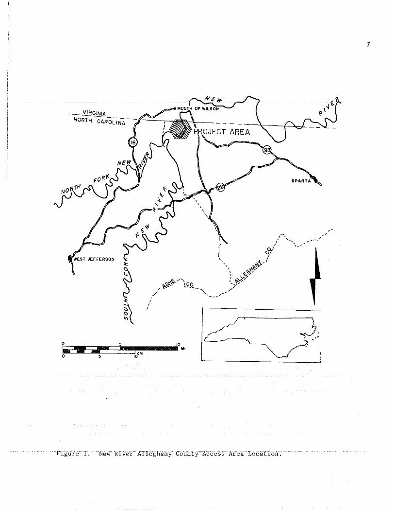
The Alleghany County Access Area is located within a broad, U-shapedmeander of the main stem New River approximately 1.2 miles (1.9 km) southof the North Carolina-Virginia state line (Figure 1). The New River watershed lies within the Blue Ridge Province of the Appalachians, comprising770 square miles (1994 km2) within North Carolina. The Alleghany CountyAccess Area contains roughly 175 acres (70.9 hal with approximately 75acres (30 hal in nearly level floodplain. Topography of the New RiverValley in general is characterized by steep-walled valleys, relativelynarrow floodplains, and a complex, fragmented ridge system. Elevationswithin the Access Area range from 2400 ft (731 m) to 2700 ft (823 m) AMSL.Roughly half of the Access Area has slopes in excess of 15%.
The Blue Ridge in western North Carolina is comprised largely of gneiss,schist, migmatite, and granitic rocks that are the products of metamorphismand plutonism that occurred roughly one million years ago (Bryant and Reed1970:10). The New River flows through some of the oldest rock in the United States, comparatively dated at 1.1 billion years. The oldest Precambrian rock along the river is the Cranberry Gneiss of the Elk Park PlutonicGroup. The Alleghany Access Area includes two aspects of this formation.The southern half of the Access Area and the adjacent cliffs are dominantlyequigranular quartz monzonite, quartz monzonite flaser gneiss, and quartzmonzonite gneiss. The norther half is dominantly augen gneiss and porphyritic gneiss (Rankin et al. 1972).
The most common mineral of local origin which was econo~ically important to prehistoric populations in the area is milk quartz. Quartz veinsare exposed in gneissic outcrops and it also occurs as large boulders in
7
,.",
~:--_'O= MI
VIRGINIA
lc~
,
~:t
*(0 5
IliiiI~ I~M0 5
Figure 1. New River Alleghany County Access Area Location.

8
some areas of the ridge top. Rhyolite is present as abraded and smoothedriver cobbles on the river floodplain. The nearest parent source is theMount Rogers formation from which it derives. Cherts, chalcedony, andjasper were also used by prehistoric populations and are not locallyavailable. It is not known which sources may have been most important tothe inhabitants of the Access Area but the nearest extensive chert~bearing
formations seem to be in the vicinity of Abingdon, Virginia (in the GreatValley) some 50 miles (80 km) from the project area (Butts 1940: ego71,106).
The other raw lithic material which appeared in the artifactual record was crystalline, clear quartz. Although no such material was observed in park formations some may exist. The most important deposits ofcrystalline quartz in western North Carolina are located in Ashe and Alleghany Counties (Mertie 1959:265). Significant, industrial quality deposits occur in two major groups. The nearest to the project area liesbetween Piney Creek and Sparta, NC. On the North Fork New River, thenearest recorded deposit is about one mile (1.6 km) west of Crumpler(1959:269-270).
Soils in Alleghany County, as in much of the mountainous region, areusually strongly acidic and low in natural fertility and organic matter(Brewer et al. 1973:1). Low natural fertility has been exacerbated byintensive cultivation and related erosion in much of the project area. TheAlleghany County Access Area is located within the Chester-Ashe Association, characterized by well-drained ro somewhat excessively well-drainedsoils. There are some notable exceptions to this condition: Comus finesandy loam and Codorus Complex soils are characteristic of nearly levelfloodplains which are subject to frequent flooding. The former is poorlydrained (1973:12). These two soil series comprise almost 50% of the floodplain within the Access Area.
In general, floodplain soils on the second terrace (Tl) are compactedwith sub-plowzone silt clays or clay silts. There is little or no humichorizon although this is largely due to the past history of cultivationand, presumably, flood scouring. First terrace (TO) soils are usuallycoarse sands and gravels lensed with silt. Alluvial sand levees existalong the rim of the second terrace at the northeastern and southeasternends of the park (in the major bend areas). In swales behind the secondterrace in the northern half of the park, alluvial sands are also present.Slopes and hilltops are typically stony clay silt and stony fine sandyloam with little or no humic development except in saddles.
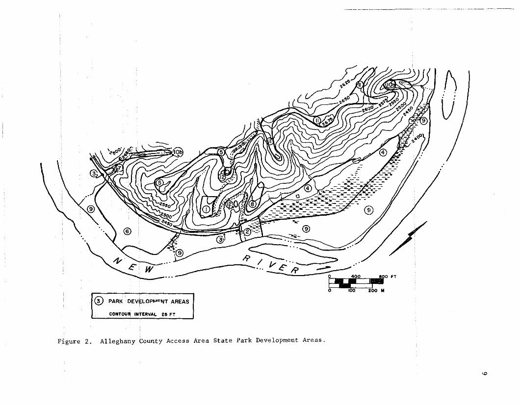
Slopes and ridges are currently in secondary hardwood forest andpasture, the latter being more common within the park. The floodplain isrelatively broad and has remained fallow only for the past year. Hardwoods and shrubs grow along impermanent and spring-fed streams cuttingthrough the floodplain and, where drainage is poor, marshes have developed.There are seven streams within the park and one fairly extensive marsh(Figure 2).
Typically, coves, lower slopes, and valleys of the New River Valleyare in mesic hardwood forest, hemlock, and white pine (State of NorthCarolina 1977:55). Hardwood forests are secondary growth, having beenexploited for timber over at least the past century with intensive exploitation in the first half of the twentieth century. Dominant species include
....-®......-
~. .::-::-------..~~ R~"'~"
-----/1/ ...~.,... _ ... ...--- 0.. IE" R----- .
I 0 400"",130 FT
@ ,,~ "-i,,."~ '"'" I ~• CONTOUR INTERVAL. 25 frT
l)U
Figure 2. Alleghany County Access Area State Park Development Areas.
'"
10
red and white oaks (Quercus), hickory (Carya), and tulip poplar (Liriodendron). Understory species include red and sugard maples (Acer) and dogwood (Cornus). Rhododendron and mountain laurel (Kalmia) are common onnorth-facing slopes (1977:75). A more complete discussion of the localvegetation can be found in Loucks (1981).
SCOPE OF WORK AND METHODOLOGY
In the Scope of Work issued by the Department of Natural Resources& Community Development (NRCD), work in each of 12 defined developmentareas was individually outlined. Archeological investigations were toinclude sub-surface testing within areas of known sites and in other locations where site presence was suspected in order to provide data whichwould be used i~assessing the significance of the sites according toNational Register criteria. On the basis of these assessments, the archeologist was to make recommendations regarding the planned development interms of impacts to archeological sites and mitigation and/or avoidance ofimpacts.
Field work was to include such activities as would enable the archeologist to determine (1) the cultural affiliation of the sites, (2) theextent, depth, and integrity of cultural deposits, and (3) the significanceof the archeological resources. Field investigations were to focus on the12 development areas (Figure 2). These areas were numbered and rankedaccording to the degree of anticipated disturbance by development withArea 1 potentially receiving the greatest impact and Area 12 the least.
Field methodology and research design were fairly simple. Systematicsurface collection and sub-surface testing were proposed for areas locatedwithin the floodplain. A permanent benchmark was to be iocated in Area 2and this would serve as a reference point for all floodplain and, wherepossible, upland investigations. It was proposed that an arbitrary gridsystem be established across the floodplain and that tests would be located at specific points along this grid. Surface collection was also proposed within 15 ft -wide transects divided into 10 ft sections along thefloodplain grid. This proved more difficult than anticipated due to verythick groundcover. Sub-surface tests were located 100 ft apart except inArea 9, a IIres idual" floodplain area, where tests were located at 200 ftor 100 ft intervals. Shovel tests were roughly 1.5 ft on a side and werelocated with their northwest corners at grid stakes unless otherwise noted.All soil was screened through one-quarter inch hardware cloth mesh and alltests were backfilled.
Methodology for testing Area 3, a 6000 ft long by 72 ft wide corridor,was different than that used in the floodplain. Tests were located 100 ftapart down the middle of the corridor and exposed surfaces were examined.Rockshe1ters within or adjacent to the corridor were also examined, surface-collected, and/or tested. Upland areas were more informally testedwith sub-surface tests located in areas of fairly level ground. Separategrid systems were established to test Areas 1, 7, and 8. Detailed accountsof proposed and employed strategies can be found in Loucks (1981).
Part of the RFP stipulation was that the archeologist must define a"site" as it was to be identified in the field. The working definition ofsite as employed by the author was that it was any location where three
or more artifacts were found in close proximity and where those artifactsrepresented a I'reasonable" association. "Close proximity" and lIreasonablellassociation were defined at the discretion of the author although it wasstated that a quartz flake, ironstone sherd, and a modern rifle cartridgewould not constitute a site even though they are found within a onefoot area.
Sampling fraction determined on the basis of test surface arearanged from a low of 0.004% (Area 9) to a high of about 1% (Areas lOa andlOb), depending on the size of the site involved. The sampling fractionbased on surface collection area was considerably higher in most cases,ranging from 1.84% (Area 9) to 100% (Areas lOa and lOb). A total of 289shovel tests were excavated and roughly 5.4 acres (2.2 hal were surfaceco11ec ted.
The nature of the development areas directly affected the testingprocedures. Testing in Areas 1 and 8, both ridge toes, was limited tofairly flat ground. In Area 1, the location of the historic McMillanfarmstead (3lA171), testing was concentrated around the house site. Area8 testing was limited to the center of the ridge toe. Extensive marshand wet areas limited testing in Areas 2 and 4. The forme" is mostlyfloodplain, the latter is primarily floodplain with some basal ridge toeareas. Areas 5 and 11 are ridge top and tests were located only on relatively flat ground, specifically in saddles (n = 8), on knolls (n = 5),on spurs (~ = 3), and on flat ridge top. Area-6 is located in the floodplain and was well-covered by shovel tests although poorly covered by surface collection due to the especially lush Johnson grass which grew atleast 6 ft tall in some areas. Area 7 is a small cove or stream floodplainbordering on the main floodplain at the western end of the park; thereis no exposed surface. Areas lOa and lOb are drainages at the northwestern and southwestern ends of the park, respectively. Only rockshelterswere examined within these areas. Area 12 is comprised of two historiccemeteries therefore no surface collection or testing were conducted.
RESEARCH GOALS
Regardless of how "assessment-oriented" a piece of archeological workmay be, there is always an opportunity for research that can at least makea contribution to regional studies if not to archeology and anthropologyin general. In fact, this is almost imperative if the significance ofthe resources is to be adequately judged. In survey and testing projectswhen specific prior knowledge is lacking or limited, questions to be addressed are often of a general nature. At the outset of this project,during the proposal preparation phase, the author knew little specificallyabout the New River archeological situation. The project prospectus madeit clear,however, that a long timespan of human activity was representedin the project area. One obvious question, therefore, concerned the relationshipof site location to natural features and resourCeS and how thisrelationship changed through time. Related to this was the question ofhow humans had utilized both local and non-local resources. What procurement networks were established to provide perceived or real necessities?What.impactshadhumans .. had.ontheirenvironment?
11
12
The reported presence of three historic sites was also noteworthy,not only because they lengthened the timespan of human occupation andprovided opportunity for examining greatly contrasting modes of humanadaptation, but also because little archeological research has involvedhistoric sites anywhere in the Southern Appalachians. It waS anticipatedthat there was considerable possibility for examining the adaptations ofearly settlers who moved into the Valley in the late eighteenth centuryand changes that these settlers underwent (and wrought) as time progressedthrough the next centuries. In the end, this was impossible since two ofthe three recorded historic sites did not exist in the archeologicalrecord. Possibly) they did not exist at all since there was no conclusivedocumentary evidence that they had been located within the project area.Although this reduced some of the comparative ability of the research, itdid make it clear that site identification based on tradition and hear-say,no matter how well informed, is questionable.
PREHISTORIC SITES
Fifteen prehistoric sites were examined during the 1981 archeologicalsurvey of the Access Area. Eleven of these had been recorded during previous surveys although the prehistoric component was not always recognized.For example, two sites (3lA17l and 3lA172) were recorded as historic sitesduring the 1976 survey (Robertson and Robertson 1978). One of these waSprimarily historic but the other waS primarily prehistoric.- Only nine ofthe 15 sites were the principal focus of the 1981 project. The other sixwere investigated in a cursory fashion only as they impinged on the parkdevelopment areas. Several isolated prehistoric finds or small clustersof artifacts were encountered but these were not designated sites.
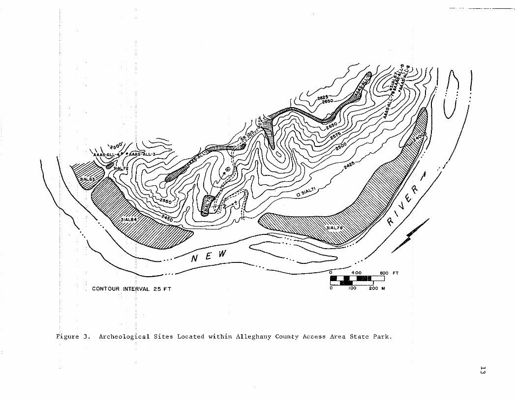
The two )argest sites were located in the New River floodplain andhad been recorded previously. 3lA178, in the northern half of the floodplain (Figure 3), had been divided into three sites during the 1976 survey (3lA178, 3lA179, and 3lA180) but no real basis was found for this distinction. Artifact occurrence was continuous over the entire area and nodistinct boundaries marking the 1976 sites could be discovered. Forthese reasons, only one site was recognized during 1981 and it was assignedthe lowest of the three numbers assigned in 1976 (i.e. 3lA178).
31A178 covers roughly 24.5 acres (9.9 hal as it is currently defined.The site is confined to the second terrace of the floodplain although artifact concentration appears to be greatest on the higher ridges of the terrace in the bend area. Artifacts were confined primarily to the plowzonebut some sub-disturbance artifacts were recovered. It does not appearthat there are any deeply buried deposits (that is, no more than 3 ft belowsurface) but different testing techniques would be required to bear thisout. No cultural features were encountered in any of the test units butsome may have escaped the plow.
Artifacts recovered from all field work, past and present, indicatehuman occupation from the Early/Middle Archaic through the Late Woodland(ca. 8000 B.C. - A.D. 1400 or later). It should be noted that re-analysisof the 1976 survey materials is currently in progress and that this maychange the interpretation of the occupation period. The "Late Woodland H
as used in this paper refers more to a way of life than to a particular
c-.~ .... - N £ W ------...~ ... ".
__--... ..... 0 400 800 FT
~ .:;:=JCONTOUR INTERVAL 25 FT 0 100 200 M
J () }: : : .
U
Figure 3 Archeological Sites Located within Alleghany County Access Area State Park.
f-'w
14
time period. In other areas of the Eastern United States (especially inthe Southeast), Woodland times end around A.D. 1000 with the spread ofMississippian influence. Mississippianism is usually marked by the appearance of fairly large population centers (stockaded villages and towns)which are the focus of religio~san~_ political<3.__c~~_v~_~i~_~_._'l:'l1~~~t:~I?:_~~rsare supported by smaller villages and hamlets, often hierarchically arranged around the center. Economic systems are characterized by longdistance trade controlled by an elite class, redistribution, increasingdifferential access to goods (especially exotic and status-related goods),and horticulture. Warfare is prevalent and public works organized by thereligious-political elite are common. Certain artifact styles are alsoassoCiated with the Mississippian phase, among them small arrow pointsand, in the Southeast, complicated stamped ceramics.
Most of these characteristics do not appear (thus far) in the archeological record of the New River Valley in western North Carolina and Virginia. Large centers with central plazas surrounded by platform moundsand elite residential areas have not been defined. Villages exist but theyseem to be relatively small. Neither platform nor burial mounds havebeen identified. As yet, it is not known how important horticulture wasin the subsistence base but the increasingly intensive occupation of thefloodplains is often interpreted as an indication that it played some rolein supporting the population. It is important to realize, however, thatthe location of villages in the floodplain does not necessarily indicatehorticulture and that other kinds of corroborating evidence are needed.Two probable (corn) cob marked sherds were recovered from the surface of3lA178 but even these do not provide substantial evidence of horticulture.
Other indications of Mississippianism are also lacking: exotic,status-related goods are not found (although the author often wonders ifother collectors over the years may be at least partially responsible forthe absence) and complicated stamped ceramics are either absent or extremelyrare. Some complicated stamped sherds were recovered during the 1981 survey but they comprised much less than 1% of the ceramic assemblages. Inview of these factors, then, the Late Woodland is usually continued throughthe end of the prehistoric era even though that date is unknown. The useof the term ··'Late Hoadland" simply indicates late prehistoric occupationand the absence of identifiable Mississippian (or equivalent) ·characteristics in any great frequency.
Returning to 31A178, then, 140 ceramics were recovered from testsand, primarily, the surface of the site. Few of these were actually identifiable but among those which had surface decoration, knotted net impressed and cord marked types predominated. The use of crushed quartz(angular particles usually greater than or equal to 0.5 mm) to temper claySwas almost universal.
Lithic artifacts were much more numerous (n = 1656) and most of thesederived from surface collection. Raw materials used in the manufacture ofstone tools included locally available resources (quartz and rhyolite) andnon-locally available materials (chert, chalcedony, and jasper). Crystalline quartz was also used but it is not known if it was local. At 3lA178,rhyolite artifacts greatly predominate over those made from other materials.Quartz is second mas t common, followed by chert. Although rhyolite is

dominant in overall frequency, non~local resources seem to have been preferred for the manufacture ofsometo61s. T6 what extent these differencesare temporal is unknown at this time although investigations on the NewRiver and elsewhere have suggested that cultural affiliation is a, if notthe--,---m-ajor--f-act-or-;-- -Anothe-r-problem--exists--,---ho·wever-,--in-o·the-g-rea-ter---dif-f-iculty of identifying wear on quartz and rhyolite than on chert and relatedmaterials. One might hypothesize, though, that given the cost of procurement prehistoric knappers would have wasted less non-local stone than localstone.
The other large floodplain site investigated during 1981 "as 31A184,located in the southern half of the park (Figure 3). This site is alsoconfined to the second terrace although cultural deposits extend up ontothe basal ridge areas around the streams at the northern and southern endof the site. The site covers approximately 11.7 acres (4.7 ha). As atthe northern floodplain site, artifacts indicate human occupation spanningthe Early/Middle Archaic through the Late Woodland. This site inventoryis very similar to that of 31A178 although artifact abundance is slightlylower in absolute terms but probably higher in relative terms. Only 46ceramics were recovered and most were unidentifiable. Knotted net impressed and cord mar~ed again seem to dominate, however. Lithic artifactswere more common (n = 1118). Rhyolite was numerically most common, followed by quartz, then chert. Debitage was the single largest class oflithic artifacts at both of the floodplain sites; worked artifacts comprised 3% or less of the floodplain site assemblages.
Most of the artifacts from 31A184 were recovered from the plowzoneor Zone 1. The major exception to this was one test located on the lowridge near the southern/western stream. Artifacts in this test were recovered to a depth of 2.90 ft (88 Gm) belowsurfqce. Most sub~plowzone
artifacts in the floodplain were collected from the tests in alluvium orin the swale behind the natural sand levee. Some artifacts were recoveredfrom just below the plowzone in other tests, however, indicating that thesite has not been totally destroyed by cultivation. No cultural featureswere encountered.
3lAl72 was by far the richest prehistoric site. It is located in asmall cove just north of the floodplain and adjacent on the west to thestream at the southern/western end of 31A184. This site was originallyrecorded for its historic importance since it was supposed to be the lateeighteenth century Sturgill homesite. The only historic artifacts recovered,:however, were twentieth century. Although thehisf6iic importa.ncecould not be demonstrated; 3lAl72is probab lyone of the most importantprehistor.icsites·in.. the. area. The cove has. received. on ly minor.distur~
bance and the culturaL midden zone is definable and largely intact. Arti~
fact distribution isvertically.stratifieq; the most obviQus indication ofthis is the fact that ceramics and chert artifacts were derived principallyfrom the upper levels in tests whereas rhyolite artifacts were recoveredprimarily froffi.thelower,.aceramiclevels.
This is a small site, encompassing an estimated 0.1 acre (0.04 hal.Except for a few small hardwoods, thE! cove is open and heavily grown inherbaceous vegetation. The artifact-bearing midden overlies alluvial'sands'and'g'ravel-6f-ii'fal:i'-f6rmafi6n'~--Late"Ar,:chaTc"'arEifa'cfswei;;e"fecOvered
15

16
from just above these sands and a few artifacts were encountered in thetop of the sand stratum. Occupational debris suggests that human activitycovers a temporal range similar to that of the floodplain sites. Withoutexcavation, however, it is impossible to ascertain if occupation was moreor less continuous or if there was an hiatus between Late Archaic andwhat appears to be Late Woodland. Seventy-five sherds anct665 stone artifacts were collected from twelve of the fourteen tests. Animal bonewas also preserved in the organic midden. Much of it was fragmentary butone element--a white-tailed deer phalanx--was identifiable.
The most common decorated ceramic type was knotted net impressed,followed by cord-wrapped sticks (or fabric) impressed. The most unusualsherd was a rim which was fairly thin and plain except for a neatly incised line just below the lip. The inclusion of coarse-to-gravel, angular quartz as temper was common. Proportions of raw materials used in themanufacture of stone tools were markedly different at this site. Chertwas the most frequent, followed by quartz and then rhyolite. This apparent abundance of non-local raw material may indicate a more intense lateoccupation than on the floodplain, functiona~ or sampling error differences.It may also be a factor of using artifact counts alone with no data taking relative size/weight into consideration. Although quartz was secondin frequency, it appeared to be represented largely by debitage.
Another cove site investigated is in the same drainage as 3lA172about 230 ft (70.1 m) north of the latter. This site, temporary numberAAAS-All-4, is not actually within the park so testing was minimal. Oneof two tests contained 93 lithic artifacts; the other was culturally sterile. Included in the lithic assemblage was a rhyolite preform base, probably intended as a Savannah River point/knife. This artifact dates thesite to at least the Late Archaic. Rhyolite was the dominant raw materialfollowed by quartz and chert. It is probable that the artifacts are stratified.
Roughly 30-35 ft (9.0-9.5 m) north of AAAS-All-4 on the oppositeside (east slope face) of the drainage, two rockshelters containing cultural material were investigated. These two shelters were given the temporary site number AAAS-All-3. They are situated 30-40 ft (9-12 m) abovethe stream and both face northwest. The lower shelter yielded 233 lithicartifacts and 15 sherds from the surface and one shovel test. The uppershelter, located immediately above the lower one, produced only 19 lithicartifacts and 36 sherds. Artifacts indicate human occupation during theLate Woodland and probably earlier. The cultural deposits in these shelters are intact and, at least in the lower shelter, stratified. Decorated ceramics were dominated by cord~wrapped sticks impressed althoughmost of these came from a single vessel. Knotted net impressed was alsocommOTI. For the site as a whole, quartz was numerically more abundantthan the other raw lithic materials but it was apparently representedlargely by debitage. Rhyolite was second most frequent followed by chertand chalcedony (aggregated as non-local materials).
Virtually all of the ridge system within the park was designated asone site, AAAS-All-l. The site was divided into two parts (lA and IB)which correspond roughly with development areas 5 and 11, respectively.These two parts are separated by S.R. 1313. The entire site encompassesabout 9 acres (3.6 hal and includes saddles, knolls, and the intervening

ridges. Most of the sub~surface tests yielded artifacts, all of whichwere lithic (n = 286). Unexpectedly, some of the knoll tests producedmore artifact; than did some of the saddle tests. None of the artifactswere diagnostic; most were quartz debitage. Rhyolite and chert were also
P!~~~~~__, __ ~~ ~_~~~_?E~_~_~ ?_t~_~_~_!"_~ft~~~~~E~q~~ __I:l_~Y' ____~~l_~ ~:I::,:l~ __?eP?~ _i_~s ~~_~~to be intact although the cultural zone is usually shallow. Erosion mayhave had some impact on the ridge. This is especially apparent in saddleswhere the midden is buried below sterile, colluvial soil.
At the northern end of the ridge is another complex of sites composedof three rockshelters (3lA167, AAAS-All-5, and AAAS-All-6) and a smallarea of ridge top immediately east of AAAS-All-5. 3lA167 was recorded in1976 and tested at that time and again in 1980 (Mathis, pers. comm.) therefore it was not tested in 1981. This was the only one of the four components that produced ceramics, all apparently part of the same vesselwhich could be Early Woodland. Immediately north of 3lA167 is a much larger shelter, AAAS-All-5. Four tests were dug in this site but only twoyielded artifacts (n = 37 lithic artifacts). One of these was a quartzMorrow Mountain point (Middle Archaic). Rhyolite was the only other rawmaterial representediu this site and it was less frequent than quartz.
AAAS-All-6 is a very small rockshelter located about 75 ft (22.5 m)NNE of AAAS-All-5. One test was excavated and one artifact (rhyolite)was recovered. All of these shelters are located on the east slope abovea small, narrow drainage which empites into the New River. All sheltersface northwest.
AAAS-All-7 is marked in a shovel test on the ridge just behind (eastof) the rockshelters. Eight lithic artifacts, including the only chertfrom the northern ridge section, were collected.
31A17l is principally an historic site but some prehistoric artifacts,all1ithic,wererecoveredfromtestsinthevicinityofthehouseruins.None of the 147 artifacts were diagnostic and all but one jasper flakewere from disturbed contexts. Quartz was the dominant raw material, followed by rhyolite and chert, in that order.
Southwest of the park proper, near the end of the Area 3 corridor, isa large cave designated 3lA154 during the 1976 survey. One test was locatedjust in front of the mouth of the cave and one chert artifact was recovered.
THE MCMILLAN FARMSTEAD
The McMillan farmstead (3lAl70 is composed of the stone foundationruins of the house and one nearby barn (Area 1), another related barn ruinin-Afeci-04;twO--s-tand-irig-i;fffuc-tUres-_-iitthe-a:reaOf--the-h6tHH~-;-a---fatilily----cem"'"
etery and a slave/black cemetery (Area 12). FieldsJ.McMillan purchased705 acres (286 hal of land in the Alleghany Access area in 1850. The houseitself was built by McMillan between 1850 and 1855, indicated by documen~
tary information and the earliest dated gravestone in the family cemetery(Loucks 1981:xviiJ. McMillan was a member of a family who were among thefirst settlers in Ashe/Alleghany Counties. His grandfather and uncle hadbeen important figures in local and/or state politics, serving in thecourts, State House, and/or State Senate. Fields McMillan himself servedtwo terms in the Senate,_v;rCl~_Cl~ ~Cl_:t:"Jy justice and of Deeds
17

18
1n Alleghany County. He was comparatively wealthy; a large landownerwho employeq laborers and owned slaves. Most of his income was from livestock sales but he also established a woolen mill in Mouth of Wilson.He was a leading figure in the rural community, served as a colonel inthe War Between the States, was a Freemason, and probably helped to establish one of the early schools in the New River area near Mouth of Wil~
son (Loucks 1981:149-155).McMillan, his family, slaves (and later, free black servants), and
his in-laws all lived in the farmstead at one time or another. McMillan,seemingly the last of the group to live on at the house, died in 1904.Members of the family continued to live in the house until the 1920s atwhich time it was rented out to tenants. It later became a hay barn andwas finally razed in the early 1970s.
Most of the investigations at the McMillan site involved sub-surfacetesting, especially in the area of the house, and making mapped and photographic records of the lot plan, buildings, ruins, and cemeteries. Atotal of 1783 historic artifacts were recovered from the site. Most ofthese derived from tests in the house area (n = 1745) and only 38 artifacts were recovered from tests in the vicinIty of the Area 1 barn. Mostof the historic artifacts were pieces of glass (primarily window but alsotablewares) and nails (primarily machine cut). Ceramics included ironstone--the most abundant--whiteware, semiporcelain, earthenware, and stoneware. Glass included fragments of bottles, goblets, tumblers, and fancyhollow wares. Organic artifacts were well-preserved, some no doubt datingto the tenenat period (twentieth century). Faunal materials (n = 62 fragments) were especially well-preserved in trash pits/middens. Asmall sample of 10 MNI included eastern cottontail (Sylvilagus floridanus), groundhog (Marmota monax), possible pig (Sus scrofa), unidentified bird, unidentified bony fish, and black snake (Colubridae). Ten floral artifacts werealso recovered: four walnut hulls, three cherry pit halves, and threepeach pit halves.
The artifacts recovered were not particularly helpful in establishinga temporal frame since historic artifacts from the last 150 years are verysimilar to those manufactured today and none of the artifacts recoveredhad complete maker's marks or legends. All that could be learned regardingtemporal affiliation of the recovered artifacts was that they date fromthe middle of the nineteenth century through at least World War I, andprobably somewhat later.
In addition to the exposed, dry-laid &tone foundations of the house,additional foundations were encountered in sub-surface tests and othercultural features (possible trash pits) were exposed in a small test andan uncompleted 5 ft by 5 ft unit. The remains, or at least the location,of the original detached kitchen may also have been discovered. The standing structures associated with the house include a springhouse and ashed of unknown function. Both are of later construction than the house,probably dating to around 1920. The silos associated with the barns arealso from this later period. All of these later additions are made ofpoured· concrete, heavily "tempered" with river gravel.
Field and documentary research and conversations with the Smith family, who live near the State Park, were extremely helpful in filling out
the picture of the now~fuiried structures. Mrs. Sue Smith, a descendantof Fields McMillan, was especially helpful. Little was known about thebarn in Area 1. Its foundat·ions are about 185 horizontal feet (55.5 m)south of the house and roughly 20 vertical feet (6 m) below it. The barnfoundation was dry-laid stone but more recent attempts have been made tofi."partsCl{ thes iu~ing foundatiCln· w:i.t:hc:e~ent. ··The best: preservedsection is the south wall. Six stone pillars, which may have supportedmajor up-rights, are spaced along the 48 ft (14.4 m) east-west lengthat alternating intervals of 5 and 10 feet. The north-south dimension ofthe barn is about 36 ft (10.8 m). The poured concrete silo foundationsare at the northwest corner of the barn. Both are about 11 ft in diameter and are reinforced with iron straps~ The superstructure was woodenboard. Both silos were plastered on the interior and had mortar floors.
The McMillan house foundation measures 30 ft (9 m) north-south by34 ft (10.2 m) east-west. It was two-story frame, faced south toward theriver, and had external, brick chimneys on the east and west ends. Thebricks for the house were reportedly made from clay dug in the floodplain(Russell 1976). According to Sue Smith, who visited the house when itwas still owned by the family, the house had the same number of rooms onboth floors. The living rooms were L-shaped and a two-story front porchfilled the angle of the "L." The front of the room, on the ground floor,consisted of the "front room" in the southwest corner and the porch inthe southeast corner. The front room is about 14 ft (4.2 m) east-westand 10 ft (3 m) deep. Behind the front room was another room containingthe west fireplace. The "large room," or sitting room, was behind theporch and contained the east fireplace. A central hallway ran betweenthe two back rooms and opened onto the porch.
It is known that other structures were present on the property buttes ting····d-id notlocatethem~ These structures included---the--- H s lavehouse, II
the house where McMillan's in-laws lived, the one or more privies, andthe original detached kitchen. Artifact type and concentration suggestthat the kitchen may have been located just west of the house foundation.
Fields McMillan, who built the house at the Mcmillan site and livedin it for over half a century, represented the changes being wrought innorthwestern North Carolina with the coming of a new phase in Americanhistory. His life and activities straddle the period of frontier expansion, land development and alteration, and emerging industrialization inthe Southern Appalachians and the country a.t large. He personifies thechanging South following the War and links the early period of settlementwith the later period of development and massive exploitation of the natt.ir-aT--envi-rori.merit~
There is no particular architectural significance to the ruins ofthe site; its significance rests in broader,culturaT aspects. Socialscientists studying modern populations (and to some extent, early twentieth century populations) in the Southern Appalachians have been concerned. with.- breakingthes tereotype __ of "maunta inee1"$11 as .ignorant,I1on~progressive,. and· culturally isolated. Economic development . in Appalachiais still conceived of by many planners as being a "new" venture. There isan almost total lack of understanding of the cultural processes whichhave created the Appalachi" that "really was" and the . stereotype .. History
19
20
in a traditional sense can make contributions to the understanding andexplanation of these processes but archeological research can providemuch greater depth to the elucidation of these processes and the natureof the populations who have inhabited these environs. Historical recordstoo often focus on the "important ll when it is the "mundane" that has hadthe longer-lasting and more irnmediatelmpacts.
SETTLEMENT PATTERN AND RESOURCE UTILIZATION
As indicated above, research questions were of a very general nature.One goal involved determination of how sites had been located with respect to natural features and how this relationship had changed throughtime (if, in fact, it had). Another question involved human utilizationof local and non-local resources and how this had changed through time.Thus far, artifact and site analysis has been at such a low level thatmuch information needed to fully address these questions is not available.Some initial statements can be made, however, and offered as tentative,informal hypotheses.
Plowing in the Access Area floodplain has sufficiently disturbed thedistribution of artifacts, making identification of overlapping or distinct Archaic and Woodland artifact clusters virtually impossible. Ifthe sites within the floodplain are treated as homogeneous units, however,it is obvious that they are multicomponent as are the undisturbed coveand southernmost rockshelter sites. Non-diagnostic lithic artifacts·havenot been differentiated into Archaic versus Woodland types thus far. Onthe basis of gross comparison, however, it can be hypothesized that Archaic components represent more limited activities than do Woodland.
Activities on the ridge top may have been associated primarily withArchaic populations but the absence of diagnostic artifacts makes thishypothetical. There is no reason to assume, even given the lack of ceramics, that only Archaic peoples made use of the ridge. AAAS-All-l seemsto represent limited activity, short-term occupation, over an unidentifiedperiod of time. Cultural debris on the ridge top may be related to quarrying and/or hunting activities. It may also reflect the hypothesis thatridge systems were important transporation routes (Mathis 1981).
Quartz was the predominant raw material recovered from tests on theridge and from the northern complex of rockshelters. Artifact densitywas not high within these shelters--certainly is was low when compared tothe southern shelters--suggesting that occupation of the northern shelterswas also limited in time and intensity. In addition, ceramics were uncommon in the northern rocksheltersand bore little re seffib lance to thOse fromelsewhere in the Access Area.
The southern rockshelters appeared more related to the cove site atthe edge of the floodplain (31A172) than to the northern shelters. Thereis no flat cove associated with the drainage system in the latter area.It would appear that the attractive features of the rockshelters differedfor Archaic and Woodland populations, the former utilizing "all" shelters,the latter (particularly during the Late Woodland) restricting occupationto shelters associated with cove/stream floodplains. What this may indicate is not immediately clear except that certa~n resources found in~h~
stream floodplain habitats were a drawing factor to Woodland peoples.These resources may include food sources such as nut-bearing trees inthe cove hardwood forests. They may alsoillclude flat, cultivable la.ndwithin easy access.
There was Some hope that protection from prevailing winds and the, facing'direc'tion of'the shelters could be used to indicate seasonalityof occupation. Prevailing winds are out of the southeast; southeasterlywinds predominate in the winter months (December through February) andlate spring-summer (April through July). In late summer and fall (Augustthrough November) and early spring (March), winds are from the northeast.The facing direction of the shelters in both areas is basically northwest and it would seem that general protection would be afforded throughout the year. According to Mathis, however, (pers. comm.) the windsblew hard and cold into the 31A167 rockshelter when it was being testedin the early spring of 1980. Winds up the cove at the southern end ofthe park might be expected to be more of a problem when the winds arefrom the southeast. Protection afforded by forests and surrounding ridges, however, must have been considerable during the late spring throughearly fall. It was probably only during the late fall through earlyspring, when the trees were bare, that the winds presented any real discomfort. In that case, occupation of the shelters at the northern endof the park during the late fall through early spring would have beenmost uncomfortable. It is difficult, if not impossible, to try to judgeprehistoric perceptions of comfort. It may be suggested, however, thatyear-round occupation of the southern rockshelters might have been moreappealing and that this may explain, at least in part, the habitation ofthese shelters by the (assumed) more sedentary Woodland populations.
Another climatic factor which may be implicated is the tendency forcold. air to "settle"in thecovesan<:lcirCiiIl_agebCifSin:;. Out on the floodplain, presumably where air flow was more intense, this would not haveafforded the problem that the lack of turbulence would in the coves. Possibly, the Woodland occupations of the southern rockshelters occurredduring the colder months when living above the floor of the cove involvedonly minor relocation but afforded greater protection from the cold andwinds. Still another possibility is that the coves and rockshelters provided relocation sites during floods. While a seemingly good possibleinterpretation, this would be very difficult to demonstrate.
Analysis of the historic settlement pattern is made difficult dueto the. fact that only one definite historic sites was located. The McMillan site was neither on the ridge nor on the floodplain, rather it wasbetween the two OIl ad.dge spuI" which was, 110 doubt " at least partiallylevelled prior to construction. It is not expected that settlers whomake their living by farming arid build substantial structures would 10"cate their buildings on fertile floodplain soils that are subject toflooding. Ridge tops, on the other hand, were exposed to the proverbialelements once they were timbered and, probably more importantly, theywere turned to pasturage and hay production. The in-between arrangementseems·fo ·have-- -been -.- the-·-IIlost ·-·pra.ctica.l---givetl-these··cdnsiderati()ns~ Theonly historic construction on the ridge top appears to have been limitedand ritually based--the construction of cemeteries. The author has not
21
22
conducted in-depth research into the reasons for locating cemeteries onknolls, spurs, and ridge tops but there are some obvious and, perhaps,ideological considerations. Such a location placed the deceased corporally and spiritually closer to heaven. This location provided the deadwith a better view of those stil-l1iving andthe-reverse-wasalso true:those living could receive fairly constant reminders of those who haddied. It is doubtful that the location of cemeteries was as much for thedead as it was for the living. There is an- obvious solemnity and spirituality (not to mention display of devotion) in the picture afforded bythe funeral procession laboring up the slopes to lay the dead to rest onthe wind-blown elevations. The practical consideration lies primarilyin the fact that this location made use of otherwise inferior settingsthus moving the dead out of the way of the living.
The McMillan family cemetery was situated on a high knoll above thefamily house. The smaller cemetery, probably that of the slaves (andlater, freed Blacks) was situated on a ridge spur below the main house.It seems clear that social position was maintained and reinforced indeath as it had been in life; more lowly humans were buried in more lowly places. The rough, local stone used in the slave/Black cemetery contrasts with the imported, finished, embellished markers in the familycemetery. Some rough gravestones occur in the family cemetery but thesewere also segregated by form, raw material, and location. If these latter were the gravestones of house servants, or freed Blacks, they hadbeen elevated (literally and figuratively) over their predecessors/peersbut they had not yet attained equality.
One could go on indefinitely regarding the symbolic location of thehouse, situated so that it faced the river and commanded a view of allthey"surveyed." Comparative information on prehistoric settlementswould be most enlightening. The commanding perspective of the historicstructure, and the orderliness of the buildings and their pattern, is inkeeping with the perspective of command over Nature rather than integration with it. Even in the planning of the State Park, the emphasis ismore one of command--with picnic areas, overlooks, and trails on the ridges for full appreciation of the scenic view--than integration. In makinga sanctuary of Nature, Western philosophy (and the resultant actions)still tends to set humans apart from the rest of the natural world.
Without full temporal control over the prehistoric archeological record, it is difficult to assess changing patterns of resolirce utilizat'ion.Undoubtedly there are temporal differences between resources used byArchaic populations and those used by Woodland groups. Settlement patternsuggests some of these differences. Woodland populations appear to bemore sedentary indicating intensification of food resource exploitationin a more localized area than that used by Archaic peoples. There is also some slight suggestion that cultivation of domesticated plants was added to the Woodland cultural milieu. The size of the later sites cannotbe determined on the floodplain and no overall estimate of changing population size is possible. The smaller cove and rockshelter sites suggestthat population density was not very great despite the postulated use ofcultigens. Environmental alteration was probably minimal· although thisis more hypothetical than substantiated.

Thus far,the best material for studying resourceutilizaEion isthe lithic artifacts. Holding temporal differences equal, it would ap~
pear that proximity to raw materials was of major importance in the floodplain and uplands. Rhyolite, which is located as river cobbles on the~_~_~~_~, _~;?_?_~:P~~~Il"-,,- ..__ "VlCis __ ~_~_~:~l?I!l~:r:Ci_Il~ •. __~Ci_~~.:r~Ci~_u_~ ..~4:- .~h:_~J:~_._tolh~E~_~~_q~~_~_~_~,available in ridge top outcrops and in rocksllelter veins, was the dominant material represented in those areas. The preferred materials fortools, however, were not always identifiable as those most readily available. Rhyolite appears to have been the preferred tool material overquartz during the Archaic in both floodplain and upland sites (as judgedfrom projectile point classification). Chert, chalcedony, and jasperappear to have been the preferred tool materials during Woodland, especially Late Woodland, periods. By the time of Woodland occupation, therefore, one can hypothesize that resource procurement networks were vastlyenlarged over the earlier Archaic stage. Whether these non-local resources were brought in as the result of procurement forays or through tradecannot be determined at this time. Certainly, however, there was an increaaeduse ofextra-territbrial resbtircesduririgthe later periods 6foccupation although this exploitation was neither far-ranging (in a modernor even late prehistoric sense elsewhere) nor- intensive since the dominant raw materials were still the local ones.
As one would expect, reliance on extra-territorial resources intensified greatly during the historic period. More could be said if thgearlier historic site purported to be in the Access Area was found. ·Bythe nineteenth century, market networks brought in glasswares, ceramics,and metals. They removed timber, stone, and livestock and crops supported by the local environment. There can be no doubt that resource utilization during the McMillan occupation was based on removal and replacement,yetlocalresources wereutilized~ Local game animals- werecon~sumed, local timber was surely used in the construction of the house andother buildings, local clay and stone were used in building houses, utilitarian structures, and monuments. The greatest monuments, however, weremanufactured from imported stone (i.e. the marble gravestones). The basic ideology expressed in this resource utilization is again one of command: alteration, extraction, importation, reconstruction. If the population density was much lower during historic times--an assumption atthis point which seems reasonable but could be questioned--the impactwas dramatically increased, for the population being supported was nolonger just the local one but a regional, national, and international one.
The Alleghany County Access Area is the Stage setting for human activities which have made a significant contribution to our past. Human exploration, settlement, adaptation, and management of mountainous environments in the eastern United States have played an important role in themore--- general occupation-of -the East--and expansion into-the- "newll-- frontierof the West beyond the mountain ranges. The mountains have always beenseen as barriers, prohibitng communication and promoting isolation. ForEuro ::American set;tlers,. conquering the mountain passes and set;tlementof
23
24
the mountains themselves opened the frontier west of the Blue Ridge tohuman expansion and exploitation. The Euro-American and the Native American past east and west of the mountains are inexorably linked to those"barriers. 1I We cannot understand what happened to "Appalachia," nor tothe east and west of Appalachia, without understanding what hllmansclidand how they lived in the mountains and the nature of their communicationwith the rest of the region, nation, and world.
Within the Access Area, the sites together comprise a "whole" thatis greater than the "parts." Individual sites mayor may not be archeologically significant, but an understanding of what happened in the pastcannot be gained if they are viewed as single, unlinked entities. Theprocess of human adaptation cannot be studied at the ridge top site without studying it also at the rockshelters, coves, and floodplain. Neithercan we really understand how life changed, and the impacts of those changes, without studying both prehistory and history. There is a patternin the whole that is absent in the parts and all too rarely, it seems,does one get the opportunity to study the entire pattern within onemicrocosm.
ACKNOWLEDGEMENTS
Appreciation is extended to the members of the 1981 survey crewwho made this project so enjoyable: Rosanne Stutts, Tom Higgins, TerriLe fl<"r,' Alexis· Sieg, VieveYarbrough,JeffcBarefoot'{field'supervisor),and Harvard Ayers (field director). Special acknowledgemnts, of varioustypes, are extended to Mr. Richard Hazard, Project Manager with Parks &Recreation, NRCD, and to Mark Mathis, Staff Archeologist with the NCArcheology Branch. Both individuals provided examples of their respectiveareas of expertise and considerably alleviated research and contract blues.The author feels a very special debt of thanks to Mrs. Sue Smith and herfamily for providing wonderfully interesting information about the McMillans and for being so cooperative.
25

26
REFERENCES CITED
Appalachian Consortium1982 Appalachia: Values and Visions. Public lecture series, Appala
chianState Universi.ty,.Boone, NC.
Ayers, Harvard G.1965 An appraisal of the archeological resources of the Blue Ridge
Project. River Basin Surveys, Smithsonian Institution, Washington.
Brewer, Edward 0., Robert M. Brown, and Julian H. McIntyre1973 Soil survey of Alleghany County, North Carolina. USDA and Soil
Coservation Service.
Bryant, Bruce and John C. Reed, Jr.1970 Geology of the Grandfather Mountain window and vlclnity, North
Carolina and Tennessee. Geological Survey Professional Paper 615.
Butts, Charles1940 Geology of the Appalachian Valley in Virginia (Part I). Virginia
Geological Survey Bulletin 52.
Holland, C.G.1969 The revised Blue Ridge Project: An archeological survey and
summary. Report submitted to the Smithsonian Institute and AmericanElectric Service Corporation of New York City. Ms. on filE, Archeology Branch, N.C. Division of Archives and History, Raleigh, NC.
Loucks, L. Jill1981 New River Alleghany Access Area archeological resource survey:
summer 1981. Report submitted to the N.C. Department of NaturalResources & Community Development. Me. on file, Archeology Branch,N.C. Division of Archives and History, Raleigh, NC.
Mathis, Mark A.1981 Investigations in the New River Valley of northwestern North
Carolina: Preliminary observations. Paper presented at the 38thSoutheastern Archeological Conference, Asheville, NC.
Mertie, John B.1959 Quartz crystal deposits of southwestern Virginia and western
North Carolina. U.S. Geological Survey Bulletin 1072-D.
Purrington, Burton L.1974 Using archeological data in the analysis of contemporary behavior.
Paper presented at the 53rd Annual Meeting of the Central StatesAnthropological Society, Chicago.
1977 The status and future of archeology and Nhtive American studiesin the Southern Appalachians. Appalachian Journal 5(1):40-54.

1979 Continuity and change in late prehistoric settlement patternsin an Appalachian North Carolina locality. Paper presented at the36th Southeastern Archeological Conference, Atlanta.
Rankin, D.W., G.H. Espenshade, and R.B. Neuman1972· .Geoiogic:map.· of t:hewest: haiT of the Winston-Salem quadrangle,
North Carolina, Virginia, and Tennessee. USGS Miscellaneous Geologic Investigations Map 1-709-A.
Robertson, Linda B. and Ben P. Robertson1978 The New River survey: A preliminary report. North C~rolina
Archeological Council Publication No.8.
27
Russell, Gayle1976 New River survey field notes.
Division of Archives and History,On file, Archeology Branch, N.C.
Raleigh, NC.
State of North Carolina1977 South Fork New River scenic river study. N.C. Department of
Natural Resources & Community Development, Division of Parks & Recreation, Raleigh.

ARCFk\EOLOGICAL INVESTIGATION OF A SMALL LATE PREHISTORIC
SETTLEMENT IN THE LITTLE TEHNESSEE DRAINAGE
MACON COUNTY, NORTH Cfu~OLINA
C. Michael Baker
C.Michael Baker, 208 Severin Street, Chapel Hill, North Carolina 27514


ARCHAEOLOGICAL INVESTIGATION.OF A SMALL LATE PREHISTORIC
SETTLEMENT IN THE LITTLE TENNESSEE DRAINAGE,
MACON COUNTY,. NORTH CAROLINA
ABSTRACT
Archaeological investigations at a small, late prehistoric sitelocated in Macon County, North Carolina are discussed. Excavationsand other data recovery methods employed are described and results ofthe fieldwork are presented. Laboratory analyses of recovered artifacts and soils are discussed in light of certain substantive andmethodological problems. The overall results of the investigationsare interpreted by reference to existing summaries of local and regional prehistory.
INTRODUCTION
Archaeological investigations reported herein were conducted at alate prehistoric aboriginal site in Macon County, North Carolina duringFebruary and March, 1980. The site·was first identified during a cultural resource inventory of a small tract of land in the Wayah RangerDistrict, Nantahala National Forest (Barber 1980). Identifying designations for the site include the U. S. Forest Service number WA-1-80*and Western Carolina University Archaeology Laboratory accession number225. The land where the site is located had been proposed for exchangeby The National Forests of North Carolina, thereby placing the site outof government control. Viewed as an adverse impact, this action required mitigative archaeological studies.
Excavations at the site were conducted on successive weekends andon some weekdays, from the beginning of February through mid-March,1980. Academic responsibilities of the Principal Investigator precluded a more regular work schedule. The field crew ranged in numberbetween two and ten persotlsand cotlsistedprimariiy of anthropologystudents enrolled at Western Carolina University. Weather during thefield session was consistently inclement. Extreme cold was the ruleand it rained or snowed frequently. Although the bad weather sometimesslowed or otherwise hampered fieldwork activities, the enthusiaSm ofthe crew members was exceptionally good. The efforts and contributionsof the following persons are gratefully acknowledged: Ronnie Ambrose,Michael Barber, Stephanie Blount, Daniel Brabson, Jack Day, RichardDavidson, James Errante, Mark Jones, Jane Lawrence, Tommy Marshall,Mark Martin, Ned Mount, Michael Odom, Linda Pinkerton, John Provetero,
*Permanent State site number 31Ma182
31

32
Ron Raxter, Mark Westebbe, Sharon Westebbe, and Ann Zito.
Laboratory processing of materials recovered from the site was performed by students enrolled in archaeology classes at Western CarolinaUnivers1ty during the spring semester, 1980. In addition, a number ofstudents undertook limited research projects on topics pertaining to theinvestigations. Selected information produced by these studies is incorporated in this report. All cultural materials recovered from thesite and all records resulting from the field and laboratory investigations are being curated at the Archaeology Laboratory, Western CarolinaUniversity.
SITE LOCATION AND DESCRIPTION
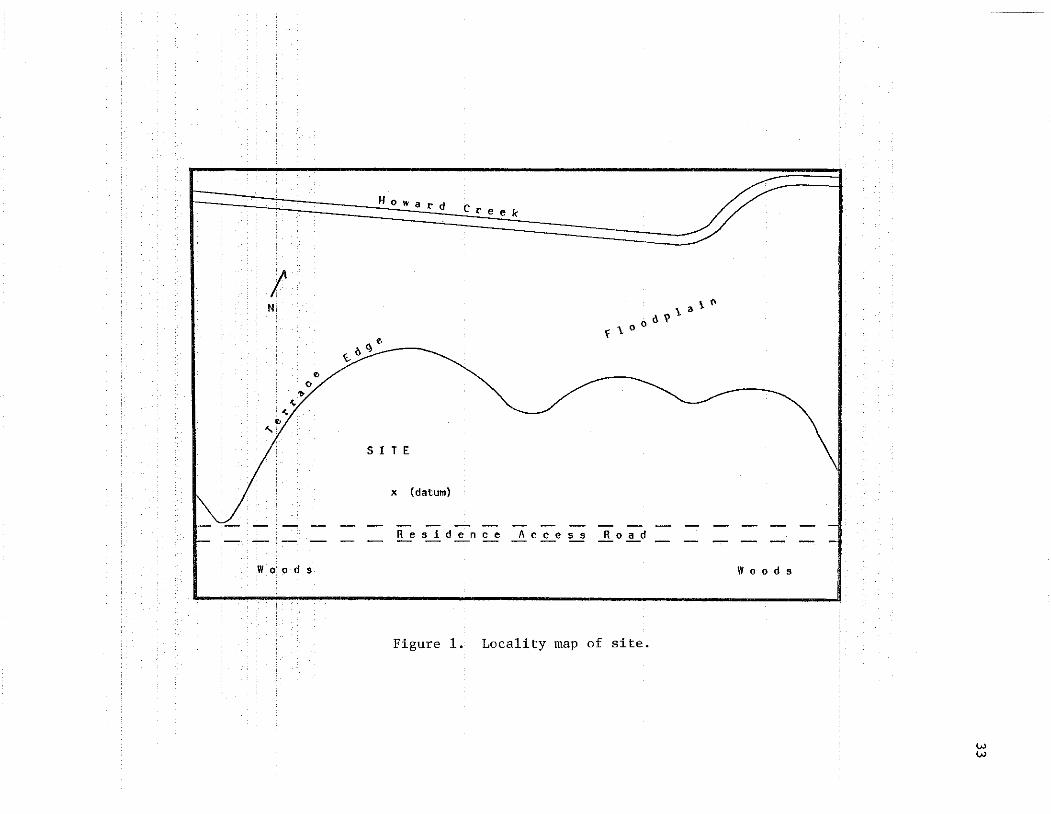
The site is located approximately 1.7 km west southwest of Otto,North Carolina on the eastern bank of Howard Creek at the western footof Little Mountain (USGS 1946). Howard Creek is the south fork tributary of Coweeta Creek which enters into the Little Tennessee River some4.4 km distance from the site.
The site is situated on a prominent flat remnant terrace (terminalmountain slope) of limited area located approximately 100 meters southwest of Howard Creek. The terrace rises immediately and abruptly toan elevation of about 10-12 meters above the creek floodplain. Prehistoric cultural materials were found distributed across this and portions of an adjoining terrace to the northeast and initial estimatesplaced site dimensions at 50 x 175-200 feet (Barber 1980). Presentinvestigations confirmed this estimate of actual artifact distribution,but the site area proper was found only to occupy the prominent terrace described. Based upon excavations, shovel tests, and soils analysis, the site area is estimated at about 0.25 ha (Fig. 1).
Artifacts and other evidence recovered during the investigationssuggest that the site is single component (i.e. represents a single occupation) dating to the Mississippian period (Dickens 1976). The primary artifact type represented at the site is ceramic sherds, withmost of these fitting sherd type descriptions of the Qualla phase (B.Egloff 1967:34; Dickens 1976:14-15). Although it is not possible toassign the site to either the early Qualla phase (A.D. 1450-1650;Dickens 1976:14) or the late Qualla phase (post-1650), the absence ofearly Euro-American artifacts at the site suggests a late prehistoric(early Qualla) site affiliation.
Excavations at the site revealed the presence of a former structure (presumed domestic) on the middle portion of the terrace. Forreasons to be discussed, it is believed likely that the structure wasoccupied for only a relatively brief period, perhaps corresponding toa segment of the occupation of the nearby Coweeta Creek village (B.Egloff 1967; K. Egloff 1971). The site charaCteristics, includingsize, artifact inventory, and location, suggest it is a component of
!N
oo,.
~
~
o
"
How a r d
o~ I> C\ ________
5 I T E
x (datum)
ere e k
'\ a \. f\
f\OOO~
Residence Access- - R 0 a d- -
Wo:ods Woods
Figure 1. Locality map of site.
ww

34
a dispersed settlement system. It could represent a small farmsteadwith adjoining areas (within the limits of the total artifact distribution) representing associated activity loci.
At the time of the fieldwork, the site was "undisturbed," beingin a forested area. Both small and large trees, mostly pine (a few aslarge as 60 cm in diameter), and sparse to moderately heavy undergrowthcovered the site. None of the trees were cleared during the investigation; placement of the excavation units was influenced by this factor.
The recent history of the site is unknown. However, based uponthe estimated age of the largest trees on the site as well as information provided by local informants, the area is not believed to havebeen cultivated in modern times. The absence of plow scars in theexcavation units supports this assumption. Four historic artifacts ofunknown precise age were recovered which suggests some degree of recentdisturbance. These include a cut nail, a tin can fragment, a plasticbutton, and a mule shoe. The latter item may indicate draft animalcultivation during historic times. Most cumulative site disturbanceis attributed to tree roots and erosion.
DATA RECOVERY
Little was known about the limits and structure of the site priorto the fieldwork except for the information provided from the initialstudy (Barber 1980). Initially, several shovel tests were dug at irregular intervals across the terrace to inspect the soil stratigraphyand to estimate the artifact distributions. The stratigraphy of thesite was found to consist of: a top humus level ranging between 5-30cm in thickness; a second more compacted layer of dark brown humus(5-15 cm thick) occurring only in selected areas (interpreted as intact midden); a highly compacted orange clay subsoil with many smallrock inclusions. This stratigraphy was subsequently found to be common across most of the site.
Three initial excavation units were placed in widely separatedareas of the site to better determine subsurface artifact dispersionand density variability. All soil excavated from these units wasscreened through ~-inch hardware cloth. These tests indicated greatvariability in artifact occurrence in the central area of the terraceand, in addition, uncovered a postmold. All subsequent excavationswere concentrated in this general area (Fig. 1).
Figure 2 shows the location of the excavation units. The sequencein which these were investigated is indicated by the identificationnumber. The common unit size was a 2 x 2 m square. The presence oftrees, however, often affected both the size and the placement of manyof the units.

•
•
•~ z
•
••
• G •~
00..,.....
<=
•
:0
>,
•
'"Q)
:>
•0tJQ)
'""' ~
•~ '"
til'" ..,-til
•'"
A
....•
-••
C
N-
Q)
'":0bO''';
•"-
•0••
•
35
36
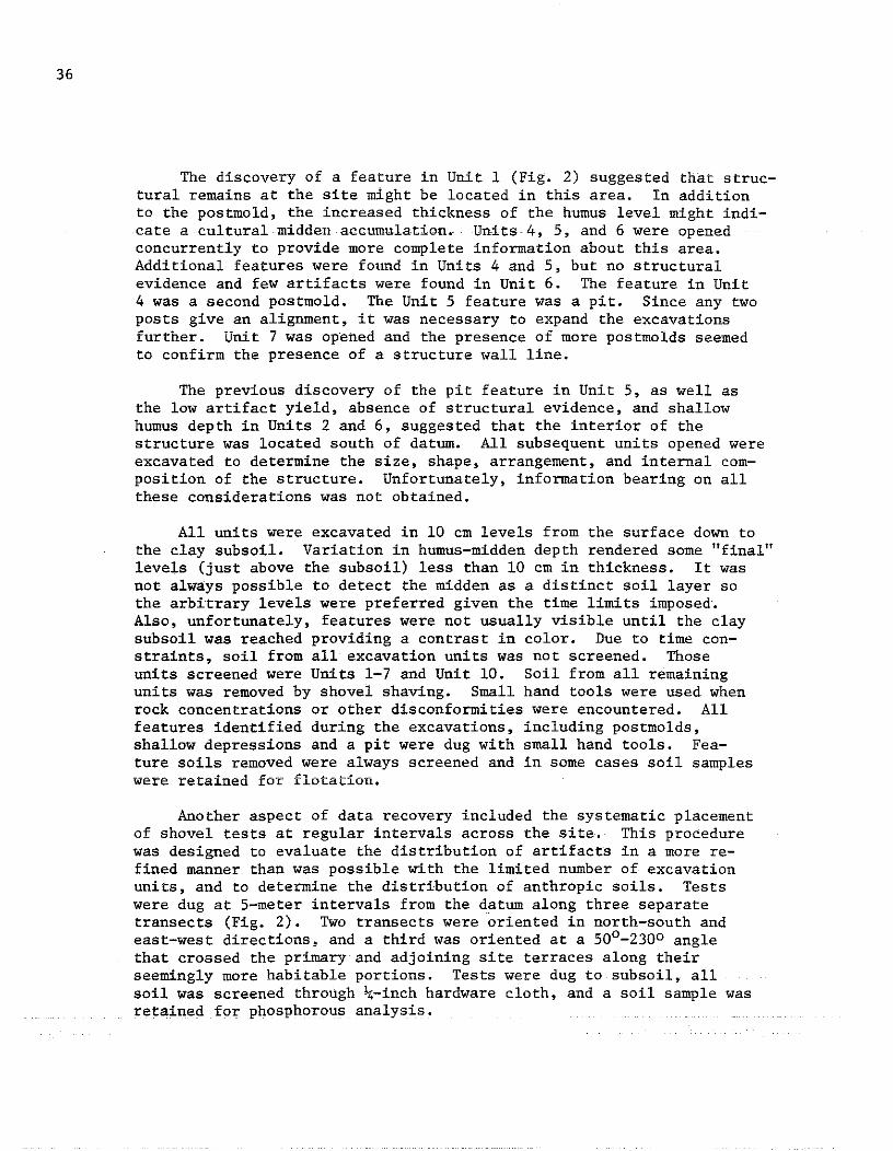
The discovery of a feature in Unit 1 (Fig. 2) suggested that structural remains at the site might be located in this area. In additionto the postmold, the increased thickness of the humus level might indicate a cultural midden accumulation. Units 4, 5, and 6 were openedconcurrently to provide more complete information about this area.Additional features were found in Units 4 and 5, but no structuralevidence and few artifacts were found in Unit 6. The feature in Unit4 was a second postmold. The Unit 5 feature was a pit. Since any twoposts give an alignment, it was necessary to expand the excavationsfurther. Unit 7 was opened and the presence of more postmolds seemedto confirm the presence of a structure wall line.
The previous discovery of the pit feature in Unit 5, as well asthe low artifact yield, absence of structural evidence, and shallowhumus depth in Units 2 and 6, suggested that the interior of thestructure was located south of datum. All subsequent units opened wereexcavated to determine the size, shape, arrangement, and internal composition of the structure. Unfortunately, information bearing on allthese considerations was not obtained.
All units were excavated in 10 em levels from the surface down tothe clay subsoil. Variation in humus-midden depth rendered some "final"levels (just above the subsoil) less than 10 em in thickness. It wasnot always possible to detect the midden as a distinct soil layer sothe arbitrary levels were preferred given the time limits imposed.Also, unfortunately, features were not usually visible until the claysubsoil was reached providing a contrast in color. Due to time constraints, soil from all excavation units was not screened. Thoseunits screened were Units 1-7 and Unit 10. Soil from all remainingunits was removed by shovel shaving. Small hand tools were used whenrock concentrations or other disconformities were encountered. Allfeatures identified during the excavations, including postmolds,shallow depressions and a pit were dug with small hand tools. Fea-ture soils removed were always screened and in some cases soil sampleswere retained for flotation.
Another aspect of data recovery included the systematic placementof shovel tests at regular intervals across the site. This procedurewas designed to evaluate the distribution of artifacts in a more refined manner than was possible with the limited number of excavationunits, and to determine the distribution of anthropic soils. Testswere dug at 5-meter intervals from the datum along three separatetransects (Fig. 2). Two transects were oriented in north-south andeast-west directions, and a third was oriented at a 500 -2300 anglethat crossed the primary and adjoining site terraces along theirseemingly more habitable portions. Tests were dug to subsoil, allsoil was screened through \-inch hardware cloth, and a soil sample wasretained for phosphorous analysis.
FIELD RESULTS
Data recovery procedures discussed above provided several independent measures of-past activity variation atthe~~si~te.,The.contrQl1edrecovery of artifacts and soils and the identification of a number offeatures associated with a structure each contributed to a better,albeit general, understanding of the site's occupation.
The controlled recovery of artifacts by screening from several ofthe excavation units provides some insight into the intensity of siteuse in different areas. As has been previously mentioned, sherds fromceramic vessels were the predominant artifacts recovered. The variable occurrence of these within those units that were screened is usedas one evaluation of differential site area use.
It would seem to be a simple process to assess sherd occurrence(i.e. frequency) variability for different locations. Certainly, manyarchaeologists opt for simple counting of sherds as the main indicatorof some level of activity variation across a given site. There is aproblem with this, however, namely that sherds differ considerably insize. It might be considered, for example, whether sherd counts fromplowed fields are analytically comparable to sherd counts from buriedsites.
A possible solution to this problem is to assess ceramic occurrence by various independent means. The comparison of ceramic occurrences among the screened excavation units followed four separate approaches. One of these was the traditional comparison of ceramic sherdcounts. The next comparison was based on arbitrarily set sherd-sizecategories. The "large" category included those sherds whose surfacearea was greater than a quarter dollar. The "small" category includedthe remaining, smaller, sherds. The third comparison is based on ceramic weight per unit. The final comparison is based on ceramic weightper unit volume of earth removed from each screened unit (g/cm3). Dataresulting from these comparisons allow a ranking of ceramic unit occurrence within the various units and are presented in Table 1. As canbe seen here, the resulting rankings are all identical. Several implications of these findings wi1Lnowbe discussed
By all de terminations, ceramicoccu:n'ences wi thin the screenedexcavation units (Table 1) display considerable yet consistent variability. These data are interpreted as follows (refer to Figs. 2 and6). The highest ceramic occurrences exist within Units 1, 4, and 7.The units correspond in location to a series of postmo1ds. It appearslikely, therefore,thatthehighest concentration of ceramics corresponds to. either the immediate inner or outer confines of the structure snorth wall. This would possibly suggest either outside discard or inside domestic cleaning towards the structure wall •... UnitaZ,5, and 10have the next highestoccuriences. Unit 2 occurs near the. terraceslope and away from the structure, perhaps indicating a secondary
37

38
discard area, but it is also possible that the accumulated artifactsreflect erosion from the higher structure area. Units 5 and 10 arethought to be located within the structure; the middle range ceramicoccurrences perhaps indicate domestic maintenance, Finally, Units 3and 6 have the lowest indices of ceramic occurrence. These unitsrepresent areas east of the structure and no doubt represent areasof less intense site use.
Table l. Ceramic artifact occurrence comparisons by screened exca-vation units ..
Sherd Sherd Counts Ceramic Wt. /Unit vol.Excavation Unit Count (large/small) Weight (g) (g/cm3)
1 419 98/321 1220 .002
2 122 40/82 615 .001
3 7 2/5 .00002
4 361 61/300 1115 .001
5 104 28/76 540 .0007
6 49 13/36 140 .0004
7 572 128/444 1680 .002
10 76 27/49 340 .0004
(Relative Unit Ranking by All Comparisons: 7,1,4 / 2,5,10 / 6,3)
Returning to the methodological problem, it is admitted that withthe available data, and possibly due to small sample size, all ceramicoccurrence comparisons yielded quite similar results. This is not believed, however, to offset the potential difficulty in comparison discussed above. Variability in average sherd size (measured by weight)per screened excavation unit of common dimension, as well as the percentage occurrence of both "large" and "small" sherds, show significantlydifferent unit ranking than is seen in Table 1 (Table 2). These additional data offer some support to the contention that artifact unitsof analysis must be defined in keeping with some set of specific questions about a site's (or set of sites) past occupation(s). In thecase of ceramics, sherd size ranges and averages should be specifiedso that meaningful between-site comparisons can be made. On a substantive level, the data presented in Table 2 indicate that average sherdsize and frequency might be inversely related at the present site inthe vicinity of the structure (see comparative excavation unit ranking).
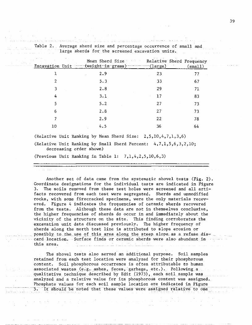
Table 2. Average sherd size and percentage occurrence of small andlarge sherds for the screened excavation units.
Mean Sherd Size Relative Sherd FrequencyExcavation Unit (weight ·in grams) (large) (small)
1 2.9 23 77
2 5.3 33 67
3 2.8 29 71
4 3.1 17 83
5 5.2 27 73
6 2.8 27 73
7 2.9 22 78
10 4.5 36 64
(Relative Unit Ranking by Mean Sherd Size: 2,5,10,4,7,1,3,6)
(Relative Unit Ranking by Small Sherd Percent: 4,7,1,5,6,3,2,10;decreasing order shown)
(Previous Unit Ranking in Table 1: 7,1,4,2,5,10,6,3)
Another set of data came from the systematic shovel tests (Fig. 2).Coordinate designations for the individual tests are indicated in Figure3. The soils removed from these test holes were screened and all artifacts recovered from each test were segregated. Sherds and unmodifiedrocks, with some firecracked specimens, were the only materials recovered. Figure 4 indicates the frequencies of ceramic sherds recoveredfrom the tests. Although these data are not in themselves conclusive,the higher frequencies of sherds do occur in and immediately about thevicinity of the structure on the site. This finding corroborates theexcavation unit data discussed previously. The higher frequency ofsherds along the north test line is attributed to slope erosion orpossibly to. the use of this area along the steep slope as a refuse discard location. Surface finds or ceramic sherds were also abundant inthis area.
The shovel tests also served an additional purpose. Soil samplesretained from each test location were analyzed for their phosphorouscontent. Soil phosphorous occurrence is often attributable to humanassociated wastes (e.g. ashes, feces, garbage, etc.). Following aqualitative technique described by Edit (1973), each soil sample wasanalyzed and a relative value for its phosphorous content was assigned.Phosphate values for each soil sample location are indicated in Figure5. It should be noted that these values were assigned relative toone
39

40
N25 •
N20 •
N15 •
NIO •
N5 •
W30 W25 W20 W15 WIO W5• • • • • • xA5.
.B30
• B25
• B20
• B15
• BIO
.B5
• • • • •E5 ElO El5 E20 E25
AI0.
A15.
A20.
• S5
• S10
• S15
• S20
Figure 3. Coordinate designations for shovel tests.
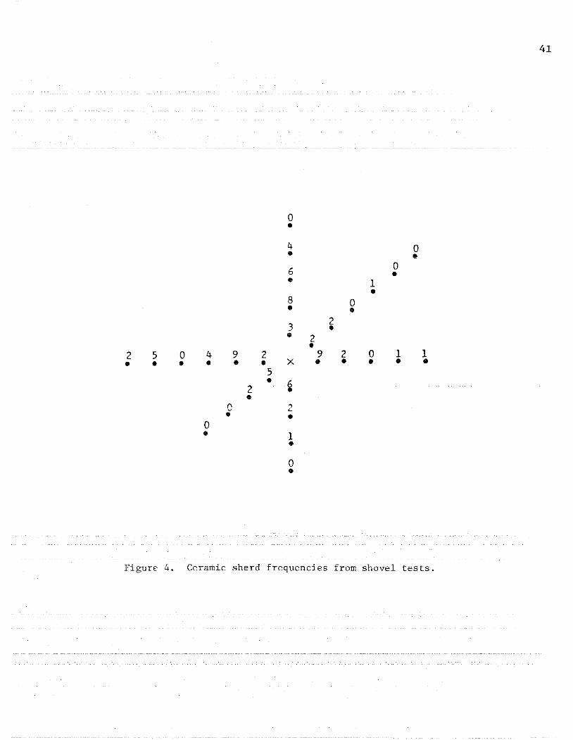
0•4 0• •6 0
•• 1•8 0• •
32•• 2•
2 5 0 4 9 2 9 2 0 1 1• • • • • • X • • • • •
5• i2
•C "L• •
0• 1•
0•
Figure 4. Ceramic sherd frequencies from shovel tests.
41
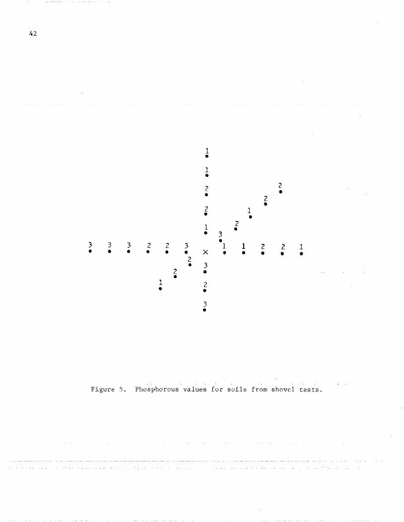
42
,~
•1•2 2
•• 2•2 1• •
1 2•• 3•3 3 3 2 2 3 1 1 2 2 1• • • • • • X • • • • •2
• 32 ••,
2~
• •3•
Figure 5. Phosphorous values for soils from shovel tests.
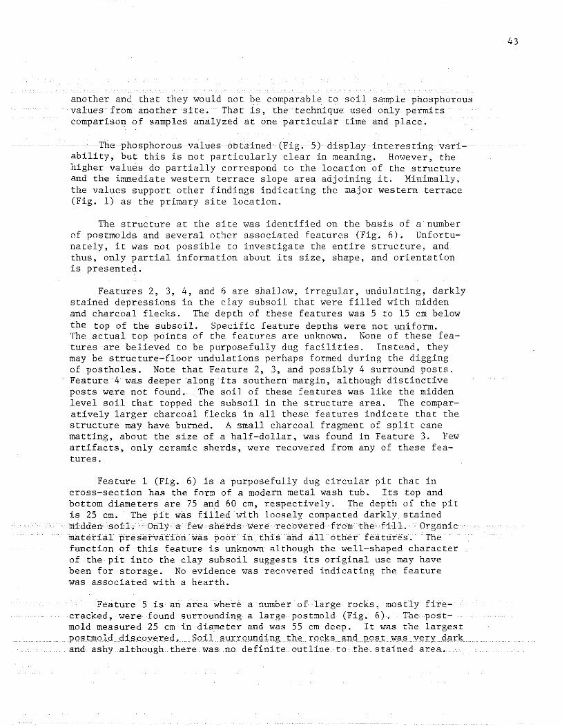
another and that they would not be comparable to soil sample phosphorousvalues from another site. That is, the technique used only permitscomparison of samples analyzed at one particular time and place.
The phosphorous values obtained ·(Fig.· 5}display· interesting variability, but this is not particularly clear in meaning. However, thehigher values do partially correspond to the location of the structureand the immediate western terrace slope area adjoining it. Minimally,the values support other findings indicating the major western terrace(Fig. 1) as the primary site location.
The structure at the site was identified on the basis of a numberof postmolds and several other associated features (Fig. 6). Unfortunately, it was not possible to investigate the entire structure~ andthus, only partial information about its size, shape, and orientationis presented.
Features 2, 3, 4, and 6 are shallow, irregular, undulating, darklystained depressions in the clay subsoil that were filled with middenand charcoal flecks. The depth of these features was 5 to 15 em belowthe top of the subsoil. Specific feature depths were not uniform.The actual top points of the features are unknown. None of these features are believed to be purposefully dug facilities. Instead, theymay be structure-floor undulations perhaps formed during the diggingof postholes. Note that Feature 2, 3, and possibly 4 surround posts.Feature 4 was deeper along its southern margin, although distinctiveposts were not found. The soil of these features was like the middenlevel soil that topped the subsoil in the structure area. The comparatively larger charcoal flecks in all these features indicate that thestructure may have burned. A small charcoal fragment of split canematting, about the size of a half-dollar, was found in Feature 3. Fewartifacts, only ceramic sherds, were recovered from any of these features.
Feature 1 (Fig. 6) is a purposefully dug circular pit that incross-section has the form of a modern metal wash tub. Its top andbottom diameters are 75 and 60 em, respectively. The depth of the pitis 25 em. The pit was filled with loosely compacted darkly stainedmiddensoiL Only a few shetdswere recoveredfronlthefill. Organicmaterial preservation was poor in this and all other features. Thefunction of this feature is·unknown although the well-shaped characterof the pit into the clay subsoil suggests its original use may havebeen for storage. No evidence was recovered indicating the featurewas associated with a hearth.
Feature 5 is an area where a number of large rocks, mostly fire~
cracked, were found surrounding a large postmold (Fig. 6). The postmold measured 25 cm in diameter and was 55 em deep. It was the largestPQstmold discovered. Soil surrollnding the rocks and post was v",ry darkand ashyalthollgh there was no definite outline to the stained area.
43
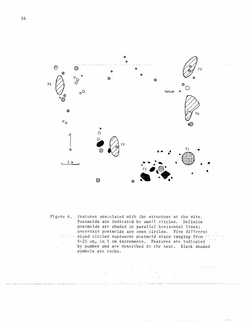
44
e
df"e
® @ ee e
®.• "0
0 ~ eF6 0 e
00 0 datum )(
o®
e
00~
e
10.. ~"N e Fl •= a- •
".•1 m ... ... ,
" •o ,.FS _,f@" •- .•. •
e • •
Figure 6. Features associated with the structure at the site.Postmolds are indicated by small circles. Definitepostmolds are shaded by parallel horizontal lines;uncertain postrnolds are open circles. Five differentsized circles represent postmold sizes ranging from5~25em, inS em increments. Features are indicatedby number and are described in the text. Black shadedsymbols are rocks.
It is not known whether the rocks were used to support the post, orbelonged toa hearth. There were no significant amounts of charcoalpresent in this feature. The large rocks were resting at the middensubsoil interface on a regular flat plane. The clay subsoil in thisand adjoining areas was highly compacted suggesting its correspondenceto the original structure floor surface.
A total of 38 postmolds was identified during the excavations.This total includes 25 definite postma Ids and possibly 12 additionalones. These latter postmolds were definite circular stains but lackeddepth. For the 25 definite postmolds, dimensions ranged between 6 and25 em in diameter and, in depth, between 8 and 65 em. The most commondiameter was 15 em; the most common depth was between 18 and 30 em.Average postmold diameter was 15.4 em with a standard deviation of 4.2em. Average depth was 28.8 em; standard deviation was 16.0 em. Thesedata presumably reflect the selection and use of trees for posts thatwere of fairly consistent size.
The fill in almost all posts was a very loosely compacted, darklystained organic soil. Soil was screened for artifacts in all cases.The bottoms of almost all postmolds were slightly undulating to flat.Many postma Ids had artifacts (mostly sherds but some rocks) in theirfill but not in great or consistent numbers. It was noticed during thecareful excavation of several of the deeper posts that the sherd locations varied. In several cases, the sherds lined the postmold wallswhile in others the sherds were located throughout the fill. The former may indicate the common use of sherds for post chinking; the lattermay indicate that the posts were removed from their holes at the timeof site abandonment, causing the sherds to become strewn throughoutthe postmolds. Unfortunately, these observations were not consistentlymade for all postmolds, and thus firm conclusions from these data arenot possible.
The overall spatial pattern of the features identified is not veryclear. In the case of the postmolds, several approaches were used(e.g. using postmold dimensions and contents) in the attempt to discernan alignment that would indicate the structure's size and shape. Theseattempt!:i, however, W"er<=n0t: very succe:ssfuJ.:. It; is bel:ieved, neverthe-less, that certain conjecture can be offered concerning the characterof the structure.
The general east-west series of posts between datum and Feature 6(Fig. 6) are thought to represent the northern wall of the structure.The smaller posts in the near middle of this series may be the remainsof a doorway. The large posts in the vicinity of Feature 6 may represent a·corner of the· structure although large trees south of Feature 6precluded investigating the presence of a north-south alignment. Ifthis were the case, however, the large deep posts in the vicinity of
. FeaturesL and 5 might possibly represent.interior pOS1;i> .... Theirregular spacing of these relative to the presumed alignments would support
45

46
this argument. Also, the largest post found in Feature 5 might be assumed to have been at or near the structure center, thus placing it andFeature 1 in the central floor area. The compacted nature of the subsoil in this area is added support for this conclusion.
Based on available data, it is suggested that the structure wasrectilinear in shape. The north-facing orientation of the structurewould certainly correspond to the orientation of the terrace on whichit is located, that is, facing Howard Creek. The structure extends foran unknown distance to the south of Feature 5. The increased depth ofthe humus-midden level in this area is support for this contention.With respect to the size of the structure, little is known about exactdimensions. The minimal east-west dimension, from the post northwestof Feature 6 to the northern post in Feature 3, (Fig. 6) is approximately 7.75 m. The presence of a corner in the area of Feature 6 seemssubstantiated by the negative results in Unit 14 (Fig. 2); no additional posts were found there.
In addition, the paucity of postmolds at this site compared withthe high density of postmolds at other late prehistoric/early historicstructures investigated in the region (see structure drawings and photographs in Dickens 1976 and Keel 1976), indicates that little if anystructure rebuilding took place on this site. This further substantiates the inference that the occupation was comparatively short-term.
A charcoal sample obtained from the postmold immediately to thenorth of Feature 6 was submitted to the University of Georgia for C-14analysis. The results indicated that the charcoal is "modern." Whilethe shape of the postmold and its artifact content are conclusive forits actually having been a post, the charcoal no doubt represents arecent tree intrusion, later burned. None of the other postmoldsyielded charcoal of similar quantity. Unfortunately then, absolutechronological placement of the site is not possible.
LABORATORY ANALYSIS
All cultural materials recovered during the excavations were washed,sorted, catalogued, and classified according to usual archaeologicallaboratory procedures. Data resulting from this process will now bediscussed.
Soil recovered from selected features was processed in the lab bya water flotation-screening technique. The apparatus used was a metaltub the bottom of which had been replaced with window screen. The purpose in water-screening the soil was to determine the presence of organic material remains within the features. Remains recovered arelisted in Table 3.
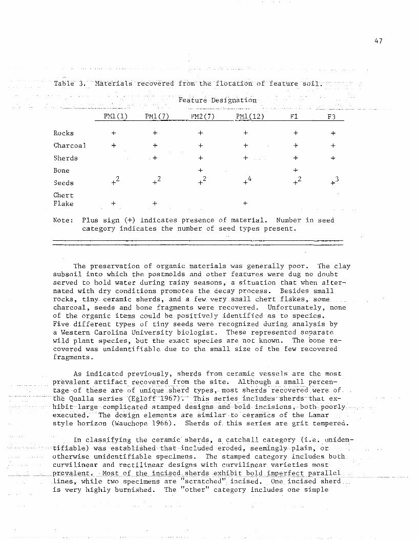
Table 3. Materials recovered from the flotation of feature soil.
Feature Designation
47
Rocks +
Charcoal +
PMl(l)
Sherds
Bone
Seeds
ChertFlake +
PMl(7) PM2 (7) PMl(12) Fl F3
+ + + + +
+ + + + +
+ + + + +
+ +
+2 +2 +4 +2 0+~
+ +
Note: Plus sign (+) indicates presence of material. Number in seedcategory indicates the number of seed types present.
The preservation of organic materials was generally poor. The claysubsoil into which the postmolds and other features were dug no doubtserved to hold water during rainy seasons, a situation that when alternated with dry conditions promotes the decay process. Besides smallrocks, tiny ceramic sherds,and a few very small chert flakes, somecharcoal, seeds and bone fragments were recovered. Unfortunately, noneof the organic items could be positively identified as to species.Five different types of tiny seeds were recognized during analysis bya Western Carolina University biologist. These represented separatewild plant species, but the exact species are not known. The bone recovered was unidentifiable due to the small size of the few recoveredfragments.
As indicated previously, sherds from ceramic vessels are the mostprevalent artifact recovered from the site. Although a small percentage of these are of unique sherd types, most sherds recovered were ofthe Qtia.Ua.series (Egloff 196 7). This series includes sherds that exhibit large complicated stamped designs and bold incisions,· both poorlyexecuted. The design elements are similar to ceramics of the Lamarstyle horizon (Wauchope 1966). Sherds of this series are grit tempered.
In classifying the ceramic sherds, a catchall category (i.e. unidentifiable) was established that included eroded, seemingly plain, orotherwise unidentifiable specimens. The stamped category includes bothcurvilinear and rectilinear designs with curvilinear varieties mostPr:IOY<ilent. MostoL. thE'in"ised .. shexds.exhibit .. boldimperfect parallellines, while two specimens are "scratched" incised. One incised- sherdis very highly burnished. The "other" category includes one simple
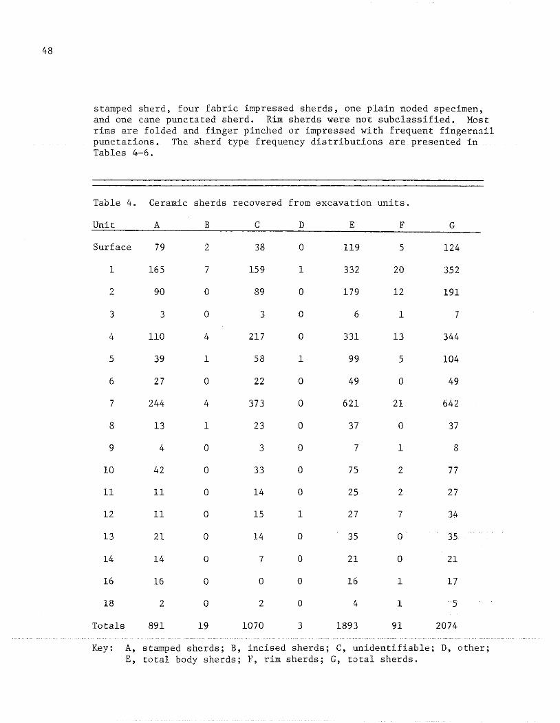
48
stamped sherd, four fabric impressed sherds, one plain noded specimen,and one cane punctated sherd. Rim sherds were not subclassified. Mostrims are folded and finger pinched or impressed with frequent fingernailpunctations. The sherd type frequency distributions are presented inTables 4-6.
Table 4. Ceramic sherds recovered from excavation units.
Unit A B C D E F G
Surface 79 2 38 0 119 5 124
1 165 7 159 1 332 20 352
2 90 0 89 0 179 12 191
3 3 0 3 0 6 1 7
4 110 4 217 0 331 13 344
5 39 1 58 1 99 5 104
6 27 0 22 0 49 0 49
7 244 4 373 0 621 21 642
8 13 1 23 0 37 0 37
9 4 0 3 0 7 1 8
10 42 a 33 a 75 2 77
11 11 0 14 a 25 2 27
12 11 a 15 1 27 7 34
13 21 a 14 a 35 0 35
14 14 0 7 a 21 a 21
16 16 a a a 16 1 17
18 2 a 2 0 4 1 5
Totals 891 19 1070 3 1893 91 2074
Key: A, stamped sherds; B, incised sherds; C, unidentifiable; D, other;E, total body sherds; F, rim sherds; G, total sherds.
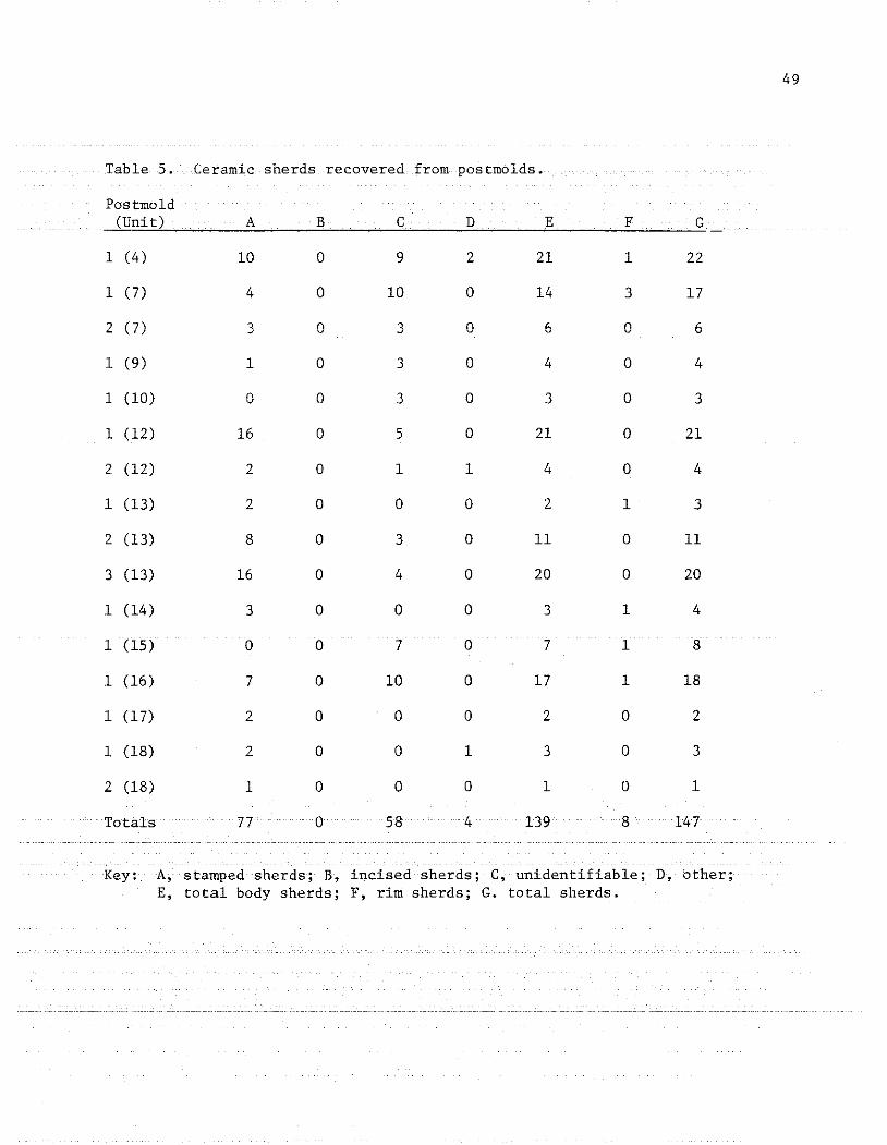
Table 5. Ceramic sherds recovered from postmolds.
Postmold(Unit) A B C D E F G
1 (4) 10 0 9 2 21 1 22
1 (7) 4 0 10 0 14 3 17
2 (7) 3 0 3 0 6 0 6
1 (9) 1 0 3 0 4 0 4
1 (10) 0 0 3 0 3 0 3
1 (12) 16 0 5 0 21 0 21
2 (12) 2 0 1 1 4 0 4
1 (13) 2 0 0 0 2 1 3
2 (13) 8 0 3 0 11 0 11
3 (13) 16 0 4 0 20 0 20
1 (14) 3 0 0 0 3 1 4
1 (15) 0 0 7 0 7 1 8
1 (16) 7 0 10 0 17 1 18
1 (17) 2 0 0 0 2 0 2
1 (18) 2 0 0 1 3 0 3
2 (18) 1 0 0 0 1 0 1
Totals 77 0 58 4 139 8 147
Key: stamped sherds; B, incised sherds; C, unidentifiable; D, other;E, total body sherds; F, rim sherds; G. total sherds.
49
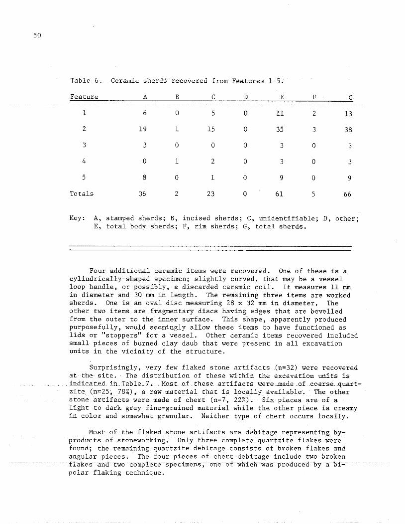
50
Table 6. Ceramic sherds recovered from Features 1-5.
Feature A B C D E F G
1 6 a 5 a 11 2 13
2 19 1 15 a 35 3 38
3 3 a a a 3 a 3
4 a 1 2 a 3 a 3
5 8 a 1 a 9 a 9
Totals 36 2 23 a 61 5 66
Key: A, stamped sherds; B, incised sherds; C, unidentifiable; D, other;E, total body sherds; F, rim sherds; G, total sherds.
Four additional ceramic items were recovered. One of these is acylindrically-shaped specimen; slightly curved, that may be a vesselloop handle, or possibly, a discarded ceramic coil. It measures 11 mmin diameter and 30 mm in length. The remaining three items are workedsherds. One is an oval disc measuring 28 x 32 mm in diameter. Theother two items are fragmentary discs having edges that are bevelledfrom the outer to the inner surface. This shape, apparently producedpurposefully, would seemingly allow these items to have functioned aslids or "stoppers" for a vessel. Other ceramic items recovered includedsmall pieces of burned clay daub that were present in all excavationunits in the vicinity of the structure.
Surprisingly, very few flaked stone artifacts (n=32) were recoveredat the site. The distribution of these within the excavation units isindicated in Table 7. Most of these artifacts were made of coarse quart~
zite (n=25, 78%), a raw material that is locally available. The otherstone artifacts were made of chert (n=7, 22%). Six pieces are of alight to dark grey fine-grained material while the other piece is creamyin color and somewhat granular. Neither type of chert occurs locally.
Most of the flaked stone artifacts are debitage representing byproducts of stoneworking. Only three complete quartzite flakes werefound; the remaining quartzite debitage consists of broken flakes andangular pieces. The four pieces of chert debitage include two brokenflakes andtwb cbml'letespecimens;<Jne<Jf wh~ichwasprbducedbyahi~
polar flaking technique.
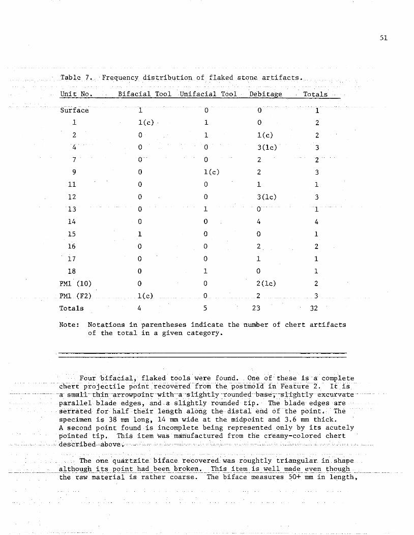
Table 7. Frequency distribution of flaked stone artifacts.
51
Unit No. Bifacial Tool Unifacial Tool Debitage Totals
1 l(c) 1 0 2
2 0 1 l(c) 2
4 0 0 3(lc) 3
7 0 0 2 2
9 0 lCc) 2 3
11 0 0 1 1
12 0 0 3(lc) 3
13 0 1 0 1
14 0 0 4 4
15 1 0 0 1
16 0 0 2 2
17 0 0 1 1
18 0 1 0 1
PMl (10) 0 0 2(lc) 2
PMl (F2) 1(c) 0 2 3
Totals 4 5 23 32
Note: Notations in parentheses indicate the number of chert artifactsof the total in a given category.
Four bifacial, flaked tools were found. One of these is a completechert projectile point recovered from the postmold in Feature 2. It isa small thin arrowpointwith a slightly rounded base; slightly excurvateparallel blade edges, and a slightly rounded tip. The blade edges areserrated for half their length along the distal end of the point. Thespecimen is 38 mm long, 14 mm wide at the midpoint and 3.6 mm thick.A second point found is incomplete being represented only by its acutelypointed tip. This item was manufactured from the creamy-colored chertdescribed-above.
The one quartzite biface recovered was roughtly triangular in shape. although. its. point had been broken. This item is well made even though
the raw material is rather coarse. The biface measures 50+ mm in length,

52
30 mm in width at the estimated midpoint, and 11 mm thick. The basalwidth of the specimen was 35 mm.
The final bifacial tool is a large quartzite chopper-like implementthat was recovered from Feature 2. The greatest dimension of this ovalshaped piece is approximately 15 cm and its weight is between 2-3 kg.The natural shape of the piece is modified only slightly by flaking,but the edges are uniformly sharp around the margin. The size andshape of this tool suggest some sort of heavy duty use such as chopping or digging.
Only one of the unifacial tools recovered was made from chert.This tool is a steep-edged scraper with a convex working edge. Theangle of the scraping edge is between 750 -800 • The specimen is 27 mmlong, 23 mm wide, and 12 mm thick. Step fractures along the marginedge suggest this implement was used to process resilient materials.
The other specimens identified as "tools" mayor may not actuallyhave been implements. Only one of these, a flake, had definite retouchon its margin and probably served as a knife. The remaining itemswere broken flakes or angular chunks with edges possibly retouched toform scraping implements. The difficulty of distinguishing purposefulfrom inadvertent retouch on coarse, translucent quartzite precludesfirm conclusions on this matter.
Six additional stone items were recovered that could be definitelyidentified as artifacts. These include two round fist-sized quartzitehammers tones and a third small flat oval hammers tone of the same material, battered on one end. One fragment of a ground stone disc wasfound, as well as an unmodified piece of nonlocal slate. The finalstone artifact came from Postmold 1 in Unit 10 and may be a diggingtool. This item is a tabular rectangular piece of schist measuring 20x 7.5 x 3.5 cm with "flaked" ends.
Miscellaneous small rocks were recovered from all excavation units,and many of these, especially those from the structure, evidencedfiring. Unfortunately, these were recovered inconsistently in the excavations, and thus were not analyzed quantitatively. The greatestconcentration of firecracked rock waS in Units 5 and 16 (Fig. 6).
The analysis of artifacts and soil from the site revealed no unusual or especially significant distribution or association of items.Perhaps the most unusual find was the near absence of stone tools anddebitage, a situation that is uncommon at late prehistoric sites in theregion. One interesting aspect of the ceramic study not mentioned pre~
viously concerned the thickness of measured sherds. A large sample of531 sherds representing various defined categories was measured. Compariso!! ofd"co"a,t"d """S11S pla,in Li,. e. e"oded, unidentifiable} sh"rdfigures revealed similar mean thickness (6.9 and 7.0 mm, respectively),however, the standard deviation for the non-decorated sherds was higher

(2.3 versus 1.2 .rom). This might indicate greater variability in veSselform and mode of manufacture for the more utilitarian wares, althoughmore comparative data are certainly needed.
SUMMARY
Archaeological investigations at WCU225 (WA-1-80) resulted in theidentification of a domestic structure and the delineation of the siteas a small habitation area. It is not known how long the site was occupied, but evidence was found suggesting the occupation was for arelatively short period. Neither is it known exactly when the site wasoccupied. Ceramics from the site indicate either a late prehistoricor early historic occupation. Qualla ceramics were manufactured fromabout A.D. 1500 to 1908 (Keel 1976:215). However, the absence of EuroAmerican trade items at the site seems to indicate a late prehistoricoccupation. On the other hand, the paucity of lithics could be indication of later occupancy. In short, precise chronological placement ofthe site, either before, during, or after white contact, is not possible.
Many other Qualla phase sites in this region also yield high quantities of chert artifacts. Because this chert is not locally available,it might be that for a portion of the Qualla phase, some network of exchange existed to distribute this material. Therefore, the few chertartifacts at WCU225 might indicate a time when this network was breaking down or had failed altogether. The breakdown of other aspects ofindigenous life after European contact has been suggested by Dickens(n.d.). The small size of this site and its relative isolation compared to other large nucleated village sites in the area support thissuggestion.
One additional aspect of the present study concerns possible pastenvironmental variation that may have characterized the area. Thiswas approached through a catchment analysis performed on areas surrounding the site. For comparative purposes, catchment analyses werealso performed on areas surrounding two other Qualla sites locatednearby, along the Little Tennessee River. WCU225 was the smallest oftheses; the two remaining sites (WCUl75 and WCU4) were the medium andthe largest sites,. respectively. The purpose of the analysis was todetermine what Catchment area variability existed around late prehistoric Qualla sites of varying size. It is considered possible thatthis might correlate with different sizes of past population aggregates.Since it was assumed that these late prehistoric populations were subsisting at least in part on agriculture, it was expected that largeramounts of arable soils would be located around the larger sites.
Using Macon County soil maps (USDA 1956), an 800-meter radius circle was drawn around each of the three sites. Within the circles,areaS 'of <iifferent'Soil types'werecomputedandpercentages' tabulated; ,The soil types were defined in terms of increased "workability"
53
54
reflecting increasingly arable lands (judged in terms of modern agricultural standards). The hypothesis stated above was not confirmed. Therewere no significant percentage differences in arable soils within thecatchment areas of the three sites. One interesting difference wasfound, however, in the number of different types of soils occuring within the three catchment areas. Twenty-six soil types occurred aroundWCU225 while 33 and 30 types occurred surrounding the medium and largestsites, respectively. Although the trend is not linear, an increasednumber of soils do occur around the larger sites. Because soil typesrelate to past vegetation, it is presumed that greater plant and animalvariability would have been present around these sites. Whether thesedata reflect purposeful site selection is a matter that must await similar types of future evaluation.
In this study, many more questions arose than were possible to investigate fully. However, several research problems were investigatedresulting in at least a partial understanding of the site. Further research is always needed, and it is hoped that information provided inthis report will be useful for future investigations.
REFERENCES CITED
Barber, Michael B.1980 A Cultural Resource Inventory
Macon County, North Carolina.Forest Service, Roanoke.
of a 7.7 Acre Tract of Land inManuscript on deposit, U. S.
Dickens, Roy S.1976 Cherokee Prehistory. University of Tennessee Press, Knoxville.
n.d. The Appalachian Summit Area: A.D. 1000 to Bartram. Manuscript.
Egloff, Brian J.1967 An Analysis of Ceramics from Cherokee TowliS. M.A. Thesis,
Department of Anthropology, University of North Carolina,Chapel Hill.
Egloff, Keith T.1971 Methods and Problems of Mound Excavation in the Southern Ap
palachia Area. M.A. Thesis, Department of Anthropology, University of North Carolina, Chapel Hill.
Eidt, Robert C.1973 A Rapid Chemical Field Test for Archaeological Site Survey
ing. American Antiquity 38:206-210.
Keel, Bennie C.1976 Cherokee Archaeology. University of Tennessee Press, Knox
ville.
u. S. Department of Agriculture1956 Soil Survey, Macon County, North Carolina. Washington, D.C.
U. S. Geological Survey1946 Prentiss Quadrangle, North Carolina. Washington, D.C.
55

AN ARCHAIC QUARRY AND STONE KNAPPING LOCATION
ON THREE HAT MOUNTAIN, NORTH CAROLINA
Joseph B. Mountjoy
Lawrence E. Abbott, Jr.
Joseph B. Mountjoy, Department of Anthropology, University of North Carolinaat Greensboro, Greensboro, North Carolina
Lawrence E. Abbott, Jr., Department of Anthropology, Wake Forest University,Winston Salem, North Carolina


INTRODUCTION
North Amer1can Indians relied heavily on stone as a basic materialfrom which to shape a wide variety of tools and ceremonial objects.When an archaeologist excavates a prehistoric Indian camp or villageit is often apparent that the one or more Indian groups which inhabitedthe site during various distinctive periods or phases preferred certainkinds of stone for the manufacture of utilitarian or ritual objects. Itis not always so obvious, however, whether the selection of a particularkind of stone was determined by its proximity to the habitationsite, its excellent quality, its aesthetic properties, its procurementfrom a special trading partner, or some kinship, religious, or sentimental attachment which the group felt toward the particular stonematerial. Furthermore, the acquisition of a particular kind of stonemay have involved different sorts of technologies and socio-politicalrelations. Appropriate raw material may be picked up on the surfaceor mined in several different ways. It may be acquired over long distances through intermediaries in a complex trading network, or throughdirect expeditions to the source. Furthermore, the material obtainedmay be in various stages of reduction, from rough pieces of raw materialup to a finished product, and the control of the source or distributionof the material in raw or finished form may reflect the political systemoperating in a region. It is for such reasons that archaeologists areinterested in locating and studying the sources of raw stone materialwhich were exploited by North American Indians. This is a report onone such source recently investigated -in Davidson County, North Carolina,designated site DV-51~
The area of the prehistoric quarrying and stone knapping activitiesto be described is along the southwestern flank of the Three Hat Mountainridge which is located on the eastern central portion of Davidson County,approximately 13 km. south of Thomasville, North Carolina (35 0 08'03"latitude, 80 0 08' 00" longitude). The ridge trends northwest to southeast,with the highest of the three separate peaks on the southwestern end,rising to an altitude of 360 m above sea level. An extensive system ofsmall streams and gullies drain all sides of the ridge, with severalnatural springs on the western slope (Fig. 1). A creek called FlatSwamp winds its way through marshy flatlands at the base of the mountainon the northeast side. Marshes and thickets at the base of the mountaingiy~_'VJ?Y t:o_G_lima.x_vegetation up_the_ slope. Ifthis-range-ofvariationin ecologicalmicroenvironments was the same during Archaic times,the area would have provided several exploitable resources attractiveto Archaic Indian groups.
We first inspected Three Hat Mountain on April 20, 1975 and,during subsequent. trips, .managed to .. locate. six areas where waste flakesfrom stone knapping are densely concentrated (Fig. 1). There may beother such areas along the southwestern flank of the ridge which werenot found in our surveys due to incomplete inspection of the entire
*Permanent State site number J1DV51
59
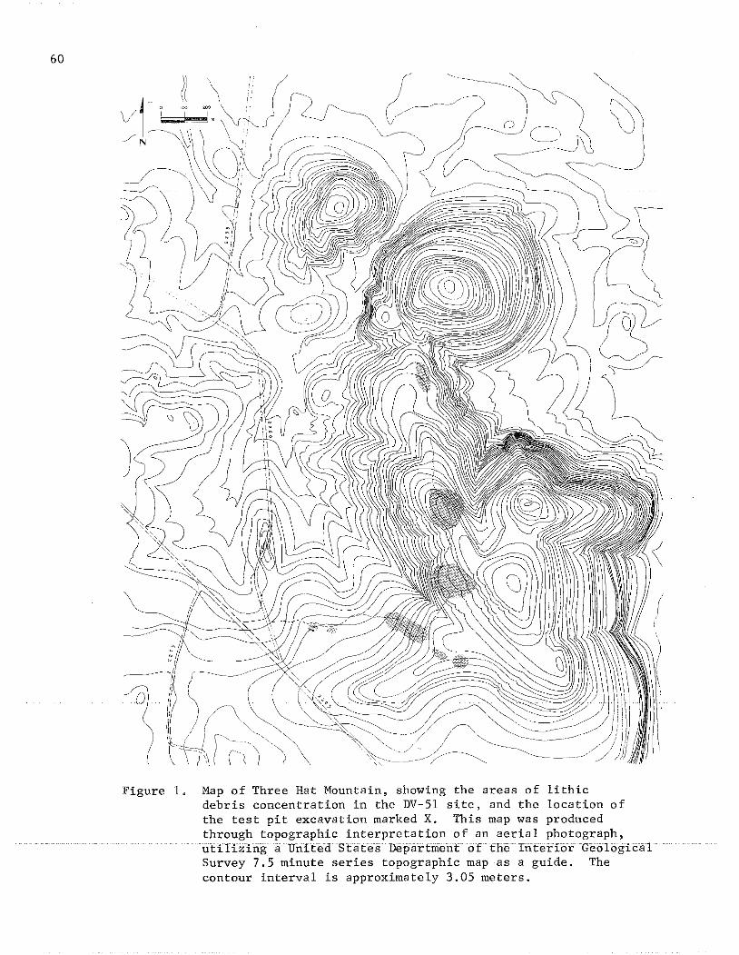
60
Figure 1. Map of Three Hat Mountain, showing the areas of lithicdebris concentration in the DV-5l site, and the location ofthe test pit excavation marked X. This map was producedthrough topographic interpretation of an aerial photograph,utilizing a United StatE"" Depaftriientof the Iriferior GeologicalSurvey 7.5 minute series topographic map as a guide. Thecontour interval is approximately 3.05 meters.
area and the heavy vegetational ground cover over most of the mountain.
THE GEOLOGY OF THREE HAT MOUNTAIN AND THE TEST PIT AREA
In 1978, Jeri Jones, geologist at Catawba College, and ProfessorPeter. Cooper, Catawba College Archaeologist, both visited the site withus and offered helpful observations on the geology of Three Hat Mountain.Mr. Jones provided us with a written report on the geology of the sitearea; the following discussion relies heavily on Jones' (1979) report.
Three Hat Mountain is located on the Silver Hill Fault which ispart of a larger geological unit known as the Carolina Slate Beltor the Uwharrie Volcanic Belt. This belt extends southwest to northeast approximately four hundred miles from central Virginia to centralGeorgia, with the Silver Hill Fault lying on its western edge. Therocks of this belt are generally metasedimentary and metavolcanic andcould have provided an abundance of lithic raw materials for Indiangroups (Jones 1977).
According to Jones (1979), the rocks examined consist of crystaland lithic tuffs, basically cryptocrystalline rhyolites and argillites(altered volcanic mud). Based strictly on hand specimens, no volcanicflows were observed; most of the material was deposited as ash. Theserocks are light gray to grayish black in color, with much variationfrom outcrop to outcrop. In addition,_ some green and very light graytuffs were observed, but their occurance is rare for the most part.The rocks weather to form a white to light cream cortex in spheroidalweathering. Some small outcrops exhibiting blocky weathering werealso noticed.
The lithic tuffs (vitric, felsic, felsic crystal and breccia) aresimilar to composition to the crystal tuffs, however, the feldsparfragments tend to be slightly larger in the former. Grain size ofthe tuffs range from fine grained (less than 0.75 mm in size) tomedium fine grained (0.75 mm to 1. 0 mm in size). Quartz is the mostabundant mineral identified among the crystal tuffs. Orthoclasefeldspar with small amounts of albite occurs in many of the rocks asphenocrysts. The crystals are white to light pink in color and areeuhedral in shape, measuring up to 1.5 mm in length. Pyrite occursas small grains and cubic crystals in green tuffs on the southwest$Jope of the mountain. Iron oxide is also_present inmost of therocks as granular masses or stains. Mica occurs as very small shinyplates of green and black.
Several samples of crystal tuffs exhibit slickenslide featuresand polished surfaces. These features are strong evidence for localfaulting; some faults have been mapped to the west and northwest ofthe site (Stomquist et al. 1971). Rocks bordering the local faultswere apparently infiltrated with additional silica producing veinsof especially fine-grained rock with homogenous texture. Veins of
61
62
this type would provide excellent raw materials for tools manufactured by flaking. Numerous quartz veins cut through the tuffs on themountain supplying the necessary silica for this upgrading process.These veins range in thickness from less than one em to 10 ill, thelargest of these being located on the westernmost peak, strikingeastward toward the highest peak (Fig. 1). Aboriginal groupsseem to have been able to distinguish these geological featuresand exploited them for high quality raw material. Although nodulesof fine grained rock outcrop on the surface of the mountain, itappears to us that stone mining and knapping activities occurredprimarily near the head of gulley cuts where veins or nodules of thisfine material were exposed (Fig. 1).
We now turn to a discussion of our test pit excavation at oneof these mining and knapping locations, along with the results of ouranalysis of the excavated artifacts.
THE TEST PIT EXCAVATION
In the Fall of 1975, one of the waste flake areas was selectedfor subsurface testing. We chose a spot on the eastern edge of alogging road which exposed approximately 1 m of soil profile whichshowed four distinct artifact-bearing strata. At this spot (Fig. 1),we plotted a two-meter square and, with the aid of UNC-G students,excavated the deposit from the square over the course of six Saturdays.
The test pit excavation was intended to answer three questions:1) were the strata formed during distinctly different phases of occupation on the site; 2) could any of the strata be dated through thepresence of chronologically diagnostic artifact types; 3) what prehistoric activities could be inferred from the study of a controlledexcavated collection of artifacts?
The first step in the test pit excavation was to shave the roadcut profile back to the east and down to 1.25 m depth, to expose thewestern face of the two meter square (Fig. 2). Then a profile wasdrawn of the strata (Fig. 3) before proceeding to strip off thenatural layers moving eastward. The layering of the deposit, whichhad seemed so clearly defined at that spot along the road cut, blurredsomewhat by the time we had cleaned back to the 1.25 m flat profile.Excavating each natural layer in turn from the western face of thesquare back to the eastern face, the stratigraphic layering becamedisturbingly vague in some areas, although layer #2 was rather clearlydefined throughout the cut (Fig. 4).
Layer #1 ranged in color from light tan to reddish clayey soil,with lots of charcoal flecks and roots, plus some waste flakes andlarge rough rocks. The layer extended down to an average depth ofabout 20 cm from the surface.

Figure 2. Photograph of the western face of the two-meter test pitsquare after the profile had been shaved back from the roadcut and prior to the excavation of the test pit square.
63
64
#1
#2
#3
#4
#5
Figure 3. Drawing of the strata visible in the western face of thetwo-meter test pit square prior to the excavation of thatsquare.

Layer #2 was a lighter colored yellowish mottled soil, withabundant waste flakes and rough rock. The larger waste flakes appearedto be concentrated on a well defined line at the bottom of the level,at 63 cm to 64 cm depth, with the small flakes, often found in tightpacked lenses, bedded horizontally on top of them in the upper portionof the leve. There were also pockets of conglomerated pebble gravelwithin this layer. The base of one projectile point (Fig. 5a) wasfound in the southeast corner of the square at a level of 35 cm from thesurface of the ground; a secand projectile point (Fig. 5b) came fromthe northeastern quadrant of the square at a depth of 50 cm; a thirdand a fourth projectile point (Fig. 5c, d) were found at a depth of55 cm in the northwestern quadrant separated by only 9 cm, and 23 cmnortheast of a concentration of charcoal fragments. A fifth projectilepoint (Fig. 5e) was found immediately upon beginning the excavationof layer #3, at a depth of about 55 cm from the surface of the groundin the southeastern quadrant of the square, and should probably beconsidered to pertain to layer #2.
Layer #3 was composed of light yellowish mottled gray clayeysoil, with relatively few rocks, most of which were large and few ofwhich were waste flakes. Small concentrations of waste flakes werenoted in the south 'central and northeast corner of the square. Thislevel ended about 72 cm below the surface.
Layer #4 was stiff yellow clay with areas of gray clay, especiallyin the southeast corner of the square at a depth of 73 cm or more.What might be part of a hearth, with 5 large rough rocks and abundanttiny specks of what appeared to be charcoal, was found in the centralpart of the southwest corner of the square at a depth of 85 cm. Thelevel terminated at about 90 cm depth from the surface.
Layer #5 was a very stiff yellow clay with many large angularrocks. Excavation below the level of 100 cm was extremely difficult,and could only be accomplished by using picks down to a level of130 cm.
The 16,552 artifacts excavated from the test square were takento the UNC-G Archaeology Laboratory where they were washed, labeled,and sorted by students under the direction of Professor Joseph B.Mountjoy. The final sorting and classification of the artifacts wasaccomplished by Professor Joseph B. Mountjoy and Lawrence . Abbott, Jr.in 1980 and 1981, aided by comments from Professor Joffre Coe, UNC-CH,and Professor Peter Cooper, Catawba College, who both inspected someof the material.
65
66
Figure 4. Photograph of the eastern profile of the two-meter testpit at the completion of the excavation
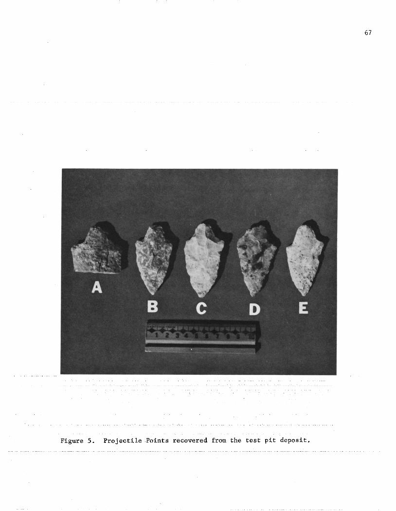
Figure 5. Projectile Points recovered from the test pit deposit.
67
68
ANALYSIS OF THE TEST PIT MATERIAL
Although the size and extent of this excavation unit was small,the amount of cultural material recovered from this pit was quitehigh. A total of 16,552 separate pieces of material were excavatedfrom the test square .(Table 1). Of these, 1,537 pieces Were foundin layer #1, 10,534 in layer #2, 1,402 in layer #3, 2,427 in layer#4, and 652 in layer #5.
Of the artifacts collected, 6,168 pieces were discarded and notused in the formal analysis of the material. These discarded piecesconsisted of spa lIs and pieces less than 1 cm in diameter that visiblylacked a hertz ian cone and bulb of percussion. The remainder of thematerial was classified in terms of 1) the logical sequence of lithicreduction; 2) evidence of utilization; and 3) diagnostic points andtools (Table 1). The cores were analyzed using a model developed byBradley (1973) and the lithic reduction sequence, along with diagnosticpieces were described primarily following Coe (1964).
Flakes
The major activity on the site appears to have been the reductionof raw materials into portable forms; therefore, most artifacts recoveredwere debris from the reduction process. The debris was classified intotwo categories: (1) decortification flakes and (2) second stage flakes.
The decortification flakes were defined as those flakes havingvisible amounts of cortex on the side opposite the bulb of percussion.These flakes were removed from the original nodule of raw materialthrough direct percussion using a hard hammer in the initial step ofcore preparation (Speth 1972). These flakes are most often large andblocky, but a few are fairly thin. Of the thin pieces, most retaina wedge-like shape contracting down from the platform (Fig. 6 a-f).
The second stage flakes were those pieces of debris that show nocortex opposite the bulb of percussion side. These flakes are morethin and less blocky than the decortification material and probablyresult from platform building and general thinning (Fig. 6 g-n). Theseflakes were also produced by direct percussion usihg a hard hammer(Speth 1972).
A relationship can be inferred between the total amounts ofdecortification and second stage flakes and the amount of reductiveactivities being carried out on the site ~t a particular time. Thequantities of debris represented in layers #2 and #4 (Table 1) farexceed the total debris within the remaining layers: therefore, it isprobable that the area of the test pit was utilized most intensivelyby the prehistoric group/groups represented by those two levels. Inaddition, it can also be inferred that the major utilization in thearea of the test pit occurred during the deposition of layer #2, because64% of the total pit material came from that level.

Table 1. Tabulation of the quantity of each artifact type from each level of the two-meter test pit.
t:I Ul '" '" '"" .0 s: ;g Ul g '" t:I t:I Ht'j t'j H ..., :;d
~C"l Z H H 0
C"l C"l H H '" ~0 g; H '" Ul >-l
0 0 ,... ,...'" '" '-< '" ~ '" C"l "'" Z H H
~ ~ f,:J '" '"" ~H " ,...
H t:I N N C"l '" C"l~ '" UlH '" '" Ul >-l 1Jl '" ?il'" Ul t:I t:I '" H H '"H ;; I;: 0
~ I;: " ~t:I
C"l t:I UlE"i
z" '"' '" '" l;j t:I H '"">-l '" C"l C"l Ul
'"" '" <:~
HH
~0 Ul 0 '" '"0 '" Z H
'""Ul :,,; C"l
z !> H t:I Z H '" '"H H '" Z Ul
'" ?'i '" Ul Ul C"l H
I;: '" H ;; '" Ul, Ul C"l Ul
?'i " '"''" H '"Ul H0 '"Z I;:
'" "!> ~?'i
'"Ul
LEVEL ifl 6 438 368 11 1 1 712 1,537
LEVEL ifr2 30 1982 5458 2 27 8 1 5 2 3 1 3015 10,534
LEVEL if3 11 205 283 1 8 1 893 1,402
LEVEL if4 587 702 1 1 14 2 1113 2,427
LEVEL if5 76 118 1 1 10 1 1 435 652
CO'
'"

70
Figure 6. Sample of flakes and cores recovered from layer #2 ofthe test pit deposit: a-f, decortification flakes (a&bexterior); g-n, second stage flakes (g-j, interior, k-n,exterior); o-q, cores (o&q, secondary cores, p, primarycore). All flakes are photographed with the platformand Hertzian cone at the top.
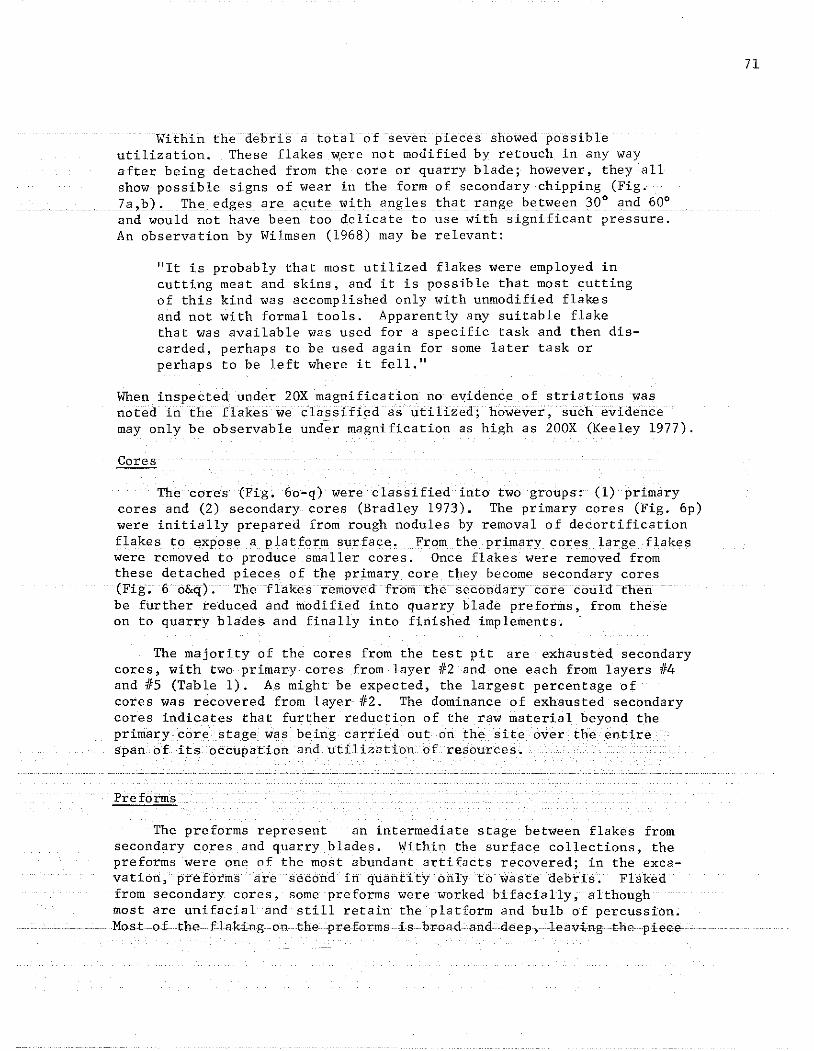
Within the debris a total of seven pieces showed possibleutilization. These flakes w~re not modified by retouch in any wayafter being detached from the core or quarry blade; however, they'allshow possible signs of wear in the form of secondary chipping (Fig.7a,b). The edges areaeute with angles that range between 30° and 60°and would not have been too delicate to use with significant pressure.An observation by Wilmsen (1968) may be relevant:
"It is probably that most utilized flakes were employed incutting meat and skins, and it is possible that most ~utting
of this kind was accomplished only with unmodified flakesand not with formal tools. Apparently any suitable flakethat was available was used for a specific task and then discarded, perhaps to be used again for some later task orperhaps to be left where it fell."
When inspected under 20Xmagnificationno evidence of striations wasu6Eed--lil iheflakes we c'lassif:i¢daslitiTized;" however", 'suchevidencemay only be observable under magnification as high as 200X (Keeley 1977).
Gores---The cores (Fig. 6o-q) were classified into two groups: (1) primary
cores and (2) secondary cores (Bradley 1973). The primary cores (Fig. 6p)were initially prepared from rough nodules by removal of decortificationflakes to expose a platform surface. From the primary cores large flakeswere removed to produce smaller cores. Once flakes were removed fromthese detached pieces of the primary core they become secondary cores(Fig; 6o&q). The flakes removed from the secondarycorecotildthetibe further reduced and modified into quarry blade preforms, from theseon to quarry blades and finally into finished implements.
The majority of the cores from the test pit are exhausted secondarycores, with two primary cores from layer #2 and one each from layers #4and #5 (Table 1). As might be expected, the largest percentage ofcores was recovered from layer-#2. The dominance of exhausted secondarycores indicates that further reduction of the raw material beyond theprimary core. stage was being carried but on the site over< theerttirespan ofitsocc:upation 'and utilization of resourCes.
The preforms represent an intermediate stage between flakes fromsecondary cores and quarry blades. Within the surface collections, thepreforms were one of the most abundant artifacts recovered; in theexcavation,preforms are second in quantity only to waste debris. Flakedfrom secondary cores, some preforms were worked bifacially, althoughmost are unifacial and still retain the platform and bulb of percussion .
....... . Most. of the flaking .onthepreforms is- broad"nd.deep,leavi·ngthe-piece
71
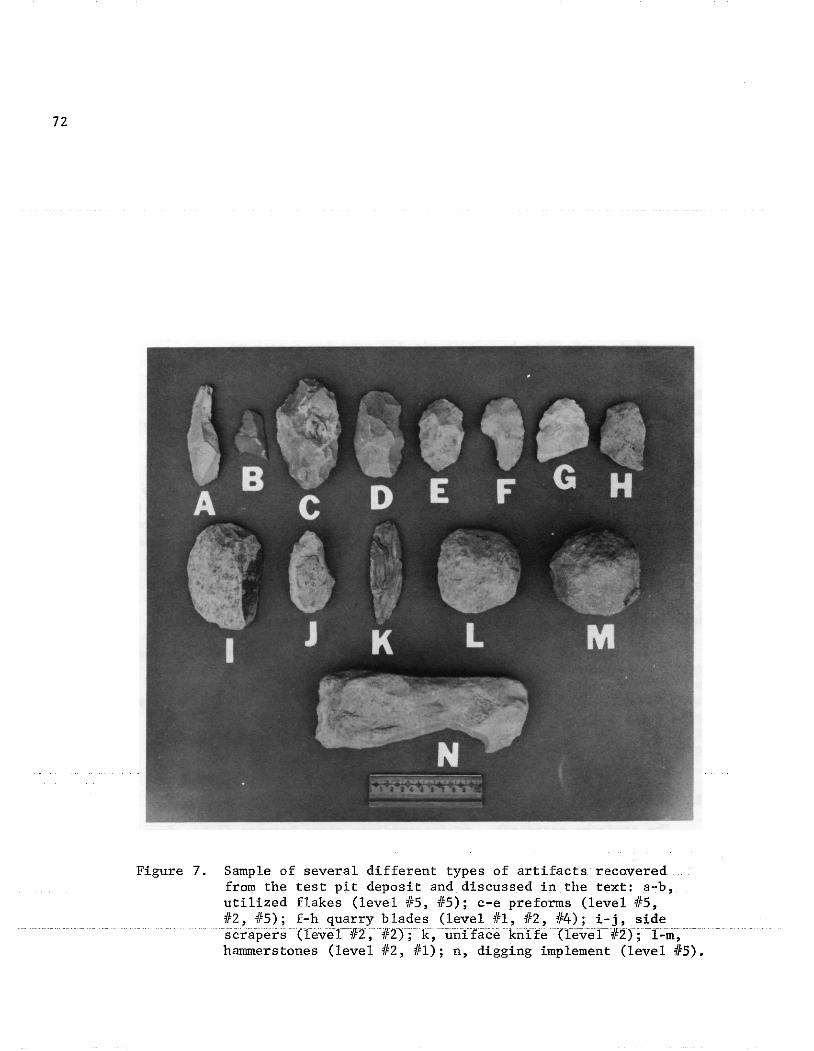
72
Figure 7. Sample of several different types of artifacts recoveredfrom the test pit deposit and discussed in the text: a-b,utilized flakes (level #5, #5); c-e preforms (level #5,#2, #5); f-h quarry blades (level #1, #2, #4); i-j, sidescrapers (1eve1112 ,112) ; k,unirace kriife(leveT112);1=01;harnmerstones (level #2, #1); n, digging implement (level #5).
thick in the middle (Fig. 7c,d,e).
It is believed that these preforms recovered in the excavationwere discarded because of technical problems which prevented furtherreduction. Many of them have very thick midsections and frequentlya-'pronounced-hump onone--s-ide-~
Quarry Blades
A total of 11 diagnostic quarry blades were recovered from thetest square: 8 were recovered from layer #2, 2 from layer #4, and 1from layer #1 (Table lA).
In layer #1 a type I blade was recovered (Fig. 7f). Seven of theblades in layer #2 were type II (Fig. 7g&h) (Coe 1964) with the remaining piece belonging to the type I category. In layer #4 oneeach of type I and II were found.
All of the quarry blades exhibited lateral snap or other breakage.Therefore, it appears that their presence in the strata results frombreakage during reduction, and subsequent discard. The final step inreduction on Three Hat Mountain appears to have resulted in quarryblades which were carried from the mountain and reduced to final toolforms elsewhere.
Scrapers
Two type I side scrapers (Fig. 7i,j) Coe (1964) were recovered fromlayer tt2. One piece (Fig. li) is 9 cm in width, 6 cm in length, and3.4 cm at the platform. The smaller piece, (Fig. 6j), measures 7 cmin width, 3.4 cm in length, and 1.7 cm at the platform. These alongwith the few utilized flakes seem to indicate activities other thanquarrying and knapping at the site.
Projectile Points
Five projectile points were recovered, all probably attributable tolayer #2 (Fig. 5). Two of the points (Fig. 5a,b) are made of felsicmaterial unlike the stone native to the test pit area. The remaining3 points (Fig. 5c,d,e) arypear to have been produced from the rhyolitenative to· the· test pit area, but have surface decomposition on .at leastone. side, got genera 11ycharacteJ:1stic of. the secondary :flake 1mappingdebris. Morphologica 11y, 40 f these points (Fig. 5a,b,c ,d) are similarto the Koens-Crispin type (Cross 1941 and Kraft 1970). Coe has associatedthe Koens-Crispin with the Savannah River Stemmed which is radiocarbondated at 1944 B.C. ± 250 years (Coe 1964:44, 118). The fifth point ismore similar to the Savannah River tYPe common in the North Carolinapiedmont (Coe 1964).
73

74
Uni face Kni fe
One unifacially flaked knife (Fig. 7k) was found in layer #2. Itis made of a medium-grained, dark grey banded rhyolite-- a type of stoneunique in the collection from the test pit excavation. The tool measuresapproximately 10.2 cm in length. Produced from a slehderflake, thekhiferetains the platform and bulb or precussion at the base and is utilizedalong both edges and at the point. The sides appear to be retouchedslightly creating curvature at the ends.
Hammerstones
Two hammerstones were recovered, one each from layers #1 and #2,in the test pit. Both stones are dense, basaltic material. Thehammerstone from layer #2 (Fig. 71) is a type V (Cae 1964), while thehammers tone from layer #1 (Fig. 7m) is a type VI. These presumablywere used in at least the first steps of theknapping process to reducecores and rough out the preforms. However, bone or antler hammers mayhave been used for the fine shallow flaking on the quarry blades.
Digging Implement
One very rough, crude implement wa s found in layer its, (Fig. 7n). Itis a long blocky piece approximately 20 cm in length, made of nativeThree Hat material, and apparently use-damaged at one end. This toolmay have been used as a digging implement to extract lithic raw materialsfrom the ground.
ANALYSIS OF SURFACE COLLECTIONS
In addition to the excavated material, two separate surface collectionswere obtained from the site. One collection was obtained around the areaof the test pit and along the western slope of the ridge following thelogging road cut (Fig. 1) (Table 2). This collection includes a totalof 102 separate pieces of material (Table Ib). The projectile pointsgathered include 2 unfinished Savannah River, and 1 Badin. Quarryblades found consist of 1 type I blade, 4 type II, 3 type III, and 2type VII blades (Coe 1964). One type II scraper and a high-backedscraper were also collected. One type VI and one type III hammerstone(Cae 1964) are also present in this collection.
The second surface collection, totaling 109 pieces of material, wasobtained from the northeastern slope of the mountain following the courseof a powerline right-of-way toward Flat Swamp Creek (Fig. 1). Projectilepoints in this collection include 1 Savannah River, 1 Guilford, and IBadin. The majority of quarry blades recovered fit into the type II andtype VII range (Co~ 1964), with quantities of Sand 6 respectively. Theone scraper in this collection is type I. Also, four sherds of YadkinSeries pottery were found.
Ie 2. Tabulation ,of the quantity of different artifact types present in four different surfacecollections. from the Three Hat Mountain area.
~t;;j [f; c:j '" .g 5'; '" t;;j :0- [f; ?' .g [f; t;;j z z 0 >-3
'" '" >-3 ::0 ::0 ::0 X 0 Z 0 H 0 0 '" 00 (") H '" :0-
~0 H '" S;; H :0- S;; <7) z z S;; S;0 0 t-< "J ::0 '-< t-< [f; "J ::0 <7) I I
::0 z H 0 ::0 '" t-< '" '" ::0 '" H t;;j [il :.: t-<>-3 t;;j N
~c<: ::0 0 [f; '" c<: '" z '" H [f;
H '" [f; H ::0 '" ::0 <7) [f; [f; (")"J [f; t;;j [f; '" >-3 H [f; s:;' '" (") (") [f;H S; r;; 0 t;; s:;' '" H '" '"~ "J Z t;;j r;; ~
H H<7) s:;' t;;j '" '" [il '" '">-3 '" '" [f; '" [f; fjl t;; >-3 >-3
H ?' [f; 00 "J '" H '" [f; &iz s:;'. UJ
~H '" '"'" z 0 H
"J ?' [f; (") >-3 H '"s:;' '" '" [f; z 0[f; [f; H '"?' [f; [f;
'"[f;
SurfacCo llec ionTest P t Area 12 7 13 41 10 2 4 2 11 102
SurfaceCollection
2 7 48 14 2 4 3 1 15 1 8 4 109Base of Mountain.
DongellCo llee tion 1 95 41 1 1 55 1 13 208
Curry
11130Collection 1 15 6 114 115 24 1"16 8 3 51 26 22 1 307 4 11
"'"
76
In addition, two private collections of artifacts from the Three HatMountain area were studied and classified. One collection belongs toMr. Oliver Dongell of Greensboro, North Carolina. His collection wasmade in an area ranging from New Cut Road, northeast and east of themountain, back to Flat Swamp Creek (Fig. 1). Nearly the entire earlyand middle Archaic sequence of projectile points found in the piedmontNorth Carolina as described by Coe (1964), are represented in his collection.However, many of the points (14), are Savannah River. Of the 95quarry blades present, 77% are type II, while 19% are type Ill. Thebalance of the quarry blades are made up of one each of types I,V, andVII (Coe 1964).
The second private collection belongs to Mr. Gary J. Curry ofThomasville, North Carolina. His collection was obtained from the northeastern slope of the mountain in the same area as the second surfacecollection, totalling 109 pieces, obtained by the UNC-G field crew. Mr.Curry's collection includes projectile points representing a majorportion of the Archaic sequence common to the North Carolina piedmont:1% Hardaway-Dalton; 3% Palmer; 11% Kirk; 9% Stanley; 17% Morrow Mountain;2% Halifax; 5% Guilford; and 50% Savannah River. In addition to thepoints common to the North Carolina piedmont, the Curry collection alsoincludes the following relatively uncommon types: 1 Benton; 6 Big Sandy;4 Eva; and 3 Le Croy (Lewis and Kneberg 1961). A total of 115 diagnosticquarry blades in the Curry collection were classified according to Coe(1964) as follows: 8% Type I, 55% Type II; 21% Type Ill; and 16% Type VII.
Mr. Curry's collection includes a total of 208 Savannah River projectilepoints. All of these (100%) exhibit lateral snap breaks, with the brokensurface uniformly decomposed to the color of the unbroken surface. Inaddition, 93% of the Type II quarry blades and 100% of the Type III quarryblades are in the same lateral~napped broken condition. These datamay indicate that much of the lithic reduction of quarry blades intofinished tools, at least during the Savannah River phase, was beingperformed at the base of Three Hat Mountain. Furthermore, most of theprojectile points and quarry blades in the Curry collection which are notattributable to the Savannah River phase do not have the same lateralsnap breakage.
Unbroken preforms from the upper part of the mountain(UNC-G collections)and from the base of the mountain (Curry and UNC-G collections),were compared todetermine if any significant difference exists in the amouIlt: of reduCti.oIl.The preforms were grouped in three units for analysis: preforms recov-ered in the test pit excavation (21 preforms); preforms in the UNC-Gsurface collection from around the test pit area and along the south-western slope of the mountain (25 preforms); and preforms in the Curryand UNC-G surface collections from the northeastern base of the mountain(124 preforms).
Two sample t tests (t=2.39, p< .01) and analysis of variance(F(2,131)=4.92,P"< .01) were calculated on the preforms in order to

statistically quantify the variation among the units. The results ofthe analysis indicate that the surface collections are different fromthe excavated material in terms of thickness (~(l1l)=3.25, p. <.01).In addition, both surface collections. are different from the excavatedmaterial interms of width. and thickness (1.(44)=3~31and1.(44)=2. 78,p.<.Ol for. the surface collection around the test pit, and t(lo7)=2.si·and 1.(107_=2.48, p.<.Ol for the surface collection from the-area atthe northeastern base of the mountain, respectively). The calculationof analysis of variance produced significance only in terms of width(£(2,131)=5.02, p.<.Ol).
From the above calculations it can be inferred that the surfacecollections are different from the excavated material. However, thesurface collection from the northeastern base of the mountain appearsto have the same statistical relationship to the excavated material asdoes the surface collection around the test pit. This indicates thatthe surface collected preforms are basically the same in the two areasof the mountain which have been compared. Also, the degree to whichthe preforms were reduced appears to be the same both on the mountainand at the northeastern base of the mountain.
CONCLUSIONS
As stated at the beginning of this report, excavation of the testpit was intended to answer three questions about activities at this location on Three Hat Mountain: 1) were the strata formed during differentphases of occupation on the site; 2) could any of the strata be datedthrough the presence of chronologically diagnostic artifact types;3) what prehistoric activities could be inferred from the study ofacontrolled excavated collection of artifacts. From the concentrationsof artifacts in the five strata, two major phases of use can be inferred.The first occurs in layer #4 and may possibly date to Stanley times,although the only diagnostic artifact occuring in this layer whichsupports this assumption is one type I (Coe 1964) quarry blade. Indeedthis layer may pertain to the Savannah River phase occupation and representonly a minor temporal difference within that phase. The next phaseof utilization is represented by layer #2, and presumably dates toSavannah Rive~ times. Three of the projectile points from layer #2 and1 from layer lf3 (Fig. 5b-e) are morphologically similar to the pointsof the Koens-Crispin Culture in New Jersey, described by Cross (1941)and Kraft (1970); The other ]:.oiht (Fig. 5a)ismorphi:>1i:>gicallYsimilar to the typical Savannah River type found in North Caro lina;
The prehistoric activities on Three Hat Mountain were primarilyquarrying and stone knapping of pieces of argillite and rhyolitecollected as nodules on the surface or quarried from the heads ofgulley cuts, following veins of the high quality materials. The rawmaterials were prepared as cores using direct percussion with hardhammers and then further reduced into secondary cores using the sametechnique. Flakes from secondaryco:reswerechippedint"quarry ],lade
77

78
preforms, some of which were discarded because of technical difficultiesarising in the reduction process. It appears that both preforms andquarry blades were taken from the site to be processed into finishedtools at the base of the mountain or elsewhere. It is also believedthat although prehistoric groups visited the site primarily to obtainquarry blades they probably also camped and hunted there occasionally.The occurrence of scrapers, points, and utilized flakes in the excavatedcollection, in our surface collections, and in the Dangell and Currycollections indicate some Archaic period hunting activities on andaround Three Hat Mountain.
SUGGESTIONS FOR FURTHER STUDY
Further study at Three Hat Mountain would contribute to a betterunderstanding of p~ehistoric lithic resource collection and distributionpatterns in this area of the Southeast. More work is needed to betterdocument the spatial and temporal extent of the site and to provideadditional information concerning the stone quarrying and knappingtechnologies of prehistoric groups. Additional work is also needed toestablish the relationship of the Three Hat Mountain lithic source toothers in the piedmont region. Furthermore, a study of the settlementpatterns on and around the mountain might help reveal the economicvalue of the site to aboriginal groups.
ACKNOWLEDGEMENTS
The excavation at Three Hat Mountain was undertaken in 1975 underthe direction of Dr. Joseph B. Mountjoy. We would like to thank Mrs.Alice M. Carll, Mr. Fred Bingham, Mr. Eugene Weaver for their permissionto conduct this study on their property, and the University of NorthCarolina-Greensboro for supporting the field research and the laboratoryanalysis.
REFERENCES CITED
Bradley, Bruce A.1973 Lithic reduction sequences: A glossary and discussion. In Lithic
Technology, (ed. E. Swanson), 5-13. Mouton Publishers. The Hague & Paris.
Coe, Joffre L.1964 The Formative Cultures of the Carolina Piedmont. Transactions
of the American Philosophical Society 54.
Cross, Dorothy1941 Archaeology of New Jersey, Vol. 1.
New Jersey and New Jersey State Museum,Archaeological Society ofTrenton.
Jones, Jeri L.1977 Field Guide to the Geology and Archaeology of the Uwharrie
Volcanic Belt Central North Carolina, Museum o£Anthropology,Catawba College, Salisbury, North Carolina.

Jones,Jeri L.1979 Preliminary geologic survey of Three Hat Mountain,
Davidson County, North Carolina. Department of Anthropology,University of North Carolina at Greensboro.
Keeley, L.H. and M.H. Newcomer1977 Microwear analysis of experimental flint tools: A test case.
Journal of Archaeological Science 4:29-62.
Kraft, Herbert C.1970 The Miller Field Site, Part 1. The Seton Hall University Press.
79
Lewis, Thomas M.N. and Madeline1961 Eva: An Archaic Site.
Knoxville.
Kneberg LewisThe University of Tennessee Press,
Speth, John D.1972 Mechanical basis of percussion flaking. American Antiquity
37:34-60.
Stromquist, A.A., P.W. Choquette and H.W. Sundelius1971 Geologic map of the Denton quadrangle, central North
Carolina. U.S. Geological Survey, Geologic Quadrangle MapGQ-872. Washington.
Wilmsen, Edwin, N.1968 Functional analysis of flaked stone artifacts. American
Antiquity 33:156-161.

THE BLUE ROCK SOAPSTONE QUARRY (31Yc7),
YANCEY COUNTY, NORTH CAROLINA
Mark A. Mathis
Mark A. Mathis, Archaeology Branch, North Division of Archives and History,Raleigh, North Carolina 27611


INTRODUCTION
In October of 1979, archaeologists from the Division of Archivesand History conducted investigations at a soapstone quarry in YanceyCounty, North Carolina. The site has since been designated as 3lYc7,the Blue Rock soapstone quarry. The purpose of the investigations wasto assess, in preliminary fashion, the potential National Registereligibility of the prehistoric quarry site and to evaluate the probablefuture of the site with regard to ongoing and/or potential destruction.
The purpose of this brief report is to present the results of the1979 investigation and to provide framework for evaluating the researchand National Register significance of the Blue Rock quarry. The investigation was conducted by Linda H. Pinkerton, then at the Western Officeof the Division of Archives and History, and Mark A. Mathis, ArchaeolpgyBranch. Sincere thanks are extended to Dr. Harley Jolly for his concernand interest in the site and to Mr. William (Bill) Wilkins, Deneen MicaCompany, for allowing us to perform the study. Illustrations for thisreport were prepared by the author and Anthony (Tony) Burden.
The soapstone quarry was first brought to the attention of theDivision in 1978 by Dr. Harley Jolly of the Department of History atMars Hill College. The site has been known to area residents for manyyears, not necessarily as a manifestation of prehistoric quarryingactivities, but as a source of relatively high grade soapstone. Recentactivity at the site has involved the removal of slabs and chunks ofthe soapstone for use in hearthstones and crafts manufacture. Scars ofsuch activities are visible as saw cuts at numerous locations on the mainoutcrop. One resident who visited the site during our investigationsadmitted to having engaged in such modern "quarrying" practices and alsonoted that the site has been a favorite hangout for weekend outings.The remains of recent campfires and a tarpaulin tent/lean-to attestedto local familiarity with the site. Some of the area residents, however,were and are aware of the prehistoric associations. At least One privatecollection from the site includes 3/4 grooved and polished- stone axes,quarrying tools, soapstone bowl fragments, and several complete bowls.
In addition to the· gradual attrition of the site through theactivities· of the residents, .the sitewa.s. recently inadvertently distu.bed by the Den.een.Mi¢a Company in search of productive talc deposits.The western side of the soapstone outcrop was partially bulldozed toallow access for a truck-mounted auger for probing the depth and natureof the deposits. In discussions with a ~ompany official it was determinedthat, for the present anyway, no plans exist for full-scale mining ofthe deposits.
83

84
GEOLOGICAL SETTING
The Blue Rock soapstone quarry (3lYc7) is located in east-centralYancey County, North Carolina, approximately 2.4 kilometers (1.5 miles)south of the small mountain community of Newdale. The setting is typicalof the interior Blue Ridge Mountain physiographic region, with moderatelyrugged to rugged topography, and highly dissected, steep-sided valleys.The quarry site is situated on a west-facing slope of Fawn Mountain atan elevation of approximately 816m (2720 ft.) above mean sea level (AMSL).Approximately 250m to the west of the site and 66m (220 ft.) lower inelevation is the north-flowing South Toe River. Fawn Mountain rises onthe east to a peak of 1011m (3370 ft.) AMSL.
The geology of the area is characterized by Early Precambrianmetavolvanic and metasedimentary lithologies, principally schists,gneisses, and quartzites. In the vicinity of the Blue Rock quarry site,hornblende gneiss is most abundant. Small veins of severely fracturedquartz and quartzite are also observed in the area, as are peridotite(an intrusive igneous rock frequently found in association with soapstone),mica, actinolite, chlorite, asbestos, feldspar, and megmatite. Asbestoswas mined locally until recent years, and mica and feldspar depositscontinue to be exploited. Soapstone and talc do not appear to have beenmined extensively in the immediate area but were until the early 1940snear Spruce Pine, in Mitchell County, and further to the south, nearMars Hill, in Madison County.
According to Stuckey (1965:34), soapstone consists of 10-80% talc,and is formed by secondary hydrothermal alteration of hornblende gneiss.Soapstone is an "impure talcy rock," frequently used in ground form as asubstitute for talc (Stuckey 1965:455), but more commonly in sawed blocksfor building and insulation materials. Talc is a hydrous magnesiumsilicate employed primarily in sawed or ground form in a variety of industrial and building products, particularly paints, ceramics, andinsulation. In much of the archaeological literature, the term "steatite"is used interchangeably with "soap8tone~" Hot.rever;o steatite refersspecifically to "a compact, massive form of very pure talc" which occursin metamorphosed dolomite limestone (Stuckey 1965:456). As such, it isnot common to the area of the Blue Rock quarry. Soapstone, on the otherhand, is common to the area, occurring in bodies varying from 5 to 25feet in thickness (Stuckey 1965:34). Given the lack of systematicgeological or archaeological research in the area, however, little canpresently be said about the distribution of those bodies or their use byhistoric or prehistoric peoples. Bohanon's (1975) source analysis ofsoapstone artifacts from Tennessee did involve the collection of samplesfrom several deposits from Yancey County, one of which may have been theBlue Rock outcrop. No mention is made in his report, however, concerningevidence of quarrying activities at any of the deposits.

SITE DESCRIPTION
The Blue Rock deposit occurs as a small hi1l~like outcrop measuringapproximately 30 meters north..,.south, 20 meters east-west, and rising toa maximum height of about 3 meters (Figure 1). It is bounded to thenorth and south by seasonally wet drainages, on the east by Blue RockRoad (S.R. 1152) and Fawn Mountain, and on the west by the steep drop tothe South Toe River.
Sometime in the last year or two, a local ffilnlng company undertookexploratory augering tests at the site to evaluate the talc and soapstonemining potential. A bulldozer was apparently used to push out an accessroad and level working surface for the truck-mounted auger and, in theprocess, cleared approximately 700 square meters on the west side of theoutcrop. Several small exposures of soapstone are now visible in thecleared area and appear to be coterminous with the main outcrop. Althoughdifficult to calculate, it appears that only a few centimeters of topsoiland several moderate-sized chunks of soapstone were pushed off the area,along with the trees and bushes. The bulldozer spoil pole now rings thenorthern and western edges of the deposit.
The most prominent features at the site are the many quarrying scarsscattered over the main soapstone outcrop. The scars provide a record ofboth historic and prehistoric exploitation of the soapstone. Modern useof the outcrop is indicated by saw cuts, most of which exhibit a glossy,unweathered surface, suggesting relatively recent origin. Others haveslightly weathered surfaces, indicating an earlier historic origin.Since soapstone slabs serve well for hearthstones and firebox liners andhave been used as cemetery headstones in many areas, there is a likelihoodof a century or more of local historic utilization of the Blue Rock deposit.The proximity of the deposit to Blue Rock Road certainly made it a readilyavailable source. Local craftspersons and hobbyists are also reported tofrequent the deposit for raw materials.
Less noticeable are the numerous basin-shaped depressions and concavities--prehistoric bowl cut outs--scattered over the outcrop. Someof the depressions or cutouts measure up to SOem in diameter and 30cmin depth. At the bottom of several cut outs are small pedestals or knobs,from which the bowl preform or blank was cut or snapped (Figure 2).However, the isolated and prominent cutout, such as that shown in -Figure 2,is rela.tivelY ra.re. MosEOffheevidence:6frawlIlate:rialextractiOrtisvisible only as slight concavities or arc-like impressions in the sides ofthe outcrop. For instance, the prominent cut out in the center of Figure 2appears to have been one of the last to be worked at that particular locuson the outcrop. Around the cut out are several less perceptible arcs andconcavities, eachbf which appears to represent an earlier quarryingepisode.
85
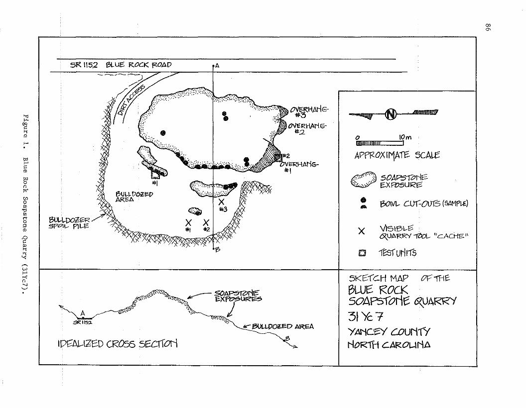
co
'"
sF< 1152 BLUe:: RocK i<:0AD .A
o 10mIImlli!ill!l!l!I I
•......Il1I...--.,tO\ . 4JililtilBI!!tf""""lIIlV 'CI
APPR.OXlrvJAiE: 5CAU:
0 ,":', "A~ ~Ir::,_:""" ,,:, 5</"".-~ It'l1to':, "," ' ~XFl:15URe:;:
l3O\VI..- c.ur:0tJ6 (5AMP~~)
VI5IB\..-~6\UARRY~ "eACHS"
18Sfurlrfs
•...
£::J
x
OV~RHAN
OVERHANGflo2
l?
BlJt..\..DOZ:~RSPOIl-- P1I-EO
.."f-'.
~'irof-'
'"f-'
'"ro13'"~'"o'"'0OJ
8"i:1(1)
.0
'"~'i'<
IPE:lAl.-I:6E:D CROSS 5E:ClIOI'l
..,..BULWaED AREA~
,B
~
Wf-'Ki
".....~
A~
~115~
.,.~"".".. ~A~rl~"",. ....XP~u~
\:. j":'!."'~
-'':J
5K(:-(C.H MAP or:-1f1~
BWE: ROCK50APSlorie 6ZUARRi31)c7YANCf::Y COuN1YNOR1H CAROl-lNA

Figure 2. Bowl quarry scars at the Blue Rock Soapstone Quarry (3lYc7).
Other visible features at the site are three small overhangs formedby the soapstone outcrop. The overhangs are located at the southern endof the outcrop and appear to have been formed--at least partially--as aresult of the weathering out or deca.y of impurities in the soa.pstone.In.·this··area of .the· deposir,chlorite, .. hemati t e,· ... and severalother mineralsprOba.blyAecOuntforOVer50% oftheniiIleralconipOsitioIl. portiOIls· of theceilings of the overhangs are severely foliated, and flakes .and. chunksare IlOt difficult to pry lOOse.
Two of the overhangs provide shelter for no more than 1~2 squaremeters of floor space and a meter or less of head room. The other overhand(l/l in Figure 1) has as· much as 25 square meters of floor andniaximuJn of a meter of headroom. the la.rger overhaIlg ma.y have providedtemporary shelter for a small number of prehistoric quarry workers andbased on the presence of modern trash, has also been used in recent years.:A single smalL test square was excavated under the overhang during therecent investigation, the results of which are discussed below.
87
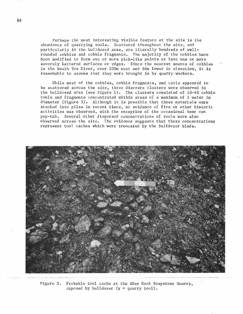
88
Perhaps the most interesting visible feature at the site is theabundance of quarrying tools. Scattered throughout the site, andparticularly in the bulldozed area, are literally hundreds of wellrounded cobbles and cobble fragments. The majority of the cobbles havebeen modified to form one or more pick-like points or have one or moreseverely battered surfaces or edges. Since the nearest source of cobblesis the South Toe River, over 200m west and 66m lower in elevation, it isreasonable to assume that they were brought in by quarry workers.
While most of the cobbles, cobble fragments, and tools appeared tobe scattered across the site, three discrete clusters were observed inthe bulldozed area (see Figure 1). The clusters consisted of 10-40 cobbletools and fragments concentrated within areas of a maximum of 1 meter indiameter (Figure 3). Although it is possible that these materials werestacked into piles in recent times, no evidence of fire or other historicactivities was observed, with the exception of the occasional beer canpop-tab. Several other dispersed concentrations of tools were alsoobserved across the site. The evidence suggests that these concentrationsrepresent tool caches which were truncated by the bulldozer blade.
Figure 3. Probable tool cache at the Blue Rock Soapstone Quarry,exposed by bulldozer (x = quarry tool).
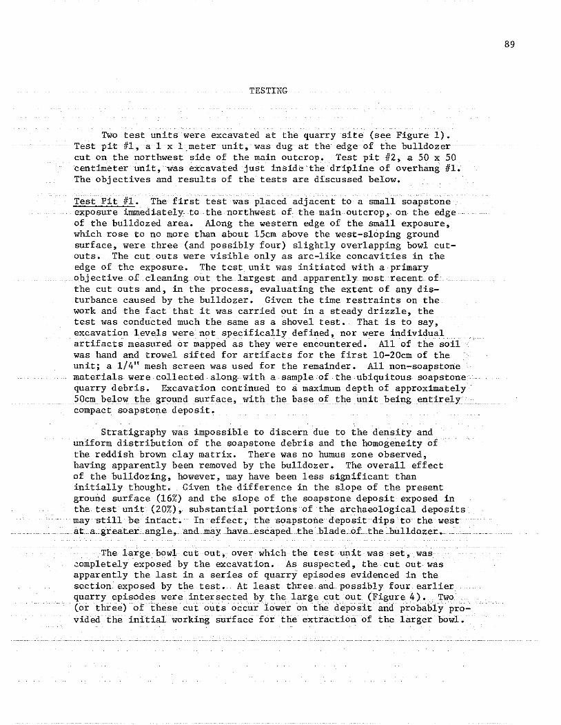
TESTING
Two test units were excavated at the quarry site (see Figure 1).Test pit ill, a 1 x l.meterunit, was dug at the edge of the bulldozercut on the northwest side of the main outcrop. Test pit #2, a 50 x 50centimeter unit, was excavated just inside the dripline of overhang Ill.The objectives and results of the tests are discussed below.
Test Pit #1. The first test was placed adjacent to a small soapstoneexposure innnediately to the northwest of the main outcrop, on the edgeof the bulldozed area. Along the western edge of the small exposure,which rose to no more than about l5cm above the west-sloping groundsurface, were three (and possibly four) slightly overlapping bowl cutouts. The cut outs were visible only as arc-like concavities in theedge of the exposure. The test unit was initiated with a primaryobjective of cleaning out the largest and apparently most recent ofthe cut outs and, in the process, evaluating the extent of any disturbance caused by the bulldozer. Given the time restraints on thework and the fact that it was carried out in a steady drizzle, thetest was conducted much the same as a shovel test. That is to say,excavation levels were not specifically defined, nor were individualartifacts measured or mapped as they were encountered. All of the soilwas hand and trowel sifted for artifacts for the first 10-20cm of theunit; a 1/4" mesh screen was used for the remainder. All non-soapstonematerials were collected along with a sample of the ubiquitous soapstonequarry debris. Excavation continued to a maximum depth of approximately50cm below the ground surface, with the base of the unit being entirelycompact soapstone deposit.
Stratigraphy was impossible to discern due to the density anduniform distribution of the soapstone debris and the homogeneity ofthe reddish brown clay matrix. There was no humus zone observed,having apparently been removed by the bulldozer. The overall effectof the bulldozing, however, may have been less significant thaninitially thought. Given the difference in the slope of the presentground surface (16%) and the slope of the soapstone deposit exposed inthe test unit (20%), substantial portions of the archaeological depositsmay still be intact. In effect, the soapstone deposit dips to the westat a greater angle, and may have escaped the blade of the bulldozer.
The large bowl cut out, over which the test unit was set, was~ompletely exposed by the excavation. As suspected, the cut out wasapparently the last in a series of quarry episodes evidenced in thesection exposed by the test. At least three and possibly four earlierquarry episodes were intersected by the large cut out (Figure 4). Two(or three)()f these cut outs occur lower on the deposit and probably provided the initial working surface for the extraction of the larger bowl.
89
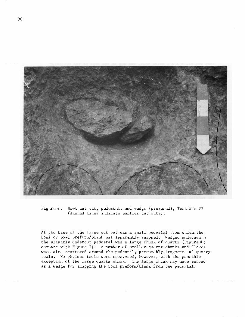
90
Figure 4 • Bowl cut out, pedestal, and wedge (presumed), Test Pit HI(dashed lines indicate earlier cut outs)~
At the base of the large cut out was a small pedestal from which thebowl or bowl preform/blank was apparently snapped. Wedged underneaththe slightly undercut pedestal was a large chunk of quartz (Figure 4 ;compare with Figure 2). A number of smaller quartz chunks and flakeswere also scattered around the pedestal, presumably fragments of quarrytoolSe No obvious tools were recovered, however, with the possibleexception of the large quartz chunk. The large chunk may have servedas a wedge for snapping the bowl preform/blank from the pedestal.

Test Pit #2. The second test was placed at the dripline of the southernmost extension of overhang 1/1 (Figure 5). The purpose of the test wasto determine whether or not intact subsurface cultural deposits were presentunder the overhang, but to do so with the least amount of disturbance tosuch deposits (should they exist). A 50 x 50cm unit was considered sufficient to meet this simple objective.
The unit was excavated in four levels following the natural slopeof the ground surface. Each level was troweled, and all fill screenedthrough a 1/4" mesh. All non-soapstone artifacts and a sample of thesoapstone debris were collected. Soil samples were also collected forfine screening and flotation, but have not been analyzed as of thiswriting.
Soapstone bedrock was encountered at a depth of around 28cm alongthe northern wall of the test unit and at 36cm along the south wall. Asmall boulder, possibly roof fall, halted excavation in the northwestcorner of the unit at about l5cm. Cultural materials, consisting of afew flakes and modern trash, were recovered from a 5-6cm thick humic zone.Surface disturbance appears to have been minimal and modern artifactswere not found below the humus zone.
Soapstone debris and small quantities of deb1tage were recovered fromall levels of the unit. Some of the debris was obviously roof fall, beingsimilarly poorly compacted and foliated. However, most was a better gradematerial, such as that found along the northwest side of the outcrop,and appear.s to occur as a result of raw material reduction activities.
Occupation or use of the shelter was most evident at a depth ofapproximately 23cm. Resting at this level was a rounded soapstone bowlbase, a pick-like cobble tool, a large unmodified quartz chunk, severalquartz flakes, and charcoal. While there was no noticeable stratigraphicbreak in soil texture or color, the vertical and horizontal associationof the larger artifacts suggests that an intact occupation floor exists.Unfortunately, no diagnostic artifacts were recovered from the unit.The two 3/4-grooved axes reported to have been collected at the site,however, would suggest an Archaic period of exploitatione A Late Arcp~ic
to Early Woodland affiliation is generally assumed for soapstone exploitation in North Carolina (Coe 1964; Keel 1976).
QUartza,nd hornblende gneissdebitage also occurred to a maximumdepth of approximately 35cm, suggesting the possibility of mUltiple useepisodes at the shelter. Given the convenient "on-site" location, it isquite possible that the shelter contains evidence of many of the quarryingepisodes undertaken at the site. A complete listing of artifacts recovered from the tests is provided in Appendix B.
91
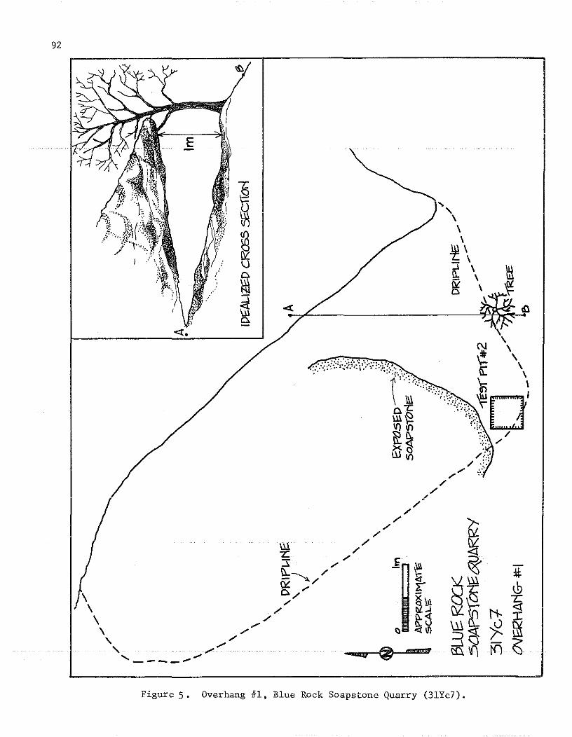
92
~,
\\\
~\- \n: \liZ \CI \
\
...
:tJ, .,.<C.
Figure 5. Overhang #1, Blue Rock Soapstone Quarry (31Yc7).

ARTIFACTS
Soapstone Artifacts. Only four soapstone bowl fragments were observedor collected at the site,two of which fit together asa single'sherd.The paucity of bowl fragments is probably an indication of the intensityof collector activities at the site, particularly in light of the immensequantity of quarry debris and quarry tools.
The three bowls represented by the four fragments included onestraight-sided, flat-bottomed rectangular or oval vessel, one roundvessel (base), and one which could have been either shape. Given theroughness of its exterior, the rectangular or oval vessel appears tohave been broken in a fairly early stage of production. The reductiontechnique suggested by the rough surface involved pecking with a sharp,pick-like implement. The rounded vessel base, recovered from test pit #2(under the overhang), appears to have been broken in a slightly moreadvanced stage. Pecking scars are readily visible on portions of theinterior. The two fitted fragments, finally, represent a vessel whichwas broken during the latter stages of production. All scars of theearlier stage pecking have been scraped smooth. Striations from a sharp,flat or slightly convex-edged tool are visible on both wall surfaces.
Non-soapstone Lithic Artifacts. A total of 112 non-soapstone lithicartifacts were collected at the quarry site, including 17 from test pit#1, 37 from test pit #2, and 58 from the site surface (Appendix B). Thesurface materials were recovered primarily from the bulldozed area onthe west side of the soapstone outcrop. A "grab" or "select II samplingtechniqiie was used for the surface col1""t:i.otls ,wit:h the exception ofone of the apparent tool caches, which was collected completely.
At least 37 of the artifacts can be identified as quarry tools orportions thereof. All of these tools were manufactured on well-roundedcobbles, presumably transported to the site from the South Toe River.Twenty-one (21) of the tools appear to have functioned as a kind of"pick," and are characterized by the presence of a 3- or 4-sided pyramidalshaped point at one end of a fist-sized, ovoid-shaped cobble (Figures6aand 6b ) • The point or bit was produced by the removal of two or threeprimary flakes, frequently retaining a portion of the cortical surfaceof the cobble as one side of the PYramidal-shaped bit. The presence ofmultiple smaller flake scars around thebit of some of the. tools suggestseither platform preparation for the primary flake removal or, more likely,utilization and recycling of the tools. All of the tools appear to havebeen used. Four of the "picks" have two'bits, one at each end of thecobble. Battering on the poll end of several suggests the occasionaluse of hammers in conjunction with the "picks." Four tools appear tobe exhausted "picks"; severe battering on the bits also suggests reuseas hammerstones (e.g., Figure 6c).
93
94
Four tools resemble crude choppers (Figure 6d). The single workingedge of these tools was bifacially worked. As with the "picks," thecortical surface was retained as natural backing. Four other tools mayhave functioned as choppers~ "picks, II or heavy-duty scrapers or adzes.These tools were either bifacially or unifacially modified to produce arelatively broad and slightly convex working edge, and may have been usedfor rough shaping of the soapstone vessles. Neither these tools nor anyof the "picks" show signs of having been hafted, although the possibilityof such cannot be discounted.
Of the remaining four tools, one is a blade-like, unifacially workedscraper or knife, and three are either wedges, chisels, or crude scrapers~
The latter specimehs show signs of utilization, but differ in form fromany of the other groups noted above. Such tools may have been used forany number of quarrying or raw material reduction activities.
Three unmodified, split cobbles were also collected. These mayrepresent abortive attempts at "pick" manufacture or simply tool blanksor preforms. All three were found in the apparent tool cache (#1) in thebulldozed area. The remainder of the non-soapstone lithic artifact collection consisted of flakes, chunks, and miscellaneous debitage (seeAppendix B).
One brown chert interior flake was collected, representing the onlytruly "exotic" raw material type noted at the site. The bulk of the tools(68%) were made fron gneiss cobbles, including hornblende gneiss (30%),micaceous gneiss (16%), and granitic gneiss (22%). Quartz and quartzitecobbles were used for eight of the tools (22%), and amphibolite for four(10%). Quartz and quartzite artifacts, including tools and debitage,are numerically more abundant than the other materials, representing over56% of the collection, but constitute only about 19% of the total artifactweight.
Overall, the lithic assemblage at the quarry site appears technologically simple and crude. However, the tools, and particularly the"picks,." are clearly specialized implements which have few counterpartsor parallels at non-soapstone quarry sites. The assemblage represents acomponent of aboriginal lithic technology and material culture which is atpresent only poorly known or understood, yet it is a component whichfunctioned as a significant aspect of many late pre-ceramic, and probablyeven early ceramic-using societies in the Eastern United States.
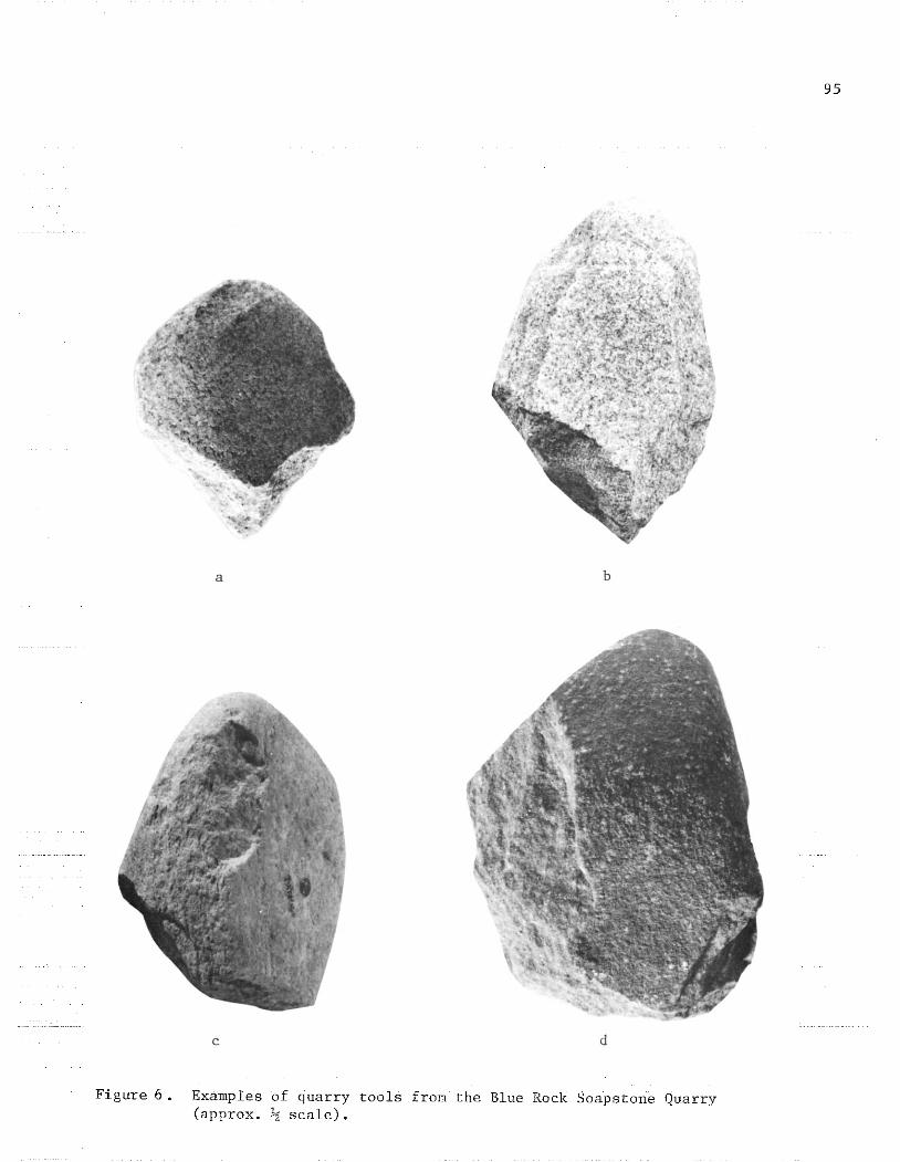
a b
d
95
Figure 6. Examples of quarry tools from the Blue Rock Soapstone Quarry(approx. ~ scale).

96
PREHISTORIC UTILIZATION OF THE BLUE ROCK SOAPSTONE QUARRY
Prehistoric exploitation of the Blue Rock soapstone was probablycentered around the production of bowls. Raw material for other items,such as ear plugs or· pipes, may have been procured at the site, thoughevidence for such is presently lacking and would probably not haveresulted in noticeable scars on the outcrop surface. Smaller itemscould have been produced from the quarry debris and aborted bowl debitage.Although several techniques were probably used to extract the soapstonefor bowl production, many of which have been discussed by Holmes (1890;1897), Bushnell (1926), Ferguson (1979), and Dickens and Carnes (1977),one technique in particular was clearly apparent at the Blue Rock quarry.Figure 7 illustrates the extraction process involving this technique,as reconstructed from the information gathered from test pit #1. Thistechnique, as discussed below, appears to have been used in the productionof many of the cut out scars observed at the site.
Isolated cut outs are rare on the outcrop, and where they do occur,the depression is only slight. This suggests that the bowl preform/blankassociated with the cut out probably occurred naturally as a prominentknob or projection of the soapstone outcrop and was therefore relativelyeasily detached. More often, however, the cut outs occur in overlappingor intersecting clusters, indicating that the scar resulting from onebowl quarrying episode served as the initial working surface for subsequent episodes. A parallel to this would be platform preparation inflintknapping.
Working from an earlier cut out, a groove was excavated to encirclethe desired size and shape of the target bowl preform/blank. The "picks" mayhave been the most commonly used tool for this, though hafted axes mayalso have been used. The two 3/4-grooved axes observed in the privatecollection were both essentially exhausted tools, having been batteredand reworked nearly to the hafting groove. Such wear would undoubtedlyoccur rather quickly if used to chop out soapstone bowls, even thoughsoapstone is a relatively soft material. The cost effectiveness of sucha practice, given the time required to manufacture grooved polished axes,is questionable and may have been the exception rather than the quarryingrule.
The groove in the soapstone was excavated by chopping Or peckingaround and under the desired amount of material, such that the preform/blank stood free from the soapstone matrix save for a connecting pedestal.The preform/blank was then snapped from the pedestal, probably with theaid of a wedge or lever. The chunk of quartz lodged under the pedestalin the cut out in test pit #1 may have served as a wedge, having beenhammered into the quarry groove, causing the preform/blank to break free.

: ....' ..
. ','
PRE::VIOU5t-Y6<UARRIE:DBOWb PE:DGSf"Al-
./
'.; '. -. '.' ' ... " '.,
. : " :
97
A. PRE.-EXiRACTlON SURFAc..E.
: " '. ~ ';: '.
', .....,,.. ;,.., .
~ ..., '. ..... . .
c. 6<u,ARRY SCAR ANDPEDEcS-rAl- RSMNAN-r
Figure 7. Hypothesized soapstone bowl quarrying stages, Blue RockSoapstone Quarry (3IYc7).

98
Remnant pedestal sizes vary significantly in the cut outs at BlueRock. Whether this is due to variations in the quarrying technique,desired bowl size, or mere, chance, augmented by impurities in the soapstone itself, is difficult to say.
Reduction of the preform/blank, and particularly the hollowing outof the interior, probably did not occur before removal from the parentmatrix, since this would have increased the potential for breakage duringthe wedging or dislodging process. It appears, however, that all stagesof reduction did occur at the quarry site. As noted previously, fragmentsof bowls roughly shaped by pecking and of bowls with smoothly scrapedsurfaces were collected. Bowls at or near a finished stage of productionwere also observed in the private collection from the site. Given thesize of the outcrop and the number of visible cut outs, it is assumed thatmany more bowls and fragments were present at one time, but have beencarried off by local collectors over the years.
The available natural shelter at the Blue Rock quarry must have beena most appreciated and attractive feature. Though there is no firm indication of the duration of any of the occupations of the larger shelter,it is evident from the small test pit that bowl reduction was performedunderneath, and that at least one fire was probably burned at one time.Evidence of food preparation or other activities was not recovered fromthe test.
As mentioned previously, one of the significant discoveries at thesite was the evidence of tool caching. Tool caches occur at other typesof prehistoric quarries (c.f. Baker 1974; Ives1975), and can probablybe expected at soapstone quarries. The discovery of such caches withoutfairly extensive and intensive investigation around the soapstone outcropsor boulders, however, will likely be a rare occurrence. The caches at theBlue Rock quarry were identified solely because of the actions of thebulldozer on the west side of the outcrop. At least three caches, andprobably many others, were truncated when the bulldozer cut off thesurface cover. It appears that several caches may have been thoroughlyscattered in the process, as indicated by the dispersed concentrationsof tools in the cleared area. In traee instances, however, the toolswere still tightly clustered (e.g., Figure 3). All of the visiblematerials in one of the apparent caches (#1) and all of the tools fromanother (#2) were collected (see Appendix B). Included in cache #1 were15 "picks," three "pick" fragments, one blade-like knife or side scraper,two split cobbles (possible tool blanks), eight large cobble fragments,and one amorphous chunk of quartz. Whether this is a typical quarryingtool kit or not remains to be seen. It is quite possible that the typicaltool kit also contained bone or deer antler tools. Discovery and investigation of undisturbed caches would be necessary to determine the full toolkit inventory.
CONCLUSIONS
In NOI"th Car-alina, the pr-ocur-ement/quar-rying component of LateAr-chaic-Ear-ly Woodland soapstone utilization has r-eceived little intensiver-esear-ch attention, in spite of the fr-equency of occur-r-ence of both soapstone deposits and ar-tifacts. Within. the ar-chaeological context of theState, then, the Blue Rock quar-r-y must pr-esently be consider-ed to have atleast statewide significance. As other- quar-r-y sites ar-e discover-ed,this status may change. For- the moment, however-, it r-emains a r-elativelyunique and r-ar-e ar-chaeological entity. When compar-ed with quar-r-ies r-epor-ted fr-om other- states, such as South Car-olina, Geor-gia, and Vir-ginia,the Blue Rock site stands out as the only known site with an associatedr-ock shelter-. The cultur-al deposits contained in the shelter- havedecided potential for- pr-oviding a br-oad r-ange of limited activity siteinfor-mation, in addition to infor-mation about soapstone bowl r-eductionsequences.
In addition to the shelter-s, tool caches per- se have not been r-epor-tedfr-om other- sites (to the author-'s knowledge), though they pr-obably occur- atmany. One possible explanation for- the lack of r-epor-ted caches thus far-is that investigator-s simply have not looked in the r-ight places.Excavations per-for-med adjacent to soapstone exposur-es will pr-obably notencounter caches, since caches at such locations would have been mor-esusceptible to discover-y by other- quar-r-y workers. If it is assumed thatcaching is a practice engaged in at least partially to pr-otect valued itemsfr-om expropriation by others, it would follow that the caches would beplaced inar-eas not likely to be discovered,accidentally or- otherwise.The visible caches at the Blue r-ock quarry are located away from theoutcrop, i.e., away from likely quar-r-ying spots.
At pr-esent, the full extent of the Blue Rock deposit and associatedcultural features is unknown. The limited investigations conducted at thesite, however, indicate that substantial potential exists for informationr-elevant to questions concerning prehistoric (and possibly histor-ic) soapstone exploitation and utilization. Futur-e r-esear-ch at the site shouldattempt to documen.t not only the extent of the deposits (natural andcultur-al), but also the pr-esence!absence of other- deposits in the immediatear-ea. The geological liter-ature combined with infor-mation pr-ovided by arearesideritspOirits to the fact that iriari'ysitess:ilIl.ilartOBllle Rod" prObablyexist in the immediate vicinity, Whether these· other- deposits contains:ilIl.ilar cultur-al associations, or- even still exist, given the extent ofthe mining activities in the r-egion, remains to be seen. Until additionalsur-vey is under-taken in the r-egion, the Blue Rock site must be consider-edan important resource which war-rants both preservation and scientificinvestigation.
Note: Sincethisrepo:r.t @s written, 1<11980, John DeuJert(1982) has .....reported the occurrence. of several additional soapstone quarriesin the vicinity of Blue Rock.
99
100
APPENDIX A
REFERENCES CITED
Baker, C.1974
M.A study of aboriginal novaculite exploitation in the QuachitaMountains of Arkansas. Unpublished M.A. Thesis, Universityof Arkansas, Fayetteville.
Bohanon,1975
E. R.A petrographic and spectrographic analysis of several soapstoneartifacts from Tennessee and soapstone deposits in North Carolinaand South Carolina in an attempt to determine the Bource area ofthe artifacts. Unpublished M.S. Thesis, University of Tennessee,Knoxville.
Bushnell,1926
D. 1., Jr.Ancient soapstone quarry in Albemarle County, Virginia.of the Washington Academy of Sciences 16(19): 525-528.
Journel
Coe, J. L.1964 The formative cultures of the
of the American PhilosophicalCarolina piedmont. TransactionsSociety, vol. 54(5).
Dewert, John1982 Archaeological survey, Yancey, Buncombe, and Mitchell Counties.
Report submitted to the North Carolina Division of Archivesand History, Raleigh.
Dickens,1977
R.S., Jr. and Linda R. CarnesPreliminary investigations at Soapstone Ridge, DeKalb County,Georgia. In Proceedings of the Southern ArchaeologicalConference Bulletin 20.
Ferguson,1976
T. A.A reconnaissance of soapstone quarries in the area of SpartanburgCounty~ South Carolina~ Paper presented at the 33rd Meeting ofthe Southeastern Archaeological Conference, Tuscaloosa, Alabama.
Holmes, W.1890
H.Excavations in an ancient soapstone quarry in the District ofColumbia. American Anthropologist 3:321-330.
1897 Stone implements of the Potomac-Chesapeake Tidewater Province.15th Annual Report, Bureau £f American Ethnology; pp. 13-152.
Ives, D~
1975J.
The Crescent Hills prehistoric quarryingMisouri-Columbia Museum Brief no. 22.
area. University of

Keel, B.1976
C.Cherokee Archaeology.Knoxville.
University of Tennessee Press,
101
Stuckey,1965
J. L.North Carolina: its geology and mineral resources.Department of Conservation and Development, Raleigh.
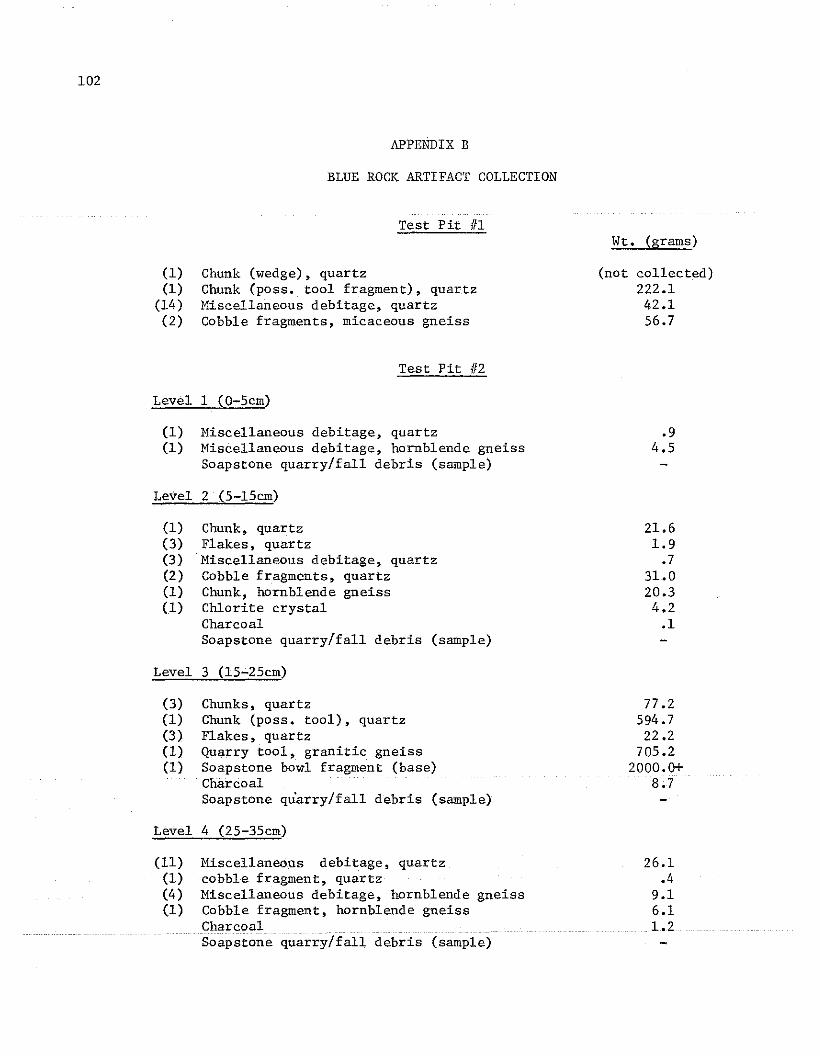
102
APPENDIX B
BLUE ROCK ARTIFACT COLLECTION
Test Pit IIIWt. (grams)
(1)(1)
(14)(2)
Chunk (wedge), quartzChunk (poss. tool fragment), quartzMiscellaneous debitage, quartzCobble fragments, micaceous gneiss
Test Pit 112
(not collected)222.142.156.7
Level 1 (0-5cm)
(1) Miscellaneous debitage, quartz(1) Miscellaneous debitage, hornblende gneiss
Soapstone quarry/fall debris (sample)
Level 2 (5-l5cm)
(1) Chunk, quartz(3) Flakes, quartz(3) Miscellaneous debitage, quartz(2) Cobble fragments, quartz(1) Chunk, hornblende gneiss(1) Chlorite crystal
CharcoalSoapstone quarry/fall debris (sample)
Level 3 (15-25cm)
(3) Chunks, quartz(1) Chunk (poss. tool), quartz(3) Flakes, quartz(1) Quarry tool, granitic gneiss(1) Soapstone bowl fragment (base)
CharcoalSoapstone quarry/fall debris (sample)
Level 4 (25-35cm)
.94.5
21.61.9
.731.020.34.2
.1
77 .2594.7
22.2705.2
2000.0+8.7
Miscellaneous debitage, quartzcobble fragment, quartzMiscellaneous debitage, hornblende gneissCobble fragment, hornblende gneiss
(11)(1)(4)(1)
Soapstone (Juar:cVI debris (sample)
26.1.4
9.16.11.2

General Surface (Select collection)
(1) Flake, brown chert(1) Cobble fragment, g"anitic gneiss(1) Quarry tool, quartz(1) Quarry tool, granitic gneiss(1) Quarry tool fragment, granitic gneiss(1) Quarry tool, micaceous gneiss(2) Quarry tools, hornblende gneiss(2) Quarry tools, amphibolite(3) Soapstone bowl fragments
Tool Cache #1 (Total surface collection)
(1) Chunk, quartz(4) Cobble fragments, quartz(1) Cobble fragment, granitic gneiss(1) Cobble fragment, micaceous gneiss(1) Cobble fragment, hornblende gneiss(1) Cobble fragment, amphibolite(2) Split cobbles, granitic gneiss(1) Quarry tool fragment, quartz(3) Quarry tools, quartz(1) Quarry tool fragment, hornblende gneiss(5) Quarry tools, hornblende gneiss(1) Quarry tool fragment, granitic gneiss(3) Quarry tools, granitic gneiss(3) Quarry tools, micaceous gneiss(1) Quarry tool, amphibolite(1) Knife/scraper, quartzite
Tool Cache #2 (Select collection)
(1) Chunk (poss. quarry tool), gneiss(2) Quarry tools, quartz(3) Quarry tools, hornblende gneiss(2) Quarry tools, micaceous gneiss(1) Quarry tool, granitic gneiss(1) Quarry tool, amphibolite
Wt. (grams)
1.444.6
570.8311.3239.2333.3721.0
1692.91500.0+
74.6613.1165.186.3
110.6103.9
1248.1287.3
1548.6175.5
2250.2176.7
1323.41591.0
556.670.7
269.2664.3
1596.4939.7
320.3
103