cold lake oil sands area: formation picks and correlation ... · (1985, 1986). in alberta, other...
TRANSCRIPT
Cold Lake Oil Sands Area:Formation Picks andCorrelation of AssociatedStratigraphy
EUB/AGS Geo-Note 2006-03
EUB/AGS Geo-Note 2006-03
Cold Lake Oil Sands Area: Formation Picks and Correlation of Associated Stratigraphy
AlbertaEnergyandUtilitiesBoard AlbertaGeologicalSurvey F.Hein,J.Weiss,andH.(Mike)Berhane
January2007

EUB/AGS Geo-Note 2006-03 (January 2007) • ii
©Her Majesty the Queen in Right of Alberta, 2007ISBN# 0-7785-3831-1
The Alberta Energy and Utilities Board/Alberta Geological Survey (EUB/AGS) and its employees and contractors make no warranty, guarantee or representation, express or implied, or assume any legal liability regarding the correctness, accuracy, completeness or reliability of this publication. Any digital data and software supplied with this publication are subject to the licence conditions. The data are supplied on the understanding that they are for the sole use of the licensee, and will not be redistributed in any form, in whole or in part, to third parties. Any references to proprietary software in the documentation, and/or any use of proprietary data formats in this release, do not constitute endorsement by the EUB/AGS of any manufacturer’s product.
If this product is an EUB/AGS Special Report, the information is provided as received from the author and has not been edited for conformity to EUB/AGS standards.
When using information from this publication in other publications or presentations, due acknowledgment should be given to the EUB/AGS. The following reference format is recommended:
Hein, F. Weiss, J., and Berhane, M. (2007): Cold Lake Oil Sands Area: Formation Picks and Correlation of Associated Stratigraphy; Alberta Energy and Utilities Board, EUB/AGS Geo-Note 2006-03.
Published January 2007 by:
Alberta Energy and Utilities BoardAlberta Geological Survey4th Floor, Twin Atria Building4999 – 98th AvenueEdmonton, AlbertaT6B 2X3CanadaTel: (780) 422-3767 (Information Sales)Fax: (780) 422-1918E-mail: [email protected]: www.ags.gov.ab.ca

EUB/AGS Geo-Note 2006-03 (January 2007) • iii
Contents
Acknowledgements ..................................................................................................................................... ivAbstract ........................................................................................................................................................ v1 Introduction .......................................................................................................................................... 12 Previous Work ...................................................................................................................................... 33 Cold Lake Oil Sands Stratigraphy ..................................................................................................... 3 3.1 Stratigraphy and Brief Descriptions of Formations ..................................................................... 6 3.2 Correlation of Formations in the Cold Lake and Surrounding Area ........................................... 74 Summary ............................................................................................................................................... 75 References ............................................................................................................................................. 8
FiguresFigure 1 Map showing historical development of the Clearwater Formation in the Cold Lake oil sands area ........................................................................................................1Figure 2 Cold Lake and surrounding area of northeastern and eastern Alberta assessed for regional nomenclature and correlation, showing the detailed and more regional cross-sections and locations of wells for which picks were made .................................2Figure 3 Sequence stratigraphic model for the east-central and northeastern Alberta subsurface, showing Lloydminster stratigraphy in the south, being replaced by Clearwater and Grand Rapids stratigraphy to the northwest .........................................................................4Figure 4 Schematic illustrating Mannville stratigraphic nomenclature of northeast and east central Alberta, compared with the different T and E surfaces picked in this study .............................................................................................................................................5Figure 5 Type logs from recent resource assessment work at the EUB, showing an interpretation that places the top of the Clearwater Formation just above the T31 marker ...................................................................................................................................5Figure 6 Schematic cross-section of the Clearwater Formation at Cold Lake, Alberta ............................6
TablesTable 1 Definition of picks and quality codes used in the access database included on the CD (modified from Wynne et al., 1994) ................................................................................4
Files on CD1 Stratigraphic picks table in Access database2 Representative digital cross-sections

EUB/AGS Geo-Note 2006-03 (January 2007) • iv
Acknowledgements
The authors thank staff of the Alberta Energy and Utilities Board, Geology and Resources Group (GRG), for assistance during this study, in particular to Nina Sitek who helped with determining protocols for identification of different stratigraphic units, and for discussions on regional correlation. Cathy Baturin-Pollack, also of GRG, helped with core examination and verification of subsurface picks. At the Alberta Geological Survey (AGS), Desmond Wynne is thanked for database conversions and metadata issues; and Maryanne Protz for production assistance. Cal Hill and Andrew Beaton are acknowledged for their critical reviews of an earlier version of this report. Managers, most notably Andrew Beaton and Rick Richardson at the AGS Office in Edmonton, and Joe MacGillivray and Rick Marsh at the EUB Office in Calgary, are thanked for their encouragement and support of this work.

EUB/AGS Geo-Note 2006-03 (January 2007) • v
Abstract
This preliminary assessment of regional stratigraphy of the Cold Lake oil sands area involved a comprehensive literature review, followed by detailed picking of logs, construction of a grid of cross-sections, and assembling of a database of regional picks for the area. At least four major transgressive surfaces subdivide the Clearwater (in ascending order): • the T31, marking the top of the Clearwater C; • the T41 the top of the Clearwater B; • the T51, a surface below the top of the Clearwater A; and• the T61, the top of the Clearwater A.
Each of these T surfaces is a transgressive surface of erosion and indicates a transgression of the Clearwater Sea and the base of a more regionally mappable, coarsening-upward, shallow-marine succession. In the sequence-stratigraphic model, the various units clinoform-downsection from Lloydminster in the south to Athabasca in the north. Each of the original shoreline successions, near the Cold Lake oil sands/Lloydminster heavy-oil contact, is the result of a fall in relative sea level, followed by cut and backfill of associated estuarine incised valley-fills. The estuarine incised valley-fills terminate northward (seaward), discharging into lowstand delta lobe, shoreface and submarine non-deltaic lobes in areas of low accommodation space. Further detailed work in the Cold Lake oil sands deposit will reconcile differences in correlation and definition of formation tops used by various workers in the study area.

EUB/AGS Geo-Note 2006-03 (January 2007) • �
� Introduction
This is a preliminary assessment of regional stratigraphy of the oil sands in the Cold Lake (Figure 1) and surrounding area (Figure 2). Part of this study was to conduct a literature review as background work to the regional assessment (see next section). This was followed by detailed picking of logs, construction of a grid of cross-sections, and creation of a database of regional picks for the area. The aim of this project was to assess stratigraphic nomenclature and to do regional correlation that would ultimately help in booking of oil sands and heavy oil reserves in the area by formation. This work arose out of need for the Alberta Energy and Utilities Board (EUB) to have an assessment of areas in the northeastern/east-central part of Alberta, where nomenclature regarding stratigraphy in the Cold Lake oil sands in some areas followed schemes developed for the north in the Clearwater–Grand Rapids successions, whereas other areas followed schemes developed for the south in the Lloydminster–Grand Rapids successions. In addition, there is a current need to place the various in situ schemes being developed in Cold Lake into a geological framework to assist the EUB in its review of in situ applications and submissions.
Figure1.MapshowinghistoricaldevelopmentoftheClearwaterFormationintheColdLakeoilsandsarea.Symbols:lightstippled,ImperialOil’sColdLakeHistoricLeases;diagonalhachured,maindevelopmentareas;heavilystippled,lakes(fromCheadleetal.,1995).

1
1'
11
11'
12
12'
1313'
14
14'
15
15'
16
16'
17
17'
18
18'
1919'
20
20'
21 21'
2
2'
22
22'
23
23'
24
24'
25
25'
26
26'
27
27'
2828'
29
29'
3030'
31
31'
9
9'
8
8'
7
7'
6
6'
5
5'
4
4'
32
32'
3
3'
33
33'10
10'
T58
T62
T64
T66
T68
T70
T72
R1W4R5W4R10W4
T60
Figure 2. Cold Lake and surrounding area of northeastern and eastern Alberta assessed for regional nomenclature and correlation, showing the detailed and more regional cross-sections and locations of wells for which picks were made (included as files on CD).
EUB/AGS Geo-Note 2006-03 (January 2007) • 2

EUB/AGS Geo-Note 2006-03 (January 2007) • 3
2 Previous Work
Regional overviews of the geology of the area include Glaister (1959), Jackson (1984), Mellon (1967), Outtrim and Evans (1978), and Williams (1963). Detailed work on bedrock stratigraphy includes the original work by Badgley (1952) and Glaister (1959), which were updated by Green and others (1970) in their bedrock map of northern Alberta. Lloydminster stratigraphy was originally defined by Wickenden (1948), with revisions by Kent in 1959. Regional correlation between the McMurray and Clearwater formations was done by McPhee (1987, 1994). Further finer-scale subdivision of the internal stratigraphy of the Cold Lake oil sands was done by Mattison (1991), with a contrasting model for the Clearwater Formation used by Imperial at Cold Lake (cf. Cheadle et al., 1995; McCrimmon, 1996; McCrimmon and Cheadle, 1997; McCrimmon and Arnott, 2002; Feldman et al., 2003 ).
Comparisons between the ichnology of brackish water deposits in Cold Lake and Lloydminster are given by Pemberton and Wightman (1994), largely based on the original work of Wightman and Berezniuk (1985, 1986). In Alberta, other stratigraphic, paleontological and paleoenvironmental studies include Clack (1967), Williams and Stelck (1975), Stelck and Kramers (1980), and Mattison and Wall (1993). Regional stratigraphy, sedimentology and petroleum geology has been assessed of the Grand Rapids Formation in the northeastern and east-central Alberta (Beynon et al., 1988; Beynon, 1991; Cant and Abrahamson (1997), and of the Clearwater Formation in the Leismer area (Maher, 1989). Most recently, stratigraphy of the Colorado Group in the Cold Lake oil sands area has been revised by Tu et al. (2006). Detailed reservoir description and mineralogical analysis was conducted by a number of workers mainly to assess in situ technologies for the recovery of bitumen from Cold Lake and Primrose (Schooley, 1975; Bayliss and Levinson, 1976; Kendall, 1977; Harrison et al., 1981; Sedimentology Research Group, 1981; Putnam and Pedskalny, 1983; Waywanko, 1984; Kirk et al., 1987; Wightman and Kirk, 1987; Hutcheon et al., 1988, 1989; Visser et al., 1988; Racki, 1991; Wickert, 1992; McKay and Longstaffe, 1997). Engineering reviews concerning processes for in situ recovery of bitumen at Cold Lake include Adegbesan et al. (1991), Sharpe et al. (1997) Donnelly (1999, 2000), Zhou et al. (1999) and Smith et al. (2003). Most recently, the Alberta Energy and Utilities Board (2003) in its Regional Geological Study of the Athabasca Oil Sands has redefined the stratigraphy in the subsurface of Athabasca South, and some of these units have been carried into the subsurface of North Cold Lake (Nina Sitek, pers. comm., 2006). Younger, overlying drift thickness and stratigraphy was addressed by Parks (2001) and Parks et al. (2005) as part of regional groundwater resource appraisals in the Athabasca and Cold Lake oil sands in situ areas.
3 Cold Lake Oil Sands Stratigraphy
A full historical review of stratigraphic nomenclature for Lower Cretaceous and lower Upper Cretaceous units associated with the oil sands and heavy oil deposits in Alberta is given by Schooley (1975), with updating of units into a sequence stratigraphic framework by Mattison (1991), Wickert (1992) Cant and Abrahamson (1997), (Figure 3). In the sequence-stratigraphic model, various units clinoform downsection from Lloydminster in the south, to Athabasca in the north. Each of the original shoreline successions near Lloydminster and the southern part of Cold Lake is the result of a fall in relative sea level, as shown by the associated incised valley-fills. The incised valley-fills terminate northward (seaward), discharging into lowstand shoreface, delta lobe and submarine lobes not associated with deltas, in areas of low accommodation space (cf. Cant and Abrahamson, 1997; Feldman et al., 2003).
EUB/AGS Geo-Note 2006-03 (January 2007) • �
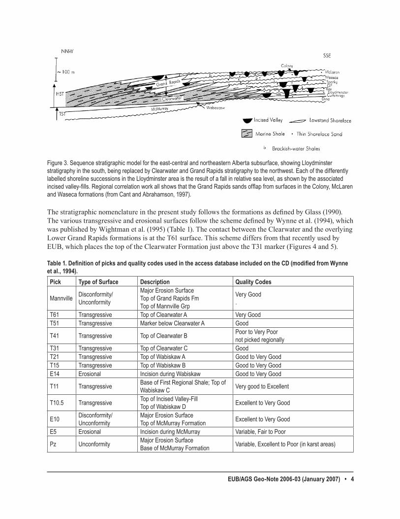
The stratigraphic nomenclature in the present study follows the formations as defined by Glass (1990). The various transgressive and erosional surfaces follow the scheme defined by Wynne et al. (1994), which was published by Wightman et al. (1995) (Table 1). The contact between the Clearwater and the overlying Lower Grand Rapids formations is at the T61 surface. This scheme differs from that recently used by EUB, which places the top of the Clearwater Formation just above the T31 marker (Figures 4 and 5).
Table 1. Definition of picks and quality codes used in the access database included on the CD (modified from Wynne et al., �99�). Pick Type of Surface Description Quality Codes
Mannville Disconformity/Unconformity
MajorErosionSurfaceTopofGrandRapidsFmTopofMannvilleGrp
VeryGood.
T61 Transgressive TopofClearwaterA VeryGoodT51 Transgressive MarkerbelowClearwaterA Good
T41 Transgressive TopofClearwaterB PoortoVeryPoornotpickedregionally
T31 Transgressive TopofClearwaterC GoodT21 Transgressive TopofWabiskawA GoodtoVeryGoodT15 Transgressive TopofWabiskawB GoodtoVeryGoodE14 Erosional IncisionduringWabiskaw GoodtoVeryGood
T11 Transgressive BaseofFirstRegionalShale;TopofWabiskawC VerygoodtoExcellent
T10.5 Transgressive TopofIncisedValley-FillTop of Wabiskaw D ExcellenttoVeryGood
E10 Disconformity/Unconformity
MajorErosionSurfaceTopofMcMurrayFormation ExcellenttoVeryGood
E5 Erosional IncisionduringMcMurray Variable,FairtoPoor
Pz Unconformity MajorErosionSurfaceBaseofMcMurrayFormation Variable,ExcellenttoPoor(inkarstareas)
Figure3.Sequencestratigraphicmodelfortheeast-centralandnortheasternAlbertasubsurface,showingLloydminsterstratigraphyinthesouth,beingreplacedbyClearwaterandGrandRapidsstratigraphytothenorthwest.EachofthedifferentlylabelledshorelinesuccessionsintheLloydminsterareaistheresultofafallinrelativesealevel,asshownbytheassociatedincised valley-fills. Regional correlation work all shows that the Grand Rapids sands offlap from surfaces in the Colony, McLaren andWasecaformations(fromCantandAbrahamson,1997).

EUB/AGS Geo-Note 2006-03 (January 2007) • 5
Figure 4. Schematic illustrating Mannville stratigraphic nomenclature of northeast and east central Alberta, compared with the different T and E surfaces picked in this study (shown in blue on the right hand side) (modifi ed from Mattison, 1991).
This Study
T61T51T31T21
E10
Pz
Mannville Top
Devonian
Grand Rapids
Clearwater
McMurray
Wabiskaw Mbr
This Study
T61T51T31T21
E10
Pz
Mannville Top
Devonian
Grand Rapids
Clearwater
McMurray
Wabiskaw Mbr
Clearwater Geology and Resources 11
Type LogsType Logs• AA/06-20-066-03W4/0• AA/06-08-065-04W4/0
Upper Grand Rapids
Lower Grand Rapids
Clearwater Fm
Clearwater sand (T31)
McMurray Fm (E10)
Paleozoic
Wabiskaw ShaleWabiskaw C (T11)
?
Figure 5. Type logs from recent resource assessment work at the EUB, showing an interpretation that places the top of the Clearwater Formation just above the T31 marker. This differs from the scheme used here that places the top of the Clearwater Formation at the T61 surface (cf. Table 1) (diagram courtesy of Nina Sitek).

EUB/AGS Geo-Note 2006-03 (January 2007) • 6
In mapping the units in the Cold Lake and surrounding areas, it was necessary to identify the various T and E surfaces outside of the main areas of valley-incision (Figure 6), where more regional stratigraphy is preserved, then work in, well-by-well, to the Cold Lake oil sands proper area (Figure 1). One has to work within the context of the regional transgressive surfaces first, tying in the regional erosional surfaces to one another, to unravel the complex stratigraphy in areas of multistacked erosional cut and fills (Figure 6). A similar approach was done by other workers (cf. Mattison, 1991; Cant and Abrahamson, 1997), who also identified links between the regional transgressive surface of erosion (T) and the major unconformities (erosional E surfaces) and incised valley-fills.
3.� Stratigraphy and Brief Descriptions of Formations
The Clearwater Shale of the Mannville Group was originally defined by McConnell in 1893, which was raised to formation status by McLearn (1917). In this original work, the Clearwater Formation was identified as those black and greenish grey shales, with interbedded grey and green lithic sands, and some siderite concretions. In the Cold Lake area, in particular, it was noted that the sands thicken to more continuous, lithic, salt-and-pepper sands interbedded with glauconitic sands and shales, with original bitumen resources estimated at 40.3 x 10⁹ bbl (Outtrim and Evans, 1978). Carrigy (1963) later outlined criteria for differentiating the McMurray and Clearwater formations in the Athabasca Oil Sands deposit.
The Cold Lake oil sands lie within a package of stacked incised valleys that lie encased within more regional deltaic, shoreface sands and marine muds (Figures 3 and 6). These overlie the fluvial and estuarine units of the Wabiskaw-McMurray succession that host the oil sands in the Athabasca deposit. The Clearwater Formation is overlain by regional deltaic, progradational barrier complexes and incised valley-fills of the Lower and Upper Grand Rapids Formation, which extends to the top of the Mannville Group (Figures 3, 4 and 6).
Figure6.Schematiccross-sectionoftheClearwaterFormationatColdLake,Alberta.Sixdepositionalsequences(ClearwaterAthroughF)areboundedbysequenceboundariesproducedduringvalleyincisions.Symbols:white,proximalsubtidalestuarinefill; diagonal hachured, distal estuarine fill; heavily stippled, open marine sediments. Total thickness of the Clearwater Formation isapproximately50to75metres(fromCheadleetal.,1995).

EUB/AGS Geo-Note 2006-03 (January 2007) • 7
At least four major transgressive surfaces subdivide the Clearwater (in ascending order): • the T31, marking the top of the Clearwater C; • the T41, the top of the Clearwater B; • the T51, a surface below the top of the Clearwater A; and • the T61, the top of the Clearwater A.
Each of these T surfaces is a transgressive surface of erosion and indicates a transgression of the Clearwater Sea and the base of a more regionally mappable, coarsening-upward, shallow-marine succession. In the sequence-stratigraphic model, the various units clinoform-downsection from Lloydminster in the south to Athabasca in the north. Each of the original shoreline successions, near the Cold Lake oil sands/ Lloydminster heavy-oil contact, is the result of a fall in relative sea level, followed by cut and backfill of associated estuarine incised valley-fills. The estuarine incised valley-fills terminate northward (seaward), discharging into lowstand delta lobe, shoreface and submarine non-deltaic lobes in areas of low accommodation space.
3.2 Correlation of Formations in the Cold Lake and Surrounding Area
Figure 2 shows the locations of 52 cross-sections completed in the study area as of March 27, 2006. The digital cross-sections and picks are included on the CD. The results of this work show there are some areas of variable stratigraphy (cross-sections 1-1’ to 9-9’), contrasting with other areas that show more consistent stratigraphy (cross-sections 11-11’ to 46-46’). In addition, the more regional cross-sections show broad interfingering of the different stratigraphic units that change from north to south, or northwest to southeast. These relationships most likely indicate the true interfingering of the various fluvial, estuarine and marine packages that, in general, show downward clinoforming to the north-northwest. Similar regional variations in stratigraphy were noted by Mattison (1991), McPhee (1994), and Cant and Abrahamson (1997) concerning the relationships between the Lower and Upper Mannville successions of east-central and northeast Alberta subsurface. The detailed correlation and regional picking of different stratigraphic units show that there are regionally consistent packages within the Clearwater, and overlying, Grand Rapids successions in the Cold Lake area, and that these can be consistently mapped and correlated. However, what is not clear is why the present scheme, at a finer scale of resolution, differs from that used recently by the EUB in its resource assessment of the Cold Lake project area (Townships 59 to 70, Ranges 1 to 13 West of the 4th Meridian). This issue will be addressed by further ongoing work at the EUB that ties in the different in situ thermal project areas to the larger scale geological framework presented here.
� Summary
This study describes the Clearwater Formation to regionally mappable transgressive surfaces of erosion (T-surfaces) that can be correlated throughout the Cold Lake oil sands and surrounding areas of northeastern and east central Alberta subsurface. The top of the Clearwater, at its contact, with the overlying Grand Rapids Formation is placed at the T61 surface. This contrasts with recent work being done in resource assessment by the EUB that places the top of the Clearwater Formation lower down section, just above the T31 surface. Further detailed work in the Cold Lake oil sands deposit will reconcile these differences in correlation and definition of formation tops.

EUB/AGS Geo-Note 2006-03 (January 2007) • �
� References
Adegbesan, D., Leaute, R.P. and Courtnage, D.E. (1991): Performance of a thermal horizontal well pilot; in Proceedings, Society of Petroleum Engineers (SPE), 68th Annual Technical Conference, Dallas, TX, SPE Paper 22892, 41 p.
Alberta Energy and Utilities Board (2003): Athabasca Wabiskaw-McMurray Regional Geological Study; Alberta Energy and Utilities Board Report, 187 p.
Badgley, P.C. (1952): Notes on the subsurface stratigraphy and oil and gas geology of the Lower Cretaceous series in ventral Alberta; Geological Survey of Canada, Paper 52-11, 12 p.
Bayliss, P. and Levinson, A.A. (1976): Mineralogical review of the Alberta oil sands deposits (Lower Cretaceous, Mannville Group); Bulletin of Canadian Petroleum Geology, v. 24, p. 211-224.
Beynon, B.M. (1991): Sedimentology and petroleum geology of the Lower Cretaceous Grand Rapids Formation, Cold Lake oil sands area, Alberta; M.Sc. thesis, University of Alberta, 267 p.
Beynon, B.M., Pemberton, S.G., Bell, D.D. and Logan, C.A. (1988): Environmental implications of ichnofossils from the Lower Cretaceous Grand Rapids Formation, Cold Lake oil sands deposit; in: Sequences, Stratigraphy, Sedimentology: Surface and Subsurface, D.P. James and D.A. Leckie (ed.), Canadian Society of Petroleum Geologists, Memoir 15, p. 275-290.
Cant, D.J. and Abrahamson, B. (1997): Regional stratigraphy, sedimentology and petroleum geology of the Grand Rapids Formation, Mannville Group, northeastern Alberta; Bulletin of Canadian Petroleum Geology, v. 45 (2), p. 141-154.
Carrigy, M.A. (1963): Criteria for differentiating the McMurray and Clearwater formations in the Athabasca Oil Sands; Research Council of Alberta, Alberta Geological Survey, Bulletin 14, 32 p.
Cheadle, B.A., Dudley, J.S., Eastwood, J.E., Lovell, R.W.W., Reed, K.W., Stancliffe, R.P.W. and Van Wagoner, J.C. (1995): Integrated reservoir description for resource management at Cold Lake, Alberta; in Proceedings, Exploration, Evaluation, and Exploitation 1995, The Economic Integration of Geology and Formation Evaluation, Canadian Society of Petroleum Geologists/Canadian Well Logging Society (CSPG/CWLS) Joint Symposium, Core Conference, June 1-2, Calgary, 14 p.
Clack, W.J.F. (1967): Sedimentology of the Mannville Group in the Cold Lake area; M.Sc. thesis, University of Calgary, 95 p.
Donnelly, J.K. (1999): Hilda Lake a gravity drainage success; in Proceedings, Society of Petroleum Engineers (SPE) International Thermal Operations and Heavy Oil Symposium, Bakersfield, CA, SPE Paper 54093, p. 131-137.
Donnelly, J.K. (2000): The best process for Cold Lake: CSS vs. SAGD; Journal of Canadian Petroleum Technology, Technical Note, v. 39 (8), p. 5-7.
Feldman, H., de Freitas, T., Cheadle, B. and McCrimmon, G. (2003): Incised valleys without lowstand deltas: examples from the Clearwater Formation at Cold Lake, Alberta, Canada; American Association of Petroleum Geologists, Program with Abstracts, p. A52.
Glaister, R.P. (1959): Lower Cretaceous of southern Alberta and adjacent areas; American Association of Petroleum Geologists, Bulletin 43, p. 590-640.
Glass, D.J., ed. (1990): Lexicon of Canadian stratigraphy volume 4 Western Canada, including eastern British Columbia, Alberta, Saskatchewan and southern Manitoba; Canadian Society of Petroleum Geologists, 772 p.

EUB/AGS Geo-Note 2006-03 (January 2007) • 9
Green, R., Mellon, G.B. and Carrigy, M.A. (1970): Bedrock geology of northern Alberta, NTS 74D, 74E, 74L and 74M; Alberta Research Council, Alberta Geological Survey, Map 24, scale 1:50 000.
Harrison, D.B., Glaister, R.P. and Nelson, H.W. (1981): Reservoir description of the Clearwater oil sands, Cold Lake, Alberta, Canada; in The Future of Heavy Crude and Tar Sands, R.F. Meyer, and C.T. Steele (ed.), McGraw-Hill, New York, p. 264-279.
Hutcheon, I., Ambercrombie, H.J., Putnam, P., Garner, R. and Krouse, H.R. (1989): Diagenesis and sedimentology of the Clearwater Formation at Tucker Lake; Bulletin of Canadian Petroleum Geology, v. 37, p. 83-97.
Hutcheon, I., Ambercrombie, H., Shevalier, M. and Nahnybida, C. (1988): A comparison of formation reactivity in quartz-rich and quartz-poor reservoirs during steam assisted recovery; in Proceedings, 4th UNITAR/UNDP Conference on Heavy Crude and Tar Sands, Edmonton, Paper 235, 12 p.
Jackson, P.C. (1984): Paleogeography of the Lower Cretaceous Mannville Group of Western Canada; in Elmworth – A case study of a deep basin gas field, J.A. Masters, (ed.), American Association of Petroleum Geologists, Memoir 38, p. 49-77.
Kendall, G.H. (1977): Importance of reservoir description in evaluating in situ recovery methods for Cold Lake heavy oil, part 1 – reservoir description; Bulletin of Canadian Petroleum Geology, v. 25, p. 314-327.
Kent, D.M. (1959): The Lloydminster oil and gas field, Alberta; M.Sc. thesis, University of Saskatchewan, 56 p.
Kirk, J.S., Bird, G.W. and Longstaffe, F.J. (1987): Laboratory study of the effects of steam-condensate flooding in the Clearwater Formation: high temperature flow experiments; Bulletin of Canadian Petroleum Geology, v. 35 (1), p. 34-47.
Maher, J.B. (1989): Geometry and reservoir characteristics, Leismer Clearwater “B” gas field, northeast Alberta: case studies in Canadian Petroleum Geology; Bulletin of Canadian Petroleum Geology, v. 37 (2), p. 236-240.
Mattison, B.W. (1991): Stratigraphic and paleoenvironmental analysis of the Upper and Middle Mannville sub-groups: Cold Lake oil sands area, east-central Alberta; Ph.D. thesis, University of Alberta, 669 p.
Mattison, B.W. and Wall, J.H. (1993): Early Cretaceous foraminifera from the Middle and Upper Mannville and Lower Colorado subgroups in the Cold Lake oil sands areas of east-central Alberta: stratigraphic and paleoenvironmental implications; Canadian Journal of Earth Sciences, v. 30, p. 94-102.
McConnell, R.G. (1893): Report on a portion of the district of Athabasca, comprising the country between Peace River and Athabasca River north of Lesser Slave Lake; Geological Survey of Canada, Annual Report (new series) 1890-91, v. 5 (1), p. 1-67.
McCrimmon, G.G. (1996): Sedimentology and sequence stratigraphy of the Lower Cretaceous Clearwater Formation, Cold Lake, Alberta; M.Sc. thesis, University of Ottawa, 281 p.
McCrimmon, G.G. and Arnott, R.W.C. (2002): The Clearwater Formation, Cold Lake, Alberta: a world class hydrocarbon reservoir hosted in a complex succession of tide-dominated deltaic deposits; Bulletin of Canadian Petroleum Geology, v. 50 (3), p. 370-392.
McCrimmon, G.G. and Cheadle, B.A. (1997): Tidal-fluvial facies of stacked incised-valley complexes in the Lower Cretaceous Clearwater Formation, Cold Lake, Alberta; in Core Conference Proceedings, J. Wood and B. Martindale (ed.), Canadian Society of Petroleum Geologists and Society of Economic Paleontologists and Mineralogists (CSPG/SEPM), Joint Convention, Calgary, p. 335-354.
EUB/AGS Geo-Note 2006-03 (January 2007) • �0
McKay, J.L. and Longstaffe, F.J. (1997): Diagenesis of the Lower Cretaceous Clearwater Formation, Primrose area, northeastern Alberta; in Petroleum geology of the Cretaceous Mannville Group, Western Canada, S.G. Pemberton and D.P. James (ed.), Canadian Society of Petroleum Geologists, Memoir 18, p. 392-412.
McLearn, F.H. (1917): Athabasca River section, Alberta; Geological Survey of Canada, Summary Report 1916, p. 145-151.
McLearn, F.H. (1933): Pelecypods of the Lower Cretaceous Clearwater Formation, northern Alberta; Transactions of the Royal Society of Canada, v. 27(4), p. 139-159.
McPhee, D. (1987): Stratigraphy, facies distribution, and structure of the Lower Cretaceous McMurray and Clearwater formations in Tp. 64-83, R 1-11W4M, in the context of Mannville Group stratigraphy in Tp 54-83, 4th–5th Meridian; B.Sc. thesis, University of Waterloo, 153 p.
McPhee, D. (1994): Sequence stratigraphy of the Lower Cretaceous Mannville Group of east-central Alberta; M.Sc. thesis, University of Alberta, 65 p.
Mellon, G.B. (1967): Stratigraphy and petrography of the Lower Cretaceous Blairmore and Mannville Groups, Alberta Foothills and Plains; Alberta Research Council, Alberta Geological Survey, Bulletin 21, 270 p.
Minken, D.K. (1974): The Cold Lake oil sands: geology and reserve estimate, in Oil Sands, Fuel of the Future, L.V. Hills, (ed.), Canadian Society of Petroleum Geologists, Memoir 3, p. 84-99.
Outtrim C.P. and R.G. Evans (1978): Alberta’s oil sands reserves and their evaluation, in The Oil Sands of Canada-Venezuela, D.A. Redford and A.G. Winestock (ed.), Canadian Institute Mining and Metallurgy, Special Volume 17, p. 36-66.
Parks, K.P. (2001): Tectonostratigraphy, water-source and water-injection potential of the Clearwater Formation, Athabasca oilsands (in situ) area, Alberta; in Proceedings, Annual Convention, Canadian Society of Petroleum Geology, p. 427-438.
Parks, K., Andriashek, L.D., Michael, K., Lemay, T., Stewart, S., Jean, G. and Kempin, E. (2005): Regional groundwater resource appraisal, Cold Lake-Beaver River drainage basin, Alberta; Alberta Energy and Utilities Board, EUB/AGS Special Report 74, 157 p.
Pemberton, S.G. and Wightman, D.M. (1994): Ichnological characteristics of brackish water deposits: examples from the Mannville Group of Alberta; in Mannville Core Conference, Canadian Society of Petroleum Geologists, Proceedings, Calgary, p. 95-110.
Putnam, P.E. and Pedskalny, M.A. (1983): Provenance of Clearwater Formation reservoir sandstones: Cold Lake, Alberta, with comments on feldspar composition; Bulletin of Canadian Petroleum Geology, v. 31, p. 148-160.
Racki, M. (1991): Diagenesis of the Clearwater Formation, Cold Lake, Alberta; M.Sc. thesis, University of Western Ontario, 250 p.
Schooley, J.V. (1975): A study of the mineralogy of Lower Cretaceous Mannville Group oil sand deposits, Alberta and west central Saskatchewan; M.Sc. thesis, University of Calgary, 134 p.
Sedimentology Research Group (1981): The effects of in situ steam injection on Cold Lake oil sands; Bulletin of Canadian Petroleum Geology, v. 29 (4), p. 447-478.
Sharpe, J.A., Shinde, S.B. and Wong, R.C. (1997): Cold Lake borehole mining; Journal of Canadian Petroleum Technology, v. 36 (1), p. 58-63.
EUB/AGS Geo-Note 2006-03 (January 2007) • ��
Smith, R.J., Bacon, R.M., Boone, T.J. and Kry, P.R. (2003): Cyclic steam stimulation below a known hydraulically induced shale fracture; Society of Petroleum Engineers, v. 43 (2), p. 39-45.
Stelck, C.R. and Kramers, J.W. (1980): Freboldiceras from the Grand Rapids Formation, north-central Alberta; Bulletin of Canadian Petroleum Geology, v. 28, p. 509-521.
Tu, Q., Schroder-Adams, C.J. and Craig, J. (in press): A new lithostratigraphic framework for the Cretaceous Colorado Group in the Cold Lake heavy oil area, east-central Alberta, Canada; Journal of Natural Resources Research, 30 p.
Visser, D., Dankers, P.H.M., Leckie, D. and Van der Marel, A.G.P. (1988): Mineralogy and geology of the Clearwater reservoir sands in the Wolf Lake, Cold Lake area, Alberta; in Third UNITAR/UNDP International Conference on Heavy Crude and Tar Sands, R.F. Meyer, (ed.), Alberta Oil Sands and Technology Research Authority, p. 118-133.
Waywanko, A.O. (1984): Sedimentology and geophysical well log analysis of the Clearwater Formation (Lower Cretaceous), Cold Lake, Alberta; M.Sc. thesis, University of Alberta, 75 p.
Wickenden, R.T.D. (1948): The Lower Cretaceous of the Lloydminster oil and gas area, Alberta and Saskatchewan; Geological Survey of Canada, Paper, 48-21, 15 p.
Wickert, L.M. (1992): Sequence stratigraphy, diagenesis, and hydrogeology of the Lower Cretaceous Clearwater Formation, Cold Lake oil sands deposit, east-central Alberta, Canada; M.Sc. thesis, University of Alberta, 365 p.
Wightman, D.M. and Berezniuk, T. (1985): Resource characterization of the Clearwater Formation, Cold Lake oil sands deposit, east-central Alberta; Alberta Oil Sands and Technology Research Authority/Alberta Research Council, Agreement Report 158B, 37 p.
Wightman, D.M. and Berezniuk, T. (1986): Resource characterization and depositional modeling of the Clearwater Formation, Cold Lake oil sands deposit, east-central Alberta; in Proceedings of the DOE Tar Sand Symposium, U.S. Department of Energy, Jackson, WO, 28 p.
Wightman, D.M. and Kirk, J.S. (1987): Sedimentology and mineralogy of the Clearwater Formation, Wells 7B-14-67-3W4 and 14B-14-67-3W4; Alberta Research Council, Alberta Geological Survey, internal report, 23 p.
Wightman, D.M., Attalla, M.N., Wynne, D.A., Strobl, R., Berhane, H., Cotterill, D.K. and Berezniuk, T. (1995): Resource characterization of the McMurray/Wabiskaw deposit in the Athabasca Oil Sands area: a synthesis; Alberta Oil Sands and Technology Research Authority, Technical Publication Series 10, 220 p.
Williams, G.D. (1963): The Mannville Group (Lower Cretaceous) of central Alberta; Bulletin of Canadian Petroleum Geology, v. 11, p. 350-368.
Williams, G.D. and Stelck, C.R. (1975): Speculations on the Cretaceous palaeogeography of North America; in The Cretaceous System in the Western Interior of North America, W.G.E. Caldwell (ed.), Geological Association of Canada, Special Paper 13, p. 1-20.
Wynne, D., Attalla, M., Berhane, H., Brulotte, M., Cotterill, D.K., Strobl, R. and Wightman, D.M. (1994): Athabasca Oil Sands database: McMurray/Wabiskaw deposit; Alberta Research Council, Alberta Geological Survey, Open File Report 1994-14, 44 p.
Zhou, Z., Wiwchar, B., Gunter, W.D. and Dudley, J.S. (1999): The potential of permeability damage during thermal recovery of Cold Lake bitumen; Journal of Canadian Petroleum Technology, v. 38 (9), p. 55-60.