coke caiooic asaic ocaoes i o queesa · coke caiooic asaic ocaoes i o queesa ... oe mcie asa ^ 6...
TRANSCRIPT


I.
COKE CAINOZOIC BASALTIC VOLCANOES IN NORTH QUEENSLAND
ISTTREAUOPIVIINERALRESOIS
J. G. Best^GEOPHYSICAL Livc.',RtV-Pfs
49...........^ ......................
SUMMARYINTRODUCTION
PREVIOUS INVESTIGATIONS
McBRIDE BASALT PROVINCE
Page 1
2
4
5
by
Records 1960/78
CONTENTS.
Age of the Basalts^ 6Older McBride Basalt^ 6Newer McBride Basalt^ 7Undara Basalt^ 7
iiH Racecourse Knob^ 7(^Chubber's Hill, Razorback
and Round Hill^ 7(iii Undara Crater^ 7(iv Murronga Crater^ 7
Kinrara Basalt^ 8Age of the Volcanoes^ 8Types of Volcanoes^ 8
iiH Shield Volcanoes^ 8(Pit Craters^ 8
Kinrara Crater^ 9Undara Crater^ 9
(iii)Scoria Cones^ 10(iv) Composite Cones^ 10
Features of the Basalts^ 11(i) Kinrara Basalt^ 11111a) The edge of the flowb) Sinks^ 11c) Depressions^ 11d) Rectangular favements and
Pressure Ridges^ 12(ii) The older basalts^ 12
N) Lava Tunnels 12) Lava Tongues 13WALLAROO BASALT PROVINCE 13
ATHERTON BASALT PROVINCE^ 13
Age of the Basalts^ 14Basaltic Pyroclasts^ 14
The information contained in this report hasbeen obtained by the Department of National Developmentas part of the policy of the Commonwealth Government, toassist in the exploration and development of mineralresources. It may not be published in any form or usedin a company prospectus or statement without the permissionin writing of the Director, Bureau of Etineral Resources,Geology and Geophysics.^
2/..

(ii)Contents Page
Explosion Craters^ 15iiH Bromfield Swamp^ 15(Lynch's Crater^ 15
(iii) Lake Eacham^ 15(iv Lake Barrine^ 15(v Lake Euramo 15Diatreme 15Scoria Cones(i) Mt. Quincan(ii) The Seven Sisters
Shield VolcanoBones Knob
Composite VolcanoesMt. WeerimbaGlen Allyn Crater
DISTRIBUTION OF THE VOLCANOES
(i) McBride Province^ 16(ii) Wallaroo Province^ 16
(iii) Atherton Province^ 17
RELATIONSHIP TO rLUTONS^ 17CONCLUSION^ 17ACKNO^MEN T S^ 17REFERENCES
^
^ 18
FIGURES AND PLATE
Figure 1 : Racecourse Knob, a shield volcano,viewed from the the north-west.
2 : The Tabletops, viewed from Mt. Munana.3 : View south-east across Kinrara Crater,4^View north-west across Kinrara Crater.5 : Part of the throat of Kinrara Crater.
!t^6 : Part of the wall of Kinrara Crater.7 : Basalt spatter in Kinrara Crater.8 : A "sink" in Kinrara Basalt Flow in OB Creek.9 : Pahoehoe basalt, Kinrara Flow, OB Creek.10 : Diatomite deposit in Wyandotte Creek.
11^11 : Air photograph of Kinrara Crater.
12 : Air photograph of Mt. Munana and the Tabletops.13 : Air Photograph of part of Undara Lava Tunnel.14 : View south-east across Bones Knob.15 : Lake Eacham from the air.16^Mt. Quincan from the air.
Plate 1 : Map showing the Cainozoic Basalts of theCairns Hinterland.
1616161616161616
16

SOME CAINOZOIC BASALTIC VOLCANOES INNORTH QUEENSLAND Sr
by
J.G. Best
SUtriMARY.
Tertiary basalt covers more than two and a halfthousand square miles of an area in North Queensland betweenlatitudes 17 and 19 degrees South, and longitudes 144 and146 degrees East.
The area is on the western side of the TasmanGeosyncline and has been the site of much igneous activityin upper Precambrian, upper Palaeozoic/lower Mesozoic, andTertiary times.^There are extensive outcrops of Proter-ozoic granite, Carboniferous granite and rhyolite, Permiangranite and rhyolite, and ?Triassic rhyolite dyke-swarms;and their emplacement appears to have been largely controlledby linear and ring-fractures; the linear fractures havedeveloped mainly within the site of the geosyncline, andthe ring-fractures mainly within the confines of the Pre-cambrian basement.
Basic lava extrusion began in the ?Upper Mioceneand continued intermittently until Recent time ^The lava
. is mainly olivine basalt, commonly iddingsitised, and waserupted through many vents.^The basalt has been mapped asthree provinces, ranging in area from tHrty squclre miles totwo thousand square miles; one hundred and nine vents havebeen recognised in the largest province, two vents in thesmallest, and twenty four vents in the third province.
The basalt in the largest and in the smallestprovinces was all effusively erupted; in contrast, inthe third province, late stage explosive activity hasmantled the flows with up to one hundred feet of basalticpyroclasts.
Within the largest province there are at leastthree shield volcanoes, and they have omitted much of thebasalt; but a considerable amount of lava was also eruptedfrom pit craters, fed into lava tunnels and ducted longdistances; one tunnel has been traced for about twentyfour miles.^Numerous scoria cones dot the surface of theprovince, but there are no pyroclastic deposits, the'youngest crater within the ?rovince (probably Historical)is a pit crater and contains abundant relics of its formerlava-lake; siliceous sublimation products adhering to .the inner walls of the crater testify to its youth. TheVolcanoes in this province are grouped in the region of thecontact between Archaean metamorphics and intrusive granites;the older granite is Proterozoic and the younger graniteis upper Palaeozoic.
The northern province is a confined lava fieldof about five hundred square miles, and contains fourexplosion c,aters; it is thought that the eruptions whichproduced the mantle of pyroclastics were mainly phroatic.
Sr This paper was prepared for presentation at the Helsinkimeeting (1960) of the International Union of Geodesy andGeophysics.
. a

•
There is one diatrelfLe, in granite, on the western side ofthis province.^Differential vertical movement on faultstrending north-west and north-east has determined, in thisarea, (a) the distribution of upper Palaeozoic acid extru-sives, (b) the disposition of Tertiary volcanoes and (c)to a large extent, the present-day topography.
INTRODUCTION
There are extensive outcrops of Tertiary Basaltin North Queensland; this pner deals with the basalts inthe area between latitudes rr and 19 South and longitudes144 ° and 146 ° East.
The area includes the western side of the TasmanGeosynclinal zone and the east an side of the PrecambrianGeorgetown Massif (Hill, 1951) and lies about an areawhere the trend of the eastern edge of the igrecambrianba§emwit changes rather abruptly.^From 19' to about17'30' South latitude the eastern edge of the basementtrends about 020 0 ; north of this there is a pronouncedswing to the west; near Chillagoe, in the north-west ofthe area, the trend is about 315 0 .^The Palaeozoic sedi-ments east of the basement, in general, reflect this changein trend; the contact between the Precambrian basementand Palaeozoic sediments is largely obscured, but wherevisible it is faulted.
The history of the igneous activity of this arearanges from Upper Precambrian to Recent and shows a markedperiodicity; the magma injected into and through the crusthas alternated between basic and acid (the volume of inter-mediate igneous rocks is insignificant) and the totalvolume of acid magma injected greatly exceeds the volumeof basic magma.
The igneous activity began in the Upper Precam-brian with the intrusion of basic magma, dominantlydoleritic, into metamorphosed sediments; this activitywas extensive but not on a very large scale.^At theend of the Precambrian or early in the Palaeozoic, granitewas intruded on a large scale into the Precambrian base-ment; these rocks cron out in the south-west of the area.Igneous activity was slight in the middle Palaeozoic(?Upper Silurian) and appears to have been confined toultrabasic and basic magma; there wore minor intrusions ofdolerite, serpentine and gabbro and some local basaltextrusions; the basalts are commonly associated with lime-stone reefs and suggest island arcs.
The upper Palaeozoic saw a marked increase inigneous activity with the extrusion of large quantitiesof acid volcanics and the intrusion of large granite bathol-iths, both phases were derived from the same magma.^InCarboniferous time acid volcanics, flows and pyroclasts,preceded a granite batholith which subsequently intrudedthem; the granite is considered to have been emplaced ata high level.^A similar pattern of igneous activity wasrepeated in Permian time, but the volume of the volcanicsappears to have been much greater than in the Carboniferousextrusions.
The final phase of igneous activity began in?upper Miocene and continued through until Recent.^Duringthis period of igneous activity the magma erupted was allbasic, at least 2,800 square miles of country have beeninundated with basalt up to perhaps, 2,000 feet thick, butgenerally 100 to 500 feet thick.^A rough estimate suggeststhat 200/250 cubic miles of basalt wore !rupted dung thistime.

-
The history of the igneous activity of this areais summarised in Table I.
Period 211Leof Activity Extent and Ma
tude of Activitasic:
Recent^
Extrusion of basalt;^Extensive, medium
mainly flows with^
scale.?Upper^some pyroclasts.Miocene
Upper
Palaeozoic
.C1
Extrusion of rhyolites,flows and pyroclasts.Intrusion of granitebatholiths.
Extensive andlarge scale.
.sic:
Middle/Lower
Palaeozoic
Intrusion of dolerite,serpentine and gabbro,extrusion of localbasalt flows.
Limited and minor.
Acid:
?UpperPrecambrian
Intrusion of granite^Extensive andlarge scale.
Basic:
Precambrian^
Intrusions of dolerite^Extensive, mediumscale.
Within the confines of the Precambrian basement,ring fractures appear to have been the dominant control in
"' the emplacement of the granite and rhyolite, particularlyduring the Upper Palaeozoic period of activity.
rast of the Precambrian basement there appears tobe two dominant directions of faulting, roughly N.E. andN.W.; differential vertical movem(nt on these faultsproduced grabens which have controlled to a aonsiderableextent:
(a) the distribution of the Upper Palaeozoicacid extrusives,
(b) the distribution of Tertiary basaltic vol-canoes (particularly in the Atherton BasaltProvince),
(c) the present-day topography particularly inthe eastern side of the area.

-4-
PREVIOUS INVESTIGATIONS
These basalts have been investigated sporadicallyover the past one hundred years.
Ludwig Leichhardt and party in 1845 were the firstEuropeans to see the basalts, he named Mt. Lang, the mostconspicuous volcano in the McBride Province.
Daintree (1872) recognised two divisions in theTertiary volcanic rocks and noted that they were both basic;this was a departure from the pattern in Southern Queenslandwhere the Tertiary volcanics include some acid lavas.
Allport (in Daintree 1872, p.313) recorded thealteration of the olivine to what he called "iron oxide".
Maitland (1891 •) carried out a close study of thebasalts of the McBride Province and recorded many pertinentobservations:
(a) his estimate of the extent of the basalt accordswell with present-day knowledge from air photo-graphs,
(b) he opined that the basalt plateau was built ofsuperimposed basalt flows which emanated fromnumerous volcanic foci,
) he noted the presence of younger basalts and drewattention to the absence of "fragmental deposits",
(d) he recorded the alteration of the olivine pheno-crysts to iddigsite and noted that this alterationwas commonly only partial.
Jack and Etheridge (1892) considered that therewere an Older and Newer Volcanic Series in Queensland butcoul find no direct evidence for their ages.
Marko 3 (1911) drew attention to the obvious agedifference of basalts on "Carpentaria Downs" Station,where mesas capped with basalt stand about 400 feet abovevalleys floored with younger basalt.
Twidale (1956) proposed names for some of thebasalt provinces and suggested three ages for the basalts.Twidale's work was based on reconnaissance and naturallyhe relied to a great extent on his interpretation of air-photOatterns, some of which he misinterpreted; thesecases will be noted in the description of the relevantareas.
& Crespin (1959) recorded two ages ofdiatomite associated with the basalts: this is the onlydefinite evidence obtained so far for ageing the basalts.
The material for this paper was gathered duringthe winters of 1958 and 1959 when I, as a memberof a jointCommonwealth Bureau of Miner.E1 Resources and QueenslandGeological Survey Party, was engaged on Regional Mappingof the Einasleigh and Atherton 4-mile Sheets (a 4-mileSheet covers 1iu longitude by I ° latitude).^The accuracyof this type of mapping is mid-way between reconnaissanceand detailed mapping and involves ground traverses coupledwith air-photo interpretation.^The McBride, the Wallaroo,and the western side of the Atherton Basalt Provinces weremapped on Regional Scale.^Most of the Atherton Basalt Pro-vince is on the Innisfail 4-mile Sheet east of the Atherton
-5-
Sheet and the mapping of the basalt on it was mainly byreconnaissance traverses (air-photo cover of this area isincomplete).
East of the meridian through the town of Athertonthe rainfall is high and increases towards the coast; mostof this area is covered in thick rain forest and air-photointerpretation is difficult.^West of the meridian throughAtherton the rainfall diminishes rapidly and the rain forestis replaced by open savannah woodland; here the photopatterns are more reliable and the basalt is conspicuous.
The loasalts of North Queensland fall naturallyinto geographic provinces and Twidale (1956) named several;the McBride was the northern-most province examined by himand is the southern-most dealt with in this paper.^Twidaleincluded the basalt around the Herbert River in the McBrideProvince, but as it is not connected to the McBride Province,I have given it a separate name, the Wallaroo Basalt Province.
The third province dealt with in this paper is theAtherton Basalt Province, named from common usage andobviously after the Atherton Tableland and the town ofAtherton at the northern end of the province.
In all three provinces the basalts are petrologic-a*.cly similar and in general cover the same time range, buteach province exhibits different features, and for thisreason it is proposed to describe the basalts by provincesrather than chronologically.^Hitherto little petrologicalwork has been done on the basalts, and this paper dealsprimarily with the morphology of the volcanoes and theirproducts.
McBride Basalt Province
The province (Plate 1) was named by Twidale (1956)from an extinct volcano situated on the north side of theroad from "Kinrap"to the Hann Highway (geographicco-ordinates 144 51' E., 18'23'S.).
The province is an "extensive lava field" (Keble1918); in the north there are a few inliers of Palaeozoicgranite, but elsewhere the old land surface is completelyconcealed by basalt; the province is about 2,000 square milesin area and roughly oval in plan; the long axis trends east.
The basalt is domed.^The doming appears to be dueto an accretion of basalt flows erupted from many vents; theedge of the McBride Province ranges from 1,500 feet to 2,000feet above sea level and the ma .i:imum altitude of 3,000 feetis attained by two shield volcap,oes, Mt. Munana and RacecourseKnob.^Tyrrell's (1937) definition of "multiple-vent basalts"describes this province fairly aptly but there is a difference;Tyrrell's definition*suggests that the large number of smallvolcanoes erupted roughly equ_l volumes of lava, whereas inthe McBride Province most of the basalt was erupted througha relatively few large vents and the large number of smallvents are mostly parasitic scoria cones which contributedlittle more than the material which built the cones.
Tyrrell (p.92) states - "In lieu of a better term I usethe designation 'multiple-vent' basalts to indicateaccumulations arising from the confluence of lava flowsfrom a large number of small and closely-spaced volcanoes".

•
-6-
One hundred and nine volcanoes have been locatedon the air photographs; twelve of these, representative ofthe different types, were examined on the ground in 1958.
Age of the Basalts.
Obvious age difference in the basalts have beennoted by previous investigators and the ages proposed bythem have been derived by analogy with Tertiary Basaltselsewhere in Australia.
Twidale (1956) proposed three ages for the basaltsof the McBride Province:-
1. Kinrara - late Pleistocene to early Recent.
2. Newer McBride - early to mid Pleistocene.
3, Older McBride•
- late Pliocene to early Pleistocene
White & Crespin (1959) described Pliocene diatomitedeposits from both the McBride and Wallaroo Provinces andPleistocene/Recent diatomite from the McBride Province; theolder diatomites are overlain by basalt, the younger aremarginal to a lake dammed by basalt.
The 1958 mapping suggested that there have beenat least four main periods of volcanism in the McBride Province;accordingly I have modified Twidales groups and proposed thefollowing:-
1. Kinrara^- Recent
2. Undara^- Pleistocene
3,^Newer McBride - mid Pliocene to late Pliocene
4.^Older McBride - ?late Miocene to early Pliocene.
The units are dealt with below and evidence fortheir ages discussed.
Older McBride Basalt
The diatomites (Fig.10) were deposited in lakesformed by basalt dams: Pliocene diatomites would require anearly Pliocene or late Miocene basalt to impound the lakes;Twidale's (1956) name "Older McBride" has been retained forthese basalts.^Their extent is not known, though undoubtedlythey underlie much, if not all, of the present-day basaltplateau; in addition there are numerous outliers of basaltbeyond the edge of the plateau which are obviously old andcould be included in this category.
On the south-west of the province a basalt-cappedmesa stands about 400 feet above the level of the CopperfieldRiver (MaDics, 1911).^The Copperfield flows over basalt whichis obvioudly much younger than that capping the mesa.',, Theplan of the mesa (Plate 1) clearly indicates that the 'oldbasalt formerly occupied an old stream channel; from this canbe obtained some idea of the amount of denudation that hastaken place in this area since the eruption of the olderbasalt.
•
• 7;
South-east of the McBride Province, between the"Valley of Lagoons" and "Camel Creek" Homesteads there arefurther relics of the early basalt flows; esker-like ridgesof silicified quartz sand (known in Australia as "billy"),in places up to 100 feet high, indicate former streampatterns; in a few places they are capped with basalt,^Aboutten miles north of the "billy" ridges black-soil flats occupythe floors of broad, shallow valleys and show as antler-likepatterns on the airphotos; these are fossil streams preservedby basalt.^In this region denudation has been slight but thedepth of weathering great.
In general, the older outliers are around thesouthern edge of the basalt plateau and suggest that theMcBride Basalt Plateau was formerly more extensive, oralternatively that the focus of activity was in this area.The prevalence of Skeleton Stage volcanoes (Kear, 1957) nearand beyond the southern edge of the basalt plateau suggeststhat the focus of early activity was in this area and migratednorth during later activity.
Newer McBride Basalts (mid Pliocene - late Pliocene )
In both the McBride and Wallaroo Provinces thePliocene diatomite deposits are overlain by basalt; (Fig.10)Twidale's name "Newer McBride" has been retained for thisbasalt.^It is difficult to delineate and no attempt has beenmade to map it in the McBride Province.^In the WallarooProvince it is the youngest basalt, but its outcrop has notbeen mapped; its surface has been greatly subdued by erosionand weatherin\and it is obviously older than much of thebasalt in the McBride Province.
Undara Basalt (Pleistocene) is the name of thebasalt which is younger than the Newer McBride Basalt but olderthan the Kinrara Basalt: it is named from the well defined pitcrater in about he centre of the McBride Province (geographicco-ordinates 144 43'E, 18'18'S).
Four main centres appear to have been active duringthe extrusion of the Undara Basalt.^They were not strictlycontemporaneous; undoubtedly the activity migrated from centreto centre during this period.^The centres are dealt withbriefly in order of assumed ascending age:-
(i) Racecourse Knob (Fig.1, Plate 1) poured out vastquantities77777=77ffra flowed radially out and built ashield volcano; this vent may be late Newer McBride or earlyUndara age.
(ii) Chubber's Hill, Razorback and Round Hill, two tothree miles north-east of "Meadowbank" Homestead, erupted largequantities of basalt, which appears to have flowed mainly tothe north-east and the west.
(iii) Undara Crater, located in about the middle of theMcBride Province, extruded vast quantities of basalt whichflowed mainly to the north and north-west, around the base ofRacecourse Knob, and extended beyond the site of the village ofMt. Surprise.
(iv) Murronga Crater (Fig.12) about twelve miles south-south-west of Racecourse Knob, erupted a large quantity ofbasalt which flowed mainly to the south, into the EinasleighRiver.

1•1
Kinrara Basalt (Figs. 8, 9, 11; Plate 1)
This basalt shows very clearly in the air photo-graphs, and consequently is easy to map.^The Kinrara Basaltwas erupted through two vents, one major and one minor,situated close together near the north-west)edge of the flow.The basalt flowed south-east into stream channels incised inolder basalt; near the vents the stream channels were com-pletely buried beneath a sheet of lava.^About six miles fromthe vents the stream channels were sufficiently incised to confinethe lava,'and so the "extensive" lava field split into three"confined" lava fields (Keble, 1918); two of these subsequentlyre-united in the valley of the Burdekin River near the "Valleyof Lagoons".
The Kinrara Basalt flow is about thirty miles longand covers an area of about one hundred square miles; it isundoubtedly the youngest,possibly the smallest, and definitelythe most spectacular basalt in the entire area.
Age of the Volcanoes
Kear (1957) has proposed a method of ageingvolcanoes by their "erosional stage"; his four erosional stages,Volcano, Planeze, Residual Mountain, and Skeleton, are allevident in the McBride Province, but because of large discrep-ancies in climate it is unlikely that a direct correlationwith Kear's ages would be reliable.^During the examinationof the younger basalts an unsuccessful search was made forfossil wood for carbon 14 dating, apart from this no attempthas yet been made to derive an absolute time scale for thesevolcanoes; so, with a few exceptions, it is not •ossible toassign definite ages to the volcanoes even though there areobvious differences in their ages.
Types of Volcanoes
(i) Shield Volcanoes Racecourse Knob (144 ° 18'E. 18 ° 18'S.) is a broad
symmetrical cone near the western side of the McBride Province(Fig.1).^It appears to be identical with the Icelandic ShieldVolcanoes even to the extent of having a smaiLapical cratersimilar to that on Skjaldbrait (Cotton, 1952 p.88,89); inaddition it supports four E:oria cones (Twidale 1956,erroneously referred to this volcano as Mt. Tabletop).^Lt.Munana, about eight miles south-south-west of Racecourse Knob,is an older, partly dissected shield volcano (Fig.12)
These two are the obvious shield volcanoes in theMcBride Province; there may be others buried beneath laterbasalt flows.
(ii)Pit Craters (Figs. 11 & 12)
Pit craters are normally apical on shield volcanoesand the one on Racecourse Knob is a'good example of this type;but throughout the McBride Basalt Province there are a numberof roughly circular depressions, two to five hundred yards indiameter and ranging from 50 to 100 feet deep, which can bestbe described as pit craters and yet do not appear to beapical on shield volcanoes.

-9-
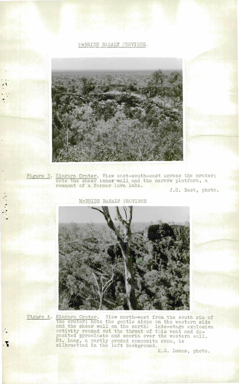
Kinrara Crater (144 °55'E, 18 ° 25'S) is the youngestcrater in the McBride Province.^It is a pit crater with a rimabout 400 yards wide and 150 feet high.^This rim has beenbuilt by overflow and spatter; the overflow was not voluminous(Cotton, p.90) and consequently the rim has a steep outer wall.The inner wall is sheer except on the western side, wherebasaltic scoria and pyroclasts are draped over it (Figs.3,4 & 5).
Two lava tunnels lead away from the crater, one tothe north-east and the other to the south-west; near thecrater the roofs of these tunnels have collapsed and made themconspicuous. (Fig.11).^These tunnels drained the basalt fromthis volcano and ducted it long distances down valleys incised
•^in the older basalts.
Within the crater a ledge of basalt about 10 feetwide (Fig.11) is attached to the sheer inner eastern wall,20 to 30 feet below the rim; it is a remnant of a former levelof a lava lake.^In the north-east portion of the wall, justabove the level of this ledge, there is the entrance to alava tunnel 8 to 10 feet in diameter and about 6 to 8 feetdeep; this tunnel is about 100 feet above the major tunnelsoutside the rim and appears to be younger than they.
Late-stage explosive activity has reamed out acrater 150 feet deep in the floor of the pit crater and exposedthe underlying older horizontal basalt flows and part of thethroat of the volcano (see Fig.5.); the fragmented materialand scoria have been draped over the western wall of the pitcrater and provide a route into an otherwise sheer-sidedcrater.
Siliceous sublimation products adhere to parts ofthe walls in the crater and their presence indicates that itis not very long since solfataric activity ceased at this vent.
Small fragments of quartz up to half an inch indiameter were found included in the basalt in the upper craterrim.
Undara is a pit crater, older than Kinrara and thewell preserved features which make Kinrara so spectacular haveall been destroyed by weathering and erosion; but it is partic-ularly interesting because from this vent a ver:y long lavatunnel originated (Fig.13).^The lava tunnel can be traced onthe air photos for an aggregate distance of at least 33 miles.Twidale (1956) misinterpreted it as "a clear arcuate fissuresome 25 miles in length".
Undara Crater is difficult to find on the groundbecause the crater is apical in a low tumid mound indistin-guishable from countless other mounds and ridges surroundingit; it is possible that it was an embryonic shield volcanowhich had its growth stunted by a too efficient plumbingsystem.^Had the lava tunnel become blocked early in thehistory of this vent, the lava would have been forced to flowover the rim of the crater and so form a cone by accretion ofcountless thin fluid basalt flows; as it was the lava tunnelducted large volumes of lava great distances and so preventedUndara from growing into a shield volcano.
The walls of Undara Crater are covered with mattedvegetation, but open savannah woodland covers the floor; thiscontrasting pattern makes it obvious on the air photos.

‘415
-1 0-
About three miles west-north-west of Ht. Lang is anunnamed pit crater obviously very much older than Undara.^Itis clothed in open savannah woodland and is not obvious on theair photographs whether it is the crest of a buried shieldvolcano or is another of the Undara , type could not bedetermined.
(iii) Scoria Cones
Scoria cones are built by "fire-fountaining" andmildly explosive activity in the declining stages of a cycleof volcanic activity.^Many of these vents are almost perfectlypreserved in the McBride Province.^The younger members of thistype are symmetrical cones 300 to 400 feet high and 300 to 400yards wide at the rim; all have shallow apical craters and therim is usually highest on the western side, owing to theinfluence of the prevailing wind.^The cones are built ofbasalt scoria with subordinate flows and pyroclasts.
The porosity and permeability of the scoria conesleaves them particularly unaffected by "channelling".Consequently they retain their pristine form far longer thancones built of more impervious forms of lava, such as flowsand fine grained pyroclasts.
In a number of places three or four scoria consare grouped together and these groups commonly trend 020 .Several of these groups are adventive on shield volcanoes,Racecourse hhob is the best example of this association withfour adventive scoria cones trending about 020 across thecrest.^The Tabletops about ten miles south-south-east ofRacecourse Knq are three very symmetrical scoria cones,aligned at 020 , and adventive on the flanks of MurrongaCrater; in this case the parasitic vents are more prominentthan the host, which may be a partly buried shield volcano.Elsewhere there is no obvious reason for the location of thescoria cones, but doubtless they are related to fractures inthe underlying basement.
(iv) Colupsite Cones
True composite or strato-cones, that is those madeup of alternating layers of effusive and pyroclastic lava,appear to be absent in both the McBride and Wallaroo areas.However, some cones have too much effusive lava to be classi-fied as scoria cones, and have therefore been classified ascomposite cones.
Mt. Lang, the most prominent volcano on the easternside of the McBride Province, is the best example of acomposite cone.^It is now deeply dissected, particularly onthe norther, western and southern sides, and part of the innerstructure is revealed; near the crest, a thick deposit of ashand lapilli containing a few volcanic bombs is exposed.^About100 feet below the crest, on the western side, a lava tunnelabout 8 feet wide, 4 feet high and 20 feet long is exposed;the flow-basalt surrounding it is now deeply weathered.
Chubber's Hill two miles north-east of "Meadowbank"is a smaller, more recent composite cone.^The cone itselfappears to be built essentially of scoria, but the late activityfrom this vent was almost purely effusive; the lava welled upthrough —the central vent, filled the apical crater, and thenoverflowed on the low, northeast, side of the cone.

Features of the Basalts
Throughout the history of the McBride Province it isevident that the basalt has generally been extruded in a veryfluid state.^Most of the obvious flow structures on the olderbasalts have been erased by weathering; in marked contrast tothis is the Kinrara Flow, with all structures perfectly pre-served.^Parts of this flow were closely examined, and theknowledge gained was of considerable assistance in evaluatingthe more weathered structures in the older basalts.
(i) Kinrara Basalt
The direction of flow of the basalt extruded fromKinrara Crater has been controlled by a pre-existing drainagepattern; the gradient of the channels, down which the basaltflowed, was sufficient to ensure rapid draining of the fluidbasalt from beneath the chilled lava surface, commonly only afoot or so thick.^Subsequent collapse of much of this surfacehas led to the formation of a chaotic assemblage of sinks,depressions and open fissures.^Below Saltern Lagoon, in theBurdekin Valley, the distal portions of the Kinrara Flow containfew collapse structures; their absence indicates that thebasalt was becoming sluggish in its movement and was not drainedfrom beneath the chilled crust.
Some of the distinctive features of the KinraraBasalt are-
(a) Edge of the FlowIn both the "extensive" and "confined" lava-field
tracts the Kinrara Basalt stands above the immediate surroundingcountry; the difference in elevation is usually about 4 to 6feet.^In the "extensive" lava field the edge of the flow isusually marked by a jumble of boulders of pahoehoe basalt,obviously broken from the chilled margin of a slowly advancingflow.
In the "confined" areas this litter of boulders isgenerally more pronounced and is similar to a lateral moraine.In some sections of the "confined" lava field the litter oflateral boulders is buried beneath the edge of the flow, whichhas slabbed off.^This slabbing is obviously caused by fractur-ing of the solidified crust, a few feet in from the edge andparallel to it; the edge of the flow then collapses outwardsunder its own weight, much in the manner of soil turned by asingle furrow mouldboard plough.
(b) SinksThe sinks range from small circular holes a few feet
in diameter to large irregular holes hundreds of square yardsin area; the smaller sinks are the more common.^Those inves-tigated ranged in depth from a few feet to about twenty feet;the depth is obviously a function of the thickness of the flow.The floors of the sinks are usually covered with a litter ofpahoehoe boulders. (Fig.8)
(c) Depressions These are similar to the sinks, but in them the roof .
has only sagged rather than completely collapsed; the sinks arethe more common form.

-12-
(d) Rectangular Pavements and Pressure Ridges.
Sub-crustal drag by the flowing basalt fractured thesolidified skin and in many places rucked it up into a jumbleof irregular blocks of pahoehoe basalt; in other places thereis little rucking and the skin was only broken into rafts,commonly rectangular, 80 to 100 square feet in area and boundedby ridges of broken lava 6 to 8 inches wide and 2 to 3 incheshigh.
Possibly the severe rucking resulted from turbulentflow of the basalt over irregular parts of the channel bed,and the pavements reflect the smoother parts of the oldchannel.
(ii) The older basalts.
Most of the lava in the McBride Province waserupted and distributed as flows, and now countless basaltboulder barriers impede travel across the area.
Skeats & James (1932) described basalt boulderbarriers from the Newer Basalt areas of Western Victoria aspredominantly ring-shaped and extending outward and down froma central vent, in a series of concentric steps.^Obviouslymuch of the basalt of the McBride Province has been distributedas sheet-flows, and possibly detailed mapping would revealbasalt boulder barriers such as described by Skeats & James.But the prominent boulder barriers in this province are notobviously ring-shaped; they meander across the country in theform of irregular stone walls; in general they can be classifiedas lava tunnels or lava tongues.^Erosion subdues these features,and in the older basalt areas meandering lines of roundedbasalt boulders protruding through black soil flats mark thecourse of old lava flows.
(a) Lava_Tunnels (Fig.13, Plate 1).Very failiT basalt poured out on a near-horizontal
surface spreads extensively and solidifies to a sheet of fairlyuniform thickness; if, before solidification is completed, theliquid lava is drained from beneath the crust, the crustcollapses and a chaotic assemblage of sinks and depressions isformed.^The proximal portion of the Kinrara Flow is anexcellent example of this; and the area between "Spring Creek"and Murronga Crater is another, older, more subdued example.
Where very fluid basalt is constrained to flow ina channel it develops a solidified skin which is constantlybreached by the weight of contained lava; the tunnel growsby accretion at the snout and the flanks become littered withangular boulders of basalt.^If the gradient is steep enoughthe lava drains out of the tunnel when the supply of basaltceases, and subsequently parts of the roof may collapse andso reveal the tunnel.
Undara Lava Tunnel is the most prominent in theMcBride Province; the collapsed portions of this tunnel containa tangled mass of dark green vegetation which is conspicuousboth on the ground and on the air photographs.^The tunnel fromUndara Crater trends north-north-west for about three milesand bifurcates; the northern branch can be traced in the samegeneral direction for about another ten miles, and the mainbranch, the western one, can be traced for more than twentymiles towards Mt. Surprise.

Va.
-1 3-
Undoubtedly there are numerous lava tunnels with nosurface expression a hole drilled for water, several milesnorth of Kinrara Crater, passed through a number of "largeholes" and was finally abandoned at a depth of about 375 feetafter the churn drill bit had "dropped about twenty feet"(Mr. J. Champney, "Kinrara" Station, personal comiunication).It seems safe to assume that these "holes" are lava tunnels andit is interesting to note that the drill passed through a numberof them in attaining a depth of 375 feet.
(b) Laza_Talaues
Esker-like ridges of basalt 5 to 15 feet high and20 to 40 yards wide meander for long distances across thesurface of the McBride Province; undoubtedly they were distrib-uted in a similar manner to the lava tunnels but, were not sub-sequently drained.^Externally they are identical; but eitherthe basalt was more viscous or the gradient was not sufficientto drain them and so they solidified as solid ridges ratherthan as hollow tubes.^In some places short breaks in the lavatongues suggest that they have, in places, been breached anddrained through the flank; but for the most part they aresolid ridges of basalt mantled with irregular basalt boulders.
WALLAROO BASALT PROVINCE
Wallaroo Province has been named from Wallaroo Hill,an old extinct volcano about three miles west of "Glen Eagle"Homestead.^There are two volcanoes in the province, both inthe "Residual Mountain/Skeleton Stage" of erosion (Rear, 1957).One is Wallaroo Hill, the other is an un-named feature abouttwo miles west of "Glen Ruth" Homestead.^The Wallaroo Basaltcovers about 50 square miles and is a "confined" lava field(Keble 1918); its surface has been subdued by erosion and itis much easier to traverse than the McBride Province.^Manyoutliers of basalt surround the province; those on the southside of the Herbert River are now separated from the parentbody by a gorge about 1,000 feet deep.
There are two ages of basalt in the Wallaroo Provinceequivalents of the Older and Newer McBride Basalts, and noevidence of late-stage activity.
ATHERTON BASALT PROVINCE (Plate 1)
The Atherton Province is named from common usage,and was derived from the Atherton Tableland and the town ofAtherton at the northern end of the province;^it is a confinedlava field (Keble, 1918) with an area of about 800 square miles.
About 80 percent of the province lies within a highrainfall area and was originally covered with thick rain forest,much of which has been felled to provide land for agriculturaland dairying pursuits.^Most of the province is mantled withbasaltic pyroclasts up to 100 feet thick on which has developeda dendritic drainage pattern, which is much more deeply incisedin the southern end of the province.^The result is that thesurface ranges from gently to steeply undulating and contrastsstrongly with the essentially flat surfaces of the McBride and.Wnllaroo Provinces.

-1 4-
Most of the basalt is confined to a north-north-west valley about 50 miles long and up to 20 miles wide. Thisvalley was formerly drained northwards by the westerly-drainingWalsh River, and southwards by the easterly-draining ancestralJohnstoneAiver.^After the outbreak of volcanic activityin, probably, mid-Tertiary time the valley was partly filledby flows of basalt, the distal portions of which coursed downthese stream valleys.^Along the western side the flows aver-top7aed several low parts of the watershed and coursed down thevalleys of adjoining streams; the most notable of these arethe flows that coursed down the Herbert River headwatertributaries and joined the McBride Basalt Province about fourmiles east of - GunnawarrallHomestead.
The fine grained pyroclasts, erupted towards theend of the activity in this province, are not as extensive asthe flows; except on the south and south-east sides thedistal portions of flows are not mantled with pyroclasts, andin general there is very little pyroclastic basalt north-westof Tolga and west of Ravenshoe.
Age of the Basalts
So far no definite evidence of the age of theAtherton Basalts has been obtained, because there are noassociated diatomite deposits as in the McBride and . jallarooProvinces; they have a similar lithology and appear to havea similar age-range to the basalts in the McBride Province -?Upper Miocene to Recent.
In several valleys on the western side of the•^province, in particular the Wild River and Oakey Creek (a
small northern tributary of Blunder Creek), small weatheredoutliers of basalt crop out on hillsides 200 to 300 feet abovebasalt-floored valleys; these inliers are possibly equivalentsof the Older McBride Basalt and the basalt in the valley floorequivalent to the Newer McBride Basalt.^The pyroclastic basaltis probably equivalent to some if not all of the Undara Basalt,and the Kinrara stage (McBride Province) is probably representedby Mt. Quincan (a scoria cone, Fig.16), and Hyipamee Crater(a diatreme).
Basaltic Pyroclasts
The thick mantle of basaltic pyroclasts which coversmost of the Atherton Province is the only significant differencebetween this province and the McBride and Wallaroo Provinces.But this mantle and the high rainfall have combined to producea deep rich soil suitable for agriculture and dairying;consequently the Atherton Province with an area of about 800squgre miles supports a population of more than 10,000 people.Whereas the McBride and Wallaroo Provinces with over 2,000square miles support only about 500 people.
There are at least seven volcanoes in the AthertonProvince which have erupted explosively (this does not includethe scoria cones), they are Bromfield Swamp, Lynch's Crater,LaJe Eacham, Lake Barrine, Lake Euramo, Bones Knob andH pamee Crater.^Most of the pyroclasts were erupted fromthe first five of the above-named craters; four of these arelarge (up to a mile in diameter) and are distributed around thecentre of the province, the fifth, Lake Euramo, is much smallerand is near the northern end of the province.

-1 5-
Most of the pyroclastic basalt was distributedsubaerially, but some of it arrived at its present site aslahars; this mode of distribution was particularly active inthe southern portion of the province.^Eleven miles south-south-east of Ravenshoe unlithified, massive, fine-grained basalticpyroclasts With sporadic basalt bombs have been penetrated bybores to a depth of more than 60 feet, material from this
r deposit has been used as a pozzolan in the construction of. Koombooloomba Dam on the Tully River.
Twenty-four volcanoes have been recognised in theAtherton Province; six of them are explosion craters, one isa diatreme, and the rest are scoria cones ,and vents formedby effusive eruptions.
Lallosl'on Craters
(i) Bromfield Swamp, as the name implies, has beenbreached and drained, but it must formerly have contained alake similar to Lakes Eacham and Barrine. . It is the largestof the old explosion craters and is about four miles south-west of Malanda and towards the western side of the province.It is about a mile wide, roughly circular in plan and about200 feet deep; it has been greatly subdued by erosion and isobviously much older than Lakes Eacham, Barrie, and Euramoto the north.
(ii) Lynch's Crater, ten miles east of Bromfield Swamphas also been breacIled and drained; it is smaller than BromfieldSwamp (about 700 yards in diameter and 150 feet deep), and wasProbably contemporaneous with it.^Rounded boulders of meta-morphics up to a foot long were found inside this crater; theymust have been derived from the underlying Barron River Meta-morphics.
(iii) Lake Eacham (Fig.15), five miles north-north-eastof Malanda, is a young explosion crater and contains a'lake.It is roughly circular, about 1,100 yards in diameter, andhas an embayment on the south-east side; possibly this embaymentis the former effusive vent.^The crater is steep-sided andabout 500 feet deep.
(iv) Lake Barrine is about 2-1- miles north-north-east ofLake Eacham and is the largest explosion crater in the province.It is about twice the area of Lake Eacham, but about 100 feetshallower.^Lake Barrine has an embayment in the north-eastside.
^
(v)^Lake Euramo, about six miles north of Lake Barrinesmallest oT-77e—eaTTO-sion craters; it consists of two smalljoined craters. Dimensions are about 500 yards long and 150yards wide; the long axis trending north, and in shape itresembles the print of a boot.
Diatreme
The only diatreme in the whole area is the craterknown as Hypipamee on the western side of the Atherton Provinceabout ten miles south of Atherton.^Here explosive activityhas blasted through granite a sheer-sided hole about 200 feetwide and 450 feet deep (now partly filled with water).^Basaltlapilli and small fragments of Upper Palaeozoic granite arescattered all around this vent; it is obviously very youngand must have been formed by one violent explosion.

-16-
Twidale (p.11) claimed that some of the McBrideProvince volcanoes contained diatremes, some of which were"occupied by lakes".^It is probable that he mistook the pitcraters for diatremes, and the thick vegetation in theyounger ones (which show dark-grey on the air photographs)for water.^The only lakes in the McBride Province haveresulted from impeded drainage and are marginal to the basalt.
Scoria Cones
(i) Mt. Quincan seven miles south-east of Atherton isthe most spectacular scoria cone in the area; it is about700 feet high and has a crater about half a mile wide.^It ismarkedly asymmetrical; the west side of the rim is abouttwice as high as the east side; the prevailing wind blows fromthe east.^The cone is composed of basalt scoria that has beenwell vdnnowed and contains many olivine bombs.
(i) The Seven Sisters two miles north of Mt. Quincan area group of scoria cones 150 to 200 feet high; they lackMt. Quincan's well developed apical crater and are probablyolder.
Adler Hill and an unnamed hill south-east ofMareeba arT-7TH—Tcoria cones from which minor basalt flows haveemanated.
Shield Volcano
Bones Knob west of Tolga is one of the oldest ventsin the Atherton Province.^Early effusive activity built up ashield volcano and subsequent explosive activity reamed outthe apical crater and constructed within it a dome of fine-grained pyroclasts (Fig.14).^The pyroclasts are bedded andcontain numerous volcanic bombs.^Basalt dykes up to eight feetwide are exposed in the valley north of the dome, andundoubtedly fed the old vent.
Composite Volcanoes
There are several composite cones in the AthertonProvince Ht. Weerii0A4gest of Bromfield Swamp, is an old ventof this type, and Gldh / -ter, six miles south-east ofMalanda, is another somewhat younger one.
DISTRIBUTION OF THE VOLCANOES
(i) In the McBride Province most of the vents fall intogroups which coincide fairly well with the contact betweenPrecambrian granite, Palaeozoic granite, and ? Archaean meta- 0morphics.^Within the groups lineations commonly striking 020are apparent.^This direction is prominent in the underlying?Archaean basement, the edge of the basement, and the Palaeozoicsediments east of the basement.
(ii) In the Wallaroo Province, with only two vents thereis no obvious grouping, but both vents appear to be located onstrong faults which bound the east and west sides of theconfining valley.

-1 7--
(iii) In the Atherton Province strong faulting againappears to have been the major control in the location of thevents.^Two prominent directions of faulting about N.N.W. andN.E., have been mapped in the area west of the Atherton BasaltProvince and the evidence suggests that differential verticalmovement (up to 2,000 - 3,000 feet) of blocks bounded by these
r.^faults gave rise to grabens, which in Upper Palaeozoic timewere filled with acid lavas.^Subsequent movement and erosionhas inverted the topography and produced valleys, one of which
4^now houses most of the Atherton Province.^The marked concen-tration of vents along the western side is undoubtedly due tothe strong fault which bounds this side of the valley.^Thegroup of vents in the centre of the province is probablylocated along a strong north-easterly fault.
RELATIONSHIP TO PLUTONS.
In all three provinces the basalts have beenextruded through areas which have formerly been the site ofextensive intrusions and extrusions of acid magma.^In southernQueensland the Tertiary volcanism had a three-fold cycle withan acid phase in the middle, but in north Queensland theactivity was all basic.
Possibly in southern Queensland the basalt hadascended to a high level and had assimilated some of thecountry rock before the magma chamber was tapped; consequentlybasic and then acid lavas were erupted, and a fresh accessionof basalt to the chamber provided the third basic phase;whereas in northern Queensland, the faulting was profound andtapped an uncontaminated basic magma at great depth - theabsence of an acid phase, the prevalence of olivine bombs, and
;^the large throws on the faults could be construed as confirm-atory evidence.
CONCLUSION
This paper records only some of the many interestingaspects of the North Queensland basalts, and stems from a briefexamination of parts of them. Huch work remains to be doneon them, particularly on the petrology and age of the basalts.It is possible that the early aboriginal inhabitants of thisarea witnessed volcanic activity at the younger Kinrara vent;but their detribalised descendants have no knowledge of suchactivity.
ACKNOWLEDGEMENT
I wish to thank Dr. N.H. Fisher, Chief Geologist,Bureau of nineral Resources, for his encouragement in thepreparation of this paper and my colleagues for their adviceand criticism.
REFERENCES
BRYAN, W.H., 1958 - Notes on the eai.ly Tertiary Basaltsof south-east Queensland. c_Lillasos_.N.S.W. 92(4), 129-32.
COTTON, C.A.^1952 - Volcanoes as Landscape Forms,2nd.Ed.,1952.
DAINTREE, R.
DENMEAD, A.K.
1872 - Notes on the geology of the colony ofQueensland. Quart . .J.geol.Soc:Lond.,28, 271-317.
1947 - CAMEL CREEK TIN, KANGAROO HILLS FIELD.Qld Govt nn.J., October, 1947.
HILL, Dorothy^1951 - Geology, in Handbook for Queensland.Aust.Ass.Adv.Sci., Brisbane, 13-24
JACK, ILL., and ETHERIDGE, R. Junr., 1692 - THE GEOLOGY ANDPALAEONTOLOGY OF QUEENSLAND AND NEWGUINEA, Government Printer Brisbane.Qld geol.Surv.Pub1.92.
KEAR, D.,^1957 - Erosional stages of volcanic cones asindicators of age. N.Z.J.Sci.Tech.,Z.Sect. B.38,7, 671-682.
KEBLE, R.A.,^1918 - The significance of Lava Residuals inthe Development of the Wee ern Portand Port Phillip drainage . ystem.Proc.Roy.Soc.Vic., 31,129-166.
MAITLAND, A.G.^1891b- Geology and mineral resources of theUpper Burdekin. Qld eol.Surv.Pub1.71.Parl.PaP. C.A.1977 9 .
MAITLAND, A.G.,^1892 - Laboratory Notes. Qld geol.Surv.Pub1.87.
MacDONALD, G.A.,^1953 - Pahoehoe,aa and block lava.Amer.J.Sci.251,(3), 169-191.
MARKS, E.O., 1911a- The Oaks and eastern portion of theEtheridge goldfields. Qld geol.Surv.Publ. 234.
RICHARDS, H.C., 1916 -The volcanic rocks of South EasternQueensland. Proc.Roy.Soc.Q1d. 27(7),105-204,
SKEATS, E.W., and JAMES, A.V.G., 1937 - Basaltic barriers andother Surface Features of the NewerBasalts of Western Victoria, Proc.Roy.Soc.Vic.,49, 240-291.
TWIDALE, C.R.,^1956 - A Physiographic reconnaissance of somevolcanic provinces in Nth.Q1d., Aust.Bull.Volcan.,2(18), 3-23
TYRRELL, G.W.,^1937 - Flood basalts and fissure eruption.Bull.Volcan.,2(1) 89-111,
WHITE, D.A. and CRESPIN, Irene, 1959 - Some Diatomite Deposits,North Queensland. Bur.Ein.Resour.Aust,Rec. 1959/12 (unpuM)77Thi. 76-vt Min.S.,50/689, 191-193.

McBRIDE BASALT I'ROVINCE
Figure 1. Racecourse Knob, a shield volcano on the western sideof the province; note the adventive scoria cones onthe flanks of the main structure. View east-south-east from the Hann Highway/Mt. Surprise road;Palaeozoic granite in the foreground, granite/basaltcontact in the middle distance. J.G. Best, photo.
McBRIDE BASALT i2ROVINCE• AP
•
111
Figure 2. The iableto7s, three adventive scoria cones ner thecentre of the province. Note how they descendnorthward down the flank of Murronga Crater, the apicalcrater of which is the dark patch partly obscured by thetree in the right foreground. View south fromMurronga.
• N.
J.G. Best, photo.
V• "
McBRIDE BASALT 2ROVINCE.
•
Figure 3. Kinrara Crater. View east-south-east across the crater;note the sheer inner wall and the narrow - platform, aremnant of a former lava lake.
J.G. Best, photo.
McBRIDE BASALT PROVINCE
Figure 4. Kinrara Crater. View north-west from the south rim ofthe crater; note the gentle slope on the western sideand the sheer wall on the north: late-stage explosiveactivity reamed out the throat of tLis vent and de-posited pyroclasts and scoria over the western wall.Mt. Lang, a pertly eroded composite cone, issilhouetted in the left background.
K.G. Lucas, photo.

McBRIDE BASALT PROVINCE
Figure 5. Kinrara Crater. The remnant of the throat of the vol-cano ex7osed—UY late-stage explosive activity whichreamed out a lower crater about 150 feet deep.
C.D. Branch, photo.
McBRIDE BASALT PROVINCE,
Figure 6. Thin superimposed flows of basalt on the south side ofthe crater. This demonstrates how liLited overflows ofbasalt constructed the rim around this crater.^Thefigure is standing on the platform visible in Figure 3.
K.G.Lucas, photo.

McBRIDE BASALT PROVINCE
Figure 7. Kinrara Crater. Basalt spatter adhering to the innereastern wall of the crater; a further relic of the lavalake.
C.D. Branch, photo
McBRIDE BASALT PROVINCE
Figure 8. A "sink" in Kinrara Basalt Flow in OB Creek; note thelava tunnel exposed by the sink and the litter ofpahoehoe basalt boulders.
J.G. Best, photo.
„-
McBRIDE BASALT 7RCVINCE
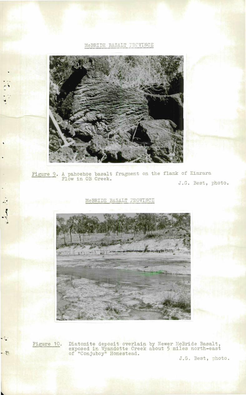
iigure 9. A pahoehoe basalt fragment on the flank of KinraraFlow in OB Creek,
J.G. Best, photo.
McBRIDE BASALT PROVINCE
Fiure 10. Diatomite deposit overlain by Newer cBride Basalt,exposed in Wyandotte Creek about 5 miles north-eastof "Conjuboy" Homestead.
•••
J.G. Best, photo.

Figure 11McBRIDE BASALT PROVINCE
south-east from the crater is the Kinrara Basalt. Note the collaps-ed lava tunnels leading away from the crater, one to the north-east and the other to the south-west. (The black circles areringed centre and wing-points on the air :laotographs).
4-- ,

McBRIDE BASALT PROVINCE^Figure 12.
c. -rrrtm uvlico el. UU U j z mi L^U Ut ui Ul^U. . Jnariu -u-ue -unetops. The dark-grey circle west of the centre Tabletop is -1.1rrongaCrater (a pit crater); note the collaTsed lava tunnel leading southfrom it. The oval deTression west of 'it. i7unana is probably anold pit crater; it was not examined on the ground.(The black circles are ringed centre and wing-points on the photos)

McBRIDE BASALT IROVINCE^Figure 13.
tangled vegetation growing in the collapsed •ortions of the tunnelaccentuates it. The scoria cone north of the lava tunnel isKalkani cone; that south of the tunnel is un-named.(The black circle is a ringed centre-point on the air photograph).
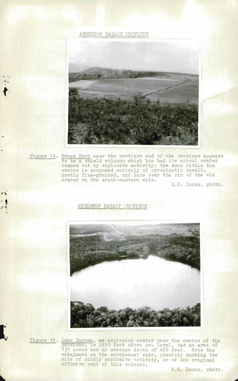
ATHERTON BASALT PROVINCE
Figure 14, Bones Knob near the nortDern end of the province appearsTo-le a -gaeld volcano which has had its apical craterreamed out by explosive activity; the dome within thecrater is composed entirely of pyroclastic basalt,aostly fine-grained, and laps over the rim of the oldcrater on the south-eastern side.
K.G. Lucas, photo.
ATHERTON BASALT .::ROVINCE
Figure 15. Lake Eacham, an explosion crater near the centre of theprovince, is 2450 feet above sea level, has an area of131 acres and an average depth of 480 feet. Note theembayment on the south-east side, possibly marking thesite of mildly explosive activity, or of the originaleffusive vent of this volcano.
K.G. Lucas, photo.
L

ATIERTON BASALT PROVINCE
Figure 16. Mt. Quincan, a young basalt scoria cone about7 miles south-east of Atherton township.The western side of the rim is almost twiceas high as the eastern side; the prevailingwind blows from the east. Olivine bombsabound in the scoria at this vent.
K.G. Lucas, photo.
