coastal sensitivity overview
TRANSCRIPT
COASTAL SENSITIVITY OVERVIEW
OF THE
STRAIT OF MALACCA
Compiled by the World Conservation
Monitoring Centre (WCMC)Cambridge
il^
for
International Maritime Organisation (IMO)
May 1994?<sr!r Ai^m
W JAM 11 iiW 1B. ii: MBA!L«B
WORLD CONSERVATIONMONITORING CENTRE
i^JH X-TGS"/
W CHC (2^c--'rs "^^
The mission of the
World Conservation Monitoring Centre is to provide
information on the status, security and
management of the Earth's biological diversity.

COASTAL SENSITIVITY OVERVIEW
OF THE
STRAIT OF MALACCA
Compiled by the World Conservation Monitoring Centre (WCMC)Cambridge
for
International Maritime Organisation (IMO)
May 1994

Digitized by the Internet Archive
in 2010 with funding from
UNEP-WCIVIC, Cambridge
http://www.archive.org/details/coastalsensitivi94wcmc

BACKGROUND
The World Conservation Monitoring Centre (WCMC) was set up in 1979 as an
information centre to provide reliable scientific data on the sate of the world's
biodiversity. This work has been greatly facilitated by the WCMC's status as a joint
venture between its three partners, the International Union for Conservation of Nature
(lUCN), the World Wide Fund for Nature (WWF) and the United Nations Environment
Programme (UNEP). In order to monitor the world's biodiversity, large quantities of data
have been collected and entered into extensive databases on a wide range of subjects.
Each of the units within the WCMC, Habitats, Species and Protected Areas, have
specialised in collecting data on a particular aspect of biodiversity. Today, these large
data sets (tabular and GIS) contain some of the most accurate and detailed inventories
of the world's biodiversity, a summary of which was published in Global Biodiversity:
Status of the Earth's Living Resources (WCMC. 1992).
The World Conservation Monitoring Centre maintains a large amount of information
relating to marine and coastal environments arvJ their conservation, and is involved in
a number of proposed and ongoing projects in this field. Increasingly, this information
is being managed using GIS. Particular attention has been devoted to mapping sensitive
coastal ecosystems and this information is of interest to oil companies for oil spill
emergency response and contingency planning, and has been used in several such
applications (see Section 7). Data relevant to coastal sensitivity mapping are held within
the Centre's Biodiversity Map Library arnJ comprise protected and unprotected important
areas for conservation, mangroves, coral reefs, forests, wetlands and species.
Additional information is held in the Centre's paper files and library - some of the
information provided in this report are examples.
This summary report of the coastal sensitivity of the Strait of Malacca has been
compiled as background material for the International Maritime Organisation (IMO).

CONTENTS
Section 1. Introduction
Section 2. Coastal Forests
Section 3. Important Coastal Wetlands
Section 4. Coral Reefs
Section 5. Protected Areas
Section 6. Species
Turtle nesting sites
Birds in the Strait of Malacca
Section 7. Oil Spill Sites


Section 1 . INTRODUCTION
The maps and enclosures show many of the important ecosystems and species found
in the Malacca Strait area, but special attention should be drawn to the following:
MangrovesMangroves are an important habitat in the Strait of Malacca, although the distribution
is scattered and hence is not clearly shown on the maps. (More detailed information
is provided in the wetland site sheets found in Section 3.) Generally, mangroves are
located in more sheltered areas and are often closely linked to fisheries, providing
shelter and nursery areas for numerous fish species, and hence are often of major
economic and ecological importance.
Oil can be extremely damaging to mangrove communities, particularly to saplings - oil
can smother the aerial roots and block the lenticels which can lead to restricted
growth, defoliation and/or mortality. There is also evidence of the toxic effect of oil,
particularly the shorter-chain molecules and aromatic fractions, which can kill trees.
Many of the invertebrate species associated with mangroves are also adversely
affected. The use of dispersants is controversial. A considerable amount of work has
been done in the region (Hoi-Chaw and Meow-Chan, 1984).
Coral Reefs
Coral reef resources along the north-east coast of Sumatra as a whole are not highly
developed. Most of the eastern coastline of Sumatra is dominated by silt-laden
waters, with high sedimentation rates. Salinity fluctuates over large areas. Similar
conditions apply over much of the west coast of Peninsular Malaysia, although here
there are several offshore islands where important coral reef communities have
developed.
Reefs are well developed in the nearby Nicobar Islands and also, though more
distant, in the Andaman Islands and off the west coasts of Thailand, Peninsular
Malaysia and islands in the close vicinity of Singapore (including the Riau and Lingga
islands of Indonesia).
There is evidence that petroleum hydrocarbons have numerous detrimental effects on
coral reproduction, larval development and settling, growth rate, photosynthesis, cell
structure, feeding and behavioural responses. Such effects are probably the result of
hydrocarbon fractions being incorporated into the water column, and can be
exacerbated by the use of dispersants. A far greater threat comes from the
smothering of corals by crude oil during particularly low tides - this is known to
cause massive mortality, and toxins can enter the food chain through coral feeding
fishes as a result. For coral reefs, as for other pelagic and subtidal benthic
communities. It is clear that mechanical recovery of the oil from the surface or
adjacent beaches is preferred over the use of emuisifiers of dispersants, which, in
themselves, are frequently toxic.

Species
The Strait of Malacca and the Nicobar Islands are extremely important as both
feeding and a breeding area for turtles: four species are known to nest:
Green turtle Chelonia mydas, hawksbill Eretmochelys imbricata, leatherback
Dermochelys coriacea and olive ridley Lepidoche/ys olivacea.
Whales and dolphins are known to occur in these waters, while dugong Dugong
dugon (classified as Vulnerable) inhabits some of the coastal waters. Many coastal
sites are important for seabird colonies.
Protected areas
Some of the important ecosystems and important areas for biodiversity are protected
by law. These important areas are listed and mapped in Section 5.
Useful References:
Aksornkoae, S. (1987). Thailand. In: Umali, R.M. et al. (Eds). Mangroves of Asia
and the Pacific: Status and Management: 231-261 . Manila: Natural Resources
Management Center and national Mangrove Committee, Ministry of Natural
Resources.
Baker, J.M. (1983). Impact of Oil Pollution on Living Resources. Commission on
Ecology Papers Number 4. lUCN, Gland, Switzerland.
Collins, N.M., Sayer, J. and Whitmore, T.C. (Eds) (1991). The Conservation Atlas of
Tropical Forests. Asia and the Pacific. WCMC, Cambridge, UK and lUCN, Gland,
Switzerland. 256 pp.
Hoi-Chaw, L. and Meow-Chan, F. (Eds) (1984). Fate and effects of oil in the
mangrove environment. Exxon Corporation, USA and University Sains Malaysia.
IPIECA (1 991 ). Guidelines on Biological Impacts of Oil Pollution. IPIECA Report
Series, Volume 4, International Petroleum Industry Environmental Conservation
Association, London. 15 pp.
IPIECA (1 991 ). Guidelines on Biological Impacts of Oil Pollution. IPIECA Report
Series, Volume 1 , International Petroleum Industry Environmental Conservation
Association, London. 15 pp.
lUCN (1983). Global Status of Mangrove Ecosystems. Commission on Ecology
Papers No. 3. lUCN, Gland, Switzerland. 88 pp.
lUCN (1 992). Protected Areas of the World: A review of national systems. Volume1: Indomalaya, Oceania, Australia and Antarctic. Compiled by WCMC, Cambridge,
UK for lUCN, Gland, Switzerland. 352 pp.
Koesoebiono, Collier, W.L. and Burbridge, P.R. (1982). Indonesia: resource use andmanagement in the coastal zone. In: Soysa et al. (Eds) Man, Land and Sea,
Bangkok. Pp. 115-34.

Loya, Y. and Rinkevich (1987). Effects of petroleum hydrocar'oons on corals. In:
Salvat, B. (Ed.) Numan impacts on coral reefs: facts and recommendations. Antenne
de Tahiti Museum, French Polynesia. 253 pp.
Malaysian Wetland Working Group (1987). Malaysian Wetland Directory, Vol 1.
Introduction. Department of Wildlife and National Parks, Peninsular Malaysia.
Pande, P., Kothari, A. and Singh, S. (1991). Directory of National Parks andSanctuaries in the Andaman and Nicobar Islands, management status and profiles.
Indian Institute of Public Administration, New Delhi. 171 pp.
Piyakarncharna, Twesukdi (1987). Multiple-use practices for establishing eco-
development policies in Thailand. In: UNDP'UNESCO Regional Project RAS/79/002.Report of Workshop for Mangrove Zone Managers, Phuket, Thailand, September1986. Pp. 47-9.
Ramsar Convention Bureau (1990). Directory of Wetlands of International
Importance. Ramsar Convention Bureau, Gland, Switzerland. [Prepared for the Bureau
by WCMCl
Saenga, P., Hegerl, E.J. and Davie, J.D.S. (1983). Global Status of MangroveEcosystems. Commission on Ecology Papers No. 3, lUCN, Gland, Switzerland. 88 pp.
Saldanha, C.J. (1989). Andaman, Nicobar and Lakshadweep, and environmental
impact assessment. Oxford and IBH Publishing Co., New Delhi, Bombay, Calcutta.
114 pp.
Salleh, M. N. and Chan, H.T. (1988). Mangrove forests in Peninsular Malaysia, an
unappreciated resource. Seminar on the Marine Environment: Challenges and
Opportunities. Institute of Strategic and International Studies, Kuala Lumpur.
Scott, D.A. (Ed)(1989). A Directory ofAsian Wetlands. lUCN, Gland, Switzerland,
and Cambridge, UK. 1181 pp., 33 maps.
Soegiarto, A. and Polunin, N. (1982). The Marine Environment in Indonesia. Report
for the Government of the Republic of Indonesia sponsored by lUCN and WWF.University of Cambridge: Department of Zoology, UK.
Thia-Eng, C. and Charles, J. K. (Eds) (1984). Coastal Resources of East CoastPeninsular Malaysia; an assessment in relation to potential oil spills. Penerbit
Universiti Sains Malaysia. 306 pp.
UNEP/IUCN (1 988). Coral reefs of the world. Volume 2: Indian Ocean, Red Sea andGulf. UNEP Regional Seas Directories and Bibliographies. lUCN, Gland, Switzerland
and Cambridge, UK. [Prepared for UNEP/IUCN by WCMC]


Section 2. COASTAL FORESTS
Mangroves of Peninsular Malaysia are found along the sheltered west coast of fronting the
Strait of Malacca, where they form an almost continuous belt, about 20 km at its greatest
width. The most extensive groups of mangroves occur along the estuaries of the larger rivers,
and are managed by the State Forest Departments for timber production on a sustained yield
basis.
Mangroves in Peninsular Malaysia occur primarily in the western States of Perak, Selangor and
Johor. The most extensive area is the Matang Forest Reserve, in the Perak area, which has
been managed since the last century. In recent years there has been severe pressure to use
the mangrove lands for agriculture, urbanisation, ponds and fisheries. Forest Department
records shown that over a 20-year period from 1965 to 1985, the total area of mangroves
declined from 1 184 sq. km to 983 sq. km for the whole of Malaysia. In Selangor alone, 86
sq. km were cut down in 1988-9.
Malaysian mangroves support a variety of endangered species of wildlife such as proboscis
monkey Nasalis larvatus, estuarine crocodile Cocodylus porosus, milky stork Mycteria cinerea
and lesser adjutant stork Leptoptilos javanicus, as well as many other highly specialized
species whose survival depends on the existence of the mangrove ecosystem. Major threats
include reclamation for agricultural purposes, clearance for aquaculture ponds, exploitation for
wood-chips and other non-sustainable exploitation for timber.
Peat swamp forests are also significant in southeastern Pahang, Johor, Selangor and Perak
and is valuable as a sustainable timber resource, for flood-mitigation and water supply. Peat
swamp forests are used by endangered mammals such as the proboscis monkey.
Large tracts of mangrove are found throughout the Indonesian archipelago but areas such as
the Banyuasin Musi River Delta on the east coast of Sumatra, comprises some of the most
extensive mangrove forests in Sumatra and are important breeding and nursery grounds for
many species of marine fish, prawns and shrimps. Peat swamp forest and mangroves are
particularly extensive along the eastern coast of Sumatra. Indonesian mangroves have been
little affected by large-scale forest exploitation until 1 975 but they are probably now the most
threatened forests in the archipelago. This is particularly worrying from an economic point
of view, as well as an ecological one, as the export value of Indonesian fisheries was at least
US$194 million in 1978, with a recorded harvest of mangrove-linked fisheries of 550,000tonnes. Some destruction of mangroves has occurred as a result of over-exploitation by
traditional users, but most destruction results from conversion of land for agriculture, brackish
water fishponds, salt ponds, and human settlement. Fishponds are particularly extensive in
Sumatra.
Peat swamps are highly significant in eastern Sumatra and form important watershed areas,
absorbing and storing excess water which reduces flooding in adjacent areas. They are also
important for sustainable forestry with many commercially valuable timber species such as
ramin Gonysty/us bancanus, Shorea spp., Cratoxylum spp. and important for products such
as rattans, resins, fruits etc. Relatively large areas of the shallower peat swamp forests along
the Malacca Strait are being drained to provide farmland for new transmigrants.
Mangroves occur on both coasts of Thailand but the most extensive and species rich
mangrove ecosystems are found along the west coast of the peninsula which supported 63%of the total mangrove area of 2,871 sq. km at the end of 1 982. The Centre for Conservation
Biology at Mahidol University estimates that only 6 % of mangroves are in protected areas,
and that many of these are degraded scrub. Few areas of tall species-rich mangrove forests
are protected; the best examples are found in Tarutao National Park in northern Strait of
Malacca.
See Map for major mangrove and peat swamp formations.
I §,p «
S -fs!
^
i § §1
° ? i ! I ^ t1
ft


Section 3. IMPORTANT COASTAL WETLANDS
The following list and descriptions of important wetland sites have been derived from A
Directory of Asian Wetiarids (1989), a regional inventory of important wetland areas
compiled by Derek Scott of the International Waterfowl and Wetlands Research Bureau.
Coastal wetlands, such as intertidal mudflats and mangroves (mentioned above) are of
enormous conservation and economic value. Intertidal mudflats in Thailand are of great
wildlife conservation importance and support huge numbers of passage and wintering
herons and shorebirds. There are also extremely important wetland habitats in Malaysia
where mudflats that are associated with mangrove forests support the richest benthic
fauna e.g. Matang in Perak and the Kelang Islands in Selangor - these areas therefore
represent the richest feeding grounds for migratory shorebirds and resident waterbirds
such as herons, egrets and storks. These areas are also of major importance to marine
fisheries.
The following sites are illustrated on the accompanying map and include mangrove
formations as well as other important coastal wetlands.
List of Wetland Sites (see Map)
MAP NUMBER NAME OF WETLAND SITE
1 Khiung
2 Ao Bandon (Bandon Bay)
3 Tapi River and Nong Tung Non-hunting Area
4 Pak Phanang Estuary
5 Thale Noi Non-hunting Area
6 Lake Songkhala
7 Ao Pattani (Pattani Bay)
8 Pa Phru
9 Ao Phang-Nga (Phang-nga Bay)
10 East Coast of Phuket Island
11 Krabi Bay
12 Ko Libong Non-hunting Area and Hat Chao Mai
13 Palian-Langu
14 Taruteo Island
15 Sungei Burung Mangroves
16 Matang Forest Reserve
17 North Selangor swamp Forest
18 Kuala Selangor Mangrove Forests and Nature Park
19 Klang Islands
20f
Tasek Bera
21 Southeast Pahang Swamp Forests
22 Sedili Kecil Swamp Forest
23 Kuala Jambu Air
24 Kuala Langsa
25 SM Karang Gadding Langkat Timur Laut |
26 Sei Prapat
27 Tanjung Sinebo/Pulau Alang Besar
28 Bakau Selat Oumai
29 Giam-Siak Kecil
30 Pulau Padang dan Oanau Tanjung Padang
3, Danau Bawah and Pulau Besar
32 Danau Belat, Besar Sekak and Sarang Burung
33 Sungai Kampar Peatswamp
34 Bakau Muara Kampar
35 Muara Sungai Guntung
36 Kerumutan Baru
37 Tanjung Datuk |
38 Pulau Bakung, including Tanjung Bakung
39 Hutan Bakau Pantai Timor
40 Tanjung Jabung |
411
Danau Toba
42 Singkil Barat
43 Pulau Simeulue
44 Taitai Batti / Pulau Siberut
45 Pulau Burung
46 Andaman Islands and Nicobar Islands1


Thailand Sites
Ao Phang-Nga (Phang-nga Bay) (9)
Location: 8o08'-8o26'N, 98o27'-98o45'E; in the Province of Phang-nga. on the west
coast of Peninsular Thailand; enclosed to the west by the island of Phuket.
Area: c.65,000ha.
Altitude: Sea level; hills around the margins of the site rise to 439m.
Biogeographical Province: 4.5.1.
Wetland type: 01 , 02, 03, 04, 05, 06 & 07.
Description of site: A huge shallow bay fringed with extensive mangrove swamps,
extending north from Phuket Island eastwards along the mainland coast past the mouths
of six river systems to the mouth of the Mae Nam Marui. The easternmost boundary of
the site is delimited by the large promontory of Khao Ao Muang, which separates the site
from another major mangrove inlet, Ao Luk (Krabi Province). A great many limestone pillars
and islands rise sheer from the coastal flats, and there are extensive shallows offshore,
only 1 -4m deep at mean low water. The site encompasses the two offshore islands of Ko
Yao Yai and Ko Yao Noi together with a great many smaller islets. Klankamsorn et al.
(1981) give the area of mangrove as 21 ,181 ha and that of intertidal mudflats as 4,048ha
(in 1979). There is massive freshwater run-off from forested hills around the bay during
the southwest monsoon. Salinities of 31.5 p.p.t. (April) and 33.0 p.p.t. (August and
January) have been recorded. The tidal amplitude at Ao Nang, Krabi, varies from 1 .Om at
neap tides to 3.0m at spring tides. The tidal regime is complex; the usual pattern is two
high tides per day, but there are many irregularities.
Climatic conditions: Tropical monsoonal climate with an average annual rainfall of
2,379.3mm, most of which falls during the southwest monsoon, from May to October.
The relative humidity varies from 68% in February to 81 % in October. The average daily
temperature is 28.1 oC (range 24.0-31 .3oC). (Data from Phuket; Sarigabutr et al. 1 , 1 982).
Principal vegetation: Extensive mangrove forest. Most of the area has been logged and
is dominated by large stands of Rhizophora and other species in relatively uniform age
classes. There are very few areas which still support larger mangrove trees. The structure
and composition of the mangrove forest has been studied by Aksornkoae and
Kongsangchai (1980). The principal vegetation in adjacent areas is semi-evergreen rain
forest, with drier sub-types on exposed limestone outcrops. Rubber plantations dominate
in lowland areas outside the National Park.
Land tenure: The wetland is state owned and open to public use in many areas;
surrounding areas are both privately owned and state owned.
Conservation measures taken: The Ao Phang-nga National Park, established in 1981,
covers an area of 40,000ha. Most of the park consists of open water, rocky headlands and
forested mountains, and only a relatively small proportion of the total mangrove area is
included within the park boundaries. Most of the remaining mangroves have been
designated as National Reserve Forest, parts of which are logged under concession.
Conservation measures proposed: Phang-nga Bay is a designated site of the
ASEANAJSAID Coastal ResourcesManagement Project (CRMP). Environmental consultants
attached to this project may be expected to produce recommendations for its conservation
and integrated development. Irwreased areas of mangrove should be incorporated within
the Ao Phang-nga National Park. Walkways should be constructed in order to introduce
visitors to the mangrove ecosystem. A comprehensive survey of the wildlife resources of
Phang-nga Bay is required, as the area has never been adequately studied. Better
protection of both marine and coastal resources is needed as most of the area is subject
to the depredations of boatmen and fishermen who continue, for example, to collect the
eggs of nesting terns and other birds for food.
Land use: Fishing, the cutting of mangroves for timber, and harvesting the fronds of Nypa
palm for the production of thatch. The area is a major tourist attraction and a great many
boatmen realize income from parties of sightseers. Caves support populations of

Edible-nest Swiftlets Aerodramus fuciphagusi , the nests of which are harvested and sold
as a luxury foodstuff. Phang-nga Bay is one of the principal sites considered for
aquaculture development under the FAO Bay of Bengal Programme. The development of
fin-fish cage culture, cockle culture and mussel/oyster culture has been promoted. Up to
the end of 1985, there were 880 fish cages divided amongst 262 owners in ten villages
In Phang-nga Province (Drewes, 1 986). In some parts of the area, tin is extracted from
sediments obtained by dredging. Rubber is widely cultivated in surrounding areas.
Possible changes in land use: The volume of tourism seems destined to increase greatly.
Land use and development of the area is being examined under the ASEAN/USAID Coastal
Resources Management Project (CRMP), and various recomrnendations for the zoning of
land use are likely to be made. The Small Scale Fisheries Development Project of the
Department of Fisheries may promote aquaculture in some parts of the site. Artificial reefs
have been constructed in some areas.
Disturbances and threats: The continued cutting of mangroves, both legally and illegally,
threatens the integrity of the site, and conversion for aquaculture puts further pressure on
the mangroves in the more sheltered areas. Tin dredging may threaten both the mangrove
ecosystem and marine ecosystem by siltation. Many areas of corals have already been
damaged. Fishermen continue to take the eggs and young of sea-birds such as terns for
food. In addition, marine animals such as dugongs and sea-turtles are occasionally caught
in trawl nets.
Economic and social values: The area has immense value as a source of mangrove
products and for its fishery. Cage culture for fin-fish, developed under the FAO Bay of
Bengal Programme, has proved to be very lucrative, yielding an estimated profit of
Bht. 1,444 per cage per year. Cockle culture is much less successful, attracting only
businessmen and large entrepreneurs, since it depends for its success upon the illegal
import of 'seed' from elsewhere; small-scale fisherfolk benefit only as labourers (Drewes,
1986).
Phang-nga Bay is of great importance for research, and is being studied by biologists from
the Phuket Marine Biological Center. In addition, the site is a valuable national and
international recreational heritage on account of its outstanding beauty.
Fauna: The area has never received a complete survey. However, it almost certainly
continues to support the scarce and possibly threatened Ardea sumatrana, and may also
support Heliopais personata. Egretta sacra and Butorides striatus are very common, and
Pelargopsis amauroptera and Pitta megarhyncha probably occur. The islets support
breeding colonies of the, terns Sterna dougallii, S. sumatrana, S. bergii and probably
S. anaethetus: the sand beaches provide nesting sites for Charadrius peronii and Sterna
a/bifrons. S. bengalensis has been recorded from the island of Ko Yao Yai, but its status
is unknown (Nadee, 1 982). There is a relatively high density of both Haliastur indus and
Haliaeetus leucogaster in the area. Wreathed Hornbills Rhyticeros undulatus are still fairly
common. Macaca fascicu/aris occurs in the area, and the bay may still support a few
Dugongs Dugong dugong (Dobias, 1982).
Special floral values: The area supports one of the most extensive areas of mangrove
remaining in Thailand.
Research and facilities: Accommodation is available at the headquarters of Ao Phang-nga
National Park, at Ban Chap Phrae. Aksornkoae and Kongsangchai (1 980) have studied the
structure and floristic composition of the mangroves; Papavasith and Setti (1982) have
carried out a study of mangrove benthos, and an ongoing programme of research, funded
by the Department of Fisheries, is being undertaken from Phuket Marine Biological Center.
A management plan for the site is being developed under the ASEANAJSAID Coastal
Resources Management Project.
References: Aksornkoae & Kongsangchai (1980); Dobias (1982); Drewes (1986);
Klankamsorn at al. (1981); Nadee (1982); Papavasith & Setti (1982); Parish & Wells
(1985); Sarigabutr et al. (1982); Whitmore (1975).

Criteria for inclusion: 1b, 1 e, 2b.
Source: Jira Jintanugool and Philip D. Round.
East Coast of Phuket Island (10)
Location: 7«>50'-7o59'N, 98o25'E; extending north and south from the town of Phuket,
between Ban Ao Makham in the south and l^em Yabu (Laem Yamu) in the north.
Area: 2,100ha.
Altitude: Sea level.
Biogeographical Province: 4.5.1.
Wetiand type: 03, 06 & 07.
Description of site: Two bays fringed with secondary mangrove at either side of a rocky
headland with sand beaches, at the base of which lies the town of Phuket. The site
encompasses four small offshore islands of which the largest is Ko Maphrao. The northern
bay is the more extensive, with at least 350ha of mudflats; the southern bay includes
about SOOha of mudflats. There is relatively little freshwater run-off into the bays. The
salinity varies from 30.0 p.p.t. at the landward edge of the mangroves to 31 .0 p.p.t. at
the seaward edge and 32.0 p.p.t. on the open mudflats. It varies somewhat with the
seasons, being least saline at the end of the rainy season in October or November. The
tidal range is 2.9m.
Climatic conditions: Tropical monsoonal climate with an average annual rainfall of
2,379.3mm. The wettest month is usually September (average 361 .0mm) and the driest,
February {24.9mm). The relative humidity varies from 81 % in October to 68% in February.
The prevailing winds are west from May to October and northeast to east from November
to April. The average annual temperature is 28.1oC (maximum 33.0°C in April; minimum
23.30C in January).
Principal vegetation: Extensive young, regenerating Rh'aophora mangroves. Mainly
cultivation in adjacent areas, although there are still 2,200ha of rain forest on the mountain
of Khao Phra Thaew (450m) at the northern margin of the site.
Land tenure: The wetland is state owned; surrounding areas are mainly in private
ownership.
Conservation measures taken: None.
Conservation measures proposed: Remaining mudflats and mangroves should be
protected from reclamation or other developments. Some reseeding of mangroves should
be carried out. Recreational facilities, such as observation hides for observing shorebirds
and wooden walkway 'nature trails" through the mangrove, might be constructed.
Land use: Fishing and harvesting of crabs. Many boats are beached or moored at the site.
Coconut plantations, rubber plantations and housing in surrounding areas.
Disturbances and threats: Reclamation of mangrove or mudflat areas for housing or
tourist developments may be under consideration. A major deep-sea port is to be
constructed in the vicinity of the site. There is increased urbanization in the water
catchment area due to the rapid expansion of Phuket township.
Economic and social values: The site has considerable scientific value, and has been
intensively studied by scientists from the Phuket Marine Biological Center. It also has
considerable potential for recreation arnl tourism owing to its proximity to the town of
Phuket.
Fauna: In October 1 984, the northern bay supported 670 shorebirds and the southern
bay at least 200, the majority of which were Tringa totanus (Parish & Wells, 1 985). These
numbers are probably an underestimate. Small numbers of herons and egrets are usually
present.
The mangrove macrofauna irKludes Polychaetes (25 species, 0.14 grams dry
weight/sq.m); gastropod molluscs (27 species, 1 .6 grams dry weight/sq.m); pelecypod
molluscs (16 species, of which only Muscuffsta sanhousia is common, 5.6 grams dry
weight/sq.m); and Crustacea (58 species, 3.8 grams dry weight/sq.m). The total primary

production of the mangrove is estimated at 2,700 grams dry weight/sq.m/year. The annual
production of the mudflats is estimated at 83.2 kcai/sq.m.
Special floral values: None known.
Research and facilities: The area is a study site of the Phuket Marine Biological Center.
It was surveyed briefly by Interwader in October 1 984.
References: Parish & Wells (1985); Tantichuduk (1982).
Criteria for inclusion: lb, 2b, 2c.
Source: Jira Jintanugod and Philip D. Round.
KrabiBaydDLocation: 7o59'-8°03'N, 98o51'-99oOO'E; extending up to 5km west and 10km south
of the town of Krabi, Krabi Province, on the west coast of Peninsular Thailand, between
Khao Laem Nang and Ban Laem Hin.
Area: c. 1 1 ,400ha; 26km of coastline.
Altitude: Sea level.
BiogeograpWcal Province: 4.5.1.
Wetiand type: 02, 06 & 07.
Description of site: An, area of mangroves and mudflats extending from the rocky
headland of Khao Laem Nang, east past the complex of rivers which open to the sea at
Pak Niam Krabi, to the Khiong Yuan and Khiong Taling Chan, and south to Ban Laem Hin.
The site encompasses some areas of steep wooded cliffs. The intertidal mudflats extend
up to twokm offshore at low tide. Klankamsorn et a/. (1 981 ) list the area of mangrove and
mudflat as 10,212ha and 1,200ha respectively. A substantial amount of fresh water
enters the system as run-off via the major rivers, especially during the wet season. Thesea-bed shelves fairiy steeply to two metres immediately offshore, and to 6-1 Om in the
mouths of the major rivers. The tidal amplitude at Ao Nang varies from 1 .Om at neap tides
to 3.0m at the highest springs tides.
Climatic conditions: Tropical monsoonal climate with an average annual rainfall of
2,379.3mm, most of which falls during the southwest monsoon, from May to October.
The wettest month is usually September or October (361.0 and 348.6mm of rainfall
respectively) and the driest February (24.9mm). The relative humidity ranges from 68%in February to 81% in October. The average annual daily temperature is 28.1 oC (range
24.0-31.3oC). (Data from Phuket, 60km to the west).
Principal vegetation: Mangroves with a high preponderance of Rhizophora spp. The area
has been logged, but some tall trees remain. Terrestrial habitats are mostly rubber
plantations, coconut groves and jack fruit orchards with a few patches of secondary
growth.
L^nd tenure: The wetland is mainly state owned; surrounding areas are privately owned.Conservation measures taken: The sand beaches, rocky wooded hills, mangroves and
Melaleuca woodland which line the shores of the bay of Ao Nang, to the west of the site
east as far as Pak Nam Krabi, are included in the Hat Nopparat Thara-Mu Ko Phi Phi
National Park. Areas of mangrove at the site are categorized as National Reserve Forest
and can only be cut under legitimate concessions.
Conservation measures proposed: The boundaries of Hat Nopparat Thara National Park
could be extended along the coast to the east in order to encompass the important areas
of mudflats and mangroves.Land use: Fishing and harvesting of crabs. Fruits of the Nypa palms are harvested for
food, while the fronds are used for thatching. Mangroves are cut on a rotational basis and
are used both for charcoal and as a source of polewood. There has been somedevelopment of aquaculture at the site, under the FAO Bay of Bengal Programme. A total
of 21 fish cages divided amongst 45 owners had been established up to the end of 1 985(Drewes, 1 986). The town of Krabi serves as a major fishing port and is also important as
a point from which tourists are ferried to the islands of Ko Phi Phi and Ko Lanta. Adjacent
areas are largely devoted to rubber and oil palm plantations. Tourism is expanding very
rapidly: the Krabi Bay Resort, a complex of bungalows and a restaurant, has been
established at Ao Nang.
Possible changes in land use: None known at present, although there may be pressure
to develop the site should the port of Krabi expand. Krabi has also been proposed as one
of the possible sites for the development of a plant for the extraction of tantalum from tin
stag. The water catchment area has been largely deforested within the past 1 0-20 years,
and the last five years have seen a massive increase in ttie areas planted with oil palm.
Disturbances and threats: Remaining mangroves at the site are under pressure from illegal
encroachment, while industrialization and increased aquaculture may also pose threats in
the future. There is probably some hunting of larger waterbirds.
Economic and social values: The area has much recreational potential owing to its
proximity to the town of Krabi. It is perhaps the most easily accessible area of species-rich
mangrove for bird-watchers and naturalists in Thailand, and some boatmen already
supplement their income through ferrying parties of bird-watchers.
Fauna: The site is one of only four along the west coast of Thailand, identified during an
aerial survey in October 1984, which supported a concentration of over 2,000 shorebirds.
A roost of 2,200 shorebirds, including about 200 large shorebirds (either Limosa spp or
Numenius spp), was located on a sand bank off the mouth of the Khiong Yuan-Khlong
Taling Chan confluence during the survey (Parish & Wells, 1985). In subsequent visits,
Pluvialis squatarola and Numeniusphaeopusi, together with over 100 Sterna albifrons and
S. hirundo, were recorded on mudflats and sand banks. The mangroves support a relatively
high density of Haliastur indus. Haliaeetus leucogaster, Heiiopais personate, Pelargopsis
amauroptera. Halcyon coromanda. Pitta megarhyncha and Trichastoma rostratum also
occur. This is the only known site in Thailand for Cyomis rufigastra. Faico peregrinus (a
bird showing the characteristics of an apparently resident form of the species) has been
seen at Hat Nopparat Thara. The site should be checked for the presence of Ardea
sumatrana and Leptoptilos Javanicus.
Special floral values: The site contains good, species-rich mangrove with many tall trees,
and is one of the best areas of mangrove remaining on the entire west coast.
Research and facilities: Accommodation is available at the headquarters of the Hat
Nopparat Thara National Park or in Krabi Town.
References: Drewes (1 986); Klankamsom et al. (1 981 ); Parish & Wells (1 985); Sarigabutr
etal. (1982).
Criteria for inclusion: 1 b, 2b.
Source: Jira Jintanugool and Philip D. Round.
Ko Libong Non-Hunting Area and Hat Chao lUlal National Park (12)
Location: 7o12'-7«>22'N, 99o20'-99o29'E; the mainland coast and a large island (Ko
Libong) 3.5km offshore, Trang Province, Peninsular Thailand.
Area: Ko Libong is approximately 3,400ha; Hat Chao Mai National Park is 23,1 OOha, but
most of this area is open sea.
Altitude: Sea level. Forested hills on Ko Libong and Hat Chao Mai rise to 31 1 m and 432mrespectively.
Biogeographical Province: 4.7.1.
Wetland type: 01 , 03, 04, 05, 06 & 07.
Description of site: The site lies to the west of the mouth of the Mae Nam Trang. The
eastern two-thirds of Ko Libong are mainly low-lying mangroves fringed by mudflats to the
south and sand flats to the north. The western end is steeply mountainous and still
supports some terrestrial forest. The intertidal zone is narrow and rocky; a long sand beach
extends along the western shore and there are some offshore coral reefs. A small island
(Ko Hard Toop), a ridge of sand and mud with small areas of mangrove, lies 500m off the
southeast tip of Ko Libong and is an important roosting site for shorebirds. The boundary
of the Non-Hunting Area encompasses the whole of Ko Libong together with some areas
of mainland coast including considerable areas of mangrove. There are three main villages
on the island. Hat Chao Mai National Park encompasses a stretch of the mainland coast
together with two offshore islets. It is best treated together with Ko Libong as the two are
adjacent and can be regarded as a single wetland site. The park comprises sand beaches
backing onto dry coastal scrub, plantations and steep, forested crags. The most extensive
areas of mangrove, however, lie outside the boundaries of the park.
The system receives fresh water from the Mae Nam Trang, to the east of the site, and as
run-off from the nearby forested crags through numerous small creeks in the mangroves.
There are extensive shallows of 1-3m in depth to the southeast of Ko Libong. The strait
separating the island from the mainland is 5-7m deep. The salinity is high, approaching
fully marine conditions. At low tide, approximately 1 ,000ha of sand flats and mudflats are
exposed around the island, and approximately 700ha are exposed along the mainland
coast. Except for one sand bar, to the east of the mouth of Khiong Chao Mai off Hat Chao
Mai, the mainland mudflats are covered by normal high tides. This is an important
alternative roosting area for shorebirds when Ko Hard Toop is covered, as during high
spring tides. The tidal amplitude is approximately two metres.
Climatic conditioiw: Tropical mortsoonal climate with an average annual rainfall of
2,379.9mm; the region receives rain from both monsoons, the southwest from May to
October and the northeast into December. The relative humidity ranges from 70% in
February to 86% in October. The average daily temperature ranges from 26.4oC in
November to 29.0oC in April. The prevailing winds are west from May to October, and
northeast or east in other months. (Data taken at Trang; Sarigabutr et al. 1, 1982).
Principal vegetation: Mangrove forest dominatedin most areasby young A vicennia alba 1;
mature A. alba occurs along the seaward fringe, and mature Sonneratia alba and
Rhizophora mucronata occur within the influence of the channels. The inner mangrove
zone is co-dominated by R. mucronata and R. apiculata. The mangrove is accreting in only
a few places along the mainland coast and southern shore of Ko Libong. Much of the area
has been logged over, though some large trees remain, particularly around the Non-Hunting
Area headquarters. Some dry grassy clearings occur on patches of sandy soils within the
mangrove. Four species of sea-grasses have been collected from the mudflats, but these
have not as yet been identified. The vegetation in adjacent areas includes beach scrub
dominated by Casuarina equisetifolia. rubber plantations, some of which contain muchsecondary growth, and other cultivation, especially coconut palms and bananas, around
villages on the mainland.
Land tenure: Areas of mangrove are state owned and leased out to concessionaires.
Conservation measures taken: The entire island of Ko Libong and part of the mainland
coast are incorporated within the Ko Libong Non-Hunting Area. The mainland coast to the
west of the Khiong Chao Mai is incorporated within the Hat Chao Mai National Park. Areas
of mangrove are, however, excluded from the park.
Conservation measures proposed: Swennen et al. (1 986) suggest that human use of the
mudflat areas around the small island of Ko Hard Toop should be reviewed and, if
necessary, reduced, since disturbance levels are very high. Better enforcement of existing
wildlife protection legislation is needed. The boundaries of Hat Chao Mai National Park
should be extended to encompass some areas of mangrove. The status of
Ephippiorhynchus asiaticus should be determined and any nesting and roosting areas
protected.
Land use: Inshore fishing, using hand nets and trawl-nets, and harvesting of mudflat
invertebrates for food. The latter include bivalve molluscs, sea cucumbers, anemones,
priapulids and crabs. There is a small charcoal-producing industry on the northeast shore
of Ko Libong, where Rhizophora spp are harvested on rotation. Hunting of birds and the
few larger mammals occasionally takes place. Cultivation of rubber, bananas, coconut
palms and rice in surrounding areas.
Possible changes in land use: There may be an increase in logging of remaining mangrove
in the future. The use of the area for tourism is certain to increase.
Disturbances and threats: Shorebirds are hunted and netted on a small scale within Ko
Libong Non-Hunting Area, and there is a considerable amount of indirect disturbance to
roosting and feeding birds. In addition, monitor lizards Varanus sp are caught in noose
traps and eaten by villagers. Possible future damage to or removal of larger mangrove trees
may pose a threat. Over-exploitation of benthic invertebrates may threaten natural stocks.
Slash-and-burn agriculture continues to denude hills both in the immediate vicinity of the
site and in the headwaters of the Trang river. This could lead to increased siltation at the
site.
Economic and sodal values: Both the inshore and offshore fisheries are important on a
local scale. The site already has some importance for small-scale tourism; boats are
sometimes rented from villagers by bird-watchers or general tourists. The site has
considerable importance as a possible future research or bird migration monitoring station,
and is one of the most frequently visited shorebird sites in the Peninsula.
Fauna: Ko Libong is one of the most important staging and wintering areas for shorebirds
in the country; it is used by more than 1 0,000 shorebirds of up to 33 species each season.
Peak counts for the commoner species include over 2,000 sar>dplovers Charadrius
mongolus and C. leschenaultii and:
600 Numenius phaeopus 200 N. arquata
1 , 1 80 Limosa lapponica 410 Tringa totanus
300 Xenus cinereus 350 Calidris tenuirostris
The corK:entration of L. lapponica is the largest such recorded in Thailand and the Malay
Peninsula combined. Scarcer species include Limnodromus semipalmatus (75 in October
1984), Tringa guttifer (groups of up to 1 1 birds recorded every winter since 1982), and
Dramas ardeola (3-1 2 birds recorded each winter). This is one of the few known wintering
sites for T. guttifer in the world, and the only regular wintering area for D. ardeola in
Southeast Asia.
Other waterfowl of note include Egretta sacra (maximum 50 birds). Charadrius peronii
(breeds at Hat Chao Mai), Sterna bergii{ma>am\ttn 100 birds, presumed to breed locally).
Sterna bengalensis (non-breeding visitor, maximum 60 birds), and Heliopaispersonata (one
recorded in March 1 986). A few pairs of Sterna anaethetus, S. dougalli and S. sumatrana
breed in the area. There is one unconfirmed but probably reliable sighting of the
endangered Sterna bemsteini; 1 were reported in July 1 980 (P. Poonswad, pars. comm).
Unconfirmed reports of Egretta eulophotes have also been received. Hat Chao Mai is the
only known nesting site in the Malay Peninsula for Ephippiorhynchus asiaticus (Robinson
& Chasen, 1936), and the species is believed still to occur (B. Amget, pers. comm.). The
scarce and local Pelargopsis amauroptera and Pitta megarhyncha both occur in the
mangroves on Ko Libong. In all, at least 126 species of birds have been recorded in the
area.
Monitor lizards Varanus sp are present on the island, and dolphins have been seen
offshore.
Special floral values: The site contains well developed stands of mature mangrove forest
which are amongst the best and least disturbed examples of this habitat type on the entire
west coast of Thailand.
Research and facilities:,Count data on shorebirds are available from the Interwader
Project at the Asian Wetland Bureau in Kuala Lumpur and from the Center for Wildlife
Research at Mahidol University in Bangkok. The Interwader Project has conducted some
sampling of benthic invertebrates, but the results are not yet published. Accommodation
is available at the headquarters of Ko Libong Non-Hunting Area, at the extreme eastern tip
of the island, and at Hat Chao Mai National Park.
References: Bijisma & da Roder (1985); Eve & Guigue (1982); Parish & Wells (1985);
Robinson & Chasen (1936); Sarigabutr etal. (1982); Swennen etal. (1986).

Criteria for inclusion: 1 b, 2a, 2b, 2c, 3b.
Source: Jira Jintanugool, Philip D. Round and Interwader.
Palian-Langu(13)
Location: 6o50'-7ol5'N, 99<»35'-99o45'E; on the west coast of Peninsular Thailand;
shared between Palian District, Trang Province and Langu District, Satun Province.
Area: 31,200ha of mangrove (in 1979); approximately 75km of coastline.
Altitude: Sea level.
BlogeograpMcal Province: 4.7.1.
Wetland type: 02, 06 & 07.
Description of site: Extensive areas of secondary mangrove and logged primary mangrove
with a narrow fringe of tidal mudflats around the mouths of six rivers. The coastline is
highly convoluted, with many large inlets and some sandy beaches. The tallest remaining
mangrove lies on the seaward edge. At the time of the survey (October 1984), the
mangroves were showing good regeneration ar>d there were still few shrimp ponds in the
area. There is great seasonal variation in the amount of freshwater run-off; the turbidity
increases and salinity decreases during the latter part of the southwest monsoon, from
July to November. There are extensive shallows offshore, less than one metre deep at
mean low water. The tidal amplitude ranges from 0.5m at neap tides to 3.0m at spring
tides.
Climatic conditions: Tropical monsoonal climate with an average annual rainfall of
2,379.9mm, most of which falls during the southwest monsoon and the eariy part of the
northeast monsoon, from May to November, The mean annual temperature is 27.4oC
(range 22.7-32.3oC); the mean relative humidity, 80%. (Data from Trang, about 50km to
the north).
Principal vegetation: Mangrove swamps. Chiefly cultivation in adjacent areas, with forest
and secondary growth on steep mountains and headlands.
Land tenure: The wetland is state owned; surrounding areas are partly private
small-holdings and partly state owned.
Conservation measures taken: The mangroves are administered as concession areas and
in theory are therefore subject to control. Some replanting of mangroves is undertaken.
Conservation measures proposed: Some areas of mangroves should be scheduled either
as National Parks or Non-Hunting Areas.
Land use: Fishing for fin-fish and crabs, and cutting of mangroves for charcoal and fence
posts. There is some aquaculture, chiefly using cages for fin-fish such as sea-bass Lates
caicarffer and grouper Epinephelus tauvina. This has been promoted under the FAO Bay of
Bengal Programme; up to the end of 1985, there were 391 fish cages in Palian District
alone, scattered among 123 owners (Drewes, 1986). Rubber plantations and coconut
groves in surrounding areas.
Possible changes in land use: There may be a trend towards increased aquaculture at the
site.
Disturbances and threats: The principal threat is the continued intensive cutting and
removal of mangroves. Larger birds are frequently shot.
Economic and social values: The mangroves will continue to provide a source of timber
if exploited on a sustainable yield basis. In addition, they probably contribute to
maintaining the yield of the offshore fishery. Fin-fish cage culture is very rewarding and
can yield an estimated profit of Bht.1 ,444 per cage per year (Drewes, 1 986). The beaches
may have considerable recreational value.
Fauna: An important staging and wintering area for migratory shorebirds; 2,450
shorebirds were recorded along eightkm of shoreline between Laem Mangang (17o04'N)
and Khiong Wang Won (1 7o01 'N) in October 1 984 (Parish & Wells, 1 985). The area mayalso be important for passage and wintering Egretta spp, breeding Reef Egret Egretta sacra
and possibly Ardea sumatrana. There was a sighting of Leptoptilos javanicus at the site

in February 1 986. The area supports a high density of Haliastur Indus and a few Haliaeetus
leucogaster.
Special floral values: None known.
Research and facilities: The area is a test site of the Remote Sensing and Mangroves
Project. 1 984-87, of the National Research Council. Interwader carried out an aerial survey
in October 1 984.
References: Drewes (1 986); Klankamsom et al. (1 981 ); Parish & Wells (1 985).
Criteria for inclusion: 1 b, 2b.
Source: Jira Jintanugool and Philip D. Round.
Tarutao Island (14)
Location: 6o30'-6o44'N, 99o36'-99o42'E; approximately 22km off the coast of Satun,
western Peninsular Thailand.
Area: The total land area of Tarutao Island is 1 5,1 OOha of which no more than 2,000ha
are wetland habitat.
Altitude: All wetlands are at or near sea level. The island rises to 708m.
Biogeographical Province: 4.7.1.
Wetiand type: 05, 06 & 07.
Description of site: A steeply mountainous, mainly forested island with six distinct areas
of mangroves and associated intertidal mudflats around its coast. The island formerly
supported a human population which has since been evacuated. Approximately 1 0% of
the area has been logged, cultivated or otherwise disturbed. The island is now included in
the Tarutao National Park which encompasses 149,000ha of open sea and islets together
with the principal islands of Tarutao, Rawi and Adang.
The following areas were measured from the 1 :50,000 Topographic Map:
I.Khlong Phante Malakaa: 195ha; an open water inlet with well developed mangrove,
parts of which have been disturbed, and a narrow fringe of mudflats. Parts of the
mangrove occur in association with limestone sink-holes.
2.Ao Talo Lingai: 1 28ha; an area of relatively undisturbed mangrove {78ha) with a narrow
fringe of mudflats and a grassy sand spit (50ha).
3.Ao Talo Wao: 198ha; an area of mangroves (72ha) and mudflats (126ha).
4.Ao Talo Dabu: 97ha; an area of mangroves (38ha) and mudflats (59ha).
5.Ao Talo Dang: c.810ha; an area of well developed mangroves (57ha), less disturbed
than at Khiong Phante Malakaa and with many huge Sonneratia trees, adjacent grassy flats
(55ha), and very extensive mudflats (c.700ha) around the southern shore of island.
6.An unnamed area on the northeast coast, south of Laem To Sen: 1 3ha; mangroves.
The water regime is principally tidal with some freshwater run-off. The tidal amplitude at
Ko Koi Noi ranges from 0.5m at neap tides to 3.0m at spring tides.
Climatic conditions: Tropical monsoonal climate with an average annual rainfall of
2,614mm, most of which falls during the months of May to November. The average
temperature is 27.5oC.
Principal vegetation: Chiefly mangroves; there are some pockets of undisturbed
vegetation with trees 20m tall, but most of the area was cut-over 10-20 years ago.
Rhizophora apiculata and R. mucronata usually dominate, with Sonneratia spp in the least
disturbed sites and some Nypa fruticans. Small areas of freshwater swamp forest with
much Salacca conferta occur around Ao Talo Dang (Congdon, 1982). Some 60% of the
island is covered with semi-evergreen rain forest. There are good examples of various
coastal plant communities including a herbaceous strand flora, a Bam'ngtonia formation,
and patches of a coastal heath forest dominated by Melaleuca cajuputi and Eugenia
splcata. Another distinct forest type occurring on limestone outcrops is also recognized
(Congdon, 1982).
Land tenure: The island and its wetiands are state owned; the surrounding seas are Thai
territorial waters.

Conservation measures taken: The entire area lies within Tarutao National Park. Apreliminary management plan has been prepared.
Conservation measures proposed: A comprehensive management plan is currently being
prepared for Tarutao National Park, and will contain proposals for improved conservation
measures. Tarutao has been proposed as a World Heritage Site. Use of sandy beaches by
tourists should be restricted, preferably by zoning. This would protect vulnerable nesting
shorebirds such as Charadrius peronii and possibly Esacus magnirostris from undue
disturbance.
Land use: Mainly recreational, although transient fishermen continue to make occasional
visits. There is a considerable amount of fishing with trawl nets and lights in the
surrounding waters, and also some illegal dynamite fishing, especially over coral reefs.
Possible changes in land use: It is proposed to build an all-weather concrete landing quay,
which would improve access to the site. At the present time, the park is closed to tourists
throughout the monsoon season. There may also be pressure to build additional park
accommodation.Disturbances and threats: Such threats as have been documented affect mainly the
offshore marine resources within the park. (Coral reefs are being destroyed by dynamite
fishing; sea turtles are being caught by trawlers).
Economic and social values: The park has great appeal for tourism and recreation, and
is one of only two sites in Thailand to be listed as an ASEAN Heritage Park.
Fauna: The wetlands support the scarce Ardea sumatrana. which is believed to nest here.
Heliopaispersonata is found regularly on the Khiong Phante Malakaa (three birds were seen
in April 1 986) and has also been recorded from Ao Talo Dang. It is still not known whether
the species is resident or a winter visitor. Rocky or sandy beaches may be expected to
support Esacus magnirostris. There is one record of Pseudibis gigantea, collected in 1 904(Riley, 1 938), and unconfirmed reports suggesting the occasional (post 1 980) presence
of Ephippiorhynchus asiaticus have been received. Pelargopsis amauroptera and Pitta
megarhyncha are both mangrove specialists with limited world ranges occurring on
Tarutao.
The park is important as one of the last sites in Thailand for nesting marine turtles. A few
individuals of three species, Lepidochelys olivacea, Eretmochelys imbricata and Cttelonia
mydas. still come ashore to lay their eggs on the beaches of the Adang island group, to
the west of Tarutao Island.
Special floral values: The island supports extremely good examples of beach and coastal,
terrestrial floristic formations. Such vegetation has usually been destroyed from similar
situations on the mainland. The park supports a number of plant species which are either
very rare or absent elsewhere in Thailand: among these is Aegialites roturtdifolia
(Plumbaginaceae) which is restricted to mangroves. Congdon (1982) lists no fewer than
56 species of mangrove and brackish water plants from Tarutao.
Research and facilities: Botanical survey work on Tarutao has been carried out since the
turn of the century, and culminated in the intensive study of Congdon (1982). Research
on coral reefs is also being carried out by Dr Allan Geater and associates from the Prince
of Songkhia University in Hat Yai. A preliminary inventory of the birds was produced by
Congdon and Sayer (unpublished) and is held on file at the Centre for Wildlife Research at
Mahidol University in Bangkok.
References: Congdon (1981 & 1982); Mahidol University (1977); Riley (1938).
Criteria for inclusion: 1 b, 2a, 2b.
Source: Jira Jintanugool and Philip D. Round.
Peninsular Malaysian Sites
Sungei Burung Mangroves (15)
Location: 4o59'-5o02'N, 100o22'-100o25'E; adjacent to Sungei Burung, northwest of

Kuala Kurau, Perak State.
Area: 250ha.
Altitude: Sea level.
Biogeographical Province: 4.7.1
Wetland type: 02, 06, 07 & 1
1
Description of site: An area of mangrove forest and mudflats with a small river (Sungei
Burung) and a few creeks. The site includes a small mangrove peninsula of 20-30ha which
hosts a large breeding colony of Black-crowned Night-Herons Nycticorax nycticorax. A
new mudbank almost onekm long was described in 1 983, to the south of the site. This
had grown to 2.5km in length and 0.5km in width by July 1986, the northern half having
been colonized by Avicennia marina. This island may form an attractive breeding site for
Night-Herons in the future. The rice-fields adjacent to the mangroves are important feeding
grounds for the herons and other waterbirds. The water is brackish, and the median tidal
range at Bagan Datoh is 4.3m. The entire area is inundated at spring tides.
Principal vegetation: Mangroves, principally accreting Avicennia marina
Land tenure: No information.
Conservation measures taken: None.
Conservation measures proposed: The site has been proposed as a Bird Sanctuary and
Virgin Jungle Reserve. The peninsula, surrounding mangrove forest and inland rice-fields
between Kuala Kurau and Bagan Serai have been proposed as a Biosphere Reserve.
Land use: The harvesting of crabs and shellfish, and collection of birds' eggs; cultivation
of rice and oil palms in surrounding areas. The whole area has been classified in soil
suitability class 4 (more than one serious limitation to crop growth and suitable for a very
restricted range of agricultural and forest crops).
Disturbances and threats: Herons' eggs are collected by the local people and there is daily
disturbance from crab-catchers. The use of pesticides in adjacent rice-fields may be
affecting the breeding success of the Black-crowned Night-Herons. Virtually the whole area
has been mapped as land alienated for agricultural purposes.
Economic and social values: No information.
Fauna: The mangroves support one of the largest breeding colonies of Black-crowned.
Night-Herons Nycticorax nycticorax in the world, with an estimated 5,000-6,000 nests.
Small numbers of Milky Storks Mycteria cinerea feed in the area. Migratory shorebirds
including Numenius arguata and N. phaeopus use the area for roosting and feeding, e.g.
C.I ,500 in 1983. Crabs and prawns are abundant, and there is a rich benthic fauna.
Special floral values: None known.
Research and facilities: Silvius et al. conducted a survey of the vegetation, fauna and
current threats to the mangrove environment in 1985 and 1986. The Department of
Wildlife and National Parks and Interwader carried out a survey of the night-heron colony
in September 1 986, to assess the effects of the colony on the vegetation.
References: EPU (1 980); Silvius et al. (1 987).
Criteria for inclusion: lb, 2c, 3a, 3c.
Source: Asian Wetland Bureau.
Matang Forest Reserve (16)
Location: 4o40'-4o55'N, 100o34'-100o40'E; on the northwest coast of Peninsular
Malaysia south from Kuala Gula for 51km, in the administrative district of Matang, Perak
State.
Area: 40,71 Iha; along 51km of coastline and up to 13km wide.
Altitude: Sea level.
Biogeographical Province:, 4.7.1
Wetland type: 01 , 02, 07 & 1
1
Description of site: A large expanse of mangrove forest situated in a huge bay stretching
from Kuala Gula in the north to Pengkalan Baharu in the south. The reserve includes
34,769ha of productive forest arKi 5,942ha of unproductive forest. Some 95% of the
mangroves are tidal swamp dominated by Rhizophoraceae, with considerable local variation
in quality. Some seven major estuaries divide the mangrove areas, which are further
dissected by numerous other rivers and waterways. The water is brackish and at low tide
is less than 6m deep. There are some small patches of forested dry ground inside the
mangroves. There are five fishing villages within the forest reserve, the rest of the
mangroves being more or less uninhabited. Two mangrove islands, Pulau Kelumpang and
Pulau Terong, have permanently inundated lakes of great importance for feeding herons,
storks and shorebirds.
Principal vegetation: Mangrove forest dominated by Rhizophora apiculata, R. mucronata.
Bruguiera parviflora, B. gymnorhiza, B. cylindrica, B. eriopeta/a, Avicennia sp, Sonneratia
alba and Ceriops candoHeana.The main vegetation types are as follows:
*"Bakau" type [Rhizophora sp): more than 80% of the 34,769ha of productive forest has
60% bakau content following extensive reafforestation with R. apiculata
2."Api-api-Perepat" type {Avicennia-Sonneratia): this occurs mainly in the accreting zone,
although in some areas, Avicennia covers large areas of forest.
S.'Berus" type {Bruguiera cy/indrica): this occurs close to the coast, mostly behind the
Api-api-Perepat type.
4."Lenggadai" type {B. parviflora): often on river banks. In the wetter parts, it can formpure stands.
5."Tumu' type {B. gymnorhiza): the climax mangrove forest type, occurring at the
landward margin where it precedes terrestrial forest types. Tumu is becoming very rare
due to reclamation activities.
As a result of forest harvesting, the canopy is mostly under 20m high, the mean height
being around 1 0m. Coastal accretion has increased the amount of dry land forest in the
Sungei Kerang forest range, while in the Port Weld and Kuala Trong ranges, the area of dry
land has decreased. Acrostichum spp and small areas of dry land forest occur in
surrounding areas.
Land tenure: State owned (Perak State Government).
Conservation measures taken: Nineteen Forest Reserves of varying size divide up the
area. These are protected areas, but may be used for commercial timber production on a
sustainable yield basis. Some 180ha are used for research in the form of seed collection
and trial plots. This area is protected and undisturbed. The Department of Wildlife andNational Parks maintains a ranger post at Kuala Gula.
Conservation measures proposed: The following measures have been proposed by Silvius
etal. (1987):
'Certain forested areas should be protected in order to re-establish the natural climaxvegetation. Such areas should be in unproductive Api-api-Perepat and in productive Bakauand Tumu forest types. These areas would provide gene-pools and seed-banks of
commercial tree species, nesting areas for large waterbirds and areas for scientific
research.
2.Stork Lake I artd Stork Lake II, situated respectively on Pulau Kelumpang and Pulau
Terong, should be fully protected, together with generous surrounding zones. Stork Lake I
should be protected as part of the proposed Kuala Gula Bird Sanctuary. Stork Lake II
should be protected as a separate Bird Sanctuary, with a fringe of at least 500m of forest
surrounding the lake as a buffer zone.
S.The proposed Kuala Gula Bird Sarwtuary should be gazetted as soon as possible.
4.Scientific research in the proposed protected areas should not interfere with the aim of
protecting the local populations of Mycteria cinerea and LeptoptHosJavanicus.D\sturbanceof large waterbirds should be prohibited.
5.Any further reclamation of mangrove forests at Sungei Rubiah or elsewhere in Matangshould be prohibited, since it is questionable whether reclamation for agriculture is more

economically viable than utilizing mangroves for sustainable forestry and fisheries.
6.Important feeding and roosting areas for migratory shorebirds should be protected.
Protection should include the maintenance of mangrove forests adjacent to the important
mudflat areas and prohibition of disturbance of roosting flocks, unless necessary for fishing
or cockle-culture activities.
It is of great importance that established field study sites and forestry plots used by a
variety of research institutions are protected from disturbance by forestry operations and
other activities. Protection could be achieved through designating these areas as Virgin
Jungle Reserves, Research Forests or Education Forests.
Land use: The current management objective of the Forest Reserve is to produce
maximum sustained yield of raw materials (prirKsipally R. conjugata and R. mucronata) for
fuel, mainly charcoal, and poles. Management consists of a 30-year crop rotation,
harvested by clear-felling with retention of standards for natural regeneration. A total
annual yield of around 990ha (890-900ha for charcoal, around 1 0Oha for firewood) is
planned for 1980-1989. The management objectives for 1980-1989 are as follows:
*To produce a sustained yield of quality greenwood for charcoal processing to meet local
demand as well as for export.
2.To produce quality poles for local consumption and export.
3.To conserve and protect the coastal zones from erosion by the strong waves and wind.
4.To provide and preserve the breeding and nursery grounds for high-protein sea-foods.
5.To produce cheap firewood, fishing stakes and structural materials for the local
communities.
6.To preserve sufficient forest for research and training in mangrove forestry.
Local fishing villages exploit the fisheries and take charcoal and firewood for their own use.
Disturbances and threats: The following threats have been identified:
•Over-exploitation of the mangrove resources. The major threat to the area is the likelihood
that the management aimed at sustainable utilization will fail. Production records indicate
a slow drop in yield, resulting in applications for new areas to exploit. Natural regeneration
is declining and more replanting is necessary after several clear-felling cycles.
2.Decrease in the availability of nesting sites for large waterbirds. As a result of forestry
practices, very few pristine mangrove areas remain which are suitable as nesting sites for
storks and large herons. This may be the main reason for decreasing populations of large
waterbirds in Matang, especially M. cinerea which normally breeds in large colonies and
therefore needs a substantial area of suitable nesting habitat.
3.Disturbance of the Stork Lakes by crab-catchers.
A.Reclamation of mangrove forest. A large area at Sungei Rubiah is currently being
reclaimed for agriculture.
5.Depletion of pristine mangrove habitats. Virtually no areas are left where the
development of undisturbed vegetation can be studied.
6. Oil pollution is a potential threat.
7.Disturbance of breeding M. cinerea including the taking of eggs and young, has occurred
in the past.
S.The use of motorboats in place of sampans.9.Disturbance from the infrastructure associated with timber extraction.
Economic and social values: The area is of great economic importance, providing an
annual revenue of US$6-9 million from forestry products and at least US$30 million from
fisheries (Silvius et at. 1 987). The area is a major supplier of sea-foods to the local and
international markets. It provides employment in forestry, fishery and linked industries for
a workforce of about 12,500 people. It is of great scientific value as one of the best
examples in the world of large-scale mangrove forest utilization on a sustainable yield
basis.
Fauna: Matang Mangrove Forest Reserve and its adjacent coastline are of major
importance as a staging area for migratory shorebirds, and are the major remaining area
of suitable habitat in Malaysia for the Milky Stork Mycteria cinerea and Lesser Adjutant
Leptopti/os Javan/cusAn 1985/86, tf>e highest count of shorebirds approached 14,300
individuals. With a possible turnover rate of between three and six times this figure, it is
likely that between 43,000 and 85,000 shorebirds utilize this area during migration. The
most important feeding and roosting areas for shorebirds are Pantai ParKhor (16.3% of
peak count), the southern mudflats of Pulau Pasir Hitam (4.1%), Sungei Larut estuarine
mudflats (12.9%), Pulau Terong and Stork Lake II (18.9%), Pulau Kelumpang mudflats
(14.1%), Pulau Kelumpang and Stork Lake I (12.1%), and Sungei Rubiah lagoon and
mudflats (1 2.7%). The most abundant species are Tringa totanus (22.3%), Limosa limosa
(19.7%) and Calidris ferruginea (16.9%). Other common species include Charadrius
mongolus, Numenius phaeopus, Tringa stagnatilis and Xerus cinereus. Limnodromus
semipalmatus has been recorded at Pantai Panchor (24 in March 1 986) and at Stork Lake I
on Pulau Kelumpang (14 in March 1986).
Matang is the last remaining area in Peninsular Malaysia capable of supporting a viable
breeding population of the Milky Stork M. cinerea.The Malaysian population is seriously
endangered, having decreased to about 100 birds. There have been no signs of breeding
or immature birds in recent years, and the population is now almost totally confined to this
area. The lakes on Pulau Kelumpang and Pulau Terong are particularly important as feeding
and roosting areas for the storks. The Lesser Adjutant L. javanicus is also endangered, but
has a wider distribution in Peninsular Malaysia. Matang is believed to support about 50%of the total population of 1 50-200 birds and is therefore the most important area for the
conservation of this species in the Peninsula. Breeding was recorded in Matang in 1 986.
Almost 1 ,400 herons and egrets (Ardeidae) of 1 2 species were recorded in 1 985/86, the
principal species being Egretta garzetta, E. intermedia and f. alba. Butorides striatus is also
very common, and the total population has been estimated at 600-1 ,000 birds. Sungei
Rubiah and Pulau Kelumpang are important as wintering and staging areas for the
endangered Chinese Egret Egretta eulophotes and the rare Masked Finfoot Heliopais
personate has been observed on a number of occasions in recent years. Matang formerly
supported the large breeding colony of Nycticorax nycticorax presently situated at Sungei
Burung. It is possible that the colony could move back to Matang in the future.
Special floral values: The largest intact tract of mangrove forest in Peninsular Malaysia,
and one of the last mangrove areas with all major habitats and forest types.
Research and facilities: The Coordination Committee on Mangrove Forest Research andthe University Pertanian Malaysia (Faculty of Forestry) have been involved in mangroveresearch. Suggestions for future research are mainly concerned with silviculture, but also
include studies on the effects of monoculture on the mangrove ecosystem, the
interrelationship between forestry and fishery requirements regarding mangroveconservation, and rehabilitation techniques in degraded or poor forest (Haron Haji AbuHassan, 1981; Nor & Chan, 1987). Universiti Sains Malaysia has conducted extensive
ecological research on the mangrove ecosystem in Matang Forest Reserve for many years.
Interwader carried out shorebird studies and habitat surveys in 1983, 1984, 1985 and1986. Perhilitan has conducted bird and mammal surveys and a study of otters in the
Kuala Gula Bird Sanctuary.
References: Chapman (1976); Dixon (1959); Haronhaji Abu Hassan (1981);
Jeyerajasingram (1983); Karpowicz (1985); Mohd. Darus (1969); Noakes (1952); Nor &Chan (1987); Ong & Gong (undated); Parish & Wells (1984 & 1985); Sabrina M. Sheriff
(1984); Silvius et al. (1987 & in prep); Siti Hawa Yatim (1984); Watson (1928).
Criteria for inclusion: 1 23.
Source: Department of Wildlife and National Parks (Peninsular Malaysia), Forest ResearchInstitute of Malaysia and Asian Wetland Bureau.
North Selangor Swamp Forest (17)
Location: 3o25'-3o42'N, 1 01 o05'-1 01 o27'E; north of Sungei Selangor and northeast of

Kuala Selangor, Selangor Stats.
Area: 74,823ha.
Altitude: Sea level.
Biogeographical Province: 4.7.1
Wetland type: 1 1 & 21
Description of site: "A low-lying, flat, peat-swamp forest bordered on the eastern side by
somewhat hlllier land with oil palm and rubber plantations. In the northern part, the forest
is crossed by Sungei Tengi. Much of the forest has already been extensively logged, but
some virgin tracts remain. Freshwater swamp forest formerly occurred in the Sungei Tinggi
area (Wyatt-Smith, 1 963), but this has now disappeared. The swamp forests lie in the
Kuala Selangor hydrdogical region, which is defined in general terms as having loose
clayey and sandy deposits with the lowest category of potential water run-off (Goh.
1974). The soils are defined by Wong (1970) as being of the Inland Swamp Association.
Peat depths of over 5.5m have been recorded in the Kuala Selangor area. In the deep peat
areas, there is usually a metre or so of peaty water between the true fibrous peat and the
alluvial clay below. Virtually the whole area has been classified in soil suitability class 4
(more than one serious limitation to crop growth arKl suitable for a very restricted range
of agricultural and forest crops). At the edges of the area, the soil is classified in class 2
(moderate limitation to crop growth and suitable for a not too wide range of agricultural
and forest crops), class 3 (one serious limitation to crop growth and suitable for a
restricted range of agricultural and forest crops), and class 5 (at least one serious limitation
to crop growth and best retained under forestry use).
Climatic corulitions: l-lumid tropical climate with an average annual rainfall of less than
2,000mm. The wettest months are April and October-December, the driest,
January-February and July. The climate is generally equatorial, with rain from both the
northeast and southwest monsoons, although the latter is mitigated by the mountains of
Sumatra.
Principal vegetation: Mixed swamp forest, according to the classification of Anderson
(1 961 ). Wyatt-Smith (1 959) describes the west coast peat swamp forests as exceedingly
rich and especially so where the peat is deep. The generalized forest structure consists of
a fairly level upper tree storey which reaches a height of about 30 metres. The density of
forest varies, but is less than that of lowland evergreen rain forest, and frequently has an
open non-continuous canopy. Emergents are normally absent. The understorey consists
of a fairly continuous canopy extending from about six to 18 metres above peat level.
Beneath this is a shrub layer and relatively poor grour)d flora. The dominant larger trees are
usually Calophyllum scriblitifolium, Gonystylus bancanus, Koompassia malaccensis,
Myristica lowiana, Shorea nigosa and Tetramerista glabra.There are extensive oil palm and
rubber plantations in adjacent areas, extensive rice-growing areas to the west, and lowland
dipterocarp forest and marine alluvial swamp forest to the northeast.
Land tenure: The southern part is State Land (Government of Selangor); Sungei Dusun
Game Reserve is state owned.Conservation measures taken: The North Selangor Swamp Forest is in the process of
being gazetted into two large Forest Reserves comprising a total of 74,823ha (the Sungei
Karang and Raja Musa Forest Reserves). About 400ha of forest along the northeastern
edge of the site overlap with the Sungei Dusun Game Reserve (Strict Nature Reserve). The
Game Reserve was established in 1 964 and covers 4,280ha.
Conservation measures proposed: The Sungei Karang and Raja Musa Forest Reserves
would be suitable for classification as 'Rood Control Forest' under the National Forestry
Act 1 984, in view of the vital role that peat swamps play in flood mitigation in northern
coastal areas. This same function makes it essential that peat swamp forests never be
cleared without a thorough environmental impact assessment of likely hydrological effects
(SPSSM, in prep).
The presence of remnant virgin tracts provides an excellent opportunity for Jabatan
Perhutanan, perhaps with assistance from the Forest Research Institute of Malaysia, to
plan a system of Virgin Jungle Reserves and Research Forest plots. These could include
selected examples of forest where the peat extends to different depths and where different
harvesting regimes (or no harvesting) have prevailed in the past {SPSSM, in prep). At
present there are no Virgin Jungle Reserves or Research Forests in northern Selangor.
The site has particular value in being large enough to hold areas that might be conserved
as representative natural communities. Virgin Jungle Reserves set within buffering
production forest may play a role here, but wildlife protection would not be adequate
without an extension of Sungei Dusun Game Reserve (SPSSM, in prep).
Future decisions on land use in the area should take a holistic planning approach, talcing
into account agricultural, forestry, conservation and hydrdogical considerations, amongst
others.
Land use: Commercial timber production; cultivation of oil palms, rubber and rice in
surrounding areas. The western and eastern edges of the area are gazetted as Malay
Reserves. An area of about 400ha around 3o34'N, lOloS'E has been alienated for
agricultural purposes (EPU, 1980).
Possible changes in land use: Conversion for agricultural uses and mining.
Disturbances and threats: The area is seriously threatened by over-exploitation and
reclamation for agriculture. Much of the forest has already been extensively logged. In the
southeastern corner, an area of about 3,600ha is covered by extant mining leases or
mining certificates; this whole area is currently used for mining or has mining potential.
The northern half of the area is mapped as potentially productive forest (EPU, 1980).
Disruption of the water table will affect water supply to the nearby Sekincan rice paddies.
There is some hunting with shotguns, probably for fruit bats at night.
Economic and social values: The site plays a critical role in the hydrology of the area,
reducing local flooding and probably acting as an important water supply to the Sekincan
rice paddies. The swamp forest also has significant forestry value, mainly in terms of
timber production and forestry research. The area is of outstanding value for scientific
research on peat swamp ecology, hydrology and forestry.
Fauna: The forest supports a considerable variety of bird species, including raptors such
as Haliaeetus leucogaster, Faico peregrinus, Microhierax fringillarius and the hornbills
Buceros rhinoceros and Artthracoceros malayanus convexus-Pwit bats (Pteropodidae) are
common, and the highly endangered Sumatran Rhinoceros Dicerorhinus sumatrensis is still
present on the eastern side. The adjacent Sungei Dusun Game Reserve supports healthy
populations of Cervus unicolor, Muntiacus muntjak, Sus scrota. Tragulus javanicus
primates, civets and rodents. Other mammals present in the reserve in smaller numbers
\nc\ude Par)thera tigris, P. pardus, Tapirusindicus,Helarctosmalayanus and D. sumatrensis
Special floral values: The swamp forest contains many commercially valuable tree
species. With virgin tracts still remaining, the site is a good example of a west coast peat
swamp forest and is of great value as a gene pool.
Research and facilities: The Department of Wildlife and National Parks has conducted a
study of the ecology of Dicerorhinus sumatrensis in Sungei Dusun Game Reserve. Few
studies have been carried out on the vegetation, although detailed investigations have been
made in the nearby Hutan Melintang Forest Reserve and in the south Selangor peat swampforests.
References: Anderson (1 961 ); EPU (1 980); Goh (1 974); lUCN (in prep); Marsh & Wilson
(1981); Ministry of Forestry (1986); SPSSM (in prep); Whitmore (1984); Wong (1970 &1974); Wyatt-Smith (1959).
Criteria for inclusion: 1 b, 2a, 2b.
Source: Department of Wildlife and National Parks (Peninsular Malaysia), SPSSM and
Asian Wetland Bureau.

Kuala Selangor Mangrove Forest (18)
Location: 3o15'-3o27'N, ^01o08'-10lo18'E; between Sungei Tengkorak in the north and
Sungei Buloh in the south, north and south of Kuala Selangor, Selangor State.
Area: c.5,760ha.
Altitude: Sea level.
Blogeographical Province: 4.7.1
Wetiand type: 01 , 02, 06, 07, 08 & 1
1
Description of site: A coastal belt of mangrove forest with extensive intertidal mudflats,
on the west coast of Peninsular Malaysia north and south of Kuala Selangor. The two main
areas of mangrove forest and a recently established Nature Park at Kuala Selangor are
described separately below as sites 1 8 contd.
Mangrove Forest North of Kuala Selangor (18 contd)
Location: 3o21'-3o27'N, 101°08'-101°14'E; between Kuala Selangor and Sungei
Tengkorak, Selangor State.
Area: Over 3,000ha, mainly mudflats; Banjor North Forest Reserve, 268ha in September
1 987 (reduced from an original 2,662ha).
Altitude: Sea level.
Blogeographical Province: 4.7.1
Wetiand type: 01 , 02, 06, 07 & 1
1
Description of site: A coastal fringe of mangrove forest with extensive intertidal mudflats,
rapidly accreting near Kuala Selangor and stable or eroding in the north. The median tidal
range at Kuala Selangor is 3.8m. The whole area has been classified in soil suitability
class 4 (more than one serious limitation to crop growth, and suitable for a very restricted
range of agricultural and forest crops).
Climatic conditions: Humid tropical climate with an average annual rainfall of less than
2,000mm. The wettest months are April and October-December, the driest,
January-February arvj July. Rain comes with both the northeast and southwest monsoons,
although the latter is mitigated by the mountains of Sumatra.
Principal vegetation: Good quality mangrove forest typical of the west coast of Peninsular
Malaysia.
Land tenure: State owned (State Government of Selangor).
Conservation measures taken: A coastal fringe of mangroves 500-1 ,000m wide has been
gazetted as a State Forest Reserve (the Banjar North Forest Reserve). By September 1 987,
the area of the reserve had been reduced from an original 2,662ha to only 268ha (SPSSM,
in prep). Newly accreting mangrove and mangroves in the north near Sungei Tengkorak
are not included in the Forest Reserve.
Conservation measures proposed: The area has been proposed as a non-exploitable forest
reserve for wildlife conservation purposes, to link up with the Kuala Selangor Nature Park
to the south. The forest class 'Forest Sanctuary for Wild Life" would be suitable for the
purpose. Possible impacts on mudflats should always be considered in environmental
impact assessments of proposed developments that may impinge on riverine or coastal
areas (SPSSM, in prep).
Land use: Fishing, harvesting of cockles and forestry; coconut plantations with somemixed horticulture adjacent to the bund.
Disturbances and threats: The wetiand is threatened by proposed aquaculture schemes.
Further loss of mangroves may affect the fisheries and cockle production, and therefore
have a negative impact on the livelihood of coastal inhabitants. The proposed development
of Sungei Selangor for water supplies (SMHB, 1 986), involving the construction of several
impoundments in the Selangor catchment, would reduce the water flow at Rantau Panjang
from 5,482 million litres per day to only 300 million litres per day. If implemented, this
development could be expected to jeopardize the mangrove ecosystem for several
kilometres on either side of Kuala Selangor, and would probably eliminate the cockle beds.
Other potential upstream threats to the cockle beds include a proposed large-scale cattle
feedlot scheme in the Rasa area (JPNHS, undated), use of pesticides in plantations,
discharge of untreated sewage, and industrial discharges (SPSSM, 1987b).
Economic and social values: The mangrove ecosystem is important in maintaining the
west coast fishery and cockle beds; it constitutes a locally important forestry resource and
provides protection against coastal erosion.
Fauna: The Banjar North Forest Reserve supports one of only two known breeding
colonies of Ardea cinerea remaining on the west coast of Peninsular Malaysia (about 50individuals in recent years). The mudflats are an extremely important feeding area for
migratory shorebirds (over 10,000 birds during the migration seasons) and resident
waterbirds such as Lesser Adjutant Stork Leptoptilos javanicus, Butorides striatus and
egrets Egretta spp.
One of the most productive prawn fishing grounds in West Malaysia and the second
largest cockle beds {Anadara granosa) in Peninsular Malaysia are located off Kuala
Selangor.
Special floral values: No information.
Research and facilities: Surveys and shorebird counts were carried out by Interwader in
1983, 1985 and 1986 (Paris & Wells, 1984; Silvius et al. 1987).
References: EPU (1 980); JPHNS (undated); Ministry of Agriculture (1 974); Parish & Wells
(1984); Silvius et al. (1987); SMHB (1986); SPSSM (1987b & in prep); Wong (1974 &1979).
Criteria for inclusion: lb, 1e, 2c, 3c.
Source: Asian Wetland Bureau, Forest Research Institute of Malaysia and SPSSM.
Mangrove Forest South of Kuala Selangor (18 contd.)
Location: 3o15'-3o21'N, 101o13'-101o18'E; between Kuala Selangor and Sungei Buloh,
Selangor State.
Area: Over 2,500ha, mainly mudflats. The area includes Banjor South Forest Reserve(1 1 1ha in September 1987, reduced from an original area of 1,261 ha).
Altitude: Sea level.
BiogeograpNcal Province: 4.7.1
Wetland type: 02, 06, 07 & 1
1
Description of site: Extensive intertidal mudflats backed by a small fringe of mangroveforest on the seaward side of the coastal bund extending south from Kuala Selangor. Theforest has been severely reduced in size by reclamation for housing estates, industry andagriculture, and by uncontrolled logging. The contiguous area of Kuala Selangor Nature
Park (site 8c) is located in a previously excised part of the Banjar South Forest Reserve.
The median tidal range at Kuala Selangor is 3.8m. At a research site north of Sungei Buloh,
salinities range from 26-36 p.p.t. and the pH from 6.48-7.25. A soluble hydrogen sulphide
content of up to six p.p.m. has been recorded at this site. The area has been classified in
soil suitability class 4 (more than one serious limitation to crop growth, and suitable for avery restricted range of agricultural and forest crops).
Climatic conditions: Humid tropical climate with an average annual rainfall of less than2,000mm and a mean annual temperature of 26.6oC (monthly range IS^C). The wettestmonths are April and October-December, the driest, January-February and July. Rain
comes with both the northeast ar)d southwest monsoons, although the latter is mitigated
by the mountains of Sumatra. The relative humidity fails during the day from an averageof 95% at 0730 hrs to 65-75% in the afternoon.
Principal vegetation: Mangrove forest. Tee (1982a) describes four distinct zones in the
area north of Sungei Buloh. Progressing inland from the lower intertidal zone, these are:
*Avicennia zone, with pure stands of A. alba
l.Sonneratia zone, dominated by S. alba with patches of the rare Avicennia intermedia
S.Bniguiera mixed forest zone, consisting of S. alba, A. alba, A. intermedia, Rhizophora

mucronata and the dominant Bruguiera parviflora
A.Rhizophora zone, consisting of monospecific stands of R. mucronata
Land tenure: State owned (State Government of Selangor).
Conservation measures taken: Part of the mangrove forest is included in the Banjar South
Forest Reserve. The reserve was 1 ,261 ha in extent when originally gazetted, but this had
been reduced to 111 ha by September 1987 (SPSSM, in prep).
Conservation measures proposed: It has been proposed that protection of the Banjar
South Forest Reserve be strengthened as a non-exploitable forest reserve for wildlife
conservation purposes, to link up with the contiguous Kuala Selangor Nature Park in the
north. The forest class 'Forest Sanctuary for Wild Life' would be suitable for this purpose.
The research site north of Sungei Buloh is of particular importance as an example of a
pristine ecosystem, and should be afforded the status of Virgin Jungle Reserve (SPSSM,in prep; Soo, 1979). Possible impacts on mudflats should always be considered in
environmental impact assessments of proposed developments that may impinge on riverine
or coastal areas (SPSSM, in prep).
Land use: Forestry, fisNng and harvesting of mangrove produce; housing estates,
industry and agriculture including mixed cropping and coconut and palm plantations in
adjacent areas. ^
Possible changes in land use: Further reclamation for housing estates, industry,
agriculture and aquaculture is possible.
Disturbances and threats: The site is threatened by further reclamation and uncontrolled
logging, and the development of a new town in the area is likely to cause a considerable
amount of disturbance. The proposed development of Sungei Selangor for water supplies
(SMHB, 1986), involving the construction of several impoundments in the Selangor
catchment, would reduce the water flow at Rantau Panjang from 5,482 million litres per
day to only 300 million litres per day. If implemented, this development could be expected
to jeopardize the mangrove ecosystem for several kilometres on either side of Kuala
Selangor. Other potential threats upstream include a proposed large-scale cattle feedlot
scheme in the Rasa area (JPNHS, undated), use of pesticides in plantations, discharge of
untreated sewage, and industrial discharges (SPSSM, 1 987b).Economic and social values: The mangroves play an important role in coastal protection
and sustaining local fisheries.
Fauna: The mudflats are an important feeding area for migratory shorebirds. Maximumcounts at the shorebird roost on adjacent reclaimed land have ranged from 5,000 to
1 0,000 birds, and have included 30 species. Nordmann's Greenshank Tringa guttifer andSpoon-billed Sandpiper Eurynorhynchus pygmeus have been recorded in very small
numbers. The area supports up to 30 feeding Grey Herons Ardea cinerea and up to 14Lesser Adjutant Storks Leptopti/osJavanicus.Jhe Mangrove Pitta Pitta megarhynchus wasrecorded breeding in 1986, and other mangrove specialists such as Mangrove Blue
Flycatcher Cyomis rufigastra mangrove Whistler Pachycephala cinerea and Brown-cappedWoodpecker Picoides mo/uccensis occur.
The Silvered Leaf Monkey Presbytis cristate Long-tailed Macaque Macaca fascicu/aris andSmooth-coated Otter Lutra perspicillata are common, and the Short-tailed MongooseHerpestes brachyurus has been recorded.
The mangrove forest supports an extremely rich tree-dwelling epifauna. The bivalve
Brachyodontes variabilis forms dense colonies on the pneumatophores of the Avicenniaforest zone. The carnivorous gastropod 77;a/s tissoti predates on the bivalves.
Special floral values: A research site located to the north of Sungei Buloh is of
exceptional importance as an example of a relatively undisturbed ecosystem, with rich
encrusting fauna on the tree trunks and good stands oi Avicennia alba and Sonneratia.Jhedevelopment of stilt roots from the bases of maxute Avicennia trees is highly unusual. Thepatches oi Avicennia intermedia are of particular interest, as this species is extremely rare
in Peninsular Malaysia (Tee, 1982a). There are also some particulariy good stands of

Ceriops tagal
Research and facilities: An area of mangroves north of Sungei Buloh in the southern part
of the site has been intensively studied by the University of Malaya, Forest Research
Institute of Malaysia and other bodies. The forest structure and composition have been
especially well studied. Regular shorebird surveys have been carried out by Interwader
since 1 983, and some shorebirds have been banded by Perhilitan and the University of
Malaya.
References: EPU (1 980); JPHNS (undated); Ministry of Forestry (1 986); Sasekumar & Loi
(1 983): Sasekumar et al. (1 984); Silvius et al. (1 987); SMHB ( 1 986); Soo ( 1 979); SPSSM(1987b & in prep); Tee (1982a & 1982b).
Criteria for inclusion: 1 b, 2a, 2b, 2c, 3c.
Source: Duncan Parish, R.C. Prentice, M.J. Silvius, A. Sasekumar, University of Malaya
and SPSSM.
Kuala Selangor Nature Park (18 contd.)
Location: 3°20'N, 101 °1 5'E; on the south side of Sungei Selangor near Kuala Selangor,
Selangor State.
Area: 260ha.
Altitude: Sea level.
BiogeograpNcal Province: 4.7.1
Wetland type: 07 & 08.
Description of site: The Nature Park is located in a previously excised section of the
Banjar South Forest Reserve. It lies behind the coastal bund to the southwest of Kuala
Selangor town, and is overlooked by the historic aruJ very scenic Bukit Melawati (itself a
wildlife reserve). It consists of degraded mangrove forest, overgrown in places with
creepers and Acrostichum ferns. A shallow lake system has been created within the
degraded mangrove area, consisting of four interconnecting lakes occupying a total area
of about six ha. Several islands have been created in the lakes, and topped with shell grit.
The salinity of the lake system can be controlled by operating a sluice gate on an adjacent
drainage canal and by pumping water into the lake system from the canal. Stagnant water
in the park area is alkaline; water in the lake system is neutral and that in the drainage
canal slightly acidic. The median tidal range at Kuala Selangor is 3.8m.Climatic conditions: Humid tropical climate with an average annual rainfall of less than
2,000mm. The wettest month is April (280mm), and the driest is January (1 20mm).Principal vegetation: The inland edge of a coastal mangrove fringe, consisting mainly of
Bruguiera mixed forest dominated by B. cylindrica, B. parviflora with some Rhizophora spp.
The vegetation is largely degraded, with extensive areas which have been invaded byclimbers and the fern Acrostichum aureum.Patches of B. cylindrica are affected bydeprivation of tidal inundation. The area has been invaded by freshwater species such as
Ficus spp and Acacia sp.
Land tenure: State owned (State Government of Selangor).
Conservation measures taken: The idea of a Nature Park was first conceived in January
1 987 by members of the Malayan Nature Society and Asian Wetland Bureau. An area of
260ha was allocated for the park in May 1 987, and the Malayan Nature Society wasgranted US$ 40,000 for its development. The Nature Park was officially opened on 27th
September 1 987. It has been gazetted as a Town Park under the Local Government Acts.
Responsibility for management rests with the Malayan Nature Society. The nearby Bukit
Melawati is a Wildlife Reserve.
Conservation measures proposed: A programme of replanting with suitable tree species,
including species of particular value as food sources for monkeys and birds, is being drawnup. A management plan for the Nature Park is necessary to guide management decisions,
especially with regard to maintenance of the lake system in such a way that it is attractive
to roosting and feeding waterbirds. A |}ermanent warden is required to coordinate the
management of the Nature Park and liaise with the appropriate local authorities.
Enforcement of Federal and State laws relating to wildlife and environmental protection
should be stepped up in the area, in order to prevent illegal logging of the mangrove forest
and disturbance to wildlife. The adjacent Banjar North and Banjar South Forest Reserves
are being considered for the status of "Forest Sanctuary for Wild Life". The protection of
these two Forest Reserves is essential for the maintenance of the Nature Park's value for
tourism, recreation and education, as they maintain the fauna of the area.
Land use: Nature Park designed for nature conservation, tourism, recreation and
education.
Disturbances and threats: There is some illegal logging in the adjacent Banjar South
Forest Reserve, and small-scale hunting of herons and migratory shorebirds has been noted
in the general area.
Economic and social values: The Nature Park has good potential to attract both local and
foreign tourists to Kuala Selangor. It also provides a recreational and educational resource
for the local area. In the first two months after opening, the Nature Park attracted over
2,000 visitors, and several school parties were given guided tours.
Fauna: The Nature Park has been designed to provide an alternative high-tide roosting site
for some 5,000-10,000 shorebirds which have previously roosted on an adjacent area of
reclaimed land currently under development. Thirty species of shorebirds have been
recorded at this roost, including Nordmann's Greenshank Tringa guttifer and Spoon-billed
Sandpiper Eurynorhynchus pygmeus.Jhe most abundant species during both northward
and southward migration are Charadrius mongolus, Tringa totanus and Calidris
ferruginea.The area supports up to 30 feeding Grey Herons Ardea cinerea and up to 14Lesser Adjutant Storks Leptoptilosjavanicus.Jb» typical mangrove avifauna occurs in the
area, including the White-bellied Sea-Eagle Haliaeetus leucogaster which has nested onBukit Melawati for several years.
The Silvered Leaf Monkey Presbytis cristata is one of the most conspicuous inhabitants
of the Nature Park. Bernstein (1968) notes that this species occurs at high population
density at Kuala Selangor, with five troops of 20-50 individuals occupying territories of
about 20ha each. The Long-tailed Macaque Macaca fascicularis and SmoothW:oated Otter
Lutra perspicillata are also common, and the Short-tailed Mongoose Herpestes brachyurushas been recorded. Reptiles include the Water Monitor Varanus salvator and Dog-faced
Water Snake Cerberus rhyrtchops
The adjacent mangrove forest and mudflats are rich in invertebrates, including crabs,
prawns, cockles and bivalves. Little information is available for the Nature Park, but the
Mud Lobster Thalassina anomala is evident from its mounds.Special floral values: None known.Research and facilities: The Kuala Selangor population of the Silvered Leaf Monkey hasbeen the subject of several studies (e.g. Bernstein, 1968; Wolf & Fleagle, 1977). Regular
shorebird counts have been carried out by Interwader since 1983 (e.g. Silvius etal.
1987), and Perhilitan has banded some shorebirds and conducted heron research in the
area. Preliminary surveys of the Nature Park have been carried out by the Asian WetlandBureau (Silvius, 1 987) and Malayan Nature Society. Facilities currently being developed
in the Nature Park include a visitor centre in the main car park, observation hides, trails'
through the mangroves, and boardwalks through the contiguous Banjar South Forest
Reserve to observation hides on the edge of the mudflats. Educational facilities will include
a classroom, laboratory, various displays, audio-visual materials and guided tours.
References: Bernstein (1968); EPU (1980); Silvius (1987); Silvius etal. (1987); SMHB(1986); SPSSM (1987b); Wolf & Fleagle (1977).
Criteria for inclusion: 2a, 3b.
Source: Duncan Parish, R.C. Prentice and M.J. Silvius.
Klang Islands (19)

Location: 2o53'-3«>04'N. 101 o1 3'-1 01 o24'E; 50km southwest of Kuala Lumpur, Selangor
State.
Area: c.23,000ha of mangrove islands, tidal mudflats and channels.
Altitude: Sea level.
Biogeographical Province: 4.7.1
Wetland type: 03, 06 & 07.
Description of site: A group of mangrove-covered islands and associated intertidal
mudflats in the estuaries of the Sungei Klang and Sungei Langat, on the west coast of
Peninsular Malaysia. The seven major islands are treated separately below:
Pulau KetamLocation: 3o00'-3o05'N, 101«>11'-101o17'E; one of the westernmost of the Klang
Islands, 50km southwest of Kuala Lumpur, Selangor State.
Area: c.4,000ha (2,400ha of mangrove forest and 1,600ha of mudflats).
Altitude: Sea level.
Biogeographical Province: 4.7.1
Wetiand type: 03, 06 & 07.
Description of site: A mangrove island in the estuaries of Sungei Klang and Sungei
Langat, with associated mudflats extending to the north and west. The water is brackish
due to the influx of riverine water (from Sungei Klang, Sungei Langat and several other
rivers) flowing into marine waters. The mean tidal variation at Pelabuhan Klang is 4.1m.
The whole area is in soil suitability class 4 (more than one serious limitation to crop growth
and suitable for a very restricted range of agricultural and forest crops).
Climatic conditions: Humid tropical climate similar to Kuala Lumpur where the average
annual rainfall is under 2,000mm. The driest month is January (1 20mm), and the wettest
April (280mm).Principal vegetation: The dominant mangrove species are Acanthus ilicifolius,
Acrostichum aureum. Avicennia alba. A. marina, Bruguiera cylindrica, Nypa fruticans,
Rhizophora apiculata, R. mucronata and Sonneratia alba
Land tenure: No information.
Conservation measures taken: None.
Conservation measures proposed: Silvius et al. (1987) have recommended that the
undisturbed southwest side of the island be made into a Wildlife Sanctuary. The areas
currently being logged should be managed as a Forest Reserve on a sustainable yield basis
with a rotation period of 25-30 years. SPSSM (in prep) recommends that the mudflats off
Pulau Ketam and Pulau Tengat should be seriously considered for Marine Park status.
Land use: Logging, mostly in the northern and eastern parts of the island. There is a
major fishery to the north of Pulau Ketam; the crab Scylla serrata is harvested and there
are some floating cage-culture fish farms.
Possible changes in land use: The Brackishwater Fisheries Research Centre of the
Fisheries Research Institute has drawn up plans to develop aquaculture in the area. The
development would involve the conversion of 1 ,01 6ha of mangrove forest to marine prawn
and fish ponds, leaving a 200 metre wide mangrove buffer zone along the northern and
northwestern sides and a 1,000 metre wide buffer zone along the southern and
southeastern coasts of the island.
Disturbances and threats: Uncontrolled logging, oil pollution and heavy hunting pressure.
The latter was probably responsible for the disappearance of the former heron colony.
Economic and social values: The mangrove ecosystem maintains a rich fishery (prawns
and marine fishes), which supports a major fishing village and several cage-culture fish
farms.
Fauna: The island supports large numbers of migratory shorebirds. The total shorebird
population in eariy October 1985 was estimated to be 7,000 birds of at least 14 species.
The most abundant were Numenius phaeopus (685) and Tringa totanus (618). OneLimnodromus semipalmatus was present at this time. The maximum count of Leptoptilos

javanicus has been 18, making Pulau Ketam the most important site for this storic in
Selangor. The island once held a breeding colony of herons and egrets, but this has
disappeared, presumably as a result of heavy hunting pressure. However, the potential for
breeding waterfowl still ensts. Some 900 Sterna hirundo were recorded in mid November
1985. The mammalian fauna has not been investigated, but it is likely that Macaca
fascicu/aris and Presbytis cristata are present. Several species of crabs are present,
including ScyUa serrata
Special floral values: None known.
Research and facilities: Aerial and ground surveys of the shorebird populations and
vegetation have been carried out by Silvius et at. (1987).
References: EPU (1980); Silvius etal. (1987); SPSSM (in prep); Wong (1974).
Criteria for inclusion: 1 b, 2b, 2c, 3b.
Source: Asian Wetland Bureau.
Pulau Tengah (19 contd)
Location: 2«>54'-3o01'N, 101oir-101<>16'E; one of the westernmost of the Klang
Islands, 50km southwest of Kuala Lumpur, Selangor State.
Area: Forest Reserve recorded as 597ha, but in reality much larger because of rapid
accretion; also approximately 2,000ha of intertidal mudflats and sand flats.
Altitude: Sea level.
Biogeographical Province: 4.7.1
Wetland type: 03, 06 & 07.
Description of site: A mangrove island in the estuaries of Sungei Klang and Sungei
Langat, with extensive adjoining mudflats artd sar)d flats to the west and south. The islarKJ
is the only known site in Peninsular Malaysia with a large sandy mudflat supporting a
relatively high benthic biomass. This is the reason for its importance as a feeding area for
migratory shorebirds. The mangrove is accreting in a generally southwesterly direction, and
is in good condition. There is some eviderwe of erosion along the eastern side. A salinity
of 30 p.p.t. has been recorded in tidal water to the southwest of Pulau Tengah, and a
salinity of 1 0-20 p.p.t. in puddles on the flats (Sasekumar & Chong, 1986). The mean tidal
variation at Pelabuhan Klang is 4. 1 m.Climatic conditions: Humid tropical climate similar to Kuala Lumpur, where the average
annual rainfall is under 2,000mm. The driest month is January (1 20mm), and the wettest
April (280mm).Principal vegetation: A major part of the southern half of the island consists mainly of
Sonneratia alba and Avicennia marina forest. A. marina is a pioneering species, rapidly
accreting over the adjoining southwestern mudflats. Rhizophora mucronata and
R. apiculata dominate elsewhere. Other species of mangrove present include Bruguiera
parviflora and Avicennia a/ba. Pulau Tengah is unusual in that Rhizophora takes over from
Avicennia whereas at other sites in Peninsular Malaysia (e.g. Matang), Bruguiera cylindrica
grows up in degenerating Avicennia areas to form a stable climax maritime forest (Watson,
1928; Silvius era/., 1987).
Land tenure: State owned.Conservation measures taken: The northern part of the island is a State Forest Reserve
(Pulau Tengah Forest Reserve; recorded as 597ha). The newly accreted section of the
southern part, formed since 1 972, is unprotected.
Conservation measures proposed: The present undisturbed vegetated area
(non-productive forest) on the south side of Pulau Tengah should be protected as Virgin
Jungle Reserve. This reserve should include the creeks dissecting the area, and the
mudflats and sand flats surrounding the forest should be fully protected. The best
protection might be afforded by Bird Sanctuary or Game Reserve status. Logged areas and
other parts of the designated Production Forest should be managed on a sustainable yield
basis (Silvius etal., 1987). SPSSM (1987a) recommends that under no circumstances

should conversion to brackish water aquaculture ponds or agriculture be allowed on Pulau
Tengah. Forest Reserve status should be maintained, with a Virgin Jungle Reserve in the
southern third of the island. Tourism potential should be assessed in conjunction with
wildlife considerations. SPSSM (in prep) recommends that the mudflats off Pulau Ketam
and Pulau Tengah should be serious considered for Marine Parle status.
Land use: The island is uninhabited. All mangrove areas are under Forest Reserve status
as production forest. There is recent evidence of pole-cutting (SPSSM, 1 987a). The area
is used for fishing, harvesting of the edible crab##Scylla serrata and collection of
mangrove products. There is a considerable amount of cage-culture off the eastern side
of the island, involving Lutianus Johni, Lates calcarffer and Epinephelus sexfasciatus as
well as mussels Mytilidus viridus (SPSSM, 1 987a).
Possible changes in land use: None known. SPSSM (1987a) makes recommendations
regarding the conservation issues associated with various potential changes in land use,
including aquaculture, agriculture and tourism.
Disturbances and threats: Uncontrolled logging arnl oil pollution from discharges or traffic
accidents in Singapore or the Straits of Malacca.
Economic and social values: No information.
Fauna: Pulau Tengah is one of the most important staging and wintering areas for
shorebirds, particularly Limosa lapponica and Charadrius leschenaultii in Peninsular
Malaysia. Some 26 species of shorebirds have been recorded, and as many as 14,000
birds may be present at one time. Almost 13,000 shorebirds were counted in early
October 1985 during the autumn migration, and some 10,000-12,000 were present in
January and February 1986. The principal species are Calidris ferruginea (maximum
3,584), Charadrius leschenaultii (maximum 3,094) and Xenus cinereus (maximum 2,303).
Up to 550 Limosa lapponica have been recorded; this species is rare elsewhere in Malaysia
(except for nearby Pulau Ketam). The sandy substrate attracts C. leschenaultii in greater
densities than elsewhere on the Peninsula, where C. mongolus is usually more abundant.
Other common waders include Tringa totanus, Numenius phaeopus and Pluvialis
squatarola.Jhe sandy mudflat is an important roosting area for terns, seven species of
which have been recorded. The principal species are:
Sterna albifrons (maximum 750) S. hirundo (maximum 225)
S. bergii (maximum 1 25) S. bengalensis (maximum 1 00)
Hydroprogne caspia and Sterna saundersi ha\/e been observed in very small numbers. The
roosting flocks of S. bergii and S. bengalensis represent more than 50% of the known
Malaysian wintering populations of these species. The island is a potential breeding area
for Leptoptilos javanicus which is regulariy observed on mudflats to the west. Up to 18
Egretta sacra and 261 £. garzetta have been recorded during the migration seasons and
in winter.
Mammals include the Long-tailed Macaque Macaca fascicularis and reptiles include the
Mangrove Snake Cerberus rynchops
There is a high benthic biomass in the mudflats. Bivalves include Glauconome virens and
species of Solen, Tellina, Anadara and Meretrix. Hermit crabs and other crab species
include Scylla serrata, Dotillopsis brevitarsis, Macrophthalmus sp and llyoplax sp;
gastropods include Cerithidea cingulata, Natica maculosa and Nassarius spp.
Special floral values: One of the few undisturbed areas which has the complete spectrum
of natural succession stages of estuarine mangrove vegetation from Avicennia marina
through Sonneratia alba to Rhizophora forest. It is a particulariy good example of the
Indo-Malayan estuarine mangrove forest.
Research and facilities: Faunal and floral surveys have been carried out by Silvius et al.
(1987). Sasekumar and Chong (1986) have studied the invertebrates.
References: Sasekumar & Chong (1 986); Silvius et al. (1 987); SPSSM (1 987a & in prep);
Watson (1928); Wong (1974).
Criteria for Inclusion: 1 b, 2b, 2c, 3a.

Source: Asian Wetland Bureau and Forest Research Institute of Malaysia.
Pulau Lumut (19 contd)
Location: 2o53'-3o00'N, 101o17'-101o22'E: the innermost of the Klang Islands,
approximately 50km southwest of Kuala Lumpur, Selangor State.
Area: Original area of Pulau Lumut Forest Reserve 6,258ha; 4,559ha remained in
September 1 987, with several blocks planned for excision.
Altitude: Sea level.
Biogeographical Province: 4.7.1
Wetland type: 03, 06 & 07.
Description of site: A mangrove island in the estuaries of Sungei Klang and Sungei
Langat, with a narrow fringe of associated mudflats at the southwestern tip. The waters
surrounding the island are brackish because of the inflow of riverine water from Sungei
Klang, Sungei Langat and several other rivers. The mean tidal variation at Pelabuhan Klang
is 4.1m. Almost the whole of the island is classified in soil suitability class 4 (more than
one serious limitation to crop growth and suitable for a very restricted range of agricultural
and forest crops). About 1 ,600ha in the centre of the island are classified in soil suitability
class 2 (moderate limitation to crop growth and suitable for a not too wide range of
agricultural and forest crops).
Climatic conditions: Humid tropical climate similar to Kuala Lumpur. The average annual
rainfall over the northern hialf of the island is 2,000-2,500mm, that over the southern half,
under 2,000mm. The driest month is January (120mm) and the wettest April (280mm).Principal vegetation: Mangrove forest dominated by Rhizophora apiculata, Bruguiera
pan/iflora with smaller areas of Ceriops tagal, Bruguiera gymnorhiza and B. caryophylloides
Land tenure: No information.
Conservation measures taken: The island is a Forest Reserve.
Land use: Harvesting of mar^rove products and fishing. Some small areas in the eastern
and southeastern parts of the island are alienated for agricultural purposes. These areasinclude approved applications arvl land allocated for agricultural schemes in course of
development, but exclude land held on temporary occupation licenses. The central part of
the island is mapped as a coconut-producir>g area.
Possible changes in land use: Part of the island is to be converted for agricultural usesand housing.
Disturbances and threats: General over-exploitation of the mangrove resources, andlogging exploitation followed by conversion to agricultural land.
Economic and social values: The mangroves sustain a major local fishery and are
exploited for a variety of products, e.g. timber poles and charcoal.
Fauna: A staging and wintering area for a wide variety of shorebirds typical of the westcoast of Peninsular Malaysia, and also a site for several egrets {Egretta spp) andkingfishers (Alcedinidae). No information is available on the mammals, but it is likely that
Macaca fascicularis and Presbytis cristata are present. Boliopthalmus sp and Periopthalmus
sp are common, and Varanus salvator and Cerberus rynchops may occur. The rich
invertebrate fauna includes a wide variety of cockles, oysters, crabs and prawns.Special floral values: None known.References: Chan (1 986); Engku Abu Bakar bin Engku Habit (1 978); EPU (1 980); Wong(1974).
Criteria for inclusion: 0.
Source: Pan Khang Aun.
Pulau Klang (19 contd)
Location: 2o57'-3o05'N, 101o15'-101o20'E; the most northeriy of the Klang Islands,
approximately 50km southwest of Kuala Lumpur, Selangor State.

Area: Pulau Kiang Forest Reserve 8,785ha; increasing due to accretion.
Altitude: Sea level.
Biogeographlcal Province: 4.7.1
Wetland type: 03, 06 & 07.
Description of site: A mangrove island in the estuaries of Sungei Klang and Sungei
Langat, with associated mudflats extending north and southwest. The surrounding waters
are brackish because of the inflow of riverine water from Sungei Klang, Sungei Langat and
other rivers. The mean tidal variation at Pelabuhan Klang is 4. 1 m. The whole area has been
classified in soil suitability class 4 (more than one serious limitation to crop growth and
suitable for a very restricted range of agricultural and forest crops).
Climatic condtions: Humid tropical climate similar to Kuala Lumpur. The average annual
rainfall is 2,000-2,500mm in the northem part of the island and under 2,000mm in the
southern part. The driest month is January (120mm), and the wettest April (280mm).Principal vegetation: Mangrove forest.
Land tenure: State owned.Conservation measures taicen: The island is a Forest Reserve (8,785ha).
Conservation measures proposed: Compartment 1 3 has been proposed for Virgin Jungle
Reserve status as a good example of island mangrove forest (older than on Pulau Tengah).
Land use: Fishing and harvesting of mangrove products.
Disturbances and threats: Over-exploitation of mangroves by illegal loggers is a major
problem. There is also some oil and other water pollution.
Economic and social values: The mangrove forest sustains a very important local fishery
and is a source of timber poles and charcoal.
Fauna: The area probably supports a considerable number of shorebirds typical of the
west coast of Peninsular Malaysia, but no information is available. It is likely that Macacafascicularis', Presbytis cristata, Varanus salvator and Cerberus rhynchops are present on
the island.
Special floral values: An excellent example of island mangrove forest. Compartment 1
3
contains forest which is older than that on Pulau Tengah and shows a different succession
(Soo, 1979).
Research and facilities: Compartment 13 has been a particulariy important site for
research and student training for well over a decade (Soo, 1 979). The Forest ResearchInstitute of Malaysia maintains study plots on the natural succession of Rhizophora forest
following clear-felling.
References: Coordinating Committee on Mangrove Research (1982); EPU (1980); Soo(1979); SPSSM (in prep); Wong (1974).
Criteria for inclusion: 0.
Source: See references.
Pulau Selat Kering (19 contd)
Location: 2o55'-2o59'N, 101ol3'-101o16'E; one of the Klang Islands, between Pulau
Tengah, Pulau Che Mat Zin and Pulau Pintu Gedong, about 50km southwest of Kuala
Lumpur, Selangor State.
Area: 1 ,220ha. Approximately one third intertidal mudflats and two thirds mangroveforest.
Altitude: Sea level.
Biogeographical Province: 4.7.1
Wetland type: 03, 06 & 07.
Description of site: A mangrove island in the estuaries of Sungei Klang and Sungei Langatwith extensive intertidal mudflats to the north and west. The water is brackish becauseof inflow of river water from Sungei Klang, Sungei Langat and several other rivers. Thetidal variation at Pelabuhan Klang is 4.1m. The whole area has been classified in soil
suitability class 4 (more than one serious limitation to crop growth and suitable for a very
restricted range of agricultural and forest crops).
Climatic conditions: Humid tropical climate similar to Kuala Lumpur, witfi an average
annual rainfall of under 2,000mm. The driest month is January (1 20mm), and the wettest
April (280mm).Prindpal vegetation: Mangrove forest.
Land tenure: No information.
Conservation measures taken: The island is a Forest Reserve.
Land use: Fishing and extraction of timber for poles and charcoal.
Disturbances and threats: Clearance of the area for development, over-exploitation of the
mangrove resources, oil pollution and other water pollution.
Economic and social values: The mangrove forest sustains a very important local fishery
and provides timber for poles and charcoal.
Fauna: The island probably supports a considerable number of shorebirds during the
migration seasons and northern winter, but no data are available.
Special floral values: No information.
References: EPU ( 1 980); Wong ( 1 974).
Criteria for inclusion: 0.
Source: See references.
Pulau Pintu Gedong (19 contd)
Location: 2o54'-2o57'N, 101o13'-101ol6'E; orte of the Klang Islands, south of Pulau
Selat Kering, Selangor State.
Area: c. 1 ,1 1 5ha, including 600ha of mangrove forest and 51 5ha of intertidal mudflats.
Altitude: Sea level.
Biogeographical Province: 4.7.1
Wetiand type: 03, 06 & 07.
Description of site: A mangrove island in the estuaries of Sungei Klang and SungeiLangat, with extensive adjacent mudflats to the west and south. The water is brackish
because of inflow of river water from Sungei Klang, Sungei Langat and several other rivers.
The mean tidal variation at Pelabuhan Klang is 4.1m.Climatic conditions: Humid tropical climate similar to Kuala Lumpur, where the averageannual rainfall is under 2,000mm. The driest month is January (1 20mm) and the wettest,
April (280mm).Principal vegetation: Mangrove forest.
Land tenure: No information.
Conservation measures talcen: The island is a Forest Reserve.
Land use: Fishing and exploitation of mangroves for poles and charcoal.
Disturbances and threats: Over-exploitation of the natural resources, forest clearance, oil
pollution and other water .pollution.
Economic and social values: The mangrove forest sustains a very important local fishery,
and provides timber for poles and charcoal.
Fauna: A staging and wintering area for a variety of shorebirds typical of the west coast
of Peninsular Malaysia.
Special floral values: No information.
References: Wong (1974).
Criteria for inclusion: 0.
Source: See refererwes.
Pulau Che Mat Zin (19 contd)
Location: 2o55'-2o59'N, 101o16'-101«>19'E; one of the Klang Islands, between Pulau
Selat Kering, Pulau Klang and Pulau Lumut, Selangor State.
Area: c.1 ,338ha; mostiy mangroves with c.SOha of interti'dal mudflats.
Altitude: Sea level.

Biogeographical Province: 4.7.1
Wetland type: 03, 06 & 07.
Description of site: A mangrove island in the estuaries of Sungei Klang and Sungei
Langat, with some intertidal mudflats to the west and east. The water is bracicish because
of the inflow of fresh water from Sungei Klang, Sungei Langat and several other rivers.
The mean tidal variation at Pelabuhan Klang is 4.1m. The whole area has been classified
in soil suitability class 4 (more than one serious limitation to crop growth and suitable for
a very restricted range of agricultural and forest crops).
Climatic conditions: Humid tropical climate similar to Kuala Lumpur, where the average
annual rainfall is under 2,000mm. The driest month is January (1 20mm) and the wettest,
April (280mm).Principal vegetation: Mangrove forest.
Land tenure: No information.
Conservation measures taken: The island is a Forest Reserve.
Land use: Fishing and exploitation of mangroves for timber poles, charcoal and other
mangrove products.
Disturbances and threats: Over-exploitation and clear-felling of mangroves, oil pollution
and other water pollution.
Economic and social values: The mangrove forest sustains a very important local fishery
and provides timber for poles and charcoal.
Fauna: A staging and wintering area for species of shorebirds typical of the west coast
of Peninsular Malaysia.
Special floral values: No information.
References: EPU (1980); Wong (1974).
Criteria for inclusion: 0.
Source: See references.
Indonesian Sites
23 Kuala Jambu Air - no site sheet available
24 Kuala Langsa - no site sheet available
Belawan (Timur Laut) (25)
Location: 3o45'N, 98o45'E; north of Medan, Kabupaten Langkat, on the east coast of
Sumatra Utara Province, Sumatra.
Area: 1 5,765ha.
Altitude: Sea level.
Biogeographical Province: 4.2.12.
Wetland type: 05 & 07.
Description of site: A large area of mangrove forest (9,000ha), with adjacent sandybeaches and remnants of dry beach forest. The terrestrial forests inland from the site have
now been cleared for agriculture.
Climatic conditions: Humid tropical climate.
Principal vegetation: Mangrove forest; some Casuarina equisetifolia forest in sandy areas.
Land tenure: State owned (Indonesian Government).
Conservation measures taken: The area has been protected as a Wildlife Reserve since
1980.
Conservation measures proposed: It has been recommended that the wardening of the
reserve be improved, and that degraded portions of the reserve be reafforested.
Land use: Fishing for prawns in surrounding areas.
Disturbances and threats: Clearance of mangroves for agriculture.
Economic and social values: The mangrove is important in maintaining the local prawnfishery.
Fauna: No information is available on the waterfowl. Sea-turtles are reported to nest on
the sandy beaches.

Special floral values: One of the few surviving large stands of mangrove forest on the
east coast of Sumatra Utara Province.
References: MacKinnon & Artha (1982a); Salm & Halim (1984).
Criteria for inclusion: 0.
Source: Marcel J. Silvius.
26 Sei Prapat - No site sheet available
27 Tanjung Sinebo/Puiau Alang Besar - No site sheet available
Bakau Selat Dumai (28)
Location: 1o35'N, 101o25'E; on the mainland coast near Puiau Rupat, Kabupaten
Bengkalis, Riau Province, Sumatra.
Area: 60,000ha.
Altitude: Sea level.
Biogeographical Province: 4.2.12.
Wetland type: 07 & 21
Description of sits: A large area of rich and almost undisturbed mangrove forest
(20,000ha) and peat swamp forest (40,000ha) on the mainland coast of Sumatra, opposite
the island of Pulau Rupat.
Climatic conditions: Humid tropical climate.
Principal vegetation: Mangrove forest and peat swamp forest.
Land tenure: No information.
Conservation measures taken: None.
Conservation measures proposed: The area has been proposed as a Wildlife Reserve
(Suaka Margasatwa).
Land use: Fisheries and coastal protection.
Disturbances and threats: There are some new coastal settlements in the area, and plans
have been made to exploit the forestry resources.
Economic artd social values: The mangroves provide breeding and nursery grounds for
economically important marine fishes and crustaceans.
Fauna: The area is known to be rich in waterbirds and other wildlife, including the
Estuarine Crocodile Crocodylus porosus but no details are available.
Special floral values: No information.
References: MacKinnon & Artha (1982a).
Criteria for inclusion: 1 b, 2a, 3b.
Source: Marcel J. Silvius.
30 Puiau Padang dan Danau Tanjung Padang - No site sheet available
Bakau Muara Kapuas (34)
Location: OQoSO'N, 102o50'E; north of the Sungai Kampar, Kabupaten Bengkalis and
Kampar, Riau Province, Sumatra.
Area: c.70,000ha.
Altitude: Sea level.
Biogeographical Province: 4.2.12.
Wetland type: 07 & 21
Description of site: An excellent complex of mangrove formations backed by peat swampforests, still in a relatively undisturbed condition.
Climatic conditions: Humid tropical climate.
Principal vegetation: 20,000ha of mangrove forest and 50,000ha of peat swamp forest.
Land tenure: State owned (Government of Indonesia).
Conservation measures taken: None.
Conservation measures proposed: The area has been proposed as a Wildlife Reserve

(Suaka Margasatwa).
Land use: No information.
Disturbances and threats: There are plans to log the area.
Econoniic and social valties: No information.
Fauna: The wetland is an important breeding area for the Estuarine Crocodile Crocodylus
porosus.The forests support a rich bird life and some primates.
Special floral values: No information.
References: MacKinnon & Artha (1982a).
Criteria for inclusion: 1 b, 2a.
Source: Marcel J. Silvius.
35 Muara Sungai Guntung • No site sheet available
Tarijung Datulc (37)
Location: QoQO'N/S, 103o45'E; on the equator, 1 5km east of Oesa Bekawan and 50kmsouth of Sungai Guntung, Riau Province, Sumatra.
Area: The proposed reserve covers c.25,000ha of mangrove forest.
Altitude: 0-0.5m.Biogeographical Province: 4.2.12.
Wedand type: 06 & 07.
Description of site: A rich mangrove area consisting of almost untouched Rhizophora
forest, extensive mudflats and several unspoiled tidal creeks. There are several brackish
lakes in the interior of the mangrove forest. The tidal range is about 2.0-2.5m.
Climatic conditions: Humid tropical climate.
Principal vegetation: Mangrove forest with Avicennia as the accreting species and
Rhizophora dominating further inland.
Land tenure: State owned (Government of Indonesia).
Conservation measures taken: None.
Conservation measures proposed: Silvius et a/. (1 986) have recommended that the entire
area be protected as a Nature Reserve (Cagar Alam). Salm and Halim (1984) have
proposed the establishment of a Marine Sanctuary of 5,000ha.
Land use: Fisheries, crocodile hunting and small-scale logging; fisheries and someagriculture in surrounding areas.
Possible changes in land use: There is a possibility that some of the mangrove forest,
especially around the small lakes, will be reclaimed for agriculture by spontaneous
transmigrants from local villages. Further reclamation of mangrove forest is likely in
adjacent areas.
Disturbances and threats: Crocodile hunting, illegal logging and spontaneous reclamation
projects.
Economic and social values: The mangrove forest is very important as a nursery and
breeding area for commercially important species of fish and shellfish.
Fauna: An important area for both resident and migratory waterfowl, notably Mycteria
cinerea and shorebirds. Over 1 0,000 migratory shorebirds were present on the mudflats
in November 1 984, along with over 1 90 Mycteria cinerea and smaller numbers of Egretta
sacra, E. alba and Leptoptilosjavanicus.Tha lakes within the mangrove forest may support
breeding colonies of large waterbirds including M. cinerea
The creeks are still inhabited by the Estuarine Crocodile Crocodylus porosus making this
area one of the last refuges for this endangered species in Riau Province.
Special floral values: No information.
Research and facilities: The area has been surveyed only once, in November 1 984.
References: Karpowicz (1985); Salm & Halim (1984); Silvius et at. (1986).
Criteria for inclusion: 1 b, 2a, 2c, 3a.
Source: Marcel J. Silvius.
Taraung Bakung (38). „ . „ .
Location: 0o13'-0o24'S, 103o35'-103o48'E; on Pulau Base. Riau Province, Sumatra.
Area: The proposed reserve covers c.40.000ha of mangrove forest.
Altitude: 0-0.5m.
Biogeographical Province: 4.2.12.
Wetland type: 06 & 07.
Description of site: Tanjung Bakung. a promontory of Baso Island, hasextensive mudflats
and primary mangrove forests. Several small lakes are present. The outermost tip of the
promontory is accreting extremely rapidly. The tidal mudflats comprise very unripe clay
sediments over 1 5m deep in places.
Climatic condtions: Humid tropical climate.
Principal vegetation: Primary mangrove forest and Nypa fruticans swamp.
Land tenure: No information.
Conservation measures taken: None.
Conservation measures proposed: Silvius et al. (1 986) have recommended that the area
be protected as a Nature Reserve (Cagar Alam).
Land use: No information.
Disturbances and threats: Small-scale logging and reclamation; possible disturbance of
breeding colonies of waterbirds by egg collectors (for consumption).
Economic and social values: The mangrove forest is important as a nursery and breeding
area for commercially important species of fish and shellfish.
Fauna: An important area for migratory shorebirds and resident large waterbirds; 1 0,000
shorebirds were present in November 1984, along with 190 Egretta alba over 360
Mycteria cinerea and over 60 Threskiomis /nelanocephalus.Accord\ng to local villagers,
there may still be some breeding colonies of egrets and storks around the small lakes in
the mangrove forests.
The Estuarine Crocodile Crocody/us porosus may still occur in the area.
Special floral values: None known.
Research and facilities: Silvius et al. carried out a preliminary waterfowl survey in
November 1984.
References: Karpowicz (1985); Silvius etal. (1986).
Criteria for inclusion: 1 b, 2a, 2c, 3a.
Source: Marcel J. Silvius.
Hutan Bakau Pantai Timor (39)
Location: O^SO'S, 1 03o30'E to 1 o02'S, 1 04o07'E; on the coast between Desa Pemusiran
and Kuala Tungkal, 70km north of Jambi, Jambi Province, Sumatra.
Area: c.6,700ha.
Altitude: 0-1 Om.Biogeographical Province: 4.2.12.
Wetland type: 06 & 07.
Description of site: An extensive fringe of mangrove forest 20-500m wide, and adjacent
large area of intertidal mudflats, stretching for 70km along the northeast coast of Jambi
Province. The forest contains several breeding colonies of large waterbirds. It is bisected
by nine major mangrove creeks and rivers and numerous small creeks. There are six
coastal fishing villages situated at the mouths of creeks. The tidal range is about 2.0-2.5m.
aimatic conditions: Humid tropical climate.
Principal vegetation: Mangrove forest containing up to 30 species of trees; agricultural
land in adjacent areas.
Land tenure: The wetland is state owned (PHPA); adjacent areas are privately owned
farmland.
Conservation measures taken: The area has been protected as a Nature Reserve (Cagar
Alam) since 1 976. The boundaries are currently being marked in the field and are supposed
to follow the present division of mangrove forest and arable land.
Conservation measures proposed: The mangrove fringe near Desa Pemusiran, at present
unprotected, should be included in the reserve as it contains important breeding colonies
of the Grey Heron Ardea cinerea
Land use: Some illegal cutting for firewood and poles for construction purposes. Thereare rice paddies and coconut plantations inland from the mangroves, and inshore fisheries
(with standing nets and small boats) along the coast.
Disturbances and threats: Further encroachment of the coastal villages into the mangrovefringe, illegal logging, and collection of eggs in the breeding colonies of storks, herons andegrets.
Economic and social values: The mangrove forest is a very important nursery andbreeding area for many species of prawns and fishes of commercial value.
Fauna: A very important breeding, feeding and roosting area for a wide variety of
waterbirds. The area is particularly important for the rare Milky Stork Mycteria cinereasupporting tfte largest known breeding colony of this species in the world. At least 74active nests were located at Kuala Betara in 1 985. (The colony at the Banyuasin MusiRiver Delta may be larger, but has never been adequately surveyed). Other breedingspecies include several species of Egretta, Ardea cirterea (one of the few colonies in
Sumatra) and possibly Threskiorrtisme/anocepha/us.Other waterfowl recorded in the areainclude Anhinga melartogaster, Ardea sumatrana, Leptoptilos javanicus and Anasquerquedula
Up to 19,000 shorebirds of 21 species have been recorded, including over 1,500 AsianDowitchers Limnodromus semipalmatus and two Nordmann's Greenshank Tringaguttifer.Other species inc\ude P/uvia/is SQuataro/a, Charadrius mongolus, C. leschenaultii,
Limosa limosa, L. lapponica, Numeniusphaeopus, N. arquata,N. madagascariensis, Tringatotanus, T. stagnatilis, T. nebularia, T. glareola, Xenus cinereus. Actitis hypoleucos,Arenaria interpres, Calidris canutus, C. ruficoiiis, C. ferruginea and Limicoia falcinellus
Reptiles include the monitor lizard Varanus salvator
Special floral values: No information.
Research and fadlities: Waterfowl surveys have been carried out by Danielson and Skov(1986 & 1987) and Siivius et at. (1986).
References: Danielson & Skov (1 986 & 1 987); Karpowicz (1 985); Siivius (1 986); Siivius
efa/. (1986).
Criteria for inclusion: 1 b, 2a, 2b, 2c, 3a.
Source: Marcel J. Siivius.
Tanjung Jabung (40)
Location: loOI'S, 104o22'E; between the mouth of the Batang Hari River and SungaiJambat, just northeast of the Berbak Game Reserve, Jambi Province, Sumatra.Area: c.3,000ha.
Altitude: 0-0.5m.Wetland type: 06 & 07.
Description of site: A coastal fringe of mangrove forest, approximately 200-500m wide,with some soft mudflats. The site lies to the east of the mouth of the Batang Hari River.The tidal range is about 2m. Gimatic conditions: Humid tropical climate.Principal vegetation: Mangrove forest; Avicennia marina dominates where the mangrovefringe is narrowest, and Rhizophora sp where the fringe is wide. Coconut plantations andrice paddies in adjacent areas.
Land tenure: The wetland is state owned; surrounding areas are owned by the localvillages.
Conservation measures taken: The area was protected until the late 1970s when theboundaries of the Berbak Game Reserve were relocated following large-scale reclamationof land behind the mangrove fringe.

Conservation measure* proposed: Silvius (1986) has recommended that the area be
protected as a Nature Reserve (Cagar Alam), to link up with the l-iutan Bakau Pantai Timor
Nature Reserve.
Land use: Some cutting of mangrove poles and inshore fisheries. There are large coconut
plantations behind the mangrove fringe.
Disturbances and threats: Illegal logging and spontaneous reclamation schemes.
Economic and social values: The mangrove is an important nursery and breeding area for
species of prawns and marine fishes which are important for the inshore fisheries of the
region.
Fauna: Many species of prawns ar>d marine fishes use the mangrove swamps as a
nursery and breeding area.
The mudflats are used by many thousands of migratory shorebirds of at least 24 species.
Some 1 2,000 shorebirds were present in autumn 1 984, 7,500 in summer 1 985, and5,300 in spring 1986. The area is particulariy important for the rare Asian Dowitcher
Limnodromus semipalmatus 1 00 were present in autumn 1 984, and 474 in spring 1 986.
The shorebird counts in April 1 986 also included:
370 Charadrius mongoJus ^ 05 C. /eschenau/tff
2,760 Limosa limosa 1 40 Numenius phaeopus11 /v. madagascariensis 475 Tringa totanus
1 30 T. stagnatilis 115 Xenus cinereus
50 Arenaria interpres 44 Calidris canutus1 30 C. ferruginea
Other waterbirds present at the same time included 245 Mycteria cinerea Milky Storks,
thirty-five Ardea cinerea two A. sumatrana twenty-six Leptoptilos Javanicus and sixty
Anas querquedula
Special floral values: No information.
Research and facilities: The area has been surveyed three times: in 1 984, 1 985 and1986. The area is readily accessible by speed-boat from the village of Nipa Panjang.
References: Danielson & Skov (1986 & 1987); Silvius (1986); Silvius et al. (1986).
Criteria for inclusion: 1 b, 2a, 2c, 3a.
Source: Marcel J. Silvius.
Pulau Burung (45)
Location: Oo25'N, 1 03o34'E; east of the mouth of the Kampar River, 1 2km NNW of thevillage of Sungai Guntung, Riau Province, Sumatra.Area: c.200ha.
Alti'tude: Sea level.
BiogeograpNcal Province: 4.2.12.
Wetiand type: 06, 07 & 08.
Description of site: A small mangrove island, surrounded by intertidal mudflats and with
a shallow, brackish lake in the centre. There are extensive sandy mudflats on the north andsoutheast coasts of the island, which is separated from the mainland by a channel several
hundred metres wide. The lake is probably not more than 50cm deep. Its salinity appearsto be dependent on precipitation and varies with the seasons. The lake is linked with the
sea at very high tides. The average tidal variation is about 2m.Climatic conditions: Humid tropical climate. There are five or six months with over
200mm of rainfall, and two or three months with less than 100mm.Principal vegetation: Mangrove forest dominated by Rhizophora mucronata and/?. apiculata with some Bwguiera parviflora, B. gymnorhiza, B. cylindrica and Avicenniasp.
Land tenure: State owned (PHPA).
Conservation measures taken: The area is protected as a Nature Reserve (Cagar Alam),
established in 1 968.

Conservation measures proposed: There is a need for regular patrols in the area.
Land use: Nature reserve.
Disturbances and threats: Some illegal logging of mangrove poles was reported in April
1984.
Economic and social values: The mangrove swamps are important in maintaining the local
fishery. The lake is very rich in fish aiHJ is likely to be a breeding and nursery area for
marine fishes and crustaceans.
Fauna: According to local people, the mangrove forest around the lake is used as a
breeding site by large waterbirds, including the Milky Stork Mycteria cinerea. Small
numbers of migratory shorebirds were observed on the mudflats in April 1 984.
Special floral values: The Rhaophora forest is very tall and healthy, and is one of the best
examples of primary mangrove forest in the region.
Research and facilities: M.J. Silvius et al. carried out a brief survey of the island in April
1984.
References: Silvius ef a/. (1986).
Criteria for inclusion: 1 b, 2a, 2c.
Source: Marcel J.
Andaman Islands and Nicobar Islands (46)
Location: 7o00'-15o00'N, 92o00'-94o00'E; in the Bay of Bengal between continental
India and Burma.
Area: Approximately 1 15,000ha of mangrove forest; total area of islands 8li3,600ha.
Altitude: Sea level to 70m.BiogeograpNcal Province: 4.20.12.
Wetland type: 01 , 03, 05, 06, 07, 08 & 1 5.
Description of site: The 348 islands of the Andaman and Nicobar archipelagos are the
peaks of a marine extension of the Arakkan Yomas in Burma and the mountains of
Sumatra. Biogeographically, they form a link between the greater Sunda and Indo-Burmese
faunas. Until recently, these islands constituted an almost undamaged and highly
diversified natural environment, with luxuriant rain forests extending down from the hills
to deserted beaches, fringing reefs and rich coastal waters almost unpolluted by soil
erosion or industrial activity. Conditions have, however, changed considerably in recent
years, with the recent colonization of the islands by large numbers of immigrants andrefugees. Some unique natural environments persist, but the indigenous groups of
hunter-gatherers are in immediate danger of cultural and/or physical annihilation.
Much the most extensive wetland habitats in the Andaman and Nicobar Islands are
mangrove swamps, but there are many small freshwater ponds and marshes throughout
the islands of considerable interest in a regional context.
Climatic conditions: Humid tropical monsoon climate, with an average annual rainfall of
between 2,750mm and 4,550mm. The islands receive precipitation from both the
Southwest and Northeast Monsoons which together account for nine to ten months of the
year. The dry months are February aruJ March. Temperatures range from 1 9-32oC.
Principal vegetation: There are an estimated 115,000ha of mangrove forest in the
islands, with a zonation greatly resembling that of the Pichavaram and Kaveri systems in
southern India. Rhizophora mucronata is the commonest species and together with
R. apiculata forms a canopy 1 0m high along the principal water courses. Tidal mangroveforest is replaced upstream by riverine or lowland evergreen forest. Cerbera manghas,Heritiera littoralis, Brownlowia lanceolata arnl Scyphiphora hydrophyllacea are widespread
transitional species. Towards the interior of the mangrove forest, Bruguiera parv'rflora andB. gymnorhiza are abundant, the trees occasionally exceeding 25m in height. Commonlythere is an undergrowth of Ceriops tagal. The Rhizophoraceae form a distinct coastal fringe
in which Aegiceras comiculatum and Xylocarpus granatum may also be found. This

zonation varies in slight detail from one bay to another. These are the only mangrove
formations in India where the Nipa Palm Nypa fruticans is common.
Large areas of primary forest remain on some of the islands, but most of the lowland areas
have now been cleared for agriculture. The flora has strong affinities with that of
Southeast Asia. In all, some 3,000 species of plants have been identified, including about
1 50 species endemic to the islands.
Land tenure: No information.
Conservation measures taken: Six National Parks and five Wildlife Sanctuaries have been
established in the islands. The following reserves include some coastal habitat and
mangrove forest:
1
.
South Button Island Sanctuary: 1 2o1 3'-1 2o1 9'N, 93o01 '-93o52'E; 300ha; 0-70m
above sea level.
2. Middle Button Island National Park: 4,400ha; 0-70m above sea level; established
in 1979. .,. ^ ^.3. Andaman Crocodile Sanctuary: 10.200ha; 0-1 5m above sea level; established in
1983.
4. North Reef Sanctuary: 13o04'-13o06'N, 92o36'-92o38'E; 348ha; 0-30m above
sea level.
5. South Sentinel Island Sanctuary: 10o44'-10o47'N, 92o05'-92o07'E; 161ha:
0-40m above sea level; established in 1 977.
The Andaman Forest Department initiated a project on the conservation of the Estuarine
Crocodile Crocodylus porosus in 1979, with the assistance of the Government of India.
Land use: Formerly subsistence agriculture in small areas and extensive hunter-gatherer
utilization of the forested areas. These activities are now yielding to intensive commercial
exploitation. Selective felling is widespread in the mangrove forest, and there is some
clear-felling in 40m strips. Two thirds of the strips are felled and the rest are left for
coastal protection and as a source of seed.
Possible changes In land use: Increasing external pressure on the islands is likely to result
in further degradation of the remaining ten^estrial ecoystems with concomitant damage
to the mangrove forest, coral reefs and fisheries. The islands have been designated as a
"specially backward" region where industry can claim general financial concessions in
order to establish itself.
Disturbances and threats: Since the 1 970s, a vast expansion of the logging operations
has clear-felled large areas with devastating ecological repurcussions. For example, Little
Andaman is already reported to be 75% deforested. The effects of this massive
deforestation on the estuarine, mangrove and coral ecosystems has not been investigated.
Some 12,000ha of mangroves have been clear-felled, mainly for firewood, with
detrimental effects on the offshore fisheries. Unrestricted persecution of Estuarine
Crocodiles by local people in the past has greatly reduced their numbers. Choudhury and
Bustard (1980) recorded 97% destruction of crocodile nests in the 1977 nesting season,
almost entirely as a result of egg-robbing by settlers. Seventeen per cent of the
nest-guarding females were killed in that year alone. The creation of an Andaman Island
Free Port has been proposed in order to accelerate the development of the islands; the
outcome of meetings in Central Government on this topic are unknown. The immense
potential of the forests for renewable resource utiization has been largely ignored in a rush
to exploit the standing timber for power house, matchwood and plywood factories.
Economic and social values: Under proper management, the terrestrial and mangrove
forests of the Andaman and Nicobar Islands would be capable of supporting a major
forestry industry on a sustainable basis. The mangrove forests are breeding and nursery
grounds for many commercially important fishes and crustaceans, and are thus of crucial
importance in maintaining the region's fisheries. The mangrove forest also provides
valuable coastal protection from cyclonic storms. Many of the islands are of great scenic
beauty and have tremendous potential for tourism.

Fauna: The wetlands support several rare and endangered wildlife species including the
Dugong Dugong dugon, an endemic race of the Grey Teal Anas gibberifrons albogularis,
the Estuarine Crocodile Crocodylus porosus and several species of marine turtles. The Grey(or Andaman) Teal was once abundant in the Andaman Islands, but numbers have fallen
drastically in recent years. Little is known of the ecology of this bird. Many endemicspecies and races of terrestrial vertebrates remain in the unexploited forests of both island
groups.
Special floral values: There are about 1 30 species of ferns and 1 00 species of orchids
in an estimated 700,000ha of forest (1984).
Research and facilities: The Bombay Natural History Society and Zoological Survey of
India launched several expeditions to the Andaman Islands during the 1 960s and 1 970s.References: Chatterjee (1977); Choudhury & Bustard (1980); FAO (1984); Fernandas
(1987); Kar (1984); Untawale (1985); Whitaker (1985).
Criteria for inclusion: 1 23.
Source: See references.


Section 4. CORAL REEFS
Coral reef resources in this region as a whole are not highly developed. Most of the
eastern coastline of Sumatra is dominated by silt-laden waters, with high sedimentation
rates. There is also fluctuating salinity over large areas. Similar conditions apply over
much of the west coast of Peninsular Malaysia, although here there are several offshore
islands where important coral reef communities have developed.
Reefs occur around Pulau Weh Marine Park at the north-west tip of Sumatra but do not
occur on the northern part of the east coast of Sumatra. They are, however, widespread
around the offshore islands to the south such as the Riau and Lingga islands, Pulau Bangka
and Pulau Belitung which are important for the collection of reef invertebrates, including
Tridacna gigas. To the north of the Strait of Malacca, in the Andaman Sea, there are a
number of well developed reefs and reef communities along the west coast of Thailand.
Some important sites for coral reefs are:
Pulau Paya/Segantang Islands Fishery Protected Area and proposed Marine National Park
Description: four islands with diverse finging reef communities, especially off the
southwest tip of Pulau Paya and the north and northeast sides of Pulau
Kaca. Important for tourism and for local fisheries.
Pulau Perak
Description: isolated conical rocky isiar)d, dense patches of coral development.
Relatively low diversity.
Sembllan Islands
Description: group of islands in relatively muddy water, corals consequently growing in
patches or outcrops on a rubble, saruly or muddy bottom.
Tanjong Tuan (see map of conservation areas)
Description: one of the only areas where corals have developed on the mainland coast,
with suprisingly high coral cover and diversity despite the turbid conditions.
Perairan Pulau Weh and Pulau Beras
Description: coral reefs and islands off the northwest coast of Sumatra.
Tarutao National Park
Description: west coast of Thailand, includes 5 1 islands and rocky outcrops, fringe reefs,
with Mgh coral diversity, reef flats which are exposed at low tide. Four
species of marine turtle are found and tourism is being developed.
Islands south of Singapore
Description: Pulau Hantu, Pulau Sudong, Pulau Salu, Pulau Samakau, Sudong, Pawai,
Senang St John's arKl Raffles Lighthouse. Despite the extensive
reclamation activity which has taken place, these reefs are considered to
have quite high coral cover, although coral diversity is low.
Kepulauan Riau Seiatan-Ungga Utara
Description: east coast of of Sumatra, south of Singapore comprising reefs, mangroveislartds and nesting turtles.


Section 5. PROTECTED AREAS
The following list of protected areas is derived from theWCMC Protected Areas Database.
Over 35 OCX) records of sites throughout the world are maintained on this database. For
some records, where information is available, individual site sheets have been compiled.
These data are less comprehensive in world coverage terms than the database, but provide
more detailed information on the status, importance, management and threats to individual
protected areas. See below the site sheets available for the protected areas relevant to
the Strait of Malacca.
Detailed infonnation for important Nicobar sites is also included. Of particular importance
for coral reefs is Tarutao National Park in Thailand - this site was nominated by the
Government of Thailand for international recognition under the Unesco World Heritage
Convention in 1991.
(Please note thatWCMC provides a key service to the lUCN Commission on National Parks
and Protected Areas (CNPPA) and the conservation community as a whole and produces
the United Nations List of National Parks and Protected Areas.)
Protected Areas for the Straft of Malacca (see Map)
MAPNUMBER
NAME OF PROTECTED AREA(* • Accompanying sits sheet)
ACTUAL BOUNDARY OR POINTLOCATION
1 Perairan Pulau Weh & P. Beras BOUNDARY
2 AneukLaut BOUNDARY
3 Kuala Jambu Aye/Air BOUNDARY
4 Kuala Langsa BOUNDARY
5 Sei Prapat Simandulang BOUNDARY
6 Pulau Aiang Besar/ Sinebu BOUNDARY
7 Bakau Selat Dumal BOUNDARY
8 Bukit Batu BOUNDARY
9 Danau Tanjung Padang BOUNDARY
10 Bakau Muara Kampar BOUNDARY
11 Pulau Burung BOUNDARY
12 Muara Sungai Guntung BOUNDARY
13 Tanjung Datuk BOUNDARY
14 * Kek>mpok Hutan Bakau Pantai Timur BOUNDARY
15 Pulau Pasir Panjang BOUNDARY
16 Pulau Bulan BOUNDARY
17 Pulau Penyengat BOUNDARY
18 •Tarutao BOUNDARY
19 MuKoPhetra BOUNDARY

MAPNUMBER
NAME OF PROTECTED AREA(• - Accompanying site sheet)
ACTUAL BOUNDARY OR POINTLOCATION
20 * Hat Chao Mai BOUNDARY
21 * Hat Nopharat Thara • Mu KoPhi Phi
BOUNDARY
22 * Ao Phangnga BOUNDARY
23 * Hat Nai Yang BOUNDARY
24 • Mu Ko Similan BOUNDARY
25 *MuKoSurin BOUNDARY
26 Laem Son BOUNDARY
27 * Sungai Menyala POINT
28 * Tanjung Tuan POINT
1^^ * Cape Rachado POINT
30 * BuidtTunah POINT
31 Puiau Lembu, Kacha, Paya, Segatang POINT
32 Panglcor (South) POINT
33 PulauKachll POINT
34 Segari Melintang POINT
35 Panglcor POINT
36 Tanjong Hantu POINT
37 Kuala Selangor POINT
38 Pulau i^nglcawi (around Langkawi Islands) POINT
Sites for Peninsular Malaysia
NAME Sungai Menyala Virgin Jungia Reserve
lUCN MANAGEMEiyrr CATEGORY I
BIOGEOGRAPHICAL PROVINCE 4.7.1
LEGAL PROTECTION Forest Enactment 1934 (Cap. 153) of Federated Malay States.
DATE ESTABUSHEDGEOGRAPHICAL LOCATION State of Negri Sembilan, compartments 9 (part), 10 (part)
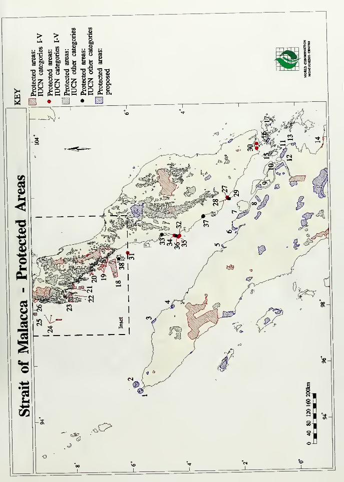
> > -e -i-^ - g, a
|| |l |i |i
•aea •art "O^ "Ok
M?H 4>Z «f^ Sri
(Jul

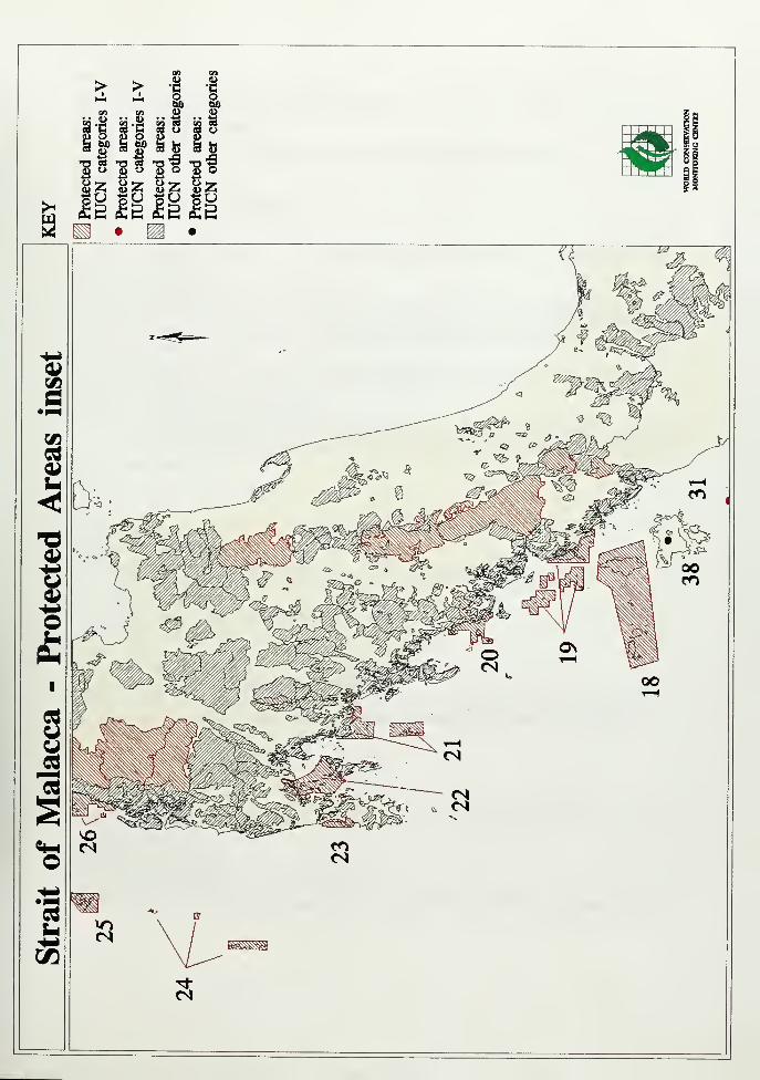
si siS bo S 60
^3 w "O " ^D
00
fI.2
bit!
^ ° ^^i -.. -^ -^ U ^ S) Z
^^^
Si

and 1 1 (part).
LATITUDE LONGITUDEAREA 18ha; based around 3 ecological plots.
LAND TENURE State land.
PHYSICAL FEATURESVEGETATION A lowland dipterocarp forest with a high diversity of plants.
FAUNACULTURAL HERITAGECONSERVATION MANAGEMENTSTAFFBUDGETLOCAL ADMINISTRATION State Director, Forestry Department, Seremban, Negri
Simbiian, Malaysia.
VISITOR FACIUTIESSCIENTIFIC RESEARCH AND FACILITIES Ecological plots have been established by the
Forest Research Institute to obtain basic data to interpret the growth and dynamics of
primary rainforest. A preliminary analysis was completed by Wyatt-Smith (1966).
LOCAL POPULATIONDISTURBANCES, DEFICIENCIES AND MANAGEMENT PROBLEMS The pressure by
loggers, agriculturists and land developers is severe.
PRINCIPAL REFERENCE MATERIALPutz, F. E. (1978). A Survey of Virgin Jungle Reserves in Peninsular Malaysia. Forest
Research Institute Research Pamphlet No. 73. The Forestry Department, Peninsular
Malaysia. 89pp.DATE
NAME Cape Rachado (Tanjong Tuan) Virgin Jungle Reserve
MANAGEMENT CATEGORY VI
BIOGEOGRAPHICAL PROVINCE 4.7.1
LEGAL PROTECTION Forest Ordinance (Cap. 147) of the Straits Settlements.
DATE ESTABLISHEDGEOGRAPHICAL LOCATION State of Malacca.
LATITUDE LONGITUDE,
AREA 120haLAND TENURE State land
PHYSICAL FEATURES Well drained coastal hill.
VEGETATION Rich coastal hill flora of seraya Shorea curtisii, meranti tembaga Shoreatembaga, keruing gondol Dipterocarpus kerrii and kempas Koompassia malaccensis.
NOTEWORTHY FAUNACULTURAL HERITAGECONSERVATION MANAGEMENTSTAFFBUDGETLOCAL ADMINISTRATION State Director, Forestry Department, Seremban, Negri
Simbiian. Malaysia.
VISITOR FACILITIES
SCIENTIFIC RESEARCH AND FACILITIES
LOCAL POPULAtlONDISTURBANCES, DEFICIENCIES AND MANAGEMENT PROBLEMS Visitors to this area
annually number in the thousands, mostly school children.
PRINCIPAL REFERENCE MATERIALPutz, F. E. (1978). A Survey of Virgin Jungle Reserves in Peninsular Malaysia. Forest
Research Institute Research Pamphlet No. 73. The Forestry Department, Peninsular
Malaysia. 89pp.DATE
Singapore Sites
NAME Bukit Timah Nature Reserve, Central Catchment Nature Reserve
lUCN MANAGEMENT CATEGORY Bukit Timah: IV (Managed Nature Reserve)
Central Catchment: IV (Managed Nature Reserve)
BIOGEOGRAPHICAL PROVINCE 4.07.01 (Malayan Rainforest)
GEOGRAPHICAL LOCATION Bukit Timah Nature Reserve lies adjacent to, arid south west of.
Central Catchment Nature Reserve in the central part of the island of Singapore, 8km from
the city.
DATE AND HISTORY OF ESTABLISHMENT Bukit Timah first received protection in the 1 840sas a 'climatic reserve', and in 1884 became Singapore's first forest reserve (Polunin, 1981).
In 1 930 the forest reserve was revoked and reconstituted so as to include only 72ha of forest.
In 1 936 it was taken over by the Gardens Department as a nature reserve, although there wasno legislation to provide for this (Corlett, 1 988). In 1 939 it was regazetted as a forest reserve
of only 66 hectares under the control of the Gardens Department, the Director of the Botanic
Gardens being gazetted as Conservator of Forests. In 1951, Bukit Timah was declared a
nature reserve under the Nature Reserves Act.
AREA Bukit Timah: 71 ha
Central Catchment: 2,434haLAND TENURE State
ALTITUDE 20-1 65m ,
PHYSICAL FEATURES Bukit Timah is located on the highest hill in Singapore. The Central
Catchment Area occupies an area with low ridges and knolls, and includes Pierce Reservoir,
Selatar Reservoir and Mac Ritchie Reservoir. Bedrock is granite, probably of post-lower
Jurassic age (Wong, 1969). The soils belong to the Rengam series: well-drained andcharacterised by a dark, greyish-brown topsoil 1 0-20cm deep with a yellowish-brown subsoil
grading to a yellowish-red firm horizon below 1.5m (Ives, 1977). Topography ranges from
gradual to steep, and in places the larnl falls to merge with steep-sided gulleys with granite
outcrops and boulders (Wong, 1 987).
CLIMATE Conditions are equatorial, with a mean annual rainfall of 2579mm and a minimummonthly rainfall of 140mm. Mean temperature is 26oC, with almost no seasonal variation
(Corlett, 1988).
VEGETATION The protected areas complex is an isolated patch of tropical forest, surrounded
by non-forest land, in which more than 850 species of vascular plants have been recorded
since the last century (Corlett, 1 988). Bukit Timah Nature Reserve still comprises about 60%primary forest, commonly classified as coastal hill forest (Wong, 1 987), although much of this
has been considerably disturbed in the past. The rest is secondary forest, which has not been
invaded by exotic or native weedy species except along road margins and artificial openings.
Secondary vegetation covers most of the Central Catchment Nature Reserve, with
regenerating high forest fringing MacRitchie Reservoir. The secondary forest is often
dominated by tiup tiup Adinandra dumosa (Choo-Teh et al.. 1 990). Dipterocarps are the
dominant canopy species in the primary forest (e.g. Shorea curtis/i, endemic to the Malay
Peninsular, Dipterocarpus kerri and D. sub/amellatus).
Other canopy species include jambu Eugenia sp., jelutong Dyera costulata, oaks Lithocarpus
spp. near the summit, rengas Melannonfioea sp. and Dracaena maingayi- Crescent tree
Aporosa benthamiana, Agrostistachys sessilifolia, Garcinia parviflora and Calophyllum sp.
make up the lower canopy with a rich abundance of epiphytes, including bird's nest fern
Asplenium nidus, stag horn fern Hatycerium coronarium. aroids (e.g. Epipremnum giganteum)
and lianas (e.g. Rourea mintosoides). The grour>d flora is sparse with tree seedlings, shrubs
(e.g. Anisophyllea disticha). elephant iemsAngiopteris evecta and creeping fig Ficuspumila.
About 100 species of ferns occur today in Singapore, of which about 80 are found only in
Bukit Timah Nature Reserve (Choo-Toh etal.. 1 990). Although there are probably no endemic
plant species at Bukit Timah, an estimated 1 5% of the flora is at its southern limit and likely
to be genetically different from other populations (Corlett, 1988). A complete list of tree
species for Bukit Timah is given by Wong (1 987). An illustrated detailed account of flora is
given in the guide to Bukit Timah Nature Reseve (Choo-Toh et al.. 1990).
FAUNA Present knowledge of the mammalian fauna is irK:omplete, particularly as regards
nocturnal species. Certainly extinct in Bukit Timah Nature Reserve are tiger Panthera tigris
(E), leopard Panthera pardus (T), clouded leopard Neofelis nebulosa (V), pig-tailed macaqueMacaca nemestrina, sambar Cervus unicolor, barking deer Muntiacus muntjak, and wild boar
Sus scrofa. Either extinct or rare are slow loris Nycticebus coucang, common porcupine
Hystrix brachyura, leopard cat Felix benga/ensis and mousedeer Tragulusj'avanicus. Mammalsthat can still be seen include common tree-shrew Tupaia glis. long-tailed macaque Macacafascicularis, Singapore rat Til(us annandalei, flying lemur Cynocephalus variegatus, commonflying fox Pteropus vampyrus, red giant flying squirrel Petaurista petaurista, commonred-bellied squirrel Callosciurus notatus. large Irtdian civet Viverra zibetha and pangolin Manisjavanica (Choo-Toh etal., 1990). Comparison of lists of bird species compiled in 1949 and1 985 suggests that more than half of Bukit Timah's avifauna has been lost, including all the
trogons, hornbills,and broadbills, all but one barbet, more than half of the babblers andwoodpeckers, and a variety of other species (Corlett, 1 988). An illustrated detailed accountof fauna is given in the guide to Bukit Timah Nature Reseve (Choo-Toh et al., 1990).
CULTURAL HERITAGE No infonmation
LOCAL HUMAN POPULATION Five hectares have been added to Bukit Timah Nature Reservein the south-west corner, more than half of which are occupied by two Malay villages (Corlett,
1988).
VISITORS AND VISITOR FAaUTIES Bukit Timah Nature Reserve is readily accessible fromthe city and is a popular weekend spot, being visited by 78,000 people in the last year
reported (Corlett, 1988). It has an extensive system of nature trails, providing access to all
parts of the reserve. Many of the bigger trees are labelled. Drinks and snacks are available
at the reserve entrar^e, and a visitor centre has been planned (Anon., 1989).SCIENTIFIC RESEARCH AND FACILITIES Few, if any. other areas of rain forest in South-east
Asia have been studied in such detail as Bukit Timah. It is botanically famous, being the typelocality for a number of plant species and many irisects arKi invertebrates (A.R. Wallace mademajor collections there last century). Various studies on the fauna and flora are conductedby the students and staff of tertiary institutions in Singapore. Current research projects
include studies of angiosperms, ferns, bryophytes. Algae, mycorrhizal fungi, macaques, birds,
insects, and freshwater crabs. There are no scientific facilities (Corlett, 1 988).
CONSERVATION VALUE Bukit Timah contains the only virgin rain forest in Singapore and is
possibly the oldest small rain forest reserve in the worid. Despite more than 1 30 years of
isolation and considerable disturbartce, the reserve still retains much of its original diversity.
It contains more than 40% of Singapore's native flora, much of which is not found elsewhereon the island, as well as an extremely rich invertebrate fauna (Corlett, 1 988; Choo-Toh etal.
1990).
CONSERVATION MANAGEMENT No record exists of when the forest on Bukit Timah first
became isolated. Following its designation in the 1880s as a forest reserve, Bukit Timah's
boundaries were demarcated by a firebreak. Although never logged, timber was extracted
illegally. The largest area (133ha) was under 'grass and fern', and the rest (88ha) under
'brushwood'. In 1895 both ereas were transferred to the control of the Collector of Land
Revenue at the Land Office. Again there was no legal extraction of timber, but illicit felling
continued to be a major problem. However, little more than a third of the 343ha reserve was
under timber. New paths were cut and signposted, trees were labelled, timber thefts were
stopped, devastated areas were planted and a thorough botanical survey was started. Somedamage occurred during the Japanese invasion in 1 942 and the subsequent occupation until
1 945, with some trees being felled and excavations made for defensive purposes, but on the
whole the reserve was not seriously damaged. More serious, post war, was the quarrying
adjacent to the reserve, and which in places encroached into it. A Select Committee,
appointed to investigate these activities, recommended that the quarries be closed. Despite
their recommendations, two quarries are still active although they are no longer being
extended horizontally (Corlett, 1988).
MANAGEMENT CONSTRAINTS Until recently, Bukit Timah was essentially part of the Central
Catchment Area, being separated only by a pipe-line carrying water. With the completion of
the six-lane Pan Island Expressway east of the reserve, however, it is now entirely isolated
except for that small portion of the Central Catchment Area lying between the expressway
and the summit of Bukit Timah, on which the integrity of Bukit Timah Nature Reserve nowdepends. Elsewhere, villages and farms border Bukit Timah Nature Reserve. Villagers harvest
firewood and pole-sized trees near the reserve's fringes, and domestic chickens, dogs and
cats enter the reserve. So far as is known, no commercial exploitation of timber has taken
place. In 1 982 it was reported that a stretch of quarry road, 200m long and 3m wide, had
been ploughed right beside the reserve fence, damaging it and some of the trees, and possibly
leading to erosion of the immediate reserved area. The Parks and Recreation Department has
since prohibited any further clearing (Corlett, 1 988). In 1 989 a new National Parks Board wascreated, to include the existing Nature Reserves Board, with responsibility for Bukit Timah and
Central Catchment nature reserves (Anon, 1989).
There is a police radio station on the summit and a VHF telecommunication transmitter on a
2ha plot of land overlooking the southernmost quarry. Shot-blasting of the telecommunication
tower has led to the deposition of up to a centimetre of copper slag, highly toxic to most
organisms, over several hectares of primary forest. These buildings are served by tarmac
roads which are not open for use by private vehicles. An additional area of about one hectare
on the summit, cleared last century, is grassed and planted with exotics. There are smaller
cleared areas around some of the shelters provided for visitors, and several views have been
'improved' by felling trees (Corlett, 1 988).
STAFF Five permanent rangers supervise Bukit Timah Nature Reserve
(Corlett, 1988).
BUDGET No information ..
LOCAL ADDRESSESNational Parks Board, Singapore Botanic Gardens, Cluny Rd, Singapore 1025 (Tel: 4741 1 65;
Fax: 4754295)REFERENCESAnon . (1989). Ministry of National Development Annual Report.
Singapore. 46 pp.
Corlett, R.T. (1 988). Bukit Timah: the history and significance of a small rain forest reserve.
Environmental Conservation 1 5: 37-44.
Ives, D.W. (1977). Soil map of Republic of Singapore. Scale
1 :63360. New Zealand Soil Survey Report 36. 1 5 pp. (Unseen)
Murphy, D.H. (1973). Animals in the forest ecosystem. In:
Chuang, C.H. (Ed), Animal life and nature in Singapore. Singapore University Press,
Singapore. Pp. 53-73.
Poiunin, N. (1981). BukitTimah Nature Reserve, Singapore.
Environmental Conservation 8: 274.
Choo-Toh, G.T., Hails, C.J., Harrison, B., Wee, Y.C. and Wong, Y.K. (1 990). A guide to Bukit
Timah Nature Reserve. Singapore Science Centre, Singapore. 1 38 pp.
Swan, F.R. (Jr.) (1988). Tree distribution patterns in the Bukit
Timah Nature Reserve. Garden's Bulletin, Singapore 41 : 59-81
.
Wong, P.P. (1969). The surface configuration of Singapore island,
a quantitative description. Journal of Tropical Geography 29: 64-74. (Unseen)
Wong, Y.K. (1987). Ecology of the trees at Bukit Timah Nature
Reserve. Garden's Bulletin, Singapore 40: 45-76.
DATE November 1980, reviewed January 1991
Sites for Sumatra
NAME Cagar Alam Kelompok Hutan Bakau Pantai Timor Jambi (Kelompok Hutan Bakau Pantai
East Jambi Nature Reserve)
lUCN MANAGEMENT CATEGORY I (Strict Nature Reserve)
BIOGEOGRAPHICAL PROVINCE 4.21.13 (Sumatra)
GEOGRAPHICAL LOCATION Lies on the east coast of central Sumatra within the
administrative province of Jambi. The city of Jambi lies to the south. The boundaries follow
the present division between mangrove forest and arable land. 0o50'-1o20'S,103o30'-104o07'E
DATE AND HISTORY OF ESTABLISHMENT Established as a nature reserve in 1981AREA 6,500haLAND TENURE State
ALTITUDE Om-IOmPHYSICAL FEATURES The reserve encompasses part of the extensive tract of coastal
wetland that fringes Sumatra's east coast. The intertidal mudflats are intersected bynumerous creeks and rivers (Silvius, 1989).CLIMATE Lies within climatic zone B, with between five and seven consecutive wet monthsand three or less consecutive dry months (Whitten et al., 1984).VEGETATION Mangrove forest
FAUNA The reserve supports a rich avifauna, with shorebirds and waterfowl being
particularly well represented. Notable species include milky stork Mycteria cinerea (V), of
which the reserve supports the largest breeding colony in the world, with some 10% of the
total population. In addition, some 1 ,500 Asian dowitcher Limnodromus semipalmatus (R),
over half the world's population, are present during their northward and southward migrations,
as well as grey heron Ardea cinerea and possibly black-headed ibis Threskomismelanocephalus. Other species of note include lesser adjutant stork Leptoptilosjavanicus (V)
and Nordmanns greenshaiik Tringa gutdferW). Shorebirds include black-bellied plover Pluvialis
squatarola, Mongolian plover Charadrius mongolus, greater sand plover C. leschenaultii,
black-tailed godwit Limosa limosa, bar-tailed godwit L. lapponica, whimbrel Numeniusphaeopus, curlew N. arquata and far-eastern curiew N. madagascariensis. Reptiles include
monitor Varanus salvator {S\\\i\us, 1986, 1989).CULTURAL HERITAGE No information
LOCAL HUMAN POPULATION There are a number of coastal villages behind the mangrove

fringe (Silvius, 1989).
VISITORS AND VISITOR FAaUTIES No information
SCIENTIFIC RESEARCH AND FACILITIES Avifauna! surveys have been carried out by
Danieison and Shov (1986. 1987, cited in Silvius, 1989) and Silvius (1986).
CONSERVATION VALUE The reserve and surrounding area are of national and international
importance as breeding arKl roosting grouruis for a number
of threatened species of waterfowl (Silvius, 1 986).
CONSERVATION MANAGEMENT Silvius (1986) makes a number of management
recommendations, including boundary marking, regular patrols and monitoring, and the
implementation of a conservation education programme for the local population. It is further
recommended that the mangrove fringe near Desa Pemusiran be included in the reserve as it
contains two important herorwies. Boundaries are currently being marked in the field (Silvius,
1989).
MANAGEMENT CONSTRAINTS Prirtcipal management problems are erwroachment of coconut
and rice plantations into the mangrove back swamps. Other problems include small-scale
illegal logging and collection of eggs (Silvius, 1 986, 1 989).
STAFF No information
BUDGET No information
LOCAL ADDRESSES PHPA headquarters are located at Bendahara
REFERENCESSilvius, M.J. (1 986). Survey of coastal wet/ands in Sumatra
Selatan and Jambi. Indonesia. For the proposed PHPA-lnterwader project. Report
No. 1 . Pp. 70-73.
Silvius, M. (1989). Indonesia. In: Scott, D.A. (Ed.), A directory
of Asian wetlands. lUCN, Gland, Switzerland and Cambridge, UK. Pp. 1004-1005.
Whitten, A. J., Damanik, S.J., Anwar, J. and Hisyam, N. (1984). The Ecology of Sumatra.
Gadjah Made University Press, Indonesia. 555 pp.
DATE January 1991
Sites for Thailand
NAME Hat Chao Mai National Park
MANAGEMENT CATEGORY II (National Park)
BIOGEOGRAPHICAL PROVINCE 4.05.01 (Indochinese Rainforest)
GEOGRAPHICAL LOCATION Located on the western mainland coast of peninsular Thailand
in Trang Province. The nearest major town is Trang, about 1 5km to the east. The boundary
encompasses marine areas. 7o14'-7o30'N, 99o14'-99o28'E
DATE AND HISTORY OF ESTABUSHMENT 14 October 1981AREA 23,088ha. Comprises 9,366ha terrestrial and 1 3,722ha marine.
LAND TENURE GovernmentPHYSICAL FEATURES Includes coastal beach, offshore islands, steep forested hills and
degraded mangrove areas (Round, 1985).
CLIMATE No information
VEGETATION Comprises evergreen forest on limestone hills inland, beach scrub and small
areas of mangrove in coastal areas (Round, 1985).
FAUNA There are recent, unconfirmed reports of blackneck stork Ephippiorhynchus asiaticus
which formeriy bred in the area (Round, 1985). The park is an important roost site for
8-10,000 wintering waders which commute to the adjacent Mu Ko Libong Non-hunting area
(P.O. Round, pers. comm.).CULTURAL HERITAGE No information

LOCAL HUMAN POPULATION No information
VISITORS AND VISITOR FACILITIES Accommodation is available for 50 people in bungalows
and an indeterminate number of large tents are also available. There is a visitor centre
although details are not available (Kasetsart University, 1 987).
SCIENTIFIC RESEARCH AND FAaLITIES No information
CONSERVATION iUIANAGEMENT No information
MANAGEMENT PROBLEMS No information
STAFF Includes two forest technicians, two National Parks Division officers, a single clerk
and up to 26 seasonally employed workers (Kasetsart University, 1 987).
BUDGET 429,300 baht (US$ 16,000) in 1986.
REFERENCESKasetsart University, 1987. Assessment of national parks, wildlife sanctuaries and other
preserves in Thailand. Draft Report. Faculty of Forestry, Kasetsart University, Royal
Forest Department, Office of the National Environment Board, USAID. 1 24 pp.
Round, P. (1985). Status and conservation of resident forest birds in Thailand. Association
for the Conservation of Wildlife. Bangkok. 143 pp.
DATE June 1987
NAME Ao Phangnga National Park
MANAGEMENT CATEGORY II (National Park)
BIOGEOGRAPHICAL PROVINCE 4.05.01 (Indochinese Rainforest)
GEOGRAPHICAL LOCATION Located on the western mainland coast of peninsular Thailand
in Phangna Province and some 3km north-east of Phuket Island. The Phuket to Phangnga
road passes close to the north-east boundary. 8o03'-8o30'N,
98o27'-98o38'E
DATE ESTABUSHED 29 April 1981
AREA 40,000haLAND TENURE GovernmentALTITUDE Sea level to 439mPHYSICAL FEATURES The Park comprises a large, shallow marine component (34,700ha)
in Phangnga Bay and a small terrestrial area (5,300ha). More than 40 limestone islands rise
steeply from the sea, many with poorly developed soils. There are a few areas of coral in the
west and some islands have beaches (UNEP/IUCN, 1 987).
CLIMATE The climate is monsoonal with heavy rain and strong winds during the May to
October south-west monsoon. Mean annual rainfall is 2380mm and the mean annual
temperature is 28<>C with only slight seasonality (Dobias, 1 982).
VEGETATION There are considerable areas of mangrove forest in good condition, although
the most extensive areas are outside the Park boundary (Round, 1985). Much of it is
secondary growth managed under concessions for timber production. Small patches of
rainforest occur on some of the flatter islands, although most support only stunted trees
(Dobias, 1982; UNEP/IUCN, 1987; Sayer, 1987).
FAUNA Dugong Dugong dugong (V) occur but are uncommon (Sayer, 1 981 ), whilst dolphins
are seen quite frequently in groups of 15 or 20 individuals (Dobias, 1982). Crab-eating
macaque Macaca fascicularis are common, whilst reports of serow Capricornis sumatraensis
remain moot. A number of caves are inhabited by bats. A mammal species list is given in
MacKinnon and MacKinnon (1 987). Birds include reef egret Egretta sacra, little green herons
(Egretta garetta or Butorides striates and hombills Bucerotidae sp., are seen frequently
(Dobias, 1 982; Sayer, 1 98 1 ) and Haliaeetus leucogaster. Pied imperial pigeon Ducula bicolor.
Pelargopsis amauroptera and Pitta pregarhyncha are reported (Round, 1985).
CULTURAL HERITAGE A shallow cave near Ko Panyi contains prehistoric drawings thought
to be about 3,000 years old (Dobias, 1 982).
LOCAL HUMAN POPULATION There is a large Muslim fishing village on Ko Panyi in the north
of the Park (Dobias. 1 982) and the number of people in a number of other villages in the Park
built on stilts. These are a major tourist attraction which makes a sizeable contribution to the
livelihood of local people (Sayer. 1981).
VISITORS AND VISITOR FACILITIES There are no details of visitor numbers available,
although quite large numbers arrive by road, or by boat, from Phuket (Sayer, 1981).
However, accommodation is available for more than 1 00 people (Kasetsart University, 1 987).
Tourist boats offer 3-4 hour trips to Tham Lot, Khao, Phingkan and Ko Panyi, visiting
limestone caves (Dobias, 1982). Interpretation material appears limited to information signs
(Kasetsart University, 1987).
LOCAL ADMINISTRATION Headquarters is near Ban Chap Phrae at the extreme north end
of the park, 96km on a paved road from Phuket, and considerably less by boat.
SCIENTIFIC RESEARCH AND FAGUTIES The avifauna has not been studied in detail (Round,
1985), although the Park is described in Dobias (1982) and Sayer (1981).
CONSERVATION MANAGEMENT The Park headquarters are near Ban Chap Phrae at the
extreme north of the Park. There are no details concerning management activities, although
a system of zonation and regulation of exploitation has been recommended (Sayer, 1981).
A management plan is scheduled for preparation in 1 990 (Kasetsart University, 1 987).
MANAGEMENT PROBLEMS There is little control of access into the Park, nor of the people
who live inside the park (Sayer, 1981). Tin dredging used to be carried out, but is no longer
an important activity. However, mine tailings are still washed into the Park (UNEP/IUCN,
1 987). Local fishing is not considered deleterious. There is a lack of freshwater in the Park
(Sayer, 1981).
STAFF One technical officer, two forest technicians, three other permanent workers and 35seasonal workers (Kasetsart University, 1 987).
BUDGET 862,000 baht in 1 986, excluding allocations for construction materials and durables
(Kasetsart University, 1 987).
LOCAL ADMINISTRATION No information
REFERENCESj
Dobias, J. (1982). The Shell Guide to the national parks of
Thailand. The Shell Company of Thailand Limited. Bangkok. 1 37 pp.
Kasetsart University, 1 987. Assessment of national parks, wildlife
sanctuaries and other preserves in Thailand. Draft Report. Faculty of Forestry,
Kasetsart University, Royal Forest Department, Office of the National Environment
Board, USAID. 124 pp.
MacKinnon, J. and MacKinnon, K. (1987). Review of the protected
areas systems in the Indomalayan Realm. lUCN, Cambridge.
Round, P. (1985). Status and conservation of resident forest birds in Thailand. Association
for the Conservation of Wildlife. Bangkok. 1 43 pp.
Sayer, J.A. (1981). A Review of the Nature Conservation andpolicies of the Royal Forest Department, Thailand. FAO, Rome.
DATE June 1987
NAME Hat Nai Yang National Park
MANAGEMENT CATEGORY II (National Park)
BIOGEOGRAPHICAL PROVINCE 4.05.01 (Indochinese Rainforest)
GEOGRAPHICAL LOCATION Situated on the north-west coast of Phuket Island, facing the
Andaman Sea and in Phuket Province. Phuket International Airport adjoins the Park boundary
and the major access route is via the Phuket to Phangnga road. The boundary encompasses
hills to the south, a 1 0km stretch of beach to the north and extends between 1 .5km and 3km
offshore. The nearest major town is Phuket, 32km to the south-east. 8o02'-8ol2'N,
98o14'-98o20'E
DATE AND HISTORY OF ESTABUSHMENT 13 July 1981
AREA 9,000ha, comprising 2,200ha terrestrial and 6,800ha marine.
LAND TENURE Government
ALTITUDE Ranges from marine areas to 335m.
PHYSICAL FEATURES Comprises 13km of coastline, with a narrow strip of beach to the
north and coastal hills and rocky headlands to the south. The bulk of the park is the marine
inshore area which includes 3-4 small islands and largely undisturbed corals some 1 .4km
offshore (Dobias, 1982; Sayer, 1981).
CLIMATE The Park is exposed to the May to October south-west monsoon with rough seas
and a mean monthly of 23 wet days during the monsoon. The mean annual temperature is
28oC with a hot season from February to May and a cool season from September to
December (Dobias, 1 982).
VEGETATION The vegetation has been greatly modified, although remnants of coastal forest
and mangrove are found. The beach area is open with some Casuarina sp., Terminalia
catappa and Barringtonia sp. The forest on hills to the south is secondary, having been
subject to clearance for maize, bananas and rubber cultivation (Sayer, 1981).
FAUNA The major points of interest are the coral formations and local nesting turtles. More
than 200 coral species have been recorded in the Phuket area and the formations in the park
are largely undisturbed; an account is given in UNEP/IUCN (1987). The park is an important
nesting area for leatherback turtle De/moche/ys coriacea (E) and Olive Ridley Lepidochelys
olivacea (E), hawksbill turtle Eretmoche/ys imbricata (E) and green turtle Chelonia mydas (E)
also occur. An estimated 1 5,000 eggs are laid on the beach annually during the November
to February nesting season (Dobias. 1982). The park supports some common bird and small
mammal species, but it does not have cortservation importance on this account (Round, 1 985;
Sayer, 1981).
CULTURAL HERITAGE No information
LOCAL HUMAN POPULATION Although there appear to be no permanent residents within
the park, the island is generally heavily settled.
VISITORS AND VISITOR FACIUTIES Some 20,000 people annually visit the Park, frequently
from a number of holiday resorts adjacent to the southern boundary, to use the beach.
However, it seems likely that many visitors are unaware that they are entering a protected
area (Paine, 1 987). Accommodation facilities include bungalows for up to 1 50 people with
tents available for a further 90 people. Other services include a visitor center, souvenir shop,
information signs and a catering facilities (Kasetsart University, 1 987).
SCIENTIFIC RESEARCH AND FACILITIES The corals of Phuket Island are the best studied in
Thailand, due to the presence of the Phuket Marine Biological Centre on the Laem Phan Wapeninsular. The results of numerous studies, several of which include work within the park
are published in the Phuket Marine Biological Centre Research Bulletin. An account of ongoing
studies is given in UNEP/IUCN (1987).
CONSERVATION MANAGEMENT It is not known if the National Parks Act (1 961 ) specifically
protects marine resources. However, the presence of a police station overlooking the best
coral flats has deterred dynamite fishing. The park is valued for its corals, breeding turtle
populations and for recreation on an island that is a major domestic and international tourist
destination. An indeterminate number of turtle eggs are collected by park staff, taken to
Phuket Marine Biological Centre in the south of the island for hatching aruj then subsequently
returned to the park for release in an annual ceremony held on 1 3 April. A total of some
3,000 individuals are released, although figures of egg and hatching mortality are unknown.
Furthermore, it is not Icnown whether this practice is beneficial or detrimental to the local
breeding population (Paine, 1987).
MANAGEMENT PROBLEMS Phuket Island is heavily developed with a major tourist industry
which inevitably threatens the integrity of the park (Sayer, 1981). Local tin dredging has
caused extensive resuspension of sediment to the detriment of corals. Crown of thorns
starfish Acanthasterplanci became common on the reefs of the west coast of Phuket in 1 983
although it is not known if the park itself was affected (UNEP/IUCN, 1 987). The park has no
guard stations or boats (Kasetsart University, 1987).
STAFF Includes three technical officers, three guards and up to 40 seasonally employed
workers.
BUDGET 557,000 baht (US$ 12,800) in 1986. This does not include allocations for
construction materials and durables (Kasetsart University, 1 987). The budget is supplemented
by a further 200,000 baht (US$ 7,300) income from tourism (Paine, 1987).
LOCAL ADMINISTRATION No information
REFERENCESDobias, J. (1 982). The Shell Guide to the national parks of
Thailand. The Shell Company of Thailand Limited. Bangkok. 1 37 pp.
Kasetsart University, 1987. Assessment of national parks, wildlife sanctuaries and other
preserves in Thailand. Draft Report. Faculty of Forestry, Kasetsart University, Royal
Forest Department, Office of the National Environment Board, USAID. 1 24 pp.
Paine, J.R. (1987). Mission Report - Thailand. Protected Areas
Data Unit, lUCN Conservation Monitoring Centre, Cambridge. 1 1 pp.
Round, P. (1985). Status and consen/ation of re^dent forest birds in Thailand. Association
for the Conservation of Wildlife. Bangkok. 1 43 pp.
Sayer, J.A. (1981). A Review of the Nature Conservation and
policies of the Royal Forest Department, Thailand. FAO, Rome.UNEP/IUCN (1987). Directory of Coral Reefs of International
Importance. Vol.2. Indian Ocean, Red Sea and Gulf. UNEP Regional Seas Directories
and Bibliographies. FAO, Rome.DATE June 1987
NAME Mu Ko Similan National Park
MANAGEMENT CATEGORY II (National Park)
BIOGEOGRAPHICAL PROVINCE 4.05.01 (Indochinese Rainforest)
GEOGRAPHICAL LOCATION Situated in the Andaman Sea in Phangnga Province, 60km from
the nearest mainland and about 110km north of Phuket town. 8<328'-8°41'N,
97o39'-97o41 'E
DATE AND HISTORY OF ESTABLISHMENT 1 September 1 982AREA 1 2,800ha, comprising a 1 ,400ha terrestrial component and an 1 1 ,400ha marine
component (Kasetsart University, 1 987).
LAND TENURE GovemmentALTITUDE Water depths of 30-60m can be found inshore whilst the maximum elevation is
attained on Ko Similan at 244m. Maximum elevations on Ko Paya, Ko Miang, Ko Payang, and
Ko Huyong are 199m, 145m, 130m and 170m, respectively.
PHYSICAL FEATURES The park encompasses six small islands and several small islets and
semi-submerged rocks. The islands comprise coarse-grained crystalline rocks and lie on a
north-south axis, with the highest in the north. There are some sandy beaches to the north
and east of some islands and occasionally limited, shallow reef flats. Fresh water is only
available intermittently (Sayer. 1981).
CLIMATE The climate on. the nearest mainland is characterised by a mean annual rainfall of

3000-4000mm and a mean annual temperature of 27-28oC (Lekagul and McNeely, 1977).
VEGETATION Semi-evergreen rain forest, poor in species and with few large trees, covers
most of the islands. This is probaWy a natural condition resulting from isolation, exposure and
water stress towards the end of the dry season. Dipterocarpus costatus is common and is
the only dipterocarp present,. The only palms are rattans which have been harvested in some
areas. The beach forest canopy is undisturbed and comprises Baningtonia asiatica.. Terminalia
catappa and Cordia subcordata. These support luxuriant growths of the epiphytes Drynaria
spp. and Pyrrosia spp., Pandanus sp., Crinum sp.. Reus microsperma and Eugenia grandis also
occur in this zone (Sayer, 1981).
FAUNA The islands are very poor in terrestrial species, and no large land mammals have been
recorded. The bird fauna is typical of small islands in the region with almost no resident forest
species and few coastal birds. The pied imperial pigeon Ducula bicolor is very common and
the green imperial Duculea aenea somewhat less so (Sayer, 1981). The Nicobar pigeon
Caloenas nicobarica also occurs (P.O. Round, pars. comm.). By contrast the marine fauna is
very rich and includes cetaceans. Marine turtles including the leatherback Deimoche/ys
coriacea (E) nest on the islands. Little is known of the numbers of the different species but
it seems likely that the park is one of the most important nesting areas in Thailand. Fish
populations in the park are reported to be denser, more diverse and comprise larger individuals
than those found in similar habitats elsewhere in the Andaman sea. This is attributed to the
close proximity of deep water and possible local upwelling of cool, nutrient-rich waters. The
coral reefs are not extensive but are rich in species (Sayer, 1981). Details are given in
UNEP/IUCN (1987).
CULTURAL HERITAGE Chao Lay marine gypsies have exploited the park area in the past,
gathering molluscs, including giant clams (Sayer, 1981).
LOCAL HUMAN POPULATION No information
VISITORS AND VISITOR FAOUTIES Accommodation facilities are restricted to small, rented
tents for some 1 00 people, and camping grounds. Other services, some operated by private
concessions, include catering facilities, a general store, visitor centre, nature trails and
information signs (Kasetsart University, 1987).
SCIENTIFIC RESEARCH AND FACILITIES The islands have been visited by staff of the Phuket
Marine Biological Centre and a Thai-Danish expedition visited the islands briefly in about 1 975
(Sayer, 1981).
CONSERVATION MANAGEMENT The principal values of the park are nesting marine turtles,
coral reefs and potential tourist development (Sayer, 1981). Furthermore, the site is
important for the conservation of the Nicobar pigeon Caloenas nicobarica (P.D. Round, pars.
comm.). There are no guard stations (Kasetsart University, 1 987). A number of management
recommendations are made in Sayer (1981).
MANAGEMENT PROBLEMS In the mid 1980s, crown of thorns starfish Acanthaster planci
population was low although significant coral damage was recorded in protected coves on
west coasts (UNEP/IUCN, 1 987). Some coral reefs have been damaged by dynamite fishing
but this is not extensive (Sayer, 1981).
STAFF Consists of a single forest technician, five part-time forest patrol staff and up to 15
seasonal workers (Kasetsart University, 1987).
BUDGET 41 3,000 baht (US$ 1 5,000) in 1 986, excluding allocations for construction materials
and durables (Kasetsart University, 1 987).
LOCAL ADMINISTRATION No information
REFERENCESKasetsart University (1987). Assessment of national parks,
. viMWiB sanctuariesand otherpreserves in Thailand. Draft report. Faculty of Forestry,
Kasetsart University, Royal Forest Department, Office of the National Environment

Board, USAID. 124 pp.
Lekagul, B. and McNeely, J.A. (1977). Mammals of Thailand.
Association for the Conservation of Wildlife. Bangkok. 758 pp.
Saver, J.A. (1981). A Review of the Nature Conservation andpolicies of the Royal Forest Department, Thailand. FAO. Rome.
UNEP/IUCN ( 1 987). Directory of Coral Reefs of International
Importance. Vol.2. Indian Ocean, Red Sea and Gulf. UNEP Regional Seas Directories
and Bibliographies. FAO, Rome.
DATE August 1987
NAME Mu Ko Surin National Park
MANAGEMENT CATEGORY II (National Park)
BIOGEOGRAPHICAL PROVINCE 4.05.01 (Indochinese Rainforest)
GEOGRAPHICAL LOCATION Lies in the Adaman Sea, 53km off the west coast of peninsular
Thailand in Ranong Province. 9o23'-9o29'N, 97o50'-97o55'E
DATE ESTABUSHED 9 July 1981
AREA 13,500ha, consisting of a 3,300ha terrestrial component and a 10,200ha marine
component (Kasetsart University, 1987).
LAND TENURE GovernmentALTITUDE Ranges from sea level to 350m on Ko Surin Tai and about 240m in Ko Surin Nua
(Brockelman and Nadee, 1977).
PHYSICAL FEATURES The park includes two larger, granitic islands, Ko Surin Nua and Ko
Surin Tai, or North Surin Island and South Surin Island, and two rocky islets. Lying within the
50 fathom depth line, the islands were connected to the Sunda Shelf land mass during the
most recent Pleistocene glaciation and are currentiy separated by a shallow strait about 200mwide.
The shorelines of the north and south islarKls, measuring 36.9km arKJ 23km respectively, are
highly irregular and feature numerous isolated coves, separated by ridges up to 100m in
elevation, and peninsulars. Sandy beaches above the high tide mark are confined to coves
whilst the remaining shoreline comprises granite. Level terrain is restricted to the cove areas.
At least 30 perennial springs are found on the two islands, located at the bases of ravines and
small brooks descend through the lower reaches of larger valleys (Brockelman and Nadee,
1977).
CLIMATE The west coast of the mainland at its closest proximity receives a mean annual
rainfall in excess of 4000mm and has a mean annual temperature oiF between 27oC and 28°C(Lekagul and McNeely, 1 977).
VEGETATION Vegetation can be classified into four types, comparable to similar formations
on the mainlarKJ. Tropical rainforest forms the main cover on steeper slopes and ridges and
is typically three-storied, with three speciation zones on the lower, middle and upper ridges.
The lower zone is found between 10m and 1 00m elevation, on steep slopes with granitic
boulders, with a continuous canopy of sterculiaceous trees, such as Pterocymbium tinctorium
and Pterygota alata some 25-35m high. The middle storey forms a broken canopy at about
20m and a very dense lower storey attains 1 0-1 5m. Creepers, rattans, bamboo entangle the
lowest storey and a sparse herbaceous ground flora occurs. The middle zone rainforest
occurs from 100-1 60m on lower ridges and gentie glopes with an anacardiaceous top storey
at 25-35m dominated by Parishia insignis, Swintonia grifffthiiand Dracontomelum mangiferum
with Dipterocarpus grandiflorus, Vatica cinera and Endospermum diadenum in association.
The middle storey attains 15-20m, the lowest storey 8-1 2m. Numerous shrubs such as
Lasianthus andamanicus, Rinoreahomeri. Microtropis sp. ar>d Glycosmis spp. occur along with
a limited number of palms. Climbers, bamboo, creepers, undershrubs and herbaceous species
are also present. The upper forest zone at 1 60-250in is a primeval, dense formation with a
continuous crown canopy up to 30m high. Dipterocarpaceous tree species such as
Anisoptera oblonga. Dipterocarpus grandiflorus. D. costatus and Vatica cinera. together with
D. mangiferum. Swintonia griffitNi. Parishia insignis and £. diadenum. The two lower stories
attain 15-20m and 7-1 5m. respectively. Shrub species are well represented along with
undershrubs. ferns, palms and herbaceous species: climbers are sparsely distributed
(Smitinand. 1 977). Isolated coves contain the greatest variety of habitats, such as small
freshwater marshes and swamps, beach vegetation, a variety of secondary formations and
some parches of mangrove (Brockelman and Nadee. 1 977). Along sandy beaches a strand
flora that includes Hemandia nymphaefoliae, Calophyllum inophyllum. Cerbera odoHam.
Casuarina equistetifolia, Bam'ngtonia asiatica and others occurs. On raised beaches some 2m
above the high tide level and behind the strand and mangrove forests, a dense stand of
two-storied forest occurs. The upper storey at 20-25m height includes Adenanthera
microsperma. Artocarpus rig/dus. V. cinerea. Hopea odorata and others. Climbers, frequent
palms and epiphytes are found. Exposed, rocky headlands support a stunted formation of
trees and shrubs with Atalantia monosperma, Cratoxy/um formosum, Ochna integerrima,
Memecylon plebejum. Grewia umbellata and Scolopia spinosa being common. Narrow strips
of poor mangrove forest covering about 6ha exist in sandy or muddy shores and estuaries
although the typical mainland formations are largely absent. Characteristic species are
Rhizophora apiculata, R. mucronata, Bruguiera gymnorhiza, Xylocarpus granatum and
Sonneratia grrffithii. A number of epiphytic ferns and orchids thrive on mangrove trees.
Logging operations and storm damage has lead to limited areas of secondary formation,
covering 10-20% of the forest area and comprising Macarang tanarius. Mallotus dispar,
Canthium umbellatum, Cratoxylon formosum and others. The remaining two islets are largely
rocky and support only a sparse vegetation (Smitinand. 1977). A vegetation description and
species list is given in Smitinand (1977).
FAUNA Faunal communities are similar to those found in Tarutao and Mu Ko Similan national
parks. Noteworthy mammals include pig-tailed macaque Macaca nemestrina. flying lemur
Cynocepha/us variegatus and mouse deer Tragulus sp. Reptiles include python Python
reticulatus. monitor lizard Varanussalvator and one or two turtle species including olive Ridley
turtle Lepidochelys coriacea (E) (Brockelman, 1 977). A preliminary survey of birds indicate
the presence of at least 54 land and freshwater residents including pied imperial pigeon
Ducula bicolor, green imperial pigeon D. aenea, Nicobar pigeon Caloenusnicobarica. wreathed
hornbill Rhyticeros undulatus and ruddy kingfisher Halcyon coromanda (Brockelman and
Nadee. 1 977; Round, 1 985). A partial, annotated species list is given in Brockelman and
Nadee (1977).
CULTURAL HERITAGE No information
LOCAL HUMAN POPULATION The islands are unpopulated although small shelters in some
coves indicate that fishermen are probably occasional temporary residents (Brockelman and
Nadee, 1977).
VISITORS AND VISITOR FACILITIES Accommodation facilities include dormitories and small,
rented tents for 90 and 100 people, respectively. Other services include a general store,
catering facilities and information signs (Kasetsart University, 1987).
SCIENTIFIC RESEARCH AND FACILITIES A preliminary survey and biogeograpWc analysis of
birds (Brockelman and Nadee, 1 977) and a preliminary vegetation study (Smitinand, 1 977)
were carried out in 1 977. Freshwater algae are described by Buri (1 977) and a brief coral reef
description is given by Kohn (1971).
CONSERVATION MANAGEMENT The principal conservation values of the islands, in addition
to their natural beauty, are an unusual terrestrial fauna, coral reefs, as a site for research into
island community dynamics, a turtle breeding ground and as a potential control area for

pollution studies (Brockelman, 1 977). The islands are identified as a key site for forest bird
conservation (Round, 1 985). There is one guard station and staff have access to four motor
boats (Kasetsart University. 1 987).
MANAGEMENT PROBLEMS The islands have been subjected to some selective logging, with
yang Dipterocarpus spp. and Takhian Hopea spp. mainly being taken. Dynamite fishing has
occurred (Brockelman, 1977; Smitinand, 1977).
STAFF Comprise a single forest technician and up to 20 seasonal workers (Kasetsart
University, 1987).
BUDGET 41 3,000 baht (US$1 5,000) in 1 986, excluding allocations for building materials and
durables (Kasetsart University, 1987).
LOCAL ADMINISTRATION No information
REFERENCESBrockelman, W.Y. (1977). To what fate, the Surin Islands.
National History Bulletin of the Siam Society 26: 247-251
.
Brockelman, W.Y. and Nadee, N. (1977). Preliminary survey and
biogeographic analysis of the birds of the Surin islands, Thailand. Natural History
Bulletin of the Siam Society 26: 21 1-226.
Buri, P. (1977). On some freshwater algae from North Surin Island.
Natural History Bulletin of the Siam Society 26: 200-210.
Kasetsart University (1987). Assessment of national parks,
wildlife sanctuaries and otherpreserves in Thailand. Draft report. Faculty of Forestry,
Kasetsart University, Royal Forest Department, Office of the National Environment
Board, USAID. 124 pp.
Kohn, A. (1971). Inshore marine habitats of some continental islands in the Eastern Indian
Ocean. Atoll Res. Bull. 140: 1-29 (unseen).
Lekagul, B. and McNeely, J.A. (1977). Mammals of Thailand.
Association for the Conservation of Wildlife. Bangkok. 758 pp.
UNEP/IUCN (1 987). Directory of Coral Reefs of International
Importance. Vol.2. Indian Ocean, Red Sea and Gulf. UNEP Regional Seas Directories
and Bibliographies. FAO, Rome.Round, P. (1 985). istatus and conservation of resident birds in
7Aa/7a/}(/. Association for the Conservation of Wildlife. Bangkok. 143 pp.
Sayer, J.A. (1 981 ). A Review of the Nature Conservation andpolicies of the Royal Forest Department, Thailand. FAO, Rome.
Smitinand, T. (1977). A preliminary study of the vegetation of
Surin Island. Natural History Bulletin of the Siam Society 26: 227-246.DATE August 1 987
NAME Tarutao National Park
lUCN MANAGEMENT CATEGORY II (National Park); ASEAN Heritage Park
BIOGEOGRAPHICAL PROVINCE 4.07.01 (Malayan Rainforest)
GEOGRAPHICAL LOCATION Lies off the extreme south-west coast of peninsular Thailand in
the Straits of Malacca of the Andaman Sea at Tambon Ko Sarai, Amphoe, Satun Province.
Ko Tarutao, the main island, is situated about 22km south-west of the mainland town of PakBara, Amphoe Langu. The park boundary extends 68km from east to west and 34km from
north to south and encompasses 51 islands. The international border with Malaysia is
contiguous to the south-east boundary. 6o30'-6o44'N, 99o09'-99o44'E
DATE AND HISTORY OF ESTABUSHMENT 6 April 1974AREA 149,000ha. Comprises a marine component (approximately 126,400ha) and a
terrestrial component with five main islands, viz. Ko Tarutao (15,100ha), Ko Ko Rawi
(3,100ha) and Ko Adang (3,000ha), Ko Lipe (400ha) and Ko Klang (300ha)
LAND TENURE Government. At present there are 10 disputed land title claims under
investigation (NPD. 1990).
ALTITUDE Sea level to 721m on Tarutao. Adang and Rawi attain 703m and 463m,
respectively.
PHYSICAL FEATURES The park includes 51 islands and rocky outcrops of the Sunda Shelf
which were separated from the mainland about 7,000 years ago. The major islands include
Ko Tarutao, Ko Adang, Ko Rawi, Ko Lipe, Ko Klang, Ko Batong and Ko Bissi, forming twomajor island groups: Mu Ko Tarutao and Mu Ko Adang-Rawi to the west. Sea water tends
to be turbid around Ko Tarutao, but of much higher quality around Mu Ko Adang-Rawi, and
shorelines vary from sandy beaches, rock beaches, mud beaches, cliffs, sunken estuaries with
mangroves to landward reef flats and seaward reef slopes with a narrow, intervening reef
edge. Water depth increases rapidly in places, whilst in others, coral gardens have formed
in shallows between islands (UNEP/IUCN, 1987; Anon., 1985). Tarutao Island measures
26km by 11 km in length and breadth and is dominated by north-south oriented hills,
frequently attaining 600m, with intervening perennial stream valleys. The west coast is
characterised by extensive sandy beaches, mangroves and densely forested hillsides
descending directly to the sea. The east coast features limestone cliffs and small islands.
Approximately 65% of the island comprises Cambrian sandstone and siltstone of the Tarutao
Formation, whilst lower Ordovician limestone of the Thung Song Formation dominates the
north and east. Quarternary alluvia fill the broad valleys behind Chak, Son and Talo Udang
bays, where a number of small streams enter the sea. Limestone caves are found to the
north, and islets to the south and east consist of sheer pinnacles and vertical cliffs descending
into the sea. Adang and Rawi, located about 45km west of Tarutao are geologically distinct
and comprise Triassic granite with a small amount of Quarternary alluvia. Of the two islands,
Rawi is the Tess hilly, possessing some flat terrain arid a number of gently sloping hills. Deep,
fertile soils occur on gentle slopes and lowlands of the three largest islands (Congdon, 1 982).
CLIMATE The climate is dominated by the May to October south-west monsoon, during
which strong winds arxi heavy seas occur. The September to June north-east monsooncauses short, sharp seas which can prohibit access to easterly coasts; violerit storms are rare
but may arise at any time of the year. Climate data for the period 1978-87, measured at
Satun, indicate a mean annual temperature of 32.4oC, rising to a maximum of 37.7oC andfalling to a minimum of 23.7oC. Mean annual precipitation was 2208mm, with a distinct dry
season from December to March (NPD, 1990).
VEGETATION Ko Tarutao supports six forest types, namely moist evergreen forest, dry
evergreen forest, mixed deciduous forest, mangrove forest, secondary forest and beach forest
(NPD, 1990). The predominant formation, covering some 67% of Tarutao and 80-90% of
Adang and Rawi, is forest that has structural and floristic affinities with Thailand rather than
Malaysia. Canopy species, reaching 30-40m, with emergents at 40-45m, include membersof the Anacardiaceae, Dipterocarpaceae, Leguminosae, Meliaceae and Sterculiaceae. Small
trees form a second story at 1 5-20m and include Anacardiaceae, Annonaceae, Ebenaceae,
Euphorbiaceae, Guttiferae and Myrisiticaeceae. A third storey of small trees, saplings andshrubs is present, and a sparse herbaceous layer that includes few grasses. Abundant and
conspicious Aglaonema simplex is found along streambeds and ferns Angiopteris evecta and
Cephalomanes javanicum are common. Other groups in the rainforest formation include
palms, woody climbers, vines, climbing shrubs and epiphytes. On dry and rocky hillsides the
forest is lower and Hopea ferrea and Vatica cinerea tend to replace the other dipterocarps.
Larger lowland tree species are usually restricted to below 200m. From 550m to 700m,climbers, spiny palms and small trees become very dense and a scrub and heath flora
develops on open rocky areas. Congdon (1982) identifies nine other distinct formations and

estimates of cover by the variuos fonnations on Ko Tarutao, Ko Adang and Ko Rawi are given
in NPD (1 990). Mangrove and brackish-water forest cover 3.5% of the park, mostly around
Ko Tarutao, Ao Talo Lingai, Ao Talo Udang and Ao Taio Wao (NPD, 1990). Mangrovres on
Tarutao feature Rhizophora sp., in particular /?. apiculata and R. mucronata. Bruguiera sp.,
Ceriops sp. and Sonneratia sp., sometimes in pure stands. Freshwater swamp occurs in very
limited areas along flat streambeds, dominated by the spiny palm Salacca conferta on Tarutao
and Barringtonia acutangula spicata on Rawi. Freshwater marsh is found at Talo Udang Bay
where perennial springs moisten the soil and sedges, ferns and herbaceous species occur.
A Pes-caprae formation is found on sandy shores just above the high water mark and features
creeping, herbaceous species adapted to growing across, and rooting, in sand. The dominant
species is /pomea pes-caprae, in addition to Canavalia spp., Cassytha filiformis, Cyperus spp.
and others. The woody vegetation behind the beaches and along rocky shores is very uniform
with large, dominant Barringtonia asiatica, Calophyllum inophyllum and Terminalia cattappa.
Coastal heath forest, at up to 6m height, occurs in small areas at Phante and Son Bays and
elsewhere on old beaches which are now 1-2m above the highest tides. Melaleuca cajuputi
is the dominant tree with abundant Eugenia spicata. The limestone of north and east Tarutao
and offshore islands supports a very distinctive vegetation. Exposed, rocky areas, for
example in northern Tarutao, with little or no soil, support stunted, thorny vegetation with few
herbaceous species and no large trees. However, where soil and moisture is more plentiful
a tall forest up to 25m in height occurs, typically with H. ferrea, Pentaspadon curtisii, Sapium
insigne and Terminalia triptera. Scrub forest has developed in exposed sites, with shrubs,
bamboo and a limited number of scattered trees closely following the land contours.
Secondary vegetation covers approximately 10% of Tarutao Island in areas previously logged,
cultivated or disturbed in some manner. All sites have been abandoned since 1 976 arKJ
Negrandia reynaudiana and Imperata cylindrica occur in pure stands. However, most formerly
cultivated areas support a typical secondary forest of fast-growing, light-demanding trees
(Congdon, 1 982). A list of 869 vascular species and a vegetation description is given in
Congdon (1982).
FAUNA Only a limited diversity of terrestrial vertebrates occurs in the park. Larger mammalsinclude dusky langur Presbytis obscura, crab-eating macaque Macaca fascicularis, wild boar
Sus scrofa , mouse deer Tragulusjavanicus, and possibly fishing cat Felis riverrinus. Dolphin
Delphinus delphis, Malayan dolphin Stenellamalayana, Irrawaddy dolphin Orcaellabrevirostris.
Sotalia dolphins, dugong Dugong dugon (V), sperm whale Physeter catodon and minke whale
Balaenoptera acutorostrata occur (NPD, 1990. Feral water buffalo and cattle are both found
on Tarutao, whilst the latter also occurs on Adang. Domestic goats and a limited number of
stump-tailed macaques are kept by sea gypsies.
The bird community is largely restricted to species associated with secondary vegetation,
mangrove, coastal or marine habitat. Pied imperial pigeon Ducula bicolor is quite common on
the outer islands and pale-capped pigeon Columba punicea may occur (P.D. Round, pers.
comm.). Hornbill species include Rhyticeros undulatus, Buceros bicornis and others. Coastal
birds include reef heron Egretta sacra and white-bellied sea-eagle Haliaeetus leucogaster, and
less frequently frigate \»tii.Fregata sp., dusky grey heron Ardea sumatrana and masked finfoot
Heliopaispersonata. Other species include green imperial pigeon Ducula aenea, brown-winged
kingfisher Pelargopsis amauroptera, ruddy kingfisher Halcyon coromanda, blue-winged pitta
Pitta megarhyncha and possibly ashy wood-pigeon Columba pulchricollis (Round, 1 985). Apartial species list is given in Round (1985).
Reptiles include green turtle Chelonia mydas (E), Pacific Ridley Lepidochelys olivacea (E) and
Pacific hawksbill Eretmochelys imbricata (E). Pacific Ridley turtles begin nesting in early
November and are restricted to the west coast of Tarutao whilst the earlier nesting green
turtles use several islands. Hawksbill nesting sites are limited to Rawi and Adang. Surveys
of nesting females indicate that populations have declined since the park was esatblished
(Dobias, 1 982), wNlst the relatively large size of adults suggest very low recruitment levels
(Ginsberg. 1981). Fifty-seven butterfly species have been identified (WWF/IUCN, 1982b).
Over 130 fish species have been recorded in the coral reefs of Adang, Hin Nagram and
Chabang islands including 20 species of Pomacentridae, 1 3 species of Labridae, 1 2 species
of Chaetodontidae and six species of Scaridae. Reef invertebrates include polyclad,
nudibranch, chiton, bivalve, gastropod, crustacean, sea urchin, brittle star, sea lily, peanut
worm and polychaete representatives (WWF, 1 983). Recent studies have identified 1 40 coral
species in the Adang-Rawi group (UNEP/IUCN, 1 987) whilst 205 species have been listed for
the whole park (Tantichdok, 1986).
Studies in 1 988 (NPD, 1 990) indicated that reefs remain around Ko Tarutao; a small reef
occurs at the north-east cormer of the islarKJ. Most reefs occur in the Mu Ko Adang-Rawi and
Ko Khai area. The condition of these reefs is variable and is summarised as follows. Reefs
south of Ko Adang at Laem Son: north-east of Ko Lipe; and reefs south of Ko Rawi have been
completely destroyed, due to dynamiting, corwn-of-thorns starfish infestation and monsoonstorms. Reefs south east of Ko Adang and at Ao Talo Ripe have been extensively degraded
by dynamiting and crown-of-thorns starfish infestation, but are still of ecological value and
could recover if given adequate protection. Reefs around Ko Kata, north of Ko Hin Ngam,north-west of Ko Rawi, and Ko Adang, and to the north-west and south of Ko Lipe are mostly
in good condition with more than 50% cover. Soft coral in deep water east of Ko Chabangare little disturbed. In total, more than half of reefs surveyed were classified as either heavily
degraded or destroyed beyond reasonable hope of recovery (NPD, 1 990).
CULTURAL HERITAGE The park area has been inhabited for many generations by proto-Malay
Moken sea gypsies (Alexander, 1983; Sayer, 1981). A prison was operated on Tela Oudangand Tela Wao in the south of Tarutao until 1 947 and numerous artefacts remain from this
period (Sayer, 1981).
LOCAL HUMAN POPULATION Ko Adang and Ko Upe are inhabited by some 627 Moken, whohave annual population increase of 3.7%. The Moken have their own language and customsand support themselves through fishing and collecting coral and reef fish. They also exploit
some terrestrial resources, such as timber, and there is a permanent settlement on Ko Lipe.
A further 23,185 people living on the mainland exploit the park's fisheries resources (NPD,
1990).
VISITORS AND VISITOR FAaUTIES Access to the park and its interior is by boat from the
coastal village of Pak Bare or Satun on the mainland (Dobias, 1982). There are 30km of
paved roads on Tarutao Island (ASEAN, 1 983). Bungalow and dormitory accommodation is
available for over 200 people, in addition to rented tents and camping grounds (Kasetsart
University. 1 987). Acconimodation for 80 people is available on Adang. Visitor centres are
located at Pak Bare and at the park office on Tarutao, and nature trails, information signs andinterpretive programmes arKi catering facilities are provided. The principal visitor attractions
are the large beaches on Tarutao and the extensive coral reefs around Adang and other islands
(Dobias, 1 982). The number of visitors is small in relation to those who visit the general area
as tourists. Thus in 1987 only 18,195 visits were made, roughly 2% of those who visited
the Hat Yai area, although this was a significant increase over the 5,743 in 1 982. Overseasvisitors accounted for just 5% of the total, and Thai nationals from Bangkok made up the bulk
of the visitors. Visitors during 1990 numbered 10,140 (S.Wongpakdee,pers.comm., 1991).
Annual visitation is expected to increase to 45,000 in 1992 (NPD, 1990)SCIENTIFIC RESEARCH AND FACILITIES Congdon (1 982) describes the park vegetation andenumerates 869 vascular plant species; a bibliography is given. Turtle studies were carried
out in 1980-1981 (Ginsberg, 1981; WWF/IUCN, 1982). The WWF/IUCN project 1816 wasinitiated in 1 982 with the objectives of: conserving terrestrial and marine resources, with an

emphasis on the controlled development and protection of habitats critical to the survival of
endangered species, notably sea turtles and coral reefs; formulating a reef management plan;
and promoting public awareness (WWF, 1982a, 1982b). A partial inventory of the bird
community has been compiled (Round, 1985). Inventories of fish and marine invertebrates,
investigations of zonation and martgrove productivity studies have been made (WWF/IUCN,1 982a). Further studies of marine fauna, the impact of dynamite fishing and the rate of reef
recovery have also been made (UNEP/IUCN, 1 987). A popular account of the park is given
in Dobias (1982).
CONSERVATION VALUE Principal conservation values of the park include nesting turtles
(Sayer, 1981), relatively undisturbed rain forest, coral reefs and recreation (Congdon, 1982;
Dobias, 1982). The park has been assessed by Round (1988) to be a key site for the
conservation of forest birds in Thailand.
CONSERVATION MANAGEMENT A management plan has been prepared (NPO, 1 990), which
five objectives. First, to preserve and protect natural and cultural resources as sites for
general nature study and education, and as important components in local and regional
socio-economic development. Secorxi, to promote and support recreation and tourism
develoment that is in harmony with the parks's natural systems and environment. Third, to
promote and support public education programmes that will build awareness and understande
of the coastal environment and of the parks's importance to local and regional communities.
Fourth, to promote and support significant distribution of direct and indirect benefits from park
authorities to local people. Five, to make opportunities available for local people, the
provincial government, and other concerned government agencies to participate in park
management in order to enhance local and regional benefits. Major goals are enhanced
conservation and sustained utilisation of park resources, especially those resources that
support the region's tourism and fishing industries. To achieve these recommendations, the
management plan presents a schedule of recommended actions for the implementation over
five years (1990-1994), with an emphasis on irKreased park management by local
government officials, local residents, and the private sector. The plan also defines a numberof specific managment •objectives and activites covering coastal resourcs, tourism,
socio-economic factors, administration ar>d zoning.
The park has four administrative sections, viz. administration, law enforcement, park
management and maintenance and accommodation. The headquarters are at Khiong Pante
Malaka, with outstations at Talo Wao and Tela Oudang Bays and Adang and Rawi islands.
Commercial fishing is permitted within 1km of Tarutao Island, in contrast to the prevailing
national 3km limit. Moken sea gypsies are officially tolerated (Alexander, 1 983) although
several large villages on Tarutao were relocated during 1 974 to 1 977 (Sayer, 1981). Zonation
includes the marking of reefs around Talo-Ayang on Adang Island and those around Hin NgarmIsland for visitor use, whilst others are reserved for research (WWF/IUCN, 1982a).
Management activities include law enforcement and the preparation and national disemination
of monthly information pamphlets. A turtle hatching and head-starting programme operates
at the park headquarters (Dobias, 1982; Ginsberg, 1981). Attempts have been made to
provide Moken with official employment within the park (Alexander, 1 983).
MANAGEMENT CONSTRAINTS Significant management issues are dynamite fishing and
channel digging in reefs by the Moken; reef damage by tour boat anchors and indiscriminate
refuse disposal; and natural causes such as crown-of-thorns starfish predation which have all
combined to severely degrade the reef resources. Water quality in the vicinity of the
headquarters and major tourist developments is poor, indicative of uncontrolled wastedisposal. Spawning grounds are under threat from illegal trawling, whilst reef fish are illegally
and in some case excessively, collected at Mu Ko Adang-Rawi for the international tropical
fish trade. Although forest cover is extensive there is concern over felling both of upland

communities and mangroves. Nesting turtles have declined by 90% in six years through egg
collection and the impact of trawlir>g. Edible-nest swiflet nests are collected under permit,
although there is no understaruJing of how this will affect the staus of the speceis. Tourist
servcies provided by the park are seen as inadequate, and, as an example, many tour boats
do meet minimum safety requirements. The disbursement of socio-economic burdens to local
communities, especially the Moken, is poor, largrly due to the presence of private sector
monopolies dominatirig the tourist irKJustry and the Moken fishinh activities. Local people are
not generally aware of park regulations, arvj in 1 988 three staff were killed during a dispute
with fishermen. Policy and managment strategies are generally lacking, and the National Park
Act is especially weak in the case of marine areas. There are also shortcomings in the
administrative structure in the park, the number of personnel, budget, coordination between
the park authorities and other private and public sector bodies (NPD, 1990).
In 1 987 the park was temporarily closed for military manoeuvres (B. Saisorn, pers. comm.).
There is a considerable level of illegal commercial fishing activity in the park, with up to 700people employed (NPD, 1 990).
STAFF Comprised 2 technical officers, 2 forest technicians, 1 6 guards, 7 other workers, and
up to 54 other staff in 1988 (NPD, 1990). Staff during 1991 included 1 chief , 3 subordinate
officers, 1 3 permananent park guards arui 1 27 temporary workers (S. Wongpakdee, pers.
comm., 1991).
BUDGET 2,590,000 baht (US$ 94,000) in 1986, excluding allocations for construction
materials and durables, |increasing to 14,921,100 baht during 1987, which included
8,342,270 baht for tourism development, 2,494,000 baht in 1988, 3,143,000 baht in 1989and 3,540,000 baht in 1990. Park income ranged from 1 ,006,575 in 1986 to 1 ,212,425 in
1988 (NPD, 1990). Fees from visitors during 1990 amounted 10 179,629 baht (S.
Wongpakdee, pers. comm., 1991).
LOCAL ADDRESSES Tarutao National Park, Parkbara, Muang District SatuI Province
REFERENCESAlexander, D. (1983). TNs battleground called Tarutao. International
Wildlife 13(3): 4-11.
ASEAN (1983). ASEAN Heritage parks and reserves. The ASEAN Experts Groupon the Environment and The United Nations Environment Programme. Bangkok,Thailand. 94 pp.
Ginsberg, J. (1981) The status of sea turtles in Tarutao National Park,
Satun, Thailand. Tigerpaper 1 3(2): 27-29.
Kasetsart University (1987). Assessment of national parks, wildlife
sanctuaries and other preserves in Thailand. Final report. Faculty of Forestry,
Kasetsart University, Royal Forest Department, Office of the National Environment
Board, USAID. 136 pp.
National Park Division (1990). Management plan of Tarutao National Park.
Royal Forest Department, Bangkok. 1 39 pp.
Round, P.D. (1 985). Status and conservation of resident birds in Thailand.
Association for the Conservation of Wildlife. Bangkok. 1 43 pp.
Round, P.D. (1988). Resident forest birds in Thailand. Thier status andconservation. Monograph No. 2. International Council for bird Preservation,
Cambridge. 211 pp.
Sayer, J.A. (1 981 ). A Review of the Nature Conservation and Policies ofthe Royal Forest Department, Thailand. FAO, Rome.
Tantichodok, P. (1 986). A checklist of coral reef mdlusks in Tarutao National Park. SongkiaNakrin University. (Unseen)
WWF/IUCN (1982a). Project 1816: Thailand, Tarutao National Park, Management

and Protection. Progress Report No. 2. 1 3 pp.
WWF/IUCN (1982b). Project 1816: Thailand, Tarutao National Park, Management
and Protection. Interim Report, December 1982. 3 pp.
UNEP/IUCN (1987). Directory of Coral Reefs of International Importance.
Vol.2. Indian Ocean, Red Sea and Gulf. UNEP Regional Seas Directories and
Bibliographies. FAO, Rome.
DATE August 1987, reviewed March 1991
NAME Hat Nopharat Thara - Mu Ko Phi Phi National Park
MANAGEMENT CATEGORY II (National Park)
BIOGEOGRAPHICAL PROVINCE 4.07.01 (Malayan Rainforest)
GEOGRAPHICAL LOCATION The marine and island component of the Phi Phi islands lies in
the Andaman Sea off the south-west peninsular coast, some 40km south-west of Krabi and
a similar distance south-east of Phuket Island. The terrestrial Hat Nopharat Thara component
comprises a mainland coastal area and adjoining sea due west of Krabi, in Krabi Province.
Marine and island component: 7o39'-7o50'N, 98o45'-98o49'E
Coastal component : 7 55'-8o08'N, 98o45'-98o56'E
DATE AND HISTORY OF ESTABUSHMENT 6 October 1983
AREA 38.996ha. Comprises 32,900ha marine and 6,096ha coastal
LAND TENURE Government. Private enclaves are located on Phi Phi Don Island and along
the western coast of the mainland component.
ALTITUDE No information
PHYSICAL FEATURES The park includes two limestone archipelagoes viz., the Poh Dah
Group, some 1-2km south of Hat Nopharat Thara and the Phi Phi Group, approximately 8km
further south. The former group can be reached on foot from the mainland during low tide
(Anon., n.d.; Wan-en et al., 1 987). The latter group is dominated by the largely limestone Phi
Phi Don to the north and the smaller PW Phi Lae to the south. Both islands feature precipitous
and heavily weathered cliffs. Phi Phi Don has a number of extensive sand beaches, inlets and
areas of relatively level land; Phi Phi Lae has no level areas (Anon., n.d.; Paine, 1987).
Vertical cliffs descend to 20-30m depth along most of Phi Phi Lae and around the southern
part of Phi Phi Don (UNEP/IUCN, 1 987). Mainland coastal features include extensive beds of
fossilised molluscs accumulated during the Mesozoic eera, some 75 million years ago; Pra
Nang Beach, composed of sand and sea shells; and Nopharat Thara Beach, which includes
extensive beds of seashells (Anon., n.d.; Warren etal., 1987).
CLIMATE The park is located in a region with a mean annual mainland temperature of
27-280C. Mean annual rainfall around Krabi is 1400-2000mm and 3000-4000mm on Phuket
Island (Lekagul and McNeely, 1 977). Mean surface sea temperatures off south Phuket Island
during 1 979-80 fluctuated from 28.6oC in December and January to 30.2oC in June (Yesaki
and Jantarapagdee, 1981).
VEGETATION Includes mangrove and beach formations (Kasetsart University, 1987). The
vegetation on Phi Phi Don is well developed relative to the sparser formations on Phi Phi Lae.
However, a number of areas on the northern island have been cleared for cultivation (Paine,
1987).
FAUNA Corals on the east of Phi Phi Don have 30-40% cover of alcyonaceaus, hard corals
and sponges. Spiny lobster Panulirus longipes and P. versicolor are found (Bhatia, 1 974). Anumber of caves on Phi Phi Lae house edible-nest swiftlets Aerodramus sp. (Anon., n.d.)
although birds are not generally abundant (Paine, 1987).
CULTURAL HERITAGE The Viking Cave on Phi Phi Lae features ancient cave paintings
depicting Viking long boats (Anon., n.d.)
LOCAL HUMAN POPULATION A community has been established on Phi Phi Don for several
decades (H. Chansang, pers. comm.). Principal livelihoods include agriculture, fishing and
tourism (H. Chansang. pers. comm.; J.R. Paine, personal observation).
VISITORS AND VISITOR FACIUTIES Access to the mainland component is via the Krabi to
Nai Sra road and to the islands by boat from Chao Fah wharf on Phuket Island or from Krabi
(Anon., n.d.). Accommodation includes bungalows for 50 people and small rented tents for
80 people (Kasetsart University, 1 987). There are at least three resorts established on Phi
Phi Don (H. Chansang, pers. comm.). The Pee Pee Island Village resort comprises some 50
chalets, a restaurant, diving equipment hire shop and other facilities (Paine, 1 987). There is
an official visitor centre (Kasetsart University, 1 987).
SCIENTIFIC RESEARCH AND FACILITIES The reefs were surveyed in a Unesco assessment
of coral reef survey methods (Unesco, 1 984).
CONSERVATION MANAGEMENT The park is valued for tourism and the unusual fossil
formations on the mainland (Anon., n.d.; H. Chansang, pers. comm.). Two enclaves have
been established on Phi Phi Don for private settlements and one on the mainland (Anon., n.d.).
There is at present little management activity (H. Chansang, pers comm.).
MANAGEMENT PROBLEMS There is some disturbed vegetation on the north island. Popular
bays, such as May-Yah on Phi Phi Lae, attract large numbers of tourists with consequent
damage to reef formations down to about 8m depth, with soft corals dominant in deeper
water. Edible-nest swiftlet nests are collected by private cor>cessionaires. Crown of thorns
starfish Acanthaster planci is present in the southem bay of Phi Phi Don and in limited
numbers in Ma-Yah Bay (Paine, 1987). Some dynamite fishing has occurred (H. Chansang,
pers. comm.).
STAFF Two technical officers, one guard and up to 30 seasonal workers (Kasetsart
University, 1987).
BUDGET 413,000 baht (US$15,000) in 1986, not including allocations for construction
materials and durables (Kasetsart University, 1 987).
LOCAL ADMINISTRATION No information
REFERENCESAnon. (n.d.). Noparat Thara Beach - Pee Island National Park, Krabi
Province. 2 pp.
Bahtia, U. (1974). Distribution of spiny lobsters along the west coast of
Thailand with observations of their fishing grounds. Phuket Marine Biological Centre
Research Bulletin 5: 1-20.
Kasetsart University (1987). Assessment of national parks, wildlife
sanctuaries and other preserves in Thailand. Draft report. Faculty of Forestry,
Kasetsart University, Royal Forest Department, Office of the National Environment
Board, USAID. 1 24 pp.
Paine, J.R. (1987). Mission Report: Thailand. Protected Areas Data Unit.
lUCN, CMC. Cambridge. 1 1 pp.
UNEP/IUCN (1 987). Directory of Coral Reefs of International Importance.
Vol.2. Indian Ocean, Red Sea and Gulf. UNEP Regional Seas Directories and
Bibliographies. FAO, Rome.
Unesco (1984). Comparing coral reef survey methods. Unesco Reports in Marine
Science 2^. 170 pp.
Warren. W., Black, S. and Rangsit Priya, M.R. (1987). Thailand. Apa
Productions (HK) Ltd. 343 pp.
Yesaki, M. and Jantarapagdee, P. (1981). Wind stress and sea temperature
changes off the west coast of Thailand. Phuket Marine Biological Centre Research
Bulletin 28: 27-41
.
DATE September 1 987

Other information concerning those sites without site sheets
Map number: not mapped here (no data available)
Name: Siboiangit
Area: 25hsi
Designation: recreation park
Description: no information
Map number: Not mapped here (no data available)
Name: Pulau Berkeh
Area: SOOhaDesignation: nature reserve
Description: island with casuarina and mangrove, important for bird life and local
fisheries
Map number: 31
Name: Pulau Lembu, Kacha, Paya. Segatang
Area: 1 30haDesignation: marine park
Description: no information
Map number:
Name:Area:
Designation:
Description:
32i
Pangkor (South)
104havirgin jungle reserve
no information
Map number:
Name:Area:
Designation:
Description:
33Pulau Kechil
32havirgin jungle reserve
mangroves
Map number:Name:Area:
Designation:
Description:
34Segari Melintang
28havirgin jungle reserve
beach forest
Map number: 35Name: Pangkor (North)
Area: 78haDesignation: virgin jungle reserve
Description: beach forest/strand vegetation
Map number:
Name:Area:
Designation:
36Tanjong Hantu364havirgin jungle reserve

Description: beach forest/coastal heath forest
Map number: 37Name: Kuala Selangor
Area: 44haDesignation: wildlife reserve
Description: mangroves, commercially important shellfish
Map number: 38Name: Pulau Langkawi (around Langkawi islands)
Area: 4000haDesignation: (Proposed) marine park
Description: no information


Directory of National Parks and Sanctuaries in
Andanian and Nicobar Islands
MANAGEMENT STATUS AND PROFILES
Pratibha PandeAahUhKothaiiShekhar Singh
Editors
Pallava Bagla
Joanne Carneiro
Raman MehtaSunila Rao
Farhad VanJa
AMtisiant EUtort
Sponsored by the Wildlife Institute of India, Dehradun
Centre for Public Policy, Planning, and Environmental StudiesINDIAN INSTITUTE OF PUBLIC ADMINISTRATION
NEW DELHI1991

A*N/S/BAt
BATTIMALVISLAND SANCTUARY
Tliit idand (aBcttuiy has.ae hitaua pepuUtlea, uid U one of tht Uit ftrengholdi of the
Nieebar pigeon. II U raull flat lalaad with lew vcgctaBoB, and ceconat gnvM whldt arc all
beat to one aide by ccntnilca of forceful ata winda. The laland waa uacd by the Navy for
ahclllng piactlce until the 1960'a.
Remotely situated in the nildat of rough acaa, the laland la not only difficult to approach butalmoat inipoaaiblc to land on, aa there arc no beadiea and Inlett where ordinary craft can be
uacd. Like all of Nicobar*! aanctuarica, Battimalv haa hardly been atudicd.
LEGAL STATUS: Dedand a iuictuaiy oa Januaiy 1985 vide notification no. CF/WL/50—VoU [notifl.
AREA: 223 ha.OB aq. tan) (nolifl
LOCATION: Dittriet Nleobar; Utitudinal lUngt 08°48'4r to OBPSff^Sr N tTpl; LongUudiiud JUngt
n9Sff\2' to 9205111' E (Tpl; Namt Town Car Nicobar (30 tan); Nearest Airport Car f^icobar (30 tan);
Helipatl Car Nicobar (30 tan)
APPROACHES: From Port Blair by ahip or air to Car hHcobar (282 tan) and on to the aancttiary by ship
00 tan) (fv 4c NAl. The island la not aervieed by public fany.
TOPOGRAPHY: yUtttude to 83 m [Tp]
FLORA: Foreat types include Andaman Tropical Evergreen 1A/C2, Andaman Semi-Evergreen 2A/C1,Littoral Forest 4A/L1, Mangrove Forest (Tidal Swamp Forest) 4B/TS2 (QL Chaudhuri 198^.
Trees 1<Z, Crhaudhurl 1987]
AfanilJEafa Uttoralie
Rkixophor* mueronat*
Pmidmuu ipp.
PterygotM dtUTermitudia etUpp*
'.\
Areee triandra
Btrringtonia eeiMtiet
Canarium eupkyUumCoeot nudfera
HibiBau tpp.
Othtr Vegetation IQl, Chaudhuri 1987]
CaUmuM andamaniauThere is no information on threatened cpedea of flora.
FAUNAiMammalt
Boar, Indian Wld
CalaiRHt paluftrts
BiriM [QL TDcader and Das 1985, Butler 1899, fv]
Eagle. WhltebelUed SeaMegapodePsstd, Ouskyvented Storm
Rtjrtilat (QL Khan undattd]i iarJ, Green Forest
JiiMcts (Butterflies)
Birdwing, Common Mormon, CommonQubtail Andaman Rote, CrimsonJay, Tailed Swordtail, Rvdiar .
Ustiap of fish, amphibians, and other fatma found in the sanctuary are not available.The:Nkoba? pigeon la r^oited to be threatened.
Pigeon, Nicobar
Pigeon, Pled Imperial
TiopiC'Urd, Longtailed
SUnk.l^tlei's

64 Dirtetory of Nlioiul Pvia mi SanetuMrjtt in AndMrnm tnd Nieobtr tsUndt
OCCURRENCE AND CONTROL OF DISEASE; None
OTHER FACTORS AFFECTING HABITATt Gales, cyclones and hailstorms occur occasionally.
WATER RESOURCES: None
PERSONNEL: None
EQUIPMENT: None
RESEARCH AND MONITORING: None
HUMAN PRESENCE: None
BATTIMALV ISLANDSANCTUARY
N
ANDAMAN SEA
«rf>tll i|iiOinll«tli
Nieobar pigeon Calotnas mcobcnea
3f
'*
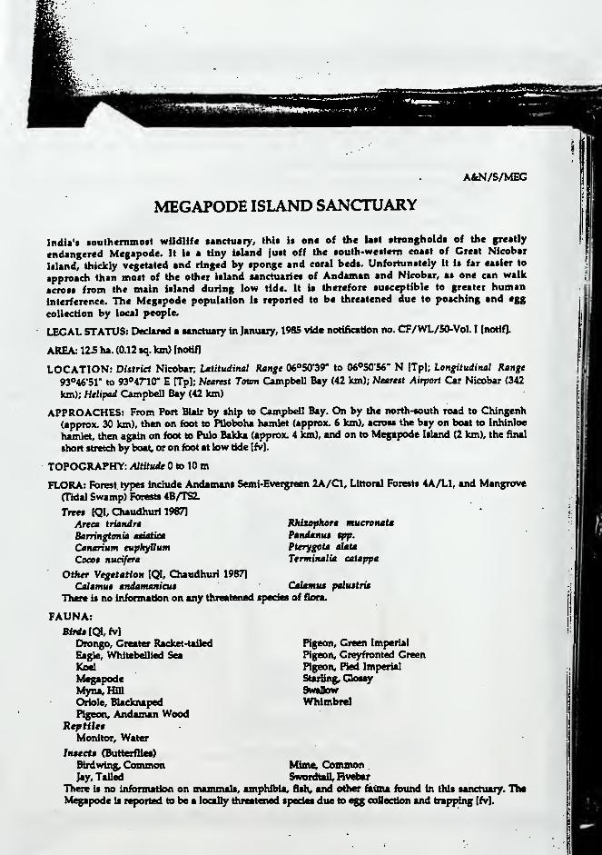
AfcN/S/MEC
MEGAPODE ISLAND SANCTUARY
India'* •oulhcinino*! wUdlife aanctuaiy, IhU it one of the Ual alrongholda of the greatly
endangered Megapode. It it a tiny iaUnd juat off the aouth-wettem coaal of Great Nicobar
Uland, thickly vegetated and ringed by sponge and coral beds. Unfortunately it i* far eaiier to
approach than moat of the other island sanctuaries of Andaman and Nicobar, as one can walk
across from the main ialand during low tide. It is therefore susceptible to greater human
inlerfeicnee. The Megapode population is reported to be threatened due to poaching and egg
collection by local people.
LEGAL STATUS: Declared a sanctuary in January, 1985 vide notification no. CF/WL/50-Vol. I (noHfl.
AREA: 123 ha. (0.12 sq. km) [notif]
LOCATION: District Nicobar; Latitudinal Range OS^SO'Sr to 06«S0"S6" N (Tpl; Longitudinal Range
93"46"51" to 93°47"10" E [TpJ; Nearest Town Campbell Bay (42 km); Nearest Airport Car Nicobar (342
km); Helipad Campbell Bay (42 km)
APPROACHES: From Port Blair by ship to Campbell Bay. On by the north-south road to Chingenh
(approx. 30 km), then on foot to Piloboha hamlet (approx. 6 km), across the bay on boat to Inhinloe
hamlet, then again on foot to Pulo Bakka (approx. 4 km), and on to Megapode Island (2 km), the final
short stretch by boat, or on foot at tow tide [fv].
TOPOGRAPHY: AltUude to 10 ra
FLORA: Forest, types include Andamans Semi-Evergreen 2A/C1, Littoral Forests 4A/L1, and Mangrove
(Tidal Swamp) Forests 4B/TS2.
Tree* (QI, C3uudhuri 1987]
Areea triandra
Barringtmia asiatica
Canarium euphfBumCoeet nuafera
Other Vegetation (QI, Chaudhuri 1987]
Cdlamuf andamaniauThere is no information on any threatened tpedes of flora.
Ridxophora mueronata
PandanuM tpp.
Pterygota tiaia
Terminalia eatappa
CatamuM palustria
Pigeon, Green Imperial
Pigeon, Greyfronted Green
ngeon. Red Imperial
Starting, GkMsySmnOowWhlmbrel
FAUNA:Birdt IQL, fv]
Drongo, Greater Racket-tailed
Eagle, Whitebdlled Sea
Koel
MegapodeMyna,HillOriole, Blacknaped
Pigeon, Andaman WoodReptiltB
Monitor, Water
Insects (Butterflies)
Biidwing, Common Mime; Common .
Jay, Tailed Swordtafl, RvdarThere is no informatkMi on mammals, amphibia, fish, and other tettMi found in this sanctuary. TheMegapode is lepoiied to be a locally tiireatened species due to egg eottection and trap^ng [fv].

70 IXfcetery of National Ptria tni SmiehuHa hi AndituK uU Nieahtr Itlsnds
OCCURRENCE AND CONTROL OF DISEASE: None
OTHER FACTORS AFFECTING HABITAT: Gales, cyclones and occasional hailstorms occur.
WATER RESOURCES: Several seasonal streams (fv].
FERSONNEU One Forester, one Forest Guard [PCCF fax 1991].
EQUIPMENT: None
RESEARCH AND MONITORING: None
HUMAN PRESENCE:
Rights and Leaaes: None specifically in the sanctuary. However, the hncobarese tribals are allowed,
under the \^dlife (ProtecHon) Act, 1972, Section 65, to hunt any wildlife (for further details, see KEYTO THE DIRECTORY SHEETS above).
Habitation: The sanctuary itself is an uninhabited island bu> in the surrounding area there are 3villages, on Great Nicobar Island, with an estimated population of 95.
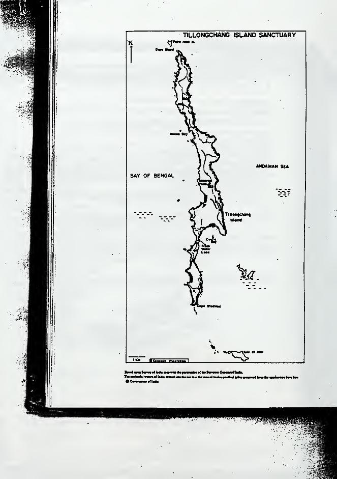
TILLONGCHANG ISLAND SANCTUARYN
BAY OF BENGAL
ANDAMAN SEA
- ' TB^^ WMi-n
•^- "• '
"-"1 11 I I I i r i r Mlllf l l ^ I Hm^lBlMB <t|«
eoi iinnntta^it

AlcN/S/TIL
TILLONGCHANG ISLAND SANCTUARY
Set up to protect the rare and endangered northern •ubipceiet {Hieobmrientit) of the
Megapodc, ihU ronete UUnd hat no human population. Apart from the Megapode the ialand
aUo harbours the Nicobar pigeon and the very rare Nicobar Hger bittern [Tikader and Dat
1985]. Relative to moat other ialand aanctuariea in Andaman and Nicobar, Tlllongdung hat
contiderable diveraity of topography. Sheer ciiffa, thickly vegeUted rolling hillt, mangrove
patches, and long beachet combine into a remarkable blend which ttill remains largely
unstudied.With rough seas around it most of the yeaz, and only one or two tuiUble landing spoU, it it
difficult to approach except by a good seafaring vessel and an appropriate landing craft
However, Nicobarese tribalt of the nearest inhabited itlands of Camorta, Teressa, and
Trlnkat, wizards as they are at sea travel, do manage to get here often. There is evidence of
some poaching and illegal coconut extraction by them, and periiaps occasionally by
passengers and crew of passing ships. The Nicobarese who land here have reported the
continued abundance of pigs, crocodilct, snakes, and other wildlife (Anon 19811.
LEGAL STATUS: Dedaivd a tanctuaiy in January 1985 vide notification no. CF/WL/50—VoL I (notifl.
AREA: 16S3 ha. (16.83 sq. km) Inotif]
LOCATION: DUtriet Nicobar; Latitudinal Range 08®2S"11" to 08*34'32* N [Tpl; Longitudinal Range
93*36"15" to 93<»38'0r E [Tpl; Searest Town Car Nicobar (approximately 112 km); Nearest Airport and
hdipad Car Nicobar (approximately 112 km).
APPROACHES: From Port Blair by ahlp or air to Car Nicobar bland (282 km), then to the tanctuaiy
(approximately 112 km) by ihlp (fv]. No public ferry available
TOPOGRAPHY: Altthirle to 323 m [Hyd. map].
FLORA: Forest types include Andaman Tropical Evergreen 1A/C2, Andaman Semi-evergreen 2A/C1,
Littoral R>rest 4A/L1, and Mangrove Forest Oldal Swamp Forest) 4B/TS2 IQI, Chaudhurl 1987].
Tree* IQL, (Diaudhuri 1987]
Areot triandra Hibiteut $pp.
Avicenma tfip. MoHilkaja gpp.
Bruguiara tpp. Pandanus $pp.
Calamais pcliutris Piarygota alaU
Canarium tuphyttum Rhixophora tpp.
Ceriopt tpp. Terminalia eatappa
Coeot nudfera
There arc three coconut plantations (Tpl. Howrever, there it no information on by whom, or when, ihty
were started. There it no information on threatened ipedet of flora in the tanctuaiy.

M Vbmttrji cf Nttiemt Paria mtd SmOiiartm i» Animmmi «ii Nkobt I$tm4*
FAUNA:MamrnmU [QI, Chaudhuri 1967, fv]
Bat, Leuer Shortnoied Fhilt
Bo«r, Indian V^nU
DMr,Spoltad*
BMi IQL CSiaudhuri 1967, TOcadfT and DuUUCJll, IIJ^B
Drongo, Leuer Racket-tafled
Eagle, Created Serpent
Eagle, WhltebeUied Sea
Heron, Raef
Megapode
Keptitf [QI, Biswac 1984, Anon 1981]
Cncoda^ Estuarine
Lizard, Green Forest
In$eet$ (Butterflies)
Birdwing, CommonJay, CreMJay, Tailed
No listings are available of the amphibian, fish, and other fauna found in the sanctuary. TheMegapode is lepoited to be threatened, due to poaching by local people [fv].
OCCURRENCE AND CONTROL OF DISEASE: None
OTHER FACTORS AFFECTING THE HABITAT: Gales, cyclones and occasional hailstorms are
reported.
WATER RESOURCES: There is one perennial lake, and 67 streams [QI, Tpl. It is not known how many,if any, of these streams are perenniaL
PERSONNEL: None
EQUIPMENT: None
RESEARCH AND MONITORINC: None
HUMAN PRESENCE:
BUgal AetivitieK Coconut extraction and poaching are reported [fv].
Flying Fox, (Nicobar) **
Shrew, Nicobar Spiny
1985, fv]
Parakeet, Redcheeked
ngeon, Andaman WoodPigeon, Green Imperial
Pigeon, Nicobar
Pigeon, Red Imperial
Monitor, Water
Mormon, AitdamanSwordtall, Hv^ar
* Authtnbe sightings of Spotted deer uc only from Otc Andaman islands. lis oocurrano* in ft* fAcoban is doubtful, asthere is no record of its having been introduced there [TUcader and Das 1985].** See Appendix 3, footnote I
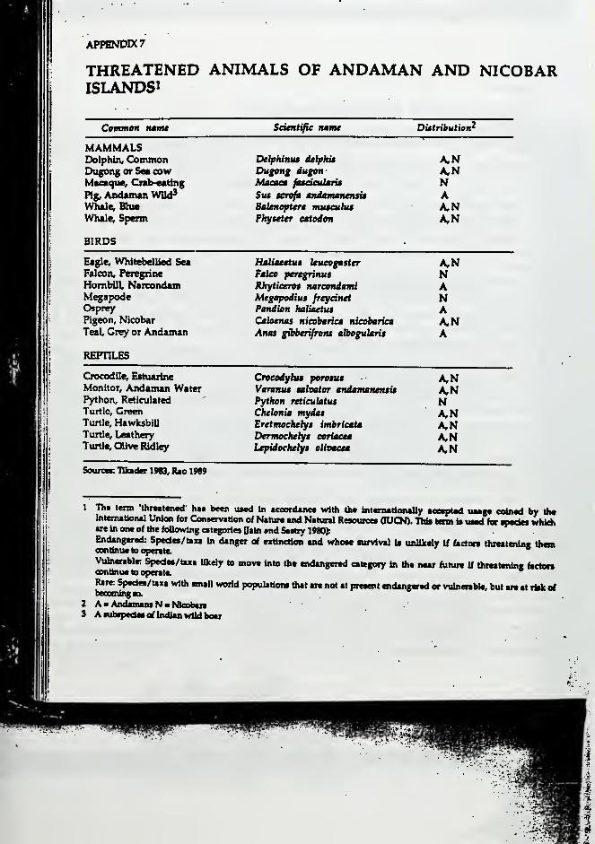
APPENDIX?
THREATENED ANIMALS OF ANDAMAN AND NICOBARISLANDS!
CoMtnoH luifu Seientifie name Distribution^
MAMMALSDolphin, ConunonDugong or Sea cowMacaque^ Crab-eating
Pig, Andaman Vnid^Whale; Bhie
Whale; Sperm
BIRDS
DelpUniu delphit
Dugong dugonMaeae* fneimlariB
Sus $cnfa mdamanensisBalenoptera mu$euhuPkyieter eatodon
A,NA,NNAA,NA,N
Eagle, Whitebellied Sea
Falcon, Peregrine
Hombill, NarcondamMegapodeOsprey
Pigeon, Nicobar
Teal, Grey or Andaman
REPTILES
Crocodile, Estuarine
Monitor, Andaman WaterPython, Reticulated
Turtle, GreenTurtle, HawksbiUTurtle, Leathery
Turtle, OUve Ridley
Hatiaettut kueogaster
Faleo peregrinus
Rkytieert* nareondami
Megapodius freydnatPandion haliaetiu
Caloenas nieohariea nieobariea
Anas gibberifrons albegularis
A,NNANAA,NA
Croeodybu porotus
Varanus sahator andamanensis
Python retieulatut
Chelonia mydasEretmochelys imbricata
Derwoehebfi eeriaeea
Lepidoehelys eUoaeia
A,NNA,NKtiA,N
SourccK lUddK 1983, Rao 1969
Th* term 'thraattned' hat been u*ed in tcoordanc* vrtOi the Inlcmatlonally aceaptad uaagt eeinad by theIntemaUonal Union for ConservaUon of Naluie and Natural Resoureei OUCN). TUa tarn is uaad for T"*^ wiikkare in one of the foUowing eategoriea Oain md Saatty 1980):
Endangered: Spedea/taxa in danger of extinetioa and whoac nirvival if unUkdy If beton thiMteniaa themcontinue to operate.
*
Vulnerablr Spedea/taxa likely to move into the endangered category in Ote near fiihue if Ihreatenine bctoncontlntie to operate.
Rare Spedea/taxa with small world population* ttut are not at preaent endangered or vulnerable, but ai« at itok efbeoooUngao.
A K Andaman* N > hBcobaiaA aubipcdai of Indian wild boar
APPENDIX 8
GREAT NICOBAR BIOSPHERE RESERVE
Biosphere Re$eroe$
The Indian Man and Bioaphere (MAB) Programm*, modeled after the UNESCO (MAB) Programme,
enviaaget the contervation of represenUtive ecotystemt which are genetically and ecologically rich.
Such ecosystems are designated Biosphere Reserves, with the "objectives of
a. conserving the diversity and integrity of plants and animals within natural ecosystems,
b. safeguarding genetic diversity of species on which their continuing evolution depends,
c providing areas for ecological and environmental research, and
d providing facilities for education and training." [Ministry of Environment and Forests, 1989cl.
The model followed internationally also envisages the designation of several zones in each Biosphere
Reserve:
"a. Natural or Core Zone Managed for minimum human interference to serve as a baseline for the
biological region; research, educational and training activities are carefully controlled and must be non-
manipulative.'
b. Manipulative or Buffer Zone: Managed for research, education and training activities, andmanipulative methods and techniques are permitted. Traditional activities including timber extraction,
hunting, fishing, and grazing are permitted in a controlled manner.
c Reclamation or Restoration Zone: Managed to study and reclaim lands and natural resources whereheavy natural or human-caused alteration has passed ecological threshold or where biological processes
have been interrupted or where species have become totally extinct.
d Stable Cultural Zone: Managed to protect and study ongoing culture and land use practices whichare in harmony with-the environment. Local residents and their activities be strictly controlled." [Ministry
of Environment and Forests, 1989cl.
So far, the designation of Biosphere Reserves is not done under any law. It is now proposed to
introduce a clause allowing for this, in the Wildlife (Protection) Act of 1972. Alternatively, in the long run,
a specific law on this may be considered [Ministry of Environment and Forests, 1989c]. At the moment,management of the Reserves is in the hands of the concerned State Government, while the Central
Government extends full financial assistance for approved activities, technical expertise and know-how,and detailed guidelines for management.
The Great Nieobar Biosphere Reseroe
On January 6, 1989, the Ministry of Environment and ForesU, Govenunent of India, designated a majorpart of Great Nieobar Island as a Biosphere Reserve, by Government Order No. ].22010/14/89-CSC[Ministry of Environment and Forests, 1989cl. The Reserve extends. In two parts, over 88,500 ha. (885 sq.
km), or about 85% of the Island. The area covered is not part of, nor does it contain, any existing nationalpark or sanctuary, though the designation of the biosphere reserve as a park or sanctuary has beensuggested by the Wildlife Institute of India (please >oe Appendix 9 for the proposal).
Reproduced below are extracts from the Project Document on the Great Nieobar Biosphere Reserve,prepared by the Ministry of Environment and Forests (Ministry of Environment and Forests, 1989al. Thereport is based primarily on work done by the Botanical Survey of India.
{Editorial Note : Minor editorial changes have been made in the text, which is otherwise reproducedverbatim. For greater deuils on the summary points made below, please see the original document. Anoutline map of the Reserve is also included here.]
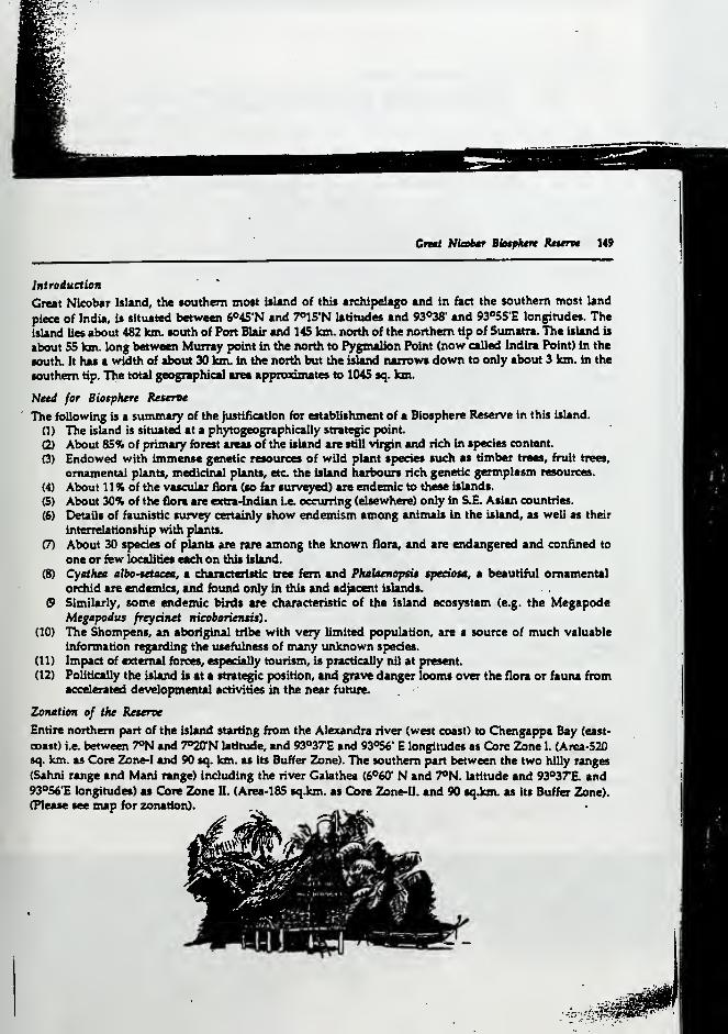
CfMt SUobar Bhtphtrt Rmitvi 149
Intreduetien
Great Nicobar Island, the southern most island of this archipelago and in fact the southern most land
piece of India, is situated between 6°45'N and T^IS'N latitudes and 93°36' and 93°55'E longitudes. The
island lies about 482 km. south of Port Blair and 145 km. north of the northern tip of Sumatra. The island is
about 55 km. long between Murray point in the north to Pygmalion Point (now called Indira Point) in the
south. It has a width of about 30 km. in the north but the island narrows down to only about 3 km. in the
southern tip. The total geographical area approximates to 1045 sq. km.
Need for Biosphere Keteroe
The following is a summary of the justification for establishment of a Biosphere Reserve In this island.
(1) The island is situated at a phytogeographically strategic point
(2) About 85% of primary forest areas of the island are still virgin and rich in species content.
(3) Endowed with immense genetic resources of wild plant species such as limber trees, fruit trees,
ornamental plants, medidiul plants, etc the island harbours rich genetic germplasm resources.
(4) About 11% of the vascular flora (so far surveyed) are endemic to these islands.
(5) About 30% of the flora are extia^ndian Le. occurring (elsewhere) only in S.E. Asian countries.
(6) Details of faunistic survey certainly show endemism among aiUmaU in the island, as well as their
interrelationship with plants.
(7) About 30 species of plants are rare among the known flora, and are endangered and confined to
one or few localities each on this island.
(8) Cyathea albo-tetaeea, a characteristic tree fern and Phalaeneptit tptaosa, a beautiful ornamental
orchid are endemics, and found only in this and adjacent islands.
9 Similarly, some endemic birds are characteristic of the island ecosystem (e.g. the MegapodeMegapodus freydnet nicobariensis)
.
(10) The Shompens, an aboriginal tribe with very limited population, are a source of much valuable
information regarding the usefulness of many tmknown species.
(11) Impact of external forces, especially tourism, is practically nil at present
(12) Politically the island is at a strat^c position, and grave danger loonu over the flora or fauna fromaccelerated developmental activities in the near future.
Zenaliem of the Keteroe
Entire northern part of the island starting from the Alexandra river (west coast) to Chengappa Bay (east-
coast) i.e. between 7°N and 7O20'N latitude, and 93°37E and 93056' E longitudes as Core Zone 1. (Area-520
sq. km. as Core Zone-I and 90 sq. km. as its Buffer Zone). The southern part between the two hilly ranges
(Sahni range and Mani range) including the river Calathea (6^60' N and 7°N. latitude and 93°37'E. and93°56'E tongitudes) as Core Zone II. (Area-185 sqJcm. as C:ore Zone-II. and 90 sqJcm. as its Buffer Zone).
(Please see map for zonation).
:-^:fim
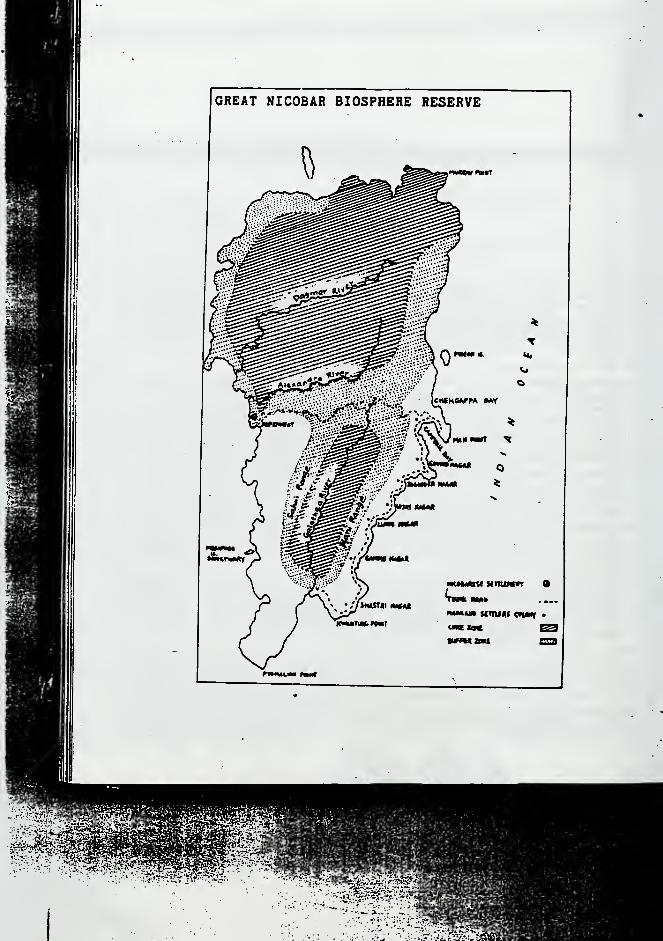
*?^>.i^-,r*':^s?-f|
••.•^:»"'. -... f<
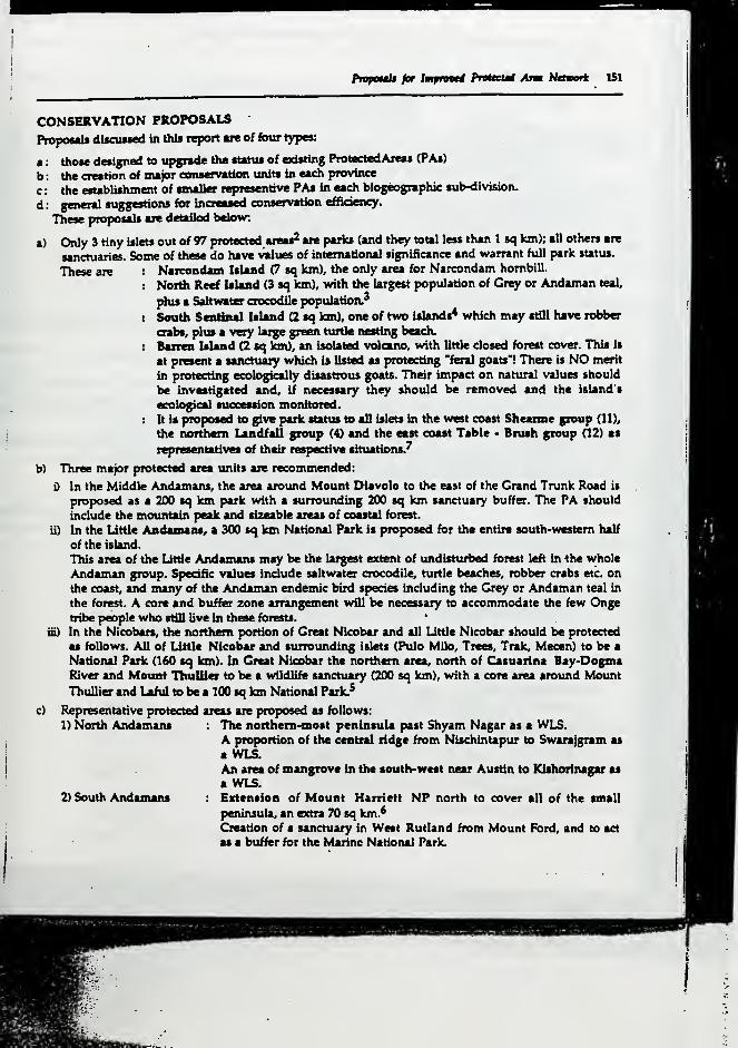
PrnpoMlt for htfnvti PreUeut Arm Ndvort 151
a)
CONSERVATION PROPOSALS
PropoHls discussed In this report are of four types:
those designed to upgrade the status of existing ProtectedAreas (PAs)
the creation of ina)or conservation units in each province
the esublishment of smaller representive PAs in each biogeographic sulMiivision.
general suggestions for increased conservation efficiency.
These proposals are detailed belo%v:
Only 3 tiny Islets out of 97 protected areas^ are parks (and they total less than 1 sq km); all others are
sanctuaries. Some of these do have values of international significance and warrant full park status.
These are : Naicondain Island (7 sq km), the only area for Narcondam hombiU.
: Neitfi Reef Island (3 sq km), with the largest population of Grey or Andaman teal,
^us a Sahwater crocodile population.^
: South Sentinal Island (2 sq km), one of two islands* which may stfll have robber
oabs, plus a very large green turtle nesting beach.
: Bairea Island (2 sq Ion), an isolated volcano, with little closed forest cover. This is
at present a sanctuary which is listed as protecting "feral goats'! There is NO merit
in protecting ecologically disastrous goats. Their impact on natural values should
be investigated and, if necessary they should be removed and the island's
ecological succession monitored.
: It is proposed to give parte satus to all islets in the west coast Sheaime group (11),
the nordtem Landfall group (4) and the east coast Table • Brush group 02) as
representatives of their respective situations.^
b) Three major protected area units are recommended:
In the Middle Andamans, the area around Mount Diavolo to the east of the Grand Trunk Road is
pro]x>sed as a 200 sq km park with a surrounding 200 sq km sanctuary buffer. The PA should
include the mountain peak and sizeable areas of coastal forest.
ii) In the Little Andamaas, a 300 sq km National Park is proposed for the entire south-western half
of the island.
This area of the Little Andamans may be the largest extent of undisttirbed forest left in the whole
Andaman group. Specific values include saltwater crocodile, t\utle beaches, robber crabs etc. on
the coast, and many of the Andaman endemic bird species including the Grey or Andaman teal in
the forest. A core and buffer zone arrangement will be necessary to accommodate the few Ongetribe people who still live in these forests.
iii) In the Nicobars, the northern portion of Great Nicobar and all Little Nicobar should be protected
as follows. All of Little Nicobar and surrounding islets (Pulo Milo, Trees, Trak, Mecen) to be a
National Park (160 sq km). In Great Nicobar the northern area, north of Casuarina Bay-DogmaRiver and Mount TliulUer to be a wildlife sanctuary (200 sq km), with a core area around Mount
Thullier and Laful to be a 100 sq km National Park.^
c) Representative protected areas are proposed as follows:
1) North Andamans
2) South Andamans
The noithem-most peninsula past Shyam Nagar as a WLS.A proportion of the central ridge from Nischintapur to Swarajgram as
a WLS.An area of mangrove in the south-west near Austin to Kishorlnagar ai
a WLS.Extension of Mount Harriett NP north to cover all of the small
peninsula, an extra 70 sq km.^Creation of a sanctuary in West Rutland from Mount Ford, and to act
as a buffer for the Marine National Park.

ISZ Dliiirnry af Ntitmal Park* mid Smtetittrk$ *» AKdmnMH and Nitobar UiaiUi
3} Rhchie'i Archipelago To add adjacent Outrain Ulaad, wrhich has 20 tq km of almost intact
forett, to the exiating Button National Park of 1 >q km.
To create a 50 aq km tanctuaiy on Kamoita Iiland.4) Central hflooban
d) General auggettioni
i) The picaent number of tiny Individual island tanctuariea be amalgated into ten logical group* for
more efficient administration. Suggeationt are:
Vieat Coast' North EM$t, South CoasP
Shearme Croup of 11 islands
(to be Paris)
Interview Islet Groups of 10
islets (note N <c S Reef
become Parks)
Spike Croup of 6 islets
C>efence Group of 4 islets
Landfall Crot^ of 4 ialets
(tobeFkriO
Table • Brush Cnmp of 12 islets
(tobepariO
Kyd Grot^ 4 islets
Sound Islet Group 12 islets
Oyster Group 3 islets
Qnque Island Group 6 islets
ii) The larger block of mangroves be surveyed widi a view to bringing a greater proportion into the
protected area network.
Wi The forest territorial divisions devdop a much larger number of 'preservation plots' in nat\iral
forest communities.
iv) The sutus of the tribal reserves to be clearly thought out and recommendations acted upon.
There are 742^ sq km of Jarawa Reserve in Middle and South Andamans. There are (or %vere!)
Reserves for the Onge in Little Andaman and Shompen in Great Nicobar, but these have fallen into
"disuse".
Giving all or part of these reserves sanctuary status under the wildlife act can allow traditional people
to pursue their way of life, but gives a strong Ic^ deterrent to any form of non<compatible land use.
DISCUSSIONPrioritia
The scale of biological values in the Andaman and Nicobar Islands is so great that all protected area
proposals must be teen as a major priority. However it is stiU possible to see proposals that are of extreme
significance for protected area plaiuiing. Priority classes are as foUoivs.
National Priority Zonal Priority Staia Priority
(Andamans)' North Andaman Peninsula WLSMount Diavolo NP k WLSMount Harriett NP (Extension)
West RutUnd NPLittle Andanuin NPSouth Sentinel NPOutram 4c Button Island NPNarcondam Island NPNorth Reef IsUnd NP(Nicobars)
Mount Thullier NPGreat Nicobar WLSUttle Nicobar NP
North Andaman Ridge WLSSouth West Mangrove WLSBarren Island NPLandfall Island Group NPTable - Brush Group NPShearme Island Group NP
Kamorta WLS
None

PrppouU for Impmtd Pmteut Arm Network 1S3
MMHagement Inputt
Thl» i«port U not primarily concerned %with mantgement luue*. Ho%vever the scale of reMuice values In
the Andaman and Nkobar is so great that some comment on important management Issues must be
made.
a) Outposts. The pladng of outposto of security peiwnnel on remote islands does create serious
impact on natural resources. Where possible such outposu should be manned by wildlife staff.
b) Patrolling. The wildlife wing must be given greater marine patrolling ability with large and small
boats. WUdlile personnel should be placed on all police, coastguards, forest patrolling vessels.
c) Tourist rights within National Parks. Tourism in MPs must be reguUted. Coral collecting, beach
camping etc. must be prevented.
d) Hunting. Hunting, especially by Karen people, is an increasing problem which requires strict
control.
There is an Immediate need for more wildlife staff and management resources to instigate proper
control and monitoring activities.
e)
NOTES
1 The protected areas of AU4 lalanda eover subttanHal stretdtes of marine waten alsa Discounting thU, ttte land
mass under naUonal parks and sanctuaries at present is about 5.80% of the total area of the union territory.
Unfortunately it is not dear from the WU report, how mudi area should similariy be discounted from its total
The proportion of protected land area to total U.T. area, as propoeed by WII, will correspondingly be smaller.
2 It is undear why the figure of 97 has been used. The total number of national parka and sanctuaries in A&N is 100.
Of thcM, 96 are hiU islands, two (Marine National Park and Salt Water Crooodile Sanctuary) are a mix of
laUnds, marine watcn. and coastal strips, and two (Mount Harriett and Saddle Peak National Parks) are parts of
the 'mainland' islands of Great Andaman. The "3 Uny islets* being refeiied to are probably the North, Middle,
and South Button Naiienal Parks.
3 Also a stron^Kdd of the Water motdtor.
4 The other being Oeat Nieobar Island (Tlkader, Daniel and Rao 1986].
5 The northern portion of Great Nieobar Island hat recently been designated a Biosphere Reserve (Ministry of
Forests and Environment 1989c] However, this does not accord it any legal status, and the Implications of this
decUntian, in terms ol protection, are as yet imdear. Sec Appendix 8.
6 The Forest Department of AitN is proposing extension of Mount Harriett National Park on all but the northern
tide [PCCT fax 1991] (please see directory sheet and map* of Mount Harriett National Park, pp. 49-52).
7 The report does not spedfy which islands comprise the Groups listed. We can deduce, on the basis of our msps.
that their compoaltlan is as follows :
ShearmeC;roi;7 Msyo, Paget. Point, Reef, Shearmc, West. White Oiff, Rowe, Shark, and
Kwangtung lalands (11th island not dear).
Interview Group Surat, Splke-1, Roper, Ranger, Entrance. Buchanan, BondoviUe, Sea Serpent,
Snake-1, and Benett Islands.
Spike Group Spike-2, Bingham, Bluff, Mangrove, Stoat, and Talabalcha Islands.
DefenceOo^ Qyde, Defence, Montogemery, and Patric Islands.
Landfall Groi^ Land^U, Chanel East, and Peacock Islands.
Table-Brush Group Brush, Table (Ddgamo), Table (Excelsior). Jungle. North, Ox. Roes, Temple,
Tree, Trilby. Turtle, and Wharf IsUnds.
KydGroup Duncan, James, Kyd. and Potanma Islands.
SowidCrn^ Dot, Bamboo, Blister, <^lew. Gander, Goose, Oliver, Oyster-1, Swamp,Curiew (BJ>.), Ordiid, and Cirjan Islands.
OysterOoi^ Cone, Oyster-2. and Parkinson Islands.
CfaiqusGroup Cinque (North and South), Passage, Sisters. North Brother, and South
Brother lalanda.
8 The area of On Jatawa rcsove as noUfled is £3886 ha.

APPENDIX9
PROPOSALS FORAN IMPROVED WILDLIFE PROTECTED AREANETWORK INANDAMANAND NICOBAR ISLANDS
!ll
In 198< the Government of India commiMioned the Wildlife Institute of India, Dtftmdun. to evaluate|
the adequacy of the existing network of wildlife protected area* and to propoM a nettvoric that coven the
range of biological diversity in the country. The Institute's report, released in 1988, includes\
recommendations for an improved protected area network in each state (Rodger* and Panwar 1988b).
This is based on a biogeographical dassiflcatton of the country's ecosystems into several distinct zones;
and provinces (Rodgers and Pan%var 1988al.
For Andaman and Nicobar Islands, the report recommends the creaHon of four new national parks
and seven new sanctuaries, upgradation of four existing sanctuaries and three duster* of existing
sanctuaries into national park sutus, extension in area of two national parks, and the dustering of several
other existing sanctuaries into compact units for more efHdent management It also suggests that all or
part of the tribal reserves in both Andaman and Nicobar be given sanctuary status.
If the suggestions made by the Wildlife Institute of India are accepted, the total area covered by the
protected area network in A<cN wiD become Z31,300 ha.(2313 sq. km.), as against the present 73,31133 ha.
(733.12 sq. km.). This will be 27.8% of the total area of the union territory, compared to abotit 5.8% at
present.'
(Editorial note: Tlic text given below is reproduced ahnest vcibatlin from Rodgers and Panwar i
(1988a); any changes made are only for die sake of clarity. Spellings of exisdag aaUoaal parks i
or sanctuaries have been changed, wherever necessary, according to the relevantnotifications, to match the usage in the rest of the directory. Our own cennenls aie (Ivea la
footnotes.)
BIOGEOGRAPHICAL DIVISIONS
The zone is split into two distinct units:
9A Andaman Islands (with Barren and Narcondam Islands)
9B Nicobar blands
The Ai\daman group is by far the largest, with 324 islands totaling 6,491 sq km. Most of the land mass is
taken up by "Great Andaman', whkh is really 5 islands separated by credcs. Little Andaaum is somedistance to dte south. For conservation planning several sub^divisioiu or biogeographic regioiu arerecognized. These are:
1. North Andaman2 Middle Andamana South Andaman, Baratang and Rutlaitd
i Little Andaaum& Ritchie Archipdago (geok>gicaIIy recent widi caldum rich soils)
6. Offshore Volcanics
7. East Coast Islands
& West Coast Islands
The Nicobar group is much smaller, with only 24 islands. Three sub- divisions are recognized:1) North group • Car Nicobar aitd Battimalv
2) Teressa, Tillongchang, Kamorta etc.
3 Uttle Nicobar and Great Nicobar.


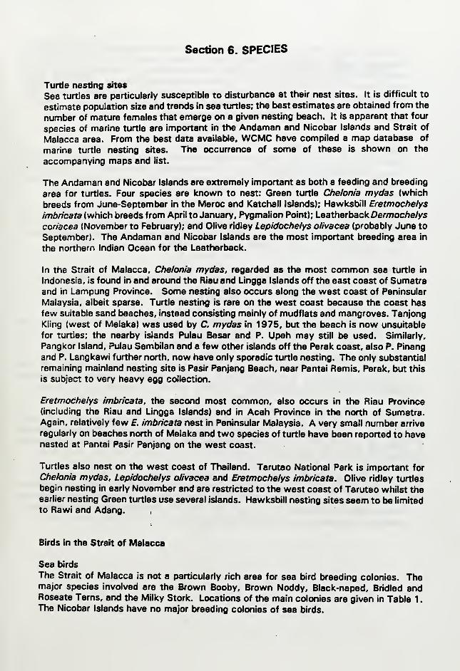
Section 6. SPECIES
Turtle nesting sites
Sea turtles are particularly susceptible to disturbance at their nest sites. It is difficult to
estimate population size and trends in sea turtles; the best estimates are obtained from the
number of mature females that emerge on a given nesting beach. It is apparent that four
species of marine turtle are important in the Andaman and Nicobar Islands and Strait of
Malacca area. From the best data available, WCMC have compiled a map database of
marine turtle nesting sites. The occurrence of some of these is shown on the
accompanying maps and list.
The Andaman and Nicobar Islands are extremely important as both a feeding and breeding
area for turtles. Four species are known to nest: Green turtle Chelonia mydas (which
breeds from June-September in the Meroc and Katchall Islands); Hawksbill Eretmochelys
imbricata (which breeds from April to January, Pygmalion Point); Leatherback Dermoc/ie/ys
coriacea (November to February); and Olive ridley Lepidochelys olivacea (probably June to
September). The Andaman and Nicobar Islands are the most important breeding area in
the northern Indian Ocean for the Leatherback.
In the Strait of Malacca, Chelonia mydas, regarded as the most common sea turtle in
Indonesia, is found in and around the Riau and Lingga Islands off the east coast of Sumatraand in Lampung Province. Some nesting also occurs along the west coast of Peninsular
Malaysia, albeit sparse. Turtle nesting is rare on the west coast because the coast hasfew suitable sand beaches, instead consisting mainly of mudflats and mangroves. TanjongKiing (west of Meiaka) was used by C. mydas in 1 975, but the beach is now unsuitable
for turtles; the nearby islands Pulau Besar and P. Upeh may still be used. Similarly,
Pangkor Island, Pulau Sembilan and a few other islands off the Perak coast, also P. Pinang
and P. Langkawi further north, now have only sporadic turtle nesting. The only substantial
remaining mainland nesting site is Pasir Panjang Beach, near Pantai Remis, Perak, but this
is subject to very heavy egg collection.
Eretmochelys imbricata, the second most common, also occurs in the Riau Province(including the Riau and Lingga Islands) and in Aceh Province in the north of Sumatra.Again, relatively few f. imbricata nest in Peninsular Malaysia. A very small number arrive
regularly on beaches north of Meiaka and two species of turtle have been reported to havenested at Pantai Pasir Panjang on the west coast.
Turtles also nest on the west coast of Thailand. Tarutao National Park is important for
Chelonia mydas, Lepidochelys olivacea and Eretmochelys imbricata. Olive ridley turtles
begin nesting in early November and are restricted to the west coast of Tarutao whilst theearlier nesting Green turtles use several islands. Hawksbill nesting sites seem to be limited
to Raw! and Adang.
Birds in the Strait of Malacca
Sea birds
The Strait of Malacca is not a particularly rich area for sea bird breeding colonies. Themajor species involved are the Brown Booby, Brown Noddy, Black-naped, Bridled andRoseate Terns, and the Milky Stork. Locations of the main colonies are given in Table 1
.
The Nicobar Islands have no major breeding colonies of sea birds.
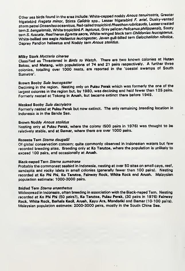
other sea birds fourKJ in the area include: White-capped noddy Anous tenuirostns Greater
frigatebird Fregata minor. Stints Calidris spp.. Lesser frigatebird F. anel. Duslcy-vented
storm petrel Oceanitesoceanicus, Red-tailed tropicbird Phaethon rubncauda, Lessercrested
tern S. bengalensis. White tropicbird P. lepturus. Grey pelican Pelicanus phihppensis. Sooty
tern S. fuscata. Reef heron Egretta sacra. White-winged black tern Chlidonias eucopterus.
White-bellied sea eagle Haliaetus leucogaster, Javan gull-billed tern Gelochelidon nilotica.
Osprey Pandion haliaetus and Noddy tern Anous stolidus.
Milky Stork Mycteria cinerea.
Classified as Threatened in Birds to Watcf}. There are two known colonies at Hutan
Bakau, and Matang, with populations of 74 and 21 pairs respectively. A further three
colonies, totalling over 1000 nests, are reported in the 'coastal swamps of South
Sumatra'.
Brown Booby Sula leucogaster
Declining in the region. Nesting only on Pulau Perak which was formerly the one of the
largest colonies in the region but, by 1980, was declining and held fewer than 125 pairs.
Formerly nested at Tokong in Aruah, but became extinct there before 1949.
Masked Booby Sula dactylatra
Formerly nested at Pulau Perak but now extinct. The only remaining breeding location in
Indonesia is in the Banda Sea.
Brown Noddy Anous stolidus
Nesting only at Pulau Perak, where the colony (500 pairs in 1 976) was thought to be
relatively stable, and at Damar, where there are over 1000 pairs.
Roseate Tern Sterna dougallii
Of global conservation concern; quite commonly observed in Indonesian waters but few
recorded breeding sites. Breeding only at Ko Tarutoa, where the population is unlikely to
exceed 1 00 pairs, and occasionally at Aruah.
Black-naped Tern Sterna sumatrana
Probably the commonest seabird in Indonesia, nesting at over 50 sites on small cays, reef,
sandspits and rocky islets in small colonies (generally fewer than 100 pairs). Nesting
recorded at Ko PN PN, Ko Tarutoa, Fairway Rock, White Rock and Aruah. Malaysian
population estimate: 1000-2000 pairs.
Bridled Tern Sterna anaethetus
Widespread in Indonesia, often breeding in association with the Black-naped Tern. Nesting
recorded at Ko Phi Phi (50 pairs?), Ko Tarutoa, Pulau Perak, (30 pairs in 1 976) Fairway
Rock, White Rock, Berhala Kedl, Aruah, Kayu Ara, Mandariki and Damar (10-100 pairs).
Malaysian population estimate: 2000-3000 pairs, mostly in the South China Sea.
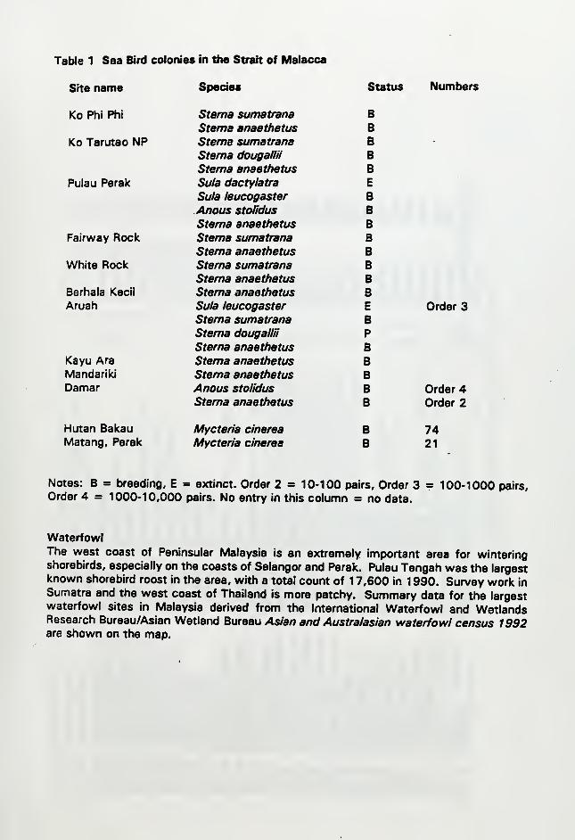
Table 1 Sea Bird colonies in the Strait of Malacca
Site name Species Status Numbers
Ko Phi Phi Sterna sumatrana BSterna anaethetus B
Ko Tarutao NP Sterna sumatrana B -
Sterna dougallii BSterna anaethetus B
Pulau Perak Sula dactylatra E
Sula leucogaster BAnous stolidus BSterna anaethetus B
Fairway Rock Sterna sumatrana BSterna anaethetus B
White Rock Sterna sumatrana BSterna anaethetus B
Berhala Kecil Sterna anaethetus BAruah Sula leucogaster E Order 3
Sterna sumatrana BSterna dougallii PSterna anaethetus B
Kayu Ara Sterna anaethetus BMandariki Sterna anaethetus BDamar Anous stolidus B Order 4
Sterna anaethetus B Order 2
Hutan Bakau Mycteria cinerea B 74Matang, Perak Mycteria cinerea B 21
Notes: B = breeding, E = extinct. Order 2 = 10-100 pairs. Order 3 = 100-1000 pairs.
Order 4 = 1000-10,000 pairs. No entry in this column = no data.
WaterfowlThe west coast of Peninsular Malaysia is an extremely important area for winteringshorebirds, especially on the coasts of Selangor and Perak. Pulau Tengah was the largestknown shorebird roost in the area, with a total count of 1 7,600 in 1 990. Survey work in
Sumatra and the west coast of Thailand is more patchy. Summary data for the largestwaterfowl sites in Malaysia derived from the International Waterfowl and WetlandsResearch Bureau/Asian Wetland Bureau Asian and Australasian waterfowl census 1992are shown on the map.
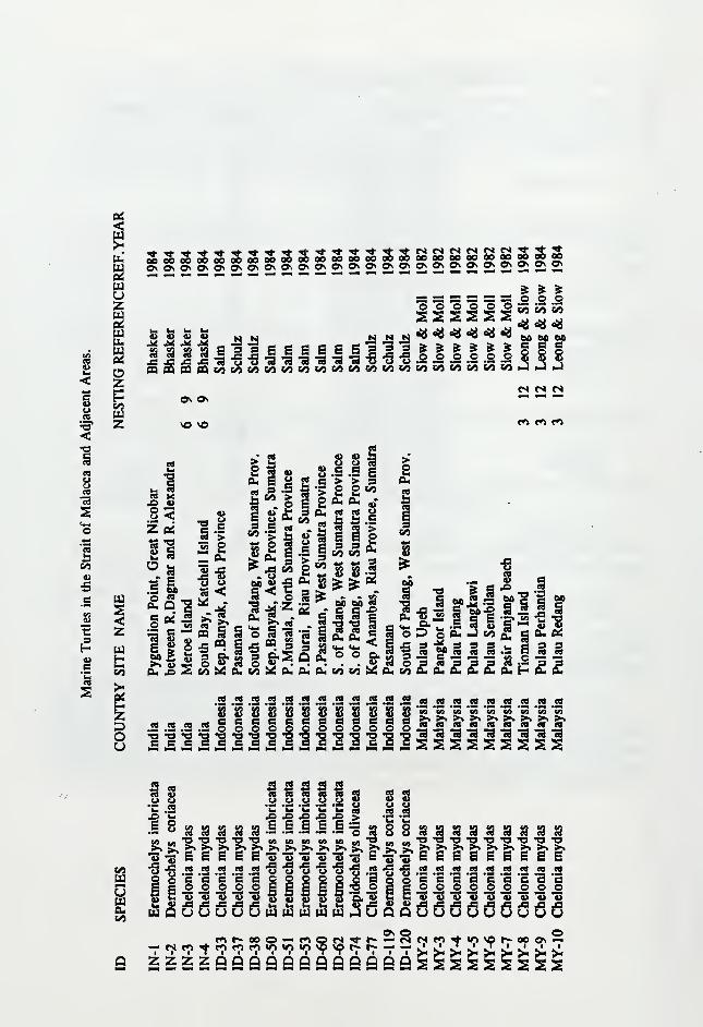
cu
<
esuu73
C/3
e
B
^^
uoz
Ozp
z
a> u u^ ^ ^£3 S3 S3•fi ^ £n 0Q CQ
8 9 5 e s s E g si3^ ^s ^ 9
000000 1CO (55
<<«4g* §• §»
iS^MC»(MMI»MMIMCOC<0SOIMCOMCO.J>JnJCQCAI^MbOMCOMCACOCOKOCObOCrOCrOCO
On On
VO VO
«s ts <s
f<i r*> c*i
eg
3
o_ <z (xi
II
^'^SbI 8<£ s a.
oa.
o
60 „>s 4)PL, A S
^ 2
1-gto <
CQ S i
C/9 X CU
3 B CO
CO .5 « .> ±3 a>
^ o n a
> ja ^ Ps « a.
o s
Ill's
CO M a. eui
8 slsee> > 3g O CO
a, £ „•CO cd uea cs >SEP9 9 £CO CO **"
*' *' 3GA CA Cd
S||
^
E9
M jjis
1 s
a. eu
o<
CO CO b^ 0<
,? -53 -a i "Sft-S § —Ma^aS 5 e B'S><»
'S S M S S g .!a
•o '3
co£aa£££euH
JO iS
CO M Cd M 08 M CO M n 68 M CD
CQ CQ AS CO B Bra ra GQ ^ Q Q
SS 8 8 8 S 8 8 8 8 8 sBeBBBBBBBB000000000 ~
CO CO CO CO C9 CO cO
«9 M 09 BO M 'go CQ
A M CO CO M CO CO M M CO" A ^8 CO CO ^8 CO C8 08 CO
Ss s
8A A fS J3 ^
.1 .1 E .§lA CO CO CO ^»>> >< >> >>"S •3 -B » -3
sc
s .5 -s a 8 8 M M M M M M CAA cO cO n ra CB cO•O •« -O 13 -O -O "O>>>«>%><><>. >iE E E E E E E
ca
a000^^9> % % "S
a a
fi r^ 00 O ^^ r'l
^ rri fo fn *o w:) in
a zzzzQQQaQaaaQQaa

o <s «s r<» r< * On00 00 00 oo ee 00 000^ O^ ON On O^ On On
OONONtnirimmmmminu^eoeoeoeeaeeeeeaeeeaoeeSeoeer>'C^t^ror>'r^r<'r~r>'eeeoaoeoaeeoeoaoooooaoOnOnOnOnO^OnOnOnOnOnOnOnOnOnOnOnOnOnOn On Ot On On
*» 2 2 2 2 ^
§ .2 .2 .2 .2 8 ^ e s
O tS IN _ _— — — On NO
— f<> «*1 — »S
^^ ^ ^ ^ Q\ Q\ fO C^ C^ <*1 f^ f^ f^ f^ fO **> f^ fJ f^ f^ O f*^
<s<s«»»sr<fN«<scscsc<esp4c<r»fSfM— «r> c»»«t»>«»»«" — — «- — — ««•— — — — —• — — ^N
ca
a- ice~
^^I I
2 Sn cs
CQ OQ00 BOC CO O¥¥H Hon 00c eo o
OOc
u Mao.e C
^ :><
M 00
73 ^
00^bOBS
So
E-i.
H H
a, ii
Is
<.2
S«>u
>
w>i i-i-i &« 2 S J 6".1
_ 2 iS 5Slgqii'oS.ggg-oooSri£:S|S<||c5Zs
a <g
8 8
§ 8a. ^ ^
saProv
nket 11
s C8 M 9 M S«2£ z £a <a CS
M M £ :S £ ^i^
CQ CQ n M CO M CQ CO A MMMMiewiaMiawMwcQcgcocec«cacocacacscsssas_a
ca 3 cd rt
II 1 11111111111111llllllllllimmllllllllllllll
i i §
E'Be-s*'-ise'«s
£ jS S £a J a-a| J a^ a a
_ B Sca § c« ca
c g-a-aS B S 2
o — CS en * wi
§§§§§§§i ^ 5 5 ? -s -a53 53 iS S SO O O O O O SS S S !? !? w •«
M 'S '5 TB '5 '5 "Smill•o •a -a -o -e
'^

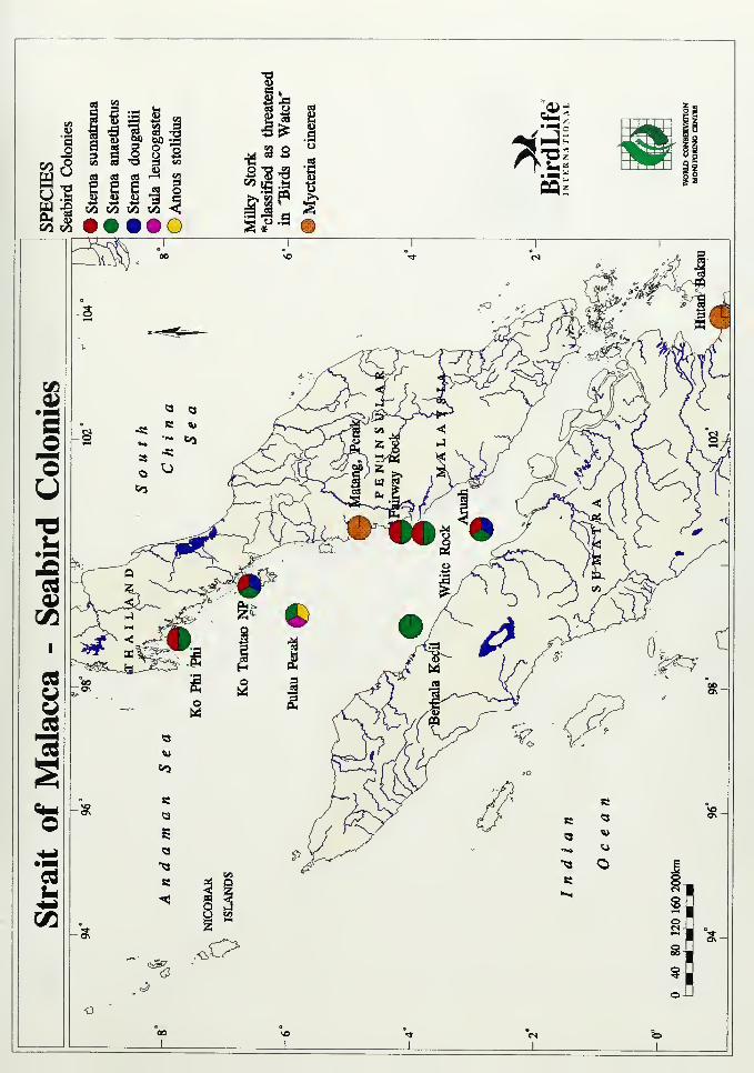
u^ s a a 3 ^g "2 wa »a V5 &o <CO WJ
<3


en U
«^**<T3T3
-' « .2 J 4^
<oll
to
_J_

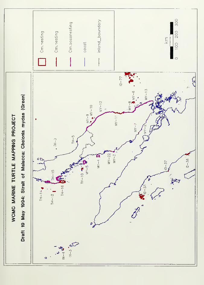
>,enc o
XIc
a> en (D 3c d c o•— ~. w J3w m w
1
CD
co
cE c t O
a
o o CJ O
1
I
I
oo
OO
OO
o0>i-
(D
1- CO
o oUJ >»-3 Eo0.
(0
co
o o7 JZ
a. O0. , a
< (0
oo(0
UJ m_i SOC <t-
z> o1- ^lU
CO
z0)
OC< •*
s 0)a>
o T-
s >.
(> (0
^ ^0)
^-»
COk.
O


>^i-
ai oC "Dx; cen :3
a> Oi <D oc c C JD
'~
-t-* m1
to w «(D +-»
(1) o ^c ^ c Q. c
o oU O o " 7-Q O Q Q .t
1
I
I
oom
ooCM
oo
oCOn«>SI*^CEt
O-I
CO
H oO o
CO
-3
o ou
cca. CO
>o
z oOL oQ. E< ^S QUJ_J CO
H otc
oCOD COH s
lU H-z oir +-•
< CO
SCO
oSo Tt
^0)CD
>.CO
:s
0)
4-«M-CO^Q


>>
oC" x>.c C-*-' 3
cr> 05to o
c c c -^', . -*-* COin ^-, Cfl to XICD CO (D O Cc o c Q- O
.-: O • -
LU O LU LaJ .b
XI09^5(0
zCO4-»
H OO —lU JQ-3 Eotr CO
CL >.
CJ
<D sz
Z uo
0.Q. E< oS UJ
lU-1
CO
oH oOC cd
z> «}
H SliJ H—
Z Oa: +•
<CO
o
o 0)
^>.CO
sa>
+^«f—
(0k.
Q
I
I
oo
oo
OO


>>
o CP-<D cc3 OT
a> O Ol 01
c J3 C c-t~j
1
-»-J CO
to CO CO
- siZ
oa.o
o o O O_l o _J _i
I
I
oo
OoCM
Oo
>.o•D
cc
o>o
1- (0oo o
LU (0-3 >o o(C0. CO
>.
CD ^z o0. oQ. D< as <D
_lUl_i tC
1- occ o
COD1- CO
LUZ o
< CO
s 4^a>o
s "to 0)
^ 2>.CO"2
a*•'
(0k.
o


Section?. OIL SPILL SITES
The following map has been compiled from data provided by The international Tanlcer
Owners Pollution Federation Ltd and comprises data on spills over 50 barrels from tankers,
combined carriers and barges in the Malacca Straits since the early 1 970s.

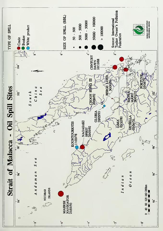
<3
_l_


0fiwmm/»*
IB'i!
5^
^^i^
m WORLD CONSERVATIONMONITORING CENTRE
'."•tmuww
World Conservation Monitoring Centre
219 Huntingdon RoadCambridge CBS ODLUnited ICingdom
Telephone +44 223 277314
Fax +44 223 277136
/^ * The World Conservation Monitoring Centre is a joint-venture between the three
t^^ paitneis who developed the World Conservation Strategy and its successor Caringfor
'^Jf the Earth: lUCN-TheWorld Conservation Union, UNEP- United Nations Environment
WWF Programme, and WWF-World Wide Fund for Nature.