coastal permafrost investigations along a rapidly …
TRANSCRIPT

Introduction
Numerous studies along arctic coastlines documentthe influence of permafrost on the rate and efficacy ofcoastal processes. Ar� (1988), for example, demonstra-ted the need to consider both classical hydrodynamicfactors and those related to permafrost stability. Recentnumerical models have built on this theme by couplingthermal and hydrodynamic effects (Nairn et al., 1998 ;Kobayashi and Atkan, 1986).
Although such models can provide reasonable predic-tions of erosion rates, their reliability is hampered bysignificant data gaps, including a lack of information onpermafrost changes in nearshore areas. With the excep-tion of mapping changes in coastal positions, there arerelatively few coastal studies that include time seriesobservations.
This paper provides a case history of coastal evolutionand changes in geotechnical, geothermal and ice-bonding conditions along a coastal shoreline atTuktoyaktuk, Northwest Territories. Detailed subsur-face conditions observed in 1994 are compared to thosein 1974, emphasizing the impact of subsurface per-mafrost changes on shoreline stability. The study fur-
ther provides an overview of impact of human activityon coastal conditions, documenting a variety of shore-line stabilization techniques undertaken during thisperiod with recommendations for future strategies.
Study area
The Hamlet of Tuktoyaktuk was established as a har-bour in 1934 by the HudsonÕs Bay Company and servedas a trans-shipment point for goods brought down theMackenzie River. Presently, Tuktoyaktuk is home toabout 1000 people and has been the centre for CanadianBeaufort Sea oil exploration for about three decades.The townsite population and infrastructure are concen-trated on a 1.2 km long peninsula, oriented north/southand exposed to the full fetch of Kugmallit Bay to thewest and the Beaufort Sea to the northwest (Figure 1).Spits project both north and south from the peninsula,though the northern spit turns eastward to align withthe dominant storm wind direction. Coastal erosion isendemic in the region with rates typically 1-2 m a-1
(Harper et al., 1985; Mackay, 1986). The townsite ishighly vulnerable to storm surges and high wavesaccompanying northwest storms (Rampton andBouchard, 1975; Solomon et al., 1994). In the HamletÕs
Abstract
Rapid coastal erosion along a peninsula forming the seaward shoreline of Tuktoyaktuk has resulted in ongo-ing control measures since the mid-1970's. While wave-generated erosion is significant along this section of theBeaufort Sea coastline, subsidence resulting from thawing of massive ice beneath nearshore sediments is alsosuggested as a major contributory cause of recession.
This study presents the thermal and physical condition of subsurface sediments within the nearshore zone,where permafrost and massive ice was documented in 1974. Observations from six boreholes drilled in March1994 indicate that alteration in subsurface thermal and ground ice regimes over the last 20 years has been sig-nificant. Thawing of ground ice likely resulted in nearshore subsidence in excess of 3 m. This subsidence maycreate a sediment demand, supplied by the shoreface, that results in ongoing erosion. This study illustrates theimportance of linking thermal and mechanical aspects when assessing coastal instability in this environment.
S.A. Wolfe, et al. 1125
COASTAL PERMAFROST INVESTIGATIONS ALONG A RAPIDLY ERODINGSHORELINE, TUKTOYAKTUK, N.W.T
S.A. Wolfe1, S.R. Dallimore2, S.M. Solomon3
1. Geological Survey of Canada, 601 Booth St. Ottawa, ON, K1A 0E8e-mail: [email protected]
2. Geological Survey of Canada, 601 Booth St. Ottawa, ON, K1A 0E8e-mail: [email protected]
3. Geological Survey of Canada, P.O. Box 1006, Dartmouth, NS, B2Y 4A2e-mail: [email protected]

short history, erosion has been responsible for thedestruction of a curling rink, closure and demolition ofan elementary school, and relocation of the RCMPdetachment building.
Methods
Historical observations cited in this paper are primari-ly from engineering studies that evaluate various shore-line stabilization options for the community. The mainfield program that established permafrost and geologicconditions for these studies was conducted in the fall of1974 (Kolberg and Shah, 1976). An extensive drillingprogram was carried out with 46 boreholes drilled atterrestrial and nearshore locations (Figure 1). Althoughsampling was limited, major sedimentary units, mas-sive ground ice occurrences, and ice-bonding condi-tions were identified at that time. Three onshore-off-shore ground temperature transects were also drilled tocharacterize nearshore ice-bonding and geothermalconditions. Each transect consisted of closely spaced airrotary boreholes in the beach area and a single boreholedrilled in winter, 100 to 150 m offshore. Five supple-
mentary offshore boreholes were drilled in 1986 along aline parallel to the peninsula, approximately 330 m off-shore (Aveco, 1986).
Coastal stability studies along the western shore ofthe peninsula were conducted by the Geological Surveyof Canada in the 1990's. This work included precisemeasurements of coastal positions using multi-year lowlevel aerial photographs and GPS surveys, nearshorebathymetric mapping, monitoring of storm activity andresultant changes in the coastline. A drilling programwas conducted in March of 1994 in order to identifynearshore permafrost conditions and subsurface geolo-gy, and to assess changes that had occurred since 1974.For this work an ATV mounted CME 750 rotary drill rigequipped with solid stem and hollow stem flight augersand a CRREL coring system was used. Seven holeswere drilled along two onshore-offshore transects sitedas close as possible to the 1974 locations near the ele-mentary school and RCMP garage. Drilling conditionswere challenging, especially in the nearshore areawhere unfrozen loose sands were encountered at theseabed. However, a number of relatively high quality
The 7th International Permafrost Conference1126
Figure 1. Location of study area (inset) and 1982 base map of Tuktoyaktuk showing cliff lines digitized from 1947, 1968 and 1992 and the location of boreholesand thermistor cables referred to in the text. Bathymetric contours (unpublished data) represent elevations in 1995 relative to mean sea level. Shoreline protec-tion was installed in front of the schoolhouse in 1976 and along the rest of the shoreline in 1987.

samples were collected, logged and sub-sampled forphysical property measurements, salinity and mois-ture/ice content determinations. Multi-thermistorcables were installed with daily readings taken to estab-lish equilibrium ground temperatures.
A location map of boreholes drilled in 1974 was regis-tered into a GIS using recently completed surveys(UMA, 1994). The 1994 boreholes were located on themap based on direction and offset from existing build-ings (Figure 1). The most appropriate boreholes forcomparison with the 1994 boreholes were those drilledin 1974 for thermistor transects at the waterline close tothe schoolhouse and the RCMP garage. These are iden-tified as Tuktoyaktuk school A (TSA) and RCMP garageA (RGA). In both cases, the boreholes were drilled atabout 0.7 m above chart datum (0.4 m above msl).
Subsurface geology and permafrost
The peninsula on which the Hamlet of Tuktoyaktuk issituated varies in elevation from about 2.5 to 6.5 m asl.Surficial sediments are composed primarily ofglaciofluvial sands, typically on the order of 2.0 to 3.0 mthick, and underlain by massive ground ice (Ramptonand Bouchard, 1975; Kolberg and Shah, 1976).Boreholes from 1974 revealed that massive ground ice ismore or less continuous along the whole peninsulavarying from 3 to 6 m thick. The upper and lower sur-faces of the ice are undulating and the upper surfaceappears to roughly conform with the overlying topog-raphy. The ice extends below sea level, terminating atan average depth of about 3.0 m below sea level, butmay extend more than 5.0 m. The sediment below theice is typically silty sand most likely of fluvial origin.The ice and included sediments are foliated and folded,indicating that they have been glaciotectonicallydeformed. Indeed, 18O values of -28.7 and -30.5ä(SMOW) obtained from ice in an ice cellar inTuktoyaktuk suggest that the ground ice has a glacialmeltwater source (Mackay, 1983). Approximately 400 mof permafrost underlies the Tuktoyaktuk area with shal-low ground temperatures recorded from instrumentedboreholes on land indicating mean annual ground sur-face temperatures from -8 to -9¡C (Dallimore, unpub-lished). Estimates of mean annual ground surface tem-peratures from 1974 boreholes drilled in the beach areaare similar or slightly warmer (Kolberg and Shah, 1976).
Nearshore bathymetry and shoreline change
The nearshore bathymetry along the main portion ofthe peninsula is dominated by a relatively steep innershoreface with coast-parallel isobaths (Figure 1). This40-60 m wide zone extends to the 1.2 m isobath with a1:25 slope. The morphology is more complex at the
north end of the peninsula where nearshore slopes aremore variable. Photographs and historical accountsfrom early in this century suggest that this area wassub-aerially exposed (R. Lemeur, pers. comm.).Seaward, between the 1.2 m and 3.3 m isobaths, the seabed decreases to a 1:70 slope. In this area the seabed ischaracterized by a number of shallow (0.1-0.3 m) basin-like features and some shore-normal ridges. It is notclear as to whether these are related to permafrostdegradation, nearshore currents or ice wallows.Offshore of the 3.3 m isobath, the sea-bed character ismore similar to the rest of Kugmallit Bay with veryshallow seaward slopes (1:400 or less).
Prior to installation of shore protection, the coast ofthe peninsula consisted of ice-rich cliffs up to 6 m high,fronted by a narrow gravel beach. Historical shorelineerosion is well-documented by airphotos extendingback to 1935. Parts of the townsite experienced morethan 100 m of erosion between 1935 and 1971 (Ramptonand Bouchard, 1975), suggesting a coastal retreat ratesimilar to other ice-rich areas along the Beaufort Seacoast in this area (Forbes and Frobel, 1985; Mackay,1986; Dallimore et al., 1996). However, it is clear thatthis rate varies considerably depending on location andinterannual variations in storm frequency and intensity(Solomon et al., 1994; Solomon and Covill, 1995).
The first documented shore protection measure wasan experiment using Longard tubes in front of the now-demolished elementary school in 1976 (Shah, 1978;Shah, 1982). These shore protection measures were allbut destroyed by 1981 as a result of vandalism andstorms. The character of the shoreline was altered sub-stantially in 1986-87, when fill was brought in to rebuildand regrade the coastal bluffs and sandbags wereplaced at the back of the beach to protect the bluffs.
Historical bluff retreat based on photogrammetryreveals that erosion has been highest at the north end ofthe townsite, in the vicinity of the RCMP detachment(Figure 1). In any given airphoto interval, at least 60%of the land lost along the peninsula has occurred in thisarea (Solomon et al., 1994). Between 1974 and 1987, thecliff edge near the north end of the peninsula retreatedapproximately 13 m, at which time shoreline protectionmeasures resulted in reconstruction of the shoreline,seaward, by about 7 m. Thus, the present shoreline inthe vicinity of the RCMP garage is partially built on thereclaimed beach and nearshore. To the south, near theformer elementary school, only about 5 m of cliff edgeretreat has occurred in the same time period, partiallyas a result of the installation of trial shore protection inthe late 1970's.
S.A. Wolfe, et al. 1127

Nearshore borehole transects
GEOLOGY AND GEOTECHNICAL CONDITIONS
Figure 2 summarizes the geology observed in the 1994nearshore drilling transects along the peninsula. Inborehole 94GSC1, drilled at the shoreward edge of thelandfast sea ice (rough estimate of shoreline) along theSchoolhouse transect, the geology is similar to boreholeTSA drilled close to that site in 1974. Approximately 1 m of beach gravel (perhaps containing re-worked fill)is underlain by about 3 m of pebbly glaciofluvial sand,2 m of massive ground ice and 3 m of fine-grained, ice-rich sand with deformed ice lenses 5-10 mm thick.Unlike in 1974, when sediments were observed to bewell ice-bonded, several thin layers at 3.5, 5.7 and 6.7 mwere unfrozen or weakly ice-bonded in borehole94GSC1. Extracted pore waters from these horizons had4 to 5ä salinities, while the remainder of the boreholehad essentially fresh pore waters. Approximately 15 mfurther offshore, at 94GSC2, the strength, ice-bondingand stratigraphy of the sediments changed dramatical-ly. At this location, approximately 1.25 m of sea ice wasobserved with only 0.15 m of beach gravel at theseabed. Underlying sediments were composed of peb-bly sands which were ice-bonded to 3.5 m depth andthen thawed to 6.4 m. A hard drilling layer encounteredat 6.4 m was interpreted as a contact with well ice-bonded sediments. Pore water salinities were elevatedcompared to 94GSC1, averaging 8ä. This sequence isinterpreted as a thawed equivalent of the stratigraphyin 94GSC1, with complete melt-out of massive ice andicy sand. Higher salinities are likely the result ofemplacement of brackish sea water coincident withthawing. If this interpretation is correct it implies thatapproximately 3.5 m of sediments annually freeze andthaw below the sea bed. Similar depths of annual freez-ing have been predicted in the sea ice contact zone byothers working in the area (Dyke and Wolfe, 1993). Themost likely reason seems to be a lack of snow cover inthe immediate nearshore area in the winter (<0.3 m)allowing for deep winter freezing. At 94GSC3, approxi-mately 45 m from the shoreline, 0.9 m of water wasobserved beneath 1.5 m of sea ice attesting to the rathersteep nearshore bathymetric gradient. Sediments wereunfrozen to 11.2 m, where a hard drilling interface wasinterpreted as marking the contact with well ice-bonded sediments. The seabed stratigraphy consistedof a 0.7 m thick sandy gravel layer underlain by 1.0 mof soft sandy silt and 0.9 m of pebbly sand. Loose, watersaturated sands, susceptible to sloughing below thisdepth, prevented sampling.
At the RCMP transect, 94GSC4 was drilled a fewmetres offshore of the edge of landfast sea ice withapproximately 1.0 m of sea ice in contact with theseabed. This borehole was positioned as near as possi-ble to the RGA borehole drilled in 1974 (Figure 1). The
stratigraphy and ice-bonding conditions at this sitewere similar to 94GSC2. Approximately 1.7 m of ice-bonded sand at the sea bed was underlain by 2.7 m ofvery loose unfrozen sand with brackish pore watersalinities. A distinct well ice-bonded interface wasobserved at 6.4 m depth. Approximately 15 m from theshoreline at 94GSC5, 1.4 m of sea ice was in contactwith 0.55 m of ice-bonded sand at the sea bed. Looseunfrozen sands encountered beneath the ice-bondedsediments presented drilling and sampling problems. Ahard layer at 5.8 m was interpreted as the contact with alower ice-bonded layer. Borehole 94GSC6 was attemp-ted 45 m from the shoreline. However this borehole hadto be abandoned as the 0.2 m thick water layer beneath1.25 m of sea ice was pressurized, with artesian flowoccurring onto the ice surface for several hours.Borehole 94GSC7 drilled 100 m offshore on the RCMPtransect line had 1.35 m of sea ice and 1.05 m of water.Similar to the offshore borehole at the Schoolhouse line,sediments were non ice-bonded at the sea bed with ahard drilling interface at 18.5 m depth interpreted as thetop of a lower ice-bonded interval. The geology wascharacterized by 0.2 m of sand at the sea bed underlainby 2.2 m of soft, laminated organic silt with peatyorganic layers. Pebbly sands were encountered atdepth. Given the finely laminated nature of the silts and
The 7th International Permafrost Conference1128
Figure 2. GSC borehole logs from 1994 drilling along the schoolhouse andRCMP garage transects.
the occurrence of terrestrial peat layers, this sequence ininterpreted as either submerged lacustrine or lagoonalsediments.
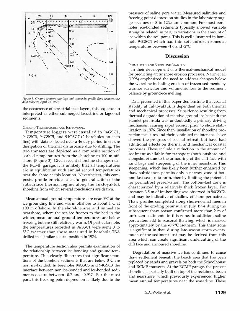
GROUND TEMPERATURES AND ICE-BONDING
Temperature loggers were installed in 94GSC1,94GSC3, 94GSC5, and 94GSC7 (2 boreholes on eachline) with data collected over a 46 day period to ensuredissipation of thermal disturbance due to drilling. Thetwo transects are depicted as a composite section ofseabed temperatures from the shoreline to 100 m off-shore (Figure 3). Given recent shoreline changes nearthe RCMP garage, it is unlikely that all temperaturesare in equilibrium with annual seabed temperaturesnear the shore at this location. Nevertheless, this com-posite profile provides a useful generalization of thesubsurface thermal regime along the Tuktoyaktukshoreline from which several conclusions are drawn.
Mean annual ground temperatures are near 0¡C at theice grounding line and warm offshore to about 1¡C at100 m offshore. In the shoreline area and immediatenearshore, where the sea ice freezes to the bed in thewinter, mean annual ground temperatures are belowfreezing but are still relatively warm. Of particular note,the temperatures recorded in 94GSC1 were some 3 to5¡C warmer than those measured in borehole TSAdrilled in a similar coastal position in 1974.
The temperature section also permits examination ofthe relationship between ice bonding and ground tem-perature. This clearly illustrates that significant por-tions of the borehole sediments that are below 0¡C arenon ice-bonded. In boreholes 94GSC5 and 94GSC3 theinterface between non ice-bonded and ice-bonded sedi-ments occurs between -0.7 and -0.9¡C. For the mostpart, this freezing point depression is likely due to the
presence of saline pore water. Measured salinities andfreezing point depression studies in the laboratory sug-gest values of 8 to 12ä are common. For most bore-holes, ice-bonded sediments typically showed variablestrengths related, in part, to variations in the amount ofice within the soil pores. This is well illustrated in bore-hole 94GSC1 which had thin soft unfrozen zones attemperatures between -1.6 and -2¡C.
Discussion
PERMAFROST AND SHORELINE STABILITY
In their development of a thermal-mechanical modelfor predicting arctic shore erosion processes, Nairn et al.(1998) emphasized the need to address changes belowthe waterline including erosion of frozen sediments bywarmer seawater and volumetric loss to the sedimentbalance by ground-ice melting.
Data presented in this paper demonstrate that coastalstability at Tuktoyaktuk is dependent on both thermaland mechanical processes. Subsidence resulting fromthermal degradation of massive ground ice beneath theHamlet peninsula was undoubtedly a primary drivingmechanism causing rapid erosion prior to shore stabi-lization in 1976. Since then, installation of shoreline pro-tection measures and their continued maintenance haveslowed the progress of coastal retreat, but have hadadditional effects on thermal and mechanical coastalprocesses. These include a reduction in the amount ofsediment available for transport (both onshore andalongshore) due to the armouring of the cliff face withsand bags and steepening of the inner nearshore. Thissteepening, which has likely been further enhanced bythaw subsidence, permits only a narrow zone of bot-tom-fast sea ice to form, thereby limiting the potentialfor permafrost preservation. The bottom-fast zone ischaracterized by a relatively thick frozen layer. Forinstance, 3.5 m of ice-bonding was observed in 94GSC2,and may be indicative of shallow offshore permafrost.Thaw profiles completed along shore-normal lines infront of the eroding peninsula in July 1994 during thesubsequent thaw season confirmed more than 2 m ofunfrozen sediments in this zone. In addition, salineporewaters add to seasonal thawing, which is markedapproximately by the -0.7¡C isotherm. This thaw zoneis significant in that, during late-season storm events,much of the sediment lost may be derived from thisarea which can create significant undercutting of thecliff face and armoured shoreline.
Degradation of massive ice has continued to causethaw settlement beneath the beach area that has beenreplaced by sands and gravels on both the Schoolhouseand RCMP transects. At the RCMP garage, the presentshoreline is partially built on top of the reclaimed beachand nearshore, which previously experienced highermean annual temperatures near the waterline. These
S.A. Wolfe, et al. 1129
Figure 3. Ground temperature logs and composite profile from temperaturedata collected April 24, 1994.

changes in the shoreline position have resulted in com-plete melting of massive ice beneath the present shore-line. In contrast, massive ice is still present at the shore-line near the former schoolhouse, although less thanobserved in 1974. In addition, a comparison of groundtemperatures between 1974 and 1994 reveals a strongwarming trend at this location, indicating that thecoastline has continued to thaw. This volumetric lossdue to melting of ground ice creates a sediment imba-lance that is further amplified by the reduction in sedi-ment availability due to armouring of the cliff face byshoreline protection measures. Scour of thawed sedi-ments at the base of the steep shore protection may alsoplay a role in enhanced erosion at the RCMP garage.
STRATEGIES FOR CONTINUED SHORELINE PROTECTION
Shoreline protection to date has stabilized the shore-line position since 1974 but has required considerablemaintenance. Severe damage by a storm in 1993demonstrated the tenuous condition of the efforts todate. As a result, the government of the NorthwestTerritories and the Hamlet have explored a range ofalternatives for the future, including possible abandon-ment (UMA, 1994). Relatively high regional coastalretreat rates in excess of 1 m a-1 indicate that, even iferosion at the peninsula were stopped completely, it islikely that the peninsula would be breached at itssouthern end within 50-100 years. Therefore, the mostappropriate long-term response is a phased withdra-wal. There is still, however, an immediate need to ma-nage the erosion problem.
A variety of shoreline protection strategies arepresently being examined. A plan to sink barges at thenorthern tip of the peninsula to act as a breakwater wasdismissed recently during an environmental reviewbecause they were found to be relatively ineffective inreducing wave energy during storm surges (C.Klengenberg, pers. comm.). In addition, the Hamlet hasbegun mining gravel from the southern spit to place onthe beach at the northern end of the peninsula.Limestone boulders have also been purchased from aquarry in Inuvik and were installed at the waterlineduring the winter of 1996-97.
The observations on thermal evolution of thenearshore combined with analyses of coastal changes(e.g., Solomon and Covill, 1995) provide some guidancefor future attempts at slowing the progress of coastalretreat at Tuktoyaktuk. The decrease in the amount ofmassive ice in the nearshore suggests that the thaw sub-sidence that assists in driving rapid coastal erosion hasbeen largely completed. Thus, although insulation ofthe beach to prevent thermal erosion has been previous-ly recommended (Kolberg and Shah, 1976; Aveco, 1986),it may be unnecessary now that most of the massive icehas thawed. However, the lack of sediment available toreplace the volume lost due to thaw subsidence hasproduced an over-steepened foreshore which permitslarger waves to attack the shoreline, especially duringstorms. Placing gravel or boulders on the beach abovethe shoreline will be relatively ineffective unless it isaccompanied by adequate protection at the toe of thebeach. Presently, sand bags are continually underminedat the toe of the beach, resulting in breakage and pro-gressive collapse of the upper layers of bags. In 1993, astorm accompanied by high water levels overtoppedthe shoreline protection at several places, mining outthe unprotected fill and causing collapse of the sandbags (Solomon and Covill, 1995). In essence, the sandsupplied by broken bags and the underlying fill is sca-venged during storms, and contributes to a form oftime-release beach nourishment. Future installationswill require improved protection against significantstorm events and must address the need for nearshorenourishment.
Acknowledgments
Financial support was provided by the Office forEnergy Research and Development, Northern Oil andGas Action Program, the Geological Survey of Canadaand Environment CanadaÕs Green Plan. The authorswish to acknowledge the considerable field supportprovided by the Polar Continental Shelf Project and byMark Nixon, of the Geological Survey of Canada.Finally, this research has benefited from discussionswith local Hamlet authorities and numerous colleagues.
The 7th International Permafrost Conference1130
References
Ar�, F.E. (1988). Thermal abrasion of sea coasts. PolarGeography and Geology, 12, 1-57.
Aveco (1986). Shoreline erosion protection, Tuktoyaktuk.Unpublished contract report prepared for Government ofthe Northwest Territories, Department of Public Worksand Highways (60 pp. and appendices).
Dallimore, S.R., Wolfe, S.A. and Solomon, S.M. (1996).Influence of ground ice and permafrost on coastal evolu-tion, Richards Island, Beaufort Sea coast, N.W.T. CanadianJournal of Earth Sciences, 33, 664-675.
Dyke, L.D. and Wolfe, S.A. (1993). Ground temperatures andrecent coastal change at the north end of Richards Island,Mackenzie Delta, N.W.T. Geological Survey of Canada Paper,93-1E, 83-91.
Forbes, D.L. and Frobel, D. (1985). Coastal erosion and sedi-mentation in the Canadian Beaufort Sea. Geological Surveyof Canada Paper, 85-1E, 69-80.
Harper, J.R., Reimer, P.D. and Collins, A.D. (1985). BeaufortSea physical shore-zone analysis. Geological Survey ofCanada Open File, 1689, (105 pp).

S.A. Wolfe, et al. 1131
Kobayashi, N. and Atkan, D. (1986). Thermoerosion of frozensediment under wave action. Journal of Waterway, Port,Coastal and Ocean Engineering, ASCE, 112, 140-158.
Kolberg, T.O. and Shah, V.K. (1976). Shore Erosion andProtection Study - Stage 2. Tuktoyaktuk, N.W.T. Departmentof Public Works, Marine Directorate, Report no. 41.
Mackay, J.R. (1983). Oxygen isotope variations in permafrost,Tuktoyaktuk Peninsula area, Northwest Territories.Geological Survey of Canada Paper, 83-1B, 67-74.
Mackay, J.R. (1986). Fifty years (1935-1985) of coastal retreatwest of Tuktoyaktuk, District of Mackenzie. GeologicalSurvey of Canada Paper, 86-1A, 727-735.
Nairn, R.B., S. Solomon, S. M., Kobayashi, N. and Virdrine,J. (1998). Development and testing of a thermal-mechani-cal numerical model for predicting arctic shore erosionprocesses. In Proceedings of the Seventh InternationalConference on Permafrost, this volume.
Rampton, V.N. and Bouchard, M. (1975). Surficial geology ofTuktoyaktuk, District of Mackenzie. Geological Survey ofCanada Paper, 74-53 (17 pp).
Shah, V.K. (1978). Protection of permafrost and ice-richshores, Tuktoyaktuk, NWT, Canada. In Proceedings, 3rdInternational Conference on Permafrost, Edmonton, Alberta.National Research Council, Ottawa, pp. 871-875.
Shah, V.K. (1982). Performance of sand-filled tube shore pro-tection, Tuktoyaktuk, Northwest Territories, Canada. InProceedings, 18th Coastal Engineering Conference, Cape Town,South Africa. 3, pp. 1901-1913.
Solomon, S. M.., Forbes, D.L. and Kierstead, R.B. (1994).Coastal Impacts of Climate Change: Beaufort Sea Erosion Study.Atmospheric Environmental Service, Downsview,Canadian Climate Centre Report No. 94-2.
Solomon, S.M. and Covill, R. (1995). Impacts of theSeptember 1993 storm on the Beaufort Sea. In Proceedings,1995 Canadian Coastal Conference. 2, pp. 779-796.
UMA Engineering Ltd. (1994). Tuktoyaktuk Shoreline ProtectionStudy Phases II and III. Interim Report no. 2. Final Draft.