cmer falmouth dredging review for mcs v4 falmouth dredging review.pdf · 5hylhz ri qhz +5$...
TRANSCRIPT

BRIEFING NOTE
coastal & marine environmental research Dr Miles Hoskin, MCIEEM 3 Restormel Terrace, Falmouth, Cornwall, TR11 3HW E-mail: [email protected] Tel: 07976 437463
Review of new information for a Habitats Regulations Assessment (HRA) of the proposed Port of Falmouth capital dredge
coastal & marine
environmental research
To: Dr Jean-Luc Solandt, Principal Specialist - MPAs, Marine Conservation Society From: Dr Miles Hoskin, CMER
2 September 2016
EXECUTIVE SUMMARY: The proponents’ case that the proposed Port of Falmouth capital dredge would not adversely affect the integrity of the Fal & Helford SAC appears flawed on several important grounds. Certain of these grounds relate to the work of Natural England (NE), others to that of the consultants advising the proponents. Important problems arising from NE’s involvement include:–
i. Failure to require the assessment of conservation objectives that are highly relevant to the dredging, including old objectives for the feature ‘subtidal sandbanks’ that have not been fully superseded and draft new ones for another feature – large shallow inlets and bays – that appears to have been overlooked entirely.
ii. Related to i: failure to require that the terms of the Habitats Regulations Assessment (HRA) be explicitly and substantively changed to reflect draft new conservation objectives that require the restoration of certain maerl attributes of subtidal sandbanks, rather than simply their maintenance.
iii. Failure by NE in its legal duty to make a formal assessment of the background conservation status of two features relevant to the dredging – subtidal sandbanks and large shallow inlets and bays – and failure thereafter to explicitly acknowledge that this adds significant uncertainty to the HRA.

Review of new HRA information for proposed Falmouth capital dredge
Final Report
© MG Hoskin 2016 2
Important problems with the proponents’ case include:– i. Reliance on the assertion that, based on its low density, live maerl in the proposed
dredge area is transitory and incapable of accumulating over the long-term, notwithstanding that this is (a.) unsupported by any evidence of ongoing decline; (b.) unsupported by any evidence of unfavourable environmental conditions and (c.) made without acknowledging the recent history of commercial maerl extraction in the area, which is potentially an important explanatory factor.
ii. Reliance on modeling of sediment settlement outside the dredge area that was done at a spatial scale that is at least two orders of magnitude larger than the scale relevant to key areas of specific ecological concern, most notably the dense live maerl bed adjacent and southwards of the proposed dredge area.
iii. Failure to consider the full range of environmental effects on maerl habitat and its associated assemblages of increasing the depth of the seabed by 3m.
iv. Reliance on an experimental mitigation trial showing recovery of macro-infaunal diversity and abundance within 44 weeks that cannot be relied upon to represent circumstances in the full-scale dredge, or the responses of other groups of animals such as meifauna and macro-epifauna.
v. Significant uncertainty regarding the need for ongoing maintenance dredging after the capital dredge, which would entail significant repeat disturbance of maerl habitats.
vi. Failure to accept the relevance of the European Court of Justice ruling in the Sweetman case, which requires that a HRA must conclude adverse effect on site integrity in any case where a plan or project would result in the permanent, irreparable loss of a constitutive characteristic of a protected habitat, contrary to its conservation objectives.
In view of the above, I believe there is an overwhelming case that the proposed dredging would adversely affect the integrity of the Fal & Helford SAC, or at the very least, that there is sufficient uncertainty regarding the likelihood of such an affect that consent cannot be lawfully given.

Review of new HRA information for proposed Falmouth capital dredge
Final Report
© MG Hoskin 2016 3
BACKGROUND
In 2011, the Marine Management Organisation (MMO) rejected a licence application for capital dredging in the approaches to Falmouth Docks submitted in 2009 by the Falmouth Harbour Commissioners (FHC) and A&P Falmouth Ltd. This application failed on the Habitats Regulations Assessment (HRA) - specifically, a failure to demonstrate that the proposed dredging would not have an adverse effect on the integrity of the Fal & Helford Special Area of Conservation (SAC) – a site designated under the European Union’s (EU) Habitats Directive. The MMO’s principal concern was the likely effect of dredging on rare maerl habitats within and adjacent to the proposed dredge area. Since this refusal, the dredging proponents have been attempting to modify their proposal and compile new environmental information that they hope will allow the MMO to overturn the previous HRA and thus licence the dredging. On 3rd May 2016, FHC, who are the lead proponent of the dredging, published two new documents that are the sum of its efforts to this end. The first document records a HRA undertaken by FHC to fulfil its duty in respect of the Fal & Helford SAC (NB: this is necessary in law, but not sufficient per se for FHC to initiate the dredge). FHC’s HRA concluded that the dredging would not adversely affect the SAC. The second and more-important document is a report by environmental consultants Royal HaskoningDHV (hereafter ‘Haskoning’) setting out a modified dredging scheme together with environmental information to inform a new HRA. This is the key document that informed FHC’s recent HRA. It has since been submitted to the MMO for review and comment. Despite considerable effort to elucidate the precise process by which a new licence for the Falmouth dredging is being sought from the MMO, it remains very unclear. Normally, the MMO would not undertake a HRA until a licence application had been submitted. In this case, however, it appears that the MMO is willing to undertake a detailed pre-application review of the proponents’ new information, which, according to the proponents, will effectively be an HRA, even if that is not

Review of new HRA information for proposed Falmouth capital dredge
Final Report
© MG Hoskin 2016 4
officially the case. The lawfulness of this process has been questioned elsewhere and is not considered further here. In this document, I (Dr Miles Hoskin) identify what I believe are the key questions and areas of uncertainty for any new HRA of the proposed dredging scheme by the MMO. There are nine in total, listed below. In most cases, these reflect the focus of attention and effort by the proponents and the statutory environmental bodies.
1. Are all the relevant conservation objectives being considered? 2. What are the implications of the lack of condition assessment for HRA? 3. What is the current population trend of live maerl in the proposed channel? 4. How significant are new restoration objectives for maerl attributes? 5. How much sediment will settle on the live maerl bed south of the channel? 6. How will live maerl in the channel fare when the seabed is lowered 3m? 7. Is the small-scale mitigation trial relevant to the full-scale dredge? 8. What will be the need for ongoing maintenance dredging? 9. Is the ECJ Sweetman ruling relevant to the proposed Falmouth dredge?
My review assesses the new information from FHC and Haskoning in light of the requirements of the Habitats Directive (including new case law), relevant generic and project-specific guidance and advice from statutory environmental bodies, previous statements by the proponents or their consultants, general principles of good science and information in the general scientific literature. For each question, I review and discuss the available information to assess its bearing on the critical question of whether the dredging would have an adverse effect on the integrity of the Fal & Helford SAC. After each review, I provide a summary of the key points and overall conclusions.

Review of new HRA information for proposed Falmouth capital dredge
Final Report
© MG Hoskin 2016 5
1 KEY QUESTIONS/ISSUES 1.1 Are all the relevant conservation objectives being considered?
In both the failed 2010 marine licence application (under FEPA 1985) and the planned new application (under MaCAA 2009), Natural England (NE) have advised the applicants to assess fewer SAC conservation objectives than appear relevant. It is questionable, therefore, whether any HRA based on this advice would be legally compliant. Section 21 of The Conservation of Habitats and Species Regulations 2010 requires that, where a plan or project is likely to have a significant effect on a European site (either alone or in combination with other plans or projects), the competent authority (here, the Marine Management Organization - MMO) must make an HRA of the implications for that site in view of that site’s conservation objectives. The qualifying features of the Fal & Helford SAC are as follow (1):–
H1110. Sandbanks which are slightly covered by sea water all the time; Subtidal sandbanks [subtidal sandbanks] H1130. Estuaries H1140. Mudflats and sandflats not covered by seawater at low
tide; Intertidal mudflats and sandflats H1160. Large shallow inlets and bays H1170. Reefs H1330. Atlantic salt meadows (Glauco-Puccinellietalia
maritimae) S1441. Rumex rupestris; Shore dock
1Natural England (2014). European Site Conservation Objectives for Fal and Helford Special Area of Conservation - Site Code: UK0013112. Published online at: http://publications.naturalengland.org.uk/file/4876894482726912

Review of new HRA information for proposed Falmouth capital dredge
Final Report
© MG Hoskin 2016 6
1.1.1 Subtidal sandbanks For the previous failed application, NE advised that the HRA need only consider conservation objectives for the subtidal sandbank sub-features and attributes listed in Table 1, below (2):– Table 1. Sub-features and attributes of subtidal sandbanks in the Fal & Helford SAC that NE advised should be the focus of the previous failed HRA for the proposed Falmouth dredging. Information as presented in Regulation 33 advice for the site. Sub-feature Attribute Target Maerl bed communities Extent No decrease in extent of maerl
as whole, or of either dead or live maerl, from an established baseline, subject to natural change.
Distribution of maerl bed communities
Distribution of maerl bed communities should not deviate significantly from an established baseline, subject to natural change.
Species composition of maerl bed communities
Presence and abundance of composite species should not deviate significantly from an established baseline, subject to natural change.
Gravel and sand communities Species composition of characteristic biotopes
Presence and abundance of composite species should not deviate significantly from an established baseline, subject to natural change.
Mixed sediment communities Species composition of characteristic biotopes
Presence and abundance of composite species from some or all of the biotopes listed in Appendix III. Measured during summer, once during reporting cycle.
After this application was rejected by the MMO, I put it to NE that other attributes of subtidal sandbanks should arguably have been assessed; most saliently the attribute ‘topography’. This is not an attribute of any sandbank sub-feature (e.g. maerl beds), rather it is a attribute of the feature generally. The target for sandbank topography was that “Depth distribution should not deviate significantly 2 Marine Management Organisation (2010). Record of HRA (under Regulation 61 of the Conservation of Habitats and Species Regulations 2010. Falmouth Harbour construction works, capital dredge and maerl mitigation scheme.

Review of new HRA information for proposed Falmouth capital dredge
Final Report
© MG Hoskin 2016 7
from an established baseline, subject to natural change” (3). Given that the primary aim of the proposed dredge is to substantially change seabed depth distribution, this target is of clear prima facie relevance and should have been appropriately assessed. Since the failed first application, NE have updated conservation objectives for the Fal & Helford SAC (4). While these are still only in draft form, they form the basis of NE’s current statutory advice regarding the dredging (5). The draft new conservation objectives for subtidal sandbanks in the Fal & Helford SAC no longer include topography as an attribute. NE excluded it on the basis that subtidal sandbanks in the Fal & Helford SAC do not have >50% deepwater perimeter and thus “do not form classic sandbanks that would be defined topographically” – [they] aren’t ‘proper’ sandbanks” (6). This reasoning seems highly questionable for two reasons. First; NE do not dispute that subtidal sandbanks in the Fal & Helford SAC qualify as such for the purpose of the Habitats Directive. Second; the purpose of the topography attribute was to prevent significant changes in seabed depth, which directly affects the composition of benthic assemblages, not the shape of the sandbank perimeter, which has no immediate influence per se. This was apparent from the following accompanying comment explaining the old topography attribute:-
Depth and distribution of the sandbanks reflects the energy conditions and stability of the sediment, which is key to the structure of the feature. Depth of the feature is a major influence on the distribution of communities throughout.
Both points have been put to NE (7), and while they have not been rebutted, neither have they been conceded. What NE have said instead is that topography issues affecting maerl are now dealt with via various new attributes that are to be 3 English Nature (2000). Fal and Helford European marine site - English Nature’s advice given under Regulation 33(2) of the Conservation (Natural Habitats &c.) Regulations 1994. 4 Natural England (2015). Marine conservation advice for Special Area of Conservation: Fal and Helford (UK0013112). Published online at: https://www.gov.uk/government/publications/marine-conservation-advice-for-special-area-of-conservation-fal-and-helford-uk0013112 5 Natural England (2015). Port of Falmouth Approach Channel Dredge and Habitat Mitigation Scheme DAS [Discretionary Advice Service] Advice. 6 Natural England (2015). Information provided in response to Freedom of Information Request #2451 of 30th March 2014. 7 Email from M Hoskin to Natural England of 18th November 2015.

Review of new HRA information for proposed Falmouth capital dredge
Final Report
© MG Hoskin 2016 8
assessed; e.g. ‘energy/exposure’ and ‘light levels’. This would appear to be a less precautionary approach as it is much harder to predict the various indirect effects of changed topography than it is to predict its direct effect on depth. Hence, while lowering the seabed from 5.5 to 8.3m is clearly a significant change in depth (a 51% increase), it is much less clear whether this would cause biologically significant changes in energy/exposure and/or light levels. At present, the new conservation objectives are still only in draft form. Thus the question arises whether the old conservation objectives, including topography, should still be a material consideration in scoping any new HRA for the dredge?
1.1.2 Large shallow inlets and bays Regardless of the answer to this question, there is still a case that NE have excluded apparently relevant conservation objectives from the new HRA. The full list of conservation objectives that NE has advised should be assessed in any new HRA were sent to the proponents via email on 22nd January 2016. The previous omission of feature-level conservation objectives for subtidal sandbanks from NE’s advice has not been repeated (which could be viewed as tacit admission of a previous oversight). What appears to have been omitted now, however, are relevant conservation objectives for a second qualifying feature of the Fal & Helford SAC that overlaps and includes the sub-tidal sandbank feature, viz ‘large shallow inlets and bays’. The ‘large shallow inlets and bays’ feature is relevant here because it encompasses the area known as Carrick Roads where the dredging is proposed. The following is a partial description of this feature from draft supplementary advice accompanying the new conservation objectives:–
The large shallow inlets and bays feature of the Fal and Helford SAC covers the Carrick Roads, Falmouth Bay and the lower Helford. Differences in wave exposure and tidal flows throughout the embayment, along with varying topography, contribute to the high diversity in marine environments. This complex Annex I feature covers a large proportion of the site and contains a variety of sub-features. Some of these subfeatures such as
Review of new HRA information for proposed Falmouth capital dredge
Final Report
© MG Hoskin 2016 9
‘Sandbanks which are slightly covered by seawater all the time’, ‘Mudflats and sandflats not covered by seawater at low tide’ and ‘Reefs’ are Annex 1 features in their own right. A central, winding and deep narrow channel of muddy sediment runs through Carrick Roads, ranging from 175m to 650m wide and up to 34m in depth which increases as it draws closer to Falmouth Bay (Rostron and Nature Conservancy Council, 1986). Maerl and seagrass beds are present at St. Mawes which provide habitat for a variety of flora and fauna.
The apparent omission of ‘large shallow inlets and bays’ from NE’s advice to the dredging proponents appears inconsistent with the following advice that they have given elsewhere to the MMO (8):–
We would advise that the LSE [likely significant effect] table covers all of the features and sub-features of the Fal & Helford Special Area of Conservation (SAC).
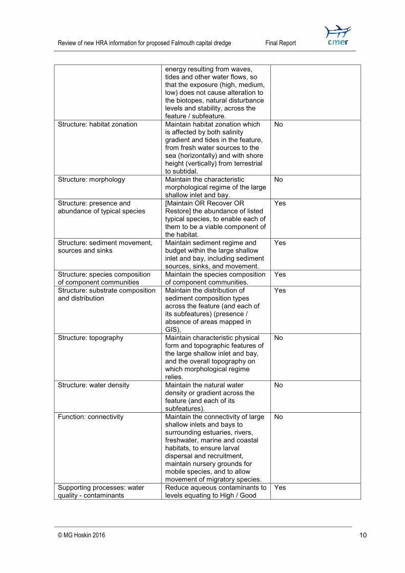
Several of the new conservation objectives for ‘large shallow inlets and bays’ simply duplicate attributes of subtidal sandbanks, so it matters little if these are not assessed. A number of attributes of ‘large shallow inlets and bays’ are, however, unique to this feature (identified in Table 2 below). Failure to assess these could potentially have important consequences. Table 2. Attributes and favourable condition targets for the ‘large shallow inlets and bays’ feature of the Fal & Helford SAC in NE’s draft new conservation advice for the site (4). Also provided is my assessment of whether each attribute duplicates an equivalent attribute of ‘subtidal sandbanks’. Attributes that are not duplicated in this way are presently at risk of being overlooked in the new HRA. Attributes Targets Equivalent attribute for
Subtidal Sandbanks? Extent and distribution Maintain the total extent and
spatial distribution of the large shallow inlet and bay to ensure no loss of integrity, while allowing for natural change and succession.
Yes
Distribution: presence and spatial distribution of large shallow inlet and bay communities
Maintain the presence and spatial distribution of large shallow inlet and bay communities according to the map.
Yes
Structure: energy / exposure Maintain the natural physical Yes 8 NE’s letter to the MMO of 14th January 2015 re ‘Port of Falmouth Development Initiative (PFDI) Habitats Regulations Assessment Framework’ (NE’s ref. 139558).
Review of new HRA information for proposed Falmouth capital dredge
Final Report
© MG Hoskin 2016 10
energy resulting from waves, tides and other water flows, so that the exposure (high, medium, low) does not cause alteration to the biotopes, natural disturbance levels and stability, across the feature / subfeature.
Structure: habitat zonation Maintain habitat zonation which is affected by both salinity gradient and tides in the feature, from fresh water sources to the sea (horizontally) and with shore height (vertically) from terrestrial to subtidal.
No
Structure: morphology Maintain the characteristic morphological regime of the large shallow inlet and bay.
No
Structure: presence and abundance of typical species
[Maintain OR Recover OR Restore] the abundance of listed typical species, to enable each of them to be a viable component of the habitat.
Yes
Structure: sediment movement, sources and sinks
Maintain sediment regime and budget within the large shallow inlet and bay, including sediment sources, sinks, and movement.
Yes
Structure: species composition of component communities
Maintain the species composition of component communities.
Yes Structure: substrate composition and distribution
Maintain the distribution of sediment composition types across the feature (and each of its subfeatures) (presence / absence of areas mapped in GIS),
Yes
Structure: topography Maintain characteristic physical form and topographic features of the large shallow inlet and bay, and the overall topography on which morphological regime relies.
No
Structure: water density Maintain the natural water density or gradient across the feature (and each of its subfeatures).
No
Function: connectivity Maintain the connectivity of large shallow inlets and bays to surrounding estuaries, rivers, freshwater, marine and coastal habitats, to ensure larval dispersal and recruitment, maintain nursery grounds for mobile species, and to allow movement of migratory species.
No
Supporting processes: water quality - contaminants
Reduce aqueous contaminants to levels equating to High / Good
Yes
Review of new HRA information for proposed Falmouth capital dredge
Final Report
© MG Hoskin 2016 11
Status (according to Annex VIII and X of the Water Framework Directive), avoiding deterioration from existing levels.
Supporting processes: water quality - nutrients
Restore the natural water quality and specifically winter dissolved inorganic nitrogen (DIN) to a concentration equating to Good Ecological Status (specifically mean winter DIN is < 12 μM for coastal waters), avoiding deterioration from existing levels.
Yes
Supporting processes: water quality - turbidity
Maintain natural levels of turbidity (e.g. suspended concentrations of sediment, plankton and other material) across the habitat.
Yes
Structure: non-native species and pathogens
Reduce the introduction of non-native species and pathogens, and their impacts.
Yes
There are thus five unique attributes of ‘large shallow inlets and bays’ that are presently at risk of being omitted from the HRA. These are: (i) habitat zonation, (ii) morphology, (iii) topography, (iv) water density and (v) connectivity. The relevance of any requirement to maintain seabed topography in relation to the proposed dredge has already been discussed. Given how morphology and habitat zonation are defined, they too are likely to be affected by the dredge. Significant impacts on connectivity and water density seem more remote possibilities. Here is not the place, however, to consider potential impacts on these attributes in detail. The key point is that the feature ‘large shallow inlets and bays’ encompasses the site of the proposed dredge, yet NE have not required any of its conservation objectives to be considered in the HRA.
1.1.3 Key points summary 1. The law requires that a HRA must assess the LSE of a plan or project on a
site in view of all relevant conservation objectives. 2. The previous failed HRA omitted to consider the conservation objective of
maintaining the ‘topography’ attribute of the site’s subtidal sandbank feature. This was not challenged at the time.
Review of new HRA information for proposed Falmouth capital dredge
Final Report
© MG Hoskin 2016 12
3. The topography attribute is designed to prevent significant anthropogenic impacts on ‘depth distribution’, which is a prima facie obstacle to capital dredging.
4. Since 2011, NE have produced draft new conservation objectives, which no longer include the attribute ‘topography’ for subtidal sandbanks.
5. NE’s advice for the new HRA is based on the new draft conservation objectives and thus does not include subtidal sandbank topography.
6. The old conservation objectives, including sandbank topography, should, arguably still be considered given the draft status of the new objectives.
7. NE’s advice for the new HRA based on the new draft conservation objectives appears to repeat the error of omitting some that appear relevant to the dredging; viz those for the feature ‘large shallow inlets and bays’
8. The Fal & Helford SAC is designated for both ‘subtidal sandbanks’ and ‘large shallow inlets and bays’ and both features encompass the site of the proposed dredging.
9. Draft new conservation objectives for ‘large shallow inlets and bays’ include topography and several others that are of prima facie relevance to the dredging, but which are not duplicated by objectives for ‘subtidal sandbanks’.
10. Conclusion: if the new HRA proceeds based on current advice from NE, there appears to be a strong case that it could be legally challenged for omitting to address conservation objectives that are highly relevant to the dredging, including old objectives that have not been fully superseded and draft new ones for an entire feature that appears to have been overlooked.
1.2 What are the implications of the lack of condition assessment for HRA? According to NE, the present ‘conservation status’ or ‘condition’ is unknown for both of the features that would potentially be impacted by the proposed dredge;

Review of new HRA information for proposed Falmouth capital dredge
Final Report
© MG Hoskin 2016 13
i.e. subtidal sandbanks and large shallow inlets and bays (9). It appears highly doubtful that the previous HRA finding that dredging would adversely affect the site could be lawfully overturned given the uncertainty this creates. Under Section 48 of The Conservation of Habitats and Species Regulations 2010, the Secretary of State must make arrangements for surveillance of the conservation status of SAC features. Typically, this work would be done by the appropriate statutory nature conservation body (SNCB) – NE in the case of the Fal & Helford SAC. This surveillance is required to fulfill the requirements of Article 11 of the Habitats Directive. It is implicit in Article 2.2 of the Habitats Directive that knowledge of the conservation status of SAC features is essential for their effective management. This is because all such measures must be “designed to maintain or restore [such features] at favourable conservation status”. Clearly, if conservation status is unknown, it cannot be determined with even moderate confidence whether any particular management measure – including any consent decision – is compatible with this objective. Without reliable knowledge of the conservation status of an attribute, the LSE of a plan or project can only be assessed on an anecdotal basis, which greatly elevates the uncertainty associated with such an assessment. The larger the predicted impact, the more likely it will be that a consent given without knowledge of the prior conservation status of the affected attributes would lead to an unanticipated adverse effect on site integrity. The critical linkage between condition assessment and effective management is explicit in various statements on this subject by the UK SNCBs. For instance, a general introduction to guidance on condition monitoring by the JNCC states that:–
One of the principal reasons for undertaking site monitoring is to assess whether management practices have been effective or not. It follows that there must be a close link between management planning
9 Natural England (2015). Fal & Helford Special Area of Conservation SAC: Draft supplementary advice on conserving and restoring site features. Published online at: https://www.gov.uk/government/uploads/system/uploads/attachment_data/file/457183/Fal_and_Helford_SAC_supplementary_advice.PDF

Review of new HRA information for proposed Falmouth capital dredge
Final Report
© MG Hoskin 2016 14
and monitoring. [ ] Once monitoring has been completed and an assessment made of the condition of the feature, there should be a feedback loop to site management, taking into account the information gathered on potential threats and management measures. The monitoring assessment may trigger adjustments to site management practices...(10)
This iterative system of management, with condition monitoring and assessment as the critical link, is summarised by the following schematic on the JNCC website (11):–
More specifically and saliently here, NE have claimed the following in their ‘standards’ statement for HRAs:–
The evidence we use for our HRAs will be based on the best available factual information in line with our Evidence standards. They will take into account the history, context and local circumstances of individual
10 JNCC (2004). Common standards monitoring introduction to the guidance manual. Published online at: http://jncc.defra.gov.uk/pdf/CSM_introduction.pdf 11 JNCC 2014. Marine Assessments. Published online at: http://jncc.defra.gov.uk/page-5329

Review of new HRA information for proposed Falmouth capital dredge
Final Report
© MG Hoskin 2016 15
sites and their prevailing environmental condition at the time of each assessment. To help address any areas of uncertainty regarding the information we use, our HRAs will highlight the level of confidence that we attach to the evidence used and explain how this has influenced the views and decisions that we have reached.(12)
Hence, the absence of current condition assessments for the features likely to be impacted by the proposed dredge is a major uncertainty that would diminish confidence in any attempt to assess its LSE. It could even be argued that an HRA cannot even be attempted without a condition assessment. At the very least, this problem should be openly acknowledged and addressed in the HRA. In their most recent advice to the dredging proponents concerning their new reports for the HRA (9), NE did not acknowledge the absence of a condition assessment for subtidal sandbanks in the Fal & Helford SAC. NE did, however, ‘strongly advise’ that:–
...that there is a specific section in the HRA to discuss the baseline environmental conditions of maerl in the site, including current understanding of condition…
While recognising the importance of information on condition in a HRA, this advice obfuscated the critical distinction between the official condition assessment that NE is required to do by law and other unofficial and possibly less-robust condition assessments. It appears here that NE has sought to circumvent the lack of a formal condition assessment by relying instead on an unofficial condition assessment commissioned by the dredging proponents, which is a highly questionable approach to HRA.
1.2.1 Key points summary 1. The law requires that the conservation status of all SAC features is
periodically assessed and reported to the EU every six years. 2. The conservation status of the two SAC features relevant to the proposed
dredging – subtidal sandbanks and large shallow inlets and bays – is 12 Natural England (2016). Habitats Regulations Assessment (HRA) Standard. Published online at: http://publications.naturalengland.org.uk/file/5658137297158144

Review of new HRA information for proposed Falmouth capital dredge
Final Report
© MG Hoskin 2016 16
currently reported as ‘not assessed’. This has been the case since site designation in 2000.
3. General policy guidance produced by NE and JNCC asserts that knowledge of conservation status is essential for effective management of site features, including HRA.
4. NE’s policy statement on HRA asserts that ‘our HRAs will [ ] take into account the history, context and local circumstances of individual sites and their prevailing environmental condition at the time of each assessment’.
5. The lack of condition assessment for relevant site features, and the uncertainty this introduces, is not explicitly addressed in NE’s advice for the new HRA for the dredging.
6. Notwithstanding the absence of formal condition assessments, NE have advised the dredging proponents to consider the ‘current understanding of condition’ in their submission for the HRA.
7. Conclusion 1: NE is potentially open to legal challenge for having failed to make a formal assessment of the conservation status of two features relevant to the dredging; subtidal sandbanks and large shallow inlets and bays.
8. Conclusion 2: the new HRA is potentially open to challenge if it proceeds without explicitly acknowledging the lack of condition assessment for subtidal sandbanks and large shallow inlets and bays and addressing the uncertainty this introduces to the HRA.
1.3 What is the current population trend of live maerl in the proposed channel? Live maerl is present throughout much of the proposed dredging area in the approach to Falmouth Docks, particularly east of the eastern breakwater. Percentage cover is highly spatially variable, but generally low and includes areas with zero percent cover. A diver survey of the area for the previous failed HRA

Review of new HRA information for proposed Falmouth capital dredge
Final Report
© MG Hoskin 2016 17
estimated maximum coverage at 75% (13). A later towed video camera survey estimated it to be only 25% (14). This difference does not necessarily indicate error or inaccuracy on the part of either study, although this cannot be ruled out. Neither survey covered the entire area, so it may be that the former survey found an area of relatively dense maerl that was overlooked in the later survey. It is accepted by the proponents’ environmental consultants, Haskoning, that dredging would result in loss of all or most of the live maerl currently in the proposed channel (15). The planned post-dredge mitigation, involving retaining and then re-laying the surface layer of maerl matrix (i.e. dead and live maerl), does not alter this. In a small-scale trial of this scheme, live maerl did not appear to survive (16). Haskoning appear to have recognised that the loss of live maerl from the channel makes it hard to conclude that the dredging would not adversely effect the SAC (15). This was not stated explicitly, but it was implicit in their attempt to construct a narrative in which this live maerl represents a special ecological case that, in their view, negates any concern about its loss. The essence of this narrative is that the live maerl in the channel does not constitute a live maerl bed, but is merely a transitory deposit that is destined to die out – in their words, “like leaves falling from a tree and decaying on the ground”. This narrative relies on the assumption that there is a gradient of declining viability for live maerl from south to north across the proposed channel. This derives from the observation that there is an extensive area of dense live maerl to the south of the proposed channel, whereas to the north there is little or no live maerl (see Figures 1 and 2 below).
13 Axelsson M, Bamber, R, Dewey S, Duke S, Hollies R (2008). Falmouth Cruise Project EIA - Marine Ecological Survey. Published online at: https://www.falmouthharbour.co.uk/wp/wp-content/uploads/50-R014-01-Falmouth-Cruise-Project-EIA-Marine-Ecological-Survey-Jan-2008.pdf 14 Sheehan EV, Cousens SL, Attrill MJ (2014). The location and extent of live and dead maerl beds in Falmouth Harbour, southwest UK. Marine Institute, Plymouth University, Plymouth, UK PL4 8AA. 15 Royal HaskoningDSV (2016). Port of Falmouth Approach Channel Dredge and Habitat Mitigation Scheme: Information for Habitats Regulations Assessment (HRA) (321 pages). Published online at: https://www.falmouthharbour.co.uk/wp/wp-content/uploads/50-R039-01-Port-of-Falmouth-Approach-Channel-Dredge-and-Habitat-Mitigation-Scheme.HRA-Final1.pdf 16 Sheehan EV, Bridger D, Cousens SL, Attrill MJ (2014). An experimental trial to assess the impact of extracting and re-laying the top 30 cm of maerl habitat within the Fal Estuary planned dredge area. Published online at: https://www.gov.uk/government/uploads/system/uploads/attachment_data/file/332240/1401-maerltrialreport.pdf

Review of new HRA information for proposed Falmouth capital dredge
Final Report
© MG Hoskin 2016 18
Figure 1. Data on the distribution of live maerl in the vicinity of Falmouth Docks compiled from the marine ecological survey report by Axellson et al. (2008) (13), which supported the 2009 application for a dredging licence. The dashed black line is the boundary of the proposed dredge area.
C1 C2C3
C9 C4 C5C6
C8
C7
C10R4
R5
R6
R1
R2
R3
B1
B2
B3
B4
T1 T2
T3 T4 T5 T6
T7
B-T1
B-T2
B-T3
B-T4
?
LegendNo information on live maerlLive maerl present, but rare/sparse/occasional/infrequentAbundant live maerlNo information on live maerl
1-10% cover live maerlLive maerl absent
11-25% cover live maerl51-75% cover live maerl
? Reported as 11-25% cover live maerl in Table F4, but reportedelsewhere (pp 39, 50 & 52) that there was so much live maerlat C10 that it was decided not to take core samples.
N
Figure 2. Figure 5b from Sheehan et al. (2014) showing the occurrence of live maerl in the vicinity of Falmouth Docks. Each datum is the percentage of 25 subdivisions of a single photo-quadrat that contained at least some live maerl, regardless of density. The yellow area indicates the proposed dredge area.
0 200 m
N
01-1516-2526-5051-7980-100

Review of new HRA information for proposed Falmouth capital dredge
Final Report
© MG Hoskin 2016 19
Haskoning sought to explain the decline in live maerl cover from south to north as follows (15):–
It appears that the abundance of maerl decreases as you move north in the area sampled. This could be due to the more exposed nature of this area away from the coast or due to its use as a navigation channel. This area is used for shipping and is not dredged for maintenance. The last time the existing channel was maintenance dredged was thought to be in the 1960’s. [ ] The live maerl nodules are not expected to accumulate into a live maerl bed over time in this area. The nodules are predicted to have been present in this area since the 1960s and have not formed a live maerl bed. The maerl fragments in the channel are likely to have originated from a nearby living maerl bed, where fragments are broken off by tidal movements and transported along the seabed by the underwater currents to other areas. [ ]
The next stage of the Haskoning’s case involved applying this narrative to the assessment of LSE on specific maerl attributes. A notable procedural issue here was that Haskoning only assessed LSE for the old (i.e. pre-2015) SAC attributes (Table 3, below). This was despite their clients, FHC, having been advised of the new SAC attributes and associated favourable condition targets by NE four months previously (17). Table 3. Attributes of subtidal sandbanks in the Fal & Helford SAC that formed the basis of Haskoning’s most recent assessment of the LSE of the proposed dredging.
Attribute Measure Target Comments Extent Area (ha) of
maerl (live & dead maerl), measured once during reporting cycle.
No decrease in extent of maerl as whole, or of either dead or live maerl, from an established baseline, subject to natural change.
The extent of maerl beds (and distribution of live and dead components within the beds) is key to their structural and functional importance. Extent provides a long-term integrated measure of environmental conditions and any loss is likely to be long-term.
Distribution of maerl bed communities
Distribution of maerl bed communities (listed in appendix III). Measured once per reporting cycle.
Distribution of maerl bed communities should not deviate significantly from an established baseline, subject to natural change.
The relative distribution of the biotopes listed in appendix III is an important structural aspect of the feature. Changes in relative extent and distribution may indicate long term changes in the physical conditions influencing the feature.
17 Email from NE to FHC of 22nd January 2016. Subject: Sandbank attributes. Attachment: Fal and Helford SAC sandbank and maerl attributes PFDI comment for FHC.doc. Obtained via FoI request (NE’s ref: RFI3300).

Review of new HRA information for proposed Falmouth capital dredge
Final Report
© MG Hoskin 2016 20
Species composition of maerl bed communities
Presence and abundance of composite species of biotopes from maerl areas. Measured during summer, one during reporting cycle.
Presence and abundance of composite species should not deviate significantly from an established baseline, subject to natural change.
Species composition is an important contributor to the structure of the maerl bed. The presence and relative abundance of characterising species gives an indication of the quality of the biotopes and change in composition may indicate cyclic change/trend in sediment communities. Maerl is species rich and contains rare algal species which are relatively stable, making this habitat a good indicator of the condition of the subtidal sandbanks.
For each of these attributes, Haskoning concluded no LSE. In respect of the attributes ‘extent’ and ‘distribution of maerl bed communities’, the possibility of a LSE was rejected based largely on the claim that the amount of live maerl in the area to be dredged does not, and would not ever, constitute a live maerl bed. A LSE on species composition of maerl bed communities was rejected based on the claim that the live maerl nodules in this area do not contribute significantly to the diversity of species within the channel area. There are a number of major objections to these conclusions. First; the claim that the amount of live maerl is too low to constitute a maerl bed presumes that there is some specified threshold that must be exceeded, yet none is cited. This is not surprising as there does not appear to be any such threshold. Official advice for the particular maerl attributes that Haskoning assessed (3) simply defines maerl beds as “accumulations of living and dead unattached coralline algae”. Similar advice supporting the updated statement of SAC attributes says that:–
The Fal and Helford maerl bed habitats range from pristine live maerl beds with up to 100% coverage to extensive areas of dead maerl with little to no live maerl.
Hence, there does not appear to be any formal basis on which Haskoning could say that the live maerl in the proposed channel does not qualify as a live maerl bed. Second; the claim of low abundance of live maerl is based solely on the 2014 towed video survey by the University of Plymouth (14), which found no more than

Review of new HRA information for proposed Falmouth capital dredge
Final Report
© MG Hoskin 2016 21
25% coverage. The 2008 diver survey, which found some sites within the channel with up to 75% coverage (13), was not mentioned in the Haskoning’s assessment of LSE. Hence, the claim of low abundance of live maerl throughout the channel is not supported. Recall also that neither survey was fully spatially comprehensive, so it is possible that there are other, as-yet-undiscovered sites within the channel with >25% cover. Third; there is no empirical evidence to support the claim that the live maerl within the channel is actually transitory and dying off. The key evidence needed to substantiate this claim would be data showing a progressive decline in the abundance of live maerl within the channel relative to other nearby places where live maerl was deemed to be a permanent component of the habitat. No such data exists. Evidence of nodule mortality within the channel would not suffice. This would only imply die-off of the local population if the rate of mortality exceeded the rate of inward migration, but even this partial evidence is absent. Furthermore, despite claiming that live maerl is transitory within the channel, elsewhere in their report Haskoning argue that live maerl killed by dredging will readily recover post-dredge. They stated:–
In terms of the overall distribution of the live maerl, following dredging, live maerl nodules are expected to continue to roll into the channel from adjacent areas. [ ] Therefore, [dredging] is only expected to cause a localised temporary effect following which recovery of the live maerl cover will continue with nodules moving into the channel.
If this were true, it would argue that the presence of live maerl in the channel was a stable, rather than a transitory feature. It cannot be both simultaneously, yet where expedient, Haskoning have used both arguments to justify dredging. Fourth; in relation to species composition of maerl habitats; the claim that live maerl does not contribute significantly to species diversity within the proposed dredge area is highly questionable. Haskoning based this claim on two studies by Sheehan et al. from the University of Plymouth – the first on infauna (16), the second on epifauna (18). The first was done within the proposed dredge area, but 18 Sheehan EV, Bridger D, Attrill MJ (2015). The ecosystem service value of living versus dead biogenic reef. Estuarine, Coastal and Shelf Science 154 (2015) 248-254.

Review of new HRA information for proposed Falmouth capital dredge
Final Report
© MG Hoskin 2016 22
should not be regarded as in any way conclusive because it sampled only a single site (~30m x 15m) with live maerl that had exceedingly low coverage, even for the dredge area, with a maximum of only 4.41 live fragments/m2. This is many fewer nodules than would have occurred in a more-typical live maerl site within the channel site, with 10-25% cover of live maerl. From personal experience of diving within the channel (>50 hours), a large live maerl nodule in this area is ~2cm diameter (or ~3cm2). Hence, at a conservative 10% cover, and assuming that all nodules were large and non-overlapping (also conservative), there would be over 330 live nodules/m2. This study found no difference in infuanal diversity between the single site with exceedingly sparse live maerl versus five other sites with dead maerl only. Had they investigated a more-representative live maerl site with 10-25% cover, it is possible they would have made a different finding regarding infaunal diversity. The second study by Sheehan et al. (18), concerned the effect of live maerl cover on the abundance and diversity of epifauna using data from Falmouth and Jersey. The Falmouth data was sampled within and adjacent to the proposed dredge area and covered sites with live maerl cover that was far more representative of variability within the channel (i.e. 0 to 75%). As regards Falmouth, this study concluded that:–
In Falmouth, maerl beds containing live maerl thalli had a greater number of taxa and a greater abundance of epifauna. In terms of taxonomic diversity, the difference was not great between sites with dead maerl only and sites with variable amounts of live maerl (2.55 vs. 2.9 taxa per m2, respectively), but it was statistically significant. The difference in total epifaunal abundance was more pronounced with 15.87 individuals per m2 in the mixed dead/live maerl and 10.16 per m2 where there was only dead maerl. Despite these findings, Haskoning nevertheless concluded that:–
...the dead maerl with live fragments (found within the channel) and the dead maerl, provide a similar habitat and that the presence of such a low abundance of fragments of live maerl do not provide any unique characteristics that would enhance the ecological value of the habitat in this area.
Review of new HRA information for proposed Falmouth capital dredge
Final Report
© MG Hoskin 2016 23
Haskoning appeared to have dismissed the finding for epifauna almost entirely on the basis that the difference in abundance was mainly due to tubeworms, which, like maerl, increase physical habitat complexity. They suggested that it was these, not living maerl, that were responsible for greater taxonomic diversity in areas with live maerl. They said:–
it is [ ] recognised in the paper that the tube worms themselves increase the structural complexity of the habitat. This is not discussed further within the paper but it could offer a potential explanation as to why these sites also have a higher number of taxa.
What Haskoning did not appear to have recognised is that the potential habitat value of tubeworms did not necessarily negate that due to live maerl. First; they are different structures – tubeworms are relatively tall, straight structures, whereas maerl is more compact and branching. Second; tubeworms are filter-feeders so they have the capacity to inhibit settlement of other species in their vicinity, which maerl does not. Hence, their physical habitat characteristics and ecosystem functions are not equivalent and interchangeable. Furthermore, it is entirely plausible that it was the presence of living maerl that caused enhanced settlement of tubeworms, as has been demonstrated for queen scallops19. There is abundant evidence that a wide range of algal species, including coralline algae specifically, have materials on their surface that stimulate the settlement of larvae of diverse invertebrate taxa (as revealed via a literature search using ‘Google scholar’). If that was the case here, then the habitat value of tubeworms, far from negating that of live maerl, would be a product of it. Another issue that Haskoning appeared to overlook in asserting that loss of live maerl would not affect the attribute ‘species composition of maerl bed communities’ was that maerl species are officially one of its ‘characterising species’ (20). Anthropogenic loss of one of these species, would by definition, constitute a LSE. 19 Kamenos NA, Moore PG, Hall-Spencer JM (2004). Attachment of the juvenile queen scallop (Aequipecten opercularis (L.)) to maerl in mesocosm conditions; juvenile habitat selection. Journal of Experimental Marine Biology and Ecology 306: 139– 155. 20 JNCC (2015). Marine Habitat Classification: SS.SMp.Mrl - Maerl beds. Published online at: http://jncc.defra.gov.uk/marine/biotopes/biotope.aspx?biotope=JNCCMNCR00001554

Review of new HRA information for proposed Falmouth capital dredge
Final Report
© MG Hoskin 2016 24
Returning to Haskoning’s suggestion that live maerl is only transitory in the proposed dredge area: in the absence of direct evidence of population die-off, the next most persuasive evidence would be of significant differences in natural environmental factors affecting maerl viability from south to north across the channel. A key publication on the ecology of maerl for conservation management of marine SACs (21) summarised the most significant environmental factors affecting maerl as follows:-
The ecological niches of both Lithothamnion corallioides and Phymatolithon calcareum are relatively narrow and subject to many controlling environmental factors. The most significant environmental factors affecting the distribution of maerl are currents; the interactive effects of depth and water quality; and wave action. The key physical factor affecting both the distribution of maerl and the type of maerl biotope is the occurrence of seabed currents, generated by tides, rivers, wave action or salinity differentials. Extensive maerl beds are more or less restricted to areas where there are moderate to strong currents. [ ] Maerl does not occur where there is strong wave action, so it is most common in bays and inlets.
Thus, if there was a trend from south to north of significantly increasing depth, increasing wave exposure, decreasing currents, decreasing salinity, or any combination of these, then there would be valid grounds for hypothesizing that the decrease in live maerl along this axis was evidence of decreasing habitat quality. In the following sections, evidence for each of the key environmental factors affecting maerl is reviewed to assess the extent to which their spatial variations might explain the current distribution of live maerl within and adjacent to the approach channel to the docks.
1.3.1 Depth Water depth affects the viability of maerl mainly via its effect on light availability for photosynthesis (21). Crossing the approach channel to the docks from south to north (a distance of ~160m), average seabed depth starts at ~4.5m below chart datum (CD), then 21 Birkett DA, Maggs CA, Dring MJ (1998). Maerl (volume V). An overview of dynamic and sensitivity characteristics for conservation management of marine SACs. Scottish Association for Marine Science. (UK Marine SACs Project).

Review of new HRA information for proposed Falmouth capital dredge
Final Report
© MG Hoskin 2016 25
increases to ~6.5m CD then decreases again to ~4.5m CD. Even the deepest charted depth within the channel, 6.9m CD (in one small area), is within the range of depth in which living maerl can be found within in the immediate vicinity of the docks. Survey dives carried out by marine biologists from the Marine Conservation Society and Seasearch (22) on the shoulder slopes of the drowned river valley that forms the main estuary channel recorded live maerl down to ~11m CD, but this was mainly in the form of very sparse, pale, thinly-branched nodules. The greatest depth that appeared capable of sustaining dense aggregations of live maerl was ~6.5m CD. In Falmouth Bay, maerl lives down to 18.9m, but it is well known that lower turbidity here (compared to the Fal estuary) allows greater depth of light penetration (23,24). It thus seems highly unlikely that the approach channel to the docks is currently too deep to allow dense aggregations of live maerl to occur. Consider also that if variation in depth was the major factor explaining spatial variation in live maerl in the approach to the docks, one might have expected to find dense live maerl both south and north of the approach channel, where depths are almost identical (~4-6m in both cases). At the same depths on the comparable St Mawes Bank on opposite side of Carrick Roads, dense live maerl extends more than 1km further north than it does on the western side.
1.3.2 Currents Maerl requires moderate to strong tidal flows to prevent smothering by fine sediments, which hinders photosynthesis and, if anoxic, may even poison maerl (21,25). The Environmental Impact Assessment (EIA) for the previous failed licence application mapped tidal current speeds in the Carrick Roads and Falmouth Bay 22 Solandt J-L, Woods C, Hoskin MG (2014). Depth distribution of maerl in the Carrick Roads. Unpublished report. 23 Ruiz-Frau et al. (2007). Falmouth Bay Maerl community benthic survey (April 2007). Centre of Applied Marine Sciences, School of Ocean Sciences, College of Natural Sciences, University of Wales, Bangor. Report to Cornwall Sea Fisheries Committee. 24 Perrins JM, Bunker F, Bishop, GM (1995). A comparison of the maerl beds of the Fal Estuary between 1982 and 1992. Report to English Nature. 25 Wilson S, Blake C, Berges J, Maggs, C (2004). Environmental tolerances of free-living coralline algae (maerl): implications for European marine conservation. Biological Conservation 120 (2004) 283–293.
Review of new HRA information for proposed Falmouth capital dredge
Final Report
© MG Hoskin 2016 26
(26). This was done for peak ebb and flood tides, under both spring and neap conditions. This showed that during neap tides, there is no difference in current strength across the area under consideration (a south-north transect of ~500m length centered on the channel). On both ebb and flood neap tides, current strength across this entire area is ~0.1m/s. On spring flood tides, current speed decreases slightly from south to north from ~0.5 to 0.3m/s. There is also a slight decrease from south to north on spring ebb tides, from 0.4 to 0.3m/s. Thus, the reduction in live maerl cover from south to north correlates spatially with a very small (~0.1m/s) reduction in spring tide current speed. The critical question is whether this is sufficient to have caused the reduction in live maerl cover? Based on current speeds on the St Mawes Bank, the most prolific area of live maerl in the Carrick Roads, this seems highly unlikely. According to the EIA, current speeds here are typically 0.1-0.2 m/s slower than in the area of interest adjacent to the docks. Live maerl beds with spring tide current flows of only 0.1m/s are also known in Galway, Ireland (21). If there was a significant reduction in current speed from south to north across the approach channel, one might expect this to be reflected in the sediment characteristics of this area. The previous EIA carried out particle size analysis for surface sediments (to 15cm depth) from a range of sites spanning the channel (13). Four sites south of the channel (samples BEN01 to BEN04) where live maerl grows in profusion had an average silt/clay content of 2.0%. Eight sites within the channel (samples CS03 to CS10), where there was typically lower coverage of live maerl, had an average silt/clay content of 2.8%. Three sites to the north of the channel (RPT04 to RPT06), where there was very little live maerl, had an average silt/clay content of 1.8%. At all sites, the remainder of the surface sediment was mainly sand (~40%), plus roughly equal proportions (~28%) of gravel and pebble-sized particles. With silt/clay content less than 3% in all cases, all of these samples would qualify as clean coarse sediment. This is further evidence that
26 HR Wallingford (2008). Falmouth Cruise Terminal - Hydrodynamic and sedimentary studies. Report EX5809.

Review of new HRA information for proposed Falmouth capital dredge
Final Report
© MG Hoskin 2016 27
there is no significant variation in current speed across the channel area that might affect the viability of live maerl.
1.3.3 Wave exposure Maerl proliferates where wave action and/or tidal flow is sufficient to remove fine sediments, but not strong enough to break the brittle maerl branches (27). In their updated assessment of the dredging and mitigation scheme (15), Haskoning suggest that the relatively low abundance of live maerl in the approach channel and to the north “could be due to the more exposed nature of this area away from the coast”. This suggestion has no obvious rational basis as wave-height data gathered for the EIA (26) shows that there is no wind direction that exposes this northern area to greater wave-heights than the adjacent southern area where live maerl is more abundant.
1.3.4 Salinity Maerl requires fully saline conditions in which to live (21). Fine-scale spatial data on average salinity in the immediate approaches to Falmouth Docks does not appear to be available. It seems highly unlikely, however, that salinity 300m north of the dense live maerl bed south of the current approach channel could be consistently too low to sustain live maerl. The much more northerly extent of live maerl on the opposite St Mawes Bank also weighs heavily against this possibility. The Fal estuary system, including the Carrick Roads, is known to have relatively low freshwater input (9). The truly estuarine (i.e. reduced salinity) parts of this system are restricted to the upper parts of the branches that feed in to the Carrick Roads.
1.3.5 Conclusion regarding the proponent’s live maerl narrative Based on the available evidence, it is difficult to see that there is sufficient variation in any of the key natural environmental factors that affect maerl viability to explain the steep decline in live maerl coverage from south to north across the 27 JNCC (2015). Maerl beds. Published online at: http://jncc.defra.gov.uk/page-6023

Review of new HRA information for proposed Falmouth capital dredge
Final Report
© MG Hoskin 2016 28
area where dredging is proposed. While depth, tidal currents and wave exposure do appear to vary across this area, none of their variations are of a direction and magnitude that could be expected to create a gradient ranging from fully viable for maerl to completely non-viable over a distance of only 200-300m. It is also notable that there is no similar trend in live maerl coverage on the St Mawes Bank directly opposite. This appears to offer very similar environmental conditions to the western bank, yet supports thriving live maerl more than 1km further north. Clearly this is correlative evidence only, so it does not allow a conclusive test of Haskoning’s hypothesis that such a gradient exists in the vicinity of Falmouth Docks, but it does strongly suggest that the search for an explanation would be more profitably pursued elsewhere. The only other factor suggested by Haskoning to explain the observed distribution of live maerl is disturbance from vessel movements (15). They do not elaborate on this, but it is presumed they are alluding to seabed disturbance from the propeller downwash from ships or tugs moving overhead. The first and most obvious thing to observe here is that this is an anthropogenic, rather than natural, explanation for the distribution of live maerl across the channel. As such, if it were ever proved that propeller downwash was significantly impacting the viability of maerl, there would be a case for managing this activity to alleviate this impact on the SAC. The updated dredging and mitigation scheme from Haskoning records that each year Falmouth Docks receives ~200 ships for repair, plus 30-40 cruise ships. Many of these vessels would require tug assistance to enter and leave the docks. Haskoning state that there are ~450 such tug movements per year at the docks. Many of these movements, however, are simply to re-position ships within the docks (e.g. move from berth to dry-dock or vice versa), rather than take them in or out via the main approach channel. If ships and/or tugs exerted significant physical force on the seabed via their propellers, then with these numbers of movements there would appear to be potential for significant impacts on benthic habitats within the channel, affecting both maerl and infauna. Whether they do exert such a force is not clear. The suggestion of vessel movements as a factor affecting maerl is not

Review of new HRA information for proposed Falmouth capital dredge
Final Report
© MG Hoskin 2016 29
backed up by any data on the downwash forces likely to act on the seabed, given the sizes of ships and depth of water involved. However forceful they might be, such disturbances can only be short-lived locally, coming and going with the passage of each vessel overhead. To better assess this suggested explanation, it would help to have been informed how such forces compare in strength and duration with the forces generated at the seabed by the prevailing wind-waves and tides. For various reasons explained here, I do not believe that propeller downwash is the key factor explaining the distribution of live maerl immediately to the east of Falmouth Docks. As a long term resident of Falmouth and keen observer of both docks activities and the local marine environment (my family home overlooks the docks and Carrick Roads and I also keep a small boat in the harbour), I have often observed dense plumes of turbid water produced by ships and tugs maneuvering in or out of the docks (e.g. see Figure 3). This is often accompanied by flocks of seabirds feeding from the surface of the plume, indicating that benthic animals have been flushed out of the seabed and raised to the surface by water currents. I have only ever observed this happening within the docks basin and inner harbour, however, not in the approach channel where dredging is proposed. I attribute this to the types of tug maneuvers typically carried out in these different harbour areas and the different forces involved. Moving vessels in or out of the inner harbour or docks basin involves a sequence of direction changes and rotations that requires tugs (at least two per ship, typically) to exert considerable force to overcome the momentum and sideways drag of the towed vessel. By contrast, transiting the approach channel involves towing slowly and smoothly in a straight line and as such requires much less force. Ecological data from the approach channel and various surrounding sites (both north and south) (13) appears to support the view that the seabed in the channel is not subject to severe, ongoing physical disturbance from vessel prop-wash. The survey report concluded that:–

Review of new HRA information for proposed Falmouth capital dredge
Final Report
© MG Hoskin 2016 30
…the infaunal community of this area is comparatively diverse, with high species richness, and, except towards the inner harbour [ ] is typical of maerl-associated communities. They also observed that:–
…the epibiota recorded during the dive-survey was far more dense and diverse in [the proposed dredge] zone than at the recovery-site-zone.
The latter was a nearby area that had previously been subject to commercial maerl extraction, which took place regularly in the Carrick Roads until 2005. If the area was frequently highly disturbed by propeller downwash, it would not be expected to support a diverse infaunal assemblage. Figure 3. Turbidity plume created by propeller wash from tugs maneuvering a Royal Fleet Auxillary vessel out of Falmouth Docks on 25 July 2014. Photograph A was taken within Falmouth Harbour, looking east. The white arrow in each photograph points to the boundary between the turbidity plume and undisturbed ambient seawater. Photograph B is a close-up of the plume. (Photographs taken by M Hoskin),
A. B.

Review of new HRA information for proposed Falmouth capital dredge
Final Report
© MG Hoskin 2016 31
1.3.6 Commercial maerl extraction: the missing piece of the jigsaw? None of the explanations offered for the northward decline in maerl abundance across the approach to Falmouth Docks bear close scrutiny. There is nothing to suggest a gradient in conditions affecting maerl that would allow it to thrive and accumulate 200m south of the proposed dredge area, yet die off within in it. Moreover, there is a ready alternate explanation for the observed distribution of live maerl that the Haskoning did not even consider. It relates to commercial maerl extraction, which was mentioned briefly at the end of the previous section. Nor does it appear that this important information was provided to Dr Nick Kamenos who peer-reviewed Haskoning’s review of information on live maerl in Carrick Roads and who appears to have endorsed the hypothesis that the sparse accumulation in the approach channel is only transitory (15). It is hard to understand why the residual impacts of industrial maerl extraction were not considered as both Haskoning and their clients, FHC, are intimately familiar with this issue. The industry operated under licence from FHC from 1975 until 2005 and Haskoning advised them on the environmental impacts of maerl dredging in the period 2003 to 2006. Maerl gravel was harvested in the Fal for sale as an agricultural soil conditioner. When added to soil it increases its pH value and introduces various minerals and trace elements that improve the quantity and quality of grass grown as feed for livestock (28). FHC licensed two operators, both of whom extracted maerl via trailer suction dredging. They were licensed to extract 30,000 tonnes of maerl per annum jointly, but it was claimed that in the last few years of this activity they extracted an average of only 20,000 tonnes per annum As shown in Figure 4, below, which is reproduced from a 2004 report to FHC by Haskoning (28), one of the main areas in which maerl extraction activity was 28 Royal Haskoning (2004). Marine ecological survey of the Fal estuary: effects of maerl extraction. Report to Falmouth Harbour Commissioners. Published online at: https://www.falmouthharbour.co.uk/wp/wp-content/uploads/50-R017-01-Marine-Ecological-Survey-of-the-Fal-Estuary-Effects-of-Maerl-Extraction-2004.pdf

Review of new HRA information for proposed Falmouth capital dredge
Final Report
© MG Hoskin 2016 32
concentrated was precisely the area where there is now little or no live maerl; i.e. east and north of Falmouth Docks. Conversely, the areas where there is now relatively dense live maerl are just outside the old extraction area to the south and west, towards the eastern breakwater and Castle Point. Figure 4. Areas in Carrick Roads where there has been commercial maerl extraction. Reproduced without alteration from a 2004 report to FHC by Haskoning.
Like suction dredging generally, suction dredging for maerl impacts the seabed in two main ways. First, there is the direct removal of maerl habitat and associated benthos – including the habitat-forming live maerl. Then there is the indirect impact on surrounding areas due to the discharge of sediment-laden seawater sucked up with the mearl. The resultant deposition smothers habitats in the immediate vicinity of the extraction area. How far this impact would have extended is not known, but several tens of meters would not seem implausible. Any live maerl within or adjacent to extraction areas is unlikely to have survived (29). 29 Hall-Spencer, J. M. (1994). Biological studies on nongeniculate Corallinaceae. PhD thesis, University of London.

Review of new HRA information for proposed Falmouth capital dredge
Final Report
© MG Hoskin 2016 33
After the Fal became a candidate SAC in 2000, the relevant SNCB, English Nature (as was), put considerable pressure on FHC to cease licensing maerl extraction in the Fal. They finally conceded in 2006 following the European Court of Justice’s ruling on the Waddenzee cockle fishery (30). This established that, to comply with the Habitats Directive, managerial decisions affecting SACs must exercise a very high degree of precaution in favour of environmental protection. Part of the Haskoning’s case that maerl cannot form a proper living bed in the proposed dredge area is the assertion that it has failed to do after being left relatively undisturbed for more than 56 years. This was based on the observation that there has been no maintenance (i.e. navigational) dredging in the approach channel since the 1960s (15). Live maerl beds are known to have low recoverability. Scientific advice on the conservation management of maerl within SACs states that full recovery ‘from a single event causing mortality’ takes 25 years (21). In advice supporting the new conservation objectives, NE states that any reduction in the extent of maerl beds in the Fal due to commercial maerl extraction “will take hundreds of years to recover naturally”. Thus, if maintenance dredging in the 1960s had been the last acute disturbance of maerl living in the approach channel, and this area was otherwise capable of sustaining a prolific live maerl bed, one might indeed have expected greater recovery by now. Knowing that industrial maerl extraction was occurring within and adjacent to this area as late as 2005, however, the low quantities of live maerl recorded in this area seem entirely unexceptional. Current densities are more or less what one would expect for a live maerl bed recovering from sustained, extreme and extensive physical disturbance within less than 10 years (the first survey of live maerl within the dredge area was done 3 years after the cessation of maerl extraction, the second, 8 years). Were it true that the present low-to-intermediate cover of live maerl in the proposed dredge area reflects partial recovery of a live maerl bed, rather than die- 30 FHC (2006). Press Release: Falmouth Harbour Commissioners to cease licensing maerl extraction. Issued 6 February 2006.

Review of new HRA information for proposed Falmouth capital dredge
Final Report
© MG Hoskin 2016 34
off in an area with permanently hostile environmental conditions, then this has significant implications for the assessment of LSE in the new HRA. The loss of live maerl in this area cannot be lightly dismissed. This is even more the case when the new conservation objectives for maerl attributes are considered (see following section).
1.3.7 Key points summary 1. Live maerl occurs extensively within the proposed dredge area, mostly at
low abundance (~10% coverage), but patches of higher abundance (25-75%) have been observed.
2. Extending ~500m southwards from the southern margin of the channel is a large area of relatively dense live maerl.
3. Live maerl did not survive in the mitigation trial and the proponents acknowledge that live maerl within the channel is unlikely to survive dredging.
4. The dense bed south of the channel is also at risk from sediment smothering caused by the dredge.
5. Relevant conservation objectives for maerl beds cover their extent, the abundance of live maerl nodules, the status of live maerl as a ‘characteristic species’ of maerl beds and the structures and processes that maintain them.
6. Loss of live maerl within and adjacent to the dredge area is thus a potential adverse effect on site integrity.
7. Notwithstanding the above, Haskoning concluded that the effect of dredging on live maerl would not constitute an adverse effect on site integrity.
8. Haskoning made this assessment without regard to the draft new conservation objectives, of which they had previously been informed of by NE.

Review of new HRA information for proposed Falmouth capital dredge
Final Report
© MG Hoskin 2016 35
9. Haskoning’s conclusion of no adverse effect was based on three main assertions: (i) that the live maerl in the channel is at too low a density to constitute a live maerl bed; (ii) that coverage is too low to provide benefits for other species; and (iii) that there is a strong environmental gradient of viability for live maerl from north to south spanning the channel, which means that live maerl forms only a transitory deposit there.
10. The only evidence in support of Haskoning’s viability gradient/transitory deposit theory is the pattern of live maerl coverage in the vicinity of the channel. All other elements of this potential explanation are purely speculative.
11. Haskoning’s assertion that live maerl coverage in the channel is too low to constitute a live maerl bed is not supported by any official statement of a qualifying level.
12. Haskoning’s assertion that live maerl coverage is too low to provide benefits for other species is not supported by a key paper by Sheehan et al. (2015), which concluded that “maerl beds containing live maerl thalli had a greater number of taxa and a greater abundance of epifauna.”
13. Haskoning’s assertion that live maerl in the channel is a transitory deposit is not supported by any evidence that the rate of mortality of individual nodules exceeds the rate of replacement (i.e. no evidence of progressive decline).
14. None of the natural environmental factors known to affect maerl shows variations of a direction and magnitude that would suggest a gradient of declining viability from south to north across the channel.
15. The possibility of environment being non-viable for maerl from the channel northwards is further undermined by the existence of a bed of dense live maerl on the opposite St Mawes Bank of Carrick Roads, which extends more than 1km further north than the equivalent bed on the western side.

Review of new HRA information for proposed Falmouth capital dredge
Final Report
© MG Hoskin 2016 36
16. Haskoning’s account of the ecology of live maerl in the vicinity of the channel fails to take any account of commercial maerl extraction in this area until 2005. Live maerl is relatively abundant away from the area where records say this activity occurred and rare or absent within or near this area.
17. Haskoning have had their account of the ecology of live maerl in the proposed dredge area peer-reviewed, and apparently endorsed, by maerl expert Dr Nick Kamenos of the University of Glasgow.
18. It does not appear that Dr Nick Kamenos was independently aware of the history and distribution of commercial maerl extraction in the Fal when he reviewed Haskoning’s account of maerl ecology locally.
19. Conclusion: Haskoning’s conclusion that the loss of live maerl from the channel would not constitute an adverse effect on site integrity is challengeable on three key grounds: (i) that not all relevant conservation objectives have been assessed; (ii) that their model seeking to explain maerl ecology in the area is not supported by any empirical evidence; and (iii) that their model omits to take account of commercial maerl extraction in the area, which appears to have much power to explain the current distribution of live maerl.
1.4 How significant are new restoration objectives for maerl attributes? In the previous scheme of conservation objectives there were only three attributes specifically for the maerl bed sub-feature of the Fal & Helford SAC, with other attributes, most notably ‘topography’ (see Section 1.1), being covered at the feature level (i.e. attributes of subtidal sandbanks). There are now nineteen attributes for maerl beds (see Table 4, below). Broadly speaking, NE have replaced a small number of general attributes, with a larger set that are more specific. Arguably more significant in the present context is that there are now several conservation objectives for maerl beds that require restoration to

Review of new HRA information for proposed Falmouth capital dredge
Final Report
© MG Hoskin 2016 37
favourable conservation status (FCS), rather than the more-usual maintenance at FCS. The attributes that must be restored are: (i) presence and spatial distribution of maerl bed communities; (ii) biomass (of live maerl); (iii) age / size frequency (of live maerl); (iv) population abundance (of live maerl); and (v) species composition of component communities (Table 4, below). There are also separate objectives for reducing non-native species, nutrients and contaminants. Information accompanying the new conservation objectives for maerl beds identifies the impacts of recent (i.e. post-SAC designation) maerl extraction and scallop dredging as the main reasons why restoration is now needed. Ship anchoring is also identified as another anthropogenic disturbance that may be impacting maerl. NE’s 2014 ‘Site Improvement Plan’ for the Fal & Helford SAC (31) does not include any artificial measures to accelerate restoration of maerl beds at present. The restoration plan, such as it is, appears simply to be to remove and/or prevent further adverse effects and then rely on purely natural recovery processes. In terms of the proposed dredging, the salient question is how might the new requirement to restore maerl beds influence the HRA? This depends on the answer to a more general question, which is this: all other things being equal, does a conservation objective requiring restoration represent a greater hurdle to consent for a plan or project than one that requires only maintenance? Logic suggests that it should be a greater hurdle. If an area of important habitat is already significantly impacted and in need of restoration, it stands to reason that conservation managers should be more than usually concerned to not disrupt recovery by allowing significant new impacts. In human health terms, the equivalent to habitat restoration would be some form of medical treatment. Clearly, if someone was recovering from one major illness or injury, medical professionals would be proactive in preventing any further illness or injury that disrupted recovery and exacerbated the patients difficulties.
31 Natural England (2013). Site Improvement Plan: Fal & Helford. Published online at: http://publications.naturalengland.org.uk/file/6662359506485248

Review of new HRA information for proposed Falmouth capital dredge
Final Report
© MG Hoskin 2016 38
Table 4. Attributes of maerl beds in NE’s draft new conservation advice for the Fal & Helford SAC. For each attribute, I have commented whether it is entirely new attribute or not and paraphrased NE’s explanation of its purpose where it is a new attribute. Attributes of maerl beds Targets My comments Extent and distribution Maintain the total extent and
spatial distribution of maerl bed.
Extent and distribution were separate attributes in old scheme. Old scheme also specified no decrease in maerl “as whole, or of either dead or live maerl”, which is no longer the case.
Extent of supporting habitat Maintain the area of habitat which is likely to support the feature.
New attribute – designed to allow for potential migration of maerl beds.
Distribution: presence and spatial distribution of maerl bed communities
Restore the presence and spatial distribution of maerl bed communities.
Equivalent to ‘Distribution of maerl bed communities’ in old scheme.
Structure: biomass Restore the biomass of maerl to natural levels within the site, to ensure a healthy, resilient habitat.
New attribute – refers to live maerl only. Significant that restoration (not maintenance) is required. Justified on grounds of necessity for recovery from impacts of activities such as maerl extraction and scallop dredging.
Structure: age / size frequency Restore the size structure and composition of maerl thalli across the site.
New attribute – significant that restoration (not maintenance) is required. Justified on grounds of necessity for recovery from impacts of activities such as maerl extraction and scallop dredging.
Supporting processes: energy / exposure
Maintain the natural physical energy resulting from waves, tides and other water flows, so that the exposure (high, medium, low) does not cause alteration to the biotopes, and stability, across the habitat.
New attribute – designed to achieve similar effect of ‘topography’ attribute in old scheme, but now less precautionary as effect on biotopes must be demonstrated instead of physical change only.
Structure: non-native species and pathogens
Reduce the introduction of non-native species and pathogens, and their impacts.
New attribute – self explanatory.
Structure: population abundance
Restore the abundance of maerl across the subfeature
New attribute – refers to the total volume of live and dead maerl across the site
Structure: presence and abundance of typical species
[Maintain OR Recover OR Restore] the abundance of listed typical species, to enable
Since presence and abundance equates to composition this is equivalent

Review of new HRA information for proposed Falmouth capital dredge
Final Report
© MG Hoskin 2016 39
each of them to be a viable component of the habitat.
to ‘Species composition of maerl bed communities’ attribute in old scheme.
Structure: sediment composition and distribution
Maintain the existing distribution of sediment composition types across the subfeature.
New attribute – addresses importance of other non-maerl materials mixed with or underlying maerl beds.
Structure: species composition of component communities
Restore the species composition of component communities.
Equivalent to ‘Species composition of maerl bed communities’ attribute in old scheme. Hard to see what this adds to ‘Presence and abundance of typical species’ above.
Supporting processes: light levels
Maintain the natural light availability at the maerl surface.
New attribute – was partially conserved via sandbank ‘topography’ attribute in old scheme, but new attribute additionally addresses shading and turbidity.
Supporting processes: physico-chemical properties
Maintain the natural physico-chemical properties of the water.
New attribute – designed to conserve conditions of salinity, pH and temperature.
Supporting processes: sedimentation rate
Maintain the natural rate of sediment deposition.
New attribute – designed to prevent smothering by fine sediment.
Supporting processes: water quality - contaminants
Reduce aqueous contaminants to levels equating to High / Good Status (according to Annex VIII and X of the Water Framework Directive), avoiding deterioration from existing levels.
New attribute – self explanatory. Risk from Hydrogen sulphide is anoxic sediments is emphasised.
Supporting processes: water quality - dissolved oxygen
Maintain the dissolved oxygen (DO) concentration at levels equating to High Ecological Status (specifically ≥ 5.7 mg per litre (at 35 salinity) for 95 % of the year), avoiding deterioration from existing levels.
New attribute – self explanatory. Unclear why this couldn’t have been addressed under ‘physico-chemical properties’.
Supporting processes: water quality - nutrients
Restore the natural water quality and specifically winter dissolved inorganic nitrogen (DIN) to a concentration equating to Good Ecological Status (specifically mean winter DIN is < 12 μM for coastal waters), avoiding deterioration from existing levels.
New attribute – addresses concern about algal blooms that might reduce dissolved oxygen.
Supporting processes: water quality - turbidity
Maintain natural levels of turbidity (e.g. suspended
New attribute – addresses concerns about reduced light

Review of new HRA information for proposed Falmouth capital dredge
Final Report
© MG Hoskin 2016 40
concentrations of sediment, plankton and other material) across the habitat.
and sediment smothering. Not clear what this achieves that isn’t covered by other new attributes.
Supporting processes: disturbance regime
Maintain the natural maerl disturbance regime
New attribute – addresses concerns about physical disturbance from activities such as maerl extraction and ship anchoring.
The Habitats Directive repeatedly refers to maintenance or restoration as distinct objectives. If the Directive had intended that the management would be the same in each case, the word ‘restoration’ would not have been necessary. Article 2(2) of the Habitats Directive also seems relevant here. It states that:–
Measures taken pursuant to this Directive shall be designed to maintain or restore, at favourable conservation status, natural habitats and species of wild fauna and flora of Community interest.
Hence, to comply with this article, it would appear that the HRA for the dredging (a ‘measure’ under Article 6(3)) must be purposefully ‘designed’ with the regard for the need for restoration. Since it is doubtful that the proponents could be expected to undertake measures to advance restoration, Article 2(2) should, at the very least, mean that the HRA should be designed to ensure that ongoing restoration is not retarded in any way. From a thorough, but admittedly not exhaustive, examination of UK and English guidance on HRA, I can only find one instance of any such requirement. It is in DEFRA’s 2012 ‘core guidance’ on implementation of the Habitats Directive in England and Wales (32). It identifies a number of types of effects that “might give rise to an [adverse effect on integrity] depending on the specific circumstances of the case”. The fifth and final of these is “Disrupting or preventing the restoration of part of the site if this is a conservation objective.” While not conclusive, by acknowledging this as a specific concern, this does seem to imply that a
32 DEFRA (2012). The Habitats and Wild Birds Directives in England and its seas: Core guidance for developers, regulators & land/marine managers. Published online at: https://www.gov.uk/government/uploads/system/uploads/attachment_data/file/82706/habitats-simplify-guide-draft-20121211.pdf
Review of new HRA information for proposed Falmouth capital dredge
Final Report
© MG Hoskin 2016 41
conservation objective requiring restoration represents a greater hurdle to development than one requiring maintenance. As regards NE’s current guidance, I identified the following documents (known as ‘standards’) (33) as being relevant and investigated them for information on the implications of a restoration conservation objective in HRA:–
Conservation objectives for European sites in England (NESTND031), Habitats Regulations Assessment (HRA) (NESTND026), Risk issues and management (NESTND003); Conservation advice for marine protected areas (NESTND036); Advice on development (NESTND030); and Responding to development plans (NESTND038).
None were helpful. All said more or less the same thing, which is that NE will exercise its various functions so as to ensure that site features are maintained or restored as appropriate. The practical difference, if any, between an HRA designed to ensure maintenance versus one designed to achieve restoration was not explained. Since the new conservation objectives for the Fal & Helford SAC were published in September 2015, NE have not published any general guidance or management documents for the site that might explain how new restoration objectives for maerl beds should bear on any HRA concerning them. NE has, however, provided detailed ‘discretionary advice’ to FHC concerning the new environmental reports they have produced for the dredging HRA (5). This informs FHC of the new conservation objectives for the Fal & Helford SAC, but it was silent on the point of interest here. Restoration of maerl was discussed, but only in relation to the immediate impact of the proposed dredge; e.g.:–
Dr Kamenos’ review states that “any sediment that settles on live maerl and has no capacity to be swept off will likely to detrimental”.
33 Natural England Standards Statements (35 documents available at 3/8/16). Published online at: http://publications.naturalengland.org.uk/category/3769710

Review of new HRA information for proposed Falmouth capital dredge
Final Report
© MG Hoskin 2016 42
This is particularly relevant to the maerl to the south of the channel. [ ] As this area is potentially a source of live maerl to the channel (and therefore relied upon to restore the extent of the live maerl postdredge) it is important that this area is maintained.
This does suggest that the capacity of an area to promote restoration elsewhere increases its conservation value. On the other hand, even if conservation objectives required only maintenance, it would still be highly unlikely that loss of the live maerl bed south of the channel would ever be acceptable. Furthermore, and more significantly, the concern NE have addressed here is the need to maintain maerl habitat (of some form) within the channel post-dredge. What was not being addressed was the degree to which the dredge would ‘disrupt or prevent’ recovery from the recent impacts of industrial maerl extraction and scallop dredging, which is what gave rise to the new restoration objectives. There are two alternate explanations for what appears to have happened here. Either NE has failed to explicitly and clearly change its focus from maintaining to restoring maerl habitats, despite the change in conservation objectives (Table 4.). Or, it is NE policy that maintenance and restoration objectives are treated in exactly the same way in HRA. If the first is true, then a change in NE’s approach to the HRA is needed to reflect the new restoration objectives. If the second is true, NE should be obliged to explain the practical significance of the new restoration objectives, beyond merely highlighting the fact that a feature is in a degraded state. Overall then, while Article 2(2), DEFRA guidance (32) and common sense all suggest that a conservation objective requiring restoration affords greater protection than one requiring maintenance, there appears to be nothing generic or case-specific that states this clearly.
1.4.1 Key points summary 1. NE are currently in the process of updating their scheme of conservation
objectives, feature attributes and favourable condition targets for all SACs.

Review of new HRA information for proposed Falmouth capital dredge
Final Report
© MG Hoskin 2016 43
2. The new scheme of conservation objectives for the Fal & Helford SAC is technically still in draft form, but it has formed the basis for NE’s recent advice in respect of the proposed dredging.
3. In respect of the maerl sub-feature of the Fal & Helford SAC, NE are replacing a small number of general attributes, with a larger set that are more specific.
4. There are also now several conservation objectives for maerl beds that require restoration to favourable conservation status (FCS), rather than the more-usual maintenance at FCS.
5. NE cited recent commercial maerl extraction and scallop dredging as the main reasons why restoration is now needed. Ship anchoring was also highlighted as an ongoing threat.
6. To assess how these changes might influence the dredging HRA, an answer to the following question was sought: all other things being equal, does a conservation objective requiring restoration represent a greater hurdle to consent for a plan or project than one that requires only maintenance?
7. It was argued that logically a feature in need of restoration should require more robust protection than one that did not.
8. It was suggested that the Habitats Directive would not have included restoration as a distinct objective from maintenance if there was no practical managerial consequence.
9. Article 2(2) of the Habitats Directive appears to require that, where a conservation objective requires restoration, conservation measures must be purposefully designed with regard to this.
10. Official guidance on implementation of the Habitats Directive in the UK does not provide a clear answer to the question posed.

Review of new HRA information for proposed Falmouth capital dredge
Final Report
© MG Hoskin 2016 44
11. DEFRA’s 2012 ‘core guidance’ on implementation of the Habitats Directive in England and Wales does, however, identify “Disrupting or preventing the restoration of part of the site if this is a conservation objective” as a circumstance that might give rise to a conclusion of adverse effect on site integrity.
12. NE’s generic guidance ‘standards’ are silent on the practical implications of a ‘restoration’ versus ‘maintenance’ conservation objective for HRA.
13. NE’s bespoke advice for the dredging HRA highlights the relevance of the draft new conservation objectives, but there is no evidence of a change in approach that reflects the need to avoid disrupting or preventing restoration from historical impacts.
14. Conclusion: the new HRA is potentially open to challenge if it proceeds without showing evidence of having been explicitly designed to avoid disrupting or preventing restoration of maerl beds from historical impacts.
1.5 How much sediment will settle on the live maerl bed south of the channel? After direct removal of benthic habitat due to the dredge, one of the biggest concerns is smothering of the seabed by fine material settling out from the turbidity plume created by the dredging (5). Haskoning claim that the total level of deposition in sensitive areas near the channel will be much less than is likely to cause significant ecological impacts. This opinion is challenged here on the basis that the modelling has been done at too coarse a spatial scale to accurately assess the risk at the scale of interest. The concern about sediment smothering applies to both habitats outside of the channel and newly translocated habitat within the channel (i.e. post-dredge mitigation). In both cases, smothering of live maerl is a very particular concern, especially where the sediment is anoxic and contains hydrogen sulphide (H2S), which is a specific risk in this case.

Review of new HRA information for proposed Falmouth capital dredge
Final Report
© MG Hoskin 2016 45
These concerns about sediment smothering arise largely from a paper by Wilson et al. 2004 (34), whose key findings are summarised as follows by Haskoning:–
Deposition of sediment onto live maerl thalli can impact on the photosynthetic ability of the maerl. Wilson et al. (2004) found that smothering of live maerl thalli with muddy sand after one week caused the thalli buried under 2cm of sediment to turn a very pale pink while the thalli on the sediment surface and those buried under 0.25cm were a stronger pink. All thalli had become white by the end of the second week, when they were deemed to be dead. When covered by coarser sediment (sand), after four weeks of smothering there was no significant difference between the thalli at depths of 4 and 8 cm, but thalli on the surface of the substratum had significantly higher photosynthetic yield. All thalli that were smothered using gravel or sand remained alive after the 4 week experiment. Burial with sediments containing hydrogen sulphide was quickly detrimental, even for maerl thalli on the surface of the fine sediment.
Based on modelling by HR Wallingford (26), Haskoning are predicting an average depth of total deposition for the duration of the capital dredge of between 0.5 to 1.7mm, with the higher levels occurring to the north of the channel. The critical area of live maerl to the south of the channel is predicted to receive between 1.1 and 1.3mm of deposition in total during the dredging (expected to last approximately 6 - 12 months). To arrive at these figures, HR Wallingford made a number of apparently reasonable assumptions about the nature of the sediment to be dredged (i.e. particle size distribution), the quantity of sediment to be dredged, the number of hours of dredging per day and the likely rate of loss of sediment into the water column during dredging. Movement of the resultant sediment plume and deposition on the seabed were then modelled over 4 tides, for both neap and spring tide conditions. The strength and direction of local tidal currents were derived from ‘tidal diamonds’ on Admiralty hydrographic charts for the area. The resultant model was run for dredging activity in each of three different locations spanning the proposed dredge area.
34 Wilson S, Blake C, Berges J, Maggs C (2004) Environmental tolerances of free-living coralline algae (maerl): implications for European marine conservation. Biological Conservation 120 (2004) 283–293.
Review of new HRA information for proposed Falmouth capital dredge
Final Report
© MG Hoskin 2016 46
Total deposition on the seabed was then estimated by extrapolation rather than long term modelling, which was not deemed practicable by HR Wallingford. The reason given was that “other meteorological effects would be expected to change the detail of the distribution”. HR Wallingford began by dividing the sea area around the channel into five adjoining polygons. There was nothing to suggest that the number, size and shape of these polygons were in any way designed to answer questions of specific relevance to any localised species assemblage or area of habitat. In fact, there was no stated rationale whatsoever. Having fixed upon this scheme, however, HR Wallingford used the results of their short-term plume modelling to estimate the total weight of sediment deposited within each polygon (assuming 6 months of continuous dredging). To estimate the depth of the settled sediment, they then divided this total weight by the area of each polygon (thus assuming uniform deposition of sediment throughout each polygon) and assumed that it formed a deposit with a density of 500kg/m3. The problem with this exercise is not in the data or assumptions underpinning the model, but in its scale of spatial resolution relative to the critical ecological questions that will decide the acceptability or otherwise of the proposed dredge. For instance, as discussed above, one of the critical concerns is the bed of dense live maerl that extends south approximately 500m from the southern edge of the channel (while not a design consideration, this concern was explicitly acknowledged by HR Wallingford in their update for the dredging HRA(15)). Given how little dense live maerl there is in the SAC, the total loss of even 10% of this bed to silt smothering would be highly significant. Hence, in order to accurately assess the threat to this live maerl bed, the smallest spatial unit in the model ought to be at least 100m x 100m (10,000m2 or 1 hectare). In HR Wallingford’s attempt to model sediment deposition from the dredging, this entire maerl bed was effectively represented in the model by a single polygon (‘Area 5’) of area 2,909,000m2 (or ~291ha), which extended from Castle Point east to the main estuary channel and south ~3km into Falmouth Bay (see Figure 5, below, which is reproduced from HR Wallingford’s report). HR Wallingford estimated that the

Review of new HRA information for proposed Falmouth capital dredge
Final Report
© MG Hoskin 2016 47
dredging would result in the deposition of 1.1mm of sediment in Area 5. To reiterate the critical point, this was calculated by spreading the total mass expected to be deposited in this area (1,633,000kg) uniformly across it. One only has to look at the size of this area relative to the scale of the dredge to doubt the validity of this assumption. It is almost impossible to conceive that sediment deposition on the seabed 30m south of the proposed dredge area is the same as it is 3km south, yet that is precisely what HR Wallingford and Haskoning have suggested. Figure 5. Bathymetric chart showing the five polygons used by HR Wallingford for estimating spatial variation in total sediment deposition due to the proposed dredge.
In their update for the dredging HRA, HR Wallingford assert that all of the coarse material lost from the dredging will fall to the seabed within the footprint of the dredge. There is, however, a wide continuum of particle sizes to be dredged, from fine silt and clay, through sand, up to maerl gravel, small stones and shells and at the coarser end. 26.5% of the material to be dredged is either sand or sand with

Review of new HRA information for proposed Falmouth capital dredge
Final Report
© MG Hoskin 2016 48
gravel and maerl. Thus, the material to be dredged cannot be treated as being either so coarse that it settles directly under the dredging vessel, or so fine that it disperses more-or-less evenly over an area of nearly 700 hectares (the total area of the five polygons modelled by HR Wallingford). It is the intermediate sized fraction that threatens the live maerl bed south of the channel, and at present this threat has not been accurately assessed.
1.5.1 Key points summary 1. A concern with the proposed dredging is the risk of sediment smothering
areas of live maerl adjacent to the channel, particularly the extensive area of relatively dense live maerl to the south.
2. Prolonged smothering by sediment reduces photosynthesis in maerl and can be lethal if maerl is buried deep enough for long enough. Fine sediment is the greatest threat, particularly if it is anoxic and contains hydrogen sulphide, which is poisonous to maerl.
3. Based on modeling work by HR Wallingford, Haskoning predict that the dense live maerl bed to the south of the channel will receive between 1.1 and 1.3mm of sediment in total during the dredging (expected to last approximately 6 - 12 months).
4. The model was designed to estimate the total weight of sediment transported to each of five adjoining polygonal areas encompassing the approach channel and surrounding area. The depth of sediment settling in each polygon was then calculated by dividing this total by the area of the polygon (assuming a deposit with a density of 500kg/m3).
5. The most critical assumption involved in this calculation was that sediment would deposit uniformly throughout each polygon.
6. In respect of the live maerl bed south of the channel, the critical problem with this modeling exercise is that it was done at too large a scale for an

Review of new HRA information for proposed Falmouth capital dredge
Final Report
© MG Hoskin 2016 49
estimate of average deposition to be relevant to the scale of the features of interest.
7. I suggest that proper assessment of the smothering threat to live maerl in the vicinity of the channel requires that the smallest area modeled should be 100m x 100m (i.e. 10,000m2 or 1ha).
8. In HR Wallingford’s model, the entire live maerl bed south of the channel is effectively represented by a single polygon (‘Area 5’) of area 2,909,000m2 (or ~291ha), which extended from Castle Point east to the main estuary channel and south ~3km into Falmouth Bay; i.e. an area more than two orders of magnitude larger than appropriate).
9. Conclusion: the new HRA is potentially open to challenge for having failed to appropriately assess potential sediment deposition on live maerl habitats in the vicinity of the channel.
1.6 How will live maerl in the channel fare when the seabed is lowered 3m? As noted before (Section 1.1), I have put it to NE and the MMO that the HRA for the previous licence application erred by failing to assess the effect of the dredge on the ‘topography’ attribute of the Fal & Helford SAC’s subtidal sandbank feature. NE and the MMO have never admitted this error, but they have since requested that Haskoning address this attribute. They did so in Section 2.4.5 of their new report, noting that this was due to “A concern [ ] raised by a member of the public”. Despite the ‘topography’ attribute being predicated on the effect of depth on “the energy conditions and stability of the sediment” (3), Haskoning took the view that light availability for photosynthesis by maerl was the only critical factor. On the assumption that live maerl does recolonise the channel post-dredge (which is not certain), Haskoning assessed that it will have sufficient light to continue living there. Recall here that the dredge would lower the seabed by up to 3m to provide a declared depth of 8.3m CD.
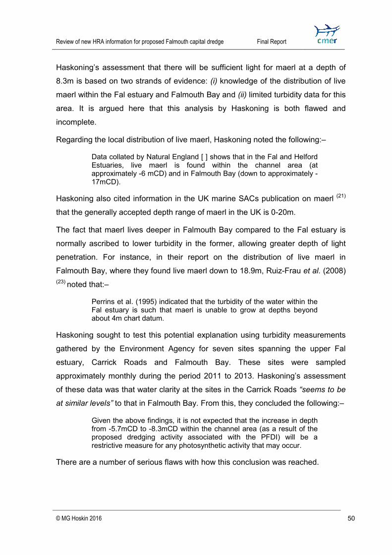
Review of new HRA information for proposed Falmouth capital dredge
Final Report
© MG Hoskin 2016 50
Haskoning’s assessment that there will be sufficient light for maerl at a depth of 8.3m is based on two strands of evidence: (i) knowledge of the distribution of live maerl within the Fal estuary and Falmouth Bay and (ii) limited turbidity data for this area. It is argued here that this analysis by Haskoning is both flawed and incomplete. Regarding the local distribution of live maerl, Haskoning noted the following:–
Data collated by Natural England [ ] shows that in the Fal and Helford Estuaries, live maerl is found within the channel area (at approximately -6 mCD) and in Falmouth Bay (down to approximately -17mCD).
Haskoning also cited information in the UK marine SACs publication on maerl (21) that the generally accepted depth range of maerl in the UK is 0-20m. The fact that maerl lives deeper in Falmouth Bay compared to the Fal estuary is normally ascribed to lower turbidity in the former, allowing greater depth of light penetration. For instance, in their report on the distribution of live maerl in Falmouth Bay, where they found live maerl down to 18.9m, Ruiz-Frau et al. (2008) (23) noted that:–
Perrins et al. (1995) indicated that the turbidity of the water within the Fal estuary is such that maerl is unable to grow at depths beyond about 4m chart datum. Haskoning sought to test this potential explanation using turbidity measurements gathered by the Environment Agency for seven sites spanning the upper Fal estuary, Carrick Roads and Falmouth Bay. These sites were sampled approximately monthly during the period 2011 to 2013. Haskoning’s assessment of these data was that water clarity at the sites in the Carrick Roads “seems to be at similar levels” to that in Falmouth Bay. From this, they concluded the following:–
Given the above findings, it is not expected that the increase in depth from -5.7mCD to -8.3mCD within the channel area (as a result of the proposed dredging activity associated with the PFDI) will be a restrictive measure for any photosynthetic activity that may occur.
There are a number of serious flaws with how this conclusion was reached.
Review of new HRA information for proposed Falmouth capital dredge
Final Report
© MG Hoskin 2016 51
First; the fact that NE only have records of live maerl down to 6m CD in the Carrick Roads might have seemed an obvious reason for doubting that it could live at 8.3m CD in this area, but this elicited no comment from Haskoning. Second; Haskoning’s conclusion that turbidity “seems” similar in Carrick Roads and Falmouth Bay did not appear to be based on any objective statistical analysis. Haskoning mentioned a “comparison” of the different sites in an attached appendix, but this was simply a series of graphs plotting the temporal trend in turbidity for each site. Hence, it would seem that their comparison was simply a subjective visual comparison of the different graphs. Moreover, when one plots mean turbidity values for the seven sites on a single graph (Figure 6), one could equally well observe that mean turbidity for both Carrick Roads sites close to the proposed dredge (Mid-channel and Penryn/Falmouth) is perceptibly greater than at any of the four sites in Falmouth Bay (Black Rock Buoy, Maenporth, Nare Point and Porthoustock. Figure 6. Average turbidity at seven sites in the Fal estuary, Carrick Roads and Falmouth Bay based on data extracted from graphs provided by Haskoning in their 2016 report. The original data, which were not available here, were produced by the Environment Agency.
EA sampling site in Falmouth area
0.02.04.06.08.0
10.012.014.016.0
Mean
turbi
dity(
95%
CI)(Fo
rmazi
n Turb
idity
Units
)
River Fal-Tolverne Carrick Roads-Mid-channel Carrick Roads-Penryn/FalmouthCarrick Roads-BlackRockBuoy
Fal Bay-off Maenporth Fal Bay-off Nare Point Fal Bay-off Porthoustock
Average turbidity for the period 2011-13

Review of new HRA information for proposed Falmouth capital dredge
Final Report
© MG Hoskin 2016 52
Indeed, the mean ( 95% confidence interval) for Carrick Road sites (3.4 FTU 0.4) is 37% higher than that for the Falmouth Bay sites (2.5 FTU 0.3). Third; having concluded (however questionably) that there was no biologically significant difference in turbidity between Carrick Roads and Falmouth Bay, Haskoning failed to suggest any alternate explanation for the initial observation that maerl lives deeper in Falmouth Bay than in Carrick Roads. Despite the obvious utility of knowing the effect of a 3m increase in depth on maerl and maerl habitats when deciding consent, neither the proponents nor NE appear to have sought to obtain this information directly. This was one of the key weaknesses of the proponents’ mitigation trial (16). While a manipulative experiment would provide the strongest evidence, valuable information could also be obtained by (i) determining the maximum depth at which maerl lives in the immediate vicinity of the proposed dredge and (ii) assessing any variations in the appearance of living maerl and maerl habitats with increasing depth. Initial investigations of these issues have, however, been done by the Marine Conservation Society (MCS) and Seasearch (35). The shoulder slopes of the main estuary channel, which shelve steeply from the tops of the banks at around 4-7m CD, down to ~30m CD, provide an opportunity to assess the biological depth limit of live maerl in the Carrick Roads and habitat trends with increasing depth. In May 2014, MCS and Seasearch did two dives for this purpose on the banks of the main channel, immediately adjacent to the approach channel to the docks – one on the eastern (St Mawes) bank and one on the western bank. They found live maerl down to 11.9m CD on the east bank and ~10m CD on the west bank. Critically, however, they observed significant depth-related changes in both the appearance of live maerl nodules and the subjacent habitat. The deepest depth at which maerl was observed to form dense accumulations of interlocking nodules was ~6.5m CD. Below this, its prevalence diminished markedly and there were increasing amounts of dead maerl 35 Solandt J-L, Wood C (2014). Depth distribution of maerl in the Carrick Roads. Unpublished report.

Review of new HRA information for proposed Falmouth capital dredge
Final Report
© MG Hoskin 2016 53
and silty sand. Parallel with these trends, individual nodules became smaller, thinner-branched and paler in colour (tending towards pinky orange), indicating less optimum conditions for growth and survival. These observations suggest that while maerl may continue to live at a depth of 8.3m CD in the dredged approach channel, it would be unlikely to thrive and form dense aggregations (which it could potentially at the current depth). They also suggest that there are likely to be significant changes in assemblage composition, due to the loss of maerl as a component of the habitat and increasing amounts of fine sediment. Thus, even if live maerl did not disappear entirely from the dredged area, there would likely be significant ecological changes that would conflict with conservation objectives for maerl attributes. The MCS/Seasearch observation that maerl habitats become increasingly silty with increasing depth in the Carrick Roads highlights the inadequacy of Haskoning assessing the impact of changed topography only in terms of light penetration through the water column. If living maerl had to cope with increased settlement of silt in a deepened approach channel, then even if there were zero effect on light penetration through the water column, one would still expect reduced photosynthesis. Modeling work by HR Wallingford predicts that dredging will result in a reduction in tidal flows through the approach channel of between 0.02-0.05m/s, which will cause a corresponding increase in silt deposition (estimated at 610m3 per annum by HR Wallingford). Since wave energy at the seabed also decreases with depth (for a given wave height), one would also predict that dredging would result in reduced clearance of settled silt. On their own these changes in hydrodynamic energy might cause only a small increase in the siltiness of the seabed, but in combination with the effect of increased depth on light penetration, there is the potential for a significant adverse effect on maerl photosynthesis (as the MCS/Seasearch observation of increasingly small, thin-branched and pale nodules from ~6.5m to ~12m CD appears to bear out) . The strength of the topography attribute under the old scheme of conservation objectives was that it prompted proper evaluation of such interactive effects. By

Review of new HRA information for proposed Falmouth capital dredge
Final Report
© MG Hoskin 2016 54
doing so, the topography attribute reflected expert conservation advice for maerl (21); viz:–
The most significant environmental factors affecting the distribution of maerl are currents; the interactive effects of depth and water quality; and wave action. Correspondingly, the fact that the topography attribute has now been replaced by separate attributes for energy and light conditions lessens the likelihood that their interactive effects on maerl will be properly assessed.
1.6.1 Key points summary 1. Haskoning assert that live maerl will eventually recolonise the bottom of the
deepened channel after dredging, but it is uncertain that the new environmental conditions there will be as conducive to its wellbeing as they are presently.
2. Concern in this regard was overlooked in the previous failed HRA as a consequence of omitting to assess LSE on the ‘topography’ attribute of the subtidal sandbanks feature.
3. In apparent consequence of this oversight, but with no admission of culpability for it, NE have now asked Haskoning to assess this attribute for the new HRA.
4. The ‘topography’ attribute was predicated on the effect of depth on “the energy conditions and stability of the sediment”, but Haskoning took the view that light availability for photosynthesis by maerl was the only critical factor.
5. It is generally known that live maerl occurs much deeper in Falmouth Bay than in the Carrick Roads. Haskoning cited 6m CD in the former and 17m CD in the latter. It has been hypothesized that this is due to lower water turbidity leading to greater depth of light penetration in Falmouth Bay.
6. Haskoning sought to test this hypothesis using turbidity data collected approximately monthly by the Environment Agency during 2011 to 2013.

Review of new HRA information for proposed Falmouth capital dredge
Final Report
© MG Hoskin 2016 55
Data were obtained from several relevant sites locally. There appeared to be no statistical test of the data by Haskoning, only subjective, visual comparison of the plotted time-series.
7. Haskoning assessed that water clarity in Carrick Roads “seems to be at similar levels” to that in Falmouth Bay. Notwithstanding the original observation of different depth limits in these areas, they concluded that a dredged depth of 8.3m CD would not restrict light for photosynthesis by maerl.
8. Based on this alone, Haskoning concluded that the change in topography due to the dredge would have no impact on the viability of live maerl.
9. A more objective analysis of the EA’s turbidity data contradicts Haskoning’s conclusion. It showed that turbidity in Carrick Roads was in fact 37% greater than that in Falmouth Bay, which is potentially biologically significant.
10. By assessing changed topography in terms of its effect on light penetration only, Haskoning overlooked its other potential impacts on current speeds, wave energy and sediment deposition at the seabed, and the potential impact on maerl of interaction among these factors.
11. The re-analysed turbidity data combined with modeling of waves, currents and sediment deposition for the 2009 EIA point to an altered environment for maerl that is likely to impact both its viability and the composition of the associated species assemblage.
12. Despite its obvious utility, neither the proponents nor NE have sought to directly assess the effect of increasing depth on maerl and maerl communities via comparisons among samples from different depths in the vicinity of the proposed dredge.
13. MCS and Seasearch have done two dives in this area for precisely this purpose. They found live maerl down to 11.9m CD, but observed that it
Review of new HRA information for proposed Falmouth capital dredge
Final Report
© MG Hoskin 2016 56
only formed dense accumulations of interlocking nodules down to ~6.5m CD.
14. Below 6.5m CD, live maerl became sparser, nodules were smaller, thinner-branched and paler in colour and the habitat comprised increasing amounts of dead maerl and silt.
15. Conclusion 1: The attribute ‘topography’ – be it of ‘subtidal sandbanks’ or ‘large shallow inlets and bays’ – is important. It should have been included in the previous HRA and must be included now.
16. Conclusion 2: Haskoning have not comprehensively assessed the impacts of altered topography on maerl and the limited assessment they did make is highly questionable.
17. Conclusion 3: the new HRA is potentially open to challenge for failing to appropriately assess the effect of altered topography on live maerl habitats within the proposed channel.
1.7 Problems extrapolating from small-scale mitigation trial to full-scale dredge One significant strand of evidence in favour of the dredging is the finding from the University of Plymouth’s mitigation trial that the number and abundance of benthic infauna had recovered 44 weeks after the initial disturbance (16). What is uncertain, however, is the extent to which this finding is a reliable predictor of recovery of infauna following the full dredge. There are three main reasons for doubting that this outcome would be replicated in the full dredge.
i. The much greater scale of the full dredge relative to the trial. ii. The fact that the trial was unable to assess the effect of post-mitigation
disturbance due to ongoing dredging in adjacent areas.

Review of new HRA information for proposed Falmouth capital dredge
Final Report
© MG Hoskin 2016 57
iii. The fact that the trial was unable to assess the effect of the seabed being lowered by 3m.
There is a further issue with the trial about extrapolating from one scale to another, but this concerns the sizes of organisms sampled in the trial versus those actually present in the proposed dredge area. Each of these four issues is discussed in more detail below.
1.7.1 The issue of scale The experimental plots in the mitigation trial were 5m x 15m (i.e. 75m2). The full dredge would cover an area of 33 hectres or 330,000m2. This vast difference in area has potentially important implications for recovery if it relies to any appreciable extent on migration of new colonists inwards from the edges. This is because the ratio of edge to area diminishes with increasing area. If the different areas were square, the ratio of edge to area for trial plots would be 0.462, whereas for the full dredge area it would be only 0.007. This problem of extrapolation to a larger area was highlighted by the Independent Science Advisory Panel (ISAP) set up by the MMO to help design the mitigation trial and review its results. In their report after the trial’s results were in, they wrote:–
...we caution that the results of this experimental study should not be applied uncritically to a much larger dredge area. Whilst recovery of infaunal communities in the re-laid deposits was relatively rapid (under 44 weeks) when small areas of deposit were removed and re-laid, evidence from other types of deposits elsewhere suggests that recolonisation may be considerably slower when large areas are defaunated.
Haskoning consider that scale-dependent edge effects are unlikely to have any appreciable influence on the rate of recovery in the full dredge. This was based entirely on the assertion that most of the macrofaunal species involved have planktonic larval development and will therefore colonise across the general area of the dredge, rather than inward from the edges. They wrote:–
Review of new HRA information for proposed Falmouth capital dredge
Final Report
© MG Hoskin 2016 58
...many species within the maerl habitat disperse through larval movement. Species that reproduce through larval mechanisms are likely to have a high recolonisation potential as larval forms will drift in the currents and settle widely throughout the estuaries following spawning activity each year. Most benthic macrofaunal populations, except those in the high arctic and deep sea, have high fecundities and a planktonic larval phase to maximise dispersal (Kennish, 2000).
The source for the assertion that most of the macrofaunal species concerned have high fecundity and planktonic larval dispersal is a single, very general marine science text by Kennish (2000)(36). Haskoning provided no information on any of the actual species found in the maerl habitat in the Fal. This drew the following comments from NE in their discretionary advice regarding Haskoning’s report (5).
Much of the reproduction information currently presented in this section is generic but it is advised that it provides evidence that links those species found in the channel with evidence to support the relatively quick recolonisation that the trial demonstrates. This is especially important due to comments made by the ISAP about scaling up from the trial to the total dredge area.
Unsurprisingly, given the source on which Haskoning relied, the information was very simplistic and thus misleading. While it is true that most macrofaunal invertebrates in UK waters have high fecundity and planktonic larval dispersal, there is still a very substantial proportion that do not. The information provided by Haskoning implies that alternative modes of development are an unusual adaptation to extreme depth or cold. This is very far from the case. There is tendency for these alternative modes to become more prevalent with increasing depth and latitude, but species exhibiting low fecundity and non planktonic larval life histories can be found at all latitudes and depths. For instance, the scientist who first proposed that planktonic larval development declines with increasing latitude – Gunnar Thorson – recorded that, in the South West of England, the percentage of plankontically developing prosobranch gastropods (a large group encompassing most sea snails) was 68.1%(37). Hence, 31.7% of such species in this region do not have planktonic development. Three well-known examples of direct developing marine snails in UK waters are the flat periwinkle Littorina 36 Kennish MJ(2000). Practical handbook of Marine Science, Third Edition 37 Thorson G (195). Reproductive ecology of marine bottom invertebrates. Biological Review 25(1): 1-45.
Review of new HRA information for proposed Falmouth capital dredge
Final Report
© MG Hoskin 2016 59
obtusata (38), the dog whelk Nucella lapillus (39) and the common whelk Buccinium undatum (40). The first two are intertidal and so do not occur in the dredge area, but B. undatum is common there (pers. obs.). Even in latitudes far south of the UK, the proportion of prosobranchs with pelagic development, while generally greater, is still highly variable (typically 70-91%) and nowhere do they all have this life history (37). Subsequent work by other scientists has shown that many other taxa exhibit the same latitudinal trend in developmental mode seen in prosobranch gastropods, and, likewise, many regional exceptions to this rule (41). Since Thorson’s first proposed his latitudinal rule, it has become apparent that there are many factors other than latitude that influence fecundity and developmental mode in marine invertebrates. These are often very narrow habitat-related risks and benefits. This is why it is not unusual to find contrasting modes of larval development among closely-related species living within the same broad habitat. Littorinind gastropods are a good example. When specific habitats provide predictably favourable conditions and/or are widely-spaced or otherwise difficult to access, there can be strong selection pressures to dispense with planktonic development in order to restrict dispersal and promote localised adaptation (42,43). Adult body size is another important factor known to influence fecundity and larval mode in benthic marine invertebrates. There is a strong tendency for species with small adult body size to produce a small number of brooded offspring that emerge at an advanced developmental stage, without entering the plankton. The interstitial fauna of soft sediments (the meiofauna) are well known for being brooders more often than their larger relatives (44). A widely-accepted explanation is that small 38 Johanesson K (2003). Evolution in Littorina: ecology matters. Journal of Sea Research 49:107– 117. 39 Tyler-Walters H (2007). Nucella lapillus Dog whelk. In Tyler-Walters H. and Hiscock K. (eds) Marine Life Information Network: Biology and Sensitivity Key Information Reviews. Published online at: http://www.marlin.ac.uk/species/detail/1501 40 FAO (2016). Species Fact Sheets: Buccinum undatum (Linnaeus, 1758) Published online at: http://www.fao.org/fishery/species/2659/en 41 Mileikovsky SA (1971). Types of larval development in marine bottom invertebrates, their distribution and ecological significance: a re-evaluation. Marine Biology 10: 193. 42 Strathman RR (1982). Selection for retention or export of larvae in estuaries. In: Estuarine comparisons (VS Kennedy, Ed.). Academic Presss, New York. 43 Obreski S (1979). Larval colonising strategies in marine benthic invertebrates. Marine Ecology Progress Series 1:293-300. 44Strathmann RR, Strathmann M (1982). The relationship between adult size and brooding in marine invertebrates. The American Naturalist 119(1): 91-101.
Review of new HRA information for proposed Falmouth capital dredge
Final Report
© MG Hoskin 2016 60
invertebrates cannot put sufficient resources into egg numbers to offset mortality in the plankton. Asexual reproduction, which is also common among marine invertebrates, is also often associated with the production of small numbers of relatively large larvae that do not develop and disperse in the plankton (41). For the above reasons it is plainly insufficient for Haskoning to rely on such a crude generalisation about the life histories of species inhabiting the dredge area. There are likely to be many that have non-planktonic larval development that will only recolonise the area in small numbers via the edges. Recovery of such species across the entire dredge area is likely to take much longer than the 44 weeks indicated by the small scale mitigation trial. Finally in relation to scale, it is important to note that the area that would be disturbed by dredging would be substantially larger than the area actually dredged. This is because of the turbidity plume created by dredging, which will reduce light availability and increase sediment smothering in peripheral areas. If edge effects are important in recovery, this will further increase recovery time.
1.7.2 The issue of ongoing disturbance In the small-scale mitigation trial, the only disturbance experienced by maerl habitat was that associated with it being dredged, temporarily stored and then re-layed, which took less than 24 hours. Once re-layed, the maerl habitat recovered under normal ambient conditions for the area. The full dredge is predicted to take between 6 to 12 months to complete (15). Thus, if the mitigation areas (totaling 2.7 ha) are worked upon first, they will experience varying degrees of disturbance more-or-less continuously for the next 6-12 months due to dredging in the surrounding area. Alternately, if these areas are worked upon last, the habitat they contain will have been heavily disturbed prior to dredging and re-laying. In either scenario, recovery in these areas is likely to take much longer than indicated by the small-scale trial.

Review of new HRA information for proposed Falmouth capital dredge
Final Report
© MG Hoskin 2016 61
A related concern is whether the care and precision that was evidently exercised during the mitigation trial could be replicated in the full-scale dredge. The mitigation trial was done over only 3 days, under close surveillance from University of Plymouth scientists and MMO officers. This included monitoring dissolved oxygen in the temporarily-store maerl matrix and live observation of seabed operations via a video-link to cameras attached to SCUBA divers. It seems highly unlikely that this could be replicated in the full-scale dredge, in which case there would be considerable commercial pressure to proceed as quickly and cheaply as possible. Without such supervision, however, it would be imprecautious to assume that the dredging contractors would work as carefully as they did in the mitigation trial. The risk is that, without close supervision, disturbance of the maerl matrix would be greater than it was in the small-scale trial, which would extend the time-scale of recovery.
1.7.3 The issue of depth As discussed previously in relation to maerl (Section 1.6), after dredging the seabed will be up to 3m deeper than it is currently, with correspondingly less light reaching it. Hydrodynamic modeling by HR Wallingford indicates that, as a consequence of dredging, the seabed will also experience slightly weaker tidal flows and slightly more sediment deposition. These are all factors that influence the composition of benthic assemblages. Thus, it is unlikely that the benthos inhabiting re-layed maerl habitat will ever return to its pre-dredge composition. One way of assessing the potential for such changes prior to the dredge would be to compare maerl assemblages at different depths in the vicinity. This has not been done thus far. Hence, the proponents should now be required to undertake such a study to inform the new HRA. If the findings indicated that significant changes in assemblage composition were likely, this would conflict with the new conservation objective of restoring the ‘species composition of component communities’ of maerl beds (Table 4).

Review of new HRA information for proposed Falmouth capital dredge
Final Report
© MG Hoskin 2016 62
1.7.4 Sizes of organisms studied versus actually present The organisms that were the subject of investigation in the mitigation trial were the macro-infauna (i.e. organisms retained on a 0.5mm sieve mesh), as sampled from sediment cores 10 cm diameter x 25 cm deep. The prediction that the diversity and abundance of fauna of the channel will recover within 44 weeks of the full dredge is based entirely on results for these organisms. This assumes that the macro-infauna are representative of all fauna inhabiting this area. For various reasons to do with life history and ecology, this cannot be taken as a given. The need to have as faunistically-comprehensive an investigation as possible was recognised by independent advisors on the trial. It was initially intended that the University of Plymouth scientists should also investigate the benthic epifauna. To this end, they also sampled 50cm x 50cm photo-quadrats of the seabed, but too few individuals were observed for meaningful statistical analysis. As such, it remains unknown how the epifauna would respond to the planned mitigation scheme. It could be argued that if there were too few epifauna to be analysed in the trial, there are too few to be concerned about in relation to the dredge. As someone who has considerable direct knowledge of the proposed dredge area, I would respond by saying that the trial must have been conducted in an especially impoverished area to have contained so few epifauna. This is further evidenced by the extremely small count of live maerl fragments in the ‘live maerl’ treatment in the trial (only 4.41 live fragments/m2). Having spent many tens of hours diving in this area, I can say with confidence that it contains large areas – particularly on the southern edge – where there is much more live maerl and prolific and diverse epifauna. Thus, as well as failing to investigate recovery in the epifauna, it can also be argued that the trial failed to assess recovery in the most biodiverse areas of the channel. Had both been done, they may have reached a different conclusion about the effectiveness of the planned mitigation. While it had at least been intended that the epifauna should have been studied, the University of Plymouth had no such plan for the meiofuana. The response of

Review of new HRA information for proposed Falmouth capital dredge
Final Report
© MG Hoskin 2016 63
this important component of the biota to the planned mitigation remains completely unknown. Given that the mitigation trial caused significant and persistent loss of fine sediment from within the maerl matrix, it is likely that the meiofauna were much more impacted than the macrofauna. Another reason why the meifauna should arguably have been studied in the trial is that it is likely to have contained many more species without a dispersive larval stage than the macrofauna. As explained above (Section 1.7.1), larval life history is highly relevant to the means and rate of population recovery following disturbance.
1.7.5 Key points summary 1. The small-scale mitigation trial by the University of Plymouth indicated
recovery of the diversity and abundance of the macro-infauna of maerl habitats after 44 weeks.
2. It is uncertain to what extent these findings can be applied to the full-scale dredge and the full range of fauna inhabiting the area.
3. Results from the trial may not be applicable at full-scale if recovery relies to appreciable extent on migration of new colonists inwards from the edges. This is because perimeter is inversely proportional to area.
4. Haskoning have argued that increasing scale would not impact recovery because the vast majority of macro-infauna have planktonic larval development, and would thus settle from the water column, generally throughout the dredged area, rather than colonising benthically from the edges inwards.
5. A more scholarly appraisal of the larval life histories of the macro-infauna indicates the likelihood of a significant proportion having non-planktonic larval development and restricted dispersal. Recovery of these would be expected to be more scale-dependent.
6. Doubts about the applicability of the trial’s results to the full-scale dredge also arise from its failure to replicate (i) the impact of ongoing disturbance

Review of new HRA information for proposed Falmouth capital dredge
Final Report
© MG Hoskin 2016 64
due to dredging in surrounding areas; and (ii) the impact of the seabed being lower by ~3m, post-dredge.
7. In terms of applicability of the trial’s results to other fauna, doubts arise in relation (i) to the epifauna, which the trial had intended, but ultimately failed, to investigate and (ii) the meiofauna, which were not intended subjects of investigation, but which are significant given their relatively greater propensity to have non-planktonic larvae with restricted dispersal.
8. Based on data on the abundance of live maerl in trial plots, it appears that the trial was conducted in a relatively biologically-impoverished part of the channel and thus its results may not be indicative of recovery in areas with greater biodiversity.
9. Conclusion: Reliance on the results of the small-scale mitigation trial would leave the new HRA open to challenge for having failed to appropriately assess the biological nature, extent and time-scale of ecological recovery from the full-scale dredge.
1.8 What will be the need for ongoing maintenance dredging? There is much uncertainty regarding the need for ongoing maintenance dredging after the proposed capital dredge. If it is needed, then the maerl habitats that re-establish in the approach channel will be subject to regular, severe ongoing impacts. If as argued previously (Section 1.4), the maerl habitats in the channel are in the very early stages of a multi-decadal process of recovery from historical dredging – most recently in the form of industrial maerl extraction (until 2005) – then regular maintenance dredging would ensure that this process never fully completes. This would be contrary to several conservation objectives requiring restoration of maerl beds in the Fal & Helford SAC. The present position of the dredging proponents, as stated by Haskoning (in Section 2.3.3 of their report for the HRA), is that “no additional maintenance

Review of new HRA information for proposed Falmouth capital dredge
Final Report
© MG Hoskin 2016 65
dredging would be required as a result of the capital dredging proposed”. This is despite predictions by HR Wallingford of between 2,500 to 5,500 m3 of sand per annum accumulating in the channel, plus an additional 610m3 of silt deposition per annum. It is unclear whether this claim is bona fide, or simply an expedient to allay environmental concerns about ongoing ecological disturbance of the seabed. The reason for doubt is that one of the strongest public justifications for the capital dredge has been the proponents’ claim that parts of the approach channel have silted up dramatically in recent decades. For instance, in the 2009 Environmental Statement for the previous licence application (45), Haskoning wrote (at Section 3.2):–
The do nothing option would involve a gradual reduction in port and docks activities at Falmouth, with the cruise industry choosing to use other ports and the gradual silting up of the existing channel meaning that the larger ships currently coming in for repair would find it more difficult to do so.
More recently, the 2011 Port of Falmouth Masterplan, written by the consultants Tibbalds for a partnership of clients including FHC and A&P Falmouth Ltd., included this more-alarming prediction (at Section 2.7.10) (46).
The existing channel depth is continuing to decrease. There is conflicting information on this. The Environmental Impact Assessment (EIA) for the dredging application states that the depth is decreasing in places by 30mm per annum. However, Falmouth Petroleum Ltd note that the charts show a minimum ‘declared’ channel depth of 6.1m in 1987 and 5.1m in 2002 – i.e. a reduction of 1m in 15 years (or an average of 66mm per annum).
If it is true that parts of the channel are currently silting up at a rate of 30-66mm per annum, then it is not unreasonable to expect that it would continue to do so after the capital dredge and that some maintenance dredging would be required.
45 Royal Haskoning (2009). Falmouth Cruise Project Environmental Statement. Published online at: https://www.falmouthharbour.co.uk/wp/wp-content/uploads/50-R011-01-Falmouth-Cruise-Project-Environmental-Statement.pdf 46 Tibbalds Planning & Urban Design (2011). Port of Falmouth Masterplan. Available online at: http://www.safechildren-cios.co.uk/media/3629890/5284-Falmouth-Masterplan.pdf

Review of new HRA information for proposed Falmouth capital dredge
Final Report
© MG Hoskin 2016 66
1.8.1 Key points summary 1. Any requirement for maintenance dredging to keep the declared depth at
8.3m CD would expose maerl habitats within and adjacent to the channel to severe ongoing disturbance that would prevent full recovery, which is believed to take decades.
2. Haskoning assert that no additional maintenance dredging would be required, but other information suggests that this may not be true.
3. Modelling by HR Wallingford indicates that the channel would accumulate 2,500 to 5,500 m3 of sand, plus an additional 610m3 of silt per annum.
4. Elsewhere, the claim that the channel is ‘silting up’ has been one of the proponents’ strongest justifications for the dredging, which would suggest a need for ongoing maintenance dredging.
5. The Port of Falmouth Masterplan asserts that in recent years the channel has reduced in depth due to ‘silting up’ at a rate of 30 to 66mm per annum.
6. Conclusion: the new HRA would be open to challenge if it were to proceed on the assumption that there was negligible likelihood of any need for ongoing maintenance dredging.
1.9 Is the ECJ Sweetman ruling relevant to the proposed Falmouth dredge? An important judicial ruling with potential implications for the proposed Falmouth dredging is that of the European Court of Justice (ECJ) on 11 April 2013 in the so-called Sweetman case (Case C-258/11) (47). This concerned the 2008 decision by An Bord Pleanála (the Irish Planning Board) to grant development consent for the N6 Galway City Outer Bypass road scheme. 47 European Court Of Justice (2013). Judgment of the Court (Third Chamber) 11 April 2013 in Case C-258/11 Peter Sweetman, Ireland, Attorney General, Minister for the Environment, Heritage and Local Government v An Bord Pleanála, notice parties: Galway County Council, Galway City Council. Published online at: http://curia.europa.eu/juris/document/document.jsf?text=&docid=136145&pageIndex=0&doclang=EN&mode=req&dir=&occ=first&part=1&cid=659424

Review of new HRA information for proposed Falmouth capital dredge
Final Report
© MG Hoskin 2016 67
Part of the proposed road was planned to cross the Lough Corrib Site of Community Importance (SCI). The specific protected habitat forming the subject-matter of the main proceedings was karstic limestone pavement, a ‘priority habitat’ under Annex 1 of the Habitats Directive. A priority habitat is one that is not only in danger of disappearing, but also has most of its distribution within the EU, giving it heightened responsibility for ensuring its conservation (i.e. Article 1(d)). Construction of the bypass would have resulted in the “permanent and irreparable loss” of 1.47 hectares of this habitat, out of a total of 270 hectares within the site (i.e. only 0.54%). It is the issue of ‘permanent and irreparable loss’ that makes this case particularly relevant to the proposed Falmouth dredging. Regarding this, the critical question that the ECJ was asked to rule upon was this:–
18-2. Does the application of the precautionary principle have as its consequence that such a plan or project cannot be authorised if it would result in the permanent non-renewable loss of the whole or any part of the habitat in question?
The ECJ ruled that the answer was effectively ‘yes’; or more fully:– 48. [ ] if, after an HRA of a plan or project’s implications for a site, carried out on the basis of the first sentence of Article 6(3) of the Habitats Directive, the competent national authority concludes that that plan or project will lead to the lasting and irreparable loss of the whole or part of a priority natural habitat type whose conservation was the objective that justified the designation of the site concerned as an SCI, the view should be taken that such a plan or project will adversely affect the integrity of that site.
Their conclusive ruling was as follow:– Article 6(3) of Council Directive 92/43/EEC of 21 May 1992 on the conservation of natural habitats and of wild fauna and flora must be interpreted as meaning that a plan or project not directly connected with or necessary to the management of a site will adversely affect the integrity of that site if it is liable to prevent the lasting preservation of the constitutive characteristics of the site that are connected to the presence of a priority natural habitat whose conservation was the objective justifying the designation of the site in the list of sites of Community importance, in accordance with the directive. The precautionary principle should be applied for the purposes of that appraisal.

Review of new HRA information for proposed Falmouth capital dredge
Final Report
© MG Hoskin 2016 68
This ruling is relevant to the Falmouth dredging because it would result in the permanent and irreparable loss of a significant volume of maerl – the ‘constituent characteristic’ of the maerl bed sub-feature of the Fal & Helford SAC – contrary to conservation objectives for this habitat (i.e. for population abundance). The case that maerl is considered to be effectively non-renewable is based on the following four statements of expert opinion:–
i. The biological equilibrium is precarious - effectively, maerl extraction is the exploitation of a non-renewable resource as the slow rate of growth implies a slow rate of accumulation.” – (Birkett et al. 1998) (21)
ii. “Due to the very slow rate of growth, maërl is considered to be a non-renewable resource” – OSPAR Commission (2010) (48) and JNCC (2007) (49).
iii. “Maerl beds are very slow to develop and are unlikely to return if removed or lost. As such, they should be treated as a non-renewable resource.” – JNCC (2015) (50).
As mentioned previously, the critical conservation objective for assessing the volume loss of maerl due to the Falmouth dredge is that of restoring the ‘population abundance’ of maerl – one of the eight ‘structural’ attributes of maerl beds. The supporting explanatory notes for this attribute read as follow:–
The abundance is the total volume of live and dead maerl across the site. Maintaining the abundance of maerl within the site is necessary due to the global pressures of habitat destruction (eg from dredging, damaging fishing practices and pollution) and the spread of invasive species (Grall and Hall-Spencer, 2003). Loss of maerl abundance adversely affects the survival of this habitat. A reduction in live thalli (maerl pieces) reduces the rate of vegetative reproduction and impairs the chances of sexual and sporangial reproduction. Dead maerl is equally important (Hall- Spencer, 1998) as the accumulation locks away carbon within the seabed and
48 OSPAR Commission (2010).Biodiversity Series: Background Document for Maërl beds. Published online at: http://www.ospar.org/documents?v=7221 49 JNCC (2007). Second Report by the UK under Article 17 on the implementation of the Habitats Directive from January 2001 to December 2006.Published online at: http://jncc.defra.gov.uk/pdf/Article17/FCS2007-S1376-audit-Final.pdf 50 JNCC (2015). Maerl beds. Published online at: http://jncc.defra.gov.uk/page-6023

Review of new HRA information for proposed Falmouth capital dredge
Final Report
© MG Hoskin 2016 69
generates productive habitats with a wide range of ecological niches for associated species (Barbera et al., 2003; Martin et al., 2006; Grall et al., 2006). In some areas, the abundance of live and dead maerl has built up over thousands of years to form beds (Bosence and Wilson, 2003; Grall and Hall- Spencer, 2003). If the population size falls, then recovering the abundance of live thalli, through the removal of damaging pressures, is important in order to encourage reproduction. Natural recovery of the accumulation could take hundreds to thousands of years due to slow growth and recruitment rates (Bosence and Wilson, 2003; Grall and Hall-Spencer, 2003; Peña et al., 2014).
The two critical points here are (i) that ‘population abundance’ applies to both live and dead maerl and (ii) that natural recovery of accumulations of maerl – such as occur in the proposed dredge area – could take hundreds to thousands of years. Haskoning do not clearly state the volume of maerl that the dredge would remove from the SAC, however it can be deduced from other information in their recent report for the new HRA. Their Table 2.1 of Appendix H gives the total volumes of the different types of seabed material to be dredged. This states that 119,649m3 of pure mearl will be dredged, plus 412,510m3 of maerl mixed with either clay, mud, sand or gravel. The total volume of all materials to be dredged is 695,112m3. These volumes do not, however, account for the quantity of maerl that would be relayed on the channel bottom as part of the impact mitigation scheme. Again, Haskoning do not clearly state the volume of maerl to be re-layed, but it can be deduced from the following information (from Section 2.2.3 of their report):–
The maerl for relaying would be placed onto specific areas of the seabed within the channel that had been dredged to levels approximately 30cm deeper than required (over dredged), taking into account the maximum dredging requirement (i.e. 30cm deeper than the required -8.3CD). It is proposed that 30cm of maerl would be placed in the placement location, covering an area of approximately 1.5ha in total. [ ] Placement of maerl, using the same methodology, would also occur in an area of 1.2ha as an enhancement measure.
Hence, the total volume to be relayed in the two areas referred to is (15,000m2 + 12,000m2) x 0.3m depth = 8,100m3.

Review of new HRA information for proposed Falmouth capital dredge
Final Report
© MG Hoskin 2016 70
This would imply that the amount of maerl that would be permanently removed from the site would be 111,549m3 of pure mearl, plus a large, but unknown quantity contained within the 412,510m3 of maerl mixed with either clay, mud, sand or gravel. That only a negligible volume of maerl would be re-layed (i.e. 8,100m3) is corroborated by two other pieces of information in Haskoning’s report for the new HRA. The first is Haskoning’s statement (in their Section 2.2.1) that “the indicative volume of contaminated dredged material would be approximately 100,000m3”. Later in the same section, Haskoning said that “…all contaminated material would be taken to an approved disposal facility on land”. The second is Haskoning’s statement (in their Section 2.2.2) regarding disposal of clean material at sea: “It is anticipated that the barge would have a volume of c. 1,000m3, which would require c.600 sailings to and from the disposal site”. This implies that the total volume of material to be disposed of at sea is 600,000m3. From these two pieces of information it is clear that approximately 700,000m3 of material is to be removed from the site and disposed of in one way or another. This is very close to the total volume of dredged material stated in their Table 2.1 of Appendix H; i.e. 695,112m3. The volume of maerl to be re-layed within the site is thus so small that it does not even figure in this crude reckoning. The missing piece of information for assessing the significance of losing somewhere between 111,549 and 524,059 m3 of maerl due to the dredge is the total volume of this resource in the Fal & Helford SAC. Even if this represented only a small proportion of the total maerl resource in the SAC, in light of the Sweetman ruling, this would still constitute an adverse effect on site integrity given the following:–
i. that this would effectively be a ‘permanent and irreparable’ loss of a ‘constitutive characteristic’ of one of the key habitats for which the site was designated;

Review of new HRA information for proposed Falmouth capital dredge
Final Report
© MG Hoskin 2016 71
ii. the previous such loss from the SAC due to commercial maerl extraction between site designation in 2000 and cessation of this activity in 2005; and
iii. the consequent need for restoration of maerl abundance (live and dead) as a formal conservation objective.
It is important to state, however, that there is one aspect of the Sweetman case that allows its applicability to the Falmouth dredging case to be challenged. It is that the habitat in question in this case was a ‘priority habitat’ under Annex 1, whereas maerl is a sub-feature of a non-priority habitat in Annex 1 (i.e. Sandbanks which are slightly covered by sea water all the time). In their report for the new HRA, Haskoning address the Sweetman ruling directly and they conclude on precisely this basis that the impacts of the Falmouth dredging would not constitute an adverse effect on site integrity:–
In the Sweetman case the habitat in question was ‘priority’ Annex I habitat, whereas maerl bed is a sub-feature of a non-priority Annex I habitat (subtidal sandbanks), with the species itself being listed in Annex V of the Habitats Directive; which is for animal and plant species of community interest whose taking in the wild and exploitation may be the subject of management measures. Priority habitats are defined as those that are considered to be particularly vulnerable; it is therefore expected that Priority habitats are likely to have a greater degree of protection than non-priority habitats and sub-features of Annex I habitats. When the significance of the effect predicted in this case is considered, the above needs to be taken into account, along with the extent of the loss and other factors relating to the location of the live maerl within a navigation channel (an area expected to be subject to periodic disturbance and already present at the time of designation), the expected life span of live maerl in this area, the potential for impact on the functioning of the site and the ecological niche that the live nodules provide. Hence, in the context of the Sweetman Ruling, an AEOI is not predicted in the case of the proposed channel dredging.
While the habitat in question in Sweetman was a priority habitat, and this was mentioned repeatedly throughout the ECJ ruling, nowhere was it stated or implied that the ruling did not apply to non-priority habitats. What appeared to be critical was the issue of lasting, irreparable loss of one of the constitutive characteristics of a designated site feature. There was nothing to indicate that such an impact
Review of new HRA information for proposed Falmouth capital dredge
Final Report
© MG Hoskin 2016 72
could not and should not also constitute an adverse effect on the integrity of a non-priority habitat. This interpretation is shared by Environmental lawyers, Client Earth in their briefing on the meaning of ‘site integrity’ (51):–
The arguments in [the Sweetman] case are expressed to apply a fortiori to priority natural habitat types - and we would argue that it would also be applicable to any natural habitat covered by Annex I.
This view is backed up by a reference opinion given by Advocate General Sharpston to the ECJ to inform the court’s deliberations in Sweetman (52). The critical paragraph in his opinion was this:–
40. It is thus an essential objective of the Directive that natural habitats be maintained at and, where appropriate, restored to a favourable conservation status. Such an aim is necessary in the context – recorded in the fourth recital in the preamble to the Directive – of a continuing deterioration in those habitats and the need to take measures in order to conserve them. That is a fortiori the case as regards priority natural habitat types. ...
In other words, whereas it should generally be taken as “essential” that natural habitats should be maintained at or restored to favourable conservation status, this is more-forcefully the case (“a fortiori”) as regards priority natural habitat type. And presaging the eventual ECJ ruling in Sweetman, Sharpston was also of the view that:–
60. ...measures which involve the permanent destruction of a part of the habitat in relation to whose existence the site was designated are, in my view, destined by definition to be categorised as adverse. The conservation objectives of the site are, by virtue of that destruction, liable to be fundamentally – and irreversibly – compromised. ...
Thus, taking paragraphs 40 and 60 together, the consequence of a habitat being non-priority or priority is only that it is ‘essential’ that such effects should be avoided in the first case and more-forcefully essential in the second case. This does not seem to provide the latitude to permit the irreversible destruction of
51 Client Earth (2013). Natura 2000 and the meaning of ‘site integrity. http://www.clientearth.org/reports/natura-2000-site-integrity-briefing.pdf 52 Advocate General Sharpston (2012). Opinion of Advocate General Sharpston, delivered on 22 November 2012: Case C-258/11 Peter Sweetman, Ireland Attorney General, Minister for the Environment, Heritage and Local Government v An Bord Pleanala. Published online at: http://eur-lex.europa.eu/LexUriServ/LexUriServ.do?uri=CELEX:62011CC0258:EN:HTML

Review of new HRA information for proposed Falmouth capital dredge
Final Report
© MG Hoskin 2016 73
several 100,000m3 of maerl in the Fal & Helford SAC that Haskoning believe exists.
1.9.1 Key points summary 1. The European Court of Justice (ECJ) ruling in the Sweetman case (Case C-
258/11) appears to present a significant hurdle to consent for the proposed Falmouth dredging.
2. Broadly speaking, the ruling asserts that an adverse effect on site integrity arises from any plan or project that prevents the lasting preservation of non-renewable constitutive characteristics of a priority habitat (limestone pavement in the Sweetman case).
3. This ruling is relevant to the dredging because statutory conservation advice for maerl is that it should be treated as a non-renewable resource.
4. From information provided by Haskoning, it appears that the proposed dredging would permanently remove 111,549m3 of pure mearl, plus 412,510m3 of maerl mixed with variable amounts of clay, mud, sand and gravel.
5. This loss would be additional to the loss of a significant quantity of maerl removed from the SAC between 2000 and 2005 by commercial maerl extraction.
6. Haskoning assert that the ECJ Sweetman ruling has no relevance to the proposed dredging because neither maerl beds nor the feature they are part of (i.e. subtidal sanbanks) are a ‘priority habitat’ under the Habitats Directive.
7. While the ECJ Sweetman ruling referred repeatedly to limestone pavement being a ‘priority habitat’ under the Habitats Directive, it did not explicitly rule out any application to non-priority habitats under the Directive.
Review of new HRA information for proposed Falmouth capital dredge
Final Report
© MG Hoskin 2016 74
8. Environmental lawyers Client Earth are of the opinion that the Sweetman ruling applies to any natural habitat covered by Annex 1 of the Habitats Directive, which would include subtidal sandbanks.
9. This opinion appears to be supported by preliminary advice to the ECJ by its Advocate General, who asserted that it is never less than “essential” that Annex 1 habitats, be they priority or non-priority, are protected from plans or projects that would result in permanent destruction on part of a site.
10. Conclusion: there is a compelling argument that, given the ECJ Sweetman ruling, any new HRA for the proposed dredging must conclude that it would cause an adverse effect on the integrity of the Fal & Helford SAC.