clough wood route summary - mar 2013 - peak district · route summary report – clough wood march...
TRANSCRIPT
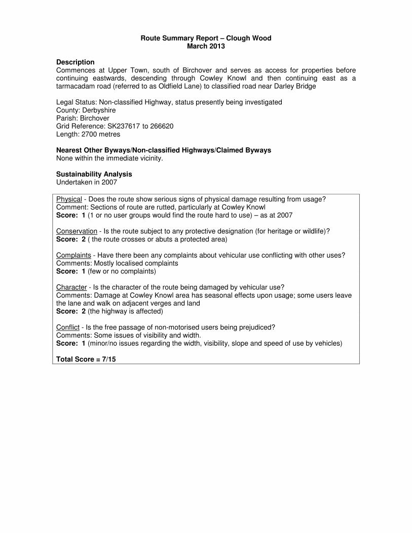
Route Summary Report – Clough Wood March 2013
Description Commences at Upper Town, south of Birchover and serves as access for properties before continuing eastwards, descending through Cowley Knowl and then continuing east as a tarmacadam road (referred to as Oldfield Lane) to classified road near Darley Bridge Legal Status: Non-classified Highway, status presently being investigated County: Derbyshire Parish: Birchover Grid Reference: SK237617 to 266620 Length: 2700 metres Nearest Other Byways/Non-classified Highways/Claimed Byways None within the immediate vicinity. Sustainability Analysis Undertaken in 2007
Physical - Does the route show serious signs of physical damage resulting from usage? Comment: Sections of route are rutted, particularly at Cowley Knowl Score: 1 (1 or no user groups would find the route hard to use) – as at 2007 Conservation - Is the route subject to any protective designation (for heritage or wildlife)? Score: 2 ( the route crosses or abuts a protected area) Complaints - Have there been any complaints about vehicular use conflicting with other uses? Comments: Mostly localised complaints Score: 1 (few or no complaints) Character - Is the character of the route being damaged by vehicular use? Comments: Damage at Cowley Knowl area has seasonal effects upon usage; some users leave the lane and walk on adjacent verges and land Score: 2 (the highway is affected) Conflict - Is the free passage of non-motorised users being prejudiced? Comments: Some issues of visibility and width. Score: 1 (minor/no issues regarding the width, visibility, slope and speed of use by vehicles) Total Score = 7/15


Levels of Vehicular Use Friday 3 August2012 - Thursday 13 September 2012 (42 days) Daily Totals Large Vehicles only Motorcycles Only Mondays 2 30 Tuesdays 4 29 Wednesdays 2 12 Thursday 2 11 Fridays 10 35 Saturdays 12 91 Sundays 24 75 Mon-Fri Total 20 117 Sat-Sun Total 36 166 Overall Total 56 282 Average Per Day 1.3 6.7
Conservation interest Ecology - An ecological survey was carried out in February 2013 (Appendix 1). The route pass through a SSSI and ancient woodland. Landscape - The route lies within Derwent Valley landscape character area - lower lying landscapes associated with the valley of the River Derwent and its tributaries. Separates the limestones of the White Peak from the prominent gritstone edges of the Eastern Moors to the east and high moorland of the Dark Peak to the North. The settled well-wooded agricultural character is characteristic of this area. Cultural heritage - The route runs through land which was enclosed at an early date and an area in which highly significant lead mining remains survive. This includes a high priority lead mining site and landscape and Old Mill close engine house complex, which is a Scheduled Monument. The route also runs through the Uppertown medieval settlement. Other significant features are sections of paved paths which are a characteristic of this area, and field barns. Peak District Local Access Forum Comments The Green Lanes Sub-group surveyed the route and met in August 2012 and February 2013. Appendix 3 sets out their individual observations. The group recommended:
• Repairs to maintain the historic features, and to steeper section
• Monitor use and illegal activity Summary of Issues
• Sections of route at Cowley Knowl become rutted, and are difficult to use in wet weather.
• Visibility is an issue at locations.
• Width issues could occur on some sections.
• Ponding has occurred on higher elevations.
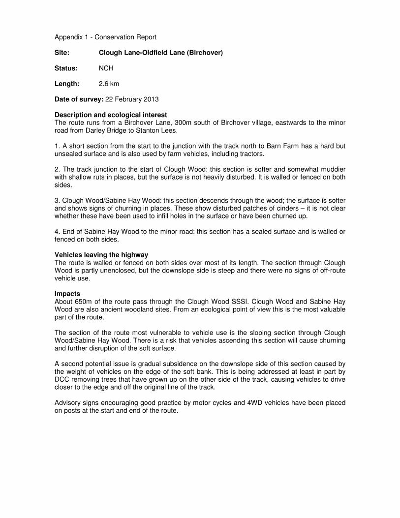
Appendix 1 - Conservation Report Site: Clough Lane-Oldfield Lane (Birchover) Status: NCH Length: 2.6 km Date of survey: 22 February 2013 Description and ecological interest The route runs from a Birchover Lane, 300m south of Birchover village, eastwards to the minor road from Darley Bridge to Stanton Lees. 1. A short section from the start to the junction with the track north to Barn Farm has a hard but unsealed surface and is also used by farm vehicles, including tractors. 2. The track junction to the start of Clough Wood: this section is softer and somewhat muddier with shallow ruts in places, but the surface is not heavily disturbed. It is walled or fenced on both sides. 3. Clough Wood/Sabine Hay Wood: this section descends through the wood; the surface is softer and shows signs of churning in places. These show disturbed patches of cinders – it is not clear whether these have been used to infill holes in the surface or have been churned up. 4. End of Sabine Hay Wood to the minor road: this section has a sealed surface and is walled or fenced on both sides. Vehicles leaving the highway The route is walled or fenced on both sides over most of its length. The section through Clough Wood is partly unenclosed, but the downslope side is steep and there were no signs of off-route vehicle use. Impacts About 650m of the route pass through the Clough Wood SSSI. Clough Wood and Sabine Hay Wood are also ancient woodland sites. From an ecological point of view this is the most valuable part of the route. The section of the route most vulnerable to vehicle use is the sloping section through Clough Wood/Sabine Hay Wood. There is a risk that vehicles ascending this section will cause churning and further disruption of the soft surface. A second potential issue is gradual subsidence on the downslope side of this section caused by the weight of vehicles on the edge of the soft bank. This is being addressed at least in part by DCC removing trees that have grown up on the other side of the track, causing vehicles to drive closer to the edge and off the original line of the track. Advisory signs encouraging good practice by motor cycles and 4WD vehicles have been placed on posts at the start and end of the route.

Appendix 2 – Cultural Heritage Report Historic Landscape Character The route runs through land which was enclosed at an early date. Narrow strip fields, which fossilise medieval open field furlongs, run to the north and south of the lane for much of its route. The more irregular field boundaries around Uppertown may be of an equally early date but there is no map evidence of the area which is earlier than 1819. Existing Historic Environment Record data, surveys and designations The route runs through an area in which highly significant lead mining remains survive. A high priority lead mining site occurs just to the east of Uppertown and to the south of the lane. At the eastern end of the route, and immediately to the south of it, is a high priority lead mining landscape in which is the Old Mill close engine house complex, which is a Scheduled Monument. A further area of lead mining remains which is recorded on the Derbyshire HER (MDR 8445) occurs immediately to the north of the lane, also in this area. In addition to lead mining interest the route also runs through the Uppertown medieval settlement (MDR 3768). Other significant features in the vicinity of the route are sections of paved paths which run between Uppertown and Birchover, and which are a characteristic of this area, and two field barns which are recorded in fields adjacent to the route. Two farm holdings which have had detailed archaeological survey, Green Farm and Ivy House Farm, are associated with the lane at its western end. General recommendations As there is no specific survey information for this route ideally a rapid walk-over survey of the actual lane should be undertaken and the condition of surviving features be noted. Particular consideration should be given to features such as gateposts, walls and wall furniture and earthworks. The results of this work would form a good basis for recording damage to any features which might have occurred already, as well as monitoring on-going damage. On the basis of the information collected recommendations for damage mitigation could be made. This could also inform the nature of any repairs to the route.

Appendix 3 - Peak District Local Access Forum Vehicle Sub-Group – Individual Comments General The lane itself has good verges which merit protection, and has the general appearance of a vehicular route, being of more or less uniform width between walls. In one sense the most problematic section is on the steepest part, but the surface is interesting. There are traces of presumably old gritstone paving stones remaining. So far as I could discern these were in a single line and did not form a double track, nor were they centrally located in the track. This might suggest they were laid for mule trains or jaggers rather than for wheeled traffic. I have no idea of the actual history of the way, but I just wonder if it was originally made for vehicular use at all. Where the slabs have not been damaged to the point of removal they have had the effect of protecting the surface beneath them, with the consequence that extensive severe rutting is generally biased more to one side of the lane than the other. In one place in particular erosion on the rutted side has extended deep into a clay layer well beneath any material that may have been used to provide a surface. It is self evident the lane is in very urgent need of repair, and I consider there to be a case for imposing a temporary TRO until such time as this can be effected to protect both the historic remains of an ancient way, and the exposed soft surface. There was evidence of trial bike transgression onto a footpath which detours a mound en route, of mountain bike use of the footpath and of extensive 4x4 abuse in an area below an old mine working in the vicinity of the point where the surfaced area, coming up from Darley Dale, finishes. This route runs due east from Birchover with good views towards Birchover and Winster and onwards by Clough Wood (to the south) and Sabine Hey Wood (to the north) to join the road by Enthoven’s works (the last section is metalled but outside the National Park). There are many footpaths which link into this route, including connections to Birchover and Winster and through adjoining woodlands. The route is clearly defined and very pleasant with good surfacing at either end and a particular steep narrower section where vehicular use seems to have caused some deep ruts and make it difficult for walkers, cyclists and horse riders. Action is needed to address this as I suspect it is deteriorating and will become unsustainable. Safety Issues Signage
• Minimal
• None observed.
• Lacking, except for paths off the route Surface and Off-site information
• None observed
• Stone surface robust at the western end, then becomes less sound some 800 metres in where ruts appear in some wetter sections. Going further to the east there is a poorly surfaced, steep and deeply rutted section. This eventually becomes a sealed surfaced lane linking the entrance to Sabbine Hey Farm down to (but with deep ruts to the southern verge), the road from Darley Bridge towards Stanton Lees.
Conflicts of different use
• Route is narrow, deep and steep. No way to escape in some sections.
• There is potential for conflict with residents at the western, Uppertown, end. Over the years of using this lane I have never had a problem
• Seem to exist given the nature and condition of one particular section of the route through use by vehicles making it unsafe & unpleasant for users on cycles, horses or foot.
Width
• Too narrow in places to allow horse, bikes etc to get out of the way of vehicles
• About 3-4 metres between walls of hedges. Restricted on the level section alongside Clough Wood by hedges in urgent need of cutting back.
• Generally good with visibility alright with the exception of the narrow, deeply rutted narrow section referred to below.

Speed
• Steep sections make this more of a problem
• None observed
• Does not appear to be an issue Causes of Damage Degradation of surface by vehicle use making the surface unstable and subject to water damage. The present condition of the route is very poor and must be reaching the point where it will become impassable by some users. Recreational Use
• Some potholes in the level section
• This appears to be a popular walking route and there was also evidence of horse riding, neither of which seem to have caused any problems. Whilst walking the route 4 motor cycles approached from the east and they were reasonable and courteous. It would have been more difficult if they had been on the steep and badly rutted (relatively narrow section). This section has undoubtedly deteriorated through vehicular use which seems to have both 4WD and motor cycle tracks. There are several paths which link into this route. Vehicle logging which is planned will be important to gaining information on existing usage patterns.
Agricultural use / access
• None observed
• Some use by adjoining farmers (tractor on the mid section of the route), but not towards the eastern end which adjoins an industrial site where access is precluded/deterred by fencing and notices.
Natural erosion
• Some water scouring on the bend and slope about grid SK256619
• Generally not a problem save for some water getting into the most sensitive section of this route.
Solution
• Track to be repaired and warning signs are needed. If repairs cannot be carried out soon restrictions will be needed to prevent further damage.
• Repair the water scoured section (about 50 metres) on the inclined section about
• SK256619
• Improve the water run-off
• Signage
• Voluntary Restraint
• Drainage and Fill in the ruts/surface with stone the key sensitive section
• Monitor and Review
Long-term Management
• The bottom section is steep which may mean that in the long term repairs are sustainable.
• Back-fill depressions as they occur
• Keep drainage working properly
• Repairs to drainage and surface as needs be – County Council
• If problems persist, need to consider a TRO.