cloud serviceslidarmag.com/wp-content/uploads/pdf/lidarmagazine...in pls-cadd software. lidar data...
TRANSCRIPT
CLOUD SERVICES Make LiDAR Accessible to Electric Transmission Vegetation Management
BY RAFA TORRO
N orth American Electric Reliability Corporation (NERC) Reliability Standard
FAC-003-3 for transmission vegetation management went into effect In July 2014. It stipulates that lines need to be routinely inspected once a year …it does not, however, recommend the best method of inspection. Increasingly, utili-ties find that aerial manual inspection
and foot patrols are inadequate when it comes to ensuring against vegetation related threats. Many utilities turn to aerial LiDAR and imagery surveys to broaden their vegetation management program and to ensure compliance with Standard FAC-003.
Aerial LiDAR/Imaging surveys are able to rapidly identify critical clear-ances, danger and hazard vegetation
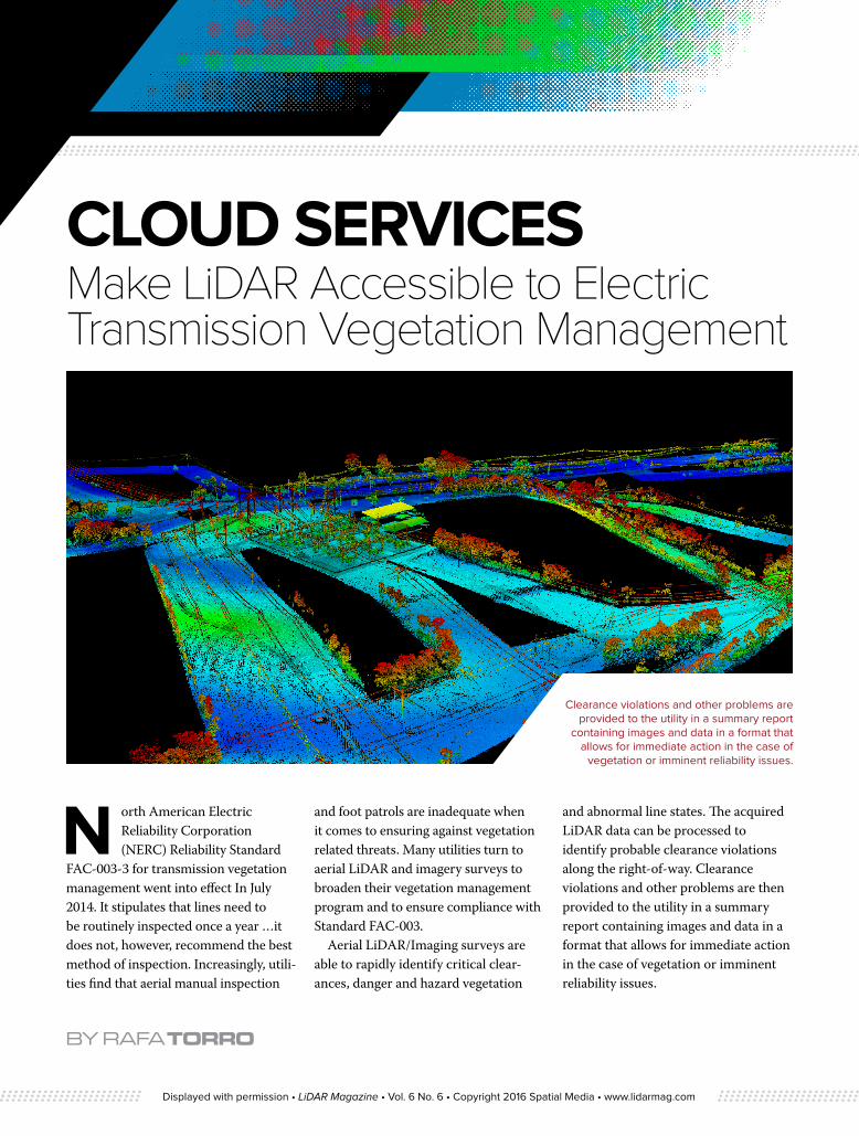
and abnormal line states. The acquired LiDAR data can be processed to identify probable clearance violations along the right-of-way. Clearance violations and other problems are then provided to the utility in a summary report containing images and data in a format that allows for immediate action in the case of vegetation or imminent reliability issues.
Clearance violations and other problems are provided to the utility in a summary report
containing images and data in a format that allows for immediate action in the case of
vegetation or imminent reliability issues.
Displayed with permission • LiDAR Magazine • Vol. 6 No. 6 • Copyright 2016 Spatial Media • www.lidarmag.com

LiDAR is able to identify vegetation clearance concerns that are not found in routine patrols flown with human observers. The accuracy of the data enables utilities to provide precise locations of vegetation requiring maintenance. The LiDAR survey looks at the entire ROW, including trees located off the ROW which may fall into the line. When utilities do aerial or foot patrols, they routinely focus only on the power lines and adjacent vegetation, while the LiDAR survey provides a complete digital 3-D survey of everything on and along the ROW.
With more than 85,000 km of power line mapping in the last four years, DIELMO3D located in Valencia, Spain is a specialized LiDAR analysis company that provides sophisticated and highly accurate products for the electricity industry. Their extensive power line experience has allowed them to develop their own processing and QA workflow to provide faster and higher quality results.
Typically, a routine aerial or foot patrol of transmission lines and vegetation provides a “snapshot in time” of what conditions are on any given day. LiDAR re-flights have the advantage of not only providing data on current conditions, but change detection algorithms in conjunc-tion with the LiDAR can be used to perform audits of completed vegetation work accomplished since the last LiDAR flight. At the end of the day, LiDAR gives utilities a better sense of being in compli-ance than they were able to achieve with human observation alone.
High density LiDAR data provides a very accurate 3D model of the existing conditions. Dielmo’s custom software enables the incorporation of exacting client specifications that can vary by
span length or along the span to detect offending vegetation. The software is 100% customizable and has the capacity to process high volumes of data. It is adapted to each project providing fast and accurate offending vegetation detection and fast pre-modelling to report clear-ances to ground, roads, and crossings.
LiDAR provides the inspector the ability to review lines and corridor condi-tions with a high degree of accuracy on their desktop, at their own pace, without the distractions of flight dynamics. This information allows utilities to respond immediately, or in an appropriate manner,
to any imminent threats to the reliability of the line, record the incident and provide evidence and contextual information about the incident to their control center.
Utilities are engaged in an endless battle waged to control vegetation, with great potential consequence, to ensure reliability of the nation’s electric power grid. Now utility ROW managers, engineers, and foresters have available to them, literally, the culmination of man’s technological advances in situational awareness, intelligence and information technology, and the same LiDAR survey can benefit all groups associated with
Aerial LiDAR/Imaging surveys are able to rapidly identify critical clearances, danger and hazard vegetation and abnormal line states.
“ With more than 85,000 km of power line mapping in the last four years, DIELMO3D is a specialized LiDAR analysis company that provides sophisticated and highly accurate products for the electricity industry.”
Displayed with permission • LiDAR Magazine • Vol. 6 No. 6 • Copyright 2016 Spatial Media • www.lidarmag.com
the effective management of electric transmission lines.
For the past few years, most utility LiDAR activity has been focused on satisfying FAC- 008 regulating facility ratings and not FAC- 003 which deals with vegetation management. LiDAR surveys for facility rating are much more labor intensive and require much higher LiDAR point densities and collection of other data driving up the level of complexity and costs. However, once the LiDAR survey for facility thermal rating has been done, creating an accurate baseline, follow-on surveys for vegeta-tion management can be much easier and economical.
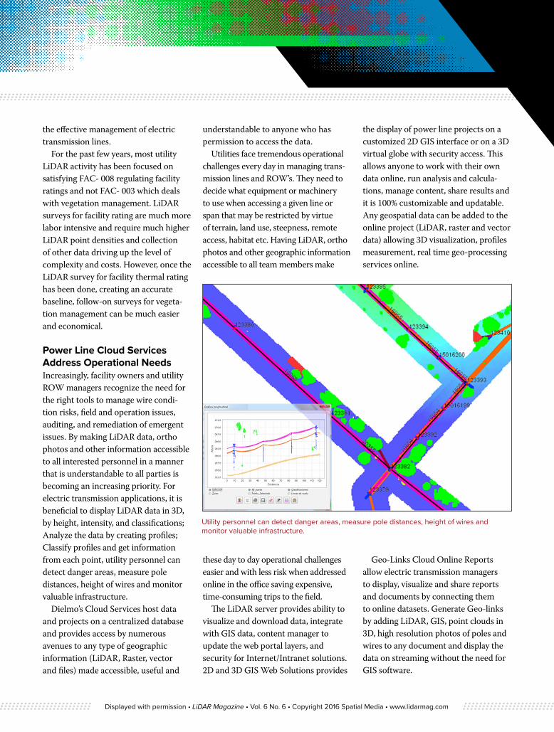
Power Line Cloud Services Address Operational NeedsIncreasingly, facility owners and utility ROW managers recognize the need for the right tools to manage wire condi-tion risks, field and operation issues, auditing, and remediation of emergent issues. By making LiDAR data, ortho photos and other information accessible to all interested personnel in a manner that is understandable to all parties is becoming an increasing priority. For electric transmission applications, it is beneficial to display LiDAR data in 3D, by height, intensity, and classifications; Analyze the data by creating profiles; Classify profiles and get information from each point, utility personnel can detect danger areas, measure pole distances, height of wires and monitor valuable infrastructure.
Dielmo’s Cloud Services host data and projects on a centralized database and provides access by numerous avenues to any type of geographic information (LiDAR, Raster, vector and files) made accessible, useful and
understandable to anyone who has permission to access the data.
Utilities face tremendous operational challenges every day in managing trans-mission lines and ROW’s. They need to decide what equipment or machinery to use when accessing a given line or span that may be restricted by virtue of terrain, land use, steepness, remote access, habitat etc. Having LiDAR, ortho photos and other geographic information accessible to all team members make
these day to day operational challenges easier and with less risk when addressed online in the office saving expensive, time-consuming trips to the field.
The LiDAR server provides ability to visualize and download data, integrate with GIS data, content manager to update the web portal layers, and security for Internet/Intranet solutions. 2D and 3D GIS Web Solutions provides
the display of power line projects on a customized 2D GIS interface or on a 3D virtual globe with security access. This allows anyone to work with their own data online, run analysis and calcula-tions, manage content, share results and it is 100% customizable and updatable. Any geospatial data can be added to the online project (LiDAR, raster and vector data) allowing 3D visualization, profiles measurement, real time geo-processing services online.
Geo-Links Cloud Online Reports allow electric transmission managers to display, visualize and share reports and documents by connecting them to online datasets. Generate Geo-links by adding LiDAR, GIS, point clouds in 3D, high resolution photos of poles and wires to any document and display the data on streaming without the need for GIS software.
Utility personnel can detect danger areas, measure pole distances, height of wires and monitor valuable infrastructure.
Displayed with permission • LiDAR Magazine • Vol. 6 No. 6 • Copyright 2016 Spatial Media • www.lidarmag.com
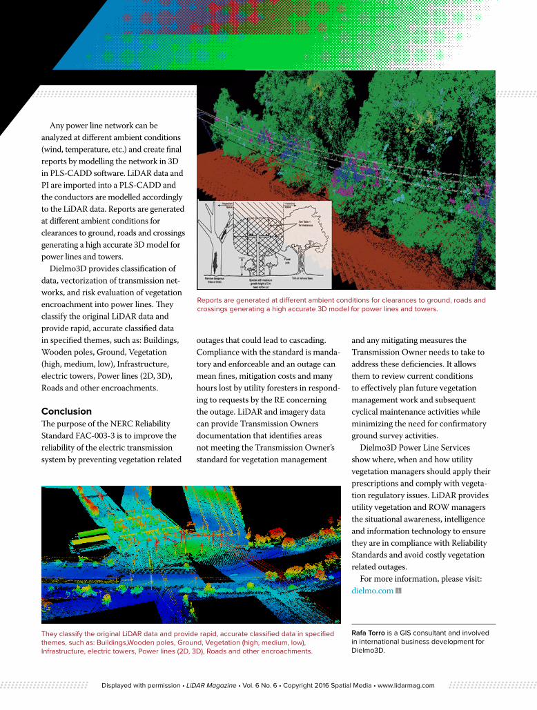
Any power line network can be analyzed at different ambient conditions (wind, temperature, etc.) and create final reports by modelling the network in 3D in PLS-CADD software. LiDAR data and PI are imported into a PLS-CADD and the conductors are modelled accordingly to the LiDAR data. Reports are generated at different ambient conditions for clearances to ground, roads and crossings generating a high accurate 3D model for power lines and towers.
Dielmo3D provides classification of data, vectorization of transmission net-works, and risk evaluation of vegetation encroachment into power lines. They classify the original LiDAR data and provide rapid, accurate classified data in specified themes, such as: Buildings, Wooden poles, Ground, Vegetation (high, medium, low), Infrastructure, electric towers, Power lines (2D, 3D), Roads and other encroachments.
ConclusionThe purpose of the NERC Reliability Standard FAC-003-3 is to improve the reliability of the electric transmission system by preventing vegetation related
outages that could lead to cascading. Compliance with the standard is manda-tory and enforceable and an outage can mean fines, mitigation costs and many hours lost by utility foresters in respond-ing to requests by the RE concerning the outage. LiDAR and imagery data can provide Transmission Owners documentation that identifies areas not meeting the Transmission Owner’s standard for vegetation management
and any mitigating measures the Transmission Owner needs to take to address these deficiencies. It allows them to review current conditions to effectively plan future vegetation management work and subsequent cyclical maintenance activities while minimizing the need for confirmatory ground survey activities.
Dielmo3D Power Line Services show where, when and how utility vegetation managers should apply their prescriptions and comply with vegeta-tion regulatory issues. LiDAR provides utility vegetation and ROW managers the situational awareness, intelligence and information technology to ensure they are in compliance with Reliability Standards and avoid costly vegetation related outages.
For more information, please visit: dielmo.com
Rafa Torro is a GIS consultant and involved in international business development for Dielmo3D.
Reports are generated at different ambient conditions for clearances to ground, roads and crossings generating a high accurate 3D model for power lines and towers.
They classify the original LiDAR data and provide rapid, accurate classified data in specified themes, such as: Buildings,Wooden poles, Ground, Vegetation (high, medium, low), Infrastructure, electric towers, Power lines (2D, 3D), Roads and other encroachments.
Displayed with permission • LiDAR Magazine • Vol. 6 No. 6 • Copyright 2016 Spatial Media • www.lidarmag.com