climate research in nepal himalayas saraju k. baidya (department of hydrology & meteorology)...
TRANSCRIPT

ClimateClimate Research in Nepal Research in Nepal HimalayasHimalayas
Saraju K. Baidya (Department of Hydrology & Meteorology)
“Mountains, witnesses of global changes. Research in the Himalaya and Karakoram: SHARE-Asia Project”, 16-17 November 2005

PhysiographyPhysiography

Meteorological Station Network
• Precipitation 337• Climatic 68• Agro-met 22• Synoptic 9• Aero-Synoptic 6• Total 442• Automatic 16
8 1 8 2 8 3 8 4 8 5 8 6 8 7 8 8
L o n g i t u d e ( ° E )
2 7
2 8
2 9
3 0
Lat
itu
de
(°N
)
8 0 8 1 8 2 8 3 8 4 8 5 8 6 8 7 8 8
L o n g i t u d e ( ° E )
2 7
2 8
2 9
3 0
Lat
itu
de
(°N
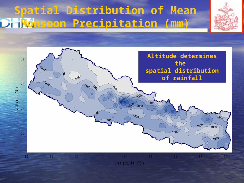
)Spatial Distribution of Mean Monsoon
Precipitation (mm)
Altitude determines the spatial distribution of
rainfall
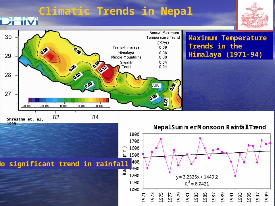
Climatic Trends in Nepal
Shrestha et. al, 1999
Nepal Summer Monsoon Rainfall Trend
y = 3.2325x + 1449.2
R2 = 0.04211000
1100
1200
1300
1400
1500
1600
1700
1800
1971
1973
1975
1977
1979
1981
1983
1985
1987
1989
1991
1993
1995
1997
1999
Rai
nfa
ll (m
m)
Maximum Temperature Trends in the Himalaya (1971-94)
No significant trend in rainfall

Climate ResearchClimate Research
The glaciological and meteorological observations in Nepal The glaciological and meteorological observations in Nepal Himalayas started in 1973 and 1974 as the "Glaciological Himalayas started in 1973 and 1974 as the "Glaciological Expedition to Nepal (GEN)". Expedition to Nepal (GEN)".
Nepal Himalayas: 2% of World’s FreshwaterNepal Himalayas: 2% of World’s Freshwater
Snowmelt:10% of annual flowSnowmelt:10% of annual flow
The studies show that these glaciers are retreating at an The studies show that these glaciers are retreating at an alarming rate. alarming rate.
Many researches in this field highlight the impacts on Many researches in this field highlight the impacts on water resource management and Glacier lake outburst water resource management and Glacier lake outburst Floods (GLOF).Floods (GLOF).
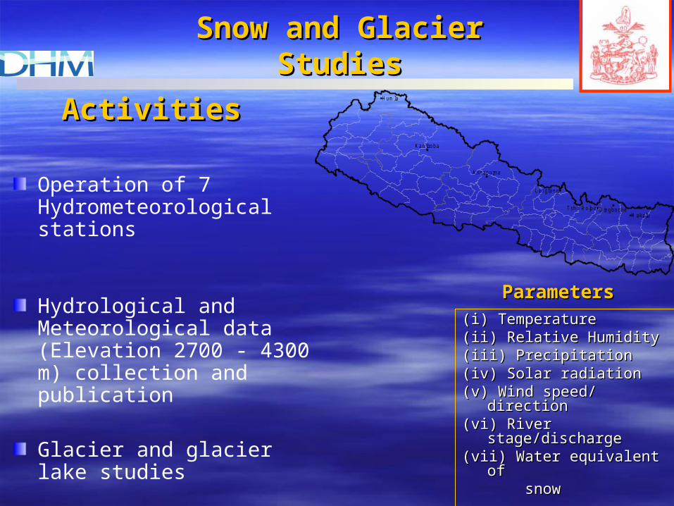
ActivitiesActivities
Operation of 7 Hydrometeorological stations
Hydrological and Meteorological data (Elevation 2700 - 4300 m) collection and publication
Glacier and glacier lake studies
Model development for snow and glacier melt runoff
Snow and Glacier Snow and Glacier StudiesStudies
(i) Temperature(i) Temperature(ii) Relative Humidity(ii) Relative Humidity(iii) Precipitation(iii) Precipitation(iv) Solar radiation(iv) Solar radiation(v) Wind speed/ direction(v) Wind speed/ direction(vi) River stage/discharge(vi) River stage/discharge(vii) Water equivalent of (vii) Water equivalent of snowsnow
ParametersParameters
Langtang
Tsho R olpaM akalu
H um la
Kanjiroba
Annapurna
D ingboche

Gauging Stations, Annapurna Region
Automatic Water Level Recorder,Langtang
Automatic Weather Station
Khumbu

Snow survey for Snow survey for determination of determination of water equivalent of water equivalent of snowsnow
Snow pitSnow pit
Snow samplerSnow sampler

Retreat of AX010 Glacier
Retreat from 1978-1989Was 30 m
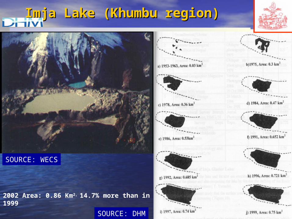
Imja Lake (Khumbu region)Imja Lake (Khumbu region)
SOURCE: WECS
SOURCE: DHM
2002 Area: 0.86 Km2, 14.7% more than in 1999

Nepal Himalayas are highly vulnerable to the climate Nepal Himalayas are highly vulnerable to the climate change. It has wide impact on water resources and change. It has wide impact on water resources and agriculture of Nepalagriculture of Nepal
His Majesty’s Government (HMG) of Nepal instituted His Majesty’s Government (HMG) of Nepal instituted a Country Study program on Climate Change in 1994 a Country Study program on Climate Change in 1994 under the support of US Country Studies Program. under the support of US Country Studies Program.
For the first time in Nepal, General Circulation Models For the first time in Nepal, General Circulation Models (GCMs) Outputs were used and climate change (GCMs) Outputs were used and climate change scenarios were developed.scenarios were developed.
Climate Change Studies

Climate Change StudiesClimate Change Studies
• Four modelsFour models
– CCCMCCCM: Canadian Climate Centre Model (2 Grid pts.): Canadian Climate Centre Model (2 Grid pts.)– GFD3GFD3: Geophysical Fluid Dynamics Laboratory R-30 : Geophysical Fluid Dynamics Laboratory R-30
Model (2 Grid pts.)Model (2 Grid pts.)– UK89UK89: United Kingdom Meteorological Office Model : United Kingdom Meteorological Office Model
(2 Grid pts.)(2 Grid pts.)– GISSGISS: Goddard Institute of Space Science Model (1 : Goddard Institute of Space Science Model (1
Grid pt.)Grid pt.)

• For 2XCO2 (22 stations)For 2XCO2 (22 stations)– Precipitation increasePrecipitation increase
•CCCM : 36%
•GFD3: 67%
– Increase in Monsoon season and decrease in dry Increase in Monsoon season and decrease in dry (winter) season(winter) season
– Temperature increaseTemperature increase•CCCM: 1.4oC to 4.1oC; 2.9oC
•GFD3: +1.7oC to 4.2oC; 3.1oC
• Limitation:Limitation: low resolution low resolution
Climate Change StudiesClimate Change Studies

Status of Climate Models Status of Climate Models inin Nepal Nepal
• Rough topography of Nepal requires high Rough topography of Nepal requires high resolution modelsresolution models
• Currently Nepal is experimenting on two RCMsCurrently Nepal is experimenting on two RCMs – RegCM3 (ICTP, Italy)– PRECIS (Hadley Centre, UK)
• Main aim of these models is to study the impact Main aim of these models is to study the impact of climate change of climate change
• Currently, we are on the process of validation Currently, we are on the process of validation experimentsexperiments

8 0 8 1 8 2 8 3 8 4 8 5 8 6 8 7 8 8
2 7
2 8
2 9
3 0
75 km50 km
30 km
RegCM3 Results of 1997 JuneRegCM3 Results of 1997 June
-100 100 300 500 700 900 1100 1300 15000
Observation
50 km 75 km

RegCM3: 1997 monsoon RegCM3: 1997 monsoon NestedNested
8 0 8 1 8 2 8 3 8 4 8 5 8 6 8 7 8 8
2 7
2 8
2 9
3 0
-200 200 400 800 1200 1600 2000 2400 2800 3200 3600 40000
Observation
Nested: 15 km75 km

Time required for 1 month simulationTime required for 1 month simulation
8.0
5.3
1.30.7(16hrs)
0
1
2
3
4
5
6
7
8
9
15 30 50 75Horizontal Resolution (km)
App
roxi
mat
e tim
e re
quire
d (d
ays)
• Major issues Running RCMMajor issues Running RCM– Time constraint to run high resolution modelsTime constraint to run high resolution models– Computing facilitiesComputing facilities

Monsoon Study
• A project was developed in 1999 and number of meteorological stations ranging from 500 m to 4400 m were installed in the Marsyangdi river basin in central Nepal and Monsoon Himalayan Precipitation Experiment (MOHPREX) was carried out during June 2001 to study the interaction of the Himalayas and the Asian summer monsoon
Source: Ana P. Barros and Timothy J. Lang (2001)

• The mountains act as barriers to the south-easterly monsoon flow from BOB and consequently low level convergence occurs.
• Upslope and upvalley flows reduce this convergence. The upslope flow leads to high level convection and secondary peak in precipitation.
• with the absence of upslope winds, and prevalent down slope winds, strong convergence of the moist advected monsoon flow occurs which acts to force convection which lead to the nocturnal peak in rainfall in these areas.
Source: Monitoring the Monsoon in the Himalayas: Observations in Central Nepal, June 2001, Ana P. Barros and Timothy J. Lang

Concluding RemarksConcluding Remarks
• Nepal deserves special attention in climate Nepal deserves special attention in climate related research becauserelated research because– Complex Topography Complex Topography – Himalayas are highly vulnerable to climate Himalayas are highly vulnerable to climate
changechange– Himalayas are the water tower for South Asia Himalayas are the water tower for South Asia
where most of the poorest people livewhere most of the poorest people live– Himalayan range plays an important role in Himalayan range plays an important role in
Asian Summer MonsoonAsian Summer Monsoon
• Need of special research on Climate models Need of special research on Climate models in Himalayan regionsin Himalayan regions

Thank You