climate and management of alpine terraces gabriele cola, luigi mariani università degli studi di...
TRANSCRIPT
Climate and Climate and management of alpine management of alpine
terracesterraces
Gabriele Cola, Luigi MarianiUniversità degli Studi di Milano
Sondrio,2005 November 3
Speech resumé
AimAim:: meso and microclimatic characterisation of alpine terraces of Sondrio province.- micro: Pianazzola (Vabregaglia)- micro/meso: Valtellina terraces with vineyards
1) Material and methods1) Material and methods- data sources- algorithms
2) Climatology2) Climatology- Some comments on time series- Spatial analisys -> - Thermal and Radiative resources - Water resources (water balance)
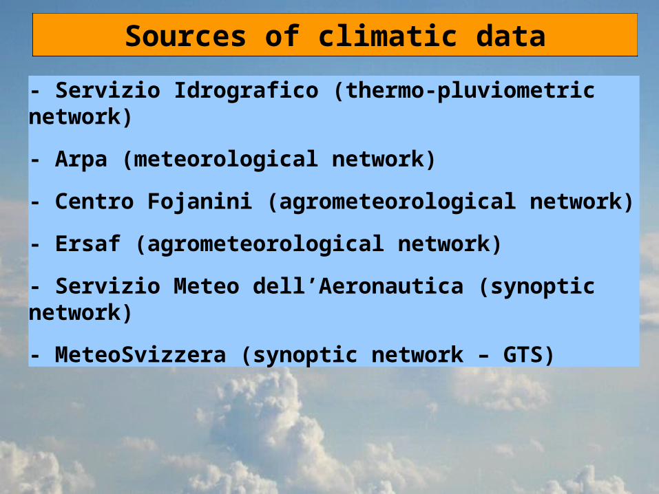
Sources of climatic data
- Servizio Idrografico (thermo-pluviometric network)
- Arpa (meteorological network)
- Centro Fojanini (agrometeorological network)
- Ersaf (agrometeorological network)
- Servizio Meteo dell’Aeronautica (synoptic network)
- MeteoSvizzera (synoptic network – GTS)
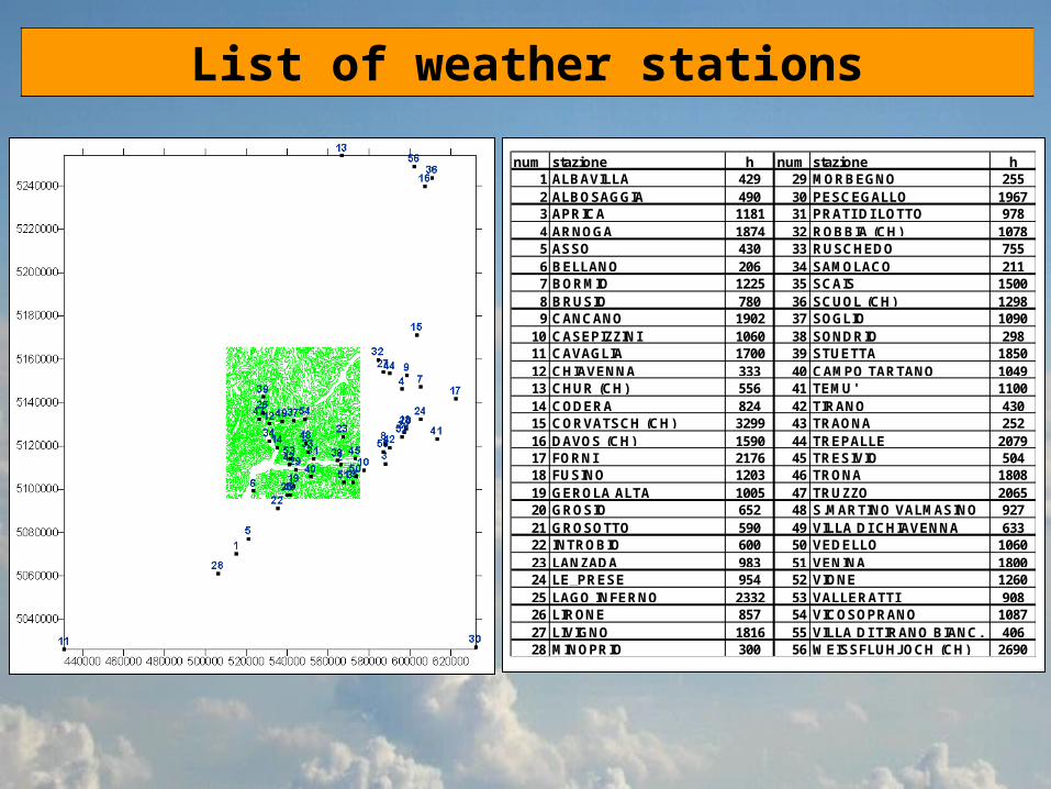
List of weather stations
num stazione h num stazione h1 ALBAVILLA 429 29 MORBEGNO 2552 ALBOSAGGIA 490 30 PESCEGALLO 19673 APRICA 1181 31 PRATI DI LOTTO 9784 ARNOGA 1874 32 ROBBIA (CH) 10785 ASSO 430 33 RUSCHEDO 7556 BELLANO 206 34 SAMOLACO 2117 BORMIO 1225 35 SCAIS 15008 BRUSIO 780 36 SCUOL (CH) 12989 CANCANO 1902 37 SOGLIO 1090
10 CASEPIZZINI 1060 38 SONDRIO 29811 CAVAGLIA 1700 39 STUETTA 185012 CHIAVENNA 333 40 CAMPO TARTANO 104913 CHUR (CH) 556 41 TEMU' 110014 CODERA 824 42 TIRANO 43015 CORVATSCH (CH) 3299 43 TRAONA 25216 DAVOS (CH) 1590 44 TREPALLE 207917 FORNI 2176 45 TRESIVIO 50418 FUSINO 1203 46 TRONA 180819 GEROLA ALTA 1005 47 TRUZZO 206520 GROSIO 652 48 S.MARTINO VALMASINO 92721 GROSOTTO 590 49 VILLA DI CHIAVENNA 63322 INTROBIO 600 50 VEDELLO 106023 LANZADA 983 51 VENINA 180024 LE_PRESE 954 52 VIONE 126025 LAGO INFERNO 2332 53 VALLERATTI 90826 LIRONE 857 54 VICOSOPRANO 108727 LIVIGNO 1816 55 VILLA DI TIRANO BIANC. 40628 MINOPRIO 300 56 WEISSFLUHJOCH (CH) 2690
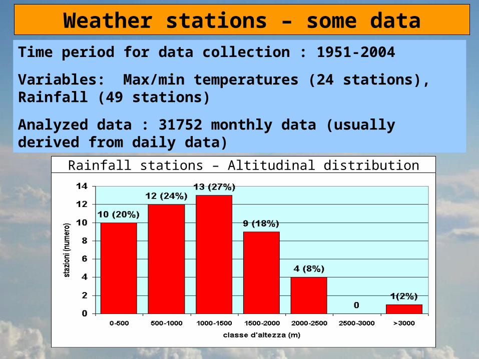
Weather stations – some dataTime period for data collection : 1951-2004
Variables: Max/min temperatures (24 stations), Rainfall (49 stations)
Analyzed data : 31752 monthly data (usually derived from daily data)
Rainfall stations – Altitudinal distribution

Analysis of time series

Spatial variability – Yearly altitudinal gradients
max T (1971-2000 - mean)
min T (1971-2000 - mean)

Spatial variability – Yearly altitudinal gradients
precipitation (1971-2000 - mean)

Spatial variability – Yearly altitudinal gradients used for temperature data homogenization
Maximu
m Minimum Mean
January - 0.38 - 0.46 - 0.53
February - 0.37 - 0.47 - 0.56
March - 0.57 - 0.63 - 0.69
April - 0.59 - 0.64 - 0.68
May - 0.62 - 0.63 - 0.64
June - 0.64 - 0.60 - 0.56
July - 0.56 - 0.56 - 0.55
August - 0.54 - 0.55 - 0.56
September - 0.48 - 0.48 - 0.47
October - 0.44 - 0.46 - 0.47
November - 0.33 - 0.42 - 0.50
December - 0.29 - 0.39 - 0.49

TIME VARIABILITYTIME VARIABILITY Yearly mean temperature and rainfall from the
selected area
Algorithm: library STRUCCHANGE (R language -Zeileis et al., 2003).
TEMPERATURE PRECIPITATION
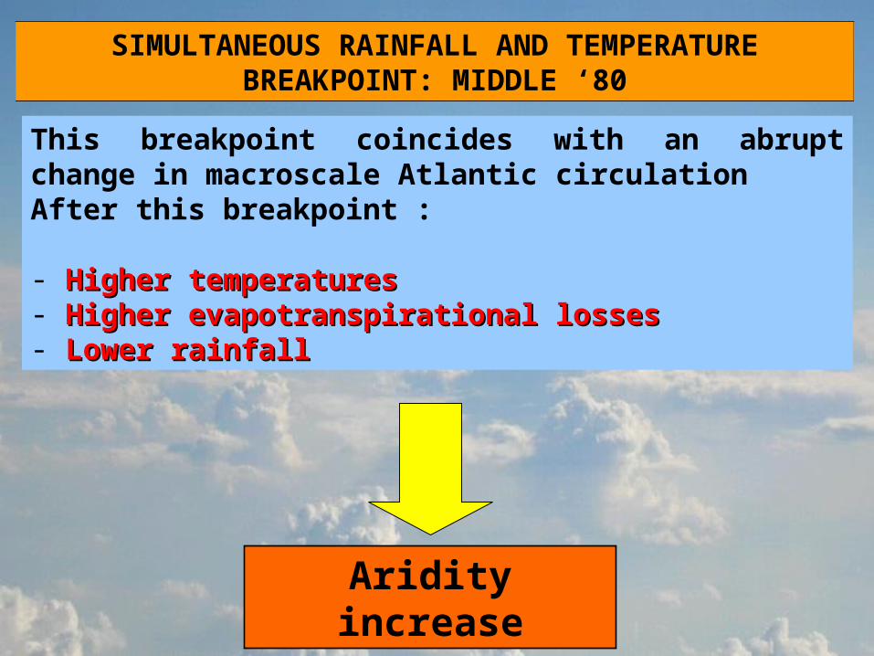
SIMULTANEOUS RAINFALL AND TEMPERATURE BREAKPOINT: MIDDLE ‘80
This breakpoint coincides with an abrupt change in macroscale Atlantic circulationAfter this breakpoint :
- Higher temperaturesHigher temperatures- Higher evapotranspirational lossesHigher evapotranspirational losses- Lower rainfallLower rainfall
Aridity increase
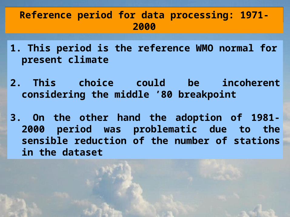
Reference period for data processing: 1971-2000
1. This period is the reference WMO normal for present climate
2.This choice could be incoherent considering the middle ’80 breakpoint
3.On the other hand the adoption of 1981-2000 period was problematic due to the sensible reduction of the number of stations in the dataset
GEOSTATISTICAL PROCESSING
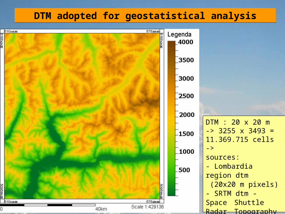
DTM adopted for geostatistical analysis
DTM : 20 x 20 m -> 3255 x 3493 = 11.369.715 cells ->sources:- Lombardia region dtm (20x20 m pixels)- SRTM dtm - Space Shuttle Radar
Topography Mission (90x90 m pixels)
1971-2000 MAPS – SOME EXAMPLES
MONTHLY FIELDS
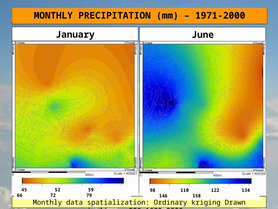
MONTHLY PRECIPITATION (mm) – 1971-2000
Monthly data spatialization: Ordinary kriging Drawn isolines: 500-1000-2000 m
JuneJanuary
98 110 122 134 146 158
45 52 59 66 72 79

MONTHLY TEMPERATURES (°C) – 1971-2000
January – min T
-22 -16 10 -4 1
June – max T
6 11 16 21 26
Monthly data spatialization: Ordinary kriging Drawn isolines: 500-1000-2000 m
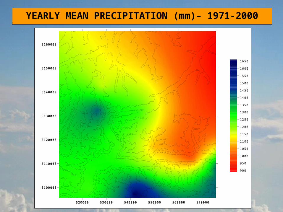
YEARLY MEAN PRECIPITATION (mm)– 1971-2000
520000 530000 540000 550000 560000 570000
5100000
5110000
5120000
5130000
5140000
5150000
5160000
900
950
1000
1050
1100
1150
1200
1250
1300
1350
1400
1450
1500
1550
1600
1650
520000 530000 540000 550000 560000 570000
5100000
5110000
5120000
5130000
5140000
5150000
5160000
520000 530000 540000 550000 560000 570000
5100000
5110000
5120000
5130000
5140000
5150000
5160000
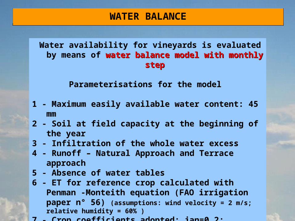
WATER BALANCE
Water availability for vineyards is evaluated by means of water balance model with monthly water balance model with monthly
stepstep
Parameterisations for the model
1 - Maximum easily available water content: 45 mm
2 - Soil at field capacity at the beginning of the year
3 - Infiltration of the whole water excess 4 - Runoff – Natural Approach and Terrace
approach5 - Absence of water tables 6 - ET for reference crop calculated with Penman
-Monteith equation (FAO irrigation paper n° 56) (assumptions: wind velocity = 2 m/s; relative humidity = 60% )
7 - Crop coefficients adopted: jan=0.2; feb=0.2; mar=0.2; apr=0.6; maj=0.8; jun=0.95; jul=0.95; aug=0.95; sep=0.95; oct=0.95; nov=0.38; dec=0.2

RUNOFF
TWO DIFFERENT APPROACHES:
1 – “Natural landscape” approach - water water balance referred to territory without terracesbalance referred to territory without terraces obtained estimating runoff with a rational method
Runoff%=ci_slope+ci_infil+ci_cover+ci_storage
where ci_slope is the slope coefficient obtained with a logaritmic equation (Ci_slope=0.0797*ln(slope)
+0.0128) and other coefficients are function of class of soil infiltration, vegetation cover and surface storage.
2 - ”Terraces” approach - water balance referred to water balance referred to terracesterraces obtained applying a constant monthly runoff of 10%
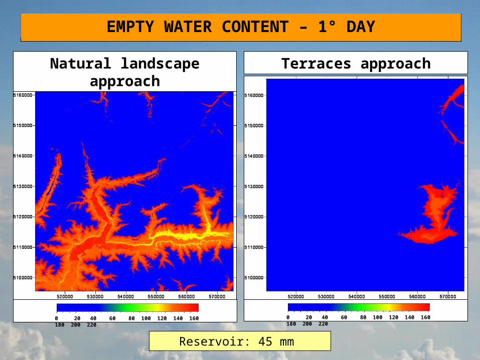
EMPTY WATER CONTENT – 1° DAY
Reservoir: 45 mm
Natural landscape approach
Terraces approach
0 20 40 60 80 100 120 140 160 180 200 220
0 20 40 60 80 100 120 140 160 180 200 220
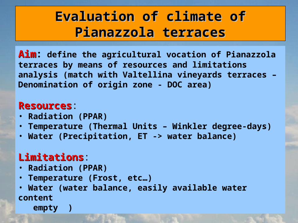
Evaluation of climate of Pianazzola Evaluation of climate of Pianazzola terracesterraces
AimAim: define the agricultural vocation of Pianazzola terraces by means of resources and limitations analysis (match with Valtellina vineyards terraces – Denomination of origin zone - DOC area)
ResourcesResources:• Radiation (PPAR)• Temperature (Thermal Units – Winkler degree-days)• Water (Precipitation, ET -> water balance)
LimitationsLimitations:• Radiation (PPAR)• Temperature (Frost, etc…)• Water (water balance, easily available water content empty )

PPAR
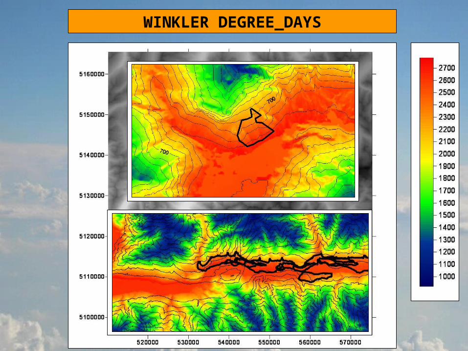
WINKLER DEGREE_DAYS
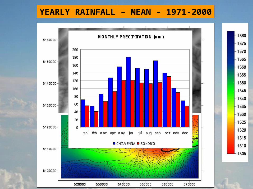
YEARLY RAINFALL – MEAN – 1971-2000
MONTHLY PRECIPITATION (mm)
0
20
40
60
80
100
120
140
160
180
200
jan feb mar apr may jun jul aug sep oct nov dec
CHIAVENNA SONDRIO
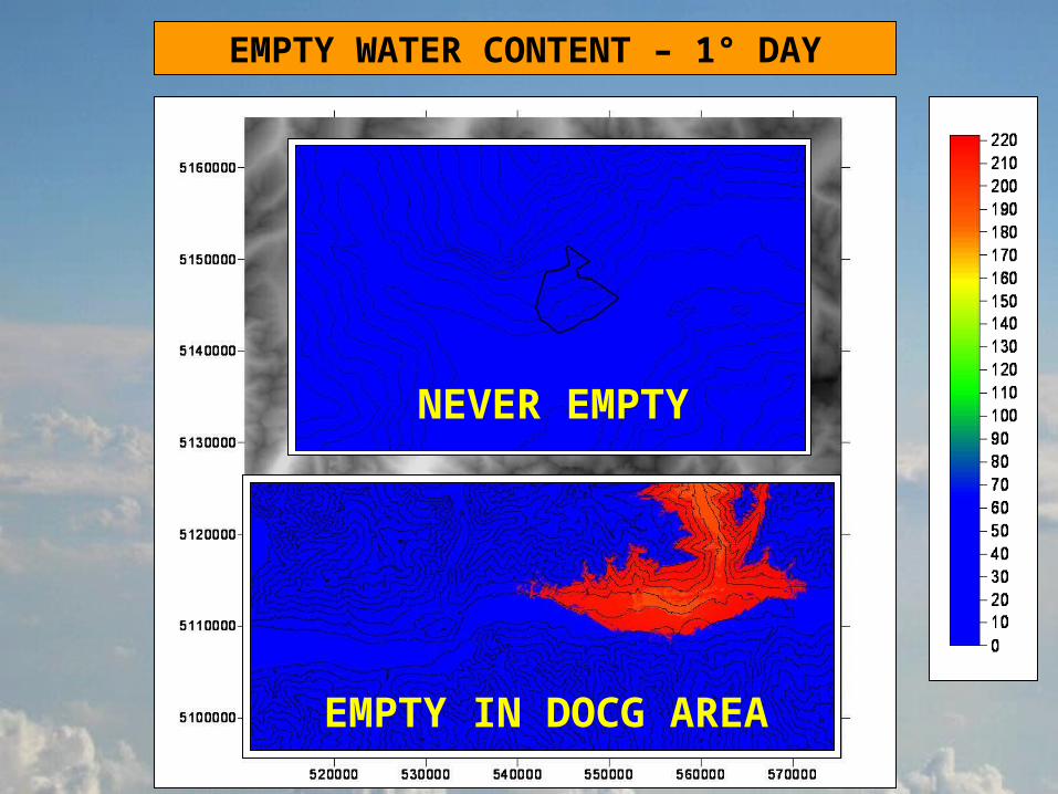
EMPTY WATER CONTENT – 1° DAY
NEVER EMPTY
EMPTY IN DOCG AREA
Both Pianazzola terraces and Valtellina DOCG area (premium quality denomination of guaranteed origin zone) show:• a good level of thermal resources (GDDW: 1100 -1800)• a good level of radiative resources (PPAR: 2700 – 3200 MJ m-2 y-1) • low risk of thermal limitations (not discussed)
Pianazzola shows a significant water limitationsignificant water limitation due to water excess (the easily available water content never ends). On the other side the premium DOC Valtellina terraces ends the easily available water content after the second half of July-> this event stands as a quality enhancer for the premium DOC area
This is probably one of the main reasons that justify the higher suitability of Valtellina DOCG area for production of higher suitability of Valtellina DOCG area for production of high quality wine.high quality wine.
This aspect is particularly important in years with “summer Atlantic weather” (high precipitation levels)
CONCLUSIONSCONCLUSIONS