clifford conservation area management plan - clifford …1).pdfstone walls or hedges. tall boundary...
TRANSCRIPT

Clifford C O N S E R V A T I O N A R E A A P P R A I S A L A N D M A N A G E M E N T P L A N Draft for consultation December 2009 Comments are welcome by 5th February 2010. Please see final page for contact details
Clifford is a place of special character and historic interest.
This appraisal and management plan sets out the features that contribute to its
distinctiveness and identifies opportunities for its protection and
enhancement.

2
and there is a high risk that further losses will occur. Boundary treatments are important in defining the character and appearance of a place. As in many of the villages in the surrounding area the front boundaries of properties are usually formed by low stone walls or hedges. Tall boundary treatments or those constructed of
inappropriate materials risk creating a dominating street frontage or an overly suburban environment. There are a number of sites within the conservation area where alien species of trees have been planted. These harm the landscape setting of the village and should be strongly resisted.
Summary of Issues Clifford’s historic character remains strong along High Street and the southern end of Willow Lane, but recent developments show that there are particular threats to this character. The medieval plan form of burgage plots has been severely eroded by the creation of the development around Springfield to the south and Willow Glade to the north. Further coarse grain backland development within the historic core will continue to erode the traditional form of the settlement and will harm the character and appearance of the village. Extensions to existing dwellings should be carefully designed to take account of their context. Magnesian limestone remains the predominant building material within the conservation area though some dwellings are rendered; a rural vernacular style is the principal form. In order to maintain the character of the village new development should respect these characteristics. Unfortunately most buildings appear to have lost traditional details such as those to windows and doors and this does have an impact upon the integrity of the settlement. Plastic is gradually replacing wood and few houses have retained original sash or Yorkshire slider windows. As few buildings in the settlement are listed traditional architectural details are not protected from removal or alteration
Introduction
Summary of Special Interest Clifford is a small village lying in the north-east corner of the Leeds District, between Bramham and Boston Spa. The settlement has a long history and its medieval toft-and-croft plan form remains in part along the length of High Street, although infil development to the western end of the village has somewhat eroded this character. The village was associated with the flax trade and this has influenced the form of the settlement; its two mills remain to the south side as well as a water wheel, mill race and the site of the old mill pond. St Edward’s Church, a landmark building in the village, is also a result of this association as the Irish workers who came to the village brought with them a strong Catholic faith. The village remains a quiet, rural settlement with a fine grain form of development around its historic core and a coarser grain characterising more recent development. Its buildings are constructed from locally quarried magnesian limestone and this gives the settlement a sense of unity.
An aerial view of Clifford showing its location between Boston Spa in the north and Brahmam to the very south. The strongly linear nature of the plots between High Street and Albion Street is clearly evident.

3
Extent of the conservation area The existing conservation area was designated in 1974 and included the historic core of the village, the site of the mills, mill pond and also Bramham Moor. This appraisal provides an oppor tun i ty to reappra ise the conservation area and to assess whether the boundary remains appropriate. There are four changes proposed to the conservation area; two areas of infill housing to the north and south would be removed, a small extension made to the southern end and the boundary around the old school site rationalised. At the time of designation in 1974 the areas of housing around Springfield and Willow Glade had not been constructed. Their presence has disrupted the historic plan form of the village and they are not considered to be of particular historic or architectural significance. To the southern end of the village the terraces of Victoria Place are attractive buildings which help frame the approach to the village from the south and are considered worthy of inclusion. In order to facilitate this it has been necessary to include some land now associated with Victoria Farm. The first edition map of 1849 does not show the farm and instead the land is clearly associated with the cottages. The changes to the conservation area boundary around the old school follow existing plot boundaries.
existing conservation area
proposed conservation area
St Edward’s Church
St Luke’s Church
This map is reproduced from Ordnance Survey material with the permission of Ordnance Survey on behalf of the Controller of Her Majesty’s Stationary Office © Crown copyright. Unauthorised reproduction infringes Crown copyright and may lead to prosecution or civil proceedings. (100019567) 2008

4
Solid Geology of Clifford
Magnesian limestone
Calcareous mudstone
Location of Clifford, between Bramham and Boston Spa.
Location and setting Clifford is a small village in the north-east corner of the Leeds district, four miles south-east of Wetherby and north-west of Tadcaster . The surrounding landscape is formed of gently rolling, predominantly arable farmland, with large fields bordered by low gapped hedges with occasional hedgerow trees. Clifford lies just south of Boston Spa and north of Bramham, and although the villages are close together they each retain a highly distinctive historic character.
General character and plan form Clifford is a linear street village with a historic plan form consisting of regular sized plots running back from a central village street. As a formerly subordinate settlement to Bramham, the village had neither a parish church nor manor house to act as a focal point during its development and a small green at the west end of the High Street terminates the principal street of the settlement. Late 20th century backland development has filled the former burgage plots and changed the character of the village. The character of the conservation area is influenced by the near universal use of magnesian limestone. Vernacular built forms shape the built environment.
Geology, topography and landscape setting Clifford lies on the southern Magnesian Limestone ridge, a narrow belt of Permian limestone which runs north-south from North Yorkshire to north Nottinghamshire. The stone is a pale, fine-grained material and is the predominant building material in the village. The stone was quarried locally from sites to the north and south east of the settlement. Properties on Willow Crescent now occupy one such site. Small deposits of calcareous mudstone
flank the north and east of Clifford village. The landscape is gently undulating, marking a transition between the Vale of York to the east and the Pennine fringe to the west. Fields are generally large, bounded by low thorn hedges with some large hedgerow trees. The area of Bramham Moor to the south of the village is an important green are which contains many fine specimens of mature trees and is important to the setting of the village, in particular its approach from the south.
Assessing the Special Interest
This map is reproduced from Ordnance Survey material with the permission of Ordnance Survey on behalf of the Controller of Her Majesty’s Stationary Office © Crown copyright. Unauthorised reproduction infringes Crown copyright and may lead to prosecution or civil proceedings. (100019567) 2008

5
settlement of Boston Spa is larger than Clifford, in the medieval era Boston Spa was part of the open field system of Clifford Village. Clifford is largely typical of a medieval farming settlement and ridge and furrow can be seen to the south, west and east of the village. Two medieval artefacts have been discovered to the north of Clifford; a seal matrix and a disc-shaped token are both cast copper alloy and date to the late medieval era. Somewhat atypical is the lack of a parish church. Whilst the Domesday book attributes some importance to Clifford it was part of the Parish of Bramham and there appears to have been no parish church within the village in the medieval period.
Post-medieval There is little obvious physical evidence of the impact of the early modern era upon Clifford. The Bay Horse is one of the oldest structures within the village and dates back to the late 17th century. To the western end of High Street is a stone outbuilding with mullioned windows suggesting an early date to the structure; a date stone set within its front gable shows 1632. It was during the mid 1700s that a section of Clifford became Boston Spa. The roads of Church Street, Clifford Road and Clifford Moor Road mark the edges of three fields which were used in a rotational strip-field cultivation system and the area between the A659 and river was used for grazing animals.
appears to be a settlement of relative importance containing “the Lord’s demesne”; a mill is also recorded. The settlement was larger than the surrounding villages and the lord of Clifford had jurisdiction over the lands of Bramham, Collingham and Boston Spa. This importance was probably due to the presence of industry within the village and the wealth that it brought. The name of Clifford derives from Old English and translates as ‘ford near the steep bank’. It is possible that this name refers to a ford over Carr Beck which lies to the east of the village or to a ford over the Wharfe to the North at Boston Spa. The landscape setting of Clifford has a more gentle, undulating character and it is more likely that the ford would have been over the Wharfe. Whilst today the
Origins and Evolution Prehistoric and Roman There remains some physical evidence of prehistoric activity within the area; enclosures, trackways, ditches and field boundaries exist in four locations around the village and are visible as cropmarks on aerial photographs. It is likely that these are Late Iron Age settlements and that activity continued on into the Roman era. Jewellery in the form of a copper-alloy and glass brooch dating to 100-150 AD and a Roman copper-alloy coin dating to 260-300 AD have been found in or around the Conservation Area. Clifford also lies close to the Great North Road, the predecessor of the A1. Norman and Medieval The first documentary evidence for a settlement at Clifford is found in the Domesday book of 1086. Here it
Firgreen Bridge over Carr Beck looking back toward The Willows
The stone flax mill in 1912, probably disused. It is possible the shape within the trees is the redbrick mill on New Mill Lane (© Leodis)
Garaging associated with ‘Box Trees’. An area of yellow stone above the right hand window suggests an opening has been filled. The date stone is set above this.
The Bay Horse; the side gable shows the building has been extensively altered. The current façade is clearly a later addition.

6
Nineteenth Century The nineteenth century had a large impact upon Clifford with both religious institutions and the mills adding new buildings to the village. The Mills In 1831 the Grimston brothers leased the mill situated at the bottom of Old Mill Lane to the south of Carr Beck. The site of the original mill, later a saw mill, is now occupied by two bungalows. The mill pond lies immediately south of this site, and the old water wheel and its housing are still visible from the road. The fabric of the wheel is sadly degraded. Other surviving buildings were probably part of the same complex and the stone building now known as Clifford Mill and converted into flats appears to be of 19th century origin.
A new, purpose built flax mill, was constructed in 1847 to the north of the beck. This large, dominant building, is one of the few brick built structures within the conservation area. The new mills required extra labour and subsequently additional housing. Some of the terraces of Albion Street were built for this purpose. The Churches Three churches exist in Clifford today; St Luke’s, St Edwards and the Wesleyan Chapel. Of these buildings St Luke's appears to have been built first around 1840. An early trade directory of 1838 identifies a Wesleyan Chapel and it is believe this was on the site of the present tower to St Edwards Church. The existing Methodist Church was constructed in 1848.
The 1857 Mill viewed from the south-east. The sunken lane shown in the foreground suggests an old route to the mill.
St Luke’s, the Anglican church to the west of the village.
.
St Edward’s Church as viewed from Bramham. Long range views of landmarks should be respected and development steered away from vista corridors.

7
The new twentieth century housing of Nunnery Way reflects the high gables and lancet windows of surrounding ecclesiastical architecture.
Twentieth Century The twentieth century has had a large impact upon the historical core of Clifford. The post-war housing developments to the north disrupted the historic field pattern and obscured linear arrangement of strips running back from High Street. This trend has continued in recent years.
The closure of the mills means that there is now little employment in the village and former mill buildings have been lost or converted into flats.
The Northways school has also been closed and is the site of some of the newest housing within the village; unlike earlier developments the new buildings have respected their context and the development is a positive new addition to the village.
St Edward’s Church viewed from High Street.
Initially associated with St Luke’s was the Northways site, also then a school. It later passed to the Sisters of Mercy and became a convent school The most dominant building within the conservation area is undoubtedly St Edward’s church with its high, characteristic tower. A Scottish architect Ramsey was responsible for its design and work was begun on the site in 1845, however the building process took many years and the church was not consecrated until 1859; its tower was not completed until 1866. The associated presbytery also shows signs of several phases of work however this is has not been documented.
The stone structure housing the old village well; reputedly used as a source of baptismal waters for St Luke’s church.

8
Character Analysis Spatial Analysis Settlement form Clifford’s settlement form is largely typical of a medieval planned village; it has houses laid out in a linear pattern along the principal road terminating in a village green. The war memorial is now sited where the village green was. The toft and croft form of the early settlement is still evident, particularly to the south of High Street. The roads running north to Boston Spa follow former field boundaries and give some indication of the old field system of the village.
Activity and grain Clifford Conservation Area’s built environment is largely fine grain, though coarser grained development exists at the old Northways site and around the site of the mills. High Street and Albion Street are largely characterised by houses set in rectangular plots running back from the road. Many older dwellings front the pavement edge though some are set back a little way behind stone boundary walls. Later 20th
century developments are always all set back from the road and often have short front gardens. The new developments of Nunnery Way and Court Barton Lane are of a coarser grain; their houses reflect the expectations of twentieth century living and their layout departs from the strongly linear form of the village. Activity within the village is low; there are two pubs within the conservation area and the village hall and its playground provide some focus for residents. Overall the village has a strong sense of remaining a quiet rural settlement. Character of spaces and green space Clifford’s conservation area has a central core of built development and an outer rim of open space, although to the north infill development has created a more built-up feel to the area.
South of the village there is a strip of parkland which is characterised by large, mature trees. These have a positive impact upon the setting of the village and occasionally stand in contrast to the alien, evergreen species which are also visible. Further south is open agricultural land which falls away toward Bramham. This agricultural land continues to the east and west and views out toward the fields are possible from key points within the village. Within the heart of the village there is a more enclosed feel. The gentle contours of the land and the curves of the road mean that from several points views are terminated by buildings, though the low massing of most buildings prevents a sense of dominance or oppression. Low stone walls provide definition between public and private areas and vegetation within front gardens helps to soften the appearance of the village. The village green is a small, but important green area. Key Views St Edward’s Church is the main local landmark and is visible from many points in and outside the settlement. Key views out of the settlement are located around St Luke’s to the west, the junction of High Street and Cinder Lane to the east, and the upper end of Albion Street to the north.
The gradual falling gradient between Boston Spa and Bramham means the best views into Clifford are from the North where the settlement appears to nestle within its surrounding patchwork of fields. From within the settlement the raised village green offers a vantage point which gives views along High Street and Willow Lane. The linear nature of High Street allows views east and west, though these terminate at the edge of the village.
The open parkland to the south of the village.
Looking west along High Street toward St Edward’s Church. The tree line in the distance terminates the view and screens the open agricultural land which lies beyond.
The coarser grain development to the edges of the village

9
Spatial Analysis Map
Extent of conservation area
Key green area
Key long range views
Key short range views
Gateway
Key intersection This map is reproduced from Ordnance Survey material with the permission of Ordnance Survey on behalf of the Controller of Her Majesty’s Stationary Office © Crown copyright. Unauthorised reproduction infringes Crown copyright and may lead to prosecution or civil proceedings. (100019567) 2008

10
Character Analysis Built Environment Architectural Characteristics Development in Clifford has a fairly unified form; it is now primarily a residential settlement and its houses are two storeys in height and reflect the simple shapes and forms of vernacular architecture from the 17th century onward. Dwellings are gabled and roof pitches are usually 35 degrees. The mill buildings are an obvious exception to this general trend, having a greater number of storeys, although their position relative to the rest of the village means they are not readily visible. Window openings are often small in scale on older properties and there are a mix of styles in evidence. Some dwellings have vertically emphasised
hung sash windows whilst others have horizontal emphasised casement windows which have replaced Yorkshire sliders. Traditional wooden windows are no longer the dominant form in the village and this has a negative impact upon the integrity of its character. Materials Clifford has a relatively unified palate of materials; external walling materials are predominate ly loca l magnes ian limestone and roofs are often clay pantiles although slate is also present. There are some brick buildings within the conservation area though these are in the minority.
Local Details Although the properties within the village display a unified general form the details between buildings can vary significantly. Some buildings display obvious links to their agricultural past, such as wagon arches, whilst many of the cottages have simple stone heads, cills, jambs and lintels. Architectural mouldings are unusual but are present on the ecclesiastical buildings and associated sites. Landmarks The church of St Edward’s remains the key landmark which is highly visible within the surrounding landscape. The yellow stone and interesting shape of the old Northways site provides an attractive entrance to the village from the south. When leaving the village the structure around the well is a unique local detail.
Boundary Treatments The type and style of front boundary treatments are important in defining the character of the village. The majority of houses have stone walls to the road frontage and these vary in height from 1.0m to 2.0m. Lower walls give views of buildings and their front gardens and contribute to the open and spacious feel of the village. Higher walls can provide definition but can also produce a sense of unwelcome enclosure. Clifford’s walls are constructed of coursed stone with little or no coping. Hedging is present to the front of some properties though both railings and fences are unusual and often unwelcome additions. Care should be taken when planting hedges or trees as inappropriate or alien species can be dominating and harm the character of the conservation area.
Properties which retain traditional details to their windows and doors have a greater sense of historical integrity
St Edward’s Terrace; red brick is an unusual detail in Clifford. As can be seen some dwellings have retained their original sash windows whilst others had them replaced with plastic casements; pane detail helps to retain a traditional style
Large hedges and fences which front directly onto the pavement create a physical and visual barrier and can give a sense of oppression
The old convent school (Northways) as viewed from Bramham Road
11
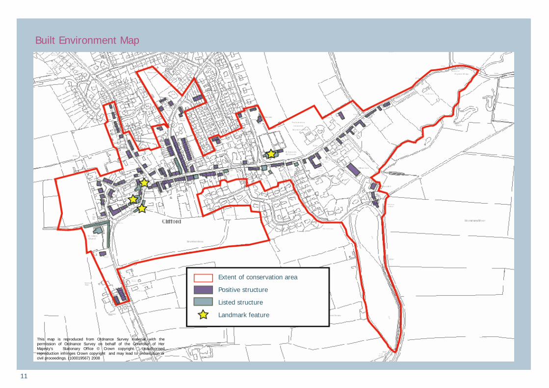
Built Environment Map
Extent of conservation area
Positive structure
Listed structure
Landmark feature
This map is reproduced from Ordnance Survey material with the permission of Ordnance Survey on behalf of the Controller of Her Majesty’s Stationary Office © Crown copyright. Unauthorised reproduction infringes Crown copyright and may lead to prosecution or civil proceedings. (100019567) 2008

12
individual buildings and the wider streetscape. Retention of chimneys and original painted timber windows is particularly important in retaining the historic character of the area.
Action: Surviving historic features should be retained and where necessary s y m p a t h e t i c a l l y r e p a i r e d . Opportunities to reinstate lost features should be capitalised upon.
Article 4 Directions Conservation area designation controls the demolition of buildings and strengthens some planning rules, but it does not prevent the removal of historic features such as traditional windows or boundary walls. The City Council has the
power to restrict such changes through a rule known as an Article 4 Direction and can do so if there is public support for such action. This would alter the planning rules so that householders would need planning permission for the removal or replacement of features such as boundary walls, windows, doors or roof materials. This could help to protect the character and appearance of the conservation area but needs to be carefully considered to ensure it is an appropriate response to the situation of the village. Action: Determine the level of public support for the introduction of an Article 4 Direction. Protect archaeological remains Clifford has been inhabited for over 1000 years and buried evidence of past occupation is likely to survive. Development which may disturb archaeological remains may require a watching br ief to ensure the preservation of archaeological finds. Action: Development which involves below-ground excavation must have regard to the potential for archaeological finds.
Successful new development in historic areas should: • Relate well to the geography and
history of the place and the lie of the land
• Sit happily in the pattern of existing development and routes through and around it
• Respect important views • Respect the scale of neighbouring
buildings • Respect historic boundary walls and
retain historic garden plots • Use materials and building methods
which are as high in quality as those used in existing buildings
• Create new views and juxtapositions which add to the variety and texture of their setting.
(CABE and English Heritage) Action: New development must respond sensitively and creatively to the historic environment. P r o t e c t s u r v i v i n g h i s t o r i c architectural forms As a result of the limited listed building coverage in the settlement, there has been some incremental loss of traditional architectural detailing in the conservation area. Replacement of windows and doors with inappropriate materials and designs is a negative feature that affects both
Management Plan Opportunities for management and enhancement Clifford is an attractive village which retains its historic character. This management plan sets out a number of principles to guide any future changes in the conservation area. Posit ive conservation management will ensure the ongoing protection of the village’s special character. Sensitive new development in the conservation area To be success fu l , any fu ture development within the conservation area needs to be mindful of the local character of the village, while at the same time being distinctly of the 21st century and addressing contemporary issues such as sustainability.
Houses with a simple shape and form and little ornamentation are typical of the village
Part of the Clifford mills complex near the site of the old mill pond. The surviving wagon arch on the property to the left gives the dwelling a unique character and a sense of historical integrity.

13
Tree management Trees make an important contribution to the character of the conservation area, particularly around St Luke’s Church and on the edges of the village. The City Council must be notified of any proposal to fell or lop a mature tree in the conservation area. Consideration should be given to ensuring continued tree cover in the future by planning for the succession of over-mature trees. Native species should be favoured. Action: Mature trees which make a positive contribution to the character of the conservation area should be retained whenever possible. Opportunities should be taken as appropriate to plant young trees to ensure continued existence tree cover in the future. Boundary Treatments Magnesian limestone boundary walls, pointed in lime mortar, are a positive feature of Clifford. Existing walls above 1 metre next to a road, or 2 metres elsewhere, are protected from demolition in the conservation area. Any new boundary walls in the conservation area should be constructed of local materials and be of appropriate height and coursing to fit well with existing walls. Fencing is atypical of the village and should be resisted.
Action: Stone boundary walls which make a positive contribution to the conservation area will be retained. New boundary treatments should fit with the character of existing boundary walls and should be constructed from matching limestone. Public realm Clifford’s character as a rural village should be respected in the provision of any future public realm enhancements. The design of items of street furniture such as litter bins, benches and bus shelters should be appropriate for the character of the conservation area. The design and siting of road signs should not detract from the character of the conservation area and the use of high-visibility backing boards is not generally appropriate in the conservation area. As at present, road lining should be kept to a minimum. Regard should be had to current “Streets for All” guidance jointly published by English Heritage and the Department for Transport. Action: The siting and design of road signs and street furniture and the use of surfacing materials should have regard to current “Streets for All” guidance.
Action: Any development proposing the infill of a site or the subdivision of a plot should respond to the scale, massing, layout and distribution of positive structures within the conservation area. The historic toft-and-croft plan should be respected. Development affecting the setting of the conservation area Clifford’s rural setting makes a significant contribution to its character. Any future development affecting the setting of the conservation area should have regard to views into and out of the conservation area, the setting of positive buildings and the character of the landscape. Appropriate design, materials and layout should be used in any development adjacent to the conservation area. Action: The impact of development on the character and appearance of the conservation area should be considered. This applies equally to d e v e l o p m e n t o u t s i d e t h e conservation area if it is likely to affect the sett ing of the conservation area.
Infill and backland development A number of bui ldings in the conservation area lie in sizeable plots. Opportunities for infill development are limited and development which would harm the character of the conservation area by disrupting the relationship between existing buildings or the spaces around them should be resisted. Intensification of development which would disrupt the character of the conservation area should also be resisted. The subdivision of the linear burgage plots will further erode the medieval plan form of the village and harm its character. The scale, massing and proportion of buildings as well as the spaces between them are important in retaining the character of the conservation area.
Views down burgage plots are important to the character of the conservation area, as are long linear rear gardens. Both are increasingly rare and are a key link to the medieval plan form of the village.

14
References Publications: • Cabe and English Heritage, Bui ld ing in Context: New development in historic areas 2001 • Pevsner,N. Yorkshire West Riding,
London 2009 • Lane Fox H, Chronicles of a
Wharefdale Parish 1909 • Stones I, Clifford Village and Flax
Mill, Yorkshire History Quarterly, Vol 2, No 3 pp 109-111
• Stones I, Clifford Village and Flax Mill, Yorkshire History Quarterly, Vol 2, No 4 pp 143-146
Acknowledgements • The preparation of this report
was made possible through funding by the North East Outer Area Committee of Leeds City Council.
• Ian Sanderson and Jason Dodds of West Yorkshire Archaeological Advisory Service provided archaeological information and advice.
Copyright Maps based on Ordnance Survey material are reproduced with the permission of the Ordnance Survey on behalf of the Controller of Her Majesty’s Stationery Office © Crown copyright. Unauthorised reproduction infringes
Crown copyright and may lead to prosecution and/or civil proceedings. The map data, derived from Ordnance Survey mapping, included within this publication is provided by Leeds City Council under licence from Ordnance Survey. Leeds City Council Licence No. (100019567 2008).
Where to find out more Wetherby & District Historical Society is active and has a long history of study of local historic buildings and people. A wide range of original documents, public records and books can also be found in the following locations:
• Wetherby Library (Local History Section)
• Central Library (Local & Family History Section), website: www.leeds.gov.uk/library
• West Yorkshire Archive Service, Chapeltown Road, Sheepscar, Leeds. Their website is: www.archives.wyjs.org.uk
• West Yorkshire Archaeological Advisory Service, Wakefield. T h e i r w e b s i t e i s : www.archaeology.wyjs.org.uk
In addition, much information is available on other websites:
• www.heritagegateway.org.uk includes all l isted building descriptions and some photos
•
• www.leodis.net has archive
photos of the Leeds district • www.old-maps.co.uk has early
Ordnance Survey maps. How to find out more about historic buildings Leeds Central Library has a large architecture collection which includes books on historic buildings. A useful general book on understanding historic houses is How Old is Your House? By Pamela Cunnington (most recent publication 2002). Shire Books also publish a range of excellent short books on historic buildings. There are a wide range of national societies devoted to the study and conservation of historic buildings. Many of these national bodies have regional groups in Yorkshire. • Society for the Protection of
Anc ient Bu i l d ings (SPAB) www.spab.org.uk . A good source of practical information about looking after buildings of all periods.
• Ancient Monuments Society www.ams.org.uk . Devoted to the study and conservation of ancient monuments, historic building and fine old craftsmanship, with a particular interest in church buildings.
• G e o r g i a n G r o u p
www.georg iangroup.o rg .uk Interested in the study and
• conservation of 18th- and early 19th-century buildings.
• V i c t o r i a n S o c i e t y www.victoriansociety.org.uk Interested in the appreciation and conservation of 19th and early 20th century buildings of all types.
• 2 0 t h C e n t u r y S o c i e t y www.c20century.org.uk Active in promoting appreciation and protection of 20th century architecture.
Adult education courses on historic buildings and/ or local history are sometimes run in the Leeds area. Check with your local provider for current information.

15
Finding Out More What is a conservation area?
A conservation area is ‘an area of special architectural or historic interest the character or appearance of which it is desirable to preserve or enhance’.
Section 69 of the Planning (Listed Buildings and Conservation Areas) Act 1990.
What does conservation area status mean?
Conservation area status provides the opportunity to promote the protection and enhancement of the special character of the defined area. Designation confers a general control over development that could damage the area’s character. The details are complex but can be summarised as: • Most demolition requires permission
and will be resisted if the building makes a positive contribution to the area.
• Some minor works to houses is no longer "permitted development" and will require planning permission. Examples are rear dormer windows, external cladding and most satellite dishes on front elevations.
• Advertisement controls are tighter • Most work to trees has to be notified
to the Council which has six weeks in which to decide to impose restrictions.
• Generally, higher standards of design apply for new buildings and alterations to existing ones.
Change is inev i tab le in most conservation areas and it is not the intention of the designation to prevent the continued evolution of places. The challenge within conservation areas is to manage change in a way that maintains, reinforces and enhances the special qualities of the area. What is the purpose of this appraisal?
This appraisal provides the basis for making informed, sustainable decisions in the positive management, protection and enhancement of the conservation area. It provides a clear understanding of the special interest of Clifford by: • accessing how the settlement has
developed • analysing its present day character
and • ident i fy ing opportuni t ies for
enhancement This appraisal follows the current guidance set out by English Heritage in the 2006 publication Guidance on Conservation Area Appraisals.
The appraisal is not intended to be comprehensive and the omission of any particular building, feature or space should not be taken to imply that it is of no interest.
Planning policy context
This appraisal should be read in conjunction with the wider national, regional and local planning policy and guidance. Relevant documents include: • Planning (Listed Buildings and
Conservation Areas) Act 1990 • Planning Policy Guidance 15:
P l a nn i n g a nd t he H i s t o r i c Environment
• Planning Policy Guidance 16: Archaeology and Planning
• The Yorkshire and Humber Plan (The Regional Spatial Strategy) May 2008, particularly Policy ENV9 Historic Environment
• Leeds C i ty Counc i l , Un i tary Development Plan Review 2006, particularly Chapter 5 Environment and Appendices A3 Building Design, Conservation and Landscape Design and A4 Archaeological Policies
• L e e d s C i t y C o u n c i l , L o c a l Development Framework, emerging document that will ultimately replace the Local Plan.
Community involvement and adoption
This draft appraisal will go through a public consultation process. A six week period of public consultation will include: • A public meeting to discuss the
proposed changes • The appraisal will be made available
through the Council’s website • Leaflets will be delivered to all
homes affected by the proposed change to the conservation area boundary.
The consultation responses will be evaluated and the appraisal amended in light of comments received. This document is intended to be approved by Leeds City Council in February 2010. Once adopted, the appraisal will be a m a t e r i a l c o n s i d e r a t i o n w h e n applications for change within the conservation area or its setting are considered by the Council.
Published in December 2009 by the Sustainable Development Unit, Leeds City Council, The Leonardo Building, 2 Rossington Street, Leeds LS2 8HD Tel 0113 2224409 email: [email protected] website www.leeds.gov.uk/conservation

16