click here: draft of new mendenhall - mendenhall, ms
TRANSCRIPT
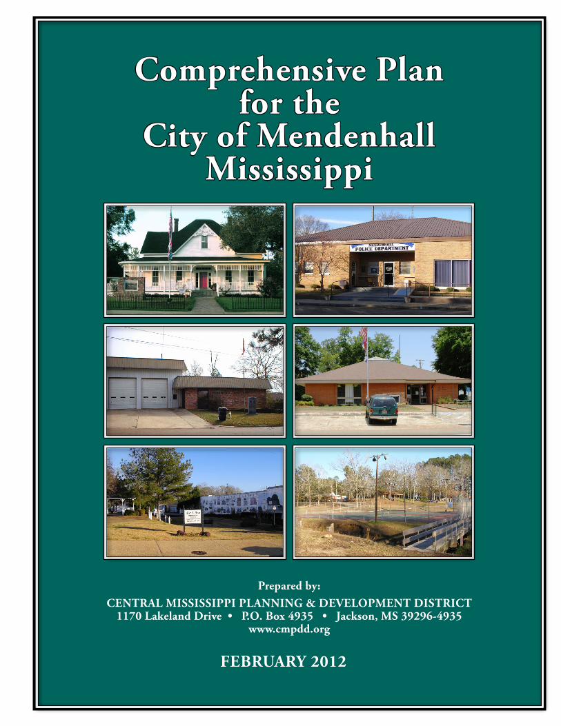
Comprehensive Plan for the
City of MendenhallMississippi
Prepared by:Central MississiPPi Planning & DeveloPMent DistriCt
1170 Lakeland Drive • P.O. Box 4935 • Jackson, MS 39296-4935 www.cmpdd.org
FeBruary 2012
CITY OFFICIALS
MAYOR AND BOARD OF ALDERMEN
Steve Womack, Mayor Tim Gray, Alderman At Large
Dale Feicke, Ward 1 Greg Paes, Ward 2
Ardell Washington, Ward 3 Thomas Lowery, Ward 4
OTHER OFFICIALS
Bill Smith, Board Attorney Kathy Brien, City Clerk
Alexander “Candy” McCullum, Chief of Police Wayne Walker, Chief of Fire Department
Kenneth “Red” Lewis, Superintendent
CITY OF MENDENHALL, MISSISSIPPI COMPREHENSIVE PLAN
TABLE OF CONTENTS
PAGE PREAMBLE ....................................................................................................................................1 INTRODUCTION ...........................................................................................................................2 Purpose of the Comprehensive Plan ....................................................................................2 Components of the Plan .......................................................................................................2 HOW TO USE THIS PLAN ............................................................................................................4 Overview ..............................................................................................................................4 Use of the Plan .....................................................................................................................5 Nonconformance of the Plan and Plan Amendments ..........................................................5 Implementation Devices ......................................................................................................6 CHAPTER I: GOALS AND OBJECTIVES ..................................................................................7 General Goals and Objectives ..............................................................................................7 Community Facilities and Services Goals and Objectives ..................................................8 Environmental Goals and Objectives ...................................................................................9 Residential Development Goals and Objectives ..................................................................9 Commercial Development Goals and Objectives ..............................................................10 Industrial Development Goals and Objectives ..................................................................10 Parks and Open Space Goals and Objectives ....................................................................11 Transportation Goals and Objectives .................................................................................11 Downtown Heritage District Goals and Objectives ...........................................................11 CHAPTER II: LAND USE PLAN ...............................................................................................12 Introduction and Methodology ..........................................................................................12 Existing Land Use Methodology .......................................................................................12 Existing Land Use Map .....................................................................................................14 The Land Use Plan .............................................................................................................15 Future Land Use Map ........................................................................................................21 Population Estimates ..........................................................................................................22 Population Characteristics .................................................................................................23 Economic Characteristics ...................................................................................................26 CHAPTER III: TRANSPORTATION PLAN ..............................................................................28 Introduction ........................................................................................................................28 Thoroughfares Plan: Functional Classifications ...............................................................28 Minimum Rights-of-way and Surface Width Requirements .............................................29 Generalized Roadway Capacities ......................................................................................30 Annual Average Daily Traffic Counts on Major Thoroughfares.......................................30 Proposed Thoroughfare Improvements..............................................................................31
TABLE OF CONTENTS CONTINUED:
PAGE CHAPTER IV: PUBLIC FACILITIES PLAN .............................................................................32 Introduction ........................................................................................................................32 Section 1: City Hall ...........................................................................................................32 Section 2: Police Department............................................................................................34 Section 3: Fire Protection..................................................................................................35 Section 4: Utilities (Water & Sewer) ................................................................................36 Section 5: Parks and Recreational Facilities .....................................................................39 Section 6: Public Library System .....................................................................................43 Section 7: Public Schools..................................................................................................46 Section 8: Housing ............................................................................................................47
PREAMBLE
The City of Mendenhall, formerly known as Edna, was organized as a town in 1890. The name was changed from Edna to Mendenhall in 1901 in honor of Thomas L. Mendenhall, advisor and attorney for the Simpson County Board of Supervisors in 1873. Mr. Mendenhall helped fill many pages of the town’s rich history. Mendenhall was selected as the official county seat after a bitter battle over the courthouse removal from old Westville (near Pinola). The county seat had previously moved from Westville to Mendenhall in 1900, and then back to Westville in 1905 when a lawsuit was filed claiming courthouse removal was unconstitutional. Finally, after much controversy over its removal from Mendenhall, the Supreme Court decided in favor of Mendenhall on July 12, 1906. The courthouse, perched atop Main Street, was completed on November 28, 1907, at a cost of $59,000. The Simpson County Courthouse in Mendenhall is one of Mississippi’s finest courthouses and is listed on the National Register of Historic Places. Mendenhall is located just 32 miles southeast of Jackson and 126 miles north of the Mississippi Gulf Coast. The City is governed by a mayor and board of five (4) aldermen. Mendenhall boasts various historic sites. The City initially flourished because of the railroad industry. The first hotel was built across the railroad from downtown on Main Street in 1911. Mrs. Hatti Heil began serving meals there to trainmen and travelers who stopped for lunch. The Heil Hotel became the Mendenhall Hotel and is home to the nationally known Revolving Tables. Gulledge Lumber Company was one of the pioneer industries in Mendenhall, with operations beginning in 1916 and continuing until 1925. Mr. Fred Bourn opened Mendenhall Grocery and Grain in 1928, and though it has changed ownership numerous times over the years, it has never closed its doors. It is currently owned and operated by Pam Jones and host book signings and markets Mississippi made products. The Mendenhall Ministries (TMM) began in the 1960’s, under the name of Voice of Calvary Ministries, (VOC) by John Perkins. The vision attracted many concerned people, and grew into a ministry known for providing progressive local leadership within the community to address problems of poor housing, segregated and unequal education, lack of employment opportunities, and lack of capital-trapping institutions within the black community. In recognition of a job well done, former President George W. Bush presented TMM with the number 541 Daily Point of Light Award in 1991. Through its volunteer ministry, over 1,000 individuals representing over 30 organizations, nation-wide, are exposed to Christian community development annually. Many of these individuals return to their communities and replicate what they see and learn at TMM. Mendenhall has experienced little growth over the past 40 years. In 1970, the population of Mendenhall was 2,402. The recently completed 2010 census indicated a population of 2,504, a growth of only four percent (4%) in a 40 year period. The 2000 census showed Mendenhall’s highest population when the population was 2,555.
2
INTRODUCTION PURPOSE OF THE COMPREHENSIVE PLAN The City of Mendenhall recognizes that in order to make both effective and economically sound decisions for the future, some type of policy must govern the decision-making process. The purpose of this Comprehensive Plan is to serve as a policy guide for the physical and economic development of the city. The Plan will serve decision-makers as a means of orderly development for the city at a minimal cost to the city. COMPONENTS OF THE PLAN Section 17-1-1 of the Mississippi Code defines a Comprehensive Plan as follows: "...a statement of public policy for the physical development of the entire municipality or county adopted by resolution of the governing body..." A Comprehensive Plan must include a minimum of four components in order to comply with the statute. These components are long-range goals, objectives, and policies, a land use plan, a transportation plan, and a community (public) facilities plan. The goals and objectives of a Comprehensive Plan are made with respect to the future. Long-range development plans help a county identify what it desires to achieve in the following decades. Section 17-1-1 of the Mississippi Code requires that the goals and objectives section of the plan address residential, commercial, and industrial development as well as parks, open space, and recreation. Additionally, street or road improvements, public schools and community facilities must be considered. The second part of a Comprehensive Plan is the Land Use Plan. This plan designates, in map form, the proposed distribution and extent of land use for residential, commercial, industrial and recreational lands, as well as public and quasi-public facilities and open space. The Land Use Plan chapter contains projections of population and employment as the basis for land use projections. The third part of a Comprehensive Plan is the Transportation Plan. The Transportation Plan presents a “Thoroughfares Plan” that includes the classifications of all existing and proposed streets, roads and highways; these are depicted in map form as an integral part of the Land Use Plan. The plan identifies arterial, collector and local streets, and roads and highways, as defined by minimum rights-of-way and surface width requirements. The Transportation Plan also addresses other transportation needs, such as general aviation airport needs. The final portion of the Comprehensive Plan is the Community (or Public) Facilities Plan. Used as a basis for making capital improvement decisions, the Community Facilities Plan includes twenty-five year projections (to 2035) of needs for: parks and recreation, public buildings and facilities, utilities and drainage, schools, and housing. The capital improvements program, which
3
is not a part of this Comprehensive Plan, schedules these improvements by priority and cost for five or six-year time periods. The City of Mendenhall recognizes that the quality of life in developing areas is affected by the quality of development. People and businesses are attracted to higher quality developments. In fact, other areas around the country have discovered that quality development breeds more quality development. All development should be examined as to its effect on the city's image, because it is the city's image that is at stake. It is a well-known fact that one of the factors a business/industry considers in determining a location is the quality of life in a community. Quality of life includes such amenities as shopping, cultural and recreational opportunities, good schools, and attractive business and residential areas. A community desperate for development without regard to the quality of that development will not be able to successfully compete with communities that are more concerned with the quality of development and other quality of life issues. Therefore, the City intends to foster those policies that will make this a more competitive community.
4
HOW TO USE THIS PLAN OVERVIEW As noted in the Introduction, a Comprehensive Plan serves as a policy guide for the physical and economic development of the community. It is to be used in making decisions regarding rezonings, zoning variances, special exceptions, and site plan review. It may also be used to aid in locating business, industries, and public facilities. Finally, it forms the basis of a Capital Improvements Program, which schedules capital improvements by priority and funding source into a five or six-year program. Comprehensive planning does not attempt to replace market forces of supply, demand, and price but serves to shape and channel market forces by establishing certain rules for development and conservation. A Comprehensive Plan should foster growth that enhances the county. For example, haphazard growth is unsightly and wasteful of space and public facilities, which results in higher public costs and property tax increases. According to Mississippi law, zoning and other land use regulations must be based upon a Comprehensive Plan. The implication is that Comprehensive Plans must precede land use regulations in preparation and adoption. Regulations that are consistent with, or conform to a Comprehensive Plan must be consistent with a plan's policies, goals and objectives as well as the land use plan map and the other plan elements. Even though there is generally not an exact identity between the land use map and zoning map, the two should mirror each other as closely as possible. The reason for such consistency or compatibility is that the courts are likely to uphold land use decisions when these decisions are based on plans. For example, when challenged on taking grounds, land use decisions requiring a more intensive zoning (zoning to a more intensive use) or a “downzoning” (zoning to a less intensive use), are likely to be upheld by the courts when based upon an adopted Comprehensive Plan. The Comprehensive Plan is a set of written, consistent policies about how the community should develop. The plan enables the legislative body to make decisions when development matters that arise, by using a unified set of general, long-range policies. The plan is supposed to serve as a practical working guide to the governing body in making decisions. The City of Mendenhall intends to use the Comprehensive Plan to take action on two types of physical development matters: (1) measures which are specifically designed to implement the Comprehensive Plan (zoning ordinance, subdivision regulations, capital improvements program and budget, and development plans), and (2) other measures that routinely require legislative approval (rezoning cases, special exceptions/conditional use permits, variance applications, subdivision plats, and public works projects). For both types, the Plan should at least be consulted to see if the Plan speaks specifically to the matter or provides any guidance as to how the matter should be handled. It should be remembered that the plan may not indicate what

5
action to take, nor will it answer all the questions that come before the Mayor and Board of Aldermen. It is not supposed to; its purpose is to serve as a generalized guide, which has the force of law in many communities. USE OF THE PLAN The proponent or applicant for a zoning change must show that the proposed change is in conformance with the Comprehensive Plan. The applicant must also show that there is a public need for the kind of change in question, and that the need will be best served by changing the zoning classification of the property in question. Usually, a rezoning's conformance or nonconformance can be quickly established by looking at the Land Use Plan map. The colored designations of land use categories on the map should follow specific boundaries to be useful as a decision-making guide. Arbitrarily drawn land use boundaries can make it difficult to determine into which map section a particular piece of property falls. If an applicant's property falls on or near the boundary between a conforming and a nonconforming land use category on the Land Use Plan map, the applicant should make a case that his particular proposal is consistent with the Plan to the nearest natural topographical boundary, or to the nearest street or property line. The applicant should also establish conformance with both the map and the text, if possible, and it is important that both the Plan and the facts showing conformance be placed into the record of the hearing. NONCONFORMANCE OF THE PLAN AND PLAN AMENDMENTS If a proposed change does not conform to the Plan, the Plan must be amended before the requested change in zoning classification can be approved. For all practicable purposes, if an applicant submits a plan amendment application to change the designation of a parcel of land, he should also submit a rezoning application. The application should explain exactly why a plan amendment and a zoning map amendment (rezoning) are needed. The reason for this is that the Planning Commission should be informed as to the intent or the end result of the plan amendment so that they can make an informed decision. Most proposed plan amendments are in pursuit of rezonings. All development proposals as well as proposed rezonings should be reviewed both in the light of the standards set forth in the Zoning Ordinance and in accordance with each element of the Plan. The goals, objectives, and policies should be checked against the proposal to determine if there is any conflict. The Land Use Plan must be checked to see if the proposed re-zoning is in line with the designated land use category. For example, if a proposed rezoning to a multi-family district is indicated, then the Land Use Plan must show a high-density classification for the site. The proposed rezoning must not be in conflict with the Transportation Plan's recommendations, nor with those of the Community Facilities Plan, both of which relate to capital improvements.
6
IMPLEMENTATION DEVICES Once the Plan has been adopted, it needs to be implemented. There are three primary means or devices commonly used to implement comprehensive plans: zoning ordinances, subdivision regulations, and capital improvements programs. Comprehensive plans should be reviewed at least every three years to determine if they need to be revised or amended. Plans should be completely revised/rewritten every five years to take advantage of changes that have occurred and to use current information. It should be emphasized this Comprehensive Plan is not “cast in concrete”, but can be amended as needed. However, justification should be clearly shown before any plan amendment is approved by the Mayor and Board of Aldermen.
7
CHAPTER I GOALS AND OBJECTIVES
The goals and objectives of the Mendenhall Comprehensive Plan and the continuous, comprehensive planning process are to provide guidance for rational response to change. They reflect ideally, consideration of a combination of community issues and facts blended with community values. Goals institute the conscious statements of a community concerning what it wants to become, and how it will direct its energy toward that achievement. The Mendenhall Comprehensive Plan begins with a set of general goals. These are followed by more specific goals in the following areas: land use, community facilities and services, environmental, residential, commercial, industrial, parks and open space, and transportation. GOAL: The ultimate purpose of an effort stated in a way that is general in nature and not
easily measured.
OBJECTIVE: A more specific, measurable goal. This plan may be implemented by a zoning ordinance, subdivision regulations, and a capital improvements program, in addition to other growth management techniques. According to State law the plan must be consistent with the implementing regulations. Therefore, the policies in the plan must be reflected in the above three implementation devices (zoning ordinance, subdivision regulations and capital improvements program). In order to be effective as guidelines for day-to-day decision-making, the policies in this plan will supersede the zoning and subdivision regulations in cases where there are conflicts between regulations and policies or where the regulations are not clear. GENERAL GOALS GOAL: Among other things, this Comprehensive Plan is designed to:
• Improve transportation; • Improve public safety; • Encourage economic development; • Prevent the overcrowding of land; • Continue to promote a better quality of living within Mendenhall.
GOAL: To provide for an orderly arrangement of land uses in Mendenhall.
OBJECTIVE: To encourage proper land use patterns and to enforce zoning laws to insure compatibility of land uses. To provide a mechanism through which development and redevelopment will be in accordance with the City’s Land Use Plan.
8
OBJECTIVE: To recognize the desirability for separation of land uses into compatible types.
OBJECTIVE: To grade land uses by type, character, intensity and orientation
with particular emphasis on the relationship between adjacent residential and commercial uses.
OBJECTIVE: To separate incompatible land uses and provision of open space
buffering to reduce possible conflicts where different land use classifications adjoin.
GOAL: Through new developments to make the city a healthy, safe and convenient place,
and to provide a pleasant and attractive atmosphere for living, shopping, recreation, civic and cultural, and service functions.
OBJECTIVE: To ensure that future development will be in the best interest of the
city and its citizens, measures will be taken which will generally improve the quality of life of the citizens of this city.
GOAL: To guide and direct the development of the foreseeable future into desirable forms
and patterns rather than inefficient sprawl.
OBJECTIVE: To prevent the inefficient use of land. By using the comprehensive plan as a guide to development, the desired land use pattern will be produced.
GOAL: To promote compatibility in land uses and to promote orderly expansion of urban
growth to provide efficient use of resources.
OBJECTIVE: To coordinate land uses so as to create a functional and appealing image for the city.
OBJECTIVE: To protect and preserve property values.
COMMUNITY FACILITIES AND SERVICES GOALS GOAL: To provide public facilities and services in a cost efficient manner and in a
manner that makes public facilities accessible and convenient to the city’s inhabitants.
OBJECTIVE: To provide public facilities in a cost efficient manner.
GOAL: To develop public facilities in a manner that is accessible, convenient, and that
most effectively serves the city.
9
OBJECTIVE: To foster a well-funded and up-to-date school system that will insure quality education for all citizens of Mendenhall.
OBJECTIVE: To develop plans for needed public facilities; to acquire open land
appropriate in character at the proper time; and to encourage their continued development, maintenance, and optimum use by the public to meet the needs of today and of the future.
ENVIRONMENTAL GOALS GOAL: To recognize and consider environmental and other natural hazard constraints in
the establishment of land use patterns.
OBJECTIVE: To manage flood plain development.
OBJECTIVE: To control land management practices and land development in a manner that is environmentally sound.
GOAL: To promote the control and regulation of the adverse effects of development such
as noise, light, odor, etc., within the city. GOAL: To recognize the value of the natural environment and its importance in creating
the rural/suburban atmosphere of Mendenhall.
OBJECTIVE: To preserve such natural features as is necessary and feasible. RESIDENTIAL DEVELOPMENT GOAL: To promote development of residential land uses that are compatible with each
other and with surrounding land uses.
OBJECTIVE: To develop a Land Use Plan identifying appropriate locations for different types of residential land uses in order to preserve the property values of homeowners.
GOAL: To establish a residential density pattern that will produce desirable
concentrations of residences and will not overburden the local community facilities or cause congestion.
OBJECTIVE: To establish lot size requirements for each type of residential
development. GOAL: To foster and encourage a balance of housing opportunities which are responsive
to diverse market preferences and needs, and which stress quality design and development through fair, objective standards and regulations.
10
OBJECTIVE: To allow a variety of dwelling types and to provide housing opportunities for a wide cross section of the population.
OBJECTIVE: To maintain a supply of affordable housing and other housing at a
relatively low cost for low and moderate income households.
GOAL: To guide and direct development in the foreseeable future into desirable forms and patterns.
OBJECTIVE: To prevent the inefficient use of land. Public facilities such as
roads, water, sewer, and storm drainage should be provided to areas of the city in a cost-efficient manner. Vacant properties with underutilized facilities are wasteful of public funds and redevelopment of such properties should be encouraged.
GOAL: To protect residential neighborhoods from encroachment by intensive commercial
uses and all industrial uses. OBJECTIVE: To protect residential property values. COMMERCIAL DEVELOPMENT GOAL: To promote development of well-designed, attractive commercial uses in areas of
the City that are suitable for and compatible with the particular use proposed.
OBJECTIVE: To segregate commercial uses on the Land Use Plan by intensity of use. Commercial uses which involve outdoor activities, heavier vehicular traffic, and noise should be located well away from ALL residential uses.
INDUSTRIAL DEVELOPMENT GOAL: To encourage continued expansion and development of industrial land use areas
in locations offering maximum potential for development but compatible with surrounding land uses and transportation facilities.
OBJECTIVE: To promote the efficient utilization of industrial land resources.
GOAL: To provide well-located sites adequately served by highways, railroads, utilities
and services for new industrial development.
OBJECTIVE: To promote new industrial development.
11
PARKS AND OPEN SPACE GOAL: To develop parks and open space to insure that the long-range open space and
recreational needs of the citizens of Mendenhall are met.
OBJECTIVE: To commit to the enhancement of the overall community by providing safe, well-maintained, and steadily-improving facilities that promote activities for the physical and mental well-being of citizens of all ages, including our senior citizens and youth.
OBJECTIVE: To improve and expand the existing recreational facilities.
TRANSPORTATION GOAL: To provide an efficient and a safe transportation system which will meet the travel
demands of motorists by implementing traffic operational improvements and major road projects, such as widening of thoroughfares and construction of new roads where needed.
OBJECTIVE: To provide better traffic flow, to reduce traffic congestion and
accidents, and to improve vehicular accessibility and circulation. OBJECTIVE: To build on and upgrade existing roadway resources and to add
new roads to accommodate expected future development and increased traffic.
DOWNTOWN HERITAGE DISTRICT GOAL: To preserve the character of the Downtown District of Mendenhall by preventing
location of inappropriate land uses throughout the District and prohibiting incompatible architectural design and materials throughout the District.
OBJECTIVE: To prescribe land uses in the Zoning Ordinance which are
compatible with the character of the area including: single-family detached residential, "indoor" commercial uses (where there is little or no outdoor storage or display of merchandise) and multiple-family residential uses as special exceptions.
OBJECTIVE: To prescribe a list of prohibited land uses in the Zoning Ordinance
which are deemed to be incompatible with the character of the Downtown District of Mendenhall.
12
CHAPTER II LAND USE PLAN
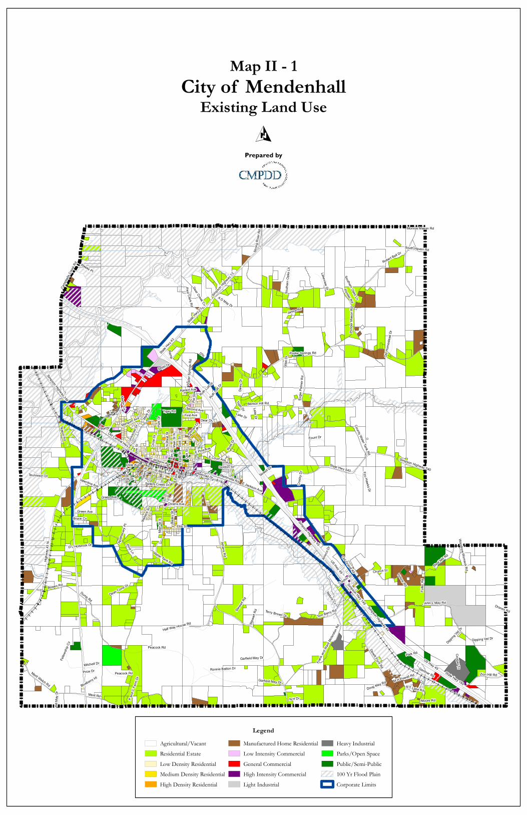
INTRODUCTION AND METHODOLOGY Section 17-1-1 of the Mississippi Code specifies that the Land Use Plan element of the Comprehensive Plan shall designate "---in map or policy form the proposed general distribution and extent of the uses of land for residences, commerce, industry, recreation and open space, public/quasi-public facilities and lands." The Code also requires that "background information shall be provided concerning the specific meaning of land use categories depicted in the plan in terms of the following: residential densities; intensity of commercial uses; industrial and public/ quasi-public uses; and any other information needed to adequately define the meaning of land use codes (reflected on the Land Use Plan map). Projections of population and economic growth for the area encompassed by the plan may be a basis of quantitative recommendations for each land use category." The purpose of the land use section of the comprehensive plan is to inventory the community's existing land use patterns and to recommend policies for future development that are consistent with the community's character. These policies also involve decisions on how the land use patterns should change for future needs. The Land Use Plan is a vital part of the Comprehensive Plan since zoning decisions are required by State law to be based on the adopted Land Use Plan. The Land Use Plan is subject to change as the City grows and may be amended at any time following the necessary public hearings. In addition to an existing land use inventory, population, housing, and employment projections are also used to determine future development patterns. Population, housing, and employment projections establish patterns of expected future development. The land use section, in particular, serves as a guide for reviewing private development proposals and for making decisions on the location of public facilities. EXISTING LAND USE METHODOLOGY The land use survey is traditionally the most important survey of the planning process. This survey is a field Awindshield@ survey conducted throughout the entire the study area. The field work was recorded on a base map and aerial photographs, and each parcel was coded according to its present land use and then transferred to a large base map, which is divided into the following categories:
1. Agricultural/Vacant 2. Residential Estate 3. Low density residential 4. Medium density residential 5. High density residential
13
6. Manufactured homes 7. Low intensity commercial 8. General commercial 9. High intensity commercial 10. Limited industrial 11. Heavy industrial 12. Public/Semi public 13. Parks/Open Space
The existing land use map (see Map II-1) shows present land use patterns and provides a basis for the development of the future land use plan and future zoning map.
US Hwy 49State
Hwy 13
State Hwy 4
3
State Hwy 149
Simpson Highway 49Simpso
n High
way 13
Martinville Rd
Main
St S
Athens Rd
East
St
Old Central Hwy
Simpson Hwy 149
Eugie
Palm
er Rd
Smith Dr
Poplar Springs Rd
State Hwy 540
Highw
ay 43
N
John L May Rd
Merit Rd
Pine Ln
Gardner Rd
Old Gravel 49
Steel Mill R
d
Teapot Rd
Pond
er Ma
son R
d
N Ea
st St
Dixie Ave
Dump Rd
Simpson Highway 540
Peacock Rd
Tom Berry Rd
E Jackson Ave
Ponder Rd
Green Ave
Oak S
t
Benton Hill Rd
Dewitt Flynt Rd
Stewa
rt Rd
Mangum Ave
Merit Welch RdGarfield May Dr
Baile
y St
E Court AveW Jackson Ave
Circle
Dr
Bowen Rd
Simpson Highway 149
Zion Hill Rd
E Pine AveN We
st St
Downs Ave
Fulle
r Rd
Ellis St
Teunisson Dr
Ross
Dr
Weeks Pl
Frank
and W
ard M
clend
on RdHalf Way House Rd
County Water Tank Rd
Ramp
Dear Dr
D'lo
A D May Dr
Dean Cone Dr
P and
C Fa
rm Dr M H Powell Rd
Main
St N
Ronnie Batton Dr
Pittman
Dr
Dow
StUn
iversa
l Dr
Tiger Rd
Mark
Dr
N H Dr
Valentine Ave
First Ave
R T Lake Rd
Moore Rd
Lake Dr
Robert Bell Dr
Camp
bells
Creek
Rd
Mitchell Dr
Southern Oaks Ln
Blueberry Hl
Deer Creek Cv
Fellow
ship
Cir
W Bell Ave
Ruth Lo
tt Dr
Circle St
Fount Dr
Mary
St
Pat S
t
Stron
g Rive
r Rd
Dipping Vat Dr
Park
Dr
Lakeview Dr
Janice Rd
Price Dr
Nature Cv
Bruce Cv
Sellers Creek Dr
Giles
Dr
Doug May Rd
Paul Clark Rd
Layton St
Fou Hawks Dr
Terry Brown Dr
Martin Cir
Old H
omes
tead D
r
Wallac
e St
Apoth
ecary
Pt
South Haven Rd
Church St
Cros
by D
r
Bill M
ay D
r
Gordon St
Woodrow Womack Rd
Park Rd
Water Tank Rd
Victory Rd
Daisy
Dr
Sewell Dr
Second Ave
Drones Rd
Amoc
o DrD L Holbrook Dr
Cougar Trl
Rankin Ave
Tiger Dr
Elm S
t
Railroad Dr
Monroe Mason Rd
Garfield May Dr
East
St
US Hwy 49
Green Ave
Stewa
rt Rd
South
ern O
aks L
n
Lake Dr
Ruth Lo
tt Dr
Peacock Rd
Ramp
Simpson Highway 49
Popla
r Spri
ngs R
d
Dipping
Vat Dr
LegendAgricultural/VacantResidential EstateLow Density ResidentialMedium Density ResidentialHigh Density Residential
Manufactured Home ResidentialLow Intensity CommercialGeneral CommercialHigh Intensity CommercialLight Industrial
Heavy IndustrialParks/Open SpacePublic/Semi-Public100 Yr Flood PlainCorporate Limits
City of MendenhallExisting Land Use
Map II - 1
Prepared by
15
THE LAND USE PLAN Overview The land use plan represents a composite of all the elements of the planning program. With this context, the plan depicts in narrative, statistical and map forms the general relationships between land use patterns, major transportation arteries, schools, parks and other community facilities, and the overall environment of the community. Preparation of the land use plan was closely coordinated with the development of all other elements of the planning program, particularly the population and economic study, the transportation plan, and the community facilities plan. In addition to coordinating the land use proposals with other elements of the planning program, preparation of this study largely consisted of two major work elements. The first work element was determining quantities of various land use categories needed to sustain anticipated future city growth through the planning period. The second major work element was selecting areas of the community that were best suited for a particular type of urban activity. The land use plan should be used primarily as a general and long range policy guide to decisions concerning future land development. The adoption of these policies by the Mayor and Board of Aldermen establishes their dominance as a guide for land use decisions, and that they may change only by amending the plan. The land use plan shall also be used as a forecast of the future land needs of the city. Although the land use forecasts are for 20 to 25 years in the future, the life expectancy of the land use plan, for accuracy and applicability is five to six years. This emphasizes the need to revise the plan every five years. The plan is not a legal tool; however, because it forms the basis for the zoning ordinance, the subdivision regulations and other implementation documents, it does carry some legal weight. The plan should serve as a guide for consideration of amendments to the Zoning Ordinance, the Official Zoning Map, the Subdivision Ordinance, public improvements program and capital improvements budget. The land use plan map is intended to indicate broad categories of development for general areas of the city. In order to be useful to zoning, the land use map attempts to delineate exact boundaries wherever possible. Methodology This section of the Comprehensive Plan was developed using three processes involving plan formulation and evaluation. First, the spatial distribution of Mendenhall=s future land uses was made after applying specific locational criteria. Second, the amount of land allocated for future land uses was correlated with the demand for land in the year 2035. Last, a physical plan for future growth was developed, which attempts to use city resources and meet city needs in an effective and efficient manner. The quantities of land needed to accompany various activities in an urban area depend on a multitude of interrelated factors. The most important of these factors are the composition and the characteristics of the population, the economy of the area and the trends in the density of

16
development. Since all three of these factors are closely related, a change in one will cause a corresponding change in the other two. For example, the density of development is dependent, to a large degree, on raw land and development cost (economic factors). Therefore, if these costs increase, the density of the development usually increases, unless the costs are offset by a corresponding increase in income, sales or other economic factors. Although there are numerous methods and techniques used to forecast demands for the future land uses in urban areas, all of these techniques rely, directly or indirectly, on estimates of these factors. The future land use plan, in order to be useful as a policy tool for guiding land use decisions, must be carefully composed. In drafting the Land Use Plan (Map II-2), the following factors were considered:
1. Existing land use patterns and growth trends, 2. Projected future land use needs based on projected future population and
employment converted to the number of acres needed to accommodate projected growth levels,
3. Flood plains, excessive slopes (over 12 percent), and soil types, 4. Location of major streets and open space,
Location Criteria Locational criteria and guiding principles and standards used in the placement of activities on the land. These principles and standards have evolved over time within the planning profession and are recognized for their universal application. These criteria involve numerous considerations including danger from floods and other health and safety standards, the vulnerability of important environmental processes to urban activities, the proximity of one land use from another in time, distance and cost, the social, economic and environmental compatibility of adjacent land uses, physical characteristics of individual locations and their suitability for development and the pattern of land values. General principles relating to the location of land uses customarily identify five major functional areas: the work areas, the living areas, the shopping and leisure time areas, the community facility systems and environmentally critical areas of land and water. These principles can be expressed as follows:
1. Work areas should be located in convenient proximity to living areas where energy efficient interconnecting transit and thoroughfare routes can be designed to insure easy access back and forth; they should be in convenient proximity to other work areas and where uses incidental to one another have access to interconnecting truck routes. The spatial distribution of work areas should harmonize with intra urban patterns of firm interaction. Heavy concentrating of work areas should be avoided so as to disperse point sources of pollution. Some work areas should be in locations accessible to heavy transportation facilities and large capacity utility lines. Work area locations provide sites adequate in size, economic to develop and attractively situated for the particular uses intended.
17
2. Living areas should be located in convenient proximity to the work and leisure time areas and where there are nearby transit and thoroughfare routes to insure easy access. The spatial configuration of residential communities should take the activity and residential preference patterns of various categories of households into account. Living areas should be in convenient proximity to large open spaces and should include smaller open spaces, with residential areas within easy walking distance of community facilities. They should be located in areas protected from traffic and incompatible uses, in areas which are economic, energy efficient, and attractive to develop, and where desirable residential densities with a range of choice can be insured.
3. Shopping areas and entertainment centers such as shopping malls, restaurant
areas, cultural centers and educational complexes should be in convenient proximity to living areas. They should be in centrally located areas and on sites adequate for their purposes.
4. Community facility systems should be designed around the underlying service-
delivery concepts of each such system and its program, with service levels appropriate to the user groups of each facility. Recreational facilities, schools, libraries, medical care facilities, police and fire stations, and other community facilities should be in locations convenient to user groups and on sites economic to develop.
5. Open space system and environmental protection. Major parks and large open
spaces should be located so as to take advantage of, as well as protect, natural processes and unusual landscape features and to provide for a variety of outdoor recreational and other activities. Environmentally critical areas of land and water should be protected from incompatible uses and from pollutants generated by urbanization in the vicinity. Wooded areas that serve a functional purpose in climate, noise, light and pollution control should be preserved as part of an urban forest and open space system. Vulnerable urban development should not be located in areas of natural hazards to life and property such as floods, slides and unstable soils. Development using on-site sewage treatment should be prohibited from areas of unsuitable soil and geological conditions. Present and future water supply drainage basins should receive only urban development compatible with protection of the water quality.
Land Use Plan Map In order for the zoning map to be optimally effective, it should closely mirror the Land Use Plan (Map II-2). In addition to the land use map, other considerations in drawing the zoning map are:
1. How many sets of districts shall there be? 2. What is the character of each type of district? 3. What types of land are suitable for each type of district?
18
4. What should be the typical relationships between various types of districts? 5. Where should the various districts be located, in general? 6. Where should the exact boundary lines of each district run?
In mapping zoning districts, there is usually a compromise between the distracting pattern dictated by existing development and that called for by the land use plan. The land use plan becomes a guide for this decision making process, as well as for the deliberations to be followed in making later amendments to the zoning ordinance. Generally, zoning districts reflect certain principles as follows:
1. Compatibility of use 2. Appropriateness of the land 3. Locational needs of uses 4. Public Service effects
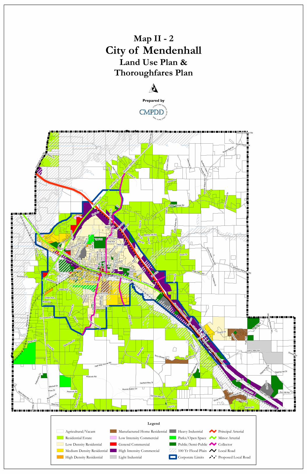
Explanation of Land Use Categories The Mendenhall Land Use Plan categorizes future land uses in the following manner:
1. Agricultural/Vacant 2. Residential Estate 3. Low density residential 4. Medium density residential 5. High density residential 6. Manufactured home residential 7. Low intensity commercial 8. General commercial 9. High intensity commercial 10. Light industrial 11. Heavy industrial 12. Public/Semi public 13. Parks/Open space
The following is an explanation of the specific meaning of land use color codes depicted on the Land Use Plan map contained in this report: AGRICULTURAL/RURAL (white): Maximum density of one single family detached residential unit per acre.
This land use classification depicts areas that are expected to remain rural or agricultural with no significant concentrations of residential, commercial, industrial or other development. These areas of the Land Use Plan are not expected to be served by municipal sewer service within the next 20+ years (by the year 2035).
19
RESIDENTIAL ESTATE (light green): Maximum density of one single family detached residential unit per acre.
This land use classification is intended to accommodate lower density residential development that is rural in character and may create a transition from agricultural areas to other suitable land uses. As sewer service and roads are extended to or improved in these areas, the Land Use Plan should be reviewed to allow areas to be re-classified to higher density residential development where appropriate.
LOW DENSITY RESIDENTIAL (yellow): Maximum density of three single family detached residences per acre.
This land use classification is intended to promote the development of single family detached dwellings on relatively large lots (approximately 11,500 square feet).
MODERATE DENSITY RESIDENTIAL (gold): Maximum density of five single family detached residential units per acre.
This land use classification allows the development of single family detached dwellings on moderate size lots (at least 8,500 square feet). This category includes the type of single family residence known as patio homes and also townhouses.
HIGH DENSITY RESIDENTIAL (orange): Maximum density of eight dwelling units per acre.
This land use classification allows the development of apartments or condominiums on arterial streets/roads or highways which have the capability of carrying higher traffic volumes generated by these higher density residences.
LOW INTENSITY COMMERCIAL (light pink): Restricted Commercial.
These areas should include: business and professional offices; personal services such as hair styling shops and photography portrait studios; instructional services such as dance studios; floral shops; and other similar uses that do not generate high vehicular traffic.
GENERAL COMMERCIAL (red): Enclosed Commercial Activities Only.
These areas should include businesses in which the principal activity is conducted indoors. However, certain land uses that involve some outdoor activities could be permitted in these areas. This land use classification would include shopping centers as well as independent commercial uses.
20
HIGH INTENSITY COMMERCIAL (purple): All Commercial Activities.
This classification would encompass all types of commercial uses, including outdoor commercial activities.
LIGHT INDUSTRIAL (light gray): Enclosed Industrial Activities Only.
This classification includes manufacturing and warehousing uses conducted primarily indoors. These manufacturing uses are those that do not generate noise, vibration or offensive odors detectable to human senses off the premises.
HEAVY INDUSTRIAL (dark gray): All industrial uses, including outdoor.
This classification includes manufacturing uses where all or part of the associated activities are conducted outdoors, or where the use requires large volumes of water or generates noise, vibration, etc., detectable off the premises.
PUBLIC/SEMI PUBLIC USES (dark green):
This land use classification includes all existing and proposed public/quasi-public uses such as churches, schools, governmental buildings and facilities, cemeteries, etc.
PARKS AND OPEN SPACE (light green):
This land use classification includes all existing and proposed parks, ballfields, bicycle/pedestrian tracks, and other similar uses.
US Hwy 49State
Hwy 13
State Hwy 4
3
State Hwy 149
Simpson Highway 49Simpso
n High
way 13
Martinville Rd
Main
St S
Athens Rd
East
St
Old Central Hwy
Simpson Hwy 149
Eugie
Palm
er Rd
Smith Dr
Poplar Springs Rd
State Hwy 540
Highw
ay 43
N
John L May Rd
Merit Rd
Pine Ln
Gardner Rd
Old Gravel 49
Steel Mill R
d
Teapot Rd
Pond
er Ma
son R
d
N Ea
st St
Dixie Ave
Dump Rd
Simpson Highway 540
Peacock Rd
Tom Berry Rd
E Jackson Ave
Ponder Rd
Green Ave
Oak S
t
Benton Hill Rd
Dewitt Flynt Rd
Stewa
rt Rd
Mangum Ave
Merit Welch RdGarfield May Dr
Baile
y St
E Court AveW Jackson Ave
Circle
Dr
Bowen Rd
Simpson Highway 149
Zion Hill Rd
E Pine AveN We
st St
Downs Ave
Fulle
r Rd
Ellis St
Teunisson Dr
Ross
Dr
Weeks Pl
Frank
and W
ard M
clend
on RdHalf Way House Rd
County Water Tank Rd
Ramp
Dear Dr
D'lo
A D May Dr
Dean Cone Dr
P and
C Fa
rm Dr M H Powell Rd
Main
St N
Ronnie Batton Dr
Pittman
Dr
Dow
StUn
iversa
l Dr
Tiger Rd
Mark
Dr
N H Dr
Valentine Ave
First Ave
R T Lake Rd
Moore Rd
Lake Dr
Robert Bell Dr
Camp
bells
Creek
Rd
Mitchell Dr
Southern Oaks Ln
Blueberry Hl
Deer Creek Cv
Fellow
ship
Cir
W Bell Ave
Ruth Lo
tt Dr
Circle St
Fount Dr
Mary
St
Pat S
t
Stron
g Rive
r Rd
Dipping Vat Dr
Park
Dr
Lakeview Dr
Janice Rd
Price Dr
Nature Cv
Bruce Cv
Sellers Creek Dr
Giles
Dr
Doug May Rd
Paul Clark Rd
Layton St
Fou Hawks Dr
Terry Brown Dr
Martin Cir
Old H
omes
tead D
r
Wallac
e St
Apoth
ecary
Pt
South Haven Rd
Church St
Cros
by D
r
Bill M
ay D
r
Gordon St
Woodrow Womack Rd
Park Rd
Water Tank Rd
Victory Rd
Daisy
Dr
Sewell Dr
Second Ave
Drones Rd
Amoc
o DrD L Holbrook Dr
Cougar Trl
Rankin Ave
Tiger Dr
Elm S
t
Railroad Dr
Monroe Mason Rd
Garfield May Dr
East
St
US Hwy 49
Green Ave
Stewa
rt Rd
South
ern O
aks L
n
Lake Dr
Ruth Lo
tt Dr
Peacock Rd
Ramp
Simpson Highway 49
Popla
r Spri
ngs R
d
Dipping
Vat Dr
LegendAgricultural/VacantResidential EstateLow Density ResidentialMedium Density ResidentialHigh Density Residential
Manufactured Home ResidentialLow Intensity CommercialGeneral CommercialHigh Intensity CommercialLight Industrial
Heavy IndustrialParks/Open SpacePublic/Semi-Public100 Yr Flood PlainCorporate Limits
Principal ArterialMinor ArterialCollectorLocal RoadProposed Local Road
City of MendenhallLand Use Plan &
Thoroughfares Plan
Map II - 2
Prepared by

22
POPULATION ESTIMATES Table II-1 contains population counts, estimates, and projections for Mendenhall. These Projections are in five-year increments from 2010 to the Comprehensive Plan target year 2035. The projections for the City were generated using the array methodology. The projections assume that past growth trends will continue into the future.
TABLE II-1 POPULATION ESTIMATES AND PROJECTIONS
YEAR SIMPSON COUNTY MENDENHALL
1970 19,947 2,402
1980 23,441 2,533
1990 23,953 2,463
2000 27,639 2,555
2010 27,503 2,504
2015 30,131 2,532
2020 32,759 2,559
2025 34,039 2,570
2030 35,319 2,581
2035 36,599 2,593 Source: U.S. Census Bureau and CMPDD

23
POPULATION CHACTERISTICS According to the 2010 U.S. Census, the City of Mendenhall=s population is 66% white and 32% black with 2% comprised of other races. 28% of the city=s population has a high school diploma or equivalent and 23% of the population has a college bachelor=s degree or higher. The following tables depict these demographics.
TABLE II-2 POPULATION BY RACE
RACE POPULATION PERCENTAGE
WHITE 1,649 65.9%
BLACK 810 32.3%
OTHER 45 1.8% Source: U.S. Census Bureau, 2010
CHART II-2 RACE BY PERCENTAGE

24
TABLE II-3 POPULATION BY SEX AND AGE
SEX/AGE NUMBER PERCENT
Male 1,157 46.2%
Female 1,347 53.8%
Under 5 years 193 7.7%
5 to 9 years 187 7.5%
10 to 14 years 175 7.0%
15 to 19 years 158 6.3%
20 to 24 years 166 6.6%
25 to 34 years 297 11.8%
35 to 44 years 271 10.8%
45 to 54 years 324 12.9%
55 to 59 years 140 5.6%
60 to 64 years 149 6.0%
65 to 74 years 237 9.5%
75 to 84 years 148 5.9%
85 years and over 59 2.4%
MEDIAN AGE (YEARS) 40.2 (X) Source: U.S. Census Bureau, 2010

25
CHART II-3 AGE DISTRIBUTION
TABLE II-4 EDUCATIONAL ATTAINMENT
Population 25 Years and Over
EDUCATIONAL ATTAINMENT NUMBER PERCENTAGE
Less than 9th Grade 267 15.4%
9th to 12th Grade, No Diploma 210 12.1%
High School Graduate 490 28.3%
Some College, No Degree 259 14.9%
Associate’s Degree 112 6.5%
Bachelor’s Degree 309 17.8%
Graduate or Professional Degree 87 5.0% Source: U.S. Census Bureau, 2010

26
CHART II-4 EDUCATIONAL ATTAINMENT
15.40%
12.10%
28.30%14.90%
6.50%
17.80%
5.00%Less than 9th Grade
9th to 12th Grade, NoDiploma
High School Graduate
Some College, NoDegree
Associate’s Degree
Bachelor’s Degree
Graduate or ProfessionalDegree
ECONOMIC CHARACTERISTICS According to the 2006-2010 U.S. Census, American Community Survey 5-Year Estimates the City of Mendenhall has a civilian labor force of 1,008 with 3.9% unemployed. As shown in Table II-6, the industry with the largest percent of the work force is educational, health and social services, with retail trade following a distant second. The highest percent of the work force by occupation are sales and office related occupations. This is followed closely by service occupations and management, business, science, and arts related occupations. The median family income is $31,932.
TABLE II-5 OCCUPATION
OCCUPATION NUMBER PERCENT
MANAGEMENT, BUSINESS, SCIENCE, AND ARTS 236 23.4%
SERVICE 244 24.2%
SALES AND OFFICE 260 25.8%
NATURAL RESOURCES, CONSTRUCTION, AND MAINTENANCE
120 11.9%
PRODUCTION, TRANSPORTATION, AND MATERIAL MOVING
148 14.7%
Source: U.S. Census Bureau, 2006-2010 American Community Survey

27
TABLE II-6 INDUSTRY
INDUSTRY NUMBER PERCENT
AGRICULTURE, FORESTRY, FISHING, HUNTING, AND MINING
73 7.2%
CONSTRUCTION 46 4.5%
MANUFACTURING 53 5.2%
WHOLESALE TRADE 48 4.8%
RETAIL TRADE 129 12.8%
TRANSPORTATION, WAREHOUSING, AND UTILITIES 44 4.4%
INFORMATION 18 1.9%
FINANCE, INSURANCE, REAL ESTATE, RENTAL, AND LEASING
44 4.4%
PROFESSIONAL, SCIENTIFIC, MANAGEMENT, ADMINISTRATIVE, AND WASTE MANAGEMENT
38 3.7%
EDUCATIONAL, HEALTH, AND SOCIAL SERVICES 315 31.3%
ARTS, ENTERTAINMENT, RECREATION, ACCOMMODATION, AND FOOD SERVICES
81 8.0%
OTHER SERVICES (EXCEPT PUBLIC ADMINISTRATION) 80 7.9%
PUBLIC ADMINISTRATION 39 3.9% Source: U.S. Census Bureau, 2006-2010 American Community Survey

28
CHAPTER III TRANSPORTATION PLAN
INTRODUCTION According to Section 17-1-1 of the Mississippi Code, the Transportation Plan must include a Thoroughfares Plan "...depicting in map form the proposed functional classification of all existing and proposed streets, roads, and highways for the area encompassed by the Land Use Plan and for the same time period as covered by the Land Use Plan. Functional classifications shall consist of arterial, collector and local streets...and these functional classifications shall be defined as to right-of-way and surface width requirements; these requirements shall be based upon traffic projections." THOROUGHFARES PLAN: FUNCTIONAL CLASSIFICATIONS INSIDE SIMPSON COUNTY Concurrently with preparation of the Land Use Plan for the City of Mendenhall, the CMPDD developed a Thoroughfares Plan, classifying streets and highways according to the function that they can be expected to perform by the target year of 2035. According to the Federal Highway Administration (FHWA), “functional classification is the process by which streets and highways are grouped into classes, or systems, according to the character of service they are intended to provide” (Highway Functional Classification, U.S. Department of Transportation, July, 1974). At present, there are no controlled access highways (e.g. Interstate 20 and Interstate 55) in the Mendenhall area, which are shown in red on the Land Use/ Transportation Plan. All State-maintained highways, including Highway 49, Highway 13, Highway 149, etc., are shown in blue. All locally-maintained thoroughfares are classified using the traditional groupings: principal arterial, minor arterial and collector; by definition a “local” street is not a thoroughfare. The proposed City of Mendenhall Thoroughfares Plan is shown on the Land Use Plan (Map II-2). Each highway, road or street was functionally classified according to criteria prescribed by the Federal Highway Administration (FHWA). The following are FHWA definitions of each classification; the color codes on the Thoroughfares Plan are the colors prescribed by the FHWA in classifying roadways:
1. Interstate Highways, Urban Freeways and Expressways (Blue on the Thoroughfares Plan): These are the controlled-access highways on the Interstate and non-Interstate system. At present, there are no controlled-access highways in the City of Mendenhall or Simpson County.
2. Principal Arterials (Red on the Thoroughfares Plan): This system of streets serves
the major centers of activity, has some of the highest traffic volumes and the longest trips.

29
3. Minor Arterials (Green on the Thoroughfares Plan): The minor arterial street system interconnects with and augments the principal arterial system. It provides service to trips of moderate length and includes facilities that place more emphasis on land access than the principal arterial system.
4. Collectors (Purple on the Thoroughfares Plan): The collector street system provides
land access service and traffic circulation within residential neighborhoods, commercial and industrial areas. It distributes traffic from the arterials to the ultimate destinations.
5. Locals (No color on the Thoroughfares Plan): These roads and streets provide direct
access to adjoining land and to higher systems; they provide the lowest level of mobility, and through traffic movement is discouraged on local facilities. By definition, local streets and roads are not thoroughfares.
MINIMUM RIGHTS-OF-WAY AND SURFACE WIDTH REQUIREMENTS The general minimum right-of-way and surface width requirements for non-Interstate and non-freeway roadways shown on the Thoroughfares Plan are specified below: Principal Arterial (Red): Generally, proposed minimum of four basic lanes (48 foot surface width or more); generally, a minimum 100 foot right-of-way. However, some roadways may be classified as principal arterials because of their function, but the projected traffic may not necessitate the widening of the roadway to four or more lanes. Minor Arterial (Green): At least 3-12 foot lanes; minimum of 70 foot right-of-way. Collector (Purple): 28-36 foot surface width; minimum of 60 foot right-of-way. Local (No Color): 2 lanes; minimum of 50 foot right-of-way.

30
TABLE III-1: GENERALIZED ROADWAY CAPACITIES ______________________________________________________________________________
Functional Classification 24 Hour Capacity (Vehicles Per Day)
Freeways (Interstate Highways and Other Controlled-Access Freeways or Expressways)
4 lane 68,000 6 lane 102,000 Arterial Highways, Roads or Streets 2 lane (without left turn lanes) 11,000 2 lane (with left turn lanes) 15,000 4 lane undivided 23,000 4 lane divided 27,000 6 lane divided 39,000 8 lane divided 51,000 Collector Streets 2 lane (without left turn lanes) 10,000 2 lane (with left turn lanes) 12,000 4 lane undivided 20,000 4 lane divided 24,000 One Way Streets 2 lane arterial 12,500 3 lane arterial 20,000 2 lane collector 10,000 3 lane collector 18,000 _________________________________________________________________________ Annual Average Daily Traffic Counts (AADT) on Major Thoroughfares: The Mississippi Department of Transportation has performed traffic counts on major county roads. Each of the functional classifications listed below show average daily traffic counts for the major thoroughfares listed for the years 2006, 2007, and 2008.
2006 2007 2008 Interstate Highways Not Applicable -- -- -- Principal Arterial Highways Highway 49 ( Strong River to Highway 13) 22,000 23,000 22,000

31
2006 2007 2008 Highway 49 (Highway 13 to Highway 540) 22,000 22,000 21,000 Highway 49 (Highway 540 to S. Corporate Limits) 21,000 21,000 21,000 Minor Arterial Highways Highway 13 (N. Corporate Limits to Highway 49) 2,200 2,200 2,900 Highway 13 (Highway 49 to Highway 149) 7,100 7,100 6,900 Highway 13 (Highway 149 to Highway 43) 5,700 5,700 5,500 Highway 13 (Highway 43 to S. Corporate Limits) 3,500 3,500 3,500 Highway 149 (Strong River to Highway 13) 3,400 3,400 3,300 Highway 149 (Highway 13 to Athens Road) 6,700 6,700 6,600 Highway 149 (Athens Road to Highway 49) 4,500 3,800 3,600 Highway 43 (Highway 13 to Corporate Limits) 2,500 2,500 2,400 Major and Minor Collectors East Street (Highway 13 to Highway 49) 770 770 750 East Street (Highway 49 to Highway 149) 1,600 1,600 1,600 Highway 540 (Highway 49 to Corporate Limits) 1,500 1,500 1,600 Athens Road (Highway 149 to S. Corporate Limits) 680 680 670 S. Main Street (Highway 149 to S. Corporate Limits) N/A N/A N/A
RECOMMENDATIONS NOTE: RECOMMENDATIONS WILL BE INCLUDED HERE AS WELL AS MAPS
DEPICTING EXISTING LAND USE, LAND USE PLAN AND TRANSPORTATION PLAN.
• Construction of a Highway 49 Frontage Road along the southbound side of U.S.
Highway 49. The frontage road is proposed from Highway 13 to East Street for Phase I. Phase II would extend the frontage road from East Street to tie into existing frontage road at Highway 149.
• Widening of Highway 13 to add a turn lane from U.S. Highway 49 to Highway 149. Existing right-of-way is more than adequate to accommodate the proposed project.
• Signalization improvements at the intersection of U.S. Highway 49 and Highway 540.

32
CHAPTER IV PUBLIC FACILITIES PLAN
INTRODUCTION The final element of a comprehensive plan is the Public Facilities Plan. Its purpose is to determine if current public facilities meet both existing and future needs. Facility costs and financing are not considered in the Public Facilities Plan, but must be included in a Capital Improvement Program (CIP) if and when the City decides to prepare a CIP. The methodology of preparing the Public Facilities Plan is inherently dependent on the other elements of the Comprehensive Plan such as the population projections. This Public Facilities Plan section consists of an analysis of existing conditions within each component of the City’s public facilities. Existing conditions serve as a baseline for projecting future needs based on projected growth rates, need for new services and anticipated population levels throughout the planning timeframe. Map IV-1 depicts an overview of the City’s public facilities. CITY HALL
City Hall is located in Mendenhall’s central business district at 172 West Maud Avenue. It was originally constructed in 1901 as a residential structure. It is not currently listed on the National Register of Historic Places. However, it could potentially be eligible. The city purchased the building in 1983 and renovated the building into City Hall. The offices within City Hall include the city clerk’s office, the mayor’s office, the water/sewer collections, a courtroom / boardroom, and a storage room. The floor space inside City Hall includes 3,250 square feet. Four (4) full-time employees and one (1) part-time
employee work at City Hall and include the Mayor, City Clerk, 2-Deputy Clerks, and the Court Clerk. The current space available at City Hall is adequate for the number of employees, offices, and storage needed bases on architectural standards for space per employee. Future Needs Furthermore, future space needs for City Hall based on the buildings current square footage (3,250 sq ft) appears to be adequate based on the City’s projected population growth. Since initial renovations were completed in 1983, the City completed additional exterior renovations in 2009. Additional improvements to repair the hardwood floors throughout the building have been identified as a future need.

Moorehead Pump Station
Broadhead Pump Station
School Water Tank
Polly Pump StationTaylor Pump Station
Hwy 13 Pump StationLagoon Pump Station
Sewer Lagoon Water Well #2Water Well #3
Water Well #1
Feed It - Tutor Lift Station
Ross Pump Station
Hwy 49 Water Tank
Votech Pump Station
Weathersby #1 LIft Station Weathersby #2 Lift StationChurch St. Lift Station
City BarnBall Park
Lee Street Park
Junior High School
Mendenhall Park
Teen Center Elementary SchoolHigh School
Police Department City HallAlice Davis ParkMendenhall Library
Fire DepartmentCivic Center
US Hwy 49
Martinville Rd
State Hwy 149
Old Central Hwy
Simpson Hwy 149
Simpson Highway 49
State Hwy 1
3
State Hwy 4
3
East
St
Smith Dr
Main
St S
Simpso
n High
way 1
3
Pine Ln
N Ea
st St
Dixie AveE Jackson Ave
Green Ave
Oak S
t
Mangum Ave
Athens Rd
Old Gravel 49
Baile
y St
E Court Ave
W Jackson Ave Circle
Dr
E Pine Ave
N We
st St
Downs Ave
Ross Dr
Ramp
Ellis St
Dear Dr
D'lo
Mami
e Dr
Main
St N
Dow S
t
Unive
rsal D
r
Mark Dr
Valentine Ave
Simpson Highway 149 Simpson Cir
Reve
re Ci
r
W Bell Ave
W Durr Ave
Mary
St
Pat S
t
Benton Hill Rd
Poplar Springs Rd
Bruce Cv
Magnolia Ave
Sellers Creek Dr
Wilkin Cir
Barre
tt St
State Hwy 540
Ceme
tery S
t
Ruth Lott Dr
Layton St
John L May Rd
Jan Dr
Wallace
St
Rosebud Trl
Springhill DrWh
ite St
Water Tank Rd
Highway 43 N
Sewell Dr
Amoco Dr
Pine Hill Cir
Jame
s Smi
th Dr
Country Trl
Rankin Ave
W Pine Ave
Gardner Rd
Railroad Dr
Brother Walker Dr
Leah Ln
Riverwood Ln
Sewe
ll Dr
Ramp
US Hwy 49
Ramp
East
St
Ramp
Simpson Highway 49
City of MendenhallPublic Facilities
Map IV - 1
Prepared by
Central MississippiPlanning & Development District

34
TABLE IV-1 FUTURE NEEDS FOR CITY HALL
Population
Projections Current Rate of Service:
1 Clerk per every 835 Residents
300 sq ft per administrative personnel; current structure 3,250
sq ft 2010 2,504 3 Adequate space 2015 2,532 3.03 Adequate space 2020 2,559 3.06 Adequate space 2025 2,570 3.08 Adequate space 2030 2,581 3.09 Adequate space 2035 2,593 3.10 Adequate space Source: Central MS Planning & Development District POLICE DEPARTMENT
Mendenhall’s Police Department is located at 167 West Maud Avenue, and includes 4,650 square feet. The Police Department operates using shifts. The patrol division operates each day using two 12-hour shifts and dispatch utilizes three 8-hour shifts. Jail detainees are housed utilizing the Simpson County jail located at 120 Cemetery Street in Mendenhall. The police chief, one (1) lieutenant, three (3) full-time patrolmen, seven (7) part-time patrolmen, four (4) full-time dispatchers, and five (5) part-time dispatchers are all housed in this building. Seven (7) parking spaces surround the building. Using architectural standards of 300 square
feet for each administrative personnel and 250 square feet for each operations person, the current station is adequate for the present staff. Future Needs Based upon future growth, the space available at the Police Department is adequate. However, the future needs of the Police Department are also driven by outside factors such as an increased crime rate or an overloaded court system. Both of these factors could place an increased demand on the number of officers needed and the amount of space needed to house the officers as well as the amount of space needed for evidence storage. However, based on the current level of service provided by the Mendenhall Police Department the current facility is adequate to meet future needs barring any outside factors that may increase the demands of the department.

35
TABLE IV-2 FUTURE NEEDS FOR POLICE DEPARTMENT
Population
Projections Current Rate of Service: 1 Officer per every 228
Residents
300 sq ft per administrative personnel & 250 sq ft per
operations personnel; current structure 4,650 sq ft
2010 2,504 11 (4 full-time, 7 part-time) Adequate Space 2015 2,532 11.1 Adequate Space 2020 2,559 11.2 Adequate Space 2025 2,570 11.3 Adequate Space 2030 2,581 11.3 Adequate Space 2035 2,593 11.4 Adequate Space Source: Central MS Planning & Development District FIRE DEPARTMENT Mendenhall’s fire protection is provided by a county volunteer fire station located at 117 North West Street. Thirty (30) volunteers “man” the station and operate the stations equipment and
respond to fire calls in the central portion of Simpson County. The department’s response time averages six (6) minutes within a five (5) mile radius of the department. The department responds to calls issued by the Mendenhall Police Department. The number of responders available for each call varies based on the time of the call due to employment and other responsibilities of the volunteers. The building for the fire department is comprised of 4,900 square feet, and is used to house the department’s equipment as well as to provide meeting space for training and other activities. Equipment for the department is
largely funded through taxes assessed to residents in the fire district as well as through fundraisers. In addition, in some cases the Board of Supervisors will provide matching funds and administrative support when the department seeks grant funds.
TABLE IV-3 INVENTORY OF EXISTING EQUIPMENT
Department Quantity Item Equipment Age (in yrs)
Mendenhall City Fire Department
1 1 1 1 1 1 1 1
GMC Engine International Tanker Freightliner Engine Rescue Boat Artic Cat Brush Fire ATV KW Engine Ford 550 Rescue Truck Tanker truck 1,000 gallons
19 17 14 12 11 5 3 1
Source: Simpson County Wildfire Protection Plan

36
Each fire district and municipality in the State of Mississippi is assigned a public protection classification through the Mississippi State Rating Bureau (MSRB) that determines the fire district’s fire insurance rating. The fire insurance rating is based on many factors including the fire department, the water department, the fire alarm system, the fire prevention program, the building department, and the permit department. The fire insurance rating may range from First Class to Tenth Class, with First Class being the lowest fire insurance rating category. The more equipped the fire district is to protect its citizens and property, the lower the rating it receives. At the present time, the Mendenhall Fire Department has achieved a Class Eight (8) MSRB rating. Future Needs Data collected from the department during the development of the county’s Wildfire Protection Plan indicates the equipment/resources needs of the department to include communication equipment. Furthermore, the building that houses the fire department is in need of a new roof. However, the department operates largely out of the control and influence of the City of Mendenhall. UTILITIES (WATER AND SEWER)
Mendenhall’s Public Works department operates out of the City Barn and includes ten (10) personnel members. The Public Works Department maintains and operates the city’s water system and sanitary sewer treatment (Map IV-2). The department is continuously responding to increased requirements related to water management, water quality and treatment standards required by the MS Department of Environmental Quality (MDEQ) and other regulatory agencies. Mendenhall’s Water Treatment Plant is located on Edd Monk Street and was constructed in 1995. The facility treats and supplies potable water to the city’s residents. There are 1,095 water connections currently in the City of Mendenhall. The plant’s production capacity is 700 GPM, and the city’s current
daily consumption rate averages 300,000 gallons per day. The city operates two (2) water wells daily and maintains a third well for use during extreme emergencies. In addition, the city maintains two (2) storage tanks with a combined storage capacity of 225,000 gallons (112 Circle Drive – 75,000 gallons and 3489 Simpson Highway 49 – 150,000 gallons). Mendenhall’s Sanitary Sewer Treatment is in compliance with MDEQ permit requirements. The city currently serves 1,040 connections for sewer treatment. However, portions of the city are not connected to the city’s sanitary sewer treatment. Instead they rely on individual septic tank systems. The city’s sewer service is comprised of two (2) lagoons; three (3) grinding stations; and multiple lift stations

Moorehead Pump Station
Broadhead Pump Station
School Water Tank
Polly Pump StationTaylor Pump Station
Hwy 13 Pump StationLagoon Pump Station
Sewer LagoonWater Well #2
Water Well #3
Water Well #1
Feed It - Tutor Lift Station
Ross Pump Station
Hwy 49 Water Tank
Votech Pump Station
Weathersby #1 LIft Station Weathersby #2 Lift StationChurch St. Lift Station
US Hwy 49
Martinville Rd
State Hwy 149
Old Central Hwy
Simpson Hwy 149
Simpson Highway 49
State Hwy 1
3
State Hwy 4
3
East
St
Smith Dr
Main
St S
Simpso
n High
way 1
3
Pine Ln
N Ea
st St
Dixie AveE Jackson Ave
Green Ave
Oak S
t
Mangum Ave
Athens Rd
Old Gravel 49
Baile
y St
E Court Ave
W Jackson Ave
Circle
Dr
E Pine Ave
N We
st St
Downs Ave
Ross Dr
Ramp
Ellis St
Dear Dr
D'lo
Mami
e Dr
W Maud Ave
Main
St N
Dow S
t
Unive
rsal D
r
Tiger RdMark Dr
Valentine Ave
W Simpson Ave
First AveSimpson Highway 149 Simpson Cir
Reve
re Ci
r
W Bell Ave
W Durr Ave
Mary
St
Pat S
t
E Maude Ave
Benton Hill Rd
Park
DrGeorge St
Poplar Springs Rd
Bruce Cv
Magnolia Ave
W Circle Dr
Sellers Creek Dr
Wilkin Cir
Barre
tt St
State Hwy 540
Ceme
tery S
t
Ruth Lott Dr
Layton St
W Court Ave
Marsha Ave
John L May Rd
N Gr
and S
t
Jan Dr
Wallace
St
Rosebud Trl
Springhill DrWh
ite St
Water Tank Rd
Highway 43 N
Sewell Dr
E Laurel Ave
Amoco Dr
N Co
ngres
s St
Pine Hill Cir
Country Trl
Rankin Ave
Gardner Rd
Railroad Dr
Brother Walker Dr
Waba
sh S
tLeah Ln
Riverwood Ln
Sewe
ll Dr
Ramp
Ramp Ramp
US Hwy 49
East
St
Simpson Highway 49
Park
Dr
City of MendenhallWater & Sewer Facilities
Map IV - 2
Prepared by
Central MississippiPlanning & Development District

38
TABLE IV-4 INVENTORY OF EXISTING UTILITIES
Facility Location Facility Location
Water Treatment Plant
299 Edd Monk Street Polly Lift Station 311 Polly Avenue
Water Well #1 (Emergency Well)
306 S. Main Street Robby’s Lift Station 3661 Simpson Hwy 49
Water Well #2 216 Mose Street VoTech-Lowery Lift Station
1353 Simpson Hwy 149
Water Well # 3 299 Edd Monk Street Cox Lift Station 2846 Simpson Hwy 13S Water Tower #1 3483 Simpson Hwy 49 Broadhead-13 Lift
Station 2869 Simpson Hwy 13S
Water Tower #2 112 West Circle Moorehead Lift Station
1935 Simpson Hwy 149
Lagoon 767 Dixie Avenue Church Street Lift Station
105 Church Street
Lagoon 757 Dixie Avenue Ross Drive Lift Station
544 Ross Drive
Grinding Station 1 136 Old Gravel 49 Weathersby #1 Lift Station
3322 Simpson Hwy 49
Grinding Station 2 3072 Simpson Hwy 49 Weathersby #2 Lift Station
3266 Simpson Hwy 49
Grinding Station 3 123 Old Gravel 49 Feed It-Tutor Lift Station
3049 Simpson Hwy 13
Taylor Lift Station 1098 East Street Future Needs A priority of the City should be to connect all residents of the City to the sanitary sewer system to prevent potential environmental hazards emanating from failing septic tank systems. Furthermore, as the City continues to grow the demand for water and sanitary sewer services will increase. Other needs that should be addressed through a CIP include the need for irrigation improvements to the lagoons; the need for an additional water well; and the replacement of older sewer lines.
TABLE IV-5
FUTURE WATER NEEDS
Population Projections
gallons produced per day
gallons consumed per day (115 gallons/resident/day)
2010 2,504 300,000 288,000 2015 2,532 300,000 291,000 2020 2,559 300,000 294,000

39
2025 2,570 300,000 296,000 2030 2,581 300,000 297,000 2035 2,593 300,000 298,000 Source: Central MS Planning & Development District
PARKS AND RECREATIONAL FACILITIES Both the young and the elderly population in Mendenhall seek leisure-time activities. Therefore leading to continued demand for a variety of recreational facilities, organized open space and other leisure related activities. Map IV-3 and Table IV-6 identifies the existing park system in Mendenhall, which is maintained by the Parks and Recreation Division. The Division is responsible for the operation and maintenance of the city’s parks and recreation facilities including any landscaping associated with each park. The department operates with a maintenance staff of one (1) full time employee under the direction of the Public Works Department. Inmates from the county jail are also used to assist with the maintenance of the grounds.

Mendenhall Park
Teen Center
Alice Davis ParkCivic Center
Lee Street Park
Ball Park
US Hwy 49
Martinville Rd
State Hwy 149
Old Central Hwy
Simpson Hwy 149
Simpson Highway 49
State Hwy 1
3
State Hwy 4
3
East
St
Smith Dr
Main
St S
Simpso
n High
way 1
3
Pine Ln
N Ea
st St
Dixie AveE Jackson Ave
Green Ave
Oak S
t
Mangum Ave
Athens Rd
Old Gravel 49
Baile
y St
E Court Ave
W Jackson Ave
Circle
Dr
E Pine Ave
N We
st St
Downs Ave
Ross Dr
Ramp
Ellis St
Dear Dr
D'lo
Mami
e Dr
W Maud Ave
Main
St N
Pittm
an Dr
Dow
StUn
iversa
l Dr
W Maude Ave
Mark Dr
Valentine Ave
W Simpson Ave
First AveSimpson Highway 149
Mose
St
Simpson C
ir
Reve
re Ci
r
W Bell Ave
Circle St
W Durr Ave
Pat S
t
E Circle Dr
W South Ave
Benton Hill Rd
Park
Dr
Poplar Springs Rd
Bruce Cv
Magnolia Ave
W Circle Dr
Wilkin Cir
Barre
tt St
State Hwy 540
Ceme
tery S
t
Ruth
Lott D
r
Educ
ation
Ln
Layton St
John L May Rd
E South AveE Bell Ave
Jan Dr
Martin
Cir
Wallace
St
Church StSteel Mill Rd
Rosebud Trl
Springhill DrWh
ite St
Water Tank Rd
Highway 43 N
Sewell Dr
E Laurel Ave
Amoco Dr
Pine Hill Cir
J D Thomas Dr
Country Trl
Rankin Ave
Gardner Rd
Railroad Dr
Brother Walker Dr
Leah Ln
Congress
Riverwood Ln
Sewe
ll Dr
Green Ave
Ramp
East
St
US Hwy 49
Ramp
Simpson Highway 49
Main
St N
Ruth Lott Dr
City of MendenhallParks and Recreational Facilities
Map IV - 3
Prepared by
Central MississippiPlanning & Development District
Simpson Legion Lake
Simpson County Country Club

Mendenhall Park
Teen Center
Alice Davis ParkCivic Center
Lee Street Park
Ball Park
US Hwy 49
Martinville Rd
State Hwy 149
Old Central Hwy
Simpson Hwy 149
Simpson Highway 49
State Hwy 1
3
State Hwy 4
3
East
St
Smith Dr
Main
St S
Simpso
n High
way 1
3
Pine Ln
N Ea
st St
Dixie AveE Jackson Ave
Green Ave
Oak S
t
Mangum Ave
Athens Rd
Old Gravel 49
Baile
y St
E Court Ave
W Jackson Ave
Circle
Dr
E Pine Ave
N We
st St
Downs Ave
Ross Dr
Ramp
Ellis St
Dear Dr
D'lo
Mami
e Dr
W Maud Ave
Main
St N
Pittm
an Dr
Dow
StUn
iversa
l Dr
W Maude Ave
Mark Dr
Valentine Ave
W Simpson Ave
First AveSimpson Highway 149
Mose
St
Simpson C
ir
Reve
re Ci
r
W Bell Ave
Circle St
W Durr Ave
Pat S
t
E Circle Dr
W South Ave
Benton Hill Rd
Park
Dr
Poplar Springs Rd
Bruce Cv
Magnolia Ave
W Circle Dr
Wilkin Cir
Barre
tt St
State Hwy 540
Ceme
tery S
t
Ruth
Lott D
r
Educ
ation
Ln
Layton St
John L May Rd
E South AveE Bell Ave
Jan Dr
Martin
Cir
Wallace
St
Church StSteel Mill Rd
Rosebud Trl
Springhill DrWh
ite St
Water Tank Rd
Highway 43 N
Sewell Dr
E Laurel Ave
Amoco Dr
Pine Hill Cir
J D Thomas Dr
Country Trl
Rankin Ave
Gardner Rd
Railroad Dr
Brother Walker Dr
Leah Ln
Congress
Riverwood Ln
Sewe
ll Dr
Green Ave
Ramp
East
St
US Hwy 49
Ramp
Simpson Highway 49
Main
St N
Ruth Lott Dr
City of MendenhallParks and Recreational Facilities:
1/2 Mile Radii
Map IV - 4
Prepared by
Central MississippiPlanning & Development District
Simpson Legion Lake
Simpson County Country Club

42
TABLE IV-6 City of Mendenhall Recreation Facilities
Facility Location Acres Facilities
Available Classification
Alice Davis park 215 North Main street
.4 Gazebo, Stage, park benches
Neighborhood Park
Mendenhall Park 1129 Park Street 14.5 1 ball field, 2 tennis court, 2
pavilions, walking trail, playground equipment, community
center, picnic tables, benches,
concession stand, & restroom
facilities
Community Park/Playfields
Ball Park 137 Baseball Drive
19 4 baseball fields, concession stand,
& restroom facilities
Community Park/Playfields
Lee Street Park 234 Lee Street 1 Basketball Court, and Picnic tables
Neighborhood Park
Teen Center 1199 Park Street -- Meeting space for rent
Special Purpose Recreation
Facility Civic Center 1630-A Simpson
Hwy 149 Capacity:
328 persons Seated: 109
persons
Meeting and kitchen space
Special Purpose Recreation
Facility
Simpson Legion Lake*
Hwy 49 South --
Fishing, boating, swimming, picnicking
Destination Park/Recreation
Area Simpson County Country Club*
184 Golf Course Road --
9-hole Golf course,
clubhouse
Special Purpose Park/Recreation
Facility * Facility is not funded nor operated by the City of Mendenhall. Each park has been classified using classifications established in the Statewide Comprehensive Outdoor Recreation Plan (SCORP). Each category has a description of the character or feature, which best describes the park and lists the activities or structures generally included in the park as well as the population served.

43
Neighborhood Park/Playground – Landscaped or natural park of limited size primarily for passive recreational needs of all ages but with designated active areas. The park serves all ages, but an emphasis is placed upon ages 5-14.
Community Park/Playfields – A large landscaped outdoor recreation area, serving several neighborhoods. Provides for a combination of active and passive uses for all ages, toddler to retiree. Destination Park/Recreation Area – Large natural or man-made area of several hundred acres combining both developed and undeveloped areas. May be centered on a lake or reservoir. Designed for use by all ages.
Special Purpose Park/Recreation Facilities – The chief feature may be a campground, zoo, teen center, senior citizens’ center, recreation center, tennis complex, golf course, or botanical garden. May exist separately or within a park or recreational area.
Future Needs As with any park and recreation department annual maintenance to existing playground equipment and ball fields is a priority. Map IV-4 displays the location of Mendenhall’s Park System. In addition, the map outlines half-mile radials around each park in which it is designed to serve to show any shortfalls between neighborhood locations and park locations. PUBLIC LIBRARY SYSTEM The Mendenhall Library is one of twenty branches associated with the Central Mississippi Regional Library System (CMRLS). The CMRLS serves approximately 213,000 residents in the four (4) counties of Rankin, Scott, Simpson, and Smith. CMRLS is based in Brandon, Mississippi, and is governed by a five-member Board of Trustees consisting of two (2) members from Rankin County and one (1) member each from Scott, Simpson, and Smith Counties.
The Library in Mendenhall is located at 1630 Simpson Highway 149. It was constructed in 1975 and contains 3,442 square feet of space. The last renovation to the facility was completed in 2002. This branch has a current book stock of 20,337 volumes, and the current circulation is 25,353 with 6,383 registered library card holders. The demand for public access to computers and internet service has greatly increased in recent years. Mendenhall currently has five (5) public access
computers and two (2) laptops. There were 7,067 total internet users in 2010 and 627 laptop users. The library is primarily funded through the Simpson County Board of Supervisors. In addition, the library receives funding through the Mississippi Library Commission, donations, fees and fines, and external grant sources. The library system also receives indirect funding through the Friends of the Library Organization and the City of Mendenhall. The Mendenhall

44
library primarily serves north central Simpson County, which includes mostly the Mendenhall, Braxton and D’Lo areas.
TABLE IV-7 PUBLIC LIBRARY CIRCULATION
Year Circulation Year Circulation 2000 24,307 2006 35,289 2001 35,550 2007 31,628 2002 33,464 2008 31,643 2003 33,969 2009 27,277 2004 30,496 2010 25,353 2005 47,595 Source: Mississippi Library Commission Future Needs In accordance with Mississippi Law related to comprehensive planning and standards established by the American Library Association (ALA), the Mendenhall library was evaluated for both the current adequacy of the library and the future year 2035 needs of the library. The American Library Association provides a consistent set of standards and guidelines by which library systems can measure their effectiveness both from an administrative and facility perspective to ensure consistency with other library systems around the country. Table IV-8 below reflects the ALA standards for minimum building space requirements according to the population of the service area, which includes approximately 2,500 residents.
TABLE IV-8 ALA GUIDELINES FOR DETERMINING LIBRARY NEEDS
AND MINIMUM SPACE REQUIREMENTS
Service Area Population
Size of Book Collection Minimum Total Floor Space
Under 2, 499 10,000 volumes 2,000 square feet 2,500 – 4,999 10,000 volumes plus 3 books per capita
for population over 3,500 2,500 square feet or 0.7 square feet per capita, whichever is greater
5,000 – 9,999 15,000 volumes plus 2 books per capita for population over 5,000
3,500 square feet or 0.7 square feet per capita, whichever is greater
10,000 – 24,999
20,000 volumes plus 2 books per capita for population over 10,000
7,000 square feet or 0.7 square feet per capita, whichever is greater
25,000 – 49,000
50,000 volumes plus 2 books per capita for population over 25,000
15,000 square feet or 0.6 square feet per capita, whichever is greater
Source: American Library Association

45
TABLE IV-9 DETERMINATION OF CURRENT YEAR LIBRARY NEEDS
2010 Service Area Population 2,504
Total Current Size of Building (sq. feet) 3,442
2010 Space Needs Using ALA Standard 2,500
2010 Space Deficit and/or Adequate: Adequate Sources: 2010 Census Population
Building Size Information: Central Mississippi Regional Library System Standards: American Library Association
TABLE IV-10 DETERMINATION OF YEAR-2035 LIBRARY SPACE NEEDS
2035 Projected Population 2,593
Minimum ALA Standard for Library Serving this Size Population in 2035 2,500 SQ FT
Total Present Library Space 3,442 SQ FT
Future Space Needs: Current Facility is Deficit and/or Adequate to Meet Projected 2035 Space Needs of at least 2,500 sq ft
Adequate
Sources: 2035 Population Projection: CMPDD Standards: American Library Association Based on the analysis of existing library facility in Mendenhall and projections of future needs within the City it is determined that the current library meets the current standard as established by the ALA. In addition, the projected growth rate of the City indicates that projected needs will increase proportionally as the City’s population increases. While the Library operates outside of the control of the City it should be noted that future needs of the library will also be determined by technology advances and residents access to that technology. Below is a list of additional needs of the library that would be best addressed through a CIP for the CMRLS: o Additional parking specifically designated for the library. o Replacement of the heating and air conditioning system. o Renovation of the public restrooms. o Funding for installation of a T-1 line to increase bandwidth and internet speed. o Funding to increase one (1) part-time position. o Funding to expand computer access.

46
PUBLIC SCHOOLS
Mendenhall is served by the only public school district in the county, the Simpson County School District. The school district is comprised of elementary, middle, and high schools in Magee and Mendenhall, and a K-8th grade school (Simpson Central) located in western Simpson County on Highway 28. The three schools (elementary, junior high, and high
school) located in Mendenhall are located on East Street, Dixie Avenue, and Circle Drive. The Mendenhall Public School Attendance Zone for the High School serves a much larger area of Simpson County than the Mendenhall Elementary and Middle School District. The information contained in this section of Mendenhall’s Plan was taken from the Simpson County Comprehensive Plan, which was completed in 2010. As part of the Simpson County comprehensive planning process, CMPDD conducted an interview with Dr. Tom Duncan, Deputy Superintendent for the Simpson County School District. In that interview, Dr. Duncan provided current enrollment and facility capacity figures as well as insight into the District’s strategic and facility planning process. Furthermore, data from Simpson County’s Comprehensive Plan has been updated to include revised enrollment figures as well as new capacity information for the Elementary school, which was expanded in 2011 with the addition of a new building. The following table provides historic and projected enrollment data for Mendenhall schools:
TABLE IV-11 HISTORIC AND PROJECTED SCHOOL ENROLLMENT
School
Enrollment History – School Years Enrollment Projections – School Years 2005 2006 2007 2008 2009 2010 2011 2015 2020 2025 2030 2035
Mendenhall Elementary 597 640 659 675 679 631 645 711 779 812 833 885
Mendenhall Jr. High School 523 485 476 450 414 456 472 423 472 517 538 552
Mendenhall High School 630 674 712 708 650 559 606 557 564 629 688 715
TOTALS 1,750 1,799 1,847 1,833 1,743 1,646 1,723 1,691 1,815 1,958 2,059 2,152 SOURCES: Simpson County School District – Enrollment History CMPDD – Enrollment Projections calculations based on cohort-component method (births, deaths, & migration).

47
Future Needs Based upon the projected growth rates at each school in Mendenhall to year 2035 it is important to consider existing classroom capacities to determine the ability of each school to manage projected growth. The following table provides existing school enrollment and facility capacity based on the projected enrollment figures in the previous table:
TABLE IV-12 SCHOOL CAPACITY NEEDS BASED ON
EXISTING AND PROJECTED SCHOOL ENROLLMENT
School
Number of Classrooms
2011 Enrollment
2035 Projected Enrollment
2035 Classroom
Need @ 1:25 Pupil Capacity
Projected Classroom
Deficit Mendenhall
Elementary 43 645 885 35.4 0
Jr. High School 23 472 552 22.08 0
High School 38 606 715 28.6 0 SOURCE: Simpson County School District – Enrollment & Capacity
CMPDD – Enrollment Projections An analysis of the data outlined in the above tables indicates that Mendenhall schools are on pace to meet the space needs of the City over the next 20 years. HOUSING
The location, density, availability and affordability of housing can play a major role in the development of a community. Housing is a basic necessity of life and an important part of the comprehensive planning process. Obtaining suitable, spacious, and affordable housing can sometimes be difficult. This section examines the existing and future needs of housing stock in Mendenhall. Table IV-13 shows a breakdown of housing in the study area for Mendenhall by type and condition of structure. This information was gathered during the initial land use survey conducted in 2011. Furthermore, Table IV-
14 outlines the housing status in Mendenhall as captured as part of the 2010 decennial Census.

48
TABLE IV-13 RESIDENTIAL STRUCTURE COUNT 2011 EXISTING LAND USE SURVEY
Structure Type Count within City Limits
Count within Study Area
Single Family 779 1,090
Dilapidated Structures 19 37
Multi-Family Units 168 168
Manufactured Homes 100 208
Total: 1,066 1,503 Source: Central Mississippi Planning and Development District.
* Total does not include group quarters.
TABLE IV-14
2010 DECENNIAL CENSUS HOUSING STATUS
Total housing units 1,097 Occupied housing units 942 Vacant housing units 155 Owner-occupied housing units 942 Population in owner-occupied housing units 1,559 Renter-occupied housing units 327 Population in renter-occupied housing units 888
Source: 2010 Census Future Needs
Based upon past trends, the future housing needs of Mendenhall can be forecasted. Based upon these forecast (Table IV-15) the city will need an additional 22 housing units by 2035. It is expected that the market forces of supply and demand as well as other economic factors such as local employment will dictate when housing is built.

49
TABLE IV-15 PROJECTED RESIDENTIAL HOUSING NEEDS
YEAR OCCUPIED HOUSING UNITS PERSONS PER
OCCUPIED HOUSING UNIT
PROJECTED POPULATION
PROJECTED NUMBER OF
HOUSING UNITS
1970 747 3.2
1980 911 2.8
1990 908 2.7
2000 938 2.5
2010 942 2.6
2015 2.7 2,532 938
2020 2.8 2,559 914
2025 2.8 2,570 918
2030 2.8 2,581 922
2035 2.7 2,593 960
Source: U.S. Census Bureau and CMPDD