cleveland centre master plan project - redland city
TRANSCRIPT

Cleveland Centre Master Plan project
V o l u m e 1 : m a s t e r P l a n a n d I m P l e m e n t a t I o n P l a n FInal Issue / July 2010
redland City Council

ii
C L E V E L A N D T O W N C E N T R E M A S T E R P L A NR E D L A N D C I T Y C O U N C I L
This report presents the Master Plan, Implementation Plan and Design Guidance produced in response to the need to develop a strategy to accommodate significant growth, in Cleveland Centre, over the next twenty years as defined by the Local Growth Management Strategy.
This document should be read in conjunction with Volume 2: Master Plan Report, the Cleveland Landscape Strategy Report, the Cleveland Built Form Report and the Cleveland Visualisation Report which documents the supporting information considered by Council in the development of the Cleveland Centre Master Plan.
The Cleveland Centre Master Plan and Implementation Plan 2007, had been revised and updated in July 2010 to incorporate the findings from the followings additional pieces of work:
Cleveland Centre - Master Plan Visualisation •
Cleveland Centre - Master Plan Development •Relationships between built form and the street
Cleveland Centre - Landscape Strategy •
Cleveland Centre - An exploration of concept •designs for Bloomfield Street
Prepared for:
Redland City Council in accordance with the South East Queensland Regional Plan 2009 - 2031.
by:
Connell Wagner
Property Research Australia
Figure 1: SEQRP Map 11- Activity Centres Network 5
Figure 2: Opportunities and Constraints 7
Figure 3: Points of Agreement 8
Figure 4: Points of Dif ference 9
Figure 5: Local Assets 12
Figure 6: Unifying the Whole 13
Figure 7: A Network of Routes and Spaces 13
Figure 8: Embracing the Bay 13
Figure 9: The Master Plan 15
Figure 10: IIlustrative Artists Impressions and Aerial Perspectives 17
Figure 11: Bloomfield St, view north towards the bay 18
Figure 12: Bloomfield St , view north toward the Town Square 19
Figure 13: Character Areas 20
Figure 14: Land Use 21
Figure 15: Building Heights 22
Figure 16: Urban Form 23
Figure 17: Bloomfield Street Long Section 25
Figure 18: Shore Street West Long Section 25
Figure 19 Landscape Concept Plan 26
Figure 20: Open Space and Public Realm 26
Figure 21: Movement Networks 27
Figure 22: Movement Networks in Context and informed by discussions in enquiry by design 29
Figure 23: Town Square Urban Design Principles 33
Figure 24: Bloomfield Street conceptual diagram 34
Figure 25: Bloomfield Street Illustratated Perspective 35
Figure 26: Case Study A: Bloomfield Street 36
Figure 27: Illustrative Street Edge Section (detail) 37
Figure 28: Case Study B: Bloomfield Street 38
Figure 29: Illustrative Street Edge Section (detail) 39
Figure 30: Case Study C: Shore Street West 40
Figure 31: Illustrative Street Edge Section (detail) 41
Figure 32: Delivery Strategy 43
Figure 33: Catalyst Sites 51
Figure 34: Urban Elements 52
Figure 35: Pedestrian Only Thoroughfare Typical Section 57
Figure 36: Diagram 1C - Podium Height 72
Figure 37: Diagram 4A - Above Podium Development (Mid-block Site) 72
Figure 38: Diagram 4B - Podium Development (Corner Site) 72
Figure 39: Plot Ratio Precinct Location Plan 73
LIST OF FIGURES

Contents 1
R E D L A N D C I T Y C O U N C I LC L E V E L A N D C E N T R E M A S T E R P L A N
Project Context The Master plan Delivery
1.0 IntroduCtIon to the ProJeCt 21.1 Purpose of this Report 2
2.0 BaCkground to study 42.1 Introduction 4
2.2 Background Presentations 4
2.3 Initial Concepts 6
2.4 Public Presentation 6
2.5 Developed Concepts 7
3.0 the BIg PICture 103.1 Cleveland Centre 2031 - Vision Statement 10
3.2 Organising Elements for the Masterplan 12
3.3 Illustrating the Master Plan 14
3.4 Visualising the Plan 16
3.5 Character Areas 20
3.6 Land Use 21
3.7 Building Heights 22
3.8 Urban Form 23
3.9 Long Sections 24
3.10 Open Space and Public Realm 26
3.11 Movement 27
4.0 detaIl ConsIderatIons 304.1 Built Form 30
4.2 Key Sites 33
4.3 Bloomfield Street 36
4.4 Shore Street West 40
5.0 ImPlementatIon Plan 425.1 Introduction 42
5.2 Initiatives Summary Tables 44
6.0 Catalyst ProJeCts 50
6.1 Overall Design Guidelines for the Centre Master Plan Area 52
6.2 Site 1A: Shore Street West 53
6.3 Site 1B: Corner Shore Street West and Wynyard Street 54
6.4 Catalyst Site 1C: Waterloo and Doig Street 55
6.5 Site 1D: Reconfiguration of Doig Street 56
6.6 Site 2A: Corner of Queen and Wynyard Street 58
6.7 Site 2B: Middle and Waters Street 59
6.8 Site 2C: Middle Street and Shore Street West 60
6.9 Site 3A: Doig Street Car Park and New Town Square 61
6.10 Site 4A: Corner Bloomfield and Middle Street 62
6.11 Site 5A: Cleveland Station 63
6.12 Site 5B: Shore Street West 65
6.13 Site 6A: The Library Site 66
6.14 Site 6B: Corner of Middle Street Bloomfield Street (east side) 67
6.15 Site 7A: Corner Masthead Drive and Shore Street West 68
6.16 Site 8A: Corner Shore Street West and Waterloo Street 69
6.17 Site 8B: Raby Bay Harbour Park 70
7.0 desIgn guIdanCe 717.1 Introduction 71
7.2 Provisions to be reviewed /revised within the Major Centre Zone Code of the Redlands Planning Scheme 71
7.3 Plot Ratios 73

Chapter 1 of this report establishes the context for the project and provides a summary of outcomes, including the early consultation work and stakeholder engagement, begun in 2007 as part of the Master Plan development process.
C L E V E L A N D C E N T R E M A S T E R P L A N
1.1 Purpose of this ReportThis report has been produced by a team from Design + Planning at Aecom on behalf of Redland City Council to record the process, considerations and outcomes that have informed the production of a Master Plan to guide the growth of Cleveland as a Principal Regional Activity Centre (PAC) over the next twenty years.
The Master Plan and Implementation Plan Report forms part of the Cleveland Centre Master Plan Project which consist of the following documents, which should be read in conjunction with each other for a comprehensive appreciation of the project and development process:
Volume 1: Contains the Cleveland Centre Master •Plan and the Implementation Plan.
Volume 2: presents the Master Plan Report and •documents the supporting information considered by Council in the development of the Cleveland Centre Master Plan.
Cleveland Centre Landscape Strategy: explores •opportunities for the development of a comprehensive Landscape Strategy that will deliver a rich mix of diverse and stimulating public realm and open space opportunities for its residents now and into the future.
Built Form and Public Realm: The document seeks •to understand and explore in more detail some of the key issues and opportunities relating to the design of built form edges and the adjacent public
realm. It provides high level design guidance and presents best practice examples to ensure appropriate design responses can be adopted in the future to ensure Cleveland maintains its position as a distinctive and attractive place to live, work and play.
Visualisation: This series of visualisations seek to •provide a realistic interpretation of the intent of the Master Plan in terms of how density, height, activities and public spaces may shape the future Cleveland Centre. Key design principles demonstrated include sustainable living, strong architectural design to define streets and spaces, subtropical character, a centre that promotes outdoor lifestyle and maintains the human scale of the public realm.
Exploration of Concept Designs for Bloomfield •Street: explores the development of more detail design concepts for Bloomfield Street in terms of issues surrounding its use as well as seeking to understand design opportunities a to enhance the street in the context of its future city role as the focus for commercial activity and life in the centre. The document also draws on research into exemplar streets to provide an appreciation of key design considerations which contribute to the establishment of great streets, exploring issues of traffic movement, one way and two options, parking provision and design.
1.0 IntroductIon to the Project
2
R E D L A N D C I T Y C O U N C I L
1.0 IntroduCtIon to the ProJeCt 21.1 Purpose of this Report 2
2.0 BaCkground to study 42.1 Introduction 4
2.2 Background Presentations 4
2.3 Initial Concepts 6
2.4 Public Presentation 6
2.5 Developed Concepts 7
Project Context

R E D L A N D C I T Y C O U N C I LC L E V E L A N D C E N T R E M A S T E R P L A N
U r b a n D e s i g n A n a l y s i s a n d I s s u e s D i s c u s s i o n P a p e r
DRAFT CLEVELAND CENTRE MASTER PLAN
October 2007
Redland Shire Council
3
Project Context
Cleveland Centre l a n d s C a P e m a s t e r P l a n
DRAFT Issue A / June 2009
redland City Council
Cleveland Centre m a s t e r P l a n d e V e l o P m e n t
DRAFT Issue A / June 2009
redland City Council
Cleveland Centre Master Plan project
V o l u m e 1 : m a s t e r P l a n a n d I m P l e m e n t a t I o n P l a n FInal Issue / July 2010
redland City Council
Cleveland Centre m a s t e r P l a n v i s u a l i s a t i o n
redland City Council
October 2009
Cleveland Centre A n e x p l o r A t i o n o f C o n C e p t D e s i g n s f o r B l o o m f i e l D s t r e e t
redland City Council
mAY 2010
document map
Vision
strategies
detailed Considerations
January 2008 and updated January 2010 december 2009 - may 2010
Landscape StrategyUrban Design Analysis and Issues Discussion Paper Vol II
Cleveland Centre Master Plan Volume 1: Master Plan and Implementation Plan
Master Plan Development : Built Form and Public Realm
Master Plan Visualisation
Cleveland Centre : An exploration of concept designs for Bloomfield
Street

C L E V E L A N D C E N T R E M A S T E R P L A N
2.1 Introduction The following chapter provides a summary of the Enquiry by Design (EbD) process, undertaken to effectively engage the collective knowledge and aspirations of local residents, business owners, developers, elected representatives and Council officers, and sets out the first stages of the development of the Master Plan.
Visioning workshop – the first workshop was held •on Monday 8th October 2007 and its focus was the production of a high level guiding statement that would express a vision for the anticipated character of Cleveland Centre in the year 2026.
Enquiry by Design (EbD) – this second element •of the public engagement process, the EbD workshop, was held over two days between Wednesday 10th and Thursday 11th October 2007. The exercise involved stakeholders from the previous Visioning exercise and additional interested parties in the detailed consideration of how the vision for Cleveland Centre would be delivered. Two groups reviewed the existing character and context of the area and explored strategies to address the centre’s growth; addressing issues such as land use, movement, building form and public realm.
2.2 Background Presentations
The Visioning workshop set the focus for the EbD process.
The workshop commenced with a series of presentations to enable those present to have an understanding of the issues to be taken into account and addressed through the Master Plan for Cleveland Centre.
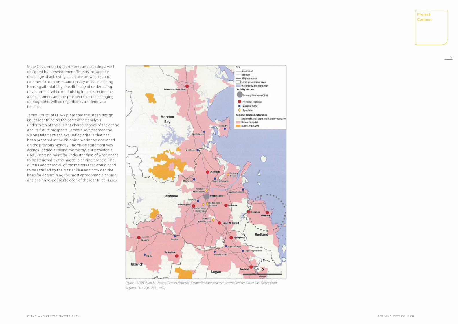
Wayne Dawson from Redland City Council described the strategic planning context for the Master Plan in terms of the South East Queensland (SEQ) Regional Plan, the draft Local Growth Management Strategy (LGMS) and the Redlands Planning Scheme. The presentation emphasised Cleveland’s maturing and expanding role as a Principal Activity Centre under the SEQ Regional Plan and the nature of the additional development that this is expected to bring over the next twenty years.
Ben Vardon from Connell Wagner presented the key issues in relation to access and mobility in Cleveland Centre. Against the background of the need to reduce reliance on the motor vehicle, enhance pedestrian connectivity and maximise accessibility to public transport, the presentation looked at the targets set
in the LGMS for walking, cycling and public transport use. The existing traffic and parking arrangements were discussed, as were the benefits of managing intersections by way of signals rather than the current roundabout configuration. The width of Shore Street West was identified as an impediment to easy pedestrian movement and cycle connectivity, an issue shown to be generally poor throughout the Cleveland Centre.
Matthew Gross from National Property Research described the current economic profile of Redlands, citing an under-representation of older teenagers and people in their early twenties as an issue of concern for future economic prospects. Coupled with the over-representation of people in older age brackets and the amount of Redlands employment that is currently provided for outside of the City, there is a need for Cleveland Centre to start to provide for a more significant amount and range of retail and office jobs. Strengths were identified as including the Centre’s connectivity to the marina, its access to rail, a reasonably consolidated private land ownership, the ease of walking around and the Council ownership of key sites. Weaknesses included limited tertiary education facilities, the Centre’s reliance on a retail provision that doesn’t continuously engage with the public realm and the sense that the centre is becoming ‘tired’ and lacking in excitement, as expressed in the detail of the design. Opportunities included strengthening the link to the train station, creating smarter traffic flow, securing the offices of
2.0 Background to study4
R E D L A N D C I T Y C O U N C I L
Project Context
R E D L A N D C I T Y C O U N C I LC L E V E L A N D C E N T R E M A S T E R P L A N
Figure 1: SEQRP Map 11- Activity Centres Network - Greater Brisbane and the Western Corridor (South East Queensland
Regional Plan 2009-2031, p.99)
State Government departments and creating a well designed built environment. Threats include the challenge of achieving a balance between sound commercial outcomes and quality of life, declining housing affordability, the difficulty of undertaking development while minimising impacts on tenants and customers and the prospect that the changing demographic will be regarded as unfriendly to families.
James Coutts of EDAW presented the urban design issues identified on the basis of the analysis undertaken of the current characteristics of the centre and its future prospects. James also presented the vision statement and evaluation criteria that had been prepared at the Visioning workshop convened on the previous Monday. The vision statement was acknowledged as being too wordy, but provided a useful starting point for understanding of what needs to be achieved by the master planning process. The criteria addressed all of the matters that would need to be satisfied by the Master Plan and provided the basis for determining the most appropriate planning and design responses to each of the identified issues.
5
Project Context

C L E V E L A N D C E N T R E M A S T E R P L A N
2.3 Initial ConceptsThe workshop attendees then convened into two groups to commence the process of preparing initial concepts to determine the direction for the next day’s work. Group One proceeded under the facilitation of Lynn Sorrell of EDAW and Group Two was facilitated by Cathryn Chatburn also of EDAW.
This session, although short, produced two planning and design directions of sufficient difference as to be a good starting point for the development of separate master planning scenarios. The groups also reached agreement on the sites that should be regarded as fixed elements to remain in place for the life of the Master Plan, and those sites that presented the greatest opportunity for redevelopment due to their ownership by Council or a limited number of private parties. These sites were seen as having potential to be catalysts for change and leading the way in the realisation of the master planning vision.
2.4 Public PresentationAt the end of the first day a session was held to which the public was invited to learn about the master planning process and to make comment on the issues that were of concern to them. Approximately twenty members of the public took the opportunity to attend the session.
Wayne Dawson presented the background to the need for a Master Plan for Cleveland Centre and James Coutts presented the urban design issues and the emerging vision statement. Questions were then taken and discussion conducted about various aspects of the process and what should be achieved through the preparation of the Master Plan.
Key points raised included concerns that the Centre is focused predominantly on retail at the present time and provides little other than shopping opportunities for the local community. There was a view that the planning of the centre should ensure that development is sustainable and represents best practice in terms of energy efficiency and water cycle management.
The need for the Cleveland Centre to continue to exhibit a high standard of landscape presentation was seen as essential by a number of participants. This could extend to creating new public squares or plazas that would be a defining feature of the Centre and the cornerstone of a quality public realm.
The view was also expressed that the link between Cleveland Centre and Toondah Harbour was extremely important and that the planning of the two localities should proceed together so the outcomes in both places can be complementary and coordinated. Photos from Enquiry by design workshop
6
R E D L A N D C I T Y C O U N C I L
Project Context
R E D L A N D C I T Y C O U N C I LC L E V E L A N D C E N T R E M A S T E R P L A N
LEGEND
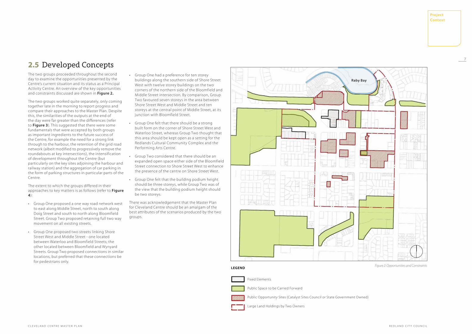
2.5 Developed ConceptsThe two groups proceeded throughout the second day to examine the opportunities presented by the Centre’s current situation and its status as a Principal Activity Centre. An overview of the key opportunities and constraints discussed are shown in Figure 2.
The two groups worked quite separately, only coming together late in the morning to report progress and compare their approaches to the Master Plan. Despite this, the similarities of the outputs at the end of the day were far greater than the differences (refer to Figure 3). This suggested that there were some fundamentals that were accepted by both groups as important ingredients to the future success of the Centre, for example the need for a strong link through to the harbour, the retention of the grid road network (albeit modified to progressively remove the roundabouts at key intersections), the intensification of development throughout the Centre (but particularly on the key sites adjoining the harbour and railway station) and the aggregation of car parking in the form of parking structures in particular parts of the Centre.
The extent to which the groups differed in their approaches to key matters is as follows (refer to Figure 4):
Group One proposed a one way road network west •to east along Middle Street, north to south along Doig Street and south to north along Bloomfield Street. Group Two proposed retaining full two way movement on all existing streets.
Group One proposed two streets linking Shore •Street West and Middle Street - one located between Waterloo and Bloomfield Streets; the other located between Bloomfield and Wynyard Streets. Group Two proposed connections in similar locations, but preferred that these connections be for pedestrians only.
Fixed Elements
Public Space to be Carried Forward
Public Opportunity Sites (Catalyst Sites Council or State Government Owned)
Large Land Holdings by Two Owners
Group One had a preference for ten storey •buildings along the southern side of Shore Street West with twelve storey buildings on the two corners of the northern side of the Bloomfield and Middle Street intersection. By comparison, Group Two favoured seven storeys in the area between Shore Street West and Middle Street and ten storeys at the central point of Middle Street, at its junction with Bloomfield Street.
Group One felt that there should be a strong •built form on the corner of Shore Street West and Waterloo Street, whereas Group Two thought that this area should be kept open as a setting for the Redlands Cultural Community Complex and the Performing Arts Centre.
Group Two considered that there should be an •expanded open space either side of the Bloomfield Street connection to Shore Street West to enhance the presence of the centre on Shore Street West.
Group One felt that the building podium height •should be three storeys, while Group Two was of the view that the building podium height should be two storeys.
There was acknowledgement that the Master Plan for Cleveland Centre should be an amalgam of the best attributes of the scenarios produced by the two groups.
Figure 2: Opportunities and Constraints
raby Bay
7
Project Context

C L E V E L A N D C E N T R E M A S T E R P L A N
LEGEND
Key Pedestrian Streets and Focus for the Centre
High Frequency Central Bus Loop
District Bus Loop
Bus Stop
Railway Station
New Routes
Key Elements of Centre Open Space
Concentration of Dedicated Car Parking
Railway Line
Gateway
Points of agreement
Figure 3: Points of Agreement
raby Bay
transport Interchange
to Capalaba and Brisbane City
to thornlands, Victoria Point and redland bay
Hig
hes
t le
vel o
f ped
estr
ian
focu
sed
cen
tre
acti
viti
es
Resi
den
tial
/ b
ou
tiq
ue
/ ar
ts /
to
uri
sm
/ en
tert
ain
men
t
Black swamp Wetlands
8
R E D L A N D C I T Y C O U N C I L
Project Context

R E D L A N D C I T Y C O U N C I LC L E V E L A N D C E N T R E M A S T E R P L A N
LEGEND
One-way Vehicular and Pedestrian Network Group 1
Pedestrian Only Routes Group 2
Built Form Group 1
Black Swamp Wetlands
Additional Open Space Group 2
Zones of Height for Group 2 (no. of storeys nominated)
Zones of Height for Group 1 (no. of storeys nominated)
Podium Area: Group 1 - Standard 3 Storeys
Group 2 - Standard 2 Storeys
Points of difference
Figure 4: Points of Difference
raby Bay
Black swamp Wetlands
9
Project Context
Presents the outcomes and tested strategies which define the final master plan for Cleveland Centre
3.0 the BIg PIcture3.1 Cleveland Centre 2031 -
Vision StatementAs part of the Enquiry by Design process a collective Vision Statement was drafted to set the focus for the master planning process and effectively capture a vision of the Centre’s future.
That vision portrayed Cleveland as a mixed and vibrant hub of activity at the heart of the Redland City and is consistent with the aspirations and vision defined in the Redland 2030 Community Plan.
The Master Plan chapter is divided into 2 sections:
the Big PictureThis section illustrates the Master Plan and its key organising elements. It includes broad level strategies to inform the definition of character areas, land use, urban form, building heights, open space and movement.
detailed ConsiderationsFollowing the development of the Master Plan document, a series of additional studies were commissioned by Redland City Council to explore in further detail specific design consideration to assist in the appreciation and understand of the master plan intent. A suite of six documents has been produced, which comprehensively now define the Cleveland Centre Master Plan, with the additional studies exploring elements of the public realm and streets through testing design propositions, architectural interventions and movement in the centre.
10
R E D L A N D C I T Y C O U N C I L
3.0 the BIg PICture 103.1 Cleveland Centre 2031 - Vision Statement 10
3.2 Organising Elements for the Masterplan 12
3.3 Illustrating the Master Plan 14
3.4 Visualising the plan 16
3.5 Character Areas 20
3.6 Land Use 21
3.7 Building Heights 22
3.8 Urban Form 23
3.9 Long Sections 24
3.10 Open Space and Public Realm 26
3.11 Movement 27
4.0 detaIl ConsIderatIons 304.1 Built Form 30
4.2 Key Sites 32
4.3 Bloomfield Street 34
C L E V E L A N D C E N T R E M A S T E R P L A N
The Master Plan
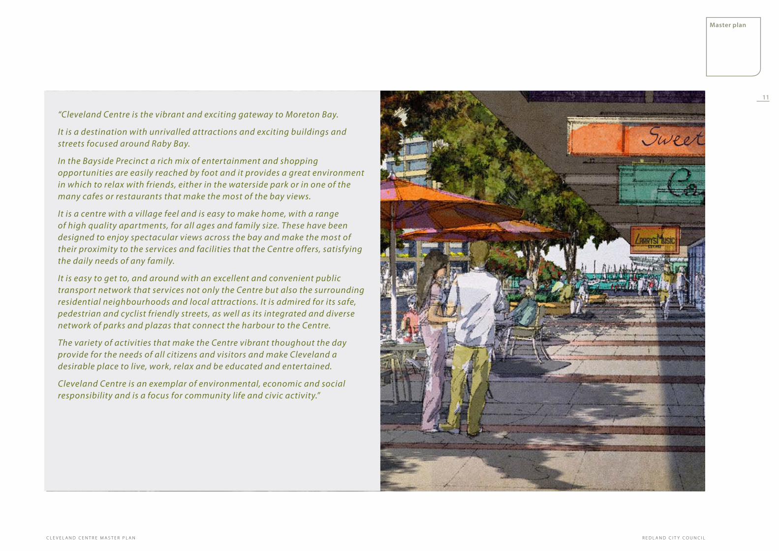
“Cleveland Centre is the vibrant and exciting gateway to Moreton Bay.
It is a destination with unrivalled attractions and exciting buildings and streets focused around Raby Bay.
In the Bayside Precinct a rich mix of entertainment and shopping opportunities are easily reached by foot and it provides a great environment in which to relax with friends, either in the waterside park or in one of the many cafes or restaurants that make the most of the bay views.
It is a centre with a village feel and is easy to make home, with a range of high quality apartments, for all ages and family size. These have been designed to enjoy spectacular views across the bay and make the most of their proximity to the services and facilities that the Centre offers, satisfying the daily needs of any family.
It is easy to get to, and around with an excellent and convenient public transport network that services not only the Centre but also the surrounding residential neighbourhoods and local attractions. It is admired for its safe, pedestrian and cyclist friendly streets, as well as its integrated and diverse network of parks and plazas that connect the harbour to the Centre.
The variety of activities that make the Centre vibrant thoughout the day provide for the needs of all citizens and visitors and make Cleveland a desirable place to live, work, relax and be educated and entertained.
Cleveland Centre is an exemplar of environmental, economic and social responsibility and is a focus for community life and civic activity.”
11
master plan
R E D L A N D C I T Y C O U N C I LC L E V E L A N D C E N T R E M A S T E R P L A N

3.2 Organising Elements for the Masterplan
The existing Centre has a number of established strengths that have been considered and used to inform the development of the Master Plan. Key assets and current issues affecting the success of the Centre have been mapped, as part of the urban design analysis, and have helped determine the underlying character of the Centre and identify where opportunities for improvement exist.
These observations have been informed by the Enquiry by Design process, which in turn has helped to determine the subsequent development of the Vision Statement for Cleveland Centre and a number of high level principles to guide the evolution of the Master Plan.
There are a number of overarching organising elements embedded within the Master Plan:
Reconnect Cleveland Centre with the Bay.•
Increase the variety and volume of activity in the •Centre, building on its existing strengths and augmenting these with built form to accommodate more mixed use development and remove voids in the Centre’s urban grain.
Increase the residential population of the Centre •and therefore the life of the area throughout the whole day and into the evening, by introducing bayside focused residential development, above large floor plate retail and commercial premises.
Facilitate the development of a mixed use leisure •and residential precinct that makes the most of the Centre’s bayside location.
Rejuvenate Raby Bay Harbour Park to create an •attractive and exciting public space of regional significance; the park to be framed by a high quality waterfront accommodation, restaurants and entertainment precinct.
Create opportunities for a range of scales •of retail provision, from smaller artisan and boutique accommodation to larger units able to accommodate lifestyle goods such as a homemaker centre.
local assetsThe key focuses of activity within Cleveland Centre (as shown in Figure 5), and the attributes which contribute to the definition of the Centre’s distinctive character, are strong but are currently isolated and under utilised due to issues of poor pedestrian connectivity and the fragmentation of the Centre as a destination.
Figure 5: Local Assets
Raby Bay
Arts
CivicCivic
Park
Retail CoreCore
ParkPark
Summer Summer CoolingCooling
Winter Cooler
Shore Street DivideShore Street Divide
Wetland
Channelled ViewRidgeRidge
+ 10.0
+ 3.0+ 3.0
Bay
View
Bay
ViewBay View
Bay ViewBay ViewBay View
Consolidate and strengthen the emerging Arts, •Cultural and Education precinct at the western end of Middle Street. Increasing the area as a focus for Local Government, State Government and civil activities; including the Police Station and Court House, and reflecting The Cleveland Centre’s emerging role as a Principal Activity Centre in the South East Queensland Region.
Enhance the user experience of movement routes •through the Centre to create a network of safe and attractive pedestrian and cyclist routes.
Allow for ongoing effective access to parking •within the Centre, while the long term strategy to encourage a modal shift towards public transport is established, and ensure that parking opportunities are accessible from inner ring roads.
Deliver Transport Orientated Development •( TOD) at Cleveland Station that maximises the development opportunity of the land and creates a high quality and accessible transport interchange with facilities for public transport passengers and cyclists. The attractiveness and convenience of the development and the services and facilities it offers contributing to achieving a modal shift away from the private car and towards cycling and use of public transport.
Create a Centre that promotes best practice in Sub-•Tropical design.
Provide facilities that encourage social interaction •and create a strong sense of community.
Delivers a high quality and well connected public •space network that includes provision for all ages.
Sustainable design is an objective for development •- maximising energy efficiency and water management etc.
Includes effective and efficient infrastructure •provision.
12
R E D L A N D C I T Y C O U N C I L
master plan
C L E V E L A N D C E N T R E M A S T E R P L A N

unifying the WholeNew uses should positively reinforce established patterns of activity and new urban form should be used to complete the voids in an already well defined urban grid (as demonstrated in Figure 6). New urban form should also be used to improve the Centre’s legibility, with greater definition of an urban hierarchy through the use of built form and public spaces that interact to create landmarks and gateway elements at key location, and greater variety within the skyline.
Figure 6: Unifying the Whole
Raby Bay
Landmark
Gateway
Ret
ail S
pin
eR
etai
l Sp
ine
Business - CCullture -- LLeiisuurrre - RRetaiill aaandd RResidenntttiiiaaaalll ww
rrraapp
tthhheee
BBaayy
embracing the BayAs shown in Figure 8, urban form should exploit the opportunity for the Centre to embrace the bay and introduce new character and a greater diversity of uses, that optimise their bay side location, and reconnect the Centre to its water frontage.
Figure 8: Embracing the Bay
a network of routes and spacesAs shown in Figure 7, the creation of a strong network of attractive, interlinking routes and spaces should provide the organisational framework for the development of the urban block. With the anticipated increase in the density of development, and the subsequent reinforcement of the established grid, opportunities to introduce a finer grain within the blocks should be explored as part of development opportunities to ensure the delivery of an attractive, legible and walkable Centre that civilises the car.
Figure 7: A Network of Routes and Spaces
art
heart
leisure
Bay InterfaceBay Interface
raby Bay
Existing Features:
1. Black Swamp Wetland
2. Raby Bay Harbour Park
3. Donald Simpson Park
4. Cleveland Showground
Ridge
02
01
01
03
04
Raby Bay
+ 10.0
+ 3.0+ 3.0
Key moments in the Centre’s urban form, including landmark buildings/structures, and significant elements of the public realm
13
master plan
R E D L A N D C I T Y C O U N C I LC L E V E L A N D C E N T R E M A S T E R P L A N

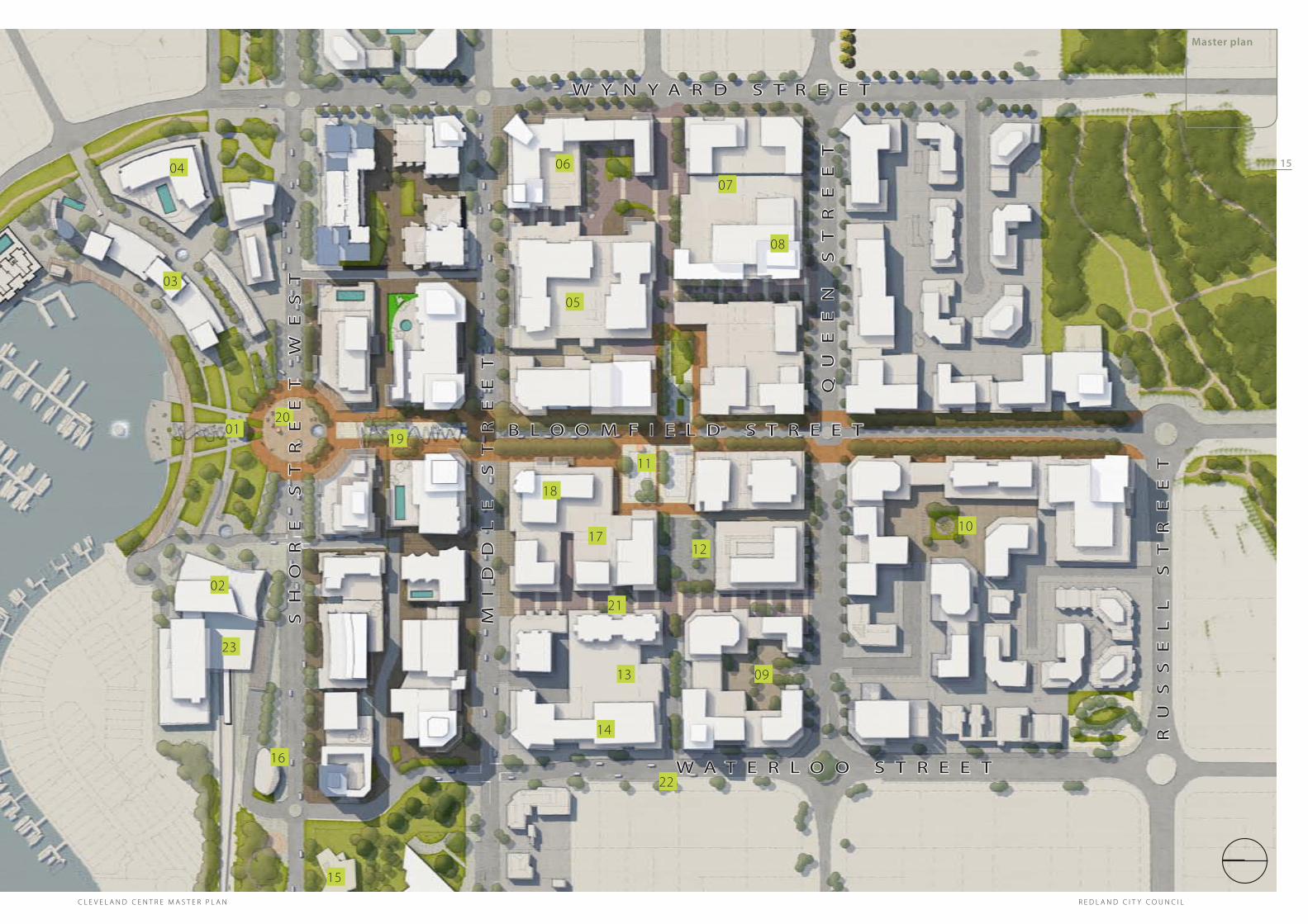
The Illustrative Master Plan (Figure 9) identifies graphically the key elements, activities and uses as numbered:
Raby Bay Harbour Park 1.
Train Station and transport interchange with 2. significant commercial and leisure floor space and associated parking contained in plinth to rear of main building. The opportunity to build over a portion of the rail line explored within the Master Plan.
Water front dining and entertainment3.
Bay side mixed use - retail and entertainment at 4. ground floor level with residential above
Supermarket5.
Large scale retail opportunity accommodating 6. either a department store or homemaker centre
Multi level car parking sleeved by development7.
Residential development above large floorplate 8. retail
Business court with associated parking9.
Business court with associated parking10.
Town Square11.
Surface level car park and market space 12.
Multi level car parking sleeved by development13.
Tertiary education facility 14.
Cultural Community facility with small element of 15. commercial provision
3.3 Illustrating the Master PlanTourist and travel information pod16.
Library 17.
Large commercial development opportunity 18. including retention of Redland City Council buildings , reconfigured to address town square
Raby Bay Harbour Park extension19.
Shore Street West - tree lined boulevard20.
Doig Street reconfigured to allow one way vehicle 21. movement to the south and a pedestrianised precinct to the north, connecting to Middle Street
New east/west pedestrian focused route 22. connecting the Cleveland Centre to its car parks, Town Square, high street and outer residential suburbs
Major public transport interchange 23.
Figure 9: The Master Plan
14
R E D L A N D C I T Y C O U N C I L
master plan
C L E V E L A N D C E N T R E M A S T E R P L A N
01
02
03
04 06
05
07
08
09
10
11
12
13
14
15
16
18
19
20
21
22
sH
oR
e
st
Re
et
W
es
t
23
MI
DD
Le
s
tR
ee
t
QU
ee
n
st
Re
et
RU
ss
eL
L
st
Re
et
W A t e R L o o s t R e e t
B L o o M F I e L D s t R e e t
W Y n Y A R D s t R e e t
17
Figure 9: The Master Plan
15
master plan
R E D L A N D C I T Y C O U N C I LC L E V E L A N D C E N T R E M A S T E R P L A N

3.4 Visualising the PlanA series of street level artists impressions and aerial perspective sketches have been produced to assist understanding and translation of the Master Plan.
They are an indicative representation of ultimate development beyond 20 years. All sites are shown as redeveloped, however this is unlikely to occur in the Master Plan time horizon.
16
R E D L A N D C I T Y C O U N C I L
master plan
C L E V E L A N D C E N T R E M A S T E R P L A N

Figure 10: IIlustrative artists impressions
17
master plan
R E D L A N D C I T Y C O U N C I LC L E V E L A N D C E N T R E M A S T E R P L A N
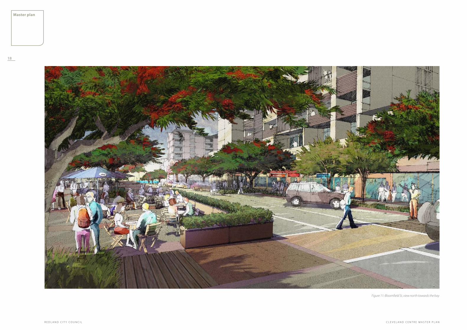
Figure 11: Bloomfield St, view north towards the bay
18
R E D L A N D C I T Y C O U N C I L
master plan
C L E V E L A N D C E N T R E M A S T E R P L A N

Figure 12: Bloomfield St , view north toward the Town Square
19
master plan
R E D L A N D C I T Y C O U N C I LC L E V E L A N D C E N T R E M A S T E R P L A N

3.5 Character AreasThe Master Plan establishes a number of distinct character areas, or precincts, that build upon the strengths of the existing Centre, and provide the opportunity for Cleveland to become an attractive and vibrant mixed use destination of significant scale and regional draw. As outlined below, four precincts have been identified and are illustrated in Figure 13.
the BaysIde PreCInCt
At the Centre’s northern edge, focused around Raby Bay, a mixed use residential neighbourhood has been established. At the heart of this neighbourhood is Raby Bay Harbour Park and Cleveland train station. Both of these facilities will be significant generators of activity and become gateways for the Centre and wider Raby Bay area. As such they should be designed to make the most of their waterside aspect and create a distinctive address for the Centre.
A significant amount of new development is anticipated within this precinct in order to create a destination; a focus for mixed use, leisure, specialist boutique and artisan retail, as well as the accommodation of a substantial proportion of residential development.
New urban form would be used to define the bay frontage, integrating the currently underutilised and vacant sites to establish a strong and dynamic address on Shore Street West.
The relationship between buildings and public space must be reinforced to create an environment where buildings are seen as a strong frame to the bay and the Centre’s most significant piece of urban green space.
The Bayside Precinct will also provide the key focus for evening activities and entertainment in the Centre.
Centre Core
Building upon the existing success of Bloomfield Street and Middle Street (east), as the Centre’s principal day to day shopping destination, this street will be reinforced in the Master Plan with additional frontage and floor area to form Cleveland’s High Street, at the heart of the Centre. This role will be augmented further with the introduction of a new public square, at a mid point within the street, connected laterally along a new pedestrian route that leads directly east/west to the residential areas surrounding the Centre and the new focuses of parking. The design of this space will reflect its civic/ceremonial role.
CIVIC, CreatIVe arts and knoWledge huB
Within the Master Plan the emerging focus for the arts, at the western end of Middle Street, is to be reinforced with the provision of development to accommodate a range of community uses and educational facilities, establishing a key focus for the arts and learning in the Centre.
reInForCed Core
Within the Master Plan strategy for the wider Centre is extended the principle of consolidating underutilised sites and providing development that accommodates a diverse mix of uses.
The southern end of Bloomfield Street continues its role as the High Street, but with an increase in the amount of residential development available, including within landmark buildings that mark the Centre’s southern gateway. This residential focus integrates the Centre with the surrounding area and also introduces a significant focus of on street activity so animating and activating the entire length of Bloomfield street.
Figure 13: Character Areas
the Bayside Precinct
reinforced Core
Civic, Creative arts and knowledge hub
Centre Core
20
R E D L A N D C I T Y C O U N C I L
master plan
C L E V E L A N D C E N T R E M A S T E R P L A N

3.6 Land UseOne of the key outcomes of the land use pattern, adopted by the Master Plan, is the delivery of a vibrant Centre that has active streets and is the focus of activity throughout the day and into the night.
This will be achieved by ensuring there is an appropriate distribution of uses across the Centre, that there is also a good mix within the block and that ground floor uses generally have a positive relationship with the street - accommodating uses that have a visible presence on, and considerable interaction with the street such as shops, cafes, restaurants and extended hours services such as fitness and medical facilities.
The application of this approach will ultimately increase employment opportunities in the Centre, helping to achieve Redland City Council’s strategy of increasing self containment of local jobs for local residents.
Within the Bayside Precinct the aim is to create a vibrant and attractive mixed use residential focus for Cleveland that also supports a strong and attractive evening economy, including restaurants focused around Raby Bay.
The key to delivering this will be to strike a careful balance between where and how concentrations of retail and leisure activities are positioned, and the nature of their relationship with the proposed residential component. This consideration will ensure that any conflicts in character of use, for example noise are considered and managed at the planning stage.
In addition to retail and residential uses the Bayside Precinct provides excellent opportunities for the establishment of high quality and distinctive opportunities for water front dining and entertainment facilities that make the most of their bay side location and adjacency to Raby Bay Harbour Park.
The train station also presents an excellent opportunity to introduce a significant element of commercial/ leisure activity as well as a transport interchange.
Along Middle and Bloomfield Streets, which continue to be the focus for main stream retail activity and commerce in the Centre, the maintenance of a continuous active street frontage is essential. At ground level it is preferable that retail frontage and access is maintained, and that the Centre retains the feel of a “High Street”. With an increase in the general density of the Centre, new accommodation will be available above this ground floor element, with the potential to extend the retail over this larger floor plate or introduce new commercial/ office uses and increase the business presence in the Centre.
In addition, further opportunities for residential development, in the form of apartments will be accommodated above the ground and first floors of buildings, particularly across the eastern half of the Centre, to the north and south of Middle Street.
Figure 14: Land Use
shore street West
middle street
Blo
om
fiel
d s
tree
t
Queen street
Wyn
yard
str
eet
Wat
erlo
o s
tree
t
Mixed Use Development
Opportunity and New
Transport Interchange
Public Buildings
Harbour Front Dining and
Entertainment Precinct
Key Focuses of Retail
Frontage at Ground Floor
Mixed Use
Residential
LEGEND
21
master plan
R E D L A N D C I T Y C O U N C I LC L E V E L A N D C E N T R E M A S T E R P L A N

3.7 Building HeightsAs a principle strategy, Cleveland has been identified to accommodate a portion of the local jobs growth in the city to 2031. Similarly, it will also accommodate increased residential dwelling supply to meet the infill growth target defined in the LGMS and SEQRP 2009-2031.
In order to do this it is not enough to simply utilise the vacant sites within the Centre at the current scale. It will require a balanced change to existing planning controls. The Master Plan seizes upon the need to increase development volume as an opportunity to redefine the Centre’s urban character and utilise greater variety in height to create landmarks, gateways, emphasise corners and important buildings and increase the opportunities for residents and visitors to appreciate views out across Raby Bay and towards the outlying islands.
Within the Master Plan the greatest height, set at a maximum of eight storeys, has been focused around the bay to capitalise on views to the bay. Across the urban blocks within the centre, height ranges between eight and five storeys.
In order to maintain a strong sense of village character and reinforce the pedestrian friendly nature of the streets the use of the podium, where taller elements of built form are allowed, has been adopted. This approach accommodates taller elements of development on a base plinth of between two and three storeys maximum across the Centre. Development of this taller element is then set back from the edge to a range of minimum and maximum depths to protect the character of the streets and create continuity of character.
The height allowance will be relative to physical size of the site and the frontage to the public street and the definitions for storey, and approach to basement car park will be as set out in the Redlands Planning Scheme.
Figure 15: Building Heights
shore street West
middle street
Blo
om
fiel
d s
tree
t
Queen street
Wyn
yard
str
eet
Wat
erlo
o s
tree
t
8 Storeys
7 Storeys
6 Storeys
5 Storeys
3 Storeys
1 Storey
legend
Maximum heights in storeys
shore street West
middle street
Blo
om
fiel
d s
tree
t
Queen street
Wyn
yard
str
eet
Wat
erlo
o s
tree
t
22
R E D L A N D C I T Y C O U N C I L
master plan
C L E V E L A N D C E N T R E M A S T E R P L A N

3.8 Urban FormThe Centre’s existing urban grain is defined by a strong grid structure with north/south and east/west connections that run between the blocks. Currently the strength of this grid is undermined by significant areas of surface car parking, which create voids in the Centre’s built form and undermine the strength and continuity of its streetscape.
A key outcome of the Master Plan is the creation of active and pedestrian scale streets to unify the Centre.
The opportunity to fill the voids and deliver mixed use development that generates attractive and animated street frontages is an important principle, as is the efficient use of currently underutilised sites, with a scale of development that will accommodate the employment and residential growth determined in the Local Growth Management Strategy 2008.
With the consolidation of development, on the existing blocks, there is a danger that the grain of the Centre will become quite large. If not handled carefully this approach could aggravate any current problems of pedestrian connectivity and also potentially diminish the sense of village character that is enjoyed by Cleveland residents and visitors currently.
In order to maintain this ‘village feel’, as well as aid the legibility and permeability of the Centre, the Master Plan formally introduces a number of smaller routes and pedestrian links at strategic locations within the structure of the proposed development.
The Cleveland Centre Master Plan Development; Relationships between built form and the Street Document provides further details on architectural character and activated streets. Plot ratios are also included in section 7.3 which recommend building form and scale relative to land area and street frontage.
Urban Grain
LEGEND
Figure 16: Urban Grain
shore street West
middle street
Blo
om
fiel
d s
tree
t
Queen street
Wyn
yard
str
eet
Wat
erlo
o s
tree
t
23
master plan
R E D L A N D C I T Y C O U N C I LC L E V E L A N D C E N T R E M A S T E R P L A N

3.9 Long SectionsThe following long sections illustrate the interpretation of the building height guidance, established by the Master Plan, along two of the key street frontages within the centre; Bloomfield Street and Shore Street West.
These sections demonstrate the overall intent within the Master Plan to deliver a variety of height that in general peaks at the bay front, at the junction between Middle Street and Bloomfield Street, and also at the end of Bloomfield where it meets Russell Street. And that allows for a range of variety in the key street edges where the lower floors of the blocks define the public realm.
Bloomfield street The topographical variation that is offered at the northern end of Bloomfield Street means that greater height can be accommodated without the general scale of the long elevation being out of balance. Unlike Shore Street this street profile will not be read as a single composition, it is therefore capable of accommodating a greater range of height variation. Even so height in general is focused at the streets’ northern end, particularly around the Bloomfield/ Middle Street junction and towards the southern end of the street to provide a ‘gateway’ element to the Centre here.
shore street West It is important, in defining guidance for built form along Shore Street West, to have an appreciation of the full elevation of the street due to its’ single sided nature and also its’ prominance as the address for the Centre when viewed from Raby Bay Harbour Park and on arrival at the train station.
The architectural treatment of the ends of the elevation, ie. at the junctions of Shore Street West and Waterloo and Wynyard Streets, should be strong on the corners. As should the architecture that frames the public space created where Bloomfield Street and Shore Street West meet.
This later opportunity is a significant one in ensuring that the strength of the visual relationship between the Centre and Raby Bay is reinforced. New buildings at this junction should not only be used to frame the public space more effectively, by creating opportunities for greater activation of the street, providing accommodation at ground level, but should also maximise on the opportunities to frame views out into Raby Bay Harbour Park and the bay beyond.
24
R E D L A N D C I T Y C O U N C I L
master plan
C L E V E L A N D C E N T R E M A S T E R P L A N

25
master plan
R E D L A N D C I T Y C O U N C I LC L E V E L A N D C E N T R E M A S T E R P L A N
8 STORIES
Figure 17: Bloomfield Street Long Section
BLOOMFIELD
STREET Figure 18: Shore Street West Long Section

Figure 20: Open Space and Public Realm
Key Pedestrians and Focus on Centre
Wider District Connections
High Frequency Central Bus Loop
Bikeway Corridor
Open Space
Proposed Streetscape Treatment
Proposed Boulevard
LEGEND
26
R E D L A N D C I T Y C O U N C I L
master plan
organising elements for the open space and public realm networkThe proposed Landscape Strategy for the wider Cleveland area seeks to provide RCC with a clear vision and coordinated approach to the conservation, enhancement, renewal and growth of Cleveland’s open space and define mechanisms and design direction to inform the renewal process.
The key components of the concept that form the foundations of the strategy, are defined by the distinctive qualities and characteristics of existing landscape assets. Three open space corridors, generally running north/south through the area, provided opportunities to create distinctive landscape experiences.
Across this palette of landscape experiences are a defined collection of community and recreational destinations connected by a network of attractive, and pedestrian and cyclist friendly movement corridors. The whole strategy presents an exciting opportunity for residents and visitors to choose journeys of landscape experience.
Bushland edgeCaptures and seeks to reinforce the characteristics of the natural landscape, predominant to the west, promoting the
creation and augmentation of natural landscape qualities with opportunities to enhance and re-establish the distinctive fauna and flora of the area as part of the recreational open space and public realm experience.
Bayside addressRecognises the significance and distinctive qualities of the areas’ bay side address, providing parklands that maximise their
waterfront address as part of the visual and physical experience and reinforcing Cleveland’s address on the bay.
3.10 Open Space and Public Realm
Figure 19 Landscape Concept Plan
Creek CorridorsIdentifies the importance of the former creek corridors in providing interesting and ecologically diverse landscape corridors with re-vegetation and naturalisation opportunities,
and the reinforcement of their role as important visual and physically attractive movement corridors for both animals and humans.
FootparksA network of ‘Footparks’ are proposed to laterally connect these corridors of distinctive landscape experience, providing attractive, safe and accessible movement routes for
residents and wildlife. The ‘Footparks’ add a further layer to the open space provision, connecting community and recreational destinations, and providing an unbroken network of important lateral routes.
destinationThe established network of community and recreational destinations are bedded into the corridors of distinctive landscape character experience.
C L E V E L A N D C E N T R E M A S T E R P L A N

In terms of movement a number of key principles have been adopted and are embedded within the design of the street network in the Master Plan. At the heart of all these is the desire to create a walkable Centre that effectively and safely integrates the needs of pedestrians, cyclists and the car.
The existing street network has been retained and augmented with a number of additional north/south and east/west links strategically located to improve connections to Raby Bay, the train station and out into the surrounding residential neighbourhoods.
A number of these new routes have been designated as pedestrian only or one way where vehicular traffic is accommodated. In both cases provision is made for cyclists within designated routes.
In addition a long term strategy to replace the roundabouts with signalised traffic management initiatives , at the four key junctions adjacent to the Centre, is considered within the Master Plan. The intention being to more effectively manage the relationship between vehicular, cycle based and pedestrian traffic as well as improve general traffic movement as volumes increase in the centre with its growth.
However, in the short term, only one change is to be made; at the junction of Waterloo and Middle Streets the roundabout is to be replaced with signals and the road corridor reconfigured to reduce its width and allow improved pedestrian movement between the Civic, Creative Arts and Knowledge Hub.
The continued provision of parking within the Centre is still a significant consideration and its maintenance is an important contributing factor in ensuring the long term economic viability and attractiveness of Cleveland Centre. With this in mind the provision of parking, both in terms of on-street and larger single site car parks, has been retained but the location and the variety developed.
In the main existing large areas of surface parking have been removed in order to utilise these sites more efficiently for development. In their place, multiple level car parks are proposed, at Doig Street,
Wynyard street and at the railway station. These are accessed via the existing street network and have been strategically located to be within easy access of the high street and linked directly to one of the new lateral pedestrian routes.
One of the existing surface parking facilities has been retained, adjacent to the new town square. The retention of this element is considered a contributor to the sense of village character and is seen as a further resource to be utilised for community events for example to accommodate Christmas markets.
The retention of on-street parking is also seen as a significant positive asset in the degree of activity and animation it provides streets.
key InterventionsShore Street West: Shore Street West, between 1. Waterloo and Wynyard Streets, has been transformed into a tree lined boulevard with vehicular traffic in both directions, parallel car parking along either side of the carriageway, and a dedicated cycle lane in both directions. As a result more generous pavement areas have been created, on either side of the vehicle corridor, allowing for ground level activity from new buildings along the street to spill out and animate the public realm and seize the opportunity for people to enjoy views out across the rejuvenated park.
Two new routes cut at mid points through the 2. urban block between Shore Street West and Middle Street. These both provide part vehicular/ part pedestrian only access between Middle Street and Shore Street West.
Doig Street: Doig Street is retained as an important 3. north/ south mid block break. Traffic studies have recommended that the street be redesigned to become one way for the northern half of the street where cars could enter a proposed new carpark. The southern half of Doig Street would remain two way. This will become and important access road for visitors to the centre arriving by car, as it provides the primary access to two of the Centre’s proposed car parks.
shore street West
middle street
Blo
om
fiel
d s
tree
t
Queen street
Wyn
yard
str
eet
Wat
erlo
o s
tree
t
legend
Sub Arterial Road
Local Collector Road
All Other Roads
Pedestrian Only Route
Railway Line
Figure 21 Movement Networks (the street structure and hierarchy illustrated in the above plan reflects the discussions in early EbD workshops
and work undertaken in the first stages of the Cleveland Master Plan development 2007/2008)
3.11 Movement27
master plan
R E D L A N D C I T Y C O U N C I LC L E V E L A N D C E N T R E M A S T E R P L A N

summary of engineering traffic study The proposed Master Plan street network was tested, using a traffic simulation package to understand network operation in the design years 2021 and 2031. A number of scenarios were tested in order to establish a network that would cater for the needs of the vehicular traffic whilst allowing adequate provision for pedestrian and cyclists. The simulation package chosen to model the centre was Quadstone-Paramics - the advantage of this particular package is that it produces a visual representation of the network allowing intersection interactions and operations to be understood in the context of overall operation.
The modelling process involved the following:
2009 base year model development and calibration1.
Testing of design year 20212.
Testing of design year 20313.
BOUNDS OF ThE MODEL:
The bounds of the model are defined by:
Shore St West and Cleveland railway station to the •north
Wellington St to the west•
Queen St to the south•
Wynyard St to the East•
Base year model deVeloPment:
Traffic counts and queue length surveys were taken at intersections in Cleveland Centre (see also Figure 1). This was undertaken in June 2009 (outside school holiday periods) at 15 locations in the AM, PM and weekend peak periods. A manual carpark survey was undertaken at the Woolworths shopping centre carpark entrance and exits and the most up to date bus data information was obtained from TransLink. A site inspection was carried out to review the location and type of parking within Cleveland Centre. Pedestrian crossings throughout the centre were recorded. Delays for through traffic in the Cleveland
centre as a result of vehicles undertaking reverse angle parking was also taken into account.
This information detailed above was used as inputs for the base model. Aerial photography was used as an overlay. Following from this a road network was created to replicate the current network. The model was then tested and calibrated to reflect the current road operation.
Future year sCenarIo testIng
The future years 2021 and 2031 were tested under a number of scenarios to understand the impacts of one way systems and removing traffic lanes in the centre. Details of these scenarios are accessible in the supporting documentation to this Master Plan. Traffic volumes for these future design years were developed by applying the following agreed growth rates to the road network:
Shore St West: 5%pa • 1
Other roads - 2% pa • 2
Carparks 2% • 2
Cul de sacs 0% • 3
The future signalisation of the following intersections were applied:
Shore Street West/Waterloo Street•
Middle Street/Waterloo Street•
Middle Street/Wynyard Street•
The signalisation of Middle St/Waterloo is proposed for the short term, whilst the signalisation of Shore Street West/Waterloo Street is proposed for the longer term. The signals at Middle Street/Waterloo Street will allow pedestrians to easily access the western end and allow a strong pedestrian spine to develop. The roundabout currently at this location, whilst adequate for traffic flows in the year 2031would not be suitable for pedestrians. Signals are viewed as strengthening the pedestrian links and a safer option for pedestrians than roundabouts.
The signalisation of Shore Street West/Waterloo Street is considered necessary in the longer terms as growth continues throughout Cleveland Centre. Further details on this intersection are discussed in the modelling results.
Results for the one way operation of Doig St and of a lane reduction in Shore St are discussed below. The modelling tested Doig Street as a one way street to halfway (north to south) where cars could enter a proposed new carpark. The southern portion of Doig Street would remain two way. Lane reduction of Shore Street West is also discussed. This road currently operates as a four lane two way dual carriageway with limited regulated parallel parking and bus set down in the road shoulders. The modelling tested a lane reduction between Harbourview Circuit and Wynyard Street – note the final proportion of road proposed for 2 lanes is not yet finalised and may not extend for this full segment of road. One way operation along Bloomfield Street is also discussed.
results desIgn year 2021:
The paramics model showed that under anticipated 2021 volumes, Cleveland Town Centre would operate satisfactorily with Doig St reduced to one way (north to south) to mid block point. This was true for the two key peak periods during the week - the weekday PM (16:00 – 18:00) and the Saturday morning AM (10:00 -12:00). It also showed that the network would operate satisfactorily if Shore St West was reduced from 4 to 2 lanes.
A critical intersection for this option was that of •Shore St West and Waterloo St which had a Level of Service (LOS) C4. Other intersections tested5 operated at LOS A6 and B7 in 2021. [Further details of these intersections are accessible in the supporting documentation to this Master Plan].
Bloomfield St (between Middle Street and Queen
Street) was tested under one way scenarios (both north to south and south to north) – both these scenarios operated satisfactorily under 2021 design volumes.
results desIgn year 2031:
The paramics model showed that under anticipated 2031 volumes, Cleveland Centre would operate satisfactorily with Doig St reduced to one way north to south from mid block. However, it showed that under these anticipated traffic volumes there would not be sufficient capacity within the network to reduce Shore St West from 4 to 2 lanes. The reduction in capacity along this section of road cause traffic to queue back along Shore St West and become gridlocked during the PM peak period.
Bloomfield St (between Middle Street and Queen Street) was also tested under one way scenarios for 2031 (both north to south and south to north) – both these scenarios operated satisfactorily in 2031.
Note the 2021 and 2031 results discussed above were obtained with retaining the on street reverse angle parking – this parking did not have significant adverse impact on the modelling results.
Traffic circulation throughout the centre would be further enhanced through the proposed restriction of
28
R E D L A N D C I T Y C O U N C I L
master plan
C L E V E L A N D C E N T R E M A S T E R P L A N

bus movements from Middle Street. This, in addition to the concentrated parking areas proposed from the centre ring road will further assist circulation of the road network.
CONCLUSIONS
The road network provided adequate level of service and network performance for the anticipated traffic volumes in 2021. In 2031 the modelling indicated that the initial favoured option in reducing Shore St West from 4 to 2 lanes would cause the network to gridlock. As discussed, this was based on the assumption that the full section between Harbourview Circuit and Wynyard Street would be reduced to two lanes. Further detailed design planning will be needed to confirm the optimal length of road for lane reduction (which may overcome some of the congestion issue),
1 Shore St West provides the key east-west link into Cleveland Centre
2. A growth rate of 2% for roads within Cleveland Centre and for carparks was considered as reasonable
3. Cul de sacs were agreed to have negligible future growth
4. Definition LOS C:There are stable operating conditions but with manoeuvring becoming more restricted and motorists appreciable tension in driving. Longer queues and/or adverse signal coordination may contribute to lower average travel speeds of about 50% of the free flow speed.
5. Shore Street West/Wynyard Street, Middle Street/Waterloo Street, Middle Street/Wynyard Street, Queen Street/Waterloo Street, Queen Street/Bloomfield Street, Queen Street/Wynyard Street8
6. LOS A: Generally free flow conditions with operating speeds usually about 90% of the free flow travel speed for the particular class of arterial. Vehicles are unimpeded in manoeuvring in the traffic stream and stopped delay at intersections in minimal.
7. LOS B: Relatively unimpeded operation with average travel speeds usually about 70% of the free flow travel speed for the type of arterial class. Manoeuvring in the traffic stream is only slightly restricted and stopped delays are low.
Figure 22: Movement Networks in Context and informed by discussions in enquiry by design (the street structure and hierarchy illustrated in the above
plan reflects the discussions in early EbD workshops and work undertaken in the first stages of the Cleveland Master Plan development 2007/2008)
Sub Arterial Road
Sub Arterial Road (connection to coast)
Local Collector Road
All Other Roads
Pedestrian Only Routes
legend
29
master plan
R E D L A N D C I T Y C O U N C I LC L E V E L A N D C E N T R E M A S T E R P L A N

• Provide supportive environments for active and healthy living through street design, and suffi cient services and amenities.

Architectural treatment of solar shading, as an integral part of Commerical Office development design
Awnings designed as an integral element of the building and utilised to create identity and interest within the street
sun shading
renewable energy
Renewable energy technologies can have strong visual qualities that, if considered as an integral part of the design of a building, can add distinctiveness as well as demonstrate green credentials
Streets and laneways can be used to frame important vistas, with activated edges ensuring a vibrant pedestrian focused street is created and architectural elements used to provide climatic comfort and safety for pedestrians
Left: Building set backs extend the area available for al fresco dining and awnings provide shade
Right: An articulated building edge creates a strong relationship with the street
The strong visual and physical relationship between the residential balconies and the street delivers high levels of natural surveillance and safety with ground floor commercial use activating the street.
articulation of building facades and corners
Design Principles for Built Form
street edges urban gardens lanewaysmixed use
Ground floor set back provides space for outdoor use, with the upper storey providing shade and planting included as an integral part of the building design
In a commercial street the ground floor maximises visual access to internal space and entrances are clear and front directly onto the street
awnings
31
master plan
R E D L A N D C I T Y C O U N C I LC L E V E L A N D C E N T R E M A S T E R P L A N

32
R E D L A N D C I T Y C O U N C I L
master plan
Design Principles for the Public Realm and Open Space Network
Vibrant Waterfront destinationProvide a centre of focus for community life for all residents and visitors to Cleveland, that provides amenity and clear, legible connections to the broader environment.
distinctive residential neighbourhoodsTown centre residents to establish an active town centre by providing a range of flexible housing typologies
Pedestrian Friendly environmentCreate a compact town centre with an emphasis on walkability with a focus on ensuring maximum shading in summer of the pedestrian sidewalks and encourage dappled light and shade in winter to add warmth and texture to the ground plane.
sustainable transportationPromote pedestrian activity to reduce the need for vehicle trips, while providing flexibility to accommodate evolving, alternative transportation modes.
Water sensitive urban design WSUD is a holistic approach to water-cycle management, which aims to protect and enhance the intrinsic values of natural watercourses and aquatic ecosystems, such as the regionally important Black Swamp and Moreton Bay.
Use stormwater in the landscape to maximise visual and recreational amenity and promote an understanding of water in the urban environment
C L E V E L A N D C E N T R E M A S T E R P L A N

33
master plan
R E D L A N D C I T Y C O U N C I LC L E V E L A N D C E N T R E M A S T E R P L A N
4.2 Key SitesThe success of the proposed, Cleveland Town Centre is pivotal to the development of two strategic project sites; the Civic Heart, and the Raby Bay Harbour Park refurbishment.
These sites are interconnected within the broader networks of footparks and laneways and will facilitate passive and active pursuits. The Raby Bay Harbour Park already has an overlay of informal sports and cultural activities, therefore the success of the proposed Master Plan is to allow for these uses to flourish over a flexible and un-cluttered space.
key design ConsiderationsRaby Bay Harbour Park: Raby Bay Harbour Park plays an important role in strengthening both the physical and visual connection between the Centre and its bay front location. In the Master Plan the park is transformed into a high quality park land landscape. The design for the area will need to be distinctive and form a destination.
Town Square: In recognition of its’ increase in scale and significance, as a focus for local governance and government, a formal public square has been introduced at a mid point and fronting onto Bloomfield Street. This space provides a new focus for community activity at the heart of the Centre.
Strategic Footparks Creating a Greenbelt Around the Town Centre
the Civic heart
For large scale events, the two public spaces on either side of Bloomfield Street are joined to create a civic scale space. The design of all three spaces undertaken to create a seamless larger plaza.
town square
A permanent urban square providing the threshold and address to the regions civic heart and government. A strongly urban space with extensive room for large groups to gather. With provision for seating on its edges and shade for comfort.
adjacent Car Parks
Space to expand into adjacent car parks for events such as markets
Courtyard
A small, more intimate scale space defined by the activity of the retail facilities along it ’s edges. The design provides a finer grain of detailing, the provision of seating and encourages lingering.
Bloomfield street
Designed at the interface between the two spaces, as a shared corridor. The road corridor raised to be fused with the adjacent spaces, with emphasis placed on pedestrian movement over the car and detail design and materials chosen to reinforce this role.
legend
Shared Space Road Corridor
Urban Public Space
Articulated Edges
Strong Visual and Physical
Connectivity Through Use of
Vegetation and Structures
Queen street
Blo
om
FIel
d s
tree
t
Figure 23 Town Square Urban Design Principles

an attractive public spaceIn addition to traffic modelling, in response to the design direction set by the Master Plan, more detail design concepts for Bloomfield Street have been explored. These options are developed more fully in the accompanying document;
Cleveland Centre - An exploration of concept •designs for Bloomfield Street,
and seek to explore the future evolution of Bloomfield Street as a vibrant and attractive subtropical street and focus of community activity.
In particular the document explores issues currently affecting the street in terms of its use, as well as seeking to understand design opportunities to enhance the street in the context of its future city role.
The following is a summary of the key project findings and are included as reference.
the Future role oF BloomFIeld street
Building upon the existing success of Bloomfield Street, as the Centre’s principal daily shopping destination, the proposed design explores opportunities to improve this role. Its role as a focus for community activity is augmented with the introduction of a new public square, at a mid-point within the street and connected laterally along a new pedestrian route leading directly east/west to adjacent residential areas.
In the Master Plan land use startegy Bloomfield Street continues its retail focus, but with an increase in the amount of residential development available. This residential focus integrates the Centre with the surrounding area and also introduces a significant generator of on-street activity, so animating and activating the Street.
Increased density within the centre has the potential to support sustainable economic and social activity, as well as deliver environmental improvements if carefully planned and managed. Well considered design is required to ensure development minimises any potential unwanted impacts on the attractiveness, character and amenity of the street. An increase in the permitted development density generates requirements for the consideration of a number of new urban conditions; associated to changes in building heights, new building typologies, and an increase in vehicular and pedestrian activity as well as changes in the diversity and patterns of land use.
Figure 24: Bloomfield Street conceptual diagram
the lIFe oF BloomFIeld street
Bloomfield Street has potential to provide its local and regional community with a high street of strong identity, character and usabilty that is well connected and easily accessible. Future planned increases in residential, retail and commercial activity will bring increased vitality and activity to the street. As part of this Bloomfield needs to tap into the potentials that would come out of a much stronger connection to the activities and aesthetics associated with Raby Bay and the adjacent Cleveland transport hub. As demonstrated in the conceptual diagram this connection can be strengthened through a series of public plaza, shared zones and sculptural elements that reference and lead to the bay.
34
R E D L A N D C I T Y C O U N C I L
master plan
C L E V E L A N D C E N T R E M A S T E R P L A N

Figure 25: Bloomfield Street Illustratated PerspectiveSculptural Art Element to refernce waterfront and provide focal points within the street
Additional tree cover providing more shade and improved ecological diversity
Strategically aligned shared zone aligning with Civic plaza
Integrated bio filtration providing sustainable stormwater management and opportunites for public education of waterway health
Overhead canopies providing shade and architectual definition
35
master plan
R E D L A N D C I T Y C O U N C I LC L E V E L A N D C E N T R E M A S T E R P L A N

4.3.1 Case study a CharaCterIstICs
In the proposed master plan, Bloomfield Street maintains its role as Cleveland’s key retail spine.
The master plan offers the opportunity to increase the size of buildings along either side of the street and presents opportunities to increase the diversity of retail and commercial activity along the corridor.
The proposed master plan envisages the street providing pedestrians with a vibrant experience, with opportunities for a rich mix of shops, cafes and restaurants fronting onto the street and spilling out onto a generous footpath where patrons can sit and dine or just simply watch the world go by.
Car park accommodated in podium sleeved with office suites
Car park accommodated in podium screened with artwork
PreCedents
Integrated artwork and building signage create a distinctive building elevation
IllustratIVe oPtIon
The illustrated option explores a notional cross section profile near the junction of Middle and Bloomfield Street where new built form has been introduced, in line with the maximum permitted development height, and a built form introduced accommodating a mix of uses, focused on commercial and retail spaces in the podium with residential above.
Residential
Office Suites
Retail
Loading
Internal Circulation
Active Street Frontage
Solar access to street
Ground
1
2
3
4
5
6
Figure 26: Case study A: Bloomfield Street
PODIUM LEVELS
4.3 Bloomfield Street36
R E D L A N D C I T Y C O U N C I L
master plan
C L E V E L A N D C E N T R E M A S T E R P L A N
a Well deFIned street

daylIght aCCess to aPartments and BalCony
Indoor/outdoor ConneCtIon
aCtIVe street Frontage and ConneCtIon
Shading to outdoor areas to increase comfort and use
Vegetation to the podium levels to break up the built form and provide some shade to outdoor areas and create attractive and usable balcony spaces
Sunshading to reduce heat and direct sunlight.
Adjustable louvres create privacy and control sunlight while reducing noise from the street
Continuous shade awning creating all weather protection and a consistent language to the street
Figure 27: Bloomfield Street llustrative Street Edge Section (Detail)
InsPIratIon
37
master plan
R E D L A N D C I T Y C O U N C I LC L E V E L A N D C E N T R E M A S T E R P L A N
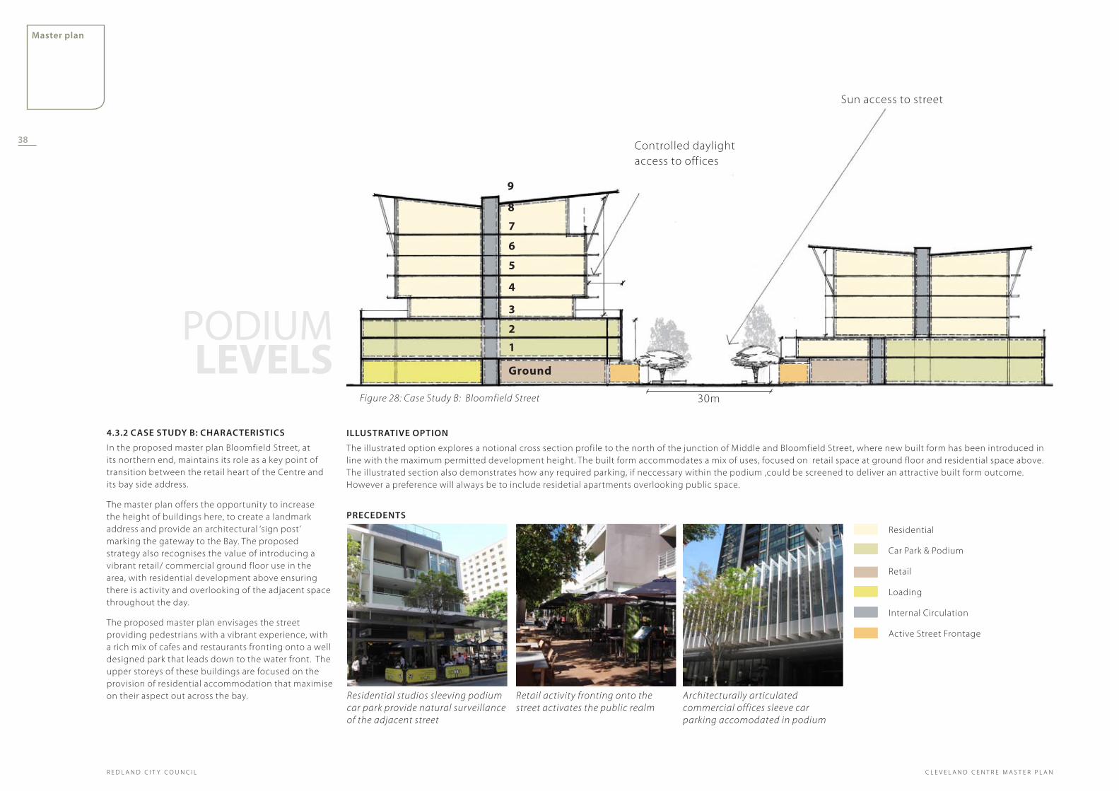
4.3.2 Case study B: CharaCterIstICs
In the proposed master plan Bloomfield Street, at its northern end, maintains its role as a key point of transition between the retail heart of the Centre and its bay side address.
The master plan offers the opportunity to increase the height of buildings here, to create a landmark address and provide an architectural ‘sign post’ marking the gateway to the Bay. The proposed strategy also recognises the value of introducing a vibrant retail/ commercial ground floor use in the area, with residential development above ensuring there is activity and overlooking of the adjacent space throughout the day.
The proposed master plan envisages the street providing pedestrians with a vibrant experience, with a rich mix of cafes and restaurants fronting onto a well designed park that leads down to the water front. The upper storeys of these buildings are focused on the provision of residential accommodation that maximise on their aspect out across the bay. Residential studios sleeving podium
car park provide natural surveillance of the adjacent street
Retail activity fronting onto the street activates the public realm
Architecturally articulated commercial offices sleeve car parking accomodated in podium
PreCedents
IllustratIVe oPtIon
The illustrated option explores a notional cross section profile to the north of the junction of Middle and Bloomfield Street, where new built form has been introduced in line with the maximum permitted development height. The built form accommodates a mix of uses, focused on retail space at ground floor and residential space above. The illustrated section also demonstrates how any required parking, if neccessary within the podium ,could be screened to deliver an attractive built form outcome. However a preference will always be to include residetial apartments overlooking public space.
Residential
Car Park & Podium
Retail
Loading
Internal Circulation
Active Street Frontage
PODIUM LEVELS
38
R E D L A N D C I T Y C O U N C I L
master plan
C L E V E L A N D C E N T R E M A S T E R P L A N
Figure 28: Case Study B: Bloomfield Street
Sun access to street
Controlled daylight access to offices
30m
Ground
1
2
3
4
5
6
7
8
9

Vegetation to the podium levels to break up the built form and provide some shade and softening of outdoor areas
Indoor/outdoor space opportunities
Artwork opportunities enhance the identity of the building, while creating interest along the street edge and offering potential sun shading
RETAIL
Existing trees continue to provide shade, privacy and create a strong street character
Integrated signage and awnings create a consistent street language while providing relief from the outdoor climate
strong street ConneCtIon
solar shadIng to resIdentIal sPaCe
sCreenIng Creates a strong IdentIty to the street
Figure 29: Illustrative Street Edge Section
Vegetation to the podium levels to break up the built form and provide some shade and softening of outdoor areas
Indoor/outdoor space opportunities
Artwork opportunities enhance the identity of the building, while creating interest along the street edge and offering potential sun shading
RETAIL
Existing trees continue to provide shade, privacy and create a strong street character
strong street ConneCtIon
solar shadIng to resIdentIal sPaCe
sCreenIng Creates a strong IdentIty to the street
39
master plan
R E D L A N D C I T Y C O U N C I LC L E V E L A N D C E N T R E M A S T E R P L A N

CharaCterIstICs
In the proposed master plan, Shore Street West will emerge as a key street in the Centre which, due to the emphasis placed on introducing activity along its frontage, will reconnect the commercial and retail heart of the Centre to the Bay.
The master plan offers the opportunity to increase the height of buildings here and also encourages the introduction of buildings that use Shore Street West as their ‘front door ’, encouraging activation of the street and the creation of a strong and attractive southern edge to Raby Bay Harbour Park.
The proposed master plan envisages the street providing pedestrians with a vibrant mix of experiences, with the facility to introduce a rich mix of cafes and restaurants fronting onto an attractive and busy street. The upper storeys of these buildings are focused on the provision of residential accommodation that maximises aspect out across the bay and resident ownership and natural surveillance of the adjacent park and street. Car park podium screened with artwork Active Streets with cafes and shade trees Arbour providing identity and shade
Residential
Commercial
Office Suites
Car Park
Retail
Loading
Circulation
Active Street Frontage
Transit Centre
PreCedents
IllustratIVe oPtIon
The illustrated option explores a notional cross section profile at the eastern end of Shore Street West, opposite the enhanced multi modal transit centre. New built form is illustrated in line with the maximum permitted development height, accommodating a mix of uses, focused on commercial and retail space at ground floor and residential space above.
4.4 Shore Street West
PODIUM LEVELS
Sun access to street
Figure 30: Case Study C: Shore Street West
Ground
1
2
3
4
5
6
7
Sun access to street
Ground
1
2
3
4
5
6
7
40
R E D L A N D C I T Y C O U N C I L
master plan
C L E V E L A N D C E N T R E M A S T E R P L A N
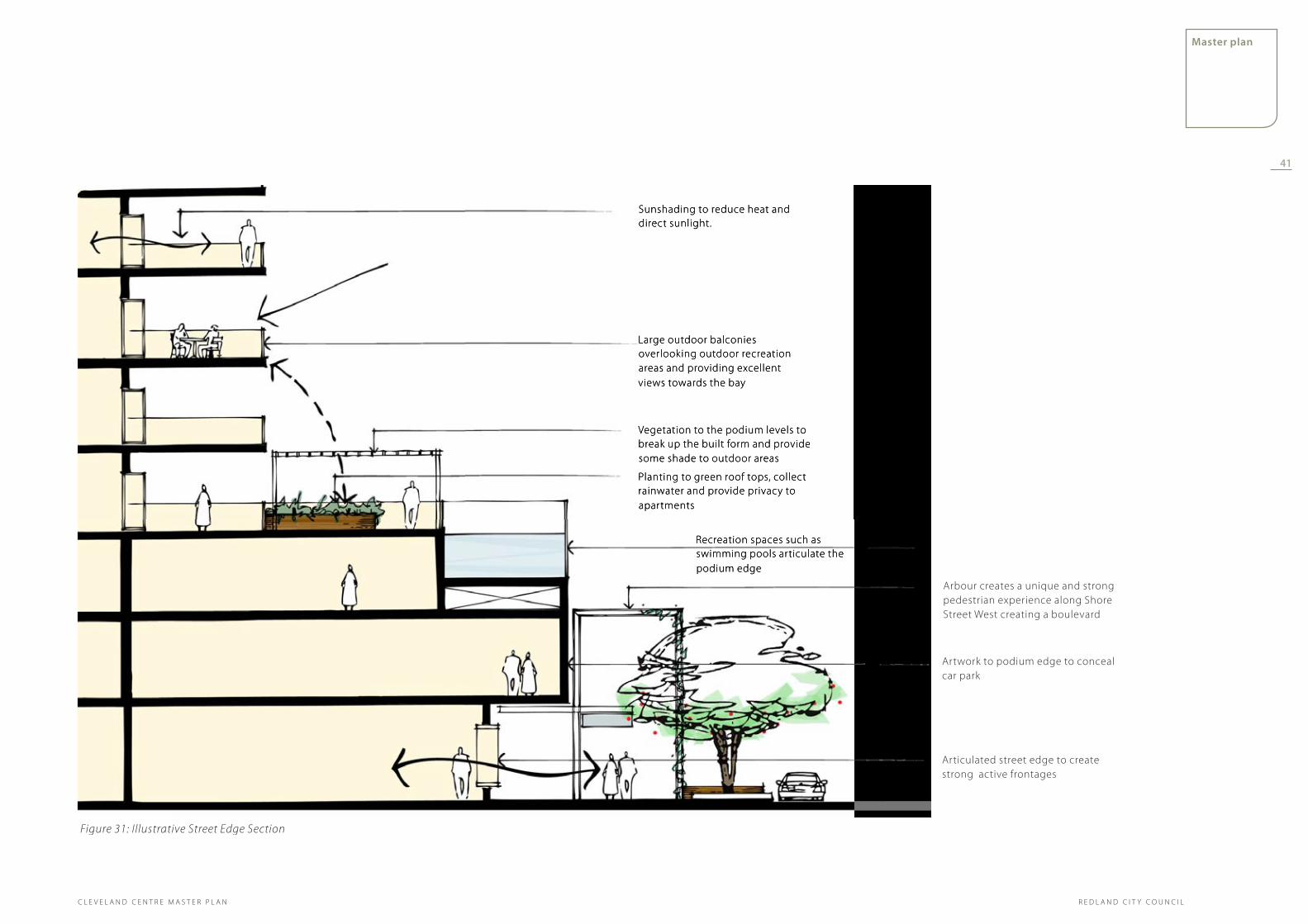
Large outdoor balconies overlooking outdoor recreation areas and providing excellent views towards the bay
Sunshading to reduce heat and direct sunlight.
Vegetation to the podium levels to break up the built form and provide some shade to outdoor areas
Planting to green roof tops, collect rainwater and provide privacy to apartments
Recreation spaces such as swimming pools articulate the podium edge
Arbour creates a unique and strong pedestrian experience along Shore Street West creating a boulevard
Artwork to podium edge to conceal car park
Articulated street edge to create strong active frontages
Figure 31: Illustrative Street Edge Section
Large outdoor balconies overlooking outdoor recreation areas and providing excellent views towards the bay
Sunshading to reduce heat and direct sunlight.
Vegetation to the podium levels to break up the built form and provide some shade to outdoor areas
Planting to green roof tops, collect rainwater and provide privacy to apartments
Recreation spaces such as swimming pools articulate the podium edge
41
master plan
R E D L A N D C I T Y C O U N C I LC L E V E L A N D C E N T R E M A S T E R P L A N

Delivery 5.0 ImPlementatIon Plan5.1 IntroductionThe illustrated Master Plan sets in place a vision to guide the development of Cleveland Centre over the next 20 years as it seeks to accommodate the projected growth for the area, as determined by the Local Growth Management Strategy’s conservative target of 456 dwelling units and 3483 jobs by 2026. The proposed Master Plan provides for development potential in excess of figures.
The Delivery chapter of this report is divided into 3 sections :
Implementation PlanThis section identifies eight specific Master Plan initiatives, required to achieve the Cleveland Centre Vision for 2031. For each initiative, a method of delivery is nominated, a champion identified and a time frame given.
These include:
Place Management•
Cleveland Centre character areas•
Land use•
Urban form•
Public Realm•
Movement•
Open Space•
Community•
Catalyst ProjectsOpportunities for Catalyst Projects have been identified, as a focus to begin the translation of the master plan. These project opportunities are illustrated through a series of plans and urban design principles providing informal design briefs.
design guidance Design guidance identifies areas of the Redlands Planning Scheme which will need to be reviewed in response to the direction set by the Master Plan, in addition to information relating to plot ratios and built form setbacks.
42
R E D L A N D C I T Y C O U N C I L
5.0 ImPlementatIon Plan 385.1 Introduction 38
5.2 Initiatives Summary Tables 40
6.0 Catalyst ProJeCts 46
6.1 Overall Design Guidelines for the Centre Master Plan Area 48
6.2 Site 1A: Shore Street West 49
6.3 Site 1B: Corner Shore Street West and Wynyard Street 50
6.4 Catalyst Site 1C: Waterloo and Doig Street 51
6.5 Site 1D: Reconfiguration of Doig Street 52
6.6 Site 2A: Corner of Queen and Wynyard Street 54
6.7 Site 2B: Middle and Waters Street 55
6.8 Site 2C: Middle Street and Shore Street West 56
6.9 Site 3A: Doig Street Car Park and New Town Square 57
6.10 Site 4A: Corner Bloomfield and Middle Street 58
6.11 Site 5A: Cleveland Station 59
6.12 Site 5B: Shore Street West 61
6.13 Site 6A: The Library Site 62
6.14 Site 6B: Corner of Middle Street Bloomfield Street (east side) 63
6.15 Site 7A: Corner Masthead Drive and Shore Street West 64
6.16 Site 8A: Corner Shore Street West and Waterloo Street 65
6.17 Site 8B: Raby Bay Harbour Park 66
7.0 desIgn guIdanCe 687.1 Introduction 68
7.2 Provisions to be reviewed /revised within the Major Centre Zone Code of the Redlands Planning Scheme 68
C L E V E L A N D C E N T R E M A S T E R P L A N

guiding master Plan strategies
master Plan delivery
Wider strategy Initiatives
Catalyst Projects
master Plan and WIder strategy InItIatIVes
InItIatIVe delIVery tImIng resPonsIBIlIty
Highlights a key initiative within the Master Plan Strategy
Describes how and where the strategy will be delivered (action). Different implementation mechanisms have been identified and are allocated to each action:
Advocacy: interventions that need active support and promotion
Policy and Regulatory Review: initiatives that require statutory support through policy review or amendments to planning scheme
Analysis: interventions which require a more detailed investigation process before the initiative can be delivered
Short: Intervention to be delivered within 5 years
Medium: Intervention to be delivered within 5-10 years
Long: Intervention to be delivered within the Master Plan design horizon (by 2031)
Nominates an agency or stakeholder who is key in the delivery of the initiative.
Figure 32: Delivery Strategy
43
delivery
R E D L A N D C I T Y C O U N C I LC L E V E L A N D C E N T R E M A S T E R P L A N

5.2 Initiatives Summary Tables
master Plan InItIatIVe
InItIatIVe delIVery tImIng resPonsIBIlIty
Precinct Identification
Advocacy: Council to explore the development and adoption of a distinctive materials and planting palette to distinguish the different character areas in the centre.
Policy and Regulatory Review: Review and update Streetscape Design Manual.
Analysis: Explore the development of a marketing strategy that develops the ‘brand’ for the Cleveland Centre and promotes catalyst project opportunities and other marketing and promotional activities.
Short RCC
A Program of Activity
Policy and Regulatory Review: Review and update the Major Centre (MC) Zone Code and Mapping to reflect the proposed Master Plan and support the development of the character areas identified for the Centre.
Short RCC
strategy 1: PlaCe management strategy 2: CleVeland Centre CharaCter areas
master Plan InItIatIVe
InItIatIVe delIVery tImIng resPonsIBIlIty
Place Management Advocacy: A 'place manager' is to be engaged to drive delivery of the master plan vision. The role of the place manager will be to broker, facilitate and manage the resources and actions needed to achieve the vision for Cleveland. This would likely involve the appointment of a dedicated officer to coordinate and drive the delivery of the master plan.
Short RCC & State Government
Promotion and Branding
Advocacy: Explore marketing strategies to define a clear brand for the Cleveland Centre and communicate the opportunities to the local community and the development sector.
Short Place Manager
Coordinated Strategy
Advocacy: Set up a task force, consisting of officers and key stakeholders from relevant departments of council, to ensure that a holistic approach to brand communication and initiative development is delivered.
Short Place Manager
Investment Strategies
Advocacy: Establish a group or mechanism to ensure annual council budgets are coordinated and supports the delivery of the master Plan where relevant.
Medium Place Manager
Promote Cleveland as a Sustainable Centre
Advocacy: Ensure branding and marketing message is underpinned by strong promotion of sustainable development in the centre.
Short Place Manager
44
R E D L A N D C I T Y C O U N C I L
delivery
C L E V E L A N D C E N T R E M A S T E R P L A N

master Plan InItIatIVe InItIatIVe delIVery tImIng resPonsIBIlIty
Major Public Transport Interchange
Catalyst Site 5A: Opportunity around the Cleveland Rail Station for mixed use development and the creation of a architectural presence on the bay.
Advocacy: RCC to collaborate with State Government in developing a design brief for the area and transport planning to be undertaken to determine the scope for a multi modal interchange on the site.
Medium
Medium
RCC, State Government and Developer
RCC, State Government and Developer
Dining and Entertainment Policy and Regulatory Review: Review planning scheme land use zones, particularly within the Bayside Precinct, where a strong evening and cafe culture is proposed.
Short RCC
Mixed Use Policy and Regulatory Review: Review of planning scheme land use zones to confirm promotion of mixed use development across the area.
Analysis: Undertake a further economic assessment of the Centre to inform further strategies concerning the location and intensity of particular uses and activities that underpin the Master Plan vision.
Advocacy: Regularly monitor the dynamic of Centre life, economic activity and development.
Catalyst Site 1A (Cnr Shore St West & Bloomfield St): A council owned site presents the opportunity for mixed use residential, retail and commercial development.
Catalyst Site 1B (Cnr Shore St West & Wynyard St): Opportunity site for mixed use residential development and multi-level car parking.
Short
Short - Medium
Ongoing
Short - Medium
RCC
RCC
RCC
RCC & Developer
Active Streets Policy and Regulatory Review : Ensure there is a diverse mix of uses and activities across the centre, and that the ground floor is activated and engages with the adjacent public realm. Refer to the supporting Landscape Strategy and Public Realm and Built Form documents for further detail direction and explore opportunities to embed as planning policy guidance.
Short RCC
strategy 3: land use
45
delivery
R E D L A N D C I T Y C O U N C I LC L E V E L A N D C E N T R E M A S T E R P L A N

master Plan InItIatIVe InItIatIVe delIVery tImIng resPonsIBIlIty
A Fine Urban Grain Advocacy: Deliver a fine grain pedestrian network through the introduction of new and protection of existing laneways and arcades.
Advocacy: Explore the opportunity to start to deliver the laneway structure promoted in the Master Plan through landscape and street enhancement strategies.
Policy and Regulatory Review: Explore the opportunity to embed policy that requires the careful consideration and management of proposals for block amalgamation to maintain the walkability and fine grain of the centre into the Planning Scheme.
Short
Short
Short
RCC & Developer
RCC & Developer
RCC
Strengthen the Urban Grid Advocacy: Remove the voids in the urban grid through the change of use of existing areas of surface car parking. Look to integrate parking provision in the urban structure of the centre and utilise the released land parcels for new mixed use development.
Medium RCC
A Legible Centre Advocacy: Adopt built form guidelines to deliver a cohesive and complimentary architectural style throughout the centre.
Advocacy: Explore opportunities for buildings, urban art, landscape and civic spaces to improve the wayfinding and legibility of the Centre.
Short
Ongoing
RCC
RCC
Sustainable Design Advocacy: Encourage the development of sustainable buildings through policy direction.
Policy and Regulatory Review: Set minimum standards and design requirements for sustainable development such as a minimum 4 star green star rating for new buildings as well as the adoption of climate responsive design principles such as orientation, solar access and cross ventilation.
Short
Short - Medium
RCC
RCC
strategy 4: urBan Form (InCludes BuIldIng heIghts)
46
R E D L A N D C I T Y C O U N C I L
delivery
C L E V E L A N D C E N T R E M A S T E R P L A N

master Plan InItIatIVe InItIatIVe delIVery tImIng resPonsIBIlIty
Establish a Street Hierarchy Advocacy: Through design detailing and careful management of traffic movement within the centre establish a clear hierarchy of streets.
Short - Medium RCC
Gateways Advocacy: Create a sense of arrival through the design approach adopted at the proposed Cleveland transit interchange for visitors, tourists, and returning commuters.
Short - Medium RCC, State Government and Developer
Maintain Village Scale Policy and Regulatory Review: Amend the Redlands Planning Scheme to require building heights and articulation to provide a pedestrian scale street address. Refer to detailed recommendations provided in the built form and public realm design guidance document.
Advocacy: Create intimate and engaging spaces and a finer grain of urban block that encourages walkability. Promote the ideas of laneways in Cleveland and a connected network of small spaces.
Short
Short
BCC
RCC
Views Policy and Regulatory Review: Incorporate provisions into the Redlands Planning Scheme to protect important view corridors and vistas.
Advocacy: Ensure key views towards the bay and view corridors are enhanced and uncompromised by new development in the centre.
Short
Short
RCC
RCC
New Town Square Catalyst Project 3A: Develop a town square as a key piece of public realm, fronting onto Bloomfield Street to provide a new civic and public heart for the centre. The project could be pursued through a design competition to create excitement and an sense of celebration.
Short - Medium State Government, RCC & Private Enterprise
Raby Bay Harbour Park Catalyst Project 8B: Transform the park into a destination in its own right; one that shares a much more positive physical and visual relationship with the Centre, adjacent development, Shore Street West and the train station. Opportunities to improve its attractiveness as a significant bayside recreational park and event space.
Medium - Long RCC
Park Link Analysis: Initiative to explore opportunity to revise northern end of Bloomfield Street, as it extends into Raby Bay Harbour Park, to improve visual and physical access between these two key elements of Clevelands public realm.
Medium RCC
Community Safety Policy and Regulatory Review: Review the Streetscape Design Manual to ensure Crime Prevention Through Environmental Design (CPTED) principles are applied in both private and public space design.
Short RCC
Pocket Park Analysis: Explore the opportunity to acquire land on the corner of Russell and Waterloo Streets for a new public open space.
Medium RCC
strategy 5: PuBlIC realm
47
delivery
R E D L A N D C I T Y C O U N C I LC L E V E L A N D C E N T R E M A S T E R P L A N

master Plan InItIatIVe
InItIatIVe delIVery tImIng resPonsIBIlIty
Establish a Street Hierarchy
Advocacy: Through design detailing and careful management of traffic movement within the centre establish a clear hierarchy of streets.
Short RCC
Laneways and Thoroughfares
Advocacy: Through the catalyst project opportunities deliver a network of finer grain laneways across the centre. Produce guidance documentation for developers promoting and providing advice on the delivery of great laneways.
Policy and Regulatory Review: Develop planning scheme provisions and mapping to identify and protect laneways as part of the Streetscape Design Manual.
Short
Medium
RCC & Developer
RCC
Streetscape Improvements
Analysis: Building on the work undertaken in both the Master Plan and Landscape Strategy documents conduct a more detail ‘ground truthed’ appreciation of streetscape conditions for use in the centre and implement a staged improvement strategy. Strategy to include asset condition review, determination of streetscape upgrade program, definition of consistent standard of design works in the Streetscape Manual .
Medium RCC & Developer
Cycle Network Upgrades
Analysis: Building on the work undertaken in both the Master Plan and Landscape Strategy documents conduct a more detail ‘ground truthed’ appreciation of existing cyclist use and provision, and develop a strategy to improve access and ease of use for cyclists in the centre.
Short RCC & State
Intersectional Treatment
Advocacy: Upgrade the junction of Waterloo and Middle Streets to a signalised intersection.
Short - Medium
RCC
Road Design Catalyst Site 5B, Shore Street West: Opportunity to transform Shore Street West into an attractive tree lined boulevard which improves the Centres important connection to Raby Bay Harbour Park.
Catalyst Site, Bloomfield Street: A preferred strategy from the Bloomfield Street Concept Expolration Document to be adopted and translated into a new street design.
Medium
Medium
RCC
RCC
strategy 6: moVement
48
R E D L A N D C I T Y C O U N C I L
delivery
C L E V E L A N D C E N T R E M A S T E R P L A N
master Plan InItIatIVe
InItIatIVe delIVery tImIng resPonsIBIlIty
Network of Public Spaces
Advocacy: Establish a network of pedestrian and cycle links between parklands and public space within the centre and promote through events, advertising and literature.
Advocacy: Enhance the quality and provision of facilities in open space, recreational and heriatge destinations.
Short
Medium
RCC
RCC
Key Park Improvements
Catalyst Site 8B: Council to commission a detail design for the upgrade of Raby Bay Harbour Park to create a highly usable space that connects the village centre, the transit hub and the waterfront.
Medium RCC
Water Sensitive Urban Design
Policy and Regulatory Review: Expand upon existing policies within the Redland Planning Scheme to require the adoption of sustainable forms of water management.
Advocacy: Conduct a review of the wider catchment and develop recommendations to holistically consider improvements to the health of the water and more sustainable water management.
Short
Short - Medium
RCC
RCC
Healthy Communities
Advocacy: Develop healthy and safe environments that encourage community activity, participation and healthy lifestyles. Particular attention should be given to active transport, walkability and connections to local destinations for seniors and families.
Advocacy: Ensure that all members of the community have access and mobility to and within the centre (age friendly, child friendly and disability).
Short
Short-Medium & Ongoing
RCC
RCC, Developer & Landowners
strategy 7: oPen sPaCe
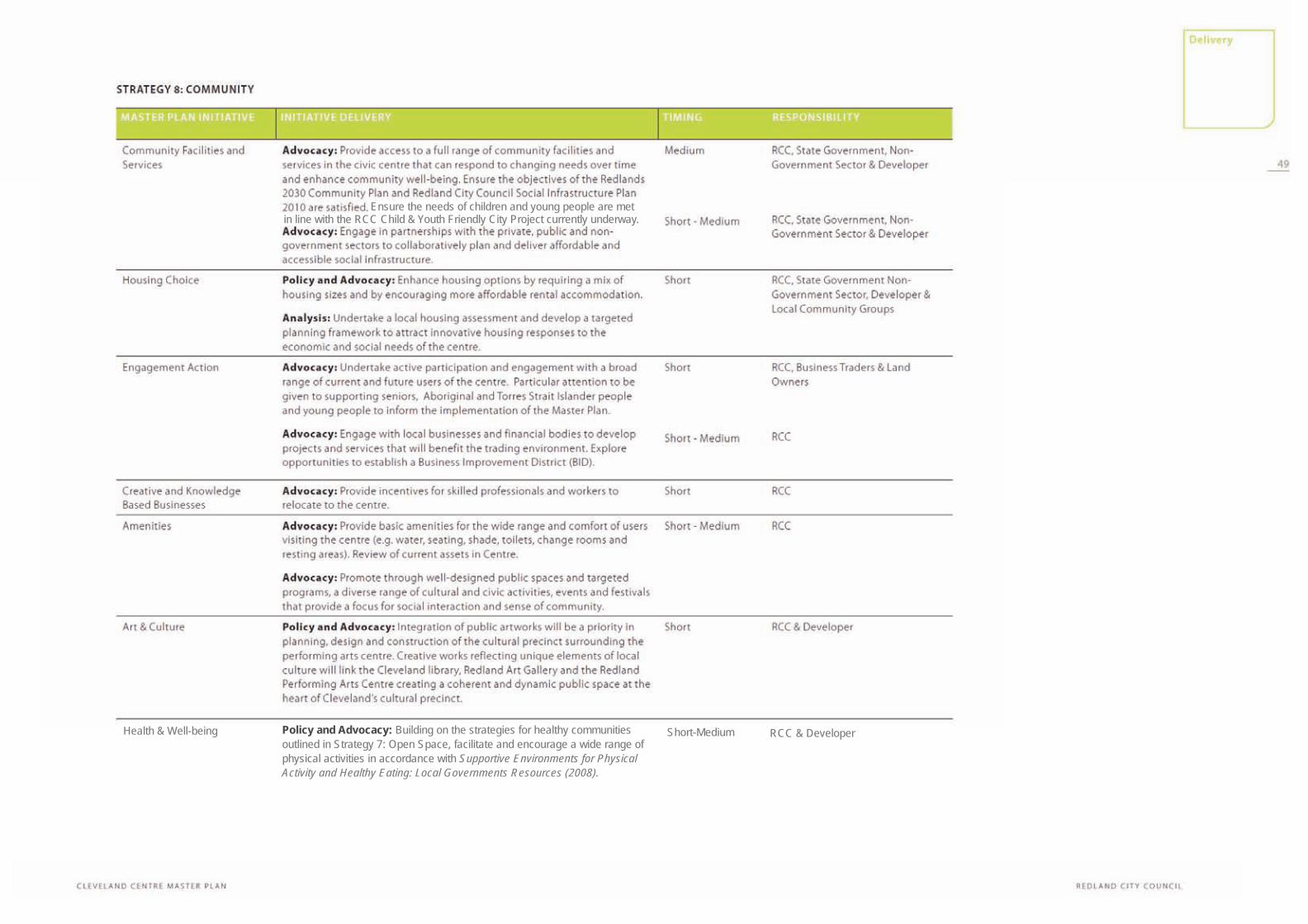
Ensure the needs of children and young people are met in line with the RCC Child & Youth Friendly City Project currently underway.
Health & Well-being Policy and Advocacy: Building on the strategies for healthy communities outlined in Strategy 7: Open Space, facilitate and encourage a wide range of physical activities in accordance with Supportive Environments for Physical Activity and Healthy Eating: Local Governments Resources (2008).
Short-Medium RCC & Developer

One of the first steps in translating the vision established by the Master Plan into a meaningful strategy to guide development, is the identification of early ‘catalyst’ development opportunities.
These are generally sites that present the greatest and most immediate opportunity for redevelopment to occur, often due to their ownership by Council, State Government or a limited number of private parties, as well as the nature of their current land use. These sites have the potential to be catalysts for change and lead the way in the realisation of the master planning vision.
Catalyst developments will set a benchmark for future developments in the centre, particularly in terms of design character, sustainability and civic space contributions. For example, future development must equal or exceed the level of design excellence achieved by the catalyst projects.
Catalyst sIte InterVentIon InterVentIon delIVery resPonsIBIlIty
Specifies key urban design interventions that will be delivered through the development of the catalyst sites.
Identifies actions and design direction to deliver the key urban design interventions. These have been categorised into:
Advocacy: interventions and design briefs that need active support and promotion.
Policy and Regulatory Review: initiatives that require statutory support through policy review or amendments.
Analysis: intervention which requires a more detailed investigation process before the initiative can be delivered.
Nominates an agency or stakeholder to lead the delivery of the initiative.
In a number of instances, the design of buildings and the public realm has to be encouraged and driven by RCC either through incentives, the DA process or through policy. In many cases the responsibility is ‘RCC & Developer ’ meaning that developers will be guided by RCC to deliver positive urban outcomes in line with the Master Plan direction.
6.0 catalyst ProjectsWithin the Master Plan and Implementation Plan, these sites have been labelled as a numbered sequence of sixteen parcels of land. This numbering has been applied in order to give an indication of the sequencing of delivery the sites may best serve to build a sense of momentum and fuel the perception of change in Cleveland Centre, as well as being sites that provide the greatest opportunity to incorporate positive uses that benefit the wider community.
The general attitude adopted in the implementation plan is to first clearly identify the extent of those sites considered to be catalysts, within the context of the above definition. Then set out to define a set of high level development principles, which expand on the more generic design guidance established within the broader illustrative Master Plan for the Cleveland Centre, identifying those considerations which will need to be addressed by Council as individual projects move forward.
These later development principles and the ‘Issues and Actions’ lists, produced as part of the implementation plan, are by no means exhaustive but have been defined to inform initial considerations of how each catalyst site may begin to evolve. The significant role of each of the catalyst sites suggests the opportunity for the development of more detail individual briefs to guide development opportunities as they come forward.
50
R E D L A N D C I T Y C O U N C I L
delivery
C L E V E L A N D C E N T R E M A S T E R P L A N

Figure 33: Catalyst Sites
8A
5A
8B
7A
5B
1A
6B 2C 1B
6A
4A
1C
3A
1D2A
2B
8B
middle street
Blo
om
fiel
d s
tree
t
Wat
erlo
o s
tree
t
Queen street
Wyn
yard
str
eet
shore street West
LEGEND
1
2
3
4
5
6
7
8
Sequence of development:
51
delivery
R E D L A N D C I T Y C O U N C I LC L E V E L A N D C E N T R E M A S T E R P L A N

shore street West
middle street
Blo
om
fiel
d s
tree
t
Queen street
Wyn
yard
str
eet
Wat
erlo
o s
tree
t
Fiigure 30: Urban Elements
6.1 Overall Design Guidelines for the Centre Master Plan Area
The plan opposite demonstrates the high level guidelines that are to be delivered through catalyst projects in the future development of the area.
The following section presents a break down of each catalyst site, in terms of the desired urban design outcomes and how they could be delivered.
This plan should be referenced in conjunction with the detail studies of each catalyst site to assist in understanding the relationship and importance of individual sites within the broader context of the Master Plan Area.
Location of Catalyst site in the Centre
Public Park
Shared Zone/Pedestrian Only Street
Town Square Extent (Restricted Vehicular Access During Events)
Bus Interchange and Railway Station
Public Car Parking - Structured
Public Car Parking - At Grade (Provides for Conversion to Civic Space)
Strong Architectural Design Articulation
Active Frontage at Ground Level
Primary Boulevard
Secondary Boulevard
Road Network
Direction of Vehicular Travel
Public Transport Access Only
Service Vehicle Access Only
Car Parking Access
General Location for Maximum Building
Iconic Structure
Traffic Signals
52
R E D L A N D C I T Y C O U N C I L
delivery
C L E V E L A N D C E N T R E M A S T E R P L A N

6.2 Site 1A: Corner Block: Shore Street West/Bloomfield Street
shore street West
middle street
Blo
om
fiel
d s
tree
t 1A1A
Refer to “Figure 34: Urban Elements” on page 52 for legend.
Catalyst sIte InterVentIon
InterVentIon delIVery resPonsIBIlIty
Ground Floor Activation
Policy and Regulatory Review: The design of building elevations should successfully activate the street at ground floor and provide opportunities for passive surveillance.
RCC & Developer
Pedestrian focused thoroughfare
Advocacy: Deliver a max 12m pedestrian focused lane to the south of the site as a key part of the proposed artisan/shopping arcade as well as providing an important link from the train station to the ‘high street’ (Bloomfield Street).
RCC & Developer
Mixed Use Advocacy: Retail and commercial uses should occupy the ground and first floors with residential above.
Developer
Building Design Advocacy: The catalyst site is located in a prime position on the corner of Bloomfield Street and Shore Street West, presenting an opportunity to further define the street edges. The taller elements of the building should be focused towards the front and west of the building plate, both to maximise natural light access and to take advantage of views to the water.
Developer
Proposed land use:
Retail / Commercial at ground and first floor, with residential above.
height range in storeys:
MInimum 2 - Maximum 8
Ownership: Council
development Principles
This Council owned site occupies a key development parcel within the Cleveland Centre. The combined attractiveness of its frontage, onto Shore Street West and Raby Bay Harbour Park, and its proximity to the train station provide one of the most attractive residential development locations within the Centre. The site also plays an important role in its potential contribution to the transformation of the Centre’s Raby Bay address; into a lively and attractive place that accommodates a broad range of evening and leisure activities as well as providing accommodation for destination shopping such as artisan studios, galleries and fashion boutiques.
A number of options have been tested, in order to inform the provision made within the illustrative master plan. The diagrams included on this page illustrate one possible scenario that includes restaurant / cafe outlets fronting onto the park to the east, and orientated out towards Raby Bay.
53
delivery
R E D L A N D C I T Y C O U N C I LC L E V E L A N D C E N T R E M A S T E R P L A N

6.3 Site 1B: Corner Shore Street West and Wynyard Street
shore street West
middle street
Wyn
yard
str
eet
1B
Refer to “Figure 30: Urban Elements” on page 52 for legend.
Catalyst sIte InterVentIon
InterVentIon delIVery resPonsIBIlIty
Land Acquisition Advocacy: As part of the redevelopment, Council to obtain land to relocate existing public car parks and additional spaces as part of any negotiated outcome for release of the land for redevelopment opportunities.
RCC
Mixed Use Advocacy: This site is intended to have a large proportion of it ’s capacity dedicated to residential uses, and will play and important role in contributing to increasing the number of residents within Cleveland Centre.
RCC & Developer
Increased intensity Analysis: Council to conduct a more detailed investigation in to the impact of the new development on local traffic conditions and road capacity.
Analysis: Determine whether the consolidation of adjacent properties is appropriate and/or beneficial for future development.
Advocacy: Building heights should be concentrated towards street corners along Wynyard Street.
RCC
RCC
RCC
A Defined Street Edge
Advocacy: Ensure the building design delivers an active frontage and strong street edge, as well as encouraging natural surveillance.
Developer
Access Advocacy: Pedestrian access should be via Wynyard and Shore Street West in order to create an address and contribute to the animation of the public realm and the creation of a strong relationship between the Centre, Raby Bay and the new apartments.
Advocacy: Dedicated set-down area parking for the development should be provided on-street, along Wynyard Street, and also within the development off Middle Street.
Developer
Developer
Proposed land use: Mixed Use.
height range in storeys: MInimum 2 - Maximum 6
Ownership: Council and Private Ownership (Land East of Council Lot Fronting Middle, Wynyard and Shore Streets)
development Principles
The proposed development site is currently occupied by a surface level car park and defines the eastern most extent of the area defined as the Cleveland
Centre Master Plan study area. Within the illustrative Master Plan this site is identified as mixed use, a significant component of which will be residential development with potential short term tourist accommodation. It will play an important role in contributing to increasing the number of residents within Cleveland Centre. This will in time start to change the dynamic of the area to one that has a substantial residential population relying on the centre to provide services such as entertainment and dining into the evening.
Multi-level/basement public car parking provided as part of site redevelopment
1B
54
R E D L A N D C I T Y C O U N C I L
delivery
C L E V E L A N D C E N T R E M A S T E R P L A N

Catalyst sIte InterVentIon
InterVentIon delIVery resPonsIBIlIty
Higher Education Facility
Advocacy: Council to contribute to developing a business case for a higher education facility on the proposed site.
Policy and Regulatory Review: Change of land use zoning to reflect maximum potential opportunities.
RCC, State Government and Private Enterprise
RCC
Access Advocacy: provision for ultimately 500+ public parking spaces within the block (preferably to be accessed via Waterloo Street). Reaffirm parking needs and management study for the centre to inform initiative.
Advocacy: Ensure that the main pedestrian access into precinct is gained off Waterloo Street.
Advocacy: Create a new lane which runs along the southern edge of the development between Waterloo Street and Doig Street. This lane is a key part of an important new east/ west strategic pedestrian focused route that links important activities across the entire width of the Centre.
RCC
Developer
Developer
Building Design Advocacy: Emphasise built form through elevational treatment and the application of higher built form towards the building corners.
Advocacy: Design for active frontages on the ground floor, particularly along Waterloo Street and the new land.
Developer/RCC
Developer/ RCC
6.4 Catalyst Site 1C: Waterloo and Doig Street
middle street
War
terl
oo
str
eet
1C
Refer to “Figure 30: Urban Elements” on page 52 for legend.
development Principles
The proposed land use, as determined by the illustrative Master Plan, is for a higher education facility, as well as public car park and commercial premises. Consideration of the appropriate size for a higher education facility in Cleveland suggests a facility in the range of between 4,000 to 6,000m2 with the possible opportunity to accommodate a larger unit of up to 15,000m2. It is anticipated that the proposed college would operate as a ‘satellite’
land use: Commercial uses, educational facility and car parking
height range in storeys: mInimum 2 - Maximum 7
Ownership: Council and Private Ownership
campus and ‘flexible’ teaching space and that, due to the nature of the facilities provided as part of the college, it would contribute to the economic vibrancy of Cleveland, with students and staff relying on the Centre itself for their daily needs.
A number of options have been tested, in order to inform the provision made within the illustrative Master Plan. The diagrams included on this page illustrate one possible scenario that includes a higher education facility of approximately 6,000m2 , maximising the use of the land, and provision for ultimately 650 public parking spaces within the block. These diagrams demonstrate how such a facility might operate on the proposed site with room for additional commercial premises to be accommodated.
The tested option has also been developed further to illustrate how, in time if demand requires it, the college could expand onto the adjacent site.
1C
55
delivery
R E D L A N D C I T Y C O U N C I LC L E V E L A N D C E N T R E M A S T E R P L A N

6.5 Site 1D: Reconfiguration of Doig Street
Queen street
middle street
1D
Refer to “Figure 30: Urban Elements” on page 52 for legend.
Catalyst sIte InterVentIon
InterVentIon delIVery resPonsIBIlIty
Streetscape Improvements
Advocacy: Establish a high quality public realm at the northern end of Doig Street as it meets Middle Street (for pedestrian access only in the long term). In the short term, one way access from north to south will be allowed.
Advocacy: create an attractive and comfortable pedestrian route that increases the opportunity for safe pedestrian and cyclist movement between the train station and Centre.
RCC & Developer
RCC & Developer
Legibility Advocacy: Adopt a complementary approach and finish to the public realm, as elsewhere in the centre, along Doig Street to enhance way finding, in terms of the materials and also the inclusion of tree planting.
RCC & Developer
Program of Activity Policy and Regulatory Review: Within the design of the pedestrian street allowance will need to be made for restricted hours access by servicing vehicles for the adjacent commercial and retail sites.
Analysis: Council to determine a more detailed development brief for the street, having regard to service provisions/needs, to both private and council buildings.
RCC
RCC
Carparking Analysis: Further research into the volume of parking the development is required to deliver as one of the key public car parks in the Centre.
RCC
development Principles
Closely associated with the development of the proposed higher education facility is the reconfiguration of Doig Street as a one way access road, providing a link to the new areas of car park and also a drop off / pick up point close to the focus of the Centre.
Proposed land use: New pedestrian street and one way vehicle access for Centre .
height range in storeys: N/A
Ownership: non-council
1D
56
R E D L A N D C I T Y C O U N C I L
delivery
C L E V E L A N D C E N T R E M A S T E R P L A N

TYPICAL PEDESTRIAN ONLY THOROGHFARE DETAIL
MINIMUM 12M
PedestrIan thoroughFare - PotentIal ConFIguratIon For PedestrIanIsed laneWays
section Location
Figure 35: Pedestrian Thoroughfare Typical Section
57
delivery
R E D L A N D C I T Y C O U N C I LC L E V E L A N D C E N T R E M A S T E R P L A N

Catalyst sIte InterVentIon
InterVentIon delIVery resPonsIBIlIty
Ground Floor Activation
Policy and Regulatory Review: The design of building elevations should successfully activate the street at ground floor and provide opportunities for passive surveillance.
RCC & Developer
Carparking Advocacy: The proposed enclosed car park is to be sleeved with development that presents an active frontage onto Waters and Queen Streets. Access to the car park will be from Wynyard Street and via Waters Street.
Analysis: A clear understanding is required of the parking numbers needed by the redevelopment to inform the development brief for the car park.
RCC & Developer
RCC & Developer
Street Alignment Policy and Regulatory Review: As part of the development, Waters Street will be extended north and then east to form a tree lined pedestrian boulevard with limited vehicle access, minimum width 12m including 4m vehicle corridor and dedicated two way cycle lanes, to be accessed via Wynyard and Queens Streets.
Analysis: Investigate the option to move Waters Street to the west to achieve a more meaningful development floorplate area is to be secured.
RCC & Developer
RCC & Developer
Land Aquisition Advocacy: A comprehensive design should be produced for the refurbished public space, which accommodates the land identified as site 3A, to ensure that the intention within the Master Plan to create a new Town Square, that at its full extent includes a section of Bloomfield Street, is delivered.
RCC
6.6 Site 2A: Corner of Queen and Wynyard Street
Queen street
middle street
2ABlo
om
fiel
d s
tree
t Refer to “Figure 30: Urban Elements” on page 52 for legend.
Proposed land use: Commercial and retail development with public car park and residential development above.
height range in storeys: MInimum 2 - Maximum 7
Ownership: Private/non-council
development Principles
The proposed development site occupies land currently under Council ownership and plays an important role in the strategic delivery of the wider Master Plan, in that it will deliver a parking station and has the potential to accommodate a significant element of single site retail/ commercial floor space in line with the direction set in the Local Growth Management Strategy.
The development of the site also brings forward part of the proposed movement strategy for the Centre; the eastern half of the strategic east/ west pedestrian focused route, and will facilitate the refurbishment of an existing public space to form the first half of the proposed ’Town Square’ which is located on this new route alignment.
2A
58
R E D L A N D C I T Y C O U N C I L
delivery
C L E V E L A N D C E N T R E M A S T E R P L A N

Queen street
middle street
2B
Blo
om
fiel
d s
tree
t
Refer to “Figure 30: Urban Elements” on page 52 for legend.
6.7 Site 2B: Middle and Waters Street Proposed land use: Retail, commercial and residential development.
height range in storeys: MInimum 2 - Maximum 7
Ownership: Non-council
Catalyst sIte InterVentIon
InterVentIon delIVery resPonsIBIlIty
Active ground Floor
Policy and Regulatory Review: The design of building elevations should successfully activate the street at ground floor and provide opportunities for passive surveillance, ensuring this is delivered onto Middle and Wynyard Streets as well as onto an internal courtyard space that will provide a focus for the retail precinct.
RCC & Developer
Car Parking Advoacay: Short stay parking provision will be provided within the internal courtyard with the opportunity for a larger number of dedicated longer term parking bays to be provided in a basement or podium level facility accessed via this central courtyard. Access to the car park will be off Wynyard Street and via Waters Street.
RCC & Developer
Access Advocacy: The development will include provision for a new pedestrian route, connecting Middle Street with the newly extended Waters Street and reconfigured car park. This new lane to provide a high quality pedestrian focused route of minimum 6m width between the built form.
RCC
Mixed Use Advocacy: Council to engage in discussion with land owner with regards to the potential for redevelopment of the site in the context of the illustrative Master Plan.
Advocacy: Residential development above the retail floor plates needs to be carefully configured to minimise conflict eg. noise issues.
Analysis: The integration of the proposed form of retail with residential development above needs to be considered carefully if it is to be successful.
RCC & Developer
Developer
RCC & Developer
development Principles
The proposed development site covers a significant area of land, at the heart of the Centre, on one of its principal shopping streets. The site is within the same land ownership and provides an excellent opportunity for the comprehensive delivery of a significant new high quality retail destination at Cleveland Centre.
2B
59
delivery
R E D L A N D C I T Y C O U N C I LC L E V E L A N D C E N T R E M A S T E R P L A N
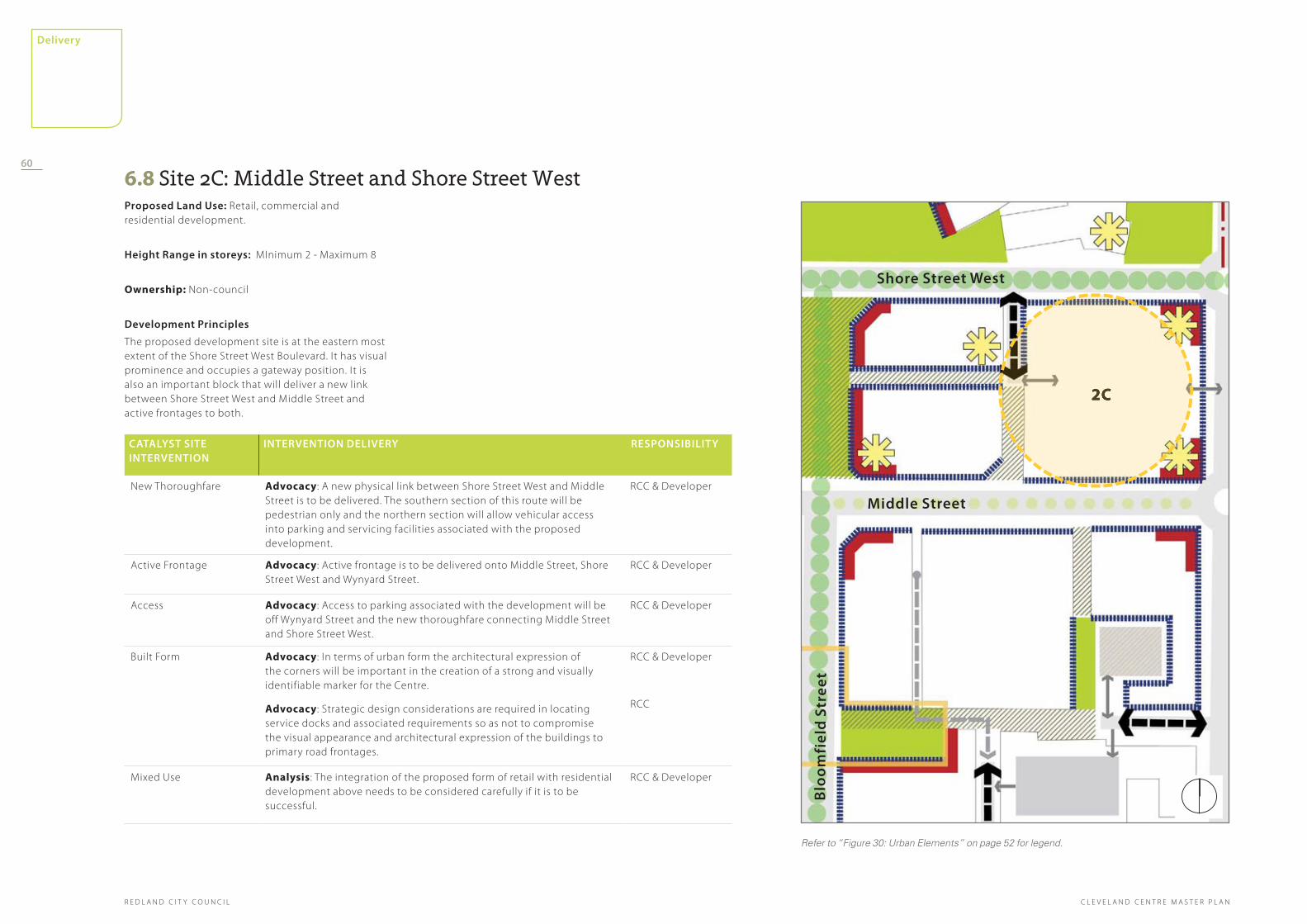
middle street
2C
Blo
om
fiel
d s
tree
t
shore street West
Refer to “Figure 30: Urban Elements” on page 52 for legend.
6.8 Site 2C: Middle Street and Shore Street WestProposed land use: Retail, commercial and residential development.
height range in storeys: MInimum 2 - Maximum 8
Ownership: Non-council
development Principles
The proposed development site is at the eastern most extent of the Shore Street West Boulevard. It has visual prominence and occupies a gateway position. It is also an important block that will deliver a new link between Shore Street West and Middle Street and active frontages to both.
Catalyst sIte InterVentIon
InterVentIon delIVery resPonsIBIlIty
New Thoroughfare Advocacy: A new physical link between Shore Street West and Middle Street is to be delivered. The southern section of this route will be pedestrian only and the northern section will allow vehicular access into parking and servicing facilities associated with the proposed development.
RCC & Developer
Active Frontage Advocacy: Active frontage is to be delivered onto Middle Street, Shore Street West and Wynyard Street.
RCC & Developer
Access Advocacy: Access to parking associated with the development will be off Wynyard Street and the new thoroughfare connecting Middle Street and Shore Street West.
RCC & Developer
Built Form Advocacy: In terms of urban form the architectural expression of the corners will be important in the creation of a strong and visually identifiable marker for the Centre.
Advocacy: Strategic design considerations are required in locating service docks and associated requirements so as not to compromise the visual appearance and architectural expression of the buildings to primary road frontages.
RCC & Developer
RCC
Mixed Use Analysis: The integration of the proposed form of retail with residential development above needs to be considered carefully if it is to be successful.
RCC & Developer
2C
60
R E D L A N D C I T Y C O U N C I L
delivery
C L E V E L A N D C E N T R E M A S T E R P L A N

middle street
Queen street
3A
Blo
om
fiel
d s
tree
t
Refer to “Figure 30: Urban Elements” on page 52 for legend.
6.9 Site 3A: Doig Street Car Park and New Town SquareProposed land use:: Commercial, retail, car park and new public space.
height range in storeys: MInimum 2 - Maximum 7
Ownership: Part council owner, part private/non-council owned
Catalyst sIte InterVentIon
InterVentIon delIVery resPonsIBIlIty
Built Form Advocacy: The creation of a high quality development that provides a high quality urban frontage for the proposed town square with the inclusion of active frontage at ground floor a key requirement.
RCC & Developer
Public Space Advocacy: The design of a high quality urban public space which shares a strong relationship with the adjacent buildings and Bloomfield Street.
RCC
Street Alignment Advocacy: A change in the configuration of the central part of Bloomfield Street corridor, removing parking provision on the street at this point in order to deliver a new public space that can be expanded, as events require, to bridge and include Bloomfield Street as part of the space.
RCC
Car Park Reconfiguration Advocacy: The reconfiguration of the existing surface car park to provide a high quality short stay parking facility that can be utilised also for markets.
RCC
Land ownership Advocacy: Council to begin discussion with land owner in regards to the potential for redevelopment of the site in the context of the illustrative Master Plan.
RCC & State Government
development Principles
Following the delivery of a significant element of public parking provision within the Centre, at sites 2A and 2B, it will be possible to release the land to the east of Doig Street for redevelopment. The release of this piece of land will allow the delivery of a significant organisational element of the Master Plan, in the shape of a new town square at the heart of the Centre, as well as additional surface parking and key commercial and retail development.
3A
61
delivery
R E D L A N D C I T Y C O U N C I LC L E V E L A N D C E N T R E M A S T E R P L A N
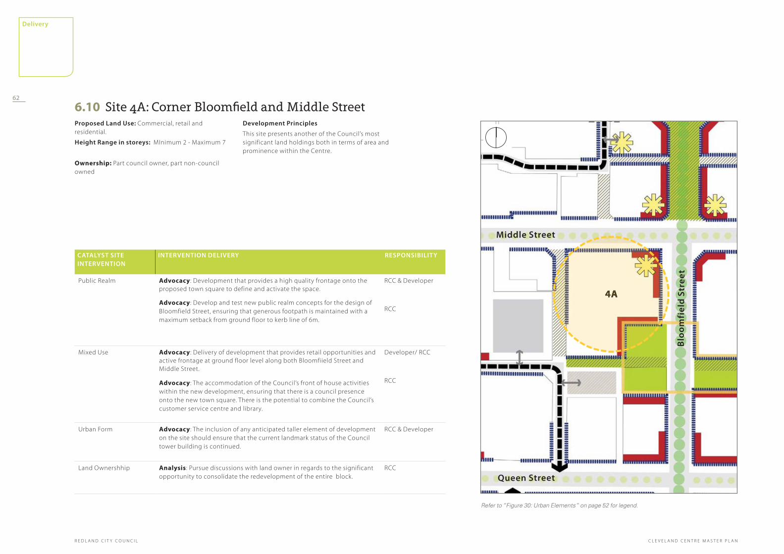
middle street
Queen street
4A
Blo
om
fiel
d s
tree
t
Refer to “Figure 30: Urban Elements” on page 52 for legend.
6.10 Site 4A: Corner Bloomfield and Middle StreetProposed land use: Commercial, retail and residential.
height range in storeys: MInimum 2 - Maximum 7
Ownership: Part council owner, part non-council owned
Catalyst sIte InterVentIon
InterVentIon delIVery resPonsIBIlIty
Public Realm Advocacy: Development that provides a high quality frontage onto the proposed town square to define and activate the space.
Advocacy: Develop and test new public realm concepts for the design of Bloomfield Street, ensuring that generous footpath is maintained with a maximum setback from ground floor to kerb line of 6m.
RCC & Developer
RCC
Mixed Use Advocacy: Delivery of development that provides retail opportunities and active frontage at ground floor level along both Bloomfiield Street and Middle Street.
Advocacy: The accommodation of the Council’s front of house activities within the new development, ensuring that there is a council presence onto the new town square. There is the potential to combine the Council’s customer service centre and library.
Developer/ RCC
RCC
Urban Form Advocacy: The inclusion of any anticipated taller element of development on the site should ensure that the current landmark status of the Council tower building is continued.
RCC & Developer
Land Ownershhip Analysis: Pursue discussions with land owner in regards to the significant opportunity to consolidate the redevelopment of the entire block.
RCC
development Principles
This site presents another of the Council’s most significant land holdings both in terms of area and prominence within the Centre.
4A
62
R E D L A N D C I T Y C O U N C I L
delivery
C L E V E L A N D C E N T R E M A S T E R P L A N
6.11 Site 5A: Cleveland StationProposed land use: Commercial, retail, leisure, conference facilities, residential apartments, parking and transport interchange.
height range in storeys: MInimum 2 - Maximum 8
Ownership: State Government
development Principles
The majority of the site is State Government owned, with a small piece to the rear in the ownership of the Council. The site presents a significant opportunity for the realisation of Transport Orientated Development ( TOD) that maximises the location at the train station in terms of accessibility and delivers a greater intensity of development volume.
The site’s physical proximity to the adjacent Raby Bay and Raby Bay Harbour Park suggests that use of the land would be best suited to public activities that generate significant levels of pedestrian activity both within the building and in the adjacent public realm. The development should provide opportunities for people to appreciate the bay side location and views, creating an attractive daytime and evening destination within the proposed Bayside Precinct.
It is therefore proposed to develop a mixed use complex, over and around the train station, which includes a significant leisure/ entertainment and conference provision as well as high quality
commercial premises with parking. In addition to a transport interchange that utilises the Shore Street West address.
Any proposed development should take advantage of aspect and views across the bay and provide a higher density of development to create a critical mass of activity in the area, as well as practically recognising the development economics in play on such a complicated site. The physical scale of development anticipated will therefore be significant, including one of the tallest elements of built form in the proposed Master Plan while still preserving view lines through the development and adjacent to its stepped edges.
The main buildings location and anticipated scale also means that in terms of townscape legibility it will become a key visual landmark at the entrance to Cleveland and in time synonymous with the Centre.
Acknowledgement should be made of the site’s relationship to the development to the north, and articulation of the building form to lessen the bulk when viewed from Shore Street West and adjacent areas to the south should be provided.
63
delivery
R E D L A N D C I T Y C O U N C I LC L E V E L A N D C E N T R E M A S T E R P L A N

shore street West
middle street
5A
Refer to “Figure 30: Urban Elements” on page 52 for legend.
Catalyst sIte InterVentIon
InterVentIon delIVery resPonsIBIlIty
Activation Advocacy: The delivery of development that provides active frontage at ground floor level onto Raby Bay and Raby Bay Harbour Park.
State Government, RCC & Developer
Train Station Upgrades
The creation of an attractive new train station, the entrance of which is legible from Shore Street West and the park, with associated facilities such a ticket booths, waiting room and toilets.
The integration of a public transport interchange along the sites Shore Street West address that includes provision for buses, taxis and facilities for cyclists.
Analysis: Investigation into the development economics associated with building in close proximity to or over a rail station.
Advocacy: Council should continue to engage with State Government to explore development timetables and EOI process documentation.
Advocacy: A further design exercise to be commissioned to test in greater detail the robustness of the proposed land use mix and design principles, including practical construction considerations and development economics.
State Government
RCC
State Government & RCC
Built Fotm Advocacy: The delivery of a high quality architectural response that creates a fitting landmark for the Centre.
Analysis: Conduct a design assessment of the impact the new development will have on surrounding areas, for example, the existing low density residential.
Advocacy: The inclusion of the taller element of development towards the northern edge of the site to maximise the opportunity for vantage points out across the Raby Bay and allow public access.
Advocacy: Create a Gateway statement through a holistic and high quality architectural response which deliveries a fitting gateway experience for Cleveland.
State Government & RCC
State Government & Developer
RCC
State/ Developer
Access Advocacy: The inclusion of a ‘Kiss and Ride’ facility, the design of which works sensitively with the delivery of a high quality pedestrian focused public realm.
RCC
Car parking Policy: The provision of car parking within a structure to the rear of the development. The parking provided for both train station users as well as enough provision to support the commercial premises and also for people attending other business and leisure activities within the complex.
RCC
Mixed Use Advocacy: The successful delivery of a mix of uses within the development to create the critical mass of activity required to animate the bayside throughout the day.
The inclusion of high quality commercial accommodation fronting onto Shore Street West.
The inclusion of food and drink establishments, principally orientated north and east, to provide publicly accessible bay views.
State Government & RCC
hore street West
5A
64
R E D L A N D C I T Y C O U N C I L
delivery
C L E V E L A N D C E N T R E M A S T E R P L A N

shore street West
middle street
5B
Blo
om
fiel
d s
tree
t
Refer to “Figure 30: Urban Elements” on page 52 for legend.
6.12 Site 5B: Shore Street WestProposed land use: Vehicular corridor and pedestrian boulevard.
height range in storeys: N/A.
Ownership: State Government
development Principles
The present configuration and scale of the Shore Street West corridor contributes to the current physical division between Cleveland Centre and Raby Bay. At 30 metres wide, with four vehicle lanes and a median strip, it presents a significant barrier and deterent to both pedestrians and cyclists wishing to make the journey between Middle Street, the Raby Bay and the train station.
An assessment has been made, as part of the master plan process, of the volume of traffic that currently uses the route and also that which is anticipated in the coming years.
As a result the opportunity in the Master Plan to transform Shore Street West into an attractive tree lined boulevard that contributes significantly to the Centre is proposed.
The design proposes that Shore Street West becomes an important connection and public space that contributes to the liveliness of the centre and also improves its physical and visual relationship with Raby Bay.
A sketch cross section has been produced to inform the consideration of the redesign for this route.
Catalyst sIte InterVentIon
InterVentIon delIVery resPonsIBIlIty
Street Upgrade Advocacy: A more significant pedestrian crossing be introduced at the point where the linear park extends south from Shore Street and connects with Middle Street.
Analysis: Council to commission a design option study for Shore Street West based on traffic modelling completed to 2031.
RCC
RCC
Public Realm Advocacy: Land remaining following this reconfiguration to be given back to the public and be redesigned to provide a high quality, attractive tree lined boulevard that provides opportunities for Al Fresco dining.
RCC & Developer
shore street West5B
65
delivery
R E D L A N D C I T Y C O U N C I LC L E V E L A N D C E N T R E M A S T E R P L A N

shore street West
middle street
6A
Blo
om
fiel
d s
tree
t
Refer to “Figure 30: Urban Elements” on page 52 for legend.
6.13 Site 6A: The Library SiteProposed land use : Retail/ Commercial at ground and first floor with residential above.
height range in storeys : MInimum 4 - Maximum 8
Ownership: Council
development Principles
A Council owned site that occupies a key development location within the Centre. The combined attractiveness of its frontage onto Middle Street and the adjacent public space, along with the opportunity for views to the north across the Raby Bay mean that development, particularly at higher levels,
is most attractive for residential accommodation. The site also plays an important role in contributing to the transformation of the adjacent park that currently provides the link between Middle Street and Shore Street West; as well as contributing to the delivery of a lively and attractive new retail and leisure precinct on the bay.
The general attitude towards development should be similar to that adopted for site 1A with ground floor active uses, the establishment of active frontage onto the lane to the north and the residential development in the element above the upper storeys.
Catalyst sIte InterVentIon
InterVentIon delIVery resPonsIBIlIty
Activation Advocacy: The creation of active ground floor uses on all sides of the development, particularly fronting onto Middle Street, adjacent to the extension of Raby Bay Harbour Park and the proposed thoroughfare to the front of the development site.
RCC & Developer
New Thoroughfare
Advocacy: The creation of a narrow pedestrianised street or thoroughfare, of minimum 12m width, to the south of the site to provide a key part of the proposed artisan/shopping arcade. This thoroughfare also provides an important route for pedestrians between the train station, Middle Street and Bloomfield Street.
RCC & Developer
Access Advocacy: Access to parking contained within the block will be via Kyling Lane with access onto both Shore Street West and Waterloo Street.
The opportunity for parking within the block, accessed via Kyling Lane, will need careful resolution and testing to ensure that the new north/south link between the station and Middle Street maintains a strong pedestrian and cyclist focus.
RCC & Developer
Mixed Use Advocacy: Retail and commercial uses to be accommodated within the ground and first floors of the development, with an emphasis on restaurant and cafe premises where the block fronts onto the adjacent public park.
Upper storeys of the block to be residential.
Council to determine a more detailed development brief for the site in potential partnership or agreement with a private developer.
RCC & Developer
Library Analysis: Council to consider its position in relation to the redevelopment of the library. RCC
Built Form Advocacy: In terms of architectural form, taller elements should be concentrated towards the rear and east of the podium, in order to maximise the amount of natural light to the residential accommodation and views of the bay, and also help define a strong street frontage onto Middle Street.
RCC & Developer
6A
66
R E D L A N D C I T Y C O U N C I L
delivery
C L E V E L A N D C E N T R E M A S T E R P L A N

shore street West
middle street
Blo
om
fiel
d s
tree
t
6B
Refer to “Figure 30: Urban Elements” on page 52 for legend.
6.14 Site 6B: Corner of Middle Street Bloomfield Street (east side)Proposed land use : Retail/ Commercial at ground and first floor with residential above and refurbishment of the adjacent public park.
height range in storeys:
Middle Street: MInimum 4 - Maximum 8.
Shore Street West: Minimum 3 - Maximum 8.
Ownership: non-council
development Principles
This piece of privately owned land occupies another key location on the bay front. It benefits from the same assets as sites 1A and 6A, with frontage onto Middle Street and the adjacent public space as well as Shore Street West, in addition to the views north and east across the Raby Bay. Uses of the block should be consistent with those recommendations made for Sites 1A and 6A both architecturally and in terms of land use. In particular, the facade of the existing building on the corner of Middle and Bloomfield Streets are to be retained and incorporated into the new development site
Catalyst sIte InterVentIon
InterVentIon delIVery resPonsIBIlIty
Activation Advocacy: The creation of active ground floor uses on all sides of the development, particularly fronting onto Middle Street, adjacent to the extension of Raby Bay Harbour Park, along the proposed lane at the centre of the development and also along Shore Street West.
RCC & Developer
New Thoroughfare
Advocacy: The creation of a narrow pedestrianised street, of minimum 12m width, at a mid point within the development block to provide a key part of the proposed artisan/shopping arcade.
RCC & Developer
Access Advocacy: Access to parking contained within the block to be via the new street, created as part of development 2C, with access and egress gained via Shore Street West only.
RCC & Developer
Mixed Use Advocacy: Retail and commercial uses to be accommodated within the ground and first floors of the development, with an emphasis on restaurant, cafe and licenced hotel premises where the block fronts onto the adjacent public park and Shore Street. Upper storeys of the block to be residential and tourist/short term accommodation.
Analysis: Council to conduct more detail testing of the various capacities for development within the context of the current local market. Issues to be considered to include traffic movement, retail capacity, ground conditions and development economics.
RCC & Developer
RCC
Urban Form Advocacy: In terms of block form, taller elements should be concentrated towards the front and east of the building to the front of the site and to the rear and west of the building to the rear of the site. This approach will maximise the amount of natural light and views of the bay accessible from both blocks and also help define this northern section of Bloomfield Street as a gateway onto the bay.
Advocacy: Sites 1A, 6A and 6B should be considered as a set piece of urban form with architectural proposals responding physically and visually to each other and defining the gateway to the Raby Bay and the Raby Bay Harbour Park.
RCC & Developer
Park Upgrade Advocacy: The refurbishment of the adjacent public park should be facilitated as part of this development. A key aim of any revised design should be to open up the view corridor and extend the visual access to Raby Bay from Middle Street and development along either side of the park.
RCC
Collaboration Analysis: Council to determine a more detailed development brief for the site in partnership with a private developer.
RCC
The site provides the final piece in the establishment of the Bayside Precinct, completing the proposed retail and leisure area, as well as delivering the refurbishment of the park that links Middle Street to Shores Street West.
It is therefore important that the general attitude towards development should be similar to that adopted for site 1A and 6A with ground floor active uses, the establishment of active frontage onto the thoroughfare that runs centrally through the site, and residential development in the upper storeys.
Blo
om
fiel
d s
tree
t
6B
67
delivery
R E D L A N D C I T Y C O U N C I LC L E V E L A N D C E N T R E M A S T E R P L A N

shore street West
middle street
7A
Wyn
yard
str
eet
Refer to “Figure 30: Urban Elements” on page 52 for legend.
6.15 Site 7A: Corner Masthead Drive and Shore Street WestProposed land use: Waterfront dining and entertainment, retail and residential development.
height range in storeys: MInimum 2 storeys fronting the bay stepping up to a maximum of 5 on the corner of Masthead Drive and Shore Street West
Ownership: Multiple private owners
development Principles
This proposed development site occupies another key location within the overall Master Plan. The land is currently occupied by a combination of residential, commercial and retail development, none of which in their current form maximise the site’s potential in terms of development quality, development volume, land use and their bayside address.
There is the opportunity, within the vision established by the Master Plan, to deliver a greater volume of development on this site that would be significantly beneficial to the establishment of the Bayside Precinct as well as increasing the quality of the urban experience adjacent to the bay.
Within the Master Plan the site is therefore seen as an important frame for the bay and also generator of greater volumes of pedestrian activity ; providing retail and commercial opportunities at ground floor and a significant increase in the amount of residential accommodation on the bay. The proposed redevelopment will also increase the visual strength of Shore Street West as a street within the Centre by ensuring residential development frames the vehicular corridor.
Catalyst sIte InterVentIon
InterVentIon delIVery resPonsIBIlIty
Mixed Use Analysis: Council to make amendments to the Redlands Planning Scheme with appropriate design brief/controls.
Advocacy: The creation of a distinctive building that introduces high quality waterfront dining opportunities, and possible accommodation, restaurant and entertainment precinct, providing a strong visual edge for the Raby Bay.
RCC
RCC & Developer
Access Policy and Regulatory Review: Design proposals for water oriented uses should ensure that there is pedestrian access through to the bay and that active frontage is introduced within the northern and western elevation at ground floor.
Advocacy: Access to the site will be one way off Masthead Drive, on a vehicular route that services both any proposed accommodation, restaurant and entertainment precinct and residential development.
RCC
RCC & Developer
Public Realm Policy and Regulatory Review: The existing pocket of public space, in the eastern corner of the site, is retained and improved as part of the development.
Advocacy: The physical relationship between the development site and adjacent Raby Bay Harbour Park should be improved with a significant component of public realm extending from the park into the development area. This is suggested to ensure that an accommodation, restaurant and entertainment precinct in particular feels like it sits within the bayside and parkland.
Developer
RCC
Built Form Advocacy: All built form should maximise the value of the bayside address in terms of orientation and interpretation of height ranges.
RCC & Developer
7A
masthead d
rive68
R E D L A N D C I T Y C O U N C I L
delivery
C L E V E L A N D C E N T R E M A S T E R P L A N

shore street West
middle street
Wat
erlo
o s
tree
t
8A
Refer to “Figure 30: Urban Elements” on page 52 for legend.
6.16 Site 8A: Corner Shore Street West and Waterloo StreetProposed land use
Community facilities.
height range in storeys
MInimum 1
Ownership: Council
development Principles
This proposed development site occupies another key location within the overall Master Plan, providing the opportunity for the creation of a strong gateway building at the western approach to the Centre. Associated with the Principal Activity Centre, the site is located within the proposed Civic, Creative Arts and Knowledge Hub and as such provides an
attractive and logical option for the accomodation of facilities to support the established theatres, for example a restaurant or bars and outdoor theatre. An appropriately designed building and parkland at this location would provide a clear signpost for the character and location of this precinct.
In addition the establishment of this kind of facility at the western end of Middle Street will aid in the delivery of greater volumes of pedestrian activity. The current lack of street activity in this area is a concern that has been raised as part of the Master Plan development process and the increase in the attractiveness of the area for both pedestrians and cyclists is a key principle for the Master Plan.
Catalyst sIte InterVentIon
InterVentIon delIVery resPonsIBIlIty
Built Form Analysis: An assessment to be made of the appropriateness of the site for the scale of development determined in the brief, particularly in relation to the functional requirements of the building for example parking provision and access.
Advocacy: Development of a detailed design brief for the site.
RCC
Gateway Statement
Advocacy: The creation of a high quality, iconic building that is both a gateway structure and provides a strong visual indicator of its role in the precinct, complementing the Performing Arts and Cultural Centre.
Advocacy: The building’s western corner provides a prominent visual marker, for both visitors and residents, signaling their arrival at Cleveland Centre.
RCC & Developer
RCC & Developer
Activation Advocacy: The building complex should accommodate an active ground floor use, particularly fronting Shore Street West.
RCC & Developer
Entertainment Advocacy: The establishment of an outdoor theatre that has strong links to the existing facilities.
RCC
8A
69
delivery
R E D L A N D C I T Y C O U N C I LC L E V E L A N D C E N T R E M A S T E R P L A N

middle street
shore street West
Blo
om
fiel
d s
tree
t
Refer to “Figure 30: Urban Elements” on page 52 for legend.
8B
6.17 Site 8B: Raby Bay Harbour ParkProposed land use: Recreation and parkland.
height range in storeys: N/A
Ownership: Council
development Principles
Raby Bay Harbour Park is one of the most significant pieces of parkland within Cleveland Centre due principally to its bayside location and physical proximity to both the Centre and the train station.
It is currently an underutilised resource with significant potential to improve its attractiveness as a bayside recreational and event space.
Within the Master Plan it is proposed to transform the park into a destination in its own right; one that shares a much more positive physical and visual relationship with the Centre, adjacent development, Shore Street West and the train station.
Catalyst sIte InterVentIon
InterVentIon delIVery resPonsIBIlIty
Diversity Advocacy: The creation of a refurbished public space that is a destination in its own right due to the quality and variety of spaces and experiences it offers.
RCC
Relationship to Water
Advocacy: The development of a design response that allows people using the park to engage more closely with the Raby Bay.
RCC
Integration with the Centre
Analysis & Advocacy: The development of a design response that extends the influence of the park, to create an environment where the train station, the potential accommodation, restaurant and entertainment precinct and Shore Street West appear to be elements within the park, improving both the physical and visual relationships between the park, the bay, the station, Shore Street and the Centre.
RCC
8B
70
R E D L A N D C I T Y C O U N C I L
delivery
C L E V E L A N D C E N T R E M A S T E R P L A N
7.0 desIgn guIdance7.1 IntroductionIn order to provide meaningful guidance that helps to translate the intentions of the master plan into development direction, the established planning controls, which currently apply within the Centre, have been considered and developed to reflect the changes anticipated by the new proposals.
The assumption is therefore made that the intent of the Master Plan will be given effect through the existing Major Centre Zone Code and other applicable general codes such as parking and access, and centre design. of the Redlands Planning Scheme with recommendations for amendments as set out within the following chapter.
7.2 Provisions to be reviewed /revised within the Major Centre Zone Code of the Redlands Planning Scheme
2.a overall outcomes for major Centre Zone Code (a) uses role and FunCtIon
(iv) Sub Areas MC3, MC4, MC5, MC6, MC7 and MC8 comprise the Cleveland Major Centre which provides for a range of uses that –
a. recognise Cleveland as one of South East Queensland’s Principal Activity Centres and one of two secondary retail and commercial centres in the City ;
j. within sub area MC4 encourage mixed use development that incorporates apartment buildings, tourist facilities, commercial and leisure activities and retail provision.
k. within sub area MC5 – encourage mixed use development that is compatible with rail uses and incorporates a rail passenger terminal, bus (public transport) interchange, cyclist facilities, commercial and conference facilities, retail and leisure uses including restaurants and bars, and residential apartments.
(B) BuIlt Form and densIty
(i) The buildings in the centre exhibit a high standard of design that:
a. reinforces the “sense of place” established by the Centre;
b. presents an intensive yet articulated and well integrated appearance;
c. does not overwhelm or dominate the adjacent land;
d. limits adverse impacts of overshadowing on public and civic places;
e. contributes to attractive high quality and distinctive streetscape when viewed from all road frontages and public or civic places;
f. within sub area MC3 – concentrates building mass around the central core, establishing a critical mass through significant building height and identifying the heart of the centre through physical building form;
g. within sub areas MC3, MC4, MC5, MC6, MC7, and built form – respects and enhances the grid street pattern reinforced with businesses fronting these streets; reinforces the connection between Raby Bay Harbour and the Centre.
(ii) The density of development:
a. maximises the appropriate and efficient use of land;
b. provides public and civic places and attractive and functional streetscapes and parkland areas;
c. with sub areas MC3, MC4, MC5, MC6, MC7 and MC8 – Cleveland – increased densities retain and enhance the nature of the Centre as a traditional Australian town with a grid street pattern, wide streets and business fronting these streets.
(C) lInkages
(i) Pedestrian and cyclist permeability and connectivity is maximised throughout the Centre;
(ii) Streetscape works are undertaken throughout the Centre to deliver comfortable, generous, safe and attractive pedestrian and cyclist environments.
(d) amenIty
(i) Developments achieve a high standard of amenity by:
a. no change required
b. ensuring car parking and servicing areas are sensitively located and do not visually dominate streetscapes or the appearance of a development;
c. no change required
d. protecting and enhancing places of cultural significance or streetscape value;
e. providing high quality useable public and civic spaces to complement the built form of the Centre;
f. providing a high quality landscape and streetscape setting that complements the built form and recognises the Centre’s function;
g. no change required
h. ensuring residents in a habitable space and the employees of, and visitors to, a business or other organisation in the building are not able to directly overlook or have an unimpeded interface with a dwelling on an
71
delivery
R E D L A N D C I T Y C O U N C I LC L E V E L A N D C E N T R E M A S T E R P L A N

2m
8m
8m
Building Frontage
75%
Less than 50% of the
height of the whole
building
2 to 3 storeys
6m
75% 6m
6m
15mNominated Primary Building Frontage
Building Frontage Building Frontage
Build
ing
Fron
tage
Figure 36: Diagram 1C - Podium Height Figure 37: Diagram 4A - Above Podium Development (Mid-block Site) Figure 38: Diagram 4B - Podium Development (Corner Site)
Setbacks between buildings should be wide enough to provide adequate separation at upper levels which ensure the following:
Access to natural light•
Protected privacy•
Optimal natural ventelation•
72
R E D L A N D C I T Y C O U N C I L
delivery
C L E V E L A N D C E N T R E M A S T E R P L A N

These scenarios will be further evaluated and refi ned in reaching a position that will form the basis for review of the Redlands Planning Scheme.

74
R E D L A N D C I T Y C O U N C I L
master plan
S01
C L E V E L A N D C E N T R E M A S T E R P L A N