civil preparation of the battlespace
TRANSCRIPT

MCCMOS Circular 3.2
CIVIL PREPARATION OF THE BATTLESPACE
Marine Corps Civil-Military Operations School
(MCCMOS)
U.S. Marine Corps
January 2019
This circular supports the academic curricula of all MCCMOS
Civil Affairs and Civil-Military Operations Programs of Instruction

i
This page is intentionally left blank.

ii
USER SUGGESTION FORM
From: ___________________________________
To: Director, Marine Corps Civil-Military Operations School
Subj: FEEDBACK ON MCCMOS CIRCULAR 3.2 Civil Preparation of the Battlespace
1. Units and individuals are encouraged to submit suggestions concerning this circular directly to the
above addressee.
Page________________________________ Paragraph No. _____________________________
Line No. ____________________________ Figure / Table No. __________________________
Nature of Change: Add Delete
Change Correct
2. Proposed Text:
_____________________________________________________________________________________
_____________________________________________________________________________________
_____________________________________________________________________________________
_____________________________________________________________________________________
_____________________________________________________________________________________
_____________________________________________________________________________________
____________________________________
3. Justification / Source:
_____________________________________________________________________________________
_____________________________________________________________________________________
_____________________________________________________________________________________
_____________________________________________________________________________________
_____________________________________________________________________________________
_____________________________________________________________________________________
____________________________________
Notes:
1. Only one recommendation per page.
2. Locally reproduced forms may be used for e-mail submissions.

iii
This page is intentionally left blank.

iv
Marine Corps Civil-Military Operations School
Weapons Training Battalion
Training Command
2300 Louis Road (C478)
Quantico, Virginia 22134-5043
3 January 2019
FOREWORD
Marine Corps Civil-Military Operations School (MCCMOS) Circular 3.2, Civil Preparation of the
Battlespace (CPB), is designed to clarify the CPB process in the execution of MAGTF planning and
operations.
The overall purpose of this circular is to support MCCMOS programs of instruction with a more complete
reference until such time that an update to MCRP 3-03A.1 (CA TTPs) is approved by the Deputy
Commandant for Combat Development and Integration.
Recommendations for improvements to this pamphlet are encouraged from commands and individuals.
The enclosed User Suggestion Form can be reproduced and forwarded to:
Director, Marine Corps Civil-Military Operations School
(Attn: Doctrine)
2300 Louis Road (C478)
Quantico, Virginia 22134-5043
Reviewed and approved this date.
A.E. VELLENGA
Lieutenant Colonel, U.S. Marine Corps
Director, MCCMOS
DISTRIBUTION STATEMENT: Approved for public release; distribution is unlimited.

v
This page is intentionally left blank

vi
Table of Contents
Introduction
Operation Swift Justice
Step 1. Define the Civil Operating Environment
1000. The Approach
1001. Information Requirements
1002. Organize the Information Gathered
Step 2. Analyze the Civil Operating Environment
2000. Overview
2001. Evaluation
2002. Analytic Process
2003. Analysis and Synthesis Tools
2004. Stability Dynamics
2005. Identify Key Influences
2006. Estimation Tools
2007. Production
Step 3. Develop a Civil Environment Model
3000. Overview
3001. A System of Key Influences
3002. Describing the Environment and Civil / Social Norms
3003. Refine Civil Environment Factors and Relevance Matrix
Step 4. Determine Civil Actions
4000. Determine Civil Actions
4001. Validate
4002. Green Cell

vii
This page is intentionally left blank
1
INTRODUCTION
The campaign plan and strategy must be adapted to the character of the people encountered.
— Small Wars Manual
Purpose of Civil Preparation of the Battlespace
Civil Preparation of the Battlespace (CPB) is an analytical method used to examine the civil
operating environment. This methodology includes; filtering and recording of data, data
evaluation, the analytic process, and civil information production. CPB analyzes different
aspects of civil information and assesses the civil impact of friendly, adversary, and external
actors on Marine Air Ground Task Force (MAGTF) operations. The purpose of CPB is to gain a
comprehensive understanding of the civil operating environment in order to develop a civil
environment model that informs decision makers of possible civil actions that may impact
MAGTF missions. CPB products can impact MAGTF planning by:
• Providing an analysis of the effect of civilian populations on military operations (and vice
versa). For example, providing an analysis of potential displaced civilian movement
routes and assembly areas affecting MAGTF lines of communication or axes of advance.
• Providing, in cooperation with the fire support coordinator / fires officer, a protected
target list, including cultural, religious, historical, and high-density civilian population
areas.
• Enhancing understanding of stakeholder motivations and power.
• Supporting operations in the information environment and/or engagement strategies.
• Enhancing an understanding of stability dynamics.
Civil Preparation of the Battlespace Process
The following are the four steps of the CPB process and their associated outputs and/or products.
Each step in the process is refined continually to ensure that the CPB products are accurate and
relevant to aid in decision making:

2
Step 1. Define the Civil Operating Environment
(1) Collect civil considerations data – (Areas, Structures, Capabilities, Organizations,
People, Events - “ASCOPE”).
(2) Organize / Incorporate operational variables data – (Political, Military, Economic,
Social, Information, Infrastructure - “PMESII”).
Step 2. Analyze the Civil Operating Environment
(1) Develop Civil Environment Factors & Relevance Matrix
(2) Develop Operational Culture Matrix
(3) Develop (In)Stability Factors Matrices
(4) Develop Stakeholder Matrix and Map
(5) Develop Geospatial Graphics
(6) Determine Key Influences
Step 3. Develop a Civil Environment Model
(1) Produce Civil Environment Model Graphic and Narrative
(2) Refine Civil Environment Factors & Relevance Matrix
Step 4. Determine Civil Actions
(1) Produce Civil Actions Graphic and Narrative
(2) Provide Support to COA War Game
How to use this Circular
Civil preparation of the battlespace is iterative in that there are sequential steps to complete the
process. Not every output and/or process is always needed. However, to give the reader a sense
of process and product flow, the examples used within this circular are all related to the same
background information. The following vignette is used as the basis of information throughout
this circular to better illustrate the civil preparation of the battlespace process and its associated

3
products. The reader is encouraged to look carefully at the information presented within the
various products and matrices.

4
Operation Swift Justice
The Opening Scene: The politics.
The island nation of Utopia is located 160 kilometers south of St. Lucia. Utopia is a former
colony of the Arctic Empire and after a prolonged nonviolent struggle gained independence in
1997. Utopia is rich in natural resources and under the Arctic Empire was a top regional oil
producer.
After a democratic election widely lauded by United Nations (UN) observers for electoral
transparency, the Gentry of Utopia Leader’s Party (GULP) was declared the winner, with
Utopia’s first Prime Minister Mr. John Goodfellow being installed by Utopia’s revered Governor
General Sir Thomas More. (The Governor General is a largely ceremonial position representing
the powers of the executive branch of government and Commander-in-Chief of the military, and
is a remnant of the Arctic Empire’s colonial rule. Under Utopia’s Constitution, the Governor
General may appoint and abolish governments under the advice of the Prime Minister and/or
according to electoral results. Sir Thomas More led the nonviolent struggle for independence
and was appointed Governor General by Her Majesty, the Queen of the Arctic Empire.) Within
months of the first election, the deputy leader of GULP, Colonel Bruce Backstab formed his own
political party – the People’s Revolutionary Guard (PRG) and through the exercise of
parliamentary powers was able to destabilize the government forcing the resignation of Mr.
Goodfellow. Sir Thomas More appointed Col. Backstab Prime Minister based on parliamentary
majority.
Under the rule of Col. Backstab much of the natural wealth of Utopia was squandered through
mismanagement and corruption. Col. Backstab maintained power through direct control of the
military with the creation of a new military position – Supreme Leader of all Armed Personnel
(SLAP) and the appointment of family and friends to positions of high power – most notably his
brother-in-law, Mr. Gaining Powers, as Minister for Oil Extraction. However, severe bouts of
gout and other syphilitic-related health concerns forced his resignation. In the years that
followed, power struggles and mismanagement of island resources between and by the allies of

5
Col. Backstab and the various leaders within the PRG left Utopia spiraling toward the status of a
failed state. Three months ago, internal strife within the PRG Government resulted in the house
arrest and the execution of Col. Backstab, and the establishment of a preliminary government,
the Revolutionary Guard Military Council (RGMC) with Mr. Gaining Powers as Chairman and
SLAP. The RGMC confined Sir Thomas More to the Governor General’s compound “for his
own protection against subversive elements” and formally placed former Prime Minister
Goodfellow under house arrest (he was in effect under house arrest for the last 10 years).
The island is organized into six regions/districts that correspond to political, military and police
commands (see Figure A). These districts were drawn during the rule of the Arctic Empire and
were based largely on where the Creole and Waffle populations lived. The district of Saint
Andrew was created out of two smaller districts to facilitate Creole and Waffle integration during
the early development of the fishing and oil industries.
Figure A.
Scene Two: The history and the people.
Utopia is 348.5 square kilometers and has an estimated population of 107,000. Utopia is divided
roughly 60/40 between the Creole Republicans north of the Utopian river and the Waffle People
south of the Utopian river, but the two parts are roughly equal in population (see Figure B).

6
Prior to colonization, Utopia was inhabited by indigenous Island Caribs. Following several
unsuccessful attempts to colonize the island due to resistance from the Island Caribs, Creole and
Waffle settlement and colonization began in 1650 and continued for the next century. On 10
February 1763, Utopia was ceded by the Creole Empire to the Arctic Empire under the Treaty of
Lights. Arctic rule continued, except for a short period of Creole rule between 1779 and 1783.
From 1958 to 1962, Utopia was part of the Federation of the West Indies, a short-lived federation
of Arctic West Indian colonies. On 3 March 1997, Utopia was granted full autonomy over its
internal affairs as an independent State.
Most Utopian citizens are descendants of the original Creole and Waffle settlers with a small
number (8%) of Caribs – descendants of the survivors of the Carib purge of September 1780 – a
date marked by island Caribs as “The time of darkness.” A small percentage of descendants of
indentured workers from the Curry colony were brought to Utopia between May 1857 – January
1885. Utopians of Curry descent comprise the third largest ethnic group and are the primary
members of the RGMC defense forces. Today, most Utopians, while respecting their heritage,
live in peace with one another. However, island Caribs are generally the poorest, least educated
of the ethnic groups on the island.
Figure B.

7
Utopia, like many of the surrounding nations is subject to a “youth bulge” and a large amount of
migration, with significant numbers of young people wanting to leave the island to seek life
elsewhere. With 107,000 people living in Utopia, estimates and census data suggest that there are
at least that number of Utopian-born people in other parts of the region and at least that number
again in First World countries (Over 300,000 Utopia diasporas throughout the world). Popular
migration points for Utopians further north include New York City, Toronto, the Arctic
Kingdom and sometimes Montreal, or as far south as Australia. This means that around a third
of those born in Utopia still actually live there, and that most youth (under 20) move elsewhere
for other opportunities.
The population is generally secular, but a large portion of older Utopians practice their faith
regularly. Creoles tend to be Catholic while Waffles tend to be Protestant. Over the years,
intermarriage has blurred religious lines but the population’s Catholic – Protestant divide
remains roughly north and south with church leaders still maintaining a prominent role in
Utopian society through sponsored social gatherings and religious services.
Literacy rates are high – roughly 95% of the population has a high school equivalency. There is
one university on the island (in St. George’s) funded and staffed by a conglomeration of
American catholic universities.
Although many Utopians identify themselves through their ethnic roots, soccer and cricket
brings all Utopians together where it is not uncommon to find 25,000 Utopians of all ethnicities
attending a national team game at the St. George’s National Cricket Stadium.
Scene Three: The economy.
Oil was discovered in the early 20th century, and today, Utopia has the world's 9th largest known
oil reserves and has been one of the region's leading exporters of oil. Previously, the country
was an underdeveloped exporter of agricultural commodities such as coffee and cocoa, and had a
small fishing industry, but oil quickly came to dominate exports and government revenues. The
1980s oil glut led to a brief recession with an increase in external debt and poverty rates rising to
40% in 1990. However, efforts by the Arctic Empire to improve tourism and support good
governance were largely successful with large investments in high quality holiday hotels and
resorts resulting in tourism increasing by 8,000% between 1975 and 1997. In addition, the

8
opening of the National Cricket Stadium presided over by Prime Minister Goodfellow was an
event of great national pride.
The recovery of oil prices in the early 2000s gave Utopia oil funds not seen since the 1980s. In
2002, upon the recommendation of the Minister for Oil Extraction, the Utopian government
under the PRG nationalized all oil extraction and production creating the Utopia Petroleum
Council (UPC). The Government then established populist social welfare policies that initially
boosted the Utopian economy and increased social spending, temporarily reducing economic
inequality and poverty in the early years of the regime. However, such populist policies coupled
with widespread corruption caused the nation's economic collapse as the excesses destabilized
the island's economy. The destabilized economy led to a crisis in Utopia, resulting in
hyperinflation, an economic depression, shortages of basic goods and drastic increases in
unemployment, poverty, disease, child mortality, malnutrition and crime. By 2017, Utopia was
declared to be in default regarding debt payments to international creditors. In 2018, the
country's economic policies led to extreme hyperinflation, with estimates expecting an inflation
rate of 1,000,000% by the end of the year. In addition, the increase in crime has greatly affected
tourism with 80% of hotels and resorts empty. Remittances from foreign diaspora make up 80%
of hard currency.
The labor force is dominated by men with many women choosing to raise children and tend to
small household farms rather than work in the economy. However, opportunities for women,
particularly in the tourist industry abound and women are generally free from prejudice.
Scene Four: Infrastructure.
While industrial capacity is very low, the PRG focused on highway development around the
island to support the rapid movement of police and military forces. Similarly, the main airport
located in the southwest of the island has undergone significant improvement with an 12,000 ft
runway capable of supporting the commercial A380, B747-8 and/or military C-17.
Industrial centers focused on fish canning and oil storage (no refining) are located in several
coastal areas – primarily the southwest and central eastern coasts. Oil extraction occurs within
the 22 km territorial waters in the southeast and northwest corners of the territory. Ninety

9
percent of oil is extracted from sea-based platforms with 10% extraction occurring on land in the
northwest.
The island has cellular and internet coverage (albeit at dial-up speed), with the RGMC
controlling the majority of commercial and government information providers. However, many
residents have access to satellite information via the multiple hotels and resorts that can provide
access to their guests and whose workforce utilizes. Additionally, offshore family members
report on world events and general news.
Utopia has two main hospitals, one to the north in Sauteurs and one to the south in St. Georges
(the capital). Each hospital has 300 beds.
St. George’s National Cricket Stadium is a modern structure that comfortably seats 25,000
people.
Scene Five: The Military.
The Revolutionary Guard Military Council Defense Force (RGMCDF) is composed of three
operational components (Air, Naval and Marine) and two support elements (logistics and
training groups). The mission of RGMCDF is to: Protect the revolution and defend the
sovereignty of Utopia. The RGMCDF is partially supported by Cuba, Bolivia, China, and
Russia, but is modeled after the Arctic Empire forces with a unified command system consisting
of three forces; the Regular Force (approx. 2,000), the Territorial Force (approx. 10,000), and the
Active Reserve Force (approx. 20,000). The average age of the combined Territorial Force and
the Active Reserve Force is 45.
The RGMCDF Air Wing was established in 1997 and operates one Beechcraft G.18S aircraft in
the maritime patrol and search and rescue roles, an American Champion Citabria light trainer,
and a Shenyang J-11 “Flanker-L,” air superiority fighter gifted to the PRG from China in 2015.
The current position of the RGMCDF air wing is unclear but all aircraft have been limited in
flight hours for the last 4 years.
The RGMCDF Naval Force is equipped with three Pacific-class patrol boats, a tanker, a Landing
Craft Mechanized and a 60’ motor boat that is the Governor General’s ceremonial “yacht.” The

10
RGMCDF Naval Force performs patrol missions, occasionally dealing with border violations at
offshore drilling platforms and Utopia’s restricted fishing zones.
The RGMCDF Marine Infantry is organized as a single Battalion-sized group with a HQ and 3
Light Infantry Companies.
The RGMCDF Personal Security Detail is a company-size unit that is responsible for the security
of the Chairman.
Utopia also has a territorial police force of 2,000 personnel organized into six districts. The
police fall under the RGMC Ministry of Internal Security. The territorial police are equipped
with a variety of armored vehicles to include 100 GAZ Tigr infantry mobility vehicles (donated
by Russia in 2015).
Scene Six: The Events.
With the ascent of Gaining Powers to the Chairmanship of the RGMC, instability erupted
throughout the country. Food shortages and massive increases in the cost of medications were
taking a toll on the elderly and the youngest Utopians. Protests against the RGMC were
common, and calls increased for new elections, the release of Sir Thomas More with the
reinstatement of John Goodfellow as interim Prime Minister. Protests were violently put down
by active RGMCDF and territorial police forces and a state of martial law declared. The RGMC
declared that all foreigners on the island (with the exception of those from China, Russia, Cuba
and Bolivia) were required to leave within the next month. This declaration brought out a
demarche from the American government. Ambassador Ronald McDonald often visited with the
Governor General and former Prime Minister Goodfellow and was highly critical of both the
PRG and the RGMC. However, Ambassador McDonald was detained by the RGMC while
delivering the demarche. At the same time a United Airlines (UAL) B777 flying from Sao
Paulo to Washington D.C. developed engine trouble and was forced to land at the Utopia airport.
The RGMC quickly surrounded the aircraft, declaring that an invasion was underway, holding
268 passengers and crew hostage, including the Brazilian ambassador to the United States. The
President of the United States convened a meeting of the National Security Council. The
Brazilian and American governments met with the Organization of American States (OAS). The

11
4th Marine Expeditionary Brigade aboard Expeditionary Strike Force 2 (Rein) was given its
orders to sail.

12
STEP 1. DEFINE THE CIVIL OPERATING ENVIRONMENT
Information is not knowledge.
— Albert Einstein
1000. The Approach
Step 1 of CPB focuses on collecting and categorizing civil information. This is a disciplined
approach to gather and organize civil information, categorize and record the results - the “what
do I see?” approach to looking at information. The starting point of this effort may be existing
higher headquarters order(s), intelligence and “Intelligence Preparation of the Battlespace”
products, reliable internet sources, and/or an already prepared “off the shelf” area study of the
designated area of operations (AO) to be further refined using civil consideration matrices. At a
minimum, information will be categorized using standard civil considerations (ASCOPE) as the
baseline. The data is the basis of all further civil information collection and analysis. While step
1 of the CPB process will likely be limited by time, information collection is continuous.
1001. Information Requirements
Evaluate existing databases and determine intelligence and information gaps relating to the civil
environment. Collect materials and submit requests for information.
Filtering. We filter to ensure that information used for further analysis is relevant to the mission
and operating environment, and to eliminate the information that is not relevant. In order to
determine the relevance of the mass of information you must analyze, you need to apply filtering
criteria, sorting information for further analysis, or for discard.
Filtering Criteria. Filtering criteria is the gateway for determining what information is retained
or discarded. Basic filtering criteria should be set by the senior CMO planner or civil affairs
Marine. There are a variety of considerations that can be used to determine filtering criteria. For
example, subject matter, i.e., information related to the civil environment, etc. Location, i.e.,
information related to the MAGTF’s Area of Operations. Time, i.e., time of occurrence - has the
information been superseded already by other reporting/processes? Redundancy, i.e., are

13
multiple reports related to the same data/event? Can the information be used to confirm or deny,
or does it possess additional significant data? It is good practice to not permanently discard
information. Instead, put the information in an “archive” file where it can be retrieved later if
there is a change in the civil environment, operational situation, etc., making the information
relevant. Filtering criteria are dynamic, should be subject to review, and will likely evolve with
the mission.
Recording. Recording is simply taking the filtered information and putting it into
written/graphical format arranged with other similar information. Part of the recording process
should be a “log-in” of the incoming information, similar to a command or staff section combat
operations center journal, and placement of the information into a file structure of some kind.
Additionally, recorded information can be displayed on a map or other graphical means to aid in
the “analytic process” step. Regardless of recording means, a good tactic, technique or
procedure is to build redundancy into the system, both electronic (e.g., backup to hard drive or
MARCIMS “cloud”) as well as hard copy (manual plot or periodic printout of information). The
Joint Civil Information User’s Manual provides formats in Annex B that provide good templates
for recording information on aspects of the civil environment. This provides a ready means for
both collectors and analysts to record information in an organized and commonly used format for
further analysis.
1002. Organize the Information Gathered
ASCOPE. The MAGTF operates at the tactical level. Detailed analysis to support sound
decision-making is achieved via an estimate of the situation. The estimate of the situation is best
captured through the acronym METT-T (mission, enemy, troops and fire support available,
terrain, time). At the tactical level, planners and staff must also account for civil considerations.
Organize information based on civil considerations (see Figure 1-1):
Areas - where do people live, work, play? These include political boundaries, religious
boundaries, social boundaries, criminal enclaves, agricultural regions, industrial centers,
education centers, and/or trade routes as examples.

14
Structures - why are structures important to the people? These include government structures,
religious structures, medical structures, warehouses, bridges, markets / shopping structures,
airports and/or seaports.
Capabilities - what capabilities are resident in the AO? These include sewer, water, electricity,
academic, trash, medical, security and/or other capabilities.
Organizations - what are the different groups in the area? These include political factions,
international organizations, nongovernmental organizations, social groups, religious
organizations, media groups, and/or criminal groups.
People - how do people organize and interact? These include political leaders, religious leaders,
community leaders, business leaders, community professionals, education professionals, law
enforcement leaders, and/or military leaders.
Events - when and what events are important to the people? These include holidays, carnivals,
religious celebrations, weather events (e.g., monsoon), harvest periods, and/or migratory events
(e.g., Hajj).
Figure 1-1.

15
PMESII. PMESII evolved from a systems perspective used at the operational and strategic
levels of war, and equates to the political, military, economic, social, information, and
infrastructure systems of nation states. The acronym provides a starting point for identifying key
interrelated systems within the operating environment and facilitates analysis and targeting.
However, applying the PMESII construct to tactical civil considerations can yield significant
benefit and a more complete picture of the civil environment. Therefore, if time allows, further
categorize ASCOPE information utilizing operational variables:
Political variable describes the distribution of responsibility and power at all levels of
government, to include political structure (both formal and informal).
Military variable includes the military capabilities of all security forces (HN, insurgents, local
militia, and police).
Economic variable consists of general economic categories of the AO (energy, raw materials,
labor distribution, income/food distribution, goods/services, and illicit markets).
Social variable describes societies within an operational environment (a population whose
members are subject to the same political authority, occupy a common territory, have a common
culture and share a sense of identity).
Information variable involves the collection, access, use, manipulation, distribution and reliance
on data, media and knowledge systems (both civilian and military) by the local communities.
Infrastructure variable includes the basic facilities, services and installations needed for a
community or society to function.
The finished product for Step 1 is a collection and collation of civil considerations (ASCOPE)
further organized using operational variables (PMESII) as seen in Figure 1-2:

16
Figure 1-2.

17

18
STEP 2. ANALYZE THE CIVIL OPERATING ENVIRONMENT
The alchemists in their search for gold discovered many other things of greater value.
— Arthur Schopenhauer
2000. Overview
The focus of effort in this step is to evaluate and analyze the information collected during Step 1.
Analysis takes into consideration several factors to include operational culture, stability and
instability dynamics, and includes a study of geospatial and stakeholder information. Finished
products may include a civil environment factors and relevance matrix, operational culture
matrix, instability and stability factors matrices, geospatial imagery overlaid with civil data,
stakeholder matrix and map, and key influence matrix.
2001. Evaluation
Evaluation is used to determine both the reliability of our information sources as well as the
accuracy of the information they provide. Evaluating the relevance, source reliability, and
accuracy of information is a step in the process that can be done “near simultaneously” with
recording. In fact, if the CMO planner determines the information is inaccurate; then the
information may be placed in the archive file vice recording it.
In today’s information age, there are numerous data and information sources available to all
Marines. Most civil information can be obtained through open source or free access. Similarly,
classified sources available to other communities (e.g., intelligence) can be utilized to further
enhance our understanding of the civil environment. In addition, close cooperation with
embassy and/or consular officials can shed light on the civil environment. Regardless, methods
to determine source reliability and data accuracy should be a part of standing operating
procedures (SOP). An example of a methodology to ascertain reliability and accuracy of
information may be found in a NATO Standardization Agreement (see Fig. 2-1.) or within other
national standards.
Relevance and Reliability. During evaluation, you must reconfirm the relevance of the
information toward the requirements, then assess the reliability of the information source or

19
agency that provided the information. This becomes a challenge, especially if there is no
previous experience with the source. In this case, the MAGTF or other friendly element closest
to the source/agency may be the best judge of a source’s reliability until you can further assess.
Accuracy. In addition to assessing source/agency reliability, CMO planners will also determine
the accuracy of the information provided by the source - this is an assessment of the probable
truth or timeliness of the information. CMO planners do this by comparing the information
provided with other similar information obtained through other sources/agencies. A collection or
information request may need to be generated in order to do this.
Evaluation Rating System: Source Reliability. CMO planners are trying to determine the
“Value/Rating/Description” regarding the source. This provides a way to characterize the
source’s reliability, ranging from near complete reliability, to reliability that cannot be judged
because there just is not enough information about the source/agency to make that determination.
Evaluation Rating System: Data Accuracy. In addition to evaluating the reliability level of a
source or agency, we also evaluate the accuracy of the data provided by that source, and then rate
the information for its inherent accuracy. Note that a completely reliable source can provide
inaccurate data; this may be for a number of reasons, to include the source has been provided
inaccurate data from another source, the source is not technically/physically or otherwise capable
of determining the accuracy of their observations (but still believes their observation to be true
and the source is not trying to deceive us, etc.).

20
Figure 2-1.
2002. Analytic Process
The analytic process is the core of Step 2, requiring the use of critical thinking skills, the ability
to synthesize information, and to describe current civil environment as well as predicting
possible future outcomes, or “estimation.” It will help CMO planners to isolate significant
elements of the civil environment related to their mission, determine the relationship and
significance of the information to what they already know about the environment, and then draw
deductions about the probable meaning of the evaluated information that then allows us to
estimate the future civil environment. The key to the analytical process is the critical thinking
that occurs in this step. It is not a rote process that will automatically generate its own
conclusions. The analytical process has three basic elements: Analysis, Synthesis, and
Estimation.

21
Analysis:
(a) Know Yourself. In order to be effective in the analysis portion of the process, the
civil analyst needs to develop and maintain a knowledge of the friendly, threat and civil
environments, and understand the friendly scheme of maneuver and activities. This is critical to
being able to judge the value of a piece of information and how it relates to other information, to
include Commander’s intent, CCIRs, etc. The civil analyst must also be able to judge the
significance of the information relative to what is already known - does new information lead to
a change in how the civil analyst views the situation, conduct a CMO activity, etc.
(b) Know the Civil Environment. The civil analyst must quickly and accurately identify
key elements of the environment and situation in the civil environment; this may include
determining “Key Influences (KI).” KI are selected individuals, groups, assets, infrastructure and
socio-cultural belief sets or factors (people, places, things), which could have a significant
influence on friendly mission accomplishment and should be considered in operational planning
and execution. KI are not limited to “key individuals” or “key actors.” As an example, a key
influence may be an annual event in the community (thing) or a pilgrimage location (place). It is
important to understand that KI are more than individuals or groups.
(c) Hypotheses, Deductions, and Conclusions. Once the civil analyst has laid the baseline
described above, hypotheses are formulated, then deductions and conclusions about aspects of
the civil environment that may be critical to friendly operations are drawn. A hypothesis is a
tentative explanation about the civil environment or actions in the environment that CMO
planners will need to prove with further facts or collection. Deduction is drawing conclusions
about a specific case or situation based on what you know about “general” cases. Conclusions
are the products of analysis and are often a combination of fact, opinion, and what is believed to
be true. When providing conclusions, it is important for CMO planners to distinguish between
what is/was/were fact, opinion, and belief in coming to that conclusion. Once conclusions are
drawn, the analyst will determine the impact of these conclusions on what is known about the
current situation, and any potential changes.
Synthesis. Once the analysis element has been completed, the analyst then synthesizes the
results. This consists of identifying relationships between information pieces and integrating the

22
information pieces with each other and with the existing situation. The analyst looks for patterns
in activity or the environment and then provides an updated view of the current situation.
Estimation. Using what was analyzed and synthesized, the analyst then estimates - by providing
a view of current conditions and presents a view of future possibilities. For the civil
environment, one of our primary estimation products is the Most Likely / Most Disruptive Civil
Reaction - which is also a key output of step 4 of the CPB process.
2003. Analysis and Synthesis Tools
To execute the three elements of the analytical process (Analysis, Synthesis, and Estimation), the
civil analyst should consider the wide variety of tools for use in the civil environment. Many of
these are borrowed from the intelligence disciplines, and there are no “one size fits all” analytical
challenges. The key is to incorporate a set of tools into a desktop SOP and train in the use of
those tools in garrison or exercise environments. Analysis should include three broad categories
of civil information: Physical Environment and Infrastructure, Individuals and Groups, and
Cultural Factors.
Physical Environment and Infrastructure. Physical environment and infrastructure analysis
covers both natural and manmade factors in the environment, with the focus on those aspects
which will have a significant influence on friendly operations. On the civil environment side,
you will use much of the same information developed / being developed by geospatial
intelligence, engineer, and other personnel so it is important to leverage this ongoing work.
Aspects of the physical environment and infrastructure can be key influences.
While there is no single way to properly display the civil physical environment, a geospatial
graphic is a useful tool to simplistically display such information. The figure 2-2 example below
is a simple “geospatial” illustration of Areas / Political of the ASCOPE-PMESII data. Other
graphic tools to help provide greater relevancy would be a scale, a north facing pointer, rather
than a single color the use of multiple colors to denote boundaries, an overlay of military and/or
police boundaries (in this example they are all the same), topographical features, etc.

23
Figure 2-2.
Another approach to capture civil information relating to the physical environment and
infrastructure is to utilize the civil factors and relevance matrix. For instance, looking at “areas”
within the ASCOPE/PMESII data, the planner might ask:
Areas/Political. What is the political situation in the AO? What are the political boundaries?
What is significant?
Areas/Military. What military (or paramilitary) capabilities are in the AO? What are the
military boundaries? What is significant?
Areas/Economic. What are the key and decisive areas of economic activity?
Areas/Social. What is the social climate in the AO? What are the key and decisive social factors
that affect the AO - ethnic enclaves, crime districts, etc.
Areas/Information. How is information collected and/or disseminated in the AO? What are the
key and decisive information requirements in the AO?
Areas/Infrastructure. What are the key and decisive elements of infrastructure in the AO?
Where are the key and decisive elements of infrastructure located?

24
The civil factors and relevance matrix is a living document and is intended to be developed
throughout the CPB process, information will be added, subtracted, modified, etc. The civil
factors and relevance matrix should be completed for each component of ASCOPE.
The figure 2-3 example below illustrates “areas” from the ASCOPE/PMESII data:
Figure 2-3. Civil Environment Factors & Relevance Matrix
Individuals and Groups. The next broad category of information to consider is individuals and
groups. Individual and group analysis emphasizes that there should be an attempt to focus on
individuals and groups that will have a significant impact on friendly operations. Individuals and
groups can be “Key Influences” both positive (help facilitate friendly goals / operations) and
negative (hinder or violently oppose friendly goals / operations) influences. Note also that you
are trying to determine intangibles such as motivations, interests, and goals - difficult at best.
Like the physical environment and infrastructure, you will often use information about individual
and groups developed / being developed by intelligence personnel, but be sure to examine the
significance of information from a civil environment perspective. There are also numerous open
source intelligence tools and software that may be available to support this effort.
Activities and Association Matrices. Two basic techniques that can be used in this type of
analysis are the activities and association matrices; these are commonly used by intelligence

25
personnel. Activities matrices link individuals to events and organizations - from a civil
environment perspective, you could easily list PMESII-type activities along the bottom axis and
use the product to determine who the “players” are in the civil environment. An association
matrix links people to other people, but certainly could include groups as well. This product
could be used in the civil environment to help determine the often-complex interpersonal
relationships that exist among stakeholders that can influence friendly operations.
Stakeholder Analysis Techniques. When analyzing stakeholders in the civil environment,
there is no “hard and fast” methodology. New stakeholders may emerge with changes in the
situation and the environment, stakeholders may change sides, and MAGTF friendly actions can
have negative and unintended effects on “friendly” stakeholders. Stakeholder analysis should
begin with a brainstorming session within the CMO working group (including senior leadership
if possible.) This way, you can whiteboard all the individuals and organizations who may be
affected by MAGTF operations. Once the larger pool of stakeholders has been identified, begin
to align them to their level of interest and involvement in the civil environment.
Stakeholder Matrix. A stakeholder matrix is a tool that can be used to “dissect” significant
stakeholders in the environment: it lays out each stakeholder’s interests in the civil environment
(businesses, political influence, religious status, etc.), to assess the type and extent of impact that
the stakeholder can have on both friendly actions and the civil environment as a whole, and to
develop mitigation/enhancement measures that friendly forces may want to implement to
facilitate their goals and objectives. See Figure 2-4.
Figure 2-4. Stakeholder Matrix
26
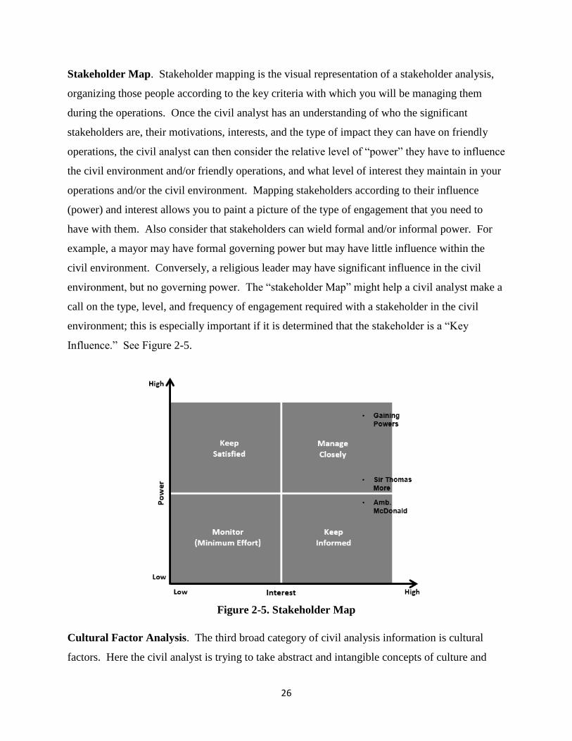
Stakeholder Map. Stakeholder mapping is the visual representation of a stakeholder analysis,
organizing those people according to the key criteria with which you will be managing them
during the operations. Once the civil analyst has an understanding of who the significant
stakeholders are, their motivations, interests, and the type of impact they can have on friendly
operations, the civil analyst can then consider the relative level of “power” they have to influence
the civil environment and/or friendly operations, and what level of interest they maintain in your
operations and/or the civil environment. Mapping stakeholders according to their influence
(power) and interest allows you to paint a picture of the type of engagement that you need to
have with them. Also consider that stakeholders can wield formal and/or informal power. For
example, a mayor may have formal governing power but may have little influence within the
civil environment. Conversely, a religious leader may have significant influence in the civil
environment, but no governing power. The “stakeholder Map” might help a civil analyst make a
call on the type, level, and frequency of engagement required with a stakeholder in the civil
environment; this is especially important if it is determined that the stakeholder is a “Key
Influence.” See Figure 2-5.
Figure 2-5. Stakeholder Map
Cultural Factor Analysis. The third broad category of civil analysis information is cultural
factors. Here the civil analyst is trying to take abstract and intangible concepts of culture and

27
determine the nature and scope of its impact. Culture is the shared world view and social
structures of a group of people that influences a person’s and a group’s actions and choices.
Note that there can be much overlap between cultural factors and the other two broad categories
of civil information, and this should be part of the “synthesis” element of the analysis.
All MAGTF operations impact the environment in which they are conducted. Similarly, the
operational environment will have an impact on MAGTF operations. Significant cultural factors
can be “Key Influences” as powerful as the tangible “Key Influences” (Physical Environment
and/or Infrastructure, and Individuals and/or Groups). An approach to organize the analysis of
cultural factors is the use of the five dimensions of operational culture developed by the USMC
Center for Advanced Operational Culture Learning (CAOCL) and described in their publication
Operational Culture for the Warfighter.
There is no singular approach to applying a cultural lens to the data collected in step 1. Every
situation will require careful consideration based on commander’s intent and guidance, and the
nature of the MAGTF’s operations. CMO planners should endeavor to apply cultural
perspective-taking (to “see” and “feel” others’ behavior/actions in the frame of that person’s
culture) and cultural interpretation (the process by which understanding, and meaning is derived)
to the information they have gathered. The point of this approach is to minimize “mirroring,” i.e.
viewing the information from a U.S. Marine, Western mentality. Regardless of the approach
taken, each of the 5 cultural dimensions has factors that must be addressed.
When applying a cultural filter to the information collected in Step 1, a good approach is to
consider the relevant questions posed in Appendix B of Operational Culture for the Warfighter.
The below matrix (Figure 2-6) illustrates some of these questions. Applying a cultural lens to
the ASCOPE/PMESII data will result in a greater understanding of key and relevant cultural
factors affecting MAGTF operations.
Operational Culture factors derived from this effort are compiled and included into the Civil
Environment Factors and Relevance Matrix to develop the most comprehensive list of known
and relevant factors at this point in the CPB process.

28
Figure 2-6. Operational Culture Matrix
2004. Stability Dynamics
CPB is a flexible tool that can be used to provide both a macro and micro civil view of an area of
operations. Similarly, accounting for stability dynamics can be scoped toward the macro and
micro level. The key difference between macro or micro-focused views relates to the level of
effort in gaining an awareness of local perceptions, i.e. it takes more effort to collate, assimilate
and comprehend the meaning of multiple local perception data from multiple areas versus
targeted singular efforts for specific local areas. While the Stability Assessment Framework
(SAF) is the preferred method to address stability dynamics, CPB incorporates SAF elements to
build an understanding of stability dynamics.
In most cases CMO planners will be looking to understand stability dynamics at a micro level.
This includes understanding the grievances (instability) and resiliencies (stability) of the local
population, identifying key influences and identifying events that could affect stability and
instability.
CPB deals primarily with understanding the civil dimension of the operational environment. To
that end, population surveys (perception data) focused on stability dynamics are very important

29
endeavors, requiring careful consideration and even more vigilant planning when operating in
remote areas where little or no information exists on local perceptions.
In many instances, perception data can be obtained through a variety of sources; for example,
unit SITREPS, U.S. embassy sources (embassy reporting, USAID, etc.), UN sources, key leader
engagements, human terrain team reports and tactical conflict surveys. Perception data is then
compiled and ordered with events and key influences where events are initially considered
neutral until acted upon by key influences, which determine whether events are perceived as
grievances or resiliencies.
Analysis of instability/stability factors is an iterative process. During CPB, CMO planners
should populate the instability and stability factors matrices to the best of their ability. Analysis
of instability and stability factors are considered such as described Figure 2-7 below (In this
example, the two matrices are combined into one matrix for display. The top two rows are the
instability factors matrix and the bottom two rows are the stability factors matrix.):
Figure 2-7. (In)Stability Factors Matrix
Instability results when factors fostering instability (grievances) overwhelm societal resiliencies
and/or the ability of the government to mitigate these factors. CMO planners should consider the
following to assist in assessing grievances (Figure 2-8) within the AO… Does the issue:

30
(1) Decrease support for the government
(2) Increase support for “malign actors”
(3) Disrupt the normal functioning of society
Figure 2-8. Source of Instability Matrix
Too often, efforts to alleviate instability obscure and actually undermine existing societal
resiliencies (stability). The analysis of resiliencies must complement overall stability
assessments and be strongly considered in planning MAGTF operations. CMO planners should
consider the following to assist in assessing resiliencies (Figure 2-9) within the AO… Does the
issue:
(1) Increase support for the government
(2) Decrease support for malign actors
(3) Increase societal and institutional capacity and capabilities

31
Figure 2-9. Source of Stability Matrix
The information derived from instability/stability analysis is included in the Civil Environment
Factors and Relevance Matrix before proceeding to Step 3 of the CPB process.
2005. Identify Key Influences
CMO planners should use previously developed products such as the Operational Culture Matrix
and/or stakeholder analysis as starting points. KI can be determined by asking the following
questions: What are the sources and nature of the KI that can affect friendly force operations?
By what manner/means can the KI apply its influence on friendly operations? How quickly can
the KI impact be applied to affect friendly operations? What is the magnitude (width, depth,
number of people/groups, how much, how far) of the KI’s effect? What is the effect of the KI
not engaging with the MAGTF? How firm is the KI’s hold on power? If answers to the above
questions indicate the KI could significantly impact friendly operations, then that influence
should be included in the Civil Environment Model.
Determine Key Influence’s Motivations and Goals. For individuals and groups this may be
difficult to determine and an analytical “best guess” may have to suffice until the target can be
further developed. In a dynamic environment, motivations and goals may shift - a KI may have
both short and long term goals and distinguishing between the two sets may be important for
determining how the KI might enhance or degrade friendly operations. For intangible factors
such as KI “thing” or “place,” there may not be any inherent motivations and goals. However,

32
the motivation and/or goals of stakeholders as they apply to the KI “thing” or “place” may be
worth noting. Techniques which could be used to determine motivations and goals include:
Identifying relationships/dynamics between KI and their environment (people, places, things).
Identifying KI conflicts and their sources, to include grievances, ethnic/ religious tension,
competition for natural resources, etc.
Identifying sources of resiliency - what structures, assets, means, etc., sustain the KI and are used
to retain position/power/legitimacy.
Determining KI desired end states - friendly, rival/threat, environment. Look at both short and
longer term goals.
Determine Key Influence’s Abilities, Capabilities, and Means. Information used to identify
KI can be used and paired with a description of preferred actions and options. Determining
“means” includes identifying tangible assets (people, places, things) that the KI can employ, as
well as intangible assets that give the KI “means” – e.g., religious legitimacy, etc. - the sources
of resiliency and relationships/dynamics between KI identified above may translate into critical
“means” in this step.
Evaluate Key Influence’s Potential Impact on Friendly Operations / Objectives. This is an
assessment of KI potential Courses of Action: Why, how, what, when and where the KI can
degrade or enhance friendly operations, and to what extent. During COA development of the
Marine Corps planning process, this information will help to develop specific actions/tasks to
either mitigate or take advantage of KI effects on friendly operations and the civil environment.
Figure 2-10 below illustrates how to compile KI information so that it can be used in the Civil
Environment Model.

33
Figure 2-10. Key Influences Matrix
2006. Estimation Tools
This step of the analytical process can be the most challenging - taking what you know, based on
your analysis, and making some predictions – i.e., what will take place in the civil environment
in the future, factoring in both friendly and threat activity, and when and how it will take place.
One way to capture and summarize estimation for the civil environment is through a Civil Most
Likely / Most Disruptive graphic and narrative (a product of step 4 of CPB, see Fig. 10) that is
similar to the threat Most Likely/Most Dangerous COA graphic and narrative developed by the
intelligence section.
2007. Production
In preparing products, take the results of your analysis and incorporate them into products that
are tailored to satisfy the requirements of the “customer” - whether the customer is the MAGTF
commander, the operational planning team, civil affairs teams, coalition and/or
interorganizational partners, etc. The user or customer requirements drive the product
parameters. As early as possible during analysis you should determine who will use the
product(s) and formats that they can readily receive and digest based on bandwidth, etc. You
also need to make the product a “stand alone” (as much possible) meaning the product is
complete, clear, and concise enough that the user or customer does not need the analyst to be
present in order to understand and use the product as intended.

34
STEP 3. DEVELOP A CIVIL ENVIRONMENT MODEL
The only people who see the whole picture are the ones who step outside the frame.
— Salman Rushdie
3000. Overview
Using the results from Step 2, the civil analyst depicts the relevant aspects of civil information
and its effect on military operations by producing a civil environment model, facilitating a
deeper, shared understanding of the operating environment. A Civil Environment Model,
conceptually similar to the technique used in producing a Modified Combined Obstacle Overlay,
may require multiple civil overlays that typically depict key terrain/infrastructure
(churches/mosques, market centers, hospitals government centers - to include political
boundaries, ports, airfields, movement corridors, population centers/clan-family boundaries,
dislocated civilian camps and significant artifacts/monuments) within the AO. A geospatial
graphic may serve as the best example.
3001. A System of Key Influences
A Civil Environment Model depicts a system of key influences. A Civil Environment Model
includes a narrative describing the civil environment that is specific to the area of operations, a
list of key influences and relevant factors produced from analytical methods such as Stakeholder
and Geospatial analysis, and a civil “picture” or graphic depicting Key influences and/or relevant
factors.
3002. Describing the Environment and Civil/Social Norms
CPB provides an evaluation and interpretation of information about key influences to discern
catalysts of behavior and the context that shapes behavior. The civil environment model informs
the commander’s understanding of key influences by detailing societies, populations and other
groups of people, including their activities, relationships, and perspectives. The purpose is to
model civilian life and activities to serve as a baseline for MAGTF planning. The civil
environment model is particularly relevant to Course of Action (COA) Development and COA
War Game steps within the Marine Corps planning process.

35
Modeling the civil environment includes the graphic representation of social and cultural
information for a given area presented spatially (on a map) and temporally (as a snapshot in
time). The content of the narrative should be derived from previous analysis, but should consist
of all relevant civil factors that may extend beyond items outlined in Figure 3-1. For example, a
CA team’s operating area would likely be comparatively small and may consist of a number of
towns or villages connected by a road and/or rail network, sharing similar customs, traditions,
legal systems, etc. This environment would be described so that it considers relationships and
activities of the population, social network analysis (looking at the interpersonal, professional,
and social networks tied to key influences) as well as small and large group dynamics, physical
environment factors, etc.
Figure 3-1. Civil Environment Model Example
3003. Refine Civil Environment Factors and Relevance Matrix
The final product of CPB step 3 is a refined civil environment factors and relevance matrix that
includes all step 2 analysis and step 3 refinements. It summarizes the most important aspects of
the civil environment affecting MAGTF operations. Until the MAGTF commander’s end state

36
has been achieved or the operation is terminated or transitioned, CPB remains an on-going
process.

37
STEP 4. DETERMINE CIVIL ACTIONS
The best qualification of a prophet is to have a good memory.
— George Savile, Marquess of Halifax
4000. Determine Civil Actions
The focus of this step is to utilize the information and analysis from previous steps to determine
potential civil actions with respect to MAGTF operations within the AO. By civil actions, we
mean modeling the independent will of the population and KI relating to friendly and malign
actions within the AO. CMO planners develop an initial assessment of possible civil actions in a
particular area within the MAGTF battlespace. This assessment is further refined by the Green
Cell and used during COA War Game. These actions serve to paint a more complete picture of
the operating environment focused on indigenous people and their leadership, but also on any
IOs/NGOs or other stakeholders in the area of operation (battlespace, village, district, and
province).
4001. Validate
During this step, CMO planners validate their assumptions and updates existing CPB products as
necessary. Lastly, during deliberate planning, civil actions are accounted for during COA War
Game depicted as Most Likely / Most Disruptive civil actions. The following considerations
may be applied to determine Civil Actions: historical patterns of the populace; conditions the
populace is trying to achieve, and/or agendas or objectives of KIs. These civil actions may
influence a decision maker’s approach to mission accomplishment.
4002. Green Cell
The CMO planner may participate in or oversee the actions of the “Green Cell.” The green cell
articulates the actions and dynamics of selected individuals, groups, tangible assets, and socio-
cultural factors in the civil environment which may significantly impact friendly operations.
Similar to the Red Cell modeling adversary actions, the Green Cell is used throughout the entire
planning process, but with a focus on testing, improving, and modifying friendly courses of

38
action to enhance the desired friendly effects on the civil environment, and to mitigate potential
negative effects. To that end, Step 4 results in a graphic and narrative depicting most likely and
most disruptive civil actions as depicted in the Figure 4-1 example below:
Figure 4-1. Civil Actions Graphic/Narrative Example

39