civil contingencies secretariat
TRANSCRIPT

Preliminary Guidance
Developing a Multi-Agency Flood Plan (MAFP) Guidance for Local Resilience Forums and Emergency Planners. February 2008 version4.4
Civil Contingencies Secretariat

II
Guidance Document Control and Distribution This guidance is maintained and updated by the Civil Contingencies Secretariat, Defra and the Environment Agency. All users are asked to advise CCS of any changes in circumstances that may materially affect the guidance in any way.
Maintained by:
Organisation Department Department Colin Berghouse Environment Agency Flood Emergencies
Capability Programme Manager
Mandy MacKenzie Cabinet Office Civil Contingencies Secretariat
Paul Ditchfield Department for Food, Agriculture and Rural Affairs
Flood Management Division
Document Version:
Version number Date Status 4.4 8-02-2008 Preliminary Guidance
Note from the editors: This preliminary guidance draws on good practice from a range of existing plans, guidance and documents. It has also taken into account to some of the findings contained within the interim report by Sir Michael Pitt on the flooding during the summer of 2007. Once the reviews and enquiries are completed and the final report published, this guidance will be updated and published as ‘final’ guidance. However, given the fact that many Local Resilience Forums are now reviewing their own emergency plans based on the lessons identified from the 2007 floods, it is timely that this interim national guidance is made available immediately. The guidance is given in three sections. Part 1 sets out the reason for having Multi-Agency plans for flooding and provides the context for developing your plan. Part 2 gives a framework for setting out your plan and what should be included. Part 3 contains some useful examples and reference material for you to draw on as appropriate. We hope that you find this document helpful.

III
TABLE OF CONTENTS PART 1 – BEFORE YOU START WHY HAVE SPECIFIC FLOOD PLANS? ABOUT THIS GUIDANCE FLOOD EMERGENCY PLANNING DEVELOPING THE PLAN
FORMAT AND STYLE
PART 2 – GUIDANCE FOR CONSTRUCTING YOUR MAFP
1 INTRODUCTION ..............................................................................................................6 2 AIM AND OBJECTIVES OF THE PLAN ...............................................................................6 3 OWNERSHIP AND AUDIENCE...........................................................................................7
4 THE RISK OF FLOODING.................................................................................................8 5 RELATED AND INTERDEPENDENT PLANS.........................................................................13 6 COMMUNICATION PLAN..................................................................................................14 7 PLAN ACTIVATION – THRESHOLDS AND TRIGGERS..........................................................15 8 ACTIONS, ROLES AND RESPONSIBILITIES .......................................................................20 9 VULNERABLE PEOPLE ..................................................................................................25 10 KEY INFRASTRUCTURE .................................................................................................26 11 EVACUATION AND SHELTERING OF PEOPLE ....................................................................28 12 RECOVERY....................................................................................................................30 13 TRAINING AND EXERCISING............................................................................................31 14 REFERENCES ................................................................................................................32 PART 3 – SUGGESTED APPENDICIES APPENDIX A: CONTACT DETAILS OF KEY PERSONNEL .................................................................34
APPENDIX B: LOCATION OF CONTROL CENTRES ........................................................................36
APPENDIX C: EXAMPLES OF OTHER POSSIBLE APPENDICIES........................................................38 • RESOURCE AVAILABILITY • WARNING THE PUBLIC • GENERAL PUBLIC ADVICE • EVACUATION RECORDS • GLOSSARY OF TERMS • DEFINITIONS AND TERMS

IV
LIST OF FIGURES
Figure 1.1 How a MAFP fits with other emergency plans .............................................................. 3 Figure 2.1 Flood Plain map Example map from Castle Morpeth Borough Council Flood
Action Plan (2006)........................................................................................................... 7 Figure 4.1 Civil Contingencies Act Risk Rating Matrix................................................................... 9 Figure 4.2 Example - Community Flood Risk Summary Sheet A ................................................ 10 Figure 4.3 Example - Community Flood Risk Summary Sheet B ................................................ 11 Figure 4.4 Example map from Ryedale’s draft Multi-Agency Flood Response Plan (2007) ..... 12 Figure 5.1 Emergency Plans – fitting them together .................................................................... 13 Figure 7.1 Example plan triggers and generic actions using qualitative impact measures..... 17
Figure 7.1a Local Respone Level Definitions ................................................................................. 18
Figure 7.2 Example plan triggers and generic actions using quantitative impact measures .. 19 Figure 8.1 Examples of Flood Specific Roles and Responsibilities............................................ 22 Figure 8.2 Example of ‘Anytown’ Council – Multi-Agency Flood Risk Matrix............................ 23 Figure 8.3 Flood Warning Actions .................................................................................................. 24 Figure 9.1 Example Log Sheet of vulnerable people in various facilities .................................. 26 Figure 10.1 Example of Key Infrastructure log sheet ..................................................................... 27 Figure 11.1 Example Evacuation and Sheltering Arrangements..................................................... 9 Figure 13.1 Example Training and Exercise Schedule ................................................................... 31
Figure A1 Example Contact Details of Key Personnel ................................................................. 34 Figure A2 Example of contact details ............................................................................................ 35 Figure B1 Example Command Centre Location Map. ................................................................. 37 Figure C1 Resources........................................................................................................................ 38
Figure C2 Siren details..................................................................................................................... 38
Figure C3 Premisis marking ........................................................................................................... 41
Figure C4 Example of a checked record ........................................................................................ 41

1
PART 1
Before you start

2
Why have specific flood plans? The Civil Contingencies Act (2004) requires Category One Responders to have plans in place to respond to all emergencies. Emergency plans may take the form of either generic plans that describe a response to a wide range of possible scenarios (e.g. /Local Resilience Forum (LRF) Incident Plan) or specific plans that deal with a particular kind of emergency (e.g. CBRN1 or Evacuation and Sheltering). Many LRFs will probably have both types depending on how emergency planning has evolved in the area. There may also be area-wide plans (e.g. at county-level) or site/local area specific plans (e.g. district or township). For many parts of England and Wales, flooding poses a significant risk and is well-recognised within many Community Risk Registers. LRFs are encouraged to develop a specific flood plan to both complement other plans and to provide more detail to generic Major Incident Plans or Strategic Emergency Response Plans. The reason for having a specific flood plan is because of the complex nature of flooding and the consequences that arise, requiring a comprehensive and often sustained response from a wide range of organisations. The guidance is therefore geared toward helping LRFs to collectively develop a Multi-Agency Flood Plan. About this guidance This guidance should be used by LRFs to undertake flood response planning, including recovery planning where it relates to flooding. It contains examples of how to set out the various components of a flood plan, all of which have been drawn from current good practice in the UK. The guidance is provided to aid the preparation of a multi-agency flood plan but is equally relevant to use in any type of flood plan, whether Unitary Authority, Emergency Planning Unit or Multi-Agency. The LRF should decide on the type of flood plan needed (depending on local circumstances) as well as deciding if a Multi-Agency flood plan is to supersede existing plans or complement existing plans. This document provides advice on flood plan content, where and how to find any relevant information and suggests a level of detail required to include in a MAFP. With minor modifications and the removal of any sensitive / confidential information, it could be turned into a plan suitable for wider or general publication.
1 Chemical, Biological, Radiological and Nuclear

3
Flood Emergency Planning Development of Multi-Agency Flood Plan (MAFP) allows all responding parties to work together on an agreed coordinated response to severe flooding. Figure 1.1 shows a hierarchy of emergency plans and how a MAFP might link to other related response plans.
Figure 1.1 How a MAFP fits with other emergency plans
Developing the Plan A good plan is predicated on the need for a good planning process. In other words, the process of working together to create the plan is as important as the end product. With this in mind, LRFs are encouraged to use “Task and Finish” groups or Flood Working Groups to lead the production of the plan, but to involve all Category One and Two Responders who will have a role in its delivery. To develop the MAFP, it is recommended that reference is made to the section called Emergency Planning (Chapter 5) of Emergency Preparedness, part one of the Civil Contingencies Act (2004). A working group with representatives from all relevant departments / agencies is a good way to develop a flood plan that considers all the consequences and impacts (short, medium and long term). Local Authorities should consider contributions from relevant departments including Emergency Planning, Highways, Drainage, Social Services and Environmental Health. A representative from the Environment Agency’s Flood Incident Management team should also be a member of the working group to provide flood risk and flood warning advice and information. Contributions from Category 2 responders is critical in terms of considering assets and infrastructure in the floodplain that may be impacted by
Leve
l of
Det
ail
Specific Actions,
Local Detail
Generic Actions, Limited Local
Detail Generic Emergency Plan
individual and community emergency plans
MULTI-AGENCY/LRF FLOOD PLAN.
Generic Evacuation
Plan
Generic Communications
Plan
Generic Rest Centre
Plan e.g. e.g.
e.g.

4
flood water and therefore adding to the consequences and compounding the impacts on people and property. For example: failure of a pumping station, collapse of a major drain, contamination of water supplies or power failure over large areas are all consequences that need to be worked through as part of developing a MAFP. To enable other responders to comment on the plan and, in particular, the links with their own plans, we recommend that the Local Resilience Forum or appropriate working group circulate the plan amongst its members. It is recommended that plans are shared with neighbouring LRFs. Format and Style
A flood plan should contain information that complements other plans as stated above. The level of detail will depend on the needs of the responding organisations and the existence of other related emergency response plans. MAFPs should aim to provide a clear and concise, yet adaptable response tool under which each responding organisation has clearly defined roles and responsibilities. The most critical part of the plan is the section on “Activation”. This should set out what the triggers are in a table, and who is expected to do what once certain thresholds are met. The plan should be intuitive so that anyone can pick it up and understand what action or response is required in different circumstances. For example, use colour-coded dividers to help users navigate through the plan together with appropriate use of maps, tables, diagrams and even pictures. Consider if it would be beneficial for the document to be accessible via the Internet on a secure webpage in order to aid document control and distribution, although hard copies should also be available for business continuity reasons and in incident control rooms. A separate folder containing spare / laminated maps may be useful to enable responding officers to remove maps without dismantling the plan. The Environment Agency Flood Incident Management team can advise where it is appropriate to use the flood map and / or flood warning areas as the basis of the maps contained within the plan.
5
PART 2
Guidance for constructing your
Multi-Agency Flood Plan (MAFP).

6
1 Introduction This section should be short and cover aspects not covered in subsequent sections. For example to put into context emergency planning in your area or region; why the plan is needed; if it supersedes other, previous plans; broadly what the plan includes and excludes and finally, when the plan will be reviewed. It is useful to include a ‘Document control / distribution’ table at the front of your MAFP. To help make sure that people are not talking at cross purposes, the MAFP should also provide working definitions for all aspects that have the potential to be interpreted differently. Examples of such definitions can be found in Appendix C (page 42) of this guidance.
2 Aim and Objectives of the Plan This section should broadly describe the purpose of the plan including:
The strategic outcome expected in responding to a flood (i.e. what successful implementation of the plan would look like).
The area covered, preferably with the aid of map(s) that show the flood outline for sea and river flooding – not surface water. (see Figure 2.1).
Describe the different types / sources of flooding and their status within the Community Risk Register.
The MAFP should include a community-level assessment of flood risk expected to include - river, sea, tidal, reservoirs, groundwater, surface water and defences and where applicable failure/overtopping of flood defences. The plan is not expected to include flood risks from foul sewage, burst water main, private lakes and canals, unless there is a specific and significant flood risk.

7
Figure 2.1 Flood Plain map Example map from Castle Morpeth Borough Council Flood Action Plan (2006).
3 Ownership and Audience In this section, the person responsible for updating and maintaining the plan should be identified and a clear description given on who the intended audience is and how they will be notified of updates and modifications to the plan. A number of agencies contribute to and jointly own multi-agency plans. Depending on local circumstances, some Local Resilience Forums (LRF) will opt to place the accountability for the plan firmly with the LRF as the joint custodian body. The agency / individual responsible for updating and maintaining the plan is normally from the local authority or Police Emergency Planning Unit and he/she should be given a mandate from the LRF to maintain and update the plan. All organisations / departments that contribute to the plan should commit (with specific dates) to review and update the plan, preferably on an annual basis. New risk assessments, lessons identified from incidents or exercises, restructuring of organisations or changes in key personnel should also prompt updates to the plan.

8
4 The Risk of Flooding This section should start with an overview of flood risk in the area covered by the MAFP, and the provide detailed information around specific communities at risk. The information should have a clear parallel to the risk assessment information published in the related Community Risk Registers. LRF’s should consider the flood risks listed in the local risk assessment guidance when preparing and updating Community Risk Registers2. The Civil Contingencies Secretariat publishes this guidance each year to inform this process. The Environment Agency’s Local Flood Warning Plans contain information on river, sea and tidal flood risk. You may also find it useful to consult the tide tables to include information on high tides if applicable. Water companies may have on-site and/or off-site emergency plans and inundation maps to refer to; such information can be requested at any time and should be made available to the author of the MAFP for emergency planning purposes. Many COMAH sites will have risk assessment information that can be considered as part of determining and describing the impact of flooding in this section of the MAFP. Historic records will be another useful source of information, particularly with regard to surface water and drainage flooding problems. If there are Internal Drainage Boards (IDB’s) within your area you need to factor in their response to a flood event. Although IDB’s are not classed as a category 1 or 2 responder under the Civil Contingencies Act they are a Drainage Authority and provide flood protection and water level management in areas of special drainage need (low-lying flood risk sensitive areas). They also operate control structures and pumping stations under their jurisdiction so it is important they are included in your plan. To prepare flood risk in this section of the MAFP, start by compiling flood risk summary sheets for each community together with associated maps (Detailed maps will help responders during an incident, to quickly identify the areas that are at risk). They should also show clearly, known locations of vulnerable groups and sites of key infrastructure (see Figure 4.2 and 4.3 and also sections 10 and 11 in this guidance). Two examples of a “Community Flood Risk Summary Sheet” are provided in figure 4.2 and figure 4.3. Figure 4.2 is an example flood risk summary sheet for a community covered by the Environment Agency’s flood warning service. Figure 4.3
2 Category 1 and 2 responders should collaborate in accordance with the Civil Contingencies Act, to
prepare a Community Risk Register by using the methodology recommended in Emergency
Preparedness guidance (2004). The product of impact and likelihood defines the risk (see Figure 4.1)
and Emergency Preparedness guidance (2004) - Annex 4D contains detailed definitions. Impact is an
average score derived from the four categories of health, social, environmental and economic effects.

9
is an example flood risk summary sheet for communities at risk from any type of flooding and not covered by the Environment Agency’s flood warning service. The example provided shows flood risk areas together with locations of vulnerable groups and critical infrastructure. Where appropriate, the table can be adapted to capture information on other types of flood risk as described in the first paragraph of this Section. In communities with significant flood risk, it may be necessary to split communities into smaller sub-areas presented over multiple sheets. These sub-areas should remain consistent with the Environment Agency’s flood warning areas.
Figure 4.1 Civil Contingencies Act Risk Rating Matrix
Cat
astro
phic
(5
)
Sig
nific
ant
(4)
Mod
erat
e
(3)
Rel
ativ
e Im
pact
Min
or
(2
)
Lim
ited
(1)
Low (1)
Medium- Low (2)
Medium
(3)
Medium-High (4)
High (5)
Relative Likelihood
Risk Category
Very High Risk High Risk
Medium Risk Low Risk

10
Figure 4.2 Example - Community Flood Risk Summary Sheet A for a community provided with a flood warning service.
Description: Morpeth
Morpeth town centre and surrounding area is at risk from flooding from the River Wansbeck. Flood defences at various locations provide a 35-year standard of protection but many residential and commercial properties are at risk in a major flood incident. Refer to the Local Flood Warning Plan for Northumberland County Council Area.
No. of people / properties at risk
No. of vulnerable people at risk
Key vulnerable infrastructure
1139 properties Approx 100.
Detail in Figure 9.1
1 Police Station.
Detail in Figure 10.1 No. of properties registered
to Flood Warning service Return Period Lead Time
679 properties From 25 years 2 hours Flooding History (if known) 1963 - Caused by snowmelt, affected 482 houses, shops, factories and garages.
Flood Defences / Alleviation Measures (if any) 35-year standard of protection downstream of Telford Bridge.
Flood Warning Status Area(s) at risk (refer to map) Flood Watch 121WAFNF905 – We expect low-lying areas including
riverside footpaths and Mitford Road to flood.
Flood Warning 121FWFNW115 – We expect Mitford Road, Dyers Cottage, Abbey View, Abbey Terrace, Challoner’s Gardens, The Riverside Leisure Centre, East Mill and River Lodge to flood.
Severe Flood Warning 121FWFNS101 – We expect Wansbeck Place, Lady’s Walk, Price Street, St Mark’s Street, High Stanners, Challoner’s Gardens, and Auburn Place to flood.
Risk Assessment: Refer to Emergency Preparedness, Annex 4D
Likelihood 4
Impact - Health
- Social
- Economic
- Environmental
3
4
4
3
Mean Impact Score
4
Final Risk Rating
Very high

11
Figure 4.3 Example - Community Flood Risk Summary Sheet B for a community not provided with a flood warning service.
Description: The Rivers Estate
A low-lying estate within the natural flood plain of the river, but also at risk from overland flow and surface water flooding.
Number of people / properties at risk
Number of vulnerable people at risk
Key vulnerable infrastructure
44 properties Approx 12
Detail in Figure 9.1
3 Electrical Sub Stations
Detail in Figure 10.1
Flooding History (If known)
There is a problem with surface water drainage at this site, and has the potential to flood annually. The site was last flooded in autumn 2000.
Flood Defences / Alleviation Measures (if any)
During a flood situation, the local authority closes the emergency penstock to delay flooding from the river. The deployment of pumps by Northumbrian Water aids drainage.
Risk Assessment Refer to Emergency Preparedness, Annex 4D
Likelihood 4
Impact - Health
- Social
- Economic
- Environmental
2
2
2
2
Mean impact Score
2
Final Risk Rating
Medium
The table should be adapted as needed to describe other flood risk categories such as reservoir failure or surface water flooding (based on historical information or Water Company and local authority drainage plans if surface water flooding is a risk).

12
Figure 4.4 Example map from Ryedale’s draft Multi-Agency Flood Response Plan (2007)

13
5 Related and Interdependent Plans In this section, you should list other related and interdependent plans as well as inserting a diagram that show linkages between the various plans. It is important that the MAFP is prepared as part of a complementary set of emergency plans some of which may contain sections on flood response. Figure 5.1 Emergency Plans – fitting them together The diagram above (figure 5.1) can be a useful way of setting out existing plans covered by your LRF and as a tool for discussion on how plans will complement one another rather than duplicating the same information. For example, if you have a plan for Warning and Informing or for Evacuation and Sheltering there is no need to cover these aspects in the MAFP. Similarly, if the roles and responsibilities of the various organisations are set out in a generic Major Incident Plan covering your LRF, then there is no need to repeat this information. Instead, insert a cross reference and include only specific or additional information that is relevant to a flood response. The Environment Agency already produces Local Flood Warning Plans. All parts of England and Wales have been assessed by the Environment Agency for the level of flood risk from river (fluvial), sea and tidal flooding. As part of warning the public where flooding is likely to occur, the Environment Agency has identified “flood warning areas” that are issued with a flood warning when weather forecasts or a rise
Generic Regional Emergency Response Plans
Multi-Agency Flood Plan
Mass Evacuation
Plan
Recovery Plan
Major Incident
Procedure Manual
Major Incident Plan
Multi-Agency Response Plan
Crisis Management Plan
EA Local Flood Warning Plans
Local Authority Plans
Emergency Services Plans
Regional Strategic Framework
Area specific emergency plans
Thematic plans, guidance and arrangements
Other plans
Specific Organisational
plans
Utility Company Plans
Organisations Communications
Plans
Essential Services Plans

14
in river levels dictate. The Environment Agency Local Flood Warning Plans contain detailed information and maps on these areas. These plans are often used by Strategic (gold) and Tactical (silver) controls as reference documents in incident control rooms during a flood. It is recommended that in preparing a MAFP, the author inserts the relevant cross-references or links to the Environment Agency Local Flood Warning Plans rather than duplicate information.
6 Communication Plan
Communication during an incident This section should contain communication arrangements between all agencies responding to a flood. Warning and informing the public is a key requirement of the Civil Contingencies Act. A separate Communication Plan or a Generic Emergency Plan may contain arrangements to communicate with the public (including modifying the message for the vulnerable, if required), media and each other. However, if this is not the case, this section should include:
arrangements for internal communications; a documented procedure for managing cross boundary mutual aid ; multi-agency strategic media co-ordinating role and Joint Media Strategy; points of contact at Bronze, Silver and Gold levels; pre-prepared announcements (Appendix C) / media releases; triggers for communicating with others; contact details (Appendix A); arrangements to set up and operate a Help Line and / or Information Line
Annex C contains useful information about public awareness advice before, during and after a flood event, including advise during evacuation. The flood plan should not contain the arrangements for issuing flood warnings, as this would duplicate the Environment Agency Local Flood Warning Plans. This section should also cross reference with LRF telecommunication plans where they exist. Where this is not the case, a section should be inserted on how communications between responding organisations would work in the case of any of the public networks failing (i.e. contingency arrangements).
Communicating with the Public about the Risk This section should include ways of raising the public’s awareness prior to an incident about the risk of flooding, of the arrangements in the MAFP and how they may be affected by floods. If an LRF telecommunications plan does not exist, this section should broadly include plans to communicate with certain vulnerable people
15
who are dependent upon their phone lines (eg dialysis patients) and how they are dealt with if the network fails completely. The detail can be included in table 9.1. The Environment Agency organise public awareness campaigns, arrange for the broadcasting of messages and provide advise of what do before during and after a flood event. There is a lot of flooding information on their website including a search facility on postcodes to see if properties are in a flood risk area. Anyone who is at risk to flooding is advised to develop a flood plan and make sure that everyone is aware of what to do should the need arise to use it.
7 Plan Activation – Thresholds and Triggers This section is vital to the success of your plan. It must describe as accurately as possible the triggers or thresholds for activating your flood plan. This is often easiest to map out as a flow diagram or a table. In doing so, it will be clear to all partners in the LRF at what point the plan is activated and at what points during an incident decisions are likely to be make and action taken. Section 8 follows on immediately to set out the specific actions to be taken by responders in relation to these triggers. The following example triggers and actions are the minimum your MAFP should include :
Triggers: Met Office severe weather warnings Environment Agency flood warnings Reports of flooding from the public
Generic actions: Alert and standby procedures People to notify / inform Instructions for the opening of control centres Other generic actions, depending on the scale of the incident
Figure 7.1 is an example plan triggers and generic actions using qualitative impact measures to describe the triggers for areas covered by the flood warning service and those that are not. It is useful to specify different response levels and the associated generic actions so that everybody is aware of the scale of response expected based on the severity of the incident. Suggested Local Response level definitions are given in Figure 7.1a.
What do flood warnings mean and what do responders do? The Environment Agency operates a flood warning service in areas at risk of flooding from rivers and the sea. If flooding is forecast, warnings are issued using a set of four easily recognisable codes. Comprehensive details are contained in the Local Flood Warning Plan maintained by the Environment Agency with the support of the members of the Flood Warning Planning Groups. It is intended to assist wider
16
dissemination and understanding of Flood Warning arrangements and systems and is the prime reference document in this respect. A description of the codes, their definition and lead times is described in the Local Flood Warning Plan that could be duplicated here if considered necessary.
Planning Assumptions
The Multi-Agency Flood Plan should be clear about the planning assumptions that are being used by everybody to ensure consistency in approach. In this section cover aspects such as the examples given below:
Coastal zone flood warnings: Assumes an 8-hour lead/warning time for over-topping of coastal defences from storm tides.
Water Rescue: Assumes the use of only emergency services’ boats, helicopters and high-clearance vehicles (not self-presenting voluntary operators whose standard of training and equipment will be unknown).
Infrastructure: State whether the plan takes account of damage or failure (at several sites) of telecommunications, power stations, road and rail links.

17
Figure 7.1 Example plan triggers and generic actions using qualitative impact measures
Environment Agency constantly monitors rainfall
and river levels.
Met Office issue a severe weather warning.
Flood warnings activate the plan.
Environment Agency opens Area Incident Room and monitors / operates flood defences on main river.
Local Authority / Emergency Planning Unit Duty Officer receives weather warnings
and reports of flooding.
Local Response
Level
LEVEL 1.
Moderate Flood Risk
Severe weather warning and / or reports of minor
flooding.
LEVEL 2.
Substantial Flood Risk
Reports of property flooding.
LEVEL 3.
Severe Flood Risk
Reports of significant / catastrophic
flooding.
LEVEL 4.
Recovery
Floodwater recedes.
Triggers in areas covered by the Flood
Warning service
Triggers in areas not covered by the Flood
Warning service
LEVEL 0.
Low Flood Risk
Local Response
Level #
# please refer to Figure 7.1a overleaf: “local Response Level Definitions.”

18
Figure 7.1a Local Response Level Definitions An alert level describes the expected scale of response to a flood incident. These could be defined as: Local Response
Level Trigger Actual or
forecast Impact Response
LEVEL 0 (Low flood risk)
No flood warning / watches and / or no warnings of severe weather in force that may result in flooding.
No flooding occurring
No specific response, normal awareness of possible flood risk.
LEVEL 1 (Moderate flood
risk)
Flood watches in force, And / or Warnings of severe weather in force that may result in flooding And / or Reports of minor impact flooding.
Low impact flooding of fields, gardens and minor roads.
Individual responders of flood plans and procedures may be activated Some routine or preparatory responses may
be underway, e.g. diversion of minor roads, duty officers put on standby, resources mobilised Heightened awareness if flood risk
LEVEL 2 (Substantial flood
risk)
Food warnings in force, And / or Warnings of severe weather in force that are likely to result in flooding And / or Reports of property flooding.
As level 1, plus: High impact flooding which may result in risk to life, homes and businesses.
As for level 1, plus: Multi-agency flood plan activated Responders undertake actions continued in
MAFP Consider the need for Police led Multi-
agency co-ordination LEVEL 3
(Severe flood risk)
Severe flood warnings in force, And / or Warnings of severe weather in force that are highly likely to result in flooding And / or Reports of significant, catastrophic flooding.
As level 2, plus: Very high impact flooding which may result in extreme danger to life and property.
As for level 2, plus: Police co-ordinate multi-agency response Multi-agency control centres open
LEVEL 4 (Recovery)
Flood warnings / severe flood warnings downgraded And / or All clears issued And / or No warnings of severe weather in force that may result in flooding
Flood water receding.
Local authority to facilitate rehabilitation of the community and restoration of the community.

19
Figure 7.2 is an example taken from the City of York Flood Defence Emergency Response Plan (2002) of quantitative measures that can replace qualitative descriptions to reflect local impacts and circumstances, such as, river levels, number of properties or specific infrastructure at risk. This is appropriate in this location as the river has a slow rate of rise. Therefore, the multi-agency group has time to implement a detailed response strategy. In rapid response catchments, such as the flooding that occurred in Boscastle in 2004 and Carlisle in 2005 a quantitative measure diagram would not be suitable due to the speed at which river levels increase. Responders need to be very sure that certain levels would trigger a particular action. (The AOD levels refer to gauge board readings on a bridge over the Ouse in the centre of York).
Figure 7.2 Example plan triggers and generic actions using quantitative impact measures
(Extracted from the City of York Flood Defence Emergency Response Plan (2007))
Flood Control Room
Floodline - Public
Activate Agency Plan
Environment Agency
Issue
Flood Warnings
York Flood Group
9.2m AOD
Silver Command
Fulton Road Police Station
(York Flood Group)
LEVEL ONE RESPONSE
Participants: City of York Council Environment Agency Yorkshire Water Police Fire and Rescue
Ambulance Service
Fulton Road Police Station
(Silver Command)
LEVEL TWO RESPONSE
Participants: Police Fire and Rescue Ambulance Service City of York Council Environment Agency Yorkshire Water Northern Electric DL Military
Flood Levels
7.3 AOD
8.8 AOD
9.2 AOD
9.6 AOD
Property Owners
City of York Council
Activate Plan
Activate Plan Utilities Others
IDB’s
Emergency Services
Activate Plans
Police, Fire, Ambulance
Trigger level for multi-agency co-ordination of counter measures. Co-ordination role passes to the Police during the emergency phase and 9.6m AOD and above.
CYC Temporary Works Signs / Sandbags

20
8 Actions, Roles and Responsibilities This section follows directly on from plan activation triggers should set out the actions, roles and responsibilities of responding agencies in relation to these triggers - for each community at risk from flooding. Non-flood specific or generic roles and responsibilities should be described in other strategic or generic emergency plans and not repeated here. A relevant reference or hyperlink should be added. Similar to that set out in Figure 8.1, focus on providing a summary of the flood specific roles and responsibilities of Category One and Two Responders in the planning stage and during and event. This could including changes in role - dependent on flooding source. For example, the Environment Agency has primary responsibility for flooding from rivers, where as the local authority and/or Water Company has primary responsibility for flooding from drains and sewers. Figure 8.1 provides an example format for presenting flood specific roles and responsibilities. It is important to also tabulate the Triggers (from Section 7) and Actions together in your plan. Two examples are provided in figures 8.2 and 8.3. (NB: Definitions for the Local Response Levels can be found in Figure 7.1a.) All LRFs are strongly advised to include tables, similar to that in Figures 8.1 and 8.2 in their Multi-Agency Flood Plan. For most, this will form the backbone of the response plan to flooding in a given area. Your plan will need to describe as far as possible the expected scale of response and associated actions to be taken where it is specific to flooding and not included in other generic plans, including:
specific actions organisations and responding agencies will take at different stages and levels of a flooding incident;
activation of plans and procedures; opening of incident rooms, command and control centres; lines of communication; criteria for making decisions to prioritise and allocate resources; relevant resources and skills; environmental responsibilities.
Appendix B includes helpful points on the location and opening of control centres.

21
Environmental considerations It is important to identify and list in the ‘consequence’ column of Figure 8.2 any anticipated environmental impacts directly resulting from the flood, for example:
disposal of animal carcasses if farmland is flooded; disposal of personal property; disposal of silt; disposal of contaminated sand bags; saline intrusion of fresh water SSSI’s (Sites of Special Scientific Interest); pollution if sewage / industrial sites are flooded.
All of the above aspects should be linked back to recovery plans where more detail on the actions needed to be taken can be drawn up.
Health and Safety considerations All organisations need to ensure that they have appropriate and adequate resources, both equipment and personnel that can be sustained over a protracted period if required. This needs to be clearly identified or reference made to another plan if it is recorded elsewhere. All responding organisations, including voluntary agencies should be aware of the risks associated with working in or nearby to floodwater, such as:
health issues when contact is made with floodwater; risk of electrocution; hidden objects / trip hazards beneath the water; the power of water, how easy it is to become unbalanced.
When discussing the MAFP, LRF members should decide whether any specific H&S issues relating to flood risk in the Area should be included in the plan. In all cases, people/staff who are expected to play a role in flood response and recovery should receive appropriate training in relevant health and safety policies and procedures of their organisation. The MAFP is not expected to report such policies and instructions although they may be identified in section, Related and Interdependent Plans.

22
Figure 8.1 Examples of Flood Specific Roles and Responsibilities
Emergency Response
Organisation Risk Preplanning Minor flood (medium consequence)
Major flood (high
consequence) Notes
Recovery
Environment Agency Tidal, fluvial, surface water
Prepare and maintain London Local Flood Warning Plan; Advise on development proposals; update flood risk maps; support LRF flood risk assessments; maintain watercourse capacity; maintain flood management structures.
Issue warnings; monitor catchments; operate defences; support LA’s and Emergency Services
(As for minor flood)
Support LA’s and community as resources allow; Repair any damaged defences.
Fire Brigade (LFB) Fluvial flooding, Tidal flooding
Standard operational response to a special service. Responsibilities under the Fire and Rescue Services Act 2004 LESLP guidance. LFB business continuity plans.
Liaise with other agencies and prioritise response and resources. Give assistance with pumping. Give priority to flooding involving a risk of life, fire or explosion. Environmental issues e.g. chemicals, hospitals & homes and the elderly, public utilities and food storage, heritage sites.
As with minor flood. Inform relevant officers. Assess resources. Follow LESLP procedures. Attend gold and other co-ordinated response meetings.
Assist other agencies to minimise the impact on the community.
Police
Ambulance Local Authority

23
Figure 8.2 Example of ‘Anytown’ Council – Multi-Agency Flood Risk Matrix (all MAFPs should have a version similar to this format) Scenario Risk Rating Response
Level Trigger Action by
Asset / Area /
Structure
Risk Likelihood Impact Rating Level Trigger Consequence EA District/ Borough Council
County C / Unitary
Authority
FRS Police Any PCT Others
Longdown drive Flood Warnings Direct failure means Flood Warnings not issued.
3 1 L 1 Dissemination error
Warnings are not issued.
Telephone media, hardcopy/fax to media and professional partners. Request assistance from the Police, provide a property list.
Loudhailers/door to door knocking to public.
Assist in disseminating warnings – phone, email, fax if possible. Use of mobile phones and contacting parishes as appropriate. General emergency support to all agencies.
Place crews on standby
NPT to work with partners to communicate message.
Anyisle and hungate.
Undefended – Risk of flooding.
4 2 M 2 Heavy rainfall warning
Inundation of water to extent indicated on EA local flood warning map. 15 properties expected to be affected.
Issue Flood Warning and patrol the area.
Notify duty team to assess and sandbag. Put out flood warning signs and diversion signs as applicable.
Pass warning to Anytown C and Divisional Engineer and Directorates as needed.
Deploy countermeasure A/B/C dependant on local circumstances and availability of equipment.
Co-ordinate the emergency services from Force Control in first instance.
Hungate Town Centre.
500 homes and shops at risk
4 4 VH 3 Severe flood warning
Inundation of floodwater to extend indicated on EA local flood warning map. Flood defences may overtop or breach, flooding 376 properties. Health clinic and GP surgery access is limited.
Issue Severe flood warning and patrol the area.
Resources are already stretched, call out response and recovery team. Silver control established at Coundon House. Prepare Highview leisure centre in case it is needed as a rest centre.
Pass warning to Anytown C and Divisional Engineer and Directorates as needed. Attend Anytown Council silver control if necessary. Consider evacuation / transportation if needed.
Use Fire Station as a meeting place. Deploy countermeasure A/B/C dependant on local circumstances and availability of equipment.
Create access routes. Establish Bronze and Silver control. Consider use of Mobile Police Stations.
Consider relocating services from clinic in longer event.

24
Figure 8.3 Flood Warning Actions (An example of what actions may be taken by various organisations when the different levels of flood warning are in force (extracted from London Flood Response Strategic Plan)
Flood Watch (example) Who What When Comments
EA Issue alert Combination of water levels and forecast suggest flooding likely. Property flooding not expected.
Precautionary: may not result in flooding.
GoL/LRT Monitor situation but no specific actions.
London Fire Brigade Emergency Planning (LFBEP)
Monitor situation but no specific actions.
CoLP Pay attention to areas of high risk.
MPS Communication of EA message to patrolling officers.
Upon receipt of EA message by BOCU control room.
Additional tasks undertaken as requested by EA.
LFB Fire brigade mobilising control promulgates warning within the LFB. Prepare for possible batch mobilising. Assess Resources.
On receipt of information from the EA.
(N.B. Tables can be produced for each warning or response level)
25
9 Vulnerable People This section should set out the mechanism for sharing information about vulnerable people in various facilities3 (not individuals details) during a flood incident. Figure 9.1 is included to help identity specific facilities. The Cabinet Office will be publishing guidance for emergency planners and responders on vulnerable people in 2008, which you will be able to find on the UK Resilience Website, and should be referred to for more detail. Information on the location and needs of vulnerable individuals is held and maintained by various agencies / organisations and no attempt should be made to catalogue the information in the MAFP. The contact details of such agencies / organisations should be included in Appendix A, Figure A1. A mechanism for sharing this information during an emergency should be agreed within the LRF and outlined in this section. The approach to warning and informing the public must be accessible to the vulnerable, which may require a number of tailored communications approaches to ensure that vulnerable people have the ability to receive messages. It is recommended that the maps in section 4 (figure 4.4) show the locations of facilities / buildings for vulnerable groups (e.g. schools, nurseries, care homes) but not individuals homes. As part of preparing this section, it is advisable to contact individual organisations (i.e. campsites, care homes) to see if they have any existing arrangements in place, such as an evacuation plan. If so, this section should include the relevant details. It is also important to include in the table the contact details of certain key people, such as key holders, flood wardens and community groups.
3 “facilities” means sites and buildings where there are a known population of vulnerable people. This may include elderly, frail, children and non-English speaking or transient populations.

26
Figure 9.1 Example Log sheet of Vulnerable People in various facilities.
Facilities
Address
Useful Contact
number(s)#
Support needed in
Emergency
Communication Issues
Comments
Grid Ref ##
Newcastle Primary School <do the same for all groups> e.g.
Schools Nurseries Care homes Surgeries / clinics
Areas with high concentrations of elderly
Caravan parks & campsites
Newcastle Street, Newcastle NE1 1AA
Mr S Smith (key holder) (daytime) 0191 111 1111 (m) 07877 345 862
Evacuation for pupils with special needs
(e.g. Sensory impaired)
300 Children No evacuation plan
xxx yyy
# All contact details should also be included in Appendix A. ## Please refer to map in section 4. (figure 4.4)
10 Key Infrastructure This section should identify key sites and infrastructure that is at risk from flooding (Figure 10.1 lists example locations, but is not an exhaustive list). Other key infrastructure includes transport links such as key road and rail links that would be a source of considerable disruption if they were closed. LRFs should first consult utility company4 plans and other organisations’ Business Continuity Plans as they may already identify such infrastructure and describe resilience or contingency measures in place. This would include consulting water company5 offsite inundation maps (where available) for dams and reservoirs and any related risk analysis. It is important to draw on local knowledge when reviewing all key infrastructure as many data sets and maps cannot be relied upon (for example, some utilities are co-located, including telecoms equipment). Where LRF telecommunication plans exist, these should be consulted as part of preparing the MAFP. It is essential that the MAFP includes accurate information on key sites and critical infrastructure and what level of risk is posed to them by flooding. Having identified the key infrastructure at risk of flooding, the LRF must undertake to prioritise the level of criticality. It should also be satisfied that enough thought has gone into determining all the potential consequences of these sites being damaged, 4 Utility companies includes: water, electricity and telecommunications businesses. 5 Follow hyperlink: Category 2 Responders - Generic Emergency Planning Arrangements - Summary of Information on Water Companies

27
flooded or disrupted by nearby flooding. The MAFP should cross reference to other emergency plans as needed and then set out in Section 8 the specific actions falling to responding agencies in relation to each of the related risks (see figure 8.2). It is recommended that the maps in Section 4 of your plan include the locations of all key sites and infrastructure. It is likely that some LRF members will have already undertaken some of this mapping and so early contact should be made with the relevant organisations.
Figure 10.1 Example of Key Infrastructure Log sheet
Key Infrastructure
Address Useful Contact
number(s)#
Details
Grid Reference
## e.g. Newcastle Sub-Station <do the same for all key sites and infrastructure> e.g.
Electrical sub-stations Telephone exchanges Police stations Fire stations Hospitals / A&Es Ambulance stations Local authority Offices
/ Depots Shopping centres COMAH Sites Prisons Water treatment works Sewage treatment
works
Main Street, Newcastle, NE1 1BB
Mrs P Smith (key holder) (daytime) 0191 111 1111 (m) 07877 345 862
Owned by NEDL - Supplies 500 properties in south Hull
XXX YYY
# All contact details should also be included in Appendix A. ## Please refer to map in section 4. (figure 4.4)

28
11 Evacuation and Sheltering of People In this section the arrangements for evacuating and sheltering people as a result of flooding should be described here – only where it is not adequately covered by a Generic Evacuation and Sheltering Plan. If a Generic Evacuation and Sheltering Plan does exist, it should not be replicated here. However, if one does not adequately describe the evacuation arrangements in the case of flooding, we recommend that the flood plan should identify:
vehicles and resources available for evacuation; safe evacuation routes and rendezvous points, preferably marked on a map; traffic management arrangements for known flood prone roads. shelters/reception centres to accommodate displaced victims (plus any
valuables they may bring, including essential medication and pets); list of Evacuation Plans operated by others; issues regarding the longer-term recovery of people, supplies and services; issues regarding the evacuation and sheltering of pets, welfare of livestock
and zoos. a method of tracking displaced people, distribution of supplies and services; consider the needs of faith, religious, cultural and minority ethnic groups and
communities and foreign nationals; In a flood event, the responding officer of the local authority would identify the most appropriate rest centres. For further guidance on evacuation planning, refer to the Evacuation and Shelter Guidance (2006) on the UK Resilience Website.
Figure 11.1 is an example of evacuation and sheltering arrangements (please note that this lists only basic examples and that there will be others). Reception / rest centres listed in this table should also be marked on the appropriate map in Section 4. Planning assumptions for evacuation need to be agreed within your LRF, on the basis of national guidance, and included within the MAFP. For example: Evacuation and emergency sheltering and accommodation: As little as one hour warning given to emergency services for evacuation. Assumes X% of people leave the area spontaneously and stay with relatives/friends (includes holidaymakers leaving the affected area to return home); Y% use available hotels in safe areas (tourists are vacated to give rooms to local residents); Z% need assisted sheltering for up to 6 months. See also Definitions (page 42) and end of Section 7 (page 16).

29
Figure 11.1 Example Evacuation and Sheltering Arrangements (adapt to suit local arrangements)
Reception / rest centres / shelter
Community being
evacuated
Potential no. of evacuees (i.e. those
at flood risk)
Routes and distance from evacuee
rendevous point
Resources available at facility Facility contact number / key
holder
O/S GridReference
Hexham School Rivers Estate Main Street
134 213
River Road 0.5 miles Main Street 1 mile
Shelter, catering , food & blankets for 200, 12 toilets, Telephones, 25 car spaces
2 kennels, 2 mini-buses on site(Bus Co A: 0191 111 1111)
077770 777777
(Jo Bloggs)
Refer to map (Fig 4.4) in section 4.
Blyth Sports Centre Upper Blyth Lower Blyth
39 122
Blyth Street 1 mile North Street 1.5 miles
Shelter, catering , food & blankets for 500, 32 toilets, Telephones, 45 car spaces 0 kennels, 3 buses on site
(Bus Co. B: 0191 222 2222)
077770 777777
(John Smith)
Refer to map (Fig 4.4) in section 4.
Premises' marking Aide Memoir and Premises Checked Record examples are shown under Appendix C

30
12 Recovery This section should describe how the recovery from a flood incident is managed. National Recovery Guidance (including a Recovery Plan Guidance Template, detailed Topic Sheets, and Case Studies) has been published on UK Resilience, and it is recommended that this guidance is used to help complete this section. If there is no existing Generic Recovery Plan, then the flood plan could outline the arrangements for managing the recovery, both short and long term, from a flood incident. As the floodwater recedes, the emergency response may still be ongoing as the recovery phase begins. The local authority will lead the recovery of the community and help to restore the economy, infrastructure and the environment in partnership with other agencies and organisations and the private sector. Recovery from a minor flood will usually form part of normal operations without special arrangements. However, a severe flood affecting many people and properties will require a co-ordinated response. The National Recovery Guidance provides advice on how the Recovery phase can be co-ordinated (including the handover from Response to Recovery). It also includes a draft Terms of Reference for the Recovery Co-ordinating Group and suggestions on sub-group structures. The Recovery Co-ordinating Group will need to prioritise the various needs identified by each sub-group and allocate resources appropriately so that the community returns to normality as soon as possible. Common issues following flooding include:
clean up and waste disposal; repairs to public assets / infrastructure – schools, buildings, roads, bridges; restoration of power, communications and water; domestic and business insurance issues; displaced businesses; humanitarian assistance needs including
o homeless / displaced residents; o psychological impacts;
Detailed Topic Sheets on all these issues can be found in the National Recovery Guidance.

31
13 Training and Exercising
Training needs This section should include the training needs and a schedule of training for all organisations. It is essential to train responding officers in their roles and responsibilities before they need to use the plan during an exercise or an actual event. Training should take place at appropriate intervals to maintain awareness and to inform responding officers of any amendments.
Exercising Exercising the plan and responding officers will identify areas for improvement and ensure that staff are able to deal with a flooding incident, should one occur. Exercises aim to validate the plans, train staff and test procedures. Such exercises may be internal, or tied into other multi-agency exercises organised by the Local Resilience Forum. They should confirm the roles and responsibilities of responding departments / agencies, as well as the adequacy of communications, resources and equipment. It may be helpful to invite ‘non-technical’ observers and / or mutual aid groups to attend these exercises. It is recommended that exercising this plan at operational and strategic levels is undertaken whenever there is a major revision, or at least every three years. The flood plan should include details of previous exercises (including the lessons identified) and proposals for future training plans (Figure 13.1). Please refer to the Exercise Planners Guide (1998) for further information on the planning and types of exercises.
Figure 13.1 Example Training and Exercise Schedule
Organiser Title of exercise Type Date Relevant lessons or link
S Smith Emergency Planning Unit
Waterworks Table top 01/07/2006 Require better communication between responding agencies – refer to new multi-agency plan
P Evans Environment Agency
Waterside Discussion 09/09/2007
N Jenkins Fire & Rescue
Waterwheel Live 06/10/2008
J Jones Police
Watercress Control Post
14/02/2009

32
14 References Civil Contingencies Act (2004) http://www.ukresilience.info/preparedness/ccact.aspx HM Publication Emergency Preparedness - Part 1 of the Civil Contingencies Act (2004) http://www.ukresilience.info/preparedness/ccact/eppdfs.aspx HM Publication Emergency Response and Recovery http://www.ukresilience.info/preparedness/ccact/errpdfs.aspx HM Publication National Recovery Guidance http://www.ukresilience.info/response/recovery_guidance.aspx HM Publication Evacuation and Shelter Guidance (2006) http://www.ukresilience.info/upload/assets/www.ukresilience.info/evac_shelter_guidance.pdf Home Office Publication Exercise Planners Guide (1998) http://www.ukresilience.info/preparedness/exercises/plannersguide.aspx Freedom of information Act (2000) http://www.dca.gov.uk/foi/guidance/index.htm Data Protection Act (1998) http://www.informationcommissioner.gov.uk Data sharing Guidance UK Resilience - EP - Information and Data Sharing Guidance on Planning for Major Water and Wastewater Incidents in England and Wales (Defra 2006) http://www.ukresilience.info/upload/assets/www.ukresilience.info/water_guidance.pdf Other reference material you may wish to make use of in the development of your MAFP:
• Environment Agency Local Flood Warning Plans • Business Continuity Plans • Evacuation Plans • Recovery Plans • Joint Media Plans • All generic emergency plans that are linked to this document • City of York Flood Defence Emergency Response Plan (2002) • Castle Morpeth Borough Council Flood Action Plan (2006) • Multi-Agency Response Plan for Flooding in Cumbria (2006) • Ryedale Multi-Agency Flood Response Plan (Draft, 2007) • London Flood Response Strategic Plan (March 2007)
33
PART 3
Suggested Appendices
(the following is information you may or may not wish to
include in your final MAFP.)

34
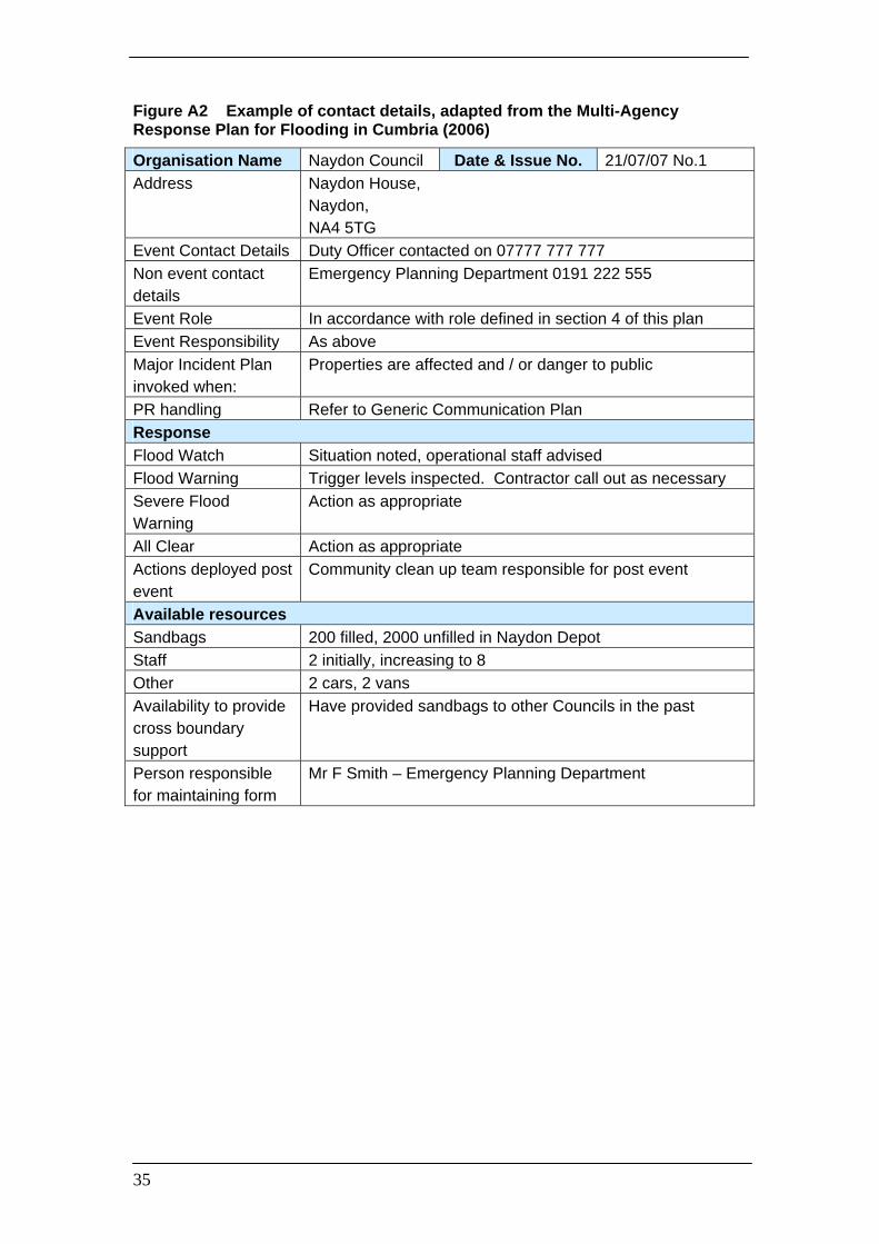
Appendix A - Contact Details of Key Personnel Where a separate contacts database / directory is not available, we recommend that the flood plan contains a list of key internal and external contacts. We suggest the use of post titles, as opposed to individuals’ names, in order to minimise the number of updates required. Figure A1 shows an example contact list with the minimum amount of detail. Figure A2 shows a more comprehensive example adapted from the Multi-Agency Response Plan for Flooding in Cumbria (2006) that extends contact details to include response and resource details.
Figure A1 Example Contact Details of Key Personnel (place Dept/Organisation in alphabetical order)
Department / Organisation
Post title Contact number Secondary contact (name / number)
Electricity Environment Agency
Flood Incident Management Team Leader
444 5689 Incident room 569 7856
Gas Highways Highways Manager 236 4578
0777 777 7777 Deputy 236 4577 0777 777 7778
IDB Police Duty Inspector 478 5623 Incident Room 395 1687 Social Services Duty Officer 236 8989
0777 666 6666 Duty Officer 236 8989 0777 667 6677
Telephone Water
35
Figure A2 Example of contact details, adapted from the Multi-Agency Response Plan for Flooding in Cumbria (2006)
Organisation Name Naydon Council Date & Issue No. 21/07/07 No.1 Address Naydon House,
Naydon, NA4 5TG
Event Contact Details Duty Officer contacted on 07777 777 777 Non event contact details
Emergency Planning Department 0191 222 555
Event Role In accordance with role defined in section 4 of this plan Event Responsibility As above Major Incident Plan invoked when:
Properties are affected and / or danger to public
PR handling Refer to Generic Communication Plan Response Flood Watch Situation noted, operational staff advised Flood Warning Trigger levels inspected. Contractor call out as necessary Severe Flood Warning
Action as appropriate
All Clear Action as appropriate Actions deployed post event
Community clean up team responsible for post event
Available resources Sandbags 200 filled, 2000 unfilled in Naydon Depot Staff 2 initially, increasing to 8 Other 2 cars, 2 vans Availability to provide cross boundary support
Have provided sandbags to other Councils in the past
Person responsible for maintaining form
Mr F Smith – Emergency Planning Department

36
Appendix B - Location of Control Centres We suggest that the flood plan should identify the triggers for opening command / control centres, and their locations including:
Environment Agency incident rooms; Local Authority control centres; multi-agency operational (Bronze) rendezvous points; multi-agency tactical (Silver) commands; multi-agency strategic (Gold) commands;
Do not to locate command / control centres in flood risk areas. Before deciding on a location, you should consider whether the proposed building receives power from utilities within the flood plain or relies on telecommunications hubs that may be vulnerable. We also suggest identifying a contingency (back-up) facility in case the primary location is not fit for use during a flood. We recommend that the plan should include all the necessary information to find and gain entry into the command / control centres, for example:
address (include the post code for ease of use with satellite navigation systems);
telephone number; key holder information; access details; security information (i.e. fobs / security codes); parking arrangements
It would be beneficial to show these control centres on a map (Figure B1). It may also be useful to have a grab bag / grab-kit containing resources that will be needed by officers attending the command / control centres.

37
Figure B1 Example Control Centre Location Map. Taken from the City of York Flood Defence Emergency Response Plan (2002)
Fulford Road Police Station (Next to Imphal Barracks – A19)

38
Appendix C - Examples of Other Possible Appendices Resource Availability An example list of resources which are available from organisations / agencies included within this MAFP. (Please note, this is not specific numbers or volumes, just an indication of where to go if specific resources are needed). Figure C1 Resources
Resource Who / Where Contact Number Sandbags Local authority, Environment Agency Boats Fire and Rescue Service, Local Authority,
Coast Guard, Environment Agency
Pumps Fire, Local Authority, Environment Agency Transport Environment Agency, Local Authority,
Police, Fire, Ambulance
Warning the Public Example loudhailer announcement in case of evacuation Here is an example of a loudhailer announcement, should evacuation become necessary: “Flooding of (insert area) is possible within the next few hours. The authorities are considering evacuating residents from properties in (specify roads / etc). If you occupy property in any of these locations you should make preparations now for a possible evacuation.”
(Adapted from the City of York Flood Defence Emergency Response Plan (2002) and from the London Flood Response Strategic Plan (March 2007)) Sirens If sirens are used within your area during a flood incident, it may be useful to include some information on them, for example; Figure C2 Siren details
SIRENS Location Ownership Trigger for activation Who approves the activation What does it mean What action is required and by whom

39
General Public Advice Before a flood Prepare a Flood kit and include the following: Pack a small bag with essential belongings and include warm clothes, torch (check batteries), radio (wind up or battery powered), food, water, other drink, mobile phone (pre input useful numbers), any medicines that you might need to take, any important documents that you have and a first aid kit. Keep this bag easily accessible.
collect personal belongings, including insurance and bank details, and essential telephone numbers together, and keep them in a waterproof bag.
Move people, pets, valuables and sentimental items upstairs or in a high place downstairs.
Keep a separate list of useful telephone numbers to hand (this should include your local Council, your insurance company and Floodline – 0845 988 188).
Find out where and how to turn off your Gas and Electricity. Ensure that you switch it off if flooding is imminent before evacuating.
If possible, move electrical equipment and furniture upstairs.
Any furniture that you cannot move upstairs, try to raise well off the floor.
Alert neighbours and assist the elderly, infirm and those with small children.
Block doorways and air bricks
Avoid walking and driving through floodwater, there could be hidden hazards.
Keep up to date with local radio for further information and announcements and via Floodline 0845 988 1188.
During a flood
Continue to listen to situation updates on your local radio and via Floodline 0845 988 1188.
Keep dry and out of floodwater if possible
Stay in your property, if safe to do so, until advised otherwise by the emergency services or the floodwater has receded.
Do not walk or drive through flowing floodwater.
If it is necessary to walk through shallow floodwater, take care for hidden holes, obstacles or other hazards
Do not walk on river banks, sea defences or cross bridges over torrential rivers.
Avoid contact with floodwater and wash any exposed parts before handling food or attending to wounds.
If possible, move electrical equipment and furniture upstairs.

40
If evacuation becomes necessary
Stay calm and do not panic.
Police officers and / or other officials will try to visit all properties at risk to advise on the requirement to evacuate.
If road conditions permit, move vehicles to unaffected areas and ask friends / family if you can share their parking facilities.
You will hear about your evacuation point for transport and the location of the reception centre either verbally or by a leaflet.
Try to check that any elderly / vulnerable family members or neighbours know about the evacuation.
Try to inform family members / friends as to where you are evacuating.
Listen to the advice of the authorities and follow any instructions to leave a property.
After a flood / returning home
Contact your insurers as soon as possible and follow their advice. Most insurers have a 24hr helpline. Do not throw away damaged goods until your insurer has authorised you to do so. It is a good idea to take photographs of the damage.
Check the safety of electricity and gas before use. A qualified electrician needs to check any electrical equipment and circuits that have been exposed to floodwater.
Avoid contact with any remaining floodwater or items having had contact with floodwater unless wearing protective gloves / clothing.
Boil all tap water until it is declared safe by the water supply company
Wash yours and your children’s hands frequently with bottled water if your supply has not been declared fit for use. Disinfect any children’s toys.
Dispose of any contaminated food, including tinned food, defrosted food, and packaged food that have been exposed to floodwater.
Seek medical assistance if any health issues appear, especially flu like symptoms.
Ventilate your property whilst taking care for security.
Do not throw rubbish and furniture outdoors; wait for an organised collection.
During these hard times, bogus / cowboy builders / traders are frequently offering their services. Make sure that you get a written quotation that is on letter headed paper with a landline contact number and address.

41
Evacuation Records Figure C3 Premises marking (extracted from the London Flood Response Strategic Plan) NB: Legal issues. Marking premisis with markers may not be well received by some owners. If used, the code used must not be placed in public facing copies of the plan as it alerts people with criminal intent.
Premises Marking Aide Memoir
S Premises secure and no answer E Premises entered and checked O Occupants have not been traced T Occupants have been traced elsewhere X Occupants refuse to leave M Occupants awaiting medical evacuation Occupants have been evacuated
> Premises have been re-occupied Markings should be:
• As large as possible (to assist quick observation / identification from the street) • Displayed on the left side of the door • In chronological order – top to bottom • As close as possible to eye level • Clearly visible to a person observing the premises from the front or normal side
of approach • By wax crayons or similar waterproof marking
Figure C4 Example of a Checked Record
FLOODING INCIDENT – PREMISES CHECKED RECORD LOCATION Use rear of form for any additional information
like babies/infants, pets, guide/hearing dogs, walking aids, non English speaking etc.
Town/Sector (Area of search): Tom Town TT1 2AB
Street of Multi-occupancy Premises Checked:
Sam Street
Date/Time Checked: 10/10/10 / 18.30
Team Ref./Officer Completing: A Team / Mr T OCCUPANTS Property No. or
Name Last Marking Symbol on
Premises or ‘None’
Number in premises
Names Vulnerable Status Y/N
Gransden None 2 Mr Harry Brown Mrs Lilly Brown
N Y - blind
44 S 3 Mr David Jones Mrs Tina Jones Miss Laura Jones
N N N

42
Glossary of Terms A glossary of terms and abbreviations used within the guidance text AOD Above Ordinance Datum
CBRN Chemical, Biological, Radiological and Nuclear
LRF Local Resilience Forum
MAFP Multi-Agency Flood Plan
SSSI’s Sites of Special Scientific Interest’s
COMAH Control of Major Accident Hazards
Definitions and Terms To help make sure people are not talking across purposes, the MAFP should also provide working definitions for all aspects that have the potential to be interpreted differently. For example, include definitions such as:
• “PROPERTIES”: All residential dwellings and commercial premises, including occupied mobile homes and caravans sites in low-lying coastal zones (including summer tourists).
• “PROPERTY FLOODED”: A residential or commercial building where flood water has entered to a level that has resulted in damage or limitation of use, including basements that are habitable or of commercial use.
• “PROPERTY IMPACTED”: A residential or commercial building where flood water that has entered the boundary of land but not resulted in the property itself being flooded.
• “PROPERTIES AFFECTED”: A residential or commercial building where flood water has affected the utilities (energy and water) that supply that property.
You may also like to use the following:
definitive list of all documents or plans that are connected / linked to the MAFP. access or transport route maps; pre-prepared wording for signage; large scale, fold out maps of communities at risk; meeting format, rules and agendas; pre-prepared media releases
* * *

43
This page is intentionally blank.