city precinct map and code - act legislation register · ni2008-27 10.1 suburb precinct maps and...
TRANSCRIPT

NI2008-27 10.1 Suburb Precinct Maps and Codes
Effective: 29 July 2016
Authorised by the ACT Parliamentary Counsel—also accessible at www.legislation.act.gov.au
City Precinct Map and Code
includes
part City Centre

10.1 Suburb Precinct Maps and Codes
Effective: 29 July 2016
NI2008-27
Authorised by the ACT Parliamentary Counsel—also accessible at www.legislation.act.gov.au
This page is intentionally blank.

NI2008-27 10.1 Suburb Precinct Maps and Codes City Precinct Map and Code
Effective: 29 July 2016
page 1
Authorised by the ACT Parliamentary Counsel—also accessible at www.legislation.act.gov.au

page 2 10.1 Suburb Precinct Maps and Codes City Precinct Map and Code
Effective: 29 July 2016
NI2008-27
Authorised by the ACT Parliamentary Counsel—also accessible at www.legislation.act.gov.au
Assessment tracks
The following tables identify the additional prohibited development and additional merit track development for blocks and parcels shown in the City Precinct Map (identified as PDn or MTn). Development that is exempt from requiring development approval, other prohibited development and the minimum assessment track applicable to each development proposal is set out in the relevant zone development table.
The following tables constitute part of the relevant zone development table.
.
Table 1 – Additional prohibited development Additional prohibited development
Suburb precinct map label Zone Development
PD1 CZ1 light industry
at ground floor level
PD2 CZ1 light industry
at 2nd floor or aboveservice station
PD3 CZ6 SHOP (except for personal services or
shops ancillary to other permitted uses)
PD4 CZ1 service station
PD5 CZ1 light industry
at 2nd floor or above
Table 2 – Additional merit track development Additional merit track development that may be approved subject to assessment
Suburb precinct map label Zone Development
MT1 CZ1 vehicle sales
MT2 CZ1 municipal depot
storevehicle sales

NI2008-27 10.1 Suburb Precinct Maps and Codes City Precinct Map and Code
Effective: 29 July 2016
page 3
Authorised by the ACT Parliamentary Counsel—also accessible at www.legislation.act.gov.au
Additional merit track development that may be approved subject to assessment
Suburb precinct map label Zone Development
MT3 CZ1 scientific research establishment
vehicle sales
MT4 CZ6 business agency
RESIDENTIAL USE
MT5 CZ5
club
indoor entertainment facility
place of assembly
MT6 CZ1
municipal depot
scientific research establishment
store
vehicle sales

page 4 10.1 Suburb Precinct Maps and Codes City Precinct Map and Code
Effective: 29 July 2016
NI2008-27
Authorised by the ACT Parliamentary Counsel—also accessible at www.legislation.act.gov.au
City Precinct Code
Contents Introduction ............................................................................................................................................ 6
Additional rules and criteria ................................................................................................................. 8
RC1 – City Centre (part) ........................................................................................................................ 8
Element 1: Use .............................................................................................................................. 8 1.1 Ground floor uses fronting main pedestrian areas............................................ 8
Element 2: Buildings .................................................................................................................... 9 2.1 Shadows ........................................................................................................... 9 2.2 Building design .................................................................................................. 9 2.3 Building height................................................................................................. 10 2.4 Front boundary setbacks ................................................................................ 10 2.5 Pedestrian shelters ......................................................................................... 10
Element 3: Footpaths ................................................................................................................. 11 3.1 Paving design.................................................................................................. 11
Element 4: City area 1 ................................................................................................................ 11 4.1 City section 21 – Childers, Hutton and Kingsley Streets ................................ 11 4.2 Marcus Clarke Street between Barry Drive and University Avenue ............... 11 4.3 Corner of Marcus Clarke Street and Barry Drive ............................................ 12
Element 5: City area 2 ................................................................................................................ 12 5.1 City section 20................................................................................................. 12
Element 6: City area 3 ................................................................................................................ 13 6.1 East of Marcus Clarke Street and West of London Circuit and Northbourne
Avenue ............................................................................................................ 13 6.2 Development adjacent to City section 1 ......................................................... 13
Element 7: City area 4 ................................................................................................................ 13 7.1 East of Northbourne Avenue and London Circuit ........................................... 13 7.2 Development adjacent to City section 48 ....................................................... 14
Element 8: City area 5 ................................................................................................................ 14 8.1 East of Northbourne Avenue and London Circuit ........................................... 14
Element 9: City area 6 ................................................................................................................ 16 9.1 East of Northbourne Avenue and London Circuit ........................................... 16 9.2 Development adjacent to City section 48 ....................................................... 16
Element 10: City area 7 ................................................................................................................ 17 10.1 Uses associated with a car parking structure ................................................. 17 10.2 East of Genge Street and Bunda Street ......................................................... 17 10.3 section 84 City Master Plan ............................................................................ 17 10.4 Ainslie Avenue ................................................................................................ 17
Element 11: City area 8 ................................................................................................................ 19 11.1 City .................................................................................................................. 19
Element 12: Redevelopment ........................................................................................................ 19 12.1 Garema Place ................................................................................................. 19 12.2 City sections 2, 3, 5, 11, 12, 22, 23, 26, 32, 38,51, 53 and 56 ....................... 19
Element 13: Development on nominated car parking areas .................................................... 21 13.1 Nominated car parking areas .......................................................................... 21

NI2008-27 10.1 Suburb Precinct Maps and Codes City Precinct Map and Code
Effective: 29 July 2016
page 5
Authorised by the ACT Parliamentary Counsel—also accessible at www.legislation.act.gov.au
Figures Figure 1 Main Pedestrian Areas and Routes ..................................................................................... 9
Figure 2 City CZ1 Zone– building height areas 5 and 6 - height plane diagrams ........................ 15
Figure 3 City Areas ............................................................................................................................. 18
Figure 4 City Building Height – Areas 5 and 6................................................................................. 20
Figure 5 Nominated Car Parking Areas ............................................................................................ 21

page 6 10.1 Suburb Precinct Maps and Codes City Precinct Map and Code
Effective: 29 July 2016
NI2008-27
Authorised by the ACT Parliamentary Counsel—also accessible at www.legislation.act.gov.au
Introduction
Name
The name of this code is City Precinct Code.
Application
The code applies to the Division of City.
Purpose
This code provides additional planning, design and environmental controls for specific areas or blocks and may also contain references to provisions in other codes.
In conjunction with other relevant codes it will be used by the Authority to assess development applications and offer guidance to intending applicants in designing development proposals and preparing development applications.
Structure
This code contains additional rules and/or criteria for particular blocks or parcels identified as areas RCn on the precinct map, to be read in conjunction with the relevant development code. It may also contain sub-parts.
Each element has one or more rules and, unless the respective rule is mandatory, each rule has an associated criterion. Rules provide quantitative, or definitive, controls. By contrast, criteria are chiefly qualitative in nature.
In some instances rules are mandatory. Such rules are accompanied by the words “This is a mandatory requirement. There is no applicable criterion.” Non-compliance with a mandatory rule will result in the refusal of the development application. Conversely, the words “There is no applicable rule” is found where a criterion only is applicable.
Code hierarchy
Under the Planning and Development Act 2007, where more than one type of code applies to a development, the order of precedence if there is inconsistency of provisions between codes is: precinct code, development code and general code.
If more than one precinct code applies to the site, the most recent precinct code takes precedence to the extent of any inconsistency.
Definitions
Defined terms, references to legislation and other documents are italicised.
Definitions of terms used in this code are listed in part 13 of the Territory Plan or, for terms applicable only to this code, associated with the respective rule.

NI2008-27 10.1 Suburb Precinct Maps and Codes City Precinct Map and Code
Effective: 29 July 2016
page 7
Authorised by the ACT Parliamentary Counsel—also accessible at www.legislation.act.gov.au
Acronyms
ACTPLA Planning and Land Authority within the ACT Environment and Sustainable Development Directorate
EPA ACT Environment Protection Authority
ESA ACT Emergency Services Agency
ESDD ACT Environment and Sustainable Development Directorate
NCA National Capital Authority
P&D Act Planning and Development Act 2007
TAMS ACT Territory and Municipal Services Directorate

page 8 10.1 Suburb Precinct Maps and Codes City Precinct Map and Code
Effective: 29 July 2016
NI2008-27
Authorised by the ACT Parliamentary Counsel—also accessible at www.legislation.act.gov.au
Additional rules and criteria
This part applies to blocks and parcels identified in the City Precinct Map (RCn). It should be read in conjunction with the relevant zone development code and related codes.
RC1 – City Centre (part)
This part applies to blocks and parcels identified in area RC1 shown on the City Precinct Map. RC1 is part of the City Centre. For the other parts, see the Braddon and Turner precinct codes.
Element 1: Use
Rules Criteria
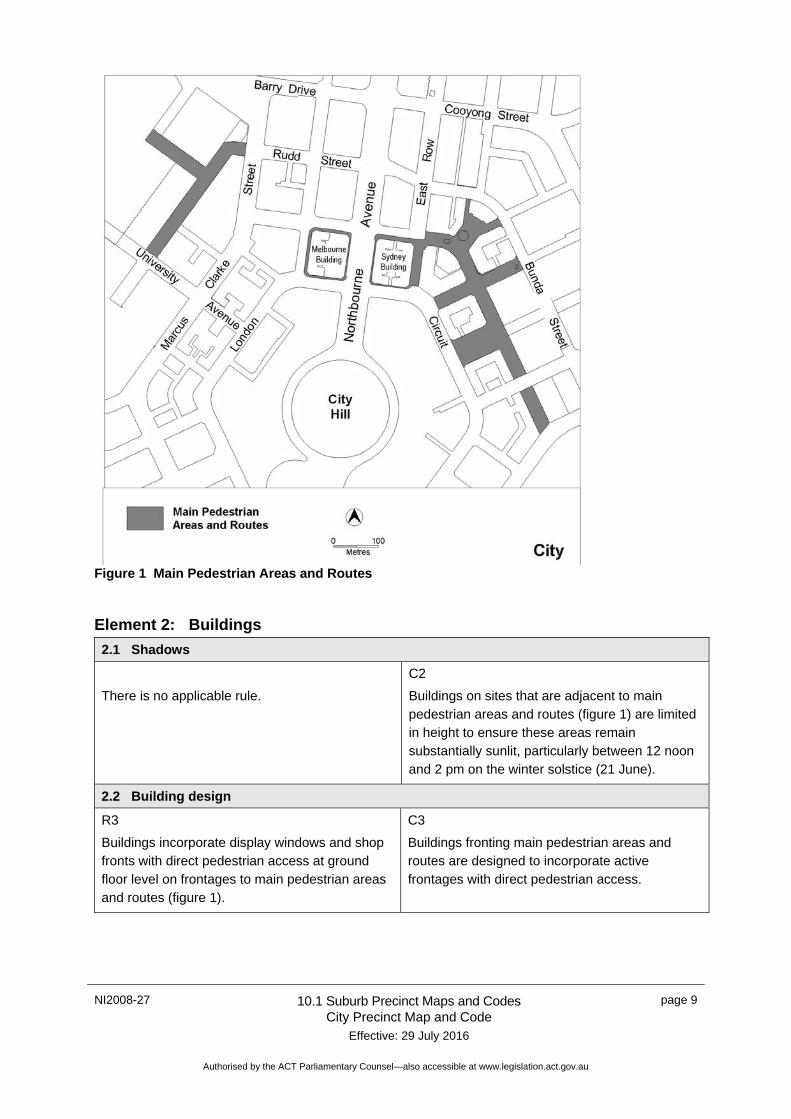
1.1 Ground floor uses fronting main pedestrian areas
R1
This rule applies to frontages to main pedestrian areas and routes shown in figure 1.
Only the following uses are allowed at ground floor level:
a) business agency
b) club
c) community activity centre
d) drink establishment
e) financial establishment
f) hotel
g) indoor entertainment facility
h) indoor recreation facility
i) public agency
j) restaurant
k) SHOP.
C1
Buildings fronting main pedestrian areas and routes incorporate uses on the ground floor that generate activity in the public space.
NI2008-27 10.1 Suburb Precinct Maps and Codes City Precinct Map and Code
Effective: 29 July 2016
page 9
Authorised by the ACT Parliamentary Counsel—also accessible at www.legislation.act.gov.au
Figure 1 Main Pedestrian Areas and Routes
Element 2: Buildings
2.1 Shadows
There is no applicable rule.
C2
Buildings on sites that are adjacent to main pedestrian areas and routes (figure 1) are limited in height to ensure these areas remain substantially sunlit, particularly between 12 noon and 2 pm on the winter solstice (21 June).
2.2 Building design
R3
Buildings incorporate display windows and shop fronts with direct pedestrian access at ground floor level on frontages to main pedestrian areas and routes (figure 1).
C3
Buildings fronting main pedestrian areas and routes are designed to incorporate active frontages with direct pedestrian access.

page 10 10.1 Suburb Precinct Maps and Codes City Precinct Map and Code
Effective: 29 July 2016
NI2008-27
Authorised by the ACT Parliamentary Counsel—also accessible at www.legislation.act.gov.au
There is no applicable rule.
C4
Extensive lengths of blank walls unrelieved by shopfront, window displays or other openings are not acceptable at street level.
There is no applicable rule.
C5
The form and scale of development is consistent with existing adjacent development.
2.3 Building height
There is no applicable rule.
C6
Building heights comply with all of the following:
i) are compatible with existing, or desired future character of, adjacent development
ii) are appropriate to the scale and function of the use
iii) do not cause detrimental impacts, including overshadowing and excessive scale.
R7
Buildings do not exceed RL617m.
This is a mandatory requirement. There is no applicable criterion.
There is no applicable rule.
C8
Unless otherwise stated below, roof top plant that is set back and screened from the street is not included in the maximum building height provided it does not exceed RL617m.
2.4 Front boundary setbacks
There is no applicable rule.
C9
Buildings abut the front property boundary unless alternative setbacks are established by existing adjacent development, in which case setbacks are consistent with the intended design themes of the area.
2.5 Pedestrian shelters
R10
Buildings provide continuous awnings or colonnaded walkways at ground floor level within the site abutting the street frontage.
Continuous shelters, in the form of awnings or colonnades, have a minimum clear width of 2.5m and minimum ceiling height of 3.6m.
C10
Sheltered and convenient pedestrian access is provided in the main retail and commercial areas at street level by incorporating colonnades or awnings, in a form that is consistent with the established/intended design themes for the area.

NI2008-27 10.1 Suburb Precinct Maps and Codes City Precinct Map and Code
Effective: 29 July 2016
page 11
Authorised by the ACT Parliamentary Counsel—also accessible at www.legislation.act.gov.au
Element 3: Footpaths
3.1 Paving design
R11
Footpaths are constructed in accordance with the Canberra Central Paving Design Palette and Policy.
C11
Footpaths are designed and constructed to reinforce a consistent design policy and paving palette.
Element 4: City area 1
This element applies to City area 1 as shown on figure 3.
Rules Criteria
4.1 City section 21 – Childers, Hutton and Kingsley Streets
There is no applicable rule.
C12
For buildings fronting Childers, Hutton and Kingsley Streets maximum building heights up to 7 storeys may be considered where development meets all of the following:
a) building elements higher than 4 storeys are set back from the front boundary
b) floor to floor height of the ground floor level of buildings facing Childers Street is 4.8 metres
c) awnings along Childers Street provide shelter and establish a pedestrian scale at street level.
4.2 Marcus Clarke Street between Barry Drive and University Avenue
There is no applicable rule.
C13
For buildings fronting Marcus Clarke Street (between Barry Drive and University Avenue) maximum building heights up to RL617M (approximately 12 storeys) may be considered where development meets all of the following:
a) the built form is configured to establish a defined parapet at the 9th storey level
b) building elements higher than 9 storeys are visually recessed
c) floor to floor height of the ground floor level of buildings facing Marcus Clarke Street is 4.8 metres
d) building elevations along Marcus Clarke Street are articulated with awnings or similar to provide shelter for pedestrians.

page 12 10.1 Suburb Precinct Maps and Codes City Precinct Map and Code
Effective: 29 July 2016
NI2008-27
Authorised by the ACT Parliamentary Counsel—also accessible at www.legislation.act.gov.au
Rules Criteria
4.3 Corner of Marcus Clarke Street and Barry Drive
There is no applicable rule.
C15
For buildings fronting Barry Drive maximum building heights up to RL617m (approximately 12 storeys) at the corner of Marcus Clarke Street may be considered where development meets all of the following:
a) buildings step up from 7 storeys adjacent to Kingsley Street to RL617m at the corner of Marcus Clarke Street
b) overshadowing of open space and existing residential buildings is prevented.
c) the built form is configured to establish a defined parapet at the ninth storey level
d) building elements higher than 9 storeys are visually recessed.
Element 5: City area 2
This element applies to City area 2 as shown on figure 3.
5.1 City section 20
There is no applicable rule.
C16
For buildings fronting corner of Ellery Crescent and Marcus Clarke Street maximum building heights up to RL617m (approximately 12 storeys) may be considered provided there is an integrated approach to building heights across Marcus Clarke Street.
There is no applicable rule.
C17
For the remainder of City section 20 maximum building heights must be sensitive to the height and scale of surrounding heritage listed buildings including Screen Sound, Shine Dome, Ian Potter House and the ANU Schools of Art and Music.
There is no applicable rule.
C18
Accessible pedestrian space is provided at the intersection of Ellery Crescent and Marcus Clarke Street that links form adjacent development on sections 61, 90, 91 and 92 to development on section 20 and the ANU School of Arts via the proposed bridge over Ellery Crescent.

NI2008-27 10.1 Suburb Precinct Maps and Codes City Precinct Map and Code
Effective: 29 July 2016
page 13
Authorised by the ACT Parliamentary Counsel—also accessible at www.legislation.act.gov.au
Element 6: City area 3
This element applies to City area 3 as shown on figure 3.
Rules Criteria
6.1 East of Marcus Clarke Street and West of London Circuit and Northbourne Avenue
There is no applicable rule.
C19
Maximum building heights are 9 storeys except that one or more taller buildings per section up to RL617m (approximately 12 storeys) may be considered where forming part of a comprehensive design for the whole section identified in a Planning Report under section 97 of the Planning and Development Act 2007.
6.2 Development adjacent to City section 1
There is no applicable rule.
C20
Development in areas adjacent to section 1 is compatible with the built form and historic character of the Melbourne building.
Element 7: City area 4
This element applies to City area 4 as shown on figure 3
Rules Criteria
7.1 East of Northbourne Avenue and London Circuit
There is no applicable rule
C21
For frontages of 30 metres or less maximum building height is 7 storeys.
There is no applicable rule
C22
Maximum building height is 9 storeys except that one or more taller buildings per section up to RL617m (approximately 12 storeys) may be considered where forming part of a comprehensive design for the whole section identified in a Planning Report under section 97 of the Planning and Development Act 2007.
There is no applicable rule.
C23
For frontages greater than 30 metres, maximum building height is 9 storeys except that one or more taller building per section up to RL617m (approximately 12 storeys) may be considered where forming part of a comprehensive design for the whole section identified in a Planning Report under section 97 of the Planning and Development Act 2007.

page 14 10.1 Suburb Precinct Maps and Codes City Precinct Map and Code
Effective: 29 July 2016
NI2008-27
Authorised by the ACT Parliamentary Counsel—also accessible at www.legislation.act.gov.au
Rules Criteria
7.2 Development adjacent to City section 48
There is no applicable rule.
C24
Development in areas adjacent to section 48 is compatible with the built form and historic character of the Sydney building.
Element 8: City area 5
This element applies to City area 5 as shown on figure 3.
Rules Criteria
8.1 East of Northbourne Avenue and London Circuit
There is no applicable rule.
C25
Building height is no higher than the heights of existing approved buildings except that:
a) Minor variations of building heights may be permitted in special circumstances such as to allow for special architectural features to enhance building facades.
b) One or more taller building per section up to RL617m (approximately 12 storeys) may be considered where forming part of a comprehensive design for the whole section identified in a Planning Report under section 97 of the Planning and Development Act 2007.
R26
a) No part of any building is above a plane extending from the centre line (figure 2) of an adjacent main pedestrian area (except Garema Place) through the main parapet line (figure 2).
b) For blocks fronting a street other than a main pedestrian area no part of any building is above a plane drawn at 45o up from the main parapet line (figure 2).
c) Above the main parapet line the whole building is set back at least 5 metres.
C26
Minor variations of building heights and setbacks may be permitted in special circumstances such as to allow for special architectural features to enhance building facades.

NI2008-27 10.1 Suburb Precinct Maps and Codes City Precinct Map and Code
Effective: 29 July 2016
page 15
Authorised by the ACT Parliamentary Counsel—also accessible at www.legislation.act.gov.au
Figure 2 City CZ1 Zone– building height areas 5 and 6 - height plane diagrams

page 16 10.1 Suburb Precinct Maps and Codes City Precinct Map and Code
Effective: 29 July 2016
NI2008-27
Authorised by the ACT Parliamentary Counsel—also accessible at www.legislation.act.gov.au
Element 9: City area 6
This element applies to City area 6 as shown on figure 3.
Rules Criteria
9.1 East of Northbourne Avenue and London Circuit
R27
a) The height of a building to its main parapet line (i.e. the top part of the building at its block frontage) does not exceed the relevant maximum building height shown on figure 4.
b) No part of any building at the ground surface at the centre of its block frontage is more than:
i) 28 metres and up to 8 storeys including roof top plant, or
ii) 23 metres for City section 15 blocks 1, 2, 5 and 12.
C27
a) Minor variations of building heights and setbacks may be permitted in special circumstances such as to allow for special architectural features to enhance building facades.
b) One or more taller buildings per section up to RL617m (approximately 12 storeys) may be considered where forming part of a comprehensive design for the whole section identified in a Planning Report under section 97 of the Planning and Development Act 2007.
c) Rebuilding up to the existing approved height limit is permitted.
R28
a) No part of any building is above a plane extending from the centre line (figure 2) of an adjacent main pedestrian area (except Garema Place) through the main parapet line (figure 2).
b) For blocks fronting a street other than a main pedestrian area no part of any building is above a plane drawn at 45o up from the main parapet line (figure 2).
c) Above the main parapet line the whole building is set back at least 5 metres.
C28
Minor variations of building heights and setbacks may be permitted in special circumstances such as to allow for special architectural features to enhance building facades.
9.2 Development adjacent to City section 48
There is no applicable rule.
C29
Development in areas adjacent section 48 is compatible with the built form and historic character of the Sydney building.

NI2008-27 10.1 Suburb Precinct Maps and Codes City Precinct Map and Code
Effective: 29 July 2016
page 17
Authorised by the ACT Parliamentary Counsel—also accessible at www.legislation.act.gov.au
Element 10: City area 7
This element applies to City area 7 as shown on figure 3
Rules Criteria
10.1 Uses associated with a car parking structure
R30
This rule applies to sections 53, 56, 68, 84, 96, and 97.
One or more of the following uses are permitted only where associated with a car parking structure:
a) service station
b) store.
This is a mandatory requirement. There is no applicable criterion.
10.2 East of Genge Street and Bunda Street
R31
Buildings are no higher than the heights of existing approved buildings.
C31
One or more buildings per section up to RL617m (approximately 12 storeys) may be considered where forming part of a comprehensive design for the whole section identified in a Planning Report under section 97 of the Planning and Development Act 2007.
10.3 section 84 City Master Plan
There is no applicable rule.
C32
Development is not inconsistent with the section 84 City Master Plan, December 2004.
10.4 Ainslie Avenue
R33
Ainslie Avenue between Cooyong Street and Bunda Street remains permanently opened to the public for pedestrian access at ground floor level. The Territory retains the right, through relevant provisions in any lease for the land, to utilise this section of Ainslie Avenue as a public transport corridor.
This is a mandatory requirement. There is no applicable criterion.

page 18 10.1 Suburb Precinct Maps and Codes City Precinct Map and Code
Effective: 29 July 2016
NI2008-27
Authorised by the ACT Parliamentary Counsel—also accessible at www.legislation.act.gov.au
Figure 3 City Areas

NI2008-27 10.1 Suburb Precinct Maps and Codes City Precinct Map and Code
Effective: 29 July 2016
page 19
Authorised by the ACT Parliamentary Counsel—also accessible at www.legislation.act.gov.au
Element 11: City area 8
This element applies to City area 8 as shown on figure 3.
Rules Criteria
11.1 City
R34
This rule applies to City section 6 block 2.
The maximum building height is 7 storeys.
C34
a) Building heights comply with all of the following:
i) are compatible with existing, or future desired character of, adjacent development
ii) are appropriate to the scale and function of the use
iii) minimise detrimental impacts including overshadowing and excessive scale
b) Part of the building may extend beyond 7 storeys to a maximum of RL 617m.
There is no applicable rule.
C35
Development on City section 6 block 2 addresses Edinburgh Avenue and London Circuit.
There is no applicable rule.
C36
Buildings in the City section 6 block 2 abut the front property boundary on London Circuit.
Element 12: Redevelopment
Rules Criteria
12.1 Garema Place
There is no applicable rule.
C37
Redevelopment within Garema Place (figure 4) is consistent with a comprehensive design for the whole area identified in a Planning Report under section 97 of the Planning and Development Act 2007.
12.2 City sections 2, 3, 5, 11, 12, 22, 23, 26, 32, 38,51, 53 and 56
There is no applicable rule.
C38
Where comprehensive redevelopment is proposed to an intensive inner city scale, each new building is to be consistent with a comprehensive design for the whole section identified in a Planning Report under section 97 of the Planning and Development Act 2007. Existing low rise buildings or building elements that are integral to the comprehensive design may be required to retain their existing heights.

page 20 10.1 Suburb Precinct Maps and Codes City Precinct Map and Code
Effective: 29 July 2016
NI2008-27
Authorised by the ACT Parliamentary Counsel—also accessible at www.legislation.act.gov.au
Figure 4 City Building Height – Areas 5 and 6

NI2008-27 10.1 Suburb Precinct Maps and Codes City Precinct Map and Code
Effective: 29 July 2016
page 21
Authorised by the ACT Parliamentary Counsel—also accessible at www.legislation.act.gov.au
Element 13: Development on nominated car parking areas
Rules Criteria
13.1 Nominated car parking areas
R39
Development on existing car parks (figure 5) complies with all of the following:
a) retains the existing level of car parking
b) accommodates onsite any additional demand for car parking that is generated by the development
c) ensures that car parking remains available for public access
d) complies with the Parking and Vehicular Access General Code.
C39
Development on existing car parks (figure 5) may be considered where it meets all of the following:
a) in accordance with the Parking and Vehicular Access General Code, there is enough car parking for the needs of the centre as a whole
b) the development does not adversely affect the overall function of the centre in terms of economic, social, traffic and parking and urban design impacts.
Figure 5 Nominated Car Parking Areas