city of manteca · city of manteca general plan 2023 policy document adopted october 6, 2003...
TRANSCRIPT
CITY OF MANTECAGENERAL PLAN
2023POLICY DOCUMENTAdopted October 6, 2003Housing Element Amended June 15, 2010Circulation Element Amended April 5, 2011
OCTOBER 6, 2003 1
Table of Contents1 General Plan Context and Vision
1.1 General Plan Purpose................................................................................................ 1-11.2 Manteca General Plan Context.................................................................................. 1-11.3 Time Horizon ........................................................................................................... 1-31.4 General Plan Study Area........................................................................................... 1-31.5 Organization of the General Plan .............................................................................. 1-51.6 Participants and Process............................................................................................ 1-71.7 Key Land Use Issues and Development Concepts ..................................................... 1-7
2 Land Use Element2.1 Summary of Proposed Land Use............................................................................... 2-12.2 Land Use Categories................................................................................................. 2-32.3 Land Use Goals and Policies................................................................................... 2-11
3 Community Design Element3.1 Compact Community Form ...................................................................................... 3-13.2 City Identity ............................................................................................................. 3-33.3 Resource Efficient Buildings .................................................................................... 3-83.4 Pedestrians and Bicycles........................................................................................... 3-83.5 Agricultural Heritage................................................................................................ 3-9
4 Circulation Element (Amended April 5, 2011)4.1 Introduction.............................................................................................................. 4-14.2 Key Assumptions ..................................................................................................... 4-14.3 Relationship to Other General Plan Elements............................................................ 4-34.4 Relationship to Regional Transportation ................................................................... 4-44.5 Time Horizon for the Circulation Element ................................................................ 4-44.6 Circulation Goals...................................................................................................... 4-44.7 Street Network and Classification ............................................................................. 4-64.8 Traffic Calming...................................................................................................... 4-104.9 Level of Service Standards ..................................................................................... 4-104.10 Major Streets Master Plan....................................................................................... 4-164.11 Parking................................................................................................................... 4-244.12 Bikeway and Pedestrian Systems ............................................................................ 4-264.13 Public Transit ......................................................................................................... 4-304.14 Goods Movement ................................................................................................... 4-324.15 Transportation Demand Management ..................................................................... 4-33
5 Economic Development Element5.1 Context and Potential for Growth.............................................................................. 5-15.2 Local Government’s Role in Economic Development ............................................... 5-25.3 Land Use.................................................................................................................. 5-35.4 Labor Force.............................................................................................................. 5-65.5 Business Sector ........................................................................................................ 5-8
TABLE OF CONTENTS MANTECA GENERAL PLAN 2023
2 OCTOBER 6, 2003
5.6 Housing .................................................................................................................. 5-115.7 Quality of Life ........................................................................................................ 5-125.8 Infrastructure .......................................................................................................... 5-14
6 Public Facilities and Services Element6.1 Purpose.....................................................................................................................6-16.2 Relationship to Other General Plan Elements ............................................................6-26.3 Projected Growth Relative to Public Facilities and Services ......................................6-26.4 General Services .......................................................................................................6-26.5 Domestic Water ........................................................................................................6-36.6 Sewer .......................................................................................................................6-76.7 Major Drainage....................................................................................................... 6-106.8 Electricity ............................................................................................................... 6-126.9 Solid Waste ............................................................................................................ 6-136.10 Education ............................................................................................................... 6-156.11 Police ..................................................................................................................... 6-176.12 Fire Protection ........................................................................................................ 6-176.13 Recreation and Parks .............................................................................................. 6-18
7 Safety Element7.1 Geologic and Seismic Hazards..................................................................................7-17.2 Flood Hazards ..........................................................................................................7-37.3 Hazardous Materials .................................................................................................7-67.4 Emergency Procedures..............................................................................................7-1
8 Resource Conservation Element8.1 Authority ..................................................................................................................8-18.2 Relationship to Other General Plan Elements ............................................................8-28.3 Water Conservation ..................................................................................................8-28.4 Energy Conservation.................................................................................................8-38.5 Soils and Erosion Control .........................................................................................8-58.6 Water Quality ...........................................................................................................8-68.7 Open Space...............................................................................................................8-78.8 Agricultural Resources..............................................................................................8-98.9 Biological Resources .............................................................................................. 8-128.10 San Joaquin County Multi-Species Habitat Conservation and Open Space Plan....... 8-128.11 Mineral Resources .................................................................................................. 8-148.12 Cultural Resources.................................................................................................. 8-14
9 Noise Element9.1 Introduction ..............................................................................................................9-19.2 Sensitive Land Uses..................................................................................................9-29.3 Noise Goals ..............................................................................................................9-29.4 Policies and Implementation Measures......................................................................9-3
MANTECA GENERAL PLAN 2023 TABLE OF CONTENTS
OCTOBER 6, 2003 3
10 Air Quality Element10.1 Introduction............................................................................................................ 10-110.2 Existing Conditions in Manteca .............................................................................. 10-210.3 Air Quality Goals ................................................................................................... 10-2
11 Administration and Implementation Element11.1 Introduction............................................................................................................ 11-111.2 Administration and Implementation Goals .............................................................. 11-1
12 Housing Element
(UPDATED AND REPLACED JUNE 15, 2010)PLEASE REFER TO UPDATED DOCUMENT ON FILE WITH THE COMMUNITY
DEVELOPMENT DEPARTMENT.

TABLE OF CONTENTS MANTECA GENERAL PLAN 2023
4 OCTOBER 6, 2003
List of Figures
1-1 General Plan Study Area Boundary...........................................................................1-42-1 Land Use Map (in Binder Pocket)2-2 Conceptual Neighborhood Scale Commercial Mixed Use Development ...................2-62-3 Primary Urban Service Boundaries ........................................................................ 2-144-1 Downtown Level of Service Exemption Area ......................................................... 4-124-2 Manteca Major Street Master Plan ......................................................................... 4-174-3 Major Street Master Plan 2023 General Plan Land Use Element Buildout
Number of Lanes ................................................................................................... 4-1812-1 Residential Land Designation in the PFIP ............................................................. 12-43
List of Tables2-1 Summary of 2023 General Plan Land Use ...............................................................2-22-2 Summary of Urban Reserve Land Use ..................................................................... 2-39-1 Maximum Allowable Noise Exposure Mobile Noise Sources ...................................9-59-2 Performance Standards for Stationary Noise Sources or
Projects Affected by Stationary Noise Sources .........................................................9-612-1 Categories of Household Income............................................................................. 12-612-2 Summary of Housing Program Activity ................................................................ 12-1212-3 Manteca Housing Characteristics .......................................................................... 12-1812-4 Manteca Building Permit History.......................................................................... 12-1812-5 Physical Housing Characteristics .......................................................................... 12-1912-6 Tenure of Housing Units....................................................................................... 12-2012-7 Median Home Value............................................................................................. 12-2112-8 Comparison of Rental Costs.................................................................................. 12-2212-9 General Demographic Characteristics ................................................................... 12-2512-10 Household Type.................................................................................................... 12-2612-11 Household Type by Type of Housing Unit ............................................................ 12-2612-12 Household Size ..................................................................................................... 12-2712-13 Household Earnings .............................................................................................. 12-2812-14 Manteca Poverty Status In 1999 (Below Poverty Level) ........................................ 12-2812-15 Characteristics Of Manteca Households Below Poverty Level............................... 12-2912-16 Percentage Of Rent, By Income Level................................................................... 12-3012-17 Employment Status (Over 16 Years of Age).......................................................... 12-3112-18 Commuting Patterns of Manteca Workers (Over Age 16) ...................................... 12-3112-19 Housing Characteristics of Manteca Seniors (Over Age 65)................................... 12-3212-20 Female Head of Household ................................................................................... 12-3512-21 Population Projections .......................................................................................... 12-3712-22 Population Projection at 3.9% Annual Growth ...................................................... 12-3812-23 Regional Housing Needs Allocation...................................................................... 12-3912-24 Land Area Available for Housing Development in 5 Years.................................... 12-4112-25 Residential Development Potential of Vacant Sites ............................................... 12-4412-26 Projected Expenditure of Agency Funds on Affordable Housing ........................... 12-46

MANTECA GENERAL PLAN 2023 TABLE OF CONTENTS
OCTOBER 6, 2003 5
12-27 Fair Housing Service Agencies ............................................................................. 12-4812-28 Services Provided For Special Needs Populations ................................................. 12-4812-29 Schedule of Manteca Development Fees (effective as of January, 2003)................ 12-5412-30 Governmental and Non-Governmental Housing Development Constraints ............ 12-5512-31 Construction Costs Per Square Foot ...................................................................... 12-5712-32 Housing Plan Program Summary .......................................................................... 12-7612-33 Summary of Quantified Objectives: 2004-2007..................................................... 12-8212-34 HCD Income Definintions .................................................................................... 12-83

TABLE OF CONTENTS MANTECA GENERAL PLAN 2023
6 OCTOBER 6, 2003
THIS PAGE INTENTIONALLY LEFT BLANK.
OCTOBER 6, 2003 1-1
1. GENERAL PLAN CONTEXT AND VISION
1.1 General Plan Purpose
California law requires each city to adopt a comprehensive, long-term general planfor the physical development of the city. The general plan must be an integrated,internally consistent, and compatible statement of policies for the city. It serves as aframework for public and private development, and establishes requirements foradditional planning studies where greater specificity is needed.
The general plan is the constitution for the City's development, and governs all landuse regulations, including zoning.
The General Plan has the following purposes:
! To identify the community's land use, transportation, environmental,economic and social goals and policies as they relate to land use,conservation and development.
! To enable the City Council and the Planning Commission to establishlong-range conservation and development policies.
! To provide a basis for judging whether specific private developmentproposals and public projects are in harmony with these policies.
! To inform citizens, developers, decision makers, and other jurisdictionsof the policies that will guide development and conservation within theCity of Manteca.
1.2 Manteca General Plan Context
This revision of the Manteca General Plan updates the plan adopted in 1988, the lasttime the City comprehensively revised its General Plan.
The City of Manteca, incorporated May 28, 1918, is located in the “heartland” ofCalifornia, with historical roots as an important agricultural center. For much of theearly 20th century, the Manteca area has been predominantly an agricultural area dueto the excellent soil, mild climate, and access to clean water. While agriculture still
CONTEXT AND VISION MANTECA GENERAL PLAN 2023
1-2 OCTOBER 6, 2003
plays an important role in Manteca’s economy, the City’s economic base has becomemore diversified with the development of industries and the influx of Bay Areaworkers seeking affordable housing.
The preparation of this General Plan coincides with new circumstances that promisea bright future for Manteca. The City is truly at a crossroads created bycircumstances beyond its borders. If properly prepared, the City can ensure sustainedeconomic growth, and maintain the existing quality of life for current and futureresidents. This General Plan defines a future based on these new circumstances.
The new circumstances that will drive economic development in Manteca reflectbroad changes in technology and demographic trends far beyond this community.Technology will change the way in which people will work, shop, and communicatewith others socially and in business, and engage in leisure activities. These changeswill make it more likely that individuals will choose a place to live based on qualityof life issues, rather than traditional economic considerations.
Regional, national and international trends present opportunities and challenges thatcan lead to the achievement of the long standing goal of a balanced economy with awide range of employment opportunities and retail services. Manteca is located inthe center of an emerging interregional metropolitan area that is undergoing aneconomic transformation. The traditional economic engine of agriculture and foodprocessing, although still important, is being supplanted by warehousing anddistribution industries that take advantage of the central location, relatively affordableland, and transportation network. Manteca is also characterized by the highpercentage of interregional commuters who are attracted by the community’s qualityof life and relatively affordable housing. This skilled workforce, presentlycommuting long distances, is a resource for economic development. Due in part tothe skills of the commuter workforce, Manteca will become increasingly competitivefor the location of manufacturing and office uses.
1.2.1 Vision 2020
The General Plan builds upon the work of a community visioning process concludedin 1998. Vision 2020, crafted by a task force of community volunteers, is acomprehensive statement of community goals and objectives. The Vision 2020

MANTECA GENERAL PLAN 2023 CONTEXT AND VISION
OCTOBER 6, 2003 1-3
document addresses the downtown area, economic development, and residentialdevelopment and community amenities.
1.3 Time Horizon
This Plan guides the City to the year 2023. The "build-out," or full development,allowed by the General Plan is based on current projections of population andemployment growth over the next twenty years. It is possible, however, that the totalamount of development allowed by the Plan will not be constructed over this 20-yearperiod, due to changes in economic conditions and other factors.
1.4 General Plan Study Area
The city may include in its general plan any land outside its boundaries which relatesto its planning. The General Plan Study Area encompasses approximately 25,975acres within and outside of the existing City limits. The purpose in establishing theStudy Area boundary larger than the existing City is to identify and evaluate the areassurrounding the City that may affect the future economic viability, traffic, services,and aesthetic quality of the City.
In addition, since many issues such as air quality, traffic and economic development,extend beyond political boundaries, the law provides for planning outside of thejurisdiction’s territory.
The General Plan must cover all territory within its boundaries as well as “any landoutside its boundaries which in the planning agency’s judgment bears relation to itsplanning,” (Government Code Section 65300). A local government can formallycommunicate its concerns for the future of lands under its neighbors’ jurisdictions bythis means. “Cooperative ‘extraterritorial’ planning can be used to guide the orderlyand efficient extension of services and utilities, ensure the preservation of openspace, agricultural, and resource conservation lands, and establish consistentstandards for development in the plans of adjoining jurisdictions” (State of CaliforniaGeneral Plan Guidelines). It is for these purposes that the City of Manteca GeneralPlan Study Area boundary extends beyond the existing Sphere of Influence.However, the City of Manteca will not necessarily seek to initiate annexation of landthat is either in the Sphere of Influence or the General Plan Study Area.

SR 99
SR 120
Airp
ort W
ay
Uni
on R
oad
Louise Avenue
Yosemite Avenue
Woodward Avenue
Lathrop Road
McK
inle
y A
venu
e
Aus tin R
oad
Roth Road
French Camp Road
Southern Pacific Railroad
FIGURE 1-1GENERAL PLAN STUDY AREA BOUNDARY
Manteca General Plan
LEGEND
Study Area Boundary
May 2003
WADE ASSOCIATESurban planning & designenvironmental planning
Mai
n S
tree
t
Atherton Avenue
Uni
on P
acifi
c R
R

MANTECA GENERAL PLAN 2023 CONTEXT AND VISION
OCTOBER 6, 2003 1-5
1.5 Organization of the General Plan
The General Plan includes a policy document, background information, technicaldata, and an environmental impact report that evaluates the impacts of the GeneralPlan on the environment.
The Manteca General Plan includes the seven state-mandated elements and fouroptional elements. The eleven total elements that comprise this General Plan include:
! Land Use- establishes land use designations with types and intensities ofuse and sets policies and programs regarding future development of theCity.
! Community Design- establishes urban design guidelines to ensure thatnew development is attractive and contributes to the sense of Manteca asa location.
! Circulation- contains policies for the City’s roadway system, transit,pedestrian and bicycle circulation, and methods of managingtransportation demand, accounting for the relationship between land useand circulation.
! Economic Development- addresses the need for Manteca to broaden itsemployment base to maintain the high quality of life currently enjoyedand implementing an economic development strategy.
! Housing- includes policies and programs to increase the variety andtypes of housing in the City, emphasizing infill sites, increased density,and mixed uses downtown, and also includes a discussion of housingneeds and programs to provide additional housing for special needspopulations.
! Public Facilities and Services- discusses public facilities includingdomestic water, sewer, storm drainage, electricity services, solid waste,education, police protection, fire protection, and parks and recreation.
! Safety- contains policies and programs to protect the community frominjury, loss of life, and property damage resulting from natural disastersand hazardous conditions.

CONTEXT AND VISION MANTECA GENERAL PLAN 2023
1-6 OCTOBER 6, 2003
! Resource Conservation- emphasizes the accommodation of populationgrowth while conserving and protecting the area’s natural resources andquality of life.
! Noise- identifies policies that will protect the community from noisehazards.
! Air Quality- addresses the community’s need to cooperate regionally sothat increased development does not further degrade the air quality.
! Administration
Each General Plan element is organized in a similar format: 1) explanatory text toprovide additional information about existing conditions or policies and programs; 2)the intent of the element; and 3) goals, policies, and implementation programs forthat element.
The key section of each element is the statement of goals, policies, andimplementation programs. The issues addressed and goals and policies identified arebased on input received from the community and the Steering Committee.
The Housing Element differs slightly because State law specifies issues that must beaddressed in housing elements. In addition to broad goals and policies, the HousingElement contains numeric goals for housing rehabilitation and new housingconstruction, as well as descriptions of programs the City will pursue toward thosegoals.
Planning Goals are statements of the community’s desires and are comprised ofbroad statements of purpose or direction. The policies serve as guides to the CityCouncil, Planning Commission, and City staff in their review of developmentproposals and execution of decisions that affect development. Implementationactions and programs are directives that carry out General Plan policies and goals.
Goals, policies, and implementation measures are distributed among the variousGeneral Plan elements. Each goal, policy, and implementation measure is numbered,based on the specific element. For example, in the Land Use Element goals arenumbered as “Goal LU-1”, policies are numbered “LU-P-1”, and implementationmeasures as “LU-I-1”.
MANTECA GENERAL PLAN 2023 CONTEXT AND VISION
OCTOBER 6, 2003 1-7
Additional explanatory material is available in a Background Report that containsinformation and analysis for each of the topic areas covered by the General Plan. It isa reference document that provides the factual basis for General Plan policies.
The Environmental Impact Report (EIR) determines the type and extent ofenvironmental impacts that would result from implementation of the General Plan. Itis a program-level analysis and identifies requirements for more detailedenvironmental analysis that may be required for site-specific projects.
1.6 Participants and Process
The Manteca General Plan Update commenced on September 24, 2001 with a"kickoff" meeting at the Manteca Senior Center. From the beginning, the MantecaGeneral Plan Update was aided by the leadership of an appointed SteeringCommittee. The Steering Committee had 10 regular members and 12 alternatemembers appointed by the City Council. The Steering Committee participated inregular meetings with staff and consultants, sponsored Public Workshops designed toafford members of the public opportunity to participate in General Plan development,and provided direction and review of the Draft General Plan.
1.7 Key Land Use Issues and Development Concepts
The General Plan is a reflection of community vision and values, and the conditionsthat influence development of the community. This section provides a summation ofthe principle issues and concepts incorporated in this Plan.
1.7.1 Logical Growth of the City
Manteca has generally grown in a compact pattern around the historic center of thecity at the crossroads of Yosemite Avenue and Main Street. Residentialneighborhoods have developed within boundaries established by the major streetsspaced one mile apart. This General Plan directs land use to continue the historicpattern of compact urbanization. The developed portion of the city should retain itsdistinct, compact form with clear, well-defined edges.
CONTEXT AND VISION MANTECA GENERAL PLAN 2023
1-8 OCTOBER 6, 2003
The expansion of the urbanized area is enabled by the extension of basic publicservices, notably sewer, drainage and streets. The City plans the extension of theseservices through periodic preparation of various public facility master plans, such aswater, sewer and drainage. These master plans are coordinated through a PublicFacilities Implementation Plan (PFIP) that identifies and establishes the fundingmechanism for specific capital improvements. The PFIP is a key to implementingthe land use goals (Land Use Element) and public facilities goals (Public Servicesand Facilities Element) of the General Plan.
1.7.2 Community Form, Scale and Identity
The community identity is established by important visual characteristics that providecues for travelers, as well as residents. Among these are:
• the scale or size of the city
• well-defined edges and gateways
• an identifiable pattern of streets and land uses
• attractive streetscapes and public places
• notable landmarks, both natural and man-made
Attractive new land uses along the major highways, new landmarks visible fromseveral vantage points throughout the city, and new gateway features along thehighways and other major roads at city boundaries can contribute significantly toestablishing a strong positive identity for Manteca.
The existing commercial core area should be retained and reinforced as the functionaland social center of the city for residents. Urbanization should generally extendoutward from this center.
In the future, population increases and a growing regional role for Manteca maygenerate the need for a second commercial, office, residential, institutional andentertainment core area east of the existing downtown. The Land Use Map identifiessuch a site designated as Commercial Mixed Use along Austin Road between

MANTECA GENERAL PLAN 2023 CONTEXT AND VISION
OCTOBER 6, 2003 1-9
Yosemite Avenue and the future extension of SR 120. This site would provide a newtown center complex that would include employment, high density residential use,entertainment, and regional retail use under a comprehensive master plan.
1.7.3 Attractive, Sustainable Neighborhoods
Neighborhoods are the fundamental organizing concept for residential land use. Theneighborhoods are typically not more than one mile in any dimension to provide areasonable walking distance from any part of the neighborhood to the schools, parks,and commercial centers.
The land use in each neighborhood is predominantly residential, but will typicallyinclude a neighborhood school, parks, and a mixed-use commercial area that includesretail or commercial goods or service facilities.
Preservation of the existing housing and enhancement of existing neighborhoods isimportant to maintaining the quality of life in the city.
1.7.4 Support of Public Transit and Bicycle and Pedestrian Circulation
High activity areas should be located to facilitate the use of public transit.
The organization of land use and circulation networks should permit and encouragewalking and bicycling to major activity centers such as shopping, recreation facilities,and schools. Commercial, employment, recreational and institutional land usesshould be conveniently located near the residential neighborhoods.
1.7.5 Housing Opportunity
The General Plan responds to the need for diversity in housing opportunity andchanges in market demand for housing types in two primary ways. First, theresidential density (dwelling units per acre) categories are broadened to provide moreflexibility and diversity in the types of dwelling units in each neighborhood.
The Land Use Map identifies more sites distributed throughout the community forspecific residential categories in order to ensure more diversity in the housing supply.

CONTEXT AND VISION MANTECA GENERAL PLAN 2023
1-10 OCTOBER 6, 2003
1.7.6 Employment and Economic Development
During the twenty-year horizon of this General Plan, Manteca will experienceeconomic development that will add to and diversify the local economy. This willconsist of additional growth in warehousing and distribution, but should also includesignificant new components, such as office and service sectors, research anddevelopment, and manufacturing.
Increases in population have the potential to drive a demand for new retailestablishments and local-serving professional office uses. The range of commercialand professional services will expand as Manteca reaches threshold populations.
The General Plan Land responds to the needs of economic development bydesignating locations for:
• warehouse, distribution and manufacturing;
• business park
• research and development and light manufacturing, and
• a major mixed-use regional retail and service center.
The General Plan also provides two new land use categories not previously used inthe General Plan. The newly-established Commercial Mixed Use (CMU) andBusiness Industrial Park (BIP) categories are intended to expand the opportunities foreconomic development by providing opportunities to integrate high densityresidential, office and retail/service uses on a single site.
1.7.7 Live/Work Housing
It is anticipated that the percentage of individuals working at home will increase overthe next twenty years. At home workers may include telecommuters, professionalservices, small service businesses, mail order, and any number of otherentrepreneurial endeavors. It is the intent of this General Plan to support suchactivities. The residential design policies provide the flexibility to include most typesof small business within the premises, and the mixed use commercial sites are

MANTECA GENERAL PLAN 2023 CONTEXT AND VISION
OCTOBER 6, 2003 1-11
intended to include services and facilities that would support workers in theneighborhood. Such support services include technical services, such as copy andsecretarial services, teleconferencing centers and day care. The commercial sites willalso typically contain coffee shops and plazas that provide a social setting for peoplewho work at home.
1.7.8 Public Services and Fiscal Stability
Growth will provide additional revenue sources, but will also place additional serviceburdens on the City of Manteca. The challenge is to balance growth with funds forrequired new services. The Land Use Element provides a mix of land use categoriesand implementation measures to ensure that the overall balance of land use issustained over time.
The City will monitor the mix of land use to gauge future decisions on land use,public service levels and capital investments.
1.7.9 Access to Open Space
Existing open space is found in the neighborhood parks, a few agricultural areaswithin and on the perimeter of the urban area, and the utility corridors.
The city is surrounded by agricultural land that provides visual open space on thenorth, east and south. Agricultural activity has significantly altered most of thenatural features that predated the urban development of the area. Consequently, thereare no natural drainage ways, significant stands of trees, or other natural features thatwould guide or provide the core of an open space network within the city.
In the absence of natural features that could define an open space network, theGeneral Plan encourages the creation of a network of open spaces in the stormdrainage channels and naturalized landscaping along major thoroughfares and bikepaths. The open drainage systems would provide a pedestrian connection betweenparks and access to open space from residential neighborhoods. The neighborhoodswould be designed with homes oriented to, rather than backing on the open spacecorridor.

CONTEXT AND VISION MANTECA GENERAL PLAN 2023
1-12 OCTOBER 6, 2003
1.7.10 Agricultural Productivity
Agricultural productivity will remain a significant element of the economy in SanJoaquin County. This General Plan supports the existing level of agriculturalproduction by directing development in a compact, concentric form in order to reducethe demand for new development areas. Existing agricultural activities will beretained within the city where practical.
OCTOBER 6, 2003 2-1
2. LAND USE ELEMENT
The Land Use Element establishes the goals that define the characteristics of landuses throughout the city. Policies based on these goals will guide the overalldevelopment of Manteca including in-fill development, and addition of new land useareas.
The General Plan Diagram (Land Use Map, Exhibit 2-1, included in the attachedpocket) defines the location and relationships between land uses.
The Land Use Element is a cornerstone of the General Plan. All other elements ofthe General Plan relate to the land uses and the physical form of the city. The type,intensity and location of land uses described in the General Plan are influenced bymany diverse factors. These include economic development potential, housing,traffic generation and circulation patterns, requirements for public services andutilities, safety from hazards, and environmental conditions.
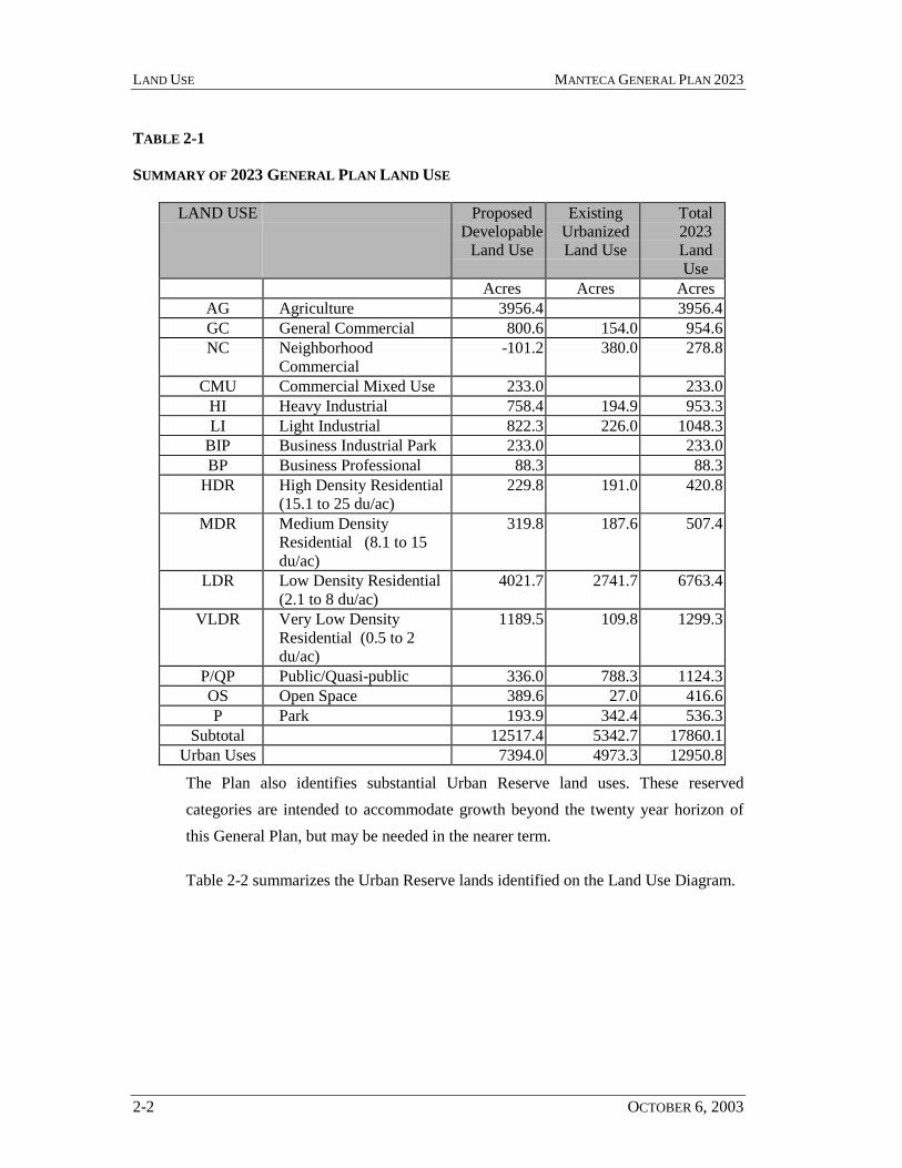
2.1 Summary of Proposed Land Use
Table 2-1 summarizes the proposed land use. The land use mix includes a diversemix of dwelling types and densities, as well as major new employment centers.
The General Plan land use is designed to achieve an adequate supply of land toaccommodate the projected population through the General Plan horizon, within theCity’s Growth Management ordinance.
The total land use proposed in the Plan will accommodate a population of 94,000 to144,000. The projected population is derived from the General Plan land use throughassumptions relating to residential density, the average density, the efficiency of theland use, vacancy factors, and a market reserve for each residential land use type. TheGeneral Plan Steering Committee reviewed and affirmed these assumptions for use inthe General Plan process.
LAND USE MANTECA GENERAL PLAN 2023
2-2 OCTOBER 6, 2003
TABLE 2-1
SUMMARY OF 2023 GENERAL PLAN LAND USE
LAND USE ProposedDevelopable
Land Use
ExistingUrbanizedLand Use
Total2023LandUse
Acres Acres AcresAG Agriculture 3956.4 3956.4GC General Commercial 800.6 154.0 954.6NC Neighborhood
Commercial-101.2 380.0 278.8
CMU Commercial Mixed Use 233.0 233.0HI Heavy Industrial 758.4 194.9 953.3LI Light Industrial 822.3 226.0 1048.3
BIP Business Industrial Park 233.0 233.0BP Business Professional 88.3 88.3
HDR High Density Residential(15.1 to 25 du/ac)
229.8 191.0 420.8
MDR Medium DensityResidential (8.1 to 15du/ac)
319.8 187.6 507.4
LDR Low Density Residential(2.1 to 8 du/ac)
4021.7 2741.7 6763.4
VLDR Very Low DensityResidential (0.5 to 2du/ac)
1189.5 109.8 1299.3
P/QP Public/Quasi-public 336.0 788.3 1124.3OS Open Space 389.6 27.0 416.6P Park 193.9 342.4 536.3
Subtotal 12517.4 5342.7 17860.1Urban Uses 7394.0 4973.3 12950.8
The Plan also identifies substantial Urban Reserve land uses. These reservedcategories are intended to accommodate growth beyond the twenty year horizon ofthis General Plan, but may be needed in the nearer term.
Table 2-2 summarizes the Urban Reserve lands identified on the Land Use Diagram.

MANTECA GENERAL PLAN 2023 LAND USE
OCTOBER 6, 2003 2-3
TABLE 2-2
SUMMARY OF URBAN RESERVE LAND USE
RESERVE LAND USE Total 2023Land Use
Acres
UR Urban Reserve 1758.0AG-UR Agriculture - Urban Reserve 1726.0UR-MDR Medium Density Residential – Urban Reserve 20.0UR-LDR Low Density Residential – Urban Reserve 1432.0UR-VLDR Very Low Density Residential – Urban Reserve 722.9UR-BIP Business Industrial Park – Urban Reserve 425.2UR-CMU Commercial Mixed Use - Urban Reserve 43.3UR-GC General Commercial – Urban Reserve 44.0UR-LI Light Industrial – Urban Reserve 115.0UR-P Park – Urban Reserve 80.0UR-P/QP Public/Quasi-Public – Urban Reserve 12.0County Approved LDR (included only for environmental analysis) 304.0County Approved GC (included only for environmental analysis) 59.0Subtotal 6741.4Urban Uses 2814.4
2.2 Land Use Categories
The Land Use Element establishes land use categories tailored to meet the specificneeds of the city. Economic development opportunities, housing needs andenvironmental characteristics are among the factors that determine the appropriateland use categories. The land use categories established in this General Plan shall beimplemented through the Manteca Municipal Code, Zoning Ordinance.
Very Low Density Residential (VLDR) (less than 2 dwelling units per gross acre)
The Very Low Density Residential land use category will provide for residences onlarger lots and small, quasi-agricultural activities, including raising and boardinglivestock. Residential units shall be permitted to deviate from standard lot dimensionswithin agricultural areas in order to cluster dwellings together and thereby allow for
LAND USE MANTECA GENERAL PLAN 2023
2-4 OCTOBER 6, 2003
continued agricultural use. The agricultural use areas that remain on the residentialparcel shall be subject to an easement dedicated to the City that allow continuedagricultural use, but prohibits any further non-agricultural related development.
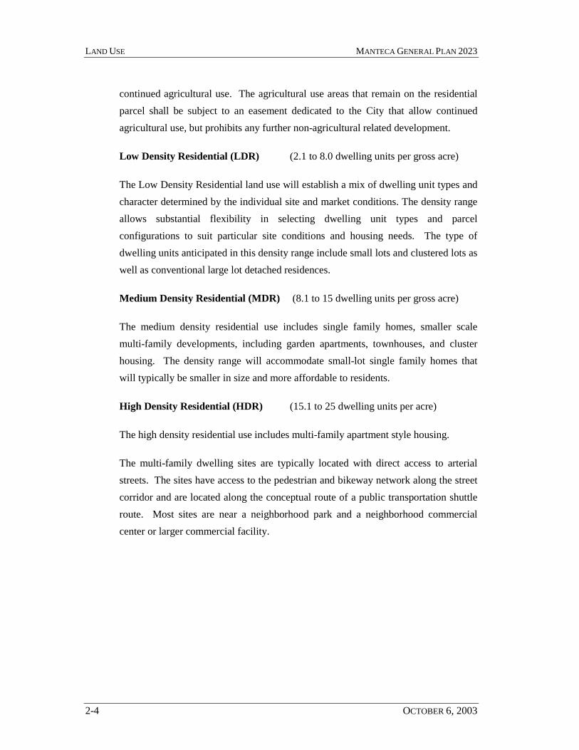
Low Density Residential (LDR) (2.1 to 8.0 dwelling units per gross acre)
The Low Density Residential land use will establish a mix of dwelling unit types andcharacter determined by the individual site and market conditions. The density rangeallows substantial flexibility in selecting dwelling unit types and parcelconfigurations to suit particular site conditions and housing needs. The type ofdwelling units anticipated in this density range include small lots and clustered lots aswell as conventional large lot detached residences.
Medium Density Residential (MDR) (8.1 to 15 dwelling units per gross acre)
The medium density residential use includes single family homes, smaller scalemulti-family developments, including garden apartments, townhouses, and clusterhousing. The density range will accommodate small-lot single family homes thatwill typically be smaller in size and more affordable to residents.
High Density Residential (HDR) (15.1 to 25 dwelling units per acre)
The high density residential use includes multi-family apartment style housing.
The multi-family dwelling sites are typically located with direct access to arterialstreets. The sites have access to the pedestrian and bikeway network along the streetcorridor and are located along the conceptual route of a public transportation shuttleroute. Most sites are near a neighborhood park and a neighborhood commercialcenter or larger commercial facility.

MANTECA GENERAL PLAN 2023 LAND USE
OCTOBER 6, 2003 2-5
2.2.1 Commercial Mixed Use (CMU) (15.1 to 25 dwelling units per acre)
Floor Area Ratio: 1.0
Maximum Site Coverage: 50%
The Commercial Mixed Use designation will accommodate a variety of purposesincluding high density residential, employment centers, retail commercial, andprofessional offices.
The mixed use concept would integrate a mix of compatible uses on a single site thatinclude sales, services and activities which residents may need on a daily basis. Withpedestrian access, these sites will enable residents to walk or bike for many localtrips, instead of driving for convenience trips.
The sites may be integrated vertically with mixed uses above one another, such asresidential or office uses over a commercial use. Sites may also be mixedhorizontally with the uses side-by-side, but linked together through commonwalkways, plazas and parking areas. In-fill sites in the existing urban area,particularly along the Main Street, Airport Way and Yosemite Avenue corridors maybe developed entirely as multi-family residential projects. Sites developed primarilyas residential may also include office and retail components. The CommercialMixed-Use designation may also be applied to smaller parcels within neighborhoods.These small parcels accommodate a variety of uses, but on a smaller, less intensescale that is compatible with the adjacent residential uses.
The residential component of any Commercial Mixed-Use development shall providedwellings at densities of 15.1 to 25 units per acre. The residential component shall beconsidered to be that portion of a site or plan area allocated exclusively to residentialuse, net of any commercial or office use.
Commercial Mixed Use developments in the new urbanizing areas of the city mayalso develop primarily as multi-family residential, but are also intended to provide acommercial and office component designed to serve the surrounding neighborhood.In new urbanizing areas it the mixed-use concept would accommodate approximately
LAND USE MANTECA GENERAL PLAN 2023
2-6 OCTOBER 6, 2003
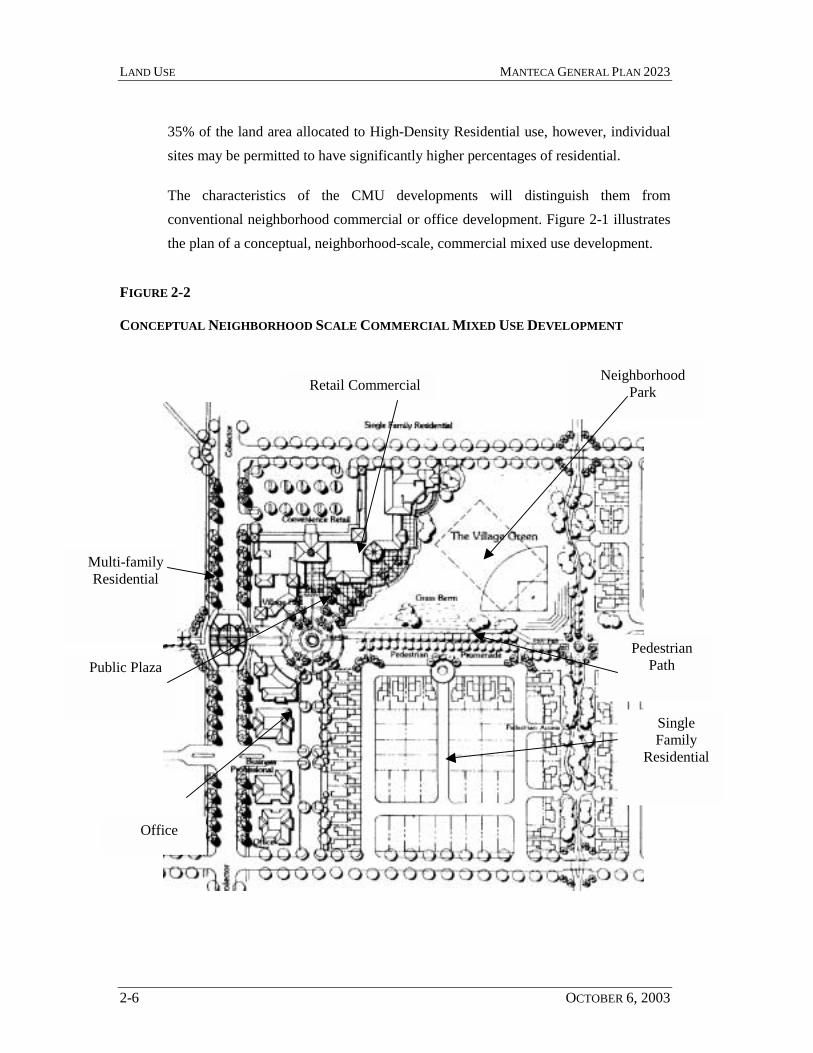
35% of the land area allocated to High-Density Residential use, however, individualsites may be permitted to have significantly higher percentages of residential.
The characteristics of the CMU developments will distinguish them fromconventional neighborhood commercial or office development. Figure 2-1 illustratesthe plan of a conceptual, neighborhood-scale, commercial mixed use development.
FIGURE 2-2
CONCEPTUAL NEIGHBORHOOD SCALE COMMERCIAL MIXED USE DEVELOPMENT
Retail CommercialNeighborhood
Park
Office
Multi-familyResidential
PedestrianPathPublic Plaza
SingleFamily
Residential
MANTECA GENERAL PLAN 2023 LAND USE
OCTOBER 6, 2003 2-7
• The CMU developments will be truly mixed use. There will be a strongrelationship between the different land uses so that pedestrian access isconvenient and there is a clear common design theme.
• The CMU developments will include space for community activities within thecenter or on an adjacent park. It is intended that the park and neighborhoodcommercial center together form a neighborhood gathering place for recreationand socializing much as does a small town square.
• Where required, detention facilities will be designed as an amenity within theCMU site landscaping, and may also provide recreation opportunities.
• CMU developments will include public facilities where feasible, such as a postoffice, library, fire station, or satellite government office.
• CMU developments may also include neighborhood work centers that providespace for private offices that use telecommunications services such thattelecommuters and other residents in the neighborhood may work near theirhomes.
• CMU developments will have a shared parking program with the objective ofreducing the parking required for each individual use.
Business Industrial Park (BIP)
Floor Area Ratio: 1.0
Maximum Site Coverage: 50%
The Business Industrial Park designation is intended to provide sites for large uses inan office park environment that would include multi-tenant buildings. Businessparks of this nature are well suited for research and development facilities and alsoprovide an attractive business environment for unrelated businesses. Typical usespermitted within the Business Industrial Park land use include:
• administrative and general office

LAND USE MANTECA GENERAL PLAN 2023
2-8 OCTOBER 6, 2003
• corporate or regional headquarters
• research and development facilities
• medical offices
• professional services such as attorneys, accountants andinsurance
• light industrial, including manufacturing and assembly
Warehouse, storage and distribution shall be for the purpose of supporting theindustrial uses and shall be limited to not more than 20% of the total land area in anyBusiness-Industrial Park use. Commercial storage facilities (mini-storage) that arecompatible with the landscape and building design standards for the business parkwill be permitted. All outdoor storage shall be screened so to not be visible from anypublic street or highway.
The business industrial park land use will also permit a limited amount of servicecommercial and retail activities provided for the convenience of the employeeswithin the area. The goal is to provide a mix of basic services in close proximity toemployees to reduce daily convenience trips. Typical service uses includerestaurants, banks, day care, and personal services, such as hair care and shoe repair,specialty retail, and similar uses. Such uses may not account for more than tenpercent (10%) of the total gross floor area allowed for the individual parcels.Convenience services within the business-professional land use should be distributedwithin the area to be easily accessible by employees. These uses should generally belocated within the building complexes and not as freestanding structures.
The Business Industrial Park uses shall incorporate the following characteristics.
• Common recreation/open space, landscaping, dining and meeting areas areamenity features that are desirable within all business-park developments.
• Required detention facilities shall be incorporated in the site landscaping as avisual amenity.

MANTECA GENERAL PLAN 2023 LAND USE
OCTOBER 6, 2003 2-9
• A common area lighting, landscaping and signage theme shall be adopted andapplied throughout the business park.
• Pedestrian paths shall be provided on site and connecting between sites withinthe business park.
Business Professional (BP)
Floor Area Ratio: 1.5
Maximum Site Coverage: 50%
The Business Professional land use is intended primarily for office and related uses ina landscaped site. The use category is specifically intended for the frontage along SR120, and along other major roads and in the Central Business District to provide anattractive, landscaped setting for one, two and three story office buildings.
This designation provides for professional and administrative offices, medical anddental clinics, laboratories, financial institutions, public and quasi-public uses, andsimilar and compatible uses.
Neighborhood Commercial (NC)
Floor Area Ratio: 2.0 in the CBD and .6 outside the CBD
This designation provides for locally oriented retail and service uses, offices,restaurants, and service stations, public and quasi-public uses and similar andcompatible uses. The mix of uses anticipated in these centers includessupermarket/drug store configuration including associated smaller retail stores andservices. Pad sites will provide restaurant and service station opportunities.
General Commercial (GC)
Floor Area Ratio: .6
Maximum Site Coverage: 40%
The General Commercial category provides for wholesale, warehousing, and heavycommercial uses, highway oriented commercial retail, public and quasi-public uses,

LAND USE MANTECA GENERAL PLAN 2023
2-10 OCTOBER 6, 2003
and similar and compatible uses. The designation is also intended to accommodatevisitor commercial, lodging, commercial recreation and public gathering facilities,such as amphitheaters, or public gardens.
Light Industrial (LI)
Floor Area Ratio: .7
Maximum Site Coverage: 60%
The Light Industrial designation provides for industrial parks, warehouses,distribution centers, light manufacturing, public and quasi-public uses and similarand compatible uses.
Heavy Industrial (HI)
Floor Area Ratio: .5
Maximum Site Coverage: 40%
This designation provides for manufacturing, processing, assembling, research,wholesale, and storage uses, trucking terminals, railroad and freight stations, andsimilar activities that require separation from residential uses due to noise, vibrationor other characteristics incompatible with residential use.
Agriculture (AG)
This designation provides for agricultural uses (such as vineyards, orchards, and rowcrops), single family homes directly related to the agricultural use of the property,limited industrial uses directly related to agriculture, and similar and compatible uses.
Open Space (OS)
The Open Space category encompasses habitat, open space, natural areas, lands ofspecial status species, wetlands and riparian areas. These areas are set aside aspermanent open space preserves to protect environmentally sensitive areas.
Park (P)
MANTECA GENERAL PLAN 2023 LAND USE
OCTOBER 6, 2003 2-11
This designation provides for neighborhood, community and regional parks, golfcourses, and other outdoor recreational facilities within urban development. Specificuses include public recreation sites, including ball fields, tot lots and play apparatus,adult softball and soccer playing fields, swimming pools, community centerbuildings, meeting facilities, libraries, art centers, after school care facilities, art inpublic places, facilities for night-time recreation, trails benches, interpretive markers,picnic areas, barbecue facilities, landscaping, irrigation, city wells, trees and naturalhabitat areas.
Public/Quasi-Public (P/QP)
This designation provides for government owned facilities, public and privateschools, institutions, civic uses and public utilities, and quasi-public uses such ashospitals and churches.
Urban Reserve
Urban Reserve is applied to many properties around the perimeter of the City. Inmost instances the Urban Reserve category overlies another land use category. Inthese instances the underlying land use is the intended use when the land is ultimatelyannexed to the City. Urban Reserve with no underlying land use indicates that theCity intends to expand in the time horizon beyond the current General Plan and that itis premature to indicate a specific future land use in this area. Urban Reserve isshown on the Land Use Map to the north and east of the proposed growth areas.
2.3 Land Use Goals and Policies
Goal LU-1. To provide for orderly, well-planned, and balanced growth consistentwith the limits imposed by the city’s infrastructure and the city’sability to assimilate new development.
2.3.1 Policies:
LU-P-1: Growth shall mitigate its own impacts and shall provide a positivebenefit to the City of Manteca.

LAND USE MANTECA GENERAL PLAN 2023
2-12 OCTOBER 6, 2003
LU-P-2: Growth must contribute to a strong diversified economic base and aneffective balance between employment and housing opportunities forall income levels.
LU-P-3: The City shall encourage a pattern of development that promotes theefficient and timely development of public services and facilities.
LU-P-4: The City shall encourage a development pattern that is contiguouswith the boundary of the City.
LU-P-5: The City shall establish and maintain a Primary Urban ServiceBoundary line designating lands eligible for annexation and urbandevelopment prior to the year 2013 (see Figure 2-3).
LU-P-6: The City shall establish and maintain a Secondary Urban ServiceBoundary line designating lands eligible for annexation and urbandevelopment beyond the year 2013 (see Figure 2-3). Lands outsidethe Primary Urban Service Boundary line, but within the SecondaryUrban Service Boundary line, shall not be annexed to the City ofManteca prior to their inclusion within the Primary Urban ServiceBoundary line. Prior to 2013, the Primary Urban Service Boundaryline may be amended through adoption of a specific plan, an areaplan, or comparable planning process, or an amendment to theGeneral Plan.
LU-P-7: All lands within the Primary and Secondary Urban Service Boundarylines to be ultimately developed to urban standards should bedeveloped under the jurisdiction of the City of Manteca. Pendingannexation to the City, all such lands should remain in agricultural,open space, or other low intensity uses. The City shall workcooperatively with the County to ensure that development approvedby the County on unincorporated lands within the Primary andSecondary Urban Service Boundary lines is developed according tostandards consistent with those of the City of Manteca. The Cityshall request all proposals for development on unincorporated landswithin the Primary and Secondary Urban Service boundary lines be
MANTECA GENERAL PLAN 2023 LAND USE
OCTOBER 6, 2003 2-13
referred to the City for review and comment prior to formalconsideration by the County.
LU-P-8: The City will review proposals for residential, commercial orindustrial development in unincorporated areas within the GeneralPlan Study Area. Urban development should occur within the Cityboundary.

I-5
SR 99
SR 120
Airp
ort W
ay
Unio
n Roa
d
W. Ripon
Ma
in S
treet
Louise Avenue
Tin
nin
Yosemite Avenue
Woodward Avenue
Lathrop Road
Olive
Graves
Austin
Ro
ad
Southland
McK
inle
y A
venu
eC
ottage
French Camp Road
Roth Road
Sedan Avenue
Lovelace
Moffat Road
Spr
eck
els
Roa
d
Atherton Avenue
Austin
Ro
ad
Moffat Road
Cotta
ge
Atherton Avenue
Lathrop Road
Olive
Austin
Ro
ad
French Camp Road
Manteca General Plan
LEGEND
Study Area Boundary
Prime Farmlands
mjrroads
primsrvc
October 2003
WADE ASSOCIATESurban planning & designenvironmental planning
FIGURE 2-2
PRIMARY URBAN SERVICE BOUNDARY

MANTECA GENERAL PLAN 2023 LAND USE
OCTOBER 6, 2003 2-15
LU-P-9: The City will consider applications for annexations that:
• are contiguous with city boundaries and provide for a logicalexpansion of the city;
• create clear and reasonable boundaries;
• ensure the provision of adequate municipal services;
• reflect a long-term fiscal balance to the city and its residents,when reviewed cumulatively with other annexations;
• are consistent with State law and San Joaquin County LocalAgency Formation Commission standards; and
• are consistent with the General Plan.
LU-P-10: The City will consider expanding its sphere of influence toincorporate areas that logically should be planned and serviced byManteca. The City shall consider the following factors when makingdeterminations involving sphere of influence boundaries:
• Present and planned land uses in the area;
• Present and probable need for public facilities and services in thearea;
• Present capacity of public facilities and adequacy of publicservices; and
• Existence of any social or economic communities of interest inthe area.
LU-P-11: The City shall manage the rate and type of growth in Mantecaaccording to a growth management program that provides for anannual allocation of residential, commercial and industrialdevelopment. The growth management program shall consider thecapacities of City facilities and services, and the ability of the
LAND USE MANTECA GENERAL PLAN 2023
2-16 OCTOBER 6, 2003
community to assimilate new development, and fluctuations in thebalance of market demand for new housing and new jobdevelopment.
LU-P-12: The City will encourage the use of specific plans as needed to ensureorderly, well-planned growth.
LU-P-13: The City may designate areas on the Land Use Map as UrbanReserve. Such areas are not planned for development prior to 2023,but are recognized by the City as areas of future growth that may beannexed to the City at the appropriate time.
Goal LU-2. To provide adequate land in a range of densities to meet the housingneeds of all income groups expected to reside in Manteca, and toregulate residential growth consistent with the capacities of Cityfacilities and services and the ability of the community to assimilatenew development.
2.3.2 Policies:
LU-P-14: The City shall promote the development of a variety of housing typesand prices to meet the needs of all households, including very low-,low-, and moderate-income households.
LU-P-15: Higher density housing shall be located in areas served by the fullrange of urban services, preferably along collector and arterialstreets, and within walking distance of shopping areas.
LU-P-16: The City shall promote the preservation and integrity of existingstable residential neighborhoods.
LU-P-17: The City shall encourage neighborhood revitalization andimprovement including replacement, renovation or conversion toalternative use of buildings in serious disrepair.
LU-P-18: The City shall seek funding to undertake neighborhood improvementprograms designed to stabilize and enhance the quality of existing

MANTECA GENERAL PLAN 2023 LAND USE
OCTOBER 6, 2003 2-17
neighborhoods. Such improvements may include, but are not limitedto sidewalk upgrade and repair, street tree programs, street lighting,signage, trash collectors, bus stop shelters and benches and similarimprovements to the public areas.
Goal LU-3. Provide adequate land for the development of commercial uses thatprovide goods and services to Manteca residents and Manteca’smarket area.
2.3.3 Policies:
LU-P-19: The City shall promote and assist the maintenance and expansion ofManteca’s commercial sector to meet the needs of both Mantecaresidents and those living within Manteca’s market area.
LU-P-20: The City shall promote the establishment, maintenance andexpansion of businesses in Manteca that generate high retail salestaxes as important contributors to the local economy.
LU-P-21: The City shall promote the downtown as a significant pedestrian-oriented, commercial and financial center of Manteca and as theprimary civic and cultural center.
LU-P-22: New commercial development serving citywide and regionalshopping needs shall be located along major arterial streets.
LU-P-23: New visitor-serving commercial development shall be located inareas with easy access to freeway interchanges.
LU-P-24: New commercial development shall be designed to avoid theappearance of strip development.
LU-P-25: The City and Redevelopment Agency will continue to support thedowntown merchants in the improvement of facades, promotion ofdowntown and the solution of problems specific to downtown.

LAND USE MANTECA GENERAL PLAN 2023
2-18 OCTOBER 6, 2003
LU-P-26: Redevelopment incentives shall be used judiciously to promote andassist commercial development and revitalization in approvedProject Areas and in areas benefiting the approved Project Areas.
LU-P-27: The City shall monitor commercial development to balance growthin residential, commercial and industrial development.
LU-P-28: The City shall monitor revenues relative to new growth to ensure thatprojected cumulative revenue of all land uses in the City would besufficient to support public service costs.
LU-P-29: The City shall support and encourage small business developmentand retention through providing appropriately zoned land andthrough such programs to reduce development and operations costsas may be available to the City.
Goal LU-4. Provide for land uses that expand employment, education, recreationand cultural opportunities for residents and enhance Manteca as thecommercial and service center for southern San Joaquin County.
2.3.4 Policies:
LU-P-30: The City shall promote, cooperate in, and assist in the maintenanceand expansion of Manteca’s industrial sector employmentdevelopment within the City of Manteca and in the south SanJoaquin County area that will help reduce the home-to-workcommute distance for Manteca residents.
LU-P-31: New employment centers that may include office, business-professional, research and development, and light industrial orindustrial development and shall be located in areas served by fullCity services or served by suitable facilities approved by the City.Employment centers should be located along major arterials witheasy freeway access and with access from public transit, andaccessible to bicyclists and pedestrians.

MANTECA GENERAL PLAN 2023 LAND USE
OCTOBER 6, 2003 2-19
LU-P-32: The City shall continue to support full development of its existingindustrial park.
LU-P-33: The City shall promote the development of “clean” industries that donot create problems or pose health risks associated with water and airpollution or potential leaks or spills. However, the City willdesignate appropriate locations that accommodate light industrial andheavy industrial uses.
LU-P-34: Redevelopment incentives shall be used judiciously to promoteindustrial employment development in approved Project Areas andfor projects benefiting approved Project Areas.
LU-P-35: The City shall monitor employment development to maintain thebalance of residential, commercial, and industrial development.
LU-P-36: The City shall promote and plan for at least one PrimaryEmployment Center to accommodate a variety of employmentopportunities compatible with the employment skills of the Mantecaresident labor force.
Goal LU-5. To provide adequate land for development of public and quasi-publicuses to support existing and new residential, commercial, andindustrial land uses.
2.3.5 Policies:
LU-P-37: The City shall designate adequate land, appropriately located forCity, County, and School District facilities.
LU-P-38: The City shall designate adequate land, appropriately located forquasi-public uses such as hospitals, churches, private school facilitiesand utility uses.
LU-P-39: In determining appropriate locations for public and quasi-publicuses, the City shall consider, among other things, proximity to major
LAND USE MANTECA GENERAL PLAN 2023
2-20 OCTOBER 6, 2003
streets, the cost to develop access to public facilities, and the safetyof pedestrians and motorists.
LU-P-40: Development shall be managed to ensure that adequate publicfacilities and services, as defined in the Public Services and FacilitiesElement, are planned and provided.
Goal LU-6. Provide open space as a framework for the city, and meet the activeand passive recreational needs of the community.
2.3.6 Policies:
LU-P-41: The City shall encourage the continuation of agricultural uses onlands within the Primary and Secondary Urban Services Boundarylines pending their development as urban uses consistent with theGeneral Plan.
LU-P-42: The City will encourage the continuation of small, specialtyagricultural operations and demonstration or educational agriculturaloperations that are compatible with the adjacent urban uses.
LU-P-43: The City shall promote the provision of both public and private openspace within urbanized Manteca to provide visual contrast with thebuilt-environment and to provide for the recreational needs ofManteca residents. Private open space shall not be considered forpublic use, other than as visual open space, and shall not beconstrained from other uses as identified in the General Plan, unlessas provided for by agreement with the land owner.
LU-P-44: The City shall develop an Open Space Master Plan that is consistentwith the General Plan, the Bicycle Master Plan and RecreationMaster Plan. The Open Space Master Plan should address thepotential linkages between public plazas, promenades, parks, utilityeasements suitable for public access, landscape areas, naturepreserves, open drainages, parks and similar public lands and right-of-ways that provide open space. The Open Space Master Plan may

MANTECA GENERAL PLAN 2023 LAND USE
OCTOBER 6, 2003 2-21
also identify future extensions of pedestrian and bikeway corridors,natural features, and nature preserve areas that may be suitable foracquisition by the City as public land or other agency to be held aspublic land in or in a public trust.
LU-P-45: The City shall encourage commercial recreation uses at the OakwoodLake Resort, and on other appropriate lands within the City.
Goal LU-7. Reinforce land use and development patterns that encourage walkingand the use of public transit within the community.
2.3.7 Policies:
LU-P-46: The City shall allow for higher density housing opportunities alongmajor streets so as to provide residents with access to the publictransit system.
LU-P-47: The City shall develop and apply standards for pedestrian circulationthat enable residents to select a reasonably direct and safe pedestrianroute to schools, parks, transit stops and commercial services.
LU-P-48: Storm drainage systems within new development areas shouldinclude open drainage corridors, where feasible, that would providebike and pedestrian paths, and visual open space withinneighborhoods. The pedestrian connection should link parks andopen space to residential neighborhoods.
Goal LU-8. To reinforce strong urban design, quality development and acompact city form.
2.3.8 Policies:
LU-P-49: The City shall give priority to in-fill development and newdevelopment contiguous to existing developed areas, wheneverpractical.
LAND USE MANTECA GENERAL PLAN 2023
2-22 OCTOBER 6, 2003
LU-P-50: The City shall encourage and direct growth that supports thedowntown as the geographic, civic, cultural, and economic center ofManteca.
LU-P-51: New residential land uses (developments with no less than 5 units)within the Stockton Metro Airport Area of Influence must have anavigation easement recorded in favor of the airport. The Deed ofAvigation and Hazard Easement must be filed with the CountyRecorder prior to development construction.
• Occupied structures must be soundproofed to reduce interiornoise to 45 dB.
• Reflective materials are not permitted to be used in structures orsigns to avoid distracting pilots.
• All proposed acquisitions of property within a 2 mile radius ofan airport runway for the purpose of constructing a schoolrequires a review and approval by the State Department ofTransportation, Division of Aeronautics.
• No transmission which would interfere with aircraftcommunications or navigation are permitted. Power lines mustbe under grounded if necessary to prevent hazard to aircraft.
LU-P-52: The City of Manteca shall refer all applications for developmentwithin the Stockton Metro Airport Area of Influence to the AirportLand Use Commission, and the Stockton Metro Airport.
LU-P-53: The City of Manteca shall cooperate with City of Ripon inimplementing the principle points of the Memorandum ofUnderstanding regarding future land use and public services andfacilities in the area between the two cities.
LU-P-54: The City of Manteca shall cooperate with City of Ripon inidentifying a suitable location for an interchange at Highway 99connecting to major roads in Ripon and Manteca.
MANTECA GENERAL PLAN 2023 LAND USE
OCTOBER 6, 2003 2-23
2.3.9 Implementation :
LU-I-1. The City shall maintain a growth management system that provides amechanism for the annual allocation of the amount of residential,commercial, and industrial development that may occur. The growthmanagement system shall have the following objectives:
• Maintain, and where necessary enhance, the community’scurrent public services and facilities;
• Protect against the construction of development projectswhich will require sewage treatment capacity in excess ofthat determined available by the City Council;
• Preserve and protect the environment;
• Preserve and protect the quality of life and character of thecommunity.
• Provide for the orderly and adequate expansion of the City’shousing stock in order to advance housing opportunities andto accommodate a reasonable share of expected regionalgrowth.
• Provide for the adequate and orderly expansion of the City’scommercial and employment development base in balancewith the city’s housing stock;
• Provide for a balance between multi-family and singlefamily residential development;
• Conserve viable agricultural and open space lands; and
• Encourage and facilitate development proposals thataccomplish the goals, policies, and programs of the GeneralPlan through development innovations that cannot beaccomplished by conventional zoning.

LAND USE MANTECA GENERAL PLAN 2023
2-24 OCTOBER 6, 2003
LU-I-2. The growth management system shall consist of the followingfeatures:
• Establishment of the maximum number and types ofresidential dwelling units and the acres or square feet ofcommercial, industrial, and public facility projects that maybe approved for a subsequent period, as determined by theCity Council based on the following considerations:
i. The goals, policies, and programs of the General Planincluding the Housing Element goals, objectives, andprograms for affordable housing, housing mix, andjobs/housing balance.
ii. The number of projects previously approved but notdeveloped, including exempt projects.
iii. The general availability of existing and projectedpublic utilities, facilities, and services. The City shallestablish and maintain a geographic informationsystem (GIS) that is common to all departments toprovide a base for data collection and managementrelative to city growth and provision of public servicesand infrastructure maintenance and expansion.
iv. The specific availability of sewage capacity.
v. The development review report to be drafted by theStaff and/or Growth Management Committee in orderto assist the City Council in their growth managementdeterminations.
The City Manager shall address the status of publicservices in the annual budget report. This reportshould document growth trends the capacity and levelof service for public services and facility planningefforts.
MANTECA GENERAL PLAN 2023 LAND USE
OCTOBER 6, 2003 2-25
The City Manager shall address land use in the annualbudget report. This report will document the growthin residential and commercial development andestimate the increase in employment in the City overthe previous year.
The land use summary shall include a reference to therange of land use projected for future needs in theLand Use Element and determine the then current andfive-year projection of land use in the City.
vi. Comments received at public hearings held inconjunction with the annual growth determinations. Ina public hearing process, the City shall establishguidelines and procedures for periodic monitoring andevaluation of the growth in the City budget, thenumber of dwelling units, growth in sales tax revenueand other factors that affect the fiscal stability andhealth of the City. The intent is to maintain balanceover time, rather than on a project-by-project basis.
• Exemptions of certain small residential projects and specificplans, vested subdivision maps, income-restricted residentialdevelopments, and other projects subject to a developmentagreement that are exempt from the annual allocations.
• A competitive rating system for evaluating and approvingdevelopments. Such rating system shall at a minimuminclude the following general categories of criteria:
i. Availability of or contribution toward public utilities,facilities, and services.
ii. Location factors (in-fill/redevelopment area).
iii. Response to housing needs specified in the HousingElement.
LAND USE MANTECA GENERAL PLAN 2023
2-26 OCTOBER 6, 2003
iv. Environmental impacts.
v. Traffic impacts.
vi. Employment impacts.
vii. Contribution to tax base.
viii. Other community benefits.
LU-I-3. The City shall monitor implementation of the growth managementsystem and new commercial and industrial development so thatGeneral Plan objectives for a balanced community are achieved.
LU-I-4. The City shall request the San Joaquin County LAFCo to adopt asphere of influence for Manteca based on the long-term growth plansof the City as reflected in the General Plan goals and policies andproposed land use.
LU-I-5. The City shall review and revise, as necessary, the Zoning Ordinanceto accomplish the following purposes:
• Ensure consistency with the General Plan in terms of zoningdistricts and development standards;
• Ensure consistency with the General Plan in terms of thedistribution and boundaries of zoning districts;
• Establish a Central Business District Zoning District;
• Provide for density bonuses for projects that reserve units forlow- and/or moderate-income households.
• Provide for a mixed-use zone that permits residential,commercial, office, business-professional and commercialrecreation subject to a use permit.
MANTECA GENERAL PLAN 2023 LAND USE
OCTOBER 6, 2003 2-27
• Provide for an accelerated project review and entitlement processfor commercial, office, business-professional, research anddevelopment, industrial and light industrial uses.
LU-I-6. The City shall maintain a Main Street program to promote economicdevelopment in the downtown area.
LU-I-7. The City will continue to cooperate with planning efforts amonglocal jurisdictions to minimize the impacts of growth to Manteca andin the south San Joaquin County area.
LAND USE MANTECA GENERAL PLAN 2023
2-28 OCTOBER 6, 2003
THIS PAGE INTENTIONALLY LEFT BLANK.
OCTOBER 6, 2003 3-1
3 COMMUNITY DESIGN ELEMENT
The Community Design Element addresses the community form and quality of thebuilt environment.
The City of Manteca has developed in a compact urban form around the historicdowntown centered on the intersection of Yosemite Avenue and Main Street.Residential development in the past few decades has occurred in relatively compactneighborhoods defined by the established grid of major streets at one-mile intervals.Growth has occurred in a predominately northwest direction away from downtown andhas diminished the downtown as the geographical center.
3.1 Compact Community Form
Goal CD-1. Retain the compact and cohesive community form of the City.
Policies:
CD-P-1: Retain the existing central city core as the geographical center of theCity.
CD-P-2: Provide institutional and leisure activity uses in the downtown core toattract residents and visitors.
CD-P-3: Retain a diversity of small businesses in the downtown core.
CD-P-4: Provide adequate parking and circulation within the downtown corearea.
CD-P-5: Provide a public transportation hub in the central area.
CD-P-6: Provide public spaces such as small parks and plazas, including asingle plaza or City park that is recognized as the City center.
CD-P-7: The City shall implement neighborhood design standards in theResidential districts that contribute to the overall character of the

COMMUNITY DESIGN MANTECA GENERAL PLAN 2023
3-2 OCTOBER 6, 2003
neighborhood by emphasizing traditional residential features thatenhance the sense of community, ensure a safe pedestrian orientation,and minimize the visual prominence of garages.
Implementation:
CD-I-1. The City shall implement an urban design plan for the CentralBusiness District (CBD). The plan should be designed to achieve thefollowing objectives:
• Assess the urban design implications of each use of the vacantparcels in the CBD and establish an overall urban design strategy;
• Establish an overall parking strategy for the CBD in order toprovide a more unified and aesthetically desirable complex ofparking lots, including an overall strategy for landscaping andscreening such areas;
• Establish design standards and design review procedures forcontrolling height, bulk, and design of buildings, and for signs inthe CBD;
• Establish a coordinated and unified street tree program for theCBD;
• Establish guidelines for street furniture in the CBD, such asbenches, trash containers, street lights, and street signs. Determinestrategies for enhancing the recently installedtrellis/street/sign/bench structures;
• Assess the potential for developing public and private open spacesin the CBD, particularly with an eye toward tempering the hotsummer microclimate with aesthetically pleasing, shaded exteriorspaces;

MANTECA GENERAL PLAN 2023 COMMUNITY DESIGN
OCTOBER 6, 2003 3-3
• Explore the potential for creating a landmark (e.g., sculpture, townclock, and fountain) at the intersection of Main Street andYosemite Avenue.
CD-I-2. Approve development projects within new growth areas that supportthe downtown area as the geographical center of the city.
CD-I-3. Approve and apply neighborhood design standards.
3.2 City Identity
Goal CD-2. Maintain a memorable City identity characterized by distinctive,high quality buildings and streetscapes.
Goal CD-3. Establish distinct, attractive identities for neighborhoods, gatewaysand commercial areas.
Goal CD-4. Promote the upgrading and aesthetic improvement of thedowntown.
Goal CD-5. Strengthen the aesthetic and functional links between the CentralBusiness District (CBD) and the Civic Center.
Goal CD-6. Promote the aesthetic development of Main Street and YosemiteAvenue.
Goal CD-7. Develop attractive and memorable entries to Manteca.
Goal CD-8. Upgrade and enhance the visual quality of Manteca’s arterial andcollector streets.
Policies:
CD-P-8: The CBD should be visually linked to adjacent parks and open spacesthrough the use of street trees, groundcover in parking strips, andsidewalk treatment. The CBD should be visually linked to the CivicCenter area through street trees, groundcover in parking strips,sidewalk treatment, and street lights along both Yosemite Avenue andCenter Street. The City shall develop design standards for the area
COMMUNITY DESIGN MANTECA GENERAL PLAN 2023
3-4 OCTOBER 6, 2003
bounded by Yosemite, Center, Union, and Main to strengthening therelationship between the CBD and the Civic Center. The emphasis inthese design standards should be on providing/maintaining unifyingelements and preserving the built landscape character of the area.
CD-P-9: The City shall develop a set of design standards for Yosemite Avenueand Main Street as a means of visually upgrading the commercialdevelopment along these streets. Such standards shall includeprovisions for setbacks, signs, landscaping, and parking.
CD-P-10: Establish City gateway features at intersections where gatewayfeatures can be established, such as Lathrop Road/SR 99, AustinRoad/SR 99, Main Street/SR 120, Union Road/SR 120, McKinleyRoad/SR 120, Airport Way/SR 120, and Yosemite Avenue/SR 99.
CD-P-11: Establish a landscape program and design standards that will providean attractive view of Manteca along SR 99 and SR 120. This wouldinclude trees, shrubs, wildflowers, and other landscape appropriate tothe Manteca climate along the highway right-of-way and within theinterchanges.
CD-P-12: Limit uses that require soundwalls adjacent to the highways.
CD-P-13: Allow recreation uses adjacent to the highways, where practical, thatare attractive and provide a high level of day and evening activity.
CD-P-14: Establish design guidelines for non-residential uses within 200 feet ofSR 99 and SR 120. The guidelines should address the followingconcepts.
• New office and commercial land use shall provide attractivelandscaping, lighting, and signage adjacent to all buildingsoriented to SR 99 or SR 120.

MANTECA GENERAL PLAN 2023 COMMUNITY DESIGN
OCTOBER 6, 2003 3-5
• Encourage buildings that include attractive focal elements, such asa tower or articulated roofline in each non-residential developmentadjacent to SR 99 or SR 120 to serve as visual landmarks.
• New non-residential buildings oriented to SR 99 or SR 120 shallprovide an attractive facade similar in articulation, and using thesame materials and colors, as the primary facade of the building.
• Truck loading and refuse collection areas adjacent to SR 99 andSR 120 shall be screened from view.
• The landscape along SR 120 and SR 99 will reflect the naturalcharacter of the region in the selection of trees and groundcover.
CD-P-15: Major arterial streets shall include a common landscape theme thatincludes primary street trees, groundcover, sidewalks, bus shelterswhere required, and lighting applied throughout the City.
CD-P-16: The City shall develop special design standards for the perimeter roadsystem comprising Lathrop Road, Austin Road, Woodward Avenue,and Airport Way to ensure their development as divided roadways.
CD-P-17: Opportunities for public art should be incorporated in the publicwalkways and parking areas.
CD-P-18: The City shall encourage the use of murals and similar public art onbuildings.
CD-P-19: The City will identify a program of local improvements such as streettree planting, annual clean-up days, sidewalk installation and repair,and similar local activities to enhance the visual quality of the city.
CD-P-20: The City will establish an inventory of dilapidated properties ascandidates for restoration or removal and establish an on-goingprogram of community participation in fix-up and clean-up ofdilapidated properties.

COMMUNITY DESIGN MANTECA GENERAL PLAN 2023
3-6 OCTOBER 6, 2003
CD-P-21: Provide parks and schools as distinct centers for neighborhoods.
CD-P-22: Provide features that distinguish one neighborhood from another, suchas natural features, entry gateways, street lighting, or signage.
CD-P-23: Provide pedestrian systems that connect the center of adjacentneighborhoods.
CD-P-24: The City shall ensure through design guidelines that the wallssurrounding residential area neighborhoods are attractive and welldesigned.
CD-P-25: The City shall encourage mixed land uses but provide physicalseparation or design buffers between incompatible land uses.
CD-P-26: Residential neighborhoods shall be designed to provide access fromthe neighborhood streets to these open space corridors.
CD-P-27: The City shall encourage designs for new construction and renovationin in-fill neighborhoods that are compatible with the adjacent buildingsand the existing residential scale and character of the neighborhood.
CD-P-28: The City shall establish residential design guidelines and standards.
CD-P-29: The City shall establish a street tree program for residentialneighborhoods.
CD-P-30: Neighborhoods in new growth areas shall incorporate the followingcharacteristics:
• The edges of the neighborhood shall be identifiable by use oflandscaped areas along major streets or natural features, such aspermanent open space. Primary arterial streets may be used todefine the boundaries of neighborhoods. The street system shallbe designed to discourage high volume and high speed trafficthrough the neighborhood.
MANTECA GENERAL PLAN 2023 COMMUNITY DESIGN
OCTOBER 6, 2003 3-7
• Neighborhoods shall be not more than one mile in length orwidth.
• Each neighborhood shall include a distinct center, such as anelementary school, neighborhood park(s), and/or a mixed-usecommercial area within a reasonable walking distance of thehomes, approximately one-half mile.
• Each neighborhood shall include an extensive pedestrian andbikeway system comprised of sidewalks and bike lanes alongstreets and dedicated trails.
CD-P-31: The pedestrian and bikeway system shall be linked to other pedestrianand bikeways in adjacent neighborhoods and, ultimately, to the City-wide Pedestrian and Bikeway Trail System to provide a continuousinterconnected system.
Implementation:
CD-I-4. Work with Caltrans to include gateway features in the future design ofthe designated arterial street and highway interchanges.
CD-I-5. Work with Caltrans to include landscape improvements andmaintenance utilizing recycled wastewater within the highway right-of-way and highway interchanges.
CD-I-6. Adopt design guidelines for non-residential uses.
CD-I-7. Amend the zoning ordinance as appropriate to allow for murals andsimilar public art on buildings.
CD-I-8. The City should attempt to negotiate an easement along a section ofthe railroad right-of-way- between South Main Street and North Streetand upgrade the area by planting into lawn.
CD-I-9. The City should provide landscaping to screen views of the electricalsubstation (located at the intersection of North Street and Elm Avenue)from Center Street.

COMMUNITY DESIGN MANTECA GENERAL PLAN 2023
3-8 OCTOBER 6, 2003
3.3 Resource Efficient Buildings
Goal CD-9. Establish a durable sustainable community that utilizes resourcesefficiently.
Policies:
CD-P-32: New buildings shall be designed to be responsive to the local climatein a manner that provides shelter from sun and rain for pedestrians.
CD-P-33: Passive solar design features are encouraged whenever possible.Design of buildings should consider energy-efficient concepts such asnatural heating and/or cooling, sun and wind exposure and orientation,and other solar energy opportunities.
CD-P-34: Solar collectors, if used, shall be oriented away from public view ordesigned as an integral element of the roof structure.
CD-P-35: Architectural elements that contribute to a building’s character, aid inclimate control, and enhance pedestrian scale are encouraged.Examples include canopies, roof overhangs, projections or recessionsof stories, balconies, reveals, and awnings.
CD-P-36: Encourage the creation of an urban forest comprised of street trees,residential lot trees, and trees in non-residential parking lots and otherpublic open space.
3.4 Pedestrians and Bicycles
Goal CD-10. Establish a pedestrian and bicycle friendly environment inneighborhoods and commercial and office land use areas.
Policies:
CD-P-37: Commercial centers should provide for convenient, attractivepedestrian access from street fronts and from adjacent commercial,office, and residential land uses.

MANTECA GENERAL PLAN 2023 COMMUNITY DESIGN
OCTOBER 6, 2003 3-9
CD-P-38: Commercial centers should provide for convenient, attractivepedestrian access within the center with dedicated pedestrian waysbetween all buildings and pedestrian spaces such as plazas, courtyards,and terraces at natural gathering areas within the site.
CD-P-39: Integrating the pedestrian elements (walkways, plazas, and terraces)with the buildings will enhance the pedestrian experience. Thepedestrian relationship to buildings should be comfortable, convenient,and protected from extremes of sun and wind.
CD-P-40: Outdoor plazas or other common areas that provide space for speciallandscaping, public art, food service, outdoor retail sales, or seatingareas for patrons are encouraged in retail settings appropriate to suchpedestrian activity. The plaza or other common area shall beappropriately scaled to the retail use and shall be directly connected tothe primary walkway.
CD-P-41: Buildings adjoining public spaces, including pedestrian ways shall bedesigned to allow the sun to reach sidewalks and plazas in the winter.
CD-P-42: Building configurations that provide “outdoor rooms,” courtyards,paseos, and promenades are encouraged.
CD-P-43: Where practical, and in compliance with ADA standards, commonareas that provide seating should be separated from the primarywalkway by informal barriers, such as planters, bollards, fountains,low fences and/or changes in elevation.
3.5 Agricultural Heritage
Goal CD-11. To the extent possible, new development shall retain orincorporate visual reminders of the agricultural heritage of thecommunity.
COMMUNITY DESIGN MANTECA GENERAL PLAN 2023
3-10 OCTOBER 6, 2003
Policies:
CD-P-44: Provide minimal levels of street, parking, building, site and public arealighting to meet safety standards and provide direction.
CD-P-45: Provide directional shielding for all exterior lighting to minimize theannoyance of direct or indirect glare.
CD-P-46: Provide automatic shutoff or motion sensors for lighting features innewly developed areas.
CD-P-47: The City shall adopt light and glare standards that minimize thecreation of new light source and the annoyance of direct and indirectglare.
CD-P-48: Allow pockets of agricultural activity to remain within the urban areasof the city where such uses are compatible with the surrounding urbanuse.
CD-P-49: Allow use of small under-utilized parcels or undeveloped portions ofparcels for temporary, seasonal agricultural activity, such as truckfarms, strawberries, and small orchards.
CD-P-50: In order to retain a visual reminder of the agricultural heritage, theCity will permit the use of non-fruiting species, such as flowering pearand plum, as secondary accent trees in landscape corridors along majorstreets. The primary street tree shall provide a shade canopy over thestreet and sidewalk.
APRIL 5, 2011 4-1
4 CIRCULATION ELEMENT (Adopted April 5, 2011)
4.1 Introduction
California Government Code Section 65302(b) that states that the General Plan is required to include:
“A Circulation Element consisting of the general location and extent of existing and proposed major thoroughfares, transportation routes, terminals, and other local public utilities and facilities, all correlated with the Land Use Element of the plan.”
The statute specifically identifies public utilities and facilities as components of the Circulation Element, but permits jurisdictions to organize elements in a manner appropriate to the community. The Manteca General Plan addresses the public infrastructure, including sewer, water, energy and utilities, in the Public Facilities and Infrastructure Element.
The Circulation Element addresses all aspects of transportation including commuter and truck traffic, intra-city vehicle traffic, rail, buses, bicycles, and pedestrians. Circulation master planning has traditionally focused on automobiles and truck traffic by ensuring that the road system will be adequate to accommodate future traffic demands. While automobile and truck traffic will continue to be important modes of transportation in the time horizon for this General Plan, the future is not necessarily a simple continuation of past trends. Several factors suggest that the conventional use of automobiles will change in significant ways within the time frame of this plan. While these factors cannot be predicted with assurance, the General Plan seeks to provide a balanced transportation system that accommodates all modes of travel and supports the City’s goals of remaining a vibrant community where people want to live, work, shop, and recreate.
4.2 Key Assumptions
The following assumptions guide the goals and policies of this Circulation Element.
People will continue to demand high levels of access and mobility. Therefore, the transportation network and land uses within the City must be
CIRCULATION MANTECA GENERAL PLAN 2023
4-2
developed in a coordinated manner to provide high degrees of mobility and access via a variety of travel modes.
A significant percentage of the aging population will grow less capable of driving automobiles, but will demand the same level of independence in their daily lives. This will require a more comprehensive system of complete streets to facilitate mobility via other modes of travel, such as walking, bicycling, and transit.
The actual cost of operating automobiles will continue to rise and consume a significantly higher percentage of household income. Increasing the viability of other travel modes through transportation investments and land use decisions will become more important in the future.
An efficient circulation system will also help to reduce construction costs through designs and standard plans that reduce the length and width of roads.
Vehicles are the single largest source of air pollution and greenhouse gas emissions in the Central Valley. Transportation and land use goals and policies to minimize vehicle travel and promote alternative fuels (e.g., hydrogen, electric vehicles) will reduce the emission of air pollution and greenhouse gasses into the community.
Recognition about the health benefits of physical activity will increase the amount of recreational bicycle and pedestrian travel.
As the population of Manteca and the surrounding area grows, there will be an increasing number of bicycles and pedestrians sharing the transportation network.
Maintaining a high automobile level of service (LOS) is not feasible over the long run from a financial or environmental perspective.
Manteca is developing into a significant regional retail and freight distribution center within the Northern San Joaquin Valley. The transportation system must be designed in such a way to support these important industries.
Manteca will continue to see new industrial, office, and retail development. This development, combined with increasing traffic congestion on area

MANTECA GENERAL PLAN 2023 CIRCULATION
APRIL 5, 2011 4-3
freeways will reduce the number of Manteca residents who will work and shop outside of the City.
Personal safety, on the road and in public places, will become increasingly important to the general public. This will result in higher demands for complete street designs, which accommodate not only vehicles and trucks, but also buses, pedestrians, and cyclists.
The railroad is an inherent safety concern because of the existing at-grade street crossings and the potential for vehicle, bicycle, or pedestrian versus train collisions.
The circulation plan must be flexible enough to accommodate today’s travel needs while looking to address future travel trends that may emerge within the timeframe of this General Plan. In general, the City seeks to develop a circulation system which reflects the resident’s values and also fits within fiscal and environmental realities. The City does not wish to invest in outdated ideas or in improvements that do not increase the mobility of its citizens.
4.3 Relationship to Other General Plan Elements
Circulation and land use are closely linked elements that provide the framework for much of the General Plan. The policies and strategies should demonstrate a balance between land uses and the transportation facilities that serve them. The location and intensity of land uses determines the need for circulation system components and, in turn, the capacity of the circulation system often determines the location and feasibility of land use. Within the context of the General Plan, the circulation policies are also interwoven with economic, housing, open space, air quality, noise, and safety policies.
Coordination between the Land Use Element and the Circulation Element:
encourages walking and bicycle trips by promoting a compact urban form with neighborhood destinations close to residents;
makes public transit feasible through coordination of the intensity and location of land uses; and
CIRCULATION MANTECA GENERAL PLAN 2023
4-4
reduces the length and number of vehicle trips outside of the community by promoting mixed-use development and by providing employment centers, shopping, and services within the city.
4.4 Relationship to the Regional Transportation System
This Circulation Element is intended to be compatible with the 2007 San Joaquin County Regional Transportation Plan and to support local transportation linkages to the regional transportation network. These linkages include the Altamont Commuter Express (ACE) train and the regional bus systems as well as future opportunities for rail and bus transportation.
4.5 Time Horizon for the Circulation Element
Perhaps more than other elements in the General Plan, the Circulation Element must take a very long-term view. Physical infrastructure, such as the road system, establishes a framework that is very difficult to alter. Land uses may change and buildings may be reconstructed, but the route of the public streets and utility corridors are typically fixed in place over time. Therefore, the circulation system components must be carefully considered for their long-term impacts on land use and community form. Major new roads are relatively expensive and must be planned long in advance in order to obtain sufficient funding and sufficient right-of-way. For these reasons, the Circulation Element must look beyond the twenty-year horizon typical of other elements in the General Plan.
4.6 Circulation Goals
The goals for the circulation system reflect the broader goals of this General Plan. These include improvement of the existing community, economic development, expanded tourism, improved aesthetic quality in the built environment, better public and personal health, improved safety, improved quality of life, and environmental protection.
The circulation system goals are, in part a reflection of the City’s historic development pattern, which has built a system that is heavily focused on moving cars quickly through and around the City. While this type of circulation system provides a high degree of mobility and access to those who have cars, it does not adequately serve residents who
MANTECA GENERAL PLAN 2023 CIRCULATION
APRIL 5, 2011 4-5
cannot or choose not to drive. Moreover, this type of circulation system is expensive to build and maintain since roadways and intersections are designed to accommodate the traffic volumes that occur during the peak one or two hours of the day. The majority of the time the roads are relatively empty, which promotes high vehicle speeds and decreases the viability of alternative modes.
More recently, additional emphasis has been given to other modes. Examples include the construction of the Tidewater Bikeway, the adoption and implementation of a Bicycle Master Plan, streetscape improvements in Downtown, new street standards with improved pedestrian facilities, and the initiation of the City’s own transit service. While the City has made great strides toward developing a circulation system that better serves all modes of travel, this Circulation Element stresses the need for a balanced circulation system based on the concept of “complete streets.”
Complete streets describes a comprehensive approach to the practice of mobility planning. The complete street concept recognizes that transportation corridors have multiple users with different abilities and mode preferences (e.g., driving, biking, walking, and taking transit). A well-integrated street system considers the complementary relationship between land use, local and regional travel needs, and the context that it serves. Complete streets apply equally to facilities like Yosemite Avenue through downtown and commercial corridors like Main Street near the State Route 120 interchange. Complete streets consider the full range of users including vehicles, trucks, pedestrians, bicycles, children, the disabled, and seniors.
Goal C-1. Provide for a circulation system that allows for the efficient movement of people, goods, and services within and through Manteca while minimizing public costs to build and maintain the system.
Goal C-2. Provide complete streets designed to serve a broad spectrum of travel modes, including automobiles, public transit, walking, and bicycling.
Goal C-3. Develop attractive streetscapes that include landscaping, street trees, planted berms, and landscaped medians.
Goal C-4. Support the development of a Downtown area that is highly accessible to all modes of travel, focusing primarily on pedestrians, bicyclists, and transit riders.
CIRCULATION MANTECA GENERAL PLAN 2023
4-6
Goal C-5. Balance the level of service for all modes so that residents and visitors have a variety of transportation choices.
Goal C-6. Maintain a safe transportation system for all modes.
Goal C-7. Accommodate truck and freight movements by developing city-wide truck routes and encouraging the development of freight and warehousing centers near existing rail lines and spurs.
Goal C-8. Establish reasonable parking requirements (minimum and maximum rates for uses) that limit parking encroachment while minimizing the amount of land consumed by parking lots.
Goal C-9. Provide a safe, secure, and convenient bicycle route system that connects to retail, employment centers, public facilities, and parks.
Goal C-10. Provide for safe and convenient pedestrian circulation.
Goal C-11. Maintain a coordinated, efficient bus service that provides both an effective alternative to automobile use and serves members of the community that cannot drive.
Goal C-12. Support and encourage regional transit connections that link Manteca to other cities.
The following sections of this Circulation Element will describe the components of the circulation system and will define policies and implementation actions to meet the goals defined above.
4.7 Street Network and Classification
Manteca is built on a grid of major streets spaced at intervals of about one mile. This grid forms the backbone of the local street system and defines the boundaries of many residential neighborhoods. Between the major streets are a series of minor streets that provide access to neighborhoods, offices, and industrial areas. Along with the City’s trail system, the sidewalks and bike lanes on these streets also serve pedestrian and bicycle modes. Transit and goods movement needs are also served on the City’s street network. The street system in Manteca consists of four general classes of streets:

MANTECA GENERAL PLAN 2023 CIRCULATION
APRIL 5, 2011 4-7
expressways;
arterial streets;
major collector streets;
minor collector streets; and
local, small scale streets that serve residential neighborhoods.
Each street classification is designed to standards appropriate to the conditions and intended use. In general, the standards use the minimum level of street cross-section needed for traffic safety and emergency access and evacuation.
The Circulation Element does not establish street standards that specify the widths of overall pavement, travel lanes, medians, corridors, bike lanes, or sidewalk dimensions. Such standards may be adjusted over time to accommodate different needs and new conditions, and are therefore adopted as separate improvement standards. The Circulation Element establishes the general parameters and intent for each street classification.
Beyond fundamental traffic safety concerns, street design should emphasize ease and expense of maintenance, simplicity of construction, visual character, and multi-modal access. Street widths should be designed at the minimum necessary curb-to-curb width that can safely accommodate the number of vehicle lanes, bicycle lanes, and parking needed for the street. All streets should also feature sidewalks and/or multi-use paths on both sides where right-of-way is available.
Expressways
Manteca currently does not have any expressways; however, the proposed McKinley Avenue extension between SR 120 and SR 99 is planned as an expressway between SR 120 and SR 99, consistent with the San Joaquin Regional Expressway Study (SJCOG May 2009). Expressways are high-capacity routes designed to serve through traffic. Expressway access would be limited to intersections with arterials and collectors with intersection spacing of no less than one-half mile. Based on the posted speed limit of the expressway, bicycle travel should be accommodated with either Class II bike lanes or a parallel off-street bike trail. Sidewalks should be provided on both sides of the street (or on one side if a bike trail is present on the opposite side). Roundabouts should be

CIRCULATION MANTECA GENERAL PLAN 2023
4-8
considered at intersections to reduce maintenance and operations costs associated with traffic signals.
Arterial Streets
Arterial streets are designed to serve through traffic and major local traffic generators such as high density housing areas, commercial, industrial, and institutional uses. Examples of arterials include Airport Way and Lathrop Road.
Arterial streets are intended to provide high-capacity routes to serve vehicle, transit, and goods movement. The streets should have an aesthetically appealing character with curbside landscaping and a landscaped median islands, where appropriate. Existing arterial streets should provide sidewalks and bike lanes where space is available. Additional space may be provided by re-striping with narrower lanes to accommodate sidewalks and bike lanes to complete connections or close gaps in the bicycle and pedestrian systems.
In general, new arterial streets should be designed to accommodate both bike and pedestrian facilities on both sides of the street while balancing concerns regarding traffic volumes, operations, and the safety of drivers, bicyclists, and pedestrians. Arterial streets shall also be designed to accommodate public transit routes by providing adequate lane widths and corner radii for safe operation of trucks and buses and bus turnouts where deemed appropriate.
Major Collector Streets
Major collector streets serve as smaller-scale parallel routes to arterial streets and provide access to neighborhoods. Examples include Center Street, Powers Avenue, and Daniels Street west of Airport Way. Major collector streets will typically provide two travel lanes, a Class II bike lane and a sidewalk on both sides. Median islands and turn lanes may be appropriate in certain conditions. For newly constructed major collector streets, on-street parking should be prohibited to reduce pavement width, pedestrian crossing distances, and maintenance costs. On-street parking for existing major collector streets should be restricted or limited by eliminating the parking lane or through the use of bulb-outs to minimize the cross section and discourage speeding.

MANTECA GENERAL PLAN 2023 CIRCULATION
APRIL 5, 2011 4-9
Minor Collector Streets
Minor collector streets serve as the backbone circulation routes within larger neighborhoods and commercial/industrial areas. These streets provide primary access to light industrial and office properties and provide a link between low volume residential streets and larger collector and arterial streets. Examples include Pestana Avenue, North Street, DuPont Court, and Vanderbilt Circle. The minor collector street should be small scale, two lane streets. The streets should be wide enough to safely accommodate traffic flows, but not so wide as to encourage high-speed travel. On-street parking should be restricted or limited by eliminating the parking lane or through the use of bulb-outs to minimize the cross section and discourage speeding. Depending on the surrounding land uses (e.g., office, commercial, or residential areas), the minor collector may accommodate Class II bike lanes. Sidewalks should be provided on each side of the street.
Residential Streets
While they carry relatively light traffic loads, residential streets constitute the majority of Manteca’s street system. These streets are intended to serve residential driveways, providing access between homes and larger streets. In general, these streets should include narrow travel and parking lanes to slow travel and discourage through trips. Features like corner bulb-outs and traffic circles (which are a smaller version of a roundabout) should be incorporated to improve the aesthetic quality of the street, while calming traffic. Class II bike lanes should not be included on residential streets as volumes and speeds are slow enough to safely accommodate bikes and cars. However, Class III bike routes and special pavement markings for bicycles may be appropriate to provide continuity for the bicycle system. Sidewalks should be provided on both sides of the street. Where a residential street ends in a cul-de-sac, a shared bicycle/pedestrian path should be constructed (as appropriate and where right-of-way is available) to connect the cul-de-sac to other residential, collector, or arterial streets. These bicycle and pedestrian connections shorten travel distances and encourage the use of these modes.
CIRCULATION MANTECA GENERAL PLAN 2023
4-10
Intersections of City Streets
Intersections are critical components of the street network since they tend to define how well the system operates. Drivers and transit users typically experience most of their traveling delay at intersections. In addition, intersections are important for pedestrians and bicycles since they provide controlled points where these modes can cross major roadways. The City’s Standard Plans should be updated to include a set of typical intersection treatments.
In general, intersections should have minimum lane widths to serve the type of vehicles expected on the roadway (e.g., lanes should be sufficiently wide to accommodate trucks in industrial areas). Narrower lanes pose less of a barrier for pedestrians to cross and reduce maintenance costs. In addition, u-turn movements should be accommodated in the intersection design to the extent feasible to extend the length of landscaped medians. Also, bus bays should be included in intersection designs for expressways, arterials, and major collectors to maintain traffic flow while busses are loading and unloading.
4.8 Traffic Calming
Traffic speed is a concern where local and collector streets are relatively straight and there are few intersections. Within the developed portions of the city, in residential and school areas, and where there are substantial numbers of pedestrians, it is desirable to maintain traffic flow at safe speeds. This may be accomplished through “traffic calming” measures. These may include modified signing and striping, roundabouts and traffic circles, bulb-outs, and other physical improvements that cause drivers to slow and be more aware of other vehicles and pedestrian or bicycle traffic. To assist in determining where and what type of traffic calming measures are appropriate, the City of Manteca has a Neighborhood Traffic Calming Program that is based on public participation. This “bottom up” approach is common throughout California and relies on neighborhood participation to identify issues and solutions.
4.9 Level of Service Standards
Level of Service (LOS) is a qualitative measure used to describe operations on transportation facilities for different user types, including vehicles, transit riders, bicyclists, and pedestrians. The Highway Capacity Manual provides guidance on state-
MANTECA GENERAL PLAN 2023 CIRCULATION
APRIL 5, 2011 4-11
of-the-practice methods to measure LOS. Traditionally, the City has evaluated vehicular LOS on roadway facilities. This analysis compares existing or projected traffic volumes with the theoretical capacity of the street or intersection. Factors taken into consideration include volume of traffic, street and intersection design, signal timing, and other variables.
Each LOS is assigned a letter, ranging from “A” (free flow conditions) to “F” (severe congestion). Vehicular LOS letter “grades” should not necessarily be viewed like school grades where A is best and F is worst. Striving to provide free flow traffic conditions (LOS A) at all hours of the day requires wide streets, large intersections, substantial right-of-way, and considerable funds to construct and maintain these streets. “Good” vehicular LOS also tends to lead to poor LOS for bicycle and pedestrian modes since the larger streets and intersections, higher speeds, and longer waiting times to cross streets makes bicycling and walking more uncomfortable and less safe. Thus vehicular LOS must be balanced against mobility needs for other modes, environmental impact, and construction and maintenance costs. This General Plan establishes an LOS Standard that will guide street improvements in the City while meeting the City’s goals of developing an efficient circulation system that promotes travel via other modes.
Policies: Level of Service C-P-1: The City shall strive to balance levels of service (LOS) for all modes
(vehicle, transit, bicycle, and pedestrian) to maintain a high level of access and mobility, while developing a complete and efficient circulation system. The impact of new development and land use proposals on LOS and accessibility for all modes should be considered in the review process.
C-P-2: To the extent feasible, the City shall strive for a vehicular LOS of D or better at all streets and intersections, except in the Downtown area where right-of-way is limited, pedestrian, bicycle, and transit mobility are most important and vehicular LOS is not a consideration. See Figure 4.1 for a map defining the Downtown area. While vehicular LOS is not a consideration in the Downtown area, traffic studies shall disclose whether any proposed transportation or land use action will substantially increase traffic at intersections and roadways within this area of the City.

Moffat Bl.
Uni
on R
d.
Mai
n St
.
Sedan Ave.
Wawona St.
Northgate Dr.
Crom St.
Airp
o rt W
y.
Woodward Ave.
Aus
tin R
d.
N:\Projects\RS_Projects\RS09-2693_Manteca_GP\Graphics2\Draft\GIS\MXD\MSMP\fig01_dt_los_exempt_portrait.mxd
DOWNTOWN LEVEL OF SERVICE EXEMPTION AREAFIGURE 4.1
N
NOT TO SCALE
LEGEND
Downtown Level ofService Exemption Area
·|}þ99
·|}þ120
·|}þ120
·|}þ99
·|}þ99
·|}þ120
MANTECA GENERAL PLAN 2023 CIRCULATION
APRIL 5, 2011 4-13
THIS PAGE INTENTIONALLY LEFT BLANK.
CIRCULATION MANTECA GENERAL PLAN 2023
4-14
C-P-3: At the discretion of City staff, certain locations may be allowed to fall below the City’s LOS standard under the following circumstances:
a. Where constructing facilities with enough capacity to provide LOS D is found to be unreasonably expensive. This applies to facilities, for example, on which it would cost significantly more per dwelling unit equivalent (DUE) to provide LOS D than is deemed reasonable by City staff.
b. Where it is difficult or impossible to maintain LOS D because surrounding facilities in other jurisdictions operate at LOS E or worse.
c. Where maintaining LOS D will be a disincentive to use of existing alternative modes or to the implementation of new transportation modes that would reduce vehicle travel. Examples include roadway or intersection widening in areas with substantial pedestrian activity or near major transit centers.
d. In the Downtown area the City cannot maintain the vehicular LOS D standard because of the historic nature of development and limited street right-of-way. However, it is the City’s goal to maintain high quality access and mobility in the area with a priority toward non-auto modes. Therefore, the City shall require that new discretionary land use action within the Downtown area, which generate net new PM peak hour auto trips, to participate in enhancing access and mobility for transit, bicycle, and pedestrian modes. These enhancements may include, but are not limited to:
• Enhancing sidewalks to create a high quality pedestrian environment, including wider sidewalks and improved crosswalks, landscaping, buffers between sidewalks and vehicle travel lanes, enhanced pedestrian lighting, increased availability of benches, provisions for café-style seating, and usage of monument elements and other public art.

MANTECA GENERAL PLAN 2023 CIRCULATION
APRIL 5, 2011 4-15
• Improving bicycle facilities to include attractive and secure bicycle parking, installation of bike lockers in appropriate locations, and provision of bicycle lanes along appropriate roadways.
• Enhancing transit stops through high quality, well maintained shelters, and provision of wayfinding signage and transit timetables.
• Providing off-street parking with high quality access to Downtown businesses, and which is well-maintained and provides amenities like shade streets, canopies, adequate lighting, and wayfinding signage.
• Supporting the development of a Downtown Business Improvement District or similar mechanism to help fund ongoing maintenance of the streetscape enhancements.
The Public Works Department shall maintain a list of all City intersections and roadway facilities that are exempt from the LOS D standard. This list shall note any alternate LOS standard that is applicable at the exempted locations.
Implementation: Level of Service
C-I-1. The City shall maintain a master list of multimodal volume data for key intersections and roadway segments. This master list shall be updated regularly with traffic counts (for autos, transit, bicycles, and pedestrians) taken in conjunction with project traffic studies and by special counts conducted by the City as necessary.
C-I-2. Perform periodic evaluation of the mobility and access on major streets, which could include evaluation of vehicular LOS conditions, as well as access and mobility issues faced by transit riders, bicyclists, and pedestrians. The use of multimodal LOS analysis techniques could also be included.
CIRCULATION MANTECA GENERAL PLAN 2023
4-16
C-I-3. The City shall develop Transportation Impact Analysis (TIA) Guidelines to provide guidance on identifying deficiencies and impacts on all modes of transportation caused by new development. The TIS guidelines will also provide guidance on the types of mitigation measures that would be appropriate to mitigate project-related impacts to transportation facilities in the City. The TIS guidelines will address impact thresholds for vehicular, transit, bicycle, and pedestrian facilities.
C-I-4. The City shall develop a pedestrian, bicycle, and transit improvement plan for the Downtown area to facilitate implementation of level of service policy C-P-3 d. This plan will develop a list of multi-modal improvements in the Downtown area to increase the viability and encourage the use of non-auto modes.
4.10 Major Streets Master Plan
The Major Streets Master Plan defines the framework of major streets. It is intended that the City will retain the existing compact form, with development occurring in a concentric pattern. Infill development is also encouraged in the Land Use Element as a means of accommodating new growth. Consequently, selected existing streets will continue to function as the major streets. Nonetheless, there are potential growth areas within and adjacent to the existing City boundary that will require new major roads, roadway capacity expansion, transit, bicycle, and pedestrian improvements where development is permitted.
Figure 4.2 is a schematic diagram of the anticipated alignment of the major streets necessary to accommodate growth over the long-term, including growth that is beyond what is currently envisioned in the Land Use Element. Figure 4.3 provides a more detailed diagram of the major streets, including the anticipated number of lanes required for the more near-term buildout of the Land Use Element. Clearly, the major street system shown in Figure 4.3 is a subset of the system shown in 4.2.

99²
²Ó
99²
²Ó
99²
²Ó
Mai
n St
.
Lathrop Rd.
Louise Ave.
Airp
ort W
y.
W. Yosemite Ave. E. Yosemite Ave.
Moffat Blvd.
McK
inle
y A
ve.
D'Arcy Pkwy. Aus
tin R
d.
Woodward Ave.Pr
esco
tt R
d.
Louise Ave.
Southland Rd.
Graves Rd.
Airp
ort W
y.
Uni
on R
d.
Mai
n St
.
Roth Rd.
Atherton Dr.
McKinley Ave.
Lovelace Rd.
French Camp Rd.
Cast
le R
d .
Cott
age
Ave.
Alic
e A
ve.
W. Ripon Rd.
Aus
tin R
d.
N:\Projects\RS_Projects\RS09-2693_Manteca_GP\Graphics2\Draft\GIS\MXD\MSMP\fig4_2_Manteca_st_msp_letter.mxd
MANTECA MAJOR STREET MASTER PLANFIGURE 4.2
·|}þ99
·|}þ120
·|}þ120
·|}þ99
·|}þ99
·|}þ120
N
NOT TO SCALE
LEGEND
Future Road
99²
²Ó
New Interchange
Freeway Extension
Major Street
§̈¦5
§̈¦5

Mai
n St
.
Lathrop Rd.
Louise Ave.
Airp
ort W
y.
W. Yosemite Ave. E. Yosemite Ave.
Moffat Blvd.
McK
inle
y A
ve.
D'Arcy Pkwy. Aus
tin R
d.
Woodward Ave.Pr
esco
tt R
d.
Louise Ave.
Southland Rd.
Graves Rd.
Airp
ort W
y.
Uni
on R
d.
Mai
n St
.
Roth Rd.
Atherton Dr.
McKinley Ave.
Lovelace Rd.
French Camp Rd.
Cast
le R
d .
Cott
age
Ave.
Alic
e A
ve.
W. Ripon Rd.
Aus
tin R
d.
N:\Projects\RS_Projects\RS09-2693_Manteca_GP\Graphics2\Draft\GIS\MXD\MSMP\fig4_3_nolanes_LOSD_2025_letter.mxd
MAJOR STREET MASTER PLAN2023 GENERAL PLAN LAND USE
ELEMENT BUILDOUT - NUMBER OF LANESFIGURE 4.3
·|}þ99
·|}þ120
·|}þ120
·|}þ99
·|}þ99
·|}þ120
§̈¦5
§̈¦5
N
NOT TO SCALE
Future Road
LEGEND
Number of Lanes
4
2
6
MANTECA GENERAL PLAN 2023 CIRCULATION
APRIL 5, 2011 4-19
Based on the planned and reasonably foreseeable development known at the time this Circulation Element was prepared, the major street system shown in Figure 4.3 meets LOS standard established in this General Plan; however, as the plan develops some modifications may be necessary to accommodate specific development projects. The Public Facilities Fee (PFF) Program will be the main implementing tool for collecting and allocating funds to implement roadway improvements consistent with the Major Streets Master Plan.
Policies: Street System C-P-4: Streets shall be dedicated, widened, extended, and constructed according
to street cross-section diagrams established in the City Standard Plans.
C-P-5: Major circulation improvements shall be completed as abutting lands develop or redevelop, with dedication of right-of-way and construction of improvements, or participation in construction of such improvements, required as a condition of approval.
C-P-6: New development shall pay a fair share of the costs of street and other transportation improvements based on impacts to LOS and other modes in conformance with the goals and policies established in this Circulation Element and the PFF program.
C-P-7: The street system shall be expanded in a contiguous and concentric manner to serve new development areas and to provide improved circulation for existing residents.
C-P-8: Street improvements will be designed to provide multiple, direct and convenient routes for all modes.
C-P-9: Residential and collector street intersections with collector and arterial streets shall be aligned with other residential and collector streets, where feasible, to maintain a high degree of connectivity between neighborhoods, minimize circuitous travel, and to allow bicyclists and pedestrians to travel conveniently and safely from one neighborhood to another without using major streets.
C-P-10: Access for bicycles and pedestrians shall be provided at the ends of cul-de-sacs, where right-of-way is available, to provide convenient access

CIRCULATION MANTECA GENERAL PLAN 2023
4-20
within and between neighborhoods and to encourage walking and bicycling to neighborhood destinations.
C-P-11: Signals, roundabouts, traffic circles and other traffic management techniques shall be applied at residential and collector street intersections with collector and arterial streets in order to allow bicyclists and pedestrians to travel conveniently and safely from one neighborhood to another.
C-P-12: Where traffic congestion, pedestrian travel, collision history, or other factors warrant the installation of a traffic signal, the feasibility of a roundabout shall also be evaluated. In general, a roundabout should be installed at these locations unless right of way, cost, design limitations, or other issues preclude the installation of a roundabout.
C-P-13: The City shall promote development of a future roadway system as shown in the Major Streets Master Plan.
C-P-14: The City may allow development of private streets in new residential projects that demonstrate the ability to facilitate police patrol, emergency access, and solid waste collection as well as fund on-going maintenance.
C-P-15: The City shall promote infill development that completes gaps in the circulation system.
C-P-16: Residential subdivisions with lots fronting on an existing arterial street should provide for separate roadway access. Ideally, access to residential lots should be from residential or collector streets. For those properties that currently front arterial streets, consideration should be given to providing separate roadway access as a condition of approval for any redevelopment or subdivision of the property.
C-P-17: Residential subdivisions along arterials and freeways shall be buffered by a noise attenuation measure (sound wall, berm, greenbelt, etc.) as determined by a noise study. Any noise attenuation measure should be
MANTECA GENERAL PLAN 2023 CIRCULATION
APRIL 5, 2011 4-21
designed in a way that it does not discourage pedestrian or bicycle travel be creating barriers between neighborhoods.
C-P-18: The City shall aggressively pursue state and federal funding to augment the PFF and implement the City’s Circulation Element.
C-P-19: The City shall coordinate with neighboring jurisdictions, including Caltrans, San Joaquin Council of Governments (SJCOG), San Joaquin County, the City of Lathrop, and the City of Ripon to pursue funding for the following regional facilities:
• A new interchange at McKinley Avenue and SR 120;
• A new interchange at Austin Road/McKinley Avenue and SR 99;
• A new interchange on SR 99 between Lathrop Road and French Camp Road;
• An easterly extension of the SR 120 freeway towards Oakdale; and
• Regional bicycle lanes and bicycle paths.
Implementation: Street System C-I-5. The City shall maintain a Major Street Master Plan showing the existing
and proposed ultimate right-of-way and street width for each road segment within the City’s Sphere of Influence and Area of Interest. The Major Street Master Plan shall also indicate the necessary right-of-way to be acquired or dedicated and the expected method of financing roadway improvements (i.e., City-funded or property owner/developer-funded). The Major Street Master Plan shall be regularly updated.
C-I-6. When planning roadway facilities, incorporate the concept of complete streets. Complete streets include design elements for all modes that use streets, including autos, transit, pedestrians, and bicycles. Complete streets shall be developed in a context-sensitive manner. For example, it may be more appropriate to provide a Class I bike path, as opposed to bike lanes along a major arterial. Pedestrian districts like Downtown
CIRCULATION MANTECA GENERAL PLAN 2023
4-22
Manteca or areas near school entrances should have an enhanced streetscape (e.g., narrower travel lanes, landscape buffers with street trees, etc.) to better accommodate and encourage pedestrian travel.
C-I-7. The City shall require new development to participate in the implementation of transportation improvements identified in the Major Street Master Plan. Participation could include the construction of roadways, improvements to roadways, payment into the PFF program, payment into other fee programs, or fair-share payments. In general, the infrastructure needs and methods of participation will be determined through an environmental impact report or transportation impact analysis.
C-I-8. The City will coordinate with Caltrans and SJCOG to make sure that projects in the City’s Circulation Element and Major Street Master Plan are included in long range planning documents, including the Caltrans Long Range Plan, the SJCOG Regional Transportation Plan, and the San Joaquin County Congestion Management Program.
C-I-9. Appropriate sound attenuation measures shall be determined by a noise study. Walls and berms shall be attractive and developed to minimize maintenance. Bicycle and pedestrian access shall be provided through walls and berms to minimize travel distances and increase the viability walking and bicycling.
C-I-10. To support the City’s goals of minimizing maintenance costs and encouraging active transportation, any new or substantially modified roadway shall be as narrow as feasible while being consistent with LOS and goods movement policies. In general, this implementation measure can be achieved by constructing narrower traffic lanes, although wider lanes may be necessary on certain truck routes.
C-I-11. The City shall regularly update the PFF program to ensure that the fees are consistent with construction costs and the project list reflects changes in the transportation system that may occur as land use
MANTECA GENERAL PLAN 2023 CIRCULATION
APRIL 5, 2011 4-23
development projects progress and more detail about their transportation needs are known.
Policies: Transportation Safety
C-P-20: The creation or continuance of traffic, bicycle, and pedestrian hazards shall be discouraged in new development, infill development, and redevelopment areas.
C-P-21: In the development of new projects, the City shall give special attention to maintaining/ensuring adequate corner-sight distances appropriate for the speed and type of facility, including intersections of city streets and private access drives and roadways.
C-P-22: The City shall encourage the development of landscape separated sidewalks along roadways (particularly arterials and non-residential streets) when feasible to discourage pedestrian/vehicle conflicts and be consistent with complete streets concepts.
Implementation: Transportation Safety
C-I-12. Maintain a program of identification and surveillance of high traffic, bicycle, and pedestrian collision locations, with emphasis on early detection and correction of conditions which could potentially constitute safety hazards.
C-I-13. The City shall identify and remove, as feasible, obstacles limiting corner-sight distances at existing street corners.
C-I-14. The City shall maintain a program of identification and surveillance of high vehicle, bicycle, and pedestrian collision locations, with emphasis on early detection and correction of conditions that could potentially constitute safety hazards.
CIRCULATION MANTECA GENERAL PLAN 2023
4-24
C-I-15. All new signs, roadway striping, and traffic signals shall be consistent with the latest edition of the Manual on Uniform Traffic Control Devices (MUTCD).
4.11 Parking
Parking demand is generated by existing businesses, new business, and residents, and is varies by the time of day, time of year, and presence of special events. Guiding new business and residential development is a fundamental purpose in this General Plan. The success of the Economic Development Element will rely, in part, on the ability to accommodate the traffic and parking associated with new businesses and special events.
Policies: Parking
C-P-23: Future growth in traffic volumes may necessitate removal of on-street parking spaces to provide additional traffic lanes.
C-P-24: New development shall provide an adequate number of off-street parking spaces to accommodate the typical parking demands of the type of development on the site. The City may dictate both minimum and maximum amounts of parking; the use of shared parking is encouraged to reduce overall land consumed by parking areas. In the Downtown area, parking supply and demand will be managed through a coordinated approach led by the City.
C-P-25: The City may allow for changes to the parking requirements under certain circumstances. In such cases, the City may require provision of off-site parking, participation in a parking district or payment of an in-lieu fee to cover the costs of land acquisition and construction of parking spaces.
C-P-26: In the Downtown area, the Redevelopment Agency should assist in the provision of off-street parking. Parking facilities in the Downtown area should be within easy walking distance of the businesses
C-P-27: Ensure that there is adequate parking for normal commercial activities.
MANTECA GENERAL PLAN 2023 CIRCULATION
APRIL 5, 2011 4-25
C-P-28: Ensure that there is adequate parking for special events where deemed appropriate.
Implementation: Parking
C-I-16. The City shall review and revise, as necessary, off-street parking standards of the Zoning Ordinance. Such revision shall be based on a survey of the parking requirements of other Northern California communities, the requirements of the Housing Element to achieve specified residential density levels, and an assessment of the adequacy of the City’s current standards.
C-I-17. Work with local merchants to improve on-street and off-street parking conditions.
C-I-18. The City will consider preparing a Parking Management Plan for the Downtown area to ensure that parking facilities are provided in a coordinated manner, which maximizes access to local businesses and connectivity with non-auto modes, including transit, bicycles, and pedestrian facilities.
C-I-19. The City shall require a shared parking analysis for all proposed mixed-use developments and new projects in the Downtown area to ensure that parking is not oversupplied.
C-I-20. To maintain adequate parking supply for businesses, the City may restrict parking on public streets through permit programs, time limits, or parking meters, where appropriate.
C-I-21. If roadway widening requires the removal of on-street parking, a parking supply study should be conducted to determine if the loss of on-street parking spaces will create a parking shortage. If so, the parking supply study should also discuss the feasibility of replacing the lost parking spaces.

CIRCULATION MANTECA GENERAL PLAN 2023
4-26
4.12 Bikeway and Pedestrian Systems
The bikeway and pedestrian systems in Manteca are critical elements in the transportation network. After driving, walking and biking are the second most common means of travel in Manteca, particularly for recreational purposes. Encouraging these modes of transportation is important for the convenience and enjoyment of Manteca residents and enhancing public health and the quality of life.
The existing bikeway and pedestrian network should be enhanced to further encourage bicycling and walking in the City. This is accomplished in part by encouraging the continuity of the existing compact land use pattern in the Land Use Element, and by the creation of new bike routes and sidewalks wherever new streets are installed or existing streets are upgraded.
Policies: Bikeways and Pedestrian Facilities
C-P-29: Through regular updates to the City’s Bicycle Master Plan, the City shall establish a safe and convenient network of identified bicycle routes connecting residential areas with recreation, shopping, and employment areas within the city. The City shall also strive to develop connections with existing and planned regional routes shown in the San Joaquin County Bicycle Master Plan.
C-P-30: Provide adequate bicycle parking facilities at commercial, business/professional and light industrial uses.
C-P-31: The City shall strive to expand the existing network of off-street bicycle facilities as shown in the City’s Bicycle Master Plan to accommodate cyclists who prefer to travel on dedicated trails. Further, the City shall strive to develop a “city-loop” Class I bike path that links Austin Road, Atherton Drive, Airport Way and a route along or near Lathrop Road to the Tidewater bike path and its extensions. The City shall also strive to develop an off-street bicycle trail extension between the Tidewater Bike Trail near the intersection of Moffat Boulevard and Industrial Park Drive to the proposed regional route between Manteca and Ripon.

MANTECA GENERAL PLAN 2023 CIRCULATION
APRIL 5, 2011 4-27
C-P-32: The City shall strive to provide on-street Class II bike lanes along major collector and arterial streets whenever feasible.
C-P-33: Bicycle travel through residential streets shall be facilitated as much as possible without the use of Class II bike lanes. In general, residential streets have sufficiently low volumes as to not require bike lanes and the narrower street cross section will assist in calming traffic.
C-P-34: The City shall extend the existing Class I bicycle route north of Lathrop Road along the former Tidewater Southern Railway right-of-way, and any branch or connecting link where right-of-way is available.
C-P-35: Improve safety conditions, efficiency, and comfort for bicyclists and pedestrians by providing shade trees and controlling traffic speeds by implementing narrow lanes on appropriate streets.
C-P-36: City shall strive to provide a sidewalk system that serves all members of the community and meets the latest guidelines related to the Americans with Disabilities Act (ADA).
C-P-37: All new sidewalks, walkways, and intersection crosswalks shall be consistent with the requirements of the ADA
C-P-38: Provide walkways connecting to the residential neighborhoods and primary public destinations.
C-P-39: Route sidewalks so that they connect to major public parking areas, transit stops, and intersections with the bikeway system.
C-P-40: Provide sidewalks along all new streets in the City.
Implementation: Bikeways and Pedestrian Facilities
C-I-22. The City shall update its Bicycle Master Plan to include all areas envisioned for development by this General Plan. The Bicycle Master Plan will establish future bicycle routes and provide standards for bicycle facilities, including bicycle paths and bicycle lanes.
CIRCULATION MANTECA GENERAL PLAN 2023
4-28
C-I-23. Utilize the standards set forth in the MUTCD and AASHTO Green Book for improvement and re-striping of appropriate major collector and arterial streets to accommodate Class II bike lanes in both directions, where sufficient roadway width is available. This may include narrowing of travel lanes.
C-I-24. Increase bicycle safety by:
Providing bicycle paths and lanes that promote bicycle travel.
Sweeping and repairing bicycle lanes and paths on a continuing, regular basis.
Ensuring that bikeways are delineated and signed in accordance with AASHTO standards and lighting is provided, where feasible.
Ensuring that all new and improved streets have bicycle-safe drainage grates and are free of hazards such as uneven pavement or gravel.
C-I-25. Add bike lanes whenever possible in conjunction with road rehabilitation, reconstruction, or re-striping projects.
C-I-26. Update the City Standard Plans to include bike lanes on collector and arterial streets, as defined by the Bicycle Master Plan.
C-I-27. Encourage resident and visitor use of the bike trail system by preparing a map of the pedestrian and bike paths.
C-I-28. Update the standard plans to specify a set of roadways with narrower lanes (less than 12 feet) to calm traffic and increase pedestrian and bicycle comfort. These narrow lane standards shall be applied to appropriate streets (e.g., they shall not be applied to outside lanes on major truck routes).
C-I-29. The City shall develop a Pedestrian Master Plan, which encompasses all areas envisioned for development by this General Plan. The Pedestrian
MANTECA GENERAL PLAN 2023 CIRCULATION
APRIL 5, 2011 4-29
Master Plan will identify existing deficiencies and establish standards for future pedestrian facilities, including sidewalks, crosswalks, and pedestrian pathways.
C-I-30. The City shall develop an ADA Transition Plan. This plan shall identify deficiencies related to ADA access and identify an implementation strategy to bring the deficient facilities up to the applicable standards
C-I-31. Update the standard plans to include landscape separated sidewalks where appropriate and feasible.
C-I-32. Provide for pedestrian access in the Downtown area, along Yosemite Avenue, Main Street, and in other high-use areas by:
Constructing wide sidewalks where feasible to accommodate increased pedestrian use.
Providing improved crosswalks, landscaping, buffers between sidewalks and vehicle travel lanes, enhanced pedestrian lighting.
Improving the walking environment by providing benches, allowing for café seating, and constructing monument elements and other public art.
Providing improvements that enhance pedestrian safety and convenience, such as bulb-outs extending into intersections and at crosswalks to reduce walking distances and provide a safe peninsula for pedestrians.
C-I-33. Provide for enhanced pedestrian environments in new subdivisions by:
Providing bulb-outs at intersections (to be identified by the City) to reduce crossing distances and calm traffic.
Providing marked (and signalized, if appropriate) mid-block crossings near schools, parks, or other neighborhood attractions. A landscaped median refuge island, raised/textured sidewalk, or other design features may also be provided.

CIRCULATION MANTECA GENERAL PLAN 2023
4-30
Providing landscape buffer separated sidewalks.
4.13 Public Transit
Manteca is located at a major ground transportation hub in the state and has the opportunity to expand both rail service and bus service. The opportunities will grow with increasing population, and higher costs of travel by automobile. The City can enhance these opportunities by encouraging the use of public transit by Manteca residents and by implementing additional transit routes and services. But the most significant means of enhancing public transit opportunities is in planning land use and circulation networks.
By locating higher density housing, commercial, employment, recreational, education and institutional facilities along major thoroughfares and by providing safe, convenient pedestrian routes to these facilities the City can make public transit more effective and viable. Sound land planning can produce benefits equal to a substantial investment in the labor and capital expenditures of a bus system.
In addition to locating major development along the existing major thoroughfares, the land plan anticipates the development of small concentrations of commercial, high-density housing and public uses in the new growth areas. These concentrations are located at logical intervals along potential public transit routes. At full development of the land uses in the new growth areas new transit routes would be within a one-quarter mile walk of a substantial percentage of the new households.
The City can further enhance the use of existing and future transit facilities by providing a local shuttle or small bus network linking residents to activity centers at or near the transit facility. Such transit facilities can provide connections to more than one form of transportation (a multi-modal center) or to a single transportation node.
Policies: Public Transportation
C-P-41: The City shall encourage the expansion of interstate bus service in the Manteca area.
C-P-42: The City shall encourage commuter and regional passenger rail service that will benefit the businesses and residents of Manteca. Examples

MANTECA GENERAL PLAN 2023 CIRCULATION
APRIL 5, 2011 4-31
include Amtrak, the Altamont Commuter Express (ACE), and high-speed rail.
C-P-43: The City shall identify and implement means of enhancing the opportunities for residents to commute from residential neighborhoods to the ACE station or other transit facilities that may develop in the City.
C-P-44: Establish a plan of primary locations where the transit systems will connect to the major bikeways and pedestrian ways and primary public parking areas.
C-P-45: Encourage programs that provide ridesharing and vanpool opportunities and other alternative modes of transportation for Manteca residents.
C-P-46: The City shall promote the development of park-and-ride facilities near I-5, SR 120, and SR 99.
C-P-47: The City shall establish and maintain a working relationship between the City administration and the local management of the Union Pacific Railroad regarding expansion of freight and passenger rail service and economic development of the region.
C-P-48: The City shall design future roadways to accommodate transit facilities, as appropriate. These design elements would include installation of transit stops adjacent to intersections and provision of bus bays and sheltered stops.
Implementation: Public Transportation
C-I-34. The City shall periodically review transit needs in the city and adjust bus routes to accommodate changing land use and transit demand patterns. The City shall also periodically coordinate with the San Joaquin Regional Transit District to assess the demand for regional transit services.

CIRCULATION MANTECA GENERAL PLAN 2023
4-32
C-I-35. The City shall explore the opportunities for, and encourage the development of, a multi-modal bus/train/bike/auto facility in the downtown area.
C-I-36. The City shall explore a transit connections study that would identify improvements to connections and access to the existing ACE station and the planned multi-modal downtown transit facility.
C-I-37. The City’s standard plans shall be updated to include the option for bus bays at intersections of major streets.
C-I-38. The City shall consider alternatives to conventional bus systems, such as smaller shuttle buses that connect neighborhood centers to local activity centers.
C-I-39. The City should explore with the Manteca School District opportunities for joint-use public transit that would provide both student transportation and local transit service.
4.14 Goods Movement
Manteca’s central location and accessibility from major highways and rail lines has made the city a major center for goods movement. The transportation system needs to facilitate the goods movement industries in the City to ensure safety for all modes of travel and to support this important sector of the City’s economy.
Policies: Goods Movement
C-P-49: The city shall require that new industrial development pay a fair share toward improvements required to accommodate heavy vehicles, including increased pavement wear.
C-P-50: All roads identified as truck routes shall be designed to accommodate STAA trucks.
C-P-51: The City shall encourage the provision of freight rail service into industrial developments through the use and development of rail spurs.

MANTECA GENERAL PLAN 2023 CIRCULATION
APRIL 5, 2011 4-33
C-P-52: The City should consider vehicle weight limit restrictions on roadways near sensitive uses like schools and residential neighborhoods to discourage cut-through truck traffic.
Implementation: Goods Movement
C-I-40. The City shall develop a truck route map identifying key goods movement corridors in Manteca.
C-I-41. The truck route map shall be periodically reviewed and updated by the City engineer to ensure that goods movement needs are adequately served.
4.15 Transportation Demand Management
The increase in traffic congestion within Manteca and throughout the region has intensified the need to promote alternative transportation modes. Transportation Demand Management (TDM) refers to measures designed to reduce the number and length of automobile trips, particularly during peak commute hours. TDM measures typically include ridesharing, vanpools, and a variety of management techniques applied by larger employers in metropolitan areas. Typical TDM measures are most effective where they can be implemented by large employers.
In communities where there is a significant number of workers commuting out to a larger metropolitan area the TDM measures focus on ridesharing and vanpooling to reduce the number of single occupant vehicle trips. Reduced vehicle travel can help reduce peak hour traffic congestion, reduce future air pollution concentrations, and reduce consumption of energy for transportation uses. Moreover, it can help reduce individual transportation costs for Manteca residents, yielding potentially significant savings as the cost of fuel rises.
Policies: Transportation Demand Management
C-P-53: The City shall establish a requirement for a TDM program in any business park, industrial or commercial land use that employs more than 50 full time equivalent employees.
CIRCULATION MANTECA GENERAL PLAN 2023
4-34
C-P-54: The City shall provide information about transit services, ridesharing, van-pools, and other transportation alternatives to single occupant vehicles at City Hall, the library, and on the City website.
C-P-55: The City shall encourage employers to provide alternative mode subsidies, bicycle facilities, alternative work schedules, ridesharing, telecommuting, and work-at-home programs employee education and preferential parking for carpools/vanpools.
C-P-56: Partner with SJCOG on the Commute Connection program, which is the regional rideshare program operated by SJCOG. The City shall work with SJCOG to ensure that appropriate businesses and land use development projects participate in the program.
MANTECA GENERAL PLAN 2023 CIRCULATION
APRIL 5, 2011 4-35
THIS PAGE INTENTIONALLY LEFT BLANK.

OCTOBER 6, 2003 5-1
5 ECONOMIC DEVELOPMENT ELEMENT
5.1 Context and Potential for Growth
Manteca is poised to see a transformation of its economy. Regional, national andinternational trends present opportunities and challenges that can lead to theachievement of the long standing goal of a balanced economy with a wide range ofemployment opportunities and retail services. Manteca is located in the center of anemerging interregional metropolitan area and its economy is in the process oftransformation. The traditional economic engine of agriculture and food processing,although still important, are being supplanted by warehousing and distributionindustries that take advantage of the central location, relatively affordable land, andtransportation network. Manteca is also characterized by the high percentage ofinterregional commuters who are attracted by the community’s quality of life andrelatively affordable housing. This skilled workforce, presently commuting longdistances, is a resource for economic development. Due in part to the skills of thecommuter workforce, Manteca is increasingly competitive for the location ofmanufacturing and office uses.
Job creation is of primary importance in creating a stable economy. New employersand existing employers expanding business in Manteca (addressed in “BusinessSector”) are ways that job creation can occur. It is critical that Manteca residents areable to find jobs in the community if desired, at an income level needed to sustaintheir existing lifestyle.
The future of Manteca’s economic development will hinge on:
! Land Use: Availability of land designated for commercialdevelopment- appropriately located and with the correct mix ofindustrial, office and retail land uses.
! Labor Force: The skills and training of the Manteca workforce.
! Business Sector: Attraction of private sector businessinvestment in the community.

ECONOMIC DEVELOPMENT MANTECA GENERAL PLAN 2023
5-2 OCTOBER 6, 2003
! Housing: The provision of housing that is affordable to theManteca workforce.
! Quality of Life: The quality of life in the community to drawcommercial development and residents.
! Infrastructure: The provision of adequate infrastructure- roads,transit, water, sewer, power, telecommunications- to serveplanned development.
The strategies underlying this Economic Development Element are to address each ofthese factors and to guide the community towards the achievement of the goal ofeconomic growth, sustainability, balance, fiscal strength as well as social andphysical health. This can be accomplished by establishing effective goals, policies,and standards in the General Plan and Manteca Municipal Code that will anticipateand accommodate new growth and protect and enhance Manteca’s quality of life.
The General Plan delineates Manteca’s role in a growing regional economy byproviding opportunities for local employment, a more diversified local economy, andincreased retail sales. Land use guidelines create an opportunity to further economicself-sufficiency and foster sound economic bases that will afford quality servicelevels while maintaining economic competitiveness and encourage retention ofManteca’s quality of life. The land use guidelines established will permit andencourage economic activities that create employment opportunities that arecommensurate with local housing costs, generate a positive sustained revenue flowinto the City, maximize economic multiplier effects, and minimize reliance on Cityservices and expenditures.
5.2 Local Government’s Role in Economic Development
Economic development is generally described as an activity intended to foster, create,or enhance economic opportunities, including jobs, industries, and sales tax base.These activities are often regional in scope and organized by local government.Private and public development organizations, local businesses, business groups, andresidents all have a stake in a prosperous economy. Economic developmentprograms commonly include activities related to job creation and retention,
MANTECA GENERAL PLAN 2023 ECONOMIC DEVELOPMENT
OCTOBER 6, 2003 5-3
employment training programs, and opportunities for the creation of public andprivate capital investments.
Local planning, through the inclusion of an Economic Development Element in aGeneral Plan, is a key tool to strengthen community development activities, enhanceeconomic growth, and reinforce the planning process as a positive part of economicdevelopment. An improved local business climate that recognizes regionalconstraints and opportunities, expansion of the local tax base, and enhancedemployment opportunities are benefits of a planning effort that has an emphasis oneconomic development. Reinforcement of the planning process through the adoptionof an Economic Development Element is an effective method of managing growth inorder to achieve a broad range of community goals and objectives, including aprosperous economy.
A prosperous economy is the result of a dynamic interaction of the labor market,housing market, business sector, and quality of life. A successful union of thesefactors will help Manteca to capture high value, commercial projects that bolstermunicipal revenue, provide interesting and diverse jobs that pay well, and foster abalance of jobs and housing in the community.
5.3 Land Use
The availability of land, properly located, in appropriate lot configuration, with arange of uses is critical to the development of the Community. Land should bedesignated for commercial development that allows for a response to market pressureand which is guided to the correct locations to enhance and preserve the community.
Goal ED-1. Provide for adequate land for a wide range of commercial activities.Industrial, office and retail land should be designated in anappropriate mix to provide a full range of employment andopportunities that match the skills of Manteca residents as well asshopping to meet the needs of residents.
Goal ED-2. Locate commercially designated land in the appropriate places tomaximize job creation, local capture of commercial sales, regional

ECONOMIC DEVELOPMENT MANTECA GENERAL PLAN 2023
5-4 OCTOBER 6, 2003
and interregional competitiveness and to minimize residential/commercial conflicts.
Policies: Land Use
ED-P-1: Designate land to facilitate expansion and retention of existingbusinesses.
ED-P-2: Designate land in sufficient quantities to provide for a communitywith adequate jobs for its residents. The goal of a ratio of jobs toemployed residents should be 1 job for each employed resident.
ED-P-3: Provide land use designations that anticipate and address the type,location and infrastructure needs of future development.
ED-P-4: Recognize the special opportunities at the areas around undevelopedRoute 120 bypass locations.
ED-P-5: Provide appropriate buffers between commercial and residential usesto preserve both the commercial feasibility and residential quality.
Implementation: Land Use
ED-I-1. Provide for high-end research and development and office uses in thecommunity, specifically in the southwest portion of the City. Thisarea would include Class A office buildings and will include site andstreet landscaping, architectural design standards and performancestandards for the intended use.
ED-I-2. Provide for expansion potential for the Manteca Industrial Park andSpeckels Park.
ED-I-3. Prepare a study of the Moffat Blvd. area to determine the bestdevelopment strategy for the area and use the tools of theRedevelopment agency in partnership with property owners toimplement the strategy.
MANTECA GENERAL PLAN 2023 ECONOMIC DEVELOPMENT
OCTOBER 6, 2003 5-5
ED-I-4. Designate land for a heavy industrial area in the south east portion ofthe city aimed at accommodating warehousing and manufacturingfacilities
ED-I-5. Enhance the commercial environment in the Downtown Area,recognizing the specialized and evolving market niche for downtowncommercial properties.
ED-I-6. Promote professional office development and residentialdevelopment in the downtown area while preserving the ground floorcommercial dominance in the downtown.
ED-I-7. Provide retail opportunities at major transportation intersectionsalong SR 120, and SR 99.
ED-I-8. Recognize the special opportunities for regional serving retaildevelopment at the Main Street/120 interchange and Airport/ 120interchange. A coherent design theme is essential. Require masterplanning to assure that the potential of these opportunities is realizedand a comprehensive development strategy is implemented.
ED-I-9. Provide a business park use designation along the SR 120 frontagethat provides for well landscaped, attractive, "flex office"developments.
ED-I-10. Designate adequate land for industrial growth along Airport Way andWest Yosemite Ave.
ED-I-11. Mixed-use land designations should be used along the North MainStreet and Yosemite Avenue Commercial areas allowing flexibilityto react to changing market conditions.
ED-I-12. Promote the development of an auto mall in Manteca to enhance theviability of existing dealers and attract new auto dealers.
ED-I-13. Monitor land availability through regular reviews of the General Planto assure a sufficient supply of commercial and industrial designatedlands.
ECONOMIC DEVELOPMENT MANTECA GENERAL PLAN 2023
5-6 OCTOBER 6, 2003
5.4 Labor Force
Education and training form a critical component of the economic fabric of thecommunity. The skills and training of the workforce are among the most importantfactors influencing business relocation and expansion. High quality educationalopportunities at all levels, including re-training, are essential to maintain and improvethe economic environment and to enhance the quality of life.
Goal ED-3. Expand, retain, and attract stable employment opportunities availableto broad income levels.
Goal ED-4. Expand education and training opportunities for City residents at alllevels.
Policies: Labor Force
ED-P-6: Expand job opportunities available in Manteca so that residents maychoose to work locally instead of commuting.
ED-P-7: Attract and retain a broad base of businesses and industries toprovide a variety of jobs allowing career growth potential.
ED-P-8: Maintain and improve public and private education in the Mantecaarea.
ED-P-9: Reduce barriers to employment by increasing mass transit and childcare accessibility.
Implementation: Labor Force
ED-I-14. Utilize the tools of the Manteca Redevelopment Agency to promotedowntown revitalization projects.
ED-I-15. Identify and attract selected targeted industries that are consistentwith the City’s goal of enhancing employment opportunities to broadincome levels.

MANTECA GENERAL PLAN 2023 ECONOMIC DEVELOPMENT
OCTOBER 6, 2003 5-7
ED-I-16. Establish a system for annually inventorying existing industries andbusinesses in order to provide early warning of businesses that are atrisk and are considering moving or expanding out of the City.
ED-I-17. Prepare an economic base study to identify trends in industry and toidentify those industries which are well positioned in the local,regional, state, national, or international markets to experience andsustain economic growth and provide viable job opportunities.
ED-I-18. Cooperatively work with the Manteca Unified School District tofurther enhance elementary and secondary educational opportunities.
ED-I-19. Cooperatively work with Delta College to preserve and enhance theagricultural laboratory “the Farm”- expand high technologyagricultural programs, and support of bio-technology studies.
ED-I-20. Cooperatively work with Delta College to implement a satellitecampus in Manteca.
ED-I-21. Cooperatively work with private and public educational institutionsto interface with Manteca students and improve information andaccess.
ED-I-22. Work with regional transit providers to improve public transportationaccess to surrounding educational institutions.
ED-I-23. Study implementation of public transportation/shuttle service inManteca with connections to regional services.
ED-I-24. Promote communication with existing and potential new employersto match skill needs with skill training programs.
ED-I-25. Encourage provision of childcare services in the community.
ED-I-26. Partner with “WorkNet” to enhance employment developmentprograms and job retaining resources.

ECONOMIC DEVELOPMENT MANTECA GENERAL PLAN 2023
5-8 OCTOBER 6, 2003
ED-I-27. Encourage efforts to provide learning opportunities for all residentsby providing modern library resources and programs.
5.5 Business Sector
Manteca’s business community, including retail, service, and industrial activities, isat the heart of the economic engine. Businesses provide job opportunities, a healthysales tax base, and goods and services to the community. The expansion andretention of existing businesses as well as the creation of new businesses will serve toimprove Manteca’s economy. New jobs will be created, decreasing the averagecommute time for Mantecans and enhancing residents’ quality of life.
Goal ED-5. Attract new industries that are compatible with the character of theCity.
Goal ED-6. Protect and promote the overall commercial service and retailbusiness sectors of the local economy.
Goal ED-7. Promote the establishment and expansion of small businesses andwork place alternatives including home occupations, telecommutingbusinesses, and technology transfer based industries.
Goal ED-8. Reform and improve regulatory processes relating to businesses tofoster the spirit of cooperation, understanding, and consensusbetween government and business.
Policies: Business Sector
ED-P-10: Encourage new employment base industries that provide foradditional employment opportunities for existing residents to locatewithin Manteca.
ED-P-11: Assist industries to remain, expand, or to locate in Manteca.
ED-P-12: Support the continued implementation of the 1998 Vision 2020.

MANTECA GENERAL PLAN 2023 ECONOMIC DEVELOPMENT
OCTOBER 6, 2003 5-9
ED-P-13: Support the continued implementation of the Manteca DowntownImprovement Plan, adopted 2001.
ED-P-14: Support business formation in Manteca.
ED-P-15: Provide for sufficient parking areas to serve commercial andindustrial uses.
Implementation: Business Sector
ED-I-28. Develop an information system on significant potential vacancies inoffice, commercial, and industrial space to facilitate the movement ofbusiness from one facility to another. The information systemshould include data that characterizes the type and source of utilitiesavailable at each vacancy.
ED-I-29. Identify and attract selected targeted industries that are consistentwith the City’s goal of enhancing employment opportunities to broadincome levels.
ED-I-30. Establish a system for annually inventorying existing industries andbusinesses in order to provide early warning of businesses that are atrisk and are considering moving or expanding out of the City.
ED-I-31. Provide adequate Public parking in the downtown that will improvecirculation and improve property values, recognizing thatdevelopment contributes to the demand for downtown parking.
ED-I-32. Conduct meetings and interviews periodically with existingcompanies in each of the identified growth industries focusing onservice needs and the City’s ability to address those needs.
ED-I-33. Monitor land availability through regular reviews of the General Planto assure a sufficient supply of commercial and industrial designatedlands. Maintain and improve awareness of the property inventoryinformation system that lists available office, commercial, andindustrial space as well as available raw land.
ECONOMIC DEVELOPMENT MANTECA GENERAL PLAN 2023
5-10 OCTOBER 6, 2003
ED-I-34. Evaluate the City’s business license procedure to streamline orminimize the process for businesses, including revised applicationsand instructions if applicable.
ED-I-35. Establish and maintain an effective liaison with local businesses andbusiness organizations to improve coordination of efforts relating tobusiness issues.
ED-I-36. Convene periodic broadly based community forums to discussManteca’s economic issues and concerns in conjunction withbusiness, educational, agricultural, environmental, and otherinterested organizations.
ED-I-37. Encourage the creation of small business incubators in Manteca.
ED-I-38. Encourage and support entrepreneurial efforts and technologicalinnovation.
ED-I-39. Encourage efforts of the Chamber of Commerce to enhance thebusiness environment in Manteca.
ED-I-40. Work with the Convention and Visitors Bureau to increase tourismin Manteca. Maximize opportunities of location adjacent tonumerous world class tourist designations and to market the potentialof agricultural tourism.
ED-I-41. Provide information on small business assistance programs, theagencies regulating small businesses, and distribute small businessresources directories.
ED-I-42. Continue Redevelopment Agency programs and partnerships tofacilitate expansion and development of new businesses.
ED-I-43. A retail capture analysis shall be conducted to determine marketsegments and types of goods and services that are poorly representedin the community. Retail recruitment efforts shall be tailoredtowards under-represented market segments.

MANTECA GENERAL PLAN 2023 ECONOMIC DEVELOPMENT
OCTOBER 6, 2003 5-11
5.6 Housing
The availability of quality housing, affordable to the existing and prospectiveworkforce, is a critical factor in the attraction of employers to Manteca. Housing thatis affordable to Manteca’s workforce is critical to reduce out-commuting. If thehousing being developed were not affordable to the Manteca workforce, substantialout-commuting would still occur with the jobs filled by commuters from other lower-cost areas. Such a “leapfrog” commute increases traffic, strains infrastructure,fractures the community, and undermines environmental quality. It is also importantthat a full range of housing be provided for each segment of the workforce, fromlaborers to executives.
Goal ED-9. Promote the development of affordable and market rate housing thatmatches with the needs of the present and future Manteca workforce.
Goal ED-10. Provide a variety of housing types to house all segments of theManteca community in accordance with the Housing Element.
Policies: Housing
ED-P-16: The City shall use appropriate land use, zoning, and permitstreamlining strategies, and other financial incentives to provide forand encourage housing types that are compatible with wagestructures associated with existing and forecasted employment.
ED-P-17: Plan for a broad range of housing types and densities toaccommodate all income levels and job classifications.
ED-P-18: Plan for a balanced community where the Manteca workforce will beable to afford housing within the city of Manteca.
Implementation: Housing
ED-I-44. Use the Policies and Implementation Measures outlined in theHousing Element to assure provision of housing affordable to theexisting and future workforce.

ECONOMIC DEVELOPMENT MANTECA GENERAL PLAN 2023
5-12 OCTOBER 6, 2003
ED-I-45. The City shall use appropriate land use, zoning, and permitstreamlining strategies, and Redevelopment Agency financialincentives to provide for and encourage housing types that arecompatible with wage structures associated with existing andforecast employment.
ED-I-46. Encourage specific plans and large planned developments throughoutthe City to include a mix of housing types and density ranges(consistent with the Zoning Ordinance) related to local wagestructures to achieve a jobs/housing balance.
ED-I-47. Encourage creative approaches to encourage integration of housingproduction with commercial development.
5.7 Quality of Life
Maintaining a high standard of living and quality of life is critical to Manteca’s futuresuccess. Amenities, such as easy circulation, culture, good air quality, low housingcosts, and availability of jobs, help to ensure a more stable population and attractresidents and visitors to the community.
Goal ED-11. Maintain and enhance the real and perceived safety in thecommunity.
Goal ED-12. Enhance recreational and educational opportunities in thecommunity.
Goal ED-13. Preserve and strengthen the city neighborhoods.
Goal ED-14. Enhance cultural opportunities both public and private.
Goal ED-15. Promote and protect the qualities and resources that make theManteca area special, identifiable, unique and attractive.
Goal ED-16. Maintain and enhance the physical beauty of the Community andsurrounding landscape.

MANTECA GENERAL PLAN 2023 ECONOMIC DEVELOPMENT
OCTOBER 6, 2003 5-13
Policies: Quality of Life
ED-P-19: Promote Manteca as a desirable location to live and visit, promotingthe “Family City” image.
ED-P-20: Promote the history and culture of the area.
ED-P-21: Enhance community identity and beauty.
ED-P-22: Promote artistic expression and facilities for celebrating andparticipating in the arts.
ED-P-23: Infrastructure needed to serve new development shall be theresponsibility of new development and not existing residents.
Implementation: Quality of Life
ED-I-48. Work with Regional Organizations to market the community’sstrengths to prospective employers.
ED-I-49. In coordination with the Chamber of Commerce and Conventionsand Visitors Bureau develop a program to market increase awarenessof the quality of life in the community.
ED-I-50. Encourage, in partnership with local non-profits and artists, thedevelopment of performance spaces and locations for the display ofartistic works.
ED-I-51. The aesthetic qualities of the City’s gateways should be maximized.Appropriate land use with high quality design and maintenanceshould be used in key gateways.
ED-I-52. The community’s historic structures shall be preserved wherefeasible.
ED-I-53. Work with the State to insure that major freeways are attractivelylandscaped and maintained. Major freeways are the community’s“front yard” they create a strong first impression of the community’scharacter.
ECONOMIC DEVELOPMENT MANTECA GENERAL PLAN 2023
5-14 OCTOBER 6, 2003
5.8 Infrastructure
The availability of public and private infrastructure to support commercialdevelopment will dictate whether it will be possible to attract desired commercialdevelopment to Manteca. Infrastructure investment must be timed to encourageeconomic development activities so as to allow quick responses to marketopportunities.
Goal ED-17. Assure adequate public infrastructure is available at the right placeand the right time to serve economic development opportunities.
Goal ED-18. Work with private utilities and private firms to assure that privateinfrastructure needed to support modern commercial development isavailable at a reasonable cost.
Goal ED-19. Assure that new development provides funding for necessaryinfrastructure.
Goal ED-20. Provide for affordable private infrastructure cost by pursuingalternative sources of energy and other utilities.
Policies: Infrastructure
ED-P-24: Public infrastructure adequate to serve planned economic growthshould be available and properly phased.
ED-P-25: Private infrastructure particularly low cost power, and high capacitytelecommunications should be available at the right place and theright time.
ED-P-26: Freight rail access should be provided to industrial areas wherepossible and appropriate.
ED-P-27: A competitive power market should be pursued through alternateproviders and potential co-generation.
MANTECA GENERAL PLAN 2023 ECONOMIC DEVELOPMENT
OCTOBER 6, 2003 5-15
Implementation: Infrastructure
ED-I-54. The City shall use the General Plan elements and PFIP program toplan for adequate public infrastructure focused on planned economicdevelopment opportunities.
ED-I-55. Collect appropriate fees from new development to provide necessaryinfrastructure.
ED-I-56. Minimize infrastructure fees charged to economic developmentprojects by applying Redevelopment Agency, regional, and State andFederal resources towards infrastructure to accommodate economicdevelopment.
ED-I-57. Prioritize infrastructure funding to assure that public infrastructure tosupport economic development is available when it is needed.
ED-I-58. Coordinate with private infrastructure providers to assure thataffordable power, high quality/high capacity telecommunications,and other private infrastructure is available in the appropriatelocations and at the right time.
ED-I-59. Relationships with potential alternate power providers such as theModesto Irrigation District and South San Joaquin Irrigation Districtshall be explored to investigate the potential of providing powerservice in Manteca.
ED-I-60. Freight Rail access shall be provided to industrial areas wherefeasible and appropriate.
ED-I-61. A plan shall be produced to assess the infrastructure needs for keydevelopment opportunities, particularly the high-end office park inthe Southwest area. The infrastructure plan will inventoryinfrastructure needs, timing, cost and potential financingmechanisms.
ECONOMIC DEVELOPMENT MANTECA GENERAL PLAN 2023
5-16 OCTOBER 6, 2003
This Page Intentionally Left Blank.
OCTOBER 6, 2003 6-1
6 PUBLIC FACILITIES AND SERVICES ELEMENT
6.1 Purpose
Public facilities and services provide the framework that supports and sustains thecommunity. They are essential to maintaining the current quality of life andaccommodating economic growth and development in the community. Theavailability and capacity of public infrastructure determines the ability to use land.
The Public Facilities and Services Element is focused on ensuring that thecommunity infrastructure is in place to accommodate the growth and developmentidentified in other elements of this General Plan. This element addresses both hardinfrastructure (such as water and sewer) and public services (recreation and parks)that are provided by the City.
The infrastructure facilities and public services addressed in this element are:
! Domestic Water
! Sewer
! Major Drainage
! Electricity Services
! Solid Waste
! Education
! Health Care
! Police
! Fire
! Parks and Recreation

PUBLIC FACILITIES AND SERVICES MANTECA GENERAL PLAN 2023
6-2 OCTOBER 6, 2003
6.2 Relationship to Other General Plan Elements
The location and capacity of basic infrastructure is closely related to the Land UseElement, Housing Element, Circulation Element, and Economic DevelopmentElement. The goals and policies of these other elements cannot be fully achievedwhere the basic public infrastructure is lacking.
The Public Facilities and Services Element addresses a broad range of activities bythe City and the other service agencies in the community. Each of these services andactivities may have specific goals that relate only to the character of that service.These principles establish the fundamental direction for expanding and refining thepublic services in the community.
6.3 Projected Growth Relative to Public Facilities and Services
Population growth and economic development affect all public services andfacilities. The City promotes orderly development and accommodates projectedgrowth by providing general engineering services to regulate the construction ofmunicipal structures, city streets, sewage disposal, water supply, and storm drainagefacilities. Through regulation, the City provides a high standard of construction forpublic services in order to preserve and protect public health, safety, andconvenience.
6.4 General Services
Goal PF-1. The City will be innovative in new techniques and technologies toprovide the best available level of public services in a cost-effectivemanner.
Goal PF-2. Public infrastructure and services will be affordable to the residentsand business interests in the City.
Goal PF-3. Facilities improvements and services required to serve developmentwill not place an economic burden on existing residents of the City.Development will pay a fair share of all costs of required publicinfrastructure and services.

MANTECA GENERAL PLAN 2023 PUBLIC FACILITIES AND SERVICES
OCTOBER 6, 2003 6-3
Goal PF-4. Public improvements and facilities will be designed to enhance,rather than degrade, the natural environment in the City andsurrounding area.
Goal PF-5. The City’s public services and facilities will support economicdevelopment and residential growth in the City.
Goal PF-6. Public facilities and services agencies will cooperate on a regionalbasis.
Guiding Policies: General
PF-P-1. Facilitate development in the in-fill areas by extendinginfrastructure.
PF-P-2. Encourage comprehensive development rather than incremental,single project development.
PF-P-3. Make use of the public right-of-way as a tool for facilitating qualitydesign and development.
Implementation Policies: General
PF-I-1. The City shall periodically review its fee schedules for water andsewer connections and for city facilities and major equipment andrevise them as necessary.
6.5 Domestic Water
Supply
Water facilities in the City of Manteca consist primarily of water wells andtransmission mains. Past development has generally occurred concentrically outfrom the center of the community. Water distribution facilities in the portion of theCity that is generally developed (i.e., from Airport Way to SR 99 and from LathropRoad to SR 120) have been near fully constructed and have the capacity to serve the

PUBLIC FACILITIES AND SERVICES MANTECA GENERAL PLAN 2023
6-4 OCTOBER 6, 2003
existing development plus the future infill development. The outlying areas willneed to have water transmission pipelines extended from the existing grid beforedevelopment can occur. Additionally, these areas will need to develop new sourcesof supply, in the form of well, to provide for the water demands.
The City of Manteca’s target Level of Service (LOS) for water is to supply anaverage of 200 gallons per day per person at pressures no less than 40 pounds persquare inch (average conditions) and 20 pounds per square inch (emergency andpeak demand conditions) (PFIP). Additional flow is needed for fire suppression of1,250 gallons per minute (gpm) for residential uses, 2,500 gpm for commercial landuses, and 3,500 gpm for industrial land uses.
Future Water Demand
The LOS targets identified should be maintained through all future development.The PFIP is intended to identify the location, timing, and financing of future waterdemand. Generally, water facilities to serve the demand created by new growth canbe expanded relatively easily and in a cost-effective manner by constructingtransmission pipelines and wells.
Future demand for water facilities is generated by new development, in accordancewith the Land Use Plan, based on the relative average demand for water by thevarious land use types. The PFIP addresses the specific calculation and provides forinfrastructure improvements to meet future water demand.
The City of Manteca currently relies entirely on groundwater to meet the waterdemand of its residents. The current demand overdrafts the existing groundwatersupply, which if continued, will result in degradation of our groundwater resources.While the City’s water supply continues to comply with all Federal and Statedrinking water standards, measures must be taken to ensure future water quality.The City of Manteca has planned to supplement the groundwater with treated surfacewater from the South County Surface Water Project to eliminate over-drafting thuspreserving groundwater quality for Manteca’s future.
This project includes the construction of a state-of-the-art water treatment plant atWoodward Reservoir and 40 miles of pipeline to deliver treated water to each of the
MANTECA GENERAL PLAN 2023 PUBLIC FACILITIES AND SERVICES
OCTOBER 6, 2003 6-5
participating cities, including Manteca. When complete, the South County SurfaceWater Supply Project will enable each of the cities to meet their present and futurewater needs. The project will help preserve groundwater quality and promoteregional water management planning, keeping water historically used in San JoaquinCounty within the County.
Goal PF-7. Maintain an adequate level of service in the City’s water system tomeet the needs of existing and projected development.
Policies: Domestic Water
PF-P-4. Secure sufficient sources of water to meet the needs of the existingcommunity and planned residential and commercial growth.
PF-P-5. City will continue to rely principally on groundwater resources forits municipal water in the near term, will participate in the regionalimprovements to deliver surface water to augment the City'sgroundwater supply.
PF-P-6. The City shall develop new water sources as necessary to serve newdevelopment.
PF-P-7. The City shall develop new water storage facilities and majordistribution lines as necessary to serve new development.
PF-P-8. The City will provide water for future development to maintain abalance of jobs and housing.
PF-P-9. City water services shall not be extended to unincorporated areasexcept in extraordinary circumstances. Existing commitments forCity water service outside the City limits shall continue to behonored.
PF-P-10. Development of private water wells within the City limits shall beallowed only where the City makes a finding that it cannot feasiblyprovide water service. Such systems shall only be allowed to beused until such time as City water service becomes available.

PUBLIC FACILITIES AND SERVICES MANTECA GENERAL PLAN 2023
6-6 OCTOBER 6, 2003
PF-P-11. The City will develop and implement water conservation measuresas necessary elements of the water system.
PF-P-12. The City shall continue to assess a water development fee on all newcommercial, industrial, and residential development sufficient tofund systemwide capacity improvements. The water developmentfee schedule shall be periodically reviewed and revised as necessary.
PF-P-13. Ensure that all new development provides for and funds a fair shareof the costs for adequate water distribution, including lineextensions, easements, and plant expansions.
PF-P-14. The City shall continuously monitor water flows through the City’swater system to identify areas of potential water loss and cases ofunder billing for water service and shall make improvements in thesystems as necessary.
PF-P-15. The City shall monitor water quality regularly and take necessarymeasures to prevent contamination.
PF-P-16. The City of Manteca shall include a groundwater analysis as atechnical analysis of water system capacity in the update of thePublic Facilities Implementation Plan (PFIP), and shall prepare anenvironmental analysis in the PFIP that addresses the quality andavailability of groundwater.
PF-P-17. The City of Manteca shall consider incremental increases in thedemands on groundwater supply and water quality when reviewingdevelopment applications.
Implementation: Water Supply and Distribution
PF-I-2. The City shall update the Public Facilities Implementation Plan,regarding water supply and distribution, every five years. Theupdate shall be reviewed annually for adequacy and consistencywith the General Plan.

MANTECA GENERAL PLAN 2023 PUBLIC FACILITIES AND SERVICES
OCTOBER 6, 2003 6-7
PF-I-3. The City shall require, as a condition of project approval, dedicationof land and easements, or payment of appropriate fees and exactions,to help offset municipal costs of expansion of water treatmentfacilities and delivery systems.
PF-I-4. The City shall retain a water conservation ordinance requiring theinstallation of low-flush toilets, low-flow showerheads, and similarfeatures in all new development.
PF-I-5. The City shall institute a remote monitoring program for the city’swater system and replace faulty meters in the system as necessary.The City will continue the practice of identifying and replacingfaulty meters at service connections on an ongoing basis.
PF-I-6. The City shall regularly monitor water quality in City wells and takeremedial action as necessary.
PF-I-7. The City will encourage the use of recycled water for landscapeirrigation where feasible, within the parameters of State and CountyHealth Codes and standards.
6.6 Sewer
Generally, the land within the existing developed City has trunk sewer constructed tofully serve the expected development. Undeveloped areas will require new municipalsewer collection facilities in order to develop.
Manteca’s target level of service for sewer is to collect and treat an average of 325gallons per day per dwelling unit equivalent (due). This standard is applicable bothin the areas of Manteca that have already developed and in the geographic areaswhere development is expected. Maintaining this same standard as developmentoccurs will require innovative solutions to extending the reach of the standard overgreater distances than in the past.

PUBLIC FACILITIES AND SERVICES MANTECA GENERAL PLAN 2023
6-8 OCTOBER 6, 2003
Average Household Demand for Sewer Service
Demand for sewer facilities is generated by the land uses established in the Land UsePlan and by the residents, employees, and visitors of those land uses that are beingserved. Future expansion of sewer collection facilities is required to maintain theexisting LOS and timing standards.
Sewer collection dwelling unit equivalent (due) factors are calculated in the PFIPbased on the relative average generation of wastewater for the various land use types.Sewer generation factors are based upon the expected building intensities andpopulation densities. For example, the average daily generation per unit for LowDensity Residential (LDR) is calculated as the product of the population per unit(3.25) times the average daily per capita generation (100 gallons). As a result, theLDR generation is 325 gallons per unit per day. Sewer flow generation factors arebased upon industry standards applicable to conceptual level facilities planning andprofessional judgement.
Sewer
Goal PF-8. Maintain an adequate level of service in the City’s sewage collectionand disposal system to meet the needs of existing and projecteddevelopment.
Policies: Wastewater Collection and Treatment
PF-P-18. Ensure wastewater collection and treatment for all development inthe City and the safe disposal of wastes.
PF-P-19. The City will maintain capacity to process combined residential,commercial, and industrial flow.
PF-P-20. The City shall develop new sewage treatment and trunk line capacityas necessary to serve new development.
PF-P-21. City sewer services will not be extended to unincorporated areas,except in extraordinary circumstances. Existing commitments forsewer service outside the city limits shall continue to be honored.
MANTECA GENERAL PLAN 2023 PUBLIC FACILITIES AND SERVICES
OCTOBER 6, 2003 6-9
PF-P-22. Development of individual septic systems may be allowed onlywhere the City makes a finding that it cannot feasibly provide publicsewer service, and such systems shall only be used until such time asCity sewer service becomes available. Such systems shall meet theminimum standards of the San Joaquin County Health Department.
PF-P-23. The City shall establish and maintain a growth management plan toensure the development of a balanced mix of residential,commercial, industrial, and public land uses.
PF-P-24. Ensure that all new development provides for and funds a fair shareof the costs for adequate sewer distribution, including lineextensions, easements, and plant expansions.
PF-P-25. The City will maintain the ability to handle peak discharge flowwhile meeting State Regional Water Quality Control BoardStandards as established in the current NPDES Permit.
Implementation: Wastewater Collection and Treatment
PF-I-8. The City shall update the Public Facilities Implementation Planregarding wastewater collection and treatment every five years. Theupdate shall be reviewed annually for adequacy and consistencywith the General Plan.
PF-I-9. The City will require all sewage generators within its service area toconnect to the City’s system, except those areas where on-sitetreatment and disposal facilities are deemed appropriate.
PF-I-10. The City will encourage and permit an industrial pretreatmentprogram for business parks and other industrial uses in accordancewith state and federal requirements.
PF-I-11. The City will investigate methods of improving the quality of theeffluent from the City plant and will investigate options for reuse oftreated wastewater. The recycled wastewater will be used for
PUBLIC FACILITIES AND SERVICES MANTECA GENERAL PLAN 2023
6-10 OCTOBER 6, 2003
irrigation of public recreation lands, restoration of wetland areas,and irrigation of landscaped areas.
PF-I-12. The City will promote reduced wastewater system demand throughefficient water use by:
! requiring water conserving design and equipment in newconstruction,
! encouraging retrofitting with water conserving devices,
! designing wastewater systems to minimize inflow andinfiltration to the extent economically feasible; and
! maintaining a Citywide map of all sewer collection systemcomponents and monitoring the condition of the system on aregular basis.
6.7 Major Drainage
The capacity of the French Camp Outlet Channel and its tributary drains is thelimiting factor that sets the flow rates for drainage systems in the city. Location ofthe discharge along the outlet conduits and channels is not a factor affecting thehydraulic capacity requirements of the system. Therefore, regardless of positionalong the channel, each tributary subarea along the system is provided the same levelof service.
The City of Manteca’s target level of service is to provide 10-year storm drainageprotection for all development and to provide 100-year storm drainage protection forall structures.
All storm water is to flow to detention basins in order to help control both the qualityand quantity of storm runoff discharge to the main drainage system, and ultimatelythe San Joaquin River. Detention basins are designed to temporarily hold andgradually release water for short periods not to exceed 72 hours. Retention basins donot provide for release but will allow water to percolate or evaporate within a 72-hour period.
MANTECA GENERAL PLAN 2023 PUBLIC FACILITIES AND SERVICES
OCTOBER 6, 2003 6-11
Major Drainage
Goal PF-9. Maintain an adequate level of service in the City’s drainage systemto accommodate runoff from existing and projected developmentand to prevent property damage due to flooding.
Policies: Major Drainage
PF-P-26. The City shall continue to complete gaps in the drainage system inareas of existing development.
PF-P-27. The City shall require the dedication and improvement of drainagedetention basins as a condition of development approval accordingto the standards of the Drainage Master Plan. The responsibility forthe dedication and improvement of detention basins shall be basedon the prorated share of stormwater runoff resulting from eachdevelopment.
PF-P-28. Storm drainage systems within new development areas shall includeopen drainage corridors where feasible to supplement or replace anunderground piped drainage system. The drainage systems wouldprovide for short-term storm water detention, storm waterconveyance for storm waters exceeding a 10-year event, storm waterquality treatment, bike and pedestrian paths, and visual open spacewithin neighborhoods. The width and length of the corridors wouldbe determined by the stormwater management requirements. Thedrainage systems would provide a pedestrian connection betweenparks and access to open space from residential neighborhoods. Theneighborhoods would be designed with homes oriented to, ratherthan backing on the open space corridor.
Implementation: Major Drainage
PF-I-13. The City shall update the Storm Drainage Master Plan and PublicFacilities Implementation Plan, regarding water supply and

PUBLIC FACILITIES AND SERVICES MANTECA GENERAL PLAN 2023
6-12 OCTOBER 6, 2003
distribution, every five years. The update shall be reviewed annuallyfor adequacy and consistency with the General Plan.
6.8 Electricity
The availability of relatively cost-effective power is essential for many types ofbusinesses and residents of Manteca. In order to expand economic developmentopportunities and enhance the quality of life, the City must seek and supportexpansion of the available power supply. Recent events in California’s electricindustry have further demonstrated the need for available power to newdevelopment.
Over the past twenty years, California has transformed its electric system from onethat was integrated and highly regulated to one that is unbundled and increasinglysubject to competitive markets and federal oversight. In 1996, the State of Californiapassed deregulation legislation to allow for wholesale trading of electricity andimplement competition at the retail level. During the ensuing years, demand forelectricity has increased and electric generating capacity has decreased (U.S.Department of Energy, June 2001).
During the summer of 2001, California experienced rotating electrical outages.These outages have reduced the reliability of electricity; that is, the assurance ofadequate supply and the security of operations. Electricity reliability is based on thefollowing factors:
! Higher summer temperatures will increase customer electrical demand.
! Hydroelectric generation will be limited by low water levels and reducedsnowpack.
! Planned new generating powerplants may not come online whenexpected.
! Forced outages of generating capacity may be more than expected.

MANTECA GENERAL PLAN 2023 PUBLIC FACILITIES AND SERVICES
OCTOBER 6, 2003 6-13
Electricity
Goal PF-10. The City shall ensure adequate, reliable electric service is availableto all users in the City.
Policies: Electric Service
PF-P-29. Ensure that reliable, adequate electric service is available to all usersin the City.
PF-P-30. Cooperate with and encourage efforts to expand the opportunities forelectric power service in the City.
Implementation: Electric Service
PF-I-14. The City will consider participating in generating and/or distributingelectric service within the City.
PF-I-15. The City will support energy conservation measures and innovativeuses of solar energy, heat recovery, and co-generation in allstructural and industrial processes.
PF-I-16. The City will confer with utility companies regarding majordevelopment plans and cooperate with planning extension ofutilities.
PF-I-17. The City will require undergrounding of utility lines in newdevelopment, and as areas are redeveloped, except where infeasiblefor operational reasons.
6.9 Solid Waste
The Solid Waste Department helps to ensure that the City's residential andcommercial demands are met effectively and that landfill use remains available forfuture generations by helping residents and businesses to recycle, compost andreduce the overall solid waste load. Manteca provides the following solid wasteservices:

PUBLIC FACILITIES AND SERVICES MANTECA GENERAL PLAN 2023
6-14 OCTOBER 6, 2003
! Residential recycling picked up on a bi-weekly schedule
! Residential bi-weekly curbside pickup of compost materials
! Leaf and Christmas tree pick up
! Oil collection containers picked up on a weekly basis
! Commercial recycling
! Household Hazardous Waste collection
The City of Manteca utilizes the Lovelace Transfer Station to process and ship itssolid waste and materials. The Lovelace Transfer Station is of regional significancein that it provides services to the majority of south San Joaquin County.
Solid Waste
Goal PF-11. Provide for the implementation and enforcement of the provisionsfor the Source Reduction and Recycling Element, as mandated bythe State.
Goal PF-12. Maintain efficient, effective and economical solid waste services forthe residents, businesses and visitors to Manteca.
Policies: Solid Waste Management
PF-P-31. The City will implement and enforce the provisions of its SourceReduction and Recycling Element.
PF-P-32. The City shall support the continued use of the Lovelace TransferStation on Lovelace Road, between Union Road and Airport Way,for the processing and shipping of solid waste materials.
MANTECA GENERAL PLAN 2023 PUBLIC FACILITIES AND SERVICES
OCTOBER 6, 2003 6-15
6.10 Education
Education opportunities are important for the quality of life of residents and theoverall sense of community that a good school system provides. The educationprograms and facilities are an integral part of the community. Good local educationopportunity is also an important factor in economic development. The local publicschool system is essential because future employees will prefer to locate where theirchildren have access to quality education.
Advanced education and training is important for residents to expand their interestsand increase their job skills. Technological advances in many fields require thatworkers have access to on-going training. Therefore, adult education and life-longlearning opportunities will become increasingly important.
Education
Goal PF-13. Maintain sufficient land inventory so that the Manteca UnifiedSchool District can provide for the educational needs of Mantecaresidents.
Policies: Education
PF-P-33. The City shall cooperate with the Manteca Unified School Districtand others in locating and reserving appropriate sites for newneighborhood walking distance schools. Adequate facilities shall beplanned to accommodate new residential development and endeavorto create neighborhood schools.
PF-P-34. The City shall cooperate with the Manteca Unified School District intheir collection of school facility development fees from newdevelopment.
PF-P-35. Financing of new school facilities will be planned concurrent withnew development.
PUBLIC FACILITIES AND SERVICES MANTECA GENERAL PLAN 2023
6-16 OCTOBER 6, 2003
PF-P-36. The City and Manteca Unified School District will work together todevelop criteria for the designation of school sites and consideropportunities for reducing the cost of land for school facilities. TheCity will encourage the school district to comply with City standardsin the design and landscaping of school facilities.
PF-P-37. The City will consider opportunities for joint-use of facilities withthe school district. When feasible, a joint-use agreement will bepursued to maximize public use of facilities, minimize duplication ofservices provided, and facilitate shared financial and operationalresponsibilities.
PF-P-38. Schools must be located away from hazards of sensitive resourceconservation areas, except where the proximity of resources may beof educational value and the protection of resources is reasonablyassured.
Implementation: Education
PF-I-18. The City will maintain an inventory of public lands to identifyopportunities for joint-use facilities and neighborhood schools.
PF-I-19. The City shall cooperate with the Manteca Unified School District toselect a suitable location for a high school south of SR 120 and toselect suitable locations within new residential development forneighborhood K-8 schools.
PF-I-20. The City will request an annual meeting with the Administrator andthe Board of Trustees of the Manteca Unified School District toreview development issues and opportunities for cooperationbetween the school district and the City.
PF-I-21. The City will encourage the expansion of higher education programofferings and opportunities in Manteca.

MANTECA GENERAL PLAN 2023 PUBLIC FACILITIES AND SERVICES
OCTOBER 6, 2003 6-17
6.11 Police
The Manteca Police Department is a full service municipal law enforcement agencywith specialized assignments and recognized specialties. In addition, the Departmenthas an active and valuable volunteer staff consisting of Police Explorers, ReserveOfficers, and senior citizens who render invaluable assistance to the Department andthe community. The Department provides aggressive crime prevention throughneighborhood watch, proactive enforcement, community policing, and citizeninvolvement.
Policies: Police Protection
PF-P-39. The City shall endeavor through adequate staffing and patrolarrangements to maintain the minimum feasible police responsetimes for police calls.
PF-P-40. The City shall provide police services to serve the existing andprojected population.
PF-P-41. The City will establish the criteria for determining the circumstancesunder which police service will be enhanced.
Implementation: Police Protection
PF-I-22. The Police Department shall continuously monitor response timesand report annually on the results of the monitoring.
PF-I-23. The Planning Commission and City Engineer will review proposedresidential developments to evaluate the accessibility for policepatrols and emergency response.
6.12 Fire Protection
Fire protection and emergency response is essential for the well being of Mantecaresidents and is fundamental to attract many types of businesses to the community.The Manteca Fire Department provides fire service in the City of Manteca.
PUBLIC FACILITIES AND SERVICES MANTECA GENERAL PLAN 2023
6-18 OCTOBER 6, 2003
Policies: Fire Protection
PF-P-42. The City shall endeavor to maintain an overall fire insurance (ISO)rating of 4 or better.
PF-P-43. The City shall endeavor through adequate staffing and stationlocations to maintain the minimum feasible response time for fireand emergency calls.
PF-P-44. The City shall provide fire services to serve the existing andprojected population.
PF-P-45. The City will establish the criteria for determining the circumstancesunder which fire service will be enhanced.
Implementation: Fire Protection
PF-I-24. The Fire Department shall continuously monitor response times andreport annually on the results of the monitoring.
PF-I-25. The Planning Commission and City Engineer will review proposedresidential street patterns to evaluate the accessibility for fireengines and emergency response.
6.13 Recreation and Parks
Parks are an important part of the overall vision for the City of Manteca. Theprimary intent of park improvements in the City is to provide recreation amenitiesfor the residents. A secondary objective is to provide space for public gatheringsthat may attract visitors to the community. In addition to the typical purposes ofproviding for open space and recreation for City residents, the parks are envisionedas space for music, craft fairs, and other public events. Consequently, the parks needto be designed to serve a variety of roles.
In order to meet the primary objective of resident recreation, the park facilities needto be designed with the local neighborhoods in mind. Parks should be distributed
MANTECA GENERAL PLAN 2023 PUBLIC FACILITIES AND SERVICES
OCTOBER 6, 2003 6-19
throughout the City so that there is a park within reasonable walking distance of allresidents.
Parks and Recreation
Goal PF-14. Establish and maintain a park system and recreation facilities thatsupport economic development and residential growth in the City.
Goal PF-15. Establish and maintain a park system and recreation facilities thatare suited to the needs of Manteca residents and visitors.
Goal PF-16. Promote the provision of private recreational facilities andopportunities.
Goal PF-17. Establish a recreation program that is suited to the needs andinterests of all Manteca residents.
Goal PF-18. Provide a network of pedestrian and bicycle routes connectingManteca’s major open space areas and destination points.
Policies: Parks and Recreation
PF-P-46. The City shall expand the community and neighborhood park systemwith the goal of providing neighborhood park facilities withinreasonable walking distance of all city residential areas.
PF-P-47. The City shall use joint development of park and drainage detentionbasins in the development of neighborhood parks.
PF-P-48. The City shall cooperate with the Manteca Unified School District inopportunities for joint-use of school and park and recreationalfacilities.
PF-P-49. City park acquisition and development efforts shall be based on agoal of 5 acres of developed neighborhood and community parklandper 1,000 residents within the city limits. The distribution of land

PUBLIC FACILITIES AND SERVICES MANTECA GENERAL PLAN 2023
6-20 OCTOBER 6, 2003
between neighborhood and community parks shall be determinedwithin the Parks and Recreation Master Plan.
PF-P-50. Neighborhood parks shall conform to the following generalguidelines (specific details and standards to be determined withinthe Parks and Recreation Master Plan):
! The typical minimum size shall be set to support active andpassive recreation activities.
! The typical service area for a neighborhood park isapproximately ¼ mile walking distance.
! Neighborhood parks shall include a turf area above the basinflood line of sufficient area to be used for playgrounds, sports,picnic areas, and other recreational facilities.
PF-P-51. The City shall aggressively pursue State and County funding tosupplement City revenues to the extent such funding is available.
PF-P-52. The City shall endeavor to identify, acquire, and develop one ormore community parks as defined in the Parks and RecreationMaster Plan.
PF-P-53. All new residential development will be required to pay a parkacquisition and improvement fee, based on providing 5 acres per1,000 residents, to fund system-wide improvements.
PF-P-54. The City shall require the provision of private open space andrecreational facilities as part of new residential developments.
PF-P-55. The City shall not discourage the expansion of private commercialrecreational facilities.
PF-P-56. The City shall develop a convenient system of pedestrian sidewalksand pathways linking City parks, major open space areas, and thedowntown core.

MANTECA GENERAL PLAN 2023 PUBLIC FACILITIES AND SERVICES
OCTOBER 6, 2003 6-21
PF-P-57. The City shall adopt a Bicycle Route Master Plan and develop abicycle route system linking areas, schools, public facilities, thedowntown core, and neighborhoods.
Implementation: Parks and Recreation
PF-I-26. The City shall adopt a Parks and Recreation Master Plan, setting outgoals, policies, and standards for the location, size, and level ofdevelopment of all existing and proposed parks. The Plan willestablish specific development criteria for the use of neighborhoodand community parks. The master plan shall cover at least thesucceeding 10-year period, with greater detail devoted toimprovements planned for the first five-year period.
PF-I-27. The City shall periodically review projected park development needsand plans, update cost estimates for park acquisition anddevelopment, and remaining development potential based on theGeneral Plan.
PF-I-28. The City shall review the Bicycle Route Master Plan that identifieslocations of and standards for appropriate bicycle routes throughoutthe City.

PUBLIC FACILITIES AND SERVICES MANTECA GENERAL PLAN 2023
6-22 OCTOBER 6, 2003
This Page Intentionally Left Blank.
OCTOBER 6, 2003 7-1
7 SAFETY ELEMENT
The Safety Element identifies the potential hazards in the community that must beconsidered when planning the location, type, and intensity of development. Theprimary objective of the Safety Element is to reduce the potential for loss of life,injuries, and property damage that could result from a natural or a man-made disaster.
Specific topics addressed in this Element include:
! Geologic and Seismic Hazards
! Flood Hazards
! Hazardous Materials
! Emergency Response Planning
7.1 Geologic and Seismic Hazards
Subsidence Potential
Subsidence is the settlement of soils due to either desiccation (dehydration) andshrinkage or oxidation of organic material, or both, following drainage. Subsidence isnot a characteristic of the nineteen soil series found within the Study Area. (SoilSurvey of San Joaquin County, California, Soil Conservation Service, U.S.Department of Agriculture, 1988)
Seismic Hazards
A seismic hazard is due to existence of active or potentially active earthquake faults.The term “earthquake” is used to describe both sudden slip on a fault, and theresulting ground shaking and radiated seismic energy caused by the slip, or byvolcanic or magmatic activity, or other sudden stress changes in the earth.

SAFETY MANTECA GENERAL PLAN
7-2 OCTOBER 6, 2003
The Alquist-Priolo Special Studies Zone Act of 1972 is directed at areas identified bythe California State Geologist as having active surface fault ruptures. It is aregulatory prohibition to build across a surface fault rupture of active faults. Itaddresses earthquake safety in building permits and subdivision procedures byrequiring project applicants to submit a registered geologist’s report describing thepotential for on-site surface rupture.
Manteca is not located within an Alquist-Priolo Fault-Rupture Hazard Zone. Thereare faults located in the region, but there are no known faults located within oradjacent to the study area.
Goal S-1. Prevent loss of lives, injury, and property damage due to geologicalhazards and seismic activity.
Goal S-2. Prevent loss of lives, injury, and property damage due to the collapseof buildings and critical facilities, and to prevent disruption ofessential services in the event of an earthquake.
Policies: Geologic and Seismic Safety
S-P-1. The City shall require preparation of geological reports and/orgeological engineering reports for proposed new developmentlocated in areas of potentially significant geological hazards,including potential subsidence (collapsible surface soils) due togroundwater extraction.
S-P-2. The City shall require new development to mitigate the potentialimpacts of geologic hazards through Building Plan review.
S-P-3. The City shall require new development to mitigate the potentialimpacts of seismic induced settlement of uncompacted fill andliquefaction (water-saturated soil) due to the presence of a high watertable.
S-P-4. The City shall maintain an inventory of pre-1940 unreinforcedmasonry buildings within the city. No change in use to a higheroccupancy or more intensive use shall be approved in such structures
MANTECA GENERAL PLAN SAFETY
OCTOBER 6, 2003 7-3
until an engineering evaluation of the structure has been conductedand any structural deficiencies corrected. The RedevelopmentAgency shall be encouraged to assist property owners in reinforcingbuildings.
S-P-5. The City shall ensure that all public facilities, such as buildings,water tanks, and reservoirs, are structurally sound and able towithstand seismic shaking and the effects of seismically inducedground failure.
S-P-6. The City shall comply with the California State seismic and buildingstandards in the design and siting of critical facilities, includingpolice and fire stations, school facilities, hospitals, hazardousmaterials manufacturing and storage facilities, and large publicassembly halls.
Implementation: Geologic and Seismic Safety
S-I-1. All new development shall comply with the current UniformBuilding Code (UBC) requirements that stipulate building structuralmaterial and reinforcement.
S-I-2. All new development shall comply with California Health and SafetyCode Section 19100 et seq. (Earthquake Protection Law), whichrequires that buildings be designed to resist stresses produced bynatural forces such as earthquakes and wind.
S-I-3. The City shall inventory potentially hazardous buildings within thecity and adopt a mitigation program, including requirements forstrengthening buildings, changing the use of the buildings to anacceptable occupancy level, or demolishing the buildings.
7.2 Flood Hazards
Flood hazards in the Planning Area are the result of the 100-year flood, localizeddrainage problems, and dam failure. The primary effects of flooding are caused by
SAFETY MANTECA GENERAL PLAN
7-4 OCTOBER 6, 2003
the initial force of floodwaters that can shatter structures and uplift vehicles.Floodwaters can carry large objects downstream which have the force to removestationary structures. Saturation of materials and earth can cause instability, collapse,and damage. Objects can be buried through sediment deposition. Floods can causedrowning or isolation of persons and animals. Floodwaters can break utility lines,interrupting services and potentially affecting health and safety, particularly in thecase of broken sewer or gas lines. The secondary effects of flooding are due tostanding water. Standing water can result in loss of crops, septic tank failure, andwater well contamination. Standing water can also damage road, foundations, andelectrical circuits.
Impervious Surfaces and Stormwater Runoff
Those development and redevelopment activities authorized under the General PlanUpdate will result in the introduction of additional impervious surfaces in theplanning area and diminish the amount of pervious areas where rain waters canpermeate. Based on the higher urbanized nature of the planning area, the extent ofadditional site coverage and the additional storm flows resulting therefrom will beminimal.
Storm water pollution can result from the contamination of runoff from urban areasas it drains from streets or property through the municipal storm water drainagesystem and into waterways (rivers, sloughs, creeks etc.) The contaminated stormwater may affect commercial fisheries, restrict swimming areas or affect thenavigability of the regional waters.
100-Year Flood Areas
The primary flood hazard in the study area is the San Joaquin River and itstributaries. The hydrology of the region consists of this established river system andcan be directly affected by several external factors. Meteorological events such asintense precipitation may adversely affect the natural drainage of the region. Inaddition, seasonal snowmelt will significantly contribute to the volume of water inthe local hydrologic system. Urbanization contributes to an increased volume in thehydrologic system by maintaining a high percentage of impervious surface, which

MANTECA GENERAL PLAN SAFETY
OCTOBER 6, 2003 7-5
does not allow for infiltration of water into the soil and thus results in increasedvelocities and volumes of runoff. All of these factors can lead to exceeding thenatural carrying capacity of the existing hydrology, which results in flooding of low-lying areas.
Dam Failure Inundation
Portions of the 100-year floodplain would be subject to inundation in the event ofdam failure. Although the likelihood is remote, the area subject to inundation withinthe study area is not specifically defined, but would generally coincide with the areadelineated as the 100-year floodplain.
Goal S-3. Prevent loss of lives, injury, and property damage due to flooding.
Goal S-4. Pursue flood control solutions that minimize environmental impacts.
Policies: Flood Safety
S-P-7. Regulate all uses and development in areas subject to potentialflooding through zoning and other land use regulations.
S-P-8. Cooperate with other agencies in the pursuit of a regional approachto flood issues.
S-P-9. Combine flood control, recreation, water quality, and open spacefunctions where feasible.
S-P-10. Ensure that any existing structures subject to the 100-year floodprovide adequate protection from flood hazards.
S-P-11. Ensure that the impacts of potential flooding are adequately analyzedwhen considering areas for future urban expansion.
S-P-12. New residential development, including mobilehomes, shall beconstructed so that the lowest floor is at least one foot above the 100-year flood level.

SAFETY MANTECA GENERAL PLAN
7-6 OCTOBER 6, 2003
S-P-13. Non-residential development shall be anchored and flood-proofed inaccord with Federal Emergency Management Agency (FEMA)standards to prevent damage or causing damage due to a 100-yearflood or, alternatively, elevated to at least one foot above the 100-year flood level.
S-P-14. When improvements to existing developments are made costing atleast 50 percent of the current market value of the structure beforeimprovements, the structure shall be brought into compliance withFEMA standards.
Implementation: Flood Safety
S-I-4. The City shall continue to participate in the National Flood InsuranceProgram. To this end, the City shall ensure that local regulations arein full compliance with standards adopted by the Federal EmergencyManagement Agency (FEMA). The City shall adopt and implementlocal flood management development standards.
S-I-5. Provide flood warning and forecasting information to City residents.
S-I-6. Discourage large continuous paved areas unless provided withengineered drainage facilities.
S-I-7. Where feasible, require the use of pervious paving materials, such asbrick or stepping stones with sand joints.
S-I-8. New development shall be required to maintain natural streamcourses and adjacent habitat and combine flood control, recreation,water quality, and open space functions.
7.3 Hazardous Materials
The handling of hazardous materials is a daily activity in truck and train traffic thatpass near or through the City. The Federal Government, under Title 49 of the Codeof Federal Regulations, lists thousands of hazardous materials, ranging from

MANTECA GENERAL PLAN SAFETY
OCTOBER 6, 2003 7-7
radioactive waste and explosives to gasoline, insecticides, and household cleaningproducts.
Urban development in general introduces potential for pollution. Often, pollutionfound on the ground can be carried to water sources through stormwater runoff. Thestormwater runoff can be expected to contain trace concentrations of nutrients,turbidity, oil and grease, and heavy metals. Some common sources of pollutioninclude:
! leakage of petroleum products from automobiles onto roads andparking areas;
! fertilizers, herbicides and pesticides applied to lawns, golf course turf,gardens and other landscaping;
! excrement from pets and livestock;
! human waste and waste water generation;
! inappropriate disposal of house-hold and commercial chemicals;
! sediment introduced from bare ground and graded surfaces; and
! solid waste disposal.
Light industrial development is expected to involve storage and use of hazardousmaterials. Commercial development such as automotive repair shops will also utilizehazardous materials. Hazardous wastes are expected to be generated by somebusinesses.
Pollution and stormwater runoff can be hazardous to the general population as well asspecific populations surrounding pollution sources.
Storage
Safe and proper storage of hazardous materials incorporates a variety of techniques,depending upon the type of material being stored. Underground storage tanks arecommonly used for the storage of hazardous material, especially petroleum products.

SAFETY MANTECA GENERAL PLAN
7-8 OCTOBER 6, 2003
These storage devices are found most often at gas stations and business operatingvehicle fleets. Leaking underground storage tanks contaminate the surrounding soiland possibly the water table. There are several gas stations operating within the Cityof Manteca, especially near SR 99 and SR 120. The Union Pacific Railroad facilitiesare another potential location of hazardous materials storage.
Transportation
Hazardous materials are routinely transported by truck over state and federalhighways as well as local roads (e.g., gasoline tankers). The California Vehicle CodeSection 31303 requires that hazardous materials be transported via routes with theleast overall travel time and prohibits the transportation of hazardous materialsthrough residential neighborhoods.
The Union Pacific Railroad through the City must be considered a possible source ofhazardous material spills. In the event of a derailing or other railroad accident, theresidents could be exposed to any hazardous materials being transported by therailroad.
Disposal
Hazardous material, used in many household products (e.g., drain cleaners, waste oil,cleaning fluids, insecticides, and car batteries) are often improperly disposed of as apart of normal household trash. Furthermore, there is risk to the community fromexposure or explosion caused by adding hazardous waste to landfills that are notequipped to handle those materials.
Emergency Response
Response to a hazardous waste spill varies according to the circumstances underwhich it is released. Union Pacific Railroad has primary responsibility for hazardsmaterials spill on its premises. Hazardous materials spills on the state and federalhighways are the responsibility of Caltrans and the California Highway Patrol (CHP),providing on-scene management of the spill site and coordinating with theEnvironmental Health Department, Office of Emergency Services, and the local fire

MANTECA GENERAL PLAN SAFETY
OCTOBER 6, 2003 7-9
department. Primary responsibility for handing of hazardous materials spills withinthe City is the Manteca Fire Department.
Goal S-5. The City shall protect the health, safety, natural resources, andproperty through regulation of use, storage, transport, and disposal ofhazardous materials.
Policies: Hazardous Materials Safety
S-P-15. The City shall maintain an awareness of hazardous materialsthroughout the Manteca region.
S-P-16. City approvals of all new development shall consider the potentialfor the production, use, storage, and transport of hazardous materialsand provide for reasonable controls on such hazardous materials.
S-P-17. Within its authority, the City shall regulate the production, use,storage, and transport of hazardous materials to protect the health ofManteca residents.
Implementation : Hazardous Materials Safety
S-I-9. The City shall require businesses that manufacture, store, use, ortransport significant quantities of hazardous materials to identifyannually such materials and their quantities.
S-I-10. The City shall require the submittal of lists of hazardous materialsused in existing and proposed industrial and commercial businesseswithin the City of Manteca. The list shall be maintained through theManteca Fire Department and updated through periodic review.
S-I-11. The City shall work with San Joaquin County and other publicagencies to inform consumers about household use and disposal ofhazardous materials.
S-I-12. Cooperate fully with Union Pacific Railroad and other agencies, suchas the CHP, in the event of a hazardous material emergency.

SAFETY MANTECA GENERAL PLAN
7-10 OCTOBER 6, 2003
S-I-13. Continue the City hazardous waste pick-up program for householdhazardous materials.
7.4 Emergency Procedures
This section refers to emergency procedures required for rescue operations, medicalassistance, fire fighting, and evacuation of residents, visitors, and personnel during anatural or man-made disaster within the City.
Goal S-6. Ensure that City emergency procedures are adequate in the event ofpotential natural or man-made disasters.
Policies: Emergency Procedures
S-P-18. The City shall maintain and periodically update the City’sEmergency Plan.
Implementation Policies: Emergency Procedures
S-I-14. The City shall conduct periodic emergency response exercises to testthe effectiveness of City emergency response procedures.
S-I-15. The City shall review County and State emergency responseprocedures that must be coordinated with City procedures.

OCTOBER 6, 2003 8-1
8. RESOURCE CONSERVATION ELEMENT
*(This element was titled Natural Resources in the 1988 General Plan).
Clean air and water, healthy agricultural land and soil, and open space opportunitiesmake Manteca an attractive place to live and work. These assets must be conservedand protected as the community grows and the population increases.
This General Plan seeks to accommodate population growth while conserving andprotecting the area’s natural resources and quality of life. Economic development(i.e. growth) and maintaining quality of life are not inconsistent and contradictorygoals. Indeed, economic development for the City of Manteca depends on protectingthe natural resources that are essential to the quality of life in Manteca.
8.1 Authority
The Conservation Element and the Open Space Element are both mandated by theGovernment Code (Sections 65302(d) and 65302(e)). The Conservation Element isrequired to:
“...provide direction regarding the conservation, development,and utilization of natural resources.”
The Open Space Element is required to:
“...guide the comprehensive and long-range preservation andconservation of ‘open-space land’ (Section 65563). Open-spaceland is defined in the code as any parcel or area of land or waterthat is essentially unimproved and devoted to open-space use(Section 65560(b)).”
The discussion of these topics are organized under the following headings:
! Water Conservation
! Energy Conservation
! Soils and Erosion Control
! Water Quality
! Open Space

RESOURCE CONSERVATION MANTECA GENERAL PLAN
8-2 OCTOBER 6, 2003
! Agricultural Resources
! Biological Resources
! Mineral Resources
! Historic and Cultural Resources
8.2 Relationship to Other General Plan Elements
The required topics for the Resource Conservation Element indicate substantialoverlap with other Elements of this General Plan. For example, water supply andenergy sources are also addressed in the Pubic Services and Facilities Element. Openspace is addressed in the Land Use Element. Energy efficiency is discussed in theCommunity Design Element and the Circulation Element.
8.3 Water Conservation
Goal RC-1. Minimize the consumption of water to reasonable levels consistentwith a high level of amenities and quality of life for City residentsand visitors.
Goal RC-2. Maximize the beneficial uses of water by recycling water forirrigation and other non-potable uses.
8.3.1 Policies: Water Conservation
RC-P-1. The City shall continue to implement water conservation standardsfor all commercial and industrial development, and for all existingand new residential development.
RC-P-2. The City shall explore potential uses of treated wastewater whensuch opportunities become available.
RC-P-3. The City shall protect the quantity of Manteca’s groundwater.
RC-P-4. The City shall require water conservation in both City operations andprivate development to minimize the need for the development ofnew water sources.

MANTECA GENERAL PLAN RESOURCE CONSERVATION
OCTOBER 6, 2003 8-3
RC-P-5. Development of private water wells within the city limits shall beallowed only where the City makes a finding that municipal waterservice is not readily and feasibly available, and such private wellsystems shall only be allowed to be used until such time as Citywater service becomes available.
8.3.2 Implementation: Water Conservation
RC-I-1. Continue to implement standards for water conserving landscapepractices, including the use of drought tolerant plants, for both publicand private projects.
RC-I-2. Continue efforts to increase public participation in waterconservation.
RC-I-3. Require large commercial and industrial water users to submit a useand conservation plan as part of the project entitlement review andapproval process, and develop a program to monitor compliance withand effectiveness of that plan.
RC-I-4. Cooperate with other agencies and jurisdictions to expand waterconservation programs, and to develop methods of water reuse.
RC-I-5. Actively pursue the use of treated wastewater in irrigation andindustrial applications, including development of appropriateinfrastructure.
8.4 Energy Conservation
Successful growth in Manteca is dependent in part on conservation and planning forthe future allocation of energy resources. The primary goals are not only to conserveand protect current energy resources, but also to seek new sources of energy forcurrent and future land use.
Energy supply and conservation are also addressed in the Public Facilities andServices Element and the Housing Element.
RESOURCE CONSERVATION MANTECA GENERAL PLAN
8-4 OCTOBER 6, 2003
Goal RC-3. The City shall ensure that land use and circulation improvements arecoordinated to reduce the number and length of vehicle trips andthereby help conserve scarce or nonrenewable energy resources.
Goal RC-4. Encourage private development to explore and apply non-traditionalenergy sources such as co-generation, wind, and solar to reducedependence on traditional energy sources.
Goal RC-5. Promote energy efficiency in new development and in buildingdesign.
8.4.1 Policies: Energy Conservation
RC-P-6. Comply with construction and design standards that promote energyconservation.
RC-P-7. Conserve public utilities.
RC-P-8. Conserve petroleum products.
RC-P-9. The City shall support use of alternative energy sources in newcommercial, industrial and residential development.
8.4.2 Implementation: Energy Conservation
RC-I-6. The City shall implement development standards that promoteenergy conservation and the use of solar energy techniques forheating and cooling, including building orientation, street and lotlayout, landscape placement, and protection of solar access.
RC-I-7. Implement construction standards which promote energyconservation including window placement, building eaves, and roofoverhangs.
RC-I-8. The City shall enforce Title 24 energy requirements (Building Code,California Code of Regulations (CCR)) which define constructionstandards that promote energy conservation.

MANTECA GENERAL PLAN RESOURCE CONSERVATION
OCTOBER 6, 2003 8-5
RC-I-9. Develop a public education program to increase public participationin energy conservation.
RC-I-10. Encourage large energy users to use an energy conservation plan aspart of the project review and approval process, and develop aprogram to monitor compliance with and effectiveness of that plan.
RC-I-11. Cooperate with other agencies and jurisdictions to expand energyconservation programs.
RC-I-12. Investigate alternative energy sources including co-generation, activesolar energy, and wind generation.
RC-I-13. Implement Transportation System Management (TSM) measures, asoutlined in the Circulation Element, which reduce the need forautomobile use and petroleum products through an efficient roadwayand intersection system. The circulation pattern is designed tominimize trips required for shopping and daily errands.
RC-I-14. Develop alternative transportation systems, such as publictransportation and bikeways, which reduce the need for automobileuse and petroleum products.
RC-I-15. Comply with state requirements for regulation of new fireplaces andwood stoves.
8.5 Soils and Erosion Control
The primary concerns regarding soil erosion are soil loss, and water quality loss dueto erosion and sedimentation. The effect on water quality is discussed below. Soilloss is due primarily to development and land management practices that leavedisturbed soil exposed to weather.
Goal RC-6. Preserve and maintain Manteca’s soils to avoid pollution of surfacewaters, decreased air quality, and loss of soil.

RESOURCE CONSERVATION MANTECA GENERAL PLAN
8-6 OCTOBER 6, 2003
8.5.1 Policies: Soils and Erosion Control
RC-P-10. Minimize soil erosion and loss of topsoil from land developmentactivities, wind, and water flow.
8.5.2 Implementation: Soil and Erosion Control
RC-I-16. All new development shall comply with the Uniform Building Code(UBC) requirements for specific site development and constructionstandards for specific soil types.
RC-I-17. All new development shall comply with the Uniform Building Code(UBC), Chapter 70, regulating grading activities including drainageand erosion control.
RC-I-18. Require site-specific land management and development practicesfor proposed development projects, including appropriate mitigationmeasures for avoiding or reducing erosion.
8.6 Water Quality
Water quality refers to protection of both surface and groundwater resources fromcontamination. Protecting surface water quality involves minimizing sedimentationfrom soil erosion, and minimizing pollution of waterways and other water bodiesfrom urban runoff. Protecting groundwater quality requires maintaining high waterquality within the water systems. The policies in this Element address themanagement of land development and use of potential contaminants.
Goal RC-7. To protect water quality in the San Joaquin River and in the area’sgroundwater basin.
8.6.1 Policies: Water Quality
RC-P-11. Minimize sedimentation and loss of topsoil from soil erosion.
RC-P-12. Minimize pollution of waterways and other surface water bodiesfrom urban runoff.
MANTECA GENERAL PLAN RESOURCE CONSERVATION
OCTOBER 6, 2003 8-7
RC-P-13. Protect the quality of Manteca’s groundwater.
RC-P-14. Encourage participation by the County and surrounding communitiesin a basin-wide groundwater management study.
RC-P-15. Once sewer service has been extended to incorporated areas, newseptic tanks shall not be permitted.
8.6.2 Implementation: Water Quality
RC-I-19. The City shall work with the County and surrounding communitiesto develop an action plan and/or to create an agency to manage andprotect local and regional groundwater resources.
RC-I-20. The City shall not approve new industrial or commercialdevelopment that has a significant potential for adversely affectingwater quality in the San Joaquin River or in the area’s groundwaterbasin.
RC-I-21. The City shall regularly monitor water quality in City wells forevidence of toxics, saltwater intrusion, and other contaminants.
RC-I-22. Maintain a buffer area between waterways and urban development toprotect water quality and riparian areas.
RC-I-23. Utilize cost-effective urban runoff controls, including BestManagement Practices (BMPs), to limit urban pollutants fromentering the water courses.
RC-I-24. Comply with the Regional Water Quality Control Board’sregulations and standards to maintain and improve groundwaterquality in Manteca.
8.7 Open Space
Manteca is a relatively compact, urbanized community with an established civiccenter, surrounded by agricultural land. The City is physically divided by the
RESOURCE CONSERVATION MANTECA GENERAL PLAN
8-8 OCTOBER 6, 2003
Tidewater Bikeway, which was a former railroad right-of-way. Protection of openspace is fundamental to maintain the quality of life enjoyed by current and futureresidents. New development will inherently change some aspects of the open spaceresource through conversion of agricultural land. However, through planning for thelocation and character of new development, open space areas can be preserved.
Open space is also addressed in the Biological Resources discussion below.
Manteca’s open space areas are intended to serve the following purposes:
• Open space for the preservation of natural and biological resources. Suchareas are required for the preservation of plant and animal life, including habitatfor plant and wildlife species (particularly rare, endangered, or threatened plantand wildlife species), areas required for ecological and other scientific studypurposes, tributaries of the San Joaquin River, and wetlands.
• Open space for the recreation opportunities. Many open space areas can beused for passive recreation, such as walking and hiking.
• Public health and safety. This refers to areas requiring special management orregulation due to hazardous or special conditions, such as earthquake fault zones,unstable soil areas, and areas required for the protection and enhancement of airquality.
Goal RC-8. To provide adequate land for open space as a framework for urbandevelopment, to meet the passive recreation needs of the community,and to set aside wildlife habitat.
8.7.1 Policies: Open Space
RC-P-16. Provide public and private open space within urbanized parts ofManteca, in order to provide visual contrast with the builtenvironment and to provide for the recreational needs of residents
RC-P-17. Provide access to public open space areas.
RC-P-18. New development shall maximize the potential for open space andvisual experiences.

MANTECA GENERAL PLAN RESOURCE CONSERVATION
OCTOBER 6, 2003 8-9
8.7.2 Implementation: Open Space
RC-I-25. Provide an interconnecting system of open space corridors thatincorporate bicycle and pedestrian paths within the urbanized areathat connect to regional open space corridors, such as the SanJoaquin River.
RC-I-26. Use a system of open space corridors to provide pedestrian andbicycle connections between schools, parks and other recreationareas, commercial uses, and employment centers. This system ofopen space corridors should be connected to the Tidewater Bikewaywhere feasible, and to a citywide bike and pedestrian trail system asdefined in the Circulation Element.
RC-I-27. Require all new development to provide linkages to existing andplanned open space that would logically be connected through theproject.
RC-I-28. Monitor groundwater resources and consider locating requireddetention basins where recharge potential is determined to be high.
RC-I-29. Provide opportunities for public education through the City’s openspace system and natural resource areas.
8.8 Agricultural Resources
Manteca is located in an area of rich agricultural resources, including orchards,dairies, vineyards, row crops, and pasture land. A wide variety of agriculturalproduction takes place in Manteca. Manteca desires to recognize the value of localagricultural resources. The City of Manteca has adopted a right-to-farm ordinancethat requires developers of new subdivisions adjacent to agricultural land to notifynew homebuyers that agricultural uses may present problems such as dust, noise, andodors.
Some of the farmland in Manteca has agricultural preserve status, under WilliamsonAct contracts (see Land Use Element).
RESOURCE CONSERVATION MANTECA GENERAL PLAN
8-10 OCTOBER 6, 2003
Goal RC-9. To promote the continuation of agricultural uses in the Manteca areaand to discourage the premature conversion of agricultural land tononagricultural uses, while providing for the urban developmentneeds of Manteca.
8.8.1 Policies: Agricultural Resources
RC-P-19. The City shall support the continuation of agricultural uses on landsdesignated for urban use, until urban development is imminent.
RC-P-20. The City shall provide an orderly and phased development pattern sothat farmland is not subjected to premature development pressure.
RC-P-21. In approving urban development near existing agricultural lands, theCity shall take actions so that such development will notunnecessarily constrain agricultural practices or adversely affect theviability of nearby agricultural operations.
RC-P-22. Nonagricultural uses in areas designated for agriculture should beredirected to urban areas.
RC-P-23. Protect designated agricultural lands, without placing an undueburden on agricultural landowners.
RC-P-24. Provide buffers at the interface of urban development and farmland;in order to minimize conflicts between these uses.
RC-P-25. The City shall ensure, in approving urban development near existingagricultural lands, that such development will not unnecessarilyconstrain agricultural practices or adversely affect the economicviability of nearby agricultural operations.
RC-P-26. The City shall restrict the fragmentation of agricultural land parcelsinto small rural residential parcels except in areas designated forestate type development in the General Plan Land Use Diagram.

MANTECA GENERAL PLAN RESOURCE CONSERVATION
OCTOBER 6, 2003 8-11
RC-P-27. The City shall discourage the cancellation of Williamson Actcontracts outside the Primary Urban Service Boundary line.
RC-P-28. The City shall not extend water and sewer lines to premature urbandevelopment that would adversely affect agricultural operations.
RC-P-29. The City shall encourage Manteca Unified School District and theDelta Community College District to maintain the school farmfacilities and associated education programs in the City.
RC-P-30. The City of Manteca will participate in a county-wide program tomitigate the conversion of Prime Farmland and Farmlands ofStatewide Importance to urban uses.
8.8.2 Implementation: Agricultural Resources
RC-I-30. Apply the following conditions of approval where urbandevelopment occurs next to farmland.
• Require notifications in urban property deeds that agriculturaloperations are in the vicinity, in keeping with the City’s right-to-farm ordinance.
• Require adequate and secure fencing at the interface of urbanand agricultural use.
• Require phasing of new residential subdivisions; so as to includean interim buffer between residential and agricultural use.
RC-I-31. Work with San Joaquin County on the following issues:
• Pesticide application and types of agricultural operationsadjacent to urban uses.
• Support the continuation of County agricultural zoning in areasdesignated for agricultural land use in the Area Plan.
RESOURCE CONSERVATION MANTECA GENERAL PLAN
8-12 OCTOBER 6, 2003
8.9 Biological Resources
The land area surrounding the urbanized portion of Manteca is predominantlyfarmland, including alfalfa, orchards, row crops, and pasture. Agricultural lands havebecome important foraging resources for a number of species, including Swainson’sHawk which is a California State and federally protected species. Riparian woodlandis found along the San Joaquin River to the west of the Study Area, and along itstributary, Walthall Slough. This riparian woodland is of special interest as the lastremnant of natural vegetation that was once more extensive. Riparian woodlandprovides food and cover for a large number of wildlife species. Wetlands have alsobeen identified along Highway 120 in the eastern portion of the Study Area.
8.10 San Joaquin County Multi-Species Habitat Conservation and Open SpacePlan
The San Joaquin County Multi-Species Habitat Conservation and Open Space Plan(SJMSCP) is a multi-species, multi-habitat, multi-purpose open space managementprogram for all of San Joaquin County. The Manteca City Council adopted theSJMSCP (Resolution #R2001-46) on February 5, 2001, signing a Joint PowersAgreement with other City, County, State, and Federal agencies.
The SJMSCP is a 50-year Plan (2001 – 2051) that provides compensation for theconversion of open space to non-open space uses which affect the plant, fish, andwildlife species covered by the Plan. The Plan also includes some compensation tooffset the impacts of open space conversions on non-wildlife related resources suchas recreation, agriculture, scenic values, and other beneficial open space.
Goal RC-10. Protect sensitive native vegetation and wildlife communities andhabitat in Manteca.
8.10.1 Policies: Biological Resources
RC-P-31. Minimize impact of new development on native vegetation andwildlife.
MANTECA GENERAL PLAN RESOURCE CONSERVATION
OCTOBER 6, 2003 8-13
RC-P-32. Condition new development in the vicinity of the San Joaquin Riverand Walthall Slough to protect riparian habitat, wetlands, and othernative vegetation and wildlife communities and habitats.
RC-P-33. Discourage the premature removal of orchard trees in advance ofdevelopment, and discourage the removal of other existing healthymature trees, both native and introduced.
RC-P-34. Protect special status species and other species that are sensitive tohuman activities.
RC-P-35. Allow contiguous habitat areas.
RC-P-36. Consider the development of new drainage channels planted withnative vegetation, which would provide habitat as well as drainage.
8.10.2 Implementation: Biological Resources
RC-I-32. Continue to support and comply with the requirements of the SanJoaquin County Multi-Species Habitat Conservation and Open SpacePlan (SJMSCP) when reviewing proposed public and private landuse changes.
RC-I-33. Project proponents who opt not to participate in the SJMSCP shall:
• Satisfy applicable U.S. Endangered Species Act (ESA),California Endangered Species Act (CESA), NationalEnvironmental Policy Act (NEPA), California EnvironmentalQuality Act (CEQA), and other applicable local, state, andfederal laws and regulation provisions through consultationswith the Permitting Agencies and local planning agencies.
• Provide site-specific research and ground surveys for proposeddevelopment projects. This research must include a detailedinventory of all biological resources onsite, and appropriatemitigation measures for avoiding or reducing impact to thesebiological resources. This requirement may be waived if
RESOURCE CONSERVATION MANTECA GENERAL PLAN
8-14 OCTOBER 6, 2003
determined by the City that the proposed project area is alreadysufficiently surveyed.
RC-I-34. Until such time that a Clean Water Act regional general permit or itsequivalent is issued for coverage under the SJMSCP, acquisition of aSection 404 permit by project proponents will continue to occur asrequired by existing regulations. Project proponents shall complywith all requirements for protecting federally protected wetlands.
RC-I-35. Continue to enforce the City’s heritage tree ordinance which definesand identifies mature trees to be protected, and establishesregulations for their protection and removal.
RC-I-36. Limit the access of pedestrians and bicyclists to wetland areas so thataccess is compatible with long-term protection of these naturalresources.
RC-I-37. The City shall implement multiple use of resource areas, wherefeasible, that includes passive recreational and educationalopportunities with the protection of wildlife and vegetation habitatareas.
8.11 Mineral Resources
The State of California has identified lands in the General Plan Study Area, near theSan Joaquin River, as areas of significant mineral resources. In particular, sanddeposits in these areas are considered to be of regional significance. However,Brown Sand and Gravel, Incorporated, the only operator within the Study Area(Oakwood Lake Pit), has completed mining operations. Oakwood Lake Resort hasbeen created from reclaimed mined lands.
8.12 CULTURAL RESOURCES
The prehistory of the Manteca area is based on the archaeology of the greaterSacramento Delta region. Modern Manteca began as a railroad flag stop, Powell'sStation, at the present location of downtown. Community life within Manteca'spresent city limits focused on the corner of Louise Avenue and Union Road.

MANTECA GENERAL PLAN RESOURCE CONSERVATION
OCTOBER 6, 2003 8-15
Residential neighborhoods were beginning to fill in by 1918. The City of Mantecawas incorporated on May 28, 1918. During the 1950's, the City grew even faster, asManteca's inexpensive housing and small-town atmosphere drew workers from theSharpe Army Depot in Lathrop and industrial plants in outlying areas.
Goal RC-11. Preserve and enhance Manteca's archaeological and historicresources for their aesthetic, educational and cultural values.
Goal RC-12. Protect Manteca’s Native American heritage.
8.12.1 Policies: Cultural Resources
RC-P-37. The City shall not knowingly approve any public or private projectthat may adversely affect an archaeological site without consultingthe California Archaeological Inventory at Stanislaus StateUniversity, conducting a site evaluation as may be indicated, andattempting to mitigate any adverse impacts according to therecommendation of a qualified archaeologist. City implementationof this policy shall be guided by the California EnvironmentalQuality Act (CEQA) and the National Historic Preservation Act(NHPA).
RC-P-38. The City shall require that the proponent of any developmentproposal in an area with potential archaeological resources, andspecifically near the San Joaquin River and Walthall Slough, and onthe east side of State Highway 99 at the Louise Avenue crossing,shall consult with the California Archaeological Inventory,Stanislaus State University to determine the potential for discoveryof cultural resources, conduct a site evaluation as may be indicated,and mitigate any adverse impacts according to the recommendationof a qualified archaeologist. The survey and mitigation shall bedeveloper funded.
RC-P-39. The City shall set as a priority the protection and enhancement ofManteca's historically and architecturally significant buildings.
RESOURCE CONSERVATION MANTECA GENERAL PLAN
8-16 OCTOBER 6, 2003
RC-P-40. The City shall work with property owners seeking registration ofhistorical structures as Historic Landmarks or listing on the Registerof Historic Sites.
RC-P-41. The City shall prepare and adopt a Historical PreservationOrdinance.
RC-P-42. The City and Redevelopment Agency shall support the efforts ofproperty owners to preserve and renovate historic and architecturallysignificant structures. Where such buildings cannot be preserved intact, the City shall seek to preserve the building facades.
8.12.2 Implementation: Cultural Resources
RC-I-38. Require a records search for any proposed development project, todetermine whether the site contains known archaeological, historic,or cultural resources and/or to determine the potential for discoveryof additional cultural resources. This requirement may be waived ifdetermined by the City that the proposed project area is alreadysufficiently surveyed.
RC-I-39. Require that sponsors of proposed development projects on siteswhere probable cause for discovery of archaeological resources (asindicated by records search and where resources have beendiscovered in the vicinity of the project) retain a consultingarchaeologist to survey the project site. If unique resources, asdefined by California State law, are found, a qualified archaeologistor historian shall be called to evaluate the find and to recommendproper action. Require a monitoring plan for the project to ensurethat mitigation measures are implemented.
RC-I-40. When feasible, incorporate significant archaeological sites into openspace areas.
RC-I-41. The City should continue its inventory of all historic sites throughoutthe City. The inventory should contain a narrative of the significant
MANTECA GENERAL PLAN RESOURCE CONSERVATION
OCTOBER 6, 2003 8-17
facts regarding the historic events or persons associated with the site,and pictures of the site.
RC-I-42. The City shall continue to support the local historical society in theirefforts to:
• archive historic information, including photographs,publications, oral histories and other materials, and
• make the information available to the public for viewing andresearch.
RC-I-43. All City permits for reconstruction or modification of existingbuildings will require submittal of a photograph of the existingstructure or site. The intent is to create a record of the buildings inthe City over time. A photograph will also be required for vacantsites that will be modified with new construction of new buildings orother above ground improvements.
RC-I-44. Encourage the placement of monuments or plaques that recognizeand celebrate historic sites, structures, and events.
RC-I-45. The City shall adopt and implement a historic building code, asauthorized by state law.
RC-I-46. If human remains are discovered, California Health and Safety CodeSection 7050.5 states that no further disturbance shall occur until theCounty Coroner has made the necessary findings as to their originand disposition pursuant to Public Resource code Section 5097.98. Ifthe Coroner determines that no investigation of the cause of death isrequired, and if the remains are of Native American origin, theCoroner will notify the Native American Heritage Commission,which in turn will inform a most likely descendent. The descendentwill then recommend to the landowner appropriate disposition of theremains and any grave goods.

RESOURCE CONSERVATION MANTECA GENERAL PLAN
8-18 OCTOBER 6, 2003
THIS PAGE INTENTIONALLY LEFT BLANK.

OCTOBER 6, 2003 9-1
9 NOISE ELEMENT
9.1 INTRODUCTION
Noise is generally defined as unwanted sound. A sound that may be disturbing toone person may go unnoticed by another. Noise levels have been quantified intounits called “decibels” (dB) to remove the subjective reaction to noise by persons ofdiffering sensitivities to noise. All sound levels referred to in this document are inA-weighted decibels (often abbreviated dBA). A-weighting de-emphasizes the verylow and very high frequencies of sound in a manner that is similar to how the humanear perceives sound.
The contents of the Noise Element and the methods used in its preparation have beendetermined by the requirements of Section 65302 (f) of the California GovernmentCode and by the Guidelines for the Preparation and Content of the Noise Element ofthe General Plan prepared by the California Department of Health Services andincluded in the 1990 State of California General Plan Guidelines, published by theState Office of Planning and Research. The Guidelines require that major noisesources and areas containing noise-sensitive land uses be identified and quantified bypreparing generalized noise exposure contours for current and projected conditions.Contours may be prepared in terms of either the Community Noise Equivalent Level(CNEL) or the Day-Night Average Level (Ldn), which are descriptors of total noiseexposure at a given location for an annual average day. The CNEL and Ldn aregenerally considered to be equivalent descriptors of the community noiseenvironment within plus or minus 1.0 dB.
Sources of noise can be divided into two categories: stationary and mobile sources.Within the City of Manteca, the primary source of noise is vehicular traffic along SR99, SR 120, and other arterial routes (e.g. Yosemite Avenue). Additional noiseimpacts are produced from rail traffic along the rail lines that cross through the City.
The purpose of the Noise Element is to define goals and policies for managing theeffect of sound in the community. It is the overall goal of the Noise Element toprotect the health and welfare of the community by promoting communitydevelopment and activities that are compatible with noise level criteria.
NOISE MANTECA GENERAL PLAN
9-2 OCTOBER 6, 2003
9.2 Sensitive Land Uses
Noise sensitive land uses refer to specific uses where a person would be adverselyimpacted by noise and where the person would have the expectation of a relativelyquiet environment. Uses generally include residences of all types, nursing homes,day care centers, medical facilities, schools, parks, and open space (see Table 9-1 forcomplete list of sensitive land uses).
9.3 Noise Goals
The existing city is a relatively quiet residential community with the notableexceptions of the railroad operations, traffic noise from SR 99 and SR 120, andcommercial/industrial uses. These sources are endemic to the community and cannotbe easily avoided. The fundamental objective is to avoid creating new noisegenerating conditions that would degrade the existing community environment, or toplace a sensitive land use where it would be adversely affected by an existing noisesource.
Goal N-1. Protect the residents of Manteca from the harmful and annoyingeffects of exposure to excessive noise.
Goal N-2. Protect the quality of life in the community and the tourism economyfrom noise generated by incompatible land uses.
Goal N-3. Ensure that the downtown core noise levels remain acceptable andcompatible with commercial and higher density residential landuses.
Goal N-4. Protect public health and welfare by eliminating existing noiseproblems where feasible, by establishing standards for acceptableindoor and outdoor noise, and by preventing significant increases innoise levels.
Goal N-5. Incorporate noise considerations into land use planning decisions,and guide the location and design of transportation facilities tominimize the effects of noise on adjacent land uses.
MANTECA GENERAL PLAN NOISE
OCTOBER 6, 2003 9-3
9.4 POLICIES AND IMPLEMENTATION MEASURES
9.4.1 Policies:
N-P-1: Areas within Manteca exposed to existing or projected exterior noiselevels from mobile noise sources exceeding the performancestandards in Table 9-1 shall be designated as noise-impacted areas.
N-P-2: New development of residential or other noise-sensitive land useswill not be permitted in noise-impacted areas unless effectivemitigation measures are incorporated into the project design tosatisfy the performance standards in Table 9-1.
N-P-3: The City may permit the development of new noise-sensitive usesonly where the noise level due to fixed (non-transportation) noisesources satisfies the noise level standards of Table 9-2. Noisemitigation may be required to meet Table 9-2 performancestandards.
N-P-4: The City shall require stationary noise sources proposed adjacent tonoise sensitive uses to be mitigated so as to not exceed the noiselevel performance standards in Table 9-2.
N-P-5: In accord with the Table 9-2 standards, the City shall regulateconstruction-related noise impacts on adjacent uses.
N-P-6: Where the development of residential or other noise-sensitive landuse is proposed for a noise-impacted area, an acoustical analysis isrequired as part of the environmental review process so that noisemitigation may be considered in the project design. The acousticalanalysis shall:
• Be the responsibility of the applicant.
• Be prepared by a qualified acoustical consultant experienced inthe fields of environmental noise assessment and architecturalacoustics.

NOISE MANTECA GENERAL PLAN
9-4 OCTOBER 6, 2003
• Include representative noise level measurements with sufficientsampling periods and locations to adequately describe localconditions and the predominant noise sources.
• Estimate existing and projected (20 years) noise levels in termsof the standards of Table 9-1 or Table 9-2, and compare thoselevels to the adopted policies of the Noise Element.
• Recommend appropriate mitigation measures to achievecompliance with the adopted policies and standards of the NoiseElement.
• Estimate noise exposure after the prescribed mitigation measureshave been implemented.
• Describe a post-project assessment program that could be used tomonitor the effectiveness of the proposed mitigation measures.
N-P-7: Noise level criteria applied to land uses other than residential orother noise-sensitive uses shall be consistent with noise performancelevels of Table 9-1 and Table 9-2.
N-P-8: The City shall enforce the Sound Transmission Control Standards ofthe California Building Code concerning the construction of newmultiple occupancy dwellings such as hotels, apartments, andcondominiums.
N-P-9: New equipment and vehicles purchased by the City shall complywith noise level performance standards consistent with the bestavailable noise reduction technology.
N-P-10: The Manteca Police Department shall actively enforce requirementsof the California Vehicle Code relating to vehicle mufflers andmodified exhaust systems.
N-P-11: For residential development backing on to a freeway or railroadright-of-way, the developer shall be required to build a sound barrier
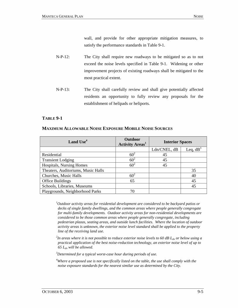
MANTECA GENERAL PLAN NOISE
OCTOBER 6, 2003 9-5
wall, and provide for other appropriate mitigation measures, tosatisfy the performance standards in Table 9-1.
N-P-12: The City shall require new roadways to be mitigated so as to notexceed the noise levels specified in Table 9-1. Widening or otherimprovement projects of existing roadways shall be mitigated to themost practical extent.
N-P-13: The City shall carefully review and shall give potentially affectedresidents an opportunity to fully review any proposals for theestablishment of helipads or heliports.
TABLE 9-1
MAXIMUM ALLOWABLE NOISE EXPOSURE MOBILE NOISE SOURCES
Land Use4 OutdoorActivity Areas1 Interior Spaces
Ldn/CNEL, dB Leq, dB3
Residential 602 45Transient Lodging 602 45Hospitals, Nursing Homes 602 45Theaters, Auditoriums, Music Halls 35Churches, Music Halls 602 40Office Buildings 65 45Schools, Libraries, Museums 45Playgrounds, Neighborhood Parks 70
1Outdoor activity areas for residential development are considered to be backyard patios ordecks of single family dwellings, and the common areas where people generally congregatefor multi-family developments. Outdoor activity areas for non-residential developments areconsidered to be those common areas where people generally congregate, includingpedestrian plazas, seating areas, and outside lunch facilities. Where the location of outdooractivity areas is unknown, the exterior noise level standard shall be applied to the propertyline of the receiving land use.
2In areas where it is not possible to reduce exterior noise levels to 60 dB Ldn or below using apractical application of the best noise-reduction technology, an exterior noise level of up to65 Ldn will be allowed.
3Determined for a typical worst-case hour during periods of use.4Where a proposed use is not specifically listed on the table, the use shall comply with thenoise exposure standards for the nearest similar use as determined by the City.
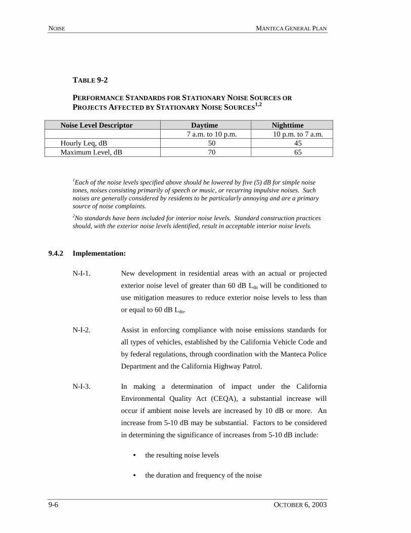
NOISE MANTECA GENERAL PLAN
9-6 OCTOBER 6, 2003
TABLE 9-2
PERFORMANCE STANDARDS FOR STATIONARY NOISE SOURCES ORPROJECTS AFFECTED BY STATIONARY NOISE SOURCES1,2
Noise Level Descriptor Daytime Nighttime7 a.m. to 10 p.m. 10 p.m. to 7 a.m.
Hourly Leq, dB 50 45Maximum Level, dB 70 65
1Each of the noise levels specified above should be lowered by five (5) dB for simple noisetones, noises consisting primarily of speech or music, or recurring impulsive noises. Suchnoises are generally considered by residents to be particularly annoying and are a primarysource of noise complaints.2No standards have been included for interior noise levels. Standard construction practicesshould, with the exterior noise levels identified, result in acceptable interior noise levels.
9.4.2 Implementation:
N-I-1. New development in residential areas with an actual or projectedexterior noise level of greater than 60 dB Ldn will be conditioned touse mitigation measures to reduce exterior noise levels to less thanor equal to 60 dB Ldn.
N-I-2. Assist in enforcing compliance with noise emissions standards forall types of vehicles, established by the California Vehicle Code andby federal regulations, through coordination with the Manteca PoliceDepartment and the California Highway Patrol.
N-I-3. In making a determination of impact under the CaliforniaEnvironmental Quality Act (CEQA), a substantial increase willoccur if ambient noise levels are increased by 10 dB or more. Anincrease from 5-10 dB may be substantial. Factors to be consideredin determining the significance of increases from 5-10 dB include:
• the resulting noise levels
• the duration and frequency of the noise
MANTECA GENERAL PLAN NOISE
OCTOBER 6, 2003 9-7
• the number of people affected
• the land use designation of the affected receptor sites
• public reactions or controversy as demonstrated atworkshops or hearings, or by correspondence
• prior CEQA determinations by other agencies specific to theproject
N-I-4. Control noise at the source through use of insulation, berms,building design and orientation, buffer space, staggered operatinghours and other techniques. Use noise barriers to attenuate noise toacceptable levels.
N-I-5. Evaluate new transportation projects, such a rail or public transitroutes, using the standards contained in Table 9-1. However, noisefrom these projects may be allowed to exceed the standardscontained in Table 9-1, if the City Council finds that there arespecial overriding circumstances.
N-I-6. Require an acoustical analysis where:
• Noise sensitive land uses are proposed in areasexposed to existing or projected noise levelsexceeding the levels specified in Table 9.1 or 9.2.
• Proposed transportation projects are likely toproduce noise levels exceeding the levels specifiedin Table 9.1 or 9.2 at existing or planned noisesensitive uses.
N-I-7. Require that all acoustical analyses utilize a consistent format and beprepared in accordance with Policy N-P-6.
N-I-8. Work in cooperation with Caltrans and the Union Pacific Railroad tomaintain noise level standards for both new and existing projects incompliance with Table 9-1.
NOISE MANTECA GENERAL PLAN
9-8 OCTOBER 6, 2003
THIS PAGE INTENTIONALLY LEFT BLANK
OCTOBER 6, 2003 10-1
10 AIR QUALITY ELEMENT
10.1 Introduction
Clean air is a critical environmental resource that affects the daily life of residentsand can be a significant factor in sustaining the economic viability of the City. TheAir Quality Element promotes air quality standards in all aspects of development,transportation, and activity affected by this General Plan to protect the health andwelfare of the community.
The Air Quality Element addresses the primary air quality concerns in the region.These include ozone precursors from internal combustion engines (smog), dust andother man-made airborne particles, objectionable odors and hazardous or toxicfumes.
Air pollution is typically a regional concern, but the City has influence over factorsthat contribute to local air pollution. Cities and counties are responsible forimplementing air friendly community planning that promotes pedestrian traffic,commute alternatives, and cleaner transit fleets, and can cooperate in policies andimplementation to redress existing jobs housing imbalances that result in significantcommuting trips. Local government policies and implementation measures can havea strong beneficial effect on limiting air pollution.
The methods by which the City can address these air quality concerns generally fallinto the following action categories.
! Reduce the number of vehicle miles traveled by automobiles,particularly short range, cold-start trips that have the highestemissions.
! Reduce the use of two stroke internal combustion engines, suchas lawn mowers and leaf blowers.
! Control activities that generate particulate materials, such aswoodburning fireplaces and stoves, leaf and trash burning, anddust from construction activities.

AIR QUALITY MANTECA GENERAL PLAN
10-2 OCTOBER 6, 2003
! Control activities that could generate toxic or obnoxious fumesand separate these activities from residences, schools, hospitalsand other sensitive land uses.
10.2 Existing Conditions in Manteca
Air pollution in Manteca and the San Joaquin Valley is attributable to several factors.
! Vehicles, both from local traffic and from the presence of twomajor thoroughfares (Interstate 5 and State Route 99)transecting the Valley.
! Long, warm summer days and surrounding mountains that trapair within the San Joaquin Valley.
! Pollution from other areas transported to the San Joaquin Valleyby prevailing winds.
The City of Manteca is within the jurisdiction of the San Joaquin Valley AirPollution Control District (SJVAPCD). SJVAPCD was created to improve the healthand quality of life for all San Joaquin Valley residents through cooperative andeffective air quality programs. The District develops plans and implements controlmeasures in program areas. These controls primarily affect stationary sources suchas factories and plants.
10.3 Air Quality Goals
Goal AQ-1. Improve air quality by:
! Achieving and maintaining ambient air quality standardsestablished by the U.S. Environmental Protection Agency, theCalifornia Air Resources Board, and the San Joaquin AirPollution Control District;
! Minimizing public exposure to toxic or hazardous air pollutants;and
MANTECA GENERAL PLAN AIR QUALITY
OCTOBER 6, 2003 10-3
! Minimizing public exposure to pollutants that create a publicnuisance, such as unpleasant odors.
Goal AQ-2. Integrate air quality planning with land use and transportationplanning processes in order to reduce vehicle miles traveled in theCity and by commuters.
Goal AQ-3. Increase opportunities for alternatives to internal combustionautomobiles including, but not limited to, public transportation,bicycles, walking and alternative fuel vehicles including hybrid gas-electric, electric and compressed natural gas.
Goal AQ-4. Reduce air emissions through energy conservation.
Policies: Air Quality- Regional Coordination
AQ-P-1: Cooperate with other agencies to develop a consistent andcoordinated approach to reduction of air pollution and managementof hazardous air pollutants.
Implementation: Air Quality- Regional Coordination
AQ-I-1. Work with the San Joaquin Valley Air Pollution Control District(APCD) to implement the Air Quality Management Plan (AQMP).
! Cooperate with the APCD to develop consistent and accurateprocedures for evaluating project-specific and cumulative airquality impacts.
! Cooperate with the APCD and the California Air ResourcesBoard in their efforts to develop a local airshed model.
! Cooperate with the APCD in their efforts to develop acost/benefit analysis of possible control strategies (mitigationmeasures to minimize short and long-term stationary and areasource emissions as part of the development review process, and

AIR QUALITY MANTECA GENERAL PLAN
10-4 OCTOBER 6, 2003
monitoring measures to ensure that mitigation measures areimplemented.
AQ-I-2. In accordance with CEQA, submit development proposals to theAPCD for review and comment prior to decision.
AQ-I-3. Cooperate with the San Joaquin County Environmental HealthDepartment in identifying hazardous material users and indeveloping a hazardous materials management plan.
Policies: Air Quality- Land Use
AQ-P-2: Develop a land use plan that will help to reduce the need for tripsand will facilitate the common use of public transportation, walking,bicycles, and alternative fuel vehicles.
AQ-P-3: Segregate and provide buffers between land uses that typicallygenerate hazardous or obnoxious fumes and residential or othersensitive land uses.
Implementation: Air Quality- Land Use
AQ-I-4. Encourage mixed-use development that is conveniently accessible bypedestrians and public transit.
AQ-I-5. Locate employment, school, and daily shopping destinations nearresidential areas.
AQ-I-6. Locate higher intensity development such as multi-family housing,institutional uses, services, employment centers and retail alongexisting and proposed transit corridors.
AQ-I-7. Locate public facilities in areas easily served by current and plannedpublic transportation.
AQ-I-8. Prior to entitlement of a project that may be an air pollution pointsource, such as a manufacturing and extracting facility, the developershall provide documentation that the use is located and appropriately
MANTECA GENERAL PLAN AIR QUALITY
OCTOBER 6, 2003 10-5
separated from residential areas and sensitive receptors (e.g., homes,schools, and hospitals).
Policies: Air Quality- Transportation
AQ-P-4: Develop and maintain street systems that provide for efficient trafficflow and thereby minimize air pollution from automobile emissions.
AQ-P-5: Develop and maintain circulation systems that provide alternatives tothe automobile for transportation, including bicycles routes,pedestrian paths, bus transit, and carpooling.
AQ-P-6: Coordinate public transportation networks, including trains, local busservice, regional bus service and rideshare facilities to provideefficient public transit service.
Implementation: Air Quality- Transportation
AQ-I-9. Maintain acceptable traffic levels of service (LOS) as specified in theCirculation Element.
AQ-I-10. In new subdivisions, require the internal street system to include theinstallation of dedicated pedestrian/bicycle pathways connecting toadjacent residential and commercial areas as well as schools, parksand recreational areas.
AQ-I-11. Provide adequate pedestrian and bikeway facilities for present andfuture transportation needs throughout the City.
Policies: Air Quality- Dust and Other Airborne Particulate Materials
AQ-P-7: New construction will be managed to minimize fugitive dust andconstruction vehicle emissions.
AQ-P-8: Woodburning devices shall meet current standards for controllingparticulate air pollution.
AIR QUALITY MANTECA GENERAL PLAN
10-6 OCTOBER 6, 2003
AQ-P-9: Burning of any combustible material within the City will becontrolled to minimize particulate air pollution.
Implementation: Air Quality- Dust and Other Airborne Particulate Materials
AQ-I-12. Construction activity plans shall include and/or provide for a dustmanagement plan to prevent fugitive dust from leaving the propertyboundaries and causing a public nuisance or a violation of anambient air standard.
! Project development applicants shall be responsible for ensuringthat all adequate dust control measures are implemented in atimely manner during all phases of project development andconstruction.
AQ-I-13. All residences built in a new subdivision or housing developmentshall be equipped with conventional heating devices with sufficientcapacity to heat all areas of the building without reliance onwoodburning heating devices.
AQ-I-14. All woodburning-heating devices installed shall meet EPA standardsapplicable at the time of project approval.
Policies: Air Quality- Reduce Emissions From Energy Generating Facilities
AQ-P-10: Encourage energy efficient building designs.
Implementation: Air Quality- Reduce Emissions From Energy GeneratingFacilities
AQ-I-15. Design review criteria shall include the following considerations, at aminimum:
! The developer of a sensitive air pollution receptor shall submitdocumentation that the project design includes appropriatebuffering (e.g., setbacks, landscaping) to separate the use from
MANTECA GENERAL PLAN AIR QUALITY
OCTOBER 6, 2003 10-7
highways, arterial streets, hazardous material locations andother sources of air pollution or odor.
! Promote the use of new and replacement fuel storage tanks atrefueling stations that are clean fuel compatible, if technicallyand economically feasible.
! The use of energy efficient lighting (including controls) andprocess systems beyond Title 24 requirements shall beencouraged where practicable (e.g., water heating, furnaces,boiler units, etc.)
! The use of energy efficient automated controls for airconditioning beyond Title 24 requirements shall be encouragedwhere practicable.
! Promote solar access through building siting to maximizenatural heating and cooling, and landscaping to aid passivecooling and to protect from winds.
AIR QUALITY MANTECA GENERAL PLAN
10-8 OCTOBER 6, 2003
THIS PAGE INTENTIONALLY LEFT BLANK.

OCTOBER 6, 2003 11-1
11 ADMINISTRATION AND IMPLEMENTATIONELEMENT
11.1 Introduction
The Administration and Implementation Element provides a tool to City staff andelected officials to administer and implement the General Plan. This Element is theframework for review of individual actions and programs (implementation measures)and review of the comprehensive General Plan.
Although the General Plan covers a long-range period, it is not intended to be aninflexible document. This General Plan is based on estimates of future growth anddevelopment. As time passes, certain assumptions made in the General Plan may nolonger be valid, due to changing circumstances or new information.
To ensure that the General Plan is true to the original vision and principles it shouldbe reviewed at regular intervals of approximately five years. Periodic adjustments tothe General Plan may occur from time to time, as development opportunities emerge.
11.2 Administration and Implementation Goals
Goal AD-1. To provide for the ongoing administration and implementation of theGeneral Plan.
Policies:
AD-P-1: The City shall annually update key data in the General PlanBackground Report to assist City officials in their regular decision-making responsibilities and to assist the development community inits decision-making and in its preparation of plans and applicationsfor development projects.
AD-P-2: The City shall bi-annually review the General Plan Policy Documentand revise it as necessary.
ADMINISTRATION MANTECA GENERAL PLAN
11-2 OCTOBER 6, 2003
AD-P-3: The General Plan may be amended no more than four times per year.Each amendment, however, may include multiple changes to theGeneral Plan.
AD-P-4: The City's Zoning Ordinance and Subdivision Ordinance shall bereviewed and amended as necessary to ensure consistency with theGeneral Plan.
AD-P-5: The City shall prepare and adopt, as deemed necessary, specificplans for new development areas.
Implementation:
AD-I-1. The City shall prepare and adopt a five-year Capital ImprovementProgram. The CIP shall be reviewed for its consistency with theGeneral Plan.
AD-I-2. The City shall annually update relevant data in the General PlanBackground Report. The annual update shall be prepared by theCommunity Development Department with the cooperation of Citydepartment managers in draft form by May 15 each year in time foruse by the City Council in making budget decisions. The draft of theupdate shall be submitted to the City Council, Planning Commission,City department heads, appropriate boards and commissions, andinterested outside agencies. Following its review, the update shallbe published in final form by August 1. The update shall be madeavailable to City officials and the public. Information in the updatemay be referenced in Environmental Impact Reports for public andprivate projects.
AD-I-3. The City shall annually review the General Plan Policy Document,focusing principally on actions undertaken in the previous year tocarry out the implementation programs of the Plan. The PlanningCommission shall complete its review of the General Plan PolicyDocument and report its findings to the City Council by September 1
MANTECA GENERAL PLAN ADMINISTRATION
OCTOBER 6, 2003 11-3
of every year. The Planning Commission's report shall include, asthe Commission deems appropriate, recommendations foramendments to the General Plan.
AD-I-4. The City shall prepare and annually update a five-year CapitalImprovements Program. The Planning Commission shall review theCIP for consistency with the General Plan and the Public FacilitiesImplementation Plan and report its findings to the City Council. TheCIP shall be adopted in conjunction with the annual City budget.
AD-I-5. The City shall review and amend, as necessary, the City’s ZoningOrdinance and Subdivision Ordinance to ensure consistency with theGeneral Plan.

ADMINISTRATION MANTECA GENERAL PLAN
11-4 OCTOBER 6, 2003
THIS PAGE INTENTIONALLY LEFT BLANK.