city of fort myers bicycle & pedestrian master plan project...
TRANSCRIPT

BICYCLE & PEDESTRIAN MASTER PLANPROJECT OVERVIEW
CITY OF FORT MYERS

Project Overview
PROJECT TEAM
In collaboration with

The purpose of the Bicycle &Pedestrian Master Plan is toestablish a framework toprovide improved mobility andfurther connectivity, leading toa more robust bicycle andpedestrian network.
Project Overview
PURPOSE OF THE MASTER PLAN

Project Overview
MASTER PLAN PROCESS
Understand the existing networks, on-going projects, andrelated plans
Identify and prioritize new and improved bicycle andpedestrian connections in Fort Myers and to the region’slarger active transportation network based on the existingframework and public input process
Inform decision-making associated with implementingbicycle and pedestrian programs and infrastructureimprovements

Project Overview
PROJECT TIMELINE
We are here
Public Engagement Process
ImagineVision and Goals
Draft Recommendations
& Next Steps
Develop Final Plan
Assess Existing Conditions

Project Overview
EXISTING RELATED PLANS
City of Fort Myers Bicycle and Pedestrian Plan, July 2007 Lee County MPO Bicycle Pedestrian Master Plan, June 2011 Lee Countywide Bicycle & Pedestrian Safety Action Plan, September 2013 City of Fort Myers Complete Streets Guidelines, July 2016 City of Fort Myers Complete Street Policy, July 2017 Census Bureau, American Community Survey, 2018 The Lee Plan, May 2019 City of Fort Myers Comprehensive Plan, November 2019 City of Fort Myers 5 Year Capital Improvement Program, FY 2020 Through 2024
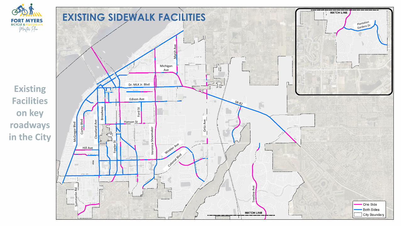
EXISTING SIDEWALK FACILITIES
Existing Facilities on key
roadways in the City
Hanson St
Mar
sh A
ve
MichiganAve
Hill Ave

EXISTING BICYCLE & MULTIMODAL FACILITIES
Existing Facilities on key
roadways in the City
Hanson St
Mar
sh A
ve
MichiganAve
Hill Ave

Project Overview
EXISTING TRANSIT ROUTES

Project Overview
PUBLIC ENGAGEMENT PROCESS
Project Website http://cfmbikepedmasterplan.com/ Online Questionnaire/Survey Interactive Map Contact Us
Project Advisory Committee Meetings Public Workshop City Council Meetings Lee County MPO Bicycle Pedestrian Coordinating Committee Meeting

The VISION of this Bicycle & Pedestrian Master Plan is consistent with the City of Fort MyersComplete Streets Guidelines.
Designed for all ages/abilities whether they walk, bicycle, ride transit, or drive cars Integrate income and social equity into future planning and budgetary functions Combine connectivity with traffic-calming and pedestrian-friendly site/building design features
that create safe and inviting places Connect people through everyday interaction Engage the community in designing streets “from the bottom up” Create inviting spaces with engaging architecture, landscaping, and public art that reflect the
diversity and cultures of the community Foster healthy and safe commerce Strengthen and enhance neighborhoods as envisioned by community members without displacing
residents Encourage active and healthy lifestyles Integrate environmental stewardship, water management, energy conservation, and preservation
of plant life Vary in character by neighborhood, density, and function
Project Overview
MASTER PLAN VISION

The GOALS of this Bicycle & Pedestrian Master Plan are consistent with the City of Fort MyersComplete Streets Guidelines.
Provide transportation options for people of all ages, abilities, and income levels Support land uses and public mobility means that service the street Encourage multimodal transportation options including walking, bicycling, and mass transit Enhance the safety and function of streets, from both traffic and pedestrian perspectives Provide sufficient landscaping along streets and sidewalks that will shade pedestrians and bicyclists
from the sun thereby diminishing the “heat-island effect” Maximize infiltration and reuse of stormwater and reduce unfiltered stormwater runoff into
watersheds Reduce greenhouse gas emissions and other air pollution contaminants Reduce energy consumption Promote the economic well-being of businesses and residents Increase civic space and encourage human interaction Efficiently utilize paved areas to accomplish healthier living opportunities Provide increased opportunities for physical activity Create livable neighborhoods that connect communities
Project Overview
MASTER PLAN GOALS

Shared Lane MarkingsShared Lane Markings “Sharrows” area type of pavement markingindicating that cyclists can use thetravel lane. It helps to positionbicyclists within the shared lane andensures safe passing. The roadwaycan also include signage “Share theRoad” or “Bicycle May Use Full Lane”.
Bicycle BoulevardBicycle boulevards are streets withlow traffic volume and speed. Theygenerally prioritize bicycle travelthrough the use of signs andpavement markings. They may alsoemploy other traffic calmingtechniques to create a saferenvironment for bicyclists.
Project Overview
TOOLBOX FOR FUTURE POTENTIAL FACILITIES
Paved ShoulderPaved shoulders provideaccommodations for bicyclistsadjacent to the travel lanes. They canvary in width depending on theavailable pavement.
Bicycle LaneBicycle lanes are designated travellanes for preferential use bybicyclists. Specific pavementmarkings and signage are required toidentify the bicycle lane and includekeyhole lanes at intersections.Additionally, they may be coloredgreen or with other pavementtreatments.

Separated Bicycle LaneSeparated/buffered bicycle lanes orcycle tracks are on-road facilities thatare physically separated from thetravel lanes. This separation may beachieved through the use ofpavement markings, a raised concreteseparator, or landscaping. Theseparation allows bicyclists to bemore comfortable when riding on theroadway.
Shared Use PathShared use paths are off-roadfacilities that are physically separatedfrom, but adjacent to, the roadway.They can accommodate bi-directionaltravel and are shared by bothbicyclists and pedestrians.
Project Overview
TOOLBOX FOR FUTURE POTENTIAL FACILITIES
TrailTrails are off-road facilities that arephysically separated from, and areindependent from, the roadway.Trails can be found in parks, oralongside canals, as examples.
SidewalkSidewalks are paved pathwaysparallel to a roadway and physicallyseparated from vehicular traffic thatare intended for use by pedestrians.

Project Overview
HOW CAN I LEARN MORE?
Visit the project website - Complete the public questionnaire Fill out the interactive online map Review available documents Contact us!
http://cfmbikepedmasterplan.com/

THANK YOU