city of fort collins: soapstone prairie management plan€¦ · the 18,728-acre soapstone prairie...
TRANSCRIPT
CITY OF FORT COLLINS NATURAL AREAS PROGRAM
SOAPSTONE PRAIRIE NATURAL AREA MANAGEMENT PLAN September 25, 2007
PO Box 580 . Fort Collins CO 80522 . 970.416.2815 . www.fcgov.com/naturalareas/

Executive Summary The City of Fort Collins is fortunate to have one of the most successful municipal natural area
programs in the world. Building on a long tradition in Colorado of municipal governments conserving important natural and cultural resources, Fort Collins has become a leader in conserving and managing natural areas that are open to the public for a wide variety of outdoor recreation opportunities. The motto of the City’s Natural Areas Program is “naturally yours,” and reflects the community’s commitment to caring for the natural and cultural resources of its natural area system while providing high-quality, sustainable outdoor experiences.
The 18,728-acre Soapstone Prairie Natural Area is, by itself, a spectacular natural area. It is
home to over one hundred bird species, elk, deer, badgers, prairie dogs; vibrant plant communities - including globally rare plants; world renowned cultural resources such as the Lindenmeier Archaeological Site; and fantastic scenic vistas. What distinguishes Soapstone even further is its location in the heart of a mountains-to-plains landscape known as the Laramie Foothills. The Laramie Foothills are the focus of a successful conservation effort undertaken by numerous organizations and individuals.
Larimer County is one of the most important partners in the conservation partnership – and
has conserved 13,500 acres of land known as Red Mountain Open Space immediately to the west of Soapstone. The City and Larimer County have worked together closely to harmonize their respective management plans. Other important conservation efforts have been undertaken by private landowners, The Nature Conservancy, Legacy Land Trust, and the Colorado Division of Wildlife. In all, the partners are conserving ~50,000 acres of land that help link a nearly 200,000-acre mountains-to-plains corridor.
The City of Fort Collins Natural Areas Program has adopted a careful, deliberate, and detailed
planning process to design a management plan for Soapstone Prairie Natural Area. Extensive surveys of the natural and cultural attributes of the property have been conducted. The survey results were used to create management zone overlays that provide a framework for characterizing and determining uses and management objectives in the respective zones. Great care has been taken not only to protect the precious resources of Soapstone, but also to provide a wealth of opportunities for citizens to experience the beauty, solitude, wildlife, and cultural resources of the site. During the collection of data, and the design of the management plan, many experts as well as citizens were consulted.
The City is grateful for all of the help and support it has received from its citizens, as well as
institutions and professionals in fields as diverse as archaeology and recreation. In particular, the citizens of Fort Collins have been instrumental with their support of Open Space, Yes!, the quarter-cent sales tax that makes the work of the City’s Natural Areas Program possible.
Working together, the community has created this initial management plan and its attendant
objectives and strategies. Importantly, the management plan is a living document, and it is entirely expected that as the community learns more about this magnificent property the City’s management approach will be adjusted accordingly.
Soapstone Prairie is vibrant with life and possibilities. As a community, the City of Fort
Collins can be proud of its efforts to conserve Soapstone for now, and forever.

Soapstone Prairie Natural Area Management Vision
Management decisions for Soapstone Prairie Natural Area are based on the concept of
maintaining and enhancing the living landscape, including its diversity of plants, animals, and natural communities, as well as its world-class archaeological and cultural values. Emphasis is placed on supporting habitat values that sustain the function, connectivity, and the spirit of the regional mountains-to-plains ecological system and its inhabitants while providing a diversity of high quality visitor experiences.
This vision includes: � Safeguarding healthy habitats for wildlife and plant communities.
� Providing high quality, sustainable recreational opportunities for visitors.
� Protecting the integrity of cultural resources that provide glimpses into the past.
� Enhancing visitors’ understanding and appreciation of the natural and cultural resources
through education and interpretation.
� Continuing the “working landscape” by providing agricultural production opportunities
that are practical and compatible with conservation goals.
The mission of the City of Fort Collins Natural Areas Program is to protect and enhance
lands with existing or potential natural areas values, lands that serve as community
separators, agricultural lands, and lands with scenic values. Protection of natural
habitats and features is the highest priority, while providing for education and
recreation for the Fort Collins community.
City of Fort Collins Land Conservation and Stewardship Master Plan, 2004

i Table of Contents
Table of Contents
Chapter 1. Introduction and Background ............................................................................. 1
Site Significance............................................................................................................. 1 Process and Scope of Management Plan ........................................................................ 2 Purchase and Interim Management ................................................................................ 3 Geographic Context........................................................................................................ 3 Land Use History............................................................................................................ 4 Public Outreach .............................................................................................................. 5
Chapter 2. Physical Resources and Geology.......................................................................... 6
Topography .................................................................................................................... 6 Geology .......................................................................................................................... 6 Streams and Springs ....................................................................................................... 9 Minerals.......................................................................................................................... 9
Chapter 3. Vegetation and Ecological Systems.................................................................... 10
Plant Communities and Ecological Systems ................................................................ 10 Rare and Threatened Plants .......................................................................................... 16 Weeds ........................................................................................................................... 18
Chapter 4. Wildlife Resources............................................................................................... 19
Mammals ...................................................................................................................... 20 Birds ............................................................................................................................. 23 Insects ........................................................................................................................... 27 Amphibians and Reptiles.............................................................................................. 28 Fish ............................................................................................................................... 28 Potential Reintroductions ............................................................................................. 28
Chapter 5. Cultural Resources.............................................................................................. 31
Lindenmeier Valley – the Paleo-Indian Period ............................................................ 31 Prehistoric Discoveries................................................................................................. 32 American Indians ......................................................................................................... 32 Homestead History ....................................................................................................... 33 Ranching History.......................................................................................................... 37
Chapter 6. Resource Management of High Priority Conservation Targets ..................... 40
Shortgrass Prairie/Grasslands System .......................................................................... 41 Birds of Prey ................................................................................................................ 48 Wetlands/Riparian Systems.......................................................................................... 50 Foothills Shrublands System ........................................................................................ 53 Rare and Threatened Plants .......................................................................................... 54 Geological Features System ......................................................................................... 56 Cultural Resources ....................................................................................................... 56 Viewshed / Sense of Place ........................................................................................... 57

ii Table of Contents
Table of Contents (cont’d) Chapter 7. Visitor Use........................................................................................................... 59
Determining Visitor Experiences ................................................................................. 59 Regional Analysis of Recreation Opportunities ........................................................... 63 Analyses of Visitor Experience Opportunities ............................................................. 64 Specific Visitor Experience Goals................................................................................ 78 Trail System ................................................................................................................. 80 Managing Visitor Use .................................................................................................. 81
Chapter 8. Management Zones, Visitor Expectations and Carrying Capacity............... 84
Developed Zone ........................................................................................................... 85 Frontcountry Zone........................................................................................................ 87 Backcountry Zone ........................................................................................................ 88 Primitive Zone.............................................................................................................. 89
Chapter 9. Education and Outreach ................................................................................... 91
Introduction .................................................................................................................. 91 Objectives ..................................................................................................................... 92 Proposed Education and Interpretive Products............................................................. 92 Suggested Education and Interpretive Topics .............................................................. 94
Chapter 10. Site Administration, Public Improvements and Site Security .................... 96
Existing Easements, Leases and Issues ........................................................................ 96 Anticipated Public Improvements ................................................................................ 97 Visitor and Resource Protection................................................................................. 100
Maps
1. Laramie Foothills Mountains to Plains .................................................................. 102 2. Surrounding Lands ................................................................................................. 103 3. Ecological Systems................................................................................................. 104 4. Special Features...................................................................................................... 105 5. Shortgrass Prairie Nested Target: Grassland Birds ................................................ 106 6. Soapstone Prairie Conceptual Trails ...................................................................... 107 7. Red Mountain & Soapstone Prairie Combined Conceptual Trails......................... 108 8. Soapstone Prairie Management Zones ................................................................... 109 9. Red Mountain & Soapstone Prairie Combined Management Zones...................... 110
Appendices
1. Laramie Foothills Mountains to Plains Project through 2006................................ 111 2. Laramie Foothills Mountains to Plains Project Timeline....................................... 112 3. Public Tours Feedback Form ................................................................................. 114 4. Public Tours Feedback Form Responses and Comments ...................................... 116 5. Public Meeting Notes, Comments and Website Feedback..................................... 127 6. Technical Advisory Group Members ..................................................................... 131 7. Plant Species........................................................................................................... 132 8. Mammal Species .................................................................................................... 136 9. Bird Species............................................................................................................ 138

1 Chapter 1 – Introduction and Background
Chapter 1
Introduction and Background
A. Site Significance Soapstone Prairie Natural Area encompasses 18,728 acres of shortgrass prairie, foothills
shrublands, cliffs and rock outcrops, wetlands, springs, and prairie streams. This property represents the largest land purchase within the City of Fort Collins Natural Areas Program and is part of the Meadow Springs regional conservation focus area as identified in the 2004 Land Conservation and Stewardship Master Plan. Soapstone Prairie is also an essential piece of the Laramie Foothills Mountains to Plains (LFMTP) Project, which, through numerous partnerships, has created a nearly 200,000-acre corridor of protected lands linking the Front Range and the High Plains, thereby conserving a large working landscape and wildlife corridor. (See Appendices 1 and 2, and Map 1 below for more LFMTP details).
Map 1* Laramie Foothills Mountains to Plains Project (*see Map 1, page 102 for larger image)
Soapstone Prairie’s landscape rises from an elevation of 6,000 feet on the eastern edge to
7,200 feet, seven miles to the west. Larimer County’s Red Mountain Open Space adjoins Soapstone Prairie’s western boundary, and Cheyenne Ridge defines the property’s northern border. Deep washes and arroyos cut dramatically to the south and east, trending downward from the ridges and out towards the plains.

2 Chapter 1 – Introduction and Background
Abundant wildlife and plant life are found within this unique and biologically diverse site. Research conducted by the City of Fort Collins Natural Areas Program staff, Colorado Natural Heritage Program, Rocky Mountain Bird Observatory and other organizations has noted that Soapstone Prairie is home to globally rare ecosystems and prairie grasslands that offer high quality, critical habitat for wildlife, including pronghorn, swift fox, black-tailed prairie dogs and mule deer. Soapstone Prairie is also one of the last places in Colorado where elk still venture out onto the plains. The land supports more than 130 species of birds, including nesting golden eagles and burrowing owls, prairie falcons, ferruginous hawks, long-billed curlews and mountain plovers. An amazing array of wetland and riparian systems, including marshes, seeps, springs, and streams support the federally threatened Colorado butterfly plant and other imperiled plant species. Areas of gnarled and aged junipers, centuries-old ponderosa pines, and even a relict stand of aspen are found in western sections of the property.
Culturally, Soapstone Prairie is rich in human history, dating back thousands of years. The most significant cultural feature on Soapstone Prairie is the Lindenmeier Archaeological Site, a National Historic Landmark. Recognized worldwide as one of the most well-preserved and extensive Folsom occupations in the American West, the history of the Lindenmeier Archaeological Site dates back over 12,000 years. This site was excavated in the 1930’s by the Smithsonian Institution and the Colorado Museum of Natural History (now known as the Denver Museum of Nature and Science), and many of the artifacts collected at that time are archived and on display at the City of Fort Collins Museum. The majority of the collection is at the Smithsonian Institution, and a smaller collection is housed at the Denver Museum of Nature and Science. In addition, archaeological surveys conducted in the summers of 2006 and 2007 by researchers from Colorado State and Southern Methodist Universities documented numerous sites of other cultural interest on the property.
B. Process and Scope of Management Plan At Soapstone Prairie, conservation of natural and cultural resources is of highest priority, and
management decisions within this plan focus on stewardship of resources while providing high quality, sustainable recreational opportunities. This management plan is a result of a multi-year process that entailed:
� Developing baseline inventories of natural and cultural resources, including wildlife, plant life, cultural sites and artifacts.
� Prioritizing resources of highest conservation concern. � Determining potential threats and impacts to the resources and developing management
strategies to address. � Analyzing recreational opportunities and visitor experiences. � Developing the concept of management zones on the property, allowing for stewardship
of areas with similar resources. � Determining carrying capacity and allowing for management adaptability as changes to
the resources occur over time. � Understanding the unique security needs of the cultural and natural resources, and
developing a plan to meet those needs. � Creating a timeline for public improvements to fulfill the visitor experience goals and to
properly steward the site consistent with the Natural Areas Program mission. This management plan follows a similar path, detailing the results of each step of the planning
process.

3 Chapter 1 – Introduction and Background
C. Purchase and Interim Management The City of Fort Collins Natural Areas Program purchased Soapstone Prairie Natural Area in
2004. At the time of the initial purchase, approximately 12,579 acres were deeded, and 3,873 acres were leased from the Colorado State Land Board. Additional purchases were completed in 2004-2006, totaling 18,728 acres for a combined purchase price of $11,056,554. A timeline of purchases, trades and other Soapstone Prairie and Laramie Foothills Mountains to Plains Project activities is found in Appendix 2. Voter approval of dedicated funding through the City of Fort Collins Open Space Yes! and Larimer County’s Help Preserve Open Spaces sales taxes made these acquisitions possible.
Table 1.1 Soapstone Prairie Natural Area land acquisition history
Year (Previous) Owner # acres cost cost/acre
2004 Soapstone Grazing Assn 12,579 $7,280,396 $579
Roman 1960 $1,177,439 $600
2005 Krafczik 316 $275,064 $870
2006 State Land Board 3,873 $2,323,656 $600
total 18,728 11,056,554 $590 (avg)
Soapstone Prairie is scheduled to open for public use in 2009. These projects have been, or
will be undertaken during the interim period: � The Natural Areas Program (NAP) entered into an interim lease agreement with the Folsom Grazing Association through 2008.
� A new fence was constructed along the Colorado/Wyoming border in 2005. � Baseline inventories for breeding birds under the direction of the Rocky Mountain Bird Observatory, partially funded by the Colorado Division of Wildlife were conducted during the summers of 2006 and 2007.
� Baseline inventories for elk, mule deer, pronghorn, swift fox, and black-tailed prairie dogs began in 2005 and are ongoing.
� Baseline vegetation studies, including rare plant inventories, were conducted by the Colorado Natural Heritage Program (CNHP) and NAP staff from 2004- 2007.
� The Laboratory of Public Archaeology, Colorado State University, conducted a Class II Archaeological Survey in 2006 and 2007. Funding came in part from the Colorado State Historic Fund and Quest Archaeological Research Fund.
� The Soapstone Prairie Oral History project was conducted in 2006 and 2007 in partnership with the Fort Collins Museum. Funding for this oral history program came from the U.S. National Parks Service’s Preserve America grants.
� Staff-led guided public tours attracted more than 1000 people from 2005-2007. Tours are scheduled to continue until the opening in 2009.
� Volunteer opportunities related to archaeological surveys and weed removal offered; nearly 100 people participated in 2006 and 2007.
� Colorado butterfly plant management plan developed; completed 2006. � Baseline inventories for butterflies and fish conducted by CNHP in 2007.
D. Geographic Context Soapstone Prairie is located in northern Larimer County, approximately 25 miles north of Fort
Collins, five miles west of Interstate 25, and adjacent to the eastern border of Larimer County’s Red Mountain Open Space. The City’s Meadow Springs Ranch (managed by City of Fort Collins Utilities Department) borders the property to the south and east. Soapstone Grazing Association owns ranch land to the north of Soapstone Prairie where the City holds deed restrictions on

4 Chapter 1 – Introduction and Background
approximately 3,000 acres to protect the viewshed to the north. The City is working to conserve approximately 4,500 acres to the south of Soapstone Prairie by purchasing conservation easements. The City of Cheyenne owns property to the north of Red Mountain Open Space.
The City of Fort Collins Natural Areas Program is coordinating with Larimer County Open Lands Program on cross-boundary management issues between Soapstone Prairie Natural Area and Red Mountain Open Space, including compatible regulations, visitor management, and shared resources. In addition, trail designs will enable visitors to travel between properties and eventually to the City of Cheyenne property (see Map 2 below) and Map 7 (page 108) for combined conceptual trail plans.
Map 2* Geographic context (*see Map 2, page 103 for larger image)
E. Land Use History Soapstone Prairie Natural Area is a landscape rich in a tapestry of human occupation for more
than 12,000 years. From big game hunters known as the Folsom people, to numerous American Indian tribes, to contemporary cattle and sheep ranchers, the archaeological record and associated artifacts demonstrate a wide and varied range of human presence and subsistence uses on the property. In addition to the Lindenmeier Archaeological Site and other known sites, studies conducted during the summers of 2006 and 2007 have revealed numerous additional sites and features of cultural significance. These include possible Clovis sites (to 13,000 years ago), numerous stone (tipi) rings, campsites dating 200-10,000 years before present (B.P.), exposed cooking sites on ancient flood plains and sheep camp rock cairns. Artifacts including bone and stone tools, scrapers, spear points and arrowheads, were also discovered and documented.
Primary land uses in northern Colorado during the homesteading period were farming and grazing. Most of the land within Soapstone Prairie has never been tilled, but ranching families and livestock companies have grazed sheep and cattle here for over 100 years. Evidence still exists of more recent history, including portions of historic homesteads, ranches and their associated buildings, and roads and trails. The deteriorating foundation of an old schoolhouse sits near Soapstone Springs.
5 Chapter 1 – Introduction and Background
F. Public Outreach The Natural Areas Program began introducing the public to Soapstone Prairie in 2005. The
first step in the community outreach effort was to offer staff-led field trips beginning in May, 2005. More than 730 citizens attended and completed feedback forms concerning specific management questions (Appendix 3 and 4) in 2005 and 2006. Members of the Fort Collins Audubon Society, Sierra Club, Fort Collins Senior Center, League of Women Voters, Fort Collins Museum, Fort Collins City Council, Fort Collins Master Naturalists, Fort Collins Volunteer Trail Hosts, Colorado Archaeological Society, Downtown Business Association, Red Feather Historical Society, and others also visited Soapstone Prairie during the same time period and provided similar input.
On June 9, 2006, the Colorado Open Space Alliance held a workshop and field trip that
focused on management of Soapstone Prairie Natural Area and Red Mountain Open Space. The workshop, entitled “Conservation Planning at a Landscape Scale,” addressed cultural resource management, managing across boundaries, and managing natural areas and open space within working landscapes. Representatives from the City of Boulder, City of Cheyenne, City of Fort Collins, Arapahoe County, Boulder County, Jefferson County, Larimer County, Summit County, and Colorado State University provided input on these issues.
In 2007, two public open houses, hosted by Larimer County and the City of Fort Collins,
were held to solicit citizen input on the management of Red Mountain Open Space and Soapstone Prairie Natural Area. More than 200 people attended the first public open house on January 24, 2007. This meeting focused on educating the public about the significance of the natural and cultural resources on the properties, and introduced the concept of management zones for guiding protection of resources and compatible recreational opportunities. More than 70 people attended the second meeting on August 16, 2007, which offered attendees an opportunity to learn about, and comment on, this management plan. Citizens also had the opportunity to comment online via the Natural Areas Program website. Comments and feedback from public open houses and online feedback forms are presented in Appendix 5.
A Technical Advisory Group (TAG), comprised of representatives from NAP staff, user
groups, subject experts, partners, other agencies, and related experts from Larimer County and City of Fort Collins staff, was consulted on specific management issues, including resource protection, recreation management, grazing, and education. The first TAG meeting was held September 6, 2006 to solicit initial feedback on conceptual management approach. The second meeting on June 26, 2007 gathered input on specific concepts in the proposed management plan including trail locations, recreation plans, visitor management, and development plans (parking area locations, kiosks, etc.). See Appendix 6 for TAG member list.
Photographic Note: All images were supplied by City of Fort Collins staff, research teams, or other public entities unless otherwise noted. Additional images were supplied by individual photographers, whom we thank for their generosity and support of the Natural Areas Program. Cover photo: Charlie Johnson.

6 Chapter 2 – Physical Resources and Geology
Chapter 2
Physical Resources and Geology
Sandstone cliffs, Joel Hayward
This chapter is based on a report prepared by Bruce A. Collins, Ph.D., P.G., C.P.G. Geological & Natural Resources Consultant, Silt, Colorado. 1
A. Topography Soapstone Prairie Natural Area lies just east of the boundary between two of North America’s
great regions: the Great Plains, and the Front Range of the Southern Rocky Mountains. Moderately rugged hills and shallow canyons associated with the complex geology of this
great boundary are present in the western part of Soapstone Prairie, with the remainder consisting of the more subdued and generally eastward-sloping grasslands. Topographical landmarks local to Soapstone Prairie include Caveat Peak, Castle Rock, the Big Hole, Table Mountain, and Spottlewood Canyon. Elevations range from a little less than 6,080 ft where Spottlewood Creek crosses the southeast corner to 7,201 feet at the summit of a ridge above the Big Hole, along the western edge, for a total relief on Soapstone Prairie of 1,121 feet.
B. Geology The geology in Soapstone Prairie and the Laramie Foothills region includes rock formations
and unconsolidated deposits dating from the Precambrian era to the present, all strongly influenced by the 300,000,000-year evolution of today’s Rocky Mountains. Soapstone Prairie extends for eight miles from the eastern edge of a three-mile-wide band of folded and faulted sedimentary rocks that represents the vast Rocky Mountains uplift, across the western margin of the Denver Basin, an Upper Cretaceous-aged, downward-folding geologic structure extending from the Arkansas River into Wyoming and from the Front Range mountains east to Colorado’s eastern border.
Surface and near-surface bedrock of Soapstone Prairie is mapped as mostly the Oligocene White River Group and the Miocene Ogallala Formation, with Miocene Arikaree Formation found erratically between them. The Ogallala Formation is a reddish-brown to brown, poorly sorted, medium- to coarse-grained sandstone and conglomerate and is present on most of the northern third of Soapstone Prairie, except in the northeast corner. The White River Group,

7 Chapter 2 – Physical Resources and Geology
which consists of the Brule Formation and the underlying Chadron Formation, is present on most of the central portion and eastern edge of the property, and the Arikaree Formation may be present in the Soapstone Camp area (see Map 5, page 106). The Brule is mostly pastel, multicolored mudstone with coarse reddish sandstone at the top, while the Ogallala is red, purplish-red, or gray, very coarse sandstone and conglomerate. Where present the Arikaree is characterized by light-brown or gray siltstone and very fine-grained sandstone.
Other geologic formations exposed at the surface within the boundaries of the Soapstone
Prairie include: � An element of the Mitten Black Shale Member is present along the south boundary of
Soapstone Prairie from west of Rawhide Creek east to Sand Creek. This member of the Upper Cretaceous Pierre Shale is a dusky-yellow to light-olive-gray sandstone that weathers dark yellowish brown and contains yellowish-orange ironstone or limestone concretions.
� Several members of the Lower Cretaceous Dakota Group are mapped in the southwest corner of the property. The Plainview Sandstone member of the South Platte Formation, as well as the Lytle Formation, are exposed in the southwest corner as well as along the southwestern edge, and both also underlie the rest of Soapstone Prairie. The carbonaceous Plainview Sandstone is gray to light-brown and fine-grained, while the Lytle Formation is a gray to light-brown, coarse-grained to conglomeratic sandstone with varicolored non-carbonaceous mudstone beds.
� Also present in the southwest corner and beneath the remainder of Soapstone Prairie are the middle shale and first sandstone members of the South Platte Formation. The middle shale consists of dark gray carbonaceous shale, thin bentonite, and thin gray siltstone and sandstone beds, while the first sandstone is gray to light-brown, well-sorted, fine- to medium-grained sandstone.
� A few small exposures of the Smoky Hill Shale Member of the Upper Cretaceous Niobrara Formation are present in the southwest corner of the property. The Smoky Hill consists of a very fissile calcareous shale which is dark gray on fresh surfaces and weathers to light-gray plates, and a distinctively yellowish-brown-weathering limestone.
� The Upper Jurassic Morrison Formation is present at the surface along the southwestern edge and in the subsurface beneath Soapstone Prairie. It consists of green, red, yellow, and white, blocky-weathering claystone and siltstone, interbedded gray limestone, and gray, fine- to medium-grained sandstone. Also mapped on this part of Soapstone Prairie is a small area of the Upper and Middle Jurassic Sundance Formation and Upper Triassic Jelm Formation, both exposed more extensively further west. In all likelihood, only the uppermost beds of the Sundance Formation, characterized by the flat- bedded light gray fine-grained sandstone and gray clay shale of the Windy Hill Sandstone Member and the flat-bedded, fine-grained, gray to white sandstone Pine Butte Member are actually exposed. However, these members, as well as the Canyon Springs Sandstone Member of the Sundance (orange-pink or reddish-brown, fine- to medium-grained, crossbedded calcareous sandstone) and the Red Draw Member of the Jelm Formation (orange-pink or reddish-brown, fine-grained, crossbedded calcareous sandstone), underlie the entire property at generally-increasing depth from west to east.

8 Chapter 2 – Physical Resources and Geology
� The L.R. Camp (see Map 5, page 106) landslide, of Oligocene age, found in the southwest corner of Soapstone Prairie, was formed by the eastward collapse of the first sandstone of the South Platte Formation and resulted from post-Laramide uplift, erosion, and also possibly wet climate conditions. The ancient landslide covers a thick sequence of Lower to Upper Cretaceous rocks (between the Dakota Group and Pierre Shale), known as the
Colorado Group. These strata consist of the siliceous Mowry Shale; the Graneros Shale (a dark-gray to grayish-black siltstone and claystone); the interlayered dark-gray limestone and olive-gray calcareous silty claystone and siltstone of the Greenhorn Limestone; and the Carlile Shale, olive-gray silty claystone and sandy siltstone.
At depth under Soapstone Prairie but exposed in the canyons and hogbacks immediately west is a sequence of mostly Late Paleozoic rocks totaling almost 2,000 feet in thickness. These members include, from top (youngest) to the basement:
• The Lykins Formation of Lower Triassic and Upper Permian age is white to gray limestone, red to purple siltstone and mudstone, and gray limestone and dolomite, with minor gray sandstone. It also includes discontinuous but locally thick and pure gypsum beds that have been mined in a number of locations in the region, as well as the Forelle Limestone Member.
• The Lyons Sandstone of Lower Permian age is a buff sandstone grading into purplish-gray siltstone north of Table Mountain.
• The Owl Canyon Formation, also Lower Permian, is mostly red siltstone and sandstone.
• The Lower Permian Ingleside Formation is pink quartzose sandstone interbedded with gray limestone and dolomitic limestone; locally thick and pure limestone beds have been and are being mined extensively north and southeast of Livermore.
• The Fountain Formation of Lower Permian and Upper Middle Pennsylvanian age is reddish-brown to purplish-gray arkosic conglomerate and sandstone interbedded with dark reddish-brown siltstone and shale, and minor thin limestone.
Soils cover the bedrock over most of Soapstone Prairie. In more rugged terrain, soils are
generally thin, rocky, and reflect the nature of near-surface rock types from which they are derived. Alluvium (unconsolidated deposits of silt, sand, and gravel) in and marginal to valley heads and upper valley arroyos likewise reflect nearby source rocks and soils in composition, but become mixed with material from other source areas with increasing distances downstream. Soils on the plains portion of Soapstone Prairie contain a significant amount of loess, windblown silt and fine sand derived largely from Pleistocene glacial action in the mountains to the west, as well as the continental ice sheets in the more-distant upper Midwest to the north and northeast.
The structural geology of Soapstone Prairie is explained by modest post-Laramide folding of
Cretaceous rocks along the southwestern edge resulting in the L.R. Camp landslide, as the first sandstone member of the South Platte Formation slid and ultimately collapsed down-dip to the
Boulders above the L.R .Camp landslide

9 Chapter 2 – Physical Resources and Geology
east along its contact with underlying failing shales and other weaker rocks. Beneath the vast majority of the rest of Soapstone Prairie sedimentary beds dip easterly at 12° or less, although erratic dips up to 35° can be found in deformed units of the Pierre Shale. Evidence of plastic deformation of the relatively soft Pierre, resulting from rapid deep burial in the late Cretaceous followed by subsequent Laramide uplift in the early Tertiary, is common at many localities along the Front Range. There are no mapped faults or igneous intrusive or extrusive rocks on Soapstone Prairie.
C. Streams and Springs While there are several springs and flowing wells, there are no mapped permanent streams on
Soapstone Prairie. The several named intermittent drainages which originate on or cross the natural area and contribute to its geologic landscape include, from west to east, Sand Creek (west), Rawhide Creek, Sand Creek (east), Spottlewood Creek, and Graves Creek (see Map 5, page 107). These and numerous unnamed intermittent and ephemeral drainages flow generally southerly into larger streams that now feed numerous irrigation ponds and lakes in the area between Buckeye and Fort Collins.
D. Minerals While there is a modest possibility of oil and gas resources, particularly in Cretaceous rocks
beneath the eastern part, and a variety of surface materials including sand and gravel is present, there are no known mineral resources of sufficient quality and extent to be of commercial interest on or beneath Soapstone Prairie. While rocks that contain limestone, gypsum, and silica sand resources that have been mined from several locations from the Owl Canyon area northwest to near Livermore and on north to the Wyoming border to the west are present in the subsurface, any such resources as these rocks may contain beneath Soapstone Prairie are too deep to be of commercial interest.
Chapter 2 References 1 Collins, Bruce A. 2007. Summary of the Geology of the Soapstone Prairie Natural Area,
Larimer County Colorado. 14 pp (citing Braddock and Cole, 1978 and Courtright and Braddock, 1989)
10 Chapter 3 – Vegetation and Ecological Systems
Blazing star, Charlie Johnson
Chapter 3
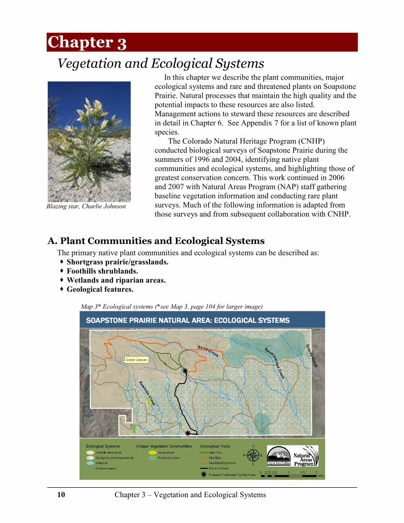
Vegetation and Ecological Systems In this chapter we describe the plant communities, major
ecological systems and rare and threatened plants on Soapstone Prairie. Natural processes that maintain the high quality and the potential impacts to these resources are also listed. Management actions to steward these resources are described in detail in Chapter 6. See Appendix 7 for a list of known plant species.
The Colorado Natural Heritage Program (CNHP) conducted biological surveys of Soapstone Prairie during the summers of 1996 and 2004, identifying native plant communities and ecological systems, and highlighting those of greatest conservation concern. This work continued in 2006 and 2007 with Natural Areas Program (NAP) staff gathering baseline vegetation information and conducting rare plant surveys. Much of the following information is adapted from those surveys and from subsequent collaboration with CNHP.
A. Plant Communities and Ecological Systems The primary native plant communities and ecological systems can be described as: � Shortgrass prairie/grasslands.
� Foothills shrublands.
� Wetlands and riparian areas.
� Geological features.
Map 3* Ecological systems (*see Map 3, page 104 for larger image)

11 Chapter 3 – Vegetation and Ecological Systems
The shortgrass prairie occurs in the flat and gently rolling terrain of the southern and eastern portions of the property. This ecological system continues south and east throughout Meadow Springs Ranch and neighboring private ranches. To the northwest on Soapstone Prairie is the
foothills shrublands, a system that connects with the shrublands on Red Mountain Open Space to the west and private ranchland to the north. Like the shortgrass prairie/grasslands, the foothills shrublands system is most effective on a large scale, such as is found at Soapstone Prairie. Wetlands
and riparian areas are interspersed within the grasslands and shrublands, and include Brannigan Springs, Jack Springs, Spottlewood Creek, Graves Creek, and Rawhide Creek, as well as scattered seeps and springs throughout. Prominent geological
features are primarily found in the central portion of the property, generally at the interface between prairie and shrublands systems (see Map 3 previous page).
1. Shortgrass Prairie/Grasslands System
The shortgrass prairie/grasslands system occupies approximately 70% of the land area on Soapstone Prairie. On a larger scale, the historic range of the shortgrass prairie extended eastward from the Rocky Mountain foothills into the mid-western states of the Great Plains. At Soapstone Prairie, the shortgrass prairie occurs primarily on flat to rolling terrain, and is
characterized by grama grasses (Bouteloua spp.) and buffalograss (Bouteloua dactyloides). While the majority of the shortgrass prairie on Soapstone Prairie is intact and has never been tilled, roughly half of the historic shortgrass prairie has been converted to other uses (tilled for agricultural production or lost to urban development). Vast expanses of this shortgrass prairie system still occur, but large areas of shortgrass prairie in high quality condition, such as that found on
Soapstone Prairie and surrounding properties, are very rare near the Front Range.1 As an interconnected or matrix ecological system, shortgrass prairie occurs at a very large
spatial scale. Because Soapstone Prairie is part of the Laramie Foothills Mountain to Plains Project (a conservation effort by multiple partners who, together are working to conserve nearly 200,000 acres in northern Colorado), this property is part of a series of regional systems that support and complement each other ecologically.
As a matrix system, shortgrass prairie depends on a variety of natural processes to stay healthy and biologically diverse. These processes include:
� Climate (including precipitation). � Grazing (naturally altering the composition and dominance of species). � Fire (a somewhat less important process, primarily due to lack of fuel).
An ecological system is defined as the association or network of living organisms, their physical environment, and all their interrelationships, including climate, elevation, disturbances, soils and water, in a particular unit of space. Also referred to as
an ecosystem.
Shortgrass prairie near foothills shrublands,
Rich Ernst
12 Chapter 3 – Vegetation and Ecological Systems
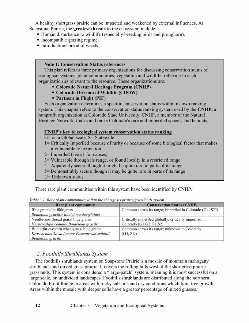
A healthy shortgrass prairie can be impacted and weakened by external influences. At Soapstone Prairie, the greatest threats to the ecosystem include:
� Human disturbance to wildlife (especially breeding birds and pronghorn). � Incompatible grazing regime. � Introduction/spread of weeds.
Three rare plant communities within this system have been identified by CNHP.1
Table 3.1 Rare plant communities within the shortgrass prairie/grasslands system
Rare plant community Conservation Status (CNHP)
Blue grama/ buffalograss Bouteloua gracilis/ Bouteloua dactyloides
Common across its range; imperiled in Colorado (G4; S2?)
Needle-and-thread grass/ blue grama Hesperostipa comata/ Bouteloua gracilis
Critically imperiled globally; critically imperiled in Colorado (G1,G2; S1,S2)
Winterfat /western wheatgrass/ blue grama Krascheninnikovia lanata/ Pascopyrum smithii/
Bouteloua gracilis
Common across its range; unknown in Colorado (G4; SU)
2. Foothills Shrublands System
The foothills shrublands system on Soapstone Prairie is a mosaic of mountain mahogany shrublands and mixed grass prairie. It covers the rolling hills west of the shortgrass prairie grasslands. This system is considered a “large-patch” system, meaning it is most successful on a large scale, on undivided landscapes. Foothills shrublands are distributed along the northern Colorado Front Range in areas with rocky subsoils and dry conditions which limit tree growth. Areas within the mosaic with deeper soils have a greater percentage of mixed grasses.
Note 1: Conservation Status references
This plan refers to three primary organizations for discussing conservation status of ecological systems, plant communities, vegetation and wildlife, referring to each organization as relevant to the resource. These organizations are:
� Colorado Natural Heritage Program (CNHP)
� Colorado Division of Wildlife (CDOW)
� Partners in Flight (PIF)
Each organization determines a specific conservation status within its own ranking system. This chapter refers to the conservation status ranking system used by the CNHP, a nonprofit organization at Colorado State University. CNHP, a member of the Natural Heritage Network, tracks and ranks Colorado's rare and imperiled species and habitats.
CNHP’s key to ecological system conservation status ranking
G= on a Global scale, S= Statewide 1= Critically imperiled because of rarity or because of some biological factor that makes
it vulnerable to extinction 2= Imperiled (see #1 for causes) 3= Vulnerable through its range, or found locally in a restricted range 4= Apparently secure though it might be quite rare in parts of its range 5= Demonstrably secure though it may be quite rare in parts of its range U= Unknown status

13 Chapter 3 – Vegetation and Ecological Systems
Mountain mahogany shrublands are plentiful in their range, and thus aren’t often recognized as significant by Front Range residents. However, it is very rare on a global scale - this shrublands system is strictly limited to the Front Range in Colorado and adjacent Wyoming. In addition, the mixed grass prairie system (a mixture of tall grass species from the eastern plains and short grass species from the high western plains) is one of the most disturbed grassland systems – an estimated 75% of the region where this system occurs has been heavily altered, and only a few remnant patches have escaped conversion to agriculture. The shrublands system on Soapstone Prairie is considered of exemplary quality, primarily because of its relatively weed-free condition and total acreage. Other mountain mahogany shrublands in the Front Range area are degraded and infested with weeds.
Natural processes that maintain and enhance this system include:
� Disturbance, such as fire, to aid reproduction of mountain mahogany, either helping seeds to sprout or encouraging root crown sprouting.
� Grazing. � Climate, especially drought.
At Soapstone Prairie, the greatest threats to this
system include: � Recreation and other human disturbance. � Incompatible grazing regime. � Introduction/spread of weeds.
Six rare plant communities have been identified within the foothills shrublands system. Table 3.2 Rare plant communities within the foothills shrublands system
Rare plant community Conservation Status (CNHP)
Mountain mahogany/ New Mexico feathergrass Cercocarpus montanus/ Hesperostipa neomexicana
Imperiled globally and in Colorado (G2,G3; S2,S3)
Mountain mahogany/ needle-and-thread grass Cercocarpus montanus/ Hesperostipa comata
Imperiled globally and in Colorado (G2; S2)
Mountain mahogany/ Scribner’s needlegrass Cercocarpus montanus/ Acnatherum scribneri
Vulnerable throughout is range, both globally and in Colorado (G3; S3)
Mountain mahogany/ mountain muhly Cercocarpus montanus/ Muhlenbergia montana
Imperiled in Colorado (GU; S2)
Mountain mahogany/ streamside wild rye Cercocarpus montanus/ Elymus lanceolatus ssp. lanceolatus)
Unknown vulnerability globally; vulnerable in Colorado (GU; S3)
Fourwing saltbush/ blue grama Atriplex canescens/ Bouteloua gracilis
Vulnerable throughout its range (G3; S3)
Natural processes are events, actions or conditions that occur or exist without human interference. These processes are necessary to enhance and maintain the quality of the ecological system.
As Soapstone Prairie is developed and becomes used by visitors and grazing cooperators, threats and impacts to these systems need to be monitored and
evaluated on an ongoing basis.

14 Chapter 3 – Vegetation and Ecological Systems
3. Wetland and Riparian Systems
Prairie wetland systems are found throughout Soapstone Prairie, and include spring seeps (which are periodically dry), springs (which have a more persistent source of water), and other small wetlands that are fed by groundwater sources. The largest wetlands on Soapstone Prairie are Brannigan Springs and Jack Springs, both of which have been identified by CNHP as
Potential Conservation Areas. There are also numerous small springs scattered throughout Soapstone Prairie closely connected with locations of cultural resources, revealing the importance of water to human occupation of the area. In the northeast portion, wetlands provide habitat for the rare Colorado butterfly plant (Gaura neomexicana ssp. coloradensis) (federally Threatened), Rocky Mountain blazing star (Liatris ligulistylis), and pale blue-eyed grass (Sisyrinchium pallidum), as well as some species of grassland birds that are not normally seen in this area (e.g. savannah
sparrows). Jack Springs is likely to support the northern leopard frog (currently petitioned for federal listing), based on documented occurrence in the same wetland system on neighboring Meadow Springs Ranch, but additional surveys are needed.
Riparian areas on Soapstone Prairie include
Rawhide Creek, Sand Creek, Spottlewood Creek and Graves Creek. These are intermittent streams, often sparsely vegetated, dry sand washes with sporadic areas of surface water, occasionally supporting a variety of plants that grow in moister conditions, including three species of cottonwood trees.
The current condition of the wetland and
riparian systems on Soapstone Prairie is good. Since this property is at the top of its watershed, there are no barriers to natural processes, either onsite or upstream. The railroad grade at the southern property boundary is likely to be impounding water and increasing the size of the wetlands at Jack Springs.
Natural processes that maintain wetland and riparian systems include:
� Climate, especially precipitation. � Grazing.
Growing in a low-lying area within an arroyo near the center of the property (see Map 3, page 104) is a relict grove of aspen trees. The age and origin of this stand is unknown, but it is unusual to find aspen at this altitude (6,300’) and latitude. Subsurface moisture is apparent, and new shoots are continuing to emerge and grow. Numerous bird species, including great-horned owls, use these trees for shelter.
Potential Conservation Areas
Places on the landscape dominated by native vegetation with potential for supporting high quality natural areas and unique natural features. These areas may provide critical ecological services such as maintaining water quality and quantity, soil development and stabilization, pollination of cropland, wildlife travel corridors, stopover sites for migratory birds, sources of genetic diversity and floodwater retention. The actual ecological value of these areas can only be truly ascertained through on-the-ground
biological surveys.
15 Chapter 3 – Vegetation and Ecological Systems
Long-eared owl in Cedar Canyon,
Joel Hayward
At Soapstone Prairie, the greatest threats to wetland and riparian systems include: � Incompatible grazing regime. � Introduction/spread of weeds. � Impacts from recreation.
Six rare plant communities have been identified within the wetland and riparian systems.
Table 3.3 Rare plant communities within the wetland and riparian systems
Rare plant community Conservation Status (CNHP)
Clustered sedge wetland (Carex praegracilis) Vulnerable globally; imperiled in Colorado (G3,G4; S2)
Nebraska sedge wetland (Carex nebrascensis) Vulnerable in Colorado (G4; S3)
Baltic rush wetland (Juncus articus ssp. littoralis) Demonstrably widespread, abundant, and secure (G5; S5)
Analogue sedge wetland (Carex simulata) Apparently secure globally; vulnerable in Colorado (G4; S3)
Beaked sedge wetland (Carex utriculata) Rare in parts of its range (G3; S3)
Brookgrass/ monkey flower wetland (Catabrosa aquatica/ Mimulus spp)
Vulnerable in Colorado (GU; S3)
4. Geological Features System
Geological features include cliffs, arroyos, canyons, shale barrens, and rock outcrops. The most prominent geological features on Soapstone Prairie occur at the interface between the foothills shrublands system and the shortgrass prairie/grasslands system. Vegetation is typically sparse and often restricted to shelves, cracks and crevices in the rock. Due to this lack of vegetation, these systems are naturally protected from fire, and invasion of weeds is limited due to the harsh growing conditions.
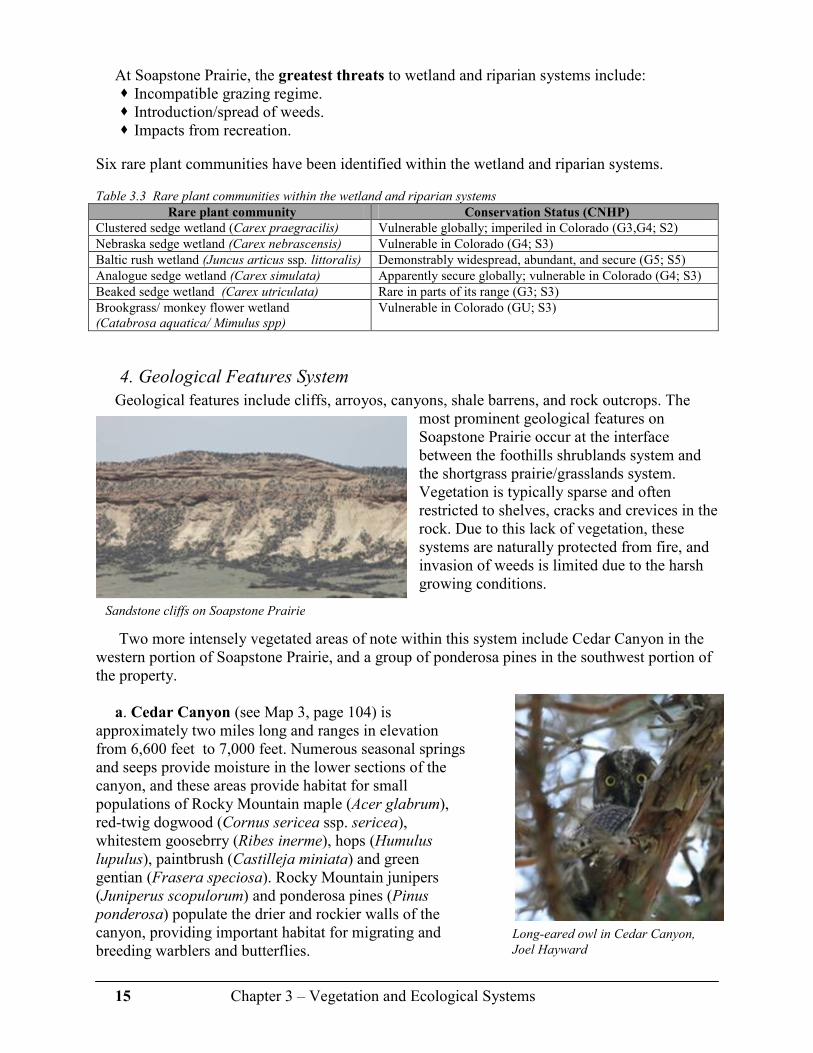
Two more intensely vegetated areas of note within this system include Cedar Canyon in the western portion of Soapstone Prairie, and a group of ponderosa pines in the southwest portion of the property.
a. Cedar Canyon (see Map 3, page 104) is
approximately two miles long and ranges in elevation from 6,600 feet to 7,000 feet. Numerous seasonal springs and seeps provide moisture in the lower sections of the canyon, and these areas provide habitat for small populations of Rocky Mountain maple (Acer glabrum), red-twig dogwood (Cornus sericea ssp. sericea), whitestem goosebrry (Ribes inerme), hops (Humulus lupulus), paintbrush (Castilleja miniata) and green gentian (Frasera speciosa). Rocky Mountain junipers (Juniperus scopulorum) and ponderosa pines (Pinus ponderosa) populate the drier and rockier walls of the canyon, providing important habitat for migrating and breeding warblers and butterflies.
Sandstone cliffs on Soapstone Prairie

16 Chapter 3 – Vegetation and Ecological Systems
b. An isolated, nearly pure stand of ponderosa pines populates the east-facing, rocky hillsides of the Tree Pasture in the southwest portion of the property (see Map 3, page 104). The
trees appear to be confined to a fine, gray shale underlying red sandstone, and occur at the ecotone between ponderosa pine woodland and shortgrass prairie. In 2005, twelve trees were cored revealing pith dates ranging from 1462 to 1902, with the majority of the pith samples dating to the 1700’s to mid 1800’s.2 Understory vegetation within this stand includes skunkbrush (Rhus trilobata), sandcherry (Punus pumila var. besseyi) and prairie golden banner (Thermopsis rhombifolia).
Natural processes that affect the geological features at Soapstone Prairie include: � Climate (especially drought). � Erosion caused by wind and heavy rains/flooding.
The greatest threats to the geological features system are:
� Incompatible grazing. � Recreation impacts related to poor trail placement and increased erosion.
B. Rare and Threatened Plants
1. Colorado butterfly plant (Gaura neomexicana ssp. coloradensis)
Soapstone Prairie is home to the Colorado butterfly plant, a federally listed Threatened species under the Endangered Species Act since 2000. This subspecies is also considered imperiled globally, and is among the most threatened plants in the state of Colorado. Colorado butterfly plant is a short-lived perennial herb found only in southeastern Wyoming, western Nebraska, and northeastern Colorado. Narrow green leaves form at the base, and when in bloom, it reaches 20-32 inches tall. The four-petaled white, airy flowers turn pinkish-red with age. Each plant may live up to five years, but blooms only once, sets seed and then dies.
Colorado butterfly plant grows in moister areas surrounded by mixed grass prairie or in areas between streams and prairie, at elevations of 5,800 feet to 6,200 feet. On Soapstone Prairie, the Colorado butterfly plant occurs in wet meadows in the northeastern portion of the property. This population is considered in very good condition; in 2006, more than 11,000 blooming plants were found occupying 650 acres. Since not all plants are in bloom the same year, NAP staff estimated a total population of approximately 35,000 – 47,000 plants.
Several ponderosa pines on site were dated to the
15th century
Colorado butterfly plant

17 Chapter 3 – Vegetation and Ecological Systems
2. Rocky Mountain blazing star (Liatris ligulistylis)
Rocky Mountain blazing star is a common species across its range, but based on current known distribution, it appears to be quite rare in Colorado. Only 11 occurrences have been documented in the state, and most of those records provide only very general information. Only five occurrences have been seen since the early 1900s – all on publicly owned land along the Front Range. Rocky Mountain blazing star is a clump-forming perennial with narrow, strap-like leaves and 8-12” tall spikes of rose-purple flowers that appear in late summer that are attractive to hummingbirds and butterflies. This species occurs in specific wet meadow habitats that are not very common, and may be highly susceptible to loss as a result of residential development, associated fire suppression, altered hydrology, and other causes of wetland loss.
3. Pale blue-eyed grass (Sisyrinchium pallidum)
Very little is known about this locally abundant, yet globally imperiled member of the iris family. Worldwide, it is found in a narrow band from central northern Colorado into south-central Wyoming, preferring poorly-drained meadows with standing water early in the growing season. There are over 39 populations in Colorado currently known in existence (three documented in Larimer County), but their habitats are potentially threatened by alterations to wetland water sources. This species is distinguished from other blue-eyed grasses by its pale blue flowers growing atop 10-12” tall stems with olive-green, grass-like foliage.
At Soapstone Prairie, the greatest threats to rare and threatened plants include: � Incompatible grazing regime. � Introduction/spread of weeds. � Weed control methods. � Change in hydrology due to loss of ground water or changes in surface flow.
There are three threatened and imperiled plants within the wetland and riparian systems.
Table 3.4 Threatened and imperiled plants within the wetland and riparian systems
Ecosystem Rare Plant Conservation Status (CNHP)
Colorado butterfly plant Gaura neomexicana ssp. coloradensis
Federally threatened (G3; S1)
Rocky Mountain blazing star Liatris ligulistylis
Critically imperiled in Colorado (G5?; S1,S2)
North American Arid
West Emergent
Marsh
Pale blue-eyed grass Sisyrinchium pallidum
Imperiled globally (G2; S2)
Rocky Mountain blazing star
Pale blue-eyed grass
18 Chapter 3 – Vegetation and Ecological Systems
C. Weeds Because the land at Soapstone Prairie has been so carefully managed by previous owners,
weed problems are currently relatively minor. Surveys conducted in 2006 by NAP staff identified nine Category B species (managed to contain the spread of infestations) and seven Category C species (managed where deemed appropriate by county weed districts) as identified by the Colorado Noxious Weed Act. No category “A” species (managed for eradication) have been found, but monitoring for these species is a priority and will continue on an ongoing basis.
Table 3.5 Colorado Noxious Weeds found at Soapstone Prairie
Category “B” species Category “C” species
Hoary cress (Cardaria draba) Common burdock (Arctium minus)
Musk thistle (Carduus nutans) Cheatgrass (Bromus tectorum)
Canada thistle (Cirsium arvense) Poison hemlock (Conium maculatum)
Bull thistle (Cirsium vulgare) Field bindweed (Convolvulus arvensis)
Houndstongue (Cynoglossum officinale) Halogeton (Halogeton glomeratus)
Redstem filaree (Erodium cicutarium) Perennial sowthistle (Sonchus arvensis)
Russian olive (Elaeagnus angustifolia) Common mullein (Verbascum thapsus)
Leafy spurge (Euphorbia esula)
Dalmatian toadflax (Linaria dalmatica)
Chapter 3 References 1 Grunau, L., S. Neid, and R. Rondeau. 2006. Preliminary management plan outline for
Soapstone Prairie Natural Area. Unpublished report prepared for City of Fort Collins Natural Areas Program. Colorado Natural Heritage Program, Colorado State University, Fort Collins, CO. 46pp
2 Huckaby, L.S. 2005. Ponderosa pine ages at Soapstone Prairie. 9pp.
Additional Resources
Doyle, G.A., Neid, S.L., and R.J. Rondeau. 2005. Survey of critical biological resources Larimer County, Colorado 2004. Colorado Natural Heritage Program. 367pp
Flora of North America Editorial Committee, eds. 1993+. Flora of North America North of
Mexico. 12+ vols. New York and Oxford. (Online at: www.efloras.org) Kettler, S., J. Sanderson, S. Spackman, K. Fayette, C. Pague, D. Clark, and A. Hicks. 1996.
Significant Plant, Animal, and Wetland Resources of Larimer County and Their Conservation. Colorado Natural Heritage Program. 293pp
USDA, NRCS. 2007. The PLANTS Database, National Plant Data Center, Baton Rouge, LA
70874-4490 USA. (Online at: http://plants.usda.gov)

19 Chapter 4 – Wildlife Resources
Chapter 4
Wildlife Resources Soapstone Prairie supports a full suite of wildlife species typically found within the foothills
and plains of Colorado. Examples of significant species that are known to occur on Soapstone Prairie include mule deer, American elk, pronghorn, swift fox, black-tailed prairie dog, golden eagle, ferruginous hawk, burrowing owl, a diverse community of shrubland birds, and many grassland birds. In addition, Soapstone Prairie provides important breeding habitat for large ungulates, birds of prey and songbirds, and critical wintering habitat for pronghorn. In planning for visitor use on Soapstone Prairie, it will be important to balance the needs of the wildlife with the timing and location(s) of recreation.
The following sections describe the most significant species known to occur on the property, and the conditions or events which may have impact upon those populations. Much of this chapter is adapted from the 2004 report from the Colorado Natural Heritage Program and the Soapstone Ranch Avian Inventory and Monitoring: Year 1 Report, January 2007 from the Rocky Mountain Bird Observatory.
Note 2: Conservation Status references
In addition to the Colorado Natural Heritage Program ranking system (see page 12), this Plan also references the Colorado Division of Wildlife (CDOW), which tracks Federal and State Threatened and Endangered wildlife species, and maintains lists of species of conservation concern. Species selection is based on quality of habitat, and population densities and population trends. The CDOW also manages habitat and species conservation status through recovery and conservation plans.
The CDOW status codes are as follows: � FE = Federally Endangered � FT = Federally Threatened � SE = State Endangered � ST = State Threatened � SC = State Special Concern (not a statutory category). � Colorado’s Comprehensive Wildlife Conservation Strategy and Wildlife Action
Plans (2006) 1 further categorizes species into Tier 1 and Tier 2 Species of
Greatest Conservation Need.
Swainson’s hawk,
Jeff Jones

20 Chapter 4 – Wildlife Resources
A. Mammals Soapstone Prairie’s diverse and high quality ecological systems and abundant water sources
offer superior habitat for migrating and resident mammals, including American elk, mule deer, pronghorn, black-tailed prairie dogs, coyotes, swift fox, and more. Since 2006, spotlight surveys, remote cameras and visual observations by staff and others have helped to determine mammal populations on the property. Staff will continue to collect information regarding mammal populations – Appendix 8 lists known and potential mammal species on the property.
1. Species of Greatest Conservation Need
According to the CDOW and CNHP, the two mammal species found on Soapstone Prairie of greatest conservation concern are black-tailed prairie dogs (Cynomys ludovicianus) and swift fox (Vulpes velox).
a. Black-tailed prairie dog Black-tailed prairie dogs are considered by many to be a keystone species in prairie
ecosystems with many other wildlife species found in association with the colonies. In Colorado, this species is listed as a species State Special Concern and Tier 1 Species of Greatest Conservation Need.1 In 2006, Soapstone Prairie supported approximately 534 acres of occupied prairie dog colonies, primarily in the Jack Springs pasture. Change in distribution from 2004 through 2006 indicates this species is expanding on the property.
Even though extensive surveys for all wildlife types have not been completed, several species often found in association with large prairie dog colonies have been found. These include burrowing owls and mountain plover. Rocky Mountain Bird Observatory research in 2006 also found McCown’s longspurs to be especially abundant on prairie dog towns. In addition, prairie dogs are a significant food resource for ferruginous hawks. All of these birds are of State Special Concern.
At Soapstone Prairie, the greatest threats to black-tailed prairie dog communities are: � Sylvatic plague (naturally occurring). � Boundary issues with neighbors. � Weed control measures.
b. Swift fox
According to CNHP, this species is considered vulnerable across its range (G3) and in Colorado (S3) and the CDOW lists swift fox as a Tier 1 Species of Greatest Conservation Need. Swift fox inhabit shortgrass prairies with dens on slopes, ridges,
Swift fox, Bruce Gill
Black-tailed prairie dog, Joel Hayward

21 Chapter 4 – Wildlife Resources
or flat areas that offer good views of surrounding land. Dens are used year-round for protection in inclement weather and predator evasion, in addition to rearing of young. Swift fox and swift fox dens have been documented on Soapstone Prairie.
At Soapstone Prairie, the greatest threats to swift fox populations are difficult to quantify but
may include: � Human disturbance that affects movement corridors. � Human disturbance that affects den sites. � Possible disease transmission such as canine distemper and rabies from domestic dogs.2 � Predation by coyotes. � Reduced numbers if red fox populations expand into the area, or if coyote abundance
increases.
2. Big Game
a. Pronghorn
Historically, pronghorn (Antilocapra americana) were considerably more abundant than they are today. Pronghorn are an indicator of overall prairie health, and presence of pronghorn on Soapstone Prairie is visible indication that the native prairie ecosystem is intact and functioning. In addition, pronghorn are among the most easily observed and recognizable animals on site. Soapstone Prairie falls within a pronghorn concentration area, and provides critical winter range during severe weather.
b. Mule deer and
American elk
Mule deer and American elk routinely occupy Soapstone Prairie, especially the shrublands and drainages in the western portion of the property, though specific densities and critical range need further investigation. The mountain mahogany shrublands appear to offer high quality calving habitat for elk, but whether or not there are specific calving areas on Soapstone Prairie needs to be confirmed.
American elk, Dale Greer
Pronghorn in winter

22 Chapter 4 – Wildlife Resources
This is one of the last places in Colorado where American elk, a prairie species, still wander onto the plains. Deer and elk that inhabit Soapstone Prairie are part of larger populations that occupy connected habitats in the surrounding landscape (e.g., Red Mountain Open Space and other adjacent public and private lands).
At Soapstone Prairie, the greatest threats to big game (deer, elk, and pronghorn) are: � Human disturbance during calving season. � Human disturbance during critical winter periods. � Loss of movement corridors from development of the property as a City-owned natural
area.
3. Bats
Very little is currently known about bat populations on Soapstone Prairie, though hoary bat (Lasiurus cinereus) and long-eared myotis (Myotis evotis) have been documented on the property. Soapstone Prairie is relatively limited in terms of potential roosting and feeding areas, but bats are likely to occur around rock outcrops and cliffs and in areas where there are trees. There are no bats of conservation concern known on the property. Common species of bats likely to inhabit the area tend to roost singly rather than in groups, especially in areas where there are no caves or mines, so it is unlikely that communal roosting or hibernation sites would occur. In the absence of communal roosting sites or hibernation sites, there is little concern for adverse impacts to bats from anticipated future management on Soapstone Prairie.
4. Small mammals
Very little is currently known about small mammal populations on Soapstone Prairie; no small mammals of conservation concern have been documented on the property. The olive-backed pocket mouse (Perognathus fasciatus) is the only small mammal species tracked by Colorado Natural Heritage Program that may occur on the property. The olive-backed pocket mouse inhabits shortgrass, mixed grass, and shrublands/mixed grass steppe habitats. In addition, there are many common species of small mammals that typically inhabit the types of habitats found on Soapstone Prairie, and the site presumably supports many of them. Impacts to small mammals are not likely to occur from anticipated future management plan implementation.
5. Carnivores
Coyotes, black bear, bobcat, mountain lion, and other species have been sighted at Soapstone Prairie. It is highly probable that some or all of these species utilize the property as part of a larger home range and travel between Soapstone Prairie, Red Mountain Open Space and other surrounding lands.
Threats to carnivores on Soapstone Prairie include: � Human disturbance. � Impacts to movement corridors. � Changes in prey populations.

23 Chapter 4 – Wildlife Resources
B. Birds Rocky Mountain Bird Observatory documented 113
species of birds on Soapstone Prairie between May and June of 2006; 17 additional species were added to this list after the 2007 field season.
The large numbers of avian species indicate a robust and nearly intact bird community exists on the property. Management of Soapstone Prairie will strive to maintain this level of diversity through a combination of habitat and recreation management. A complete list of avian species can be found in Appendix 9.
Soapstone Prairie is expected to be very popular with birders. Highest priority destinations will likely be prairie dog communities (mountain plover), wetlands (savannah sparrows), the Roman Pasture area (migrants), and canyons (owls). Guided tours will be offered to trail-less areas during non-breeding season. Trails through critical breeding areas will be closed seasonally to reduce human impact.
1. Grasslands Ecosystem Birds
Soapstone Prairie supports many grasslands and prairie bird species, including: burrowing owl, mountain plover, McCown’s longspur, chestnut-collared longspur, long-billed curlew, horned lark, lark bunting, grasshopper sparrow, and loggerhead shrike. In addition, Cassin’s sparrow, though not yet documented on the property, is potentially present.
Historically, the native shortgrass landscape was a series of habitat patches created by grazing animals and ranged from extensive disturbance to areas of infrequent or no grazing.3 As such, shortgrass prairie bird communities require a mosaic of grass heights, from very short grass with a high percent of bare ground, to taller grass with more structure, including some shrubs. Of the prairie birds documented at Soapstone Prairie, those of highest conservation priority (mountain plover, burrowing owl, and McCown’s longspur) require sites within the shortgrass prairie created through heavy grazing pressure and high levels of surface disturbance. 3
Active prairie dog colonies create important habitat for several species of grassland birds. The same three species of highest conservation priority have been found to be especially abundant on
Note 3: Conservation Status references
Partners in Flight (PIF) is an international, cooperative effort focusing on most landbirds and other bird species requiring terrestrial habitats and which migrate or travel between North and South America. The central premise of PIF is that the resources of public and private organizations of both continents must be combined, coordinated, and increased in order to achieve success in conserving bird populations in this hemisphere.
PIF rankings are based on six species assessment factors: population size, breeding and non-breeding distribution, threats to breeding and non-breeding conditions, and population trends. The two primary rankings are:
� RC: species of Regional Concern
� CC: species of Continental Concern
Loggerhead shrike, Jeff Jones

24 Chapter 4 – Wildlife Resources
prairie dog towns found on Soapstone Prairie. The grazing and surface disturbance created by active prairie dog towns creates habitat suitable for these species.
The other species of conservation concern found on Soapstone Prairie are adapted to moderate and light grazing regimes. Management of this group of species will focus on using grazing management techniques (through selected species) to create a shortgrass landscape similar to that found historically.
At Soapstone Prairie, the greatest threats to grasslands birds include: � Grazing regimes that destroy or fail to create habitat mosaics historically found within the
shortgrass prairie. � Human activity (presence during critical periods). � Weeds.
Table 4.1 Conservation status of significant grasslands and shrublands bird species (see Appendix 9 for complete
species list)
Common Name CDOW Status 1 PIF
Designation
4
Mountain plover Greatest Conservation Need not listed
Common nighthawk not listed Regional Concern
Burrowing owl Greatest Conservation Need Regional Concern
Red-headed woodpecker not listed Continental Concern , Regional Concern
Loggerhead shrike Greatest Conservation Need Regional Concern
Brewer's sparrow Greatest Conservation Need Continental Concern , Regional Concern
Lark sparrow not listed Regional Concern
Lark bunting Greatest Conservation Need Continental Concern , Regional Concern
Vesper sparrow Greatest Conservation Need not listed
Savannah sparrow not listed not listed
Grasshopper sparrow Greatest Conservation Need Regional Concern
McCown's longspur Greatest Conservation Need Continental Concern
Chestnut-collared longspur Greatest Conservation Need Regional Concern
Virginia’s warbler not listed not listed
2. Shrublands, Wetlands and Riparian Ecosystem Birds
By the end of 2006, Rocky Mountain Bird Observatory had not yet conducted transect research in the shrublands or western riparian systems. Initial observations suggest that these ecosystems support a diverse bird community, and could represent habitat types (high quality shrublands/grassland interface) that are otherwise lost on the Front Range.
� Brewer’s sparrows, normally a sagebrush migrant species, are unique for this area, found in the interface between the mountain mahogany shrublands and
shortgrass prairie/grasslands on Soapstone Prairie. This species has declined by more than 50% over 30 years, potentially due to loss of
shrub/grass interface and sagebrush habitats. � Junipers and pine in canyon areas are important for Virginia’s
warblers and long-eared owls. � Chokecherry habitat in drainages on Soapstone Prairie is
important for McGillivray’s warblers. � Yellow warblers and yellow-breasted chats, as well as
many migrants, are found in areas that support Prairie falcon, Tony Leukering

25 Chapter 4 – Wildlife Resources
willows and accompanying plant communities. Yellow warblers are tied exclusively to this type of vegetation.
� Washes out of foothills and into grasslands with sumac shrubs support green-tailed towhees. Soapstone Prairie represents the eastern edge of its geographic range.
At Soapstone Prairie, the greatest threats to shrublands birds are: � Human disturbance from dispersed recreation (this may have a much greater impact than
on-trail recreational use). � Human disturbance during nesting period (mid-May to mid-July). � A possible increase in brown-headed cowbird abundance associated with equestrian use.
Table 4.2 Conservation status of significant wetland and riparian ecosystems bird species (see Appendix 9 for
complete species list)
Common Name CDOW Status 1 PIF
Designation
4
Northern harrier Greatest Conservation Need Regional Concern
Short-eared owl Greatest Conservation Need Continental Concern
Long-billed curlew Greatest Conservation Need not listed
Yellow warbler not listed Regional Concern
Yellow-breasted chat not listed not listed
3. Birds of Prey
Birds of prey include raptors such as eagles, hawks and falcons, as well as owls and harriers. Nesting birds of prey on Soapstone Prairie include golden eagle, ferruginous hawk, Swainson’s hawk, red-tailed hawk, prairie falcon and American kestrel. Other raptor species have been sighted on site during the breeding and nesting season, but no nests have been found.
Birds of prey play an important role in the ecological processes at Soapstone Prairie, feeding on many of the small to mid-sized mammals, rodents, snakes, and larger insects such as grasshoppers. Many raptor populations are declining regionally, in part due to disturbance, habitat loss, habitat fragmentation, and direct mortality from poisoning and prey reduction.1
Birds of prey also often need large foraging areas of high quality habitat such as that found on Soapstone Prairie.
Table 4.3 Conservation status of significant raptor species (see Appendix 9 for complete species list)
Common Name CDOW Status 1 PIF
Designation
4
Swainson's hawk Greatest Conservation Need Continental Concern
Ferruginous hawk Greatest Conservation Need Regional Concern
Golden eagle Greatest Conservation Need not listed
Peregrine falcon Greatest Conservation Need not listed
Prairie falcon Greatest Conservation Need Regional Concern
Northern harrier Greatest Conservation Need Regional Concern

26 Chapter 4 – Wildlife Resources
a. Golden eagles
Golden eagles are the largest nesting raptor species on Soapstone Prairie and are listed as a Tier 1 species of Greatest Conservation Need in Colorado.1 Two large golden eagle nests are situated on the south-facing cliffs at the shrublands/grasslands interface. These nests have been active since the purchase of the property, and evidence suggests the nests were active several
years prior to the City’s acquisition. Golden eagle populations are relatively stable in Colorado, but threats to their survival, such as poisoning, prey reduction (through rodent control), habitat loss and collisions with vehicles and power lines are increasing in occurrence.1
b. Ferruginous hawks
Ferruginous hawks are also a CDOW Tier 1 Species of Greatest Conservation Need and a PIF species of Regional Concern. Their population status is low but relatively stable.1 These large hawks require open country for foraging, especially prairies, plains and badlands. Prairie dogs are their primary food source but they also feed on small mammals such as rabbits and ground squirrels. In Colorado, ferruginous hawk nests are usually
built in trees near streams or on steep slopes. A large ferruginous hawk nest, located in a tree in an upper tributary of Sand Creek, has been
used for many years. A second nest is located along the southern boundary, just west of Upper Jack Springs.
c. Other Raptors
At least two red-tailed hawk nests have been documented on Soapstone Prairie. Swainson’s hawks and northern harriers have been observed hunting in the eastern portion of the property. Swainson’s hawks are a Partners in Flight (PIF) species of Continental Concern and northern harriers are PIF species of Regional Concern. Prairie falcons, American kestrels, sharp-shinned and Cooper’s hawks have also been documented on the site. Peregrine falcons have been observed on the western rim of the property. 5
d. Owls
Several species of owls were observed or heard during the 2006 Rocky Mountain Bird Observatory bird survey, but nesting sites have yet to be documented. These species include barn owl, great horned owl, long-eared owl, short-eared owl, barn owl and burrowing owl (detailed in the Grassland birds section - see previous.)
The greatest threats to birds of prey at Soapstone Prairie are: � Human activity near nesting and foraging areas. � Activities associated with visitor facilities (trails, parking areas, etc.).
Ferruginous hawk nest in cottonwood

27 Chapter 4 – Wildlife Resources
C. Insects In general, little is known about the status and distribution of invertebrate wildlife when
compared to vertebrate communities. This trend is true for Soapstone Prairie. At Soapstone Prairie, the greatest threat to insect populations could include routine weed and pest control.
1. Butterflies
Butterfly surveys were conducted on Soapstone Prairie in May and June of 2004 by the Colorado Natural Heritage Program.6 Eighteen common species were documented, and represent all habitat types present on the property. No rare butterflies or species of conservation concern were found. Climatic conditions in 2004 were uncommonly dry due to several years of drought and may have depressed butterfly diversity and abundance compared to what would be expected given the diversity of the area. Additional surveys were conducted in 2007 in an effort to better define the butterfly and moth community of Soapstone Prairie. Habitat priorities for future surveys are wetland areas, dry arroyos and exposed ridges in grassy areas.
Ten species of rare or imperiled butterfly species could potentially inhabit Soapstone Prairie.
Table 4.4 Potential butterfly species
Common name Scientific name CNHP Conservation status Habitat notes
Colorado blue Euphilotes rita
coloradensis
Vulnerable to imperiled across its range; imperiled in Colorado (T2T3; S2)
Transition zone prairies; habitat is threatened
Smokey-eyed brown
Satyrodese eurydic
fumosa
Common to vulnerable across its range; critically imperiled in Colorado (T3T4; S1)
Sedge meadows/ marshes in prairies
Mottled dusky wing
Erynnis martialis Vulnerable to common across its range; vulnerable to imperiled in Colorado (G3G4; S2S3)
Shrubby foothills
Two-banded skipper
Pyrgus ruralis Secure across its range; vulnerable in Colorado (G5; S3)
Forest clearings and meadows along streams
Simius roadside skipper
Amblyscirtes
simius
Common across its range; vulnerable in Colorado (G4; S3)
Short and mixed grass, shaley prairies, hillsides, and grassy openings in pinon-juniper
Arogos skipper Atrytone arogos Vulnerable across its range; imperiled in Colorado (G3; S2)
Moist, sloping prairie meadows in foothills canyons and ridges
Dusted skipper Atrytonopsis
hianna
Common to secure across its range; imperiled in Colorado (G4G5; S2)
Transition zones, open dry fields, open woodland, and prairie gulches
Two-spotted skipper
Euphyes bimacula Common across its range; imperiled in Colorado (G4; S2)
Sedge meadows
Crossline skipper Polites origenes Secure across its range; vulnerable in Colorado (G5; S3)
Grasslands, sandy barrens, canyon openings near plains, swales and grassy meadows adjoining foothills
Rhesus skipper Polites rhesus Common across its range; vulnerable to imperiled in Colorado (G4; S2S3)
Short and mixed grass prairie
Juniper hairstreak on yarrow

28 Chapter 4 – Wildlife Resources
D. Amphibians and Reptiles Very little is known about the amphibian and reptile
populations on Soapstone Prairie. A field inventory will be conducted to support analysis of current status and future impacts to amphibian and reptile species.
Soapstone Prairie is likely to support the northern leopard frog (currently petitioned for federal listing), based on documented occurrence of this species in the Jack Springs wetland system on neighboring Meadow Springs Ranch.
Primary concerns for potential threats to amphibians at Soapstone Prairie include: � Weeds and weed control in wetland habitats. � Reduced water quality and altered vegetation related to incompatible cattle grazing. � Chytrid fungus if Northern leopard frogs are documented. There is little concern for adverse impacts to reptiles from anticipated future management.
Rattlesnakes, documented on the site, could pose a concern to recreational users.
E. Fish Spottlewood Creek and Graves Creek both have a persistent water supply through much of
the year, and fish surveys are scheduled to be completed during the summer of 2007. Prairie wetlands and riparian systems are declining regionally, and the CDOW rates eastern plains streams as habitats of high priority for conservation.3 At least four species of native fish are possible in the riparian system on Soapstone Prairie.
Table 4.5 Potential native fish species that could be found in Spottlewood Creek and Graves Creek
Common name Scientific name CNHP status CDOW status
Iowa Darter Etheostoma exile Globally secure, vulnerable throughout Colorado (G5; S3)
Plains Topminnow Fundulus sciadicus Apparently secure globally and statewide, though may be quite rare in parts of its range (G4; S4)
Brassy Minnow Hybognathus hankinsoni Globally secure, vulnerable throughout Colorado (G5; S3)
State threatened
Common Shiner Luxilus cornutus Globally secure; imperiled in Colorado (G5; S2 )
State threatened
F. Potential Reintroductions Some native prairie wildlife that were historically present on or near Soapstone Prairie no
longer exist on the site. These include the black-footed ferret, American bison, and plains sharp-tailed grouse. It may be possible to reintroduce any or all of these species to the area. The Colorado Division of Wildlife is responsible for wildlife species in the state and any reintroductions would be conducted in coordination with them.
Bull snake in aggressive pose
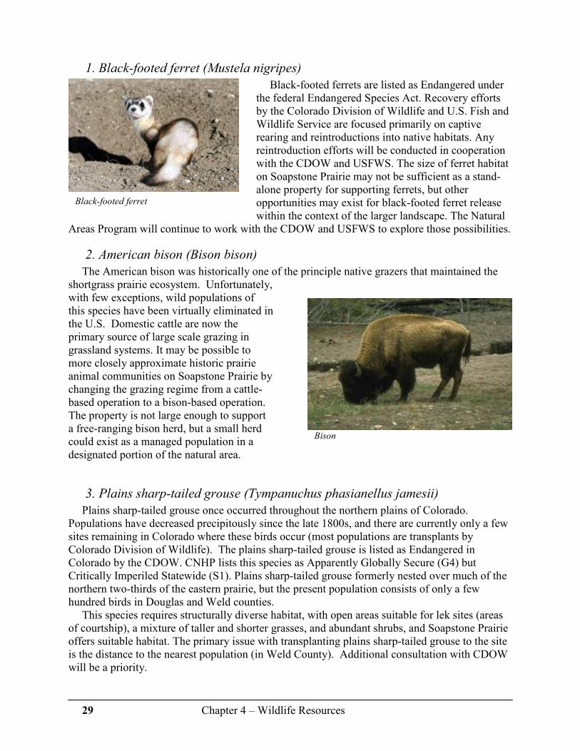
29 Chapter 4 – Wildlife Resources
Bison
1. Black-footed ferret (Mustela nigripes)
Black-footed ferrets are listed as Endangered under the federal Endangered Species Act. Recovery efforts by the Colorado Division of Wildlife and U.S. Fish and Wildlife Service are focused primarily on captive rearing and reintroductions into native habitats. Any reintroduction efforts will be conducted in cooperation with the CDOW and USFWS. The size of ferret habitat on Soapstone Prairie may not be sufficient as a stand-alone property for supporting ferrets, but other opportunities may exist for black-footed ferret release within the context of the larger landscape. The Natural
Areas Program will continue to work with the CDOW and USFWS to explore those possibilities.
2. American bison (Bison bison)
The American bison was historically one of the principle native grazers that maintained the shortgrass prairie ecosystem. Unfortunately, with few exceptions, wild populations of this species have been virtually eliminated in the U.S. Domestic cattle are now the primary source of large scale grazing in grassland systems. It may be possible to more closely approximate historic prairie animal communities on Soapstone Prairie by changing the grazing regime from a cattle-based operation to a bison-based operation. The property is not large enough to support a free-ranging bison herd, but a small herd could exist as a managed population in a designated portion of the natural area.
3. Plains sharp-tailed grouse (Tympanuchus phasianellus jamesii)
Plains sharp-tailed grouse once occurred throughout the northern plains of Colorado. Populations have decreased precipitously since the late 1800s, and there are currently only a few sites remaining in Colorado where these birds occur (most populations are transplants by Colorado Division of Wildlife). The plains sharp-tailed grouse is listed as Endangered in Colorado by the CDOW. CNHP lists this species as Apparently Globally Secure (G4) but Critically Imperiled Statewide (S1). Plains sharp-tailed grouse formerly nested over much of the northern two-thirds of the eastern prairie, but the present population consists of only a few hundred birds in Douglas and Weld counties.
This species requires structurally diverse habitat, with open areas suitable for lek sites (areas of courtship), a mixture of taller and shorter grasses, and abundant shrubs, and Soapstone Prairie offers suitable habitat. The primary issue with transplanting plains sharp-tailed grouse to the site is the distance to the nearest population (in Weld County). Additional consultation with CDOW will be a priority.
Black-footed ferret

30 Chapter 4 – Wildlife Resources
Chapter 4 References 1 Colorado Division of Wildlife. 2006. Colorado’s Comprehensive Wildlife Conservation
Strategy and Wildlife Action Plans. Denver, CO. 328 pp. (online at: http://wildlife.state.co.us/NR/rdonlyres/D26A4806-8776-4460-831E-AA654EC7DDED/0/CWCS_FinalReport2006.pdf)
2 Sime, C. A. 1999. Domestic Dogs in Wildlife Habitats. Pages 8.1-8.17 in G. Joslin and H.
Youmans, coordinators. Effects of recreation on Rocky Mountain wildlife: A Review for Montana. Committee on effects of Recreation on Wildlife, Montana Chapter of The Wildlife Society. 307pp.
2 Samson, F.B. and F.L. Knopf. 1996. Prairie conservation: preserving North America’s most
endangered ecosystem. Edited by Fred B. Samson and Fritz L. Knopf. Island Press 339 pp. 4 Rich, T. D., C. J. Beardmore, H. Berlanga, P. J. Blancher, M. S. W. Bradstreet, G. S.
Butcher, D. W. Demarest, E. H. Dunn, W. C. Hunter, E. E. Iñigo-Elias, J. A. Kennedy, A. M. Martell, A. O. Panjabi, D. N. Pashley, K. V. Rosenberg, C. M. Rustay, J. S. Wendt, T. C. Will. 2004. Partners in Flight North American Landbird Conservation Plan. Cornell Lab of Ornithology. Ithaca, NY. (online at: www.partnersinflight.org/cont_plan/ )
5 Sparks, R.A., A.O. Panjabi, and D.J. Hanni. 2006. Soapstone Avian Inventory and
Monitoring: Year 1. Rocky Mountain Bird Observatory. Technical Report #M-Soapstone06-01. 38pp.
6 Doyle, G.A., Neid, S.L., and R.J. Rondeau. 2005. Survey of critical biological resources
Larimer County, Colorado 2004. Colorado Natural Heritage Program 367pp.
Additional Resources
Hickman, S. 1990. Evidence of edge species’ attraction to nature trails within deciduous forests. Natural Areas Journal 10:3-5
Hillman, C.N. and T.W. Clark. 1980. Mustela nigripes. American Society of
Mammalogists. Mammalian species no. 126. pp 1-3. Luce, R.J. 2006. Areas where habitat characteristics could be evaluated to identify potential
black-footed ferret reintroduction sites and develop conservation partnerships. In Recovery of the black-footed ferret: progress and continuing challenges. Proceedings of the symposium on the status of the black-footed ferret and its habitat, Fort Collins, CO, January 28-29, 2004, J.E. Roelle, B.J. Miller, J.L. Godbey, and D.E. Biggins, eds. U.S. Geological Survey Scientific Investigations Report 2005-5293.

31 Chapter 5 – Cultural Resources
Chapter 5
Cultural Resources The human history of Soapstone Prairie Natural Area and the surrounding area transcends the
past 12,000 years, beginning with the Clovis (up to approximately 13,000 years ago) and Folsom periods (to approximately 12,000 years ago) Over the millennia, people have had a presence upon the land and have utilized its abundant natural resources almost continuously since those earliest times. More recent occupants of the site include American Indian tribes, homesteaders and ranchers. Soapstone Prairie is filled with evidence of many of these people, and protection and interpretation of its cultural resources are a primary focus of this management plan.
A. The Lindenmeier Valley - The Paleo-Indian Period (12,000 – 8,500 years Before Present [BP])
The Lindenmeier Archaeological Site sits in the central portion of the Soapstone Prairie property near a tributary of the Rawhide Creek. It is an integral component of the larger archaeological story encompassing the entire Lindenmeier Valley. The area is named for William Lindenmeier, Jr., who owned the property when the first Folsom points were discovered on site in 1924 by local artifact collectors. The Lindenmeier Archaeological Site was excavated by the Smithsonian Institution and the Colorado Museum of Natural History (now known as the Denver Museum of Nature and Science) from 1934-1940. Their extensive excavations covered more than 1,800 square meters, produced more than 5,000 lithic (stone) artifacts, numerous bone tools, more than 46,000 pieces of debitage (waste flakes), and between 10,000 and 20,000 animal bones.1 Tiny decorative beads and etched bone disks discovered here are some of the earliest and best evidence of decoration in the North America, and these artifacts date back to a culture living more than 11,000 years ago. While the majority of the artifacts are in repository at the Smithsonian Institution’s National Museum of Natural History in Washington, D.C., many of these artifacts are archived at the Fort Collins Museum. A smaller collection is housed at the Denver Museum of Nature and Science
The Lindenmeier Valley
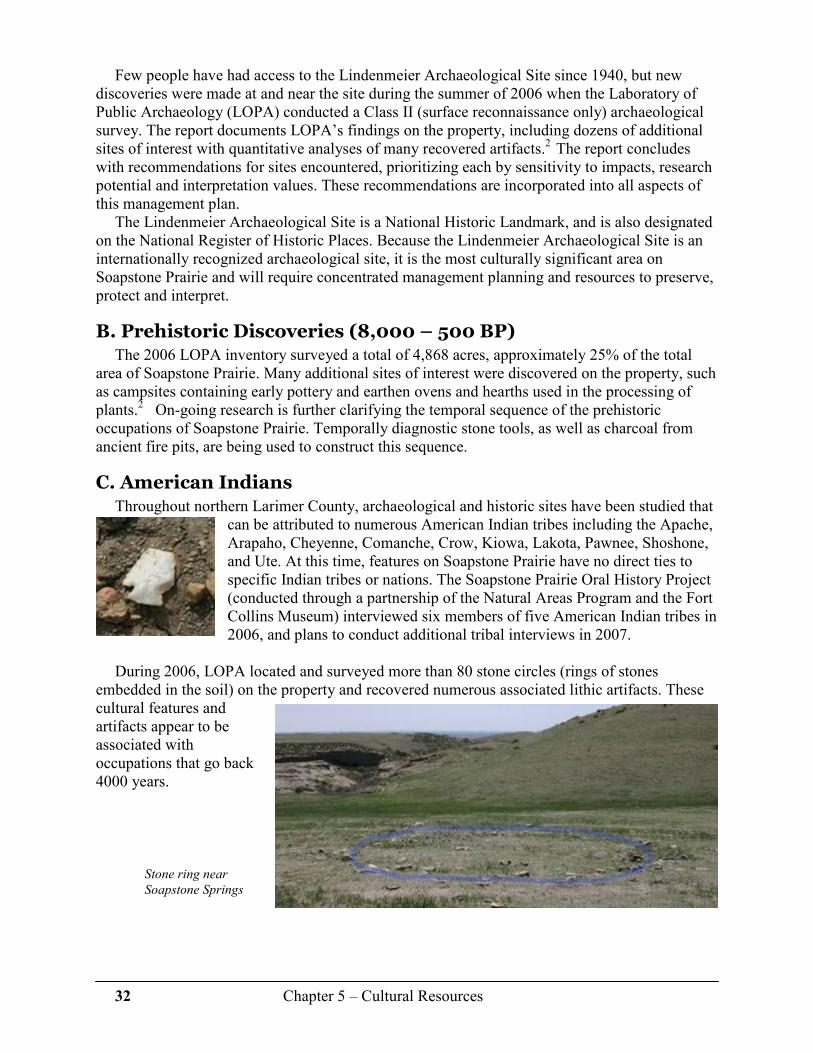
32 Chapter 5 – Cultural Resources
Few people have had access to the Lindenmeier Archaeological Site since 1940, but new discoveries were made at and near the site during the summer of 2006 when the Laboratory of Public Archaeology (LOPA) conducted a Class II (surface reconnaissance only) archaeological survey. The report documents LOPA’s findings on the property, including dozens of additional sites of interest with quantitative analyses of many recovered artifacts.2 The report concludes with recommendations for sites encountered, prioritizing each by sensitivity to impacts, research potential and interpretation values. These recommendations are incorporated into all aspects of this management plan.
The Lindenmeier Archaeological Site is a National Historic Landmark, and is also designated on the National Register of Historic Places. Because the Lindenmeier Archaeological Site is an internationally recognized archaeological site, it is the most culturally significant area on Soapstone Prairie and will require concentrated management planning and resources to preserve, protect and interpret.
B. Prehistoric Discoveries (8,000 – 500 BP) The 2006 LOPA inventory surveyed a total of 4,868 acres, approximately 25% of the total
area of Soapstone Prairie. Many additional sites of interest were discovered on the property, such as campsites containing early pottery and earthen ovens and hearths used in the processing of plants.2 On-going research is further clarifying the temporal sequence of the prehistoric occupations of Soapstone Prairie. Temporally diagnostic stone tools, as well as charcoal from ancient fire pits, are being used to construct this sequence.
C. American Indians Throughout northern Larimer County, archaeological and historic sites have been studied that
can be attributed to numerous American Indian tribes including the Apache, Arapaho, Cheyenne, Comanche, Crow, Kiowa, Lakota, Pawnee, Shoshone, and Ute. At this time, features on Soapstone Prairie have no direct ties to specific Indian tribes or nations. The Soapstone Prairie Oral History Project (conducted through a partnership of the Natural Areas Program and the Fort Collins Museum) interviewed six members of five American Indian tribes in 2006, and plans to conduct additional tribal interviews in 2007.
During 2006, LOPA located and surveyed more than 80 stone circles (rings of stones
embedded in the soil) on the property and recovered numerous associated lithic artifacts. These cultural features and artifacts appear to be associated with occupations that go back 4000 years.
Stone ring near
Soapstone Springs

33 Chapter 5 – Cultural Resources
D. Homestead History After the Homestead Act of 1862, Euro-Americans soon began settling the area.
Homesteaders in northern Larimer County often subsisted on food produced through dryland farming, sheep and cattle grazing and other agricultural pursuits. Because of numerous hardships (e.g. drought, the Depression), many homesteaders were unsuccessful during the 1920’s – 1930’s in these various pursuits on Soapstone Prairie and found it necessary to sell their interests and move elsewhere. Several foundations and remnants of buildings left from the homesteading era exist on the property, though further research and documentation are required to identify the former occupants.
The Soapstone Prairie Oral History Project is helping to provide the needed research and documentation required to identify occupants of these homesteads, further strengthening the area’s historical richness. At least 50 interviews with local ranchers, American Indian elders, historians and others who have connections to Soapstone Prairie and the surrounding landscape will have been conducted between 2006 and 2008. Funding was made available, in part, through the U.S. National Park Service’s Preserve America Program. The results of this work will be made available through the Fort Collins Museum.
1. Bear/Roman property
The Bear family homesteaded a section (640 acres - the Roman Pasture – see Map 4 next page) in the center of what is now Soapstone Prairie in the early 1900’s. The Bears were well known in the area, and supplied labor and horse power to the Smithsonian Institution’s Lindenmeier excavations in the 1930’s. The original homestead was dugout, with another building later constructed and used as a residence and the local dance hall. The Roman family bought the property from the Bears in 1961 where they grazed cattle on their section until 2004. They constructed a small dwelling on the foundation of the Bear residence/dance hall, and used it primarily for hunting or recreating purposes. They also constructed a garage and numerous outbuildings. All electrical power was supplied by a wind charger and a gas generator, and water was obtained from an active spring. Displayed in and on the ground above the dwelling in a fenced area is a collection of antique glass bottles collected and placed there by Keith Roman’s mother. There are also other collections of cultural artifacts (e.g. stone and rock flakes and tools) and eco-artifacts (e.g. rocks) found near the dwelling and in the lower pasture.
Structures on the Bear/Roman property

34 Chapter 5 – Cultural Resources
2. Soapstone Springs School foundation
Adjacent to Soapstone Springs (see Map 4 below) sits the foundation of the Soapstone Springs School. The school was active during the local homestead era and was likely decommissioned during the rural school consolidations in the 1920’s. The remnants of a school desk leg and several other artifacts were found on this site during the LOPA 2006 archaeological survey.
Map 4* Special features on Soapstone Prairie (*see Map 4 on page 105 for larger image)
Soapstone Springs schoolhouse foundation

35 Chapter 5 – Cultural Resources
3. Soapstone Springs springhouse
This corrugated metal structure was probably built during the Warren Livestock era to protect Soapstone Springs from decimation by cattle. The spring produces water throughout most of the summer except in the driest years. A small door allows access, and two tin beverage cans, modified as drinking cups, hang from a hook inside the door.
Soapstone Springs springhouse
4. Welch dugout
This dugout, once the home of the Welch family, is built into a hillside above a spring-fed drainage that is a tributary of Sand Creek. It is believed that the original floor was dirt. Two other structures, perhaps small livestock pens, are near the dugout.
Welch dugout
5. Stone building
This two-room stone building was most likely a residence, occupied perhaps near the turn of the last century. Much of the building is still standing, though the mortar of locally native materials is disintegrating and the building is deteriorating. A second foundation sits to the south
of the main building, and an apparent root cellar is in the trees just to the southwest of the main building. Many historic artifacts, such as broken glass, horse combs, square nails, a barrel ring and more, are scattered within the vicinity of the house. There is also an abundance of prehistoric lithic artifacts found within close proximity to the building, and other sites in the general location.
Foundation of stone building

36 Chapter 5 – Cultural Resources
6. “Lindenmeier” homestead
This cluster of features includes what appears to be another stone house, a corral enclosure, a series of water troughs for livestock, a stone-walled dugout, and a barrel-enclosed spring head. It is not known who occupied this site, but it was likely homesteaded during the late 1800’s to early 1900’s. It is anecdotally reported to be the home of William Lindenmeier, Jr. before he moved to Fort Collins, but a records search has yet to be conducted.
Water troughs at
“Lindenmeier” homestead
Stone foundation of “Lindenmeier” homestead
7. Taulman homestead
The Taulman homestead foundation stands on the hillside northeast of the proposed public entrance. It may have been built in the 1920’s. The Taulmans were relatives of the Krafcziks from whom the City purchased this portion of the Soapstone Prairie property.
8. Guy homestead
The Ed Guy homestead foundation is just north of the proposed entrance along County Road 15. It is reported that this was a 2-story home, and was the first home in the region to have carbide lights. A possible grave is on the site, likely of a small child. Stone remains of a second structure, possible root cellar and animal closures are also apparent here.
Guy homestead

37 Chapter 5 – Cultural Resources
E. Ranching History The grasslands and shrublands of Soapstone Prairie have been used as grazing land by
ranching families for over 100 years. The high quality condition of these ecosystems illustrates the role that private landowners play in maintaining important habitats for wildlife. Part of the property was held by the Warren Livestock Co., a sheep and cattle company headquartered near Cheyenne, Wyoming, from the early 1900’s until 1965. The owners prior to the City of Fort Collins’ purchase (the 20 members of the Soapstone Grazing Association [SGA]), ran cattle seasonally on the property for 40 years, from 1965-2004. After the sale, ten of the SGA members formed the Folsom Grazing Association, which will continue cattle grazing on the property through 2008.
1. Graves Camp
Several ranch-related buildings, primarily from the Warren Livestock era, are in various stages of use or deterioration near Graves Creek at the locked, eastern entrance of the property. The home is currently occupied by the livestock manager of the Folsom Grazing Association. Several penciled messages from the 1920’s-1940’s are still visible on the corrugated metal walls.
Ranch buildings near Graves Creek
2. Jack Springs Camp
A collapsed livestock building, likely used from the early 1920’s into the 1960’s, sits to the north of Jack Springs.2 A wide variety of historic artifacts were documented on this site, including cans, wire, latches, hinges and a 1919 wheat penny.
Collapsed livestock building at Jack Springs Camp
3. Brannigan Springs Camp
A large collapsed pole barn structure, probably used during the Warren Livestock era, is all that’s left of this historic camp. A variety of debris, including square nails, aqua glass, cans and unidentified metal scraps were documented here.
Collapsed pole barn near Brannigan Springs

38 Chapter 5 – Cultural Resources
4. Upper Jack Springs Camp
A small, faded red corrugated metal structure is located at what is historically known as Upper Jack Springs Camp. This single-room building contains a wooden table and wooden chair, and looks to have been inhabited during the Warren Livestock era. A single, three-paned window faces east, and the entrance is protected with a small, covered alcove.
5. Castle Rock Camp
Three features, including a small building, a collapsed structure, and what appears to be a small corral, make up the remnants of Castle Rock Camp near the northern border of the property. Discarded items, including numerous metal cans, interior shelving, a bed frame and table attached to the walls give the appearance that this was inhabited over a relatively long time period, likely during the Warren Livestock era.
Castle Rock Camp building
6. Rock cairns
Organized piles of rocks (cairns), sometimes referred to as a “Stone Johnny,” are located throughout the property and were likely constructed to aid in navigation by sheepherders in the early to mid 1900’s. The largest cairn sits north of the building at Upper Jack Springs (see #4 above) on the point of a flat bench overlooking Sand Creek and Upper Jack Springs Camp. It measures 2.7 meters high, 2.3 meters wide and consists of at least 800 rocks, all of which appear to have been obtained in the immediate vicinity.2 It can be seen for several kilometers in all directions.
Rock cairn near Upper Jack Springs Camp
Metal building at Upper
Jack Springs Camp

39 Chapter 5 – Cultural Resources
7. Stage routes and railroads
Wells Fargo ran a stage route from Cheyenne to Denver from approximately 1866-1877, with a “swing station” for switching out horses at Round Butte just south of the property on Round Butte and Meadow Springs Ranches.3 The Colorado Central Railroad followed the stage route from Fort Collins to Cheyenne through Round Butte and Jack Springs until 1890. Homesteaders and ranchers on Soapstone Prairie were later serviced by the Denver Pacific Railroad through the Norfolk station near Carr. The old railroad grade is visible south of Jack Springs on the Meadow Springs property. The abundance of historic and prehistoric cultural resources on Soapstone Prairie will add to the
total visitor experience to the property. All management actions will strive to preserve, protect, and interpret these resources.
At Soapstone Prairie, the greatest threats to cultural resources are:
� Erosion and damage related to cattle use. � Natural processes, such as wind and water erosion. � Human disturbance, especially artifact collecting.
Chapter 5 References 1 Wilmsen, E., and F.H.H. Roberts, Jr. 1978. Lindenmeier, 1934-1974: Concluding Report on
Investigations. Smithsonian Contributions to Anthropology 24, Smithsonian Institution Press, Washington. 187pp
2 LaBelle, Jason and Brian, N. Andrews. 2006. Class II Archaeological Survey of the Soapstone
Prairie Natural Area, Larimer County, Colorado. LOPA Archaeology Report 07-02, Laboratory of Public Archaeology, Department of Anthropology, Colorado State University. 218 pp
3 Baker, Richard S., Summer. 1975. Overland Stage Routes and Stations in Larimer County, Fort
Collins Chronicle, V.1, No. 2.
Additional resources
Gilmore, Kevin P., Marcia Tate, Mark L. Chenault, Bonnie Clark, Terri McBride, and Margaret Wood. 1999. Colorado Prehistory: A Context for the Platte River Basin, Colorado Council for Professional Archaeologists, Denver. 403pp
Burris, Lucy. 2006. People of the Poudre, An Ethnohistory of the Cache la Poudre River
National Heritage Area AD 1500-1880. 105pp

40 Chapter 6 – Resource Management
Chapter 6
Resource Management of High Priority Conservation Targets
Identifying conservation targets, or goals, helps the Natural Areas Program (NAP) staff to
better define and guide management decisions. These targets will allow staff to: � Evaluate current conditions. � Identify potential threats to natural and cultural resources. � Measure effectiveness of management practices. � Evaluate conservation success and adapt management actions to address negative impacts. This chapter describes Soapstone Prairie Natural Area’s: � High priority conservation targets. � Potential impacts to these targets. � Projected potential management actions to maintain and/or improve the targets. In addition to conservation targets, nested targets help to provide a measurable goal. Nested
targets are a species or system that occurs on the landscape within the conservation target. Management plans that conserve primary conservation targets should also conserve nested targets.1
Nested targets:
� Require similar ecological processes to the primary conservation target. � Share similar threats with the primary conservation target. � Require management strategies similar to strategies for the primary conservation targets. Conservation targets were selected through a planning process facilitated by the Colorado
Natural Heritage Program (CNHP) that included staff from NAP along with various natural and cultural resource professionals conducting baseline inventories on Soapstone Prairie. Results of this process:
� Identified species, ecological systems, and cultural resources that warrant focused conservation attention.
� Evaluated biological integrity of significant ecological systems and species of concern, and factors that may affect viability.
� Defined management issues and desired uses for the property. � Explored the relationship(s) among significant biological and cultural resources and
potential impacts from various uses. � Delineated geographic zones that describe where conservation, recreation, and/or
production uses are most compatible and appropriate.
Conservation targets represent natural and cultural resources of the highest conservation value on Soapstone Prairie Natural Area. Selection of these conservation targets is based on a variety of attributes, including:
� Ecological systems or species that are in need of conservation. � Ability to contribute toward the conservation of habitat, species or cultural resources. � Key cultural and scenic resources.
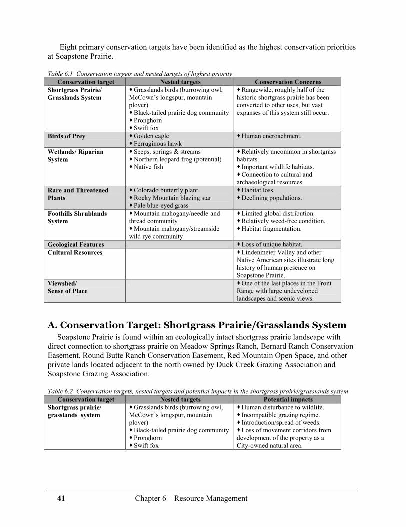
41 Chapter 6 – Resource Management
Eight primary conservation targets have been identified as the highest conservation priorities
at Soapstone Prairie.
Table 6.1 Conservation targets and nested targets of highest priority
Conservation target Nested targets Conservation Concerns
Shortgrass Prairie/
Grasslands System
� Grasslands birds (burrowing owl, McCown’s longspur, mountain plover) � Black-tailed prairie dog community � Pronghorn � Swift fox
� Rangewide, roughly half of the historic shortgrass prairie has been converted to other uses, but vast expanses of this system still occur.
Birds of Prey � Golden eagle � Ferruginous hawk
� Human encroachment.
Wetlands/ Riparian
System
� Seeps, springs & streams � Northern leopard frog (potential) � Native fish
� Relatively uncommon in shortgrass habitats. � Important wildlife habitats. � Connection to cultural and archaeological resources.
Rare and Threatened
Plants
� Colorado butterfly plant � Rocky Mountain blazing star � Pale blue-eyed grass
� Habitat loss. � Declining populations.
Foothills Shrublands
System
� Mountain mahogany/needle-and-thread community � Mountain mahogany/streamside wild rye community
� Limited global distribution. � Relatively weed-free condition. � Habitat fragmentation.
Geological Features � Loss of unique habitat.
Cultural Resources � Lindenmeier Valley and other Native American sites illustrate long history of human presence on Soapstone Prairie.
Viewshed/
Sense of Place
� One of the last places in the Front Range with large undeveloped landscapes and scenic views.
A. Conservation Target: Shortgrass Prairie/Grasslands System Soapstone Prairie is found within an ecologically intact shortgrass prairie landscape with
direct connection to shortgrass prairie on Meadow Springs Ranch, Bernard Ranch Conservation Easement, Round Butte Ranch Conservation Easement, Red Mountain Open Space, and other private lands located adjacent to the north owned by Duck Creek Grazing Association and Soapstone Grazing Association.
Table 6.2 Conservation targets, nested targets and potential impacts in the shortgrass prairie/grasslands system
Conservation target Nested targets Potential impacts
Shortgrass prairie/
grasslands system
� Grasslands birds (burrowing owl, McCown’s longspur, mountain plover) � Black-tailed prairie dog community � Pronghorn � Swift fox
� Human disturbance to wildlife. � Incompatible grazing regime. � Introduction/spread of weeds. � Loss of movement corridors from development of the property as a City-owned natural area.

42 Chapter 6 – Resource Management
The shortgrass prairie community on Soapstone Prairie totals approximately 13,000 acres located in the flat and gently rolling terrain of the southern and eastern portions of the property (see Map 3). Current vegetation condition of the shortgrass prairie within Soapstone Prairie is very good and includes structural patchiness at a variety of scales (from bare ground to mixed taller grass/shrub patches), with a healthy forb component, high quality winter browse, and a mix of native grasses.
Wildlife communities are well represented here due, in part, to the scale and quality of intact shortgrass prairie on and surrounding Soapstone Prairie. The following nested targets represent the highest priority conservation concerns in the shortgrass prairie.
1. Shortgrass prairie/grasslands system nested target:
Prairie grassland birds
As discussed in Chapter 3, the native shortgrass landscape historically was a series of habitat patches created by grazing animals and ranged from extensive disturbance to areas of infrequent or no grazing.2 As such, shortgrass prairie bird communities require a mosaic of grass heights, from very short grass with a high percent of bare ground, to taller grass with more structure, including some shrubs.
Of the prairie birds documented at Soapstone Prairie, those of highest conservation priority (McCown’s longspur, mountain plover, burrowing owl) require sites within the shortgrass prairie created through heavy grazing (here by prairie dogs) and high levels of surface disturbance 2. The other species of conservation concern found on Soapstone Prairie are adapted to moderate and light grazing pressure.
These three species are especially abundant on prairie dog towns within Soapstone Prairie. The grazing and surface disturbance created by active prairie dog towns creates habitat suitable for these species. Allowing prairie dog colonies to move, expand, and/or contract over time helps create and maintain habitat mosaics defined by a high percent of bare ground, structurally very short grass, and relatively high forb component.
The eastern region of the property within and surrounding the large black-tailed prairie dog
colony will be the initial focus of this management practice (see Maps 3 and 5). However, as the prairie dog colony moves, expands, or contracts, this focus area may change. Livestock grazing will be used to expand this low-structure vegetation, as needed outside of the prairie dog colonies. As the prairie dog colonies expand, adjustments to livestock grazing will be made to prevent overuse of the grassland resource.
To meet the habitat needs of other grassland birds, grass heights representing mid- to taller structural habitat will be provided outside of the prairie dog colonies. Prescriptive livestock
Shortgrass prairie
Horned lark, Joel Hayward
Management of the shortgrass prairie for grassland birds will focus on maintaining habitat mosaics, with emphasis on creating a large area of habitat that meets the needs of
prairie grassland birds.

43 Chapter 6 – Resource Management
grazing will provide grassland structural variability through regulated grazing levels. Cattle are currently used for grazing management, but reintroducing native and historic animals such as bison or sheep may provide additional grazing opportunities.
Recreation-related disturbance, such as visitor use of trails, and infrastructure placement
such as parking areas, roads, and trail alignments are possible sources of impacts. Placement of these public facilities will be based in part on: � Breeding bird distribution and abundance. � Location of wildlife movement corridors. � Location of important ecological features (e.g. raptor nests, den sites, wetland and riparian
areas, rare plant communities).
Recreational use of trails and related impacts to grasslands birds are difficult to define as few studies have occurred within grasslands. Given this lack of information, trails will be closed seasonally in the areas utilized by, and managed for, the nested target species (McCown’s longspur, mountain plover and burrowing owl). To better understand recreation impacts to nesting grassland birds, point counts will continue to be collected in future years for comparison to 2006 data and to data collected on a broader scale (i.e. Partners in Flight Bird Conservation Region 18). Modifications to management practices will be based on these results, local abundance and distribution relative to trail alignments.
Map 5* Shortgrass prairie nested target: grassland birds (*see Map 5, page 106 for larger image)
During the 2006 Rocky Mountain Bird Observatory survey, the following grasslands bird
nests were documented during the course of the nesting season. Nest success is monitored as it provides earlier and better indicators of impacts from outside sources. A sufficient number of

44 Chapter 6 – Resource Management
nests were found for two species (horned lark and McCown’s longspur) to calculate daily survival and nest success rates.
Additional monitoring efforts will focus on changes in nest success and daily survival rates, and changes in baseline data will be used to adjust trail placement or seasonal closures, as needed.
a. Prairie grassland birds detail: McCown’s longspur
McCown’s longspur was found to be one of the most widespread and abundant breeding bird species found at Soapstone Prairie. Density estimates across all areas surveyed indicated 0.67 birds per hectare with the highest densities (1.61 birds/hectare) being found on the eastern edge of the property within the Jack Springs pasture. This portion of the property also contains the largest black-tailed prairie dog colony on Soapstone Prairie (see Map 5 previous page).
Table 6.3 Conservation status and management actions for McCown’s longspur (see Chapter 4 for references)
CDOW
conservation status
Partners In Flight
conservation status
Population status
and trends 3,5
Potential management actions
Tier 1 Species of Greatest Conservation Need
Species of Continental Concern
Low, with unknown trends statewide
� Maintain a viable black-tailed prairie dog colony within the flat terrain. � Maintain short, sparsely vegetated habitat through grazing. � Seasonal closures (April 1-July 15).
b. Prairie grassland birds detail: mountain plover
A total of six mountain plovers were found in the extreme southeastern portion of Soapstone Prairie within the black-tailed prairie dog complex in 2006.3 Habitat within this area is typical of the flat landscapes, with very short, sparse vegetation and a relatively high amount of bare ground. Mountain plover are also noted as being strongly associated with prairie dog towns in portions of its range, an association that is supported by its distribution on Soapstone Prairie.
Monitoring will occur as needed to prevent overgrazing of the shortgrass. Due to high site fidelity, known nesting areas will be protected from disturbance such as roads, trails, etc. Any new nests discovered in future years will be protected through seasonal closures if needed.
Table 6.4 Conservation status and management actions for mountain plover (see Chapter 4 for references)
CDOW
conservation status
Partners In Flight
conservation status
Population status
and trends 3,5
Potential management actions
Tier 1 Species of Greatest Conservation Need
not listed Low, declining 1.5% annually statewide
� Maintain a viable black-tailed prairie dog colony within the flat terrain. � Maintain short, sparsely vegetated habitat through grazing. � Seasonal closures (April 1-July 15).
McCown's longspur,
Joel Hayward
Mountain plover,
Joel Hayward

45 Chapter 6 – Resource Management
c. Prairie grassland birds detail: western burrowing owl A total of six western burrowing owls were documented in
2006.3. Distribution was within the shortgrass prairie within Jack Springs, Brannigan, and the Tree Pastures (see Maps 4 and 5) .
Burrowing owls are typically found in close association with active black-tailed prairie dog colonies. On Soapstone Prairie, four of six reports occurred within active prairie dog colonies. This owl also prefers grassland of short structure typical of grazed grasslands, so a reduction in grazing may have negative impacts to this species. Burrowing owls also tend to frequent prairie dog colony margins, so buffer zones
(see table below) will be applied to colony perimeters for greatest conservation efforts.
Table 6.5 Conservation status and management actions for western burrowing owl (see Chapter 4 for references)
CDOW
conservation status
Partners In Flight
conservation status
Population
status and
trends 3,5
Potential management actions
Tier 1 Species of Greatest Conservation Need, State Threatened
Species of Regional Concern
Medium, relatively stable statewide
� Maintain a viable black-tailed prairie dog colony within the flat terrain. � Maintain short, sparsely vegetated habitat through grazing. � Apply prairie dog colony perimeter buffer zone of 75 yards (April 1 – August 15).4 � No prairie dog population or colony control between March 1 and October 31.4
2. Shortgrass prairie/grasslands system nested target: Black-tailed prairie dog
community
The black-tailed prairie dog as a keystone species has been widely debated, however it is generally accepted that the black-tailed prairie dog plays an important role in grassland systems.6
Several species of wildlife, including mountain plover, western burrowing owl, ferruginous hawk, golden eagle, swift fox, horned lark, deer mouse, and grasshopper mouse are strongly associated with prairie dog colonies.6 While not all taxonomic groups have been surveyed on Soapstone Prairie, the close association of several of the avian species found and swift fox is well documented. Maintaining a viable black-tailed prairie dog population is vital to maintaining a functional shortgrass prairie and associated wildlife community.
Approximately 600 acres of active black-tailed prairie dog colonies existed on Soapstone Prairie in 2006 (see Map 5). Management efforts will allow prairie dog colonies to move, expand, and/or contract over time with an eventual
Western burrowing owl,
Jeff Jones
Black-tailed prairie dog, Joel Hayward
Buffer zone: an area around an important feature where access and/or development is prohibited. Some buffers may be seasonal (e.g. occupied nest
or den sites).
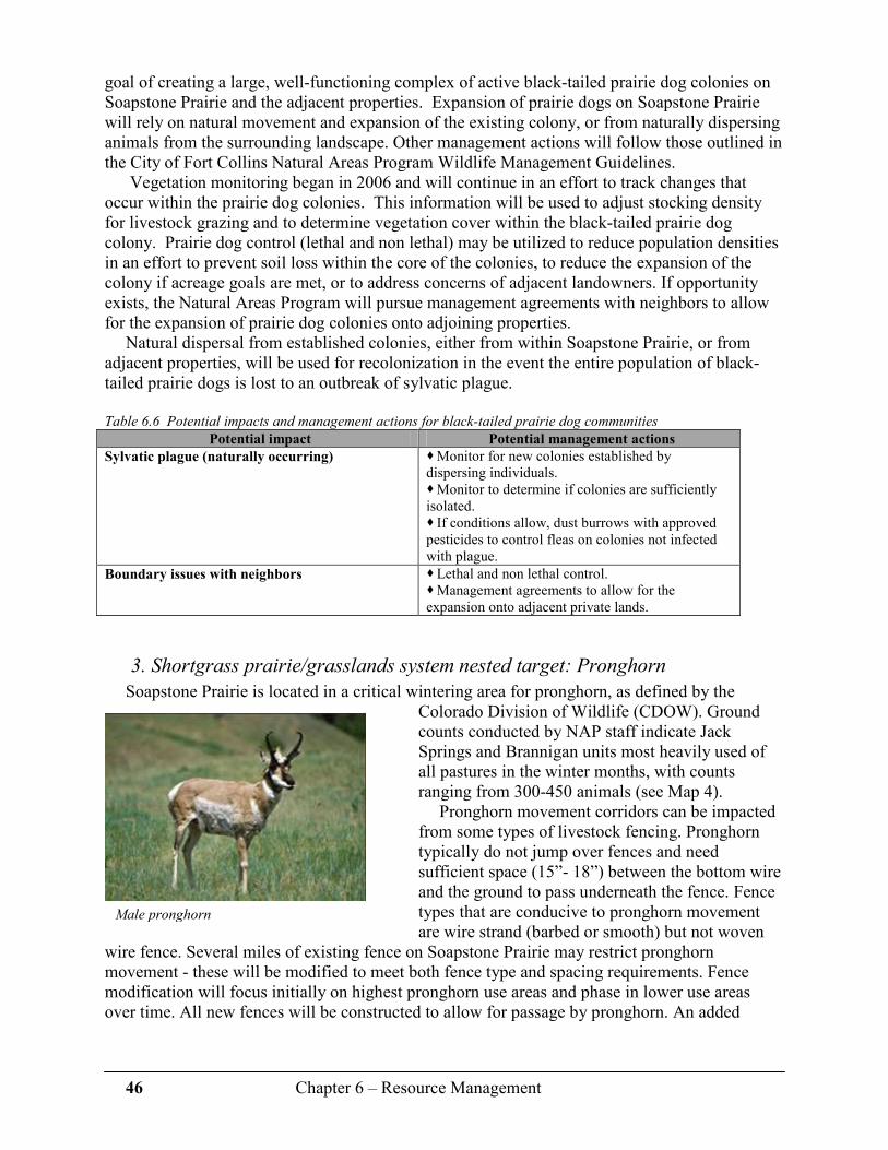
46 Chapter 6 – Resource Management
goal of creating a large, well-functioning complex of active black-tailed prairie dog colonies on Soapstone Prairie and the adjacent properties. Expansion of prairie dogs on Soapstone Prairie will rely on natural movement and expansion of the existing colony, or from naturally dispersing animals from the surrounding landscape. Other management actions will follow those outlined in the City of Fort Collins Natural Areas Program Wildlife Management Guidelines.
Vegetation monitoring began in 2006 and will continue in an effort to track changes that occur within the prairie dog colonies. This information will be used to adjust stocking density for livestock grazing and to determine vegetation cover within the black-tailed prairie dog colony. Prairie dog control (lethal and non lethal) may be utilized to reduce population densities in an effort to prevent soil loss within the core of the colonies, to reduce the expansion of the colony if acreage goals are met, or to address concerns of adjacent landowners. If opportunity exists, the Natural Areas Program will pursue management agreements with neighbors to allow for the expansion of prairie dog colonies onto adjoining properties.
Natural dispersal from established colonies, either from within Soapstone Prairie, or from adjacent properties, will be used for recolonization in the event the entire population of black-tailed prairie dogs is lost to an outbreak of sylvatic plague.
Table 6.6 Potential impacts and management actions for black-tailed prairie dog communities
Potential impact Potential management actions
Sylvatic plague (naturally occurring) � Monitor for new colonies established by dispersing individuals. � Monitor to determine if colonies are sufficiently isolated. � If conditions allow, dust burrows with approved pesticides to control fleas on colonies not infected with plague.
Boundary issues with neighbors
� Lethal and non lethal control. � Management agreements to allow for the expansion onto adjacent private lands.
3. Shortgrass prairie/grasslands system nested target: Pronghorn
Soapstone Prairie is located in a critical wintering area for pronghorn, as defined by the Colorado Division of Wildlife (CDOW). Ground counts conducted by NAP staff indicate Jack Springs and Brannigan units most heavily used of all pastures in the winter months, with counts ranging from 300-450 animals (see Map 4).
Pronghorn movement corridors can be impacted from some types of livestock fencing. Pronghorn typically do not jump over fences and need sufficient space (15”- 18”) between the bottom wire and the ground to pass underneath the fence. Fence types that are conducive to pronghorn movement are wire strand (barbed or smooth) but not woven
wire fence. Several miles of existing fence on Soapstone Prairie may restrict pronghorn movement - these will be modified to meet both fence type and spacing requirements. Fence modification will focus initially on highest pronghorn use areas and phase in lower use areas over time. All new fences will be constructed to allow for passage by pronghorn. An added
Male pronghorn

47 Chapter 6 – Resource Management
benefit of protecting movement corridors is that swift fox will be able to move across Soapstone Prairie and onto other habitats on adjacent properties.
Table 6.7 Potential impacts and management actions for pronghorn
Potential impact Potential management actions
Recreation use during the winter months � Seasonal closure of Jack Springs Unit, and if needed, Brannigan Unit.
Loss of movement corridors from development
of the property as a City-owned natural area
� Modify existing fences. � New fences to be conducive to pronghorn movement. � Avoid placement of facilities in movement corridors.
4. Shortgrass prairie system nested target: Swift fox
Swift fox have been documented within the shortgrass prairie on Soapstone Prairie and on shortgrass prairie conserved through conservation easements on adjacent lands. Documentation includes sightings of individuals, family groups, and occupied den sites. Impacts to swift fox
from development and recreation activities on Soapstone Prairie are difficult to quantify but may include impacts to movement corridors and den sites. Other canines, such as coyote and red fox, are known to be major predators of swift fox and increased populations of these other canine species may reduce swift fox abundance. Impacts from domestic dogs are unknown, but possible threats include predation, and evidence suggests they may be a transmission source for canine distemper and rabies.7
Table 6.8 Potential impacts and management actions for swift fox
Potential impact Potential management actions
Disease transmission such as rabies and canine
distemper
� Prohibit domestic dogs from Soapstone Prairie.
Increased predation by coyotes and red fox � Reduce population size of coyote and red fox if needed.
Loss of movement corridors and den sites from
development of the property as a City-owned
natural area.
� Avoid placement of facilities in movement corridors. � Protect known den sites from development and recreation activities.
Swift fox pups nursing, Bruce Gill

48 Chapter 6 – Resource Management
B. Conservation Target: Birds of Prey Soapstone Prairie provides important foraging and nesting habitat for more than 16 species of
birds of prey, including golden eagles, ferruginous hawks, prairie falcons, Swainson’s and red-tailed hawks, great-horned owls, long- and short-eared owls, and northern harriers. Efforts will be made to protect nests from disturbance and to provide large blocks of habitat for foraging.
Table 6.9 Potential impacts and management actions for nesting and foraging birds of prey
Nested targets Conservation Concern Potential impacts Potential management
actions
Golden eagle
Ferruginous hawk
� Both are Tier 1 Species of Greatest Conservation Need (CDOW) � Ferruginous hawks are a species of Regional Concern (PIF) � Loss of habitat � Easily disturbed during nesting
� Human encroachment � Follow buffer zone guidelines. 4 � Allow prairie dog colonies to expand naturally. � Avoid impacts to foraging habitat with proper placement of recreation facilities.
1. Birds of Prey Nested Target: Golden eagles
Golden eagles are listed as a Tier 1 Species of Greatest Conservation Need (CDOW). The greatest threats to golden eagles are poisoning (directly, and indirectly through rodent control), loss of habitat, and collisions with, or electrocutions through, power lines.5
Two golden eagle nests are located on the south-facing sandstone cliffs in the center of the property, approximately one half mile north of Soapstone Ranch Road. The area has had little
Key Management Actions for Shortgrass Prairie/Grasslands
Conservation Targets
• Manage habitat at large scales to accommodate spatial needs of species.
• Allow prairie dog colonies to move, expand, and/or contract over time.
• Use prescriptive grazing to provide structural components created through heavy, moderate, or no grazing.
• Provide grass heights representing mid- to taller structural habitat outside of the prairie dog colonies to meet the habitat needs of other grassland birds.
• Locate parking areas, trails, and other public facilities to minimize impacts to nested targets, wildlife movement corridors and other ecologically sensitive areas.
• Avoid impacts to nesting birds April 1-July 15 through seasonal closure of trails.
• Continue to monitor nesting success, nesting density, and species use, and adjust management actions as needed.
• Modify or remove fences to allow for wildlife passage.
• Prohibit domestic dog use of Soapstone Prairie.
Golden eagle on prey

49 Chapter 6 – Resource Management
human occupancy historically, and the impacts of recreation-related development may affect breeding, nesting and/or brooding cycles. Jerry Craig, former Raptor Biologist for the CDOW, recommends a buffer zone of up to one mile from nest sites, with seasonal restrictions to human encroachment from December 15 to July 15.4
2. Birds of Prey Nested Target: Ferruginous hawks
Ferruginous hawk populations in Colorado are low, and the greatest threats to their success include habitat degradation, invasive or exotic species altering or competing for habitat, low reproductive rate, and indirect mortality from pesticide applications.5 They are listed as a Tier 1 Species of Greatest Conservation Need (CDOW) and a species of Regional Concern (PIF).
The ferruginous hawk nest in a cottonwood tree approximately one-third mile south of the Brannigan Pasture Road has been active in recent years, and birds have been seen hunting within the prairie dog colonies further east. There are several other possible nest sites, as well. Care will need to be taken with impacts of human activity, because ferruginous hawks are especially prone to nest abandonment during incubation period if disturbed.4
Table 6.10 Recommended buffers for birds of prey species found on Soapstone Prairie 4
Species Nesting/
incubation
Nesting/
brooding
Nest period
(optimal) Sensitive period
Golden eagle 1.0 mi 1.0 mi 1.0 mi December 15 to July 15
Ferruginous
hawk
0.5 mi
0.5 mi
0.5 mi
February 1 to July 15
Red-tailed
hawk
448-553 yd 428-604 yd 0.34 mi February 15 to July 15
Swainson’s
hawk
171-203 yd 309-382 yd 0.22 mi April 1 to July 15
Prairie falcon 546-1093 yd 1093 yd 0.62 mi N/A
Key Management Actions for Birds of Prey Conservation Targets
� Maintain appropriate buffer zones around nest sites during sensitive times of year.
� Continue to search out and document new nest sites. � Close trails seasonally where new nests occur.
� Minimize impacts to foraging habitats.
Ferruginous hawk, Dave
Rintoul

50 Chapter 6 – Resource Management
C. Conservation Target: Wetlands/Riparian Systems According to the 2006 CDOW Colorado Comprehensive Wildlife Plan, streams and rivers of
the eastern plains (a key habitat in Colorado) are in relatively poor condition and continuing to decline in quality. 5 Several riparian systems are found on Soapstone Prairie; named streams (from west to east) include Sand Creek (west), Rawhide Creek, Wire Draw, Sand Creek (east), Spottlewood Creek and Graves Creek. Graves, Spottlewood, and Rawhide Creek tend to flow more frequently and have more areas of surface water than other drainages on the property. Numerous, unnamed intermittent and ephemeral drainages occur on the property and flow generally toward the south. These creeks support hydric plants and sporadic cottonwood stands.
The wetland system includes seeps, numerous springs and other small wetlands supported by groundwater discharge.
Table 6.11 Conservation targets, nested targets and potential impacts in the wetlands/riparian systems
Conservation target Nested targets Conservation Concerns
Wetlands/ Riparian
System
� Northern leopard frog (potential) � Native fish
� Generally, Eastern plains wetlands and streams are in poor condition overall, though the wetlands at Soapstone Prairie are in relatively good conditions.
Soapstone Prairie is located near the top of the watershed for each of these major drainages,
and the current condition of the riparian and wetland systems is good. The relative location in the watershed has produced few impacts and barriers to the natural watershed process onsite or upstream of the property. Current impacts to the wetlands and riparian systems include: � The existing road though Jack Springs is likely increasing the amount of water impounded and thus increasing the size of the wetland. � Graves Creek is impounded near the ranch headquarters, and overflow is returned to the stream. � Road crossings occur on all major drainages (water is not impounded). Few exotic plants (weeds) classified by the State of Colorado as Category B and higher have
been noted during baseline inventory work. However, given the high soil moisture within these habitats, wetlands and riparian areas may be easily invaded by exotic plants and this invasion may threaten species composition of native plant communities.
Livestock grazing has impacted wetland and riparian areas on Soapstone Prairie. Stock tanks are used to distribute cattle across the grasslands, but wetlands and riparian areas are not excluded from cattle grazing. Surface water found in wetlands and riparian areas are utilized for cattle watering sites, and many have been developed to capture water and pipe to livestock watering tanks. Stream banks have evidence of overuse by cattle and some wetlands have similar impacts.
Graves Creek

51 Chapter 6 – Resource Management
Due to the ecological sensitivity and the close association of cultural and archaeological sites to water sources, management actions will help reduce the chance of invasive plant introduction into these habitats, protect cultural sites, and allow wildlife access to these important habitats and water sources.
Table 6.12 Potential impacts and management actions for wetland/riparian systems
Potential impact Potential management actions
Introduction/spread of weeds � Vegetation monitoring. � Immediate action upon discovery of invasive plants.
Incompatible grazing regime � Shorter grazing seasons. � Increased recovery times. � Reduction in stocking densities. � Exclusion of natural water features from grazing. � Change grazing animal from cattle to bison or sheep. � Increase use of stock tanks to manage livestock movement and grazing.
Impacts from recreation management
� Few or no trails or other public developments in or near areas classified as wetlands, seeps, springs, and riparian areas.
1. Wetlands/Riparian Ecological Systems Nested target: Northern leopard frog
The northern leopard frog is listed as a species of concern in Colorado. Habitat for this species includes wet meadows and the banks and shallows of marshes, ponds, glacial kettle ponds, beaver ponds, lakes, reservoirs, streams, and irrigation ditches.8 Jack Springs is likely to support the northern leopard frog, based on documented occurrence of this species in the same wetland system on the adjacent Meadow Springs Ranch.
Table 6.13 Potential impacts and management actions for northern leopard frog
Potential impact Potential management actions
Incompatible grazing regime � Reduce grazing impacts. � Reduce grazing in wetlands and streams. � Promote stream bank vegetation.
Weed control � Closely monitor vegetation.
2. Wetlands/Riparian Ecological Systems Nested target: Native fish
At least four species of native fish are possible to exist in the riparian system on Soapstone Prairie. These species are generally found in streams with cool, clear water with vegetated stream banks and some shading by tree and shrub canopy.8 Status of these species on Soapstone Prairie is unknown; however, brassy minnow have been known to occur in the lower sections of Spottlewood Creek. Studies to identify existing fish species on Soapstone Prairie are planned.
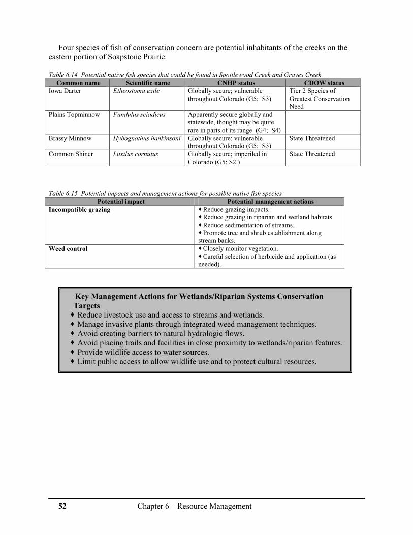
52 Chapter 6 – Resource Management
Four species of fish of conservation concern are potential inhabitants of the creeks on the
eastern portion of Soapstone Prairie.
Table 6.14 Potential native fish species that could be found in Spottlewood Creek and Graves Creek
Common name Scientific name CNHP status CDOW status
Iowa Darter Etheostoma exile Globally secure; vulnerable throughout Colorado (G5; S3)
Tier 2 Species of Greatest Conservation Need
Plains Topminnow Fundulus sciadicus Apparently secure globally and statewide, thought may be quite rare in parts of its range (G4; S4)
Brassy Minnow Hybognathus hankinsoni Globally secure; vulnerable throughout Colorado (G5; S3)
State Threatened
Common Shiner Luxilus cornutus Globally secure; imperiled in Colorado (G5; S2 )
State Threatened
Table 6.15 Potential impacts and management actions for possible native fish species
Potential impact Potential management actions
Incompatible grazing � Reduce grazing impacts. � Reduce grazing in riparian and wetland habitats. � Reduce sedimentation of streams. � Promote tree and shrub establishment along stream banks.
Weed control
� Closely monitor vegetation. � Careful selection of herbicide and application (as needed).
Key Management Actions for Wetlands/Riparian Systems Conservation
Targets
� Reduce livestock use and access to streams and wetlands. � Manage invasive plants through integrated weed management techniques. � Avoid creating barriers to natural hydrologic flows. � Avoid placing trails and facilities in close proximity to wetlands/riparian features. � Provide wildlife access to water sources. � Limit public access to allow wildlife use and to protect cultural resources.

53 Chapter 6 – Resource Management
D. Conservation Target: Foothills Shrublands System As discussed in Chapter Three, the foothills shrublands system on Soapstone Prairie is of
exemplary quality based in part on: � Absence of Category B or higher invasive weeds. � Dominance of native species. � High species richness. � Presence of rare plant communities. � Overall size (>5000 acres). This system is most successful on a large scale, on
undivided landscapes. It’s also important to note this community is connected to foothills shrubland communities of
equal quality on Red Mountain Open Space and private land to the north and southwest. These factors combined make this plant community one of the highest ecological values on Soapstone Prairie.
Table 6.16 Conservation targets, nested targets and potential impacts in the foothills shrublands system
Conservation target Nested targets Conservation Concerns
Foothills Shrublands
system
� Mountain mahogany/needle-and-thread community (Cercocarpus montanus/ Hesperostipa comata) � Mountain mahogany/streamside wild rye community (Cercocarpus montanus/ Elymus lanceolatus ssp. lanceolatus)
� Global distribution of these plant associations is limited to the Front Range in Colorado and adjacent Wyoming. � Land use changes and system fragmentation.
Management of this habitat type includes: � Grazing practices that maintain the natural integrity of species composition. � Control of invasive exotics. Fire is a naturally occurring event in these systems and may be prescribed as a tool for
mountain mahogany reproduction (via seeds or regrowth from roots), to create openings in this dense canopy and increase forage quality. However, the full effects of prescribed or naturally occurring fire are not completely understood and concerns exist if such a disturbance will increase the incursion of weedy species into these relatively excellent condition shrubland communities. If fire is determined a necessary prescription to meet a management goal, or if a naturally occurring fire moves through the mountain mahogany shrublands, vegetation will be monitored to determine what effects occur and any invasive species incursion will be treated.
Grazing will also be used to maintain this system, however not as extensively as in the shortgrass prairie. Livestock used for grazing may change from cattle to sheep or bison as management practices are refined.
Currently, invasive exotics (weeds) are minimal in cover, though Dalmatian toadflax occurs in isolated patches and cheatgrass is found at the periphery of the shrublands. If Dalmatian toadflax or cheatgrass increases in abundance or distribution, or if new invasive plants are introduced into this system, the quality of rare plant communities may become degraded. If rare foothills butterflies are present, alteration in vegetation could be problematic, since butterflies are often highly adapted to particular plant species.
American elk and mule deer make use of this community type on Soapstone Prairie and Red Mountain Open Space. Movement corridors exist between the properties but are limited due to the natural geologic features of the Big Hole and management efforts will maintain these

54 Chapter 6 – Resource Management
corridors. Not only will elk and mule deer benefit from these management actions, larger carnivores that are found on occasion at Soapstone Prairie, such as black bear, bobcat, and mountain lion, will also utilize these corridors.
E. Conservation Target: Rare and Threatened Plants The highest priority rare and threatened plants on Soapstone Prairie are Colorado butterfly
plant (federally listed as a Threatened species under the Endangered Species Act since 2000) and Rocky Mountain blazing star.
Table 6.17 Conservation targets of rare and threatened plants
Conservation target Nested targets Conservation Concern
Rare and threatened
plants
� Colorado butterfly plant � Rocky Mountain blazing star
� Population trend � Limited distribution
1. Rare and Threatened Plants Nested Target: Colorado butterfly plant
Soapstone Prairie has one of the largest known populations of Colorado butterfly plant (Gaura neomexicana ssp. coloradensis) in the world, with a calculated population of approximately 35,000 - 47,000 plants. The known population occurs in wet meadows along the northeast portion of the property (see Map 3). Habitat for this plant is found in other portions of Soapstone Prairie but no known population occurs. Managing the current population is of highest priority.
Colorado butterfly plant is thought to be naturally rare and has very specific habitat requirements. This population has flourished in a small pasture that typically supported short term, early summer and late fall grazing, a regime unique to this small pasture and not typical within other areas of suitable habitat.
Concerns for future adverse impacts to this plant include: � Introduction and/or spread of invasive weeds into existing habitat. � Incompatible grazing regime.
Key Management Actions for Foothills Shrublands Conservation Targets
� Maintain taller vegetation structure through light grazing as needed. � Trails will avoid the highest valued plant communities. � Invasive plant control will focus along trails to help prevent expansion. � Trails will be limited to on-trail, hiking and bicycling only. � Equestrian use will not be allowed within most of this area due to the
concern of weed seed introduction and movement along trails. � Vegetation monitoring will evaluate invasive weed movement along trails. � Immediate actions to reduce or eliminate invasive plants will be taken upon
discovery. � If invasive plants become extensive, trails may be closed permanently and
restored. � New trails and facilities will not create wildlife movement barriers. � Any existing fence identified as barriers to movement will be removed. � Seasonal closures may be implemented if elk calving is found to occur on
Soapstone Prairie.

55 Chapter 6 – Resource Management
Two issues make weed control problematic: invasive weeds appear to have a competitive
advantage for space and resources, and Colorado butterfly plant is highly susceptible to most common herbicides. Currently, Canada thistle is found within the known population. Management staff has conducted, and will continue to conduct, selective herbicide applications to reduce the population of this invasive plant.
Incompatible grazing is also problematic in two ways. First, grazing during the flowering stage may reduce the number of flowers that successfully produce seed, and secondly, a degree of grazing is necessary to maintain the open habitat surrounding the plants needed for seed establishment. Grazing management will use historical grazing patterns within the current population as a guide for management of this species. In addition, as opportunities arise, modification to the overall grazing plan will attempt to replicate this pattern outside of the current population within potential habitat areas.
2. Rare and Threatened Plants Nested Target: Rocky Mountain blazing star
Rocky Mountain blazing star (Liatris ligulistylis) is a common species across its range, but only 11 occurrences have been documented in Colorado. Of these, five occurrences have been seen since the early 1900s and all have been from publicly owned land along the Front Range. Like the butterfly plant, this species occurs in wet meadow habitats and is highly susceptible to habitat degradation. In addition, habitat for this species is very susceptible to weed infestations, especially Canada thistle.
Management strategies designed to protect the Colorado butterfly plant will also conserve this species.
Table 6.18 Potential impacts and management actions Colorado butterfly plant and Rocky Mountain blazing star.
Potential impact Potential management actions
Introduction and/or spread of invasive weeds � Selected herbicide application to eliminate known areas of Canada thistle. � Monitor for population degradation.
Incompatible grazing regime � Grazing will occur prior to and/or after flower production. � Grazing will be sufficient to create open soils for seed germination.
Recreation development � No trails in occupied habitat; access by guided tours only.

56 Chapter 6 – Resource Management
F. Conservation Target: Geological Features System The most prominent geological features on Soapstone Prairie are the cliffs at the interface
between the foothills shrublands system and the shortgrass prairie system. This area supports nesting golden eagles. Prairie falcons are also known to use this area, but nest locations have not been documented (additional field work is planned for 2007). Numerous sensitive cultural resources, including the Lindenmeier Archaeological Site, are located within this system.
Table 6.19 Potential impacts and management actions of geological features
Potential impacts Potential management actions
Human disturbance to nesting birds of
prey and unique cultural resources
� Permanent closure of sensitive areas. � Trails will be placed as described in shortgrass section and in Craig.4
Erosion � Enforcement of on-trail only recreation. � Trails and facilities will avoid fragile soils associated with these features.
G. Conservation Target: Cultural Resources Cultural resources on Soapstone Prairie are abundant and located throughout the entire
property. Some of these sites date back to more than 12,000 years, including possible Clovis sites, along with buried sites of unknown age, an abundance of American Indian surface sites, homestead-era foundations, historic ranches and associated buildings, and roads and trails. Of all these cultural resources, the Lindenmeier Valley containing the Lindenmeier Archaeological Site is the highest priority for protection and preservation.
A significant number of visitors will want to see the Lindenmeier Archaeological Site and should be able to view the area without adverse impact via specially designated trails. There is little evidence remaining of the Smithsonian’s National Museum of Natural History and the Denver Museum of Natural History’s excavation; focused education and interpretation will be required to help people understand the significance of the area. The most significant current impact is erosion related to cattle use. Tour vans bringing groups to the site since 2005 have increased erosion on the site and impacted a road that is to be decommissioned. Mitigation may be needed in places where damage is obvious. Providing access to the area via the north edge of the valley (where artifacts are not exposed) will help avoid additional impacts.
Many natural springs align with existing main roads. All of these springs are known to have, or are expected to have, cultural sites associated with them. Many are not pristine and are already impacted.
Because there is a market for the types of artifacts found on Soapstone Prairie, security of archaeological and cultural resources is of utmost concern. Management strategies that influence and control visitor behavior (e.g., access, education/interpretation, and enforcement) will be implemented.
57 Chapter 6 – Resource Management
Table 6.20 Potential impacts and management actions of cultural resources.
Potential impacts Potential management actions
Damage to Lindenmeier Valley � Provide access via north edge of valley. � Modify grazing practices in area.
Loss of artifacts from collection, theft and
vandalism
� Collect “at risk” artifacts. � Establish a site security system/plan. � Use trail system to avoid archaeologically sensitive areas. � Monitor the site through a partnership with an archaeological group (e.g. Colorado Archaeological Society) and trained volunteers. � Implement a focused educational/interpretive plan.
Visitor access � Provide view access of Lindenmeier Archaeological Site via trail system from north edge only.
H. Conservation Target: Viewshed/Sense of Place Soapstone Prairie is located within a landscape that for many millennia has offered humans a
sense of place. Although the evidence of current human occupation is minimal and most likely buried, in ruins, or unpaved, the property offers views from several elevated points that reveal a landscape practically uninterrupted by human constructs (e.g. buildings, paved roads or trails, power lines, water storage tanks). Soapstone Prairie is one of the last remaining places on Colorado’s Front Range where these views are available to residents and visitors, both now and in the future. Expansive views are available in all directions from Soapstone Prairie, but to the south lies a vast, level terrain at elevations below that of the property. This creates a wide-open viewshed across private lands from Soapstone Prairie to Fort Collins. Future development associated with these private properties will have negative impacts within the viewshed, thereby creating the need for the Natural Areas Program to continue pursuing conservation easements. Acquisition of significant conservation easements will help to reduce the number, and manage the location of, potential residences and other types of development. All land purchases through these easements are by a willing seller. Please refer to Map 2 for efforts to date.
Table 6.21 Potential impacts and management actions of the viewshed/sense of place..
Potential impacts Potential management actions
Public improvements (parking areas, vault
toilets, roads, trails, shelters)
� Use natural terrain to “hide.” � Use natural colors and materials. � Build shorter-statured structures.
Development to south � Pursue conservations easements through willing landowners.
Chapter 6 References 1 Grunau, L., J. Sovell, and R. Rondeau. 2006. Assessment of Conservation Targets,
Viability, and Impacts to Biological Diversity on the Lowry Range. Colorado Natural Heritage Program 91pp.
2 Samson, F.B. and F.L. Knopf. 1996. Prairie conservation: preserving North America’s most
endangered ecosystem. Edited by Fred B. Samson and Fritz.L. Knopf. Island Press. 339 pp.

58 Chapter 6 – Resource Management
3 Sparks, R.A., A.O. Panjabi, and D.J. Hanni. 2006. Soapstone Avian Inventory and
Monitoring: Year 1. Rocky Mountain Bird Observatory. Technical Report #M-Soapstone06-01. 38pp.
4 Craig, G. R. 2002. Recommended buffer zones and seasonal restrictions for Colorado
raptors. 7 pages. 5 Colorado Division of Wildlife. 2006. Colorado’s Comprehensive Wildlife Conservation
Strategy and Wildlife Action Plans. Denver, CO. 328 pp. (online at: http://wildlife.state.co.us/NR/rdonlyres/D26A4806-8776-4460-831E-AA654EC7DDED/0/CWCS_FinalReport2006.pdf) 6 Colorado Division of Wildlife. 2003. Conservation Plan for Grassland Species in Colorado.
205 pp. 7 Sime, C. A. 1999. Domestic Dogs in Wildlife Habitats. Pages 8.1-8.17 in G. Joslin and H.
Youmans, coordinators. Effects of recreation on Rocky Mountain wildlife: A Review for Montana. Committee on effects of Recreation on Wildlife, Montana Chapter of The Wildlife Society. 307pp.
8 Colorado Division of Wildlife, Natural Diversity Information Source. (online at:
http://ndis.nrel.colostate.edu/index.htm )
Additional resources
City of Fort Collins Natural Areas Wildlife Management Guidelines. 2007. 114pp. (Online at http://www.fcgov.com/naturalareas/wildlife-guidelines.php)
Dechant, J. A., M. L. Sondreal, D. H. Johnson, L. D. Igl, C. M. Goldade, P. A. Rabie, and B.
R. Euliss. 1999 (revised 2002). Effects of management practices on grassland birds: Burrowing Owl. Northern Prairie Wildlife Research Center, Jamestown, ND. 33 pp.
Dechant, J. A., M. L. Sondreal, D. H. Johnson, L. D. Igl, C. M. Goldade, P. A. Rabie, and B.
R. Euliss. 1999 (revised 2002). Effects of management practices on grassland birds: McCown’s Longspur. Northern Prairie Wildlife Research Center, Jamestown, ND. 13 pp.

59 Chapter 7 – Visitor Use
Chapter 7
Visitor Use Soapstone Prairie is the second large-scale, regional natural area acquired by the City of Fort
Collins Natural Areas Program, Bobcat Ridge Natural Area located in the Masonville area being the first.
This management plan incorporates the concept of carrying capacity, which includes not
only the number of visitors, but also the desired condition of the site’s natural, cultural, and scenic resources and a visitor experience consistent with overall management objectives for the site. The concept is aligned with the Natural Areas Program’s mission statement found at the beginning of this document.
In the following sections, appropriate recreation uses for Soapstone Prairie are determined
through several analyses. This chapter also recommends a conceptual design for a trail system as well as methods for visitor management. All recreational uses are evaluated in a context of:
� Providing and balancing a high quality visitor experience. � The Natural Areas Program’s capacity to manage the recreational uses. � The ability to protect the site’s resources.
In addition, visitor uses and recreation will be monitored and adapted to changing conditions over time as necessary.
A. Determining Visitor Experiences
1. Public Input
Staff conducted 93 public tours to Soapstone Prairie during 2005 and 2006. While each of the field trips had slightly different itineraries, the same management issues were discussed and evaluated through a participant feedback questionnaire. This “non-scientific survey” was completed by 733 individuals who participated in the Natural Areas Program’s public tours. The summarized results were as follows. See Appendix 4 for response details.
The goal for visitor use at Soapstone Prairie Natural Area is to provide a variety of
recreational opportunities for people of all ages and abilities consistent with the:
� Natural Areas Program’s mission.
� Carrying capacity of the site.
� Natural Areas Program’s capacity to deliver a safe, high quality visitor
experience.
It is also the Program’s goal to provide visitor and recreation experiences while
simultaneously protecting the site’s significant ecological and cultural resources.

60 Chapter 7 – Visitor Use
Question 1: Over the next two years we will be preparing management plans for the
Soapstone Prairie Natural Area and the Red Mountain Open Space. Please share with us how
you feel we should prioritize our efforts.
72% rated natural resource protection as the #1 priority. 53% rated human history/cultural protection as the #2 priority. 40% rated recreational opportunities as the #3 priority. 52% rated protecting the ranching tradition as the #4 priority.
Question 2: What types of non-motorized recreation would you like to see available here?
(these answers were written in).
Hiking (60%), horseback riding (50%), biking (46%), interpretive walks (9%), camping (7%), cross country skiing (4%), bird watching (4%), no dogs (1%).
Question 3: Which types of trails do you prefer?
Participants were asked to choose from a combination of mixed- and/or single-use trails. Mixed-use trails: Most preferred mixed-use trails (various combinations of hiking, bicycling
and horseback riding), but most preferred horseback riding to be separate from bicycling (87%). Out of the 4 combinations, trails permitting horseback riding and hiking together were the most preferred (28%). 25% preferred to see all user groups on the same trails.
Single-use trails: 42% preferred separate trails for hiking, 32% preferred separate trails for biking and 36% preferred separate trails for horseback riding.
Limited visitation with few or no trails: 10% preferred.
Question 4: Is limited, permit-only, designated backcountry camping an appropriate use
here?
57% said yes. 20% said no. 22% were not sure.
Question 5: Is limited hunting an appropriate use here?
28% said yes. 52% said no. 18% were not sure.
Question 6: Is it appropriate to seasonally close areas due to sensitive wildlife activities
such as nesting, denning or calving?
92% said yes. 3% said no. 4% were not sure.
Question 7: Is it appropriate to seasonally close areas due to sensitive plants/plant
communities?
70% said yes. 11% said no. 14% were not sure.

61 Chapter 7 – Visitor Use
Question 8a: Is grazing by domesticated cattle an appropriate use at Soapstone Prairie and
Red Mountain when used for vegetation management goals?
85% said yes. 6% said no. 9% were not sure.
Question 8b: Is grazing by domesticated cattle an appropriate use at Soapstone Prairie and
Red Mountain when used to maintain a ranching tradition?
57% said yes. 18% said no. 25% were not sure.
Question 9: During the course of a year, how many times are you likely to visit these areas
after they are open to the public?
Respondents indicated they would visit Soapstone Prairie and Red Mountain an average of 3.7 times per year.
Question 10: Please rank the following biological and cultural features in order of
importance for protection.
92% rated the Lindenmeier Archaeological Site as a high priority. 85% rated wildlife nesting, denning and calving sites as a high priority. 81% rated the rock cliffs/eagle nests as a high priority. 77% rated wildlife migration corridors as a high priority. 65% rated sensitive ecosystems as a high priority. 63% rated the tipi rings as a high priority. 42% rated the historic camp sites as a high priority. 38% rated the homestead sites as a high priority. 23 % rated the prairie dog colonies as a high priority. 14% rated the ranch buildings as a high priority.
Question 11: What educational topics would you like to see on interpretive signs and
brochures?
Question 13: What topics would you like to see emphasized by naturalists on future visits to
these areas?
Questions 11 and 13 had very similar responses. The compiled topics listed were: animals/birds, archaeology, “Big Hole”, cultural history, ecology, geology, Lindenmeier, plant identification, ranching, responsible visitation /use and site plans.
Question 12 asked about distribution of information and site interpretation.
46% felt it was more appropriate to have an equal balance of brochures and signs. 27% felt it was appropriate to have more information on brochures. 24% felt it was appropriate to have more information on signs.
Question 14: Do you feel you have a good understanding of where funding to protect these
properties came from?
95% said yes. 5% said no.

62 Chapter 7 – Visitor Use
Question 15: What did you find most interesting on the field trip? (compiled)
These subjects were listed by participants: ability to see before high use by public, “Big Hole”, diversity, “everything”, geology, human history, Lindenmeier, nature/ecology, partnerships, protection of undeveloped area, site planning, vastness, views/beauty.
Question 16: What part of the field trip was the least interesting?
Most respondents replied, “It was all interesting.”
Question 17: Would you recommend this field trip to others? Why?
96% said yes.
Question 18: How did you find out about this field trip?
37% found out through a newspaper or magazine. 25% found out by word-of-mouth.
Question 19: Would you like to provide a quote about your experiences today for future
publications?
231 participants provided quotes or comments – see Appendix 4.

63 Chapter 7 – Visitor Use
B. Regional Analysis of Recreation Opportunities A staff survey of regional recreation availability looked at the combined opportunities offered
by federal, state, and county parks and open lands, and city natural areas, parks and trails. The purpose was to determine which types of recreation are either widely available or not available or have limited availability on a regional basis. Recreational offerings at Soapstone Prairie could add additional opportunities when the recreation type is consistent with protection of the resources and management objectives. The summary table is shown below.
Table 7.1 Regional recreation destinations and activities
Hiking
Dog W
alking
Mountain
Biking
Horseback
Bird/w
ildlife
Watching
Nature W
alk
ADA
Compliant
Trails
ADA
Compliant
Facilities
Picnic
Fishing
Rock Climbing
Hunting
Backcountry
Cam
ping
Cam
pground
Federal Lands
Pawnee National
Grassland X X X X X X X X X X X
Rocky Mountain NP X X X X X X X X X X X
Roosevelt NF X X X X X X X X X X X X
State Lands
Lory State Park X X X X X X X X X X X
Boyd Lake SP X X X X X X X X X X
Larimer County Lands
Fossil Creek
Reservoir X X X X X X
Horsetooth
Mountain Park X X X X X X X X X X
Horsetooth
Reservoir X X X X X X X X X X X X
Devil’s Backbone
Open Space X X X X X X X X
Rimrock Open
Space X X X X
City of Fort Collins Lands
Bobcat Ridge NA X X X X X X X
Coyote Ridge NA X X X X X X X X
Foothills NAs X X X X X X X
City Parks and
Trails
X X X X X X X X X X
TOTALS 14 9 12 12 14 10 9 12 11 7 4 4 4 5
This survey indicates that opportunities and facilities for hiking, dog walking, mountain
biking, horseback riding, wildlife watching, nature walks, ADA compliant trails and facilities, and picnicking are widely available. Rock climbing, hunting, backcountry and campground camping, are less available within the region. Each activity is explored in more depth further in this chapter.
Recommended visitor uses at Soapstone Prairie include: hiking, walking, running,
mountain biking, horseback riding, wildlife viewing, interpretive walks, an ADA
compliant trail and facilities, and picnicking. Future possibilities for backcountry
camping and recreational hunting will be analyzed and considered.

64 Chapter 7 – Visitor Use
C. Analyses of Visitor Experience Opportunities
1. Trails - Hiking, Walking, Running
Pedestrian use on open space lands is a staple recreation, and many natural areas are designated as “on-trail only” to help protect sensitive resources. Because of its large size, sensitive ecosystems, critical wildlife habitats, important cultural and archaeological sites, and easily eroded geological features, Soapstone Prairie will also be designated as an “on-trail only” natural area. In addition, on-trail only use allows for cultural resources to remain in place and for the unique opportunity to interpret these features within the landscape in which they occur.
With 18,728 acres, Soapstone Prairie will provide opportunities for many miles of trails: � Through a diversity of habitats. � With expansive and striking viewsheds. � Within view of cultural sites.
Opportunities for off-trail use of Soapstone Prairie will be offered through the Natural Areas
Program education and interpretation activities.
Table 7.2 Trails: hiking, walking, running
Opportunities � Shortgrass and foothills shrublands areas offer ample opportunities for hiking, walking and running. Certain portions of an existing road network will become part of the trails.
Constraints � Existing roads in some areas are in poor condition and are eroding. These require erosion control if they remain open or restoration if they are closed.
High Quality
Visitor Experience
� Trails at Soapstone Prairie will to provide diverse terrain, long trail loops, diverse trail types, and various levels of difficulty. Combined with numerous scenic vistas and destination sites, this natural area offers a premier trail experience. Managing visitor behavior through “share the trail,” “trail yield” etiquette, and routine patrol should limit the number of negative interactions.
Ability to
Protect Resources
� Managed on-trail use that avoids sensitive cultural and ecological areas can ensure a high level of resource protection. Trail layout must be designed to minimize impacts to target plant communities and cultural resources. The location, amount and timing of trail use must be evaluated to protect nesting birds of prey and grassland birds, calving deer and elk, important wintering areas, rare plants and plant communities, moth and butterfly habitat, and other similar conservation targets. Monitoring trails in areas with high cultural resource density after spring run-off and the summer rainy seasons can help protect resources that wash-out onto trails.
Capacity to Manage � Pedestrian use on an established trail system with anticipated level of compliance offers little enforcement challenge to ranger staff.
Recommended
Actions
� Designate Soapstone Prairie as an on-trail only area.
� Design trails that visitors can use to access vistas, rare plant
communities, and cultural sites as appropriate and as management
constraints allow.
� Design methods to integrate trail systems within existing cattle
pastures. This may include using cattle guards, spring-loaded
pedestrian gates, or separated uses temporarily. Interpretive signs
could assist.

65 Chapter 7 – Visitor Use
2. Trails – Leashed Dog Walking
Dog walking is one of the most popular types of recreational use in City of Fort Collins natural areas, especially within the urban area. With limited exceptions, most natural areas and trails are available for leashed dog walking: 31 of the 35 City’s natural areas open to the public allow leashed dog walking; currently, out of approximately 45 miles of trails on the City’s natural areas properties, nearly 36 miles are available for leashed dog walking.
Unfortunately, dogs off leash remain the Natural Areas Program’s number one visitor compliance issue. Conflicts between dogs and other visitors are a continual source of citizen complaints.
Table 7.3 Trails: leashed dog walking
Opportunities � Both shortgrass prairie and foothills shrublands areas offer ample opportunities for dog walking. An existing road network is in place that could form a basis for portions of the trail layout.
Constraints
� There is an active grazing lease on site; potential dog/cattle interactions could occur. � Rangers have limited ability to comprehensively enforce on-leash regulations, especially in backcountry areas. � Enforcing the leash law has been problematic system-wide. � Dogs off leash are a threat to the natural resources being protected:
� Domestic dogs have been linked to the transmission of several diseases to wildlife species.
� Particularly while off-leash, dogs increase the radius of human recreational influence or disturbance to wildlife.
� If dogs chase or pursue wildlife, injuries to the wildlife and/or dogs could be sustained directly or indirectly.
� Canids are natural, evolutionary predators of many wildlife species, and the resemblance between domestic dogs and wild canids may elicit similar responses in those wildlife species.
� Dogs off leash may negatively affect the quality of visitors’ experiences. � Wildlife is a threat or a hazard to off-leash dogs. � Dog waste degrades resources and is a human and wildlife health hazard.
High Quality
Visitor Experience
� Natural areas regulations and city code require that dogs be leashed in all natural areas. A limited ability to patrol the entire property may result in low levels of compliance especially in areas out of visual range of parking areas. � Dogs off leash have caused negative dog/human interactions in other natural areas.
Resource Protection � Limited or prohibited dog use of the area would ensure protection of sensitive biological resources (deer, elk, pronghorn, nesting birds, etc.).
Capacity to Manage � Ranger staff has limited capacity to enforce leash code on this property.
Recommended
Action
� Prohibit domestic dogs at this sensitive natural area.*
*During the planning process for Soapstone Prairie, more than 1000 citizens toured the property and attended various meetings to learn more about the Soapstone Prairie’s resources and management planning. To date, those citizens have been largely supportive of the proposed dog regulations.

66 Chapter 7 – Visitor Use
3. Trails - Mountain Biking
Mountain biking is one of the more popular recreational activities in the City’s natural areas. The 2003 Statewide Comprehensive Outdoor Recreation Plan conducted by Colorado State Parks 2 notes that:
• Nearly 10% of Coloradoans took a bicycle vacation in the last 12 months. • 69% of Colorado households own at least one bicycle, with an average ownership of 2.7 • Bicycling in Colorado: (both off road and on road) - 1995: 960,000 participants - 2003: 1,510,000 participants
Table 7.4 Trails: mountain biking
Opportunities � Both shortgrass prairie and foothills shrublands areas offer ample opportunity.
Constraints � Existing roads are in poor condition and are eroding. Mountain biking considerably increases erosion. � Mountain bikes present more safety issues (speed, lack of control, etc.) than other trail uses. Separating users (i.e. multi-use trail and pedestrian/horse only trail) decreases the potential for user conflicts and increases visitor safety.
High Quality
Visitor Experience
� Soapstone Prairie may provide long trails, diverse terrain, trail types, and levels of difficulty. Combined with numerous scenic vistas and destination sites, this natural area offers a premier mountain biking experience. Managing visitor behavior through “share the trail” and “trail yield” etiquette, and routine ranger and trail host patrols should limit the number of negative interactions.
Ability to
Protect Resources
� Managed, on-trail mountain biking on a planned trail system that avoids sensitive ecological areas can achieve a high level of resource protection. The location, amount and timing of trail use must be evaluated to protect nesting birds of prey and grassland birds, calving deer and elk, important wintering areas, rare plants and plant communities, moth and butterfly habitat, and other similar conservation targets. � Monitoring trails in areas with high cultural resource density after spring run-off and the summer rainy seasons can help protect resources that wash-out onto trails.
Capacity to Manage � Mountain biking on an established trail system with a high level of compliance offers little enforcement challenge to ranger staff. It is anticipated that some illegal, downhill use will occur and require enforcement action. � Routine trail maintenance will be required.
Recommended
Action
� Mountain biking will be designated as an on-trail only activity to
increase user safety and prevent resource damage.

67 Chapter 7 – Visitor Use
4. Trails - Horseback Riding
Horseback riding is available on many of the City’s natural areas, although few areas receive heavy use. Soapstone Prairie is likely to become a destination for local equestrian enthusiasts. In Northern Colorado there are five equestrian recreational trail-riding associations with a total of over 340 members, and two distance-riding associations. As with most trail systems, equestrians will need to share the trail with pedestrians and mountain bicyclists unless separate, designated trails can be developed.
Table 7.5 Trails: horseback riding
Opportunities � Nearly 30 square miles of prairie grasslands and rolling foothills could provide much needed, close-to-town equestrian opportunities.
Constraints � To preserve sensitive resources, all trailers will be required to be parked in designated parking areas. The number of parking spaces available for horse trailer parking will limit the number of riders. � Access to the site for the local community along county roads is limited.
High Quality
Visitor Experience
� Soapstone Prairie may provide diverse terrain, trail types, and levels of difficulty. Combined with numerous scenic vistas and destination sites, this natural area offers a premier horseback riding experience. Managing visitor behavior through “share the trail,” “trail yield” etiquette, and routine patrols should limit the number of negative interactions.
Ability to
Protect Resources
� Managed on-trail use on a planned trail system that avoids sensitive ecological areas can achieve a high level of resource protection. Trail layout must be designed to minimize impacts to target plant communities. � The location, amount and timing of trail use must be evaluated to protect nesting birds of prey and grassland birds, calving deer and elk, important wintering areas, rare plants and plant communities, moth and butterfly habitat, and other similar conservation targets. � The distribution of weed seed will increase due to horse manure on and along trails. � Monitoring trails in areas with high cultural resource density after spring run-off and the summer rainy seasons can help protect resources that wash-out onto trails.
Capacity to Manage � Use on an established trail system with anticipated level of compliance offers little enforcement challenge to Ranger staff.
Recommended
Actions
� Horseback riding will be designated as on-trail only in order to
prevent resource damage.
� Horses will not be allowed in areas of rare or sensitive plant
communities to protect against weed seed dispersal, and only
portions of the foothills shrublands system will be accessible by
horse. � Implement the 12-heartbeat rule to reduce trail impact (no more
than 6 people and 6 animals in a group - see page 78).

68 Chapter 7 – Visitor Use
5. Trails – Equestrian carriage driving
Carriage driving is an activity not available on any City of Fort Collins natural area. Horse-drawn carriages are treated the same as motorized vehicles and allowed on roads in Larimer County if a yield sign is displayed on the back of the buggy. This activity is also allowable on U.S. Forest Service two-track road systems including the nearby Pawnee Grasslands. In Northern Colorado there are three carriage driving clubs with a total membership of over 200.
Table 7.6 Trails: equestrian carriage driving
Opportunities � Both shortgrass prairie and foothills shrublands areas offer ample opportunities for carriage driving. An existing road network is in place that could form a basis for portions of the trail layout.
Constraints � By regulation, the number of parking spaces available for horse trailer parking will limit the number of riders. � Existing roads are in poor condition and are eroding. Carriage use may exacerbate the condition. � Trails will be narrower than what is required for this activity. � Many existing roads were built to sustain very low use and would need substantial improvements to support this activity. � Carriage use presents more safety issues (speed, size, etc.) than other trail uses and creates conflicts with other trail users. � Opportunity exists off-site along all county roads.
High Quality
Visitor Experience
� Soapstone Prairie may provide long trails, diverse terrain, trail types, and levels of difficulty. Combined with numerous scenic vistas and destination sites, this natural area offers a premier experience.
Ability to
Protect Resources
� Managed on-trail use on a planned trail system that avoids sensitive ecological areas can achieve a high level of resource protection. Trail layout must be designed to minimize impacts to target plant communities. The location, amount and timing of trail use must be evaluated to protect nesting birds of prey and grassland birds, calving deer and elk, important wintering areas, rare plants and plant communities, moth and butterfly habitat, and other similar conservation targets. The distribution of weed seed will increase due to horse manure on and along trails.
Capacity to Manage � Increases in infrastructure (increased parking, wide trails, ranch road improvements) to support this activity increases ecological impacts and development and maintenance costs. � Conflicts with other trail users difficult to address due to size of carriage and the inability to of carriages to pass other users within the established trail.
Recommended
Action
� Prohibit use of carriages on Soapstone Prairie except along roads
open to public vehicle use.

69 Chapter 7 – Visitor Use
6. Trails – Americans with Disabilities Act (ADA) compliancy
The Natural Areas Program is committed to providing a high quality appropriate recreation experience for visitors of varying abilities. System-wide, the Natural Areas Program offers diverse trails with a diversity of surfaces and levels of difficulty.
Table 7.7 Trails: ADA compliancy
Opportunities � Portions of Soapstone Prairie provide good opportunity for an all-access trail with scenic views, varied terrain, and interesting destinations.
Constraints � The foothills shrublands area has extremely steep slopes; grades would not meet Americans with Disabilities Act requirements. The best location for an all-access trail is in the area of the main parking area.
High Quality
Visitor Experience
� Proper design, with the Lindenmeier Valley as an interesting destination, along with ample scenic vistas combine to provide an all-access trail that delivers a high quality visitor experience.
Ability to
Protect Resources
� Managed on-trail use on a planned all-access trail that avoids sensitive ecological areas can achieve a high level of resource protection. Trail layout must be designed to minimize impacts to target plant communities. The proposed location of an all-access trail has little impact on nesting birds of prey and songbirds, calving deer and elk, important wildlife wintering areas, moth and butterfly habitat, and other similar conservation targets.
Capacity to Manage � An all-access trail needs to be carefully designed to ensure ADA compliance.
Recommended
Actions
� Build an all-access portion of the trail from the parking area to an
overlook of the Lindenmeier Valley.
� Trail features could include a picnic shelter and self-guided
interpretive features.

70 Chapter 7 – Visitor Use
7. Picnic Areas
Many of the responses and comments that were received as part of public outreach efforts indicated a desire to create picnic opportunities at Soapstone Prairie. Typically the City’s Parks department has constructed and maintained picnic shelters. However, as the number of regional natural areas expands and these sites become destinations, it is desirable to develop picnic shelters near the parking areas and picnic waysides along the trail system.
Table 7.8 Picnic areas
Opportunities � Opportunities to develop picnic shelters near parking areas and wayside areas along trails for picnicking are abundant. Waysides could consist of a short spur off the main trail to a seating area (fabricated benches, or made of rocks, logs or natural materials), and appropriate signage. There is opportunity for a picnic shelter in proximity to the parking areas or along the all-access trail.
Constraints � Shelter and tables will require routine maintenance and trash management.
High Quality
Visitor Experience
� Wayside areas along trails and a picnic shelter will provide a high quality visitor experience for visitors, including those that cannot walk into the steeper terrain. Design, capacity, and level of maintenance will strongly influence the visitor experience in the picnic shelter area.
Ability to
Protect Resources
� Any picnic area will need to be monitored to ensure litter and food scraps do not attract wildlife. Careful consideration must be given to placement of the picnic shelter so that it doesn’t impact scenic views. Social trails in and around the picnic areas may occur.
Capacity to Manage � Ranger and maintenance staff must monitor wayside picnic areas and the picnic shelter. Routine cleaning and trash removal required at the shelter.
Recommended
Actions
� Plan and build wayside picnic areas in trail design.
� Include Leave No Trace information in education efforts.
� Use wildlife safe trash receptacles.
� Determine location of picnic shelter in proximity to the North
parking area or along the all-access portion of the trail.

71 Chapter 7 – Visitor Use
8. Wildlife Watching
Birding and wildlife watching are a staple recreation activity on City natural areas. Although there is abundant opportunity for these activities in the region, public feedback indicated that Soapstone Prairie would be a choice destination for birders and wildlife watchers. Statewide, birding and wildlife-viewing activities have significant recreational and economic impacts. In 2001, 1.6 million U.S. residents (not including visitors from other countries), 16 years and older observed or photographed wildlife in Colorado. 2
In 2001, more than 25% of Colorado’s residents, ages 16 and older participated in some form of birding. More than 1 million birders (individuals who have taken a trip a mile or more from home for the primary purpose of observing birds) participated in the activity in Colorado. 3 Of these,
� 74% were Colorado residents � 61% birded in open fields � 83% visited public lands � 70% observed song birds � 68% observed birds of prey
Table 7.9 Wildlife watching
Opportunities � A large variety of wildlife have been documented including deer, elk, pronghorn, swift fox, mountain lion, black bear, nesting birds of prey, and over 100 species of birds.
Constraints � The main constraints are the extent of access and level of visitor use. A trail system accessing a variety of habitats throughout the property will permit enhanced viewing opportunities. Heavy visitor use during critical seasons and songbird nesting season could, however, have the potential to disturb wildlife unless managed through establishing safe viewing locations, limiting times, or imposing seasonal closures.
High Quality
Visitor Experience
� The size of the property, when considered with adjoining protected land and the variety of ecotones present, provide for a high quality wildlife watching experience.
Ability to
Protect Resources
� Wildlife watching and birding are recreation activities at the core of the Natural Areas Program’s mission. These activities are anticipated to have minimal impact on biological resources at normal levels of use. Modifying the times and locations wildlife can be viewed will be strong tools to ensure that wildlife and plant communities are not disturbed. Existing Natural Areas regulations protects against disturbing wildlife. Wildlife watching must be restricted to open areas, except on guided interpretive walks.
Capacity to Manage � Wildlife watching is a generally safe activity. Additional ranger patrols may be required during times of seasonal closures, songbird nesting, or critical winter seasons to ensure resources protection.
Recommended
Actions
� Provide regular guided wildlife watching field trips, including trips
to areas not open to the public.
� Provide wildlife watching educational products.

72 Chapter 7 – Visitor Use
9. Interpretive Walks
Education is a primary focus of the Natural Areas Program. The program has an active volunteer Master Naturalist Program in addition to staff-led interpretive programs. Soapstone Prairie abounds with opportunities for both natural and cultural history walks.
Table 7.10 Interpretive walks
Opportunities � The Natural Areas Program has an active education staff and more than 110 volunteer Master Naturalists. The wide diversity of wildlife and plant communities, combined with interesting topography, geology, scenery, and human history of the site provide a variety of themes and topics for interpretive walks and educational activities.
Constraints � The site’s topography and size may limit the accessibility to some of the rarest and most interesting landscapes and features.
High Quality
Visitor Experience
� The diversity of natural and cultural history features, together with a well-designed trail system provides the highest quality visitor experience.
Ability to
Protect Resources
� Interpretive walks will occur on the same trails available for wildlife viewing as well as off-trail in areas not typically open to public use. Interpretive walks are anticipated to have minimal impact on biological resources at normal levels of use. Modifying the times and locations that wildlife can be viewed will ensure wildlife and plant communities are not disturbed. Natural Areas regulations protect against disturbing or harassing wildlife.
Capacity to Manage � Education staff has the capacity to plan, advertise and deliver programming at this site. The availability of Master Naturalists may be limited during the spring as program demand is high at this time; the desire to lead field trips at Soapstone Prairie is also high, however.
Recommended
Actions
� Conduct regular guided field trips, including to areas closed to the
public.
� Provide self-guided learning experiences through a variety of
educational products.

73 Chapter 7 – Visitor Use
10. Rock Climbing
The regional recreation analysis shows that the number of areas open for rock climbing is limited and declining. Preliminary evaluations and site visits with local rock climbing representatives indicate that rock climbing and bouldering opportunities are limited on Soapstone Prairie. Access to known sites is difficult and at long distances from planned trails and parking areas. These sites also serve as important areas for wildlife movement corridors, and provide important habitat for native plant and wildlife species.
Table 7.11 Rock climbing
Opportunities � There is one identified rock climbing site at Soapstone Prairie.
Constraints � There has not been a complete inventory, though the geology at Soapstone Prairie is limited for rock climbing. Some rock formations along the eastern edge of the Big Hole are suitable for rock climbing (bouldering). These formations also contain sensitive habitat for birds of prey, birds, snakes and mammals and are within important wildlife movement corridors. At the bases of these formations are rare and sensitive plants. � Distance to known formations from planned parking areas and trails is significant.
High Quality
Visitor Experience
� Sites are good quality (pitch, hardness of rock, suitable anchors, etc.).
Ability to
Protect Resources
� Some areas should be considered off-limits to rock climbing since significant biological resources (nesting birds of prey and rare plants) have been documented for these areas. � Access trails would interfere with wildlife movement corridors.
Capacity to Manage � Ranger staff have not been trained or equipped to deal with managing rock climbing areas.
Recommended
Actions
� Prohibit rock climbing to protect sensitive ecological and cultural
resources.
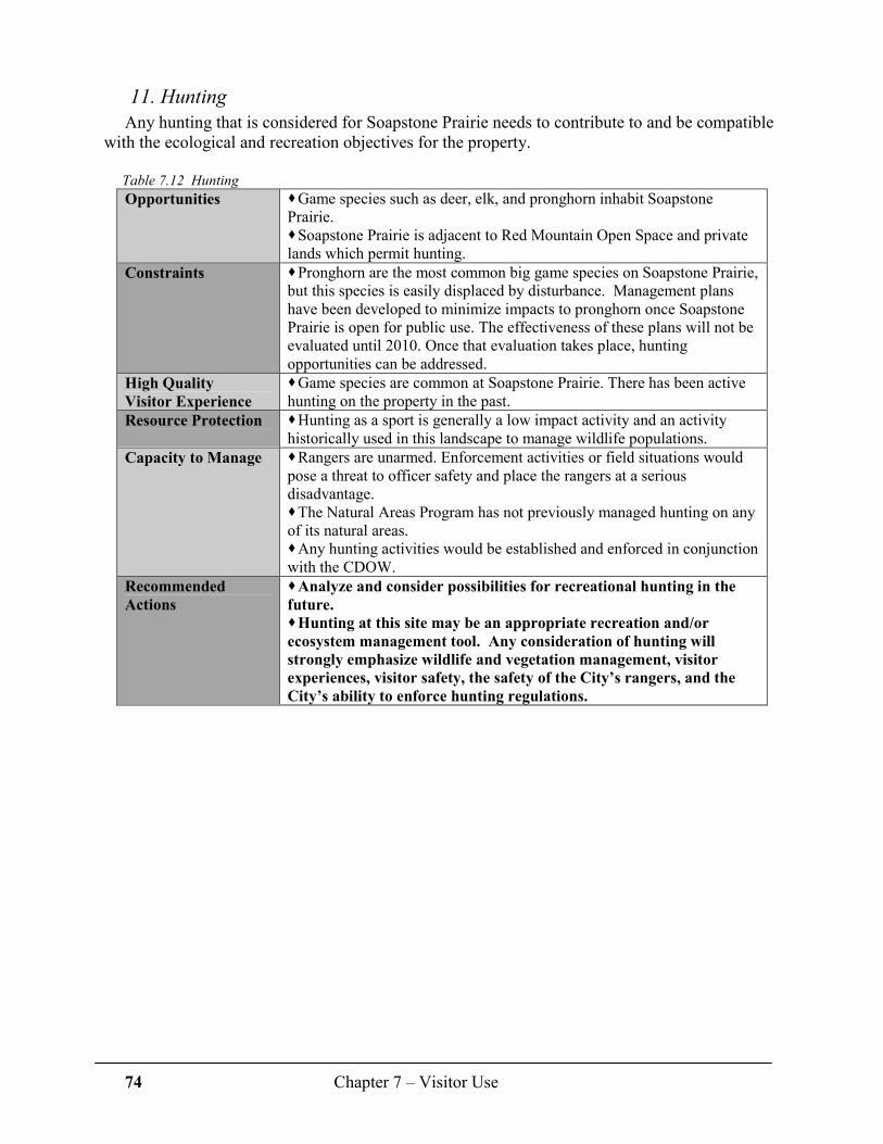
74 Chapter 7 – Visitor Use
11. Hunting
Any hunting that is considered for Soapstone Prairie needs to contribute to and be compatible with the ecological and recreation objectives for the property.
Table 7.12 Hunting
Opportunities � Game species such as deer, elk, and pronghorn inhabit Soapstone Prairie. � Soapstone Prairie is adjacent to Red Mountain Open Space and private lands which permit hunting.
Constraints � Pronghorn are the most common big game species on Soapstone Prairie, but this species is easily displaced by disturbance. Management plans have been developed to minimize impacts to pronghorn once Soapstone Prairie is open for public use. The effectiveness of these plans will not be evaluated until 2010. Once that evaluation takes place, hunting opportunities can be addressed.
High Quality
Visitor Experience
� Game species are common at Soapstone Prairie. There has been active hunting on the property in the past.
Resource Protection � Hunting as a sport is generally a low impact activity and an activity historically used in this landscape to manage wildlife populations.
Capacity to Manage � Rangers are unarmed. Enforcement activities or field situations would pose a threat to officer safety and place the rangers at a serious disadvantage. � The Natural Areas Program has not previously managed hunting on any of its natural areas. � Any hunting activities would be established and enforced in conjunction with the CDOW.
Recommended
Actions
� Analyze and consider possibilities for recreational hunting in the
future.
� Hunting at this site may be an appropriate recreation and/or
ecosystem management tool. Any consideration of hunting will
strongly emphasize wildlife and vegetation management, visitor
experiences, visitor safety, the safety of the City’s rangers, and the
City’s ability to enforce hunting regulations.

75 Chapter 7 – Visitor Use
12. Backcountry Camping
Public feedback indicates a desire for limited, designated-site, backcountry camping. Opportunities for backcountry camping are regionally limited to federal lands and Lory State Park.
Table 7.13 Backcountry camping
Opportunities � Soapstone Prairie is well-suited for designated backcountry camping.
Constraints � Infrastructure, regulations and a permit system need to be developed. Human waste is a major issue. Attracting wildlife such as bears could become an issue.
High Quality
Visitor Experience
� Soapstone Prairie offers opportunities for overnight getaways close to urban areas.
Ability to
Protect Resources
� Designated camping sites need to be in areas that do not impact protected resources. Open fires would not be permitted. � For visitor safety reasons, campsites may be closed as conditions warrant. Campsites require close monitoring to ensure that regulations are adhered to and so that garbage does not accumulate and attract wildlife.
Capacity to Manage � The Natural Areas Program has not permitted or managed this use previously. A permit system needs to be administered. Designated camping sites may need to include tent platforms and a plan for dealing with human waste. Natural sources of water for use by campers are limited and would require purification. � Leave No Trace principles would be emphasized.
Recommended
Action
� Complete a feasibility plan including addressing management
issues, measuring public demand, and identifying potential
campsites.

76 Chapter 7 – Visitor Use
The following table offers an overview of the potential recreational activities, issues that have been considered, and management status as discussed earlier in this plan.
Table 7.14 Recreational activities, considerations and current status.
Recreational Activity
Considerations
Current Status
Hiking • On-trail only.
• Trails designed to access sites of interest while protecting natural and cultural resources.
• Limit groups to 12 hikers, walkers or runners.
>30 miles of trails open to hiking, biking and walking.
Leashed Dog
Walking • Impacts to and conflicts with
wildlife.
• Enforcement of leash law difficult.
Dogs will be prohibited.
Mountain Biking • On-trail only to prevent resource damage and increase user safety.
• Limit groups to 12 bikers.
>25 miles of trails open to mountain biking.
Horseback Riding • On-trail only.
• Horses restricted from sensitive plant communities to protect against weed dispersal.
• Limit groups to 6 riders.
>20 miles of trails open to horseback riding.
Horse Carriages • Increased infrastructure costs.
• Potential conflicts with other users.
Use of carriages will be prohibited, except along roads open to public vehicle use.
Accessible Trails
ADA Compliant • Much of Soapstone Prairie has
rugged terrain; providing accessible trails may cause extensive resource damage.
• An accessible trail from parking area to Lindenmeier Valley overlook will be provided.
• Accessible trails will be provided to picnic shelters, vault toilets and scenic overlooks.
Picnic Areas • Leave No Trace information will be available.
• Wildlife safe trash receptacles.
• Locations will need to be carefully selected to avoid scenic impacts.
Picnic areas and shelters will be designed along trails and near parking areas.
Wildlife Watching • Extent of access and level of visitor use; areas may be seasonally closed due to wildlife activities.
Guided wildlife watching trips will be provided by Natural Areas Program staff and wildlife watching educational products will be developed.
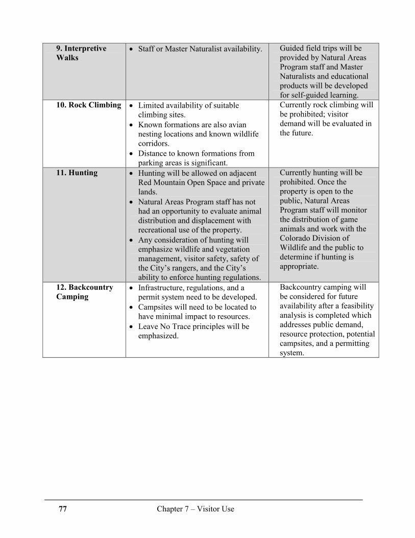
77 Chapter 7 – Visitor Use
9. Interpretive
Walks • Staff or Master Naturalist availability. Guided field trips will be
provided by Natural Areas Program staff and Master Naturalists and educational products will be developed for self-guided learning.
10. Rock Climbing • Limited availability of suitable climbing sites.
• Known formations are also avian nesting locations and known wildlife corridors.
• Distance to known formations from parking areas is significant.
Currently rock climbing will be prohibited; visitor demand will be evaluated in the future.
11. Hunting • Hunting will be allowed on adjacent Red Mountain Open Space and private lands.
• Natural Areas Program staff has not had an opportunity to evaluate animal distribution and displacement with recreational use of the property.
• Any consideration of hunting will emphasize wildlife and vegetation management, visitor safety, safety of the City’s rangers, and the City’s ability to enforce hunting regulations.
Currently hunting will be prohibited. Once the property is open to the public, Natural Areas Program staff will monitor the distribution of game animals and work with the Colorado Division of Wildlife and the public to determine if hunting is appropriate.
12. Backcountry
Camping • Infrastructure, regulations, and a
permit system need to be developed.
• Campsites will need to be located to have minimal impact to resources.
• Leave No Trace principles will be emphasized.
Backcountry camping will be considered for future availability after a feasibility analysis is completed which addresses public demand, resource protection, potential campsites, and a permitting system.

78 Chapter 7 – Visitor Use
D. Specific Visitor Experience Goals As stated in the beginning of this chapter, it is the Natural Areas Program’s goal at Soapstone
Prairie to provide a high quality visitor and recreation experience while simultaneously protecting the site’s significant ecological and cultural resources. This fine balance of recreation and conservation will be achieved with thoughtful planning, and careful implementation of recreation facilities design.
1. Trails
Goal: Provide a sustainable trail system to a variety of users while maintaining a high quality
visitor experience and protecting the natural and cultural resources.
• Employ best management practices and designs that offer scenic vistas, and that are sustainable.
• Design trails to minimize negative interactions between trail users.
• Design trail layout to access scenic and cultural vistas.
• Develop a trail system that provides opportunities for solitude.
• Develop the trail to include a series of short and long loops across diverse terrain.
• Design trails to minimize the opportunity for visitors to create unwanted social trails.
• Create an accessible (American Disabilities Act compliant) trail opportunity with scenic views, interpretive features and an interesting destination.
• Implement the “12-heartbeat rule” to reduce trail impact and to help manage visitor behavior through “share the trail” and “trail yield” etiquette.
2. Picnic Areas
Goal: Create opportunities for picnicking.
• Establish wayside areas along trails for picnics.
• Locate and build picnic shelter(s) to include tables and benches. Prohibit use of barbeques to limit the risk of wildfire and to reduce attracting wildlife.
• Minimize trash/wildlife interactions by highlighting Leave No Trace ethics such as “pack it in, pack it out” and using bear- and wind-proof trash cans.
3. Wildlife Watching
Goal: Provide ample wildlife watching opportunities.
• Manage all plant communities to enhance wildlife habitat and diversity.
• Provide regular guided wildlife watching field trips.
• Provide wildlife watching destinations as appropriate.
• Provide wildlife watching information in education products.
The “heartbeat rule” refers, literally, to the number of hearts. For instance, 6 riders + 6 horses = 12 heartbeats 8 hikers in a group = 8 heartbeats This system is often used by wilderness and other land managers to
reduce group sizes, thus reducing impacts to the natural resources.

79 Chapter 7 – Visitor Use
4. Interpretive Walks
Goal: Provide a variety of meaningful educational experiences for all visitors.
• Establish a regular schedule of guided public field trips with a wide variety of themes and topics.
• Provide self-guided learning experiences through a variety of educational products.
5. Hunting
Goal: Provide a recreational opportunity that is historic to the area.
• Determine abundance and distribution of big game wildlife species (elk, mule deer, pronghorn) after Soapstone Prairie opens to public use.
• Determine the feasibility of mixing limited hunting with other recreation and management goals, such as grazing.
6. Backcountry Camping
Goal: Provide designated backcountry camping opportunities on a trial-basis and as
institutional capacity allows.
• Determine feasibility by identifying management issues, public demand after the initial opening, and potential campsites.
Bird watching near trees on Roman Pasture

80 Chapter 7 – Visitor Use
E. Trail System The following map indicates the conceptual trails plan at full build-out, including
approximately 39 miles of public access trails. Actual locations of some trails will differ from the conceptual trail map below – final trail locations will be determined as crews work to find suitable terrain, scenic view points, and appropriate accessibility.
Hiking opportunities will be available on all trails; mountain biking will be available on all
but the trails close-in to the main parking area; and equestrians will have access to most trails in the southern two-thirds of the property. Trails will be phased in over time.
Trails will join the Red Mountain Open Space trail system in three locations. See Map 7, page
108 for the combined trails conceptual plan.
Map 6* Conceptual trails plan (*see Map 6 on page 107 for larger image)

81 Chapter 7 – Visitor Use
F. Managing Visitor Use The mission of the Natural Areas Program states in part that management actions will attempt
to balance conservation needs with recreation and education. Several types of management actions will be implemented in an effort to achieve this balance. These include limiting operating hours, seasonal trail closures and seasonal property closures.
1. Schedule of Operation
a. Open Periods
Soapstone Prairie will be open to public use every day from dawn to dusk, and from March 1 – November 30 each year.
b. Property and Trail Closures
Seasonal closures and limited recreation areas may be necessary for reducing the impact of recreation on certain wildlife species and cultural resources. The Natural Areas Program will monitor the amount and locations of visitor use, timing issues, visitor behavior, types of uses and visitor expectations.
The trail system and designated visitor use areas are located to provide safe use and high quality visitor experience while ensuring sustainability of the resources. Some trails may cross or come near areas identified as sensitive or potentially sensitive. Best management practices will be used to ensure the sustainability of long-term recreational use without damage to the resources. For instance, some trails may have seasonal closures and some trails will be designated for certain uses only, such as foot traffic.
- Seasonal Closures
The Jack Springs Unit on the eastern side of Soapstone Prairie will be closed to public use during the nesting and brood-rearing season for grassland birds; from April 1 – July 15 of each year (see Map 5 page 106 for general locations).
- Winter Closure Soapstone Prairie will be closed to public use from December 1 – end of February of each
year. This closure corresponds to relatively low levels of public visitation while allowing wildlife to endure critical winter periods without disturbance from recreation activities. Few winter recreation opportunities exist on Soapstone Prairie (cross country skiing, snow shoeing, etc.) given the limited amount of snow cover due to low precipitation and wind-scouring. In addition, the need for road maintenance related to blowing snow will be eliminated with this closure.
- Temporary Closures
Trail closures may be necessary as changes occur in distribution of some wildlife species. Examples include new locations for raptor nesting sites or swift fox den sites. Temporary closures may occur with limited public notification and will be marked clearly on trailhead kiosks and at the affected portion of the trail and posted on the Natural Areas Program website.
Table 7.14 Schedule of operation, sunrise to sunset
What When Where
Daily, dawn to dusk Open March 1 – November 30 All trails, except for seasonal closures
Seasonal closure Closed April 1 – July 15 Trails within Jack Springs Unit
Winter closure Closed December 1 – end February All trails
Temporary closures Closed As needed Where needed
82 Chapter 7 – Visitor Use
2. Law Enforcement
Law enforcement actions adhere to guidelines and objectives established in the Natural Areas Program (NAP) and Trails Ranger Manual. NAP and Trails Ranger personnel will provide primary law enforcement responsibilities, including patrolling, educating the public about rules, regulations and resource management, issuing warnings and/or citations, monitoring site conditions for misuse and maintenance needs, and calling for assistance in situations requiring emergency response.
Rangers have a limited commission to enforce NAP regulations and City of Fort Collins code. Rangers are unarmed and are not equipped to deal with certain situations. In situations involving criminal activities, rangers will call for appropriate authority. Colorado Division of Wildlife will handle situations involving illegal hunting. All other criminal activities will be handled by the Larimer County Sheriff’s Office.
The on-site ranger will be responsible for the primary patrol and enforcement responsibilities at Soapstone Prairie. All other NAP and Trails Ranger personnel will provide a secondary role in enforcement activities. Ranger trucks, all-terrain-vehicles will not be used to patrol the site, but motorized vehicles may be used only for management, maintenance and emergency situations.
3. Emergency Response Plan
Soapstone Prairie has extensive backcountry. This, combined with the property’s relatively large size and remote location, warrants an emergency response plan to ensure visitor safety and site protection.
Emergency response may involve several agencies and fire protection districts. For all emergencies, 911 will be the primary contact number. Emergency dispatch will send the appropriate response, as determined by the nature of the emergency. Callers should provide the physical address for 3700 Soapstone Road, Wellington CO. A list of responding agencies is provided below:
AMBULANCE / FIRE / POLICE
Any Emergency 911
Larimer County Sheriff’s Office (LCSO) 970-416-1985 City of Fort Collins Police Services 970-221-6545 Larimer County Emergency Services (LCES) 970-498-5300 Natural Areas and Trails Rangers 970-416-2147 Greeley AirLife 1-800-AIR-LIFE (247-5433)
FIRE
Any Fire 911
Wellington Fire 970-568-3232
WILDLIFE and NATURAL RESOURCES
Colorado Division of Wildlife 970-472-4300 Fort Collins NAP on-duty Ranger 970-416-2147 Larimer County Parks and Open Space 970-679-4570x1
HAZARDOUS MATERIALS
Emergency 911
Larimer County Health Department 970-498-6775 (weekdays, 9-5) Poudre Fire Authority (non emergency) 970-416-2600

83 Chapter 7 – Visitor Use
HOSPITALS
Poudre Valley Hospital (Fort Collins) 970-495-7000 Cheyenne Regional Medical Center (Cheyenne) 307-634-2273
a. Vehicle Access
There are two vehicle entrances into Soapstone Prairie. The east entrance is along a private road and the address is 3700 Soapstone Road. The south entrance can be accessed by driving north on North County Road 15 to the entrance gate.
Soapstone Prairie is able to accommodate air and vehicle evacuations should medical emergencies arise. Responding agencies may include Larimer County Sheriff’s Office, Larimer County Emergency Services, and Natural Areas Rangers. First Responders include Wellington Rural Fire District, Poudre Valley Hospital, Platte River Power Authority (PRPA) and AMR Ambulance in Cheyenne. First Aid supplies and equipment will be cached in a storage area located near the entrance or parking area. The storage area will be available to Natural Areas employees and emergency crews.
b. Wildfire
Wildfire operations fall under the jurisdiction of the Wellington Rural Fire District. All wildfires at Soapstone Prairie will be suppressed. PRPA has an automatic aid agreement with Wellington Fire and would be dispatched to all calls at Soapstone Prairie Monday through Thursday from 6:30 am to 5:00 pm. Outside of that, PRPA rescue response would require a special call. Natural Areas Program Fire Crew, Larimer County Emergency Services, and Poudre Fire Authority may provide assistance as requested.
c. Air Support (Flight for Life and Helitack)
Soapstone Prairie will have emergency accesses from the air that will be suited for air operations related to medical evacuations (Flight for Life, AirLife Greeley) and wildland fire operations (Helitack). Water sources will be identified with GPS coordinates and provided to responders.
Chapter 7 References 1 Easley, Tom and Newman, Wendy. 2003. Colorado’s Outdoor Recreation Future: Strategies
for Colorado’s Outdoor Heritage, Statewide Comprehensive Outdoor Recreation Plan, Denver. 258 pp. (Online at: http://parks.state.co.us/Trails/LWCF/SCORPPlan/)
2 U.S. Department of the Interior, Fish and Wildlife Service and U.S. Department of
Commerce, U.S. Census Bureau. 2001 National Survey of Fishing, Hunting, and Wildlife-Associated Recreation. 86 pp. (Online at: http://www.census.gov/prod/2002pubs/fhw01-co.pdf)
3 Genevieve Pullis La Rouche. 2001. Birding in the United States: a Demographic and
Economic Analysis Addendum to the 2001 National Survey of Fishing, Hunting and Wildlife -Associated Recreation, Report 22001-1, U.S. Fish and Wildlife Service, Division of Federal Aid, pages 9, 11, 12. (Online at: http://federalaid.fws.gov/surveys/surveys.html)

84 Chapter 8 – Management Zones, Visitor Expectations and Carrying Capacity
Chapter 8
Management Zones, Visitor Expectations and Carrying Capacity
Soapstone Prairie’s diverse ecological and cultural resources are spread across the landscape,
but in many instances are clumped in distribution. Because of this “clumping,” management delineations for recreation, visitor use, and conservation of Soapstone Prairie will be developed through the use of “management zones,” a concept used by many public and private entities for land management. Dividing large properties into management zones allows appropriate stewardship for areas with similar resources while providing a wide range of visitor experiences. Management zones support the design of a comprehensive development plan for this unique and extensive site, and specifically address the conservation target issues discussed in Chapter 6.
Soapstone Prairie will be divided into four management zones; each zone is defined by similar ecological or cultural resources for which there are related visitor expectations, management needs, and levels and types of development. The zones with greater levels of development (Developed and Frontcountry Zones) focus more heavily on creating positive visitor experiences; the less developed zones (Backcountry and Primitive Zones) place higher priority on cultural and ecological resources.
The table below illustrates the levels of visitor impacts and experiences that can be expected
within each management zone on Soapstone Prairie.
Table 8.1 Progression of management zone objectives
Management Zone
Resource
Condition
Visitor
Experience
Level of
Development
Developed Modified High Use Developed
Frontcountry
Backcountry
Primitive Pristine Restricted None

85 Chapter 8 – Management Zones, Visitor Expectations and Carrying Capacity
Map 8* Proposed management zones (*see Map 8 on page 109 for larger image)
The following pages describe in greater depth the goals, resource conditions, visitor expectations, facilities, carrying capacity and management actions for the four management zones of Soapstone Prairie. The colors of the Zone description boxes correspond with those on Map 8 above and on page 109. Red Mountain Open Space incorporates the concept of Management Zones, as well. A map showing the combined management zones of Soapstone Prairie and Red Mountain is on page 110.
Developed Zone: Resource Conditions
� Natural processes such as erosion, flooding, and grazing will be limited or controlled. � Native plant species dominate, but some non-native or invasive plants may be present. � Wildlife communities are diverse and provide excellent viewing opportunities. � Native plant communities will be restored through extensive control of invasive plants. � Areas impacted by human alteration will be restored. � Grasslands will be managed primarily through the use of prescriptive grazing and
mowing.
A. Developed Zone
� Developed to accommodate a high level of visitor use.
� Evidence of human alteration will be common.
� Included in this zone will be trails designed for ADA accessibility and shorter, less
physically demanding trails.

86 Chapter 8 – Management Zones, Visitor Expectations and Carrying Capacity
� Some roads occur within this zone, and will be used by management staff, livestock grazing cooperators and permitted researchers.
� Most cultural resources will be removed from site or tested by archaeologists.
Management actions to address resource condition changes in the Developed Zone may
include:
� Expanding efforts to inform visitors of the on-trail only designation. � Increasing education efforts to reduce impacts to resources. � Closing social trails. � Increasing invasive plant management activities. � Increasing efforts at trailheads to define trail use regulations. � Increasing education regarding invasive plant control and impacts from social trail use. � Limiting use by modifying parking capacity. � Increasing law enforcement presence if needed.
Developed Zone: Visitor Expectations
� Limited opportunities for solitude. � Visual and auditory impacts from other humans. � High quality plant communities, but habitats will be
fragmented by human alterations. � Some opportunities for wildlife viewing and good
views of the surrounding landscape. � Appropriate activities include picnicking and on-trail hiking, horseback riding, and
bicycling. � Very little, to a modest level of time and energy needed for visitor experiences.
Developed Zone: Facilities
� Facilities will include access roads, parking areas, picnic shelters, trailheads, well-defined natural and hard surface trails, interpretive and regulation signs, benches, kiosks, and observation areas as appropriate.
� Biological, cultural, geological, and/or other resources may require protection and management, but are not easily disturbed by regulated public use.
Developed Zone: Carrying Capacity Issues
� Gather visitor information (number and occurrence of visitors, types of recreation, group sizes, visitor satisfaction, etc.) through trail counts, trail inspections, and questionnaires gathered at parking areas and trailheads; determine changes from that information over time.
� Inspect trails to determine if impacts from high use are occurring.
� Inspect areas along established trails for evidence of dispersed use or social trails.
� Monitor resource values for changes in distribution of invasive plants along established or social trails, changes in wildlife distribution, and/or impacts to geological or archaeological resources.
Carrying Capacity refers to the type and level of human use that can be accommodated while sustaining conservation objectives and visitor opportunities. It is not based on visitor days or limiting the number of people visiting the natural area, but is a
process involving monitoring,
evaluating, and managing visitor use,
and adapting management as needed
to protect and conserve visitor and resource values.
The term Visitor Experience refers to the level of satisfaction to which each visitor feels his or her expectations have been met
within each management zone.

87 Chapter 8 – Management Zones, Visitor Expectations and Carrying Capacity
Frontcountry Zone: Resource Condition
� Erosion, flooding, and grazing allowed within portions of the zone. � Restoration efforts will be visible in areas along trails and within the viewshed. � Native plant species dominate, but some non-native or invasive plants may be present. � Wildlife communities are diverse and provide excellent viewing opportunities. � Restore native plant communities through extensive control of invasive plants and
reseeding. � Grasslands will be managed primarily through prescriptive grazing. � Some roads occur within this zone and will be used by management staff, livestock
grazing cooperators and permitted researchers. � Protect cultural resources, either in place, or remove for protection, depending on the
sensitivity of the site and/or resource.
Management actions to address resource condition changes in the Frontcountry Zone
may include:
� Expanding efforts to inform visitors to stay on established trails. � Increasing education efforts to reduce impacts to resources. � Trail closures. � Limiting use. � Increasing presence of law enforcement staff. � Increasing invasive plant management activities. � Modifying management zone boundaries.
Frontcountry Zone: Visitor Expectations
� Modest opportunities for solitude. � Visual and auditory impacts from other visitors; from restoration efforts, and from human
use (current and past use) of the landscape. � Presence of prescriptive livestock grazing activities and restoration activities. � High quality plant communities, wildlife viewing, and excellent views of the Front Range. � Appropriate activities include on-trail hiking, horseback riding, and bicycling. � A relatively high level of time and energy needed for visitor experiences.
Management actions to address changes in visitor experiences in the Frontcountry Zone
may include:
� Modifying grazing and restoration practices. � Limiting use by modifying parking capacity.
B. Frontcountry Zone
� Includes portions of Soapstone Prairie that contain native plant communities,
abundant wildlife, cultural, geological, and/or other resources that require
protection, but are found in locations that can be managed through regulated
public use.
� Evidence of human alteration is present and management activities will be more
intensive.

88 Chapter 8 – Management Zones, Visitor Expectations and Carrying Capacity
Frontcountry Zone: Facilities
� Well-defined natural surface trails, signs, benches, and observation areas as appropriate. � Biological, cultural, geological, and/or other resources may require protection and
management, but are not easily disturbed by regulated public use. � Signs as needed along trails to direct and inform visitors of regulation changes. � Signs and displays for public interpretation of cultural and natural features.
Frontcountry Zone: Carrying Capacity Issues
� Gather visitor information (number and occurrence of visitors, types of recreation, group sizes, visitor satisfaction, etc.) through trail counts, trail inspections, and questionnaires gathered at parking areas and trailheads; determine changes in information over time.
� Inspect sensitive areas such as cultural sites for footprints and other signs of visitor use. � Inspect areas along established trails for evidence of dispersed use or social trails. � Monitor for changes in distribution of invasive plants along established or social trails,
changes in wildlife distribution, and/or impacts to geological or archaeological resources.
Backcountry Zone: Resource Condition
� Erosion, flooding, and grazing allowed with as little human influence as possible. � Rare plant communities, rare plants, wetlands, riparian systems, important wildlife habitat,
cultural resources, and/or unique geologic features occur in this zone - management efforts will focus on protecting and conserving these features of the property.
� Invasive plant control will take place in all habitats as needed. � Grasslands will be managed through the use of management efforts designed to mimic
natural processes such as fire and grazing. � Some roads occur within this zone but will be used on a limited basis by management
staff, livestock grazing cooperators and permitted researchers. � Cultural resources will be protected in place.
Management actions to address changes in resource conditions in the Backcountry Zone
may include:
� Expanding efforts to inform visitors to stay on established trails. � Increasing education efforts to reduce impacts to resources. � Trail closures. � Establishing a permit system. � Limiting use. � Increasing presence of law enforcement staff.
C. Backcountry Zone
� This zone is representative of native plant and animal communities that are found
throughout Soapstone Prairie.
� Natural and cultural resources are considered sensitive but are located in areas
where impacts from recreation are more limited or can be managed and
protected.
89 Chapter 8 – Management Zones, Visitor Expectations and Carrying Capacity
Backcountry Zone: Visitor Expectations
� Greater opportunities for solitude. � Little or no visual and auditory impact from human disturbance. � High quality plant communities, wildlife viewing, and excellent views of the Front Range. � Appropriate activities include walking or hiking, on-trail only. � Visitors must be willing to commit a relatively high level of time and energy within this
zone.
Management actions to address changes in visitor experiences in the Backcountry Zone
may include:
� Establishing a permit system. � Limiting use.
Backcountry Zone: Facilities
� Facilities include narrow, natural surface trails. � No parking areas, restrooms, kiosks or other public improvements. � Trail systems will be used to access this zone. � Information will be placed at trailheads and signs may be placed along the trails at the
boundary of this zone indicating changes in trail use regulations.
Backcountry Zone: Carrying Capacity Issues
� Gather visitor information (number and occurrence of visitors, types of recreation, group sizes, visitor satisfaction, etc.) through trail counts, trail inspections, and questionnaires gathered at parking areas and trailheads; determine changes in information over time.
� Inspect sensitive areas such as cultural sites for footprints and other signs of visitor use. � Inspect areas along established trails for evidence of dispersed use or social trails. � Monitor resource values for changes in distribution of invasive plants along established or
social trails, changes in wildlife distribution, and/or impacts to geological or archaeological resources.
� Determine changes in visitor experience through visitor information.
Primitive Zone: Resource Conditions
� Erosion, flooding, and grazing allowed with as little human influence as possible. � Rare plant communities, rare plants, wetlands, riparian systems, important wildlife habitat,
cultural resources, and/or unique geologic features occur in this zone. � Focus is on protecting and conserving these features of the property. � Control invasive plants in all habitats as needed. � Grasslands will be managed through the use of management practices designed to mimic
natural events such as fire and grazing.
D. Primitive Zone
� Represents the portion of Soapstone Prairie with the greatest resource values,
least human influence, or represents areas of sensitive resources that may be
impacted by recreation. Visitors to Soapstone Prairie will be allowed into this
management zone only during guided tours.
� Research can be conducted by permit.

90 Chapter 8 – Management Zones, Visitor Expectations and Carrying Capacity
� Some roads occur within this zone but will be used on a limited basis by management staff and livestock grazing cooperators.
� Cultural resources will be protected in place.
Changes in resource conditions in the Primitive Zone may include:
� Expansion of invasive plants in areas visited. � Impacts to native vegetation. � Evidence of trails developing. � Changes in wildlife distribution.
Management actions to address resource changes in the Primitive Zone may include:
� Reducing tours, both in number of tours and number of people per tour. � Changing tour locations and access routes. � If wildlife impacts are seasonal in nature, tour dates may be changed accordingly.
Primitive Zone: Visitor Expectations
� Access limited to guided tours or research conducted under a Natural Areas Program permit.
� No trails or other facilities are found within this zone. � High quality plant communities, wildlife viewing, and opportunities to see cultural
artifacts in place. � High levels of solitude and hiking opportunities crossing natural landscapes developed
with little human influence. � Guided visitors must be willing to commit a relatively high level of time and energy
within this zone.
Primitive Zone: Facilities
� No constructed trails, parking areas, or other amenities typically found on natural areas. � Existing roads will remain in place and receive limited or no use by management staff and
grazing cooperators.
Primitive Zone: Carrying Capacity Issues
� No unguided visitation is allowed within the zone. � Impacts from guided tours will be monitored. � Visitor information will be gathered and analyzed for trends of use.

91 Chapter 9 – Education and Public Outreach
Chapter 9
Education and Public Outreach
A. Introduction
Educational and outreach opportunities are many and varied at Soapstone Prairie. The
variation in terrain, diversity of habitats, open vistas, unique geology and bountiful cultural history provides endless subject matter for presentations by volunteer naturalists and staff educators as well as interpretive displays and features on the sites.
The Natural Areas Program’s education component integrates education with appropriate recreation to enhance visitors’ experiences. Bird
watching, plant identification, reflecting, looking at scenery, attending a guided nature walk, hiking, horseback riding and biking allows citizens to explore and discover natural areas in a relaxed setting. Interpretive features, print material and personal communication by interpreters via guided field trips and presentations will help citizens understand the complexity of Soapstone Prairie’s ecology, the long cultural history of the area, and some of the challenging management issues. Management issues to be addressed may include on-going ranching activities including grazing by domestic animals, prairie dog management, seasonal closures, and strategies to prevent weeds and preserve the native vegetation communities.
A strong emphasis in the education and outreach efforts will be placed on Leave No Trace ethics that help inform visitors about the impacts of their actions on the land, on wildlife, and on other users. These will help the visitor learn to recreate on the land in a sustainable low-impact fashion.
The visitor learning and education experience concerning Soapstone Prairie may begin even before reaching the natural area. Initial concepts for this include educational activities, exhibits, print and electronic media regarding Soapstone Prairie and the entire Laramie Foothills
The mission of the City of Fort Collins Natural Areas Education Program is to:
� Increase the public’s awareness of natural and cultural resource areas.
� Promote understanding of natural systems and cultural resource protection.
� Foster each individual’s realization of the importance and meaning that natural
places and cultural resources add to our lives.
The education program accomplishes this by providing diverse materials on a variety
of topics concerning natural areas and cultural resources; by actively providing
experiential and participatory learning situations; and by personal outreach by trained
volunteer naturalists.
Guided tour, 2006
92 Chapter 9 – Education and Public Outreach
Mountains to Plains Project at strategic locations in Fort Collins (e.g. Fort Collins Museum/Discovery Science Center) and on the web.
B. Objectives Through interpretive panels, brochures and other print media, waysides, and other educational
features, programs, presentations and personal contacts with education personnel, visitors to Soapstone Prairie Natural Area should:
• Feel a sense of anticipation and welcome upon entering the site and a sense of responsibility and stewardship toward Soapstone Prairie.
• Be aware of specific management issues involving visitors including carrying capacity, multi- and single-use trails, management zones, resource protections and seasonal closures.
• Willingly conduct themselves so that the resources are not damaged by understanding the area’s regulations, the principles of Leave No Trace and by demonstrating appropriate behavior.
• Understand the variety of visitor experiences provided at this natural area.
• Be oriented on the site and easily recognize designated trails and closed areas.
• Understand the potential risks of visiting this natural area (e.g. rattlesnakes; steep rocky trails; long, exposed distances; exposure to weather extremes).
• Recognize that this area is managed to conserve the natural and cultural resources first, then to provide appropriate recreation and education opportunities.
• Learn some of the ecology of the shortgrass prairie, the foothills shrublands, cliffs, wetlands and springs and the influences of geology upon them.
• Appreciate the international cultural significance of the site.
• Know some of the prehistory and history including archaeological significance, and the American Indian, homesteading, and ranching heritages.
• Appreciate the international cultural significance of the site.
C. Proposed Education & Interpretive Products All education products will be dynamic, accurate and designed to engage a wide range of ages
and abilities that enable visitors to use different senses and preferential learning styles. Education products will be interactive where possible and make use of up-to-date technologies. Exhibits will be inviting, drawing in visitors with dynamic illustrations, easy-to-read active voice text, multi-media and three dimensions as appropriate, thereby allowing visitors to learn through exploration.
1. Entrance Station and Road Signs
In order to prevent a wasted trip and/or a bottleneck at the property boundary, visitors will be informed of specific conditions (trail closures, specific-use areas) before they reach the property boundaries of Soapstone Prairie. In addition to signs on NCR 15, an entrance station will be
Overall Interpretive Theme Soapstone Prairie Natural Area is a large landscape with complex relationships between
the land, the wildlife, and the people occurring over many millennia.

93 Chapter 9 – Education and Public Outreach
designed and placed in such a manner that visitors will receive information and make decisions about their visit before they arrive on the site. The entrance station may be staffed by Volunteer Trail Hosts or Master Naturalists on weekends or other busy days.
2. On-site interpretive panels and features
Interpretive features will be designed to be unobtrusive and fit into the landscape. This objective will be balanced with the goal of providing visitors with a clear orientation to the site and the regulations for use, while providing for group gathering areas, places for picnicking, and overlooks for enjoying the views.
3. Off-site interpretive panels and features
Permanent exhibits at the Fort Collins Museum/Discovery Science Center and other strategic locations will allow visitors to begin their experience even before arriving at Soapstone Prairie. A variety of print media and personal communication (some in partnership with the Fort Collins Museum/Discovery Science Center and Parks Departments, and Larimer County Parks and Open Lands) are planned. The visitor will be equipped with realistic expectations, primed with knowledge and a piqued sense of anticipation before venturing to Soapstone Prairie.
4. Self-guided interpretive information
This may involve numbered posts or other unobtrusive structures, or may use web- and GPS-based technologies that allow the visitor to learn more in-depth information about Soapstone Prairie. This type of information is conducive to frequent updates and changing information to keep repeat visitors interested.
5. Kiosks with orientation panels, bulletin boards and brochure racks
These structures will be located at each parking area in a manner that provides all visitors the opportunity to read the information, become oriented to the site, and learn more about the Natural Areas Program. The kiosks will house interpretive panels that welcome and orient visitors and inform them of the regulations and risks. The kiosks will also house bulletin boards that allow staff to inform visitors of upcoming programs and events, wildlife sightings, additional safety information, and other topical subjects. The brochure holders will have information concerning the Natural Areas Program, pertinent topics to this site and general information of interest to the visitors.
6. Site-specific brochure
The brochure will incorporate a trail map with distances and permitted uses and major landscape features. The brochure will be designed so visitors can carry it with them and refer to it while visiting the site.
7. Animal species checklists
These will be developed over a period of several years as more surveys are completed, but initially a bird list will be developed. These checklists enable some visitors to more fully explore the diversity of wildlife at Soapstone Prairie and more fully appreciate the dwindling habitat of this type along the Front Range.

94 Chapter 9 – Education and Public Outreach
8. Plant species brochure
This will also be developed over a period of several years as more surveys are completed. Proposed categories may be trees, shrubs, grasses, forbs and succulents. Plant lists help the visitor learn what to expect at the site and to appreciate the large diversity of plants and their habitats at Soapstone Prairie.
D. Suggested Education and Interpretive Topics Public tour surveys (summers 2005 and 2006) asked visitors “What topics would you like to
see on education and interpretive signs?” The most requested education topics at Soapstone Prairie were animals (especially birds), archaeology (specifically the Lindenmeier Valley), plants/wildflowers, ecology, geology, historical features and the ranching/homesteading heritage. Management issues to be addressed may include on-going grazing by domestic animals, prairie dogs, seasonal closures and weed prevention strategies. The following list of topics serves as guidelines for interpretation. Several topics may be incorporated into a single product.
1. Birds of Soapstone Prairie
In addition to a species list, guided tours to the shortgrass prairie ecosystem, volunteer bird surveys and bird walks will occur during certain seasons and areas.
2. Other animals of Soapstone Prairie
While birds are ubiquitous, large and small mammals, insects and herptiles all play important ecological roles.
3. Geology of the Laramie Foothills
Geologic influences including the effects of erosion and deposition strongly influences the ecology and landscape that we see today.
4. Ecology of the sandstone cliffs
A dominant feature of the site, the cliffs are used by nesting raptors and served as a landmark for many peoples over long periods of time.
5. Ecology of the shortgrass prairie
This high quality prairie habitat supports a diverse assemblage of declining prairie birds (several of high conservation significance), a robust prairie dog animal community, and critical winter range and concentration area for pronghorn. This is also one of the last places in Colorado where elk still venture out onto the plains. This area is subject to seasonal closures (in addition to entire site closures), thus it’s important for the visitor to understand sensitive wildlife species such as burrowing owls, mountain plover, prairie dogs and pronghorn, and the role of grazing in maintaining this rare ecosystem.
Guided birding trips are popular at
many natural areas
95 Chapter 9 – Education and Public Outreach
6. Ecology of the foothills shrublands community
The mountain mahogany/needle-and-thread plant community is a globally rare system and is significant for its extremely high quality condition – a sharp contrast to the weed-infested shrublands typical of other areas along the Front Range at similar elevations. It provides unique and vanishing habitat for butterfly and bird communities, as well as elk calving areas. This area is closed to horses due to its sensitivity and importance as a wildlife migratory corridor and habitat.
7. Cultural History of Soapstone Prairie
This vast subject will emphasize the archaeological significance of the Lindenmeier Archaeological Site and more recent use by American Indians. There are remnants of homesteading and ranching on the property and these will be included, as appropriate.

96 Chapter 10 – Site Administration
Chapter 10
Site Administration, Public Improvements and Site Security
Soapstone Prairie Natural Area is the second “regional” and largest property to date managed
and operated by the City of Fort Collins Natural Areas Program. Staff immediately began assessing initial needs of the site following the acquisition of the property in 2004. This included posting the area as closed, managing the boundaries, and completing an inventory of existing roads, structures, and other features of importance. This chapter lays out other property management considerations related to infrastructure, access, administration, roles, and restrictions of easements and leases, costs for planned public improvements and site security plans.
A. Existing Easements, Leases and Issues
1. Lease for cattle grazing
Two grazing leases were issued upon the City’s purchase of Soapstone Prairie in 2004. The Folsom Grazing Association leased approximately 11,762 acres and the Soapstone Grazing Association leased approximately 4,640 acres. Both leases expired December 31, 2005. In 2005, a Request for Proposals was issued that combined these grazing lands into a single lease. The Folsom Grazing Association was awarded this lease with an ending date of December 31, 2008.
Upon the purchase of the Roman and Krafzik properties in 2004 and 2005 respectively, a grazing lease between the property owners and Kurt Zimmerman was transferred to the City of Fort Collins (upon the City’s acquisition). The lease area included approximately 2,276 acres and will end December 31, 2007. At that time, the lease may be extended with the Zimmermans, or may be included with the Folsom Grazing Association lease.
A new grazing lease that combines all grazing rights to a single tenant and is tailored to meet public use needs and habitat management needs of the property will be issued in 2009, coinciding with the public opening of Soapstone Prairie Natural Area.
2. Declaration of Covenants, Conditions, and Restrictions for
Soapstone Ranch, Wyoming
The City of Fort Collins holds a limited development covenant on a portion of the Soapstone Ranch, Wyoming property. This covenant’s purpose is to protect the view from the Colorado property looking north and is applied to areas directly adjacent to the north of Soapstone Prairie. The covenant defines the protected area and limits and defines allowable development in three separate building envelopes.
3. Right of First Offer and Right of First Refusal
The Soapstone Grazing Association (owners of the Soapstone Ranch, Wyoming) granted a right of first offer and right of first refusal to the City of Fort Collins. This agreement ends on December 31, 2035.

97 Chapter 10 – Site Administration
4. Special Warranty Deed
The City of Fort Collins granted the Soapstone Grazing Association a perpetual access and utility easement along Soapstone Ranch Road entering Soapstone Prairie from the east. A second agricultural access easement was granted to allow movement of cattle or other animals from property owned by the Gallegos family to the south and west of Soapstone Prairie across the natural area to Soapstone Ranch, Wyoming. The agriculture access is not perpetual and shall terminate when more than 50% of the Wyoming ranch or 50% of the Gallegos property is sold.
5. Radio Tower/Transmitter Site Lease
An agreement between the Soapstone Grazing Association and Mountain States Radio was transferred to the City of Fort Collins upon purchase of Soapstone Prairie Natural Area. This lease agreement provides for a radio tower 190’ in height, an associated building (16’x 8’x 8’), a 210’x 210’ parcel of land, right of way for access and utilities, and the use of an existing road.
6. County Road 15
Larimer County Road 15 will serve as the public entrance to Soapstone Prairie. From County Road 82 north, it is considered a public road with private maintenance. Approximately nine miles of road will be improved to meet Larimer County Appendix G standards that require a 16’ travel surface. In addition, two bridges will be constructed to cross Rawhide Creek and Wire Draw.
B. Anticipated Public Improvements Several public improvement projects are needed at Soapstone Prairie Natural Area. However,
given the large size of the natural area and the many improvements needed, these projects will be constructed over time. Phase 1 pubic improvements are those needed to open the property to the public. Phase 2 projects are those that will occur after the public opening and as funding allows.
1. Phase I – Prior to public opening of Soapstone Prairie
Below is a list of current visible concerns or needs and recommended actions to be completed before Soapstone Prairie opens to the public.
a. Administrative
� Develop public input process designed to gather information on management needs, visitor enjoyment and use, and recreation needs after Soapstone Prairie opens to the public.
� Develop a protocol in case the parking areas are full which notifies the public prior to arrival. In addition to signs posted south of Soapstone Prairie, a phone- and internet-message system will be developed allowing the pubic to call in or check for information prior to departing for Soapstone Prairie.
� Update neighbors on issues associated with NCR 15 including construction, regulation enforcement, and others issues as they arise.
� Design visitor use monitoring program to identify the number of visitors, types of recreation use, trails used, etc. In addition this monitoring program will be used to measure ecological impacts, visitor satisfaction, and visitor needs.
� Hire additional Ranger by early 2009.
98 Chapter 10 – Site Administration
b. Public Improvements – NCR 15 Road Access
� Work with Larimer County Engineering Department to make improvements to NCR 15 needed to meet Appendix G road standards.
� Design and construct needed improvements to NCR15. � Restore all areas disturbed during NCR 15 construction. � Install security gate at appropriate location south of Soapstone Prairie Natural Area. � Clearly mark private roads and travel route to public trailhead parking. � Install roadside directional and information signs. � Install signage designating travel speeds, children present in neighborhood, and other
signage as needed.
c. Public Improvements – Trailhead Parking and Day Use areas
� Complete design of two parking areas in 2007. The South parking area will be designed to ultimately accommodate 15 horse trailers, and 30-40 cars. The North parking area will ultimately accommodate 50-80 cars and two buses.
� Locate site for Phase I trailhead picnic area by September 2007. � Design and install vault toilets as needed at both parking areas. � Design ADA facilities (parking, vault toilet, trails) at North parking area. � Complete construction of parking areas, ADA facilities, and installation of all vault-
toilets by spring 2009. � Design and construct picnic shelter areas in the North parking area by spring 2009. � Install bear-proof trash cans by spring 2009. � Design and construct entrance station and welcome kiosk.
d. Public Improvements – Trail Construction
� Construct Phase I trails. � Construct Phase I ADA accessible trails. � Install trail, safety, and directional signs as needed. � Install welcome kiosk with regulatory and educational information. � Design and install education and interpretive panels and signs at designated locations. � Design and install benches as needed along Phase I trails. � Decommission roads as needed.
2. Phase II - 0-5 years from public opening
These additional tasks will be phased in as demand and budget allow.
a. Public Improvements – Trail Construction
� Construct Phase II trails. � Install trail signs. � Install interpretive signs.
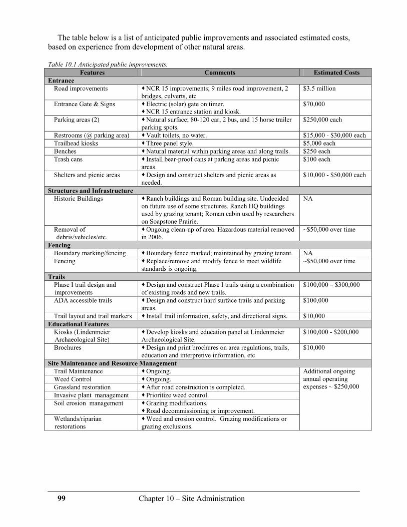
99 Chapter 10 – Site Administration
The table below is a list of anticipated public improvements and associated estimated costs, based on experience from development of other natural areas.
Table 10.1 Anticipated public improvements.
Features Comments Estimated Costs
Entrance
Road improvements � NCR 15 improvements; 9 miles road improvement, 2 bridges, culverts, etc
$3.5 million
Entrance Gate & Signs � Electric (solar) gate on timer. � NCR 15 entrance station and kiosk.
$70,000
Parking areas (2) � Natural surface; 80-120 car, 2 bus, and 15 horse trailer parking spots.
$250,000 each
Restrooms (@ parking area) � Vault toilets, no water. $15,000 - $30,000 each
Trailhead kiosks � Three panel style. $5,000 each
Benches � Natural material within parking areas and along trails. $250 each
Trash cans � Install bear-proof cans at parking areas and picnic areas.
$100 each
Shelters and picnic areas � Design and construct shelters and picnic areas as needed.
$10,000 - $50,000 each
Structures and Infrastructure
Historic Buildings � Ranch buildings and Roman building site. Undecided on future use of some structures. Ranch HQ buildings used by grazing tenant; Roman cabin used by researchers on Soapstone Prairie.
NA
Removal of debris/vehicles/etc.
� Ongoing clean-up of area. Hazardous material removed in 2006.
~$50,000 over time
Fencing
Boundary marking/fencing � Boundary fence marked; maintained by grazing tenant. NA
Fencing � Replace/remove and modify fence to meet wildlife standards is ongoing.
~$50,000 over time
Trails
Phase I trail design and improvements
� Design and construct Phase I trails using a combination of existing roads and new trails.
$100,000 – $300,000
ADA accessible trails � Design and construct hard surface trails and parking areas.
$100,000
Trail layout and trail markers � Install trail information, safety, and directional signs. $10,000
Educational Features
Kiosks (Lindenmeier Archaeological Site)
� Develop kiosks and education panel at Lindenmeier Archaeological Site.
$100,000 - $200,000
Brochures � Design and print brochures on area regulations, trails, education and interpretive information, etc
$10,000
Site Maintenance and Resource Management
Trail Maintenance � Ongoing.
Weed Control � Ongoing.
Grassland restoration � After road construction is completed.
Invasive plant management � Prioritize weed control.
Soil erosion management � Grazing modifications. � Road decommissioning or improvement.
Wetlands/riparian restorations
� Weed and erosion control. Grazing modifications or grazing exclusions.
Additional ongoing annual operating expenses ~ $250,000

100 Chapter 10 – Site Administration
C. Visitor and Resource Protection (Site Security) Because of the large and remote nature of Soapstone Prairie, there are new and significant
challenges toward ensuring the general safety of all visitors and staff, and providing for the security of the significant cultural and ecological resources. Safety and security concerns generally fall into three areas:
� Safety for all visitors, staff and volunteers. � Security for site improvements, archaeological artifacts, features, and sites. � Prevention of resource damage that could include wildlife poaching, off-road vehicle
travel, and the harassment of wildlife. Providing for the safety of people and protection of resources, the Natural Areas Program is
first considering access control, ranger patrol capability and enforcement authority, and additional resources and partnerships that will need to be forged with the Larimer County Sheriff’s office and Colorado Division of Wildlife to assist with a variety security and enforcement issues.
1. Access Control
All visitor access will be controlled through an entrance point on NCR 15 located at the south end of the property. When the site is open to the public, an entrance kiosk will be staffed (as often as feasible) to provide visitor information, and track numbers of visitors entering and leaving. Regulations and other visitor safety information will be placed at a kiosk near the entrance station and at all parking lots. Additional information regarding areas within the property that are prohibited or limited to public access will be provided.
The property perimeter will be posted as “City of Fort Collins Natural Areas Program” along fences and listed as “not an access.” While it is understood that three strand wire fencing is not tamper-proof, it is not desirable to “improve” fencing as a barrier as that would deter from traditional fencing in the area, be a barrier to wildlife movement, and be financially exorbitant. During times when the site is closed to the public, a solar electric gate set on a timer will be installed at the entrance to prevent off-hours access. A second electric gate will be installed across NCR 15 approximately 3 miles south of Soapstone Prairie. This gate will also close NCR 15 when Soapstone Prairie is closed to public use. Signage stating the hours of operation will be installed at both gates. Vehicular access from the east (Soapstone Prairie Road via Duck Creek Ranch and I-25) is already electronically gated.
2. Enforcement
Natural Areas Program and Trail Rangers will provide first line patrol and law enforcement at Soapstone Prairie. One additional Ranger FTE has been approved for 2009 to provide additional system-wide capacity as the site becomes open to the public. Active ranger patrol will be conducted between dawn and dusk on a daily basis with more full-time patrol during hours of operation. Volunteer Trail Hosts (VTH’s) will be assigned to assist rangers with visitor safety and resource protection. VTH’s will be equipped with two-way radios that will be monitored by on-duty ranger staff.
Because of the unique and pristine nature of the site, an aggressive education effort combined with strict enforcement of the City Municipal Code will be the protocol for ranger staff to ensure safe and responsible use of the site and deter repeat code violations. It will be critical to
101 Chapter 10 – Site Administration
coordinate law enforcement activities with Larimer County Open Lands Rangers who will patrol Red Mountain Open Space, and Larimer County Sheriff’s Office that are responsible for emergency backup and criminal activity that exceeds City of Fort Collins municipal code. Finally, rangers will need to work closely with the Colorado Division of Wildlife on wildlife protection and hunting-related issues.
3. Cultural Resources and Archaeological Sites Protection
The Lindenmeier Archaeological Site and hundreds of cultural features present on Soapstone Prairie tell the rich story of human occupation on the site over the course of thousands of years. The first step in the preservation of this resource will be to raise public interest and awareness of the significant cultural values through educational outreach. Experience as managers tells us that the public in general is very respectful of public resources when they are aware of, and understand, the value of the resource.
From a management aspect, access to the Lindenmeier Archaeological Site, stone rings, and similar cultural features and sites will be prohibited or limited. Fencing may be used to discourage visitor access in cultural sensitive areas. In cases where sites or features are intended to be viewed by visitors, delineating access to the areas with educational displays will be employed to help interpret the cultural feature to the visitor. The spectrum of recreation activities may be limited in the vicinity of these sites in the interest of preservation, and in some cases limited guided tours may be the only way to view some features. This plan is also recommending that if overnight camping is considered, campsites be located away from cultural sites.
Volunteers with specified archaeological training may be utilized to routinely examine sites to ensure the site’s features and artifacts are secure from human disturbance and/or natural events such as erosion. Artifacts will be collected under the direction of the City of Fort Collins Museum or Natural Areas Program staff. All artifacts collected will be deposited with the City of Fort Collins Museum.
Finally, The Lindenmeier Archaeological Site is listed as a National Historic Landmark which is administered by the National Park Service. City and state regulations are applicable to this site as well as other archaeological sites found on Soapstone Prairie. State statute CRS 24 80-401 (Historical, Prehistoric and Archaeological Resources Act) also applies to Soapstone Prairie.
4. General Visitor and Resource Protection Guidelines
Staff and volunteers will be trained to be aware of and report any activity to ranger staff that jeopardizes the safety of visitors or preservation of ecological and cultural resources. Signs requesting visitors to report any unusual activity to ranger staff will be displayed at appropriate locations. Specific responsibility may be delegated to ranger and other staff to perform routine inventory of sensitive sites and artifacts as well as any sign, fence or other security measure used to help protect the resource. Rangers will complete a patrol log for an accounting purpose that could then be used to establish a timeline of a resource violation. Finally, security cameras may be used in remote locations to monitor access into areas closed to public use or in areas where there may be trespass across city boundaries.
During hours open to the public, rangers, staff and volunteers will communicate with the use of two-way radios. The on-duty ranger will always be in radio contact with the Poudre Emergency Communications Center (Dispatch). Staff and volunteers will be instructed to act only as observers and witnesses and to immediately contact a ranger. Rangers will respond to incidents following established protocols. During hours when the area is closed to the public, daytime events will be handled by rangers following routine protocols. Evening and nighttime incidents will be coordinated by Larimer County Sheriff’s office.

102 Map 1 – Laramie Foothills Mountains to Plains Project

103 Map 2 – Surrounding Lands

104 Map 3 – Ecological Systems

105 Map 4 – Special Features
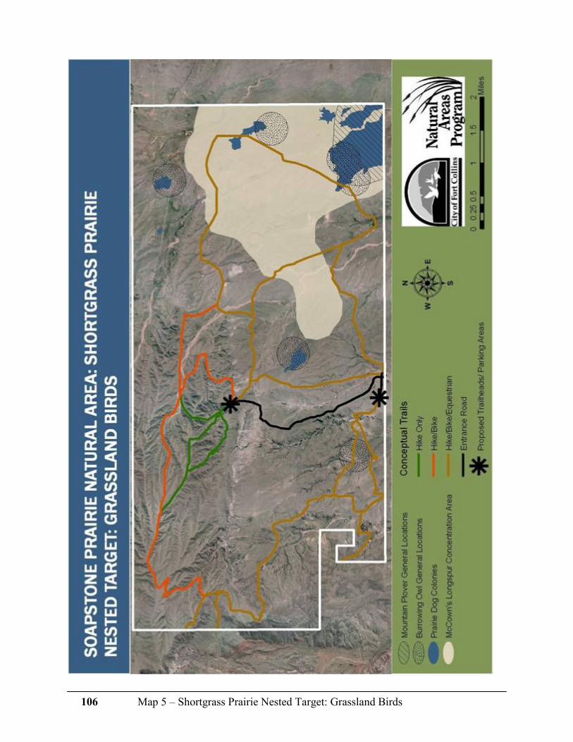
106 Map 5 – Shortgrass Prairie Nested Target: Grassland Birds

107 Map 6 – Soapstone Prairie Conceptual Trails Plan

108 Map 7 – Red Mountain & Soapstone Prairie Combined Conceptual Trails Plan

109 Map 8 – Soapstone Prairie Management Zones

110 Map 8 – Red Mountain and Soapstone Prairie Combined Management Zones

111 Appendix 1 – Laramie Foothills Mountains to Plains Projects through 2006
Appendix 1 Laramie Foothills Mountains to Plains Project through 2006
Total 194,733 acres
# acres ownership funding source ^^
Lead Agency: Legacy Land Trust, total 2,360 acres
747 private private
405 private public
1,208 private combined
Lead Agency: The Nature Conservancy, total 25,790 acres
9,223 private private
4557 private public
12,010 private combined
Lead Agency: Larimer County, total 15,229 acres
755 public public
13,448 public combined
70 private private
956 private combined
Lead Agency: City of Fort Collins, total 20,528 acres
4,189 public public
1,800 public* public
14,539 public combined
City of Cheyenne, Wyoming, total 20,800 acres
19,000 public public
1,800 public combined
Other Public Lands**
110,026 public public
^^ Public funding source include City of Fort Collins, Colorado Division of Wildlife, Great Outdoors Colorado, Larimer County, Rural Land Use Program, State of Wyoming, U.S. Fish and Wildlife Service
* Once conservation easements (CE's) are in place, these properties will be sold to private ownership.
**Other: includes Bureau of Land Management, City of Fort Collins (Utilities), Colorado Division of Wildlife, Colorado State University, Colorado State Land Board, State of Colorado, U.S. Forest Service.

112 Appendix 2 – Laramie Foothills Mountains to Plains Project Timeline
Appendix 2 Laramie Foothills Mountains to Plains Project Timeline
� Early 1980’s - The Nature Conservancy (TNC) recognizes the importance of the conservation of this area and coins the term “Laramie Foothills.” � 1987 – TNC formalizes its investment in conserving this landscape by completing its first capital campaign and purchasing what becomes known as Phantom Canyon Preserve. The preserve opens for stewardship and education programs in 1989. TNC builds a community-based conservation program developing partnerships and cooperative projects with private property owners, public land management agencies, non-profit and for-profit organizations and local, state, and federal governments including ranchers, Larimer County, Legacy Land Trust and the City of Fort Collins. � 1992 – Fort Collins voters pass a citizen initiated ¼ cent sales tax to fund the City’s Natural Areas Program. � 1993 – Larimer County adopted their first Parks Master Plan, and that plan identified the heart of the Laramie Foothills as a priority. � 1995 – Larimer County voters overwhelmingly pass a citizen initiated “Help Preserve Open Spaces” ¼ cent county-wide sales and use tax to fund the County’s Open Lands Program, 55% of which is shared with each of the eight incorporated cities and towns in the county. � 1997 – Fort Collins citizens pass the Building Community Choices ¼ cent sales tax to continue the funding of the City’s Natural Areas Program. � 1999 – Larimer County citizens overwhelmingly vote to extend the Help Preserve Open Spaces sales and use tax for 15 years until 2018, and to also give the County bonding authority for future revenues up to $54 million. � 2001 – Larimer County adopts an Open Lands Master Plan which expands upon the Laramie Foothills as a high priority area for conservation. � 2002 – Fort Collins citizens pass the citizen initiated Open Space Yes! ¼ cent sales tax to continue funding the City’s Natural Areas Program to 2030. Ballot language called for regional land conservation. By 2003 numerous conservation partners and community members have collectively conserved almost 15,000 acres in the Laramie Foothills forever. � 2003 – Jerry McMorris decides to sell the Red Mountain Ranch. � 2003 – City of Cheyenne purchases 17,000 acres of the Belvoir Ranch in Wyoming. This purchase will forge the beginning of an Open Space Program in Laramie and Albany counties. � December 2003 – GOCO begins discussions at their board meeting in Fort Collins regarding funding of large scale projects through citizen approved bonding or through existing fund balance. Kathay Rennels, Larimer County Commissioner, introduces the Laramie Foothills Mountains to Plains project to the Board of Directors of Great Outdoors Colorado (GOCO). � 2003 – The twenty members of the Soapstone Grazing Association decide to sell the Colorado portion of the Soapstone Ranch which they have owned for over 40 years. � May 2004 – City of Fort Collins adopts the Land Conservation and Stewardship Master Plan which designates the Laramie Foothills as a high priority area for conservation. � 2004 – Catherine Roberts sells a conservation easement on 4,557 acres of the Roberts Ranch after many years of discussion and planning with The Nature Conservancy. TNC partners on the purchase of the conservation easement were the City of Fort Collins, Larimer County and GOCO. � May 2004 – City of Fort Collins purchases the Colorado portion of the Soapstone Ranch property, now known as Soapstone Prairie Natural Area.

113 Appendix 2 – Laramie Foothills Mountains to Plains Project Timeline
� June 2004 –GOCO Board allocates $60 million towards large-scale projects of statewide significance. � July 2004 – Fort Collins City Council approves the sale of Certificates of Participation, providing the Natural Areas Program $15 million for land conservation, which will be paid back over 15 years. � August 2004 – Larimer County in partnership with the City of Fort Collins, The Nature Conservancy and Legacy Land Trust submits an application to GOCO requesting $11.6 million for the Laramie Foothills: Mountains to Plains Project. With a local match of 13.7 million, the partnership will protect over 55,000 acres of land at an average cost of $425 per acre. � September 2004 – Larimer County, using funds from a Farm and Ranchland Protection grant, purchases an easement on over 550 acres of the Ackerman property as part of the Mountains to Plains Project. � September 2004 – City of Fort Collins acquires a 640-acre in-holding in Soapstone Prairie and 1,220 acres adjacent to the south boundary from Keith and Myrna Roman. � November 2004 – City of Fort Collins leases 3,866 acres of in-holdings in Soapstone Prairie from the State Land Board. � December 1, 2004 – GOCO recognizes the great opportunity and approves the full grant request of $11.6 million – one of the largest GOCO grants ever awarded. � December 30, 2004 – Larimer County and TNC close on 13,500 acres of the Red Mountain Ranch, the most urgent element of the Mountains to Plains project, spending $7.8 of the $11.6 million GOCO dollars awarded to the project � January 2005 – City of Fort Collins acquires 316 acres from the Krafcziks for right-of-way for the extension of County Road 15 to provide public access to Soapstone Prairie. � February 2006 – City of Fort Collins acquires 1,360-acre Round Butte Ranch to help fill the conservation “donut hole” and protect scenic viewshed. The City will place a conservation easement on the property, funded largely by a GOCO grant, and will sell the land to a conservation buyer continuing the ranching tradition. � May 2006 – Catherine Roberts and TNC sign a voluntary conservation easement agreement to forever conserve the rest (13,500 acres) of the historic centennial Roberts Ranch. � November 30, 2006 – The City’s Natural Areas Program trades a 440-acre sod farm (acquired in 2005) in the Wellington Community Separator for the 3,873 acres of State Land Board in-holdings plus $807,000 cash. The sod farm has a conservation easement on it which allows an additional 23 homes to be constructed in a cluster. This is an overall win-win land exchange.

114 Appendix 3 – Public Tours Feedback Form
Appendix 3 Public Tours Feedback Form
Soapstone Prairie Natural Area/Red Mountain Open Space City of Fort Collins Natural Areas Program and Larimer County Open Lands Program
Tour type: SSN only____ SSN/RMOS____ Hiking SSN ____ Cultural ____
Please help us determine the types of activities and uses that you feel are desirable at
Soapstone Prairie and Red Mountain
Over the next two years we will be preparing management plans for the Soapstone Prairie Natural Area and the Red Mountain Open Space. Please share with us how you feel we should prioritize our efforts.
(1= highest priority, 4 = lowest priority) ___ Natural resource protection ___ Human history/cultural protection
___ Recreational opportunities ____Protecting the ranching tradition
What types of non-motorized recreation would you like to see available here?
Which types of trails do you prefer? (mark all that apply) Note: Developing a trail system for all types of users will be one of the key elements of the management plan.
Because this area is used by wildlife and contains sensitive ecological areas, there will be a finite number of trail miles. Combined or mixed-use trails = more total trail miles for a greater number of users, separated, or single-use
trails = fewer total trail miles per activity. � Biking, hiking & horseback riding together on the
same trail � Biking & hiking together on the same trail
� Biking & horseback riding together on the same trail
� Hiking & horseback riding together on the same trail
� Separate trail for hiking
� Separate trail for biking � Separate trail for horseback riding
� Limited visitation with few or no trails
Is limited, permit-only, designated backcountry camping an appropriate use here? Why? � Yes � No � Not sure
Is limited hunting an appropriate use here? Why? � Yes � No � Not sure
Is it appropriate to seasonally close areas due to sensitive wildlife activities such as nesting, denning or calving?
Why? � Yes � No � Not sure
Is it appropriate to seasonally close areas due to sensitive plants/plant communities? Why? � Yes � No � Not sure
Is grazing by domesticated cattle an appropriate use at Soapstone Prairie and Red Mountain
when used for vegetation management goals? � Yes � No � Not sure
when used to maintain a ranching tradition? � Yes � No � Not sure
During the course of a year, how many times are you likely to visit these areas after they are open to the public?
� 1-3 � 3-5 � 5-10 � 10+
Please rank the following biological and cultural features in order of importance for protection: (mark with an X)

115 Appendix 3 – Public Tours Feedback Form
Biological and Cultural
Features
High
Priority
Medium
Priority
Low
Priority
Didn’t see/
not sure
Historic camp sites
Homestead sites
Lindenmeier Archaeological Site
Sensitive ecosystems (i.e. shortgrass prairie)
Prairie dog colonies
Ranch buildings
Rock cliffs/eagle nests
Tipi rings
Wildlife migration corridors
Wildlife nesting, denning and calving sites
Other (please list)
What educational topics would you like to see on interpretive signs and brochures?
Is it more appropriate to have: � More information on signs, less information through brochures
� More information through brochures, less signage
� An equal balance of information on signs and brochures
What topics would you like to see emphasized by naturalists on future visits to these areas?
Do you feel you have a good understanding of where funding to protect these properties came from?
What did you find most interesting on the field trip?
What part of the field trip was the least interesting?
Would you recommend this field trip to others? Why?
How did you find out about this field trip?
Would you like to provide a quote about your experience today for future publications? If so, please provide your
name.

116 Appendix 4 – Public Tours Feedback Form Responses and Comments
Appendix 4 Public Tours Feedback Form Responses and Comments
2005-2006, total 733 returned forms
Question 1: Over the next two years we will be preparing management plans for the Soapstone Prairie Natural
Area and the Red Mountain Open Space. Please share with us how you feel we should prioritize our efforts.
(1= highest priority, 4= lowest priority)
Priority Natural resource
protection
Recreational
opportunities
Human history /
Cultural protection
Protecting the
ranching
tradition
1 72% 10% 25% 7%
2 17% 20% 53% 10%
3 6% 40% 18% 30%
4 4% 30% 5% 52%
Question 2: What types of non-motorized recreation would you like to see available here?
(these were written-in answers, not table) Figures = more than 100 percent because respondents could list multiple options
Hike
Horse-
back
ride
bike other Interpretive
walks Camp
Cross
country ski
Bird-
watch None
No
dogs
66% 50% 46% 12% 9% 7% 4% 4% 1% 1%
Question 3: Which types of trails do you prefer?
Biking,
hiking &
horseback
riding on
same trail
Biking &
hiking
on same
trail
Biking &
horseback
riding on
same trail
Hiking &
horseback
riding on
same trail
Separate
hiking
trail
Separate
biking
trail
Separate
equestrian
trail
Few or
no
trails
Prefer 25% 24% 13% 28% 42% 32% 36% 10%
Do Not Prefer 75% 76% 87% 72% 58% 68% 64% 90%
Question 4: Is limited, permit-only, designated backcountry camping an appropriate use here? Why?
Yes 57% No 20% Not Sure 22% (blank) 1%
Question 4: Comments and concerns (compiled)
� Danger to campers (weather) � Fires / trash/ water/ human waste concerns � Infrastructure costs may be prohibitive � Other camping resources are available � Regular camping, too � Sensitivity of site – protection of natural and cultural resources � Serve minority of population � Tent only, permit fee, limited use � To allow backpacking � To experience the land by both day and night � To see backcountry – some areas too far away for day use only � Wait until usage (of whole area) is determined � With "leave no trace" permits required

117 Appendix 4 – Public Tours Feedback Form Responses and Comments
Question 5: Is limited hunting an appropriate use here? Why?
Yes 28% No 52% Not Sure 18% (blank) 1%
Question 5: Comments and concerns (compiled)
� Allow wildlife to regulate itself � Bow and arrow only � Close it at night to preserve wildlife and artifacts � Closing off sections not fair � Damage to land from vehicles or off trail use � Depends on need – both from visitor and wildlife standpoints � Disturbs peacefulness � Does not appear to have overpopulation problem � Emphasis on activities which benefit everyone � For game management � Tradition - historically land was used for hunting � Hunt pronghorn/not predators � Hunting could make wildlife harder to see � I hunt but would prefer not to allow hunting there � Limited hunting by permit only � No hunting – not appropriate � Other hunting areas are available � Protect natural resources – purpose is to conserve � Recreation � Should be by scientific analysis � Use hunting fees for maintenance, patrol � Visitor safety/ conflicts with mixed uses � Will hunting effect grazing?
Question 6: Is it appropriate to seasonally close areas due to sensitive wildlife activities such as nesting, denning
or calving? Why?
Yes 92% No 3% Not Sure 4% (blank) 1%
Question 6: Comments/concerns (compiled)
� Conservation/preservation of native species is important � Major purpose should be ecosystem restoration � Natural Resources primary - recreation secondary � Only if necessary – very limited � Post it clearly � Route trails around these areas � Seasonal, and only amount of area necessary � Teach people how to act in sensitive areas � To promote diversity of wildlife so we can enjoy � Would still like guided tours
Question 7: Is it appropriate to seasonally close areas due to sensitive plants/plant communities? Why?
Yes 70% No 11% Not Sure 14% (blank) 5%
Question 7: Comments/concerns
� Conservation/preservation of native species is important � Does not appear to be delicate – plants will grow back � If grazing is done some plants need time to reproduce � Keep biodiversity in area � Limited time/ limited areas � Need more environmental education at NA areas � Not needed – trail use only, or route trails away from these areas � There's plenty of land � To assure food for wildlife � To experience those areas better

118 Appendix 4 – Public Tours Feedback Form Responses and Comments
Question 8a: Is grazing by domesticated cattle an appropriate use at Soapstone Prairie and Red Mountain when
used for vegetation management goals? Why
Yes 57% No 18% Not Sure 25% (blank) 1%
Question 8b: Is grazing by domesticated cattle an appropriate use at Soapstone Prairie and Red Mountain when
used to maintain a ranching tradition? Why?
Yes 85% No 6% Not Sure 25% (blank) 1%
Question 8: Comments/concerns (compiled)
� For limited number of years – gradually reduce � Grazing is essential to health of ecosystem � If used for education and well-managed (no overgrazing) � In designated areas only � Most ranchers are good stewards of the land � Not mutually exclusive � Only 100 years of cattle, native species have been here for 1000’s of years � Poop draws nasty flies � Tradition/ historical importance to area � Unexpected consequences � Use bison or elk instead � Yield to the experts on this issue
Question 9: During the course of a year, how many times are you likely to visit these areas after they are open to
the public?
0 2%
1 32%
3 28%
4 14%
5 11%
7 4%
10 9%
Total 100%
Average # of visits 3.7
Question 10: Please rank the following biological and cultural features in order of importance for protection:
(mark with an X)
High Medium Low
Didn’t see/ not
sure N/A (blank)
Historic camp sites 42% 39% 10% 4% 3% 3%
Homestead sites 38% 46% 10% 1% 1% 3%
Lindenmeier Archaeological Site
92% 4% 1% 0% 0% 3%
Sensitive ecosystems 65% 25% 4% 0% 2% 4%
Prairie dog colonies 23% 35% 34% 3% 1% 3%
Ranch buildings 14% 45% 32% 3% 2% 3%
Rock cliffs / eagle nests 81% 13% 2% 1% 1% 3%
Tipi rings 63% 27% 4% 0% 1% 4%
Wildlife migration corridors 77% 14% 4% 0% 1% 3%
Wildlife nesting, denning and calving sites
85% 10% 1% 0% 1% 3%
Other 3% 0% 0% 0% 0% 96%
Question 11: What educational topics would you like to see on interpretive signs and brochures? (compiled)
These topics were listed: animals / birds, archaeology, “Big Hole”, cultural history, ecology, geology, Lindenmeier, plant identification, ranching, responsible visitation / use, site plans

119 Appendix 4 – Public Tours Feedback Form Responses and Comments
Question 12: Is it more appropriate to have:
Equal balance of information 46%
More information on brochures 27%
More information on signs 24%
(blank) 3%
Question 13: What topics would you like to see emphasized by naturalists on future visits to these areas?
(compiled)
These topics were listed: animals/birds, archaeology, “Big Hole”, cultural history, ecology, geology, Lindenmeier, plant identification, ranching, responsible visitation /use, site plans.
Question 14: Do you feel you have a good understanding of where funding to protect these properties came
from?
Yes 95%
No 5%
Question 15: What did you find most interesting on the field trip? (compiled)
These subjects were listed by participants:
Lindenmeier 33%
Everything 20%
Nature / Ecology 16%
Views / Beauty 16%
Human History 15%
Big Hole 7%
Other 5%
Vastness 4%
Diversity 3%
Site Planning 2%
Geology 2%
Partnerships 1%
Protection of undeveloped area 1%
Question 15: What did you find least interesting on the field trip? (compiled)
Comments included: “the gates,” “driving on the Interstate,” “the ride home,” and “filling out this survey,” though most remarked that they found nothing “least interesting.”
Question 17: Would you recommend this field trip to others? Why? Yes 96%
No 4%
Question 18: How did you find out about this field trip?
Word of mouth 25%
Newspaper/ magazine 37%
Other 11%
City Employee 7%
League of Women Voters 3%
Master Naturalist 3%
Work 3%
Flyer / display 2%
Web 2%
Figures add to up less than 100 percent due to some global non-responses.

120 Appendix 4 – Public Tours Feedback Form Responses and Comments
Question 19: Would you like to provide a quote about your experiences today for future publications?
2005 Responses
� This area will provide our descendants with such valuable insights into open space and history. It is a wonderful use of our money. - Fran Johnson � Don't miss a chance to learn about the past of this area. - Roberta Cole � The day was full of great history info. I was so very happy for a perfectly wonderful day! � The Soapstone Natural Area is truly a gem and a fantastic resource for learning and recreation for Northern Colorado. � I am so glad this area is being preserved. I don't think there are any natural areas that few years down the road people have regretted creating. � One hundred years from now, this area will be one of only a few areas that will look the same as in 1800. � I wish that everyone could feel the same as I do after my incredible experience in Soapstone/Red Mountain. - Steve Olt � It would be helpful to merge trails so that traffic travels from more pristine areas into less pristine areas- keeping transport needs to a minimum. I have seen areas open to horseback riding which have restrictions on which kinds of feed can be provided to horses- this is a good idea to avoid seed contamination. Trails arranged in loops may help users limit themselves from off-trail exploration. It is helpful to know that the beginning of a trail, how long the trail is and if there is a particular destination associated with that trail. I would like to see guided tours and displays to educate users about prehistoric (Folsom) and current use of area, geology and ecosystems. � Soapstone Prairie is like taking a step back in time. It gives you some sense of what the prairie was like before modern man. Rejuvenating! Thank you - Pam Annis � I would like to see an artists painting day to display paintings at an open house. It would also be a good way to advertise to put a painting on material to advertise what is being done. A tour for art teachers and art classes. Involve children and what they would like. � Keep exploring Colorado Open Spaces. They're bigger and better than ever. - Mike Harchster � The acquisition of open space is the wisest thing that we can give to future generations and ourselves- money well spent! - Ken Wright � It is amazing to me that Fort Collins has the foresight to fins the resources to protect a priceless environment such as Soapstone Ranch! - Ken Kerchenfaut � The city and the county have great foresight in preserving this area- a wonderful and appropriate use of our money. - Lynne Hull � I am so proud of our city for having the foresight to preserve this unique landscape for us and to appreciate and enable wildlife corridors to be continued. � Fort Collins and Larimer County made a wise choice in protecting this beautiful area for the enjoyment of future generations. - Gary Raham � It has been the finest day I've experienced in a while: emotionally and philosophically. The site captures America's history, the West's expansions, and today's needs. - Linda Hamilton � I feel that tax money was used to purchase property - but it is not accessible to all. There should be a way to have people get in 2-3 weeks out of a season. � One of the most informative tours I have taken. I learned a lot about ranching and history of this area. - Louis Linn � Suggestions - fall trail race - funds to go to signage & brochures? Soapstone 10 mile and Soapstone 10K � Haiku to SOAPSTONE: Skies, grasses, hills, vales, our senses stimulated, Share all the beauty Please continue auto tours past opening for disabled people. - Anne Coffey � Continue auto tours even up to opening of area and also after the area is open. � Soapstone helped me make sense of the city's property acquisition activities. � Anyone who cares about the land and its human uses history and its geology should take this trip - Walter Rosenberry � Colorful desolation. - Jim White � This is a beautiful place worthy of our efforts to preserve it. - D. W. � It is important to allow good access, but limit cars. Perhaps entry from both sides, with parking and trailheads 2-3 miles, several trails and trail branches to high points, important destinations- up to 3-4 miles. � A unique and precious gift to the future of our area. - Karl Krahnke � After 20 years our successors will think we were brilliant for setting aside this area as public property- at any cost. - Alan Silverstein � Future generations will be forever grateful to the foresight and vision of the present people devoted to the idea of open space and nature. � An awesome view of undeveloped land. Let's keep it that way. Thanks, Fort Collins, for your future insight.- Electra Cameron
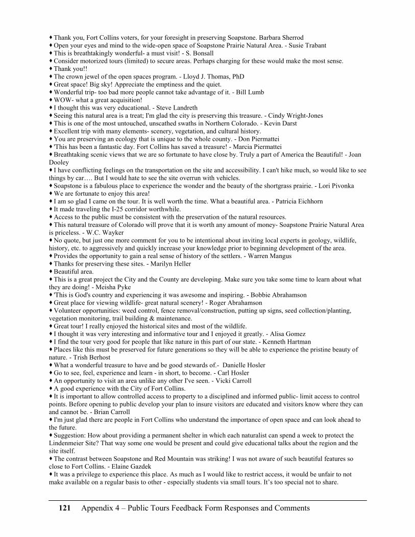
121 Appendix 4 – Public Tours Feedback Form Responses and Comments
� Thank you, Fort Collins voters, for your foresight in preserving Soapstone. Barbara Sherrod � Open your eyes and mind to the wide-open space of Soapstone Prairie Natural Area. - Susie Trabant � This is breathtakingly wonderful- a must visit! - S. Bonsall � Consider motorized tours (limited) to secure areas. Perhaps charging for these would make the most sense. � Thank you!! � The crown jewel of the open spaces program. - Lloyd J. Thomas, PhD � Great space! Big sky! Appreciate the emptiness and the quiet. � Wonderful trip- too bad more people cannot take advantage of it. - Bill Lumb � WOW- what a great acquisition! � I thought this was very educational. - Steve Landreth � Seeing this natural area is a treat; I'm glad the city is preserving this treasure. - Cindy Wright-Jones � This is one of the most untouched, unscathed swaths in Northern Colorado. - Kevin Darst � Excellent trip with many elements- scenery, vegetation, and cultural history. � You are preserving an ecology that is unique to the whole county. - Don Piermattei � 'This has been a fantastic day. Fort Collins has saved a treasure! - Marcia Piermattei � Breathtaking scenic views that we are so fortunate to have close by. Truly a part of America the Beautiful! - Joan Dooley � I have conflicting feelings on the transportation on the site and accessibility. I can't hike much, so would like to see things by car…. But I would hate to see the site overrun with vehicles. � Soapstone is a fabulous place to experience the wonder and the beauty of the shortgrass prairie. - Lori Pivonka � We are fortunate to enjoy this area! � I am so glad I came on the tour. It is well worth the time. What a beautiful area. - Patricia Eichhorn � It made traveling the I-25 corridor worthwhile. � Access to the public must be consistent with the preservation of the natural resources. � This natural treasure of Colorado will prove that it is worth any amount of money- Soapstone Prairie Natural Area is priceless. - W.C. Wayker � No quote, but just one more comment for you to be intentional about inviting local experts in geology, wildlife, history, etc. to aggressively and quickly increase your knowledge prior to beginning development of the area. � Provides the opportunity to gain a real sense of history of the settlers. - Warren Mangus � Thanks for preserving these sites. - Marilyn Heller � Beautiful area. � This is a great project the City and the County are developing. Make sure you take some time to learn about what they are doing! - Meisha Pyke � 'This is God's country and experiencing it was awesome and inspiring. - Bobbie Abrahamson � Great place for viewing wildlife- great natural scenery! - Roger Abrahamson � Volunteer opportunities: weed control, fence removal/construction, putting up signs, seed collection/planting, vegetation monitoring, trail building & maintenance. � Great tour! I really enjoyed the historical sites and most of the wildlife. � I thought it was very interesting and informative tour and I enjoyed it greatly. - Alisa Gomez � I find the tour very good for people that like nature in this part of our state. - Kenneth Hartman � Places like this must be preserved for future generations so they will be able to experience the pristine beauty of nature. - Trish Berhost � What a wonderful treasure to have and be good stewards of.- Danielle Hosler � Go to see, feel, experience and learn - in short, to become. - Carl Hosler � An opportunity to visit an area unlike any other I've seen. - Vicki Carroll � A good experience with the City of Fort Collins. � It is important to allow controlled access to property to a disciplined and informed public- limit access to control points. Before opening to public develop your plan to insure visitors are educated and visitors know where they can and cannot be. - Brian Carroll � I'm just glad there are people in Fort Collins who understand the importance of open space and can look ahead to the future. � Suggestion: How about providing a permanent shelter in which each naturalist can spend a week to protect the Lindenmeier Site? That way some one would be present and could give educational talks about the region and the site itself. � The contrast between Soapstone and Red Mountain was striking! I was not aware of such beautiful features so close to Fort Collins. - Elaine Gazdek � It was a privilege to experience this place. As much as I would like to restrict access, it would be unfair to not make available on a regular basis to other - especially students via small tours. It’s too special not to share.

122 Appendix 4 – Public Tours Feedback Form Responses and Comments
� This land is an exquisite jewel and we Northern Coloradoans are so very blessed to have this wonderful natural resource to explore in our very own backyard! - Doreen Jansen � Excellent land saved for us and the future generations and a very appropriate use of the tax initiatives. - Sharon Clemens � Take bus loads of hikers in, drop off at trails. Charge for all tours. Get hikers involved - games, power point presentations. Get TOP native photographers here to document the best part of it and artists to preserve it. In the next 2-3 years: public art competition to help promote - bring up 2-3 loads up at once to a scenic spot. � It is very important that some form of motorized access to the top be provided. Even if this access is only on weekends. The views are spectacular, but too many individuals would not be able to reach the top without motorized access. � Minimal motorized access re: single road through needs to stop at (view of Big) Hole. � Need to keep close tabs on who will be working on the property so it doesn't turn into a playground. � It was like a revisitation to my youth years in East Montana. - Dick Hecker � Use white tents as interpretive avenue for Lindenmeier. These could be removed in the winter. Provide very limited shuttle service to more remote sites for small fee. Provide guided tours. Keep Lindenmeier Site accessible to the public. Work on creative funding sources, but don't overdevelop it. � Hiking trails to include potable water - ecological toilets at designated campsites. No fees should be collected for use of the area. Multiple use trails should connect City to County to Cheyenne open space. Winter use should be encouraged. Any restrictions to humans should include cattle/ranching. Is there any upland game in the area? � Solar potties or bathrooms similar to those at Maroon Bells/Aspen. Allow dogs on leashes or a fenced off area allowed for dogs. � Suggest to have one centrally located horseback riding concession shared by the County and City administration. And, given the heat of summer months, some kind of relief stations (i.e. shaded areas w/water) be available. � Maybe an off leash area for dogs - separately fenced. � The City has done an excellent job of instituting their program, but I don't agree that these areas are needed or desirable. Larimer County has a huge amount of public land already and it’s much more user friendly than it appears that Soapstone or Red Mountain promise to be. I enjoy rural (open) land, but would prefer that we do the role of structure (at local and federal level). I also dislike removing large areas from the tax base. � Maybe, out of 125,000 people in Fort Collins, more people should know about this project than just from a few trips. Look at the control of Mesa Verde National park where a few people control many visitors. Try to save money. The City cannot do this project alone. Look for outside help, etc. Partner with others - not just the City. � Would like to see bus tours through area. � Provide limited transportation within the park. Possibly some transportation from Fort Collins. � I am so thankful the City Council chose to buy this wonderful site. It's a special place and will be treasured for decades to come.- Gina Janett * Consider contracting with private contractors for small group tours- bringing in small revenue streams. Shuttle trips on weekends with reservations required. Lindenmeier was a dream to me that I have wanted to visit since 1978- it would be great to have a summer archeology camp for grad students. � Because the Lindenmeier Site is so important, I believe there should be an interpretive center devoted specifically to it. Perhaps something with good info and visual and photo and an overlook at the actual place. I also think that this would be an excellent place for guided trolley tours for public and otherwise limited access by private cars/vehicles. � If you need to go out of town and fulfill a quest for exploring something practically in your backyard, you can do no better than to go to Soapstone Prairie N.A. WOW! � The best was the past and the best is yet to come because of far sighted naturalists and preservationists. - Vonda Carter � We need to travel through the area to fully appreciate its significance. � We ought to commend all the organizations involved for working together and having the foresight to bring this project to fruition. - Barbara Rutstein � You get treats for filling out the questionnaire. - John Muis � It's nice to spend a big part of the day mostly out of sight of civilization, man-made structures, traffic, noise, etc. - Margaret S. Smith � Don't let the land go the way of the Folsom Man. - Mark Loader 1. (Create) a list of books that relate to the area. 2. Ask for input from old timers on the history. 3. Have set camp sites so impact is confined to less vulnerable locations. 4. Lindenmeier Site could be reached from I-25. 5. I-25 site for interpretive site for education and income. � I can't explain how excited I am to see this project take shape and the carefulness of how it is being approached. � Best kept secret. � Breathtaking scenery - a very worthwhile trip. - Mary Jo Shafer � Sign a comprehensive MOA with CSU for field work, instruction, construction, etc. and include; College of Agriculture, Construction management, Archaeology, geology, Horticulture, etc.

123 Appendix 4 – Public Tours Feedback Form Responses and Comments
� Thanks! � On our drive north from Soapstone, we passed house after house. The area is being filled in by people at an amazing rate. Somewhere land should be set aside so that future generations can see the open space and the beauty that brought people to this area originally. For a local group, in this case, a city to control land for conservation is important. No national group would care for or care about Soapstone the way people in Fort Collins can and will. � Fort Collins is looking forward in planning and conservation. � Fee visitors should be responsible for their own liability. � Please be careful not to invite too much recreation/people that it scares the wildlife away! � Understanding the extent of possibilities on the Lindenmeier Site was very exciting. � I have always felt this is an excellent way for all general visitors to enjoy… especially for all of us who could never afford to own that much land! Thank you.- Bill Murphy � I believe this area has too much competition and too distant from Ft. Collins to justify a large development expense. � The tour is a great introduction to an element of our first class open space system. - Ted. � I had no idea of the size of Soapstone Prairie Natural Area nor the proximity to FTC. I would love to come back. I learned a lot today. - Mary Anne Bross. � For students/children when opened to public structured informational booklet like a scavenger hunt on Jr. Ranger program - covering plants - trees- historic info- ranching etc. � It must be seen to be appreciated. - Dan Bihn � What a beautiful area. I'm so proud to be a part of the community which is conserving it. Have you considered using the area as part of a wolf reintroduction or management plan? - Denise Wilks � Look into management by the Wichita Mountains Wildlife Refuge, Cache Oklahoma. - Jean Wilks � I loved seeing the bobcat! � This is a wonderful area to be protected and enjoyed by our community. - Nancy Hanch � An Eden perpetuated - saved from the Front Range megametropolis - Tom Butler � Money well spent. I am anxious to see it become a place where families can come and enjoy nature. - Bill Liskey � This was a splendid day trip. The uniqueness of the area should be understood and appreciated by those who live here. - Linda Adams � As a native northern Colorado resident I strongly support the city's efforts to preserve our natural and cultural heritage. - Larry Caswell � You won't believe how beautiful the land is and how fascinating the history is. � This day was a rejuvenation of my love for Colorado which had been tarnished from watching overbuilding of the land along the Front Range. � Marvelous! � All this for a 1/4 penny on the dollar? � A great opportunity to see and understand our archeological history, real time. - Pam Peterson � Please keep this area undeveloped and use roadways for trails. There should be areas that take many miles of trail to reaches that are not accessible by vehicle. Please provide the opportunity for solitude as a high priority. � I am glad to live in a city with the foresight to purchase such an open area. � Surface artifacts will be hard to protect, so don't bother. Concentrate on protecting sub-surface artifacts. Don't limit access any more than absolutely necessary. Keep cars on many dirt roads. Hikers need open access to trails and off trails in back country. � Amazing ancient history of native cultures. - Jim Slovick � I want my children to be able to experience wild areas. Barb Turnbull � The open space areas were even more beautiful and dramatic than I expected.
2006 responses
� Seeing the Soapstone Prairie Natural Area and hearing from our guide how the funding for it came about made me feel grateful for the foresight of Fort Collins voters which enables this area to be preserved. � This area is a reminder of how fortunate we are to live in Colorado and how important it is that we take care of these spectacular resources. - Judy Scherpelz � The romance of the hills and canyons, of birds, sky, deer and tiny flowers. Hazel Krantz, Editor of Frontier Life Magazine � How about guided tours through certain areas in appropriate vehicles for anyone- especially handicapped (similar but on smaller scale) to canyon. � I am somewhat bothered by location. It is far from Fort Collins. It would be good to trade this land with the State for their land on the western FC City limits. It would be available to more residents. � A step back in time. You could almost see the Indians lining the ridges. - Sandy

124 Appendix 4 – Public Tours Feedback Form Responses and Comments
� The amazing scenery was matched and highlighted by an amazing guide. This was a highlight of our western experience. A sneak preview of things to come! - Dr. Karl Winegardner � Consider use of contract vendor to provide tours, interpretive trips (will lessen high impact use by clustering. Example biking/wagon trips to more sensitive areas, etc. can provide discount for FC resident.) Evaluate/project economic impact based on usage/pints of ingress. Also as destination consider impact on City. i.e. overnight stays, restaurants, retail � Some concept of shuttle bus to limit road travel but still give access (fee OK) is a good idea. � How fortunate we are in Larimer County to have this fantastic area. - Eva Sue Littleton � Amazing important property. - Ken Fraley � Generations to come will enjoy this magnificent area! - Linda Stanley � This site has amazing potential to bring visitors to the area, both for educational and natural purposes. - Cathy Jones, FCCVB � We saw Fort Collins best-kept secret on this trip. - Shirley Vander Wall � The best thing about the Soapstone Prairie Natural Area is how different everyone’s experience well be. - Steve Jones � Great tour - Thank you! � The vision that citizens of Fort Collins had to preserve this unique resource will be appreciated by all future generations.- Jana McKenzie � If you want to see some of the most beautiful and historic area in the west, see this. - George Mason � I learned a lot about the local area that I didn't know after living in the area for many years. - LaVerne Mason. Access for walking impaired persons, camping in vehicles not just tents. � It was very educational and beautifully orchestrated - superb guide. � I would like to say that I think it's important to have areas of Soapstone that are limited access, so visitors that are willing to hike a bit can get away from it all, i.e. have less likelihood of encountering a lot of other people. � SSN and Red Mountain are jewels in the crown of Northern CO open space. This outing is the best way to experience them. � If you put in picnic spots, use old architecture, old materials so it blends in with rest of area. Don't make them modern - make them fit the sense of the area. � The importance of preserving the ecosystem and archeological site is only fully understood by visiting the ranch. - Bob Dana � Tour Guide was excellent. NO WALMART. � A beautiful way to spend the day! Thank you is was a great tour. � Thanks - great presentation/ trip. � I live just a few miles from this area and never dreamed that such a beautiful place was so close to my home. - Ina Rea Bicknell � Thanks to the foresight of Fort Collins and Larimer County, our great-great grand children will be able to enjoy the same vistas! � It's an experience that all Larimer County voters should utilize to see what a wonderful area has been acquired with their tax monies. � If you don't save it today, you won't have it tomorrow - Randall W. Owens � A live guide is wonderful! � Outstanding very informative on why Ft. Collins has purchased this outstanding area. � Going to Soapstone and understanding the history was a great experience. � Nice to know future generations will see what past generations saw. Glad I got to. - Barbara Paiz � I was really in my happy place. � The area is a large museum without walls. - Phil Carpenter � It was a great day to spend a Saturday! � Make sure trash containers are wind proof and maintained. � As a possible World Heritage site, we are privileged to have it so near. - Donna Deard � This area makes me think about what is important in life - how beautiful and diverse Northern Colorado is, the history of humans for thousands of years and how that was affected (along with everything else) by the water and its power. This site is amazing because of the unique sources of water and its power to form the landscape, the ecosystems, and the human cultures. - Judy Scherpelz � The canyonlands of Larimer County at 6800 feet. � What is your policy going to be on dogs? Their impact can be enormous. � A great experience! � “That land is a community is the basic concept of ecology, but that land is to be loved and respected is an extension of ethics. That land yields a cultural harvest is a fact long known, but latterly often forgotten.” From A Sand County Almanac by Aldo Leopold. - Vicky McLane

125 Appendix 4 – Public Tours Feedback Form Responses and Comments
� Visiting Lindenmeier is a great opportunity not only for professional archeologists but also for anyone else. It is a great chance and opportunity to encourage the stewardship and protection of cultural resources. - Amy Frederick � A great imaginary trip to life more than 12,000 years ago - plus a delightful view of this gorgeous area. � Preservation of natural / wild areas is important, nay essential, even if no one ever goes there. Natural / wild areas are the fount of our civilization. - Robert Zimdahl � What a precious resource. I am somewhat disabled, and it concerns me that there won't be any access for those who can't walk, ride a horse or bike. � Being able to hear the history while seeing the exact sites was an amazing experience. - Debbie Dixon � Since the Soapstone Prairie Natural Area encapsulates the biological and natural features of the plains, it should be developed to preserve its history for future generation. � Other: Think about the possibility of contracting with a tour bus company to provide access to the property - can also use a shuttle for recreational activities. � I had no idea that the Lindenmeier Site is only part of the archeological treasure on Soapstone Prairie Natural Area – Jason (Labelle) is doing a great job mapping these and explaining what we're looking at. - Bob Viscount � The Lindenmeier Site should definitely be a World Heritage Site. - Bev Goering, Pres. WCC/CAS � What a thrill to have these treasures in our own backyard - World Class Natural History and World Class Human/cultural history - Jack Steele � The cultural and natural features on this site are unique in Colorado. The city of Fort Collins has an opportunity to be stewards to a significant cultural and natural asset and to enhance the experience of its citizens. It is worth the price we paid. - Greg Hurst � It was amazing to stand at the Lindenmeier Site, looking over the broad expanse of prairie, and to imagine those who had lived there over so long ago. - Cindy Jones � I have lived in Ft. Collins since 1977 and had no idea there was such a vast beauty to be seen!! It needs to be seen - Marge Bjorlo age 84 � It was overwhelming to think of the peoples who walked here and the monumental task of preserving such a magnificent place for future generations. I feel so touched to be able to see it now. � What a fantastic opportunity to visit an area few others have seen! � Time travel - The illusion of being somewhere where no one has been before. � Excellent driver and area knowledge. � Educational – informational. � Soapstone is a true jewel and will be for generations to come. I look forward to riding my horse at Soapstone. Thank you Ft. Collins! - Lee Thielen � Just another reason why Ft. Collins is #1 city! � It was a really neat tour, it was first time I have ever seen my ancestors’ homesteads. Jason M. Hodziewich � Such a short trip to feel so far away. - Bill and Judy Kenyon � A Colorado treasure that seems miles away but jest a short distance from town. - Bill & Judy Kenyon/ Fort Collins � No one has been more vocal about this being an inappropriate use of funds i.e. ongoing, not purchase. The history timeline flyer & tour will make me as vocal in support. - Phil Porter � An old timer - Ft. Collins native - still has much to learn about this wonderful area. Dick Hopkins Born here in 1923 � The historical data regarding the Folsom people is very interesting. � A special place: quiet and electrical-wire free. Margaret Makar � So much of the land in the area is private and closed to exploration (and rightfully so). It is a pleasure to be a part of a community that owns so much wilderness that we can walk on and appreciate. - Judith Powers � I have lived in the FTC area for 54 years and didn't know this area at all. Would love our 3 grown children and grandchildren to see this and be able to enjoy it. � I have been to other archeological sites in the world. It's nice to know I'll have access to one in our own backyard. - Robert Lujan � Absolutely beautiful, interesting area (cultural) and view of the Larimer County red mountain valley. � Ft. Collins is wisely using the 1/4 cent sales tax in ways to provide habitat for wildlife, preserve important historical and ecological sites, and promote outdoor recreation for all of us. � I am thrilled that Larimer County citizenry voted to pay for and support this significant archeological site and open space at such a good price. � Time and space define us - it's important to understand them. � The SSPNA is a great treasure for residents of N. CO. I'm glad the city's vision and money was there when the property became available. - Chuck Washington � Thank you and keep up the good work. - Chad Pitner � Our tax dollars are well used.

126 Appendix 4 – Public Tours Feedback Form Responses and Comments
� The reason I moved to the Western US was to experience the type of vistas and ecosystems here, unspoiled by human development. � WOW! on a Sept. 30, 2006 beautiful fall day I was privileged to visit Soapstone Natural Area via a tour by the Natural Areas dept. guided by Pat Hayward. This tour had it all. The view of the Red Mt. area for us and future generations was spectacular. What a jewel we have acquired, thanks to all who made the purchase possible. � A day at Soapstone is like a bath. � We have seen a fine example of what the foothills/grassland ecotone once was in an invaluable natural resource. Fort Collins is fortunate to have this world-class heritage area at its doorstep. - Alex Cringan � A relaxing and interesting day. A great get-away. - Cynthia Molson � The present generation of local citizens should tour this area often and get to know it well, in order to tell the younger generations about this wonderful area that we live in. - James Hayland
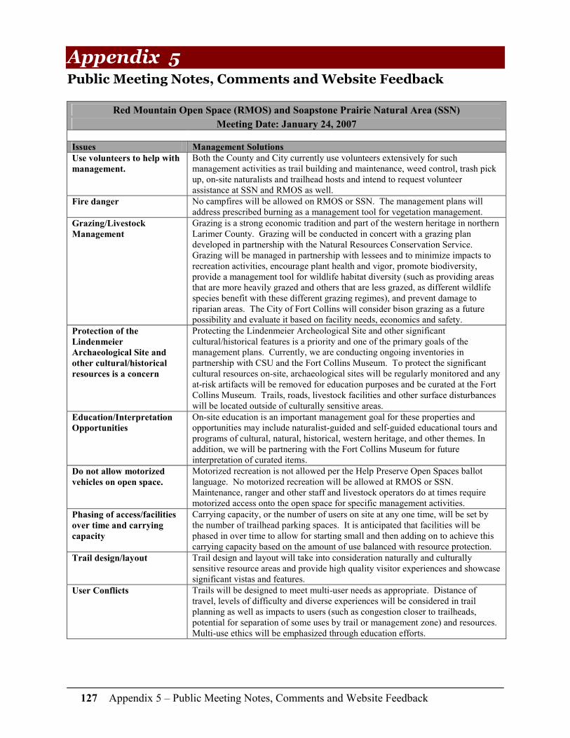
127 Appendix 5 – Public Meeting Notes, Comments and Website Feedback
Appendix 5 Public Meeting Notes, Comments and Website Feedback
Red Mountain Open Space (RMOS) and Soapstone Prairie Natural Area (SSN)
Meeting Date: January 24, 2007
Issues Management Solutions
Use volunteers to help with
management.
Both the County and City currently use volunteers extensively for such management activities as trail building and maintenance, weed control, trash pick up, on-site naturalists and trailhead hosts and intend to request volunteer assistance at SSN and RMOS as well.
Fire danger No campfires will be allowed on RMOS or SSN. The management plans will address prescribed burning as a management tool for vegetation management.
Grazing/Livestock
Management
Grazing is a strong economic tradition and part of the western heritage in northern Larimer County. Grazing will be conducted in concert with a grazing plan developed in partnership with the Natural Resources Conservation Service. Grazing will be managed in partnership with lessees and to minimize impacts to recreation activities, encourage plant health and vigor, promote biodiversity, provide a management tool for wildlife habitat diversity (such as providing areas that are more heavily grazed and others that are less grazed, as different wildlife species benefit with these different grazing regimes), and prevent damage to riparian areas. The City of Fort Collins will consider bison grazing as a future possibility and evaluate it based on facility needs, economics and safety.
Protection of the
Lindenmeier
Archaeological Site and
other cultural/historical
resources is a concern
Protecting the Lindenmeier Archeological Site and other significant cultural/historical features is a priority and one of the primary goals of the management plans. Currently, we are conducting ongoing inventories in partnership with CSU and the Fort Collins Museum. To protect the significant cultural resources on-site, archaeological sites will be regularly monitored and any at-risk artifacts will be removed for education purposes and be curated at the Fort Collins Museum. Trails, roads, livestock facilities and other surface disturbances will be located outside of culturally sensitive areas.
Education/Interpretation
Opportunities
On-site education is an important management goal for these properties and opportunities may include naturalist-guided and self-guided educational tours and programs of cultural, natural, historical, western heritage, and other themes. In addition, we will be partnering with the Fort Collins Museum for future interpretation of curated items.
Do not allow motorized
vehicles on open space.
Motorized recreation is not allowed per the Help Preserve Open Spaces ballot language. No motorized recreation will be allowed at RMOS or SSN. Maintenance, ranger and other staff and livestock operators do at times require motorized access onto the open space for specific management activities.
Phasing of access/facilities
over time and carrying
capacity
Carrying capacity, or the number of users on site at any one time, will be set by the number of trailhead parking spaces. It is anticipated that facilities will be phased in over time to allow for starting small and then adding on to achieve this carrying capacity based on the amount of use balanced with resource protection.
Trail design/layout Trail design and layout will take into consideration naturally and culturally sensitive resource areas and provide high quality visitor experiences and showcase significant vistas and features.
User Conflicts Trails will be designed to meet multi-user needs as appropriate. Distance of travel, levels of difficulty and diverse experiences will be considered in trail planning as well as impacts to users (such as congestion closer to trailheads, potential for separation of some uses by trail or management zone) and resources. Multi-use ethics will be emphasized through education efforts.

128 Appendix 5 – Public Meeting Notes, Comments and Website Feedback
Issues Management Solutions
Allow horseback riding,
mountain biking, hiking
Equestrian, mountain biking and hiking activities will be allowed on designated trails. However, not all trails will necessarily be open to all recreation uses and will be defined by management zone.
Horses & noxious weeds
are a concern
There are very few non-native plant species currently present at SSN and RMOS. To minimize the spread of introduced non-native species all uses will be on designated trails with few exceptions (research and limited guided hiking tours). Also, some trails may be closed to horse use to help address invasive weed concerns in ecologically sensitive areas. In partnership with local equestrian groups, we will explore other management actions to minimize weed introductions from horse manure.
Permit horse-drawn
carriages, buggies, etc
Due to the nature of this activity (potential speed of horses pulling buggies, needed turn around space, occupying much of a roadway, additional parking space accommodation) by a fairly specialized user group, it is not being considered as a compatible use of the open spaces. We will be meeting with equestrian representatives to discuss this issue. If requested on a special event basis, this use would be reviewed and evaluated based on the level of impact to other users and resources. According to the Larimer County Sheriff's Department, horse-drawn carriages are treated the same as motorized vehicles and allowed on roads in greater Larimer County if a yield sign is displayed on the back of the buggy. This type of use is also allowable on U.S. Forest Service two-track road systems including the nearby Pawnee Grasslands (call 346-5000 for more information).
Hunting Hunting at RMOS will be allowed for wildlife management in coordination with the Division of Wildlife (DOW). Hunting will be on a limited basis as determined in partnership with the DOW in a hunting plan and lease. On SSN, hunting may be allowed in the future, following observation of wildlife for several years after the opening. Hunting access would be on foot for hunting and animal retrieval to be consistent with minimizing weed spread outside of existing trail corridors.
Accessibility for disabled
people/ Continue guided
limited tours for disabled
access.
If requested as a special event, limited guided tours for disabled visitors would be evaluated based on feasibility, impact to other users and resources. Restrooms will be wheelchair accessible and close-in trails may allow for wheelchair access based on terrain.
Rock climbing Rock climbing will be evaluated to determine if it is an appropriate activity at these properties. We will be meeting with rock climbing representatives to discuss the desirability of climbing in light of the existing rock substrates, distance from trailheads, ecological considerations, and potential impacts to other users or their viewshed.
Protect Wildlife Protection of wildlife and their habitat is a primary goal on SSN and RMOS. Trails and other on-site features will be located to avoid sensitive wildlife areas following Division of Wildlife recommendations. Monitoring, education, keeping intact unfragmented habitats, not allowing domestic dogs, and potential seasonal trail closures will be the measures employed to protect wildlife and their habitats.
Dogs Due to the truly wild nature of the properties' wildlife, the remoteness of these areas, and on recommendation from the Division of Wildlife, we have determined that domestic dogs are incompatible with the primary goal of protecting the site's native wildlife. Negative impacts of dogs on wildlife may include disease transmission, harassment, displacement, injury and death. On a limited and special permit basis, working dogs that are necessary for livestock operations under guidance of grazing tenants may be considered. In the big picture, in the Larimer County Parks and Open Lands and the City of Fort Collins Natural Areas Program there are over 96 miles of trails that allow domestic dogs; and 13 miles of trails that do not allow domestic dogs. Dog parks specifically, fit the function of a City Parks system and currently the City is exploring additional areas system-wide where it may be appropriate to provide additional dog parks to the existing three that are currently available.

129 Appendix 5 – Public Meeting Notes, Comments and Website Feedback
Issues Management Solutions
Winter Closure of
Properties
Winter corresponds with the highest periods of inclement weather, sensitive large mammal winter range, and low visitation estimates for RMOS and SSN. There is little opportunity for winter recreational activities (such as cross-country skiing or snowshoeing) on these properties due to low altitude and high winds that result in very few days with standing snow on the ground. For these reasons, both properties will be closed seasonally in the winter time. The City is exploring the potential to close Soapstone Prairie on 1-2 weekdays corresponding to low visitation times year-round.
Backcountry Camping The City is evaluating the possibility of designating 1-2 backcountry campsites with stoves on Soapstone Prairie Natural Area during the initial opening of the site. The City will monitor the amount of use and resource impacts to determine if backcountry camping is a compatible use. In addition, after the properties are open to public access, we will evaluate additional backcountry campsites based on demand, resource impacts and appropriateness in light of sensitive archaeological and natural resources.
Prairie Dog Management Existing prairie dog colonies will be monitored regularly. Protection of wildlife and their habitat is a primary goal on RMOS and SSN and therefore, prairie dogs will be managed as a part of the larger ecosystem.
Species Reintroductions There are specific habitat and management requirements to allow rare or endangered species to be reintroduced on new sites and we will explore the possibility of species reintroductions in partnership with the Division of Wildlife and US Fish and Wildlife Service.
CR 15 Improvements and
Drainage
The City of Fort Collins Natural Areas Program is designing improvements to North County Road 15.
Fences Boundary fences will be maintained in partnership with adjacent landowners. Internal fences will be maintained for the customary management of livestock as appropriate. Any new or replaced fences will be wildlife friendly (designed to allow for deer and elk to jump and pronghorn to go under).
Trespass on Private
Property
Signs will be posted indicating the open space/natural area boundaries. Upon request, adjacent landowners will be given a phone number for the on-site manager/ranger staff to report any trespass issues.
Long-term management
costs
Funding for long-term management of both sites comes from both the Help Preserve Open Spaces Sales Tax and City of Fort Collins Open Space Yes! Tax funds. These dollars are allocated for management activities including ranger patrols, weed control, grazing management, trail maintenance, routine maintenance, etc. In addition, the City and County regularly apply for grants and have volunteer opportunities to help off-set costs for specific resource management projects and stretch their available management dollars.
Wind Development The conservation easement in place on Red Mountain Open Space prohibits wind development.
Daylan Figgs Meegan Flenniken
Senior Environmental Planner Resource Specialist Fort Collins Natural Areas Larimer County Parks and Open Lands (970) 416-2814 (970) 679-4562 [email protected] [email protected]

130 Appendix 5 – Public Meeting Notes, Comments and Website Feedback
Red Mountain Open Space and Soapstone Prairie Natural Area Open House: August 16, 2007
32 people offered comments through the open house feedback form, online and by phone. Where multiple responses were similar, the number of comments is noted in parentheses.
Issues Comments
Grazing � Allow for heavy, short term grazing options. � Bison – great idea for future; make higher priority (3); would like more info; object to introduction because of liability and expense.
Economic Opportunities
� Consider fee-permits for private concessionaires or fee-based guided tours. (2) � Publish and sell a book explaining site’s significance for promotion/education.
Security & Enforcement
� Concerned especially about Lindenmeier Archaeological Site. (2) � Concerned about enforcement of on-trail and on-road only, no dogs, etc. rules.
Other
� Need to provide more accessible roads and trails for less-abled visitors. � Willing to help with management efforts/volunteering. � Ban plastic disposable containers. � Need to present cost estimates in all publicity of project.
Generally agree with plan
� Concerned with protection of cultural sites. (3) � Job well done – shows careful planning. (4) � Great opportunity for wildlife and native species conservation. (4) � Good balance between use and conservation. � Liked organization, especially conservation targets. � Good partnership opportunities with Fort Collins Museum. � Offer natural gas or hybrid shuttles between parking lots. � But would like dogs allowed. (2)
Generally disagree with plan � Plans cater too much to recreational users. (2)
Specific Topics Agree with Plan Disagree with plan
Dogs � No dogs. (8) � Allow dogs (2)
Horses � Don’t allow horses.
Bikes � Don’t allow bikes. � Too many bike trails. (6)
Trails � Good trails. (4) � Enforce on-trail only rule.
� Allow cross country hiking. � Too much multi-use –more hiking only. (3) � Don’t put trails on east side of Soapstone.
Camping � Trial basis first. (2) � Agree with plan.
� Don’t allow.
Hunting � If offered, conduct pre-CDOW deadline for Larimer County residents only � Appreciate flexibility.
� Worried about conflicts caused by hunting while property is open to visitors. � Should prohibit altogether. � Have doubts about hunting.
Closures � Allow winter use with special use permits. � Close mid-week to protect wildlife.
Summary of feedback received through website 22 comment were received from 9/29/06 – 8/24/07 � Need more information on planning process (3) � Offer to volunteer services/information (2) � Generally agree with plan (3); generally disagree with plan. (2) � Concerned with security of cultural resources, especially Lindenmeier. � Wants more vehicle access for greater accessibility. � Dogs should be allowed (5) � Horses should not be allowed. (3) � Bikes should not be allowed or should be more restricted. (3) � Camping should definitely be allowed. (1) � Should be fewer trails. (1) � Hunting should definitely be allowed. (1)

131 Appendix 6 – Technical Advisory Group Members
Appendix 6 Technical Advisory Group (TAG) Members for Soapstone Prairie Natural Area and Red Mountain Open Space Management Plans
Core Planning Team
Daylan Figgs, Fort Collins/Senior Environmental Planner Meegan Flenniken, Larimer County/Resource Specialist K-Lynn Cameron, Larimer County/Open Lands Manager John Stokes, Fort Collins/Natural Resources Director Gary Buffington, Larimer County/Parks and Open Lands Director Ernst Strenge, Larimer County/Resource Planning Mark Sears, Fort Collins/Natural Areas Program Manager Rachel Steeves, Fort Collins/Environmental Planner
User Groups and Subject Experts
Tyler Abbott, U.S. Fish and Wildlife Service Barb Allan, Diamond Peaks Mountain Bike Patrol Joe Andrews, Larimer County Horseman Association Cheryl Donaldson, Fort Collins Museum Eric Erslev, CSU - Geologist John Fusaro, Natural Resources Conservation Service David Hanni, Rocky Mountain Bird Observatory Nancy Howard, Colorado Division of Wildlife Dr. Jason LaBelle, Colorado State University – Department of Anthropology Boyd Lebeda, Colorado State Forest Service Rodney Ley, Colorado State University - Outdoor Adventure Program Stephanie Neid/Lee Grunau, Colorado Natural Heritage Program Ed Seely, Colorado Mountain Club Dr. Greg Smoak, Colorado State University - History
Partners and Agencies
Mike Abel, City of Cheyenne Andre Duvall, Larimer County Parks Task Force Heather Knight, The Nature Conservancy Steve Smith, North Poudre Irrigation Company Willie Altenburg, President, Folsom Grazing Association
Larimer County & Fort Collins Staff/Subject Experts
Mark Caughlan, Horsetooth District Manager Ann Dewey, Education Coordinator Charlie Gindler, Laramie Foothills Manager Maxine Guill, Weed Specialist Joe Temple, Engineering
Jerry White, Land Transactions Joel Wykoff, Trails Management Karen Manci, Senior Environmental Planner Rick Bachand, Senior Environmental Planner Pat Hayward, Environmental Planner
Larimer County Open Lands Advisory Board Subcommittee
Bob Streeter, Jean Carpenter, Sue Sparling, Ben Manvel and Peter Kast
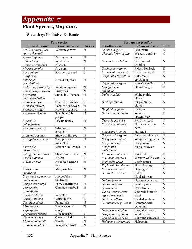
132 Appendix 7– Plant Species
Appendix 7 Plant Species, May 2007
Status key: N= Native, E= Exotic
Forb species
Scientific name Common name Status
Achillea millefolium
var. occidentalis
Western yarrow N
Agoseris glauca Pale agoseris N
Allium textile Wild onion N
Alyssum alyssoides Alyssum E
Alyssum simplex Alyssum E
Amaranthus
retroflexus
Redroot pigweed E
Ambrosia
artemisiifolia
Annual ragweed N
Ambrosia psilostachya Western ragweed N
Antennaria parvifolia Pussytoes N
Apocynum
androsaemifolium
Spreading dogbane N
Arctium minus Common burdock E
Arenaria fendleri Fendler’s sandwort N
Arenaria hookeri Hooker’s sandwort N
Argemone hispida Rough prickly poppy
N
Argemone
polyanthemos
Prickly poppy N
Argentina anserine Silverweed cinquefoil
N
Asclepias speciosa Showy milkweed N
Astragalus bisulcatus Two-grooved milkvetch
N
Astragalus
missouriensis
Missouri milkvetch N
Astragalus shortianus Short’s milkvetch N
Bassia scoparia Kochia E
Bidens cernua Nodding beggar’s tick
N
Calochortus
gunnisonii
Mariposa lily N
Calystegia sepium ssp. americanum
Hedge false bindweed
N
Campanula parryi Parry’s bellflower N
Campanula
rotundifolia
Common harebell N
Cardaria draba Whitetop E
Carduus nutans Musk thistle E
Castilleja miniata Paintbrush N
Chamaesyce
serpyllifolia
Thyme-leaved spurge
N
Chorispora tenella Blue mustard E
Cirsium arvense Canada thistle E
Cirsium flodmanii Thistle N
Cirsium undulatum Wavy-leaf thistle N
Forb species (cont’d)
Scientific name Common name Status
Cirsium vulgare Bull thistle E
Clematis ligusticifolia Western virgin’s bower
N
Comandra umbellata Pale bastard toadflax
N
Conium maculatum Poison hemlock E
Convolvulus arvensis Field bindweed E
Cryptantha thyrsiflora Calcareous cryptantha
N
Cryptantha virgata Miner’s candle N
Cynoglossum
officinale
Houndstongue E
Dalea candida White prairie clover
N
Dalea purpurea Purple prairie clover
N
Delphinium geyeri Larkspur N
Descurainia pinnata Western tansymustard
E
Dyssodia papposa Fetid marigold N
Epilobium ciliatum Northern willow-herb
N
Equisetum hyemale Horsetail N
Erigeron divergens Spreading fleabane N
Eriogonum alatum Winged eriogonum N
Eriogonum sp. Eriogonum N
Eriogonum
umbellatum
Sulphur flower N
Erodium cicutarium Storksbill E
Erysimum asperum Western wallflower N
Euphorbia esula Leafy spurge E
Euphorbia brachycera Horned spurge N
Frasera speciosa Green gentian N
Gaillardia aristata Indian blanketflower
N
Galium boreale Northern bedstraw N
Gaura coccinea Scarlet gaura N
Gaura mollis Velvetweed N
Gaura neomexicana
ssp. coloradensis Colorado butterfly plant
N
Gentiana affinis Pleated gentian N
Geranium caespitosum Common wild geranium
N
Geum macrophyllum Large-leaf avens N
Glycyrrhiza lepidota Wild licorice N
Grindelia squarrosa Curlycup gumweed N
Halogeton glomeratus Halogeton E

133 Appendix 7– Plant Species
Forb species (cont’d)
Scientific name Common name Status
Harbouria
trachypleura
Whisk-broom parsley
N
Helianthus annuus Annual sunflower N
Helianthus nuttallii Nuttall’s sunflower N
Helianthus pumilus Prairie sunflower N
Heterotheca villosa Hairy goldenaster N
Hippuris vulgaris Mare’s tail N
Humulus lupulus Wild hops N
Iris missouriensis Blue flag N
Iva axillaris Povertyweed N
Lactuca serriola Prickly lettuce E
Lesquerella montana Mountain bladderpod
N
Liatris ligulistylis Rocky Mountain blazing star
N
Liatris punctata Dotted gayfeather N
Linaria dalmatica Dalmation toadflax E
Linum lewisii Blue flax N
Linum puberulum Yellow flax N
Lupinus argenteus Common lupine N
Lupinus plattensis Nebraska lupine N
Lygodesmia juncea Skeletonweed N
Machaeranthera
canescens
Purple aster N
Maianthemum
stellatum
False Solomon’s seal
N
Malva neglecta Common mallow E
Marrubium vulgare Common horehound
E
Medicago lupulina Black medic E
Medicago sativa Alfalfa E
Melilotus albus White sweet clover E
Melilotus officinalis Yellow sweet clover
E
Mentha arvensis Field mint N
Mentzelia albicaulis Whitestem blazingstar
N
Mentzelia sinuata Leachleaf blazingstar
N
Mentzelia speciosa Jeweled blazingstar N
Mertensia lanceolata Prairie bluebells N
Mimulus glabratus Roundleaf monkey-flower
N
Mimulus sp. Monkey-flower N
Mirabilis linearis Narrowleaf four o’ clock
N
Monarda fistulosa ssp. fistulosa var.
menthifolia
Beebalm N
Nepeta cataria Catnip E
Nothocalais cuspidata Wavy-leaf false dandelion
N
Oenothera albicaulis Whitest evening primrose
N
Forb species (cont’d)
Scientific name Common name Status
Orobanche fasciculata Clustered broomrape N
Orobanche
ludoviciana
Many-flowered broomrape
N
Orthocarpus luteus Yellow owl’s clover N
Oxytropis deflexa var.
sericea
Blue nodding locoweed
N
Oxytropis lambertii Locoweed N
Oxytropis multiceps Nuttall’s oxytrope N
Oxytropis sericea White locoweed N
Parnassia fimbriata Fringed grass of Parnassus
N
Pedicularis crenulata Purple lousewort N
Penstemon
angustifolius
Broadbeard penstemon
N
Penstemon eriantherus Fuzzy tongue penstemon
N
Penstemon
secundiflorus
Sidebells penstemon N
Penstemon unilateralis Oneside penstemon N
Penstemon virens Blue mist penstemon N
Phacelia hastata Scorpion-weed N
Phlox hoodii Hood’s phlox N
Physalis virginiana Virginia groundcherry
N
Picradeniopsis
oppositifolia
Opposite leaf bahia N
Plantago major Common plantain E
Plantago patagonica Wooly plantain N
Polanisia dodecandra Clammyweed N
Portulaca oleracea Common purselane E
Potamogeton
epihydrus
Ribbonleaf pondweed N
Potentilla hippiana Wooly cinquefoil N
Prunella vulgaris Heal-all N
Psoralidium
tenuiflorum
Slimflower scurfpea N
Quincula lobata Chinese lantern N
Ranunculus
cymbalaria
Shore buttercup N
Ratibida columnifera Prairie coneflower N
Rorippa sylvestris Creeping yellowcress E
Rudbeckia hirta Black-eyed susan N
Rumex crispus Curly dock E
Sagittaria latifolia Duck potato N
Salsola tragus Russian-thistle E
Selaginella densa Little clubmoss N
Sisymbrium altissimum Tumble mustard N
Sisyrinchium
montanum
Blue-eyed grass N
Sisyrinchium pallidum Pale blue-eyed grass N
Sium suave Water parsley N
Solidago canadensis Canada goldenrod N
Solidago missouriensis Prairie goldenrod N
Solidago mollis Velvety goldenrod N

134 Appendix 7– Plant Species
Forb species (cont’d)
Scientific name Common name Status
Sonchus arvensis Perennial sow-thistle
E
Sonchus asper Spiny sow-thistle E
Sophora nuttalliana Silky sophora N
Sphaeralcea coccinea Scarlet globemallow
N
Symphyotrichum
falcatum
White prairie aster N
Taraxacum officinale Dandelion E
Tetraneuris acaulis ssp acaulis
Stemless four nerve daisy
N
Thelesperma filifolium Stiff greenthread N
Thelesperma
megapotamicum
Hopi tea greenthread
N
Thermopsis rhombifolia Prairie golden banner
N
Thlaspi arvense Field pennycress E
Townsendia grandiflora Largeflower daisy N
Forb species (cont’d)
Scientific name Common name Status
Toxicodendron rydbergii Poison ivy N
Tragopogon dubius Yellow salsify E
Tragopogon lamottei Salsify E
Typha latifolia Broad-leaved cattail
N
Urtica dioica Stinging nettle N
Verbascum thapsus Common mullein E
Verbena bracteata Big bract verbena N
Veronica americana American speedwell
N
Vicia americana American vetch N
Xanthium strumarium Cocklebur N
Zigadenus elegans Mountain deathcamas
N
Zigadenus venosus Meadow deathcamas
N
Grass and grass-like species
Scientific name Common name Status
Achnatherum
hymenoides
Indian ricegrass N
Achnatherum robustum Sleepygrass N
Achnatherum scribneri Scribner’s needlegrass
N
Agrostis stolonifera Redtop bent E
Aristida purpurea Purple threeawn N
Aristida purpurea ssp. fendleriana
Fendler’s threeawn N
Bouteloua curtipendula Sideoats grama N
Bouteloua dactyloides Buffalograss N
Bouteloua gracilis Blue grama N
Bromus arvensis Field brome E
Bromus inermis Smooth brome E
Bromus porteri Nodding brome N
Bromus tectorum Cheatgrass E
Calamagrostis
canadensis
Bluejoint N
Carex praegracilis Clustered sedge N
Carex nebrascensis Nebraska sedge N
Carex simulata Analogue sedge N
Carex sp. sedge
Carex utriculata Beaked sedge N
Catabrosa aquatica Brookgrass N
Distichlis spicata Inland saltgrass N
Eleocharis palustris Spike-rush N
Elymus canadensis Canada wildrye N
Elymus elymoides ssp. elymoides
Bottlebrush squirreltail
N
Elymus lanceolatus ssp. lanceolatus
Thickspike wheatgrass
N
Elymus repens Quackgrass E
Grass and grass-like species (cont’d)
Scientific name Common name Status
Elymus trachycaulus Slender wheatgrass N
Festuca ovina Sheep fescue E
Festuca sp. Fescue
Hesperostipa comata Needle-n-thread N
Hesperostipa
neomexicana
New Mexico feathergrass
N
Hordeum jubatum Foxtail barley N
Juncus articus ssp. Littoralis
Baltic rush N
Juncus confusus Colorado rush N
Juncus sp. Rush
Juncus torreyi Torrey’s rush N
Koeleria macrantha Prairie junegrass N
Leersia oryzoides Rice cut-grass N
Muhlenbergia montana Mountain muhly N
Muhlenbergia torreyi Ring muhly N
Nassella viridula Green needlegrass N
Panicum virgatum Switchgrass N
Pascopyrum smithii Western wheatgrass
N
Phleum pratense Timothy E
Poa compressa Canada bluegrass E
Poa pratensis Kentucky bluegrass E
Pseudoroegneria spicata
ssp. spicata Bluebunch wheatgrass
N
Schedonnardus
paniculatus
Tumblegrass N
Schizachyrium
scoparium
Little bluestem N
Schoenoplectus
maritimus
Alkali bulrush N

135 Appendix 7– Plant Species
Grass and grass-like species (cont’d)
Scientific name Common name Status
Schoenoplectus pungens
var. pungens
Three-square N
Schoenoplectus
tabernaemontani
Softstem bulrush N
Grass and grass-like species (cont’d)
Scientific name Common name Status
Spartina pectinata Prairie cordgrass N
Sporobolus cryptandrus Sand dropseed N
Thinopyrum intermedium Intermediate wheatgrass
E
Triglochin maritima Arrow-grass N
Vulpia octoflora Sixweeks fescue N
Shrubs and subshrub species
Scientific name Common name Status
Acer glabrum Rocky Mountain maple
N
Amelanchier alnifolia Saskatoon serviceberry
N
Artemisia campestris Field sage N
Artemisia frigida Fringed sage N
Artemisia ludoviciana Cudweed sagewort N
Atriplex canescens Fourwing saltbush N
Cercocarpus montanus Mountain mahogany
N
Cornus sericea ssp. sericea
Red-twig dogwood N
Ericameria nauseosa Rubber rabbitbrush N
Eriogonum effusum Spreading buckwheat
N
Gutierrezia sarothrae Broom snakeweed N
Krascheninnikovia
lanata
Winterfat N
Machaeranthera
pinnatifida
Lacy tansyaster N
Physocarpus monogynus Mountain ninebark N
Shrubs and subshrub species (cont’d)
Scientific name Common name Status
Prunus americana Wild plum N
Prunus pumila var.
besseyi
Sandcherry N
Prunus virginiana var.
melanocarpa
Chokecherry N
Rhus trilobata Skunkbrush N
Ribes aureum Wax currant N
Ribes cereum Squaw currant N
Ribes inerme Whitstem gooseberry
N
Rosa arkansana Wild rose N
Rosa woodsii Wood’s rose N
Salix exigua Coyote willow N
Senecio rapifolius Openwoods ragwort
N
Senecio spartioides Broomlike ragwort N
Symphoricarpos albus Common snowberry
N
Symphoricarpos
occidentalis
Western snowberry N
Syringa vulgaris Lilac E
Tetradymia canescens Horsebrush N
Tree species
Scientific name Common name Status
Acer glabrum Mountain maple N
Elaeagnus angustifolia Russian-olive E
Juniperus scopulorum Rocky Mountain juniper
N
Pinus ponderosa ssp. scopulorum
Ponderosa pine N
Populus angustifolia Narrowleaf cottonwood
N
Populus deltoides ssp. monilifera
Plains cottonwood
N
Populus tremuloides Quaking aspen N
Populus X acuminata Lanceleaf cottonwood
N
Salix amygdaloides Peach-leaf willow
N
Succulent species
Scientific name Common name Status
Echinocereus viridiflorus Hedgehog cactus N
Escobaria missouriensis Missouri foxtail cactus
N
Escobaria vivipara Spinystar N
Opuntia polycantha Prickly pear cactus
N
Yucca glauca Yucca N
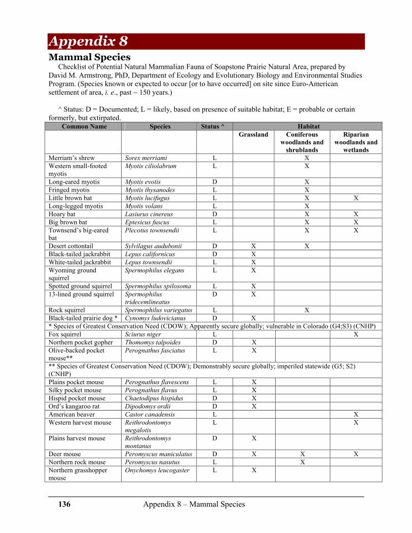
136 Appendix 8 – Mammal Species
Appendix 8 Mammal Species
Checklist of Potential Natural Mammalian Fauna of Soapstone Prairie Natural Area, prepared by David M. Armstrong, PhD, Department of Ecology and Evolutionary Biology and Environmental Studies Program. (Species known or expected to occur [or to have occurred] on site since Euro-American settlement of area, i. e., past ~ 150 years.)
^ Status: D = Documented; L = likely, based on presence of suitable habitat; E = probable or certain
formerly, but extirpated. Common Name Species Status ^ Habitat
Grassland Coniferous
woodlands and
shrublands
Riparian
woodlands and
wetlands
Merriam’s shrew Sorex merriami L X
Western small-footed myotis
Myotis ciliolabrum L X
Long-eared myotis Myotis evotis D X
Fringed myotis Myotis thysanodes L X
Little brown bat Myotis lucifugus L X X
Long-legged myotis Myotis volans L X
Hoary bat Lasiurus cinereus D X X
Big brown bat Eptesicus fuscus L X X
Townsend’s big-eared bat
Plecotus townsendii L X X
Desert cottontail Sylvilagus audubonii D X X
Black-tailed jackrabbit Lepus californicus D X
White-tailed jackrabbit Lepus townsendii L X
Wyoming ground squirrel
Spermophilus elegans L X
Spotted ground squirrel Spermophilus spilosoma L X
13-lined ground squirrel Spermophilus
tridecemlineatus
D X
Rock squirrel Spermophilus variegatus L X
Black-tailed prairie dog * Cynomys ludovicianus D X
* Species of Greatest Conservation Need (CDOW); Apparently secure globally; vulnerable in Colorado (G4;S3) (CNHP)
Fox squirrel Sciurus niger L X
Northern pocket gopher Thomomys talpoides D X
Olive-backed pocket mouse**
Perognathus fasciatus L X
** Species of Greatest Conservation Need (CDOW); Demonstrably secure globally; imperiled statewide (G5; S2) (CNHP)
Plains pocket mouse Perognathus flavescens L X
Silky pocket mouse Perognathus flavus L X
Hispid pocket mouse Chaetodipus hispidus D X
Ord’s kangaroo rat Dipodomys ordii D X
American beaver Castor canadensis L X
Western harvest mouse Reithrodontomys
megalotis
L X
Plains harvest mouse Reithrodontomys
montanus
D X
Deer mouse Peromyscus maniculatus D X X X
Northern rock mouse Peromyscus nasutus L X
Northern grasshopper mouse
Onychomys leucogaster L X
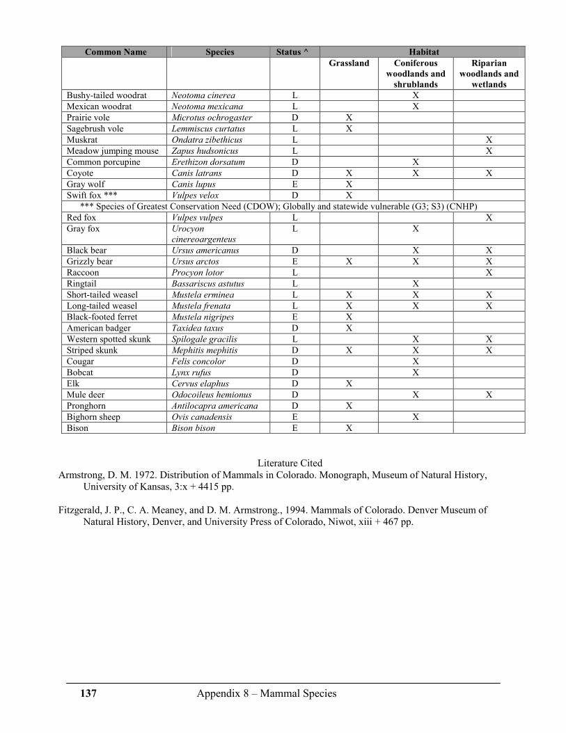
137 Appendix 8 – Mammal Species
Common Name Species Status ^ Habitat
Grassland Coniferous
woodlands and
shrublands
Riparian
woodlands and
wetlands
Bushy-tailed woodrat Neotoma cinerea L X
Mexican woodrat Neotoma mexicana L X
Prairie vole Microtus ochrogaster D X
Sagebrush vole Lemmiscus curtatus L X
Muskrat Ondatra zibethicus L X
Meadow jumping mouse Zapus hudsonicus L X
Common porcupine Erethizon dorsatum D X
Coyote Canis latrans D X X X
Gray wolf Canis lupus E X
Swift fox *** Vulpes velox D X
*** Species of Greatest Conservation Need (CDOW); Globally and statewide vulnerable (G3; S3) (CNHP)
Red fox Vulpes vulpes L X
Gray fox Urocyon
cinereoargenteus
L X
Black bear Ursus americanus D X X
Grizzly bear Ursus arctos E X X X
Raccoon Procyon lotor L X
Ringtail Bassariscus astutus L X
Short-tailed weasel Mustela erminea L X X X
Long-tailed weasel Mustela frenata L X X X
Black-footed ferret Mustela nigripes E X
American badger Taxidea taxus D X
Western spotted skunk Spilogale gracilis L X X
Striped skunk Mephitis mephitis D X X X
Cougar Felis concolor D X
Bobcat Lynx rufus D X
Elk Cervus elaphus D X
Mule deer Odocoileus hemionus D X X
Pronghorn Antilocapra americana D X
Bighorn sheep Ovis canadensis E X
Bison Bison bison E X
Literature Cited Armstrong, D. M. 1972. Distribution of Mammals in Colorado. Monograph, Museum of Natural History,
University of Kansas, 3:x + 4415 pp.
Fitzgerald, J. P., C. A. Meaney, and D. M. Armstrong., 1994. Mammals of Colorado. Denver Museum of Natural History, Denver, and University Press of Colorado, Niwot, xiii + 467 pp.

138 Appendix 9 – Bird Species
Appendix 9 Bird species recorded May-July, 2006 and May-July 2007*
Approximately 130 species of birds have been observed on or flying over Soapstone Prairie Natural Area. Breeding status key: D= documented nesting on site, P= possible breeder on site
Common Name Scientific Name Breeding
status
Swans, Geese & Ducks
Canada goose Branta canadensis Mallard Anas platyrhynchos D
Green-winged teal Anas crecca
Pelicans & Cormorants
American White Pelican
Pelecanus
erythrorhynchos
Double-crested cormorant
Phalacrocorax
auritus
Bitterns & Herons
Great blue heron Ardea herodias Cattle egret Bubulcus ibis American Vultures, Osprey
Turkey vulture Cathartes aura Osprey Pandion haliaetus Hawks, Eagles & Harriers
Northern harrier Circus cyaneus
Sharp-shinned hawk Accipiter striatus
Cooper's hawk Accipiter cooperi Swainson's hawk Buteo swainsoni Red-tailed hawk Buteo jamacaensis
Ferruginous hawk Buteo regalis D
Golden eagle Aquila chrysaetos
Falcons
American kestrel Falco sparverius
Peregrine falcon Falco peregrinus P
Prairie falcon Falco mexicanus D
Cranes
Sandhill crane Grus canadensis
Plovers & Sandpipers
Killdeer Charadrius
vociferus
D
Mountain plover Charadrius
montanus
D
Upland Sandpiper Bartramia
longicauda
Long-billed curlew Numenius
americanus
Wilson's snipe Gallinago delicata P
Wilson's phalarope Phalaropus
tricolor
P
Gulls
Ring-billed gull Larus delawarensis
California gull Larus californicus
Common Name Scientific Name Breeding
status
Pigeons & Doves
Rock pigeon Columba livia D
Eurasian collared-dove
Streptopelia
decaocto
Mourning dove Zenaida macroura D
Owls
Barn owl Tyto alba P
Great horned owl Bubo virginianus P
Long-eared owl Asio otus P
Short-eared owl Asio flammeus Burrowing owl Athene cunicularia D
Goatsuckers
Lesser nighthawk Chordeiles
autipennis
Common nighthawk Chordeiles minor D
Common poorwill Phalaenoptilus
nuttallii
P
Whip-poor-will Caprimulgus
vociferus
Swifts
White-throated swift Aeronautes
saxatilis
Hummingbirds
Broad-tailed hummingbird
Selasphorus
platycercus
Rufous hummingbird
Selasphorus rufus
Woodpeckers
Red-headed woodpecker
Melanerpes
erythrocephalus
Downy woodpecker Picoides pubescens Tyrant flycatchers
Olive-sided flycatcher
Contopus cooperii
Western wood-pewee
Contopus
sordidulus
Eastern wood-pewee Contopus virens
Willow flycatcher Empidonax traillii Least flycatcher Empidonax
minimus
Dusky flycatcher Empidonax
oberholseri
Cordilleran flycatcher
Empidonax
occidentalis
Say’s phoebe Sayornis saya D

139 Appendix 9 – Bird Species
Common Name Scientific Name Breeding
status
Tyrant flycatchers (cont’d)
Cassin’s kingbird Tyrannus
vociferans
Ash-throated flycatcher
Myriarchus
cinerascens
Western kingbird Tyrannus verticalis D
Eastern kingbird Tyrannus tyrannus P
Shrikes
Loggerhead shrike Lanius
ludovicianus
P
Vireos
Plumbeous vireo Vireo plumbeus
Warbling vireo Vireo gilvus Jays, Magpies & Crows
Blue jay Cyanocitta cristata
Steller’s jay Cyanocitta stellerii Western scrub-jay Aphelocoma
californica
P
Black-billed magpie Pica hudsonia P
American crow Corvus
brachyrhynchos
Common raven Corvus corax P
Larks
Horned lark Eremophila
alpestris
D
Swallows & Chickadees
Tree swallow Tachycineta
bicolor
Violet-green swallow
Tachycineta
thalassina
P
Northern rough-winged swallow
Stelgidopteryx
serripennis
Bank swallow Riparia riparia Cliff swallow Petrochelidon
pyrrhonota
P
Barn swallow Hirundo rustica P
Mountain chickadee Poecile atricapilla
Wrens
Rock wren Salpinctes
obsoletus
P
Canyon wren Catherpes
mexicanus
House wren Troglodytes aedon P
Old World Flycatchers & Thrushes
Blue-gray gnatcatcher
Polioptila caerulea P
Western bluebird Sialia mexicana Mountain bluebird Sialia currucoides
Gray-cheeked thrush Catharus minimus
Swainson’s thrush Catharus ustulatus Hermit thrush Catharus guttatus American robin Turdus migratorius
Common Name Scientific Name Breeding
status
Mockingbirds & Thrashers
Gray catbird Dumetella
carolinensis
P
Northern mockingbird
Mimus polyglottos D
Sage thrasher Oreoscoptes
montanus
Brown thrasher Toxostoma rufum D
Curve-billed thrasher
Toxostoma
curvirostre
Starlings
European starling Sturnus vulgaris P
Waxwings
Cedar waxwing Bombycilla
cedrorum
Wood-Warblers & Tanagers
Orange-crowned warbler
Vermivora celata
Virginia’s warbler Vermivora
virginiae
P
Yellow warbler Dendroica petechia P
Yellow-rumped warbler
Dendroica
coronata
Palm warbler Dendroica
palmarum
MacGillivray’s warbler
Oporornis tolmiei
Common yellowthroat
Geothlypis trichas
Wilson’s warbler Wilsonia pusilla Yellow-breasted chat
Icteria virens P
Western tanager Piranga
ludoviciana
Towhees, Sparrows & Old World Buntings
Green-tailed towhee Pipilo chlorurus D
Spotted towhee Pipilo maculatus D
Chipping sparrow Spizella passerina Clay-colored sparrow
Spizella pallida
Brewer’s Sparrow Spizella breweri D
Vesper sparrow Pooecetes
gramineus
D
Lark sparrow Chondestes
grammacus
P
Lark bunting Calamospiza
melanocorys
D
Savannah sparrow Passerculus
sandwichensis
D
Grasshopper sparrow
Ammodramus
savannarum
P
Song sparrow Melospiza melodia

140 Appendix 9 – Bird Species
Common Name Scientific Name Breeding
status
Towhees, Sparrows & Old World Buntings (cont’d)
White-crowned sparrow
Zonotrichia
leucophrys
McCown’s longspur Calcarius
mccownii
D
Chestnut-collared longspur
Calcarius ornatus P
Black-headed grosbeak
Pheucticus
melanocephalus
Blue grosbeak Passerina caerulea
Lazuli bunting Passerina amoena Blackbirds, Meadowlarks & Orioles
Bobolink Dolichonyx
oryzivorus
Red-winged blackbird
Agelaius
phoeniceus
D
Eastern meadowlark Sturnella magna Western meadowlark
Sturnella neglecta D
Common Name Scientific Name Breeding
status
Blackbirds, Meadowlarks & Orioles (cont’d)
Yellow-headed blackbird
Xanthocephalus
xanthocephalus
Brewer's blackbird Euphagus
cyanocephalus
P
Blackbirds, Meadowlarks & Orioles (cont’d)
Common grackle Quiscalus quiscula Brown-headed cowbird
Molothrus ater P
Bullock's oriole Icterus bullockii Baltimore oriole Icterus galbula Finches & Old World Sparrows
House finch Carpodacus
mexicanus
Red crossbill Loxia curvirostra
Pine siskin Carduelis pinus
Lesser goldfinch Carduelis psaltria
American goldfinch Carduelis tristis P
* Soapstone Ranch Avian Inventory and Monitoring: Year 1, Rocky Mountain Bird
Observatory report, January, 2007. 14500 Lark Bunting Lane, Brighton, CO 80603, 303.659-4348. Tech. Report # M-Soapstone06-01