city of colorado springs · city of colorado springs ... environment to the natural fuels and...
TRANSCRIPT

1
City of Colorado Springs Community Wildfire Protection Plan
“Sharing the Responsibility” Recommended by: ___________ _____ __ Date: ________ Brett T. Lacey, Fire Marshal, Colorado Springs Fire Department Approved by: __ Date: ______ Kurt Schroeder, Manager, Colorado Springs Parks Maintenance, Open Space & Trails Approved by: ______________________________________________________ Date: ____________ Steven W. Cox, Fire Chief, Colorado Springs Fire Department Approved by: ______ _________ Date: _____ Larry Long, Woodland Park District Forester, Colorado State Forest Service

2
Reviewed By: Neighborhood Champions Jamie Adams, Warren Management Margaret Brettschneider, Skyway HOA James Doukas, Village at Comstock HOA Dick Hansen, Mountain Shadows HOA Francine Hansen, Mountain Shadows HOA Ron Iaconis, Woodmen Oaks HOA Richard Ingold, Country Broadmoor HOA Sandy Lewis, Cedar Heights Community Association Johnnie Toniolli, Hunters Point HOA Interagency Cooperators Brent Botts, District Ranger, USFS Pikes Peak Ranger District Scott Campbell, Deputy Fire Marshal, El Paso County Scott Campbell, Executive Director, Palmer Land Trust Bob Chastain, President / CEO, Cheyenne Mountain Zoo Ron Honn, Department of Public Safety, University of Colorado at Colorado Springs Eric Howell, Natural Resources Planner, Colorado Springs Utilities Mitchell Martin, Park Manager, Cheyenne Mountain State Park Jim Reid, Fire Marshal, El Paso County Dave Root, Forester, Colorado State Forest Service, Woodland Park District Frank Serpe, Facilities Director, Mount Saint Francis Paul Smith, City Forester, Colorado Springs Intra-agency Cooperators Troy Branham, Battalion Chief, Colorado Springs Fire Department Steven Dubay, Battalion Chief, Colorado Springs Fire Department James Schanel, Battalion Chief, Colorado Springs Fire Department Contributors Brett Lacey, Fire Marshal, Colorado Springs Fire Department Christina Randall, Wildfire Mitigation Administrator, Colorado Springs Fire Department Andrew Notbohm, Wildfire Mitigation Program Coordinator, Colorado Springs Fire Department Roger Mounts, Wildfire Mitigation Program Coordinator, Colorado Springs Fire Department Dustin Steigauf, Lead Fuels Technician, Colorado Springs Fire Department Edited by Amy Sylvester, Senior Office Specialist, Colorado Springs Fire Department

3
Colorado Springs Community Wildfire Protection Plan
Introduction………………………………………………………………………………………………4 Goals and Objectives…………………………………………………………………………………….5 Area Description…………………………………………………………………………………………5 Historical Fire Regime…………………………………………………..……………………………….6 Current Conditions……………………………………………………………………………………....7 Desired Conditions……………………………………………………………………………………….7 Wildfire Hazard Risk Assessment…………………………………..……..……………………………8 Wildfire Mitigation Section Services…………………………………………………………………..23 Fuel Treatment Options…………………………………………………………………………………31 Removal and Utilization……………………………………………………………………………...…32 Scoping ………………………………………..………………………………………………………….33 Potentially Affected Interests…………………………………………………………………………...34 Project Planning…………………………………………………………………………………………..36 Monitoring………………………………………………………………………………………………...39 Rehabilitation……………………………………………………………………………………………..39 Maintenance……………………………………………………….………………………………………39 Contact Information………………………………………………………………………………………39 Appendix I: Sample Brochure……………………………………………………………………………40 Appendix II: Sample Stewardship Agreement…………………………………………………………41 Appendix III: Neighborhood Chipping Flier..…………………………………………………………42

4
Introduction In 1999, a Tri-Data Corporation Study of the Colorado Springs Fire Department (CSFD) identified the need to address the risk of wildfire to the City of Colorado Springs. As a result of the recommendations in that report, the Colorado Springs Wildfire Mitigation Plan was completed in 2001. It included an extensive, interactive risk assessment of the wildland urban interface and the establishment of a strong community education program. The Colorado Springs Community Wildfire Protection Plan is an update to the Wildfire Mitigation Plan with detailed emphasis on future project planning and program features. Wildland urban interface is defined as that part of the city where people and development meets wildland fuels and topography. The Colorado Springs region has a long history of wildland fires resulting in several fatalities and millions of dollars in suppression costs and property loss. The city continues to experience wildland fires on an annual basis. These fires pose a risk not only to neighborhood residents, but to special populations (i.e. nursing homes, schools and assisted living facilities), fire fighters, city infrastructure, natural resources and the city’s economy. Throughout the western United States, wildland fires continue to increase in size, intensity and suppression costs. This is not a forest health issue alone, but an issue that must address the built environment as well. It is the relationship of the natural environment to the built environment that determines the risk of wildfire to life and property. Note an example of the relationship of the built environment to the natural fuels and landscape in Figure 1.
Figure 1. Broadmoor Neighborhood in the Colorado Springs wildland urban interface.

5
Goals and Objectives The goals of the Colorado Springs Community Wildfire Protection Plan are: • To reduce the risk of wildfire to the residents of Colorado Springs. • To reduce the risk of wildfire to fire fighters in a wildfire event. • To reduce the risk of wildfire to property and infrastructure. • To reduce the risk of wildfire to natural resources. The objectives of the Colorado Springs Community Wildfire Protection Plan are: • To reduce the amount of natural, hazardous fuels around and adjacent to homes, businesses,
schools, infrastructure and medical facilities by 10-60% depending on fuel loading and stand health.
• To improve the structural characteristics of new and existing construction in the wildland urban interface through ordinances, development review and individual consultation.
• To educate residents regarding ways to reduce their wildfire risk. • To manage common areas and open spaces with respect for the natural characteristics and
protecting habitat features.
Area Description The City of Colorado Springs is located 60 miles south of Denver with a population of 414,358 residents. Colorado Springs is the county seat for El Paso County and is a home rule city. The Colorado Springs wildland urban interface encompasses 28,800 acres and shares over 16 miles of boundary with federal lands. 24% of the city’s population resides in the interface. The wildland urban interface runs south from the Air Force Academy to Cheyenne Mountain Air Force Station and Fort Carson Army Installation. Although most of the defined area is in the foothills west of Interstate 25, there are areas to the east on bluffs and mesas that exhibit wildland characteristics. To the west of the interface is the Pike National Forest and within city boundaries there are state and county parks. City owned undeveloped parks and open spaces comprise 10,492 acres. See Figure 2 for area map and defined wildland urban interface.
Figure 2. Colorado Springs Wildland Urban Interface

6
As the City of Colorado Springs sits at the foot of Pikes Peak, most of the wildland urban interface is located in foothills, on alluvial fans with long narrow drainages and ridgelines. Throughout the interface, slopes range from flat to 45%. Currently, as defined in the Hillside Ordinance, no structures are built on slopes greater than 25%. Elevations range from 6,035 to 7,200 feet above sea level.
Historical Fire Regime Colorado Springs has a mixed severity regime of frequent, low intensity fires with infrequent high intensity fires. Although large fires are less frequent, the city has had several wildland fire fatalities and millions of dollars in property loss. In 1950, the Camp Carson burn claimed 9 lives including 8 soldiers and a 14-year old volunteer. In 2008 on the Fort Carson TA 25 Fire, there was a single fire fighter fatality as a result of an aircraft accident. Other fires resulting in property loss or damage include the Mesa Fire in which a home was destroyed, the Westwood fire in which an outbuilding was lost and the Camp Carson Burn during which there was more than $3 million in property damages.
Figure 3. Newspaper headline and photos of the 1950 Camp Carson Burn. (Source: Gazette
Telegraph and Pikes Peak Library Photo Archives.)

7
Several large fires have occurred in and around Colorado Springs including the Big Burn of 1854, the Cheyenne Mountain Fire of 1890 and the Camp Carson Burn of 1950. Recent fire history includes the Westwood Fire in 2005 (35 acres), the Manitou Incline Fire in 2007 (30 acres) and the Coronado Fire in 2009 (12 acres). Historical fire occurrence includes large fires every 50 -75 years, with smaller, more frequent fires every 2-4 years. Tree ring data collected in and around Colorado Springs shows a more frequent regime prior to settlement; on average fires occurring every 17-35 years.
Current Conditions The Colorado Springs wildland urban interface is predominantly Ponderosa pine with Gambel oak understory. There are several areas with mixed conifer stands including North Cheyenne Canyon, Cheyenne Mountain Zoo and Blodgett Open Space. Other vegetation types include short grass prairie with yucca and prickly pear cactus as well as pinyon-juniper stands. Fire behavior fuel models represented in the wildland urban interface include: • Short Grass (Fuel Model 1) • Pine with grass understory (Fuel Model 2) • Intermediate brush (Fuel Model 5) • Timber Model, light surface fuel load (Fuel Model 8) • Timber Model, heavy surface fuel load (Fuel Model 10) There are isolated pockets of beetle-kill in the city as well as areas with mistletoe in the Ponderosa pines. Stand density in many areas have greater than 300 stems per acre, where traditionally stand densities have ranged between 75-150 stems per acre.
Desired Conditions Desired conditions around structures include 10 foot clearance with mitigation (limbing, thinning and removal) out at least 30 feet or to the property line, whichever comes first. Homeowners can extend beyond 30 feet as long as it is still on their property; 30 feet is the minimum recommendation. In adjacent open spaces and parks, stand management is intended to reduce the number of stems per acre as well as removing dead and diseased individuals, not clear cutting or putting in fire breaks. In adjacent areas and open spaces, specifications for desired conditions include: • Manage for less than 20% mortality in the timber and brush. • Reduce stand density to 50 – 150 stems per acre. • Remove ladder fuels by limbing and thinning. • Create separation between oak clumps by at least 10 feet (or 1 ½ times the height of the fuels). • Retain a minimum of 2 snags per acre for wildlife, as available (minimum of 6 inch diameter
at breast height). • Thin out understory regeneration in mixed conifer and manage for mature pine overstory.

8
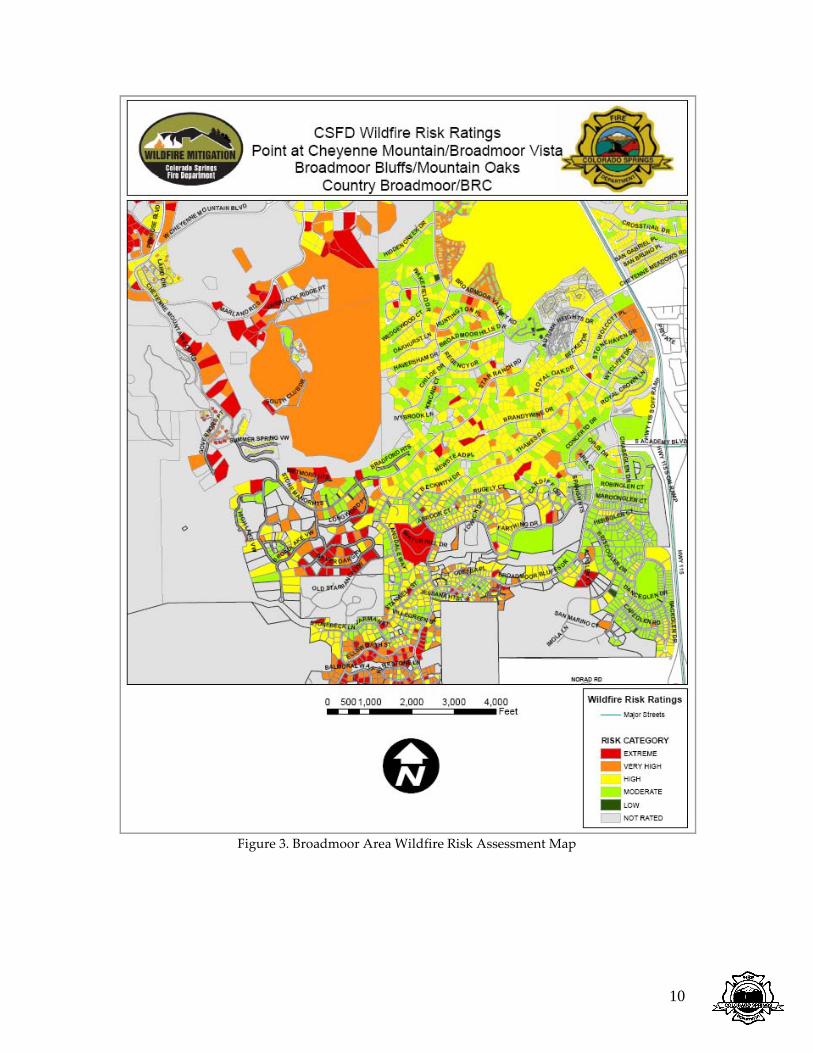
Wildfire Hazard Risk Assessment The Wildfire Hazard Risk Assessment for Colorado Springs was determined using the Wildfire Hazard Information Extraction model (WHINFOE). WHINFOE processes 25 weighted values with fire behavior modeling to determine the risk rating at the parcel level. The model inputs are derived using Geographic Information Systems (GIS) and collected data. The input factors range from structural characteristics to fuels and topography. Wildfire risk ratings are not a guarantee of the ignitability or survivability of the structures, but instead are a statement of relative risk. It is also important to note that the risk assessment is not an operational model and is not intended to be used as a tactical or decision making tool during a wildfire event. In Colorado Springs there are 35,360 individual parcels identified as at-risk in the wildland urban interface. There are 5 adjective risk ratings that range from LOW to EXTREME. Homeowners can access their individual wildfire risk ratings at http://csfd.springsgov.com. The initial data collection of the wildfire risk ratings was made in 2000, with updates as homeowners made modifications and upgrades. Maintenance of the wildfire hazard risk map with reassessments and updated parcel data is done every 10 years. The Wildfire Mitigation Section will update the 35,360 parcels by collecting ground-truth data and updated GIS files, including parcel data (new construction, development and subdivision.) Neighborhoods Identified in the Wildland Urban Interface or having wildland characteristics:
1. Bradford Heights 2. Broadmoor 3. Broadmoor Bluffs 4. Broadmoor Resort Community 5. Canyons at Broadmoor 6. Cedar Heights 7. Chatham 8. Cheyenne Canyon 9. Country Broadmoor 10. Country Club 11. Crescent 12. Discovery 13. Eagle Rock 14. Erindale 15. Erindale Heights 16. Friendship 17. Garden Ranch 18. Gold Camp 19. Golden Hills 20. Greencrest 21. Highland Oaks 22. Highland Terrace 23. Hillside 24. Holland Park 25. Hunters Point 26. Kissing Camels

9
27. La Strada 28. Mesa 29. Mesa Point 30. Mountain Shadows 31. Oakmont 32. Oak Valley 33. Panorama 34. Peregrine 35. Perfect View 36. Pinecliff 37. Pine Terrace at Broadmoor 38. Pinon Valley 39. Pleasant Valley 40. Quail Ridge Point 41. Raven Hills 42. Rustic Hills 43. Sanctuary at Peregrine 44. Skyway 45. Skyway Heights 46. Sondermann 47. Spires 48. Star Ranch 49. Stonebridge 50. Stratton Forest 51. Stratton Pines 52. Stratton Preserve 53. Sunset Mesa 54. Top of Skyway 55. University Park 56. Village at Comstock 57. Village at Erindale 58. Villages at Peregrine 59. Village at Skyline 60. Village Seven 61. Woodmen Oaks 62. Woodmen Oaks Estates 63. Woodmen Valley
The CSFD Wildfire Risk Rating maps show wildfire risk at the lot level and include homeowner associations, community associations, subdivisions and the neighborhood groups listed. Some areas identified outside of the wildland urban interface or the hillside have also been included as needing to address wildfire risk. Those neighborhoods identified as wildland urban interface consist of natural fuels with topographical features. Although there are neighborhoods that do not have all the criteria necessary to meet wildland characteristics, they may have certain fuels (either addressed as immediate or as an adjacency) that increase the risk of a wildland fire (e.g. grassy areas, oak brush or mature conifers in the landscaping.) See Figures 3 through 15 for neighborhood scale risk assessments of those neighborhoods identified in the wildland urban interface.
10
Figure 3. Broadmoor Area Wildfire Risk Assessment Map

11
Figure 4. Cedar Heights Wildfire Risk Assessment Map

12
Figure 5. Rockrimmon Area Wildfire Risk Assessment Map

13
Figure 6. Palmer Park / Austin Bluffs Area Wildfire Risk Assessment Map

14
Figure. 7 Kissing Camels Park Wildfire Risk Assessment Map

15
Figure 8. Mountain Shadows Wildfire Risk Assessment Map

16
Figure 9. Cheyenne Canyon Wildfire Risk Assessment Map

17
Figure 10. Peregrine / Hunters Point Area Wildfire Risk Assessment Map

18
Figure 11. Pinecliff Wildfire Risk Assessment Map

19
Figure 12. Mesa Area Wildfire Risk Assessment Map

20
Figure 13. Skyway / Stratton Area Wildfire Risk Assessment Map

21
Figure 14. Spires Wildfire Risk Assessment Map

22
Figure 15. Erindale / University Park Area Wildfire Risk Assessment Map

23
Wildfire Mitigation Section Services The Colorado Springs Fire Department Wildfire Mitigation Section, as part of the Division of the Fire Marshal, provides many services to the community to help reduce wildfire risk. These program features align with the Division’s mission statement: “To promote a safer community through hazard mitigation, fire prevention, fire code development and enforcement, fire investigation, public education, hazardous materials regulation, and wildland fire risk management.” Reducing wildfire risk depends on commitment from every level of the community: from federal, state and local government agencies to residents and non-profit agencies. The tagline “Sharing the Responsibility” emphasizes the need for collaboration between agencies and the public. Community Education and Outreach As part of the tagline “Sharing the Responsibility,” the Wildfire Mitigation Section works closely with neighborhood organizations and homeowner’s associations. The education program for existing construction works without an enforcement posture; homeowners are given the information and must decide on an acceptable level of risk. The intent of educating and involving residents at the homeowner level is to engage them so they understand their risk and how it impacts their neighborhood. Because a wildland fire is a landscape scale event, their risk also influences their neighbors. The risk assessment model is not only designed to educate homeowners, but to motivate them to take action. The tagline “Sharing the Responsibility” emphasizes the need for commitment and collaboration at every level of involvement: from the homeowner to the local, state and federal agencies. There are several methods to deliver the wildfire mitigation message to homeowners. Neighborhood meetings are offered free of charge. During these meetings citizens learn about fire behavior, homeowner guidelines and evacuation tips in the event of a wildfire. As part of the outreach, free onsite consultations are also provided where residents receive specific guidelines as to how they can mitigate wildfire risk through vegetation management and structural retrofits on their property. The interactive website, where homeowners and residents can access their risk rating, also has tips and guidelines for mitigation around their property. Several forms of print media are also used as educational tools including brochures and signs with homeowner information (see Appendix I for a sample brochure). In addition to traditional onsite consultations and neighborhood meetings, CSFD is developing a lecture series in response to request for additional education opportunities. The Wildfire Mitigation Section plans to offer several lectures annually covering wildfire topics ranging from fire behavior and fire effects to forest health and basic arbor care. In addition to neighborhood events, the Wildfire Mitigation Section will also host an annual, city-wide Wildfire Mitigation season kick-off event each spring. The event will include vendor booths, agency cooperator booths and champion recognition to kick-off awareness of the field season.

24
Fire danger signs are also a good tool for increasing wildfire awareness and notifying residents about fire danger, burn restrictions and burn bans. Fire danger signs are slated for city fire stations, neighborhoods and park entrances. Priority for sign installation: 1) fire stations in the wildland urban interface, 2) park entrances, 3) remaining fire stations, and 4) neighborhoods. Considerations for sign locations include:
• Visibility • Target audience • Traffic • Fire history • Wildfire risk • Fuel conditions • Natural resource value • Historic value • Firewise Communities USA designation
Sign maintenance will be the responsibility of the Wildfire Mitigation Section working with individual fire stations, neighborhood designees and the Colorado Springs Parks, Recreation and Cultural Services. Along with posting current fire danger, signs will also have riders attached with pertinent messages including burn restrictions, burn bans and fire safety messages. Fire Danger Sign Installation (as funding allows)
1. Station 12 2. Station 9 3. Station 4 4. Station 3 5. Station 13 6. Station 16 7. Station 18 8. Station 5 9. Garden of the Gods 10. North Cheyenne Cañon 11. Palmer Park 12. Stratton Open Space 13. Ute Valley Park 14. Blodgett Open Space 15. Red Rock Canyon 16. Station 11 17. Station 19 18. Station 17 19. Station 15 20. Station 8 21. Station 6 22. Station 14 23. Station 7 24. Station 10 25. Station 20 26. Station 1

25
27. Station 2 28. Colorado Springs Fire Wise Communities/USA
a. Cedar Heights b. Country Broadmoor c. Greencrest d. Raven Hills e. Hunters Point f. Top of Skyway g. Village at Comstock h. Woodmen Oaks i. Golden Hills j. Skyway
Stewardship Program The Colorado Springs Fire Department is not a land management agency and therefore has no authority or responsibility for property management. However, we are responsible for improving public safety and mitigating risk to life and property. Work is completed through stewardship with property owners on private and public property, common areas and open spaces. Signed stewardship agreements must be in place before any work can begin including project planning, obtaining funding, structural upgrades, neighborhood chipping or vegetation removal. Stewardship agreements outline the responsibility of the Colorado Springs Fire Department and funding availability, as well as property owner liability and participation requirements (see Appendix II). The stewardship agreement is intended as a handshake between the fire department and the property owner. The Wildfire Mitigation Section will not incur costs on behalf of the owner without notification or prior consent. Likewise, project implementation is based on funding availability only. Fuels Management The Wildfire Mitigation Section has the responsibility and authority to assist with mitigation efforts. This coincides with the Colorado Springs Fire Department’s responsibility to respond operationally. If property is within city boundaries or threatens any city asset other than federal land, CSFD has the responsibility to work with the owner or agency responsible for maintaining that property to mitigate wildfire risk. City assets can include utilities, watershed, communication sites or infrastructure. Implementation is based on several factors including: wildfire risk rating, willingness to participate in the program, environmental assessment, cultural and historical assessment, slope, access, fuel loading, forest health and mortality, values at risk, ownership, funding and resource availability. Fuels mitigation has a very high benefit to cost ratio. Nationally, fuels management projects have a 4:1 benefit cost ratio, meaning that for every $1 spent on mitigation, there is a savings of $4 for operational response and recovery. Analysis of Colorado Springs projects for grant funding has shown that every dollar spent on fuels mitigation projects results in a savings of $12 - 24 in a wildfire event.

26
Figure 16. Photo point 1: Fuels Mitigation project at Cedar Heights (Untreated / Treated.)
Figure 17. Photo point 7: Fuels Mitigation project at Cedar Heights (Untreated / Treated.)
Colorado Springs treats on average more than 900 acres annually between project acres, maintenance, prescribed burning, volunteer projects and neighborhood chipping. For a map of completed fuels management projects see Figure 18. Fuels mitigation projects adjacent to at-risk neighborhoods reduce potential fire behavior, but also act as an educational tool for the residents. Those areas that are visible from roadways serve as an excellent example to homeowners how mitigation can look without clear cutting their property. Additional benefits include providing for fire fighter safety and improving wildlife habitat.

27
Figure 18. Completed Fuels Mitigation Projects from 2004 – 2010
28
Neighborhood chipping is part of “Sharing the Responsibility.” The Colorado Springs wildland urban interface is truly an urban setting; many households do not own a truck for hauling debris to a collection site. The neighborhood chipping service offers homeowners free curbside chipping and hauling when they do mitigation work on their own property. The curbside chipping prevents the need for a dedicated collection site. The Colorado Springs Fire Department works closely with city Code Enforcement to ensure that the slash does not block sidewalks or roadways. Chipping crews follow a safety plan that includes traffic cones and signs for working in high traffic areas. Neighborhood chipping participation criteria includes a minimum of 12 neighbors participating. This is done to engage neighborhoods and educate them on wildfire mitigation concepts. The intent of neighborhood chipping is not debris removal, landscaping or cleanup. Rather, the intent is to reduce the risk of wildfire, modify fuels adjacent to structures and reduce fire behavior in the event of a wildfire. With a 2-person chipping crew working in stewardship with 63 homeowner associations, we are unable to respond to individual requests for chipping; this participation requirement also helps with scheduling and geographic coordination. Homeowners must also attend a wildfire mitigation meeting or schedule a free on-site consultation to participate. There is no fee for the service which is funded 100% out of Public Safety Sales Tax. See Appendix III for a neighborhood chipping flier.
In addition to the CSFD Wildfire Mitigation fuels crew and neighborhood chipping crew, mitigation work is also contracted out to private tree service companies. Contracting standards include using licensed and insured contractors only. Adding contracting of crew projects allows execution of simultaneous projects without additional salary or capital investment of fleet and equipment. Development Review As part of the effort to address wildfire risk on the front end of new construction, the Division of the Fire Marshal offers free Hazard Risk Assessments for development plans in the wildland urban interface. When development plans are routed through the Fire Protection Engineer for design review and the site is identified as located in the wildland urban interface, a risk assessment with recommendations are attached to the plans and put into comments. As an added value from the Fire Marshal’s office, this service saves money and turnaround time. Recommendations include vegetation and landscape designs as well as structural components. Hazardous and Non-Hazardous Materials Permitting For any activities that increase wildfire potential, the Division of the Fire Marshal in Colorado Springs issues Hazardous and Non-Hazardous Materials activity permits. These permits are required for activities that include public fireworks displays, pyrotechnics, blasting, prescribed burning, bonfires and rockets. The permit fee is based on inspection and processing. Monitoring and Fire Danger Wildfire detection is not an issue in a city with more than 400,000 city residents and 20 fire stations. The city does not post lookouts, however during VERY HIGH and EXTREME fire danger days there may be hire-back patrols. These patrols serve not only for detection during high fire danger days, but allow for pre-positioning in order to improve response time. These patrols also serve to make public contact and provide visibility.

29
The Wildfire Mitigation section monitors fire weather and fuel moistures year round. Using the National Fire Danger Rating System and FireFamily Plus, thresholds are in place based on predicted fire behavior. The fire danger adjective rating for Colorado Springs is posted daily on the fire department website at www.springsgov.com (follow the links to the fire department web page). Fuels are monitored throughout the growing season on a bi-weekly basis. During burn restrictions or burn bans, wildland fuels are monitored every week. Fuel moisture sampling includes representative species indicative of Colorado Springs. Wildland fuels monitored for fire danger include Ponderosa pine, Gambel oak, herbaceous plants, grasses, dead and downed woody debris, litter and duff. Fire weather is also monitored year round. Outside of the growing season, relative humidity is used as an indicator for fine fuel moistures and driving fire danger. Operational Support The Wildfire Mitigation Section works as part of the CSFD Plans Section in a wildfire event. Responsibilities include collecting spot weather data, field observations, fire behavior analysis, Global Position System (GPS) mapping and documentation. The Wildfire Mitigation Section also serves to provide logistical support. Burn Ban and Restrictions The Wildfire Mitigation Section monitors fire weather and fuels in support of the Fire Marshal as the authority having jurisdiction in the City of Colorado Springs enacting burn restrictions or burn bans. Pre-established thresholds and criteria are in place for determining when to enact burn restrictions or burn bans. These include:
• Fire weather conditions (i.e. winds, relative humidity and temperature) • Fuel moisture conditions (i.e. live and dead fuels) • Regional fire activity • Aircraft availability • Resource availability • Cooperator status • National Preparedness Level • Holidays Grant Administration The Wildfire Mitigation Section relies heavily on federal and state grants for project funding. Grant sources include FEMA Pre-Disaster Mitigation grants, Western States Wildland Urban Interface grants, Healthy Forest Restoration Act stimulus grants and Assistance to Firefighter grants. Grant administration involves project planning, application process, scoping, monitoring, reporting, project oversight, evaluation and closeout. Matching commitment is funded through Public Safety Sales Tax, soft matching using volunteer labor and homeowner matching. Examples of homeowner matching include neighborhood volunteer projects, structural retrofits, contracted labor and hard cash donations. Volunteer Program Coordination Volunteer labor is not free labor; it requires an investment of time and resources. However, volunteers are important for community buy-in and educational outreach to youth and homeowners. Volunteer projects bring neighborhoods together and help to create a strong sense

30
of community. Volunteer labor can be a beneficial source of soft match for grants; volunteers and grant projects can be coordinated to meet required matching. The Wildfire Mitigation Section has had extremely good success with several organizations that provide a great service to their community. These include: • Colorado Springs Fire Department Explorers • Mile High Youth Corps • Boy Scouts of America • Twocor Youth Vocational Education
Projects include fuels mitigation in parks, open spaces, common owned areas and private property identified as homeowners with special needs. Homeowner Assistance The Wildfire Mitigation Section works with property owners to provide assistance on private property as funding is available. Emphasis and priority will be given to seniors or homeowners with special needs. An individual stewardship agreement is required before work can be done on private property. Mitigation work may involve the wildfire mitigation fuels crew, contracting or coordinating volunteer projects. Social Media Program updates are posted on the Colorado Springs Fire Department webpage at www.springsgov.com , on Facebook at www.facebook.com/csfdpio and Twitter at http://twitter.com/#!/csfdpio. These include project information, wildland fire updates and program features. Program features added to the website include a chipping and neighborhood meeting calendar, photo gallery of projects and maps of project areas. Grass Fire Educational Program Colorado Springs has identified more than 28,000 acres of wildland urban interface, but a threat of wildfire from grassfires exists throughout the city. Colorado Springs experiences more than 30 grass fires annually. The risk of grass fires occurs year round and impacts all parts of the city. The Colorado Springs Wildfire Mitigation Section works with neighborhood groups and homeowner associations identified outside of the wildland urban-interface to teach grass fire safety. The educational message includes ways to mitigate the risk of grass fires and provide evacuation guidelines. As in the wildland urban-interface, on-site consultations and neighborhood meetings are provided free of charge. Prescribed Burning Prescribed burning is another tool in fuels reduction and wildfire mitigation. Although it is not practical in many parts of the city due to large population density, there may be remote areas where it is feasible. Considerations that limit the use of fire include:

31
• Smoke impact on residents, hospitals, schools and nursing homes • Risk of escape • Existing fuel loading • Critical habitat • Risk of invasive or noxious weeds • Erosion or slope movement • Impact on water quality • Impact on roadways and visibility Prescribed burning may be beneficial in areas that are remote and where the prescription calls for reintroducing fire. These areas may include steep areas that are not accessible to mechanized equipment. Other prescribed fire opportunities would include areas with specific resource objectives and training fires. The Wildfire Mitigation Section works with Operations to administer prescribed burns. Support includes public process and outreach, prepping units (layout, line, mapping, GPS and flagging units) and line assignments (lighters, holders and field observers.)
Fuel Treatment Options Efforts to lessen the impacts of the various treatments include education, outreach, rehabilitation, specified operating periods (time of year) and specialized equipment. Treatment options may also include a combination of treatment prescriptions (e.g. hand thinning and pile burning). See Table 1. Table 1. Fuel Treatments and Resulting Issues
Slash
Smoke
Wildlife
Visual
Water
Soils
Cost
Neighborhood Chipping x Hand Thinning x x Mechanical x x x Pile Burning x x Chemical Treatment x x x x Understory Burning x x x x

32
There can be associated benefits as well as detriments for each of the treatment options. Cost benefit analysis goes beyond project expenditures to include social and political capital. Hand thinning can be species selective with little to no ground disturbance. It also tends to be visually appealing as slash is chipped and hauled away or scattered onsite. Hand thinning tends to be a costly method of removal, but where there are adjacency issues to neighborhoods and the site is used as a demonstration area, then hand thinning is cost effective in terms of visual quality. Mechanical treatment can drive down the treated cost per acre, but can also result in some soil disturbance. Contracting specifications have limited disturbance on past projects. Mechanical treatment is the recommended option for oak brush in areas with high mortality. Chemical treatment can be used in conjunction with a cutting treatment to prevent re-sprouting of the oak brush. The herbicide application adds to the cost of the treatment and should only be used for complete eradication of the oak brush. Colorado Springs is located in a naturally occurring wildfire environment. Prescribed fire has not been considered a treatment option in the past because of smoke issues and risk of escape in a densely populated area. These issues can be addressed by identifying project areas that are not directly adjacent to neighborhoods as well as an approved burn plan with a smoke management plan. Pile burning is a very cost effective method (no chipping or hauling costs) and easier to contain. Understory burning can have a greater smoke impact and risk of escape, but can be ecologically sound for areas away from neighborhoods. Understory burning would also require a detailed burn plan with a smoke management plan. Removal and Utilization Slash disposal requires consideration for travel time and distance, additional cost, smoke impact, insects, root systems and visual quality. Removal methods include chipping and scattering onsite, hauling to landfill, recycling and burning. Chipping and scattering on site is very cost effective; it cuts down on travel time and added expense of hauling away. Scattering slash mulch requires that it be scattered around the site at a depth no greater than 4 inches. Scattering onsite may also be beneficial as the nutrient base is not removed from the site and can also be beneficial by preventing noxious weeds from sprouting after cutting. Hauling to a landfill is not cost effective given the additional time required to haul, and the cost of disposal. In Colorado Springs, there is a market for slash mulch. Rocky Top Resources, Inc. recycles slash mulch into decorative mulch for retail. Any slash related to CSFD Wildfire Mitigation projects and neighborhood chipping is taken free of charge. This is a viable alternative to chipping and scattering if slope or visual quality is an issue. Rather than going into a landfill, the material is treated and recycled for landscaping. Burning has not been utilized for slash removal because of population density and risk of escape. Reintroducing fire in the form of pile burning can have ecological as well as social benefits. There are areas in the wildland urban interface where access is an issue and burning is viable because of distance to surrounding neighborhoods. Pile or understory burning would require an approved burn plan and qualified burn boss, lighting and holding crews. It can also provide benefits to the community as an educational tool; smoke in the air can serve as a reminder of their wildfire risk.

33
Scoping Scoping is defined as the ongoing assessment of a situation through monitoring, consultation and discussion. The Colorado Springs Wildfire Mitigation Section works with numerous agencies and non-profit organizations throughout the project planning and implementation process. These include: Interagency and Non-Profit Collaboration: • Air Force Academy • Cheyenne Mountain Air Force Station • Cheyenne Mountain Zoo • Coalition for the Upper South Platte • Colorado Division of Emergency Management • Colorado Division of Wildlife • Colorado Historical Society • Colorado Springs Council of Neighbors and Organizations • Colorado Springs Development Review Enterprise • Colorado Springs Parks, Recreation and Cultural Resources • Colorado Springs Public Safety Sales Tax Oversight Committee • Colorado Springs Utilities • Colorado State Forest Service, Woodland Park District • Colorado State Parks, Cheyenne Mountain State Park • El Paso County • Federal Emergency Management Agency • Fort Carson Army Installation • Friends of Cheyenne Cañon • Sisters of Mount Saint Francis • Palmer Land Trust • Pikes Peak Wildfire Prevention Partners • School Districts 2, 11, 12, 20 • University of Colorado at Colorado Springs • US Forest Service, Pikes Peak Ranger District In 2010, the Wildfire Mitigation Steering Committee met to identify project planning including priority criteria and identifying project areas. Committee members were asked to serve because of their involvement and accomplishments in their own neighborhood. Wildfire Mitigation Steering Committee: • Sandy Lewis • Jamie Adams • Rich Ingold • Margaret Brettschneider

34
Public scoping and notification process includes the following mediums: • Neighborhood signs • Colorado Springs Fire Department website and social media sites • Neighborhood meetings • Mailings
Potentially Affected Interests Wildfire Mitigation projects have a direct effect on the residents in terms of reducing wildfire risk, but the activities can also cause issues for other cooperators and non-profits. The intent is to balance mitigation measures with social and resource values and minimizing any negative effects. See Table 2 for potentially affected interests and the correlating issues with mitigation measures.

35
Table 2. Potentially Affected Interests and Associated Issues
S
MO
KE
MA
NA
GEM
ENT
/ AIR
QU
ALI
TY
S
LOPE
MO
VEM
ENT
/ ERO
SIO
N
V
ISU
AL
CO
RRID
ORS
/ SC
REEN
ING
E
GRE
SS /
ESC
APE
RO
UTE
S
P
RESC
RIBE
D B
UR
NIN
G
W
ILD
LIFE
HA
BITA
T
F
ORE
ST H
EALT
H
O
UTD
OO
R RE
CRE
ATI
ON
W
ATE
R Q
UA
LITY
M
ECH
AN
ICA
L FU
ELS
TREA
TMEN
T
1. Residents and HOAs X
X
X
X
X
X
X
X
X
X
2. Colorado Springs Fire Department
X
X
X
X
X
X
3. Colorado Springs Parks, Recreation & Cultural Resources
X
X
X
X
X
X
X
X
X
4. US Forest Service X
X
X
X
X
X
X
X
X
5. Palmer Land Trust X
X
X
X
X
X
X
X
X
6. Colorado Springs School Districts
X
X
X
X
7. Cheyenne Mountain Zoo X
X
X
X
X
X
X
X
X
8. Colorado Division of Wildlife X
X
X
X
X
X
X
X
9. Colorado State Parks X
X
X
X
X
X
X
X
X
10. Colorado State Forest Service
X
X
X
X
X
X
X
X
X
11. Medical / Nursing Facilities X
X
X
X
X
X
12. UCCS X
X
X
X
X
X
13. Mount Saint Francis X
X
X
X
X
X
Potential collaboration on wildfire mitigation projects include cross boundary projects with the Air Force Academy, El Paso County, US Forest Service and Cheyenne Mountain State Park.

36
Project Planning Selection criteria were determined by more than fuel conditions as these are not forest health projects. Potential project areas were identified based on local knowledge by the steering committee members. Selection criteria for the project areas were listed and discussed for each project. The following selection criteria were used to identify project areas: • Neighborhoods with HIGH – EXTREME wildfire risk ratings • Location and adjacency to population density • Cooperation and “buy-in” from the surrounding neighborhood • Involvement in “Sharing the Responsibility;” a demonstrated commitment to reducing
wildfire risk on private property • Vegetation density, fuel type and fuel loading • Stand health and amount of mortality in the timber and brush • Age of homes (existing shake shingle roofs, wood siding, mature vegetation) • Topography • Adjacency to critical infrastructure (hospitals, schools, fire stations, transportation routes) • Critical habitat (threatened and endangered species) • Cultural and historical resources • Fire history and frequency • Project size (larger projects receive the highest priority as they can drive down the cost per
acre) Project Areas Project areas are identified as city assets at risk. Project scheduling and completion will depend on funding availability, staffing resources and weather conditions. For grant funded projects and additional wildfire mitigation project see Tables 3, 4 and 5. Table 3. Pre-Disaster Mitigation Grant Funded Projects
2011-2013 Project Area (FEMA PDM Grant) Year Acres Broadmoor Resort Community 2011-13 173 Quail Lake Park 2011-12 57 Village at Skyline 2011 5 Palmer Park (North) 2012-13 300 Skyway Heights 2012 20 Garden Ranch / Union Meadows 2013 32 Cedar Heights 2013 75 TOTAL 662

37
Table 4. Wildfire Mitigation Projects, 2014-2021
2014 – 2021 Project Areas Acres University Park 325 Blodgett Peak Open Space 70 Garden of the Gods 530 Palmer Park (South) 300 Sunset Mesa Open Space 78 Southface Rockrimmon 17 Comstock / Linear Park 47 North Cheyenne Cañon Park 225 Bear Creek Cañon Park 80 Mount Saint Francis 15 Ute Valley Park 338 Mountain Shadows 25 TOTAL 2050
Table 5. Other Potential Project Areas as funding allows
Additional Project Areas Acres North Slope Recreation Area 2267 Austin Bluffs (Pulpit Rock) Open Space 585 Cheyenne Mountain State Park Backdrop Open Space 832 Manitou Section 16 634 Mesa Valley Open Space 42 Red Rock Canyon Open Space 785 Rockrimmon Open Space 78 Sondermann Park Open Space 100 Stratton Open Space 318 University of Colorado at Colorado Springs 200 TOTAL 5841
The number of targeted accomplished acres (neighborhood chipping, hand thinning, mastication, volunteer projects and prescribed burning) is 1000 acres annually. Volunteer projects and neighborhood contributions will be utilized in grant funded projects toward the matching grant requirement. For a location map of planned projects through 2021, see Figure 19.

38
Figure 19. Planned Fuels Mitigation Projects from 2011 - 2021

39
Monitoring Projects are to be monitored during implementation and up to 3 years after completion. Monitoring effects as a result of mitigation efforts include: • Erosion • Noxious and invasive weeds • Oak brush regeneration • Pests • Wildlife activity • Social trails and unauthorized vehicle access Rehabilitation Rehabilitation planning includes wildfire mitigation projects and wildland fires. In the event of any adverse effects of the mitigation work, prescribed burn or wildland fire, the Wildfire Mitigation Section will mitigate the damages using erosion control methods, spraying of noxious weeds, or other called-for rehabilitation. All attempts to minimize impact to the site will be made with respect to time of year, weather conditions, soil conditions, existing vegetation and amount of disturbance. Maintenance Initial costs of fuel treatment can range between $900 - $2500 / acre depending on fuel loading, access and slope. It is important that these projects are maintained as there is so much invested on the initial treatment. Maintenance costs range from $200 – $500 / acre. Project maintenance is funded from the Public Safety Sales Tax and is part of the grant cycle. Responsibility for project maintenance is shared between the Wildfire Mitigation Section and the property owner. Maintenance includes cutting oak regeneration using brush cutters, mower attachment and ATV. Scheduled maintenance is every 5-8 years post project depending on timing of treatment, seasonal precipitation, regeneration rates and stand composition. Contact Information Christina Randall Wildfire Mitigation Administrator Colorado Springs Fire Department 375 Printers Parkway Colorado Springs, CO 80910 (719) 385-7368 [email protected] Andrew Notbohm Roger Mounts Wildfire Mitigation Program Coordinator Wildfire Mitigation Program Coordinator (719) 385-7342 (719) 385-7281 [email protected] [email protected]
“Sharing the Responsibility” http://csfd.springsgov.com

40
Appendix I. Sample Brochure

41
Appendix II. Sample Stewardship Agreement
Wildfire Mitigation Stewardship Agreement This Agreement is entered into this day of , ______ between the City of Colorado Springs, a Colorado municipal corporation and home rule city by and through its Colorado Springs Fire Department Wildfire Mitigation Section (hereinafter, the “City”) and (hereinafter, the “Owner(s)”). The Parties agree as follows: The Owner(s) wish to reduce natural fuel accumulation (including brush, grass, duff and litter) in the neighborhood in
order to reduce the fire danger posed to the area and the owner’s property. The City has code and requirements that regulate the accomplishment of this clearing and removal.
City's Responsibilities
1. To assess current conditions and provide guidelines for property owners. 2. To identify and assist in pursuing grant opportunities for vegetation management on behalf of the Owner(s),
whenever possible. The City is not responsible for any funding for the project. 3. To conduct a reassessment upon completion of the work to evaluate and update the wildfire hazard rating. 4. To inspect the project area in order to monitor progress and check for compliance with Colorado Springs Wildfire
Mitigation guidelines. Owner’s Responsibilities 1. To implement a comprehensive vegetation management prescription for mechanical thinning and removal of fuels. 2. To approve treatment methods which can include, but are not limited to, the following: cutting, limbing, pruning,
felling, bucking, grinding, chipping and hauling of slash or other debris. 3. The work under this Agreement should be limited to the hours of 8 a.m. to 6 p.m. daily. 4. Owner(s) further agree to provide measures recommended by the City on any newly exposed hillsides for protection
from erosion. These measures can include, but are not limited to, the following: terracing, retaining walls, plantings, waterbars, slope blankets or mesh.
5. Owner(s) agree to use those standards of good practice as directed by the Colorado Springs Wildfire Mitigation concepts.
6. Upon the completion of the work, Owner(s) will contact the Wildfire Mitigation Program Coordinator for a final site visit. This site visit is for the purpose of reassessing the wildfire risk values for the treated parcel.
7. Owner(s) agree and understand that this agreement may be withdrawn without the consent or acquiescence of the City.
8. Owner(s) agree and understand that in case the agreement is withdrawn, there shall be no liability or responsibility on the part of the City for termination of the agreement. Owner(s) shall hold the City harmless for any such withdrawal or termination.
9. Owner(s) understand that in case the agreement is withdrawn, there shall be no liability or responsibility on the part of the Owner(s) for termination of the agreement. City shall hold the Owner(s) harmless for any such withdrawal or termination.
10. Owner(s) agree that they are responsible for the actions of any work performed by volunteers, contractors, or other persons working on their property.
11. If the Owner(s) employs contractor(s) or personnel, then the Owner(s) will provide a general description of personnel, qualifications, professional certifications and licenses.
12. Owner(s) agree and understand that there is no representation or warranty by any person that this vegetation management project or creation of defensible space will or could prevent the ignition or spread of any fire.
The City and the Owners have executed this agreement on the date above written. City of Colorado Springs Fire Department Owner(s) By ___________________________________ By_____________________________________ Printed________________________________ _____________________________________ Disclaimer: Wildfire mitigation is intended to reduce wildfire risk; not eliminate the risk of wildfire. It is important to note
that wildfires are a dynamic event influenced by several factors including weather (winds, relative humidity, temperature,
atmospheric pressure, lightning, etc.) topography, fuels, human activity, response times and seasonal trends (i.e.
drought.) There will always be some risk of wildfire regardless of mitigation efforts and structural characteristics.

42
Appendix III. Neighborhood Chipping Flier