chust klimagune 2011 may 6 lowres2 - · pdf filexabier irigoien, marina chifflet, ibon...
TRANSCRIPT

1

2
Guillem Chust&
K-egokitzen core team: Á. Borja, P. Liria, A. Caballero, J. Franco, X. Irigoien
AZTI-Tecnalia, Marine Research Division
The impact of the sea level rise on Basque coastal habitats
throughout the 21st century
May 6th, 2011

© AZTI-Tecnalia 3
K-EGOKITZEN Project
“Climate Change in the Basque Country: Impacts and
adaptation”
Work Package : Coastal Zones
Period: first phase 2007-2009, 2nd phase: 2010-2012Goal: to assess the impacts of climate change and to propose adaptation measures for the Basque coast Financed by Basque Country GovernmentProject leader: Labein-Tecnalia

© AZTI-Tecnalia 4
Specific objectives :
I. Evidences of climate changeII. Climate scenariosIII. Impacts and vulnerabilityIV. Adaptation strategies
Coastal zones and elements:
1. Beaches, dunes and estuaries2. Habitats and biodiversity 3. Coastal infrastructures and urban areas
Objectives
Basque coast

© AZTI-Tecnalia 5
• Global mean sea-level rate: 1.8 ± 0.3 mm/yr between 1950 and 2000 (Church et al., 2004), with large spatial variability at regional scales
Linear trends in mean sea level (mm yr–1) for1955 to 2003 based on the past sea levelreconstruction with tide gauges and altimetrydata (IPCC 4AR, 2007)
Global sea level trends
SLR = Thermal expansion + ice melting

© AZTI-Tecnalia 6Year
1940 1960 1980 2000
Mea
n se
a le
vel (
mm
)
6800
6850
6900
6950
7000
7050
7100St. Jean de LuzBilbao
Mea
n se
a le
vel (
mm
)6800
6850
6900
6950
7000
7050
7100
7150
Santander
Sea-level measurements (tide gauge) along the Basque coast and nearby records
Santander
St Jean Luz
Bilbao
2.08 ± 0.33 mm yr-1
2.09 ± 0.42 mm yr-1
2.99 ± 1.08 mm yr-1
Chust et al. 2009. Estuarine, Coastal and Shelf Science 84:453-462
Regional sea level measurements

© AZTI-Tecnalia 7
Location Method Time period
Rate and error (mm yr-1)
Reference
Vigo Tide gauge 1943 - 2001 2.91±0.09 Marcos et al. (2005) La Coruña Tide gauge 1943 - 2001 2.51±0.09 Marcos et al. (2005) Santander Tide gauge 1943 - 2001 2.1 Marcos et al. (2005) Brest Tide gauge 1890 - 1980 1.3±0.5 Wöppelmann et al.
(2006) Brest Tide gauge 1980 - 2004 3.0±0.5 Wöppelmann et al.
(2006) Newlyn Tide gauge 1915 - 2005 1.77±0.12 Araújo and Pugh
(2008) St. Mary’s Tide gauge 1968 - 2006 1.73±0.52 Haigh (2009) Open water of Bay of Biscay
Satellite altimeters and Tide gauge
1993 - 2002 3.09±0.21 Marcos et al. (2007)
Open water of Bay of Biscay
Satellite altimeters 1993 - 2005 2.7 Caballero et al. (2008)
Basque coast Foraminifera-based transfer
functions
20th century 2.0 Leorri et al. (2008)
Basque coast Foraminifera-based transfer
functions
20th century 1.9 Leorri and Cearreta (2009)
Sea level rise within the Bay of Biscay

© AZTI-Tecnalia 8
Future Climate Scenarios

© AZTI-Tecnalia 9
San Sebastián
⇒ Mean Sea Level Rise (thermal expansion + ice melting)
⇒ Storm surges (meteorological tides)
⇒ Wave extreme events (tides + run-up)
Deusto, 10 September 2010
Sea level
variability
Regional climate scenarios for the 21st century

© AZTI-Tecnalia 10
1. Column waterintegration
2. Model selection
SRES A1B
WCRP Tª oceanSalinity
Sea level
Chust et al. 2010. Estuarine, Coastal and Shelf Science 87:113-124
∫−=01H
dpg
TSL α
Projections for the thermosteric sea level rise

© AZTI-Tecnalia 11
Year
1940 1960 1980 2000 2020 2040 2060 2080 2100
Sea
leve
l ris
e (c
m)
-20
0
20
40
60
St. Jean de Luz Santander Bilbao SRES A2 + MinMelt SRES A1B + MaxMelt
Thermal expansion + ice melting (4 to 20 cm) => 29 to 49 cm
Chust et al. Climate Research (In Press)
Mean Sea Level Rise for the bay of Biscay

© AZTI-Tecnalia 12
High-resolution cartographic data

© AZTI-Tecnalia 13
• LIDAR-based Digital TerrainModel (DTM)
– Spatial resolution: 1 x 1 m– Vertical accuracy: 15 cm
• Habitat maps fromortophotography:
– Spatial res.: 25 x 25 cm
High-resolution airborne data
(M.A. Ortiz)
LIDAR: laser altimeter

© AZTI-Tecnalia 14
Bilbao I
PMA
NMMB
NMMA
BMA Cero Puerto
0,337 m (REDNAP2008)
2,063 m (REDNAP2008)
4,94
0,11
Alicante
Bilbao
LiDAR validation with GPS and MSL references

© AZTI-Tecnalia 15
Expected impacts from sea level rise

© AZTI-Tecnalia 16
Mean Sea LevelTiderange:4.94 m
SLR: +0.49 m
Tides
KOSTASystem
© AZTI-Tecnalia 17
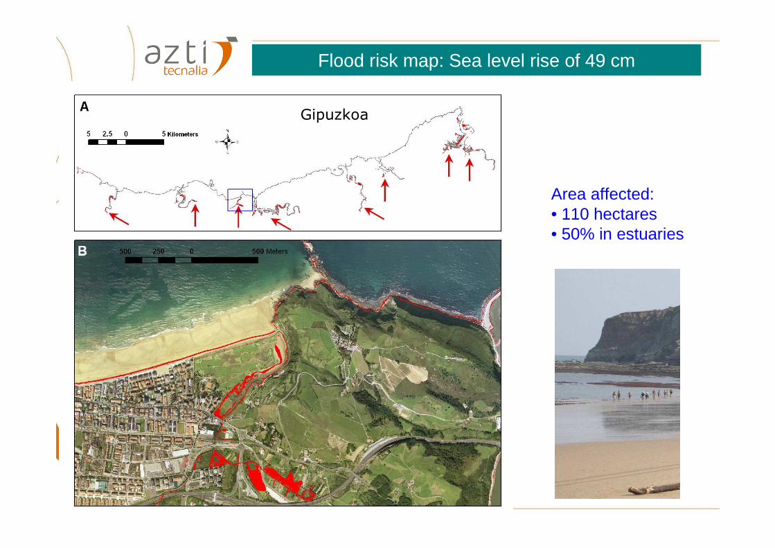
Gipuzkoa
Area affected:• 110 hectares • 50% in estuaries
Flood risk map: Sea level rise of 49 cm
© AZTI-Tecnalia 18
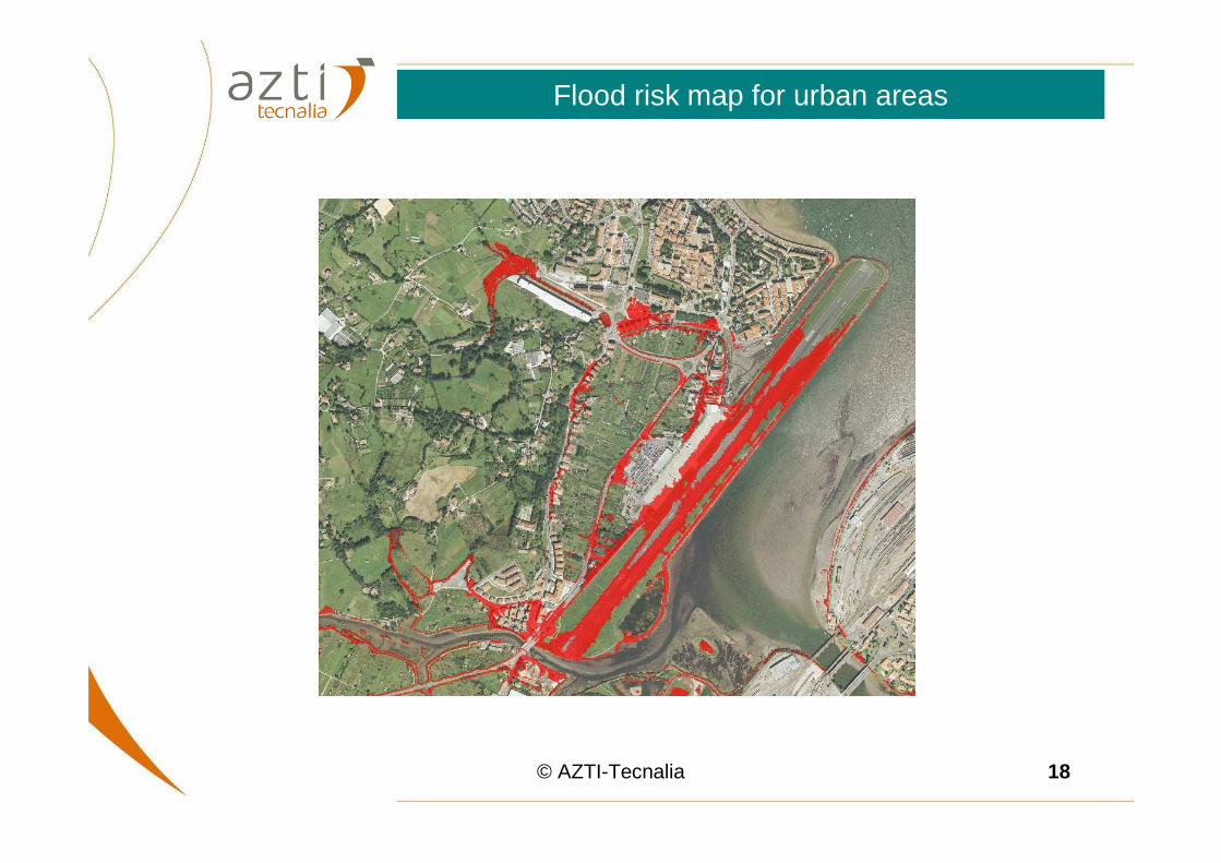
Flood risk map for urban areas

© AZTI-Tecnalia 19
Futuro
Bruun rule
Retreat in beach width
25%
40%
Flood risk map for sandy beaches

© AZTI-Tecnalia 20
Flood risk map for saltmarshes
Saltmarshes and crops
Profile (pixels)
0 100 200 300
Height (A
MS
L)
0
2
4
6
8
10
MAHT + SLR MAHT OMEHT OMEHT + SLR
SaltmarshWall
Crops
A
B
FitzGerald, 2008
Within the Basque estuaries, an accretion rate of 3.7 mm yr−1 during the 20th c. (Leorri et al., 2008) suggests that marshes are potentially able to adjust to the projected SLR rates …

© AZTI-Tecnalia 21
… except for “Coastal squeeze”

© AZTI-Tecnalia 22
Urbanización de la costa
1956
2002

© AZTI-Tecnalia 23
2004
Urbanización de la costa

© AZTI-Tecnalia 24
Natural changes(38 ha)
Anthropogenicchanges (98 ha)
Changes due to sea level rise (3 ha)
71%
27%
2%
Trasnformaciones en el litoral gipuzkoano entre 1954 a 2004
Chust et al. 2009. Estuarine, Coastal and Shelf Science 84:453-462
⇒ Barriers willconstrain thenatural migrationof species

© AZTI-Tecnalia 25
Bathymetric LiDAR and the impacts of sea
level rise on coastal biodiversity

© AZTI-Tecnalia 26
Topographic LiDAR
(NIR: 1064 nm)
Bathymetric LiDAR
(Green: 532 nm)
Bathymetric LiDAR (Hawk Eye MK II)

© AZTI-Tecnalia 27
Digital Elevation Model of the Oka estuary

© AZTI-Tecnalia 28
Intertidal area
Subtidal area

© AZTI-Tecnalia 29
Field work: Zostera noltii distribution

© AZTI-Tecnalia 30
Profile (m)
0 200 400 600 800 1000 1200
Hei
ght (
m)
-4
-2
0
2
4
6
Neap Tide
High Tide
+ Sea level rise
+ Sea level rise
Phra
gmite
s
Junc
us
Mar
shes
Spar
tina
Gra
cila
ria
Zost
era
Mudflats
Marshes
Main channel
Fixedboundary
(A) (B)
Zostera noltii
Estuaries in a Changing Climate5-8 Pril 2011, Porto, PortugalTide zonation of intertidal species communities
Chust et al. 2010 Estuarine, Coastal and Shelf Science 89: 200-213
© AZTI-Tecnalia 31
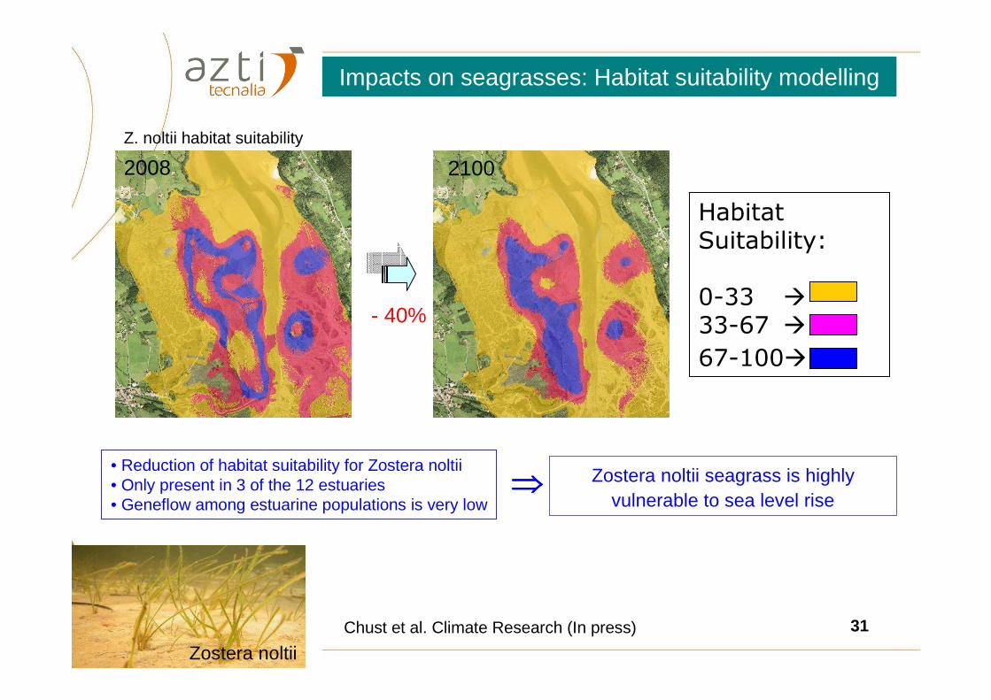
Zostera noltii
2008 2100
Z. noltii habitat suitability
- 40%
Chust et al. Climate Research (In press)
HabitatSuitability:
0-33 �
33-67 �
67-100�
Impacts on seagrasses: Habitat suitability modelling
• Reduction of habitat suitability for Zostera noltii• Only present in 3 of the 12 estuaries• Geneflow among estuarine populations is very low
Zostera noltii seagrass is highly vulnerable to sea level rise
⇒⇒⇒⇒

© AZTI-Tecnalia 32
Flood risk from storm surges

© AZTI-Tecnalia 33
Sea level = Astronomic Tide + Meteorological Tide
Meteorological Tide depends on wind and pressure
Sea level expected by 2050-2100 as a consequence of 50-yr return level
Sea level rise + Storm surge ( marejada ciclónica ) ⇒ 85 cm above Maximum Astron. tide
Flood risk from storm surges
Deusto, 10 September 2010
Sea level ~ Maximum Astronomic tide
IMEDEA-CSIC
Marcos et al. (submitted)

© AZTI-Tecnalia 34
Flood risk map expected by 2050-2100 as a consequence of 50-yr return level Sea level rise + Storm surge ⇒ 85 cm above Maximum Astron. tide
⇒ 363 ha are under risk of flooding, of which 54% correspond to artificial landMarcos et al. (submitted)
Flood risk from storm surges

© AZTI-Tecnalia 35
Flood risk from wave extreme events
13 de marzo de 2008

© AZTI-Tecnalia 36
Extreme wave (wave height) flood level expected for a 50-yr return period
FL: Flood level
TL: Tide level
RU: wave run-up (ascenso de la lámina de agua sobre el perfil de la costa debido a la rotura del oleaje)
AT: Astronomic tide
MT: meteorological tide
RU0: theoretical run-up
Liria et al. 2011 Journal of Coastal Research
RUMTATRUTLFL ++=+=
Extreme wave events: methodology

© AZTI-Tecnalia 37
Extreme wave events Sea-level rise
Liria et al. 2011 Journal of Coastal Research
Flood risk areas

© AZTI-Tecnalia 38
Inundation and floods dueto:
• sea level rise (29-49 cm)• storm surges (+85 cm)• extreme wave events
⇒ 250 ha of the Basque coast is at risk of flood, concentrated within the estuaries (~50%)
⇒ Retreat of beaches on 25-40% of width
⇒ The habitat of intertidalspecies and salt-marshescan be reduced
Scenarios Impacts Adaptations
• Maintenance andrebuilding of coastalinfrastructures
• Revision of drainagesystems
• To promote coastal resilience such as protection, regeneration of dune plants and intertidal species and wetlands, sand stabilization, establish buffer zones
Conclusions and Adaptation strategies
© AZTI-Tecnalia 39
Acknowledgements
• Gobierno Vasco (ETORTEK, proyecto K-Egokitzen I & II)• Ministerio de Medio Ambiente y Medio Rural y Marino, Gobierno de España
(Proyecto Ref.: 0.39/SGTB/2007/4.1)• Agencia vasca del Agua (URA), Gobierno Vasco, proyecto « Inundabilidad de los
estuarios vascos »• Diputación Foral de Gipuzkoa• K-egokitzen participants: Ángel Borja, Ainhoa Caballero, Pedro Liria, Javier Franco,
Xabier Irigoien, Marina Chifflet, Ibon Galparsoro, Carlos Hernández, Manuel González, Marta Revilla, Almudena Fontán, Víctor Valencia, Joxe. M. Garmendia
Climate Change Documentary: www.vimeo.com/13292409

© AZTI-Tecnalia 40
References
• Chust, G., Á. Borja, P. Liria, I. Galparsoro, M. Marcos, A. Caballero, and R. Castro (2009). Human impacts overwhelm the effects of sea-level rise on Basque coastal habitats (N Spain) between 1954 and 2004. Estuarine, Coastal and Shelf Science 84:453-462.
• Chust, G., A. Caballero, M. Marcos, P. Liria, C. Hernández, and Á. Borja. 2010. Regional scenarios of sea level rise and impacts on Basque (Bay of Biscay) coastal habitats, throughout the 21st century. Estuarine, Coastal and Shelf Science 87:113-124.
• Chust, G., Grande, M., Galparsoro, I., Uriarte, A. & Borja, A. 2010. Capabilities of the bathymetric Hawk Eye LiDAR for coastal habitat mapping: a case study within a Basque estuary. Estuarine, Coastal and Shelf Science89: 200-213.
• Valle, M., Borja, Á., Galparsoro, I., Garmendia, J.M., Chust, G., 2010. Estudio del hábitat idóneo para Zostera noltii y su modificación bajo un escenario de cambio climático en el estuario del Oka. Revista de Investigación Marina 17(1): 1-12.
• Chust G, Borja A, Caballero A, Liria P, Marcos M, Moncho R, Irigoien X, Saenz J, Hidalgo J, Valle M, Valencia V. Climate Change on the coast and pelagic environment in the south-eastern Bay of Biscay. Climate Research (In press). DOI: 10.3354/cr00914.
• Valle, M, Á. Borja, G. Chust, I. Galparsoro, JM Garmendia. Modelling suitable habitat for Zostera noltii within the Oka estuary (Basque Country), using Ecological Niche Factor Analysis. (Submitted to ECSS).
• Liria, P., Chust, G., Epelde, I., and Caballero, A., 2011. Extreme Wave Flood-Risk Mapping Within the Basque Coast. Journal of Coastal Research, SI 64.
Thank you for your attention!