chemical and physical properties of the fryeburg, lovewell
TRANSCRIPT

ISSN 0734-9556
Chemical and Physical Properties of the Fryeburg, Lovewell, Cornish, and Charles 5oil Map Units
R.V. Rourke
MAINE AGRICULTURAL EXPERIMENT STATION
technical Bulletin 145 July 1991


Chemical and Physical Properties of the Fryeburg, Lovewell,
Cornish, and Charles Soil Map Units
R.V. Rourke
Department of Plant, Soil and Environmental Sciences University of Maine Orono, Maine 04469


CONTENTS
Introduction 1
Materials 1
Field Procedure 3
Laboratory Procedure 3
Results and Discussion 4
Organic Carbon Distribution 4
Fryeburg Map Unit 5
Lovewell Map Unit 9
Cornish Map Unit 10
Charles Map Unit 11
Conclusions 12
Literature Cited 13
Appendix A 15
Appendix B 21
Fryeburg 22
Lovewell 32
Cornish 42
Charles 52
iii

TABLES
Table 1. Taxonomic classification soil series 2
Table 2. Organic carbon levels at a depth of 125 cm 5
Table 3. Carbon range in well-drained soil 6
Table 4. Carbon range moderately well drained soils 7
Table 5. Carbon range poorly drained soils 8

ACKNOWLEDGMENTS
The author wishes to recognize others who contributed to the success of this study.
The selection and description of the soil sites were through the efforts of Mr. N.R. Kalloch, Mr. K.J. LaFlamme, Mr. R.V. Joslin, Mr. D.E. Wilkinson, Mr. G.T. Hedstrom, Mr. W.D. Hoar, Mr. P.A. Hughes, and Mr. R. Ferland of the Soil Conservation Service, USDA.
The work of Mr. N.R. Kalloch in sampling the added sites for carbon distribution added greatly to the study.
The excellent laboratory work of Ms. Kathrine Schmidt, Ms. Deborah Bull, Ms. Lisa Turner, and Mr. Robert Vile assured the technical accuracy of the analyses.
Mr. Richard T. Hunter provided valuable assistance in handling the data and generating the soil profile description, soil data sheets, and in computing the weighted means for each map unit.
Ms. Mary Fernandez helped to frequently unravel the computer word-processing errors of the author, and Ms. Meg Cough graciously converted the final version to an acceptable word-processing program.
The constructive reviews of the text and data by Dr. Russell Briggs, Mr. Bruce Hoskins, and Mr. Kenneth J. LaFlamme are greatly appreciated.
The study was supported by Hatch funds and by the Soil Conservation Service, Orono, Maine.
SUMMARY
Four soil map units from the flood plains of the Saco and Androscoggin rivers were sampled at five locations each. Soil morphology was described at each site, and samples of the soil were taken for later laboratory analyses. Chemical and physical properties of the soil were analyzed in the laboratory. The morphologic and laboratory data are presented for each pedon sampled and as summaries using weighted means of laboratory data for each soil map unit. Organic carbon measurements are presented at other sites of similar drainages and positions to demonstrate the variable carbon content.
v


Maine Agricultural Experiment Station Technical Bulletin 145 1
INTRODUCTION
Although the soils of Maine have developed in a range of parent materials, the soils reported in this bulletin are restricted to sediments that have been deposited by relatively recent flood waters. The sediments investigated are along the Saco and Androscoggin Rivers. Similar deposits may be observed along many other rivers and streams in central and southwestern Maine.
Since the soils are of recent deposition and are still subject to periods of flooding and deposition, their morphology is not stable. This instability is reflected in their chemical and physical properties. These soils have been used extensively for agriculture. At times, floods have caused economic and/or resource losses (Dept. of Army 1971). In some instances attempts have been made to reduce the frequency of flooding with varying degrees of success.
The soils in this report represent four drainage classes ranging from well to poorly drained. The soil features of the various drainages are noted by trained soil scientists and delineated on a soil map. These soil maps can be used by agriculturists, environmentalists, engineers, and others to assist them in determining the extent and the possibilities for management of the flood plains of the state. A flood plain soil common to northern Maine has been characterized previously (Rourke 1990).
MATERIALS
The Fryeburg soil map unit is well drained and is located on nearly level to undulating sites on flood plains. Flooding usually occurs in the spring for short periods. However, flooding may occur in the fall following periods of heavy rains. Flood duration is usually not more than two days on the higher positions, but may be longer at lower sites. These soils have silt loam or very fine sandy loam textures in the upper meter.
Soils formerly mapped as Hadley in Maine have been correlated to this map unit, as Hadley has a wanner temperature regime than do Maine soils.
The Lovewell soil map unit consists of moderately well drained soils in broad depressions on the flood plain that are nearly level and that have low chroma mottles between 40 and 60 cm reflecting biologic activity in this region when the soil is wet. These soils are not flooded for long periods of time and generally are wet to the surface for short periods in the spring or following heavy fall rains as a result of overflow. These soils have silt loam or very fine sandy

2 Maine Agricultural Experiment Station Technical Bulletin 145
loam textures in the upper meter. In Maine the previously mapped Winooski soil map unit was correlated with this unit, as Winooski has a warmer temperature regime than does Lovewell.
The Cornish soil map unit contains somewhat poorly drained soils in the flood plains that have silt loam and very fine sandy loam textures in the upper meter. They are located in broad, nearly level depressions. Flooding occurs in either spring or fall. The water table is between 15 and 40 cm at periods when soil temperatures are above biologic zero resulting in the formation of low chroma mottles. Wetter Winooski and drier Limerick soil map units have been correlated to this map unit in Maine because of temperature difference previously noted.
The Charles map unit is poorly drained and is in lower depressions of broad level areas in the flood plain. It has silt loam or very fine sandy loam textures above one meter and has low chroma mottles above 15 cm unless frequently mixed by agricultural tillage to that depth. It generally floods annually and remains wet for extended periods when soil temperatures are above biologic zero. The Limerick map unit is a warmer soil previously mapped in Maine that has been correlated to this map unit.
These four soil map units form a drainage sequence on the landscape. They can be differentiated from each other by the length of time they are wet at depths of less than 100 cm as expressed by soil morphology. All of these map units are in the flood plain. The fact that these soils are flood prone restricts their use for agricultural, forestry, or wildlife management. Regardless of use, management of these soil must anticipate the hazard of periodic flooding. The soils are classified according to Soil Taxonomy (Soil Survey Staff 1975) in Table 1.
Table 1. Taxonomic classification of the Fryeburg, Lovewell, Cornish and Charles soil series.
Soil Series Family Name
Fryeburg Coarse-silty, mixed, frigid Fluventic Dystrochrepts
Lovewell Coarse-silty, mixed, frigid Fluvaquentic Dystrochrepts
Cornish Coarse-silty, mixed, frigid Fluvaquentic Dystrochrepts
Charles Coarse-silty, mixed, nonacid, frigid Aerie Fluvaquents

Maine Agricultural Experiment Station Technical Bulletin 145 3
Field Procedure Site selection of each sampling location was done by a soil
scientist from the USDA, Soil Conservation Service. Within each soil map unit, the five pedons selected were separated by at least one mile.
The soil was sampled by horizon from the surface to a depth of one meter. Soil morphology and position characteristics of the area were described at each site using standard methods (Soil Survey Staff 1951, 1981).
The soil in each horizon was removed from an area 30 by 30 cm for laboratory analyses and determination of stone volume. Soil cores 4.44 cm in diameter and 2.5 cm in thickness were removed in triplicate in a nearly undisturbed state for determination of water storage and bulk density.
At other locations on the flood plain, samples were taken at 2.5 cm intervals from beneath the plow layer to a depth of about 100 cm at six locations of each of the well, moderately well and poorly drained flood plain soils. These samples were used to evaluate the distribution of organic carbon in the soil profile of flood plain soils.
Laboratory Procedure The volume of coarse material larger than 2mm was deter
mined by sieving and water displacement techniques. The material smaller than 2mm in diameter was mixed and subsampled for other analyses.
Soil moisture retention at 0.06, 0.1, 0.33, 0.67, and 1.0 bars pressure were measured on soil cores removed from the field using the ceramic plate. Soil core weight and volume were corrected for coarse material larger than 2mm after oven drying and the soil bulk density was determined. Disturbed soil material from the bulk sample that had passed a 2mm sieve was used to determine soil moisture retention at pressures of 2.0, 3.0, 5.0, and 15.0 bars (Richards 1965). Plant available soil moisture on a volume basis was assumed to be the difference between 0.1 and 15 bars.
Walkley - Black organic carbon was determined by methods described by Allison (1965). A factor of 1.3 was used to approximate 100% C recovery.
Particle size distribution was measured using pipet analysis (Day 1965). Organic matter destruction was accomplished by hydrogen peroxide and heat treatment. Soil dispersal was by overnight shaking of the oxidized sample with a dilute solution of sodium hexametaphosphate.

4 Maine Agricultural Experiment Station Technical Bulletin 145
Soil reaction was measured in water and 1M potassium chloride (KC1) using a 1:1 v: w solution to soil ratio. Soil reaction in 0.01M calcium chloride (CaCl2) used a 2:1 solution to soil ratio (Peech 1965). Samples were mixed and allowed to equilibrate overnight before pH measurement.
Exchangeable cations were extracted from the soil using neutral 1M ammonium acetate (NH4OAc). The filtrate was analyzed using atomic absorption and emission methods previously described (Rourke and Beek 1971). Exchange acidity was found using 1M KC1 as described by Mclean (1965), and extractable acidity (Peech 1965) was determined using barium chloride and trietha-nolamine (BaCl2 TEA). The cation exchange capacity (CEC) was estimated by addition of exchangeable cations and extractable acidity. Effective cation exchange capacity (ECEC) was estimated by the summation of exchangeable cations and exchange acidity.
RESULTS AND DISCUSSION
The concept of the map units computed by horizon as a weighted average of the chemical, and physical properties of individual pedons sampled is presented in Appendix A Morohological, chemical and physical data for each individual pedon are provided in Appendix B.
Organic Carbon Distribution The unusual distribution of organic carbon in the profile of a
flood plain soil is presented in Tables 3, 4, and 5. These data were gathered as part of the soil mapping of Oxford and Franklin Counties. The data are grouped by drainage class, and demonstrate that organic carbon does not decrease in a regular manner as depth increases in these soils.
The increase and decrease of organic carbon at irregular depth intervals in the soil is the result of the presence of old surfaces that have been buried by deposition during flooding sequences. The data show that not all profiles have the same magnitude of expression, but that there is always an irregular decrease. These old surfaces were frequently thin, often only 2 to 5 cm in thickness. The characteristic irregular distribution of organic carbon (Tables 3,4,5) is frequently masked when bulk samples are removed for laboratory analysis (Appendix B). Classification of the Lovewell, Cornish, and Charles soil map units in the Fluvaquentic subgroup or Fluvaquent great group is supported by the organic carbon content at 1.25 m as shown in Table 2 as well as by the irregular decrease of organic carbon presented in Tables 3, 4, 5 (Soil Survey Staff 1975).
Maine Agricultural Experiment Station Technical Bulletin 145 5
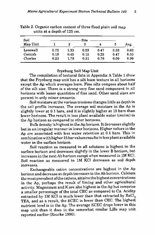
Table 2. Organic carbon content of three flood plain soil map units at a depth of 125 cm.
Fryeburg Soil Map Unit The compilation of textural data in Appendix A Table 1 show
that the Fryeburg map unit has a silt loam texture in all horizons except the Ap which averages loam. Fine silts compose about half of the silt size. There is a strong very fine sand component in all horizons with lesser quantities of fine sand. Other sand sizes are present in only minor amounts.
Soil moisture at the various tensions changes little as depth in the soil profile increases. The average soil moisture in the Ap is slightly lower at 0.1 bars, and it is slightly higher at 15 bars than lower horizons. The result is less plant available water (cm/cm) in the Ap horizon as compared to other horizons.
Bulk density is highest in the Ap horizon. It decreases slightly but in an irregular manner in lower horizons. Higher values in the Ap are associated with less water retention at 0.1 bars. This in combination with higher 15 bar values results in less plant available water in the surface horizon.
Soil reaction as measured in all solutions is highest in the surface horizon and decreases slightly in the lower B horizon, but increases in the next Ab horizon except when measured in 1M KC1. Soil reaction as measured in 1M KC1 decreases as soil depth increases.
Exchangeable cation concentrations are highest in the Ap horizon and decrease as depth increases to the Ab horizon. Calcium the most prevalent of the cations, attains the highest concentrations in the Ap, perhaps the result of liming and other agricultural activity. Magnesium and K are also highest in the Ap but comprise a smaller percentage of the total CEC as compared to Ca. Acidity extracted by 1M KC1 is much lower than that extracted by BaCl2
TEA, and as a result, the ECEC is lower than CEC. The highest nutrient level is in the Ap. The average ECEC drops lower in this map unit than it does in the somewhat similar Lille map unit reported earlier (Rourke 1990).
Soil Map Unit 1 2
--Site — 3 4 5 Avg.
Lovewell Cornish Charles
0.72 0.19 0.23
1.33 0.45 1.79
0.23 0.15 0.31
0.47 0.25 0.78
0.33 0.47 0.09
0.62 0.35 0.99

6 Maine Agricultural Experiment Station Technical Bulletin 145
Table 3. Distribution of percentage organic carbon in the profile of pedons from well-drained flood plain soils in southwestern Maine.
Depth cm 1 2 3 4 5 6
20.0 3.69 22.5 1.09 25.0 1.14 0.73 27.5 1.09 0.38 0.45 30.0 1.37 0.70 0.28 1.12 32.5 0.99 0.97 0.25 0.33 0.90 35.0 1.04 0.73 1.34 0.04 0.31 0.76 37.5 2.02 0.88 1.39 0.13 1.00 0.54 40.0 1.02 1.06 1.09 0.17 0.67 0.70 42.5 1.00 1.19 1.07 0.19 0.59 0.52 45.0 0.74 0.96 0.84 0.17 0.34 0.50 47.5 0.95 1.10 0.70 0.17 0.59 0.50 50.0 1.04 1.17 0.66 0.13 0.81 0.40 52.5 0.89 1.05 0.26 0.21 1.08 0.22 55.0 0.78 1.19 0.24 0.06 0.88 0.26 57.5 1.00 0.94 0.22 0.11 0.79 0.24 60.0 0.96 1.70 0.43 0.02 0.71 0.28 62.5 1.60 1.74 0.18 0.13 0.53 0.22 65.0 1.56 1.14 0.28 0.13 0.61 0.28 67.5 1.60 0.79 0.13 0.17 0.37 0.24 70.0 1.36 1.02 0.18 0.16 0.29 0.24 72.5 2.39 1.12 0.16 0.13 0.35 0.28 75.0 1.66 1.80 0.15 0.09 0.21 0.24 77.5 1.78 3.38 0.32 0.15 0.21 0.30 80.0 2.00 1.58 0.32 0.09 0.24 0.12 82.5 2.59 0.93 0.32 0.11 0.04 0.22 85.0 1.26 1.66 0.28 0.09 0.07 0.22 87.5 0.90 1.52 0.26 0.06 0.08 0.48 90.0 0.96 1.14 0.47 0.10 0.09 0.34 92.5 0.67 1.16 0.34 0.11 0.15 0.24 95.0 0.76 0.93 0.49 0.12 0.02 0.04 97.5 0.81 1.09 0.47 0.01 0.16 0.10
100.0 1.07 0.18

Maine Agricultural Experiment Station Technical Bulletin 145 7
Table 4. Distribution of percentage organic carbon in the profile of pedons from moderately well drained flood plain soils in southwestern Maine.
Depth Site Number cm 1 2 3 4 5 6
20.0 1.22 22.5 2.21 25.0 0.92 1.56 27.5 2.21 0.98 1.34 0.92 0.90 30.0 2.55 0.62 1.18 0.74 0.76 32.5 4.53 0.82 1.62 0.76 0.80 35.0 2.31 0.58 1.04 0.70 0.64 37.5 1.68 1.06 1.34 0.92 0.88 0.58 40.0 1.82 1.68 1.36 0.82 0.84 0.76 42.5 1.46 0.98 1.00 0.70 0.82 0.60 45.0 1.24 1.34 1.12 0.58 0.94 0.56 47.5 1.04 0.96 0.94 0.46 0.76 0.50 50.0 1.62 1.10 0.78 0.42 0.82 0.68 52.5 1.46 1.44 0.40 0.40 0.76 0.54 55.0 1.44 1.34 0.66 0.34 1.12 0.40 57.5 1.56 1.82 0.64 0.30 1.16 0.44 60.0 1.68 1.80 0.78 0.30 0.72 0.54 62.5 1.33 1.54 0.58 0.32 0.62 0.46 65.0 2.95 1.24 0.60 0.26 0.40 0.38 67.5 1.35 1.18 0.34 0.28 0.18 0.40 70.0 1.52 0.92 0.38 0.28 0.28 0.34 72.5 0.83 0.83 0.34 0.24 0.38 0.36 75.0 1.06 1.02 0.58 0.20 0.36 0.36 77.5 0.87 1.16 0.48 0.16 0.10 0.52 80.0 0.77 1.18 0.42 0.12 0.38 82.5 0.81 1.12 0.32 0.06 0.40 85.0 0.86 1.10 0.56 0.16 0.48 87.5 0.33 0.96 0.28 0.38 90.0 0.27 0.94 0.28 0.26 92.5 0.79 1.00 0.44 0.20 95.0 0.41 0.82 0.44 0.16 97.5 0.39 0.96 0.48 0.20
100.0 0.25

8 Maine Agricultural Experiment Station Technical Bulletin 145
Table 5. Distribution of percentage organic carbon in the profile of pedons from poorly drained flood plain soils in southwestern Maine.
Depth SiteNi; Depth SiteNi; cm 1 2 3 4 5 6
25.0 2.36 1.56 0.60 27.5 0.50 1.88 0.84 0.68 30.0 0.72 1.15 0.90 1.08 0.60 32.5 0.60 1.11 1.19 0.80 0.84 35.0 0.58 1.36 1.57 0.90 1.18 37.5 1.10 0.50 0.80 1.14 0.86 0.74 40.0 1.02 0.40 0.80 0.77 1.54 1.08 42.5 1.22 0.52 0.46 0.63 0.76 2.07 45.0 1.04 0.62 0.66 0.41 0.92 3.65 47.5 0.86 0.58 0.70 0.41 0.84 3.97 50.0 0.96 0.48 0.68 0.25 1.12 5.67 52.5 1.04 0.60 0.54 0.43 0.52 6.50 55.0 0.88 0.62 0.52 0.37 0.24 5.09 57.5 0.76 0.70 0.42 0.35 0.18 3.59 60.0 0.88 0.62 0.60 0.31 0.04 5.03 62.5 1.08 0.38 0.58 0.23 0.08 3.83 65.0 0.88 0.44 0.40 0.19 0.08 3.27 67.5 0.80 0.48 0.48 0.23 0.28 2.75 70.0 0.84 0.56 0.36 0.21 0.10 2.49 72.5 0.82 0.70 0.25 0.22 0.04 2.21 75.0 1.04 0.44 0.29 0.25 0.12 2.31 77.5 1.12 0.28 0.39 0.25 0.02 2.69 80.0 0.72 0.22 0.29 0.27 0.14 2.61 82.5 0.80 0.40 0.39 0.21 0.12 1.10 85.0 0.76 0.54 0.33 0.25 0.14 1.90 87.5 0.96 0.76 0.29 0.35 0.02 0.60 90.0 0.72 0.46 0.29 0.31 0.08 0.56 92.5 1.32 0.28 0.18 0.17 0.00 0.66 95.0 0.86 0.30 0.17 0.21 0.02 0.62 97.5 0.86 0.74 0.11 0.29 0.10 0.68
100.0 0.60 0.72 0.07
There are very few rock fragments in any of the sampled horizons of this soil map unit.
The Fryeburg map unit is separated from the Lille map unit in that the Fryeburg has a cambic B horizon and the Lille does not. This implies that Lille sediments have undergone less soil development than have the Fryeburg deposits. This could be because the

Maine Agricultural Experiment Station Technical Bulletin 145 9
Lille is in northern Maine on flood plains of the St. John River, and Fryeburg is in southern Maine in warmer climates and with greater opportunity for weathering. Alternatively, the flood plain sediments in southern Maine may have been less subject to recent additions as compared to the northern soil. It could also be a combination with the sediments in the southern soil eroded from more highly weathered soils and as such readily developed into a B horizon.
Lovewell Map Unit The composite profile of laboratory data for this map unit is
presented in Appendix A, Table 2. All horizons of this map unit average to be silt loam in texture. The fine silt particle size composes about half of the silt size. Very fine sands are present in about half the amount as compared to fine silt. Fine sand averages about half the very fine sand content. Other sand sizes and clays are present in varying, but relatively small, amounts. There is more silt present in the Ap and Bw horizons than in the same horizons of Fryeburg.
Organic carbon is highest in the Ap and decreases in lower horizons. Irregular variation within horizons was discussed previously.
Bulk density has its lowest average value in the Bw horizon. The high density of the Ap may be the result of agricultural traffic which decreases pore space. The increase of density has contributed to a decrease in the average amount of water held (cm\cm) in the Ap as compared to lower horizons. The decrease is particularly evident when compared to the Bw horizon.
Soil reaction is highest in the Ap and decreases slightly in the Bw. The higher level in the Ap is probably the result of liming during normal agricultural activity.
Cation retention is highest in the Ap horizon and decreases rapidly in lower horizons. This may be related to the agricultural activity and higher organic matter content that is common on these soils. The lower horizons have very low cation content and an increase in exchange acidity, but a decrease in extractable acidity as compared to the Ap. Calcium is the most prevalent cation in all horizons. There are measurable amounts of Na in all horizons. The ratio of K:Mg:Ca approaches 1:2:12 in the Ap, but the presence of equal amounts of K and Mg in the Bw and more K than Mg in the C horizon represent an imbalance.
Rock fragments were present in small volumes in the Ap, but were not frequently found in either the Bw or C.

10 Maine Agricultural Experiment Station Technical Bulletin 145
Cornish Map Unit Weighted means of soil properties of this map unit are shown
in Appendix A, Table 3. Soil textures average silt loam in all horizons. Fine silt increases in lower horizons as compared to the Ap. It forms more than half of the silt in the C horizon. The fine silt increase with depth may reflect deposition of finer materials in these deeper or lower depressions on the flood plain. As the soil depth increased with successive depostions and the depression became shallower, less fine silt would have accumulated in the flood period because of less depressional depth. There are less very fine sands prevalent in all horizons as compared to better-drained members of this group. Fine sands are considerably reduced as compared to the quantity present in both Fryeburg and Lovewell. The lower quantity of sand in this soil, as compared to better-drained soil map units of this group, support the concept of the finer materials being settled in the deeper and quieter pockets with the coarser materials being deposited at slightly higher topographic positions, since the waters slowed when reaching the deeper areas.
Average organic carbon decreases with depth. Bulk density remains about constant in the Ap and Bw, but
increases in the C. The combination of slightly less than average water retention in the Ap at 0.1 bar, but higher water retention at 15 bars, results in an increase of plant available water in the Bw horizon compared to the Ap. Plant available water in the C averages only slightly less than that in the Bw. The higher organic matter levels in the Ap account in part for the higher average 15 bar water retention values. There is more water in plant available form in the Cornish than in other better drained soils in this study, which may relate to the higher silt contents in the Cornish soils.
Soil reaction decreases with depth regardless of the manner of measurement. The difference between the Bw and C horizons is less than that between the Ap and the Bw. The greater difference noted possibly reflects the addition of limestone and other agricultural amendments to the Ap.
Cations retained in the Ap average twice as much Mg as K and about 20 times as much Ca as K. There is about 9 times as much Ca as Mg present. The K level may be considered as being low in relation to other cations present. Cation concentrations of lower horizons are less than those in the Ap, and again Na is present in measurable amounts in all horizons. Potassium levels exceed Mg in the Bw and C horizons. Average extractable acidity is highest in the Ap and decreases with depth in contrast to exchange acidity

Maine Agricultural Experiment Station Technical Bulletin 145 11
which is lowest in the Ap and increases with depth. Average CEC and ECEC levels decrease in lower soil horizons.
The average rock fragment volume content is very low in the soil with only small volumes noted in the Ap.
Charles Map Unit A composite profile of the laboratory data for this map unit is
in Appendix A, Table 4. The average soil texture in this map unit is silt loam. The silt percentage averages over 70 in all horizons. Fine silt composes about one-third of the total silt content and is less than that in comparable horizons of the Lovewell and Cornish map units, but similar to that of the Fryeburg map unit. There is a decrease of both very fine and fine sand in this map unit as compared to the other map units. The clay content is increased in this map unit above that of the others by a factor of 25% or more. If the fine silt is added to the clay content in this map unit, the sum indicates that fine materials <0.02mm diameter are about equal to the amount in the Lovewell, Cornish, and Charles map units and more than th<_ amount in the Fryeburg unit. The Charles map unit has more coarse silt and clay than the other map units, and when that is combined with its fine silt content, the Charles has finer textures than the other map units.
The average organic carbon content is highest in the A and decreases in lower horizons. The high organic carbon in the A horizon is the result of extended wet periods that slow the breakdown of organic materials deposited on the surface from surrounding vegetation.
Plant available water averages highest in the A and decreases slightly in the B and C horizons. Average bulk density increases as depth below the soil surface increases. The high organic content and low bulk density of the A result in more pore space and enhance water-holding capacities of this horizon.
Soil reaction is lower than it is in the other soil map units. There is no indication that cations have been added in the quantities that they have in the other map units.
Cations in the A horizon of the Charles are lower than in the A horizons of the other map units. In the lower horizons, however, they are about the same as in the other map units. The acidity extracted by BaCl2 TEA is at least twice as high in the A horizon as compared to that found in the surface horizons of the other map units. The average acidity extracted by 1M KC1 ranges from 5 to 20 times as high as that in the Ap horizons of other map units. The average of the KC1 acidity measurements in lower horizons is high-
12 Maine Agricultural Experiment Station Technical Bulletin 145
er than that found in the Fryeburg and Lovewell map units. The average CEC of the A is higher than in other map units, but the average ECEC is lower. ECEC average values in lower horizons of the Charles map unit are roughly equal to those of the other map units. The average CEC of lower horizons of the Charles are slightly higher than that in similar horizons of other map units in this study. The combination of more clay, more organic matter and less agricultural activity on soils of this map unit may have resulted in these differences in the chemistry of the Charles soils.
There are very few rock fragments present in the upper meter of this soil map unit.
C O N C L U S I O N S
The average soil texture of these soil map units is silt loam. There is an increase in either fine silt or clay as the drainage class becomes wetter. Soil water retention has been influenced by agricultural activity, resulting in lower available water in plowed horizons. Average bulk density is higher and organic carbon levels are lower in soil map units that have been plowed. Soil reaction in the surface horizons averages higher on agricultural sites than on soil that lack agricultural management. The soil reaction of lower horizons is slightly higher on soils that are better drained. There are more basic cations present in the surface of soils that have been managed for agriculture, but the increase is largely restricted to that horizon. KC1 acidity increases with depth on soils under agricultural management, but generally decreases with depth on nonagricultural soils. There are very few rock fragments present in any of the horizons of these soils within 100 cm of the surface.

Maine Agricultural Experiment Station Technical Bulletin 145 13
LITERATURE CITED
Allison, L.E. 1965. Organic carbon. In Methods of Soil Analysis. Part II. Agronomy 9, ed. C.A. Black, 1367-1378. Madison.WI: Amer. Soc. Agron.
Day, P.R. 1965. Particle fractionation and particle size analysis. In Methods of Soil Analysis. Part II. Agronomy 9, ed. C.A. Black, 547-567. Madison, WI: Amer. Soc. Agron.
Department of Army, 1971. Flood Plain Information, Saco River, Fryeburg, ME., New England Div., Corps of Engineers. Waltham, MA.
Mclean, E.0.1965. Exchangeable aluminum. In Methods of Soil Analysis. Part II. Agronomy 9, ed. C.A. Black, 985-994. Madison.WI: Amer. Soc. Agron.
Peech, M. 1965a. Hydrogen ion activity. In Methods of Soil Analysis. Part II. Agronomy 9, ed. C.A. Black, 914-926. Madison, WI: Amer. Soc. Agron. ; 1965. Exchange acidity. In Methods of Soil Analysis. Part II.
Agronomy 9, ed. C.A. Black, 905-913. Madison, WI: Amer. Soc. Agron. Richards, L.A. 1965. Physical conditions of water in soil. In Methods of Soil
Analysis. PartII. Agronomy9,ed. C.A. Black, 131-137. Madison.WI: Amer. Soc. Agron.
Rourke, R.V., and C. Beek. 1971. Chemical and physical properties of the Allagash, Hermon, Howland, andMarlow soil mapping units. Maine Agricultural Experiment Station, Technical Bulletin 34.
Rourke, R.V. 1990. Chemical and physical properties of the Aurelie, Burnham, Easton, Lille, Linneus, Monadnock, Nicholville, and Tunbridge soil map units. Maine Agricultural Experiment Station, Technical Bulletin 137.
Soil Survey Staff. 1951. Soil survey manual. Agric. Handbook No. 18. Washington, DC:USDA.
. 1975. Soil taxonomy. A basic system of soil classification for making and interpreting soil surveys. Agric. Handbook No. 436. Washington, DC:USDA. . 1981. Chapter 4 Examination and description of soils in the field.
SCS USDA Directive Issue 1, Washington, DC:USDA.

14 Maine Agricultural Experiment Station Technical Bulletin 145
Maine Agricultural Experiment Station Technical Bulletin 145 15
APPENDIX A

16 Maine Agricultural Experiment Station Technical Bulletin 145
Appendix Table 1. Weighted means by horizon of soil data for the Fryeburg map unit
Hor Sand Silt Clay Very Coarse Medium Fine Very Fine izon 3- .05- Coarse 0.6- .25- Fine Silt
.05 .002 <.002 2-1 .5 .25 .1 .1-. 05 02-.002 . . . Pct nf *• 9 m n
Ap 44.27 47.60 8.12 0.16 0.43 2.31 17.83 23.54 18.22 B 36.52 56.76 6.71 0.00 0.04 0.67 12.66 23.15 22.54 Ab 37.71 56.97 5.31 0.00 0.02 1.30 14.48 21.91 25.77 C- 27.69 68.96 3.35 0.11 0.12 0.26 5.73 21.47 28.38
Horizon
Org. C
BD — Water Content (Bar Pressures) Avail. Water
Horizon
Org. C 0.06 0.1 0.33 0.67 1.0 2.0 3.0 5.0 15.0
Avail. Water
%
2.02
_/ % cm/cm
0.29 Ap
%
2.02 1.22 35.5 33.0 27.2 25.0 23.7 13.7 11.8 10.7 9.4
cm/cm
0.29 B 0.80 1.10 44.9 39.7 31.3 26.2 23.6 11.7 9.7 8.5 6.5 0.36 Ab 0.56 1.15 41.4 35.0 27.0 20.9 17.8 10.6 8.5 7.3 5.6 0.34 C- 0.74 1.11 42.7 38.3 34.8 29.7 26.6 11.7 10.3 8.8 6.6 0.31
Hor - Soil Reaction - Bases Acidity .. izon KC1 CaCl, H20 Ca Mg Na K BaCl2 KC1 CEC ECEC
•
Ap 5.18 5.58 6.17 5.32 0.31 0.03 0.33 10.54 0.46 16.54 6.45 B 4.63 5.13 5.78 1.32 0.14 0.03 0.16 10.38 0.55 12.02 2.20 Ab 4.61 5.18 5.87 0.51 0.08 0.04 0.04 9.13 0.50 9.81 1.17 C 4.80 5.30 6.00 1.00 0.10 0.01 0.01 11.10 0.45 12.22 1.57
Hor Percent by Volume Rock Fragments izon (width in mm)
>76 76-51 51-38 38-25 25-19 19-13 13-6 6-2 Total Ap 0.00 O.OO 0.00 0.00 0.00 0.00 O.OO 0.02 0.03 B O.OO 0.00 0.00 0.00 0.00 0.00 O.OO 0.00 0.00 Ab 0.00 0.00 0.00 0.00 0.00 0.00 0.00 0.00 0.00 C- 0.00 0.00 0.00 0.00 0.00 0.00 0.00 0.00 0.00
' Data consist of only one horizon at the five locations and are included only for comparison purposes.

Maine Agricultural Experiment Station Technical Bulletin 145 17
Appendix Table 2. Weighted means by horizon of soil data for the Lovewell map unit.
Horizon
Sand 2-.05
Silt .05-.002
Clay
<.002
Very Coarse Medium Coarse 1- 0.5-
2-1 .5 .25
Fine 25-.1
Very Fine Fine Silt .1-.05 02-.002
Ap Bw C
30.32 60.04 27.17 65.28 38.41 56.49
9.63 7.54 5.10
0.22 0.47 0.00 0.03 0.00 0.06
1.30 0.40 0.46
10.79 8.55
12.50
17.54 30.83 18.19 33.06 25.38 30.63
Horizon
Org. C %
BD 0.06 0.1
- Water Content (Bar Pressures) -0.33 0.67 1.0 2.0 3.0
% 5.0 15.0
Avail. Water cm/cm
0.31 0.43 0.37
Ap Bw C
1.95 0.82 0.46
1.20 35.3 1.07 47.3 1.17 37.5
33.5 45.2 34.2
28.8 26.6 25.1 38.5 34.1 30.8 26.7 24.2 22.3
15.9 13.1 9.4
13.5 10.5 7.8
11.3 9.3 6.8
9.6 7.2 5.6
Avail. Water cm/cm
0.31 0.43 0.37
Horizon
- Soil Reaction -KC1 CaCl2 H2C ) Ca
Bases • Mg Na
Acidity -K BaCl2 KC1
meq/lOOgm CEC ECEC
- Soil Reaction -KC1 CaCl2 H2C
Acidity -K BaCl2 KC1
meq/lOOgm
Ap Bw C
5.42 4.84 4.64
6.02 6.62 6.47 0.80 0.18 5.43 6.07 2.04 0.26 0.13 5.16 5.91 0.79 0.12 0.08
0.45 0.24 0.19
9.19 0.10 8.82 0.25 6.86 0.40
17.09 11.48 8.03
8.01 2.91 1.58
Horizon
>76 76-51
Percent by Volume Rock Fragments (width in mm)
51-38 38-25 25-19 19-13 13-« 6-2 Total
Ap Bw C
0.00 0.00 0.00
0.00 0.00 0.00
0.00 0.00 0.00
0.00 0.00 0.00 0.00 0.00 0.00
0.02 0.00 0.00
0.03 0.00 0.00
0.06 0.00 0.00
0.11 0.00 0.00

Horizon
Sand 2-.05
Silt .05-.002
Clay
<.002
Very Coarse Medium Fine Coarse 1- 0.5- 25-
2-1 .5 .25 .1
Very Fine Fine Silt .1-.06 02-.002
Ap Bw C
19.8E 24.76 25.85
i 68.09 1 66.87 ! 69.05
12.05 8.34 5.12
1.20 0.02 0.01
1.70 1.82 5.30 0.11 0.53 6.58 0.13 0.71 5.68
9.83 26.69 17.53 33.35 19.29 40.50
Horizon
Org. C %
B£) - Water Content (Bar Pressures) -0.33 0.67 1.0 2.0 3.0
%
Avail. Water cm/cm
Horizon
Org. C %
0.06 g/cc
0.1 - Water Content (Bar Pressures) -
0.33 0.67 1.0 2.0 3.0 %
5.0 15.0 Avail.
Water cm/cm
Ap Bw C
2.65 0.82 0.47
1.15 40.1 1.13 45.6 1.21 40.2
39.0 43.9 39.4
35.4 33.1 31.2 23.2 18.4 37.4 32.7 29.5 14.1 10.4 35.8 32.7 30.3 12.8 8.9
15.4 8.8 7.0
12.3 7.2 5.5
0.31 0.53 0.41
HHor-izon
Soil Reaction KC1 CaCl, H2C ) Ca
Bases Mg
Acidity Na K BaCl, KC1 CEC ECEC
Soil Reaction KC1 CaCl, H2C
Ap Bw C
5.09 4.50 4.41
5.65 6.20 5.90 0.72 5.05 5.76 1.27 0.14 4.89 5.48 0.40 0.08
0.28 0.32 12.99 0.17 0.06 0.23 10.73 0.69 0.13 0.10 8.06 0.76
20.21 12.44 8.78
7.39 2.39 1.48
Horizon
>76 76-51
Percent by Volume Rock Fragments (width in mm)
51-38 38-25 25-19 19-13 13-6 6-2 Total
Ap Bw C
0.00 0.00 0.00
0.08 0.00 0.00
0.00 0.00 0.00
0.00 0.00 0.00
0.00 0.03 0.10 0.00 0.00 0.00 0.00 0.00 0.00
0.08 0.00 0.00
0.30 0.00 0.00
18 Maine Agricultural Experiment Station Technical Bulletin 145
Appendix Table 3. Weighted means by horizon of soil data for the Cornish map unit

Maine Agricultural Experiment Station Technical Bulletin 145 19
Appendix Table 4. Weighted means by horizon of soil data for the Charles map unit
Hor Sand Silt Clay Very Coarse Medium Fine Very Fine izon 3- 05- Coarse V- 0.5- 25- Fine Silt
.05 .002 <.002 2-1 .5 .25 .1 . 1 - .05 02-.002
A 9.40 74.10 16.49 0.23 0.34 0.68 2.12 6.03 24.89 B 9.38 78.41 12.20 0.20 0.32 0.36 1.34 7.15 26.11 C 9.40 77.32 13.27 0.10 0.17 0.39 2.11 6.62 23.65
Horizon
Org. C
BD 0.06
._ W n t p i " l^rtTltfiTlt (Tiaf P r o c o n r c c l Avail. Water
Horizon
Org. C
BD 0.06 0.1
T r a t C I V-/U11 t<_ 11 L .̂
0.33 0.67 1.0 2.0 3.0 5.0 15.0 Avail.
Water %
6.70
_/__ % cm/cm
0.49 A
%
6.70 0.74 96.4 94.5 87.0 83.4 80.2 42.3 36.7 30.6 28.2
cm/cm
0.49 B 1.59 0.96 61.0 60.3 56.6 53.3 50.4 30.1 22.2 15.2 12.6 0.46 C 1.15 1.13* 46.6" 46.8- 44.5' 42.6" 41.8 26.0 19.8 12.8 9.6 0.42
Horizon
„ Soil ^aQ'*'"'*"*i*1 -- Acidity aCl2 K
Horizon KCl CaCl2 H20 Ca Mg Na K B
Acidity aCl2 K :ci CEC ECEC
meq/lOf meq/lOf
A 4.09 4.40 4.96 2.42 0.47 0.11 0.27 25.80 2.61 29.07 5.88 B 4.30 4.78 5.59 1.23 0.20 0.08 0.09 14.25 0.96 15.85 2.56 C 4.22 4.68 5.60 0.78 0.17 0.10 0.05 10.88 1.11 11.98 2.22
Hor Percent by Volume Rock Fragments izon (width in mm)
>76 76-51 51-38 38-25 25-19 19-13 13-6 6-2 Total
A 0.00 0.00 0.00 0.00 0.00 0.00 0.00 0.00 0.02 B 0.00 0.00 0.00 0.00 0.00 0.00 0.00 o.oo 0.00 C 0.00 0.00 0.00 0.00 0.00 0.00 0.00 0.00 0.00
'These data based upon 4 pedons (7 horizons).

Maine Agricultural Experiment Station Technical Bulletin 145

Maine Agricultural Experiment Station Technical Bulletin 145 21
APPENDIX B

22 Maine Agricultural Experiment Station Technical Bulletin 145
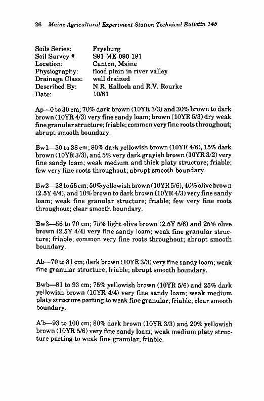
Soils Series: Fryeburg Soil Survey # S80-ME-090-180 Location: Canton, Maine Physiography: flood plain in river valley Drainage Class: well drained Described By: N.R. Kalloch and R.V. Rourke Date: 10/80
Apl—0 to 9 cm; dark brown (10YR 3/3) silt loam; brown (10YR 5/3) dry; moderate very fine and fine granular structure; friable; common medium and many very fine and fine roots throughout; abrupt wavy boundary.
Ap2—9 to 25 cm; brown to dark brown (10YR 4/3) silt loam; brown (10YR 5/3) dry; weak very fine granular structure; friable; common fine and many very fine roots throughout; clear wavy boundary.
A/B—25 to 55 cm; 34% very dark grayish brown (10YR 3/2), 30% dark yellowish brown (10YR4/4), and 36% light olive brown (2.5Y 5/4) silt loam; massive; friable; common very fine and fine roots throughout; abrupt smooth boundary.
Bw—55 to 84 cm; 40% dark yellowish brown (10YR 4/4), and 60 light olive brown (2.5Y 5/6) silt loam; massive; friable; common very fine and fine roots throughout; diffuse wavy boundary.
C—84 to 100 cm; 40% dark yellowish brown (10YR 4/4), and 60% brown to dark brown (10YR 4/3) silt loam; massive; friable; common very fine and fine roots throughout.
SOIL—FRYEBURG SOIL Nos.—090180 LOCATION—Canton, Maine
Depth Hor Sand Silt Clay Very Coarse Medium Fine Very Coarse Fine cm izon Coarse Fine Silt Silt
(2-0.06) (0.05-0.002) (<0.002) (2-1) (1-0.5) (0.5-0.25) (0.25-0.1) (0.1-0.05) (0.05-0.02) (0.02-0.002) p«* «f - O m «
0-8 Apl 27.59 60.07 12.34 0.08 0.76 l . l l 11.16 14.48 40.03 20.04 9-25 Ap2 37.64 56.19 7.17 0.20 0.25 0.56 11.20 25.43 36.94 18.25
25-55 A/B 36.10 53.24 10.66 0.11 0.17 0.44 8.70 26.68 35.52 17.72 55-84 Bw 33.74 57.78 8.48 0.00 0.03 0.24 7.79 25.68 30.05 27.73
84-100 C 27.69 68.96 3.35 0.11 0.12 0.26 5.73 21.47 40.58 28.38
Organic Carbon
Avail. H20
pH KC1 CaCl H20 Depth
Organic Carbon BD .06 .1 - wditr ^uiiit iiL vndi r
.33 .67 1 2 3 5 15
Avail. H20
pH KC1 CaCl H20
cm % g/cc % % % % % % % % % cm/cm (1:1) (2:1) (1:1)
0-9 2.71 1.08 43.1 40.6 35.7 31.3 29.7 16.1 14.0 12.6 11.8 0.31 6.50 6.70 7.10 9-25 1.60 1.17 41.2 38.4 28.5 25.9 25.6 12.8 10.5 9.4 8.2 0.35 4.90 5.40 6.00
25-55 1.28 0.96 57.6 49.9 39.3 30.9 27.5 12.4 10.2 8.4 6.9 0.41 4.70 5.10 5.80 55-84 0.76 1.06 45.0 38.3 32.2 26.2 23.2 11.7 10.0 8.4 6.6 0.34 4.80 5.20 5.90
84-100 0.74 1.11 42.7 38.3 34.8 29.7 26.6 11.7 10.3 8.8 6.6 0.35 4.80 5.30 6.00
Ext KC1 Volume—% Rock Fragments Depth Ca Mg Na K Acid CEC Al+H ECEC (Width in:
cm me/lOOg - >76 76-51 51-38 38-25 25-19 19-13 13-6 6-2 Total
0-9 14.10 0.60 0.01 0.20 5.90 20.81 0.35 15.26 0.00 0.00 0.00 0.00 0.00 0.02 0.04 0.11 0.17 9-25 3.90 0.10 0.01 0.01 10.90 14.92 0.30 4.32 0.00 0.00 0.00 0.00 0.00 0.00 0.00 0.01 0.01
25-55 1.30 0.01 0.01 0.01 14.10 15.43 0.65 1.98 0.00 0.00 O.OO 0.00 0.00 0.00 0.00 0.00 0.00 55-84 1.50 0.01 0.01 0.01 11.30 12.83 0.60 2.13 0.00 0.00 0.00 0.00 0.00 0.00 0.00 0.00 0.00
84-100 1.00 0.10 0.01 0.01 11.10 12.22 0.45 1.57 0.00 0.00 0.00 0.00 0.00 0.00 0.00 0.00 0.00
Maine A
gricu
ltura
l Experim
ent S
tatio
n T
echnical Bulletin
14
5
23

24 Maine Agricultural Experiment Station Technical Bulletin 145
Soils Series: Fryeburg Soil Survey # S80-ME-090-280 Location: Fryeburg, Maine Physiography: flood plain in river valley Drainage Class: well drained Described By: K.J. LaFlamme and R.V. Rourke Date: 10/80
Ap—0 to 20 cm; brown to dark brown (10YR 4/3) loam; pale brown (10YR 6/4) dry; weak very fine granular and weak fine granular structure; friable; common very fine and fine roots throughout; clear wavy boundary.
A/B—20 to 34 cm; 50% brown to dark brown (10YR 4/3) and 50% light olive brown (2.5Y 5/6) silt loam; massive; friable; few very fine and fine roots throughout; clear smooth boundary.
Bw—34 to 58 cm; dark yellowish brown (10YR 4/4) silt loam; massive; friable; few very fine and fine roots throughout; clear smooth boundary.
CAbl—58 to 78 cm; light olive brown (2.5Y 5/6) silt loam; massive; friable; few very fine roots throughout; clear smooth boundary.
CAb2—78 to 99 cm; light olive brown (2.5Y 5/6) silt loam; massive; friable; few very fine roots throughout; abrupt smooth boundary.
A/Cb—99 to 100 cm; 60% dark brown (10YR 3/3) and 40% olive brown (2.5Y 4/4) silt; massive; friable; few very fine roots throughout.

SOIL—FRYEBURG SOIL Nos.—090280 LOCATION—Fryeburg, Maine
Depth Hor Sand Silt Clay Very Coarse Medium Pine Very Coarse Fine cm izon Coarse Fine Silt Silt
(2-0.055 (0.05-0.002) (<0.002) (2-1) (1-0.5) (0.5-0.25) (0.25-0.1) (0.1-0.05) i [0.05-0.02) (0.02-0.002)
0-20 Ap 38.64 48.56 12.80 0.30 0.65 1.40 16.20 20.09 28.00 20.56 20-34 A/B 30.44 58.06 11.50 0.15 0.25 0.75 10.57 18.72 28.91 29.15 34-58 Bwb 18.73 70.97 10.30 0.00 0.04 0.16 3.07 15.46 52.26 18.71 58-78 CAbl 12.30 76.46 11.24 0.00 0.05 0.13 1.21 10.91 37.50 38.96 78-99 CAb2 11.29 75.88 12.83 0.00 0.01 0.10 1.80 9.38 32.70 43.18
99-100 A/Cb 6.32 83.51 10.17 0.10 0.12 0.26 1.07 4.77 23.40 60.11
Organic - Water Content (Bar Pressures) Avail. - pH Organic - Water Content (Bar Pressures) Avail. - pH Depth Carbon BD .06 .1 .33 .67 1 2 3 5 15 H 2 0 KC1 CaCl H 2 0
cm % g/cc % <7< % % % % % % % cm/cm (1:1) (2:1) (1:1)
0-20 1.40 1.28 32.2 29.7 27.0 25.8 24.3 12.0 11.0 8.7 6.6 0.30 4.60 5.00 5.30 20-34 0.98 1.27 39.2 37.5 35.2 31.4 26.1 12.5 11.1 9.1 6.7 0.39 4.40 4.80 5.00 34-58 0.62 1.06 53.1 51.0 47.0 43.5 40.5 13.1 11.2 9.4 6.9 0.47 4.70 5.10 5.40 58-78 0.62 1.00 50.8 45.6 37.3 33.2 28.2 13.7 12.3 10.6 7.6 0.38 4.60 5.00 5.40 78-99 0.64 0.95 53.0 48.0 39.7 33.6 29.6 14.5 13.4 11.1 7.9 0.38 4.50 5.00 5.50
99-100 1.36 0.93 59.6 57.6 54.6 51.0 47.0 23.1 21.6 17.6 13.3 0.41 4.40 5.00 5.60
Ext KC1 Volume—% Rock Fragments Depth
cm
0-20
Ca Mg Na K Acid me/lOOg - —
0.6O 12.50
CEC Al+H ECEC fWi/jth ;„ , mm) 19-13
0.00
Depth cm
0-20
Mg Na K Acid me/lOOg - —
0.6O 12.50
CEC Al+H ECEC - >76 76-51
0.00 0.00
51-38
0.00
38-25
0.00
25-19
0.00
mm) 19-13
0.00
l o f i fi_9 T"*-«l Depth
cm
0-20 2.70 0.40 0.01
K Acid me/lOOg - —
0.6O 12.50 16.21 0.90 4.61
- >76 76-51
0.00 0.00
51-38
0.00
38-25
0.00
25-19
0.00
mm) 19-13
0.00 0.00 0.08 0.08 20-34 1.90 0.20 0.01 9.50 12.10 14.71 1.35 3.96 0.00 0.00 0.00 0.00 0.00 0.00 O.OO 0.04 0.04 34-58 1.50 0.20 0.01 i D.40 9.70 11.81 0.85 2.96 0.00 0.00 0.00 0.00 0.00 0.00 0.00 0.00 0.00 58-78 0.90 0.10 0.01 Q.30 10.50 11.81 1.10 2.41 0.00 0.00 0.00 0.00 0.00 0.00 0.00 0.00 0.00 78-99 0.90 0.10 0.01 0.20 12.30 13.51 1.30 2.51 0.00 0.00 0.00 0.00 0.00 0.00 0.00 0.00 0.00
99-100 1.40 0.20 0.01 i 0.10 15.40 17.11 1.20 2.91 0.00 0.00 0.00 0.00 0.00 0.00 0.00 0.00 0.00
26 Maine Agricultural Experiment Station Technical Bulletin 145
Soils Series: Fryeburg Soil Survey # S81-ME-090-181 Location: Canton, Maine Physiography: flood plain in river valley Drainage Class: well drained Described By: N.R. Kalloch and R.V. Rourke Date: 10/81
Ap—0 to 30 cm; 70% dark brown (10YR 3/3) and 30% brown to dark brown (10YR 4/3) very fine sandy loam; brown (10YR 5/3) dry weak fine granular structure; friable; common very fine roots throughout; abrupt smooth boundary.
Bwl—30 to 38 cm; 80% dark yellowish brown (10YR 4/6), 15% dark brown (10YR 3/3), and 5% very dark grayish brown (10YR 3/2) very fine sandy loam; weak medium and thick platy structure; friable; few very fine roots throughout; abrupt smooth boundary.
Bw2—38 to 56 cm; 50% yellowish brown (10YR 5/6), 40% olive brown (2.5Y 4/4), and 10% brown to dark brown (10YR 4/3) very fine sandy loam; weak fine granular structure; friable; few very fine roots throughout; clear smooth boundary.
Bw3—56 to 70 cm; 75% light olive brown (2.5Y 5/6) and 25% olive brown (2.5Y 4/4) very fine sandy loam; weak fine granular structure; friable; common very fine roots throughout; abrupt smooth boundary.
Ab—70 to 81 cm; dark brown (10YR 3/3) very fine sandy loam; weak fine granular structure; friable; abrupt smooth boundary.
Bwb—81 to 93 cm; 75% yellowish brown (10YR 5/6) and 25% dark yellowish brown (10YR 4/4) very fine sandy loam; weak medium platy structure parting to weak fine granular; friable; clear smooth boundary.
A'b—93 to 100 cm; 80% dark brown (10YR 3/3) and 20% yellowish brown (10YR 5/6) very fine sandy loam; weak medium platy structure parting to weak fine granular; friable.

SOIL—FRYEBURG SOIL Nos.—090181 LOCATION—Canton Point, Maine
Depth Hor Sand Silt Clay Very Coarse Medium Fine Very Coarse Fine cm izon Coarse Fine Silt Silt
(2-0.05) (0.05-0.002) (<0.002) (2-1) (1-0.5) (0.5-0.25) I 0.25-0.1) (0.1-0.05) (0.05-0.02) (0.02-0.002) Pet f*r ^ 9 mn
0-30 Ap 54.21 40.57 5.22 0.13 0.35 1.52 21.91 30.30 25.59 14.98 30-38 B w l 41.26 55.38 3.36 0.00 0.06 0.45 12.74 28.01 35.60 19.78 38-56 Bw2 44.53 52.07 3.40 0.00 0.00 0.47 15.45 28.61 34.31 17.76 56-70 Bw3 57.50 40.12 2.38 0.00 0.06 1.84 27.24 28.36 27.26 12.86 70-81 Ab 52.94 44.12 2.94 0.00 0.05 0.71 20.84 31.34 29.77 14.35 81-93 Bwb 54.39 43.17 2.44 0.00 0.01 0.35 20.75 33.28 29.14 14.03
93-100 A"b 56.01 40.97 3.02 0.00 0.02 0.48 22.67 32.84 27.50 13.47
Or Avail. H 2 0
• pH CaCl Depth Carbon BD .06 .1
- W t i l t i LOIl I t
.33 .67 1 2 3 5 15 Avail. H 2 0 KC1
• pH CaCl H 2 0
cm % g/cc % % % % % % % % % cm/cm (1:1) (2:1) (1:1)
0-30 1.78 1.36 28.E 27.1 20.8 18.3 16.8 11.4 9.8 8.7 8.3 0.26 5.05 5.35 6.30 30-38 1.91 0.97 56.5 53.5 40.3 32.6 28.2 14.1 12.0 10.9 8.8 0.43 4.95 5.45 5.80 38-56 1.14 0.98 49.f 1 43.9 28.1 23.3 20.2 11.6 9.7 8.4 6.8 0.36 4.60 5.15 5.40 56-70 0.65 1.11 38.S 1 30.6 18.2 15.3 14.2 8.2 7.0 6.3 5.2 0.28 4.50 5.10 5.40 70-81 1.00 1.02 42.£ i 36.0 23.5 18.8 16.9 9.0 8.2 7.0 5.8 0.31 4.45 5.00 5.55 81-93 0.68 1.05 41.S i 36.2 25.3 20.6 18.7 9.2 7.0 6.8 5.4 0.32 4.45 5.05 5.70
93-100 0.74 1.07 40.2 ! 33.3 23.5 19.1 17.6 9.2 7.7 7.0 5.7 0.30 4.45 5.00 5.55
Ext KC1 Volume—% Rock Fragments Depth Ca Mg Na K Acid CEC Al+H ECEC (Width in mm)
cm me/lOOg - >76 76-51 51-38 38-25 25-19 19-13 13-6 6-2 Total
0-30 4.60 0.40 0.00 0.50 9.60 15.10 0.35 5.85 0.00 0.00 0.00 0.00 0.00 0.00 0.00 0.00 0.00 30-38 4.00 0.40 0.10 0.40 12.90 17.80 0.30 5.20 0.00 0.00 0.00 0.00 0.00 0.00 0.00 0.00 0.00 38-56 2.00 0.30 0.00 0.40 11.30 14.00 0.35 3.05 0.00 0.00 0.00 0.00 0.00 0.00 0.00 0.00 0.00 56-70 0.70 0.10 0.00 0.20 8.20 9.20 0.50 1.50 0.00 0.00 0.00 0.00 0.00 0.00 0.00 0.00 0.00 70-81 0.90 0.10 0.10 0.20 9.80 11.10 0.55 1.85 0.00 0.00 0.00 0.00 0.00 0.00 0.00 0.00 0.00 81-93 0.50 0.10 0.00 0.20 8.20 9.00 0.35 1.15 0.00 0.00 0.00 O.OO 0.00 0.00 0.00 0.00 0.00
93-100 0.50 0.10 0.00 0.20 8.80 9.60 0.55 1.35 0.00 0.00 0.00 0.00 0.00 0.00 0.00 0.00 0.00
Maine A
gricultu
ral Experim
ent Station
Technical B
ulletin
145 27

28 Maine Agricultural Experiment Station Technical Bulletin 145
Soils Series: Fryeburg Soil Survey # S81-ME-090-281 Location: Rumford, Maine Physiography: flood plain in river valley Drainage Class: well drained Described By: N.R. Kalloch and R.V. Rourke Date: 10/81
Ap—0 to 15 cm; very dark grayish brown (10YR 3/2) silt loam; pale brown (10YR 6/3) dry; moderate fine and medium granular structure; friable; many very fine, fine, and medium roots throughout; abrupt smooth boundary.
A/B—15 to 27 cm; 80% very dark grayish brown (10YR 3/2) and 20% grayish brown (2.5Y 5/2) silt loam; weak thin and medium platy structure; friable; many very fine and common fine roots throughout; clear wavy boundary.
B/A—27 to 58 cm; 60% dark yellowish brown (10YR 4/4), 30% dark grayish brown (10YR 4/2), and 10% brown to dark brown (10YR 4/ 3) silt loam; massive; friable; common very fine roots throughout; clear wavy boundary.
Bw—58 to 93 cm; yellowish brown (10YR 5/4) silt loam; weak thin and medium platy structure; friable; many very fine and few medium roots throughout; clear smooth boundary.
Ab—93 to 100 cm; brown to dark brown (10YR 4/3) silt loam; massive; friable; few very fine roots throughout.

SOIL—FRYEBURG SOIL Nos.—090281 LOCATION—Rumford, Maine
Depth Hor Sand Silt Clay Very Coarse Medium Fine Very Coarse Fine cm izon Coarse Fine Silt Silt
(2-0.05) (0.05-0.002) (<0.002) (2-1) (1-0.5) (0.5-0.25) (0.25-0.1) (0.1-0.05) (0.05-0.02) (0.02-0.002)
Pet. 0.25 0-15 Ap 34.52 57.75 7.73 0.06 Pet. 0.25 0.74 12.90 20.57 32.65 25.10
15-27 A/B 29.25 63.29 7.46 0.00 0.17 0.57 9.74 18.77 33.91 29.38 27-58 B/A 19.93 73.90 6.17 0.00 0.16 0.39 5.15 14.23 35.31 38.59 58-93 Bw 29.19 63.22 7.59 0.00 0.07 1.18 13.43 14.51 31.01 32.21
93-100 Ab 25.37 66.23 8.40 0.00 0.08 3.16 9.63 12.50 34.17 32.06
Organic - Water Content (Bar Pressures) -- Avail. - pH Organic - Water Content (Bar Pressures) -- Avail. - pH Depth Carbon BD .06 .1 .33 .67 1 2 3 5 15 H20 KC1 CaCl H20
cm % g/cc % % % % % % % % % cm/cm (1:1) (2:1) (1:1)
0-15 3.25 1.12 41.9 40.1 35.6 33.1 31.3 21.2 17.5 17.4 15.4 0.28 4.70 5.50 5.95 15-27 2.49 1.13 43.7 41.2 32.2 28.6 27.7 18.3 14.8 14.2 10.8 0.34 4.40 4.85 5.65 27-58 1.75 0.93 60.2 57.8 47.7 40.1 35.9 19.3 15.6 13.8 10.7 0.44 4.40 4.70 5.80 58-93 0.53 1.25 37.0 32.1 28.0 23.4 21.2 12.4 9.8 8.7 6.0 0.33 4.45 4.95 6.00
93-100 0.31 1.37 32.9 30.6 28.5 23.5 20.6 11.0 8.6 7.5 5.2 0.35 4.50 5.15 6.05
Ext KC1 Volume—% Rock Fragments Depth Ca Mg Na K Acid CEC Al+H ECEC -— (Width in mm)
cm
0-15
me/lOOg
3.10 15.70
- >76 76-51
0.00 0.00
51-38
0.00
38-25
0.00
25-19
0.00
19-13
0.00
I O C C O f r t + n l cm
0-15 3.60 0.10 0.10 i
me/lOOg
3.10 15.70 19.60 0.60 4.50
- >76 76-51
0.00 0.00
51-38
0.00
38-25
0.00
25-19
0.00
19-13
0.00 lxr-O O—L, T
0.00 0.00 0.00 15-27 2.20 0.00 0.00 i 3.00 17.30 19.50 1.00 3.20 0.00 0.00 0.00 0.00 0.00 0.00 0.00 0.00 0.00 27-58 1.00 0.10 0.10 i 3.00 17.10 18.30 0.75 1.95 0.00 0.00 0.00 0.00 0.00 0.00 0.00 0.00 0.00 58-93 0.80 0.10 0.10 i 3.00 9.60 10.60 0.55 1.55 0.00 0.00 0.00 0.00 0.00 0.00 0.00 0.00 0.00
93-100 0.70 0.00 0.10 i 3.00 8.00 8.80 0.55 1.35 0.00 0.00 0.00 0.00 0.00 0.00 0.00 0.00 0.00
Maine A
gricu
ltura
l Experim
ent Sta
tion
Technical B
ulletin
14
5
29

30 Maine Agricultural Experiment Station Technical Bulletin 145
Soils Series: Fryeburg Soil Survey # S81-ME-090-381 Location: Rumford, Maine Physiography: flood plain in river valley Drainage Class: well drained Described By: N.R. Kalloch and R.V. Rourke Date: 10/81
Ap—0 to 14 cm; dark yellowish brown (10YR 4/4) very fine sandy loam; light yellowish brown (10YR 6/4) dry; weak fine granular structure; very friable; common very fine, fine and medium roots throughout; abrupt wavy boundary.
A/B—14 to 28 cm; 80% dark yellowish brown (10YR 4/4) and 20% light gray (10YR 7/2) very fine sandy loam; weak thin and medium platy structure; friable; many very fine and common fine roots throughout; abrupt smooth boundary.
Bw—28 to 49 cm; yellowish brown (10YR 5/6) silt loam; weak thin and medium platy structure; friable; many very fine and few fine roots throughout; abrupt wavy boundary.
A b l - 4 9 to 87 cm; dark yellowish brown (10YR 4/4) silt loam; massive; friable; many very fine roots throughout; clear wavyboun-dary.
Ab2—87 to 100 cm; dark yellowish brown (10YR 4/4) silt loam; massive; friable; common very fine roots throughout.

SOIL—FRYEBURG SOIL Nos.—090381 LOCATION—Rumford, Maine
Depth Hor Sand Silt Clay Very Coarse Medium Fine Very Coarse Fine cm izon Coarse Fine Silt Silt
(2-0.05) (0.05-0.002) (<0.002) (2-1) (1-0.5) (0.5-0.25) (0.25-0.1) (0.1-O.05) i :o.05-0.02) (0.02-0.002)
Pet. 0.45
nf *» O T Y i t n
0-14 Ap 59.79 33.77 6.44 0.12 Pet. 0.45
U l V £t II1I1I " — —
9.77 28.62 20.83 20.52 13.25 14-28 A/B 55.68 38.53 5.79 0.00 0.16 6.90 26.25 22.37 22.41 16.12 28-49 Bw 40.10 51.80 8.10 0.00 0.00 0.68 12.33 27.09 31.66 20.14 49-87 Abl 33.56 61.04 5.40 O.OO 0.00 0.75 11.31 21.50 31.18 29.86
87-100 Ab2 41.68 53.65 4.67 O.OO 0.00 1.71 20.00 19.97 31.05 22.60
Organic Carbon
Avail. H 2 0
• PH CaCl H 2 0 Depth
Organic Carbon BD .06 .1
" TT a i d V . ' U l l t L
.33 .67 1 2 3 5 15 Avail. H 2 0 KC1
• PH CaCl H 2 0
cm % g/cc % % % % % % % % % cm/cm (1:1) (2:1) (1:1)
0-14 2.11 1.12 36.9 31.7 25.3 24.2 23.8 12.8 11.4 11.0 9.2 0.25 6.25 6.50 7.00 14-28 1.70 1.21 32.5 25.6 18.1 16.4 15.1 11.7 10.0 10.0 7.8 0.22 5.30 6.05 6.45 28-19 0.94 1.11 46.0 40.6 29.2 22.0 19.2 11.9 10.0 8.7 7.4 0.37 4.70 5.30 6.20 49-87 0.56 1.08 45.8 37.4 27.9 21.1 18.9 11.8 9.4 7.7 5.9 0.34 4.70 5.20 6.00
87-100 0.35 1.25 37.8 32.9 27.3 21.7 18.8 9.4 7.4 6.1 4.6 0.35 4.70 5.35 5.70
Ext KC1 Volume—' fo Rock Fragments Depth Ca Mg Na K Acid CEC Al+H ECEC
cm me/lOOg — - >76 76-51 51-38 38-25 25-19 19-13 13-6 6-2 Total
0-14 8.40 0.30 0.10 0.30 6.80 15.90 0.20 9.30 0.00 0.00 0.00 0.00 0.00 0.00 0.00 0.10 0.10 14-28 4.00 0.30 0.00 0.10 10.10 14.50 0.30 4.70 0.00 0.00 0.00 0.00 0.00 0.00 0.00 0.00 0.00 28-19 1.00 0.10 0.00 0.00 12.10 13.20 0.55 1.65 0.00 0.00 0.00 O.OO 0.00 0.00 0.00 0.00 0.00 49-87 0.40 0.10 0.00 0.00 9.80 10.30 0.50 1.00 0.00 0.00 0.00 O.OO 0.00 0.00 0.00 0.00 0.00
87-100 0.30 0.10 0.10 0.00 8.00 8.50 0.40 0.90 0.00 0.00 0.00 0.00 0.00 0.00 0.00 0.00 0.00
Maine A
gricultu
ral Experim
ent Station
Technical B
ulletin
145 31

32 Maine Agricultural Experiment Station Technical Bulletin 145
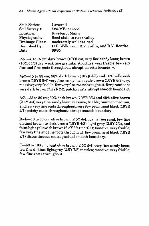
Soils Series: Lovewell Soil Survey # S85-ME-090-485 Location: Fryeburg, Maine Physiography: flood plain in river valley Drainage Class: moderately well drained Described By: D.E. Wilkinson, R.V. Joslin, and R.V. Rourke Date: 06/85
Apl—0 to 13 cm; very dark grayish brown (10YR 3/2) silt; pale brown (10YR 6/3) dry; weak fine granular structure; friable; few very fine and fine roots throughout; abrupt smooth boundary.
Ap2—13 to 26 cm; 95% very dark grayish brown (10YR 3/2) and 5% yellowish brown (10YR 5/8) silt; pale brown (10YR 6/3) dry; massive; friable; few very fine roots throughout; few fine rounded dark nodules; abrupt smooth boundary.
Bwl—26 to 46 cm; 90% dark yellowish brown (10YR 4/4) and 10% brown to dark brown (10YR 4/3) silt; few fine distinct light olive brown (2.5Y 5/4), and dark yellowish brown (10YR 4/6) mottles; massive; friable; few very fine roots throughout; common medium irregular dark nodules; gradual smooth boundary.
Bw2—46 to 66 cm; olive brown (2.5Y 4/4) fine sandy loam; common fine faint light olive brown (2.5Y 5/4) and few light yellowish brown (2.5Y 6/4) mottles; massive; very friable; few very fine roots throughout; few prominent brown to dark brown (7.5YR 4/4), yellowish brown (10YR 5/8), and very dark gray (10YR 3/1) patchy coats on sands; few very fine roots throughout; gradual smooth boundary.
C—66 to 100 cm; olive brown (2.5Y 4/4) very fine sandy loam; few fine faint light olive brown (2.5Y 5/4) and distinct dark yellowish brown (10YR 4/4) mottles; massive; very friable; few very fine roots throughout.

SOIL—LOVEWELL SOIL Nos.—090485 LOCATION—Fryeburg, Maine
Depth Hor Sand Silt Clay Very Coarse Medium Fine Very Coarse Fine cm izon Coarse Fine Silt Silt
(2-0.06) (0.05-0.002) (<0.002) (2-1) (1-0.5) (0.5-0.25) (0.25-0.1) (0.1-0.05) i :0.05-O.02) (0.02-0.002)
0-13 Apl 7.84 80.54 11.62 0.09 0.19 0.26 0.94 6.36 45.05 35.49 13-26 Ap2 6.85 83.49 9.66 0.01 0.12 0.18 0.83 5.71 49.73 33.76 26-46 Bwl 9.84 80.82 9.34 0.00 0.04 0.15 1.63 8.02 48.06 32.76 46-66 Bw2 36.32 59.90 3.78 0.00 0.02 0.20 7.64 28.46 21.17 38.73
66-100 C 52.51 43.72 3.77 0.00 0.03 0.43 16.87 35.18 13.38 30.34
fir Av 1 • pH CaCl Depth Carbon BD .06 .1
* ' » d LI I \_.U11LL
.33 .67 1 2 3 5 15 H 2 0 KC1 • pH CaCl H 2 0
cm % g/cc % % % % % % % % % cm/cm (1:1) (2:1) (1:1)
0-13 3.08 1.13 41.6 40.4 36.5 34.2 32.2 22.4 18.6 16.6 13.1 0.31 5.50 6.10 6.70 13-26 2.93 1.23 40.1 39.8 38.2 37.0 36.1 22.7 20.0 16.8 13.5 0.32 5.40 6.10 6.65 26-16 1.20 0.94 64.2 63.1 59.1 55.9 54.6 21.4 14.5 14.3 8.9 0.51 4.90 5.50 6.15 46-66 0.49 0.98 44.6 42.0 34.0 30.9 30.2 9.9 7.2 6.6 4.9 0.36 4.70 5.20 5.90
66-100 0.31 1.17 32.3 27.7 18.4 15.3 14.4 7.3 6.0 4.8 3.8 0.28 4.60 5.00 5.65
Ext KC1 Volume—% Rock Fragments Depth Ca Mg Na K Acid CEC Al+H ECEC (Width in mm)
cm
0-13
•>76 76-51 51-38 38-25 25-19
0.00 0.00
19-13 IVfi 6-2 Totol cm
0-13 8.70 1.40 0.80 a.io i i . 7 0 22.70 0.10 11.10 0.00 0.00 0.00
38-25 25-19
0.00 0.00 0.00 0.01 0.20 0.21 13-26 7.90 1.40 0.70 i D.10 12.10 22.20 0.10 10.20 0.00 0.00 0.00 0.00 0.00 0.00 0.00 0.20 0.20 26-16 2.20 0.50 0.50 i D.10 11.50 14.80 0.20 3.50 0.00 0.00 0.00 0.00 0.00 0.00 0.00 0.00 0.00 46-66 0.70 0.20 0.10 i 3.10 7.40 8.50 0.40 1.50 0.00 0.00 0.00 0.00 0.00 0.00 0.00 0.00 0.00
66-100 0.30 0.10 0.10 i 3.10 5.50 6.10 0.40 1.00 0.00 0.00 0.00 0.00 0.00 0.00 0.00 0.00 0.00
Maine A
gricu
ltura
l Experim
ent S
tatio
n T
echnical Bulletin
14
5
33
34 Maine Agricultural Experiment Station Technical Bulletin 145
Soils Series: Lovewell Soil Survey # S85-ME-090-585 Location: Fryeburg, Maine Physiography: flood plain in river valley Drainage Class: moderately well drained Described By: D.E. Wilkinson, R.V. Joslin, and R.V. Rourke Date: 06/85
Apl—0 to 15 cm; dark brown (10YR 3/3) very fine sandy loam; brown (10YR 5/3) dry; weak fine granular structure; very friable; few very fine and fine roots throughout; abrupt smooth boundary.
Ap2—15 to 33 cm; 90% dark brown (10YR 3/3) and 10% yellowish brown (10YR 5/4) very fine sandy loam; pale brown (10YR 6/3) dry; massive; very friable; few very fine roots throughout; few prominent very dark brown (7.5YR 2/2) patchy coats; abrupt smooth boundary.
A/B—33 to 50 cm; 60% dark brown (10YR 3/3) and 40% olive brown (2.5Y 4/4) very fine sandy loam; massive; friable; common medium, and few very fine roots throughout; very few prominent black (10YR 2/1) patchy coats throughout; abrupt smooth boundary.
Bwb—50 to 63 cm; olive brown (2.5Y 4/4) loamy fine sand; few fine distinct brown to dark brown (10YR 4/3), light gray (2.5Y 7/2), and faint light yellowish brown (2.5Y6/4) mottles; massive; very friable; few very fine and fine roots throughout; few prominent black (10YR 2/1) discontinuous coats; gradual smooth boundary.
C—63 to 100 cm; light olive brown (2.5Y 5/4) very fine sandy loam; few fine distinct light gray (2.5Y 7/2) mottles; massive; very friable; few fine roots throughout.

SOIL—LOVEWELL SOIL Nos.—090585 LOCATION—Fryeburg, Maine
Maine A
gricu
ltura
l Experim
ent Sta
tion
Technical B
ulletin
14
5
35
Depth Hor Sand Silt Clay Very Coarse Medium Fine Very Coarse Fine cm izon Coarse Fine Silt Silt
(2-0.05) (0.05-0.002) (<0.002) (2-1) (1-0.5) (0.5-0.25) I :0.25-0.1) (0.1-0.05) 1 ;0.05-0.02) (0.02-0.002) P(*t f\f -. 9 rrv
0-15 Apl 64.41 32.30 3.29 0.71 0.72 3.10 31.66 28.22 10.63 21.67 15-33 Ap2 64.64 32.56 2.80 0.24 0.55 3.10 32.57 28.18 11.78 20.78 33-50 A/B 56.86 39.21 3.93 0.00 0.15 2.41 26.66 27.64 13.37 25.84 50-63 Bwb 71.62 27.06 1.32 0.03 0.10 2.34 39.60 29.55 8.18 18.88
63-100 C 63.29 35.93 0.78 0.00 0.04 0.69 26.68 35.88 10.45 25.48
Or \A7nfiiT f ^ n n f p " * fRo** P r o c c n r o c \ A il - PH CaCl H 2 0 Depth Carbon BD .06 .1 .33 .67 1 2 3 5 15 H 2 0 KC1
- PH CaCl H 2 0
cm % g/cc % % % % % % % % % cm/cm (1:1) (2:1) (1:1)
0-15 1.12 1.18 27.4 24.0 15.6 13.2 12.4 8.4 6.3 5.9 4.6 0.23 5.70 6.35 7.10 15-33 1.02 1.37 25.3 22.4 15.8 13.3 12.1 8.0 6.7 5.9 5.0 0.24 5.65 6.35 7.25 33-50 0.77 1.20 37.8 34.8 22.8 17.8 16.2 9.0 6.4 6.0 5.0 0.36 5.55 6.20 7.05 50-63 0.41 1.18 28.4 22.5 13.2 11.1 10.4 6.2 4.8 4.5 3.9 0.22 5.25 5.85 6.90
63-100 0.41 1.13 33.7 27.2 15.6 13.7 13.0 6.5 5.3 5.0 4.3 0.26 4.95 5.45 6.60
Ext KC1 Volume—% Rock Fragments Depth Ca Mg Na K Acid i CEC Al+H ECEC (Width in mm)
rm >76 76-51 51-38 38-25 25-19 19-13 13-6 6-2 Total
0-15 4.00 0.50 0.20 0.01 4.70 9.41 0.10 4.81 O.OO 0.00 0.00 0.00 0.00 0.00 0.00 0.00 0.00 15-33 3.90 0.40 0.10 0.01 4.70 9.11 0.00 4.41 0.00 0.00 0.00 0.00 0.00 0.00 0.00 0.00 0.00 33-50 3.10 0.30 0.10 0.O1 4.90 8.41 0.10 3.61 0.00 0.00 0.00 0.00 0.00 0.00 0.00 0.00 0.00 50-63 1.40 0.10 0.10 0.01 3.50 5.11 0.10 1.71 0.00 0.00 0.00 0.00 0.00 0.00 0.00 0.00 0.00
63-100 1.00 0.01 0.10 0.O1 4.10 5.22 0.20 1.32 0.00 0.00 0.00 0.00 0.00 0.00 0.00 0.00 0.00

36 Maine Agricultural Experiment Station Technical Bulletin 145
Soils Series: Lovewell Soil Survey # S86-ME-040-486 Location: Farmington, Maine Physiography: flood plain in river valley Drainage Class: moderately well drained Described By: K.J. LaFlamme, G.T. Hedstrom, W.D. Hoar,
P.A. Hughes, and R.V. Rourke Date: 06/86
Apl—0 to 18 cm; dark brown (10YR 3/3) silt loam; pale brown (10YR 6/3) dry; weak fine granular structure; friable; few very fine roots throughout; clear smooth boundary.
Ap2—18 to 33 cm; dark brown (10YR 3/3) silt loam; light brownish gray (10YR 6/2) dry; weak fine granular structure; friable; few very fine and fine roots throughout; abrupt wavy boundary.
Bwl—33 to 53 cm; olive brown (2.5Y 4/4) silt loam; weak medium platy structure; friable; few very fine roots throughout; clear wavy boundary.
Bw2—53 to 71 cm; light olive brown (2.5Y5/4) silt; common medium prominent light olive gray (5Y 6/2) and coarse yellowish brown (10YR 5/6) mottles; weak medium platy structure; friable; few very fine roots throughout; clear wavy boundary.
C—71 to 100 cm; olive (5Y 5/3) silt; many coarse prominent brown to dark brown (7.5YR 4/4) and few medium faint light olive gray (5Y 6/2) mottles; weak very coarse prismatic structure parting to weak medium and thick platy; friable; few prominent dark reddish brown (5YR 3/3) discontinuous oxide coats throughout.

SOIL—LOVEWELL SOIL Nos.—040486 LOCATION—Farmington, Maine
Depth Hor Sand Silt Clay Very Coarse Medium Fine Very Coarse Fine cm izon Coarse Fine Silt Silt
(2-0.05) (0.05-0.002) (<0.002) (2-1) (1-0.5) (0.5-0.25) (0.25-0.1) (0.1-0.05) (0.05-0.02) (0.02-0.002)
- — Pet. 0.78 0-18 Apl 26.09 60.67 13.24 0.28
- — Pet. 0.78 1.75 7.92 15.36 28.84 31.83
18-33 Ap2 25.75 60.46 13.79 0.27 0.69 1.59 7.98 15.22 25.57 34.89 33-63 B w l 15.99 75.33 8.68 0.00 0.02 0.15 2.17 13.65 37.26 38.07 53-71 Bw2 9.34 84.00 6.66 0.00 0.02 0.14 1.05 8.13 46.67 37.33
71-100 C 7.72 84.48 7.80 0.00 0.17 0.35 1.01 6.19 52.67 31.81
Organic - Water Content (Bar I Avail. • pH Organic - Water Content (Bar I Avail. • pH Depth Carbon BD .06 .1 .33 .67 1 2 3 5 15 H 2 0 KC1 CaCl H 2 0
cm % g/cc % <% % % % % % % % cm/cm (1:1) (2:1) (1:1)
0-18 2.07 1.23 36.4 34.8 32.8 30.8 29.8 16.6 14.8 12.7 11.0 0.29 5.85 6.40 7.00 18-33 2.01 1.25 36.3 35.1 32.5 30.0 28.4 16.2 13.8 11.4 11.0 0.30 5.80 6.55 7.00 33-53 1.35 1.16 47.6 46.8 43.6 37.6 30.6 15.8 14.3 11.5 9.5 0.43 5.20 5.90 6.65 53-71 1.30 0.97 57.1 55.8 51.2 46.1 41.4 14.8 13.7 11.4 10.0 0.44 4.85 5.60 6.35
71-100 0.95 1.08 49.5 48.8 47.2 45.9 44.1 15.4 13.6 12.0 9.8 0.42 4.60 5.35 6.15
Ext KC1 Volume—% Rock Fragments Depth Ca Mg Na K Acid CEC Al+H ECEC (Width in mm)
cm me/lOOg - — - >76 76-51 51-38 38-25 25-19 19-13 13-6 6-2 Total
0-18 9.00 0.50 0.01 i D.50 7.30 17.31 0.05 10.06 0.00 0.00 0.00 0.00 0.00 0.00 0.00 0.01 0.01 18-33 8.50 0.50 0.01 i D.30 7.20 16.51 0.05 9.36 0.00 0.00 0.00 0.00 0.00 0.00 0.01 0.01 0.02 33-53 4.50 0.30 0.10 i D.20 9.30 14.40 0.05 5.15 0.00 0.00 0.00 0.00 0.00 0.00 0.00 0.01 0.01 53-71 3.00 0.30 0.10 i 9.20 11.20 14.80 0.15 3.75 0.00 0.00 0.00 0.00 0.00 0.00 0.00 0.00 0.00
71-100 1.60 0.30 0.10 i 3.30 11.40 13.70 0.30 2.60 0.00 0.00 0.00 0.00 0.00 0.00 0.00 0.00 0.00
Maine A
gricu
ltura
l Experim
ent S
tatio
n T
echnical Bu
lletin 1
45
37

38 Maine Agricultural Experiment Station Technical Bulletin 145
Soils Series: Lovewell Soil Survey # S86-ME-040-686 Location: Farmington, Maine Physiography: flood plain in river valley Drainage Class: moderately well drained Described By: K.J. LaFlamme, G.T. Hedstrom, P.A. Hughes,
W.D. Hoar, and R.V. Rourke Date: 06/86
Ap—0 to 35 cm; dark brown (10YR 3/3) silt loam; pale brown (10YR 6/3) dry; weak fine granular structure; very friable; common fine roots throughout; abrupt wavy boundary.
Bwl—35 to 43 cm; 70% olive brown (2.5Y 4/4) and 30% light olive brown (2.5Y 5/4) silt loam; weak very coarse prismatic structure parting to weak thick platy; friable; few fine roots throughout; clear wavy boundary.
Bw2—43 to 76 cm; light olive brown (2.5Y 5/4) silt loam; common medium distinct light olive brown (2.5Y 5/6) and prominent olive gray (5Y 5/2) mottles; weak very coarse prismatic structure parting to weak thick platy; friable; few fine roots throughout; clear smooth boundary.
C—76 to 100 cm; olive (5Y 5/4) silt loam; common coarse distinct light olive gray (5Y 6/2) and few medium prominent yellowish brown (10YR 5/6) mottles; massive; friable.

SOIL—LOVEWELL SOIL Nos.—040686 LOCATION—Farmington, Maine
Depth Hor Sand Silt Clay Very Coarse Medium Fine Very Coarse Fine cm izon Coarse Fine Silt Silt
(2-0.06) (0.05-0.002) (<0.002) (2-1) (1-0.5) (0.5-0.25) (0.25-0.1) (0.1-0.05) (0.05-0.02) (0.02-0.002)
Pet. 0.34 0-36 Ap 18.37 70.08 11.55 0.13 Pet. 0.34 0.78 3.93 13.19 35.89 34.19
35-43 Bwl 10.77 74.00 15.23 0.00 0.04 0.13 2.33 8.27 46.95 27.05 43-76 Bw2 29.12 60.64 10.24 O.OO 0.00 0.14 7.71 21.27 27.79 32.85
76-100 C 35.99 56.41 7.60 0.00 0.02 0.21 8.32 27.44 22.40 34.01
Or Avail • PH CaCl H 2 0 Depth Carbon BD .06 .1 .33 .67 1 2 3 5 15 H 2 0 KC1
• PH CaCl H 2 0
cm % g/cc % % % % % % % % % cm/cm (1:1) (2:1) (1:1)
0-35 2.17 1.12 38.9 37.4 33.2 31.6 30.4 17.1 16.4 13.1 11.3 0.29 5.40 5.95 6.30 35-43 0.93 1.17 44.6 43.7 39.6 35.7 31.9 17.6 14.0 11.8 8.9 0.41 4.80 5.40 5.85 43-76 0.52 1.06 45.8 43.2 33.5 27.8 23.8 11.1 9.1 8.0 6.4 0.39 4.65 5.20 5.60
76-100 0.40 1.10 41.0 38.0 26.7 22.8 18.8 9.1 7.2 6.5 5.3 0.36 4.60 5.15 5.65
Ext KC1 Volume—% Rock Fragments Depth Ca Mg Na K Acid CEC Al+H ECEC (Width in mm)
cm me/lOOg - — - >76 76-51 51-38 38-25 25-19 19-13 13-6 6-2 Total
0-35 8.20 0.90 0.10 1.20 10.30 20.70 0.05 10.45 0.00 0.00 0.00 0.00 0.01 0.10 0.10 0.10 0.31 35-43 3.10 0.40 0.10 0.70 11.10 15.40 0.15 4.45 0.00 0.00 0.00 0.00 0.00 0.00 0.00 0.00 0.00 43-76 1.40 0.20 0.01 0.40 8.70 10.71 0.30 2.31 0.00 0.00 0.00 0.00 0.00 0.00 0.00 0.00 0.00
76-100 1.00 0.10 0.10 0.30 6.80 8.30 0.30 1.80 0.00 0.00 0.00 0.00 0.00 0.00 0.00 0.00 0.00
Main
e Agricu
ltural E
xperiment S
tation T
echnical Bu
lletin 145
39

40 Maine Agricultural Experiment Station Technical Bulletin 145
Soils Series: Lovewell Soil Survey # S86-ME-090-486 Location: Canton, Maine Physiography: flood plain in river valley Drainage Class: moderately well drained Described By: K.J. LaFlamme, D.E. Wilkinson, and RV. Rourke Date: 06/86
Ap—0 to 30 cm; brown to dark brown (10YR 4/3) silt loam; light yellowish brown (2.5Y 6/4) dry; weak thin platy structure parting to weak very fine granular; friable; many very fine and fine roots throughout; abrupt smooth boundary.
B/A—30 to 39 cm; 70% olive brown (2.5Y 4/4) and 30% dark brown (10YR 3/3) siltloam; weak thin platy structure parting to weak very fine granular; friable; common very fine and fine roots throughout; abrupt smooth boundary.
Ab—39 to 51 cm; dark brown (10YR 3/3) silt loam; weak medium platy structure parting to weak very fine granular; friable; few very fine and fine roots throughout; abrupt smooth boundary.
Bwbl—51 to 55 cm; olive (5Y 5/3) silt loam; common medium distinct light olive gray (5Y 6/2) and few fine prominent yellowish brown (10YR 5/6) mottles; massive; friable; few very fine and fine roots throughout; abrupt smooth boundary.
Bwb2—55 to 67 cm; light olive brown (2.5Y 5/4) very fine sandy loam; common medium distinct light olive brown (2.5Y 5/6), prominent yellowish brown (10YR 5/6), and few light olive gray (5Y 6/2) mottles; massive; friable; few very fine roots in cracks; abrupt smooth boundary.
C—67 to 100 cm; pale olive (5Y 6/3) silt loam; common fine faint light olive gray (5Y 6/2) and medium distinct light olive brown (2.5Y 5/4) mottles; moderate very coarse prismatic structure; friable; few very fine roots in cracks.

SOIL—LOVEWELL SOIL Nos.—090486 LOCATION—Canton, Maine
Depth Hor Sand Silt Clay Very Coarse Medium Fine Very Coarse Fine cm izon Coarse Fine Silt Silt
(2-0.05) (0.05-0.002) (<0.002) (2-1) (1-0.5) (0.5-0.25) (0.25-O.1) (0.1-0.05) 1 0.05-0.02) (0.02-0.002)
Pet -»f-- 9 mi
0-30 Ap 31.40 59.06 9.54 0.13 0.42 0.44 7.04 23.37 27.45 31.61 30-39 B/A 33.28 61.00 5.72 0.00 0.05 0.22 7.89 25.12 27.43 33.57 39-51 Ab 30.67 63.77 5.56 0.02 0.05 0.27 7.36 22.97 28.58 35.19 51-55 Bwbl 36.23 58.80 4.97 0.00 0.03 0.32 10.45 25.43 24.48 34.32 55-67 Bwb2 46.94 48.58 4.48 0.00 0.05 0.71 16.33 29.85 19.23 29.35
67-100 C 24.74 68.16 7.10 0.00 0.04 0.53 5.27 18.90 34.91 33.25
Or Av il • P H CaCl Depth Carbon BD .06 .1
* TV a l l I V _ . U I L l . l _
.33 .67 1 2 3 5 15 H20 KC1 • P H CaCl H20
cm % g/cc % % % % % % % % % cm/cm (1:1) (2:1) (1:1)
0-30 1.65 1.19 35.1 33.3 26.2 23.4 20.7 16.9 11.9 9.8 8.0 0.30 4.70 5.20 5.90 30-39 1.00 1.38 32.6 32.0 28.8 26.8 24.6 18.6 10.5 8.2 6.6 0.35 4.65 5.20 5.85 39-61 1.10 1.20 41.4 40.2 34.1 30.4 26.6 18.7 10.9 8.0 6.6 0.40 4.55 4.90 5.65 51-55 0.46 1.30 35.5 34.2 26.9 23.2 19.8 9.2 7.2 6.2 4.8 0.38 4.50 4.90 5.50 55-67 0.32 1.29 34.7 33.4 24.7 21.0 17.8 7.5 6.2 5.5 4.3 0.38 4.50 4.90 5.40
67-100 0.31 1.36 34.0 33.3 29.9 27.0 24.1 9.7 7.8 6.5 5.5 0.38 4.40 4.85 5.40
Ext KC1 Volume—% Rock Fragments Depth Ca Mg Na K Acid CEC Al+H ECEC — (Width in mm)
cm
0-30
m a / 1 A >76 76-51
0.00 0.00
51-38
0.00
38-25
0.00
25-19
0.00
19-13 io_fi fi-2 TWol cm
0-30 3.10 0.90 0.01 0.40 12.60 17.01 0.30 4.71
>76 76-51
0.00 0.00
51-38
0.00
38-25
0.00
25-19
0.00 0.01 0.01 0.01 0.03 30-39 1.20 0.40 0.01 0.30 11.00 12.91 0.35 2.26 0.00 0.00 0.00 0.00 0.00 0.00 0.00 0.01 0.01 39-51 0.70 0.20 0.01 0.30 12.40 13.61 0.65 1.86 0.00 0.00 0.00 0.00 0.00 0.00 0.01 0.01 0.02 51-55 0.30 0.10 0.10 0.30 7.50 8.30 0.70 1.50 0.00 0.00 0.00 0.00 0.00 0.00 0.00 0.01 0.01 55-67 0.20 0.10 0.01 0.30 6.90 7.51 0.65 1.26 0.00 0.00 0.00 0.00 0.00 0.00 0.00 0.00 0.00
67-100 0.20 0.10 0.01 0.30 7.40 8.01 0.80 1.41 0.00 0.00 0.00 0.00 0.00 0.00 0.00 0.00 0.00
Maine A
gricultu
ral Experim
ent Station
Technical B
ulletin
145 41
42 Maine Agricultural Experiment Station Technical Bulletin 145
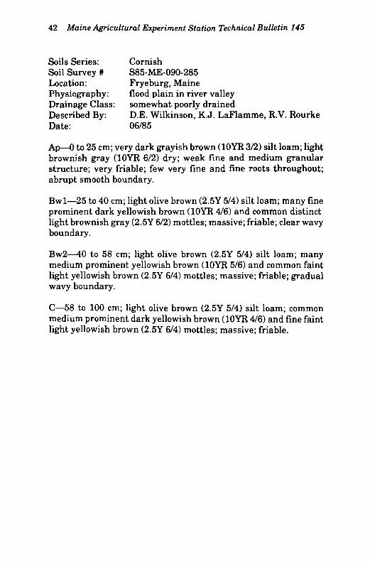
Soils Series: Cornish Soil Survey # S85-ME-090-285 Location: Fryeburg, Maine Physiography: flood plain in river valley Drainage Class: somewhat poorly drained Described By: D.E. Wilkinson, K.J. LaFlamme, R.V. Rourke Date: 06/85
Ap—0 to 25 cm; very dark grayish brown (10YR 3/2) silt loam; light brownish gray (10YR 6/2) dry; weak fine and medium granular structure; very friable; few very fine and fine roots throughout; abrupt smooth boundary.
Bwl—25 to 40 cm; light olive brown (2.5Y 5/4) silt loam; many fine prominent dark yellowish brown (10YR 4/6) and common distinct light brownish gray (2.5Y 6/2) mottles; massive; friable; clear wavy boundary.
Bw2—40 to 58 cm; light olive brown (2.5Y 5/4) silt loam; many medium prominent yellowish brown (10YR 5/6) and common faint light yellowish brown (2.5Y 6/4) mottles; massive; friable; gradual wavy boundary.
C—58 to 100 cm; light olive brown (2.5Y 5/4) silt loam; common medium prominent dark yellowish brown (10YR 4/6) and fine faint light yellowish brown (2.5Y 6/4) mottles; massive; friable.
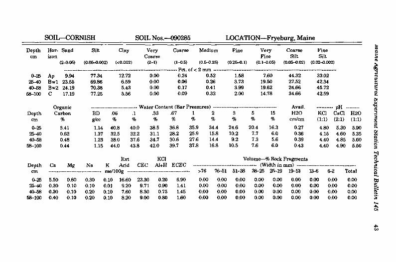
SOIL—CORNISH SOIL Nos.—090285 LOCATION—Fryeburg, Maine
Depth Hor Sand Silt Clay Very Coarse Medium Pine Very Coarse Fine cm izon Coarse Fine Silt Silt
(2-0.06) (0.06-0.002) (<0.002) (2-1) (1-0.5) (0.5-0.25) (0.25-0.1) (0.1-0.05) (0.06-0.02) (0.02-0.002)
0-25 Ap 9.94 77.34 12.72 0.00 0.24 0.52 1.58 7.60 44.32 33.02 25-W Bwl 23.55 69.86 6.59 0.00 0.06 0.26 3.73 19.50 27.52 42.34 40-58 Bw2 24.19 70.38 5.43 0.00 0.17 0.41 3.99 19.62 24.66 45.72
58-100 C 17.19 77.25 5.56 0.00 0.09 0.32 2.00 14.78 34.66 42.59
Or Avail. - D H
Depth U r ^ a i n v
Carbon BD .06 .1 .33 .67 1 2 3 5 15 H20 KC1 pn CaC]
H20 cm % g/cc % % % % % % % % % cm/cm (1:1) (2:1) (1:1)
0-25 3.41 1.14 40.8 40.0 38.5 36.8 35.9 34.4 24.6 20.4 16.3 0.27 4.80 5.30 5.90 25^0 0.62 1.37 32.5 32.2 31.1 28.2 25.9 15.8 10.2 7.7 6.0 0.36 4.15 4.60 5.35 40-58 0.48 1.23 38.0 37.6 34.7 30.6 27.6 14.4 9.2 7.3 5.6 0.39 4.40 4.85 5.60
58-100 0.44 1.15 44.0 43.8 42.0 39.7 37.8 16.8 10.5 7.6 6.0 0.43 4.40 4.90 5.50
Ext KC1 Volume—% Rock Fragments Depth
cm
0-25
Ca Mg Na K Acid CEC Al+H ECEC (Width in i 38-25 25-19
0.00 0.00
Depth cm
0-25
Ca Mg Na K Acid V L J ^ A I T l 1
•>76 76-51 51-38 (Width in i
38-25 25-19
0.00 0.00
19-13
0.00
1S-6 fi-3 T/rfol Depth
cm
0-25 5.50 0.80 0.30 0.10 16.60 23.30 0.20 6.90 0.00 0.00 0.00
(Width in i 38-25 25-19
0.00 0.00
19-13
0.00 0.00 0.00 0.00 25^0 0.30 0.10 0.10 0.01 9.20 9.71 0.90 1.41 0.00 0.00 0.00 0.00 0.00 0.00 0.00 0.00 0.00 40-58 0.30 0.10 0.20 9.10 7.60 8.30 0.75 1.45 0.00 0.00 0.00 0.00 0.00 0.00 0.00 0.00 0.00
58-100 0.40 0.10 0.20 0.10 8.20 9.00 0.80 1.60 0.00 0.00 0.00 0.00 0.00 0.00 0.00 0.00 0.00
Main
e Agricu
ltural E
xperiment S
tation T
echnical Bu
lletin 145
43

44 Maine Agricultural Experiment Station Technical Bulletin 145
Soils Series: Cornish Soil Survey # S85-ME-090-385 Location: Fryeburg, Maine Physiography: flood plain in river valley Drainage Class: somewhat poorly drained Described By: D.E. Wilkinson, R.V. Rourke, R.V. Joslin, and
R. Ferland Date: 06/85
Apl—0 to 18 cm; dark brown (10YR 3/3) silt loam; pale brown (10YR 6/3) dry; weak thick platy structure parting to moderate medium granular parting to weak fine granular; friable; common very fine roots throughout; abrupt wavy boundary.
Ap2—18 to 40 cm; 95% dark brown (10YR 3/3), 3% yellowish brown (10YR 5/8), and 2% strong brown (7.5YR 5/8) silt loam; pale brown (10YR 6/3) dry; moderate medium platy structure; friable; few very fine and fine roots throughout; clear smooth boundary.
A/B—40 to 57 cm; 90% very dark grayish brown (10YR 3/2), 5% light olive brown (2.5Y 5/4), and 5% yellowish brown (10YR 5/8) silt loam; light brownish gray (10YR 6/2) dry; massive; friable; common very fine and fine roots throughout; very few prominent very dark brown (10YR 2/2) continuous organic coats on horizontal faces of peds, and light gray to gray (10YR 6/1) patchy coats throughout; abrupt smooth boundary.
Ab—57 to 79 cm; 70% olive gray (5Y4/2), 20% light olive brown (2.5Y 5/4), and 10% very dark grayish brown (2.5Y 3/2) silt loam; common fine prominent dark yellowish brown (10YR 4/6) mottles; massive; friable; few very fine and fine roots throughout; very few prominent black (N 2/0) patchy organic coats throughout; abrupt wavy boundary.
Bwb—79 to 82 cm; olive (5Y 5/3) silt loam; few fine distinct light olive brown (2.5Y 5/4) and common faint olive gray (5Y 5/2)mottles; massive; friable; few very fine and fine roots throughout; very few prominent black (N 2/0) patchy organic coats, and few distinct very dark grayish brown (2.5Y 3/2) coats throughout; abrupt wavy boundary.
C—82 to 100 inches; olive (5Y 5/3) silt loam; common fine distinct light olive brown (2.5Y 5/4) and faint light olive gray (5Y 6/2) mottles; massive; friable.

SOIL—CORNISH SOIL Nos.—090385 LOCATION—Fryeburg, Maine
Depth Hor Sand Silt Clay Very Coarse Medium Fine Very Coarse Fine cm izon Coarse Fine Silt Silt
(2-0.05) (0.05-0.002) (<0.002) (2-1) (1-0.5) (0.5-0.25) (0.25-0.1) (0.1-0.05) (0.05-0.02) (0.02-0.002)
p ^ /\f - 9 TTV
0-18 Apl 11.94 79.37 8.69 0.14 0.30 0.57 2.43 8.50 47.83 31.54 18-40 Ap2 11.30 75.50 13.20 0.05 0.32 0.85 2.47 7.61 45.58 29.92 40-57 A/B 13.14 75.74 11.12 0.13 0.70 2.02 3.71 6.58 51.69 24.05 57-79 Ab 7.07 81.16 11.77 0.00 0.00 0.05 1.20 5.82 54.64 26.52 79-82 Bwb 23.40 72.23 4.37 0.00 0.02 0.10 4.08 19.20 32.80 39.43
82-100 C 33.98 63.39 2.63 0.00 0.02 0.22 5.65 28.09 19.47 43.92
Or Avail. H20
• pH CaCl Depth Carbon BD .06
•~ W it LCI \_-UIlLL
1 .33 .67 1 2 3 5 15 Avail. H20 KC1
• pH CaCl H20
cm % g/cc % % % % % % % % % cm/cm (1:1) (2:1) (1:1)
0-18 3.05 1.08 43.4 42.5 37.8 34.6 32.3 25.5 19.4 16.8 12.1 0.33 5.50 6.20 6.40 18-J0 3.77 1.05 48.1 47.4 43.3 41.1 40.3 25.3 24.3 19.2 15.1 0.34 5.20 5.55 6.40 40-57 4.13 0.82 70.6 69.3 63.4 62.5 61.9 30.8 26.2 20.4 17.6 0.42 4.45 4.80 5.55 57-79 4.61 0.69 95.2 94.0 89.5 88.0 87.4 25.7 24.4 19.8 15.3 0.54 4.40 4.55 5.15 79-82 0.94 1.41 31.6 31.3 30.2 28.3 25.6 15.2 10.5 8.2 5.9 0.36 4.30 4.55 5.15
82-100 0.46 1.41 31.0 30.6 27.6 24.5 21.6 8.2 6.9 5.9 4.0 0.38 4.30 4.60 5.05
Ext KC1 Volume—% Rock Fragments Depth Ca Mg Na K Acid CEC Al+H ECEC (Width in i ran)
cm me/lOOg — >76 76-51 51-38 38-25 25-19 19-13 13-6 6-2 Total
0-18 6.40 1.20 0.80 i 3.10 12.50 21.00 0.10 8.60 0.00 0.00 0.00 0.00 0.00 0.00 0.00 0.00 0.00 lcMO 5.80 0.70 0.70 i 3.10 15.00 22.30 0.20 7.50 0.00 0.00 0.00 0.00 0.00 0.00 0.00 0.00 0.00 40-57 1.70 0.20 0.30 i 3.01 20.30 22.51 1.80 4.01 0.00 0.00 0.00 0.00 0.00 0.00 0.00 0.00 0.00 57-79 0.70 0.10 0.20 i 9.10 22.00 23.10 1.45 2.55 0.00 0.00 0.00 0.00 0.00 0.00 0.00 0.00 0.00 79-82 0.10 0.01 0.10 i 3.10 11.10 11.41 1.20 1.51 0.00 0.00 0.00 0.00 0.00 0.00 0.00 0.00 0.00
82-100 0.01 0.01 0.10 i 3.01 7.40 7.53 0.90 1.03 0.00 0.00 0.00 0.00 0.00 0.00 0.00 0.00 0.00
Main
e Agricu
ltural E
xperiment S
tation T
echnical Bu
lletin 145
45

46 Maine Agricultural Experiment Station Technical Bulletin 145
Soils Series: Cornish Soil Survey # S86-ME-040-286 Location: Farmington, Maine Physiography: flood plain in river valley Drainage Class: somewhat poorly drained Described By: K.J. LaFlamme, R.V. Rourke, G.T. Hedstrom,
P.A. Hughes, and W.D. Hoar Date: 06/86
Ap—0 to 18 cm; dark brown (10YR3/3) siltloam; light brownish gray (2.5Y 6/2) dry; weak very fine granular structure; friable; few very fine roots throughout; abrupt smooth boundary.
Bwl—18 to 43 cm; olive brown (2.5Y 4/4) silt loam; common medium prominent light olive gray (5Y 6/2), and few distinct light olive brown (2.5Y 5/6) mottles; weak thin platy structure; friable; few very fine roots throughout; clear wavy boundary.
Bw2—43 to 88 cm; light olive brown (2.5Y 5/4) silt loam; common medium prominent light olive gray (5Y 6/2) and few distinct light olive brown (2.5Y 5/6) mottles; weak thick platy structure; friable; few very fine roots throughout; clear wavy boundary.
C—88 to 100 cm; olive (5Y 5/3) silt loam; common medium faint light olive gray (5Y 6/2), prominent light olive brown (2.5Y 5/6), and few yellowish brown (10YR 5/6) mottles; massive; friable.

SOIL—CORNISH SOIL Nos.—040286 LOCATION—Farmington, Maine
Depth Hor- Sand Silt Clay Very Coarse Medium Fine Very Coarse Fine cm izon Coarse Fine Silt Silt
(2-0.05) (0.05-0.002) (<0.002) (2-1) (1-0.5) (0.5-0.25) I ;o.25-0.1) (0.1-0.05) (0.05-0.02) (0.02-0.002)
0-18 Ap 32.67 59.38 7.95 0.02 0.25 1.03 11.24 20.13 28.82 30.56 18-43 Bwl 37.56 52.54 9.90 0.00 0.09 0.90 13.64 22.93 24.95 27.59 43-88 Bw2 28.77 61.79 9.44 0.04 0.07 0.63 9.96 18.07 31.68 30.11
88-100 C 18.56 74.74 6.70 0.04 0.06 0.28 5.19 12.99 35.25 39.49
(\r Avail. H20
nH
Depth urgoiui Carbon
BD .06 .1 " ' ' ( I I I . 1 VsUllLC
.33 .67 1 2 3 5 15 Avail. H20 KC1 pn
CaCl H20
cm % g/cc % % % % % % % % % cm/cm (1:1) (2:1) (1:1)
0-18 1.19 1.34 33.8 32.3 28.1 24.7 20.9 13.9 9.9 8.8 7.8 0.33 4.85 5.45 6.00 18-43 0.99 1.18 43.6 41.4 33.8 28.3 25.3 13.3 8.7 8.0 6.9 0.41 4.50 5.15 5.95 43-88 0.99 0.95 55.1 52.1 44.9 40.1 36.6 14.1 9.7 8.7 7.8 0.42 4.30 4.80 5.50
88-100 0.73 1.12 47.8 46.9 43.7 38.3 34.6 12.0 9.7 8.5 7.3 0.44 4.25 4.85 5.60
Ext KC1 Volume—% Rock Fragments Depth Ca Mg Na K Acid CEC Al+H ECEC -— (Width in
>76 76-51 51-38 38-25 25-19 19-13 I O C C O T V » o l
0-18 3.40 0.20 0.01 0.50 10.30 14.41 0.10 4.21 0.00 0.00 0.00 0.00 0.00 0.00 0.01 0.00 0.01 1843 1.80 0.10 0.01 0.40 11.20 13.51 0.50 2.81 0.00 0.00 0.00 0.00 0.00 0.00 0.00 0.00 0.00 43-88 1.00 0.10 0.01 0.30 13.20 14.61 1.05 2.46 0.00 0.00 0.00 0.00 0.00 0.00 0.00 0.00 0.00
88-100 0.80 0.10 0.01 0.20 10.90 12.01 0.90 2.01 0.00 0.00 0.00 0.00 0.00 0.00 0.00 0.00 0.00
Ma
ine A
gricu
ltura
l Experim
ent
Sta
tion
Tech
nical B
ulletin
14
5
47

48 Maine Agricultural Experiment Station Technical Bulletin 145
Soils Series: Cornish Soil Survey # S86-ME-040-386 Location: Farmington Falls, Maine Physiography: flood plain in river valley Drainage Class: somewhat poorly drained Described By: K.J. LaFlamme, R.V. Rourke, G.T. Hedstrom,
W.D. Hoar, and P.A. Hughes Date: 06/86
Ap—0 to 26 cm; dark brown (10YR 3/3) silt loam; pale brown (10YR 6/3) dry; weak fine granular structure; friable; few very fine roots throughout; clear smooth boundary.
B/A—26 to 41 cm; 60% light olive brown (2.5Y 5/4) and 40% dark brown (10YR 3/3) very fine sandy loam; few fine distinct light brownish gray (2.5Y 6/2) and common medium prominent yellowish brown (10YR 5/6) mottles; weak thick platy structure; friable; few very fine roots throughout; abrupt wavy boundary.
A/Bb—41 to 51 cm; 60% very dark grayish brown (10YR 3/2) and 40% light olive brown (2.5Y 5/4) silt loam; common fine prominent light brownish gray (2.5Y 6/2) and distinct yellowish brown (10YR 5/6) mottles; weak thick platy structure; friable; common medium and few very fine roots throughout; abrupt smooth boundary.
Bwb—51 to 92 cm; light olive brown (2.5Y 5/4) silt loam; common medium prominent light olive gray (5Y 6/2) mottles; weak thick platy structure; friable; clear smooth boundary.
C—92 to 100 cm; olive (5Y 4/3) very fine sandy loam; common medium faint olive gray (5Y 5/2) and few prominent light olive brown (2.5Y 5/6) mottles; massive; very friable.

SOIL—CORNISH SOIL Nos.—040386 LOCATION—Farmington, Maine
Depth Hor Sand Silt Clay Very Coarse Medium Fine Very Coarse Fine cm izon Coarse Fine Silt Silt
(2-0.05) (0.05-0.002) (<0.002) (2-1) (1-0.5) (0.5-0.25) (0.25-0.1) (0.1-O.05) i :0.05-0.02) (0.02-0.002)
Pet. 0.99 0-26 Ap 37.49 53.34 9.17 0.20 Pet. 0.99 2.57 14.18 19.55 24.09 29.25
2&41 B/A 43.58 48.97 7.45 0.03 0.34 0.96 15.59 26.66 20.23 28.74 41-51 A/Bb 22.06 68.71 9.23 0.00 0.04 0.21 6.21 15.60 33.66 35.05 51-92 Bwb 24.77 68.74 6.4S 0.00 0.07 0.48 3.92 20.30 28.74 40.00
92-100 C 52.87 41.65 5.48 0.02 0.69 4.58 20.26 27.32 12.92 28.73
r*i- Avail. H 2 0
- pH CaCl Depth Carbon BD .06 .1
- VVaLci ^UIILC
.33 .67 1 2 3 5 15 Avail. H 2 0 KC1
- pH CaCl H 2 0
cm % g/cc % % % % % % % % % cm/cm (1:1) (2:1) (1:1)
0-26 1.76 1.32 31.6 30.0 25.5 23.4 21.2 13.3 11.1 9.7 8.4 0.29 4.50 5.05 5.65 2fr41 1.16 1.31 33.6 31.4 23.0 19.2 16.3 11.0 9.3 8.0 6.9 0.32 4.70 5.25 6.05 41-51 1.34 1.16 43.2 41.9 35.8 32.1 28.9 15.2 11.0 9.3 8.0 0.39 4.50 5.00 5.70 51-92 0.81 1.11 46.7 44.9 33.2 26.1 21.6 10.2 9.5 7.9 6.2 0.43 4.55 5.05 5.75
92-100 0.43 1.11 35.2 30.5 19.4 15.1 12.7 6.3 5.8 5.3 4.4 0.29 4.55 5.10 5.70
Ext KC1 Volume—% Rock Fragments Depth Ca Mg Na K Acid CEC Al+H ECEC
>76 76-51 51-38 38-25 25-19 19-13 13-6 6-2 T"f
cm
0-26 3.20 0.40 0.01 0.40 13.10 17.11 0.40 4.41 0.00 0.00 0.00 0.00 0.00 0.00 0.01 0.01 0.02
2fr41 2.50 0.20 0.01 0.30 9.70 12.71 0.20 3.21 0.00 0.00 0.00 0.00 0.00 0.00 0.01 0.01 0.02 41-51 2.00 0.20 0.01 D.20 12.60 15.01 0.55 2.96 0.00 0.00 0.00 0.00 0.00 0.00 0.00 0.01 0.01 51-92 1.10 0.10 0.01 0.20 10.10 11.51 0.60 2.01 0.00 0.00 0.00 0.00 0.00 0.00 0.00 0.01 0.01
92-100 0.60 0.10 0.01 0.20 6.50 7.41 0.40 1.31 0.00 0.00 0.00 0.00 0.00 0.00 0.00 0.00 0.00
Main
e Agricu
ltural E
xperiment S
tation T
echnical Bu
lletin 145
49

50 Maine Agricultural Experiment Station Technical Bulletin 145
Soils Series: Cornish Soil Survey # S86-ME-090-386 Location: Fryeburg, Maine Physiography: flood plain in river valley Drainage Class: somewhat poorly drained Described By: K.J. LaFlamme, R.V. Rourke, and
D.E. Wilkinson Date: 06/86
Apl—0 to 15 cm; dark brown (10YR 3/3) silt loam; light yellowish brown (2.5Y 6/4) dry; moderate very fine granular structure; very friable; abrupt smooth boundary.
Ap2—15 to 39 cm; dark brown (10YR 3/3) silt loam; light yellowish brown (2.5Y 6/4); weak very fine granular structure; friable; abrupt smooth boundary.
Bw—39 to 60 cm; light olive brown (2.5Y 5/4) silt loam; common medium prominent light olive gray (5Y 6/2) and coarse yellowish brown (10YR 5/6) mottles; weak very coarse prismatic structure; friable; clear wavy boundary.
BC—60 to 96 cm; light olive brown (2.5Y 5/4) silt loam; many coarse prominent yellowish red (5YR 5/6), and common medium light olive gray (5Y 6/2) mottles; weak very coarse prismatic structure; friable; clear wavy boundary.
C—96 to 100 cm; olive (5Y 5/3) very fine sandy loam; many coarse prominent yellowish brown (10YR 5/6), and common medium faint olive gray (5Y 5/2) mottles; massive; friable.

SOIL—CORNISH SOIL Nos.—090386 LOCATION—Fryeburg, Maine
Depth Hor Sand Silt Clay Very Coarse Medium Fine Very Coarse Fine cm izon Coarse Fine Silt Silt
(2-0.06) (0.05-0.002) (<0.002) (2-1) (1-0.5) (0.5-0.25) (0.25-0.1) (0.1-0.05) ;0.05-0.02) (0.02-0.002)
0-15 Apl 15.11 68.89 16.00 3.10 4.77 3.36 1.86 2.02 52.50 16.39 15-39 Ap2 18.21 65.22 16.57 5.10 5.46 3.83 1.98 1.84 50.92 14.30 39-60 Bw 2.45 86.07 11.48 0.08 0.32 0.30 0.35 1.40 68.91 17.16 60-96 BC 9.31 83.26 7.43 0.04 0.25 0.32 1.20 7.50 47.92 35.34
96-100 C 47.45 46.23 6.32 0.00 0.16 0.61 16.75 29.93 16.44 29.79
O r Avail. - pH CaCl Depth Carbon BD .06 .1
• I ? CI Lt I V/UI J It-
.33 .67 1 2 3 5 15 H20 KC1 - pH CaCl H20
cm % g/cc % % % % % % % % % cm/cm (1:1) (2:1) (1:1)
0-15 2.73 0.95 45.0 43.9 39.3 36.5 34.1 25.4 19.6 16.9 13.4 0.29 5.55 6.15 6.60 15-39 2.53 1.10 40.3 39.5 36.8 35.4 34.1 24.0 19.1 15.6 12.4 0.30 5.50 6.20 6.70 39-60 0.70 1.24 41.5 41.3 40.6 40.0 39.1 21.4 17.1 13.4 10.2 0.39 5.15 5.95 6.55 60-96 0.72 1.09 48.7 48.3 46.8 45.8 44.4 17.1 12.5 10.1 8.0 0.44 5.20 5.80 6.45
96-100 0.20 1.42 30.0 28.4 17.9 15.4 12.4 5.9 5.0 4.3 3.6 0.35 5.15 5.80 6.45
Ext KC1 Volume—% Rock: Fragments Depth Ca Mg Na K Acid CEC Al+H ECEC - — (Width in mm) -
>76 76-51 51-38 38-25 25-19 19-13
0.01
13-6 6-3 Tntol C D J
0-15 9.20 0.90 0.10 0.6O 11.20 22.00 0.05 10.85 0.00 0.00 0.00 0.01 0.00
19-13
0.01 0.20 0.80 1.02 15-39 8.80 0.90 0.10 0.50 10.80 21.10 0.05 10.35 0.00 0.50 0.00 0.00 0.00 0.20 0.50 0.01 1.21 39-60 3.10 0.40 0.20 0.20 9.90 13.80 0.10 4.00 0.00 0.00 0.00 0.00 0.00 0.00 0.00 0.00 0.00 60-96 2.10 0.30 0.20 0.20 8.30 11.10 0.10 2.90 0.00 0.00 0.00 0.00 0.00 0.00 0.00 0.00 0.00
96-100 0.60 0.10 0.10 0.10 4.20 5.10 0.10 0.00 0.00 0.00 0.00 0.00 0.00 0.00 0.00 0.00 0.00
Maine A
gricu
ltura
l Experim
ent S
tatio
n T
echnical Bu
lletin 1
45
51

52 Maine Agricultural Experiment Station Technical Bulletin 145
Soils Series: Charles Soil Survey # S85-ME-090-185 Location: Fryeburg, Maine Physiography: flood plain in river valley Drainage Class: poorly drained Described By: D.E. Wilkinson, R.V. Joslin, and R.V. Rourke Date: 06/85
Oi—3 to 0 cm; very dark grayish brown (10YR 3/2) fibric material; abrupt irregular boundary.
Oa—0 to 8 cm; very dark brown (10YR 2/2) sapric material; strong medium granular structure; very friable; many very fine and fine roots throughout; abrupt smooth boundary.
A—8 to 23 cm; very dark grayish brown (10YR 3/2) silt loam; moderate fine granular structure; very friable; many very fine, fine, medium, and coarse roots throughout; abrupt irregular boundary.
Bg—23 to 30 cm; grayish brown (2.5Y 5/2) silt; common fine distinct dark yellowish brown (10YR 4/4) and prominent strong brown (7.5YR 5/6) mottles; weak very fine and fine granular structure; very friable; many very fine, fine, medium, and coarse roots throughout; clear smooth boundary.
Cgl—30 to 59 cm; olive gray (5Y 5/2) silt loam; common fine prominent brown to dark brown (7.5YR 4/4) and medium brown to dark brown (10YR 4/3) mottles; weak very fine angular blocky structure; friable; many medium, coarse and few very fine roots between peds; very few prominent dark reddish brown (5YR 3/2) patchy organic coats in root channels and/or pores; clear smooth boundary.
Cg2—59 to 82 cm; light olive brown (2.5Y 5/4) silt; many coarse distinct olive gray (5Y 5/2) and common medium prominent yellowish brown (10YR 5/8) mottles; moderate coarse prismatic structure; friable; common fine and medium, few coarse and very fine roots between peds; abrupt wavy boundary.
Cg3—82 to 100 cm; grayish brown (2.5Y 5/2) silt; many coarse distinct dark grayish brown (10YR 4/2), fine prominent yellowish brown (10YR 5/8), and few red (2.5YR4/6) mottles; moderate coarse prismatic structure; friable; few coarse and very fine, common fine and medium roots between peds; few distinct olive gray (5Y 5/2) patchy pressure faces on faces of peds.

Main
e Agricu
ltural E
xperiment S
tation T
echnical Bu
lletin 145
53
SOIL—CHARLES SOIL Nos.—090185 LOCATION—Fryeburg, Maine
Depth Hor Sand Silt Clay Very Coarse Medium Pine Very Coarse Fine cm izon Coarse Fine Silt Silt
(2-0.05) (0.06-0.002) (<0.002) (2-1) (1-0.5) (0.5-0.25) (0.25-0.1) (0.1-0.05) i 10.05-0.02) (0.02-0.002)
2 mn 0-8 Oa 10.53 64.69 24.78 0.22 0.43 0.96 4.88 4.04 52.18 12.51
8-23 A 2.83 74.98 22.19 0.00 0.00 0.09 0.73 2.01 57.33 17.65 23-30 Bg 2.79 82.14 15.07 0.06 0.07 0.11 0.51 2.04 64.74 17.40 30-59 Cgl 7.74 79.46 12.80 0.04 0.11 0.49 2.88 4.22 58.55 20.91 59-82 Cg2 8.53 81.61 9.86 0.00 0.03 0.11 1.41 6.98 51.02 30.59
82-100 Cg3 3.29 84.13 12.58 0.42 0.43 0.37 0.42 1.65 60.99 23.14
(\T Avail. H 2 0
• PH CaCl H 2 0 Depth Carbon BD .06 1 .33 .67 1 2 3 5 15
Avail. H 2 0 KC1
• PH CaCl H 2 0
cm % g/cc % % % % % % % % % cm/cm (1:1) (2:1) (1:1)
0-8 19.85 0.24 217.2 213.0 202.9 L99.7 197.8 71.5 67.9 63.5 60.6 0.37 3.40 3.55 4.10 8-23 9.68 0.43 127.8 124.6 113.2 : L07.6 104.5 47.3 41.4 38.1 33.5 0.39 3.95 4.10 5.05
23-30 4.68 0.60 91.0 89.0 83.2 79.0 77.2 32.5 27.1 23.0 18.2 0.42 4.10 4.30 5.35 30-59 1.65 0.93 52.5 51.9 49.8 47.2 46.0 23.2 18.0 14.2 9.9 0.39 4.30 4.40 5.50 59-82 0.63 1.28 36.3 36.1 35.1 32.9 30.9 18.7 13.8 11.1 7.8 0.36 4.10 4.60 5.55
82-100 0.81 1.16 46.7 46.6 45.6 44.1 42.9 25.3 16.7 12.9 8.6 0.44 4.15 4.50 5.50
Ext KC1 Volume—% Rock Fragments Depth Ca Mg Na K Acid CEC ECEC (Width in mm)
>76 76-51
0.00 0.00
51-38
0.00
38-25 25-19
0.00 0.00
19-13
0.00
13-6 6-2 Total
0.00 0.00 0.00 0-8 1.90 1.50 0.30 1.20 50.30 55.20 5.45 10.35
>76 76-51
0.00 0.00
51-38
0.00
38-25 25-19
0.00 0.00
19-13
0.00
13-6 6-2 Total
0.00 0.00 0.00 8-23 0.30 0.30 0.20 I 3.20 32.00 33.00 5.20 6.20 0.00 0.00 0.00 0.00 0.00 0.00 0.00 0.00 0.00
23-30 0.10 0.10 0.10 i 3.10 20.90 21.30 2.30 2.70 0.00 0.00 0.00 0.00 0.00 0.00 0.00 0.00 0.00 30-59 0.00 0.10 0.10 I 3.10 14.00 14.30 1.80 2.10 0.00 0.00 0.00 0.00 0.00 0.00 0.00 0.00 0.00 59-82 0.00 0.01 0.10 I 3.01 10.30 10.42 1.40 1.52 0.00 0.00 0.00 0.00 0.00 0.00 0.00 0.00 0.00
82-100 0.00 0.01 0.10 l 3.01 11.70 11.82 1.65 1.77 0.00 0.00 0.00 0.00 0.00 0.00 0.00 0.00 0.00
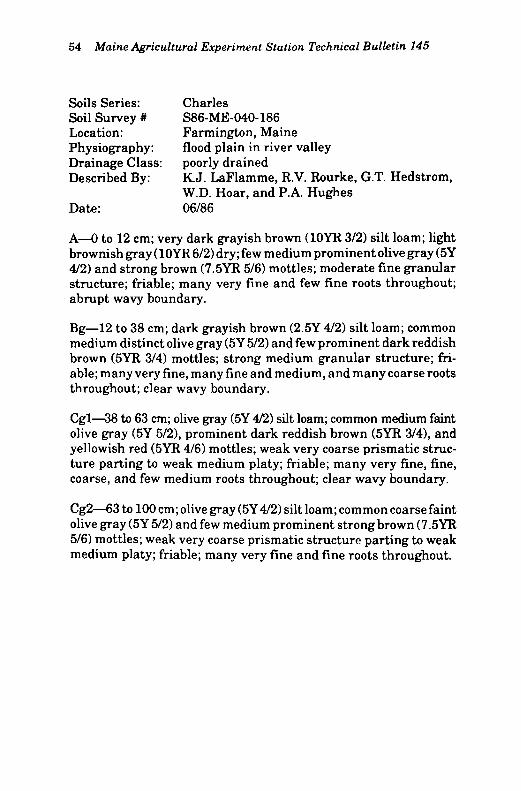
54 Maine Agricultural Experiment Station Technical Bulletin 145
Soils Series: Charles Soil Survey # S86-ME-040-186 Location: Farmington, Maine Physiography: flood plain in river valley Drainage Class: poorly drained Described By: K.J. LaFlamme, R.V. Rourke, G.T. Hedstrom,
W.D. Hoar, and P.A. Hughes Date: 06/86
A—0 to 12 cm; very dark grayish brown (10YR 3/2) silt loam; light brownish gray (10YR 6/2) dry ;few medium prominent olive gray (5Y 4/2) and strong brown (7.5YR 5/6) mottles; moderate fine granular structure; friable; many very fine and few fine roots throughout; abrupt wavy boundary.
Bg—12 to 38 cm; dark grayish brown (2.5Y 4/2) silt loam; common medium distinct olive gray (5Y 5/2) and few prominent dark reddish brown (5YR 3/4) mottles; strong medium granular structure; friable; many very fine, many fine and medium, and many coarse roots throughout; clear wavy boundary.
Cgl—38 to 63 cm; olive gray (5Y 4/2) silt loam; common medium faint olive gray (5Y 5/2), prominent dark reddish brown (5YR 3/4), and yellowish red (5YR 4/6) mottles; weak very coarse prismatic structure parting to weak medium platy; friable; many very fine, fine, coarse, and few medium roots throughout; clear wavy boundary.
Cg2—63 to 100 cm; olive gray (5Y 4/2) silt loam; common coarse faint olive gray (5Y 5/2) and few medium prominent strong brown (7.5YR 5/6) mottles; weak very coarse prismatic structure parting to weak medium platy; friable; many very fine and fine roots throughout.
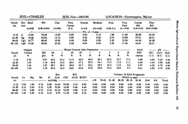
SOIL—CHARLES SOIL Nos.—040186 LOCATION—Farmington, Maine
Depth Hor Sand Silt Clay Very Coarse Medium Fine Very Coarse Fine cm izon Coarse Fine Silt Silt
(2-0.05) (0.06-0.002) (<0.002) (2-1) (1-0.5) (0.6-O.25) (0.25-0.1) (0.1-0.05) (0.05-0.02) (0.02-0.002) t P ( ^ fxf ** O T«YW
0-12 A 13.95 73.46 12.59 0.00 0.02 0.15 1.98 11.80 38.96 34.50 12-38 Bg 18.46
15.77 65.82 15.72 0.00 0.02 0.06 2.70 15.68 37.01 28.81
38-63 Cgl 18.46 15.77 68.40 15.83 0.00 0.06 0.25 3.22 12.25 44.04 24.36
63-100 Cg2 15.36 69.32 15.32 0.22 0.04 0.40 3.36 11.34 44.81 24.51
Cir Avail. H 2 0
- pH CaCl Depth Carbon BD .06 .1
* Waver v/Uiitc .33 .67 1 2 3 5 15
Avail. H 2 0 KC1
- pH CaCl H 2 0
cm % g/cc % ft % % % % % % % cm/cm (1:1) (2:1) (1:1)
0-12 3.32 0.97 55.2 54.2 51.0 48.8 46.2 26.1 23.9 19.7 17.4 0.36 4.65 5.10 5.40 12-38 1.92 1.19 43.9 43.5 40.4 37.1 35.3 24.1 17.5 11.9 11.1 0.39 4.40 4.90 5.60 38-63 1.54 1.27 38.7 38.5 36.6 34.7 32.4 22.7 15.3 11.0 9.3 0.37 4.20 4.75 5.40
63-100 1.43 1.16 45.2 45.0 42.6 40.2 37.6 23.2 15.8 10.6 9.7 0.41 4.20 4.70 5.55
Ext KC1 Volume—% Rock: Fragments Depth Ca Mg Na K Acid CEC Al+H ECEC
>76 76-51 51-38 38-25 25-19 19-13
0.00
l^-fi fi-9 T~*«l
0-12 7.00 1.00 0.10 B.30 14.40 22.80 0.15 8.55 0.00 0.00 0.00 0.00 0.00
19-13
0.00 0.00 0.00 0.00 12-38 3.10 0.50 0.10 i 0.20 12.00 15.90 0.50 4.40 0.00 0.00 0.00 0.00 0.00 0.00 0.00 0.00 0.00 38-63 1.70 0.30 0.10 i 9.10 10.10 12.30 0.90 3.10 0.00 0.00 0.00 0.00 0.00 0.00 0.00 0.00 0.00
63-100 1.30 0.20 0.10 i 0.10 9.70 11.40 1.05 2.75 0.00 0.00 0.00 0.00 0.00 0.00 0.00 0.00 0.00
Main
e Agricu
ltural E
xperiment S
tation T
echnical Bu
lletin 145
55

56 Maine Agricultural Experiment Station Technical Bulletin 145
Soils Series: Charles Soil Survey # S86-ME-040-586 Location: Farmington, Maine Physiography: flood plain in river valley Drainage Class: poorly drained Described By: K.J. LaFlamme, R.V. Rourke, G.T. Hedstrom,
P.A. Hughes, and W.D. Hoar Date: 06/86
Ap—0 to 25 cm; very dark grayish brown (10YR 3/2) silt loam; pale brown (10YR 6/3) dry; weak very fine granular structure; friable; many very fine roots throughout; abrupt smooth boundary.
Bgl—25 to 44 cm; dark grayish brown (2.5Y 4/2) silt loam; many coarse prominent gray (5Y 5/1) and few medium distinct olive brown (2.5Y 4/4) mottles; weak thick platy structure; friable; many very fine roots throughout; clear smooth boundary.
Bg2—44 to 72 cm; olive gray (5Y 5/2) silt; common coarse faint light gray to gray (5Y 6/1) and distinct olive (5Y 5/6) mottles; weak very coarse prismatic structure parting to weak medium platy; friable; few very fine roots throughout; very few prominent dark reddish brown (5YR 2/2) patchy manganese or iron-manganese stains; gradual wavy boundary.
BCg—72 to 79 cm; olive gray (5Y 5/2) silt; many coarse distinct olive (5Y 5/6) and few medium faint light gray to gray (5Y 6/1) mottles; weak very coarse prismatic structure parting to weak thick platy; friable; few very fine roots throughout; very few prominent dark reddish brown (5YR 2/2) patchy manganese or iron-manganese stains; abrupt wavy boundary.
CBg—79 to 92 cm; olive gray (5Y 5/2) silt loam; many coarse prominent yellowish red (5YR 5/6) few faint light gray to gray (5Y 6/1) mottles; weak very coarse prismatic structure parting to weak medium platy; friable; very few prominent dark reddish brown (5YR 2/2) patchy manganese or iron-manganese stains; abrupt smooth boundary.
B/Cg—92 to 100 cm; 70% strong brown (7.5YR 5/6) and 30% gray (5Y 5/1) silt loam; many coarse prominent light gray to gray (5Y 6/1) mottles; weak very coarse prismatic structure; friable.

SOIL—CHARLES SOIL Nos.—040586 LOCATION—Farmington, Maine
Depth Hor Sand Silt Clay Very Coarse Medium Fine Very Coarse Fine cm izon Coarse Fine Silt Silt
(2-0.05) (0.05-0.002) (<0.002) (2-1) (1-0.5) (0.5-0.25) (0.25-0.1) (0.1-0.05) i ;0.05-0.02) (0.02-0.002)
- — Pet. 0.83
Df< n
0-25 Ap 21.39 64.17 14.44 0.67 - — Pet.
0.83 Df<
1.65 4.78 13.46 25.95 38.22 25-44 Bgl 15.20 76.88 7.92 0.19 0.40 0.46 1.65 12.50 35.64 41.24 44-72 Bg2 11.51 80.38 8.11 0.87 0.88 0.42 0.66 8.68 45.24 35.14 72-79 BCg 9.91 83.95 6.14 0.32 0.54 0.32 0.69 8.04 43.98 39.97 79-92 CBg 6.92 79.65 13.43 0.28 0.48 0.36 1.02 4.78 53.74 25.91
92-100 B/Cg 20.38 60.94 18.68 0.54 1.00 1.86 5.44 11.54 36.03 24.91
Or Water Content- (Rnr Prps Avail, - pH CaCl Depth Carbon BD .06 I .1 .33 .67 1 2 3 5 15 H 2 0 KC1
- pH CaCl H 2 0
cm % g/cc % % % % % % % % % cm/cm (1:1) (2:1) (1:1)
0-25 3.12 1.05 46.8 46.2 42.7 40.1 38.4 26.3 18.9 14.2 13.4 0.34 4.40 4.80 5.45 25-44 1.87 1.04 53.3 53.1 50.4 45.0 41.0 27.3 14.7 11.4 10.1 0.45 4.40 4.75 5.55 44-72 1.10 1.04 49.2 49.0 46.7 44.0 40.6 21.2 14.6 11.7 10.0 0.41 4.45 4.85 5.60 72-79 1.07 1.11 45.1 44.9 42.2 38.5 34.8 17.7 14.7 11.7 9.6 0.39 4.45 4.85 5.65 79-92 1.03 28.2 19.6 16.3 12.7 4.45 4.90 5.65
92-100 0.44 19.8 14.8 12.7 10.1 4.30 4.85 5.60
Ext KC1 Volume—% Rock ] Fragments Depth Ca Mg Na K Acid CEC Al+H ECEC
cm
0-25
nWlf >76 76-51 51-38 38-25 25-19 19-13 13-6 6-2 T«t°' cm
0-25 2.80 0.30 0.01 0.30 17.40 20.81 0.85 4.26 0.00 0.00 0.00 0.00 0.01 0.01 0.01 0.01 0.04 25-44 0.90 0.10 0.01 0.20 16.90 18.11 1.10 2.31 0.00 0.00 0.00 0.00 0.00 0.00 0.00 0.01 0.01 44-72 0.60 0.10 0.01 0.20 15.90 16.81 0.95 1.86 0.00 0.00 0.00 0.00 0.00 0.00 0.00 0.01 0.01 72-79 0.50 0.10 0.10 0.20 16.50 17.40 0.90 1.80 0.00 0.00 0.00 0.00 0.00 0.00 O.OO 0.00 0.00 79-92 0.60 0.10 0.10 0.20 17.00 18.00 0.90 1.90 0.00 0.00 0.00 0.00 0.00 0.00 0.00 0.00 0.00
92-100 1.40 0.40 0.10 0.10 9.30 11.30 0.65 2.65 0.00 0.00 0.00 0.00 0.00 0.00 0.00 0.00 0.00
Main
e Agricu
ltural E
xperiment S
tation T
echnical Bu
lletin 145
57

58 Maine Agricultural Experiment Station Technical Bulletin 145
Soils Series: Charles Soil Survey # S86-ME-090-186 Location: Bethel, Maine Physiography: flood plain in river valley Drainage Class: poorly drained Described By: K.J. LaFlamme, D.E. Wilkinson, and R.V. Rourke Date: 06/86
Oi—2 to 0 cm; undecomposed organic matter; abrupt smooth boundary.
Apl—0 to 20 cm; very dark grayish brown (2.5Y 3/2) silt; light brownish gray (2.5Y 6/2) dry; few coarse prominent dark reddish brown (5YR 3/4) mottles; moderate fine granular structure; friable; many very fine, few fine and medium roots throughout; abrupt smooth boundary.
Ap2—20 to 25 cm; dark grayish brown (2.5Y 4/2) silt; light brownish gray (2.5Y 6/2) dry; common coarse prominent light olive gray (5Y 6/2) and few medium strong brown (7.5YR 5/6) mottles; weak medium platy structure parting to moderate fine granular; friable; few very fine roots throughout; abrupt smooth boundary.
Bg—25 to 39 cm; dark grayish brown (2.5Y 4/2) silt; common coarse prominent dark yellowish brown (10YR 4/4) and medium distinct olive gray (5Y 5/2) mottles; weak very coarse prismatic structure parting to weak thick platy; friable; few very fine and medium roots throughout; abrupt smooth boundary.
Bgbl—39 to 44 cm; light olive gray (5Y 6/2) silt; common coarse prominent brown to dark brown (7.5YR 4/4) mottles; weak very coarse prismatic structure parting to weak very thick platy; friable; few very fine roots throughout; abrupt smooth boundary.
Bgb2—44 to 70 cm; olive gray (5Y 5/2) silt; many coarse prominent yellowish red (5YR 5/6) mottles; weak thin platy structure; friable; few fine roots throughout; clear wavy boundary.
Cg—70 to 100 cm; light olive gray (5Y 6/2) silt; many coarse prominent yellowish red (5YR 4/6) mottles; weak very coarse prismatic structure; friable.

SOIL—CHARLES SOIL Nos.—090186 LOCATION—Bethel, Maine
Depth Hor- Sand Silt Clay Very Coarse Medium Fine Very Coarse Fine cm izon Coarse Fine Silt Silt
(2-0.06) (0.05-0.002) (<0.002) (2-1) (1-0.5) (0.5-0.25) (0.25-0.1) (0.1-0.05) i :0.05-O.02) (0.02-0.002) Pft nf*. n
0-20 Apl 5.99 84.58 9.43 0.25 0.54 0.83 1.16 3.21 58.03 26.55 20-25 Ap2 3.69 85.49 10.82 0.05 0.19 0.32 0.51 2.62 59.81 25.68 25-39 Bg 4.19 86.89 8.92 0.00 0.01 0.03 0.28 3.87 58.46 28.43 39-44 Bgbl 1.76 91.63 6.61 0.13 0.09 0.10 0.13 1.31 73.18 18.45 44-70 Bgb2 ', 3.32 88.31 8.37 0.06 0.38 0.45 0.62 1.81 70.93 17.38
70-100 Cg 4.15 87.97 7.88 0.00 0.33 0.38 0.67 2.77 63.83 24.14
rw Avail. H 2 0
- p H CaCl Depth Carbon BD .06 .1 .33 .67 1 2 3 5 15
Avail. H 2 0 KC1
- p H CaCl H 2 0
cm % g/cc % <fi 1 % % % % % % % cm/cm (1:1) (2:1) (1:1)
0-20 5.22 0.88 66.0 65.0 60.9 59.4 57.2 31.2 29.8 22.5 19.8 0.40 4.15 4.55 5.05 20-25 3.90 0.99 56.3 55.8 52.8 50.3 48.0 30.3 28.9 17.8 16.6 0.39 4.20 4.70 5.30 25-39 2.00 1.01 57.1 56.5 51.6 45.2 40.5 31.9 21.1 15.3 13.6 0.43 4.20 4.80 5.65 39-44 1.37 1.00 57.1 56.4 54.8 52.9 50.3 39.5 27.7 13.9 11.9 0.45 4.30 4.90 5.50 44-70 0.98 0.95 63.0 62.3 58.0 55.3 52.2 37.1 26.2 15.2 11.9 0.48 4.35 5.00 5.85
70-100 0.95 1.11 48.0 47.7 46.1 45.1 44.1 27.7 21.5 13.0 10.0 0.42 4.40 5.05 6.00
Ext KC1 Volume—% Rock: Fragments Depth Ca Mg Na K Acid
r n p / l f H i t r
C¥r ECEC (Width in i OK 9 K - 1 Q
Depth Ca Mg Na K Acid r n p / l f H i t r >76 76-51 51-38 3 8 - _
(Width in i OK 9 K - 1 Q 19-13 13-6 6-2 T/rfoi
CHI
0-20 2.90 0.50 0.10
IIltV .LVASg - - - - -
D.10 22.30 25.90 1.70 5.30 0.00 0.00 0.00 0.00 0.00 0.01 0.01 0.00 0.02 20-25 1.70 0.30 0.10 i D.10 20.20 22.40 1.65 3.85 0.00 0.00 0.00 0.00 0.00 0.00 0.00 0.00 0.00 25-39 0.80 0.10 0.10 i 9.01 14.80 15.81 1.35 2.36 0.00 0.00 0.00 0.00 0.00 0.00 0.00 0.00 0.00 39-44 0.70 0.10 0.10 i D.10 14.40 15.40 1.10 2.10 0.00 0.00 0.00 0.00 0.00 0.00 0.00 0.00 0.00 44-70 0.60 0.10 0.10 i 3.01 14.90 15.71 1.05 1.86 0.00 0.00 0.00 0.00 0.00 0.00 0.00 0.00 0.00
70-100 0.60 0.10 0.10 i 3.01 13.60 14.41 0.80 1.61 0.00 0.00 0.00 0.00 0.00 0.00 0.00 0.00 0.00
Main
e Agricu
ltural E
xperiment S
tation T
echnical Bu
lletin 145
59
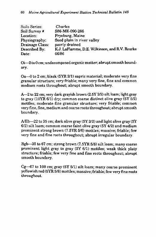
60 Maine Agricultural Experiment Station Technical Bulletin 145
Soils Series: Charles Soil Survey # S86-ME-090-286 Location: Fryeburg, Maine Physiography: flood plain in river valley Drainage Class: poorly drained Described By: K.J. LaFlamme, D.E. Wilkinson, and R.V. Rourke Date: 06/86
Oi—2 to 0 cm; undecomposed organic matter; abrupt smooth boundary.
Oa—0 to 2 cm; black (5YR 2/1) sapric material; moderate very fine granular structure; very friable; many very fine, fine and common medium roots throughout; abrupt smooth boundary.
A—2 to 22 cm; very dark grayish brown (2.5Y 3/2) silt loam; light gray to gray (10YR 6/1) dry; common coarse distinct olive gray (5Y 5/2) mottles; moderate fine granular structure; very friable; common very fine, fine, medium and coarse roots throughout; abrupt smooth boundary.
A/Eb—22 to 35 cm; dark olive gray (5Y 3/2) and light olive gray (5Y 6/2) silt loam; common coarse faint olive gray (5Y 4/2) and medium prominent strong brown (7.5YR 5/6) mottles; massive; friable; few very fine and fine roots throughout; abrupt irregular boundary.
Bgb—35 to 67 cm; strong brown (7.5YR 5/8) silt loam; many coarse prominent light gray to gray (5Y 6/1) mottles; weak thick platy structure; friable; few very fine and fine roots throughout; abrupt smooth boundary.
Cg—67 to 100 cm; gray (5Y 5/1) silt loam; many coarse prominent yellowish red (5YR 5/8) mottles; massive; friable; few very fine roots throughout.

SOIL—CHARLES SOIL Nos.—090286 LOCATION—Fryeburg, Maine
Depth Hor- Sand Silt Clay Very Coarse Medium Fine Very Coarse Fine cm izon Coarse Fine Silt Silt
(2-0.05) (0.05-0.002) (<0.002) (2-1) (1-0.5) (0.5-0.26) (0.25-0.1) (0.1-0.05) (0.05-0.02) (0.02-0.002)
0-2 Oa 2-22 A 1.01 76.68 22.31 0.00 0.00 0.07 0.17 0.77 65.68 11.00
22-35 A/Eb 2.57 78.56 18.87 0.00 0.06 0.09 0.48 1.94 62.39 16.17 35-67 Bgb 8.78 74.36 16.86 0.03 0.24 0.66 2.08 5.77 50.34 24.02
67-100 Cg 5.39
Organic Carbon
78.80 15.81 0.00 0.05 0.25 1.12 3.97 59.51
Avail.
19.29
- pH CaCl Depth
Cg 5.39
Organic Carbon BD .06 1 .33 .67 1 2 3 5 15 H20 KC1
- pH CaCl H20
cm % g/cc % % % % % % % % % cm/cm (1:1) (2:1) (1:1)
0-2 31.86 0.21 295.4 284.1 261.4 257.5 250.5 127.7 109.5 90.3 86.5 0.41 2.85 3.05 3.70 2-22 7.89 0.43 151.9 148.3 132.5 126.2 118.7 70.7 59.7 50.1 47.5 0.43 3.65 3.85 4.20
22-35 4.11 0.66 103.4 102.3 96.7 92.9 88.2 56.7 40.0 29.9 26.3 0.50 3.80 4.10 4.65 35-67 1.41 0.79 78.6 77.6 73.5 71.0 68.1 35.9 28.9 19.4 15.1 0.49 4.15 4.55 5.40
67-100 0.98 1.04 55.0 54.6 52.6 51.2 49.2 39.8 34.7 16.2 10.9 0.45 4.10 4.65 5.60
Ext KC1 Volume—% Rock Fragments Depth Ca Mg Na K Acid CEC Al+H ECEC
->76 76-51 51-38 38-25 25-19 19-13
0.00
13-6 fi-9 T«+Qi cm
0-2 4.30 0.80 0.30 0.60 59.60 65.60 7.40 13.40 0.00 0.00 0.00 0.00 0.00
19-13
0.00 0.00 0.00 0.00 2-22 0.70 0.10 0.10 0.10 33.60 34.60 4.35 5.35 0.00 0.00 0.00 0.00 0.00 0.00 0.00 0.00 0.00
22-35 0.90 0.10 0.10 0.01 22.60 23.71 2.55 3.66 0.00 0.00 0.00 0.00 0.00 0.00 0.00 0.00 0.00 35-67 1.20 0.20 0.10 0.01 12.40 13.91 0.80 2.31 0.00 0.00 0.00 0.00 0.00 0.00 0.00 0.00 0.00
67-100 1.20 0.30 0.10 0.01 7.90 9.51 0.65 2.26 0.00 0.00 0.00 0.00 0.00 0.00 0.00 0.00 0.00
Maine A
gricultu
ral Experim
ent Station
Technical B
ulletin
145 61