characteristics of isolated convective storms austin cross weisman, m.l., and j.b. klemp, 1986:...
TRANSCRIPT

Characteristics of Isolated Convective Storms
Austin Cross
Weisman, M.L., and J.B. Klemp, 1986: Characteristics of Isolated Convective Storms. In Mesoscale Meterorology and Forecasting, Ray, P. (ed), Amer. Meteor. Soc., Boston

Main Topics
• Models of different wind shear profiles
• What’s left out of models
• Determining storm type
• Importance of storm motion
• Local effects

Models of Wind Shear
• Updraft redevelopment and motion depends on environmental wind shear
• Dependence explains precipitation patterns
• Klemp-Wilhelmson cloud model used to demonstrate for variety of hodographs
• Storms initiated by isolated warm bubble in horizontally homogenous environment

Sounding

Case A: Short-Lived Multicell
• During initial half hour, warm bubble produces updraft• Downdraft develops, rain begins to reach surface, cold
pool• After 40 min, updraft near heaviest rainfall• After 80 min, updraft has disappeared, new updraft from
gust front convergence• After 120 min, second updraft gone. New, weaker
updrafts
40 80 120

Case B: Supercell on Multicellular Line
• Hodograph same shape, twice as much shear• Enough to produce strong vertical pressure
gradient forces on flank of initial updraft• Induces initial cell to become supercell

Case B: Supercell on Multicellular Line
• At 80 min, new rain centers develop on left flank and continue to redevelop
• Right flank supercell stronger• Gust front never far from rain and updrafts• At 120 min, appearance similar to squall line, with
supercell on southern end

Case C: Right Flank Supercell Split from Weaker Left-Flank Storm
• Same magnitude and depth of shear as B
• Hodograph now straight from 2.5 to 5km
• With less curvature, left flank more isolated
• If straight line (dashed), storm split is mirror image

Case D: Right Flank Supercell
• Now straight line portion extends to 7.5 km• Right moving supercell now has rain drawn
around by strong upper level flow• Left flank is even weaker than in case C

Case E: Weak Squall Line
• Shear profile same as B, truncated at 2.5km
• Shear is not deep enough to have pressure forcing for supercells
• New updrafts grow on gust front
• By 120 min, appearance of squall line

Case F: Squall Line• Shear profile same as case E,
except magnitude of shear increased
• Extreme magnitude of shear produces steady updraft on right flank
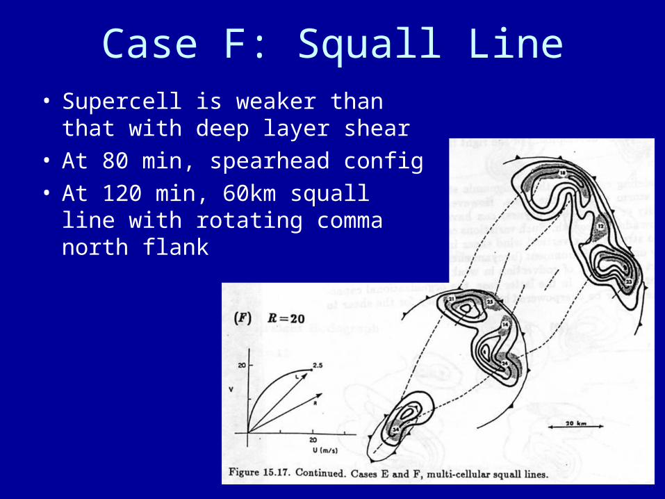
Case F: Squall Line• Supercell is weaker than that
with deep layer shear• At 80 min, spearhead config• At 120 min, 60km squall line
with rotating comma north flank

Observed Splitting Storm
• Hodograph shows veering wind below 1km
• Omnidirectional shear above 1km
• Storm splitting expected (like cases C and D) and curvature favors right flank

Thermodynamic Stratification
• Thermodynamic stratification was kept same in models
• Instability or mid level dryness can affect updraft strength
• E.g. weakly unstable environment can’t support convection in strong shear cond.

More Thermodynamic Stratification
• Mid level moisture may alter strength of outflow; that could alter speed of gust front relative to updraft
• Low level structure could alter if gust front can trigger new convection: if LFC high, convergence on gust front must be over deeper layer or over longer time

Determining Storm Type
• Identifying type of storm can help to predict effects
• Type was shown to be strongly dependent on vertical wind shear, but can be modified by thermodynamic considereations
• Weisman and Klemp (1982, 1984) show this can be represented by bulk Richardson number…

Bulk Richardson Number
• B is buoyant energy (eq. 15.1)• U is vertical wind shear• Unsteady, multicells occur with R > 30• Supercells occur with 10 < R < 40• Environment could support multicells and
supercells simultaneously as in cases B and C

Bulk Richardson Number

Downsides of Richardson Number
• Indicates type of convection might occur but not severity
• Small buoyant energy and moderate shear could have R in supercell range, but lack of buoyancy might mean no severe weather
• Large buoyant energy and moderate shear could have large R, but produce tornadoes or large hail in unsteady storm

12Z Sounding to Find Mesocyclone and Tornado Potential
• Tornadic storms only in high buoyancy, moderate to strong shear
• Mesocyclones w/o tornadoes in lower buoyancy, strong shear

Storm Motion
• Multicell updrafts tend to move with mean wind of lowest 5-7km, with redevelopment downshear
• Supercells have significant propagation perpendicular, may appear to move to the right or left
• Since ground-relative motion dependent on ground-relative winds, examples can be used to portray conditions for flash flooding

Flash Flooding
• For heavy rain, systems must be steady
• Either steady supercells or unsteady cells that redevelop in same area
• Occurs in all examples except case A, if moving slow enough

Local Effects
• Knowledge of local variations and terrain on storm structure and evolution limited
• Most storms are triggered by such effects

Local Effects
• In low shear– Pre-existing boundaries as effective as
storm’s outflow in redevelopment– Enhanced surface moisture or instability also
influence location of updraft
• In strong shear– Steadiness and propagation of supercell
updraft depends on storm mesolow forcing air up, apart from surface outflow
– Supercell propagation less affected by environment boundaries

The End

Case A

Case B

Case C

Case D
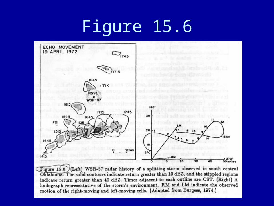
Figure 15.6