chapterblogs.4j.lane.edu/cylibrary/files/...ancient_world_chapter_19_0150.pdf · chapter 4 the...
TRANSCRIPT
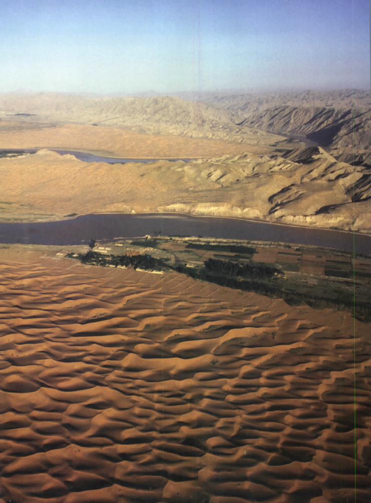

CHAPTER4 The Huang He {Yellow River) flows
through the "Land of the Yellow Earth."
Geography and theEarly Settlement of China19.1 Introduction
In the last unit, you learned about the people and empires of ancient India.In this unit, you will explore the civilization of ancient China. This civilization
flourished from about 1700 B.C.E. to 220 C.E.
China is a large country in eastern Asia. It's easy to use words like highest,
largest, and longest when talking about China's geography. The world's high-est mountains, the Himalayas, are in China. So is one of the world's largest
deserts, the Taklamakan Desert. China also boasts some of the longest rivers
in the world.China's climate is just as extreme as its physical features. The weather can
vary from ice storms in the high moun-
tains to the dreaded sandstorms of the
Taklamakan Desert. During a sand-storm, the sky darkens until it feels likenight. Hot, howling winds drive sand
and gravel against you. The only way
to survive is to wrap yourself in clothesor blankets and lie down until the storm
passes. That could be hours or even
days.
As you can see, China is a land ofcontrasts. In this chapter, you will com-pare five geographic regions in
China. You'll learn about the climate,physical features, and vegetationof each region. You'll also discoverhow geography affected where the first
Chinese settled, the way they lived, andtheir ability to communicate with other
civilizations.
8,200-18,000 feet
4,500-8,200 feet
1,150-4,500 feet
0-1,150 feet
Use this map as a graphic organizer to learn aboutfive geographic regions in China.
Geography and the Early Settlement of China 183
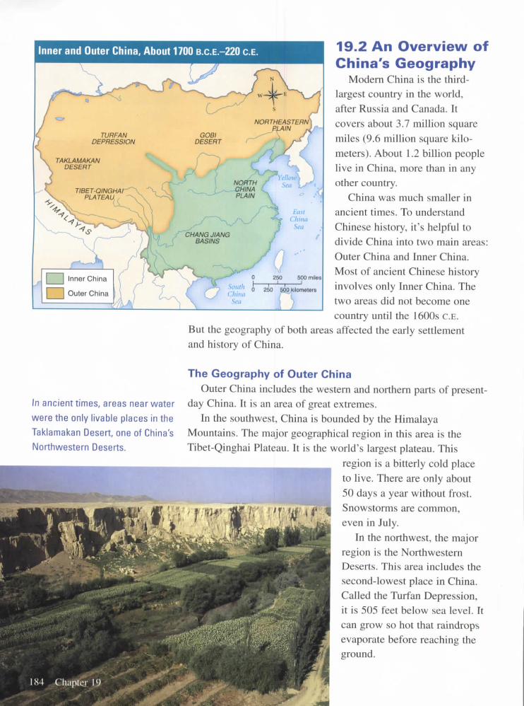
Inner and Outer China, About 1700 B.C.E-220 C.E.
J Inner China
] Outer China
500 miles
ilo meters
In ancient times, areas near water
were the only livable places in the
Taklamakan Desert, one of China's
Northwestern Deserts.
19.2 An Overview ofChina's Geography
Modern China is the third-largest country in the world,after Russia and Canada. Itcovers about 3.7 million squaremiles (9.6 million square kilo-
meters). About 1.2 billion peoplelive in China, more than in anyother country.
China was much smaller inancient times. To understand
Chinese history, it's helpful todivide China into two main areas:Outer China and Inner China.Most of ancient Chinese historyinvolves only Inner China. Thetwo areas did not become onecountry until the 1600s C.E.
But the geography of both areas affected the early settlementand history of China.
The Geography of Outer ChinaOuter China includes the western and northern parts of present-
day China. It is an area of great extremes.In the southwest, China is bounded by the Himalaya
Mountains. The major geographical region in this area is theTibet-Qinghai Plateau. It is the world's largest plateau. This
region is a bitterly cold placeto live. There are only about
50 days a year without frost.Snowstorms are common,even in July.
In the northwest, the majorregion is the NorthwesternDeserts. This area includes thesecond-lowest place in China.Called the Turfan Depression,it is 505 feet below sea level. Itcan grow so hot that raindropsevaporate before reaching theground.

In the northeast, the major region is the Northeastern Plain. Thisis a land of low hills and plains. It has short, hot summers. Wintersare long and dry, with five months of freezing temperatures.
The Geography of Inner ChinaInner China includes the southeastern part of present-day
China. Compared to the west, this part of China is closer to sealevel. It is a land of rolling hills, river valleys, and plains. Riversflow through the area from the west. The rivers often enrich thesoil by flooding. They also provide water for irrigation. Thesephysical features made Inner China more attractive to early set-tlers than Outer China.
Inner China has two main regions. The northern region is theNorth China Plain. To the south are the low river plains of themiddle and lower Chang Jiang Basins. These regions have verydifferent climates. The Chang Jiang Basins are warm and wet.The North China Plain is drier and often cooler.
Each of China's major regions has its own climate, physicalfeatures, and vegetation. Let's take a closer look at each region,
starting with those in Outer China.
The wet, warm Chang Jiang
Basins are a major region for
growing rice.

The Tibetan Plateau is cold and
dry. Summer temperatures aver-
age only 45 degrees Fahrenheit.
Winters average 18 degrees.
The annual precipitation is only
10 inches.
19.3 The Tibet-Qinghai PlateauThe southwestern part of Outer China is dominated by the
high Tibet-Qinghai Plateau. Also known as the Tibetan Plateau,this area is often called the "Roof of the World." Its average ele-
vation is more than two miles (13,500 feet) above sea level. It is
a very large area, covering almost a quarter of the land in China.
The Tibetan Plateau is a rocky land surrounded by towering
mountains. The Himalayas are on the southern edge of theplateau. The tallest mountain in the world, Mount Everest, is
part of this mountain range. Its peak is more than five miles(29,000 feet) high.
Since the Tibetan Plateau is so high, the climate is very cold.
The air is thin and dry. Snow falls even in the summer.
Two of China's major rivers begin in this area, the Huang He(Yellow River) and the Chang Jiang (Yangtze River). In spite of
the rivers, the plateau is rather dry. The natural vegetation con-sists of sparse scrubs and grasses. Antelopes and yaks, a type ofox, roam the area. Sometimes they are hunted by wolves andwildcats.
For the people of ancient times, the Tibetan Plateau was achallenging place to live. It was too cold and dry to grow crops.But the grasses did provide food for yaks and other livestock. The
cold, rocky plateau and the high mountains made travel throughthis area to Inner China very difficult.
186 Chapter 19

19.4The Northwestern DesertsThe northwestern part of Outer China is known for its great
deserts, including the Taklamakan and Gobi Deserts. The desertsare harsh places to live and difficult for travelers to cross. Theclimate varies from sizzling hot in the summer to below freezingin winter. The only places to grow crops or raise animals such assheep are the oases, where water can be found. In ancient times,shelters made of mud were sometimes built near oases.
The Taklamakan DesertThe Taklamakan Desert is about 105,000 square miles. It is
considered one of the most dangerous deserts in the world. Infact, its name means, "Onceyou go in, you will not comeout." The desert's huge sanddunes shift and change as thewind blows the sand around.Sandstorms arise with stunningspeed. Legend says that twoarmies and 300 cities areburied 600 feet beneath thesand dunes.
As you might expect, thedesert is too dry to have muchvegetation. Bushes, weeds, andtrees grow only near oases andalong rivers.
The Gobi DesertStretching over 500,000
square miles, the Gobi Desertis one of the world's largestdeserts. It covers part of Chinaand present-day Mongolia.Unlike the Taklamakan Desert,the Gobi has very few sanddunes. Most of the desert isstony. Its surface is made upof small pebbles and tiny bitsof sand. Vegetation is sparse.Plants tend to be small andwidely spaced.
oasis a place where water
can be found in a desert
Temperatures vary greatly in the
Northwestern Deserts. Summer
temperatures can be 100 degrees
Fahrenheit. Winter temperatures
might be a chilly 15 degrees.
The annual precipitation is about5 inches.

The Northeastern Plain is general-
ly rather cold and dry. During the
short summer, temperatures climb
to 75 degrees Fahrenheit. In win-
ter, they fall to 10 degrees. The
annual precipitation is about
20 inches.
19.5 The Northeastern PlainThe Northeastern Plain is located east of present-day
Mongolia. Today this area is sometimes called Inner Mongolia
and sometimes Manchuria. It is a land of low hills and plains.
The natural vegetation is mostly prairie grass. In ancient times,
the grass provided food for horses, sheep, and other animals
raised by herders.The major rivers running through the Northeastern Plain are
the Liao and Sungari. The Liao is a shallow river. Only smallboats can navigate it. The Sungari is deeper. It can carry largerboats. The rivers freeze in the winter, and people use them asroads.
The Northeastern Plain is an area of great contrasts in climate.
It has short, warm summers. The northern and eastern parts of theplain are dry and cold in winter. The southern half, especially thevalley of the Liao, has milder weather and more water. In general,though, the plain is too cold and dry to be a good place for grow-ing crops.
In the south, a narrow coastal plain links this area to the rest ofChina. This plain was the route several groups of invaders tookinto Inner China.
188 Chapter 19

19.6The North China PlainThe North China Plain is a flat region of grassland in Inner
China. Temperatures range from very warm in the summer toquite cold in the winter.
This region is sometimes called the "Land of the YellowEarth" because the ground is covered by yellow limestone silt.The silt comes from the Gobi Desert. It is carried by the wind to
the North China Plain. The river that runs through the plain is
also full of yellow silt. The silt gives the river its name, Huang
He (Yellow River).The Huang He is one of the longest rivers in the world. It may
also be the world's muddiest river. The mud makes it look more
like soup than river water. The river starts in the high western
mountains and winds its way down to the eastern plains. The siltit carries helps fertilize the surrounding lands, making the North
China Plain a good place to settle down and grow crops.
While the Huang He helps farmers, it has also been the source
of many disasters for the Chinese. In the past 3,000 years, the
river is said to have flooded more that 1,500 times, causing much
damage and loss of life.
silt fine particles of rock
The North China Plain, nearthe
Huang He, is grassy, fertile land. In
the summer, the average tempera-
ture is 82 degrees Fahrenheit. In
the winter, the average tempera-
ture is 28 degrees. The annual
precipitation is about 23 inches.
Geography and the Early Settlement of China 189

tributary a stream that
feeds into a larger river
The Chang Jiang Basins have a
mild, wet climate. Temperatures
range from about 68 degrees
Fahrenheit in summer to about
39 degrees in winter. The annual
precipitation is about 41 inches.
19.7 The Middle and LowerChang Jiang Basins
The middle and lower Chang Jiang Basins are areas of low,wet coastal plains. The basins are located along the river calledthe Chang Jiang.
The Chang Jiang is even longer than the Huang He. In fact,its name means "Long River." It has hundreds of tributaries.People use the river to move goods between eastern and westernareas of the region.
Like the Huang He, the Chang Jiang starts in the high westernmountains. It flows through three plains and then to a rich delta.Its deposits help to make the surrounding lands very fertile. Theriver floods less often than the Huang He, making it much lessdangerous.
The climate in the Chang Jiang Basins is warm and wet. Inancient times, the vegetation may have been thick rainforest.There was limited space for farming, and the area was not suit-able for grazing animals. But the basins were very good forgrowing rice, which needs lots of warmth and moisture.

19.8 Early Settlement inAncient China
Archeologists believe that the first inhabitants
of China lived in caves more than 500,000 years
ago. Remains of these people, known as Peking(or Beijing) Man, were found in the 1920s in the
northeastern part of China. They lived by hunting,gathering, and fishing. They made tools and prob-ably used fire.
When people in China began farming, they
settled mostly on the North China Plain in Inner
China. They grew crops and lived in villages near
the Huang He. This marked the beginnings of
settled Chinese society.It's not surprising that early farmers chose this
area to live in. The North China Plain had plentyof water, fertile soil, and a moderate climate. In
contrast, the Tibetan Plateau and Northeastern
Plain were too cold and dry to grow crops. TheNorthwestern Deserts were also too dry. The Chang
Jiang Basins were wet and fertile, but heavy rains
may have made farming difficult.
19.9 Ancient China's IsolationChina's geography kept the early settlements in
Inner China isolated. Only a narrow coastal plain
linked the Northeastern Plain to Inner China. In the
southwest, the towering mountains, rocky plateau,and cold climate formed a natural barrier. In the
northwest, the large deserts were another barrier.
Later in Chinese history, the same geographicfeatures that kept China isolated also made it diffi-cult to govern China as one unified state.
Traveling was difficult during China's early history.
This 18th-century painting shows a traveler and camel
making their way through towering sand dunes in
a desert.
H••
Geography and the Early Settlement of China 191
maize a type of cornmutton meat from sheep
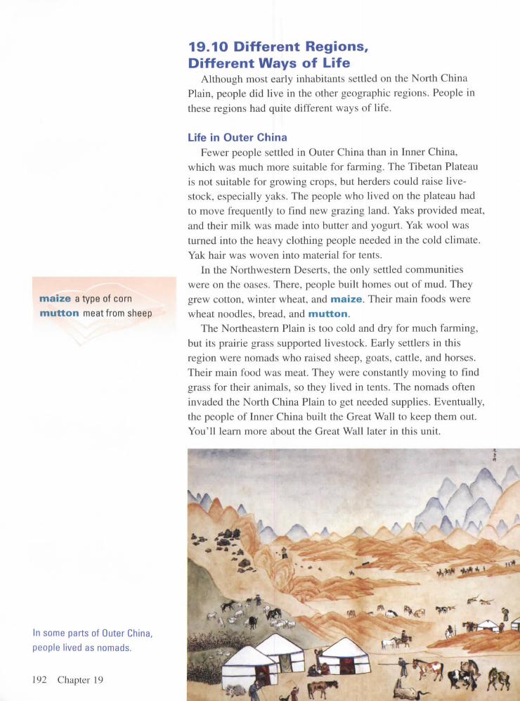
in some parts of Outer China,
people lived as nomads.
192 Chapter 19
19.10 Different Regions,Different Ways of Life
Although most early inhabitants settled on the North ChinaPlain, people did live in the other geographic regions. People in
these regions had quite different ways of life.
Life in Outer ChinaFewer people settled in Outer China than in Inner China,
which was much more suitable for farming. The Tibetan Plateauis not suitable for growing crops, but herders could raise live-stock, especially yaks. The people who lived on the plateau had
to move frequently to find new grazing land. Yaks provided meat,
and their milk was made into butter and yogurt. Yak wool was
turned into the heavy clothing people needed in the cold climate.Yak hair was woven into material for tents.
In the Northwestern Deserts, the only settled communities
were on the oases. There, people built homes out of mud. Theygrew cotton, winter wheat, and maize. Their main foods were
wheat noodles, bread, and mutton.The Northeastern Plain is too cold and dry for much farming,
but its prairie grass supported livestock. Early settlers in thisregion were nomads who raised sheep, goats, cattle, and horses.
Their main food was meat. They were constantly moving to find
grass for their animals, so they lived in tents. The nomads often
invaded the North China Plain to get needed supplies. Eventually,the people of Inner China built the Great Wall to keep them out.
You'll learn more about the Great Wall later in this unit.

Life in Inner ChinaThe fertile land of Inner China supported larger and more
settled populations. Most people settled on the fertile North
China Plain. There they grew mainly wheat and millet. They
raised cattle, sheep, oxen, pigs, and chickens. They herded cat-
tle, water buffalo, and horses. People built permanent homes out
of rammed earth (soil tightly
packed to make solid walls).The Chang Jiang Basins had
limited areas for farming, andthey lacked grazing land for
raising animals such as cattle.But rice thrived in this warm,
wet area. Settlers began grow-
ing rice in the river valley asearly as 10,000 B.C.E. They also
raised pigs and poultry, andthey ate seafood. They builtpermanent houses so they
could stay in one place andtend their animals and crops.
millet a type of grain
4 I I
19.11 Chapter SummaryIn this chapter, you explored five geographic regions in
China. Three of these regions are in Outer China: the TibetanPlateau, the Northwestern Deserts, and the Northeastern Plain.The two regions of Inner China are the North China Plain and
the Chang Jiang Basins. You learned about each region's phys-
ical features, climate, and vegetation. You also discovered how
differences in geography led to different ways of life.Many early farmers settled on Inner China's northern plain.
Outer China's physical features isolated Inner China. Thesefeatures included high mountains, a cold and rocky plateau,and large deserts.
The ancient Chinese traced their history through several
dynasties, or rul ing families. In the next chapter, you will
explore one of the earliest of these dynasties, the Shang
dynasty.
In Inner China, most people lived
in one place and raised crops
such as millet and rice.
Geography and the Early Settlement of China 193