chapter ten: tsunami - geoscience australia · tsunami is a japanese word based on two elements:...
TRANSCRIPT
Ts unam i | Chap t e r x xx | page 147
Chapter Ten:
Tsunami
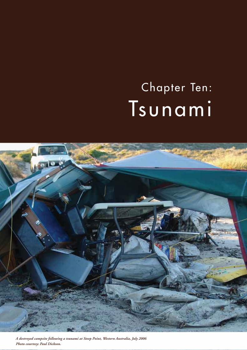
A destroyed campsite following a tsunami at Steep Point, Western Australia, July 2006Photo courtesy: Paul Dickson.
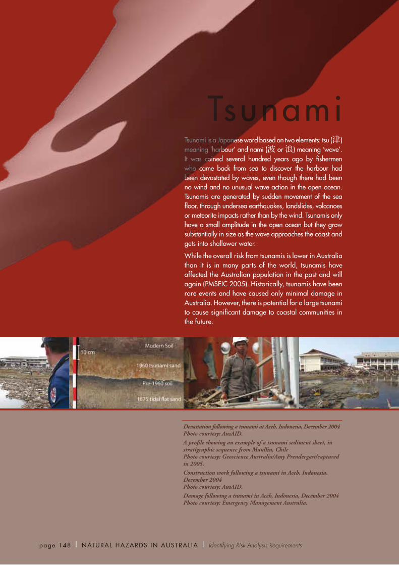
Devastation following a tsunami at Aceh, Indonesia, December 2004 Photo courtesy: AusAID.
A profile showing an example of a tsunami sediment sheet, in stratigraphic sequence from Maullin, Chile Photo courtesy: Geoscience Australia/Amy Prendergast/captured in 2005.
Construction work following a tsunami in Aceh, Indonesia, December 2004 Photo courtesy: AusAID.
Damage following a tsunami in Aceh, Indonesia, December 2004 Photo courtesy: Emergency Management Australia.
TsunamiTsunami is a Japanese word based on two elements: tsu (津) meaning ‘harbour’ and nami (波 or 浪) meaning ‘wave’. It was coined several hundred years ago by fishermen who came back from sea to discover the harbour had been devastated by waves, even though there had been no wind and no unusual wave action in the open ocean. Tsunamis are generated by sudden movement of the sea floor, through undersea earthquakes, landslides, volcanoes or meteorite impacts rather than by the wind. Tsunamis only have a small amplitude in the open ocean but they grow substantially in size as the wave approaches the coast and gets into shallower water.
While the overall risk from tsunamis is lower in Australia than it is in many parts of the world, tsunamis have affected the Australian population in the past and will again (PMSEIC 2005). Historically, tsunamis have been rare events and have caused only minimal damage in Australia. However, there is potential for a large tsunami to cause significant damage to coastal communities in the future.
page 148 | NATURAL HAZARDS IN AUSTRAL IA | Identifying Risk Analysis Requirements
The following section describes in more detail the potential trigger sources of tsunamis. The majority of tsunamis are caused by large earthquakes under the sea floor. Submarine landslides also cause tsunamis when sediments on steep slopes (such as those around volcanic islands or along the edges of continental shelves) become unstable and fail (see Chapter 8 for a general discussion of landslides). Less common are tsunamis initiated by the explosion or collapse of a volcano. Meteorites and comets may cause tsunamis if they fall in the ocean. Although such impacts are rare, some argue that tsunamis generated by this mechanism may have reached Australian shores in prehistoric times (Bryant 2001).
EarthquakeThe most frequent sources of large tsunamis
are earthquakes that occur in subduction zones,
where two of the rigid plates comprising the
earth’s surface converge and one slides beneath
the other (Figure 10.1). As the plates ‘rub’ past
each other, friction along their contact pulls the
upper plate downward, causing stress to increase
on the inter-plate contact. This stress builds up
continuously along the 8000 kilometre system
of subduction zones that surround Australia
to the north and east, as the Australian plate
moves northward at a rate of approximately
7 centimetres per year. An earthquake occurs
when the stress exceeds the frictional strength
and the upper plate ‘pops’ back upward,
vertically displacing a large mass of water.
Vertical movement of the sea floor in this manner
causes the overlying water to move upwards and
spread outwards from the earthquake centre as a
tsunami (PMSEIC 2005).
Subduction zones have the potential to produce
the largest earthquakes in the world. Of the 12
largest earthquakes that have occurred since
1900, all but one occurred in subduction zones
This chapter identifies and briefly describes the most likely sources of tsunami that have happened in the past or could in the future. The Australian Government in partnership with state and territory governments are currently the main players in assessing tsunami risk to Australia, and the current method for assessing risk from tsunamis is described. Since the Indian Ocean tsunami of December 2004 highlighted the potential catastrophic impacts of tsunami, significant work on managing the tsunami risk to Australia has been undertaken. However, many information gaps still hinder our knowledge of the risk posed by these rare, but potentially very damaging, natural disasters.
Hazard IdentificationTsunamis are waves generated by sudden movement of the sea floor, usually caused by undersea earthquakes, but sometimes caused by landslides, volcanic eruptions or meteorite impacts. A tsunami is very different from a typical wind-generated wave. Wind-generated waves cause movement of water only near the sea surface, and have wavelengths measured in metres. In contrast, tsunamis involve water movement to the sea floor, and can have wavelengths of 100 kilometres or more.
In the deep ocean, tsunamis rarely have a wave height (peak-to-trough) greater than a couple of metres. However, as they approach shallow water they slow down and increase dramatically in height. This effect makes them potentially very destructive to coastal buildings and infrastructure. Waves during the Indian Ocean tsunami of December 2004 had heights of less than 2 metres in the open ocean but ran up to heights of 10 metres above sea level along many coasts, even those thousands of kilometres from the earthquake (Narayan and others 2005). The maximum height reached by the wave as it inundates an area (i.e. the ‘run-up height’) is often larger than the wave height off the coast.
Ts unam i | Chap t e r Ten | page 149

page 150 | NATURAL HAZARDS IN AUSTRAL IA | Identifying Risk Analysis Requirements
and produced large tsunamis. While there is still
insufficient information to perform a detailed
assessment for most of the subduction zones
facing Australia, some general conclusions can
be drawn from the information available.
Historically, the tsunamis which have created
the largest run-ups in Australia have come from
earthquakes off the south coast of Indonesia and
have inundated parts of the Western Australian
coast. Earthquakes above magnitude 7.5 have
created several tsunamis over the past few decades,
particularly those from eastern Indonesia, such
as the Java tsunami in 2006.
To the east of Australia, earthquakes from the
subduction zones stretching from Papua New
Guinea to New Zealand have not yet generated
tsunamis large enough to create substantial
inundation along the east coast.
Large earthquakes have been known to occur
in the eastern Pacific, off South America. The
largest recent earthquake, the magnitude 9.5
Chile earthquake in 1960, was far away, and
most of the tsunami did not head in Australia’s
direction. Although this event did not create any
major inundation on the Australian coast, it did
create currents strong enough to tear boats from
their moorings in several harbours along the east
coast (Lynam and others 1988).
VolcanoThere are at least five active source regions which have volcanoes capable of generating a tsunami that could affect Australia: eastern Indonesia (including Krakatau), Papua New Guinea (New Britain–New Ireland), the Kermadec Islands region, the Tonga–Samoa volcanic arc and the South Fiji basin (Rynn and Davidson 1999).
However, the Krakatau eruption of 26–27 August 1883 is the only documented eruption to have affected Australia (Gregson and Van Reeken 1998). It caused 36,000 deaths in Indonesia and generated a tsunami in the Indian Ocean that was more extensive than the 2004 Indian Ocean tsunami. Within four hours of the final eruption, a tsunami which ran up to 1.8 metres above sea level reached several locations along the coast of Western Australia (Hunt 1929). The recurrence time for major eruptions at Krakatau is thought to be 21,000 years (Beauregard 2001).
LandslideLess is known about the effect and frequency of submarine landslides that cause tsunamis. The tsunami that hit Sissano, Papua New Guinea, in 1998, causing the loss of 2000 lives, was probably caused by an earthquake-triggered submarine landslide (Tappin and others 2001).
A recent targeted survey along the New South Wales continental slope identified several potential sources of similar failures (Glenn and
Indian Ocean Sumatra
Prior to earthquake
Earthquake
10 minutes after earthquake 07-2256-1
Figure 10.1 Simplified diagram showing how an earthquake along a subduction zone generates a tsunami Source: Geoscience Australia (2005).
There is considerable uncertainty about the likelihood of intermediate-sized objects, with diameters in the range from 100 metres to 1 kilometre, generating tsunamis. Objects smaller than 100 metres almost certainly do not generate damaging tsunamis (PMSEIC 2005).
Cost of TsunamisThe average annual cost of tsunamis to the Australian community has not been calculated. Anecdotal evidence suggests that the cost so far has been small, with only minor damage to ports and beach-side campsites and the loss of some small boats. For example, a range of marine impacts (such as boats being torn from their moorings) were reported along the New South Wales coast as a result of the 1960 Chile event.
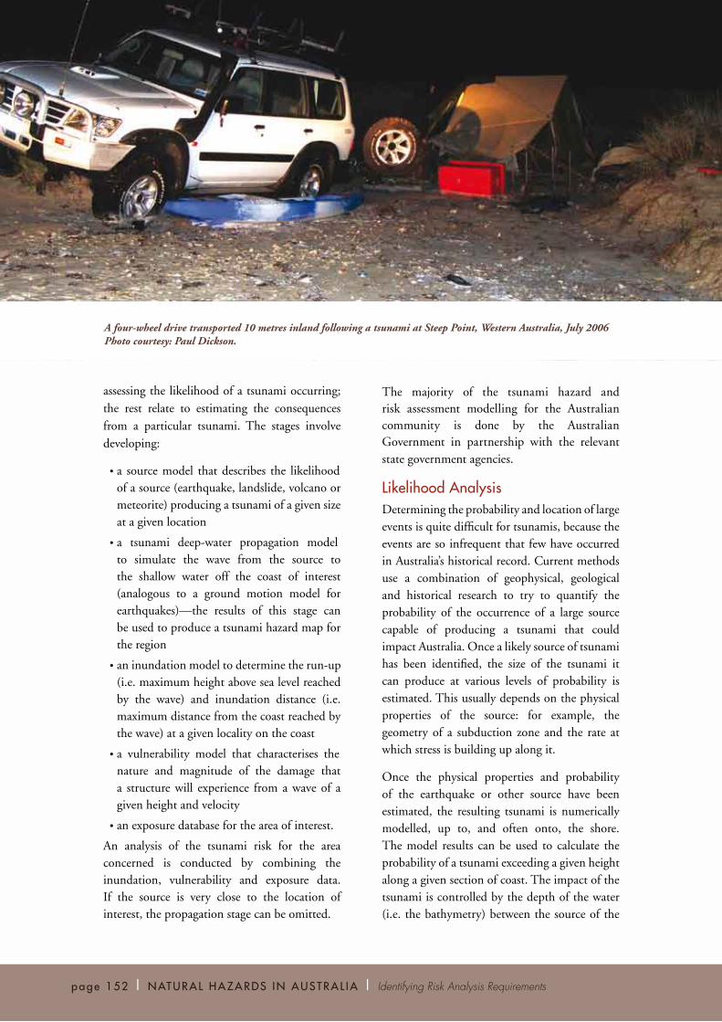
More recently, the 2006 Java tsunami inundated Steep Point (on the western margin of the Shark Bay world heritage area in Western Australia), where it caused widespread erosion of roads and sand dunes and transported a vehicle 10 metres inland. It also caused extensive vegetation damage and destroyed several campsites (Prendergast and Brown 2006). If a similar tsunami were to hit a major populated centre, significant losses could be expected.
There have been no confirmed deaths from tsunamis in Australia (although the deaths arising from the Black Sunday event may be attributable to a tsunami). However, in the past few hundred years Australia has not experienced a large tsunami that directs its energy towards the more densely populated parts of the coast. Should such an event occur, it could cause loss of life as well as significant amounts of damage.
Risk AnalysisThe general approach to estimating tsunami risk is similar to that for earthquakes (as discussed in Chapter 9). There are five key, sequential stages in assessing the risk. The first two stages relate to
Ts unam i | Chap t e r Ten | page 151
others in review). Multiple landslide scars were located along the continental slope, several of them adjacent to population and critical infrastructure locations.
It is also thought that an ocean-wide tsunami can be produced by massive collapse of a part of a volcano (Ward and Day 2001). Although an argument could be made that such a collapse is possible of a volcano in the Heard and McDonald Island region, there is no information on the likelihood of such an event occurring, nor on whether such events occur in a manner that actually generates a tsunami.
Anecdotal evidence exists of freak waves having swamped the coast on clear, calm days at several Australian locations. One example is the event known as ‘Black Sunday’, which occurred on 6 February 1938 at Bondi Beach, New South Wales (PMSEIC 2005). This event was characterised by three successive waves that piled water on the beach and returned as backwash, sweeping swimmers out to sea. Five people were drowned. The waves were not restricted to Bondi Beach; they were reported on adjacent beaches and as far north as Newcastle. These freak wave events may represent tsunamis generated by small, localised submarine landslides.
Meteorite or CometMeteorites or comets in near-earth orbits are ultimately the source of the most spectacular and life-threatening impacts. Evidence indicates that several major extinction events marking the transitions between geologic eras, such as between the Cretaceous and Tertiary periods 65 million years ago, may be at least partially due to the massive impacts of comets or meteorites of about 10 kilometres in diameter (PMSEIC 2005). Such objects would certainly be capable of causing massive tsunamis, with wave heights far exceeding any tsunami in recorded history, if they landed offshore.
page 152 | NATURAL HAZARDS IN AUSTRAL IA | Identifying Risk Analysis Requirements
assessing the likelihood of a tsunami occurring; the rest relate to estimating the consequences from a particular tsunami. The stages involve developing:
• a source model that describes the likelihood of a source (earthquake, landslide, volcano or meteorite) producing a tsunami of a given size at a given location
• a tsunami deep-water propagation model to simulate the wave from the source to the shallow water off the coast of interest (analogous to a ground motion model for earthquakes)—the results of this stage can be used to produce a tsunami hazard map for the region
• an inundation model to determine the run-up (i.e. maximum height above sea level reached by the wave) and inundation distance (i.e. maximum distance from the coast reached by the wave) at a given locality on the coast
• a vulnerability model that characterises the nature and magnitude of the damage that a structure will experience from a wave of a given height and velocity
• an exposure database for the area of interest.
An analysis of the tsunami risk for the area concerned is conducted by combining the inundation, vulnerability and exposure data. If the source is very close to the location of interest, the propagation stage can be omitted.
The majority of the tsunami hazard and risk assessment modelling for the Australian community is done by the Australian Government in partnership with the relevant state government agencies.
Likelihood AnalysisDetermining the probability and location of large events is quite difficult for tsunamis, because the events are so infrequent that few have occurred in Australia’s historical record. Current methods use a combination of geophysical, geological and historical research to try to quantify the probability of the occurrence of a large source capable of producing a tsunami that could impact Australia. Once a likely source of tsunami has been identified, the size of the tsunami it can produce at various levels of probability is estimated. This usually depends on the physical properties of the source: for example, the geometry of a subduction zone and the rate at which stress is building up along it.
Once the physical properties and probability of the earthquake or other source have been estimated, the resulting tsunami is numerically modelled, up to, and often onto, the shore. The model results can be used to calculate the probability of a tsunami exceeding a given height along a given section of coast. The impact of the tsunami is controlled by the depth of the water (i.e. the bathymetry) between the source of the
A four-wheel drive transported 10 metres inland following a tsunami at Steep Point, Western Australia, July 2006 Photo courtesy: Paul Dickson.

similar structures. However, structures affected by previous tsunamis are typically dissimilar to Australian buildings, and most surveys tend to be biased towards damaged structures rather than structures representative of the population as a whole (Dale and Flay 2006). Alternatively, an engineering modelling approach can be taken. This involves generalising the loads on a structure, then using knowledge of the strengths of components and connections, as well as their variability, to assess damage outcomes (if any) for the resultant loads.
Little research has been done to look at human vulnerability, such as estimating casualty rates. Factors likely to affect human vulnerability include the vulnerability of structures, population density, and the time of day of the event, as well as simply the height and velocity of the tsunami.
Data requirements Wave height and velocity estimates of the incoming tsunami, based on high-resolution topography and bathymetry, are essential data for modelling consequence. Any limitations in the resolution and accuracy of the data will introduce errors to the inundation maps, in addition to the range of approximations made within the models themselves.
An accurate and up-to-date exposure database of the area is also required. This may include information about residential and commercial buildings, as well as critical infrastructure. The database should include information on the structure type, number of floors, typical number of inhabitants and building materials, and other information depending on the purpose of the vulnerability modelling and the requirements of the vulnerability model.
Information GapsIt took the catastrophic events of the Indian Ocean tsunami to alert the Australian public to the potential for a tsunami tragedy closer
Ts unam i | Chap t e r Ten | page 153
earthquake and the coast, the topography of the coast and the physical structures on the coast.
Data requirementsSeveral different types of data are required for a tsunami hazard assessment: historic catalogues of tsunamis, geophysical and geological data about the source, bathymetric data and topographic data about the coast.
Historic catalogues provide empirical estimates of the frequency of tsunami sources as well as the impacts tsunamis have had.
Since the historic catalogue for tsunamis is too short to completely constrain the likelihood, geophysical and geological data of the source area are needed as well. These data can be used to estimate the likelihood, based on some assumptions about the physical processes that cause the tsunami source to happen.
Finally, moderate-resolution bathymetry data for the deep-water tsunami propagation are needed for the areas between the source and the coast. High-resolution bathymetric and topographic data are needed close to specific communities and/or infrastructure.
Consequence AnalysisFor exposure modelling, the area inundated by a hypothetical tsunami is calculated as described above and combined with a database containing information on the structures within the area inundated. The structural vulnerability of the infrastructure within the area being inundated must also be estimated.
As with other aspects of tsunami risk assessment, the models for estimating the structural vulnerability of buildings to tsunami are still under development. The hydrodynamic loads acting on a structure during a tsunami can be very complex. One modelling method is based on assessing the damage from past events in order to better estimate the effect of future events on
page 154 | NATURAL HAZARDS IN AUSTRAL IA | Identifying Risk Analysis Requirements
to home. At the strategic level, policy decision makers, planners and emergency managers need to assess the likelihood of a major tsunami impacting Australia and consider what can be done to reduce the loss of life. The current lack of knowledge about the tsunami hazard means that some crucial questions cannot be answered.
Acquiring the knowledge needed requires a significant, focused and coordinated scientific effort. As with most research, the range of science required is not yet known. However, there are some priority areas where the coordination, development and application of science can improve the understanding of the behaviour of tsunamis and make a vital contribution to the safety of communities in Australia and the region.
The following sections describe some of the more important information gaps that need to be filled for both likelihood and consequence analysis, based on a report published by the Prime Minister’s Science, Engineering and Innovation Council (PMSEIC 2005). The first few examples concentrate on determining the likelihood of a tsunami being generated and reaching the coast with a large enough amplitude to cause damage. The rest concern trying to work out the impact on a community once a tsunami arrives.
Subduction Zone DynamicsSubstantial scientific questions remain about the fundamental physical properties of subduction zones. This makes it difficult to estimate the likelihood of an earthquake occurring along one of the subduction zones, the maximum magnitude that can be expected for each zone and, particularly, the dynamics of a possible rupture.
Non-seismic Tsunami SourcesIn general, even less is known about non-subduction zone sources of tsunami. Substantial questions remain regarding whether other
sources (landslides, volcanoes and meteorites) are likely to produce tsunamis, and how they may affect Australia’s overall level of tsunami risk. For example, to ascertain the potential locations, the prevalence and return frequency of future near-shore submarine landslides, a high-resolution bathymetry dataset is needed for high-priority areas. This would be coupled with focused analysis of the nature of the marine sediments in order to estimate the frequency of the landslides.
Historic and Prehistoric EventsResearch on historic and prehistoric tsunamis is one method for constraining the uncertainties in analysing the likelihood and impact of tsunamis. Such research can give information on the return frequency of tsunamis in the past, as well as their sizes and the areas they affected.
Numerical ModellingWhile the basic physics of tsunami propagation is
fairly well known, there are still questions in this
area. It is not yet clear how important a detailed
knowledge of bathymetry, topography, erosion
and basal friction is to predicting a tsunami.
These questions are particularly important to
the inundation component of tsunami risk
modelling.
Vulnerability ResearchBecause no substantial tsunami has impacted on an Australian community, there are no data available on how vulnerable Australia’s structures are to a tsunami. The level of damage from a tsunami of a given height and velocity is therefore not clear. Equally, the best way to improve the resistance of structures to tsunami is also not known. It is not possible to exactly estimate the economic impact of a major tsunami nor to confidently estimate the average annual loss tsunamis might cause over the next few centuries.
records whenever a tsunami event occurs. This requires quantitative measurements of the extent of inundation and run-up as well as any damage that the tsunami may have caused. Such data can be used to validate and calibrate models, helping to produce better tsunami risk assessments and warnings in the future.
Roles and ResponsibilitiesThe different levels of government in Australia, and the general community, have different roles and responsibilities in managing tsunami risk. The Australian Government, state government and the Northern Territory, and academic institutions in particular play important roles, as described below.
Australian Government The Australian Government is the main organisation in Australia involved with assessing tsunami hazard and risk. As with earthquake, the Australian Government is involved in tsunami hazard assessments at a national scale.
Ts unam i | Chap t e r Ten | page 155
Modelling the impact of a tsunami involves more than simply calculating the economic loss. It also involves trying to work out the expected casualties and how fast a community will recover from the impact of tsunami. Major gaps in knowledge also exist in this area.
One factor affecting recovery time from any natural hazard event is the impact on infrastructure (such as roads and power lines). Damage to these infrastructure could affect an area much larger than that directly affected by a tsunami, as is the case with other hazards.
In addition to the effect on human communities, tsunamis can produce long-term environmental effects (such as the contamination of ground water with salt). It is unclear how much environmental damage a tsunami can do, and how long it may take to rectify the damage.
Post-disaster AssessmentIn order to improve future forecasts and hazard assessments it is important to update the historical
1.5
1.0
0.5
0
Maximumwater height
(m)
Reunion
0 1000 km
Perth
Broome
CocosIslands
Maldive Islands
ChristmasIsland
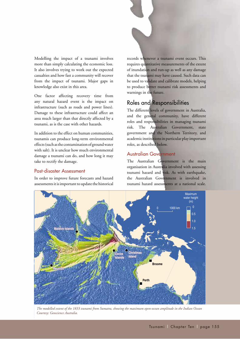
The modelled extent of the 1833 tsunami from Sumatra, showing the maximum open-ocean amplitude in the Indian Ocean Courtesy: Geoscience Australia.

page 156 | NATURAL HAZARDS IN AUSTRAL IA | Identifying Risk Analysis Requirements
The Australian Government is also involved in research designed to improve future vulnerability and exposure assessments of communities, through tsunami risk modelling.
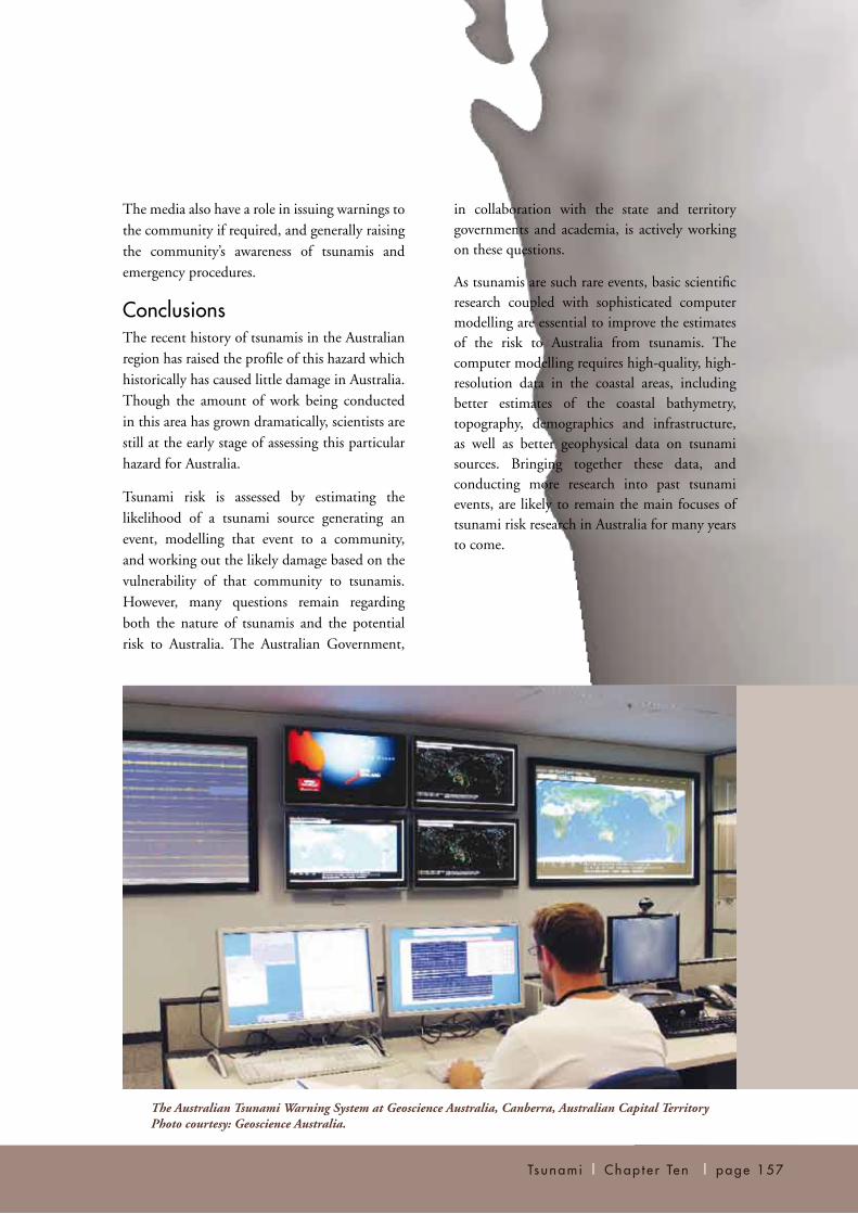
The Australian Tsunami Warning System (ATWS) is run jointly by several Australian Government agencies. The role of the ATWS is to detect and warn of approaching tsunamis generated by major earthquakes along any of the plate boundaries surrounding Australia or other, more distance sources. The Australian Government is responsible for seismic monitoring, sea level monitoring, numerical modelling and forecasting, and for issuing warnings to state and territory emergency agencies. The Australian Government also has some responsibility for public awareness activities and the coordination of national assistance to state and territory responses in the event of a tsunami disaster.
State and Territory GovernmentsState and territory government emergency agencies have a responsibility to prepare and plan for the impact of a tsunami on the communities within their jurisdiction, and to warn communities of the impending tsunami (and evacuate communities, if necessary) once they have been alerted by the ATWS. State and territory agencies would also be involved in providing emergency assistance and relief in the event of a major tsunami.
Local Government Local governments should include tsunami
as part of their natural disaster emergency risk
management plans for the coastal communities
in their jurisdiction.
Industry, Coordinating Groups, Professional Bodies and Research InstitutionsSeveral universities are involved in researching
tsunamis and/or assessing the hazard they
present to Australia and the region. Examples
include the University of Queensland, Macquarie
University, the Australian National University,
the University of Western Australia, James Cook
University and the University of Wollongong.
Various private companies in Australia and
overseas are also contracted to provide tsunami
hazard and risk advice to insurance companies or
to government.
General Community The general public should be aware of the
possibility of a tsunami and should take
preventative actions when a warning is given
or unusual sea conditions become apparent. An
example of an unusual sea condition could be a
sudden change in sea level not associated with
normal tidal changes.
Devastation in the suburbs caused by a tsunami in Aceh, Indonesia, December 2004 Photo courtesy: AusAID/Gregson Edwards.
The Australian Tsunami Warning System at Geoscience Australia, Canberra, Australian Capital Territory Photo courtesy: Geoscience Australia.
in collaboration with the state and territory governments and academia, is actively working on these questions.
As tsunamis are such rare events, basic scientific research coupled with sophisticated computer modelling are essential to improve the estimates of the risk to Australia from tsunamis. The computer modelling requires high-quality, high-resolution data in the coastal areas, including better estimates of the coastal bathymetry, topography, demographics and infrastructure, as well as better geophysical data on tsunami sources. Bringing together these data, and conducting more research into past tsunami events, are likely to remain the main focuses of tsunami risk research in Australia for many years to come.
Ts unam i | Chap t e r Ten | page 157
The media also have a role in issuing warnings to the community if required, and generally raising the community’s awareness of tsunamis and emergency procedures.
ConclusionsThe recent history of tsunamis in the Australian region has raised the profile of this hazard which historically has caused little damage in Australia. Though the amount of work being conducted in this area has grown dramatically, scientists are still at the early stage of assessing this particular hazard for Australia.
Tsunami risk is assessed by estimating the likelihood of a tsunami source generating an event, modelling that event to a community, and working out the likely damage based on the vulnerability of that community to tsunamis. However, many questions remain regarding both the nature of tsunamis and the potential risk to Australia. The Australian Government,