chapter one research background and approaches …
TRANSCRIPT

CHAPTER ONE
RESEARCH BACKGROUND AND APPROACHES
1.1 Background to the Study
This thesis re-examines the current interpretations on the expansion and decline of
complex socio-political systems in the Shashe/Limpopo River Basin (hereafter referred to as
SLRB), southern Africa (Figure 1.1). Over the last several decades, archaeological research has
focussed on reconstructing the cultural sequence of Iron Age communities, primarily those
centred on the elite sites of Schroda, K2 and Mapungubwe, with growing consideration given to
allied commoner sites. Researchers (e.g. Hanisch 1980; Eloff and Meyer 1981; Huffman
1986a,b; Meyer 1998) have shown that these central places, or capitals, controlled and
coordinated the region in increasingly more complex ways between AD 900 and 1290, leading to
a class-based society in which hierarchy was controlled by sacred leadership from the ‘capital’ at
Mapungubwe between AD 1220 and 1290. This was followed by the collapse of the
Mapungubwe system (Meyer 1998), with a population decrease and redistribution until after AD
1450, when large settlements were re-established in the river basin.
While the complexity and increased size of the Mapungubwe state is readily acknowledged,
the production and acquisition of food resources required to sustain its burgeoning population
are often perceived in terms of small-scale subsistence farming (e.g. Voigt 1983; Huffman
1996a; Meyer 1998). Within this context, research in the SLRB makes assumptions about the
environmental parameters and the nature of cultural knowledge for crop and livestock
production. Voigt (1983:64), for example, speculates, “It is unlikely that the Mapungubwe people
were aware of the importance of carrying capacity, which would have aggravated the situation in
drought years”. This and other suppositions gives rise to untested correlations between climate
change and the success or failure of agropastoralists in the region, as exemplified by the
expansion and decline of agropastoral communities centred on Mapungubwe. Consistently, the
sequence of cultural change, as exemplified by the expansion and decline of agropastoral
communities centred around Mapungubwe, has been directly correlated with the timing of large-

2
Figure 1.1: Approximate locations of the SLRB and sites discussed in thesis (adapted from Mitchell 2002). HR-Happy Rest; SC-Schroda; PD-Pont Drift; LH-Leokwe Hill; MP-Mapungubwe; IC-Icon; GZ-Great Zimbabwe; FR-Faure; KL-Kolope; SF-Sofala
Shashe Rv
SOUTH AFRICA
BOTSWANA
ZIMBABWE
MOZAMBIQUE
250km
26oE 32oE 36oE
18oS
24oS Soutpansberg
PD MP K2 SC
GZ
SF
HR
KL
LH FR IC
NAMIBIA
ZIMBABWE MOZAMBIQUE
SWAZILAND
LESOTHO
500km
BOTSWANA
N
South Africa
Limpopo Rv

3
scale climatic trends, such as the ‘Medieval Warm Epoch’ (AD 900 to 1300) and the ‘Little Ice
Age’ (AD 1300 to 1850), and the subsequent affect these ‘events’ may have had on the
economy, especially agropastoral production (Huffman 1996a; Meyer 1998; Plug 2000; Tyson et
al. 2002).
There are several problems with this approach and its underlying assumptions. For one,
these relatively small-scale temperature shifts are well established for high latitudes in the
Northern Hemisphere, and extension beyond those areas (i.e. as global phenomena) has been
debated. Likewise, any global climate shifts and their regional manifestations in different parts of
the world are not clearly understood; certainly, they were not at the time when most of the
previous research was being carried out in the SLRB. Greater clarity has since emerged on the
chronology and regional climate manifestations of the ‘Little Ice Age’ from high-resolution
stalagmite sequences in Limpopo Province. Two records suggest that stormy, cooler and drier
conditions culminated at 1700-1750 AD (Lee-Thorp et al. 2001; Holmgren et al. 2003).
Secondly, in applying climatic data extrapolated from trends at a sub-continental scale and from
external climatic sequences, one may speciously imply universal timing, effects or responses,
thereby overlooking local climatic variability as well as environmental and cultural modifiers. In
my re-examination of these climatic and agropastoralist correlations I add a consideration of the
environmental ranges and tolerances of livestock and crops, and the learned knowledge of
managing them in an area that is currently regarded as being environmentally marginal for
agropastoral production. These strategies are placed within the ~AD 900 to 1700 socio-political
context of the SLRB, building on hypotheses expound in J. Smith and S. Hall (1999), and
Huffman’s (2000) reconsideration, that the agropastoral economy associated with the rise of the
Mapungubwe political state would have required organised intensive or extensive production
well beyond the homestead level. As noted elsewhere (e.g. Classen 1984; Tainter 1988;
Kopytoff 1989) when approaching or reaching the level of a state, cultural, socio-political and
economic activities go beyond the local context to that of regional interaction and the integration
of regional diversity.

4
This thesis, therefore, seeks to investigate the structure of agropastoral production in the
SLRB, its compatibility with increasing socio-political complexity and how both relate to local
climatic change. In summary, I aim to identify and quantify factors relating to:
1. The structure of crop and livestock management in an area that is semi-arid and
environmentally marginal or variable for agropastoral production.
2. Agropastoral production and management at different social and political scales, particularly
those in the shift from K2 to Mapungubwe.
3. Short-and long-term local environmental and climatic fluctuations, for which there is a
paucity of local data pertaining to the last 2000 years. Before climatic trends and
environmental modifications can be assigned causal status for cultural change, it is pertinent
to know if they are manifested in the SLRB sequence and if so, what scale of change they
represent.
In order to achieve these goals two different methodologies are employed. First,
documented African agropastoralist cultural systems are explored to provide comparable
environmental parameters and management practices that are required to sustain, intensify and
extend agropastoral production in semi-arid regions. Secondly, identifying these parameters and
the climatic and environmental history for the SLRB is approached using multi-stable isotope
analyses of material directly associated with the cultural sequence between AD 900 and 1700.
1.2 Research Review and Archaeological Context Previous archaeological research in the SLRB has divided the Iron Age sequence into the
Early, Middle and Late Iron Age and phases within each period. This thesis uses this established
periodisation. These terms are used with the understanding that they do not represent
technological stages in the SLRB, but mark the advent, beginning in ~AD 500, of significant
reconfigurations of Bantu-speaking agropastoralists upon this landscape. The recognition of
these expansions in the SLRB and their timing are facilitated by radiocarbon-dated stylistic
distinctions in ceramics (Figure 1.2). These distinctions in space and through time represent
broad cultural identities because, as Huffman (1989) argues, pottery techniques and ceramic
5
styles are learnt and communicated within specific cultural settings.
Before proceeding, some brief comments about cultural terms and sequences are required.
First, is that the term ‘Iron Age’ and its periodisation, which was initially adopted by Summers
(1950) and then by successive archaeologists, has been criticised as being too constrained in its
perceived emphasis only on iron-working technology and defined cultural boundaries. Most
obviously, research into the significant interactions and overlaps between agropastoralists and
Later Stone Age foragers (S. Hall pers. comm.; B. van Doornum, pers. comm.; S. Hall and B.
Smith 2000) have perhaps been hampered by the persistent use of traditional cultural history
categories. In this regard, S. Hall and B. Smith (2000) stress the need to use an alternative
terminology that does not imply exclusive temporal and cultural boundaries. However, if the
focus is only on the ‘Iron Age’, and despite criticism that the description of stylistic boundaries
holds back research into more people centred themes, the archaeology suggests that stylistic
sequences do in part materialise real historical processes. In considering both approaches, what
has to be underscored is the need to explain the political, economic and social strategies that
maintain or change the contemporary juxtaposition of stylistically distinct communities. It is,
consequently, appropriate to use different terms and labels depending on the context under
discussion. Where traditional Iron Age periodisation is not necessary, I adopt Maggs and
Whitelaw’s (1991) suggested use of an economic identification. In this thesis, I use the term
agropastoralist to signify people whose farming economy is dominated by both crop and
livestock. Agriculturalist and pastoralist denote the former and latter, respectively. Where
appropriate, placement within the SLRB cultural and chronological sequence is designated by
the associated ceramic phase, e.g. Zhizo and Leopard’s Kopje A.
In this review section, I describe the SLRB cultural chronology and contextualise it in
relation to the environmental and economic correlations outlined in Section 1.1.

6
Figure 1.2: Origins of southern African agropastoral ceramic traditions discussed in chapter (adapted from Huffman 1999)
100km
Indian Ocean
Atlantic Ocean
6oS 18oS 30oS
12oE 24oE 42oE
Orange Rv
Vaal Rv
Limpopo Rv
Shashe Rv
Lake Victoria
Lake Tanganyka
Lake
Mal
awi
Kalundu Tradition Urewe Tradition Moloko Tradition N
7
The basis for this review is Huffman’s (1996a) cultural correlations for the SLRB compared
against the initial climatic sequence put forward by Tyson and Lindesay (1992) (Table 1.1). I
also discuss previous interpretations of the role of agropastoralism, environmental variability and
related cultural strategies within the changing socio-political structures of the SLRB. Initial
archaeozoological studies for the SLRB Iron Age focussed on the management of herds,
demographics and livestock health, of livestock, as well as the type, amount and distribution of
meat (Voigt 1980, 1983; for review see Plug 2000). While these studies tend to interpret
agropastoralist management within a subsistence level economy, they do nevertheless provide
baseline data for this thesis for understanding agropastoralism beyond the homestead level. The
archaeological material relevant to this review for the period between ~AD 900 and 1700 is
discussed according to the following themes: cultural identity, increasing socio-political
complexity, trade, population growth and health, agropastoralism, evidence for and ideas about
the collapse of Mapungubwe and questions concerning the nature of the post AD 1290 cultural
and physical environment.
Although the initial Early Iron Age phase, dated to between AD 300 and 700, predates
those later periods investigated for this thesis, it is briefly reviewed here for it signifies the
beginning of the SLRB and adjacent areas being settled by agropastoralists and used for mixed
farming. Prior to AD 300 there is ambiguous evidence for Bambata ceramics, which appear in
other areas to be associated more with semi-or-non-sedentary pastoralism, herding or hunters
with sheep (see Huffman 1994, Reid et al 1998). Based on ceramic style, the origins of the early
agropastoral phase, referred to as Happy Rest, is associated with the spread of Eastern Bantu-
speaking people. They are part of the Kalundu Tradition (or Western Stream) that spread from
the western Congo, Angola, western Zambia and Zimbabwe, north and eastern Botswana,
through the Limpopo Province of South Africa and on to KwaZulu-Natal (Figure 1.2) (Prinsloo
1976; Phillipson 1979,1989; Hanisch 1981; Huffman 1982, 1986b, 1993;1989; Whitelaw 1996;
Whitelaw and Moon 1996; Meyer 1997).

8
Table 1.1: Climatic events and linked cultural sequence for SLRB between ~AD 900 and 1850
Time Interval (AD)
Climatic Events (after Tyson and Lindesay 1992)
SLRB Cultural Sequence (after Huffman 1996a)
1650 to 1850
Little Ice Age: cool and dry Fluctuating settlement by various groups
1500 to 1650
Warming within the Little Ice Age Moloko and Khami settlement after AD 1450
1290 to 1500 Little Ice Age: cool and dry End of Leopard’s Kopje B, abandonment of Mapungubwe by AD 1290. Arrival of Moloko (Icon Facies)
1220 to 1290 Medieval Warm Epoch:
End of Leopard’s Kopje A, abandonment of K2. Start of Leopard’s Kopje B, settlement of Mapungubwe
1040 to 1220 warm and wet End of Zhizo, abandonment of Schroda. Start of Leopard’s Kopje A, settlement of K2
900 to 1040 Zhizo settlement, settlement of Schroda

9
As with the subsequent cultural phases, the presence or absence of this Early Iron Age
phase has also been linked to large-scale climatic changes. The occurrence of Happy Rest
ceramics at the base of the Mapungubwe sequence (Meyer 1997) led Huffman (1996a) to
correlate the success of dryland agriculture at this time with a proposed general warm/wet phase
between AD 500 and 700 (Tyson and Lindesay 1992). This association is difficult to assess
because, in spite of extensive archaeological surveys in the SLRB (for review see Huffman
2000), no unequivocal Happy Rest homesteads have been found. The ceramic and faunal
evidence, including more recent finds on nearby hilltops (Huffman 1999), is too scant to
determine the extent or the nature of the Happy Rest occupation and whether indeed,
agropastoral activities were practiced or viable in the SLRB. Huffman (1996a) argues that an
inferred cool/dry trend between AD 700 and 900 (Tyson and Lindesay 1992) accounts for any
apparent agropastoralist hiatus during this interval. In the light of contemporary Early Iron Age
agropastoralist sites in adjacent north-eastern Botswana at this time (Reid and Segobye 2000),
it is not clear whether this hiatus is actually climatically influenced or simply reflects a continued
low visibility of cultural material. Alternatively, given the settlements in Botswana and the
developing east-coast trade, this small-scale intrusion into the SLRB may have set the stage
and motivation for the subsequent cultural expansions.
1.2.1 ~AD 900 to 1290: Agropastoralist expansion, increasing socio-political complexity and the collapse of Mapungubwe Following Happy Rest, the Zhizo phase (Early Iron Age), marks the second and
archaeologically more visible occupation of the SLRB by agropastoralists. Huffman (1996a) and
Tyson et al. (2002) argue that this was stimulated by the favourable warmer/wetter climate of the
‘Warm Medieval Epoch’. Zhizo sites dominate the SLRB between ~AD 900 and 1010. Zhizo
ceramics are derived from the Nkope Branch of the Urewe Tradition (or Central Stream)
originating within Eastern Bantu-speaking groups that spread southwards from East Africa
through Malawi, Zimbabwe and into eastern Botswana and the northern part of the Limpopo
Province (Figure 1.2) (Huffman 1982, 1999). Zizho ceramics disappear from the SLRB by about
AD 1010, to be replaced by new agropastoralists identified by Leopard’s Kopje A ceramics
(Middle Iron Age). Deriving from an Early Iron Age middle phase of the Kalundu Tradition, the

10
Leopard’s Kopje A phase, also known as K2, dates between about AD 1010 and 1220 (Huffman
1982, 1999; Vogel 2000). The change and shifts in settlement organisation that accompanied
the K2 phase attest to the growing complexity of agropastoralist organisation at this time.
Both Zhizo and most Leopard’s Kopje A settlements were organised according to the
Central Cattle Pattern model (Huffman 1986b, 2000, Kuper 1982), in which central cattle byres
are enclosed by a ring of huts and material linked to domestic activities. The Nguni and
Sotho/Tswana-speakers upon which the model is based (Kuper 1982) are Eastern Bantu-
speakers and the settlement plan underpins a linked set of beliefs that emphasize patrilineal
descent, brideprice transacted through cattle and the primacy of ancestors in the day-to-day
affairs of the living. In this model, the central cattle byres are linked to a court, formal political
power and male activities and are where men or important people are buried. Women, children
and domestic activities are constrained to the outer ring of households.
During the Zhizo phase, the settlement of Schroda has been identified as the capital
(Figure 1.3) (Hanisch 1980; Meyer 1998) because of its greater spatial extend compared to
other Zhizo sites, as well as the types of artefacts recovered. Size correlates with political
authority and the unequal access to cattle and the power this gives to attract and command
people (Huffman 2000). Furthermore, large numbers of ceramic figurines at Schroda also attest
to the centralised control of ritual, perhaps initiation (see van Schalkwyk and Hanisch 2002).
Most importantly, the capital is identified through the evidence of exotic glass trade beads and
the growing control and accumulation of cultural material and trade items resulting from trade
links with Swahili Arabs on the East African coast (Hanisch 1980; Huffman 2000; Woods 2000).
Indeed, one potential motivation for Leopard’s Kopje A people to move into the SLRB, and
rapidly incorporate certain Zhizo related groups and displace others, was to take over the
growing international trade links (Denbow 1982; Huffman 1996b, 2000). This led to the
abandonment of Schroda and the establishment of K2 as the regional capital (Figure 1.3). The
contemporary increase in Zhizo influenced ceramic styles at Toutswe period sites in northeast
Botswana, points to one potential area to which Zhizo people moved (Denbow 1982, 1983,

11
Figure 1.3: Approximate spatial distributions of SLRB sites between AD 900 and 1300 (adapted from Huffman 2000)
Limpopo Rv
Shashe Rv
Motloutse Rv
Unzingwani Rv
600m
600m
Zhizo
N
Limpopo Rv
Shashe Rv
Motloutse Rv
Unzingwani Rv
600m
600m
Leopard's Kopje A
Limpopo Rv
Shashe Rv
Motloutse Rv
Unzingwani Rv
600m
Leopard’s Kopje B
600m

12
1986). The continuation of a Zhizo phase at Leokwe Hill until ~AD 1200, however, indicates that
this displacement was not absolute, and that there is a need to re-evaluate the position of Zhizo
within the Leopard’s Kopje A/K2 phase (Calabrese 2000; Vogel and Calabrese 2000).
The next phase in this sequence sees the dramatic abandonment of the Leopard’s Kopje A
capital at K2 at about AD 1220 and the relocation to Mapungubwe less than one kilometre away
(Figure 1.3). Continuity of K2 ceramic style in those of the Leopard’s Kopje B ceramics of
Mapungubwe (Huffman 2000) represents an in situ social and political change and not an influx
of a new cultural group as thought by other researchers (Gardner 1958, Meyer 1980). This
underpins the most important shift in the rise of social complexity from a kin-based or ranked
society, to a class based system that was socially and politically stratified, and in which the
relationship between elites and commoners was redefined (Huffman 1986b, 2000). This was
spatially expressed by a new settlement organisation at elite sites, exemplified by the capital at
Mapungubwe between ~AD 1220 to 1290, and defines the beginning of the Zimbabwe Culture
Pattern. Commoners, however, continued to organise their settlements according to the
principles of the Central Cattle Pattern.
Huffman (2000) suggests that the re-location of the capital to Mapungubwe was the end
point in a process started at K2, in which the Central Cattle Pattern could no longer express the
political and socio-economic distance between elites and commoners. An important indicator of
this structural change begins at K2 with the relocation of the central cattle byre away from the
settlement and the dominance of a huge court midden in its place. Very simply, this midden
expressed political power and wealth derived from the increasing centralisation of the east coast
trade and consequently, the status of the capital. That the structural shift was almost complete at
K2 is indicated by the fact that the new settlement form is immediately established at
Mapungubwe. Most obvious is that the distance between commoner and elite is now fully
articulated by the elite ruling family removing themselves from the body of the settlement and
into a position of sacred seclusion on the hilltop. Archaeologically, the hilltop palace is identified
by prestige walling, while the status of its occupants is further embellished by the royal cemetery

13
and the well known associated gold grave goods, a royal wives area at the western end of the
hill and a national rain making area at the eastern end. The public court was now located at the
base of the hill on the southern side and it was from just above the court that access to the
hilltop via a short but difficult accent could be made. The link between the court (male activity)
and this route suggests it was that only men used it (Huffman 2000). In contrast, commoners
lived around the base of the hill on the southern terrace and on a low plateau to the north.
Unlike Schroda and the initial stage of K2 occupation there was no central cattle byre at
Mapungubwe, which contrasted to the continued Central Cattle Pattern at its associated
commoner sites. This indicates that cattle continued to have status and that elites must have still
owned and had extensive access to cattle herds. Livestock was probably kept elsewhere until
needed (Garlake 1978), a suggestion that is debated by Voigt (1983) (see below for further
discussion), and raises obvious questions about the way herds were managed. Elites obviously
had more political power than that allowed by a solely cattle based wealth system, and this
came from the control of trade goods and the additional wealth this brought. Although elite cattle
wealth in the form of byres is not directly observable, apart from settlement organisation, wealth
and status was materialised in other ways. Three of the skeletons recovered from the royal
cemetery on the hilltop, for example, were ornately adorned with gold grave goods (Meyer
1998), a practice not found in commoner burials.
The external economy, and the increasingly important connection to the Indian Ocean and
sub-continental trade networks, clearly was a main factor in the development of a stratified
socio-political system by creating access to wealth for those controlling the trade. Elites at
Mapungubwe likely controlled the export of Shashe/Limpopo gold and ivory to the Swahili-Arab
traders of the East African coast (see Axleson 1973 for trade links; Voigt and Plug 1981; Voigt
1983; Miller et al. 2000), and intensified historical trade patterns forged by Zhizo and Leopard’s
Kopje A people. The widespread distribution of Leopard’s Kopje B ceramics, over about
30 000km2 (Huffman 1999), may indicate the extent of the region that participated or contributed
this trade network controlled by Mapungubwe. Tracing trade connections to areas outside of the

14
SLRB need to be studied further, however, keeping in mind that a common ceramic style as a
reflection of a common identity and a commodity catchment for trade need not be the same.
Of the trade items present in the SLRB archaeological record, glass beads are the most
abundant (see Saitowitz 1996; Wood 2000) and are important political and trade markers. In the
Zhizo phase, beads are found at the capital, Schroda, as well as other Zhizo sites (Hanisch
1980; Denbow 1986), implying a less centralised control over trade. At K2 and Mapungubwe,
however, access to exotic goods appears to have become restricted to the upper class elites.
There may have also been a decreased dependency on imported items as local innovations
were able to replace imports. The presence of spindle whorls, for instance, indicates the use of
cotton plants for local production of cloth, thereby limiting the need to import it. Additionally,
technical developments during the K2 period leads to glass beads being locally recycled and
made into the larger but rare garden roller beads, an innovation probably aimed at providing
another material sign of status and control (Wood 2000).
It is beyond question that the Schroda, K2 and Mapungubwe sequence in the SLRB
represents an absolute population increase, but attaching numbers to this increase is difficult.
Based on ceramic style, present survey data securely identifies and allocates settlements to a
cultural phase, irrespective of settlement size and rank within a regional hierarchy. Table 1.2
represents Huffman’s (2000:23) breakdown of the predicted population, based on current site
numbers and using an ethnographic standard of ~50 people per homestead and an independent
estimate for the capitals. Archaeological estimates of this kind are difficult because there will be
a range of homestead populations and furthermore, it is unknown whether people in the capital
also maintained farming homesteads elsewhere in the river basin. Nevertheless, additional site
surveys by T. N. Huffman (2000; pers. comm. 2001) record that even if there is continuity in
homestead occupation from one phase to the next, there is still an incremental increase in sites
between Zhizo, Leopard’s Kopje A and Leopard’s Kopje B (Figure 1.3). In addition, the
interpretation of the mortality profile derived from human skeletal remains from K2 and
Mapungubwe supports Huffman’s estimates of population increase. Steyn (1998:290)

15
Table 1.2: Huffman’s (2000) estimated population increase for SLRB capitals and related homesteads between ~AD 900 and 1300
Capital AD Date Capital Population Homestead Population Total
Schroda 900 to 1010 500 1400 1900
K2 1010 to 1220 1500 3800 5300
Mapungubwe 1220 to 1290 5000 5000 10 000

16
estimates that there was a growth rate of 2.5% per annum, a demographic profile that she finds
to be similar to those recorded for populations elsewhere in the world at this time.
There was a clear population increase in the SLRB between ~ AD 900 and 1290 but, as
indicated above, there has been little attention given to how agriculture was accordingly
managed to meet the demands. Although Zhizo and Leopard’s Kopje A and B were obviously
settled agropastoralists, there is yet little direct evidence of crop types, although it is axiomatic
that varieties of sorghum and millet would have been the primary crops. The few carbonised
seeds found at K2, Mapungubwe (Eloff and Meyer 1981) and Little Muck (Calabrese pers.
comm.), as well as the presence of granaries and grinding stones and historical and
ethnographic accounts of agricultural practices (for example Schapera 1950; Axleson 1973) all
indicate that this was the case. Furthermore, millet seed impressions on pottery from earlier in
the sequence dating to ~ AD 300 from the site of Silver Leaves, near Tzaneen in the Limpopo
Province, confirm that millet was a component of the earliest agropastoralist economy (Klapwijk
and Huffman 1996). For successful sorghum and millet production to have been possible in the
SLRB during this period, Huffman (1996a) suggests, based on criteria set forth by Doggett
(1976) and Purseglove (1976), that minimum growth season temperature was >15oC, minimum
summer rainfall was >350mm and annual rainfall was >500mm. This criteria, however, does not
consider the full environmental range under which sorghum millet can be produce, which
encompasses cooler and drier climates (National Research Council 1996).
In addition to a consideration of site numbers, population increase and the tolerances of
staple cereals, the specific locations of settlements can be added to the question of agricultural
management. This thesis specifically examines the variety of growing conditions for staple
cereals and other food crops. Consequently, I suggest that the SLRB site locations reflect
agriculturalist strategies and knowledge of the conditions necessary to maintain or increase crop
production as political complexity and population increased and climate conditions continued to
vary. Most Zhizo phase sites, for example, are located along the Shashe/Limpopo tributaries
and rocky outcrops, while Leopard’s Kopje phase sites dominate the floodplains (Figure 1.3).

17
Earlier I presented (J. Smith and S. Hall 1999; Huffman 2000) that intensive or extensive use of
the Shashe/Limpopo floodplains would have been central to the growing socio-political
complexity and large-scale and long-term agricultural production. Prior to the construction of
recent weirs and dams, regular flooding by the Shashe and Limpopo Rivers replenished soil
nutrients, creating an extensive fertile strip for cultivation. The typography around the junction of
these two rivers makes this part of the system particularly attractive for this mode of agriculture
(Figure 1.3), and the distribution of commoner homesteads reflects this activity. A developing
focus on floodplain agriculture through the Zhizo, K2 and Mapungubwe sequence is a logical
agricultural strategy in light of the inferred increase in population and political complexity.
After 400 years of continuous agropastoral occupation of the SLRB, the capital of
Mapungubwe was abandoned around AD 1290, while Great Zimbabwe emerged and elaborated
the Zimbabwe Culture Pattern established in the SLRB where there was an apparent overall
decrease in the number of sites up to ~AD 1450 (Huffman 1996a; Meyer 1998). The reasons for
this collapse are obviously important and several ideas have been suggested. As highlighted in
Section 1.1 and in Table 1.1, there is an apparent correlation between the decline of
Mapungubwe and with the start of the cooler/drier ‘Little Ice Age’ (Huffman 1996a), and the
negative impact this had on agricultural production. This correlation, along with the earlier
AD 900 to 1290 correspondence between agropastoralist success and the warmer/wetter
‘Medieval Warm Epoch’, are based on broadly resolved sub-continental-scale climate
reconstructions by Tyson and Lindesay (1992) and Tyson (1999a), which need to be
substantiated by synoptic climatic and environmental data from the SLRB and the wider region.
The location of Great Zimbabwe following the decline of Mapungubwe may also be seen as
a response to a climatic downturn. Its position on the southern slopes of the Zimbabwe Plateau
would have optimised a higher amount of available rainfall (Figure 1.1) for the agropastoral
production required for sustaining the new capital. The success of trade for the SLRB elites may
also have played a role in the decline of Mapungubwe (Voigt 1983; Huffman 1986b, 2000). The
system was dependent on East African coast trade and people to the east, who were closer to

18
the coast, may have contributed to the decline of Mapungubwe’s economic and political control
by interfering with trade routes and supply and shifting their trade alliances, e.g. Great
Zimbabwe. The possible relationship between climate change and the collapse of Mapungubwe
is one that is returned to in the following sections of this thesis. I now turn in slightly more detail
to a consideration of Voigt’s research that discusses the demise of Mapungubwe in relation to
herding practice. This is necessary background because I develop alternative ideas below.
Voigt’s (1983) interpretation of the faunal remains from K2 and Mapungubwe ties the
collapse of the Mapungubwe capital to herding practices within a deteriorating environment by
quantify the changing relationships between herd size and carrying capacity. She clearly
demonstrates that domesticated Bos taurus (cattle) and Ovis/Capra (sheep/goat) were the
dominate herd animals and the main protein sources for people at K2 and Mapungubwe, and
which was supplemented to a much lesser extent by wild and freshwater fauna. Voigt (1983:45)
calculates herd size using ethnographic accounts of pastoralists in Kenya (Brown as cited in
Monod 1975) and these numbers are extrapolated to the SLRB Mopane grassland, where she
estimates that to avoid overgrazing under present conditions 30 head of cattle will require ~385
hectares of graze, or one cow per 20 or 30 hectares (Voigt 1983:45). Additional to her
calculations is that to achieve a minimum pastoralist standard for dietary protein, one person
needs to consume ~5 cattle (Bos taurus) or ~25 sheep/goat (Ovis/Caprus) per year (Brown as
cited in Monod 1975). If such a diet was maintained throughout the increase in human
population between K2 and Mapungubwe the outcome would have been overstocking, as
evident in Table 1.3 which combines Voigt’s ratio of required livestock per person with Huffman’s
population estimates to calculate the change in livestock numbers at different stages in the
SLRB sequence. These herd levels would have lead to decreases in carrying capacity and
production and large-scale stock loss during droughts, which would have been exacerbated by
the overgrazing. Voigt concludes that land degradation eventually reached a state whereby the
Mapungubwe capital could no longer sustain the agricultural or the pastoral production demands
of the increased population.

19
Table 1.3: Estimated increase in livestock for the SLRB capitals of Schroda, K2 and Mapungubwe between ~AD 900 and 1290
Capital AD Date
*Capital Population
+Bos taurus (5 x 1 Person/Year)
+Ovis/Capra (25 x 1 Person/Year)
Schroda 900 to 1010 500 2500 12 500
K2 1010 to 1220 1500 7500 37 500
Mapungubwe 1220 to 1290 5000 25 000 125 000
*Estimated population (Huffman 2000) +Estimated number of livestock required for 1 pastoralist/year (Voigt 1983)

20
This model, however, assumes that both large and small livestock, as the major dietary
component, were pastured nearby and that a transhumant herding strategy, i.e. seasonal
pasturing, as proposed, for example, by Garlake (1978), was not practiced. The presence of
cattle bone from all age categories in the elite faunal assemblage suggests to Voigt (1983) that
there was ample choice of meat, and that they did not have to manage herds for beef, a practice
implied by transhumant grazing of livestock. The ready availability of meat for elites may be
tentatively recognised in human dietary reconstruction and bone pathologies. Stable carbon and
nitrogen isotope data, for example, show that some people at K2 and the Leopard’s Kopje B site
of Skutwater consumed more meat in comparison to those from the other South African Iron Age
sites (Lee-Thorp et al. 1993). Furthermore, human skeletal analysis by Steyn and Henneberg
(1995) and Steyn (1998) conclude that overall, the children and adults from K2 and
Mapungubwe were well nourished, postulating that meat resources possibly buffered periods of
cereal crop famine.
There are potential inconsistencies in a local herding strategy for Mapungubwe and its
proposed link to environmental deterioration. For instance, a decline in animal nutrition due to
increased herd sizes and decreased local carrying capacity would place considerable stress on
livestock. Currently, however, no bone pathologies indicative of stress, poor diet or health have
been identified in the Iron Age faunal assemblages from the SLRB, and none were recorded
during the course of bone and teeth sample selection for this thesis. Likewise, absence is the
expected skeletal evidence for deterioration in human dietary health that would have been in
accordance with drier ‘Little Ice’ conditions, as meat protein would not be able to compensate
fully for crop famine.
Further, Voigt’s (1983) extrapolation of Brown’s (as cited in Mondo 1975) pastoralist model
of meat consumption to K2 and Mapungubwe does not in corporate that cereal crops are the
primary day-to-day food sources in most agropastoralist communities. Consequently, the
dietary, as opposed to the social importance of livestock at these archaeological sites may be
over emphasized, and the required meat consumption as calculated in Table 1.3 over estimated.

21
At the time of Voigt’s initial faunal study there was a dearth of palaeoenvironmental data for the
last 2000 years. The lack of emphasis on cereal crops, therefore, stems from environmentally
contextualising livestock reconstruction within the recent SLRB conditions, which are marginal
for dryland agricultural, but suitable for herding. If this thesis data support Tyson and Lindesay’s
(1992) model for a general increase in moisture between ~AD 900 and 1290, then analogous
agropastoral economies in environments comparable to the SLRB, as well as those in higher
rainfall areas need to be considered, in order to obtain a realistic assessment of the contribution
of both cereal crops and livestock to the diet of Zizho, K2 and Mapungubwe people, and most
importantly, how agricultural production was managed within the SLRB landscape.
In this thesis I confront the hypothesis idea that Mapungubwe collapsed because of poor
herd management and asserts instead that the local management of large herds with a focus on
meat production was sustainable within an expanding social and political system because of the
implementation of appropriate strategies. I contend that the archaeologically identified livestock
consumption patterns and livestock age profiles do not exclude transhumant pastoral strategies
and this thesis presents appropriate supporting data to support this theory. Rather, such
strategies can be seen as a means by which herd size and carrying capacity would have been
regulated and overgrazing ameliorated. In reconsidering the larger role played by agriculture,
these aspects would have been important in preserving soil quality and field productivity. I
propose that as regional power expanded through the SLRB sequence, cattle and crops would
have also been managed regionally not simply to spread the ecological load and offset localised
failures, but also to build and maintain social and political links. I now turn to a brief review of the
post Mapungubwe period where the correlations between climatic and cultural change continue
to be an issue.
1.2.2 ~AD 1300 to 1700: Nature of post 1290 environment and occupation
The immediate post-Mapungubwe period in the SLRB has received little attention. As
referred to earlier and below, this is perhaps because of lower archaeological visibility and that
the assumed cooler/drier climate of the ‘Little Ice Age’ at the end of the 13th century AD limited

22
agropastoral production or exacerbated a degraded environment, which lead to population
dispersal (Huffman 1996a; Tyson et al. 2002). The movement of Leopard’s Kopje B people out
of the SLRB creates a cultural discontinuity in the archaeological record, but the Zimbabwe
Culture Pattern that was established at Mapungubwe continues elsewhere. People appear to
have migrated northward from the SLRB to settle at Great Zimbabwe, the capital of the middle
phase of the Zimbabwe Culture between ~AD 1300 and 1450. Here the continuity and
elaboration of the Zimbabwe Culture Pattern implies an obvious cultural link to Mapungubwe.
During this phase, the capital presided over a larger territory than Mapungubwe, trade with the
East African coast intensified further and the institution of sacred leadership expanded (Garlake
1982, 1983; Huffman 1996b, 2000). A further movement of Leopard’s Kopje B people from
Mapungubwe south and east along the Soutpansberg (Loubser 1991; Huffman 2000) is also
well documented. These areas are believed to have been wetter during this period, since they
presently receive greater annual precipitation than the SLRB (Huffman 1996a).
Although there is movement of people out of the SLRB after the Mapungubwe state
collapsed, the region continued to support agropastoralist settlement. Between ~AD 1300 and
1400 a new group of agropastoralists settled in the Shashe/Limpopo area, and ceramics from
the type-site of Icon (Hanisch 1979) represent the first phase and facies of the Moloko ceramic
tradition. Early Moloko ceramics represent a sharp stylistic break with prior ceramic phases.
Stylistic continuity of Moloko ceramics through to historic times indicates that they were
ancestral Sotho/Tswana-speakers, while comparative linguistics trace their origins to a
movement out of East Africa (Huffman 1989). The presence of other Icon related sites in the
SLRB area and northern Limpopo Province (E. O. M. Hanisch pers. comm. 1998; S. Hall pers.
comm. 2000) indicate that agropastoral activities were still viable during the post-Mapungubwe
period, despite the emphasis placed on the alleged negative impact of late 13th century climatic
change. Attention clearly needs to be given to this period to determine the nature and extent of
the early Moloko/Icon occupation. If the demise of the Mapungubwe state was the result of
climate change, then what environmental conditions in the early 14th century supported the Icon
and related communities? There is a sharp contrast between the productive and political scale of

23
the two systems and agriculture was viable perhaps only at the scale of the small dispersed
Moloko homesteads and not at the demographic scale evident at Mapungubwe and related
sites? Given the drought-adapted varieties of millet and sorghum (National Research Council
1996) and African livestock (Campher et al. 1998; see Appendix C), it is imperative to have
higher resolution climate data for the 'Little Ice Age' in order to assess how it influenced
sustainable production, the collapse of Mapungubwe and subsequent agropastoralist
settlement?
Sometime between AD 1400 and 1450 Great Zimbabwe was abandoned and a new
dynasty and capital was established at the site of Khami (Figure 1.4). The new leadership was
formed either by an external group expanding into the region or by people connected to Great
Zimbabwe. In either instance, there is continuity in settlement layouts and Khami starts a third
period of the Zimbabwe Culture Pattern (Robinson 1959; Huffman 1996b). Site distributions
places the extent of Khami’s influence somewhere between that of Great Zimbabwe and
Mapungubwe (Figure 1.4) (Huffman et al. 1995). Ancestral Sotho/Tswana (Moloko)
agropastoralists were already resident in the SLRB when Khami settlements expanded into the
SLRB and areas north of the Soutpansberg at around the mid-15th century AD, and evidence for
interaction comes from the presence of Moloko ceramics in Khami tradition sites (Huffman and
Hanisch 1987; G. Lathy pers. comm. 1998; T. N. Huffman pers. comm. 2000).
At the start of the 16th century AD the control of the east coast trade shifted from the
Swahili-Arabs to the Portuguese (Axelson 1973) who began to meddle increasingly in the affairs
of interior African polities. Portuguese documents indicate that maize was imported into the
Mozambican port of Sofala early in the 16th century AD (Axelson 1973), and that its cultivation
became more widespread in southeastern African communities between ~AD 1600 and 1700
(M. Hall 1976; M. Hall and Vogel 1978; Maggs 1980). It was eventually added to the
complement of Khami cultivars and was probably known to the later Moloko agropastoralists. It
suggested that the re-settlement of the SLRB after AD 1450 was made possible by an
interpreted warmer/wetter phase within the ‘Little Ice Age’ from ~AD 1500 to 1650 (Table 1.1)

24
Figure 1.4: Estimated area under control of the capitals of Mapungubwe (MP), Great Zimbabwe (GZ) and Khami (KM) (Adapted from Huffman 1999)
Mapungubwe Zimababwe Khami
SOUTH AFRICA
ZIMBABWE
MOZAMBIQUE
BOTSWANA
MP
GZ KM

25
(Huffman 1996; Tyson et al. 2002) that in turn met the higher moisture requirements of maize.
Again, this is a tempting correlation but (a) is there independent evidence for such a
wetter/warmer interlude and (b) what conditions allowed for the continued agropastoralist
occupation after the return to cold ’Little Ice Age’ conditions?
These questions and the other climatic/cultural correlations put forward for the SLRB need
to be explored further. Clearly, in a marginal area like the SLRB, there must have been a
relatively direct relationship between appropriate climatic and environmental conditions and the
success or failure of agropastoralism. There is, however, a danger of over-determining this
relationship, particularly in the absence of a local and independent palaeoenvironmental
sequence. Moreover, the directness of these correlations tends to paint agropastoralists in a
somewhat passive light. As made clear by Huffman (2000), a number of inter-related factors
were important in the rise of complexity in the SLRB, but wealth and power generated by control
and distribution of resources, of which I also include agropastoral production, was critical. The
cultural and political dynamics of this control may be amplified by drawing on historical
analogues, of which facets of Kopytoff’s (1989) African frontier model may provide a framework
for the rise and decline of the Mapungubwe capital. This model posits that after a ruler has
gained wealth and status amongst a growing population, there is a formation of inter-
dependence between the ruler and the ruled. The sacred-leader becomes responsible for the
well-being of the society through: 1) accumulation and distribution of food resources, 2) the
control of rain and prevention of certain natural disasters via contact with the ancestors and 3)
connections with outside polities. The need to preserve a divine image leads to his seclusion.
Death or removal of the sacred-leader leads to disorder in the socio-political system until a
successor is appointed or people leave for leadership in different polity.
Having reviewed the basic archaeological sequence and highlighted climatic correlations, in
the following section I outline an approach that tests these assumptions and asserts more
control by agropastoralists over the management of production even in highly variable
conditions.

26
1.3 Theoretical Approaches to Semi-Arid Agropastoral Ecologies
Section 1.2 draws out the strong links that researchers have made between cultural
activities and changes in climatic and environmental conditions, be they naturally or human
induced. Working within the framework of a controlling and determining ecology, climatic change
and environmental carrying capacity are seen as over-riding factors that motivated the
establishment of settlement, hiatuses in settlement and the termination of settlement phases in
the SLRB. This approach stems from an equilibrium model for agropastoral land use in which,
…vegetation change is gradual…Livestock populations are in turn limited by available forage in a density-dependent manner, so that excessive animal numbers, above a ‘carrying capacity’ level, results in negative effects on the vegetation. In the longer term this is assumed to cause more or less permanent damage - degradation or desertification. Scoones (1995:1).
In a classic equilibrium situation, environments within an ecosystem are considered stable
and the climate - especially high rainfall - is predictable, hence there is very little annual variation
in primary bio-production levels (for reviews see Ellis 1995; Dalhberg 1996; Archer 2002). The
stability of the system enables it to normally absorb a certain amount impact without structural
change, but once change occurs it is difficult to recover its mature state, because the longer-
lived components, e.g. trees, have slower turnover rates (Green 1988:250). Sustained
agropastoral production is favourable under these conditions, providing that cultural exploitations
can maintain the established balance that exists amongst the natural components of a system.
The security afforded agropastoralists in these systems frequently leads to over intensification of
an area and alters the productivity of the natural resources, e.g. soil and vegetation. Unless
brought back to a former equilibrium or stable state, usually by removing stock or ceasing crop
cultivation, imbalances created between the natural components can lead to an unstable state
and environmental deterioration. For semi-arid regions, such as the SLRB, climate exacerbates
the imbalance process. Under conditions of variable rainfall, the carrying capacity for crops and
livestock is difficult to predict from one season to the next. This results in greater environmental
fragility and unless carefully managed, equilibrium is more difficult to maintain.

27
In South Africa, the equilibrium model has governed semi-arid agropastoral management
policies and practices, and informed research questions and interpretations. Underpinning its
practical application is the preservation of the succession/climax pathway for natural vegetation
communities and at a larger scale ecosystems (Clements 1916, 1928; Stoddart et al. 1975), in
which productivity and biomass increase at small intervals to reach a mature community that is
constant in composition and productivity. Green (1998:248) points out that in general there is a
conflict between agropastoralism and succession systems, as the latter aims to increase
productivity by keeping the system in an immature, less diverse, fast growing and highly
productive state. Such a system is vulnerable and therefore, needs to be socially managed in
order to protect it from factors such as climate change, depleted soil nutrients and pests that
may shift the natural direction of succession. In reports of the deterioration of South African
semi-arid grazing lands (Acocks 1979, 1988), colonial period overgrazing of the Karoo is held up
as a warning for loss of both economic and environmental productivity if semi-arid grazing lands
that are not “properly” managed. Here depletion of grass cover has lead to reduced topsoil and
water retention, encroachment of Acacia thorn bush and the incapacity of the vegetation
community to revert to its grassland succession state even after the removal of livestock.
This model implicitly informs the environmental-culture correlations made for the SLRB
archaeological sequence. In the face of increased cooling and drying, the carrying capacity of
the SLRB decreased and the environmental equilibrium was unable to recover from
agropastoralist over exploitation. The outcome was reduced food production and environmental
degradation that led to the collapse of the Mapungubwe state (Voigt 1983). Mortimore (1998:2),
furthermore, alerts us to the fact that in research on African semi-arid agropastoral ecologies,
the equilibrium model implicitly links environmental degradation to population growth (Figure
1.5). Driven by population and socio-economic pressures, degradation is caused by the failure to
prevent overgrazing, over cultivation and deforestation, due to inappropriate technologies and
the management of natural resources. In broad outline, this is the prevailing scenario applied by
Voigt to the SLRB.

28
Figure 1.5: Population induced degradation model for semi-arid Africa (adapted from Mortimore 1998)
Population Growth
Resource Mismanagement
Reduced Supporting Capacity
_
+
+
Environmental Degradation
_
29
In contrast to this general paradigm for agropastoral ecology, a series of studies (e.g. Blaikie
1985; Ellis and Swift 1988; Parry et al. 1988; Westoby et al. 1989; Gill 1991; Mace 1991;
Behnke et al. 1993; Scoones 1995; Dahlberg 1996; Beinart 1996; Brocking and Homewood
1996; Dahlberg and Blaikie 1996; Scoones et al. 1996; Mortimore 1998) question the viability of
applying the equilibrium model to semi-arid regions, where unpredictable rainfall and lower
carrying capacities make it difficult, or unwarranted, to sustain a successional environment. This
is particularly evident under modern commercial and privatised farming practices where fields
are fenced for livestock pasture and agriculture, thereby decreasing an already low agropastoral
carrying capacity and limiting access to alternative support environments. Rather, these
researchers consider semi-arid ecosystems to contain non-equilibrium environments that are
highly dynamic in response to extremely variable rainfall patterns. This dynamic creates a
resilient system that is able to recover from impacts that cause structural change thereof. Within
these environments there may be stable equilibrium conditions, for example, the floodplains and
naturally dammed wetlands of the SLRB. As summarised by Scoones (1995:2, 3), this non-
equilibrium approach posits that most semi-arid ecosystems are:
• Not at equilibrium with external factors, such as drought, set livestock numbers and
vegetation status. Under these conditions, livestock numbers are kept naturally in check,
thereby limiting degradation and long-term negative effects caused by overstocking and
overgrazing.
• Heterogeneous environments that vary across space and over time in their composition and
productivity. Flexible movement by agropastoralists between different resource zones is
necessary to offset local variability and unpredictability.
• Influenced by a range of different agropastoral production strategies, therefore, a universal
management plan with fixed carrying capacity and standard, fenced off size fields is not
practical for sustaining or increasing output.
Central to this hypothesis and to this thesis is that there is a range of intra-and inter-
environmental heterogeneity through time and over space, and that such systems have the
capacity to accommodate and absorb a corresponding range of cultural strategies that are

30
designed to contend with environmental unpredictability (Westoby et al. 1989). In these systems
incorporating uncertainty is the norm, rather than an aberration (Mortimore 1998).
In a southern African context, although Kinahan (2000:234) advocates the need to move
away from an equilibrium approach, he cautions that the non-equilibrium perspective should not
over look the fact that any ecology is obviously finite and that this model may downplay the
potential “long-term impacts of subsistence farming in Africa by emphasizing the apparent
sustainability of such systems”. In his research context, Kinahan’s focus is on pastoralism and
foraging in a very arid landscape. I argue that in sustainable agropastoralism there are shifts in
response to a resilient and adapting ecosystem, as opposed to one that is constant. An
environment, for example, that becomes less sustainable for agriculture, may then fall within the
parameters for a more pastoral based economy. In contrast to the equilibrium model, it is
acknowledged that the requirements and management of semi-arid systems are influenced by
the cultural perceptions and values placed upon it, which relate to historical context and the
social and economic structure of the community making those demands. In this regard, Cleaver
and Schreiber (1994) and Neff (1994) observe that in semi-arid agropastoral ecologies there is
no direct causal relationship between population growth and environmental degradation, and
that technology and social organisations mediate between the two. Maintaining productivity
while offsetting drought, variability in seasonal rainfall and degradation reflects the “complex
economic and social adjustments that embody the everyday decisions of ordinary people”
(Mortimore 1998:6). Humanly generated degradation is more likely to occur when the
community’s social memory no longer remembers shifting and sustainable strategies, or when
they are prevented from practicing them (McIntosh 2000).
In the SLRB, it seems that semi-arid conditions prevailed since at least ~AD 900 and
probably well before that (see Lee-Thorp et al. 2001). Even with an increase of ≥200mm of
rainfall purported to have occurred between ~AD 900 and 1290, as argued by Huffman (1996a),
it is highly unlikely that mean annual rainfall ever exceeded 800mm, which is the upper range for
semi-arid summer rainfall regions. Contextualised within this persistently semi-arid environment,
31
I adopt a non-equilibrium model for the reconstruction of agropastoral strategies, in which
environmental resilience and social mediation are investigated in relation to concepts of drought,
variability in precipitation and land degradation. Chapter Two sets out the present-day and
historical ecological baseline against which these strategies and concepts are assessed in the
archaeological and palaeoecological contexts. Local and regional climatic variability are qualified
relative to present SLRB conditions and where documented, quantified over annual and multi-
year cycles. Corresponding agropastoralist perceptions of semi-arid ecological variability and
associated management strategies are drawn from ethnographic and historical sources. Chapter
Two also outlines the important natural and agropastoral domestic resource base of the region
and the importance of understanding the range of environmental tolerances within which these
resources can be productive, rather than the optimal conditions in which plants and animals
produce optimal yields.
1.4 Alternative Methods for Reconstructing SLRB Agropastoral Ecology
Our current understanding of the past agropastoral ecology of the SLRB is derived from
archaeozoological and palaeobotanical analyses that provide varying degrees of information
about economy, human diet, animal husbandry and health, trade networks and environment. As
noted in Section 1.2, archaeozoological analysis of faunal assemblages from Schroda, K2 and
Mapungubwe clearly establish that most of the protein diet came from B. taurus and Ovis/Capra.
This conventional analysis, however, advocates an equilibrium approach and a local herd
management strategy for cattle, against a background of a steadily decreasing carrying capacity
(Voigt 1983). Alternatively, I have suggested that a non-equilibrium management framework
may better serve analysis and interpretation. One aspect of this is the movement of livestock
between regions in order to offset seasonal variability in carrying capacity, for trade and socially
and economically bind communities in different resource regions. Archaeozoological methods
required for identifying livestock habitats have to go beyond conventional methods of interpreting
faunal ecology based on species expected dietary behaviour and modern habitat utilisation, e.g.
grazers=grassland and browsers=woodland, and be able to detect dietary and territory flexibility
when faced with seasonal variability in vegetation sources.

32
It is possible to identify crops types through current methods of palaeobotanical analysis
and to have them surmised from material culture such as grinding stones. These in turn
contribute towards inferring the general environmental conditions under which the crops and
natural vegetation communities grew. A few seed remains have been under collected from the
SLRB sites, but pollen however, typically desiccates in dry conditions and therefore is poorly
preserved in the SLRB environment. Pollen sequences from other regions of the Limpopo
Province offer tentative environmental data for the last 2000 years (Scott 1984, 1990), but
because these sequences are chronologically too poorly resolved for the purpose of this thesis,
and moreover not local, correlations with the SLRB cultural sequence have limited application.
One other potential source of SLRB palaeobotanical data comes from plant phytoliths, which are
micro-silicate formations that withstand dry environments. In a preliminary study, Carrion et al.
(2000), demonstrate that phytoliths, ingested and excreted by cattle, are recoverable from SLRB
Middle Iron Age dung deposits. They suggest that the paucity of arboreal phytoliths in the dung
during this period indicates the anthropogenic removal of trees and environmental degradation
of the SLRB. While methodologically valuable, the environmental interpretation is open to
contention and limited in scale because the result reflect only the conditions in the immediate
vicinity of the settlements. Based ethnographic observations, these would have been cleared
open environments.
The Schroda, K2 and Mapungubwe sequence in the SLRB represents important changes in
the scale of agropastoralist societies, but there are critical questions concerning the
commensurate scale of agropastoral production and the environmental and climate backgrounds
against which agropastoral strategies were developed. Furthermore, the alternative ecological
perspectives outlined in Section 1.3, offer an appropriate framework within which changing
agropastoral production redefines and recalibrates the landscape according to cultural needs. In
order to explore these questions further it is necessary to develop alternative methodologies to
those discussed above. Accordingly, this thesis adopts multi-stable isotope analyses of faunal
remains, recovered from high-resolution archaeological contexts, to address some of the gaps in
the record. This approach can develop insight into long- and short-term patterns of vegetation
33
change and social use and shifts in climate, which are all factors that affect livestock and crop
production. Furthermore, isotopic analyses can potentially resolve and identify the geology and
geography of different herding locations and thereby, contribute data relevant to livestock
movement and management and areas of interaction.
These stable isotopic reconstructions are based on the testable supposition that dietary
sources and consequently, environmental conditions are transferred to faunal bone collagen and
enamel apatite in a predictable manner (for reviews see Ambrose 1993; Koch et al. 1994;
Schoeninger 1995; Lee-Thorp 2002; Price et al. 2002). Chapter Three discusses the link
between stable carbon, nitrogen, oxygen and radiogenic strontium isotopic signatures of
terrestrial environments and those of faunal tissues, and the application and methods used to
investigate environmental changes and agropastoral strategies. The stable isotopic signatures
from modern fauna, with a range of grazing and mixed-feeding diets and habitats, are quantified
and qualified with regards to precipitation levels (nitrogen), evapotranspiration and available
moisture (oxygen), percentage graze versus browse in the diet (carbon), territory (strontium),
and seasonal shifts in evapotranspiration and available moisture (oxygen) and diet (carbon).
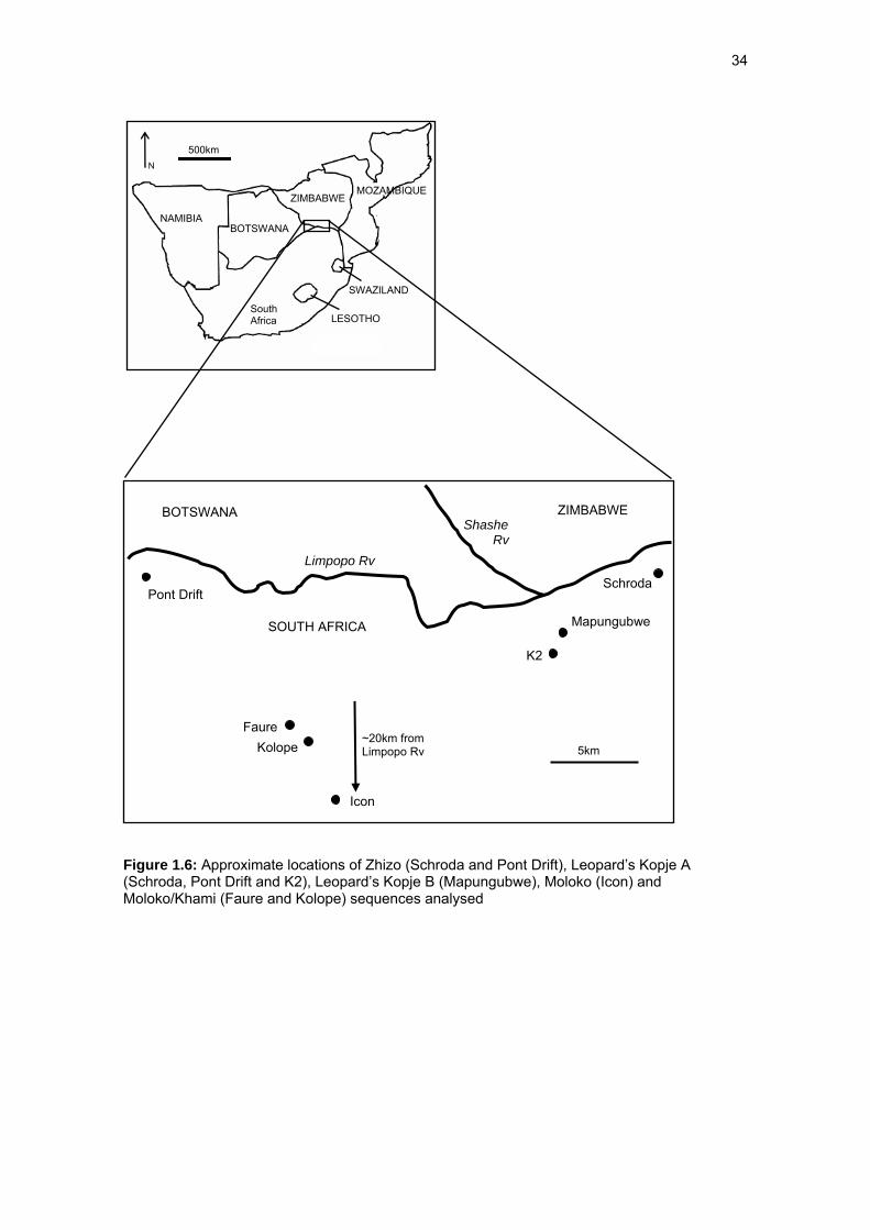
In Chapters Four and Five the isotopic composition of B. taurus and Ovis/Capra samples
from archaeological sites dating between ~ AD 900 and 1700, (Zhizo, Leopard’s Kopje A and B,
Icon, Moloko and Khami occupations) (Figure 1.6) are assessed in relation to the modern
comparative values provided in Chapter 3. Stable carbon, nitrogen and oxygen data are
presented in Chapter Four which are relevant to the reconstruction of moisture levels, livestock
diet and seasonal variability, while herding strategies and regions of interactions are interpreted
from strontium data in Chapter Five. Chapter Six provides a concluding synopsis of the results
which are compared to previous ecological interpretations and the regional and sub-continental
scale climatic sequences outlined in Table 1.1. Most importantly, this new data also provides a
re-evaluation of previous explanations for the “rise” and “collapse” of complex socio-political
structures in the SLRB. Natural environmental change is reviewed as a more intricate part of a
socially mediated ecology, rather than the primary controlling factor of agropastoral success or
34
Figure 1.6: Approximate locations of Zhizo (Schroda and Pont Drift), Leopard’s Kopje A (Schroda, Pont Drift and K2), Leopard’s Kopje B (Mapungubwe), Moloko (Icon) and Moloko/Khami (Faure and Kolope) sequences analysed
NAMIBIA
ZIMBABWE MOZAMBIQUE
SWAZILAND
LESOTHO
500km
BOTSWANA
South Africa
BOTSWANA ZIMBABWE
SOUTH AFRICA Mapungubwe
K2
Schroda
5km
Limpopo Rv
Pont Drift
Shashe Rv
Faure Kolope
Icon
~20km from Limpopo Rv
N

35
failure. Recommendations for future research directions are presented in relation to the
objectives outlined in this introduction.