chapter i geological setting -...
TRANSCRIPT

CHAPTER I
GEOLOGICAL SETTING
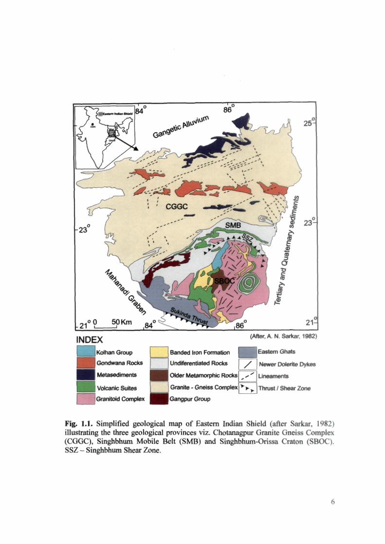
GENERAL GEOLOGY OF THE EASTERN INDIAN SHIELD
The Eastern Indian Shield is bounded by Mahanadi Graben and Sukinda thrust
in the west and in the south by granulite terrain of Eastern Ghats and recent coastal
alluvium. In the north and east it is masked by vast Gangetic alluvium and Quaternary
sediments of Bengal Basin (Fig. 1). It has received adequate attention of geoscientists
and almost all aspects of its geology have been discussed (Mukhopadhyay, 2001;
Mahadevan, 2002). However, due to scarcity of reliable radiometric age data and
structural complexities, stratigraphic sections and evolutionary models from difTerent
parts are inconsistent from each other. Three geological provinces have been
recognized in the Eastern Indian Shield: (i) Chotanagpur Granite Gneiss Complex
(CGGC) (ii) Singhbhum Mobile Belt (SMB) and (iii) Singhbhum-Orissa Craton
(SBOC). The tectonic and temporal relationships between these geological provinces
and the stratigraphy within each province have been the subject of the debate
(Mahadevan, 2002; Naqvi, 2005). Stratigraphic successions proposed by various
workers are given in Table 1. These successions indicate that there are wide
differences of opinion regarding the chronostratigraphy of various metasedimentary
rocks of SMB and their relationship with the rocks of the SBOC. The general
geological features of each of the above geological provinces are briefly discussed in
the following sections.
CHOTANAGPUR GRANITE GNEISS COMPLEX (CGGC)
Chotanagpur Granite Gneiss Complex (CGCC) covers an area of about 80,000
km^ (Latitudes 23°00Tsr to 25^00? ; Lx)ngitudes 83°45'E to 87*'45'E) in parts of West
Bengal and almost entire Jharkhand state, except the Singhbhum region. It is a
composite mass consisting mainly of granite-gneisses, migmatites and massive
INDEX Kolhan Group
Gondwana Rocks
Metasediments
Volcanic Suites
Granitoid Complex
Banded Iron Formation
Undiferentiated Rocks
OMer Metamorphic Rocks
Granite - Gneiss Complex
Gangpur Group
/
(After, A. N. Sarkar. 1982)
Eastern Ghats
Newer Oolerite [Tykes
Lineaments
Thrust / Shear Zone
Fig. 1.1. Simplified geological map of Eastern Indian Shield (after Sarkar, 1982) illustrating the three geological provinces viz. Chotanagpur Granite Gneiss Complex (CGGC), Singhbhum Mobile Belt (SMB) and Singhbhum-Orissa Craton (SBOC). SSZ - Singhbhum Shear Zone.

granites with enclaves of para-and ortho-metamorphics, dolerite dykes and
innumerable veins of pegmatite, aplite and quartz (Naqvi and Rogers, 1987). From the
structural patterns, woiiced out in different parts of the CGGC, it is clear that the
region has undergone polyphase deformation producing distinctive folds and related
linear fabrics (Mahadevan, 2002). Reliable radiometric age data are rare in CGGC.
The available isotopic data (Mahadevan, 2002) indicate that the metamorphism,
migmatization or granitization continued for a long period fix)m 1600 to 635 Ma.
Geologic events older than 1600 Ma are not recorded because of the fact that efficient
and robust radiometric systons have not been applied to this geologic province.
Radhakrishna (1989) suggested that CGGC is a Paleoproterozoic Suspect Terrain.
Mahadevan (2002) based on the available structural, metamorphic, lithological and
radiometric data, has proposed that the CGGC may be classified into five east-west
trending belts, namely (i) South Palamau-Gumla-Ranchi Purulia belt, (ii) Daltonganj
(North Palamau)-Hazaribagh belt, (iii) North Gariiawa-Chatra-Gridih-Deoghat-
Dumka belt, (iv) Bihar Mica Belt and (v) Rajgir-Kharagpur belt. All these belts,
metamorphosed into greenschist to granulite facies, have variable proportions of
metasediments and metavolcanic rocks permeated by granitoids and pegmatites.
CGGC is cut into northern and southern parts by Damodar rif^ valley
containing rocks of Gondwana Supergroup. Anorthosite-gabbro plutons are found at
several places in CGGC. Some of the well known occurrences of the anorthosite-
gabbro plutons are Bela gabbro-anorthosite, Debaur anorthosite, Dumka anorthosite
and Bankura anorthosite. A smaller body of anorthosite at Kushinda is associated with
nepheline syenite (Naqvi, 2005).
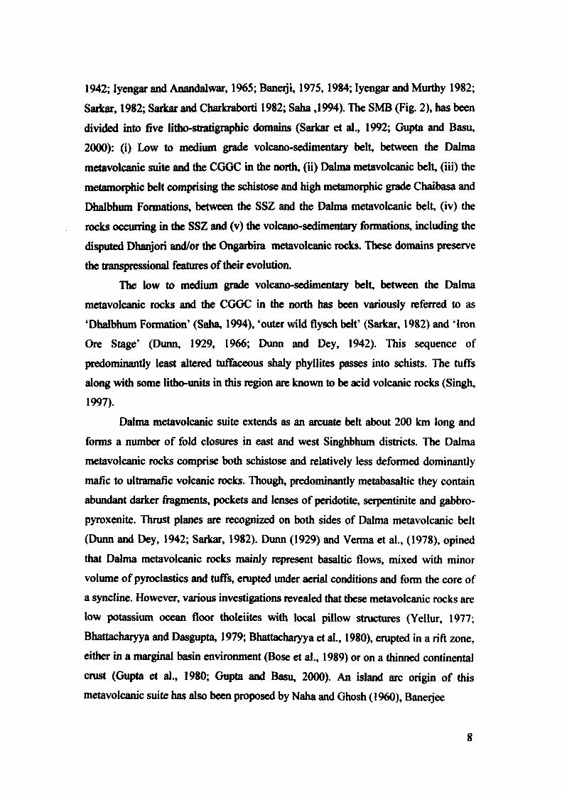
SINGHBHUM MOBILE BEL T (SMB)
The formations occurring in between the Singhbhum Granitoid Complex
(SBGC) and Chotanagpur Granite Gneiss Complex (CGGC) are now collectively
recognized either as the Singhbhum Mobile Belt (SMB) or Singhbhum Group despite
of different opinions given regarding the tectono-stratigr^hic relationship between
the rocks of this belt and those lying across the well known Singhbhum Shear Zone
(SSZ) in the southern part of this belt (e.g., Dunn, 1929, 1940, 1966; Dunn and Dey,
1942; Iyengar and Anandalwar, 1965; Banerji, 1975,1984; Iyengar and Murthy 1982;
Saikar, 1982; Sarkar and Charkraborti 1982; Saha ,1994). The SMB (Fig. 2), has been
divided into five litho-stratigraphic domains (Saiicar et al., 1992; Gupta and Basu,
2000): (i) Low to medium grade volcano-sedimentary belt, between the Dalma
metavolcanic suite and Utte CGGC in the north, (ii) Dabna metavolcanic belt, (iii) the
metamorphic belt con^rising the schistose and high metamorphic grade Chaibasa and
Dhalbhum Formations, between the SSZ and the Dalma metavolcanic belt, (iv) the
rocks occurring in the SSZ and (v) the volcano-sedimentary formations, including the
disputed Dhanjori and/or the Oi^arbira metavolcanic rocks. These domains preserve
the transiHessional features of their evolution.
The low to medium grade volcano-sedimentary belt, between the Dalma
metavolcanic rocks and the CGGC in the north has been variously referred to as
'Dhalbhum Formation' (Saha, 1994), 'outer wild flysch belt' (Sarkar, 1982) and 'Iron
Ore Stage' (Dunn, 1929, 1966; Dunn and Dey, 1942). This sequence of
predominantly least altered tufTaceous shaly phyllites passes into schists. The tuffs
along with some litho-units in this region are known to be acid volcanic rocks (Singh,
1997).
Dalma metavolcanic suite extends as an arcuate belt about 200 km long and
forms a number of fold closures in east and west Singhbhum districts. The Dalma
metavolcanic rocks comprise both schistose and relatively less deformed dominantly
mafic to ultramafic volcanic rocks. Though, predominantly metabasaltic they contain
abundant darker fragments, pockets and lenses of peridotite, serpentinite and gabbro-
pyroxenite. Thrust planes are recognized on both sides of Dalma metavolcanic belt
(Dunn and Dey, 1942; Sarkar, 1982). Dunn (1929) and Verma et al., (1978), opined
that Dalma metavolcanic rocks mainly represent basaltic flows, mixed with minor
volume of pyroclastics and tuffs, erupted under aerial conditions and form the core of
a syncline. However, various investigations revealed tiiat these metavolcanic rocks are
low potassium ocean floor tholeiites with local pillow structures (Yellur, 1977;
Bhattacharyya and Dasgupta, 1979; Bhattacharyya et al., 1980), erupted in a rift zone,
either in a marginal basin environment (Bose et al., 1989) or on a thinned continental
crust (Gupta et al., 1980; Gupta and Basu, 2000). An island arc origin of this
metavolcanic suite has also been proposed by Naha and Ghosh (1960), Banerjee
8

N
I 0 10Km
85*45' CGGC
NorUiem Shear Zone - « — • — » — * -
8«*15'
INDEX
I Chotanagpur Granite Gneiss Con^)lex • • Kolhan Group
m H Volcanic Rock f H Alluvium
H H Granitoid
(After A. K. Saha, 1994)
Thrust / Shear Zone
I ! Metasediments
Fig. 1.2. Simplified geological map of the Singhbhum Mobile Belt (after Saha, 1994) showing major stratigraphic units.

(1982) and Alvi (2005). Sarkar (1982) considered it as an ophiolite suite. The age of
emplacement of Dalma metavoicanic rocks has been considered as Paleoproterozoic
(Saha, 1994; Misra and Johnson, 2005; Misra, 2006).
The metasedimentaiy sequence, north of the SSZ is composed of mica schists,
often gametiferous with numerous bands of amphibolite facies, and has variously
been named as 'Chaibasa Stage' (Dunn, 1929), 'Chaibasa Formation' (Saha, 1994),
'Ghatshila Group' (Iyengar and Murthy, 1982) and central metaflysch beh (Sarkar,
1982). These rocks have generally preserved primary sedimentary structures such as,
cross bedding, convolute laminations, graded bedding and current ripple laminations.
The flysch character of the rocks of this belt has been emphasized by many workers
(e.g. Gobar Gaal, 1964; Iyengar and Anandalwar, 1965; Naha, 1966; Sarkar, 1982).
An arcuate belt about 200 km long in the southern part of the SMB is well
known as the "Copper Thrust Belt" (Dunn, 1992; Dunn and Dey, 1942; Sarkar and
Saha, 1994) or Singhbhum Thrust or Singhbhum Shear Zone (Naha, 1965;
Bhattacharyya, 1966; Banerji 1975; Sarkar,1982). In the west the zone is more than
25 km wide and contains three major thrust slices. These slices are compressed into a
narrow zone of 1 km width in the centre, but the zone widens to about 5 km at its
eastern end (Sarkar, 1982). The rocks occurring in the SSZ are mainly phyllonite,
chlorite sericite schist and sheared granite-gneiss along with some lenticular bodies of
sheared conglomerate and sandstone. Several bodies of ultramaflc rocks,
metamorphosed into mafic schists, occur all along the SSZ. It is now well established
that SSZ does not represent the structural boundary between the rocks of the
Singhbhum-Orissa Craton and the E-W trending SMB. It was reactivated several
times during the geological past, the earliest being around 2.22 Ga, followed by
around 1.8 Ga, 1.5 Ga and the final phase at 1.0 Ga (Alvi, 2006).
Several detached granitoid bodies occur along the SSZ. These include from
west to east: (i) Chakradharpur Granitoids (CKPG) containing two distinct units, the
older tonalite-trondhjemite gneiss and younger granodiorite (Bandhopadhyay, 1981;
Sengupta et al., 1983), (ii) Arkasani Granophyres represent a group of lenticular
bodies containing massive cores of monzo to syeno-granite and margins of
granodiorite and tonalite (Banerji et al., 1978), (iii) Soda Granite comprising a group
of lenticular granitoids which are commonly mylonitized and converted into sericite
10
or muscovite- quartz schist (Mukhopadhay, 1986), (iv) Mayurbhanj Granite consists
of thi«e distinct units, viz. fine grained granophyric granite, coarse grained granite
with biotite and ferro-hastingsite and small injections of biotite aplogranite (Saha,
1975).
There is a vast terrain of platform type of metasediments to the south of SSZ.
This terrain displays prominent discontinuous polymictic conglomerate horizons
along or close to Singhbhum Granitoid Complex. There are at least two identifiable
sub basins (Banerjee, 1982), along this domain namely, Sahedba and Dhanjori which
are characterized by the following volcanic suites:
Ongarbira Volcanic Suite
The Ongarbira metvolcanic suite has a general ENE-WSW trend which is
discordant to the regional NNE-SSE strike of the Chaibasa metasedimentary rocks
(Sarkar and Chakraborti, 1982). The ultramafics, basalts and gabbro-pyroxinites with
subordinate tuffaceous members show intricate inter-fingering among them and also
with the underlying metasediments with which they are co-folded (Gupta et al., 1981).
Blackburn and Srivastava (1994) pointed out their MORE affinity and suggested their
generation in an extensional environment. However, Raza et al. (1995), suggested
these volcanic rocks as typical arc-tholeiites.
Dhanjori Volcanic Suite
The Dhanjori metavolcanic suite (Latitudes 22"'30' and 22*457^; Longitudes
86°15' and 86'*30'E) containing a variety of rocks including ultramafic to mafic and
rarely acid lava flows, tuff and agglomerate is inter layered with ortho-quartzite and
phyllite, underlain by quartzite conglomerate and forms a group named Dhanjori
Group (Dunn and Dey, 1942; Singh and Nim, 1998). These metavolcanic rocks are
found to have age around 2072 ± 106 Ma by Sm/Nd isochron method (Roy et al.,
2002), whole rock Pb/Pb date of 2858 ± 17 and 2787 ± 270Ma by Sm-Nd ,CHUR)
model (Misra and Johnson, 2005). The Newer Dolerite dyke swarms do not cut across
the Dhanjori metavolcanic suite or the Dhanjori quartzite at its base. Therefore, the
11

Newer Dolerite dykes and volcanism i.e. Gonimahisani greenstones of this area seem
to be older than Dhanjori sedimentation and volcanism.
SINGHBHUM-ORISSA CRATON(SBOQ
The Singhbhum-Orissa Craton (SBOC) records a long history of crustal
evolution from Mesoarcbaean to Mesoproterozoic. Significantly, global Neoarchean
peak of 2.7 Ga (Naqvi, 2005) is missing in this craton. Komatiites which are abundant
in other cratonic regions are either yet to be discovered or they have not been formed
during this period (Bose, 2000). If the former happens to be true, the Mesoarcbaean
geodynamic setting of Singhbhum-Orissa Craton appears to be maikedly different
from the other cratonic regions of Indian subcontinent. It is an extensive terrain of
granite and gneissic complex with subordinate metabasic and minor metasedimentary
rocks (Fig. 3). Saha (1994) classified the rocks occurring in nordi and south of SSZ
into two separate stratigrtq^c and orogenic belts, whereas others believe that despite
of their apparent structural and metamorphic contrast they belong to one broad
tectono-stratigraphic unit (Dunn, 1929, 1940; Dunn and Dey, 1942; Iyengar and
Anandalwar, 1965; Banerji, 1974; Iyengar and Murthy, 1982; Sarkarand Chakraborti,
1982). The dual concept regarding the stratigraphic and tectonic classification of the
rocks of this region is the most outstanding controversy. Various rock units in the
stratigrpahic sequence are described as follows:
Older Metamorphic Group (OMG)
The Older Metamorphic Group (OMG), metamorphosed in amphibolite facies
under P-T conditions of 5-5.5 kbar and 600-630^C, is represented by pelitic schists,
gametiferous quartzite, calc-magnesian metasediments and sill like mafic rocks, now
metamorphosed to ortho-amphibolite and hornblende schist (Saha, 1994). Unlike in
other Archaean supracrustal belts spinifex textured mafic-ultramafic komatiites are not
present. It is exposed around Champua (Latitudes 22WN: Longitudes 85°40'E) and
also occurs as enclaves within the Sin^bhum Granitoid complex (SBGC). Goswami
et al. (1995) and Mishra (2006), have dated detrital zircons and established an older
12

INDEX
^ ^ H Older Metamorphic Group
jSingbhum Granitoid Ckxnplex
Banded Iron Formation
SJnghbhum Group Metasediments
Chotanagpur Granite Gneiss Complex
y Granulites
Gneissic Rocks
Gangpur Group
' - . .
/
(Mlar Iyengar and Murttiy, 1982)
Undifferentiated rocks
Thrust / Shear Zone
Netver Ooierite dykes
i Kolhan Group
Vok:ank; Rocks
Fig. 1.3. Simplified geological map of the Singhbhum-Orissa Craton (after Iyengar and Murthy, 1982)
13

limit of 3.5 Ga for the age of the sedimentation of these supracrustals. The
suptacnistals are partially granitized and co-folded with a suite of biotite-
(homblende)-tonalite gneiss grading into trondhjemite (OMTG) for which most
reliable dates are given by Moorbath and Taylor (1988) as 3378 db 98 Ma, based on
Pb/Pb whole rock isochron. This date appears in feir agreement with the Sm/Nd (TDM
model) ages of 3.41, 3.39 and 3.35 Ga for tiie same rocks (Moorbath and Taylor,
1988). Sharma et al. (1994), however, pointed out that protoliths of OMG amphibolites
are 3305 :i: 60 Ma old and therefore OMTG wliich intrude OMG can not be older than
3300 Ma.
Singhbhum Granitoid Complex (SBGC)
The Singhbhum Granitoid Complex (SBGC) (Latitudes 2l°00' and 22''45' N:
Longitudes 85°30' and 86°30'E) is made up of at least twelve separate magmatic bodies
that are considered to have been emplaced during two major phases of magmatism
(Saha, 1994). The early phase of Singhbhum Granite has an age of 3.25 ± 0.05 Ga
based on an eight point Pb /Pb whole rock isochron (Moorbath et al., 1986). Recent
work on other granitic plutons in the Singhbhum-Orissa Craton also reveals ages
correlatable to SBGC. Sengupta et al. (1991) reported Pb/Pb age of Bonai pluton as
3369 ± 57 Ma. Vohra et al. (1991), dated Katipada tonalite as 3275 ± 81 Ma old by
Rb/Sr method. Available radiometric ages for the later phase of the Singhbhum
Granitoid Complex are 3.06 Ga (Pb/Pb whole rock) and 2.9 Ga (Rb/Sr whole rock) as
compiled by Saha (1994). Rb/Sr radiometric dates of the SBGC and OMG are
significantly overtyping in between 3200 Ma and 3000 Ma (Saha, 1994) that perhaps
correspond to both age of OMG metamorphism and emplacement of the later phase of
the Singhbhum Granite.
Banded Iron Formations (BIFs)
Saricar and Saha (1963) revised the stratigraphic succession of Dunn (1929,
1940) clubbing all BIFs of the Singhbhum-Orissa Craton into their "Iron Ore Group".
It is considered to have been deposited in three interconnected basins (Saha 1994).
14

These basins are: (i) Noamundi (Latitudes 22*'09'N: Longitudes 85°3rE) - Koira
(Latitudes 2r54'N: Longitudes 85°15'E) basin of west Singhbhum district and
Keonjhar. (ii) Gorumahisani (Latitudes 22*»18'30'N: Longitudes 86''17'E) -
Badampahar (Latitudes 22*WN: Longitudes 86°07'E) basin along the eastern border
of the Singhbhum Granitoid Complex and (iii) Daitari-Tomka basin in the southern
parts of the Singhbhum-Orissa Craton.
The occurrence of BIF in a belt around Singhbhum Granitiod Complex is
significant as their position in space and time is controversial. Dunn (1940), Dunn and
Dey (1942) and Saha (1994) have proposed "Singhbhum Granite" to be younger than
BIF. But Banerji (1974), Mukhopadhyay (1976) and Iyengar and Murthy (1982), have
opined that Singhbhum granitiod Complex is the oldest cratonic block on which BIF
were laid down.
Dunn and Dey (1942), Sarkar and Saha (1963) and Saha (1994), consider
Noamundi (Latitude 22°09'N: Longitude 85°3rE) - Koira (Latitude 21 "541^:
Longitude 85°15'E) and Gorumahisani (Latitude 22°18'30"N: Longitude 86°17'00" E)
- Badampahar (Latitude 22°04'N: Longitude 86°07' E), sequence of BIF rocks to be
stratigraphically equivalent, \^ereas, Prasada Rao et al. (1964), Iyengar and
Ananadalwar (1965) and Acharya (1984) regarded these two as separate stratigraphic
units. The Noamundi-Koira basin has been considered to be the type area of the 'iron
Ore Group" where a tectonic synclinorium is overtumed towards south-east (Saha,
1994). In the Noamundi- Koira BIF, rocks are made up of shale, phyllite, the middle
formation of banded hematite jasper and an upper formation of magniferous shale,
chert, manganese formation and shale (Prasada Rao et al. 1964; Sarangi and Acharya,
1975; Acharya, 1984).
In the north east of Singhbhum Granitoid Complex, BIF of Mesoarchean age
occurs in the Gorumahisani-Badampahar basin where Sm/Nd dating of a granite body
intruding BIF near Sulaipat has given an isochron age of 3.12 ± 0.01 Ga (Chakraborty
and Majumdar, 1986). The BIF in this basin represents the rock type, namely cherty
quartz arenite, muscovite quartzite, fuchsite quartzite, homblende schist, tuff and
phyllite overlain by one or two distinct horizons of BIF wliich are separated by a zone
of cherty quartzite with numerous thin layers of intercalated chert and altered volcanic
tuff (Charicraborty and Majumdar, 1986). Some mafic and ultramafic rocks referred to
15

as Gorumahisani Greenstones (Banerjee, 1982), are associated with this BIF
sequence. Although their relationship with BIF is obscure, EXinn and Dey (1942) and
Banerjee (1982), are of the opinion that the magmatic rocks are partly volcanic but
primarily intrusive into the referred BIF.
Both iron and manganese ore deposits are widespread in the Noamundi-Koira
basin. The iron formations contain abundant sedimentary structures, such as current
markings of penecontemporaneous slumps and banding (Rai et al., 1980). Initial
precipitation of magnetite in a silica gel and later segregation into bands has been
proposed (Chakraborty and Majumdar, 1986). Compositions of ai^Uaceous members
of the assemblage are constant with a shallow marine environment of deposition in
the basin which is supported by the presence of stromatolites in the dolomites and
micro fossils in the phyllites and cherts (Maithey et al., 2000). Several large blankets
occur associated with BIF. These are:
Bona! Volcanic Suite
Below the BIF of the Noamundi-Koira, an extensive volcanic suite occurs,
indicating sub-aerial character in the west and sub-marine in the east (Baiterjee,
1982). The Bonai metavolcanic rocks consist of variable amounts of mafic lavas and
tuffs with minor silicic volcaniclastic interbeds. Ficrite rocks show pillow structures
(Bose, 1982). Banerjee (1982) regarded this suite as island arc basalt.
Jagannathpur volcanic suite
A remarkably fresh or least metamorphosed rectangular volcanic outcrop is
well exposed (Latitudes 22°00' and 22°15' N: Longitudes 85»30' and 85°45' E) around
Noamundi, extending up to Jagannathpur. These rocks are younger than Noamundi-
Koira sequence of BIF (Banerjee, 1982). Significantiy, Newer Dolerites are not
cutting across the Jagannathpur Suite. It, therefore, appears tiiat it is either equivalent
in age or younger than the Newer Dolerite swarm. Flat lying deposition of the lava
flows and absence of any submarine volcanic structure suggests a continental setting
of eruption. Alvi and Raza (1991) found these to be calc-alkaline basalts and
16

si^ested tiiat these lava flows represent an early arc volcanism. The Jagannathpur
lavas have been dated around 1629 ± 30 Ma by K/Ar method (Saha, 1994) and 2250 ±
81 Ma by Ph/Pb whole rock isochron method (Misra and Johnson, 2005). Banerjee
(1982), Iyengar and Murthy (1982) and Saha (1994) correlated this suite with the
Dalma and the Dhanjori metavolcanic suite.
Gorumahisam Volcanic Suite
It is associated with Gorumahisani-Badampahar BIF along the eastern border
of SBGC. The relationship between the associated metasediments and the volcanic
suite is obscure. They consist of both mafic and ultramafic types, and some of them
have garnet peridotite inclusions (Banerjee, 1982); Dunn and Dey (1942) and
Banerjee (1982) are of the opinion that this suite is partly volcanic but primarily
intrusive. The rocks of this volcanic suite are intruded by Kumhardubi (Latitude 22°
17^4: Longitude 86°19'30") - Dublarbera (Latitude 22'^9'30" N: Longitude 86°17'E)
gabbio- anorthosite, Rangamatia (Latitude 22°29'15"N: Longitude 86°17'30"E)
Lcucotonalite, Katupith (Latitude 22°18TM: Longitude 86"17'30"E) Leucogranite and
Newer Dolerite dyke swarm.
SinUipal Complex
A large circular outcrop pattern containing alternate bands of mafic volcanic
rocks and ortho-quartzites, overlies the granitoid basement of Archaean age.
According to Iyengar and Banerjee (1964), the volcanic rocks are represented by
spilitic lavas and tuffs. Three bands of volcanic rocks alternate with three bands of
ortho-quartzite and denote three periods of quiescence. Along the flanks a suite of
gabbro-anorthosite and ferrohedenburgite-granite granophyre intrudes into the
volcanic rocks. The centre of the complex is occupied by the Amjori sill (Iyengar et
al., 1981 b). Naqvi and Rogers (1987) have suggested that Simlipal complex may be a
crypto-volcanic feature, possibly an astrobleme. On the basis of Rb-Sr whole rock
isochron age of 2084 ± 70 Ma with an initial St"/Sr^ ratio of 0.745 given by Iyengar
17
et al. (1981a), Saha (1994) considered Simlipal Complex to be of Paleoproterozoic
age.
Kolhan Croup
On the western margin of the SBGC, Kolhan Group is preserved in linear belt
extending for 80 to 100 Km with an average width of 10 to 12 Km. Similar
formations in the Chaniakpur-Keonjhargarh, Mankarchua and Sarpalli-
Kamakhyanagar areas of Orissa along the SW and S fringes of the SBOC have been
correlated with the Kolhans by Saha (1994). The Kolhan Basin has a geological
setting vAasKxn the basement is provided by the intersection of three major geological
formations. It comfMises of sandstone, limestone and shale overlying unconformabty a
shallow platform shared by the Singhbhum granite Basement on the NE, the
Dongoaposi (Jagannathpur) lavas on the SE and S and the Iron Group of the eastern
arm of the Noamimdi syncline on Uie west (Mukhopadhyay et al., 2006). The
Jagaruiathpur lavas in the south have faulted boundaries with the Kolhan rocks
(Banerjee, 1982). The western boundary of the Basin is faulted gainst the Iron Ore
Group (Saha, 1994; Mukhopadhyay et al., 2006). The Kolhan shales north of Hat
Gamaria are intruded by three parallel sills of the Newer Dolerite. South west of
Jagannathpur, flat lying Kolhan shales overlie the Jagannathpur lava. The Kolhan
Group has been classified into three Formations (Mukhopadhyay et al., 2006): (i)
Basal Mungra sandstone Formation is 25 m thick and comprises of conglomeratic and
sanstone facies, (ii) the Jhinkpani Limestone Formation overlies the Mungra
Formation. It has a maximum thickness of 20m; it is divided into lower limestone and
an upper calcareous shale facies, the contact being transitional and (iii) the Jetia Shale
Formation may have a thickness exceeding 200m; it comprises three facies with
gradiational boundaries. These are a purple shale, calcareous shale and limestone.
The age of the Kolhan Group is not well consti^ned. A maximum 1531 Ma
whole-rock K/Ar age has been obtained for Kolhan shale and based on this
observation, Saha (1994), suggested the sedimentation age around 2.0 Ga.
18

Newer DolerUes
A dyke swarm, known as Newer Dolerite traverses within the Singhbhum
Granitoid Complex (Mallick and Sarkar. 1994; Saha, 1994), The dominant trend of
the dykes within the Singhbhum Granitoids is NNE-SSW to NE-SW; subsidiary
trends are NW-SE and E-W, The dj4ce swarms, intruding into the Singhbhum
Granitoid Complex, form several discontinuous ridges and are few meters to over 20
km in length and is i ) to a km wide. The dyke incidence is estimated to be 1 - 4 per
km . The most common rock type is quartz dolerite with numerous occurrences of
norite. Rarely granophyre, microgranite, syenodiorite are associated with the
dolerites. A few ultramafic intrusions are also present. Most significant of the
ultramafic intrusions are those of Keshargaria. Field relations and geochemical
characters indicate the existence of three generations of dykes. Verma and Prasad
(1974) inferred fiom paleomagnetic data the existence of three different episodes of
dyke intrusion. Unfortunately reliable age data on the dykes are missing. Unreliable
K-Ar dates range from 923 Ma to 2144 Ma reveal that the available dates may be
grouped into three periods, namely 2100 ± 100 Ma, 1500 ± lOOMa and 1100 ± 200
Ma (Mallick and Sarkar, 1994).
STRATIGRAPfflC FRAMEWORK AND FIELD OCCURRENCE OF NEWER
DOLERITES
Dunn and Dey (1942) coined tf\e term "Newer Dolerite" and considered
dolerite dykes as the youngest stratigraphic unit in the Singhbhum-Orissa Craton.
However, chronostratigrs^c position of the Newer Dolerites seems to be
controversial because of the available K/Ar data (Saha, 1994; Mallick and Sarkar,
1994) and observed field relationships. Significantly, the Newer Dolerites do not cut
across the Paleoproterozoic Jagannathpur, Dhanjori and Ongarbira metavolcanic
suites \1uch are occurring on the periphery of the Singhbhum Granitoid Complex.
Hence, it spears that Newer Dolerites are either equivalent or older to these
Paleoproterozoic metavolcanic suites (Banerjee, 1982; Alvi and Raza, 1991, 1992).
19

Usually the dykes are exposed as resistant ridges varying widely in size.
Individual dykes vary in length fix>m 5 meters to several kilometers with variable
width here and there. The contacts of the dykes with the adjacent granitoid country
rocks are very sharp. At places, chilled contact of the dolerite and granitoid is also
noticed. Dykes are normally vertical.
Measurement of dyke trends in the vicinity of Haludpukhor (Latitude 22°36'
N: Longitude 86°08'E) reveals the presence of five distinct sets of dykes. Study of the
joint sets in Singhbhum Granitoid Complex adjacent to the dolerite dykes around
Bahalda Road indicates that there is a good coincidence between the joint sets in the
Singhbhum Granitoid Complex and the dyke trends of this area, although the
prominences of the dyke sets do not tally with those of the joint sets. The dyke trends
of other areas within Singhbhum Granitoid Complex viz. (1) Jorapokhor (Latitude 22°
24'N: Longitude 85°46'E) area, (2) Keonjhar (Latitude 21°! TM: Longitude 85°U'E)
area, (3) Keshargaria (Latitude 22°36'N: Longitude 85°56'E) area, (4) Rairangpur
(Utitude 22"15'N: Longitude 86"10'E) area, (5) Jashipur (Latitude 2r58'N:
Longitude 86°4'E) and Chaibasa (Latitude 22*'34Tsf: Longitude 85°49'E) have been
measured in order to study the regional variability of the dyke trends following Guha
(1969). Jorapokhor, Keshargaria, Rairangpur, Chaibasa and Haludpukhor areas lie
near the border region of the Singhbhum Granitoid Complex, while Keonjhar and
Jashipur areas lie more towards the interior of the Singhbhum Granitoid Complex. On
the whole, there are two major trends of the dykes which remain nearly constant over
the entire Singhbhum Granitoid Complex under consideration - (i) NE to N trends
forming several sub-sets and (ii) a relatively less frequent NW trending set; the latter
set is much less prominent in the southern areas. The frequencies of the joint sets in
the Singhbhum Granitoid Complex do not correspond with those of the dyke sets:
however, joint sets corresponding to all the dyke sets are present in the Singhbhum
Granitoid Complex. ITiis suggests that all the pre-existing joint planes were not
equally opened up during the emplacement of the dykes. Major dyke swarms appear
to be associated with either (i) crustal warping or (ii) the plutonic centers. In the case
of Newer Dolerites, there is no indication of the presence of plutonic centers, so they
are likely to be related to crustal warping.
20

The Newer Dolerites appear to have been emplaced along the preexisting
joints in the SinghUium Granitoid Complex; during their emplacement certain sets of
joints were opened iq) preferentially in response to a regional crustal compression
trending WNW-ESE i.e. a{ nx>ximately at right angles to the length of the Singhbhum
Granitoid Complex. This compression caused a broad hfNE trending up warp
(flexure) and the joint sets which were parallel or made small angles with the axis of
the flexure (i.e. N to NE trending sets) were opened up preferentially, so also were
those approximately at right angles to diis axis i.e. the WNW-NW trending set. The
fiequency of the latter set of dykes would depend on the magnitude of transpression
parallel to the w irp axis. The greater frequency of the NW trending dyke set in the
northern areas might have been due to greater transpression parallel to the warp axis
in the north than in die south.
21