chapter benthic ecology 12 - inch cape offshore … environment benthic ecology inch cape offshore...
TRANSCRIPT

Biological Environment BENTHIC ECOLOGY
INCH CAPE OFFSHORE LIMITED OFFSHORE ENVIRONMENTAL STATEMENT
Chapter
12
i
Contents
Contents ...................................................................................................................................... i
List of Tables ............................................................................................................................... iii
List of Figures .............................................................................................................................. iv
Abbreviations and Acronyms ........................................................................................................ v
Glossary .................................................................................................................................... vi
12 Benthic Ecology............................................................................................................. 1
12.1 Introduction ................................................................................................................. 1
12.2 Consultation ................................................................................................................. 1
12.3 Policy and Plans ............................................................................................................ 4
12.4 Design Envelope and Embedded Mitigation ................................................................... 4
12.5 Baseline Environment ................................................................................................... 9
12.5.1 Regional Study Area .............................................................................................................. 11
12.5.2 Development Area ................................................................................................................ 12
12.5.3 Offshore Export Cable Corridor ............................................................................................ 18
12.5.4 Guidance and Methods ........................................................................................................ 26
12.5.5 Baseline without the Project ................................................................................................ 26
12.6 Assessment Methodology ........................................................................................... 27
12.6.1 Methodology ........................................................................................................................ 27
12.6.2 Uncertainty of Data .............................................................................................................. 31
12.6.3 Identification of Impacts ....................................................................................................... 32
12.6.4 Supporting Information for the Assessment ........................................................................ 33
12.7 Impact Assessment- Development Area ....................................................................... 33
12.7.1 Effects of Construction ......................................................................................................... 33
12.7.2 Effects of Operation and Maintenance ................................................................................ 47
12.7.3 Effects of Decommissioning ................................................................................................. 55
12.8 Impact Assessment- Offshore Export Cable Corridor .................................................... 56
12.8.1 Effects during Construction .................................................................................................. 56
12.8.2 Effects of Operation and Maintenance ................................................................................ 68
12.8.3 Effects of Decommissioning ................................................................................................. 71
12.9 Impact Interactions ..................................................................................................... 72
12.10 Cumulative Impacts .................................................................................................... 72
12.10.1 Cumulative Impacts of the Project during Construction ...................................................... 77

Biological Environment BENTHIC ECOLOGY
INCH CAPE OFFSHORE LIMITED OFFSHORE ENVIRONMENTAL STATEMENT
Chapter
12
ii
12.10.2 Cumulative Impacts of the Project during Operation and Maintenance ............................. 79
12.10.3 Cumulative Impacts of the Project during Decommissioning .............................................. 80
12.10.4 Cumulative Impact of the Project and Other Projects ......................................................... 81
12.10.5 Cumulative Impacts of the Project and Other Projects during Construction ....................... 82
12.10.6 Cumulative Impacts of the Project and Other Projects during O&M ................................... 84
12.10.7 Cumulative Impacts of the Project and Other Projects during Decommissioning ............... 86
12.11 Mitigation ................................................................................................................... 86
12.12 Conclusions and Residual Impacts ............................................................................... 87
12.12.1 The Development Area ......................................................................................................... 87
12.12.2 Offshore Export Cable Corridor ............................................................................................ 89
12.12.3 Cumulative Impacts .............................................................................................................. 92
References ................................................................................................................................. 96

Biological Environment BENTHIC ECOLOGY
INCH CAPE OFFSHORE LIMITED OFFSHORE ENVIRONMENTAL STATEMENT
Chapter
12
iii
List of Tables
Table 12.1: Scoping and Consultation Responses and Actions ............................................................... 2
Table 12.2: Worst Case Scenario Definition –Development Area .......................................................... 5
Table 12.3: Worst Case Scenario Definition – Offshore Export Cable Corridor ...................................... 7
Table 12.4: Key Data Sources (full References can be found in the References Section) .................... 10
Table 12.5: Summary of Survey Campaign ........................................................................................... 14
Table 12.6: Biotopes Present within the Development Area ............................................................... 16
Table 12.7: Magnitude of Effect ........................................................................................................... 28
Table 12.8: Sensitivity of Receptor ....................................................................................................... 29
Table 12.9: Sensitivity of Receptors in the Development Area ............................................................ 30
Table 12.10: Sensitivity of Receptors in the Offshore Export Cable Corridor ....................................... 30
Table 12.11: Maximum Potential Areas of Direct Temporary Habitat Disturbance for each Biotope . 35
Table 12.12: Impact Summary of Direct Temporary Disturbance to Seabed Habitats Caused by
Construction Based Activities ............................................................................................................... 38
Table 12.13: Impact Areas for Range of Depositional Thresholds ........................................................ 40
Table 12.14: Impact Summary of Temporary Increases in SSC from Construction Based Activities and
Associated Deposition........................................................................................................................... 42
Table 12.15: Impact Summary of Release of Contaminants Bound in Sediments ............................... 44
Table 12.16: Impact Summary of Secondary Impacts of Decreased Primary Production .................... 45
Table 12.17: Impact Summary of Potential Release of Pollutants from Construction Plant ................ 46
Table 12.18: Impact Summary of Introduction and Spread of Non Indigenous Species ...................... 47
Table 12.19: Extent of Habitat Loss in Each Biotope ............................................................................ 47
Table 12.20: Impact Summary of Loss of Original Habitat ................................................................... 49
Table 12.21: Impact Summary of Changes in Hydrodynamic Regime and Sediment Transport .......... 50
Table 12.22: Impact Summary of Changes in Hydrodynamic Regime and Sediment Transport .......... 51
Table 12.23: Impact Summary of Colonisation of Introduced Substrata ............................................. 52
Table 12.24: Impact Summary of Introduction and Spread of NIS ....................................................... 53
Table 12.25: Impact Summary of Potential Release of Pollutants from Operation Plant .................... 53
Table 12.26: Impact Summary of Electromagnetic Field (EMF) and Thermal Heating Effects ............. 55
Table 12.27: Impact Summary of Temporary Habitat Disturbance from O&M Activities .................... 55
Table 12.28: Impact Summary of Direct Temporary Disturbance due to Construction Activities ....... 60
Table 12.29: Impact Summary of Temporary Increases in SSC and Sediment Deposition ................... 63
Table 12.30: Impact Summary of Release of Contaminants Bound in Sediments ............................... 65
Table 12.31: Impact Summary of Secondary Impacts of Decreased Primary Production .................... 66
Table 12.32: Impact Summary of Potential Release of Pollutants from Construction Plant ................ 67
Table 12.33: Impact Summary of Introduction of Non Indigenous Species ......................................... 67
Table 12.34: Impact Summary of Loss of Original Habitat ................................................................... 68
Table 12.35: Impact Summary of Colonisation of Cable Protection Leading to a Change in the Benthic
Ecology and/or Increase in Biodiversity ................................................................................................ 69
Table 12.36: Impact Summary of Introduction and Spread of Non Indigenous Species ...................... 69
Table 12.37: Impact Summary of EMF and Heating Effects ................................................................. 70
Table 12.38: Impact Summary of Potential Release of Pollutants from Operation Plant .................... 70
Table 12.39: Impact Summary of Temporary Habitat Disturbance due to O&M Activities ................. 71
Table 12.40: Cumulative Assessment Parameters ................................................................................ 75

Biological Environment BENTHIC ECOLOGY
INCH CAPE OFFSHORE LIMITED OFFSHORE ENVIRONMENTAL STATEMENT
Chapter
12
iv
Table 12.41: Summary of Effects and Mitigation - Development Area ................................................ 87
Table 12.42: Summary of Effects and Mitigation - Offshore Export Cable Corridor ............................ 89
Table 12.43: Summary of Effects and Mitigation – The Project ........................................................... 92
Table 12.44: Summary of Effects and Mitigation - The Project with Other Projects ............................ 94
List of Figures
Figure 12.1: Regional Study Area .......................................................................................................... 11
Figure 12.2: Benthic Survey Stations .................................................................................................... 15
Figure 12.3: Epibenthic Trawl Survey Stations ...................................................................................... 15
Figure 12.4: The Development Area Biotope Map ............................................................................... 18
Figure 12.5: Intertidal Survey Area ....................................................................................................... 20
Figure 12.6: Sub-tidal Survey Station Positions .................................................................................... 21
Figure 12.6a: Sub-tidal Survey Station Positions (near Development Area) ........................................ 21
Figure 12.6b: Sub-tidal Survey Station Positions (Mid-section)............................................................ 22
Figure 12.6c: Sub-tidal Survey Station Positions (Near-shore) ............................................................. 22
Figure 12.7: The Offshore Export Cable Corridor Northern Biotope Map ............................................ 25
Figure 12.8: The Offshore Export Cable Corridor Southern Biotope Map ............................................ 25
Figure 12.9: Fishing Vessel Activity in Relation to the Development Area and Offshore Export Cable
Corridor, 2007 – 2011 ........................................................................................................................... 58

Biological Environment BENTHIC ECOLOGY
INCH CAPE OFFSHORE LIMITED OFFSHORE ENVIRONMENTAL STATEMENT
Chapter
12
v
Abbreviations and Acronyms
AL Action Level
CEFAS Centre for Environment, Fisheries and aquaculture Science
DECC Department of Energy and Climate Change
GES Good Environmental Status
LNR Local Nature Reserve
MarLIN The Marine Life Information Network
MESH Mapping European Seabed Habitats
MSFD Marine Strategy Framework Directive (2008)
MS-LOT Marine Scotland Licencing Operations Team
MSS Marine Scotland Science
NIS Non Indigenous Species
OSPAR The Convention for the Protection of the marine Environment of the North-
East Atlantic (the ‘OSPAR Convention')
PAH Polycyclic Aromatic Hydrocarbons
PCB Polychlorinated Biphenyl
PMF Priority Marine Feature
ppm Parts per Million
PSA Particle Size Analysis
SNH Scottish National Heritage
SSC Suspended Sediment Concentration
TOC Total Organic Carbon

Biological Environment BENTHIC ECOLOGY
INCH CAPE OFFSHORE LIMITED OFFSHORE ENVIRONMENTAL STATEMENT
Chapter
12
vi
Glossary
Aerobic Living or occurring only in the presence of oxygen.
Alien Species A non-established introduced species, which is incapable of establishing self-sustaining or self-propagating populations in the new area without human interference.
Anaerobic An environment in which the partial pressure of oxygen is significantly below normal atmospheric levels; deoxygenated.
Anemone Any of numerous flowerlike marine coelenterates of the class Anthozoa, having a flexible cylindrical body and tentacles surrounding a central mouth.
Anoxic Describes an environment without oxygen.
Bathyal Pertaining to the sea floor between 200 m and 4000 m (Lincoln and Boxshall, 1987).
Benthic Communities of organisms present on the seabed.
Benthos Those organisms attached to, or living on, in or near, the seabed, including that part which is exposed by tides as the littoral zone.
Bio-accumulate The ability of organisms to retain and concentrate substances from their environment. The gradual build-up of substances in living tissue; usually used in referring to toxic substances; may result from direct absorption from the environment or through the food-chain.
Bioavailable Amount of a substance that becomes available (reaches the target organ or systemic circulation) to an organism's body for bioactivity when introduced through ingestion, inhalation, injection, or skin contact.
Biodiversity The variability among living organisms from all sources including, inter alia, terrestrial, marine and other aquatic ecosystems and the ecological complexes of which they are part; this includes diversity within species, between species and of ecosystems.
Biotope The physical habitat with its biological community; a term which refers to the combination of physical environment (habitat) and its distinctive assemblage of conspicuous species.
Bivalve Characteristically a shell of two calcareous valves joined by a flexible ligament.
Cefas Action Levels (AL) Thresholds against which levels of contaminants within sediments can be assessed.
Circalittoral The subzone of the rocky sublittoral below that dominated by algae (the infralittoral), and dominated by animals.
Colonisation The process of establishing populations of one or more species in an area or environment where the species involved were not present before.
Biological Environment BENTHIC ECOLOGY
INCH CAPE OFFSHORE LIMITED OFFSHORE ENVIRONMENTAL STATEMENT
Chapter
12
vii
Desorption Substance released from or through a surface.
Diversity The state or quality of being different or varied. In relation to species, the degree to which the total number of individual organisms in a given ecosystem, area, community or trophic level is divided evenly over different species, i.e. measure of heterogeneity. Species diversity can be expressed by diversity indices, most of which take account of both the number of species and number of individuals per species.
Echinoderms Any of numerous radially symmetrical marine invertebrates of the phylum Echinodermata, which includes the starfishes, sea urchins, and sea cucumbers, having an internal calcareous skeleton and often covered with spines.
Ecosystem A community of organisms and their physical environment interacting as an ecological unit.
Elasmobranchs A subclass of fishes, comprising the sharks, the rays, and the Chimæra. The skeleton is mainly cartilaginous.
Epibenthic Communities of organisms present within the seabed.
Habitat The place in which a plant or animal lives.
Hydrodynamic The scientific study of the motion of fluids.
Infralittoral A subzone of the sublittoral in which upward-facing rocks are dominated by erect algae, typically kelps.
Intertidal The zone between the highest and lowest tides.
IR.MIR.KR.Ldig.Ldig Laminaria digitata on moderately exposed sublittoral fringe bedrock.
LR.HLR.MusB.Cht.Cht Chthamalus spp. on exposed upper eulittoral rock.
LR.LLR.F.FSpi.FS Fucus spiralis on full salinity sheltered upper eulittoral rock.
LR.MLR.BF.FspiB Fucus spiralis on exposed to moderately exposed upper eulittoral rock.
LR.MLR.BF.PelB Pelvetia canaliculata and barnacles on moderately exposed littoral fringe rock.
LS.LSa.FiSa.Po Polychaetes in littoral fine sand.
LS.LSa.FiSa.Po.Aten Aten Polychaetes and Angulus tenuis in littoral fine sand.
LS.LSa.MoSa.AmSco.Sco Scolelepis spp. in littoral mobile sand.
Mollusc Invertebrates of the phylum Mollusca, typically having a calcareous shell of one, two, or more pieces that wholly or partly enclose the soft, unsegmented body, including the chitons, snails, bivalves, squids, and octopuses.

Biological Environment BENTHIC ECOLOGY
INCH CAPE OFFSHORE LIMITED OFFSHORE ENVIRONMENTAL STATEMENT
Chapter
12
viii
OSPAR The Convention for the Protection of the marine Environment of the North-East Atlantic (the ‘OSPAR Convention') was open for signature at the Ministerial Meeting of the Oslo and Paris Commissions in Paris on 22 September 1992. It was adopted together with a Final declaration and an Action Plan.
Oxidization Addition of oxygen to a compound with a loss of electrons.
Priority Marine Feature Habitats and species which are considered to be marine nature conservation priorities in Scottish waters.
Polychaete A general term for members of the Class Polychaeta (segmented worms of the Phylum Annelida).
Sessile Permanently attached to a substratum.
Sorptive The process in which one substance takes up or holds another; adsorption or absorption.
Sponge Any of numerous aquatic, chiefly marine invertebrate animals of the phylum Porifera, characteristically having a porous skeleton composed of fibrous material or siliceous or calcareous spicules and often forming irregularly shaped colonies attached to an underwater surface.
SS.SCS.CCS Circalittoral coarse sediment.
SS.SCS.CCS.MedLumVen Venerid bivalves in circalittoral coarse sand or gravel.
SS.SCS.OCS Offshore circalittoral coarse sediment.
SS.SMu.CFiMu.SpnMeg Seapens and burrowing megafauna in circalittoral fine mud.
SS.SMx.CMx Circalittoral mixed sediment.
SS.SMx.CMx.FluHyd Flustra foliacea and Hydrallmania falcata on tide-swept circalittoral mixed sediment.
SS.SMx.CMx.MysThyMx Mysella bidentata and Thyasira spp. in circalittoral muddy mixed sediment.
SS.SSa.CMuSa Circalittoral muddy sand.
Sub-tidal A physical term for the seabed below the mark of Lowest Astronomical Tide.
Trophic Involving the feeding habits or food relationship of different organisms in a food chain.
Venerid The common name for members of the Order Veneroida of bivalve molluscs (Class Bivalvia, Phylum Mollusca). They are characterized by a shell composed of two equal sized valves, with umbones forward of the midline (anterior), and a hinge bearing central (cardinal) and lateral teeth.

Biological Environment BENTHIC ECOLOGY
INCH CAPE OFFSHORE LIMITED OFFSHORE ENVIRONMENTAL STATEMENT
Chapter
12
1 of 102
12 Benthic Ecology
12.1 Introduction
This chapter assesses the potential effects of the Inch Cape Offshore Wind Farm and 1
Offshore Transmission Works (OfTW) on benthic ecology. Benthic ecology refers to the
communities of organisms living on (epibenthic) or within (benthic) the seabed. These have
been characterised within and around the Development Area and Offshore Export Cable
Corridor through the evaluation of existing survey data and desk studies, implementation of
site specific baseline surveys, and mapping of the identified benthic communities. These
communities are categorised into biotopes, areas of common habitat and species, which are
defined in the glossary and detailed in Appendix 12A: Benthic Ecology Baseline Development
Area. Subsequently, this chapter presents an assessment of the potential impacts of the
construction, operation and decommissioning phases of the Wind Farm and associated
OfTW on benthic ecology. Details of mitigation are also presented.
This chapter is supported by the following appendices: 2
Appendix 12A: Benthic Ecology Baseline Development Area;
Appendix 12B: Contaminated Sediment Baseline Development Area;
Appendix 12C: Benthic Ecology Baseline Offshore Export Cable Corridor; and
Appendix 12D: Biotope Mapping.
This chapter also shares direct linkages with the following Environmental Statement (ES) 3
chapters and makes reference to their content where relevant:
Chapter 10: Metocean and Coastal Processes;
Chapter 13: Natural Fish and Shellfish; and
Chapter 18: Commercial Fisheries.
12.2 Consultation
Scoping responses as summarised in Appendix 5A: Summary of Scoping Responses. 4
Responses received from Scottish Natural Heritage (SNH) and Marine Scotland Science (MSS)
which were relevant to the Benthic Ecology Environmental Impact Assessment (EIA) are
summarised below in Table 12.1.

Biological Environment BENTHIC ECOLOGY
INCH CAPE OFFSHORE LIMITED OFFSHORE ENVIRONMENTAL STATEMENT
Chapter
12
2 of 102
Table 12.1: Scoping and Consultation Responses and Actions
Consultee Scoping Response Project Response
SNH The proposed combination of video survey and benthic grabs is essential to adequately determine the dominant habitat types and species present in the Development Area.
Benthic grab and video surveys were carried out in combination and results were collated to allow biotopes to be determined as accurately as possible. Further analysis using geophysical data was carried out to combine the results from the Development Area and Offshore Export Cable Corridor and produce distribution maps of biotopes and habitats. Analysis steps are presented in Appendix 12D. The resulting mapping of the dominant habitat types are described within the baseline Sections 12.5.2 and 12.5.3 and also presented in Figures 12.4, 12.7 and 12.8.
MSS To check for Biodiversity Action Plan habitats and species, Marine Priority Features and Annex I habitats during survey works.
A seabed video and benthic sampling survey approach was adopted. This allowed habitats and species of conservation importance to be noted in the video survey. Grabs were not carried out in these areas to minimise disturbance to important species and habitats. Following surveys, analysis and mapping of habitats allowed for the habitats and species of conservation importance to be identified and mapped. The resulting mapping of the dominant habitat types are described within the baseline Sections 12.5.2 and 12.5.3 and also presented in Figures 12.4, 12.7 and 12.8.
Undertake early analysis of survey data in case this indicates that survey methods need to be revised and/or that further detailed surveys are required.
Analysis of survey results was carried out immediately after surveys were undertaken and laboratory analysis was complete. This early analysis of contaminated sediment data highlighted possible anomalous results; re-analysis of replicate samples was undertaken and presented to Marine Scotland which allowed these results to be confirmed as anomalous (Appendix 12B).
The biotopes/habitat map should be used by the applicant to inform their finalised wind farm layout.
Biotopes across the Project areas have been mapped by combining video, benthic and epibenthic survey results. Results are presented in detail in Appendix 12D. The resulting mapping of the dominant habitat types are described within the baseline Sections 12.5.2 and 12.5.3 and presented in Figures 12.4, 12.7 and 12.8. Assessment of worst case impacts within the Development Area resulting from the Wind Farm and OfTW infrastructure has been carried out as described in Section 12.4 and detailed in Table 12.2 and 12.3. No significant impacts have been identified on biotopes or habitats and as such no micro-siting of the Wind Farm layout has been deemed necessary.
Biological Environment BENTHIC ECOLOGY
INCH CAPE OFFSHORE LIMITED OFFSHORE ENVIRONMENTAL STATEMENT
Chapter
12
3 of 102
Consultee Scoping Response Project Response
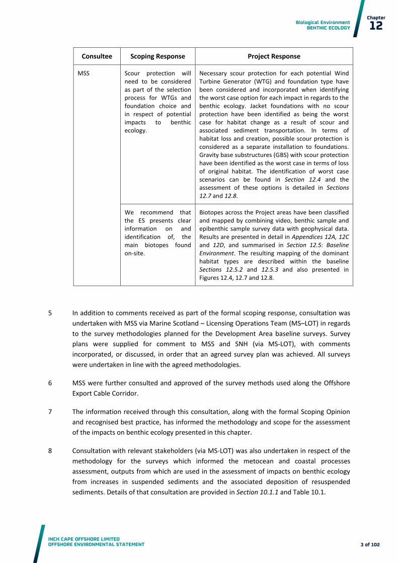
MSS Scour protection will need to be considered as part of the selection process for WTGs and foundation choice and in respect of potential impacts to benthic ecology.
Necessary scour protection for each potential Wind Turbine Generator (WTG) and foundation type have been considered and incorporated when identifying the worst case option for each impact in regards to the benthic ecology. Jacket foundations with no scour protection have been identified as being the worst case for habitat change as a result of scour and associated sediment transportation. In terms of habitat loss and creation, possible scour protection is considered as a separate installation to foundations. Gravity base substructures (GBS) with scour protection have been identified as the worst case in terms of loss of original habitat. The identification of worst case scenarios can be found in Section 12.4 and the assessment of these options is detailed in Sections 12.7 and 12.8.
We recommend that the ES presents clear information on and identification of, the main biotopes found on-site.
Biotopes across the Project areas have been classified and mapped by combining video, benthic sample and epibenthic sample survey data with geophysical data. Results are presented in detail in Appendices 12A, 12C and 12D, and summarised in Section 12.5: Baseline Environment. The resulting mapping of the dominant habitat types are described within the baseline Sections 12.5.2 and 12.5.3 and also presented in Figures 12.4, 12.7 and 12.8.
In addition to comments received as part of the formal scoping response, consultation was 5
undertaken with MSS via Marine Scotland – Licensing Operations Team (MS–LOT) in regards
to the survey methodologies planned for the Development Area baseline surveys. Survey
plans were supplied for comment to MSS and SNH (via MS-LOT), with comments
incorporated, or discussed, in order that an agreed survey plan was achieved. All surveys
were undertaken in line with the agreed methodologies.
MSS were further consulted and approved of the survey methods used along the Offshore 6
Export Cable Corridor.
The information received through this consultation, along with the formal Scoping Opinion 7
and recognised best practice, has informed the methodology and scope for the assessment
of the impacts on benthic ecology presented in this chapter.
Consultation with relevant stakeholders (via MS-LOT) was also undertaken in respect of the 8
methodology for the surveys which informed the metocean and coastal processes
assessment, outputs from which are used in the assessment of impacts on benthic ecology
from increases in suspended sediments and the associated deposition of resuspended
sediments. Details of that consultation are provided in Section 10.1.1 and Table 10.1.

Biological Environment BENTHIC ECOLOGY
INCH CAPE OFFSHORE LIMITED OFFSHORE ENVIRONMENTAL STATEMENT
Chapter
12
4 of 102
12.3 Policy and Plans
Relevant policies and plans are introduced in Chapter 2: Policy and Legal Background, the 9
descriptions below provide an overview of how these specifically relate to benthic ecology.
UK Marine Policy Statement (Her Majesty’s (HM) Government, 2011). To ensure
responsible and sustainable use of the marine environment, developers must ensure
that environmental and social impacts of their operations are assessed with this in mind.
Under this statement, the United Kingdom (UK) aims to ensure a halting and, if possible,
a reversal of biodiversity loss with species and habitats operating as a part of healthy,
functioning ecosystems; and the general acceptance of biodiversity’s essential role in
enhancing the quality of life, with its conservation becoming a natural consideration in
all relevant public, private and non-governmental decisions and policies.
Scotland's National Marine Plan: Pre-Consultation Draft (Scottish Government, 2011)
The National Marine Plan is a major component of the Marine (Scotland) Act 2010 and
will aim to ensure sustainable economic growth of marine industries, while taking the
environment into account. Under this plan developments should aim to avoid harm to
marine ecology, biodiversity and geological conservation interests, including through
location, mitigation and consideration of reasonable alternatives. Furthermore, proper
weighting should be applied to designated sites of conservation importance, species and
habitats of importance for the conservation of biodiversity and to species designated to
be under statutory protection (e.g. via the European Union (EU) Directive 92/43/EEC
(the Habitats Directive).
12.4 Design Envelope and Embedded Mitigation
The potential development parameters and scenarios are defined as a Design Envelope and 10
presented in Chapter 7: Description of Development. The assessment of potential impacts on
benthic ecology is based upon the worst case scenario as identified from this Design
Envelope, and is specific to the potential impacts assessed in this chapter.
Key parameters for the worst case scenario for each potential impact are detailed in Tables 11
12.2 and 12.3 below. For this assessment these include consideration of the design,
construction and operation of: Wind Turbine Generators (WTGs), meteorological masts (met
masts), foundations and substructures, Offshore Substation Platforms (OSPs), inter-array
cables and Export Cables.

Biological Environment BENTHIC ECOLOGY
INCH CAPE OFFSHORE LIMITED OFFSHORE ENVIRONMENTAL STATEMENT
Chapter
12
5 of 102
Table 12.2: Worst Case Scenario Definition –Development Area
Potential Impact Design Envelope Scenario Assessed
Construction (and Decommissioning)
Direct temporary disturbance of seabed habitats caused by construction based activities
Total seabed area disturbed is 5.54 km2, equating to 3.69% of the
Development Area resulting from:
seabed preparation for 213 WTGs with GBS selected as having the largest disturbance footprint (125 m dredge effected diameter);
seabed preparation for five OSPs with GBS selected as having the largest area disturbance footprint (300 m dredge effected diameter);
seabed preparation for three met masts with GBS selected as having the largest area disturbance footprint (125 m dredge effected diameter);
353 kilometres (km) Inter-array cable installation with a trench affected width of six metres as the widest possible area of disturbance;
jack up vessel with disturbance footprint per jack up vessel of 600 m2 and three visits per foundation installation/decommissioning required for WTGs, OSPs and met masts; and
vessel anchorage disturbance from 5 m2 anchor footprints deployed at 500 m intervals along the 353 km of inter-array cable.
Indirect impacts of temporary increases in suspended sediment concentrations (SSC) from construction based activities, and associated deposition
Model outputs of anticipated worst case SSC, deposition and sediment transportation from energetic means (cable) and dredging (foundations) are detailed in Section 10.4. Chapter 10 also describes the methodology by which worst case has been identified. Assessment includes:
suspended sediments arising from seabed preparations and installations for 213 WTGs, five OSPs and three met masts with GBS foundation types; and
suspended sediments arising from inter-array cable burial using energetic means (excavated trench 353 km long, one metre wide and two metres depth) as recognised as representing the worst case as described in Section 10.1.3.
Release of contaminants bound in sediments
Sediment release as per ‘Indirect impacts of temporary increases in suspended sediment concentrations (SSC) from construction based activities, and associated deposition’ impact (above).
Contaminant levels as described in the baseline Section 12.5.
Secondary impacts of decreased primary production due to increased SSC within the water column
Sediment release as per ‘Indirect impacts of temporary increases in suspended sediment concentrations (SSC) from construction based activities, and associated deposition’ impact (above).

Biological Environment BENTHIC ECOLOGY
INCH CAPE OFFSHORE LIMITED OFFSHORE ENVIRONMENTAL STATEMENT
Chapter
12
6 of 102
Potential Impact Design Envelope Scenario Assessed
Potential release of pollutants from construction plant
Sources from vessels and plant associated with the construction of WTGs, OSPs, inter-array cables, and associated works.
Introduction of Non Indigenous Species (NIS)
Introduction from vessels and plant associated with the installation of WTGs, OSPs, inter-array cables, and associated works.
Operation
Loss of original habitat
Total loss of original habitat is 1.87 km2, equating to 1.25% of the
Development Area resulting from:
seabed preparation for 213 WTGs with GBS selected as having the largest footprint (95 m diameter including scour protection);
seabed preparation for five OSPs with GBS selected as having the largest footprint (180 m diameter including scour protection);
seabed preparation for three met masts with GBS selected as having the largest footprint (95 m diameter including scour protection); and
maximum 10% protection on the 353 km inter-array cable installation with protection width of six metres as the widest possible area of disturbance.
Changes in tidal regime and associated sediment transport
Model outputs of predicted changes to hydrodynamics (Chapter 10) resulting from WTGs, met masts and OSPs. GBS foundations have been identified as being the worst case for impacts on tidal regime.
Scour and associated sediment transportation leading to changes in habitats
Model outputs of predicted scour effects (Chapter 10) resulting from WTGs, met masts and OSPs. Jacket foundations with no scour protection have been identified as being the worst case for impacts on scour and associated sediment transportation.
Colonisation of introduced substrata leading to a change in the benthic ecology and/or biodiversity
Introduction of new substrate available for colonisation from infrastructure as described in ‘loss of original habitat’ above.
Provision of Introduced Substrata Facilitating Spread of NIS
Introduction of new substrate available for colonisation from infrastructure as described in ‘loss of original habitat’ above.
Potential release of pollutants from operation plant
Sources from vessels and plant associated with the operation and maintenance of WTGs, OSPs, inter-array cables, and associated works.
Responses to electromagnetic fields and thermal emissions
Total Inter-array cable length of 353 km suitably buried and protected where burial is not feasible. Longest length and shallowest burial, or protection, recognised as the worst case in terms of electromagnetic fields (EMF) exposure.

Biological Environment BENTHIC ECOLOGY
INCH CAPE OFFSHORE LIMITED OFFSHORE ENVIRONMENTAL STATEMENT
Chapter
12
7 of 102
Potential Impact Design Envelope Scenario Assessed
Temporary habitat disturbance from operations and maintenance (O&M) activities
Area of seabed disturbed annually is 0.14 km2, equating to 0.09% of
the Development Area resulting from:
jack up vessel with disturbance footprint per vessel of 600 m2 and one visit per foundation (WTGs, OSPs and met masts) every five years;
vessel anchorage disturbance from 5.0 m2 anchor footprints deployed at 500 m intervals along the 353 km of inter-array cable; and
inter-array cable reburial assuming maximum of 10% reburial during operation of the total 353 km with a trench affected area of six metres as the widest possible area of disturbance.
Table 12.3: Worst Case Scenario Definition – Offshore Export Cable Corridor
Potential Impact Design Envelope Scenario Assessed
Construction (and Decommissioning)
Direct temporary disturbance of seabed habitats caused by construction based activities
Sub-tidal area of seabed disturbed across export cable corridor is 3.02 km
2 (3.0% of Offshore Export Cable Corridor) resulting from the
export cable installation:
AC selected as worst case as it utilises the largest possible number of cables i.e. six DC options utilises less cables than AC;
maximum cable length for each of the six cables is approximately 83 km; and
each of the six cables are installed in a separate trench resulting in six trenches in total.
Intertidal area disturbed at the Cockenzie beach landfall option is 2,216 m
2 which equates to 2.0% of total beach area (measured from
the Cockenzie Power station to East Cuthill Rocks) resulting from:
the cable corridor width which is disturbed by installation equipment which is six metres for each of the six trenches i.e. 36 m in total.
two jointing pits estimated at 100 m2 each within the intertidal area; and
tidal range at widest point of the beach, and therefore cable length across the intertidal area of 56 m.
Intertidal Area disturbed at Seton Sands beach landfall option is 14,636 m
2 which equates to 1.1% of total beach area measure from
Wrecked Craigs to Fenny Ness resulting from:
the cable corridor width which is disturbed by installation equipment which is six metres for each of the six trenches;
two jointing pits estimated at 100 m2 each; and
tidal range at widest point of the beach, and therefore cable length across the intertidal area of 401 m.
Biological Environment BENTHIC ECOLOGY
INCH CAPE OFFSHORE LIMITED OFFSHORE ENVIRONMENTAL STATEMENT
Chapter
12
8 of 102
Potential Impact Design Envelope Scenario Assessed
Mechanical Cutting utilised in any of the intertidal areas where there are rocky habitats.
Indirect impacts of temporary increases in SSC from construction based activities and associated deposition
Model outputs of anticipated SSC, deposition and sediment transportation from installation of the cable by energetic means (Chapter 10).
Release of contaminants bound in sediments
Sediment release as per ‘Indirect impacts of temporary increases in SSC from construction based activities and associated deposition’ impact (above).
Contaminant levels as per baseline characterisation in Section 12.5.3.
Secondary impacts of decreased primary production due to increased SSC within the water column
Sediment release as per ‘Indirect impacts of temporary increases in SSC from construction based activities and associated deposition’ impact (above).
Potential release of pollutants from construction plant
Sources from vessels and plant associated with the construction of Export Cable and associated works.
Introduction of NIS Introduction from vessels and plant associated with the construction of Export Cable and associated works.
Operation
Loss original of habitat
Total area of original habitat loss = 0.6 km2 resulting from:
Protection of 20% of each of the 83 km long Export Cables.
Protection material 6.0 m wide.
Colonisation of introduced substrata leading to a change in the benthic ecology and/or biodiversity
Introduction of new substrate available for colonisation from Export Cable protection which is predicted to be installed on a maximum of 20% of the total cable length for each cable.
Provision of Introduced Substrata Facilitating Spread of NIS
Introduction of new substrate available for colonisation from Export Cable protection which is predicted to be installed on a maximum of 20% of the total cable length for each Export Cable.
Potential release of pollutants from construction plant e.g. from accidental spillage/leakage or sacrificial anodes
Source from vessels and plant associated with the O&M of Export Cables, and associated works.
Responses to EMF and thermal emissions associated with cabling
Total Export Cable length of approximately 83 km for each six cables, suitably buried to a target depth of 1.0 m and protected where burial is not practicable.

Biological Environment BENTHIC ECOLOGY
INCH CAPE OFFSHORE LIMITED OFFSHORE ENVIRONMENTAL STATEMENT
Chapter
12
9 of 102
Potential Impact Design Envelope Scenario Assessed
Temporary habitat disturbance from O&M activities
Annual disturbance from Export Cable reburial is 0.007 km2
equating to 0.005% of the Export Cable Corridor. This results from a maximum predicted reburial of 10% of the 83 km Export Cable length for each of the six cables during the operational phase.
Embedded Mitigation
A range of Embedded Mitigation measures to minimise environmental effects are captured 12
within the Design Envelope (see Section 4.5.2). The assessment of effects on benthic ecology
has taken account of the following Embedded Mitigation measures:
Vessels and plant relating to construction, operation and decommissioning activities will
follow best practice and guidance for pollution at sea, detailed in the final Environmental
Management Plan (EMP) to reduce and coordinate response to pollution events if they
were to occur. The final EMP will follow OSPAR, IMO and MARPOL guidelines and
industry best practices regarding pollution at sea, this includes provision for storage of
pollutants and identifies products suitable for use in the marine environment. The EMP
will be finalised prior to construction;
The risk of invasive species introduction will be managed through prevention methods
by following best practice, for example the International Convention for the Control and
Management of Ships’ Ballast Water and Sediments (BWM), and the Scottish Code of
Practice on non-native species. Details will be confirmed in the EMP prior to
construction;
Cables will be suitably buried or will be protected by other means when burial is not
practicable which will reduce the impacts of loss of original habitat; and
For any drilling activities, reversed circulation (air), sea water, water based mud, or
synthetic (biodegradable) oil will be used. These compounds have been shown to have
reduced environmental impacts over traditional oil based muds. For example, studies at
some offshore drilling platforms using water-based drilling mud’s have found no adverse
effects (Daan and Mulder, 1996).
These measures would be delivered as part of the Project (see Appendix 7A). 13
12.5 Baseline Environment
To describe the baseline environment the following activities were undertaken: 14
An initial review of existing benthic survey data and desk based studies was carried out.
Subsequently Project specific surveys, commissioned by Inch Cape Offshore Limited
(ICOL), were conducted using marine ecological techniques.
Baseline data as described in Table 12.4 were then used to characterise and map the
marine communities and to identify the location of any sensitive features present (e.g.
Annex 1 features of the Habitats regulations, or Priority Marine Features (PMFs)).

Biological Environment BENTHIC ECOLOGY
INCH CAPE OFFSHORE LIMITED OFFSHORE ENVIRONMENTAL STATEMENT
Chapter
12
10 of 102
Key data sources including existing data and those commissioned by the Project are 15
highlighted in Table 12.4, and results are summarised below within the sections for the
Development Area (Section 12.5.2) and Offshore Export Cable Corridor (Section 12.5.3)
baselines. Full details are presented in the Baseline Reports Appendix 12A, Appendix 12B,
Appendix 12C, and Appendix 12D.
Table 12.4: Key Data Sources (full References can be found in the References Section)
Data Source Area of Research
Existing Data
Marine Scotland (pers. comm. 2012)
Contaminant data for Bell Rock disposal ground.
The Marine Nature Conservation Review (MNCR) of East Scotland (Brazier, 1998)
Provides information on the benthic environments in proximity to the Development Area and Offshore Export Cable Corridor.
2004 Strategic Environmental Assessment (SEA) for region 5 (Eleftheriou et al., 2004)
Provides information on the benthic environments in proximity to the Development Area and Offshore Export Cable Corridor.
Clean Seas Environment Monitoring Programme (CSEMP, 2012)
Contaminant data for monitoring station at Montrose Bank and along the east coast of Scotland.
EUSeaMap - Mapping European Seabed Habitats (MESH, 2012)
EU seabed predictive mapping and benthic survey data.
Site Specific Surveys/analysis
Osiris Hydrographic & Geophysical Projects Limited (Osiris Projects) and iXsurvey Limited
Geophysical survey data of Development Area and Offshore Export Cable Corridor.
AMEC on behalf of ICOL Benthic and Epibenthic surveys as described in and 12.5.2 and shown in Figures 12.2 and 12.3.
Envision on behalf of ICOL Geophysical data interpretation and habitat mapping.
EMU on behalf of Neart na Gaoithe offshore wind farm export cable (collected in 2009, reported in 2010)
Intertidal survey at cable landing locations within the Offshore Export Cable Corridor.
Benthic survey along within and in the vicinity of the Offshore Export Cable Corridor, survey extent highlighted in Figure 12.6.
(Note: these surveys were originally carried out for the Neat na Gaoithe project but overlapped the Offshore Export Cable Corridor and so were used for the ICOL analysis).

Biological Environment BENTHIC ECOLOGY
INCH CAPE OFFSHORE LIMITED OFFSHORE ENVIRONMENTAL STATEMENT
Chapter
12
11 of 102
Data Source Area of Research
EMU on behalf of ICOL (2012) Benthic surveys along Offshore Export Cable Corridor as described in Section 12.5.3.
Intertidal surveys at cable landing locations within the Offshore Export Cable Corridor as described in Sections 12.5.3.
Intertek Metoc on behalf of ICOL
Metocean and coastal process modelling as described in Chapter 10.
Envision on behalf of Forth and Tay Offshore Wind Developers Group
Interpretation of benthic and geophysical data for biotope classification and mapping in order that all cumulative Firth of Tay and Forth Developments (Inch Cape, Neart na Gaoithe and Firth of Forth Phase 1 (Alpha and Bravo) have comparable benthic analysis.
12.5.1 Regional Study Area
The Regional Study Area used to define the baseline environment, was selected to 16
encompass the Development Area and Offshore Export Cable Corridor, and adjacent seabed
areas within a single spring tide excursion of the Development Area and Offshore Export
Cable Corridor (see Figure 12.1). Offshore habitats that encompass the cumulative
development sites, namely the Firth of Forth and Neart ne Gaoithe offshore developments
(Figure 12.1) were also included.
Figure 12.1: Regional Study Area
Biological Environment BENTHIC ECOLOGY
INCH CAPE OFFSHORE LIMITED OFFSHORE ENVIRONMENTAL STATEMENT
Chapter
12
12 of 102
12.5.2 Development Area
A detailed benthic ecology baseline technical report, reviewing existing data and desk 17
studies and reporting site specific surveys, has been produced for the Development Area
and is attached as Appendix 12A. An overview of this report is presented below. Throughout
the document biotopes are referenced using their classification codes and not their full
classification titles. This is usual practice as the descriptive nature of full classification titles
makes it impractical to replicate them for every reference. Full titles are referenced on first
use and can be found in the glossary section.
Existing Data
The Marine Nature Conservation Review (MNCR) of East Scotland (Brazier, 1998) provides 18
information on the benthic environments in proximity to the Development Area. In addition,
a number of scientific papers which describe the benthic and epibenthic community
composition over large areas of the North Sea have been reviewed in the 2004 Strategic
Environmental Assessment (SEA) for region 5 (Eleftheriou et al., 2004) (which spans the
Development Area). Typically, the offshore environment has been studied to a lesser degree
than the inshore environment, with the main body of information focused around Bell Rock
sewage sludge disposal ground, which is located partially within the Development Area,
Figure 12.2. Relevant local information is also available from the long term benthic
monitoring records of the Clean Seas Environmental Monitoring Programme (CSEMP, 2012)
and the United Kingdom Offshore Operators Association (UKOOA), as well as specific studies
for the Mapping European Seabed Habitats (MESH, 2012) project.
MESH identifies the Development Area as deep circalittoral sand and coarse sediment, with 19
areas of circalittoral coarse sediment and fine or muddy sand. This predictive information is
supported by survey data collected by Envision Mapping in 2003, which identified the
biotope Mysella bidentata and Thyasira spp. in circalittoral muddy mixed sediment
(SS.SMx.CMx.MysThyMx) at the sampling locations which coincide with the southern end of
the Development Area. Monitoring at Bell Rock disposal ground provides long term benthic
data within the Development Area, and shows a polychaete and bivalve dominated habitat
with occasional opportunistic species present (SEA 5, 2004).
Contaminated sediment levels within the Development Area are also available as a result of 20
monitoring at the Bell Rock disposal ground. The most recent data from a survey,
undertaken in 2002, shows generally low levels of contaminants, with some elevation of
heavy metals but no strong temporal variations of trace metals in surface sediments either
during or post disposal operations, which indicates the highly dispersive nature of the area
(Hayes et al., 2005).
Site Specific Surveys
The survey area consisted of the Development Area, an area within a single tidal excursion 21
from the Development Area, and discreet reference stations outside of the tidal excursion.
This is in accordance with the Guidelines for the Conduct of Benthic Studies at Marine
Aggregate Extraction Sites (Ware and Kenny, 2011).

Biological Environment BENTHIC ECOLOGY
INCH CAPE OFFSHORE LIMITED OFFSHORE ENVIRONMENTAL STATEMENT
Chapter
12
13 of 102
In advance of the survey consultation with Marine Scotland was undertaken to develop an 22
agreed survey methodology and programme. Detailed methodologies and full results of the
survey are included in Sections 12A.2 and 12A.3 of Appendix 12A and Sections 12B.2 and
12B.3 of Appendix 12B with the survey results summarised below. The benthic survey was
undertaken between 19 March 2012 and 25 May 2012. Sampling stations are shown in
Figure 12.2 and 12.3, and Table 12.5 below and consisted of the following elements:
Drop Down Video (DDV) at 124 stations;
Benthic grabs (including sub-sampling for contaminant analysis, particle size analysis
(PSA) and total organic carbon (TOC) analysis) at 87 stations; and
Epibenthic trawls at 24 stations.

Biological Environment BENTHIC ECOLOGY
INCH CAPE OFFSHORE LIMITED OFFSHORE ENVIRONMENTAL STATEMENT
Chapter
12
14 of 102
Table 12.5: Summary of Survey Campaign
Development Area Tidal Excursion Control Total
Stations Replicates Total Samples
Stations Replicates Total Samples
Stations Replicates Total Samples
Stations Total Samples
Benthic Grab
74 Single 74 7 Triplicate 21 6 Triplicate 18 87 113
Drop Down Video
108 Single 108 8 Single 8 8 Single 8 124 124
Epibenthic Trawls
20 Double 40 2 Triplicate 6 2 Triplicate 6 24 52

Biological Environment BENTHIC ECOLOGY
INCH CAPE OFFSHORE LIMITED OFFSHORE ENVIRONMENTAL STATEMENT
Chapter
12
15 of 102
Figure 12.2: Benthic Survey Stations
Figure 12.3: Epibenthic Trawl Survey Stations

Biological Environment BENTHIC ECOLOGY
INCH CAPE OFFSHORE LIMITED OFFSHORE ENVIRONMENTAL STATEMENT
Chapter
12
16 of 102
Results – Physical Environment
Data from the geophysical survey, ground-truthed by the PSA data from grab sampling and 23
DDV footage indicated that overall, the Development Area consisted of circalittoral sands
and gravelly sands with areas of muddy mixed sediment.
Results – Epibenthic Communities
The epibenthic survey data from two metre beam trawls confirmed the assignment of 24
coarse and mixed sediment communities. Catches were dominated by epibenthic species
typical of these habitats, i.e. dead man’s fingers (Alcyonium digitatum), horned wrack
(Flustra folicacea), brittlestars (Ophiothrix fragilis), hydroids (e.g. Hydrallmania falcata) and a
number of small fish and mobile benthic invertebrates.
Results – Biotope Classification
Through the various benthic survey methods applied across the Development Area, biotopes 25
were identified, with the majority of the sedimentary habitat across the Development Area
classified as the circalittoral mixed sediment biotope ‘Mysella bidentata and Thyasira spp. in
circalittoral muddy mixed sediment (SS.SMx.CMx.MysThyMx)’.
The biotopes identified through the supervised classification of geophysical and benthic data 26
as present across the Development Area are detailed in Table 12.6 and Figure 12.4.
Table 12.6: Biotopes Present within the Development Area
Biotope Area (km2) % of Survey Area*
% of Development Area
SS.SCS.CCS.MedLumVen 8 4 4
SS.SCS.OCS 62 31 33
SS.SMx.CMx.MysThyMx 132 65 62
*The geophysical survey area included a buffer around the Development Area and so the
Survey Area is slightly larger than the Development Area.
Results – Habitats and Species of Conservation Importance
The following habitats and species of conservation importance have been noted as present 27
within the Development Area:
(SS.SCS.OCS), is regarded as a conservation priority in the UK Post-2010 Biodiversity
Framework (JNCC and Defra, 2012);
Venerid bivalves in circalittoral coarse sand or gravel (SS.SCS.CCS.MedLumVen) is listed
under the EC Directive 92/43/EEC (the habitats directive) as part of the features:
sandbanks which are slightly covered by sea water all the time, large shallow inlets and
bays and estuaries; and
Biological Environment BENTHIC ECOLOGY
INCH CAPE OFFSHORE LIMITED OFFSHORE ENVIRONMENTAL STATEMENT
Chapter
12
17 of 102
The Icelandic cyprine, Arctica islandica, a PMF and listed under OSPAR’s list of
threatened and/or declining species(OSPAR, 2008b), was recorded at moderate
abundances across the Development Area (0-5000 individuals per 100 m2). All
individuals recorded were juveniles, but were greater than one millimetre (mm)in
diameter.
No evidence of any Annex I biogenic reef features were observed during any of the surveys 28
carried out across the Development Area. A number of reef forming polychaetes were
recorded (Sabellaria spinulosa and Serpula vermicularis), as was a single individual of
Modiolus modiolus. These species are of high conservation importance when in reef form;
no reef features were observed, and therefore they are not considered further in the
assessment.
The proposed Marine Protection Area (MPA), the Firth of Forth Banks Complex, is an option 29
for the designation for sands and gravels, Arctica islandica, and shelf banks and mounds.
This proposed MPA sits to the east of the Development Area, approximately one kilometre
(km) distant at its nearest point. Where impacts have the potential to affect this proposed
MPA they have been identified within this Environmental Impact Assessment.
A number of Special Area of Conservation (SAC) including the Isle of May, Firth of Tay and 30
Eden Estuary, Moray Firth and the River Tay, which cite Annex I habitats as their qualifying
conservation have been detailed in Chapter 9. However, there is no potential connectivity
with these SACs and the Development Area relating to Benthic Ecology or Annex I habitat
interests due to their remoteness and the limited range of direct or indirect effects.
Connectivity with the Offshore Export Cable Corridor is discussed in Section 12.5.3.
The Aberlady Bay Local Nature Reserve (LNR) includes features of interest relevant to the 31
Benthic Ecology assessment. However as with the SACs there is no potential connectivity
with the Development Area due to their remoteness and range of effects.
Results – Contaminated Sediments
Results of the sediment chemistry analyses showed that TOC and sulphide was low at all 32
stations, with TOC below 0.4 per cent and sulphide below 17 mgkg-1. Polycyclic Aromatic
Hydrocarbons (PAHs), Polychlorinated Biphenyls (PCBs) and organotins were also low across
the Development Area, with concentrations below Cefas Action Levels (AL), Canadian
Sediment Quality Guidelines and Dutch Standards (defined in Appendix 12B). Arsenic,
cadmium, chromium, copper, and nickel concentrations exceeded Cefas AL 1.
Additionally, nickel and cadmium concentrations exceeded Cefas AL 2 at five locations 33
(Figure 12.2) but on re-analysis of a duplicate sample these values were not reached1
(Marine Scotland, 2012). As described in Appendix 12A levels of all contaminants were
spatially variable across the Development Area and there are no identified areas of
1 Through consultation with MS it was agreed that these levels were anomalous and could therefore be
removed from the impact assessments. Email correspondence 5 November 2012.

Biological Environment BENTHIC ECOLOGY
INCH CAPE OFFSHORE LIMITED OFFSHORE ENVIRONMENTAL STATEMENT
Chapter
12
18 of 102
enhanced contamination, despite the presence of the historical disposal ground at Bell Rock
(located partially within the Development Area).
Figure 12.4: The Development Area Biotope Map
12.5.3 Offshore Export Cable Corridor
A detailed benthic ecology baseline technical report, reviewing existing data and desk 34
studies, and reporting on site specific surveys, has been produced for the Offshore Export
Cable Corridor and is attached as Appendix 12C. An overview of this report is presented
below.
Existing Data
The benthic environment along the Offshore Export Cable Corridor is relatively well 35
documented, with a number of studies and surveys having been carried out in the Firth of
Forth, including the Clean Seas Environmental Monitoring Programme (CSEMP, 2012)which
showed a very impoverished fauna as present within the Firth of Forth (Eleftheriou et al.,
2004). Predictive mapping (MESH) highlights the variety of habitats that coincide with the
Offshore Export Cable Corridor. Also, recent survey data, from the previous Cockenzie cable
option investigated in 2009 for the Neart na Gaoithe offshore wind farm, also exists and has
been made available to ICOL.
Existing data shows the substrates in the Forth estuary to be mainly sedimentary, with 36
species diversity increasing with increasing salinity and depth offshore. Deep circalittoral
sand and mud habitats intersect the Offshore Export Cable Corridor for the majority of its

Biological Environment BENTHIC ECOLOGY
INCH CAPE OFFSHORE LIMITED OFFSHORE ENVIRONMENTAL STATEMENT
Chapter
12
19 of 102
length, together with circalittoral sandy or fine mud. Infralittoral sandy or fine muds coincide
with the Offshore Export Cable Corridor closer inshore, with a number of other broad-scale
habitat types also represented, including circalittoral rock, and circalittoral and infralittoral
fine muddy sand.
A number of sites, designated for nature conservation are intercepted by the Offshore 37
Export Cable Corridor. These sites are detailed in Chapter 9: Designated Nature Conservation
Sites. The Isle of May Special Area of Conservation (SAC) is designated in relation to sub-tidal
benthic features, with rocky reefs surrounding the island. Impacts that have the potential to
interact with the characterising features of this SAC are identified within the assessment. A
number of other SACs detailed in Chapter 9 cite Annex I habitats as their qualifying
conservation interests, including the Firth of Tay and Eden Estuary , the Moray Firth and the
River Tay. There is no potential connectivity with these SACs and the Offshore Export Cable
Corridor relating to Benthic Ecology or Annex I habitat interests due to their remoteness and
the limited range of direct or indirect effects.
The Aberlady Bay LNR includes features of interest relevant to the Benthic Ecology 38
assessment. The distance from Aberlady Bay to the Offshore Export Cable Corridor is
approximately 1.5 km at the closest point, and so there will be no direct impacts on the LNR.
Indirect impacts that have the potential to interact with the features of interest of this LNR
are identified within the assessment.
JNCC and SNH have identified one potential nature conservation Marine Protected Area in 39
the vicinity of the Development Area, the Firth of Forth Banks Complex. Arctica islandica has
been identified as a PMF in this location. Impacts that have the potential to interact with the
PMF within this MPA are identified within the assessment. The Firth of Forth Site of Special
Scientific Interest covers large areas of the Firth of Forth (including the Offshore Export
Cable landfall options, at Cockenzie and Seton Sands) with the marine Notified Natural
Features of mudflats and saltmarsh within its boundary. None of these Notified Natural
Features are present at the landfall options and as such, no impacts to these features are
predicted. Impacts to the habitats present at the landfall points are covered within the
Impact Assessment, with baseline conditions discussed below.
Where there is potential for indirect impacts on designating features of a European site, 40
other than benthic ecology interests, these are considered in the Chapter 13, Chapter 14:
Marine Mammals and Chapter 15: Ornithology.
Site Specific Survey
MSS was consulted and agreed with survey methodologies prior to commencement. The 41
survey methods and results are presented in full in Appendix 12C, and consisted of:
Intertidal biotope mapping surveys at the cable landfall options at Cockenzie and Seton
Sands (Figure 12.5), and
Sub-tidal surveys within and in proximity to the Offshore Export Cable Corridor (Figure
12. 6) including;

Biological Environment BENTHIC ECOLOGY
INCH CAPE OFFSHORE LIMITED OFFSHORE ENVIRONMENTAL STATEMENT
Chapter
12
20 of 102
o DDV at 22 stations;
o DDV transects at 11 rock seabed stations; and
o Benthic grab sampling for PSA and contaminant sampling at 13 Stations.
In addition, existing seabed video footage and sediment particle size distribution data from a 42
further 37 stations were used to characterise habitats and associated communities along the
sub-tidal Offshore Export Cable Corridor. This data was sourced from the 2009 Neart na
Gaoithe survey.
Figure 12.5: Intertidal Survey Area

Biological Environment BENTHIC ECOLOGY
INCH CAPE OFFSHORE LIMITED OFFSHORE ENVIRONMENTAL STATEMENT
Chapter
12
21 of 102
Figure 12.6: Sub-tidal Survey Station Positions
Figure 12.6a: Sub-tidal Survey Station Positions (near Development Area)

Biological Environment BENTHIC ECOLOGY
INCH CAPE OFFSHORE LIMITED OFFSHORE ENVIRONMENTAL STATEMENT
Chapter
12
22 of 102
Figure 12.6b: Sub-tidal Survey Station Positions (Mid-section)
Figure 12.6c: Sub-tidal Survey Station Positions (Near-shore)

Biological Environment BENTHIC ECOLOGY
INCH CAPE OFFSHORE LIMITED OFFSHORE ENVIRONMENTAL STATEMENT
Chapter
12
23 of 102
Results - Intertidal Surveys
Cockenzie was divided into two main areas, one classified as hard substratum and one by 43
mixed substrata. The mixed substrate in the south of the surveyed area ranged from sandy
gravel on the upper to mid shore, to sandy gravel and cobbles on the mid to lower shore,
with small boulders present on the extreme low shore and sub-tidal area. Algal growth was
prevalent on the mid to lower shore with the presence of the biotope LR.FLR.Eph.BLitX,
whilst further down the shore LR.LLR.F.Fspi.X became more prevalent. The hard substrata in
the northern half of the Cockenzie survey area showed typical zonation for a rocky shore.
The biotope LR.MLR.BF.PelB was present on the upper shore, LR.HLR.MusB.Cht.Cht on the
mid shore and LR.MLR.BF.FspiB on the mid to lower shore leading to the kelp biotope of
IR.MIR.KR.Ldig.Ldig on the extreme low shore in addition to an area of soft sediment
classified as LS.LSa.MuSa.Lan.
Previous sampling (EMU, 2010), at the northern area of the Cockenzie landfall option, also 44
identified a mussel bed (LS.LBR.LMus.Myt.Mx) represented as a thin band of mussels (a few
metres wide) on mid shore mixed cobble and gravel substrates. During the EMU (2012)
survey this habitat was not present, suggesting that this is likely to have been a naturally
ephemeral feature (Appendix 12C).
The Seton Sands survey area consisted predominantly of fine sand habitats, though a small 45
area of hard substrata, classified as LR.LLR.F.FSpi.FS, occurred within a fine sand biotope on
the upper shore. A series of upper to mid shore mobile sand banks (LS.LSa.MoSa.AmSco.Sco)
led to a large mid to low shore polychaete dominated biotope (LS.LSa.FiSa.Po). Polychaete
worms were present in large numbers down into the low shore but the bivalve mollusc,
Angulus tenuis, was present in sufficient numbers on the extreme low shore for the
LS.LSa.FiSa.Po biotope to be further classified to LS.LSa.FiSa.Po.Aten.
Results – Sub-tidal Survey
Combination of the EMU (2010) and EMU (2012) samples showed that the predominant 46
sediment type present along the Offshore Export Cable Corridor was slightly gravelly muddy
sand, with slightly gravelly sand and slightly gravelly sandy mud making up the majority of
the remaining sediment classes. Sediments tended to be slightly coarser towards the
offshore limit of the Offshore Export Cable Corridor. The dominant mud/sand biotope
present along the Offshore Export Cable Corridor was classed as SS.SMu.CFiMu.SpnMeg.
Towards the intertidal, sediments became more heterogeneous and were classified as IMx
and CMx derived biotopes.
Further interpretation of the Offshore Export Cable Corridor survey data was carried out by 47
Envision in order to collate it with the Development Area data, Figures 12.7 and 12.8. This
interpretation used the ICOL commissioned geophysical data, alongside the benthic survey
data (EMU 2010, 2012).

Biological Environment BENTHIC ECOLOGY
INCH CAPE OFFSHORE LIMITED OFFSHORE ENVIRONMENTAL STATEMENT
Chapter
12
24 of 102
Results – Contaminated Sediments
Contaminant samples (analysis of total PAH, metals and organotin (Tributyltin (TBT)) 48
compounds) were combined with results from 2009. In general, levels of PAHs were below
the available Cefas AL for this contaminant. A number of samples collected in the inshore
area approaching the Cockenzie landfall and at historic dumping grounds were found to
have relatively elevated PAH concentrations. Recent sampling showed metal contaminant
concentrations were variable, with Arsenic and Cadmium below Cefas AL1 for all sites,
Mercury, Copper, Lead and Zinc all with at least one site above AL1 and Nickel and
Chromium showing all sites above AL1. No site exceeded the Cefas AL2 for any metal.
In terms of spatial patterns, mercury concentrations were generally low offshore but 49
exhibited a gradient of increasing concentrations closer to the landfall points. Nickel
concentrations, however, showed no distributional pattern. The baseline survey showed
contamination levels within the Offshore Export Cable Corridor reflect the environmental
status of the Firth of Forth. Contaminants were found to be in higher concentrations near
shore. This is likely due to anthropogenic activity, for example there is a historic disposal
ground, Port Seton, along the Seton Sands inshore corridor and coastal and estuarine waters
typically receive contaminants via local anthropogenic activities and riverine inputs.
Results – Habitats and Species of Conservation Importance
A number of habitats and species of conservation were identified: 50
SS.SCS.CCS - Conservation priority in the UK Post-2010 Biodiversity Framework (Joint
Nature Conservation Committee (JNCC) and Department for Environment, Food and
Rural Affairs (Defra), 2012), identified in 2012, in the offshore environment of the
Offshore Export Cable Corridor;
SS.SMu.CFiMu.SpnMeg - Listed on the Scottish draft list of Priority Marine Features
(Howson et al., 2012) (Section 9.3.4), identified in the offshore environment of the
Offshore Export Cable Corridor;
Stony Reef – potential to be listed under the EC Directive 92/43/EEC (Habitats Directive)
as part of the feature: Annex I reef. However, examples identified have low resemblance
to Annex I reef criteria (Assessment of Reefiness within Appendix 12C); and
The Icelandic cyprine, Arctica islandica, is listed on OSPAR’s list of threatened and/or
declining species (OSPAR,2008b) and is an identified PMF of the potential MPA on the
Firth of Forth Banks Complex.
Potential Annex 1 rocky reef habitats were also identified during the current video surveys 51
around the Isle of May SAC (Figure 12.1). These habitats were represented by a mosaic of
biotopes), reflecting the local heterogeneity, including CR.MCR.EcCr.FaAlCr.Bri,
CR.MCR.EcCr.FaAlCr.ADig, CR.MCR.EcCr.FaAlCr.Pom, SS.SMx.CMx.FluHyd, and
SS.SMx.CMx.ClloMx.Nem. Although outside of the boundaries of the Offshore Export Cable
Corridor, these features may be considered to have particular sensitivity due to their
inclusion in, or connection to, designated sites identified in Chapter 9.

Biological Environment BENTHIC ECOLOGY
INCH CAPE OFFSHORE LIMITED OFFSHORE ENVIRONMENTAL STATEMENT
Chapter
12
25 of 102
Figure 12.7: The Offshore Export Cable Corridor Northern Biotope Map
Figure 12.8: The Offshore Export Cable Corridor Southern Biotope Map

Biological Environment BENTHIC ECOLOGY
INCH CAPE OFFSHORE LIMITED OFFSHORE ENVIRONMENTAL STATEMENT
Chapter
12
26 of 102
12.5.4 Guidance and Methods
Relevant information and guidance to the Benthic Chapter Assessments includes: 52
Cefas (2004). Offshore Wind Farms: guidance notes for Environmental Impact
Assessment in respect of FEPA and CPA requirements. Version 2.
www.cefas.co.uk/publications/files/
windfarm-guidance.pdf;
Defra (2005) Nature conservation guidance on offshore wind farm development.
http://www.defra.gov.uk/wildlife-countryside/ewd/windfarms/windfarmguidance.pdf;
Hendrick et al. (2006). Sabellaria spinulosa reef: a scoring system for evaluating
‘reefiness’ in the context of the EC Directive 92/43/EEC (Habitats Directive).
J.Mar.Biol.Ass.UK. 86: 665-677;
Gubbay (2007). Defining and Managing Sabellaria spinulosa Reefs: Report of an Inter-
agency Workshop. JNCC report No.405;
OSPAR (2008a). OSPAR Guidance on Environmental Considerations for Offshore Wind
Farm Development. www.ospar.org;
IEEM (2010). Guidelines for Ecological Impact Assessment in Britain and Ireland - Marine
and Coastal Consultation document. www.ieem.net;
Irving (2009). Identification of the Main Characteristics of Stony Reef Habitats under the
EC Directive 92/43/EEC (Habitats Directive). Summary of an Inter-agency Workshop 26-
27, March 2008. http://www.jncc.gov.uk/page-5023;
Limpenny et al. (2010). Best methods for identifying and evaluating Sabellaria spinulosa
and cobble reef. Aggregate Levy Sustainability Fund Project MAL0008. Joint Nature
Conservation Committee, Peterborough, 134 pp., ISBN - 978 0 907545 33 0;
Judd, 2012. Guidelines for data acquisition to support marine environmental
assessments for offshore renewable energy projects. CEFAS, Report ME5403 – Module
15: May 2012; and
Ware, S. J. and Kenny, A. J. (2011) Guidelines for the Conduct of Benthic Studies at
Marine Aggregate Extraction Sites 2nd Edition, Marine Aggregate Levy Sustainability
Fund, 80 pp.
12.5.5 Baseline without the Project
A review of previous data sets, mainly composed of those situated within the Bell Rock 53
disposal ground, and surveys as part of the MESH programme (situated within 10 km from
the Development Area) highlights that the environment surrounding the Project, has been
relatively stable in its sedimentary composition and contamination levels for up to 10 years,
with little change observed in the infaunal component for 10-20 years. Notable changes are
restricted to a reduction in opportunistic species such as Capitella sp. at the Bell Rock
disposal ground, indicating a general improvement of conditions at this historic disposal
ground. Recent contamination results obtained through the site specific surveys were also

Biological Environment BENTHIC ECOLOGY
INCH CAPE OFFSHORE LIMITED OFFSHORE ENVIRONMENTAL STATEMENT
Chapter
12
27 of 102
comparable to those recorded in 2002 at the Bell Rock disposal ground which suggests
stable levels over the last decade. Such analysis would also suggest that the existing baseline
conditions would prevail in the future, should no development occur.
Despite the relatively stable conditions highlighted above, the potential for effects as a 54
result of climate change introduces scope for change to baseline conditions (over the
Development Area and Offshore Export Cable Corridor).
While alterations to the functioning of marine ecosystems associated with climate change 55
across the Development Area and Offshore Export Cable Corridor, in the absence of the
Project, are difficult to predict, the response of the near shore environment to sea level rise
does allow for a more detailed assessment of potential change to the baseline conditions.
This scenario, summarised below, may occur in the absence of the Project as a result of the
effects of global climate change. Chapter 8: Benefits of the Project explains the positive
impacts of the Project on future climate change.
Sea levels along the coastline of the Forth Estuary predicted to rise by around 0.32 m –
0.58 m over the next 100 years (Firth et al., 1997; Forth Estuary Forum, 1999) which
suggest that some measurable rise in sea levels at the Offshore Export Cable landfall
options will occur in the absence of the Project, subject to the degree of actual warming.
Coastal “squeeze” may occur resulting in an overall loss in the total area of intertidal
habitat at the Cockenzie landfall option due to artificial sea defences. In contrast, the
low lying sand dune system backing the shore at Seton Sands is likely to result in little or
no reduction in the extent of intertidal habitat as a result of predicted sea level rises
during the life of the Project.
12.6 Assessment Methodology
12.6.1 Methodology
The impact assessment methods used within this chapter follow the principals and 56
approaches detailed in Chapter 4: Processes and Methodology, with further chapter specific
assessment parameters detailed below.
Magnitude of Effects
Assessment of the magnitude of effects uses a number of criteria, including the absolute 57
scale of the effect (e.g. proportion of habitat lost), its duration, its frequency, the relative
scale of the effect alongside documented benchmarks (e.g. those produced by the Marine
Life Information Network, MarLIN), the level of tolerance and vulnerability of the receptor to
that effect, and the recoverability after cessation of the impacting activity. This is
summarised in Table 12.7 below.

Biological Environment BENTHIC ECOLOGY
INCH CAPE OFFSHORE LIMITED OFFSHORE ENVIRONMENTAL STATEMENT
Chapter
12
28 of 102
Table 12.7: Magnitude of Effect
Category High Level Environmental Indicator
Corresponding Scale of Effect and Receptor Characteristics
High
Total loss or major alteration to key elements/features of the baseline conditions
Scale of Effect
>10% of Development Area or Offshore Export Cable Corridor, affected throughout the life of the Project.
Receptor
Loss of ecosystem function and/or receptor is highly intolerant and will not recover to baseline conditions within the life of the Project.
Moderate
Partial loss or alteration to one or more key elements/features of the baseline conditions
Scale of Effect 5-10% of Development Area or Offshore Export Cable Corridor, affected through operation.
Receptor
Receptor is intolerant and is lost to impact, however recovery is expected during the life of the Project.
Low Minor shift away from the baseline conditions
Scale of Effect 1-5% of Development Area or Offshore Export Cable Corridor. Occurs through construction.
Receptor
Receptor is modified but not lost. Substantial recovery of the receptor expected within five years of cessation of the effect but may take up to 10 years.
Negligible Very slight change from baseline conditions
Scale of Effect
<1% of Development Area or Offshore Export Cable Corridor. Potential to occur through construction/operational phase.
Receptor
Community level effects (e.g. diversity, richness) but characteristic and keystone species are expected to remain, recovery is expected to occur quickly and within one or a few years of cessation of the effect.
Sensitivity of Receptor
The Sensitivity of receptors has been assessed according to its conservation importance, its 58
relative abundance/spatial extent at geographical scales and its importance to the wider
ecological area (Table 12.8). The MarLIN sensitivity criteria are fully included within the

Biological Environment BENTHIC ECOLOGY
INCH CAPE OFFSHORE LIMITED OFFSHORE ENVIRONMENTAL STATEMENT
Chapter
12
29 of 102
assessment of impact magnitude above, and as such, the following assessment table for
receptor sensitivity is more akin to receptor value.
Table 12.8: Sensitivity of Receptor
Receptor Sensitivity Receptor Characteristics
High Receptor of high conservation importance (international) that also provides a key ecological function, and is rare in its abundance.
Moderate Receptors of high conservation importance (International) but with either a low ecological value or high abundances. Or, receptors of low conservation importance, yet with high ecological value or low abundances.
Low Receptors of medium conservation importance (National), yet with low ecological importance or high abundances. Or, Receptors of low conservation importance, with low ecological importance or high abundances.
Assessment of Impact Significance
The assessment of impact significance follows that described in Table 4.6. Impacts described 59
by Moderate/Major or Major are considered to be significant.
Consideration of Receptors
Receptors to be considered within the impact assessment were selected based upon analysis 60
of regional and site-specific survey data (see Section 12.5), their relative conservation and
ecological importance, and if they were highlighted as being of concern during consultation.
For this assessment, each biotope, as identified through the detailed habitat mapping
(Appendix 12D) is assessed, grouped according to their assigned sensitivity in relation to
their conservation importance and ecological niche (e.g. sub-tidal infaunal communities,
sub-tidal epibenthic communities, intertidal soft sediment communities, intertidal rocky
shore communities, intertidal biogenic reefs, etc.) as responses to impacts will be largely
consistent within these groups. Due to its internationally important conservation status
(JNCC, 2012 and OSPAR, 2008b), the bivalve Arctica Islandica is specifically highlighted
where impacts are likely on the population of this species. Where impacts on designated
sites (including proposed MPAs) are possible, these are identified within the Impact
Assessment below.
Table 12.9 and Table 12.10 highlight the qualification of the sensitivity assessment of each 61
receptor group for the Development Area and Offshore Export Cable Corridor respectively.
In addition, where wider biodiversity impacts are considered, e.g. in the assessment of non
indigenous species (NIS) on the wider ecology of the area, these have been assessed against
high level receptors accordingly, i.e. the wider benthic ecology of the region.

Biological Environment BENTHIC ECOLOGY
INCH CAPE OFFSHORE LIMITED OFFSHORE ENVIRONMENTAL STATEMENT
Chapter
12
30 of 102
Table 12.9: Sensitivity of Receptors in the Development Area
Receptor Grouping Sensitivity Qualification
SS.SMx.CMx.MysThyMx Offshore soft Sediments
Low Widely distributed habitat (recorded particularly along the east coast of southern Scotland and northern England), not considered of conservation importance or of key ecological importance for species outside this habitat (Rayment, 2008a).
SS.SCS.OCS
SS.SCS.CCS.MedLumVen
Offshore soft Sediments
Moderate Habitats of conservation importance (OCS is regarded as a conservation priority in the UK, whilst MedLumVen is listed under the EC Directive 92/43/EEC (Habitats Directive) as part of the features (Section 9.2): sandbanks which are slightly covered by sea water all the time, large shallow inlets and bays, and estuaries). These habitats are likely to provide a food source for predatory and opportunistic species, but are widely distributed throughout UK and offshore continental shelf.
A. islandica Key sensitive species
Moderate Species of International importance (listed on the threatened and/or declining OPSAR species list, and is a PMF in offshore waters). Provides an important food source, particularly for cod, but is abundant and widely distributed throughout UK coastal and offshore waters.
Table 12.10: Sensitivity of Receptors in the Offshore Export Cable Corridor
Receptor Grouping Sensitivity Qualification
Sub-tidal
SS.SMu.CFiMu.SpnMeg,
SS.SCS.CCS
Sub-tidal soft sediments
Moderate Habitats of International and National importance but not rare in their abundance. SpnMeg is distributed throughout UK waters and is listed under the EC Directive 92/43/EEC (the Habitat Directive), OSPAR convention (1998), the UK Post-2010 Biodiversity Framework (JNCC and Defra, 2012), and is a component biotope of the burrowed mud PMF. CCS is regarded as conservation priority in the UK Post-2010 Biodiversity Framework, and is widely distributed around the UK.

Biological Environment BENTHIC ECOLOGY
INCH CAPE OFFSHORE LIMITED OFFSHORE ENVIRONMENTAL STATEMENT
Chapter
12
31 of 102
Receptor Grouping Sensitivity Qualification
Stony Reef Key sensitive habitat
Moderate Stony reef habitats present in the Offshore Export Cable Corridor have at best a low resemblance to Annex I reef criteria only (Appendix 12C).
SS.SMx.CMx,
SS.SSa.CMuSa,
SS.SMx.CMx.MysThyMx
SS.SMx.CMx.FluHyd
Sub-tidal soft sediments
Low Widely distributed habitats throughout the UK and offshore continental shelf, not considered to be of conservational importance. Likely to provide a food resource for predatory and opportunistic species.
Intertidal
LR.MLR.BF.PelB,
LR.HLR.MusB.Cht.Cht,
LR.MLR.BF.FspiB,
IR.MIR.KR.Ldig.Ldig,
LR.LLR.F.FSpi.FS
Intertidal and sublittoral fringe rock
Low Although of potential to be considered under the Annex I habitat of reef, these habitats were not considered to be of significant conservation value (Appendix 12C), and are widely distributed habitats throughout the UK. These habitats are likely to provide a food resource for predatory and opportunistic species.
LS.LSa.MoSa.AmSco.Sco,
LS.LSa.FiSa.Po,
LS.LSa.FiSa.Po.Aten
Intertidal soft sediments
Low Although of potential to be considered under the Annex I habitat of mudflats and sandflats not covered by seawater at low tide, these habitats were not considered to be of significant conservation value (Appendix 12C), and are widely distributed habitats throughout the UK, Potential to provide a food resource for predatory and opportunistic species.
12.6.2 Uncertainty of Data
The uncertainty within the assessment is described as Low, Medium, or High based on data 62
quality, availability of numerical models, presence of relevant case studies, and published
studies of effects as follows.
Low uncertainty: Receptor responses to specified effect are well studied, and interactions 63
are well understood. Quantitative, project specific data, is available against which to make
the assessment, including Project specific modelling studies.
Medium uncertainty: Receptor responses to the specified effect are documented, and 64
interactions are understood. Quantitative data or modelling studies are available against
which to make the assessment, however these are un-validated or not Project specific.

Biological Environment BENTHIC ECOLOGY
INCH CAPE OFFSHORE LIMITED OFFSHORE ENVIRONMENTAL STATEMENT
Chapter
12
32 of 102
High uncertainty: Receptor responses to specified effect are not well studied, and 65
interactions are poorly understood. Quantitative data is not available against which to make
the assessment, which is subsequently undertaken using a qualitative approach.
Where uncertainty exists, appropriate conservative assumptions are incorporated into 66
assessment of magnitude. As a consequence, the assigned significance builds uncertainty
into the assessment. This provides a high degree of confidence that the assessment
conclusions are robust.
Key impacts where uncertainty has been incorporated into the assessment of magnitude are 67
the introduction and spread of NIS, and the determination of contaminant bioavailability in
disturbed sediments.
The introduction and spread of NIS is the area where high uncertainty exists. This 68
uncertainty is present when quantifying the risk of potential colonisation, and in the
subsequent prediction of interactions and effects on local fauna. To incorporate this
uncertainty, a conservative assessment has been undertaken in relation to the magnitude of
effects, in addition to consideration of wider ecological impacts in the assignation of
receptors.
The assessment of contaminants in sediment and their associated bioavailability after 69
disturbance is considered an area of medium uncertainty. Information on contaminant levels
in the Development Area and Offshore Export Cable Corridor sediments have been obtained
(Section 12.5), and have been used to inform the assessment of magnitude. Use of these
levels builds in an appropriate level of conservatism to the assessment.
12.6.3 Identification of Impacts
Impacts to benthic ecology were identified at the scoping stage (see Section 12.2) and 70
further informed by stakeholder responses within the Scoping Opinion. This consultation
ensured that all key aspects, and those of concern to stakeholders, were addressed. Effects
are classified as either direct or indirect. Direct effects are those such as loss and disturbance
of habitats due to foundation installation, placement of jack up vessels, cable installation,
and scour protection. Indirect effects include the redistribution of fine sediments as a result
of construction activities, seabed contamination through accidental spillage of pollutants,
and effects on seabed characteristics as a result of hydrodynamic changes (e.g. scour).
Consideration of Embedded Mitigation is included within Design Envelope and Embedded 71
Mitigation (Section 12.4). Additional mitigation is discussed where necessary in Section
12.11.
Cumulative effects assessments are presented in Section 12.10. 72

Biological Environment BENTHIC ECOLOGY
INCH CAPE OFFSHORE LIMITED OFFSHORE ENVIRONMENTAL STATEMENT
Chapter
12
33 of 102
12.6.4 Supporting Information for the Assessment
The assessments for impacts relating to increases in suspended sediments and the 73
associated deposition of resuspended sediments are based on the outputs from the coastal
processes assessment, found in Chapter 10.
12.7 Impact Assessment- Development Area
Impacts considered within this Development Area assessment are listed below relative to 74
each development phase:
Effects of Construction (and Decommissioning): 75
Direct temporary disturbance of seabed habitats caused by construction based activities;
Indirect impacts of temporary increases in suspended sediment concentrations (SSC)
from construction based activities and associated deposition;
Release of contaminants bound in sediments;
Secondary impacts of decreased primary production due to increased SSC of the water
column;
Potential release of pollutants from construction plant; and
Introduction of Non Indigenous Species.
Effects of Operation 76
Loss of original habitat;
Changes in hydrodynamic regime and associated sediment transport;
Scour and associated sediment transport leading to changes in seabed habitats;
Colonisation of introduced substrata leading to a change in the benthic ecology and/or
biodiversity;
Provision of new substrata facilitating spread of NIS;
Potential release of pollutants from operation plant;
Responses to electromagnetic fields and thermal emissions; and
Direct temporary habitat disturbance from operations and maintenance (O&M)
activities.
12.7.1 Effects of Construction
Direct Temporary Disturbance to Seabed Habitats Caused by Construction Based Activities
Direct temporary disturbance of seabed habitat and associated benthic fauna will occur as a 77
result of seabed preparation for foundation installation, inter-array cable burial, and jacking
up activities associated with the installation.

Biological Environment BENTHIC ECOLOGY
INCH CAPE OFFSHORE LIMITED OFFSHORE ENVIRONMENTAL STATEMENT
Chapter
12
34 of 102
As identified in Table 12.2, gravity base foundations (for WTGs, met masts, and OSPs) are 78
the foundation option that present the worst case scenario with respect to temporary
habitat disturbance. Temporary disturbance of 3.0 km2 (2.0 per cent of the Development
Area) will result from the dredging operations carried out to prepare the seabed for the
gravity base installation. The majority of this area consists of the excavation pits for each
foundation, with reduced levels of disturbance predicted outside of the excavation pit, but
within the dredge affected area. No impacts of seabed preparation outside of this area are
predicted, as studies show that during dredging activities there is little evidence of an impact
on community structure outside the immediate boundaries of the intensively dredged site
(Newell et al., 2004).
Cable installation (ploughing or jetting) is predicted to impact a six metre wide corridor, 79
within which a trench of one metre width will be excavated. The total area of habitat
disturbed through cabling for the inter-array cables is 2.1 km2 (1.4 per cent of the
Development Area), though this includes variable levels of effect, from the excavation of
sediments within the trench, to compaction related effects under the installation
equipment. Additional seabed disturbance from cable installation vessel anchoring will
affect a further 0.02 km2 (0.01 per cent of the Development Area).
The number of jack-up vessels required over the construction period has been estimated 80
assuming there is three localised vessel jack up movements at each WTG/platform location.
Each jack up is estimated to have 600 m2 footprint per location. The total area of disturbed
habitat due to jack up activity is 0.4 km2 (0.3 per cent of the Development Area).
The total area of habitat disturbance across the Development Area is 5.5 km2 (3.7 per cent of 81
the Development Area). The areas affected during cable installation and dredging will see
variable levels of disturbance, with the greatest effects seen in the immediate vicinity of the
trench (one metre width) where 100 per cent mortality can be expected. For the less
disruptive activities, such as the contact of inter-array cable laying equipment tracks with
the seabed, only the more fragile organisms such as thin shelled bivalves, e.g. Abra
prismatica, may suffer 100 per cent mortality through compaction. As a result, habitat
disturbance can be expected to reduce species richness and diversity across the affected
area.
The 3.7 per cent of the Development Area disturbed would however not occur 82
simultaneously as the works would be completed in phases, allowing some areas (buried
inter-array cable, dredge affected areas, and jack-up vessel contact areas) to begin recovery
during the construction phase. For example, the recovery of SS.SMx.CMx.MysThyMx, the
most widespread habitat, is likely to begin within the construction period, as with favourable
conditions partial recovery should occur within five years, with full recovery likely to take
longer (Marshall, 2008).
Data from the EIA characterisation surveys show that within and immediately surrounding 83
the Development Area the biotope SS.SMx.CMx.MysThyMx covers an area of 132 km2. The
total identified areas of SS.SCS.OCS and SS.SCS.CCS.MedLumVen are 62 km2 and 8 km2
respectively, although interpolation methods have been used for area calculations based on

Biological Environment BENTHIC ECOLOGY
INCH CAPE OFFSHORE LIMITED OFFSHORE ENVIRONMENTAL STATEMENT
Chapter
12
35 of 102
geophysical and benthic point data (Appendix 12D). These habitats can be considered to be
intolerant to substratum loss as the associated community is almost entirely infaunal and
the removal of the substratum would lead to the loss of the biotope in these areas
(Marshall, 2008). However, the biotopes are predicted to be widespread in the wider
geographical area.
Using the minimum WTG spacing (820 m) the maximum number of WTGs possible within 84
each of the defined habitats areas has been calculated. The maximum possible number of
WTGs within each habitat in isolation is:
213 for SS.SMx.CMx.MysThyMx;
120 for SS.SCS.OCS; and
16 for SS.SCS.CCS.MedLumVen.
The placement of this many WTGs and associated inter-array cables, OSPs and jack-up 85
placement, causes a disturbance to a percentage of the total habitat, 4.2 per cent, 5.3 per
cent and 9.9 per cent of the total habitat area for SS.SMx.CMx.MysThyMx, SS.SCS.OCS, and
SS.SCS.CCS.MedLumVen respectively. It is considered that this represents a worst case
assessment, and further detail is provided in Table 12.11 where each biotope is assessed
individually against the likely maximum potential disturbance. Although realistic, the
assessment maintains a degree of conservatism as all OSP’s and met masts are considered as
present in each habitat type, which although unlikely is considered a possibility at this stage
without detailed Wind Farm and OfTW layouts. As such, this approach has been adopted as
a conservative assumption.
Table 12.11: Maximum Potential Areas of Direct Temporary Habitat Disturbance for each
Biotope
Biotope (Sensitivity) Activity Description Area km2
% of Biotope
SS.SMx.CMx.MysThyMx (Low)
213 WTG foundations
125 m diameter affected by dredger per WTG.
2.61 1.98
Three Met masts
125 m diameter affected by dredger.
0.04 0.03
Five OSPs 300 m diameter affected by dredger per platform.
0.35 0.27
100% of inter-array cabling disturbance
Trench affected width – six metres.
2.12 1.60

Biological Environment BENTHIC ECOLOGY
INCH CAPE OFFSHORE LIMITED OFFSHORE ENVIRONMENTAL STATEMENT
Chapter
12
36 of 102
Biotope (Sensitivity) Activity Description Area km2
% of Biotope
221 Jack-up 600 m2 footprint per jack up
vessel, one jack up vessel deployed with three movements per WTG, OSP and met mast foundation.
0.40 0.30
Total 5.52 4.18
SS.SCS.OCS (Moderate) 120 WTG foundations
125 m diameter affected by dredger per WTG.
1.47 2.38
Three Met masts
125 m diameter affected by dredger.
0.04 0.06
Five OSPs 300 m diameter affected by dredger per platform.
0.35 0.57
56% of inter-array cabling disturbance
Trench affected width – six metres.
1.19 1.91
128 jack-up vessel
600 m2 footprint per jack up
vessel, one jack up deployed with three movements per WTG, OSP and met mast foundation.
0.23 0.37
Total 3.28 5.29
SS.SCS.CCS.MedLumVen (Moderate)
16 WTG foundations
125 m diameter affected by dredger per WTG.
0.20 2.45
Three Met masts
125 m diameter affected by dredger.
0.04 0.46
Five OSPs 300 m diameter affected by dredger per platform.
0.35 4.42
7.5% of inter-array cabling disturbance
Trench affected width – six metres.
0.16 1.99
24 jack-up vessels
600 m2 footprint per jack up
vessel, one vessel deployed with three movements per WTG, OSP and met mast foundation.
0.04 0.52
Total 0.79 9.84

Biological Environment BENTHIC ECOLOGY
INCH CAPE OFFSHORE LIMITED OFFSHORE ENVIRONMENTAL STATEMENT
Chapter
12
37 of 102
Arctica islandica, considered to be intolerant to substrate removal (Sabatini et al., 2008), 86
was found at 35 per cent of the benthic grab stations with a maximum count of 5,000
individuals per 100 m2. A. islandica was found in all three of the infaunal communities
described through the habitat mapping (Appendix 12D). However, it was only in biotopes
MysThyMx and MedLumVen that it was recorded as a main contributing species to those
communities. Biotope mapping shows that the distribution of A. islandica therefore occurs
as a contributing species over an area of 140 km2 of the Development Area (96 per cent).
Using the minimum spacing of WTGs, there is the potential to disturb 3.9 per cent of this
area through construction related disturbance (potential for 213 WTGs, five OPS, three met
masts and 100 per cent inter-array cabling to be located within this area). A. islandica is
however widely distributed across the wider North Sea, and has been recorded at
considerably higher densities than that found at the Development Area (e.g. 28,600
individuals per 100 m2 in the Fladden Grounds (Witbaard and Bergman, 2003)).
Recovery of the species and habitats found across the Development Area will vary 87
depending on the relative life cycles of those affected. For example, populations of A.
islandica may take more than 10 years to reach maturity, although the high juvenile
population recorded at the Development Area indicates a good larval supply to the area,
suggesting that recovery to pre-impacted levels (i.e. a return to high juvenile abundance)
may occur over a shorter timeframe than this. For most species, full recovery of diversity,
abundance and biomass may take two to three years (based on estimates by Newell et al.
(1998)). Recovery rates may affect the community structure at the Development Area, with
a shift to the more generalist species seen, including a proliferation of scavenging species
(e.g. starfish) capitalising on any damaged macrofauna (Hiscock et al., 2002). Although
construction monitoring at offshore wind farm sites is still in its infancy, post construction
monitoring at the Round 1 North Hoyle Offshore Wind Farm, which is considerably smaller
than the Project, observed some temporal variability in infaunal abundance and species
richness, although these variations were thought to be within natural levels of community
variability (Cefas, 2009).
As described above, a decrease in abundance and richness will likely occur during 88
construction, however according to the biotope mapping of the Development Area
(Appendix D) no more than 10 per cent of each biotope is likely to be impacted (Table
12.12), including the habitats and species of conservation importance (SS.SCS.OCS and
SS.SCS.CCS.MedLumVen and A. islandica). Despite the certainty of effects, the relatively
small areas likely to be affected, and the likely recovery of the majority of the species within
a relatively short time frame, results in the magnitude of effects being classed as low.
The low magnitude of effects, and moderate (SS.SCS.OCS, SS.SCS.CCS.MedLumVen, and A. 89
islandica) and low (SS.SMx.CMx.MysThyMx) sensitivity results in a minor/moderate and
minor impact respectively.
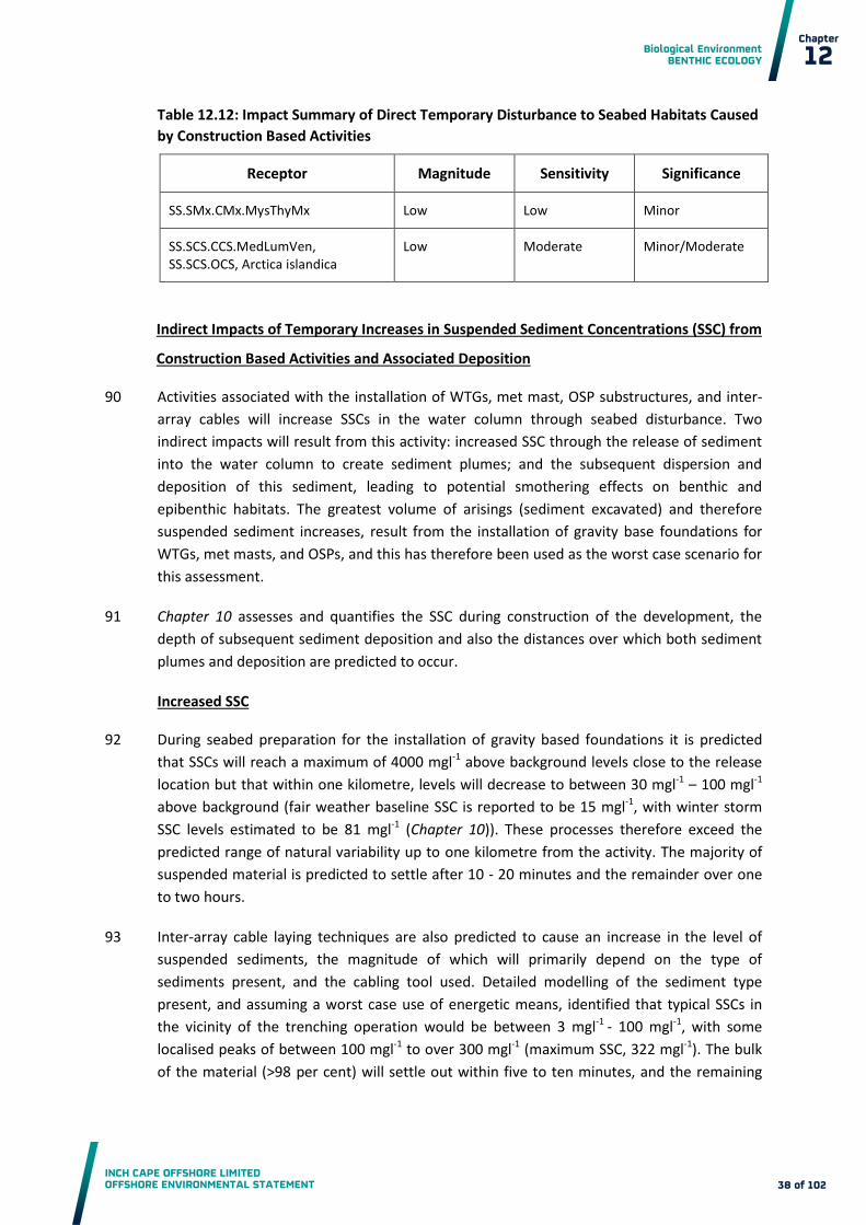
Biological Environment BENTHIC ECOLOGY
INCH CAPE OFFSHORE LIMITED OFFSHORE ENVIRONMENTAL STATEMENT
Chapter
12
38 of 102
Table 12.12: Impact Summary of Direct Temporary Disturbance to Seabed Habitats Caused
by Construction Based Activities
Receptor Magnitude Sensitivity Significance
SS.SMx.CMx.MysThyMx Low Low Minor
SS.SCS.CCS.MedLumVen, SS.SCS.OCS, Arctica islandica
Low Moderate Minor/Moderate
Indirect Impacts of Temporary Increases in Suspended Sediment Concentrations (SSC) from
Construction Based Activities and Associated Deposition
Activities associated with the installation of WTGs, met mast, OSP substructures, and inter-90
array cables will increase SSCs in the water column through seabed disturbance. Two
indirect impacts will result from this activity: increased SSC through the release of sediment
into the water column to create sediment plumes; and the subsequent dispersion and
deposition of this sediment, leading to potential smothering effects on benthic and
epibenthic habitats. The greatest volume of arisings (sediment excavated) and therefore
suspended sediment increases, result from the installation of gravity base foundations for
WTGs, met masts, and OSPs, and this has therefore been used as the worst case scenario for
this assessment.
Chapter 10 assesses and quantifies the SSC during construction of the development, the 91
depth of subsequent sediment deposition and also the distances over which both sediment
plumes and deposition are predicted to occur.
Increased SSC
During seabed preparation for the installation of gravity based foundations it is predicted 92
that SSCs will reach a maximum of 4000 mgl-1 above background levels close to the release
location but that within one kilometre, levels will decrease to between 30 mgl-1 – 100 mgl-1
above background (fair weather baseline SSC is reported to be 15 mgl-1, with winter storm
SSC levels estimated to be 81 mgl-1 (Chapter 10)). These processes therefore exceed the
predicted range of natural variability up to one kilometre from the activity. The majority of
suspended material is predicted to settle after 10 - 20 minutes and the remainder over one
to two hours.
Inter-array cable laying techniques are also predicted to cause an increase in the level of 93
suspended sediments, the magnitude of which will primarily depend on the type of
sediments present, and the cabling tool used. Detailed modelling of the sediment type
present, and assuming a worst case use of energetic means, identified that typical SSCs in
the vicinity of the trenching operation would be between 3 mgl-1 - 100 mgl-1, with some
localised peaks of between 100 mgl-1 to over 300 mgl-1 (maximum SSC, 322 mgl-1). The bulk
of the material (>98 per cent) will settle out within five to ten minutes, and the remaining

Biological Environment BENTHIC ECOLOGY
INCH CAPE OFFSHORE LIMITED OFFSHORE ENVIRONMENTAL STATEMENT
Chapter
12
39 of 102
fine material will settle out within one hour. This prediction is conservative, estimating that
the entire contents of the trench are resuspended by the cabling operation.
It is possible that elevated SSC impacts might result from two construction activities 94
combined. This could arise through GBS dredging at the same time as cable burial, or jacket
leg scour pit development at the same time as cable burial. As a worst case, the impacts
identified above for the individual activities would be additive. For example, GBS dredging
(maximum SSC up to 4000 mg/l above background) and cable burial by energetic means
(maximum SSC up to 300 mg/l above background) could in theory combine to give a
maximum SSC of up to 4300 mg/l above background. However, the potential for combined
SSC impacts is unlikely to cause substantially higher impacts than those from the
construction activities considered in isolation. First, there is little substantial difference in
the predicted SSC since it tends to be the case that one activity or the other will dominate
SSC impacts (most notably GBS dredging). Second, the additive impacts would only arise if
the activities were being undertaken in close proximity and at a similar time, which is likely
to occur infrequently, if at all. For all construction activities, the predicted SSC impacts are
localised and transient. As such, the impacts from different construction activities on SSC can
effectively be considered as independent.
At this level and duration, mortality of the species present is unlikely, but a decrease in 95
growth may be experienced with recoverability predicted to be immediate. The time period
for this SSC increase is predicted to be one to two hours at each installation, which is below
the MarLIN benchmark of 100 mgl-1 for one month. Although dredging activity will be
repeated for each installation over the construction period the spacing of WTGs and quick
settlement of sediments results in little spatial overlap of increased suspended sediments
throughout the construction period. As a result of the short duration of elevated suspended
sediments at each foundation installation and the fact that levels quickly reduce with
distance from source, benthic flora and fauna will only be subjected to increased SSC for a
minimal duration.
The biotopes identified within the Development Area (SS.SMx.CMx.MysThyMx, SS.SCS.OCS, 96
& SS.SCS.CCS.MedLumVen) are sedimentary in nature and, therefore, relatively tolerant to
increases in SSC due to their predominantly infaunal communities. For example, A. islandica
is likely to revert to deposit feeding following increases in suspended sediment (Sabatini et
al., 2008). There are however some filter feeding species present within the main biotopes
which are more sensitive to suspended sediment increases. For example, the main biotope,
SS.SMx.CMx.MysThyMx, although a sedimentary habitat, does contain suspension feeders
which may be adversely affected by an increase in suspended sediment through clogging of
their feeding apparatus. Species such as Amphiura filiformis can tolerate slight increases in
SSC by removing an excess of particles with mucus production, however increased cleaning
can lead to an energy burden and reduced ingestion. Only a small area around each dredge
location will experience levels of suspended sediment above 100 mg/l, with peak
concentrations of 4,000 mg/l. These peak levels will however, be short lived and localised.
The magnitude of increased suspended sediment effects is therefore classed as low. The
proposed MPA, the Firth of Forth Banks Complex, is greater than one kilometre from the

Biological Environment BENTHIC ECOLOGY
INCH CAPE OFFSHORE LIMITED OFFSHORE ENVIRONMENTAL STATEMENT
Chapter
12
40 of 102
Development Area, and as SSC levels at this distance are predicted to be within the range of
natural variation (Chapter 10), no impacts of increased SSC are predicted on this proposed
MPA.
The low magnitude of effects and moderate (SS.SCS.OCS, SS.SCS.CCS.MedLumVen, and A. 97
islandica) and low sensitivity (SS.SMx.CMx.MysThyMx) results in a minor/moderate and
minor impact respectively.
Smothering
Smothering of benthic fauna is likely to occur as suspended sediments settle out. Settlement 98
is predicted to occur within an elliptical footprint due to the tidal influence, with a maximum
thickness of 1.8 m occurring in the immediate vicinity of the release location, and all
material settling out within 10 km. The areas of the development area impacted by a range
of depositional depths from dredging activities are shown in Table 12.13.
Deposition caused by temporary increases in SSC from inter-array cabling activities is also 99
likely to occur within the Development Area. The level of deposition from the inter array
cable burial is estimated as a maximum of five millimetres within very close proximity of the
cable laying activity, with depositional thicknesses of greater than one millimetre within one
kilometre. Outside of this area, any remaining fine material in suspension will remain so
indefinitely, or will settle out beyond three kilometres of the cabling location but not at
thicknesses great enough to form a noticeable layer.
Table 12.13: Impact Areas for Range of Depositional Thresholds
Threshold Area Covered due to all foundations
(m2) % Coverage of Development
Area
>3 mm 22,321,930 14.9
>3 cm 11,964,409 8.0
>5 cm 10,091,159 6.7
>30 cm 4,059,200 2.7
>3m 0 -
SS.SMx.CMx.MysThyMx, the main biotope across the Development Area, is likely to be 100
tolerant of smothering up to five centimetres (MarLIN benchmark) since the majority of
associated fauna are burrowing infauna. For example, the characterising suspension feeders
Mysella bidentata, Thyasira spp., and Amphiura filiformis, are all capable of burrowing and
are tolerant to a degree of smothering (Marshall, 2008).
The tolerance of the circalittoral coarse sediment biotopes (SS.SCS.OCS and 101
SS.SCS.CCS.MedLumVen), to smothering is also considered to be high. This is because

Biological Environment BENTHIC ECOLOGY
INCH CAPE OFFSHORE LIMITED OFFSHORE ENVIRONMENTAL STATEMENT
Chapter
12
41 of 102
shallow burying siphonate suspension feeders are typically able to escape smothering of 10
cm - 50 cm of their native sediment and relocate to their preferred depth by burrowing
(Rayment, 2008a). These characterising species of SS.SCS.CCS.MedLumVen (venerid
bivalves), do however require their siphons to be above the sediment surface in order to
maintain a feeding and respiration current and so deposition of sediment in the order of 10
cm may reduce feeding and be energetically costly (Rayment, 2008a). Other species within
this biotope will be affected to a larger degree, particularly those which cannot burrow
through deposited sediment, potentially causing reductions in species richness. For example,
sessile epifauna, such as Hydroides norvegica, would not be able to relocate following
smothering and would not be able to feed or respire (Rayment, 2008a).
Sudden smothering of A. islandica would halt feeding, however, as a burrower A. islandica is 102
able to switch from aerobic to anaerobic respiration and is generally considered to be
tolerant of anoxia (Theede et al., 1969; Rosenberg and Loo, 1988). Even so, high mortality of
a Baltic population was recorded following an anoxic event, thus the intolerance is classed as
intermediate by MarLIN (Sabatini et al., 2008). A 50 cm burial event is likely to represent an
intolerable level of smothering for A. islandica, with very little chance of recovery of
individuals. This level of deposition is only likely be found in very close proximity to the
release location of the dredged sediment, and as such will represent a small loss (<2.7 per
cent of the Development Area according to the modelled parameters) of the area within
which A. islandica are present. Impacts of smothering on the features within the Firth of
Forth Banks Complex proposed MPA (including A. islandica) are predicted to be negligible as
depositional levels are not predicted to exceed one millimetre beyond one kilometre from
the Development Area. Using the model output from the coastal processes assessment and
the MarLIN sensitivity benchmark for smothering (five centimetres), the area over which
deposition up to five centimetres occurs (i.e. that which will result in mortality of some
species) is 9.0 km2 (6.7 per cent of the Development Area).
Large scale mortality, reducing species richness and abundance, is unlikely within the area of 103
deposition due to the tolerance of most species. Areas impacted above the MarLIN bench
mark are relatively small, with effects and timescales for recovery not expected to exceed
that for physical disturbance during seabed preparation (i.e. 2-3 years). The magnitude of
the effect of smothering is therefore classed as moderate.
The moderate magnitude of effects, and moderate (SS.SCS.OCS and SS.SCS.CCS.MedLumVen 104
and Arctica islandica) and low sensitivity (SS.SMx.CMx.MysThyMx) of receptors results in an
impact of moderate and minor/moderate respectively.

Biological Environment BENTHIC ECOLOGY
INCH CAPE OFFSHORE LIMITED OFFSHORE ENVIRONMENTAL STATEMENT
Chapter
12
42 of 102
Table 12.14: Impact Summary of Temporary Increases in SSC from Construction Based
Activities and Associated Deposition
Impact Receptor Magnitude Sensitivity Significance
Increases in SSC SS.SMx.CMx.MysThyMx Low Low Minor
SS.SCS.CCS.MedLumVen, SS.SCS.OCS, Arctica islandica
Low Moderate Minor/Moderate
Smothering SS.SMx.CMx.MysThyMx Moderate Low <Minor/Moderate
SS.SCS.CCS.MedLumVen, SS.SCS.OCS, Arctica islandica
Moderate Moderate Moderate
Release of Contaminants Bound in Sediments
Marine sediments, particularly those comprising fine material, readily accumulate 105
contaminants due to their sorptive nature; this storage reduces the toxicity potential to
aquatic organisms (Eggleton and Thomas, 2004). Disturbance to the seabed could lead to the
unlocking of contaminants which are then redistributed. Changes in sediment chemistry can
also affect desorption into the water column and transformation of contaminants into more
bioavailable or toxic chemical forms. Contaminants are known to have detrimental effects
on benthic fauna which can then bio-accumulate.
As construction activities will re-suspend sediment, there is potential for contaminants to be 106
released and redistributed in a bioavailable form. The magnitude of effects is assessed using
contaminant levels recorded within the Development Area during baseline surveys and
historical monitoring at Bell Rock disposal ground (detailed in Appendix 12B).
Despite a relatively large volume of material that could be excavated, the Development Area 107
has a low percentage of fines (<10 per cent), with which contaminants are generally
associated. The scale over which the majority of material, and therefore associated
contaminants, will be transported during construction is predicted to be up to 10 km from
the point of release (Chapter 10).
The potential for contaminants to remain within the Development Area is partially 108
determined by the sediment type and exposure, with sheltered and moderately exposed
areas with low water flow more likely to accumulate contaminants for long periods of time.
The baseline survey showed contamination levels outside of the Development Area to be
comparable to those within the Development Area. Despite the presence of a historic
disposal ground, Bell Rock (situated partially within the Development Area), only low levels
of organotins, PAHs and PCBs, were found within the Development Area (below Cefas AL 1,
and Dutch and Canadian reference levels). Metal contamination showed higher values, with

Biological Environment BENTHIC ECOLOGY
INCH CAPE OFFSHORE LIMITED OFFSHORE ENVIRONMENTAL STATEMENT
Chapter
12
43 of 102
Cefas AL 1 being exceeded for arsenic, cadmium, chromium, copper and nickel. Levels were
also shown to be stable over the last decade, with comparable values to those recorded by
MSS at Bell Rock, highlighting no active sources of contaminants exist in the area and
therefore are expected to remain stable in the future.
When considering the effects of contamination release, measuring the total concentration 109
does not necessarily accurately represent the bioavailable fraction (Bryan et al., 1985). A
chemical is said to be bioavailable if it can move through or bind to a permeable surface
coating (e.g. skin, gill epithelium, gut lining or cell membrane) of an organism (Newman and
Jagoe, 1994). Disturbance activities associated with construction within the Development
Area will expose anoxic sediment to an oxic environment and cause changes to the sediment
chemistry (Eggleton and Thomas, 2004). This may lead to desorption and the transfer of
chemicals to a more bioavailable and toxic form, although accurate measurements of this
transformation are difficult to obtain (Eggleton and Thomas, 2004).
The sediments within the Development Area were not observed to have an anoxic layer 110
during benthic surveys, although these observations were limited to the depth of the grab
penetration. As such, much of the sediment disturbed during construction will not undergo
oxidisation, reducing the potential for release of bioavailable contaminants.
The known effects of contaminants are limited to a small number of species where 111
experimental and biological effects sampling has been carried out. Some information on the
characterising species of the Development Area are reviewed by MarLIN, for example
Olsgard (1999) reported that the abundance of Chaetozone setosa and Thyasira sarsi were
only significantly reduced at the highest concentration of copper in the sediment (>2000
ppm). López-Jamar et al. (1988) reported that Thyasira flexuosa was moderately tolerant of
copper in the sediment. The abundance of other species including Pholoe minuta had no
significant correlation between the sediment content of copper and therefore seem highly
tolerant of it (Olsgard, 1999). Bryan (1984) suggests that the larval and embryonic stages of
bivalves are particularly intolerant of heavy metal contamination. Echinoderms are also
regarded as being intolerant of heavy metals (e.g. Bryan, 1984; Kinne, 1984) while
polychaetes are considered tolerant (Rayment, 2008b).
Any release of bioavailable contaminants would have a negative effect on the benthic 112
community. However, due to the very low levels of organotins, PAHs, and PCBs recorded
within the Development Area, combined with the limited re- distribution potential of any
fines (maximum of 10 km from point of release), the magnitude of the re-suspension and
deposition of sediments containing these contaminants is judged to be negligible. The
sensitivity of the receptors, as described within Section 12.6.1 Methodology, are low or
moderate, depending on their conservation importance. As such the impacts of PAH, PCB,
and organotin release is defined as negligible/minor or minor respectively.
Metal concentrations (arsenic, cadmium, chromium, copper and nickel) at the Development 113
Area are elevated above Cefas AL 1, and studies show that metals can reduce the faunal
diversity in sedimentary habitats and adversely affect community structure (Hall et al.,
1997). Redistribution of metals is likely to have effects if transported to areas with a

Biological Environment BENTHIC ECOLOGY
INCH CAPE OFFSHORE LIMITED OFFSHORE ENVIRONMENTAL STATEMENT
Chapter
12
44 of 102
comparably low level of contaminants, as species in these areas are not likely to be pre-
adapted. However, the mobile nature of the sediments in the area, and the comparable
levels of metal contamination across the Development Area, and out to an area beyond one
tidal excursion, indicates that the maximum dispersal distance of redistributed sediments
from construction activities (10 km) will not exceed areas already influenced by these levels
of contamination. Potential areas that may be affected include the Firth of Forth Banks
Complex MPA site, however considering the dispersive environment and mobile nature of
the sediments present, and the fact that contaminant levels at the Development Area are
not recorded as exceeding those in the surrounding area, it is considered that no increases
to contaminant levels at the MPA site will result from the construction activity.
The presence of the historical disposal ground, Bell Rock, partially within the Development 114
Area and the un-impacted status of benthic communities (Hayes et al., 2005) highlights their
tolerance to the current levels of contaminants. The comparability of previous studies with
the baseline benthic surveys indicates the stable nature of the communities in the area.
Whilst abundances of these characterising species fluctuate over time, the communities
themselves have shown stability and resilience to influxes of pollution, namely disposal of
sewage sludge at the Bell Rock disposal ground.
The magnitude of effects of heavy metals is thus classified as low. This reflects the relatively 115
high levels of metal contamination, but takes into account the low silt content of sediments,
and the likely restricted area of re-distribution, in addition to the tolerance of benthic
communities. The sensitivity of the receptors, as described within Section 12.6.1
Methodology, are low or moderate, depending on their conservation importance. As such
the impact of metal contaminant release is described as minor or minor/moderate
respectively.
Table 12.15: Impact Summary of Release of Contaminants Bound in Sediments
Contaminant Receptor Magnitude Sensitivity Significance
PAH, PCB and organotins
SS.SMx.CMx.MysThyMx Negligible Low Negligible/Minor
SS.SCS.CCS.MedLumVen, SS.SCS.OCS
Negligible Moderate Minor
Metals
SS.SMx.CMx.MysThyMx Low Low Minor
SS.SCS.CCS.MedLumVen, SS.SCS.OCS
Low Moderate Minor/Moderate
Secondary Impacts of Decreased Primary Production Due to Increased SSC of the Water
Column
Phytoplankton production can be very low in environments with high turbidity, caused by 116
the attenuation of light in the water column, due to inputs of suspended particulate matter
and/or re-suspension of bottom sediments. This can confine photosynthesis to a shallow

Biological Environment BENTHIC ECOLOGY
INCH CAPE OFFSHORE LIMITED OFFSHORE ENVIRONMENTAL STATEMENT
Chapter
12
45 of 102
photic zone and as a consequence, phytoplankton dynamics are largely controlled by light
availability (Cloern, 1999) and nutrient availability.
The MarLIN benchmark for increases to turbidity are divided into those that are of short 117
term (one month of high turbidity) and long term (one year at moderate to low turbidity).
The construction period, approximately three years, for works within the Development Area
therefore falls into the long term category, although turbidity will only increase for short
periods within the whole construction phase in transient and localised areas.
The majority of primary production occurs in coastal waters and the temporary increase in 118
turbidity due to construction activities is unlikely to have any measurable effect on this large
scale process, especially as sediment plumes will be short lived and localised (>98 per cent of
increased SSC settled within 10 to 20 minutes, with remainder settling within one to two
hours) (see Chapter 10 ). Elevated SSC from construction activities are however predicted to
exceed the range of natural variability of 15 mgl-1 - 81 mgl-1, with peak levels of up to 4,000
mgl-1 above background levels predicted close to the release location and between 30 mgl-1 –
100 mgl-1 above background within one kilometre of the release point.
A decrease in the primary production of phytoplankton may have an effect on food 119
availability, e.g. of deposit feeding species including A. Islandica, as reduced phytoplankton
based detritus settles out to the seabed. Benthic communities also rely on nutrient input
from pelagic and coastal fringe production, however, the nutrient input to such benthic
communities originates from a very wide area and the effects on the benthos from changes
induced by relatively small scale developments are unlikely to be detectable (Barnes and
Hughes, 1992).
The magnitude of effects is therefore assessed as negligible as the nutrient input is unlikely 120
to be altered at a detectable level. The sensitivity of the receptors, as described within
Section 12.6.1 Methodology, are low or moderate, depending on their conservation
importance, and as such the impact is negligible/minor and minor respectively.
Table 12.16: Impact Summary of Secondary Impacts of Decreased Primary Production
Receptor Magnitude Sensitivity Significance
SS.SMx.CMx.MysThyMx Negligible Low Negligible/Minor
SS.SCS.CCS.MedLumVen, SS.SCS.OCS, A. islandica
Negligible Moderate Minor
Potential Release of Pollutants from Construction Plant
Throughout construction there are sources that have the potential to add to the current 121
levels of contaminants present at the Development Area, e.g. activities associated with
WTG, OSP and met mast installations, inter-array cable laying, and associated vessel
movements. The risk of accidental release of contaminants includes fuel, lubricating oils,

Biological Environment BENTHIC ECOLOGY
INCH CAPE OFFSHORE LIMITED OFFSHORE ENVIRONMENTAL STATEMENT
Chapter
12
46 of 102
cleaning fluids, paints, sacrificial anodes, specialised chemicals and litter. Standard controls
will be in place, including following best practice and guidelines for the prevention of
pollution at sea, including the implementation of an EMP (see Appendix 7A), as described in
Section 12.4 that will detail pollution prevention and response procedures. As such it is not
predicted that contaminants from construction plant will be introduced into the
environment at a high level.
Benthic communities within the Development Area are likely to be pre adapted to current
levels of contaminants, due to historical dumping, and likely to recover quickly. The risk of
pollutants entering the environment during construction, if best practice as described in
Section 12.4 is followed, is low and as a result the magnitude of effect is low. The sensitivity
of the receptors, as described within Section 12.6.1 Methodology, are low or moderate,
depending on their conservation importance, and as such, this results in minor and
minor/moderate impacts respectively.
Table 12.17: Impact Summary of Potential Release of Pollutants from Construction Plant
Receptor Magnitude Sensitivity Significance
SS.SMx.CMx.MysThyMx Low Low Minor
SS.SCS.CCS.MedLumVen, SS.SCS.OCS, Arctica Islandica
Low Moderate Minor/Moderate
Introduction of Non Indigenous Species
The introduction of NIS is possible through a number of pathways, including ships hulls, 122
ballast waters, and the transport of materials to the Development Area. Embedded
Mitigation as detailed in Section 12.4 will reduce the potential for spread of NIS to the
Development Area. Furthermore, as NIS is also a descriptor of Good Environmental Status
(GES) under the Marine Strategy Framework Directive (MSFD, 2012), the prevention of NIS
introduction will be a key component of the draft EMP (Appendix 7A).
Due to uncertainties within the assessment of NIS introduction at offshore developments, 123
the potential long term effects on the local environment, and the importance in terms of the
MSFD, a moderate magnitude of effect is ascribed. The sensitivity of existing benthic
communities is considered to be low or moderate depending on their conservation
importance, and as such the impact is considered to be minor/moderate and moderate
respectively.

Biological Environment BENTHIC ECOLOGY
INCH CAPE OFFSHORE LIMITED OFFSHORE ENVIRONMENTAL STATEMENT
Chapter
12
47 of 102
Table 12.18: Impact Summary of Introduction and Spread of Non Indigenous Species
Receptor Magnitude Sensitivity Significance
SS.SMx.CMx.MysThyMx Moderate Low Minor/Moderate
SS.SCS.OCS SS.SCS.CCS.MedLumVen Arctica islandica
Moderate Moderate Moderate
12.7.2 Effects of Operation and Maintenance
Loss of Original Habitat
The greatest potential area of habitat loss caused by the placement of WTG, OSP and met 124
mast foundations and inter-array cable protection is 1.9 km2, representing 1.3 per cent of
the Development Area.
As with temporary habitat disturbance during the construction phase, a greater percentage 125
of the less abundant habitats within the Development Area have the potential to be
impacted by habitat loss. Table 12.19 details out the maximum percentages of original
habitat loss that could occur through the minimum spacing of WTGs. This is considered a
realistic, yet conservative assessment as all OSP’s and met masts are considered as present
in each habitat type, which although unlikely, is considered a possibility at this stage without
detailed Wind Farm and OfTW layouts.
Table 12.19: Extent of Habitat Loss in Each Biotope
Installation Parameters Area Lost
(km2) % of
Habitat
SS.SMx.CMx.MysThyMx - habitat available = 132 km2
213 WTGs foundations 95 m diameter of footprint including scour protection
1.51 1.14
Three Met masts 95 m diameter of footprint including scour protection
0.02 0.02
Five OSPs 180 m diameter of footprint including scour protection
0.13 0.10
100% of protected Inter-array Cabling
Max of 10% of cable protected at an affected width – 6 m
0.21 0.16
Total 1.87 1.42
SS.SCS.OCS - habitat available = 62 km2
120 WTGs and foundations installation
95 m diameter of footprint including scour protection
0.85 1.37

Biological Environment BENTHIC ECOLOGY
INCH CAPE OFFSHORE LIMITED OFFSHORE ENVIRONMENTAL STATEMENT
Chapter
12
48 of 102
Installation Parameters Area Lost
(km2) % of
Habitat
Three Met masts 95 m diameter of footprint including scour protection
0.02 0.03
Five OSPs installation 180 m diameter of footprint including scour protection
0.13 0.21
56% of protected Inter-array Cabling
Max of 10% of cable protected at an affected width – 6 m
0.12 0.19
Total 1.12 1.80
SS.SCS.CCS.MedLumVen - habitat available = 8 km2
16 WTGs and foundations installation
95 m diameter of footprint including scour protection
0.11 1.42
Three Met masts 95 m diameter of footprint including scour protection
0.02 0.27
Five OSPs installation 180 m diameter of footprint including scour protection
0.13 1.59
7.5% of protected Inter-array Cabling
Max of 10 % of cable protected at an affected width – 6 m
0.02 0.20
Total 0.28 3.48
As discussed within the construction phase impacts, habitat containing A. Islandica as a 126
contributing species covers 140 km2, and using the minimum WTG spacing, this equates to a
possible maximum loss of 1.3 per cent of this habitat.
Therefore, 3.5 per cent or less of each habitat type is likely to be affected by permanent 127
habitat loss (Table 12.19). As such, and despite the long term (i.e. present for the
operational duration) nature of this effect which precludes recovery from this impact, the
magnitude of the loss of original habitat on the benthic ecology at the Development Area is
considered to be low according to the definitions described in Table 12.6.
The sensitivity of the receptors, as described within Section 12.6.1 Methodology, are low or 128
moderate, depending on their conservation importance, and as such this results in minor
and minor/moderate impacts respectively.

Biological Environment BENTHIC ECOLOGY
INCH CAPE OFFSHORE LIMITED OFFSHORE ENVIRONMENTAL STATEMENT
Chapter
12
49 of 102
Table 12.20: Impact Summary of Loss of Original Habitat
Receptor Magnitude Sensitivity Significance
SS.SMx.CMx.MysThyMx Low Low Minor
SS.SCS.CCS.MedLumVen, SS.SCS.OCS, Arctica islandica
Low Moderate Minor/Moderate
Changes in Hydrodynamic Regime and Associated Sediment Transport
Changes to hydrodynamic and sediment transport processes are predicted in Chapter 10 129
which in turn have informed this assessment of potential associated effects on the benthic
ecology. Results from the predictive modelling indicate a small change to tidal currents,
which include increases and decreases in water flow up to 0.04 ms-1 (seven per cent change
from baseline) in the immediate vicinity of the WTG foundations within the Development
Area. These small changes predicted to occur in the hydrodynamic conditions at the
Development Area due to the installation of the infrastructure are considered to be well
within the range of natural variability with negligible effects to the overall sediment
transport predicted (Chapter 10).
Changes in currents have been predicted to increase on the ebb tide and decrease on the 130
flood tide (Chapter 10), and are predicted to slightly and temporarily (over a period of
minutes) increase the levels of sediment mobilisation at the Development Area. The main
biotopes found across the Development Area are of mixed or coarse sediment and therefore
less sensitive to changes in water flow. However, within the main biotope across the
Development Area, SS.SMx.CMx.MysThyMx, it is the muddy component of the sediment
that supports the various deposit feeders. An increase in currents could lead to a reduction
in the finer sediment fraction, as a result of an increase in erosion and winnowing of fine
sediments from the seabed, and a decrease in organic matter, reducing the habitats
suitability for species such as Amphiura filiformis, Spiophanes bombyx and Thyasira flexuosa.
In contrast, a decrease in water flow rate as is predicted on the flood tide may increase the
deposition of finer sediments. Although the associated increase in deposition of finer
sediment particles may benefit deposit feeders due to increased deposition of organic
material, passive suspension feeders may experience a reduction in feeding efficiency due to
clogging of feeding apparatus. It is considered that the highly localised and temporary
changes in increased sediment mobilisation predicted in the Development Area are unlikely
to cause such effects (Chapter 10).
The highly localised and temporary effects predicted to the hydrodynamics across the 131
Development Area results in a negligible magnitude of effects. The sensitivity of the
receptors, as described within Section 12.6.1 Methodology, are low or moderate, depending
on their conservation importance, and as such this results in a negligible/minor and minor
impact respectively.

Biological Environment BENTHIC ECOLOGY
INCH CAPE OFFSHORE LIMITED OFFSHORE ENVIRONMENTAL STATEMENT
Chapter
12
50 of 102
Table 12.21: Impact Summary of Changes in Hydrodynamic Regime and Sediment
Transport
Receptor Magnitude Sensitivity Significance
SS.SMx.CMx.MysThyMx Negligible Low Negligible/Minor
SS.SCS.CCS.MedLumVen, SS.SCS.OCS, A. islandica
Negligible Moderate Minor
Scour and Associated Sediment Transportation Leading to Changes in Habitats
Changes to currents at the scale identified above (Changes in Hydrodynamic Regime and 132
Associated Sediment Transport) will however cause localised scour. Scour protection on
gravity based foundations would result in no significant increases in suspended sediment or
deposition. Therefore, during operation the greatest effect is represented by jacket
foundations with no scour protection. As highlighted in Chapter 10, without scour protection
the lateral extent of the area affected at jacket foundations by scour would be 12 m on a
peak spring tide in line with tidal orientation. Total scour footprint per WTG foundation
during a spring tide is 2,261 m2, which results in an area of 0.5 km2 across the Development
Area (0.3 per cent).
Peak concentrations of suspended sediment as a result of scour are predicted to be within 133
30 mgl-1 and 100 mgl-1 in the immediate vicinity of the foundations (compared to 15 mgl-1
background). Levels quickly drop to less than 10 mgl-1 above background within 100 m from
the foundation and falling to <1 mgl-1 above background levels beyond one kilometre from
the foundation. This increase in SSC produces a maximum deposition of 1.1 m at the WTG
base, and depositions of up to 10 cm within a distance of 150 m from the foundation.
Beyond this distance, deposition drops markedly, with depositional depths of <1 mm
predicted beyond 200 m from the location of scour.
Communities within the direct scour footprint will experience altered conditions during 134
operation but the area of effect is small (0.3 per cent across the Development Area). Within
this area benthic communities will experience increased instability, and a loss of finer
grained sediments, leading to a reduction in species intolerant to such disturbance over the
life of the Wind Farm. The area of scour footprint resulting from the jacket foundations will
also be lesser than the area of Loss of Original Habitat identified above for the Gravity base
structures (GBS) option and as such will impact on habitats to a lesser extent than the Loss
of Original Habitat impact type.
Suspended sediment increases due to scour are predicted to be below the MarLIN 135
benchmark of 100 mgl-1. The levels highlighted are however only representative of the peak
volumes and are not expected to be constant, rather increased SSC will exist at variable
levels depending on the tidal flow rates until scour equilibrium is reached after 12 days.
Smothering impacts caused by the deposition of scoured material are also predicted, with
levels exceeding the MarLIN benchmark of 5 cm over an area of 4.6 km2 (3.1 per cent of the
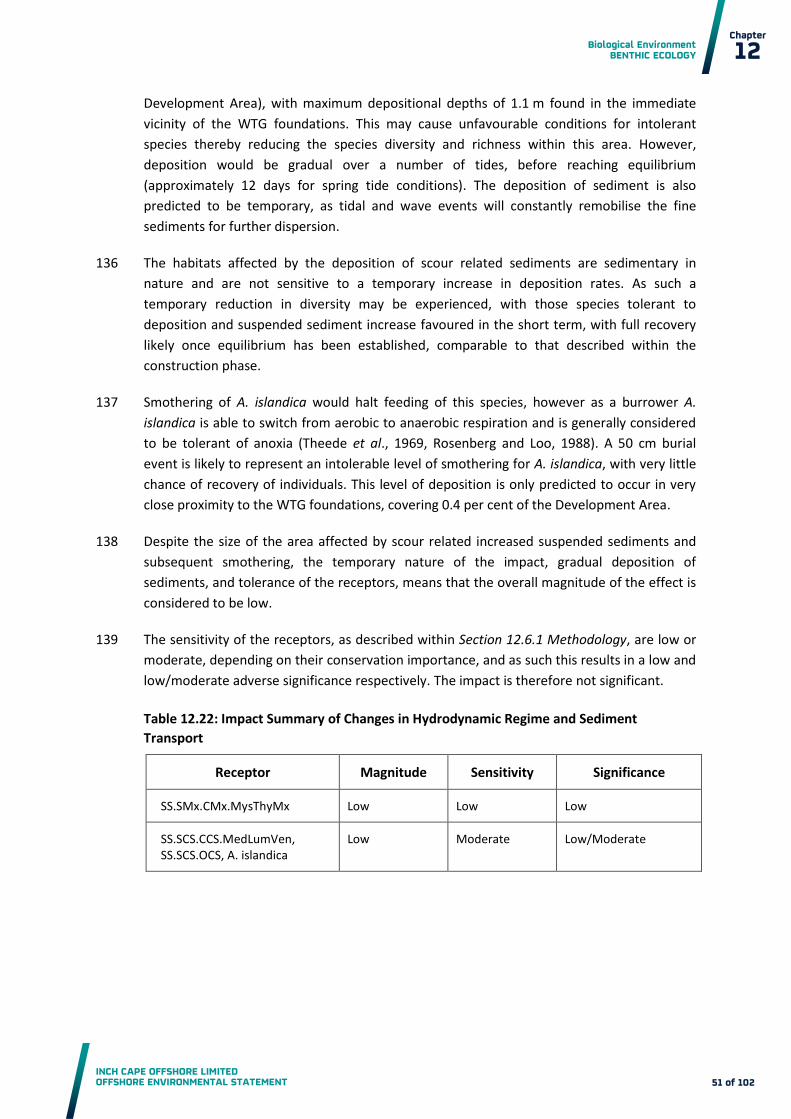
Biological Environment BENTHIC ECOLOGY
INCH CAPE OFFSHORE LIMITED OFFSHORE ENVIRONMENTAL STATEMENT
Chapter
12
51 of 102
Development Area), with maximum depositional depths of 1.1 m found in the immediate
vicinity of the WTG foundations. This may cause unfavourable conditions for intolerant
species thereby reducing the species diversity and richness within this area. However,
deposition would be gradual over a number of tides, before reaching equilibrium
(approximately 12 days for spring tide conditions). The deposition of sediment is also
predicted to be temporary, as tidal and wave events will constantly remobilise the fine
sediments for further dispersion.
The habitats affected by the deposition of scour related sediments are sedimentary in 136
nature and are not sensitive to a temporary increase in deposition rates. As such a
temporary reduction in diversity may be experienced, with those species tolerant to
deposition and suspended sediment increase favoured in the short term, with full recovery
likely once equilibrium has been established, comparable to that described within the
construction phase.
Smothering of A. islandica would halt feeding of this species, however as a burrower A. 137
islandica is able to switch from aerobic to anaerobic respiration and is generally considered
to be tolerant of anoxia (Theede et al., 1969, Rosenberg and Loo, 1988). A 50 cm burial
event is likely to represent an intolerable level of smothering for A. islandica, with very little
chance of recovery of individuals. This level of deposition is only predicted to occur in very
close proximity to the WTG foundations, covering 0.4 per cent of the Development Area.
Despite the size of the area affected by scour related increased suspended sediments and 138
subsequent smothering, the temporary nature of the impact, gradual deposition of
sediments, and tolerance of the receptors, means that the overall magnitude of the effect is
considered to be low.
The sensitivity of the receptors, as described within Section 12.6.1 Methodology, are low or 139
moderate, depending on their conservation importance, and as such this results in a low and
low/moderate adverse significance respectively. The impact is therefore not significant.
Table 12.22: Impact Summary of Changes in Hydrodynamic Regime and Sediment
Transport
Receptor Magnitude Sensitivity Significance
SS.SMx.CMx.MysThyMx Low Low Low
SS.SCS.CCS.MedLumVen, SS.SCS.OCS, A. islandica
Low Moderate Low/Moderate

Biological Environment BENTHIC ECOLOGY
INCH CAPE OFFSHORE LIMITED OFFSHORE ENVIRONMENTAL STATEMENT
Chapter
12
52 of 102
Colonisation of Introduced Substrata Leading to a Change in the Benthic Ecology and/or
Biodiversity
Colonisation of scour or inter-array cable protection in addition to foundations themselves is 140
expected within the Development Area. GBS foundations provide the greatest footprint area
for colonisation, an area that will be further increased through the use of scour and cable
protection to a maximum footprint of 1.87 km2 (1.3 per cent of the Development Area).
This introduction of new substrate will have direct effects on the overall biodiversity of the 141
Development Area, and indirect effects through increased food availability to higher trophic
levels (see Chapter 13). Furthermore, studies have shown that soft sediment benthic
communities in the direct vicinity of the foundations are altered by the introduction of such
habitat, with hard substrate species present in the sediments surrounding the foundations
(Degraer et al., 2011).
Community changes will be localised to the new habitat, and to those existing habitats 142
immediately surrounding the new habitat, and due to the necessary separation between
WTGs, a significant change to the existing benthic ecology over the entirety of the
Development Area is not expected. Changes are likely to be present throughout the
operational phase, and effects therefore are predicted to be of negligible magnitude.
The sensitivity of existing benthic communities is considered to be low or moderate 143
depending on their conservation importance, and as such the significance of the impact is
considered to be negligible/minor and minor respectively.
Table 12.23: Impact Summary of Colonisation of Introduced Substrata
Receptor Magnitude Sensitivity Significance
SS.SMx.CMx.MysThyMx Negligible Low Negligible/Minor
SS.SCS.OCS, SS.SCS.CCS.MedLumVen, Arctica islandica
Negligible Moderate Minor
Introduced Substrata Facilitating the Spread of NIS
Measures to prevent the introduction of NIS will be as described for the construction phase 144
impacts, and will incorporate the Embedded Mitigation identified as described in Section
12.4.
Negative effects of the introduction of new substrate include the increased risk of spread of 145
NIS through colonisation of the new substrate. For example, splash midge (Telmatogeton
japonicas), a NIS in Nordic waters, was found on Danish wind farms in the North Sea.
However while dense tubes of this species may modify microhabitats, no serious adverse
impacts are currently known (Jensen, 2010). Brodin and Andersson (2009) highlighted that
the increasing number of offshore wind farms may provide a mechanism by which this

Biological Environment BENTHIC ECOLOGY
INCH CAPE OFFSHORE LIMITED OFFSHORE ENVIRONMENTAL STATEMENT
Chapter
12
53 of 102
species might expand its geographic range in addition to facilitating the potential for
colonisation of invasive species more generally.
Effects of NIS are expected to be isolated around foundations and not impact the wider 146
benthic community structure. However, due to the potential for NIS to expand their range,
and the use of NIS as a descriptor of GES under the MSFD, the prevention of NIS introduction
will be a key component of the EMP (Appendix 7A).
Despite the limited spatial extent of the effect, and due to uncertainties within the 147
assessment of NIS introduction at offshore developments, the potential long term effects on
the local environment, and the importance in terms of the MSFD, a moderate magnitude of
effects is ascribed. The existing benthic communities are considered to be of no greater than
moderate sensitivity, and as such the impact is considered to be moderate.
Table 12.24: Impact Summary of Introduction and Spread of NIS
Receptor Magnitude Sensitivity Significance
Benthic and epibenthic communities
Moderate Moderate Moderate
Potential Release of Pollutants from Operational Plant
As with the construction phase, a number of possible pollution sources exist during 148
operation. The effects of pollution on the local environment, and the standard controls and
implementation of the EMP (Appendix 7A) as described in Section 12.4 and outlined for the
construction phase also apply during the operation phase. The impact magnitude is
therefore assessed as low.
The sensitivity of existing benthic communities in the Development Area is considered to be 149
low or moderate depending on their conservation importance, and as such the impact is
considered to be minor and minor/moderate respectively.
Table 12.25: Impact Summary of Potential Release of Pollutants from Operation Plant
Receptor Magnitude Sensitivity Significance
SS.SMx.CMx.MysThyMx Low Low Minor
SS.SCS.OCS SS.SCS.CCS.MedLumVen, Arctica islandica
Low Moderate MInor/Moderate

Biological Environment BENTHIC ECOLOGY
INCH CAPE OFFSHORE LIMITED OFFSHORE ENVIRONMENTAL STATEMENT
Chapter
12
54 of 102
Responses to Electromagnetic Field (EMF) and Thermal Emissions
EMF effects are relatively well documented in some fish species such as elasmobranchs, 150
however it is currently poorly understood in invertebrates (Appendix 13C: Electromagnetic
Field Assessment). However, decapods (Crangon crangon), isopods (Idotea baltica) and
amphipods (Talorchestia martensii and Talitrus saltator) have been shown to experience
magnetic sensitivity (Gill et al., 2005; Gill et al., 2009). However, despite the limited
information on EMF effects on benthic organisms, no adverse effects have been observed in
the research, with any impacts that may occur expected to be highly localised, and in close
vicinity to the cables (Meißner and Sordyl, 2006).
Warming of the surrounding area along subsea cables is also possible as electricity is 151
transported along the conductors, and there is evidence that various marine organisms react
sensitively to even a minor increase in the ambient temperature (OSPAR, 2009), with some
benthic organisms showing intolerance to temperature increases. A. islandica is highlighted
in the MarLIN sensitivity matrix to be intolerant to temperature increases which could play a
part in their distribution in the North Sea (i.e. they are not found south of 53 ° 30 ´ N
(Witbaard and Bergman, 2003)). The MarLIN benchmark is defined for both short term
changes (5.0 °C for three days) and long term changes (20.0 °C for a year).
In general, heat dissipation due to transmission losses can be expected to be more 152
significant for AC cables than for High Voltage DC cables at equal transmission rates, and loss
in coarse sediments is expected to be greater than in fine material (OSPAR, 2009). As such
Section 12.4 identifies the AC option as the Design Envelope worst case. Field data for
thermal radiation is however limited. The rise in temperature at the Nysted wind farm did
not provide conclusive results (Meißner et al., 2007), but suggested that the rise in
temperature did not exceed 1.4 °C in 20 cm depth above the cable (OSPAR, 2009). In New
York, the cross sound cable interconnector project estimated a 0.19 °C rise in temperature at
the seabed immediately above the buried cable and an associated increase in seawater
temperature of 0.000006°C (The Department for Business, Enterprise and Regulatory
Reform (BERR), 2008).
The majority of benthic organisms live in the top tens of centimetres, with even deep 153
burrowing bivalves unlikely beyond 0.5 m. The target burial depth of the inter-array cable
(one metre), and protection where burial is not feasible, will reduce interaction with benthic
species and thus EMF and thermal effects are not predicted beyond a negligible magnitude.
The sensitivity of existing benthic communities is considered to be low or moderate
depending on their conservation importance, and as such the resulting impact of EMF and
heating of the sediments due to electrical transmission is negligible/minor and minor
respectively.

Biological Environment BENTHIC ECOLOGY
INCH CAPE OFFSHORE LIMITED OFFSHORE ENVIRONMENTAL STATEMENT
Chapter
12
55 of 102
Table 12.26: Impact Summary of Electromagnetic Field (EMF) and Thermal Heating Effects
Receptor Magnitude Sensitivity Significance
SS.SMx.CMx.MysThyMx Negligible Low Negligible/Minor
SS.SCS.OCS, SS.SCS.CCS.MedLumVen, Arctica islandica
Negligible Moderate Minor
Temporary Habitat Disturbance from Operation and Maintenance (O&M) Activities
The use of jack-up vessels throughout the operational phase will impact benthic 154
communities through compression of sediments beneath the legs, and subsequent damage
to benthic fauna. In addition to the WTG, OSP, and met mast maintenance, inter-array cable
maintenance may also be required, with a worst case assumption of up to 10 per cent re-
burial of the inter-array cables. The total area of annual disturbance is therefore 0.14 km2
(0.09 per cent of the Development Area).
This area represents a temporary disturbance, with recovery of communities expected in 155
line with that identified for the construction phase impact of temporary habitat disturbance
due to foundation installation, i.e. two to three years for the majority of species and
habitats. As a result of this, and due to the small area of effect, the magnitude of this impact
is considered to be negligible. The sensitivity of existing benthic communities is considered
to be low or moderate depending on their conservation importance, and as such the impacts
are determined as negligible/minor and minor respectively.
Table 12.27: Impact Summary of Temporary Habitat Disturbance from O&M Activities
Receptor Magnitude Sensitivity Significance
SS.SMx.CMx.MysThyMx Negligible Low Negligible/Minor
SS.SCS.OCS, SS.SCS.CCS.MedLumVen, Arctica islandica
Negligible Moderate Minor
12.7.3 Effects of Decommissioning
The potential effects of decommissioning are considered to be equivalent to and potentially 156
lower than the worst case effects assessed for the construction phase. The approach to
decommissioning is described in Section 7.12. A decommissioning plan will be prepared in
accordance with the requirements of the Energy Act 2004 (see Section 3.2.5) and will be
subject to approval from the Department of Energy and Climate Change (DECC) prior to
implementation
Biological Environment BENTHIC ECOLOGY
INCH CAPE OFFSHORE LIMITED OFFSHORE ENVIRONMENTAL STATEMENT
Chapter
12
56 of 102
In particular no seabed preparation through dredging will be required for the 157
decommissioning phase. Removal of the GBS is expected to cause some material to be
suspended in the water column. However, the scale of this effect is predicted to be less than
the effects of GBS dredging during the construction phase. As such the impacts relating to
GBS preparation and SSC would be much lower than those predicted for the construction
phase.
12.8 Impact Assessment- Offshore Export Cable Corridor
Impacts considered within this Offshore Export Cable Corridor assessment are listed below 158
relative to each development phase:
Effects of Construction (and Decommissioning):
o Direct temporary disturbance of seabed habitats caused by construction based
activities;
o Indirect impacts of temporary increases in SSC from construction based activities
and associated deposition;
o Release of contaminants bound in sediments;
o Secondary impacts of decreased primary production due to increased SSC of the
water column;
o Potential release of pollutants from construction plant; and
o Introduction of NIS.
Effects of Operation:
o Loss of original habitat;
o Colonisation of introduced substrata leading to a change in the benthic ecology
and/or biodiversity;
o Provision of Introduced Substrata Facilitating spread of NIS;
o Potential release of pollutants from operation plant;
o Responses to EMF and thermal emissions; and
o Direct temporary habitat disturbance from O&M activities.
12.8.1 Effects during Construction
Direct Temporary Disturbance of Seabed Habitats caused by Construction Activities
Sub-tidal Area
Disturbance to the seabed, leading to changes in the habitat and species therein will occur 159
during the installation of the Offshore Export Cable. Where cable burial equipment is used,
this area of disturbance will be associated with the compression of sediments beneath the
plant over the trench affected width of six metres. Within this trench affected area, a trench

Biological Environment BENTHIC ECOLOGY
INCH CAPE OFFSHORE LIMITED OFFSHORE ENVIRONMENTAL STATEMENT
Chapter
12
57 of 102
of one metre width will be excavated. The activities will be similar to the inter-array cabling,
within the Development Area, as described in Section 12.7.1.
The total area of temporary direct disturbance caused by the installation of the Offshore 160
Export Cable is 3.0 km2, 3.0 per cent of the 100 km2 Offshore Export Cable Corridor. The
majority of the species present will be lost within the immediate vicinity of the one metre
trench, however recovery will begin after cable installation so the loss is considered
temporary. Effects to the remainder of the six metre trench affected area will be a product
of compression and compaction of the sediments beneath the construction plant.
A number of habitats of conservation importance were identified during the Offshore Export 161
Cable Corridor baseline surveys namely SS.SMu.CFiMu.SpnMeg, and SS.SCS.CCS. Of these,
SS.SMu.CFiMu.SpnMeg is the most dominant in terms of area and is likely to extend away
from the Offshore Export Cable Corridor for some distance where hydrographic and
sedimentary conditions are favourable.
Characterising species of this biotope include the sea pens Virgularia mirabilis and Pennatula 162
phosphorea. These epifaunal species are likely to be dislodged or damaged by the trenching
equipment, however studies of fishing related damage identified that sea pens can re-attach
to the sediment if dislodged, and their ability to retract into the sediment may provide some
resilience to physical disturbance. The presence of these species in this area of known
Nephrops trawling indicates that this is the case (Figure 12.9, and Chapter 18). Other
characterising species that will be affected by the installation of the Offshore Export Cable
include the burrowing crustaceans Nephrops norvegicus, Calocaris macandreae, and Jaxea
nocturna, and the echiuran worm Maxmuelleria lankesteri. Less robust, or shallower
burrowing species such as some bivalves and polychaetes are likely to be affected to a
greater degree, suffering an initial loss of individuals in this trench affected area, followed by
recovery post-cable installation.
Recovery of this biotope in areas of total loss is likely to be variable depending on individual 163
species and the level of impact, although complete recovery is likely to require several years
(Meißner and Sordyl, 2006). The reproductive biology of the sea pens found in this habitat
has not been studied, but work on other species suggest that some may live up to 15 years,
and take five or six years to reach sexual maturity (Birkeland, 1974). Larval settlement can be
patchy in space and highly episodic in time, with no recruitment taking place in some years
(Davis and Van Blaricom, 1978). Recovery of these species is therefore likely to be slow and
patchy in its occurrence. Recovery of other species (large burrowing species (e.g. Nephrops)
and polychaetes and bivalve species) is likely to occur rapidly, with recruitment and adult
migration both contributing. It is considered however, that due to the long life histories of a
number of key species, the time required for this habitat to reach maturity following loss is
approximately five years (Sabatini and Hill, 2008; Budd, 2008b).

Biological Environment BENTHIC ECOLOGY
INCH CAPE OFFSHORE LIMITED OFFSHORE ENVIRONMENTAL STATEMENT
Chapter
12
58 of 102
Figure 12.9: Fishing Vessel Activity in Relation to the Development Area and Offshore
Export Cable Corridor, 2007 – 2011
Biological Environment BENTHIC ECOLOGY
INCH CAPE OFFSHORE LIMITED OFFSHORE ENVIRONMENTAL STATEMENT
Chapter
12
59 of 102
As with SS.SMu.CFiMu.SpnMeg, other infaunal or epifaunal communities present within the 164
trenched area (one metre) can be considered to be temporarily lost during Export Cable
installation, with a variety of disturbance related effects experienced within the remainder
of the trench affected area. Recovery of infaunal species is likely to be rapid (within one
year) due to their relatively high dispersal potential and short life histories (Hill, 2008).
Epibenthic species, such as encrusting bryozoans, hydroids, and ascidians are likely to re-
establish within two years, with Flustra foliacea (a key species of the FluHyd biotope) likely
to reach an abundance of occasional (–1.0 – 5.0 per cent cover) within four years and
recover to its pre-impacted density within five years (Tyler-Walters and Ballerstedt, 2007).
Due to the small areas affected by the cable installation (three per cent of Offshore Export 165
Cable Corridor), and the relatively fast recovery of the majority of species, the magnitude of
this impact is considered to be low. Only a very small proportion of the low quality stony
reef habitat will be temporarily disturbed, and other examples of this habitat type exist
elsewhere outside of the Offshore Export Cable Corridor at the Isle of May SAC, for instance.
The wider availability of stony reef habitat will therefore not be affected. The sensitivity of
the receptors is considered to be low, or moderate for those habitats of conservation
importance, (SS.SMu.CFiMu.SpnMeg, stony reef, and SS.SCS.CCS) and as such the impact of
direct temporary habitat disturbance in the offshore environment is considered to be minor
or minor/moderate respectively.
Intertidal Area
The intertidal areas affected by direct temporary disturbance during construction at 166
Cockenzie and Seton Sands cover 4,320 m2 and 13,968 m2 respectively (4.1 and 0.7 per cent
of the intertidal area respectively).
Sedimentary Habitats
The area affected during Export Cable installation is predicted to be of the same magnitude 167
as for the sub-tidal cable installation described above (six cables each with six metre trench
affected areas), with a range of disturbance related impacts in the affected areas, depending
on the sensitivity of the organisms to physical abrasion. Recovery of sandy intertidal
biotopes characterised by polychaetes is predicted to take between one to two years after
installation impacts have ceased (Budd, 2008a), and as such the magnitude of the effect to
these features is considered negligible.
The sensitivity of the habitats is considered to be low, and as such the impact of habitat loss 168
and disturbance is considered to be negligible/minor.
Rocky Habitats
Although it is assumed that from a technical feasibility perspective installation in the 169
intertidal area will avoid areas of hard substrates, impacts to rocky/boulder habitats may
occur and will be variable depending on installation methods used (e.g. directional drilling,
mechanical cutting, etc.), with mechanical cutting considered the worst case. The removal of
rocky habitats will cause a temporary loss of species richness and diversity in these habitats.

Biological Environment BENTHIC ECOLOGY
INCH CAPE OFFSHORE LIMITED OFFSHORE ENVIRONMENTAL STATEMENT
Chapter
12
60 of 102
Recovery is dependent on the suitability of the replaced substrate and the life cycle of the
characterising species, which are typically long for rocky intertidal species (Fucoids four to
five years, limpets up to 20 years, but usually < 10 years, and barnacles at least five years but
sometimes as long as 20 years (Hill et al., 1998)). As such recovery, assuming a temporary
loss of all species, will take at least 10 years, potentially longer to reach full maturity. This
process will be helped through adult migration from outside areas, and so the timeframe
may be reduced. Due to the potential long timescales required for the recovery of the rocky
habitats, despite the small area of effect, a magnitude of low has been predicted.
The sensitivity of the habitats is considered to be low, and as such the impact of habitat loss 170
and disturbance is considered to be minor.
Table 12.28: Impact Summary of Direct Temporary Disturbance due to Construction
Activities
Receptor Magnitude Sensitivity Significance
SS.SMu.CFiMu.SpnMeg, SS.SCS.CCS, Stony Reef
Low Moderate Minor/Moderate
SS.SMx.CMx, SS.SSa.CMuSa, SS.SMx.CMx.MysThyMx SS.SMx.CMx.FluHyd
Low Low Minor
LR.MLR.BF.PelB, LR.HLR.MusB.Cht.Cht, LR.MLR.BF.FspiB, IR.MIR.KR.Ldig.Ldig, LR.LLR.F.FSpi.FS
Low Low Minor
LS.LSa.MoSa.AmSco.Sco, LS.LSa.FiSa.Po, LS.LSa.FiSa.Po.Aten
Negligible Low Negligible/Minor
Indirect Impacts of Temporary Increases in Suspended Sediment Concentrations SSC from
Construction Based Activities and Associated Deposition
Sub-tidal Area – Increased SSC
Cable laying techniques will cause an increase in the level of suspended sediments, the 171
magnitude of which will primarily depend on the type of sediments present, and the cable
installation methodology selected. Detailed modelling of the sediment type present
(assuming a worst case use of an energetic tool) identified that SSCs in the vicinity of the
trenching operation would typically be about 3.0 mgl-1 - 10 mgl-1 above background (typically
between 3.0 mgl-1-100 mgl-1, with some localised peaks of up to 322 mgl-1). Most of the
resulting sediment plume will settle out within tens or a few hundred metres of the Export
Cable, over a period of seconds or minutes. The finest (mud and silt) sediment fractions will
persist for longer in the water column and be carried further, but even these will generally
not be advected beyond the near-field vicinity of the Export Cable (less than three
kilometers), and will settle out within a few hours of disturbance. This prediction is

Biological Environment BENTHIC ECOLOGY
INCH CAPE OFFSHORE LIMITED OFFSHORE ENVIRONMENTAL STATEMENT
Chapter
12
61 of 102
conservative, estimating that the entire contents of the trench are resuspended by the
cabling operation. Even with this conservative estimate this level is below the MarLIN
benchmark of 100 mgl-1 for one month.
Increased suspended sediments can affect filter feeding mechanisms, clog gills, and affect 172
respiratory processes. The offshore habitats present along the Offshore Export Cable
Corridor are predominantly sedimentary in nature, with an infauna that is tolerant of such
short term increases in suspended sediment levels. Epifauna such as seapens may suffer
some clogging of filter feeding apparatus, especially if subject to high levels. However, these
animals are relatively tolerant of increased suspended sediments, and their ability to self-
clean their feeding apparatus means that the energetic cost of any clogging is likely to be
low (Hill, 2008). Other filter feeding fauna (e.g. bryozoans, soft corals) may suffer some
reduction in feeding efficiency, however the epifaunal biotopes typified by these species
along the Offshore Export Cable Corridor (e.g. SS.SMx.CMx.FluHyd) are frequently found in
high sediment environments and have a high tolerance to this impact (Tyler-walters, 2008b).
As a result, the magnitude of effect is considered negligible.
The sensitivity of the receptors is considered to be low, or moderate for those habitats of 173
conservation importance, (SS.SMu.CFiMu.SpnMeg, stony reef, and SS.SCS.CCS) , and as such
the impact of increased suspended sediments produced via Export Cable installation on the
benthic environment is considered negligible/minor and minor respectively.
The Annex 1 rocky reef habitats identified within the Isle of May SAC (Chapter 9) are 174
predicted to be outside of the resulting sediment plume from Export Cable installation
activities as they are over four kilometres from the Offshore Export Cable Corridor. As such
no impacts are predicted on these qualifying features.
At more than 1.5 km for the Offshore Export Cable Corridor the Aberlady Bay LNR is 175
predicted to be outside the areas of highest increased SSC which is within a few hundred
metres of the Export Cable. As such no impacts are predicted on these features of interest.
Intertidal Area – Increased SSC
In the intertidal environment, construction activities undertaken at high water (i.e. 176
continuation of the sub-tidal ploughing) will have effects (and a subsequent magnitude)
analogous to those seen in the sub-tidal area.
Other construction activities are predicted to be undertaken at low tide (e.g. directional 177
drilling and open trenching) and as such no significant suspended sediments are predicted
during construction by these methods. Immediately after construction however, some
localised increases in SSC may be evident as the tide rises. These are likely to be of relatively
low magnitude (BERR, 2008) and considering the highly mobile and dynamic nature of the
environment, well within the tolerances of the species present (Budd, 2008a; Tyler-Walters,
2008a). As such, no further impacts of increased suspended sediments are predicted in the
intertidal area.

Biological Environment BENTHIC ECOLOGY
INCH CAPE OFFSHORE LIMITED OFFSHORE ENVIRONMENTAL STATEMENT
Chapter
12
62 of 102
The sensitivity of receptors is low, and as such the impact of increased suspended sediments 178
produced via Export Cable installation on the benthic environment is considered
negligible/minor.
Sub-tidal Area – Smothering
Smothering, caused by temporary increases in depositional rates due to the increased SSC, is 179
also likely to occur along the Offshore Export Cable Corridor as a result of cabling operations.
According to the coastal processes modelling (Chapter 10) the proposed cable burial will
result in depositional thicknesses of greater than one millimetre within one kilometre of the
activity, with peaks of up to five millimetre. Outside of this area, any remaining fine material
in suspension will remain so indefinitely, or will settle out beyond three kilometres of the
Export Cable location, but not at thicknesses great enough to form a noticeable layer. The
MarLIN benchmark for smothering is a depth of five centimetres, which is 10 times the
depth of the maximum predicted sediment deposition along the Offshore Export Cable
Corridor.
The offshore habitats present along the Offshore Export Cable Corridor are predominantly 180
sedimentary in nature, with an infauna that is tolerant of such levels of smothering, able to
re-establish burrows or position immediately (within hours) (Hill, 2008, Marshall, 2008). The
seapens V. mirabilis and P. phosphorea are also tolerant of smothering of up to five
centimetres sediment, and no impact is predicted on these species (Hill, 2008). Other filter
feeding fauna (e.g. bryozoans, soft corals) may suffer some reduction in feeding efficiency,
with the more sensitive organisms suffering reduced growth rates, and, in extreme cases,
possibly death (Tyler-walters, 2008b). This potential reduction in diversity of the epibenthic
species is considered for the MarLIN benchmark of five centimetres, and as such is likely to
represent the extremes of reaction along the Offshore Export Cable Corridor. As a result, the
magnitude of effects on all receptors is considered negligible. The sensitivity of receptors is
low or moderate depending on their conservation status, and as such the impacts of
smothering on the benthic environment is considered negligible/minor or minor
respectively.
The Annex 1 rocky reef habitats identified within the Isle of May SAC are predicted to be 181
outside of the depositional footprint from cabling activities as they are over four kilometres
from the Offshore Export Cable Corridor. As such no impacts are predicted on these
qualifying features.
At more than 1.5 km for the Offshore Export Cable Corridor the Aberlady Bay LNR is 182
predicted to be outside the areas of highest deposition which is within a few hundred
metres of the Export Cable. As such no impacts are predicted on these features of interest.
Intertidal Area–Smothering
In the intertidal environment, construction activities are predicted to be undertaken at low 183
tide and no smothering impacts are predicted during construction. Immediately after
construction, some smothering impacts may be evident as the tide rises and SSC is
temporarily increased, however these are likely to be of relatively low magnitude, not

Biological Environment BENTHIC ECOLOGY
INCH CAPE OFFSHORE LIMITED OFFSHORE ENVIRONMENTAL STATEMENT
Chapter
12
63 of 102
exceeding five millimetres in depth. Considering the highly mobile and dynamic nature of
the environment, this level is well within the tolerances of the species present, which are
tolerant of high scour or mobile sedimentary environments (Budd, 2008a). As the predicted
levels of deposition (less than five millimetres) are considerably lower than the MarLIN
benchmark (five centimetres) these adverse effects are considered unlikely and a negligible
magnitude is predicted.
The sensitivity of the habitats is considered to be low as described within the Assessment 184
Methodology Section 12.6. As a result, the impact is considered to be negligible/minor.
Table 12.29: Impact Summary of Temporary Increases in SSC and Sediment Deposition
Effect Receptor Magnitude Sensitivity Significance
Increased SSC SS.SMu.CFiMu.SpnMeg, SS.SCS.CCS,Stony Reef
Negligible Moderate Minor
SS.SMx.CMx, SS.SSa.CMuSa, SS.SMx.CMx.MysThyMx SS.SMx.CMx.FluHyd
Negligible Low Negligible/Minor
LR.MLR.BF.PelB, LR.HLR.MusB.Cht.Cht, LR.MLR.BF.FspiB, IR.MIR.KR.Ldig.Ldig, LR.LLR.F.FSpi.FS
Negligible Low Negligible/Minor
LS.LSa.MoSa.AmSco.Sco, LS.LSa.FiSa.Po, LS.LSa.FiSa.Po.Aten
Negligible Low Negligible/Minor
Deposition of resuspended sediments leading to smothering
SS.SMu.CFiMu.SpnMeg, SS.SCS.CCS, Stony Reef
Negligible Moderate Minor
SS.SMx.CMx, SS.SSa.CMuSa, SS.SMx.CMx.MysThyMx SS.SMx.CMx.FluHyd
Negligible Low Negligible/Minor
LR.MLR.BF.PelB, LR.HLR.MusB.Cht.Cht, LR.MLR.BF.FspiB, IR.MIR.KR.Ldig.Ldig, LR.LLR.F.FSpi.FS
Negligible Low Negligible/Minor
LS.LSa.MoSa.AmSco.Sco, LS.LSa.FiSa.Po, LS.LSa.FiSa.Po.Aten
Negligible Low Negligible/Minor

Biological Environment BENTHIC ECOLOGY
INCH CAPE OFFSHORE LIMITED OFFSHORE ENVIRONMENTAL STATEMENT
Chapter
12
64 of 102
Release of Contaminants Bound in Sediments
Sub-tidal Area
The sediments found along the Offshore Export Cable Corridor have the potential to 185
accumulate contaminants, the fine fraction, in particularly due to their sorptive nature; this
store reduces the toxicity potential to aquatic organisms (Eggleton and Thomas, 2004).
Disturbance to the seabed, as would be experienced from the construction of the Export
Cable, could lead to the unlocking and re-distribution of contaminants. Contaminants could
have detrimental effect on the benthic fauna and potentially bioaccumulate.
Organotins were not found to be at levels where effects would be likely on sensitive species 186
such as gastropods, as levels were at the lower end of OSPAR classification (Appendix 12C
Section 12C.7.3). No recent sampling location recorded metals exceeding Cefas AL2, with
present levels comparable to those recorded in the Firth of Forth as part of the CSEMP
monitoring.
Difficulties in recording contaminant transformations during resuspension events have been 187
highlighted by Vale et al. (1998), in which they observed a complex and rapid oxidation of
anoxic sediment during laboratory simulations of dredging. Contaminant release has been
studied during dredging activities as maintenance dredged sediments are usually anoxic and
changes in the physicochemical conditions at the disposal site can result in substantial
release of contaminants. However Pieters et al. (2002) (cited in Eggleton and Thomas, 2004)
observed low contaminant mobilisation during dredging, although metal mobility changed
during each dredging technique and was different for every contaminant examined. Van den
Berg et al. (2001) and De Groote et al., (1998) also observed low mobilisation of metal
contaminants into the dissolved phase during dredging, which was thought to be due to the
rapid scavenging of sulphide liberated metals by newly formed Fe and Mn
oxides/hydroxides. This is in agreement with simulated dredging studies, where low or no
metal contaminants were released and concentrations returned to background levels within
27 hours (Eggleton and Thomas, 2004).
Despite a relatively large total volume of material that will be excavated, this is spread along 188
the entire Offshore Export Cable Corridor. In practice the volume predicted to arise is a
conservative estimate as the trench is likely to have sloped sides and therefore only a
proportion of this material will be excavated. Fishing, which is similar in its transient nature,
causing furrows, although not as deep as during Export Cable burial, has not been
considered a major cause of contaminant remobilisation (Eggleton and Thomas, 2004). The
relatively fine material associated with the Firth of Forth gives the potential for high
suspended sediment levels and strong currents in the area can increase the extent of
contamination re-distribution, although concentrations will be lower due to dilution. As
described, the maximum distance over which the majority of sediment, and therefore the
associated contaminants, will be transported during construction is three kilometres from
the release location with most sediment settling within tens or a few hundred meters.
Any release of bioavailable contaminants is considered to have a negative effect on the 189
benthic community. Burrowing fauna are typically more difficult to sample, and are for that
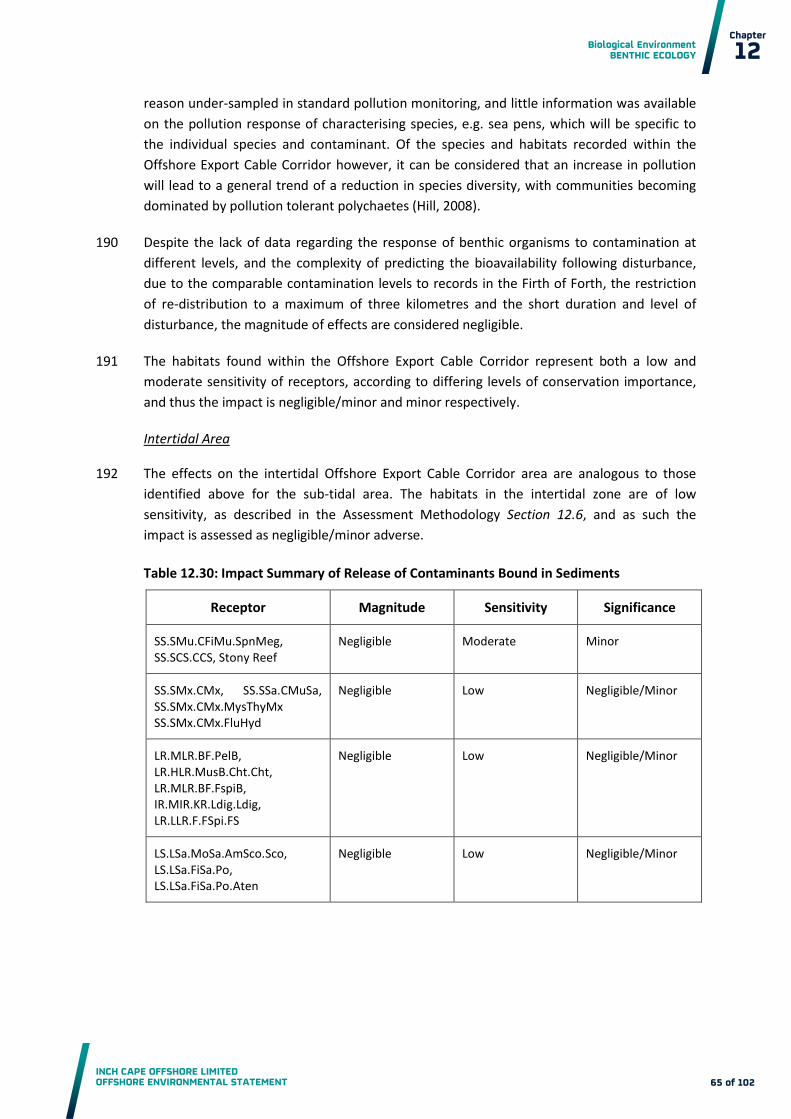
Biological Environment BENTHIC ECOLOGY
INCH CAPE OFFSHORE LIMITED OFFSHORE ENVIRONMENTAL STATEMENT
Chapter
12
65 of 102
reason under-sampled in standard pollution monitoring, and little information was available
on the pollution response of characterising species, e.g. sea pens, which will be specific to
the individual species and contaminant. Of the species and habitats recorded within the
Offshore Export Cable Corridor however, it can be considered that an increase in pollution
will lead to a general trend of a reduction in species diversity, with communities becoming
dominated by pollution tolerant polychaetes (Hill, 2008).
Despite the lack of data regarding the response of benthic organisms to contamination at 190
different levels, and the complexity of predicting the bioavailability following disturbance,
due to the comparable contamination levels to records in the Firth of Forth, the restriction
of re-distribution to a maximum of three kilometres and the short duration and level of
disturbance, the magnitude of effects are considered negligible.
The habitats found within the Offshore Export Cable Corridor represent both a low and 191
moderate sensitivity of receptors, according to differing levels of conservation importance,
and thus the impact is negligible/minor and minor respectively.
Intertidal Area
The effects on the intertidal Offshore Export Cable Corridor area are analogous to those 192
identified above for the sub-tidal area. The habitats in the intertidal zone are of low
sensitivity, as described in the Assessment Methodology Section 12.6, and as such the
impact is assessed as negligible/minor adverse.
Table 12.30: Impact Summary of Release of Contaminants Bound in Sediments
Receptor Magnitude Sensitivity Significance
SS.SMu.CFiMu.SpnMeg, SS.SCS.CCS, Stony Reef
Negligible Moderate Minor
SS.SMx.CMx, SS.SSa.CMuSa, SS.SMx.CMx.MysThyMx SS.SMx.CMx.FluHyd
Negligible Low Negligible/Minor
LR.MLR.BF.PelB, LR.HLR.MusB.Cht.Cht, LR.MLR.BF.FspiB, IR.MIR.KR.Ldig.Ldig, LR.LLR.F.FSpi.FS
Negligible Low Negligible/Minor
LS.LSa.MoSa.AmSco.Sco, LS.LSa.FiSa.Po, LS.LSa.FiSa.Po.Aten
Negligible Low Negligible/Minor

Biological Environment BENTHIC ECOLOGY
INCH CAPE OFFSHORE LIMITED OFFSHORE ENVIRONMENTAL STATEMENT
Chapter
12
66 of 102
Secondary Impacts of Decreased Primary Production due to Increased SSC of the Water
Column
As with the Development Area, increased SSC from Export Cable laying activities in both the 193
sub-tidal and intertidal areas can lead to a reduction in primary production through a
reduction of light penetration. Modelling outputs describing the increase in SSC during the
cabling process are described above in the discussion of temporary increases in SSC and
sediment deposition. These increases are short lived and transient in nature, and are
unlikely to affect the large scale processes which regulate primary production. As such the
magnitude of this effect is considered to be negligible.
The sensitivity of the receptors, as described within the Assessment Methodology Section 194
12.6, are low or moderate, depending on their conservation importance, and as such the
impact is therefore negligible/minor and minor respectively.
Table 12.31: Impact Summary of Secondary Impacts of Decreased Primary Production
Receptor Magnitude Sensitivity Significance
SS.SMu.CFiMu.SpnMeg, SS.SCS.CCS, Stony Reef
Negligible Moderate Minor
SS.SMx.CMx, SS.SSa.CMuSa, SS.SMx.CMx.MysThyMx SS.SMx.CMx.FluHyd
Negligible Low Negligible/ Minor
LR.MLR.BF.PelB, LR.HLR.MusB.Cht.Cht, LR.MLR.BF.FspiB, IR.MIR.KR.Ldig.Ldig, LR.LLR.F.FSpi.FS
Negligible Low Negligible/ Minor
LS.LSa.MoSa.AmSco.Sco, LS.LSa.FiSa.Po, LS.LSa.FiSa.Po.Aten
Negligible Low Negligible / Minor
Potential Release of Pollutants from Construction Plant
Throughout construction there are sources that could add to the current levels of 195
contaminants during cable laying. There is the risk of accidental release of contaminants
such as fuel, lubricating oils, cleaning fluids, paints, sacrificial anodes, specialised chemicals
and litter. Standard controls will be in place, including following best practice and guidelines
for the prevention of pollution at sea, including the establishment of an EMP (Appendix 7A)
that will detail pollution prevention and response procedures. As such it is not predicted that
contaminants from construction plant will be introduced into the environment at a high
level.

Biological Environment BENTHIC ECOLOGY
INCH CAPE OFFSHORE LIMITED OFFSHORE ENVIRONMENTAL STATEMENT
Chapter
12
67 of 102
Due to the Embedded Mitigation the risk of pollutants entering the environment during 196
construction is low and as a result the magnitude of impacts is low. The sensitivity of
receptors is low and moderate according to the relative conservation importance of
receptors. This results in a minor and minor/moderate impact respectively.
Table 12.32: Impact Summary of Potential Release of Pollutants from Construction Plant
Receptor Magnitude Sensitivity Significance
SS.SMu.CFiMu.SpnMeg, SS.SCS.CCS, Stony Reef
Low Moderate Minor/Moderate
SS.SMx.CMx, SS.SSa.CMuSa, SS.SMx.CMx.MysThyMx SS.SMx.CMx.FluHyd
Low Low Minor
LR.MLR.BF.PelB, LR.HLR.MusB.Cht.Cht, LR.MLR.BF.FspiB, IR.MIR.KR.Ldig.Ldig, LR.LLR.F.FSpi.FS
Low Low Minor
LS.LSa.MoSa.AmSco.Sco, LS.LSa.FiSa.Po, LS.LSa.FiSa.Po.Aten
Low Low Minor
Introduction of Non Indigenous Species
The introduction of NIS is possible through a number of pathways, including ships hulls, 197
ballast waters, and the transport of materials to the Offshore Export Cable Corridor.
Embedded Mitigation will reduce the potential for spread of NIS to the Offshore Export
Cable Corridor, and furthermore, as NIS is also a descriptor of GGES under the MSFD, the
prevention of NIS introduction will be a key component of the EMP (Appendix 7A).
Due to uncertainties within the assessment of NIS introduction at offshore developments, 198
the potential long term effects on the local environment, and the importance in terms of the
MSFD, a moderate magnitude of effect is ascribed. The existing benthic communities are
considered to be of no more than moderate sensitivity, and as such the impact is considered
to be moderate.
Table 12.33: Impact Summary of Introduction of Non Indigenous Species
Receptor Magnitude Sensitivity Significance
Benthic and epibenthic communities
Moderate Moderate Moderate

Biological Environment BENTHIC ECOLOGY
INCH CAPE OFFSHORE LIMITED OFFSHORE ENVIRONMENTAL STATEMENT
Chapter
12
68 of 102
12.8.2 Effects of Operation and Maintenance
Loss of Original Habitat
The worst case scenario assessed is that up to 20 per cent of the Export Cable would be 199
protected using means other than burial, i.e. rock placement, mattresses etc., covering a
maximum area of 0.6 km2 (0.6 per cent of Offshore Export Cable Corridor). In these areas,
the loss of the original habitats and species present can be predicted, with a change to hard
substrate.
Due to the limited area affected by the Export Cable protection, the magnitude of effects is 200
considered to be negligible. The sensitivity of the receptors is considered to be low or
moderate according to their relative conservation importance, and as such the impact is
considered to be negligible/minor and minor respectively.
Table 12.34: Impact Summary of Loss of Original Habitat
Receptor Magnitude Sensitivity Significance
SS.SMu.CFiMu.SpnMeg, SS.SCS.CCS, Stony Reef
Negligible Moderate Minor
SS.SMx.CMx, SS.SSa.CMuSa, SS.SMx.CMx.MysThyMx SS.SMx.CMx.FluHyd
Negligible Low Negligible/Minor
LR.MLR.BF.PelB, LR.HLR.MusB.Cht.Cht, LR.MLR.BF.FspiB, IR.MIR.KR.Ldig.Ldig, LR.LLR.F.FSpi.FS
Negligible Low Negligible/Minor
LS.LSa.MoSa.AmSco.Sco, LS.LSa.FiSa.Po, LS.LSa.FiSa.Po.Aten
Negligible Low Negligible/Minor
Colonisation of Introduced Substrata Leading to a Change in the Benthic Ecology and/or
Biodiversity
As within the Development Area assessment, the introduction of new substrate (along the 201
subtidal areas of the Offshore Export Cable Corridor from the export cable protection) will
have direct effects on the overall biodiversity of the site, and indirect effects through
increased food availability to higher trophic levels (see Chapter 13). Furthermore,
community changes, through the introduction of hard substrate species, are expected in the
sedimentary habitats immediately surrounding the cable protection (Degraer et al., 2011).
Changes are likely to be present throughout the operational phase. However, such 202
community changes will be localised to the new habitat (footprint of 0.6 km2 along the
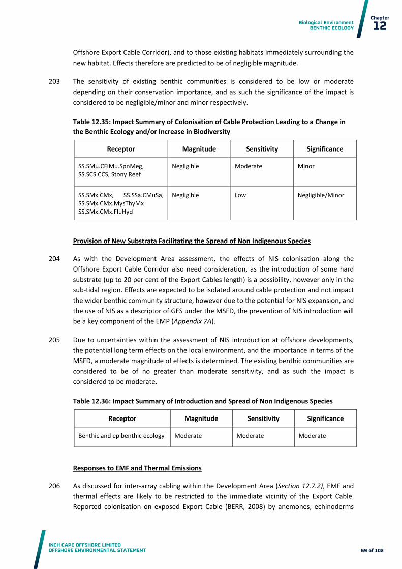
Biological Environment BENTHIC ECOLOGY
INCH CAPE OFFSHORE LIMITED OFFSHORE ENVIRONMENTAL STATEMENT
Chapter
12
69 of 102
Offshore Export Cable Corridor), and to those existing habitats immediately surrounding the
new habitat. Effects therefore are predicted to be of negligible magnitude.
The sensitivity of existing benthic communities is considered to be low or moderate 203
depending on their conservation importance, and as such the significance of the impact is
considered to be negligible/minor and minor respectively.
Table 12.35: Impact Summary of Colonisation of Cable Protection Leading to a Change in
the Benthic Ecology and/or Increase in Biodiversity
Receptor Magnitude Sensitivity Significance
SS.SMu.CFiMu.SpnMeg, SS.SCS.CCS, Stony Reef
Negligible Moderate Minor
SS.SMx.CMx, SS.SSa.CMuSa, SS.SMx.CMx.MysThyMx SS.SMx.CMx.FluHyd
Negligible Low Negligible/Minor
Provision of New Substrata Facilitating the Spread of Non Indigenous Species
As with the Development Area assessment, the effects of NIS colonisation along the 204
Offshore Export Cable Corridor also need consideration, as the introduction of some hard
substrate (up to 20 per cent of the Export Cables length) is a possibility, however only in the
sub-tidal region. Effects are expected to be isolated around cable protection and not impact
the wider benthic community structure, however due to the potential for NIS expansion, and
the use of NIS as a descriptor of GES under the MSFD, the prevention of NIS introduction will
be a key component of the EMP (Appendix 7A).
Due to uncertainties within the assessment of NIS introduction at offshore developments, 205
the potential long term effects on the local environment, and the importance in terms of the
MSFD, a moderate magnitude of effects is determined. The existing benthic communities are
considered to be of no greater than moderate sensitivity, and as such the impact is
considered to be moderate.
Table 12.36: Impact Summary of Introduction and Spread of Non Indigenous Species
Receptor Magnitude Sensitivity Significance
Benthic and epibenthic ecology Moderate Moderate Moderate
Responses to EMF and Thermal Emissions
As discussed for inter-array cabling within the Development Area (Section 12.7.2), EMF and 206
thermal effects are likely to be restricted to the immediate vicinity of the Export Cable.
Reported colonisation on exposed Export Cable (BERR, 2008) by anemones, echinoderms

Biological Environment BENTHIC ECOLOGY
INCH CAPE OFFSHORE LIMITED OFFSHORE ENVIRONMENTAL STATEMENT
Chapter
12
70 of 102
and sponges also highlights the apparent minimal impact likely on benthic species. The
target burial depth of the Export Cable (one metre), and protection where this is not
feasible, will reduce interaction with benthic species. Thus effects of EMF and thermal
emissions are predicted to be negligible. The sensitivity of receptors is low, and moderate
for the habitats and species of conservation importance identified along the Offshore Export
Cable Corridor. The resulting impact of EMF and increased temperatures due to electrical
transmission is therefore negligible/minor and minor respectively.
Table 12.37: Impact Summary of EMF and Heating Effects
Receptor Magnitude Sensitivity Significance
SS.SMu.CFiMu.SpnMeg, SS.SCS.CCS, Stony Reef
Negligible Moderate Minor
SS.SMx.CMx, SS.SSa.CMuSa, SS.SMx.CMx.MysThyMx SS.SMx.CMx.FluHyd
Negligible Low Negligible/Minor
LR.MLR.BF.PelB, LR.HLR.MusB.Cht.Cht, LR.MLR.BF.FspiB, IR.MIR.KR.Ldig.Ldig, LR.LLR.F.FSpi.FS
Negligible Low Negligible/Minor
LS.LSa.MoSa.AmSco.Sco, LS.LSa.FiSa.Po, LS.LSa.FiSa.Po.Aten
Negligible Low Negligible/Minor
Potential Release of Pollutants from Operation Plant
As with the construction phase, a number of possible pollution sources exist during 207
operation. The effects of pollution on the local environment, and the standard controls and
implementation of the EMP (Appendix 7A) outlined for the construction phase, also apply
during the operation phase. The impact magnitude is therefore assessed as low.
The sensitivity of existing benthic communities is considered to be low or moderate 208
depending on their conservation importance, and as such the impact is considered to be
minor and minor/moderate respectively.
Table 12.38: Impact Summary of Potential Release of Pollutants from Operation Plant
Receptor Magnitude Sensitivity Significance
SS.SMu.CFiMu.SpnMeg, SS.SCS.CCS, Stony Reef
Low Moderate Minor/Moderate
SS.SMx.CMx, SS.SSa.CMuSa, SS.SMx.CMx.MysThyMx SS.SMx.CMx.FluHyd
Low Low Minor

Biological Environment BENTHIC ECOLOGY
INCH CAPE OFFSHORE LIMITED OFFSHORE ENVIRONMENTAL STATEMENT
Chapter
12
71 of 102
Receptor Magnitude Sensitivity Significance
LR.MLR.BF.PelB, LR.HLR.MusB.Cht.Cht, LR.MLR.BF.FspiB, IR.MIR.KR.Ldig.Ldig, LR.LLR.F.FSpi.FS
Low Low Minor
LS.LSa.MoSa.AmSco.Sco, LS.LSa.FiSa.Po, LS.LSa.FiSa.Po.Aten
Low Low Minor
Temporary Habitat Disturbance due to O&M Activities
During operation the worst case scenario that is applied is re-burial or maintenance along a 209
maximum of 10 per cent of the length of the Export Cable (annual area of disturbance is
0.007 km2), which results in a negligible magnitude for this impact. The sensitivity of the
habitats is considered to be low, or moderate for those habitats of conservation importance,
and as such the impact is considered to be negligible/minor or minor respectively.
Table 12.39: Impact Summary of Temporary Habitat Disturbance due to O&M Activities
Receptor Magnitude Sensitivity Significance
SS.SMu.CFiMu.SpnMeg, SS.SCS.CCS, Stony Reef
Negligible Moderate Minor
SS.SMx.CMx, SS.SSa.CMuSa, SS.SMx.CMx.MysThyMx SS.SMx.CMx.FluHyd
Negligible Low Negligible/Minor
LR.MLR.BF.PelB, LR.HLR.MusB.Cht.Cht, LR.MLR.BF.FspiB, IR.MIR.KR.Ldig.Ldig, LR.LLR.F.FSpi.FS
Negligible Low Negligible/Minor
LS.LSa.MoSa.AmSco.Sco, LS.LSa.FiSa.Po, LS.LSa.FiSa.Po.Aten
Negligible Low Negligible/Minor
12.8.3 Effects of Decommissioning
The potential effects of decommissioning are considered to be equivalent to and potentially 210
lower than the worst case effects assessed for the construction phase. The approach to
decommissioning is described in Section 7.12. A decommissioning plan will be prepared in
accordance with the requirements of the Energy Act 2004 (see Section 3.2.5) and will be
subject to approval from the DECC prior to implementation.

Biological Environment BENTHIC ECOLOGY
INCH CAPE OFFSHORE LIMITED OFFSHORE ENVIRONMENTAL STATEMENT
Chapter
12
72 of 102
12.9 Impact Interactions
The potential for individual impacts identified through the impact assessment to interact 211
and create new, or more significant impacts on benthic ecology has been assessed. Impacts
from the effects considered are considered predominantly to be temporally sequential. For
example, deposition causing smothering will occur following an increase in suspended
sediments but the maximum from each individual effect will not occur simultaneously.
Furthermore, assessments are made considering worst case scenarios and peak
measurements, and it is unlikely that impacts will interact at these levels.
In addition, for a number of effects the worst case scenarios relate to design parameters 212
that will not coexist. For example jacket foundations drive a worst case for scour related
impacts, and GBS drive a worst case for habitat loss. There will be no path for additive
elements for these effects as the worst cases are independent. As such the effects are not
predicted to increase beyond that assigned for each impact in isolation.
The potential for impacts from other projects to interact with the impacts identified in the 213
impact assessment and cumulative impact assessment to result in a greater long term
effects has been assessed. No such interactions are identified.
12.10 Cumulative Impacts
The assessment of cumulative impacts is structured as follows: 214
firstly, cumulative impacts of the Wind Farm with the OfTW, i.e. the Project, are
assessed (see Section 12.10.1 to 12.10.3); and
secondly, cumulative impacts of the Project with other projects and activities in the area
(see Section 12.10.4 to 12.10.7).
The cumulative assessment takes a precautionary standpoint in that the most sensitive 215
habitats present are taken forward into the assessment of significance. The full list of
projects and activities considered as part of the cumulative assessment are found in Section
4.7. These fall into the following categories:
Other offshore wind farms in the Firth of Forth and Tay area; and
Other projects and activities.
Other Offshore Wind Farms in the Firth of Forth and Tay Area
The other offshore wind farms in the Firth of Forth and Tay area include projects developed 216
by Seagreen Wind Energy, and Mainstream Renewable Power, i.e. the Firth of Forth, and
Neart ne Gaoithe offshore wind farms. The construction periods for the three projects are:
Neart ne Gaoithe – Construction to begin in March 2015, ending September 2016;
Firth of Forth (Alpha, Bravo and Transmission Asset) – Export cable October 2015,
ending December 2017, WTGs from July 2016, ending December 2019; and

Biological Environment BENTHIC ECOLOGY
INCH CAPE OFFSHORE LIMITED OFFSHORE ENVIRONMENTAL STATEMENT
Chapter
12
73 of 102
Inch Cape Offshore Wind Farm– The construction activities are expected to start in 2016
and work will occur over approximately four years (see Section 7.10). The Firth of Forth
Offshore Wind Farm phases 2 and 3 also have the potential to interact with the Project
and generate cumulative impacts and as such are considered further within this
cumulative assessment. However, as stated within the Firth of Forth Phase 1 ES,
mitigation for the development would ensure that any sensitive habitats are avoided,
and the impacts at phase 2 and 3 are not predicted by Seagreen to be significant.
Furthermore, no significant cumulative impacts of the later phases of the development
are predicted, and as such these subsequent phases of the Firth of Forth Offshore Wind
Farm are not considered further within this cumulative assessment.
Other Projects and Activities
Other Offshore Wind Farms:
o European Offshore Wind Development Centre (Aberdeen);
o Hywind Demonstration Site (near Aberdeen);
o Methil (Fife Energy Park) Offshore Demonstration Wind Turbine (Methil);
o Beatrice Offshore Wind Farm (Moray Firth); and
o Moray Firth Offshore Wind Farm R3 Zone (Moray Firth).
These other offshore wind farms are considered to be sufficiently distant to the Project that 217
no cumulative impacts with regard to benthic ecology are predicted.
Onshore Wind Farms – No cumulative impacts with respect to Benthic Ecology.
Other Coastal Projects:
o Forth Replacement Crossing (Firth of Forth);
o Rosyth Interational Container Terminal Project (Rosyth);
o Coastal Improvement Works at the Mouth of the Barry Burn (Carnoustie);
o Edinburgh Harbour Master Plan (Leith);
o Port of Dundee Expansion; and
o GlaxoSmithKline Tidal Energy (Montrose).
The scale and distance from the Project of these developments means that no interactions 218
or cumulative impacts are predicted on the benthic ecology at a significant level. As such
these projects are not considered further within the assessment.
Other Onshore Projects:
o Grangemouth Renewable Energy Plant (Grangemouth);
o Rosyth Renewable Energy Plant (Rosyth);
o Dundee Renewable Energy Plant (Dundee);
o Victoria and Albert Museum (Dundee);

Biological Environment BENTHIC ECOLOGY
INCH CAPE OFFSHORE LIMITED OFFSHORE ENVIRONMENTAL STATEMENT
Chapter
12
74 of 102
o Captain Clean Energy Project Caledonia Clean Energy Project (Grangemouth); and
o Cockenzie Combined Cycle Gas Turbine Power Station (Cockenzie).
No cumulative impacts with respect to benthic ecology are predicted, and as such these 219
projects are scoped out of the following assessment.
The impacts assessed as having potential cumulative effects over the construction, operation 220
and decommissioning phases are the same as the Development Area and Offshore Export
Cable Corridor in isolation, i.e.:
Effects of Construction (and Decommissioning):
o Direct temporary disturbance of seabed habitats caused by construction based
activities;
o Indirect impacts of temporary increases in SSC from construction based activities
and associated deposition;
o Release of contaminants bound in sediments;
o Secondary impacts of decreased primary production due to increased SSC of the
water column;
o Potential release of pollutants from construction plant; and
o Introduction of NIS.
Effects of Operation:
o Loss of original habitat;
o Changes in hydrodynamic regime and sediment transport leading to changes in
seabed habitats (scour);
o Colonisation of introduced substrata leading to a change in the benthic ecology
and/or biodiversity;
o Provision of Introduced Substrata facilitating spread of NIS;
o Potential release of pollutants from operation plant;
o Responses to EMF and thermal emissions; and
o Temporary habitat disturbance from O&M activities.
Table 12.40 summarises the assessment parameters taken from published ES’ for the Firth of 221
Forth and Neart ne Gaoithe offshore wind farms during both construction and operation,
alongside the project specific design envelopes.
Impacts Scoped Out
A number of impacts have been scoped out of the following sections as no cumulative effects 222
are predicted. These are summarised below:
The Project (as defined):
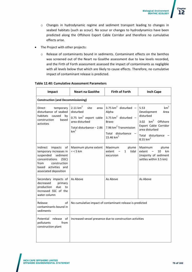
Biological Environment BENTHIC ECOLOGY
INCH CAPE OFFSHORE LIMITED OFFSHORE ENVIRONMENTAL STATEMENT
Chapter
12
75 of 102
o Changes in hydrodynamic regime and sediment transport leading to changes in
seabed habitats (such as scour). No scour or changes to hydrodynamics have been
predicted along the Offshore Export Cable Corridor and therefore no cumulative
effects arise.
The Project with other projects:
o Release of contaminants bound in sediments. Contaminant effects on the benthos
was screened out of the Neart na Goaithe assessment due to low levels recorded,
and the Firth of Forth assessment assessed the impact of contaminants as negligible
with all levels below that which are likely to cause effects. Therefore, no cumulative
impact of contaminant release is predicted.
Table 12.40: Cumulative Assessment Parameters
Impact Neart na Gaoithe Firth of Forth Inch Cape
Construction (and Decommissioning)
Direct temporary disturbance of seabed habitats caused by construction based activities
2.11 km2 site area
disturbed
0.75 km2 export cable
area disturbed
Total disturbance – 2.86 km
2
3.75 km2 disturbed –
Alpha
3.75 km2 disturbed –
Bravo
7.96 km2 Transmission
Total disturbance – 15.46 km
2
5.53 km2
Development Area disturbed
3.02 km2 Offshore
Export Cable Corridor area disturbed
Total disturbance – 8.55 km
2
Indirect impacts of temporary increases in suspended sediment concentrations (SSC) from construction based activities and associated deposition
Maximum plume extent = < 5 km
Maximum plume extent – 1 tidal excursion
Maximum plume extent – 10 km (majority of sediment settles within 3.5 km)
Secondary impacts of decreased primary production due to increased SSC of the water column
As Above As Above As Above
Release of contaminants bound in sediments
No cumulative impact of contaminant release is predicted
Potential release of pollutants from construction plant
Increased vessel presence due to construction activities

Biological Environment BENTHIC ECOLOGY
INCH CAPE OFFSHORE LIMITED OFFSHORE ENVIRONMENTAL STATEMENT
Chapter
12
76 of 102
Impact Neart na Gaoithe Firth of Forth Inch Cape
Operation
Loss of Original Habitat 0.31 km2 site area lost
0.05 km2 export cable
area lost
Total loss – 0.36 km2
Combined loss of 2.18 km
2 across Alpha,
Bravo and export cable
1.87 km2
Development Area lost
0.60 km2 Offshore
Export Cable Corridor lost
Total loss – 2.47 km2
Changes in hydrodynamic regime and sediment transport leading to changes in habitats such as scour
Increase in current speed of 0.02 m/s and decrease by 0.04 m/s
Maximum lateral extent of scour = 7.99 m
Negligible magnitude impacts on current speeds
Scour Footprint = 0.36 km
2
Increases and decreases in water flow up to 0.04 m/s (7 % change from baseline)
Scour Footprint = 0.49 km
2
Lateral extent of footprint on spring tide – 12 m
Colonisation of introduced substrata leading to a change in the benthic ecology and/or a biodiversity
Colonisation of introduced new substrate from foundations, scour protection and cable protection. Footprint of introduced substrata equal to area defined under loss of original habitat
Introduction and spread of NIS
NIS introduction will be a key component of the EMP (Appendix 7A)
EMF and heating effects
140 km inter-array cable buried to 1 -3 m
2 x 33 km export cable buried to 1-3 m
355 km inter-array cable buried to 0.5 m minimum (for both Alpha and Bravo)
530 km export cable buried to 0.5 m minimum (Transmission)
353 km inter-array cable buried 0 – 3 m (target 1 m) with protection where not buried
6 x 83 km export cable buried 0 – 3 m (target 1 m) with protection where not buried

Biological Environment BENTHIC ECOLOGY
INCH CAPE OFFSHORE LIMITED OFFSHORE ENVIRONMENTAL STATEMENT
Chapter
12
77 of 102
Impact Neart na Gaoithe Firth of Forth Inch Cape
Temporary habitat disturbance via jacking-up of O&M vessels and cable maintenance
Area disturbed per jack up vessel if 848 m
2, two
visits per year of operation gives an annual total 0.1 km
2
Inter-array cable annual maintenance – 0.008 km
2 (assuming total re-
burial)
Export cable annual maintenance – 0.002 km
2 (assuming 10 % re-
burial)
Area disturbed per jack up vessel if 729 m
2, assume one visit
per foundation per five years of operation gives an annual total of 0.12 km
2
Inter-array cable annual maintenance – 0.002 km
2 (assuming
10 % re-burial along 355 km cable, width 3 m)
Export cable annual maintenance – 0.016 km
2 (assuming 10 %
re-burial)
Area disturbed per jack up vessel if 600 m
2, one visit per
foundation per five years of operation gives an annual total of 0.13 km
2
Inter-array cable annual maintenance – 0.004 km
2 (assuming
10 % re-burial)
Export cable annual maintenance – 0.007 km
2 (assuming 10 %
re-burial)
12.10.1 Cumulative Impacts of the Project during Construction
Direct Temporary Seabed Disturbance caused by Construction Based Activities
The combination of construction activities in the Development Area and Offshore Export 223
Cable Corridor is predicted to result in a total area of habitat disturbance of 8.6 km2 based
upon the worst case scenario (3.4 per cent of the Development area and Offshore Export
Cable Corridor when combined). As described within the individual assessments, the
disturbance is considered to be localised and of a small scale in relation to the wider
geographical context of available habitats. As a result the magnitude of this effect is
considered to be low, with a low to moderate sensitivity ascribed to species and habitats
depending on their relative conservation importance. Therefore the impact is considered to
be minor/moderate.
Indirect Impacts of Temporary Increases in SSC from Construction Based Activities and
Associated Deposition
The combination of increased suspended sediment derived from construction activities 224
within the Development Area and the Offshore Export Cable Corridor are not predicted to be
carried beyond the near field and as such are unlikely to interact over the majority of the
combined areas. Overlap will only occur at a distance of 10 km from the Development Area
if cable laying at the northern extent of the Offshore Export Cable Corridor and dredging or
cable laying at the southern end of the Development Area occurred at the same time. As
such, and due to the small area ultimately affected, no increase in magnitude is predicted
beyond the individual impact assessments, with a low magnitude predicted. The habitats
likely to be impacted are of low or moderate sensitivity, and as such the overall cumulative
impact is minor/moderate.
Biological Environment BENTHIC ECOLOGY
INCH CAPE OFFSHORE LIMITED OFFSHORE ENVIRONMENTAL STATEMENT
Chapter
12
78 of 102
Release of Contaminants Bound in Sediments
The sediments both within the Development Area and along the Offshore Export Cable 225
Corridor have been shown to contain a number of contaminants at varying levels. Although
construction activities may lead to the remobilisation of these contaminated sediments,
they are not predicted to travel in excess of 10 km from the Development Area, and 3.5 km
from the Offshore Export Cable Corridor. The benthic communities in the Development Area
and Offshore Export Cable Corridor indicate a certain level of tolerance to the current levels
(as indicated by baseline sampling stations), and due to the cumulative levels of sediment
resuspension and movement predicted, and as the movement of contaminants into non-
contaminated areas is unlikely, the magnitude of effects is predicted to be low, in line with
the assessment for the Development Area and Offshore Export Cable Corridor considered
separately.
The sensitivity of species and habitats varies from low to moderate, and as such the impact 226
is considered to be minor/moderate.
Secondary Impacts of Decreased Primary Production due to Increased SSC of the Water
Column
Increases in suspended sediment and therefore turbidity will occur at both the Development 227
Area and Offshore Export Cable Corridor during construction phases. The deep benthic
communities found at the Development Area could experience a reduction in food
availability if an effect on primary production was seen. The effects assessed during the
construction phase for the Development Area and Offshore Export Cable Corridor showed
small, short lived and localised increases in turbidity that would not affect the large scale
processes driving primary production. Cumulatively there would be an increase in turbidity
over a wider area, but the low levels predicted mean no increases to effects over those
identified in the Development Area and Offshore Export Cable Corridor are expected.
These limited effects of construction on primary production results in a negligible magnitude 228
of effects. A low or moderate sensitivity is determined for the species and habitats present,
and as such the overall impact is considered to be minor.
Potential Release of Pollutants from Construction Plant
The increased need for construction plant over the Project as a whole, when compared to 229
the individual elements, means that the risk of a pollution event occurring increases.
However, the potential release of pollutants from construction plant will be managed, and
following best practice guidance will reduce the risk of major pollution events.
The low risk of pollution events results in a low magnitude of effect, and with a low or 230
moderate sensitivity of species and habitats, the overall impact is considered to be
minor/moderate.

Biological Environment BENTHIC ECOLOGY
INCH CAPE OFFSHORE LIMITED OFFSHORE ENVIRONMENTAL STATEMENT
Chapter
12
79 of 102
Introduction of NIS
As with the Development Area and Offshore Export Cable Corridor assessment, the effects 231
of NIS introduction due to vessel and material transport also need consideration.
NIS is a descriptor of GES under the MSFD, and as such the prevention of NIS introduction 232
will be a key component of the EMP (Appendix 7A). However, due to uncertainties within the
assessment of NIS introduction at offshore developments, the potential long term effects on
the local environment, and the importance in terms of the MSFD, a moderate magnitude of
effects is determined.
The sensitivity of existing benthic communities is considered to be low or moderate, and as 233
such the impact is considered to be moderate according to a precautionary standpoint.
12.10.2 Cumulative Impacts of the Project during Operation and Maintenance
Loss of Original Habitat
The combination of the installation within the Development Area and Offshore Export Cable 234
Corridor will result in a total area of permanent habitat loss of less than 2.5 km2 based upon
the worst case scenario (equating to <1 per cent of the Development Area and Offshore
Export Cable Corridor combined). In relation to the wider geographical context of available
habitats this loss is considered to be of negligible magnitude.
Habitats and species found within the Project area are considered to be of low or moderate 235
sensitivity, and as such the overall impact is considered to be minor.
Colonisation of Introduced Substrata Leading to a Change in the Benthic Ecology and/or
Biodiversity
As within the Development Area and Offshore Export Cable Corridor assessments, the 236
introduction of new substrate will have direct effects on the overall biodiversity of the
Project areas, and indirect effects through increased food availability to higher trophic levels
(see Chapter 13). Furthermore, community changes, through the introduction of hard
substrate species, are expected in the sedimentary habitats immediately surrounding the
cable protection (Degraer et al., 2011).
Changes are likely to be present throughout the operational phase. However, such 237
community changes will be localised to the new habitat, and to those existing habitats
immediately surrounding the new habitat. As such effects are predicted to be of negligible
magnitude. The sensitivity of existing benthic communities is considered to be low or
moderate, and as such the impact is considered to be minor.
Provision of New Substrata Facilitating the Spread of NIS
As with the Development Area and Offshore Export Cable Corridor assessments, the effects 238
of NIS colonisation of any introduced substrata also need consideration. Effects are expected
to be isolated around introduced substrate and not impact the wider benthic community

Biological Environment BENTHIC ECOLOGY
INCH CAPE OFFSHORE LIMITED OFFSHORE ENVIRONMENTAL STATEMENT
Chapter
12
80 of 102
structure, however due to the potential expansion of NIS ranges, and the use of NIS as a
descriptor of GES under the MSFD, the prevention of NIS introduction will be a key
component of the EMP (Appendix 7A).
The conclusions of significance for the spread of NIS mirror those for their introduction at 239
the construction phase, and as such this cumulative impact is considered to be moderate.
Potential Release of Pollutants from Operation Plant
As with the Development Area and Offshore Export Cable Corridor assessment, a number of 240
possible pollution sources exist during operation. The effects of pollution on the local
environment, and the standard controls and EMP (Appendix 7A) outlined for the
construction phase, also apply during the operation phase. The impact magnitude is
therefore assessed as low.
The sensitivity of existing benthic communities is considered to be low or moderate, and as 241
such the impact is considered to be minor/moderate.
EMF and Heating Effects
Due to the locality of any effects on benthic species as a result of EMF and thermal heating, 242
effects within the Development Area and Offshore Export Cable Corridor do not present
cumulative impacts beyond those assessed individually, and are therefore considered to be
of negligible magnitude. The sensitivity of existing benthic communities is considered to be
low or moderate, and as such the impact is determined as minor.
Temporary Habitat Disturbance of O&M
Temporary habitat disturbance of the Offshore Export Cable Corridor and the Development 243
Area resulting from jack-up vessels and cable maintenance, using a 10 per cent re-burial of
the Export Cable as the worst case scenario, of 0.13 km2 per annum.
This area represents a temporary disturbance, with recovery of communities expected in 244
line with that identified for the construction phase impact of temporary habitat disturbance,
i.e. two to three years for the majority of species and habitats. As a result of this, and due to
the small annual area of effect, the magnitude of this impact is considered to be negligible.
The sensitivity of existing benthic communities is considered to be low or moderate
depending on their conservation importance, and as such the impact is determined as
minor.
12.10.3 Cumulative Impacts of the Project during Decommissioning
The potential effects of decommissioning are considered to be equivalent to and potentially 245
lower than the worst case effects assessed for the construction phase. The approach to
decommissioning is described in Section 7.12. A decommissioning plan will be prepared in
accordance with the requirements of the Energy Act 2004 (see Section 3.2.5) and will be
subject to approval from the DECC prior to implementation

Biological Environment BENTHIC ECOLOGY
INCH CAPE OFFSHORE LIMITED OFFSHORE ENVIRONMENTAL STATEMENT
Chapter
12
81 of 102
12.10.4 Cumulative Impact of the Project and Other Projects
The benthic environments present at the Firth of Forth and Neart na Gaoithe offshore wind 246
farms are summarised below to give some context to the following assessments. The
baseline conditions present at the Project are discussed in Section 12.5, and in Appendices
12A, 12B, 12C and 12D.
At a wider level, and described by the EUSeaMap project, the offshore environment across 247
the wider Firth of Forth area is characterised by shelf and bathyal sands, and coarse or mixed
sediments, with shallow and shelf muds and sands present within the Firth of Forth. To the
south (towards the Northumberland coast) rocky substrate appears more commonly in the
offshore environment, but which is restricted elsewhere to a narrow coastal band.
Firth of Forth Offshore Wind Farm
Each of the three proposed areas, Alpha, Bravo and the transmission asset (export cable) 248
have been characterised in terms of their benthic ecology as follows:
Alpha - The western area of the Alpha site is dominated by three communities, namely
Sabellaria (SBR.PoR.SspiMx), sparse polychaete and bivalves (SCS.ICS.MoeVen), and
faunal turf (SMX.CMx.FluHyd) habitats. The central and eastern area consists of sandy
muddy mixed sediments dominated by sabellid polychaetes (SS.SMx.OMx).
Bravo - The Bravo site was comparable, with the western half dominated by rich
polychaete (SS.SMx.OMx.PoVen), Sabellaria (SBR.PoR.SspiMx), and epifauna/polychaete
(SS.SMx.OMx.PoVen) habitats, and the eastern half predominately SS.SMx.OMx.PoVen
and SS.SMx.OMx.
The transmission asset - The transmission asset cable corridor comprises of ophiothrix
(SMc.CMx.OphMx) and faunal turf (SMX.CMx.FluHyd) habitat at the area adjoining the
Alpha site, then moving into Sabellaria (SBR.PoR.SspiMx) and sparse polychaete and
bivalve (SCS.ICS.MoeVen) habitats. Moving eastwards is an area dominated by rich
polychaete (SS.SMx.OMx.PoVen) and sparse Amphiura (SSMx.CMx.MysThyMx) habitats,
with outcrops of cobble/faunal turf (SS.SMX.CMx) and epifauna/polychaete
(SS.SMx.OMx.PoVen) habitats. Further inshore the area is dominated by a large stretch
of Amphiura/Phoronis habitat (SS.SMu.CSaMu.AfilMysAint) giving way to cobble/faunal
turf (SS.SMX.CMx) at the landfall point. In the intertidal, the exposed sandy beach was
devoid of benthic fauna, with the lower eulittoral sediments dominated by polychaetes.
Species and habitats of conservation importance were identified, including offshore sub-249
tidal sands and gravels (PMF), A. islandica (JNCC, 2012 and OSPAR, 2008b), shelf banks and
mounds (MPA large scale search feature) and sub-tidal rocky reef (Annex 1 reef). Sabellaria
spinulosa was also identified across the site but not in its reef form. As a result of the species
and habitats present, the sensitivity of receptors was classed from very low to moderate.

Biological Environment BENTHIC ECOLOGY
INCH CAPE OFFSHORE LIMITED OFFSHORE ENVIRONMENTAL STATEMENT
Chapter
12
82 of 102
Neart na Gaoithe Offshore Wind Farm
The site and export cable areas have been characterised in terms of their benthic ecology as 250
follows:
The site is characterised by circalittoral sandy mud (SS.SMu.CSaMu), dominated by
Amphiura filiformis and Nuculoma tenuis (SS.SMu.CSaMu.AfilNten) with circalittoral
coarse sediment (SS.SSa.OSa) and offshore circalittoral sand (SS.SCS.CCS) also extensive.
The export cable is characterised by deep circalittoral mud in the offshore region,
dominated by the biotopes SS,SMu.CSaMu.ThyNten, AfilMysAnit and AfilNten, and
overlain with SS.SMu.CFiMu.SpnMeg. Further inshore, deep circalittoral coarse sediment
and low energy rock habitats prevail, characterised by the biotope SS.SCS.CCS and areas
with dense populations of O. fragilis (SS.SMx.CMx,OphMx) at the most southerly and
northerly boundaries. The intertidal sandy habitats of the two landing points are typical
of exposed sites along the east coast of Scotland and devoid of fauna.
Habitats of conservation importance were identified, including the littoral biotopes 251
LR.FLR.RkpG, LR.FLR.Eph.EntPor, and LR.MLR.BF.Rho, and the infralittoral IR.MIR.KR.Ldig,
which are contained within Annex 1 reef features. Also the littoral rock features (LR.FLR) are
UK BAP priority habitats. Offshore, habitats of conservational interest identified consist of
small areas of stony reef, however these were not conclusively classified as Annex 1 habitat.
Burrowed mud (PMF), circalittoral sands and coarse sediments (BAP priority habitats), and
brittlestar beds (SS.SMx.CMx,OphMx) were also identified in the sub-tidal.
Species of conservation importance identified were A. islandica (OSPAR,2008b; JNCC, 2012), 252
Echinus esculentus (IUCN Red List, revised 2012), Simnia patula (Scottish Government, last
updated 2013) and Devonia perrieri (Scottish Government, last updated 2013). As a result of
the species and habitats present, the vulnerability of receptors was classed as negligible to
low (low to moderate equivalent by the Project classification).
12.10.5 Cumulative Impacts of the Project and Other Projects during Construction
Direct Temporary Disturbance of Seabed Habitats Caused by Construction Activities
Total habitat disturbance across all projects (Inch Cape, Firth of Forth and Neart na Gaoithe) 253
assessed (Table 12.40) is 26.9 km2 based upon all worst case scenarios calculated within
each impact assessment. In relation to the wider geographical context of available habitats
the disturbance area is considered to be localised (area represents 4.2 per cent of the
combined Development Area and Neart na Goaoithe and Firth of Forth sites), and recovery
is expected in line with that predicted for the Project (i.e. within two to three years). As
such, the cumulative effect magnitude is considered to be low.
The sensitivity of benthic communities likely to be affected across the developments is 254
considered to be low or moderate depending on their conservation importance, and as such
the impact is determined as minor/moderate.

Biological Environment BENTHIC ECOLOGY
INCH CAPE OFFSHORE LIMITED OFFSHORE ENVIRONMENTAL STATEMENT
Chapter
12
83 of 102
Indirect Impacts of Temporary Increases in SSC from Construction Based Activities and
Associated Deposition
Suspended sediment increases for other projects considered in the cumulative assessment 255
area are predicted, with fine particles transported a number of kilometres from source
(Table 12.40). However, the spread of sites mean sediment plumes are unlikely to interact at
levels beyond background. The locality of some areas of the projects does allow for some
overlap if cable burial and dredging occur simultaneously. However the short duration of
cable burial would result in effects seen over a number of hours, with most suspended
sediment settling within one tidal cycle. The settlement of sediment within these areas
therefore could increase beyond predicted levels for each site where overlap occurs.
However, the areas likely to be impacted by overlap are small, and as such smothering
impact interactions are predicted to be small, especially as low levels of settlement
(millimetres) are predicted from cable laying operations.
In view of this, the magnitude of impacts is considered to be low and the sensitivity of the 256
species and habitats affected low or moderate, as a number of those of conservation
interest reside in areas of overlap. The cumulative impact is therefore predicted to be
minor/moderate.
Secondary Impacts of Decreased Primary Production due to Increased SSC of the Water
Column
Increases in SSC will occur across all the projects during construction phases. The benthic 257
communities present could experience a reduction in food availability if an effect on primary
production was seen. However, in relation to the wider environmental drivers of primary
production, the increases in SSC are short lived and localised and are not predicted to affect
the large scale processes driving primary production.
These limited effects of construction on primary production results in a negligible magnitude 258
of effects, and the sensitivity of receptors determined as low or moderate. As such, the
overall impact is considered to be minor.
Potential Release of Pollutants from Construction Plant
The increased need for construction plant across all projects, means that the risk of a 259
pollution event occurring increases. However, the potential release of pollutants from
construction plant will be closely managed, and following best practice guidance will reduce
the risk of major pollution events.
The low risk of pollution events results in a low magnitude of effect, however with low to 260
moderate sensitivity species and habitats identified, the overall impact is considered to be
minor/moderate.

Biological Environment BENTHIC ECOLOGY
INCH CAPE OFFSHORE LIMITED OFFSHORE ENVIRONMENTAL STATEMENT
Chapter
12
84 of 102
Introduction of NIS
Both the Development Area and Offshore Export Cable Corridor assessments highlight the 261
effects of NIS introduction due to vessel and material transport. Embedded Mitigation will
reduce the potential for spread of NIS, and the prevention of NIS introduction will be a key
component of the EMP (Appendix 7A).
Due to uncertainties within the assessment of NIS introduction at offshore developments, 262
the potential long term effects on the local environment, and the importance in terms of the
MSFD, a moderate magnitude of effects is determined. The sensitivity of existing benthic
communities is considered to be low or moderate depending on their conservation
importance, and as such the impact is considered to be moderate.
12.10.6 Cumulative Impacts of the Project and Other Projects during O&M
Loss of Original Habitat
The total habitat loss of the cumulative development projects, using reported permanent 263
loss areas calculated for each site, is 5.0 km2, which is equivalent to less than 1.0 per cent of
the combined development areas. In relation to the wider geographical context of available
habitats this loss is therefore considered to be of negligible magnitude.
The sensitivity of benthic communities likely to be affected across the developments is 264
considered to be low or moderate, and as such the impact is determined as minor.
Changes in Hydrodynamic Regime and Associated Sediment Transport
Considering all cumulative developments, no interactions are predicted within Chapter 10, 265
with any changes in hydrodynamic and sediment transport processes restricted to the near
field of each project. In view of this, the magnitude of impacts is considered low, with the
sensitivity of receptors ranging from low to moderate. As such the overall cumulative impact
is predicted to be minor/moderate.
Scour and Associated Sediment Transportation leading to changes in Seabed Habitats
Although no cumulative change in sedimentary conditions are predicted in Chapter 10, at 266
each development, potential for scour to occur has been identified in the absence of
protection. While the scour footprints for each site are localised to each foundation base, 12
m lateral extent of scour pits are predicted at the Inch Cape Development Area, the
associated suspended sediment increases and deposition will occur over a wider area. At the
Inch Cape Development Area, increases in SSC are predicted to impact to a distance up to
200 m and at Neart na Gaoithe increased levels are predicted to occur over 250 m.
Settlement of this material is also predicted over these areas. Such parameters are not
presented for the Firth of Forth, however the total scour pit area is described as 0.7 km2.
Levels of suspended sediment and deposition are not predicted to significantly surpass
MarLIN benchmarks in terms of their value (i.e. 100 mgl-1 and five centimetres). Smothering
impacts caused by the deposition of scoured material may cause unfavourable conditions for

Biological Environment BENTHIC ECOLOGY
INCH CAPE OFFSHORE LIMITED OFFSHORE ENVIRONMENTAL STATEMENT
Chapter
12
85 of 102
intolerant species, thereby reducing the species diversity and richness within this area.
However, deposition would be gradual over a number of days, then reaching equilibrium.
No interactions of scoured material are predicted, and as such assessments identified for 267
individual sites are applicable. In addition, impacts are not predicted to be permanent with
effects and timescales similar to those predicted for temporary habitat disturbance likely.
Community changes and or loss may result within the scour pits, however, this will be
localised in the direct vicinity of foundations. The magnitude of this cumulative impact is
considered to be low.
The sensitivity of receptors present at all sites ranges from low to moderate, according to 268
their relative conservation importance. As such the overall cumulative impact is
minor/moderate.
Colonisation of Introduced Substrata Leading to a Change in the Benthic Ecology and/or
Biodiversity
As with the Project in isolation, the introduction of new substrate will have direct effects on 269
the overall biodiversity of the area, including indirect effects through increased food
availability to higher trophic levels (e.g. Chapter 13). Furthermore, community changes,
through the introduction of hard substrate species, are expected in the sedimentary habitats
immediately surrounding the new substrate (Degraer et al., 2011).
Such community changes will be localised to the new habitat, and to those existing habitats 270
immediately surrounding the new habitat and effects therefore are predicted to be of
negligible magnitude. The sensitivity of existing benthic communities is considered to be low
or moderate depending on their conservation importance, and as such impact is considered
to be minor.
Provision of New Substrata Facilitating the Spread of NIS
As with the Project in isolation, the effects of NIS colonisation also need consideration due 271
to the introduction of hard substrate. Although the potential area of substrata available for
colonisation is increased over the Project in isolation, the effects are still expected to be
isolated around the introduced substrate and not impact the wider benthic community
structure. The prevention of NIS introduction will be a key component of implementation of
the EMP (Appendix 7A).
Due to uncertainties within the assessment of NIS introduction at offshore developments, 272
the potential long term effects on the local environment and expansion of NIS, and the
importance in terms of the MSFD, a moderate magnitude of effects is determined. The
sensitivity of existing benthic communities is considered to be low or moderate depending
on their conservation importance, and as such the impact is considered to be moderate.

Biological Environment BENTHIC ECOLOGY
INCH CAPE OFFSHORE LIMITED OFFSHORE ENVIRONMENTAL STATEMENT
Chapter
12
86 of 102
Potential Release of Pollutants from Operation Plant
As with the Project assessment, a number of possible pollution sources exist during 273
operation, and are increased due to the increased vessel use across all developments. The
effects of pollution on the local environment, and the standard controls EMP (Appendix 7A)
outlined for the construction phase, also apply during the operation phase. The impact
magnitude is therefore assessed as low.
The sensitivity of existing benthic communities is considered to be low or moderate 274
depending on their conservation importance, and as such the impact is considered to be
minor/moderate.
Responses to EMF and Thermal Emissions
Due to the locality of any effects on benthic species as a result of EMF and thermal heating, 275
cumulative impacts are not presented beyond those assessed individually. Cumulatively with
the Inch Cape, Firth of Forth Round 3 – Phase 1 and Neart na Gaoithe sites over 1,500 km of
cable will be installed, however, as any effects will be highly localised a negligible magnitude
is assigned.
As species and habitats of conservation importance are found along the Offshore Export 276
Cable Corridor and found within the equivalent areas of the cumulative projects, a low to
moderate sensitivity is applied. As such, the impact is determined as minor adverse.
Temporary Habitat Disturbance from O&M Activities
The habitat disturbed from jack-up vessels and other O&M activities e.g. cable re-burial, 277
represents less than one per cent of the combined areas. As such, the cumulative effect
magnitude is considered to be negligible.
The sensitivity of benthic communities likely to be affected across the developments is 278
considered to be low or moderate, and as such the impact is determined as
minor/moderate.
12.10.7 Cumulative Impacts of the Project and Other Projects during Decommissioning
General approach to decommissioning is detailed in Section 7.12 Following the operational 279
phase a decommissioning plan will be prepared as part of the ongoing development work
and will be subject to approval from the DECC. It is assumed that the potential impacts
during this phase will at worst be as those assessed for the construction phase.
12.11 Mitigation
The benthic ecology assessment has assessed worst case scenario impacts of the Project in 280
isolation and cumulatively. This assessment has concluded that changes to the benthic
environment within the Regional Study Area from Project related activities will be of no
more than a moderate impact to the identified receptors.

Biological Environment BENTHIC ECOLOGY
INCH CAPE OFFSHORE LIMITED OFFSHORE ENVIRONMENTAL STATEMENT
Chapter
12
87 of 102
Based on the outputs from this impact assessment, it has been concluded that the 281
Embedded Mitigation detailed in Section 12.4 is appropriate to reduce any potential impacts
relating directly to benthic ecology to an acceptable level. No Additional Mitigation is
proposed for the Project.
12.12 Conclusions and Residual Impacts
12.12.1 The Development Area
As all the mitigation considered for the Development Area in this chapter was Embedded 282
Mitigation and therefore included in the assessment conclusions, only residual effects have
been presented in this table.
Table 12.41: Summary of Effects and Mitigation - Development Area
Effect Receptor Residual Effect
Construction (and Decommissioning)
Direct temporary disturbance to seabed habitats caused by construction based activities
SS.SMx.CMx.MysThyMx Minor
SS.SCS.CCS.MedLumVen, SS.SCS.OCS, Arctica islandica
Minor/Moderate
Indirect impacts of temporary increases in SSC from construction based activities
SS.SMx.CMx.MysThyMx Minor
SS.SCS.CCS.MedLumVen, SS.SCS.OCS, Arctica islandica
Minor/Moderate
Deposition of resuspended sediments leading to smothering
SS.SMx.CMx.MysThyMx, Minor/Moderate
SS.SCS.CCS.MedLumVen, SS.SCS.OCS, Arctica islandica
Moderate
Release of PAH, PCB, organotins bound in sediments
SS.SMx.CMx.MysThyMx Negligible/Minor
SS.SCS.CCS.MedLumVen, SS.SCS.OCS
Minor
Release of metals bound in sediments
SS.SMx.CMx.MysThyMx Minor
SS.SCS.CCS.MedLumVen, SS.SCS.OCS
Minor/Moderate
Secondary impacts of decreased primary production due to increased SSC of the water column
SS.SMx.CMx.MysThyMx Negligible/Minor
SS.SCS.CCS.MedLumVen, SS.SCS.OCS
Minor

Biological Environment BENTHIC ECOLOGY
INCH CAPE OFFSHORE LIMITED OFFSHORE ENVIRONMENTAL STATEMENT
Chapter
12
88 of 102
Effect Receptor Residual Effect
Potential release of pollutants from construction plant
SS.SMx.CMx.MysThyMx Minor
SS.SCS.CCS.MedLumVen, SS.SCS.OCS
Minor/Moderate
Introduction of NIS SS.SMx.CMx.MysThyMx Minor/Moderate
SS.SCS.CCS.MedLumVen, SS.SCS.OCS
Moderate
Operation and Maintenance
Loss of original habitat
SS.SMx.CMx.MysThyMx Minor
SS.SCS.CCS.MedLumVen, SS.SCS.OCS, Arctica islandica
Minor/Moderate
Changes in hydrodynamic regime and sediment transport
SS.SMx.CMx.MysThyMx Negligible/Minor
SS.SCS.CCS.MedLumVen, SS.SCS.OCS, Arctica islandica
Minor
Scour and Associated Sediment Transportation Leading to Changes in Habitats
SS.SMx.CMx.MysThyMx Minor
SS.SCS.CCS.MedLumVen, SS.SCS.OCS, Arctica islandica
Minor/Moderate
Colonisation of introduced substrata leading to a change in the benthic ecology and/or biodiversity
SS.SMx.CMx.MysThyMx Negligible/Minor
SS.SCS.OCS and SS.SCS.CCS.MedLumVen
Minor
Introduced Substrata facilitating the Spread of NIS
SS.SMx.CMx.MysThyMx Minor/Moderate
SS.SCS.OCS and SS.SCS.CCS.MedLumVen
Moderate
Potential release of pollutants from operation plant
SS.SMx.CMx.MysThyMx Minor
SS.SCS.OCS and SS.SCS.CCS.MedLumVen
Minor/Moderate
Responses to EMF and thermal emissions
SS.SMx.CMx.MysThyMx Negligible/Minor
SS.SCS.OCS and SS.SCS.CCS.MedLumVen
Minor
Temporary habitat disturbance from O&M activities
SS.SMx.CMx.MysThyMx Negligible/Minor
SS.SCS.OCS and SS.SCS.CCS.MedLumVen
Minor

Biological Environment BENTHIC ECOLOGY
INCH CAPE OFFSHORE LIMITED OFFSHORE ENVIRONMENTAL STATEMENT
Chapter
12
89 of 102
12.12.2 Offshore Export Cable Corridor
As all the mitigation considered for the Offshore Export Cable Corridor in this chapter was 283
Embedded Mitigation and therefore included in the assessment conclusions, only residual
effects have been presented in this table.
Table 12.42: Summary of Effects and Mitigation - Offshore Export Cable Corridor
Effect Receptor Residual Effect
Construction (and Decommissioning)
Direct Temporary Disturbance of seabed habitats caused by Construction Activities
SS.SMu.CFiMu.SpnMeg, SS.SCS.CCS, Stony Reef
Minor/Moderate
SS.SMx.CMx, SS.SSa.CMuSa, SS.SMx.CMx.MysThyMx SS.SMx.CMx.FluHyd
Minor
LR.MLR.BF.PelB, LR.HLR.MusB.Cht.Cht, LR.MLR.BF.FspiB, IR.MIR.KR.Ldig.Ldig, LR.LLR.F.FSpi.FS
Minor
LS.LSa.MoSa.AmSco.Sco, LS.LSa.FiSa.Po, LS.LSa.FiSa.Po.Aten
Negligible/ Minor
Indirect impacts of temporary increases in SSC from construction based activities
SS.SMu.CFiMu.SpnMeg, SS.SCS.CCS, Stony Reef
Minor
SS.SMx.CMx, SS.SSa.CMuSa, SS.SMx.CMx.MysThyMx SS.SMx.CMx.FluHyd
Negligible/Minor
LR.MLR.BF.PelB, LR.HLR.MusB.Cht.Cht, LR.MLR.BF.FspiB, IR.MIR.KR.Ldig.Ldig, LR.LLR.F.FSpi.FS
Negligible/Minor
LS.LSa.MoSa.AmSco.Sco, LS.LSa.FiSa.Po, LS.LSa.FiSa.Po.Aten
Negligible/Minor
Deposition of resuspended sediments leading to smothering
SS.SMu.CFiMu.SpnMeg, SS.SCS.CCS, Stony Reef
Minor
SS.SMx.CMx, SS.SSa.CMuSa, SS.SMx.CMx.MysThyMx SS.SMx.CMx.FluHyd
Negligible/Minor
LR.MLR.BF.PelB, LR.HLR.MusB.Cht.Cht, LR.MLR.BF.FspiB, IR.MIR.KR.Ldig.Ldig, LR.LLR.F.FSpi.FS
Negligible/Minor
LS.LSa.MoSa.AmSco.Sco, LS.LSa.FiSa.Po, LS.LSa.FiSa.Po.Aten
Negligible/Minor

Biological Environment BENTHIC ECOLOGY
INCH CAPE OFFSHORE LIMITED OFFSHORE ENVIRONMENTAL STATEMENT
Chapter
12
90 of 102
Effect Receptor Residual Effect
Release of contaminants bound in sediments
SS.SMu.CFiMu.SpnMeg, SS.SCS.CCS, Stony Reef
Minor
SS.SMx.CMx, SS.SSa.CMuSa, SS.SMx.CMx.MysThyMx SS.SMx.CMx.FluHyd
Negligible/Minor
LR.MLR.BF.PelB, LR.HLR.MusB.Cht.Cht, LR.MLR.BF.FspiB, IR.MIR.KR.Ldig.Ldig, LR.LLR.F.FSpi.FS
Negligible/Minor
LS.LSa.MoSa.AmSco.Sco, LS.LSa.FiSa.Po, LS.LSa.FiSa.Po.Aten
Negligible/Minor
Secondary impacts of decreased primary production due to increased SSC of the water column
SS.SMu.CFiMu.SpnMeg, SS.SCS.CCS, Stony Reef
Minor
SS.SMx.CMx, SS.SSa.CMuSa, SS.SMx.CMx.MysThyMx SS.SMx.CMx.FluHyd
Negligible/Minor
LR.MLR.BF.PelB, LR.HLR.MusB.Cht.Cht, LR.MLR.BF.FspiB, IR.MIR.KR.Ldig.Ldig, LR.LLR.F.FSpi.FS
Negligible/Minor
LS.LSa.MoSa.AmSco.Sco, LS.LSa.FiSa.Po, LS.LSa.FiSa.Po.Aten
Negligible/Minor
Potential release of pollutants from construction plant
SS.SMu.CFiMu.SpnMeg, SS.SCS.CCS, Stony Reef
Minor/Moderate
SS.SMx.CMx, SS.SSa.CMuSa, SS.SMx.CMx.MysThyMx SS.SMx.CMx.FluHyd
Minor
LR.MLR.BF.PelB, LR.HLR.MusB.Cht.Cht, LR.MLR.BF.FspiB, IR.MIR.KR.Ldig.Ldig, LR.LLR.F.FSpi.FS
Minor
LS.LSa.MoSa.AmSco.Sco, LS.LSa.FiSa.Po, LS.LSa.FiSa.Po.Aten
Minor
Introduction of NIS
SS.SMu.CFiMu.SpnMeg, SS.SCS.CCS, Stony Reef
Moderate
SS.SMx.CMx, SS.SSa.CMuSa, SS.SMx.CMx.MysThyMx SS.SMx.CMx.FluHyd
Minor/Moderate
LR.MLR.BF.PelB, LR.HLR.MusB.Cht.Cht, LR.MLR.BF.FspiB, IR.MIR.KR.Ldig.Ldig, LR.LLR.F.FSpi.FS
Minor/Moderate

Biological Environment BENTHIC ECOLOGY
INCH CAPE OFFSHORE LIMITED OFFSHORE ENVIRONMENTAL STATEMENT
Chapter
12
91 of 102
Effect Receptor Residual Effect
LS.LSa.MoSa.AmSco.Sco, LS.LSa.FiSa.Po, LS.LSa.FiSa.Po.Aten
Minor/Moderate
Operation and Maintenance
Loss of original habitat
SS.SMu.CFiMu.SpnMeg, SS.SCS.CCS, Stony Reef
Minor
SS.SMx.CMx, SS.SSa.CMuSa, SS.SMx.CMx.MysThyMx SS.SMx.CMx.FluHyd
Negligible/Minor
LR.MLR.BF.PelB, LR.HLR.MusB.Cht.Cht, LR.MLR.BF.FspiB, IR.MIR.KR.Ldig.Ldig, LR.LLR.F.FSpi.FS
Negligible/Minor
LS.LSa.MoSa.AmSco.Sco, LS.LSa.FiSa.Po, LS.LSa.FiSa.Po.Aten
Negligible/Minor
Colonisation of cable protection leading to a change in benthic ecology and/or biodiversity
SS.SMu.CFiMu.SpnMeg, SS.SCS.CCS, Stony Reef
Minor
SS.SMx.CMx, SS.SSa.CMuSa, SS.SMx.CMx.MysThyMx SS.SMx.CMx.FluHyd
Negligible/Minor
Provision of New Substrata Facilitating the Spread of NIS
SS.SMu.CFiMu.SpnMeg, SS.SCS.CCS Moderate
SS.SMx.CMx, SS.SSa.CMuSa, SS.SMx.CMx.MysThyMx SS.SMx.CMx.FluHyd
Minor/Moderate
Responses to EMF and thermal emissions
SS.SMu.CFiMu.SpnMeg, SS.SCS.CCS, Stony Reef
Minor
SS.SMx.CMx, SS.SSa.CMuSa, SS.SMx.CMx.MysThyMx SS.SMx.CMx.FluHyd
Negligible/Minor
LR.MLR.BF.PelB, LR.HLR.MusB.Cht.Cht, LR.MLR.BF.FspiB, IR.MIR.KR.Ldig.Ldig, LR.LLR.F.FSpi.FS
Negligible/Minor
LS.LSa.MoSa.AmSco.Sco, LS.LSa.FiSa.Po, LS.LSa.FiSa.Po.Aten
Negligible/Minor
Potential release of pollutants from operation plant
SS.SMu.CFiMu.SpnMeg, SS.SCS.CCS, Stony Reef
Minor/Moderate
SS.SMx.CMx, SS.SSa.CMuSa, SS.SMx.CMx.MysThyMx SS.SMx.CMx.FluHyd
Minor

Biological Environment BENTHIC ECOLOGY
INCH CAPE OFFSHORE LIMITED OFFSHORE ENVIRONMENTAL STATEMENT
Chapter
12
92 of 102
Effect Receptor Residual Effect
LR.MLR.BF.PelB, LR.HLR.MusB.Cht.Cht, LR.MLR.BF.FspiB, IR.MIR.KR.Ldig.Ldig, LR.LLR.F.FSpi.FS
Minor
LS.LSa.MoSa.AmSco.Sco, LS.LSa.FiSa.Po, LS.LSa.FiSa.Po.Aten
Minor
Temporary habitat disturbance due to O&M activities
SS.SMu.CFiMu.SpnMeg, SS.SCS.CCS, Stony Reef
Minor
SS.SMx.CMx, SS.SSa.CMuSa, SS.SMx.CMx.MysThyMx SS.SMx.CMx.FluHyd
Negligible/Minor
LR.MLR.BF.PelB, LR.HLR.MusB.Cht.Cht, LR.MLR.BF.FspiB, IR.MIR.KR.Ldig.Ldig, LR.LLR.F.FSpi.FS
Negligible/Minor
LS.LSa.MoSa.AmSco.Sco, LS.LSa.FiSa.Po, LS.LSa.FiSa.Po.Aten
Negligible/Minor
12.12.3 Cumulative Impacts
The Project
As all the mitigation considered for the Project in this chapter was Embedded Mitigation and 284
therefore included in the assessment conclusions, only residual effects have been presented
in this table.
Table 12.43: Summary of Effects and Mitigation – The Project
Effect Receptor Residual Effect
Construction (and Decommissioning)
Direct temporary disturbance of seabed habitats caused by construction based activities
Benthic and epibenthic populations
Minor/Moderate
Indirect impacts of temporary increases in SSC from construction based activities and associated deposition
Benthic and epibenthic populations
Minor/Moderate
Release of contaminants found in sediments
Benthic and epibenthic populations
Minor/Moderate

Biological Environment BENTHIC ECOLOGY
INCH CAPE OFFSHORE LIMITED OFFSHORE ENVIRONMENTAL STATEMENT
Chapter
12
93 of 102
Effect Receptor Residual Effect
Secondary impacts of decreased primary production due to increased SSC of the water column
Benthic and epibenthic populations
Minor
Potential release of pollutants from construction plant
Benthic and epibenthic populations
Minor Moderate
Introduction of NIS Benthic and epibenthic populations
Moderate
Operation and Maintenance
Loss of original habitat Benthic and epibenthic populations
Minor
Changes in hydrodynamic regime and sediment transport leading to changes in habitats such as scour
Benthic and epibenthic populations
N/A
Colonisation of introduced substrata leading to a change in the benthic ecology and/or a biodiversity
Benthic and epibenthic populations
Minor
Provision of new substrata facilitating the Spread of NIS
Benthic and epibenthic populations
Moderate
Potential release of pollutants from operation plant
Benthic and epibenthic populations
Minor/Moderate
Responses to EMF and thermal emissions
Benthic and epibenthic populations
Minor
Temporary Disturbance from O&M activities
Benthic and epibenthic populations
Minor

Biological Environment BENTHIC ECOLOGY
INCH CAPE OFFSHORE LIMITED OFFSHORE ENVIRONMENTAL STATEMENT
Chapter
12
94 of 102
The Project with Other Projects
As all the mitigation considered for the Project and other projects in this chapter was 285
Embedded Mitigation and therefore included in the assessment conclusions, only residual
effects have been presented in this table.
Table 12.44: Summary of Effects and Mitigation - The Project with Other Projects
Effect Receptor Residual Effect
Construction (and Operation)
Direct temporary disturbance of seabed habitats caused by construction based activities
Benthic and epibenthic populations
Minor/Moderate
Indirect impacts of temporary increases in SSC from construction based activities and associated deposition
Benthic and epibenthic populations
Minor/Moderate
Release of contaminants found in sediments
Benthic and epibenthic populations
N/A
Secondary impacts of decreased primary production due to increased SSC of the water column
Benthic and epibenthic populations
Minor
Potential release of pollutants from construction plant
Benthic and epibenthic populations
Minor/Moderate
Introduction of NIS Benthic and epibenthic populations
Moderate
Operation and Maintenance
Loss of original habitat Benthic and epibenthic populations
Minor
Changes in hydrodynamic regime and sediment transport
Benthic and epibenthic populations
Minor/Moderate
Scour and associated sediment transportation leading to changes in seabed habitats
Benthic and epibenthic populations
Minor/Moderate
Colonisation of introduced substrata leading to a change in the benthic ecology and/or a biodiversity
Benthic and Epibenthic populations
Minor
Provision of new substrata facilitating the Spread of NIS
Benthic and epibenthic populations
Moderate
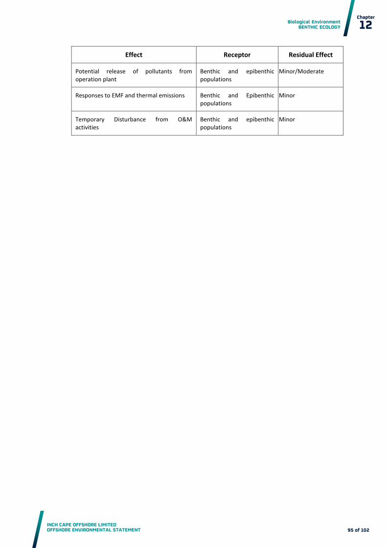
Biological Environment BENTHIC ECOLOGY
INCH CAPE OFFSHORE LIMITED OFFSHORE ENVIRONMENTAL STATEMENT
Chapter
12
95 of 102
Effect Receptor Residual Effect
Potential release of pollutants from operation plant
Benthic and epibenthic populations
Minor/Moderate
Responses to EMF and thermal emissions Benthic and Epibenthic populations
Minor
Temporary Disturbance from O&M activities
Benthic and epibenthic populations
Minor

Biological Environment BENTHIC ECOLOGY
INCH CAPE OFFSHORE LIMITED OFFSHORE ENVIRONMENTAL STATEMENT
Chapter
12
96 of 102
References
Barnes, R.S.K. and Hughes, R.N., (1992). An Introduction to Marine Ecology. Oxford: Blackwell
Scientific Publications
Birkeland, C. (1974). Interactions Between a Sea Pen and Seven of its Predators. Ecological
Monographs, 44: 211-232
Brazier, D.P., Davies, J., Holt, R.F.H., and Murray, E. (1998) Marine Nature Conservation Review,
Sector 5. South-east Scotland and North-east England: Area Summaries, 235 pages A4 softback Many
maps, some colour-coded, ISBN 1 86107 433 6
Brodin, Y., and Andersson, M. H. (2009). The Marine Splash Midge Telmatogon japonicus (Diptera;
Chironomidae) extreme and alien?, Biol. Invasions 11, 1311-1317
Bryan, G. W. (1985). Bioavailability and Effects of Heavy Metals in Marine Deposits. Pp. 42-79 In:
Wastes in the Ocean: Nearshore Waste Disposal. B. H. Ketchum, J. M. Capuzzo, W. V. Burt, I. W.
Duedall, P. K. Park and D. R. Kester (eds.). New York: John Wiley and Sons
Bryan, G.W. (1984). Pollution due to Heavy Metals and Their Compounds.In: Marine Ecology: A Comprehensive, Integrated Treatise on Life in the Oceans and Coastal Waters, vol. 5. Ocean Management, part 3, (ed. O. Kinne), pp.1289-1431. New York: John Wiley & Sons
Budd, G.C. (2008a). Burrowing amphipods and Eurydice Pulchra in Well-drained Clean Sand Shores.
Marine Life Information Network: Biology and Sensitivity Key Information Sub-programme [on-line].
Plymouth: Marine Biological Association of the United Kingdom. [cited 03/12/2012]. Available at:
http://www.marlin.ac.uk/habitatsbasicinfo.php?habitatid=344&code=2004
Budd, G.C. (2008b). Macoma Balthica and Abra Alba in Infralittoral Muddy Sand or Mud. Marine Life
Information Network: Biology and Sensitivity Key Information Sub-programme [on-line]. Plymouth:
Marine Biological Association of the United Kingdom. [cited 03/12/2012]. Available at:
http://www.marlin.ac.uk/habitatbenchmarks.php?habitatid=173&code
Cefas (2004). Offshore Wind Farms: Guidance Notes for Environmental Impact Assessment in respect
of FEPA and CPA requirements. Version 2. [cited 03/12/2012]. Available at:
www.cefas.co.uk/publications/files/windfarm-guidance.pdf
Cefas (2009). Strategic Review of Offshore Wind Farm Monitoring Data Associated with FEPA Licence Conditions. [cited 03/12/2012]. Available at : http://www.cefas.defra.gov.uk/media/393511/annex-1-benthos.pdf
Cloern, J.E. (1999). The relative importance of Light and Nutrient Limitation of Phytoplankton
Growth: a Simple Index of Coastal Ecosystem Sensitivity to Nutrient Enrichment. Aquat. Ecol. 33: 3–
16.
Clean Seas Environment Monitoring Programme (CSEMP) (2012). Data available through:
http://www.bodc.ac.uk/projects/uk/merman/project_overview/

Biological Environment BENTHIC ECOLOGY
INCH CAPE OFFSHORE LIMITED OFFSHORE ENVIRONMENTAL STATEMENT
Chapter
12
97 of 102
Daan R. and Mulder M. (1996). On the Short-term and Long-term Impact of Drilling Activities in the Dutch Sector of the North-Sea. ICES Journal of Marine Science, 53, 1036-1044
Daly, M.A. and Mathieson, A.C., 1977. The Effects of Sand Movement on Intertidal Seaweeds and
Selected Invertebrates at Bound Rock, New Hampshire, USA. Marine Biology, 43, 45-55
Davis, N. and Van Blaricom, G.R. (1978). Spatial and Temporal Heterogeneity in a Sand Bottom
Epifaunal Community of Invertebrates in Shallow Water. Limnology and Oceanography, 23: 417-427
De Groote, J., Dumon G., Vangheluwe M., Jansen C. (1998). Environmental monitoring of Dredging
Operations in the Belgian Nearshore Zone. Terra et Aqua;70:21– 5. 1;35(8):1979– 86
Defra (2005). Nature Conservation Guidance on Offshore Wind Farm Development. [cited
03/12/2012]. Available at:
http://webarchive.nationalarchives.gov.uk/20080915101357/http://www.defra.gov.uk/wildlife-
countryside/ewd/windfarms/windfarmguidance.pdf
Degraer, S., Brabant, R. and Rumes, B., (Eds.) (2011). Offshore Wind Farms in the Belgian Part of the
North Sea: Selected Findings from the Baseline and Targeted Monitoring. Royal Belgian Institute of
Natural Sciences, Management Unit of the North Sea Mathematical Models. Marine ecosystem
management unit. 157 pp. + annex.
Department for Business, Enterprise and Regulatory Reform (BERR) (2008). Review of Cabling
Techniques and Environmental Effects Applicable to the Offshore Wind Farm Industry. Technical
Report in association with Defra. Available at:
http://webarchive.nationalarchives.gov.uk/+/http://www.berr.gov.uk/files/file43527.pdf
Eggleton, J. and Thomas, K.V. (2004). A Review of Factors Affecting the Release and Bioavailability of
Contaminants during Sediment Disturbance Events, Environment International, 30(7), 973-980
Eleftheriou A., Basford D. and Moore D.C. (2004). Synthesis of Information on the Benthos of Area,
SEA 5. Report for the Department of Trade and Industry. Final draft May 2004
EMU Limited (EMU) (2012). Inch Cape Offshore Wind Farm. Export Cable Route Benthic Ecology
Survey. Report for RESPSOL, Southampton, pages 227.
EUSeaMap – Mapping European Seabed Habitats(MESH) (2012). [Online] Accessed at:
http://jncc.defra.gov.uk/page-5020
Firth, C.R., Collins P.E.F. and Smith, D.E. (1997). Coastal Processes and Management of Scottish
Estuaries – IV The Firth of Forth. Scottish Natural Heritage. No. 87
Forth Estuary Forum (1999). The Forth Integrated Management Strategy. Available at:
http://www.forthestuaryforum.co.uk/assets/pdf/reports/strategy.pdf
Gill, A.B., Gloyne-Phillips, I., Neal, K.J. and Kimber, J.A. (2005). The potential Effects of
Electromagnetic Fields Generated by Sub-sea Power Cables Associated with Offshore Wind Farm
Developments on Electrically and Magnetically Sensitive Marine Organisms – A Review. Report to
Collaborative Offshore Wind Research into the Environment (COWRIE) group, Crown Estates

Biological Environment BENTHIC ECOLOGY
INCH CAPE OFFSHORE LIMITED OFFSHORE ENVIRONMENTAL STATEMENT
Chapter
12
98 of 102
Gill, A.B., Huang, Y., Gloyne-Philips, I., Metcalfe, J., Quayle, V., Spencer, J. and Wearmouth, V. (2009).
COWRIE 2.0 Electromagnetic Fields (EMF) Phase 2: EMF-sensitive Fish Response to EM Emissions
from Sub-sea Electricity Cables of the Type used by the Offshore Renewable Energy Industry.
Commissioned by COWRIE Ltd (project reference COWRIE-EMF-1-06)
Gubbay (2007). Defining and Managing Sabellaria spinulosa Reefs: Report of an Inter-agency
Workshop. JNCC report No.405
Hall, J.A., Frid, C.L.J. and Gill, M.E. (1997). The Response of Estuarine Fish and Benthos to an
Increasing Discharge of Sewage Effluent. Marine Pollution Bulletin. 34, 527–535
Hayes, P., Russell, M., and Packer, G. (2005). Surveys of Dredges Material and Wastewater Sludge
Sea Disposal Sites for the East Coast of Scotland. Fisheries Research Services Internal Report No
08/05.
Hendrick, V.J; Foster-Smith, R.L. (2006). Sabellaria spinulosa reef: A Scoring System for Evaluating
‘Reefiness’ in the Context of the Habitats Directive. J.Mar.Biol.Ass.UK. 86: 665-677.
Her Majesty’s (HM) Government (2011). UK Marine Policy Statement. Available at:
http://www.defra.gov.uk/publications/files/pb3654-marine-policy-statement-110316.pdf [Accessed
November 2012].
Hill, S., Burrows, M.T. and Hawkins, S.J. (1998). Intertidal Reef Biotopes (volume VI). An overview of
Dynamics and Sensitivity Characteristics for Conservation Management of Marine SACs. Scottish
Association for Marine Science (UK Marine SACs Project)
Hill, J.M. (2008). Sea Pens and Burrowing Megafauna in Circalittoral Soft Mud. Marine Life
Information Network: Biology and Sensitivity Key Information Sub-programm, Plymouth: Marine
Biological Association of the United Kingdom. [cited 02/01/2013]. Available at:
http://www.marlin.ac.uk/habitatsbasicinfo.php?habitatid=131&code=2004
Hiscock, K., Tyler-Walters, H. and Jones, H. (2002). High Level Environmental Screening Study for
Offshore Wind Farm Developments – Marine Habitats and Species Project. Report from the Marine
Biological Association to The Department of Trade and Industry New & Renewable Energy
Programme. (AEA Technology, Environment Contract: W/35/00632/00/00.)
Howson, C. M., Steel. L., Carruthers, M. and Gillham, K. (2012). Identification of Priority Marine
Features in Scottish territorial waters. Scottish Natural Heritage Commissioned Report No. 388.
IEEM (2010). Guidelines for Ecological Impact Assessment in Britain and Ireland - Marine and Coastal
Consultation document. [cited 08/01/2012]. Available at:
http://www.ieem.net/data/files/Resource_Library/Technical_Guidance_Series/EcIA_Guidelines/Fina
l_EcIA_Marine_01_Dec_2010.pdf
Irving, R. (2009). The Identification of the Main Characteristics of Stony Reef Habitats Under the
Habitats Directive. Summary report of an inter-agency workshop 26-27 March 2008. JNCC Report
No. 432

Biological Environment BENTHIC ECOLOGY
INCH CAPE OFFSHORE LIMITED OFFSHORE ENVIRONMENTAL STATEMENT
Chapter
12
99 of 102
IUCN Red List (revised 2012). The IUCN Red List of Threatened Species 2012. [Online]. Accessed at:
http://www.iucnredlist.org/
Jensen, K.R. (2010). NOBANIS – Invasive Alien Species Fact Sheet – Telmatogeton japonicus – From:
Identification Key to Marine Invasive Species in Nordic Waters – NOBANIS www.nobanis.org
JNCC (2012). Identification of Priority Marine Features in Scotland’s seas. JNCC Report No. 462
JNCC and Defra (on behalf of the Four Countries’ Biodiversity Group) (2012). UK Post-2010
Biodiversity Framework. July 2012. Available at: http://jncc.defra.gov.uk/page-6189
Judd, A. (2012). Guidelines for Data Acquisition to Support Marine Environmental Assessments for
Offshore Renewable Energy Projects. CEFAS, Report ME5403 – Module 15: May 2012
Kinne, O. (ed.) (1984). Marine Ecology: A Comprehensive, Integrated Treatise on Life in Oceans and
Coastal Waters.Vol. V. Ocean Management Part 3: Pollution and Protection of the Seas - Radioactive
Materials, Heavy Metals and Oil. Chichester: John Wiley & Sons
Limpenny, D.S., Foster-Smith, R.L., Edwards, T.M., Hendrick, V.J., Diesing, M.,Eggleton, J.D.,
Meadows, W.J., Crutchfield, Z., Pfeifer, S. and Reach, I.S. (2010). Best Methods for Identifying and
Evaluating Sabellaria spinulosa and Cobble Reef. Aggregate Levy Sustainability Fund Project
MAL0008. Joint Nature Conservation Committee, Peterborough, 134 pp., ISBN - 978 0 907545 33 0
Lincoln, R., Boxshall, G. and Clark, P., 1998. A Dictionary of Ecology, Evolution and Systematics (2nd
ed.). Cambridge: Cambridge University of Press
Lincoln, R.J., and Boxshall, G.A., 1987. The Cambridge Illustrated Dictionary of Natural History.
Cambridge: Cambridge University Press.
López-Jamar, E. and Mejuto, J. (1988). Infaunal Benthic Recolonization after Dredging Pperations in
La Coruña Bay, NW Spain. Cahiers de Biologie Marine, 29, 37-49
Marine Strategy Framework Directive (MSFD). (2008). Directive 2008/56/EC of the European
Parliament and of the Council of 17 June 2008 Establishing a Framework for Community Action in the
Field of Marine Environmental Policy (Marine Strategy Framework Directive) (Text with EEA
relevance).
Marine Scotland (2012). Contaminated Sediments Data - Bell Rock Disposal Ground. Personal
Communication [email]. Amec consulting. 5 November 2012.
Marshall, C.E. (2008). Mysella Bidentata and Thyasira spp. in Circalittoral Muddy Mixed Sediment.
Marine Life Information Network: Biology and Sensitivity Key Information Sub-programme [on-line].
Plymouth: Marine Biological Association of the United Kingdom. [cited 03/12/2012]. Available at:
http://www.marlin.ac.uk/habitatbenchmarks.php?habitatid=374&code

Biological Environment BENTHIC ECOLOGY
INCH CAPE OFFSHORE LIMITED OFFSHORE ENVIRONMENTAL STATEMENT
Chapter
12
100 of 102
Meißner, K. and Sordyl, H. (2006). Literature Review of Offshore Wind Farms with Regard to Benthic
Communities and Habitats. - In: Zucco, C., Wende, W., Merck, T., Köchling, I. and Köppel, J. (eds.):
Ecological Research on Offshore Wind Farms: International Exchange of Experiences - PART B:
Literature Review of the Ecological Impacts of Offshore Wind Farms. BfN-Skripten 186: 1-45. [cited
03/12/2012]. Available at:
http://www.lanis.de/habitatmare/de/downloads/berichte/Ecological_Research_Offshor-
Wind_Part_B_Skripten_186.pdf
Meißner, K., Bockhold, J. and Sordyl, H. (2007). Problem Kabelwärme? – Vorstellung der Ergebnisse
von Feldmessungen der Meeresbodentemperatur im Bereich der Elektrischen Kabel im Dänischen
Offshore-Windpark Nysted Havmøllepark (Dänemark). In: Meeresumwelt-Symposium 2006. Hrsg.
Bundesamt für Seeschiffahrt und Hydrographie, Hamburg : [cited 03/12/2012]. Available at:
http://www.bsh.de/de/Das_BSH/Veranstaltungen/MUS/PDF/Symposium_2006_Internet.pdf
Newell, R.C., Seiderer, L.J., and Hitchcock, D.R. (1998). The Impact of Dredging Works in Coastal
Waters: A Review of the Sensitivity to Disturbance and Subsequent Recovery of Biological Resources
on the Seabed. Oceanography and Marine Biology: an Annual Review, 36, 127-78
Newell, R.C., Seiderer, L.J., Simpson, N.M. and Robinson, J.E. (2004). Impacts of Marine Aggregate
Dredging on Benthic Macrofauna off the South Coast of the United Kingdom. Journal of Coastal
Research, 20: 115-125
Newman, M.C and Jagoe, C.H. (1994). Ligands and the Bioavailability of Metals in Aquatic
Environments. In: Hamelink, J.L., Landrum, P.F., Bergman, H.L., Benson, W.H. (Eds.). Bioavailability:
Physical, Chemical, and Biological Interactions, Lewis, Boca Raton, FL, pp. 39–62
Olsgard, F. (1999). Effects of Copper Contamination on Recolonisation of Subtidal Marine soft
Sediments - An Experimental Field Study. Marine Pollution Bulletin, 38, 448-462
OSPAR (1998a). Convention for the Protection of the Marine Environment of the North-east Atlantic
(OSPAR Convention). Available at: http://eur-
lex.europa.eu/LexUriServ/LexUriServ.do?uri=CELEX:21998A0403(01):EN:HTML
OSPAR (2008a). OSPAR Guidance on Environmental Considerations for Offshore Wind Farm
Development. [cited 03/12/2012]. Available at: www.ospar.org
OSPAR (2008b). List of Threatened and/or Declining Species and Habitats. Available at:
http://www.ospar.org/content/content.asp?menu=00180302000014_000000_000000
OSPAR (2009). Assessment of the Environmental Impacts of Cables. [cited 03/12/2012]. Available at:
http://qsr2010.ospar.org/media/assessments/p00437_Cables.pdf
Rayment, W.J. (2008a). Fabulina fabula and Magelona Mirabilis with Venerid Bivalves in Infralittoral
Compacted Fine Sand. Marine Life Information Network: Biology and Sensitivity Key Information
Sub-programme [on-line]. Plymouth: Marine Biological Association of the United Kingdom. [cited
03/12/2012]. Available at: http://www.marlin.ac.uk/habitatbenchmarks.php?habitatid=142&code

Biological Environment BENTHIC ECOLOGY
INCH CAPE OFFSHORE LIMITED OFFSHORE ENVIRONMENTAL STATEMENT
Chapter
12
101 of 102
Rayment, W.J. (2008b). Venerid Bivalves in Circalittoral Coarse Sand or Gravel. Marine Life
Information Network: Biology and Sensitivity Key Information Sub-programme [on-line]. Plymouth:
Marine Biological Association of the United Kingdom. [cited 03/12/2012]. Available at:
http://www.marlin.ac.uk/habitatsbasicinfo.php?habitatid=63&code=2004
Rosenberg, R. and Loo, L. (1988). Marine Eutrophication Induced Oxygen Deficiency: Effects on soft
Bottom Fauna, Western Sweden. Ophelia, 29, 213-225
Sabatini, A. and Hill, J. (2008). Nephrops Norvegicus. Norway lobster. Marine Life Information
Network: Biology and Sensitivity Key Information Sub-programme [on-line]. Plymouth: Marine
Biological Association of the United Kingdom. [cited 03/12/2012]. Available at:
http://www.marlin.ac.uk/speciesfullreview.php?speciesID=3892
Sabatini, M., Pizzolla, P., and Wilding, C. (2008). Arctica islandica. Icelandic cyprine. Marine Life
Information Network: Biology and Sensitivity Key Information Sub-programme [on-line]. Plymouth:
Marine Biological Association of the United Kingdom. [cited 03/12/2012]. Available at:
http://www.marlin.ac.uk/speciesfullreview.php?speciesID=2588
Scottish Government (2011). Scotland's National Marine Plan: Pre-Consultation Draft. Available at:
http://www.scotland.gov.uk/Resource/Doc/346796/0115349.pdf [Accessed November 2012]
Scottish Government (last updated 2013). Scottish Biodiversity List. Available at:
http://www.scotland.gov.uk/Topics/Environment/Wildlife-Habitats/16118/Biodiversitylist/SBL
Scottish Parliament (2010). Marine (Scotland) Act 2010. Available at:
http://www.legislation.gov.uk/asp/2010/5/pdfs/asp_20100005_en.pdf
Strategic Environmental Assessment (SEA) 5 (2004). Strategic Environmental Assessment of parts of
the northern and central North Sea to the east of the Scottish mainland, Orkney and Shetland.
[Online] Accessed at: http://www.offshore-
sea.org.uk/consultations/SEA_5/SEA5_Background_Document.pdf
The Council of the European Communities (1992). Council Directive 92/43/EEC of 21 May 1992 on
the Conservation of natural habitats and of wild fauna and flora (Habitats Directive) as amended.
Available at: http://eur-
lex.europa.eu/LexUriServ/LexUriServ.do?uri=CONSLEG:1992L0043:20070101:EN:HTML [Accessed
September 2012]
Theede, H., Ponat, A., Hiroki, K. and Schlieper, C. (1969). Studies on the Resistance of Marine Bottom
Invertebrates to Oxygen-Deficiency and Hydrogen Sulphide. Marine Biology, 2, 325-337
Tyler-Walters, H and Ballerstedt, S. (2007). Flustra foliacea. Hornwrack. Marine Life Information
Network: Biology and Sensitivity Key Information Sub-programme [on-line]. Plymouth: Marine
Biological Association of the United Kingdom. [cited 10/01/2013]. Available at:
http://www.marlin.ac.uk/speciesfullreview.php?speciesID=3342

Biological Environment BENTHIC ECOLOGY
INCH CAPE OFFSHORE LIMITED OFFSHORE ENVIRONMENTAL STATEMENT
Chapter
12
102 of 102
Tyler-Walters, H. (2008a). Mytilus Edulis. Common mussel. Marine Life Information Network: Biology
and Sensitivity Key Information Sub-programme [on-line]. Plymouth: Marine Biological Association
of the United Kingdom. [cited 03/12/2012]. Available at:
http://www.marlin.ac.uk/speciesbenchmarks.php?speciesID=3848
Tyler-Walters, H. (2008b). Ocnus Planci Aggregations on Sheltered Sublittoral Muddy Sediment.
Marine Life Information Network: Biology and Sensitivity Key Information Sub-programme [on-line].
Plymouth: Marine Biological Association of the United Kingdom. [cited 10/01/2013]. Available at:
http://www.marlin.ac.uk/habitatecology.php?habitatid=325&code
Vale, C., Ferreira, A.M., Micaelo, C., Caetano, M., Pereira, E. and Madureira, E. (1998). Mobility of
Contaminants in Relation to Dredging Operations in a Meso-tidalestuary (Tagus Estuary, Portugal).
Water Sci Technol 1998;37(6– 7):25– 31
Van den Berg, G.A., Meijers, G.G.A., van der Heijdt, L.M, Zwolsman, J.J.G. (2001). Dredging-related
Mobilization of Trace Metals: A Case Study in the Netherlands.
Ware, S.J. and Kenny, A.J. (2011). Guidelines for the Conduct of Benthic Studies at Marine Aggregate
Extraction Sites (2nd Edition). Marine Aggregate Levy Sustainability Fund, 80 pp
Witbaard R. and Bergman M.J.N. (2003). The Distribution and Population Structure of the Bivalve
Arctica islandica L. in the North Sea: What Possible Factors are Involved? Journal of Sea Research 50
(2003) 11 – 25