chapter 6–analysis of salinity · evapoconcentration is the process of concentrat-ing salts or...
TRANSCRIPT

CHAPTER 6–Analysis of Salinity
The U.S. Fish and Wildlife Service and the public have identified salinity and blowing salts at the Bow-doin National Wildlife Refuge as one of the most critical situations needing to be addressed in this CCP planning process. Because of the complexity of the salinity analysis, all aspects of NEPA evaluation are presented together in this chapter in the follow-ing sections:
■■ 6.1 Issues■■ 6.2 Background■■ 6.3 Salt and Water Management■■ 6.4 Planning Process■■ 6.5 Alternatives Analysis■■ 6.6 Implementation of the Proposed Action
This chapter begins with a summary of the issues including extensive background to explain what caused the elevated salinity levels, what the effects are, and why it was important to address it in this planning effort. To develop this information and de-termine the best methods for resolving the issues, the Service assembled from various Federal and State agencies a team—hydrologists, biologists, en-
gineers, managers, planners, and contaminant spe-cialist—to develop and evaluate different options, known as alternatives. The team developed and analyzed four alternatives beyond current manage-ment; the evaluation included an analysis of the en-vironmental and socioeconomic consequences and the cumulative impacts of implementing each of the following alternatives:
■■ Salinity alternative 1—current management (no action)
■■ Salinity alternative 2—evaporation ponds and removal of saline residue
■■ Salinity alternative 3—flushing by Beaver Creek
■■ Salinity alternative 4—underground injection well and flushing by Beaver Creek (proposed action)
■■ Salinity alternative 5—pumping to the Milk River
Alkali salt blows off Dry Lake at Bowdoin Refuge, Phillips County, Montana (1988).
US
FW
S
160 Draft CCP and EA, Bowdoin National Wildlife Refuge Complex, Montana
The Service has identified salinity alternative 4 as the best option, or proposed action, for addressing salinity and blowing salts based on the effective-ness of treatment, environmental and socioeconomic consequences, and cost. In addition, this alternative has been identified as the best option to achieve the long-term, desired future conditions described in this proposed goal statement:
Goal for Salinity and Blowing SaltsDevelop a water management system on Bow-doin National Wildlife Refuge that would protect the environment and mitigate current and future blowing salt concerns for neigh-boring properties, while providing quality water and wildlife habitat for migratory birds and other wetland dependent wildlife.
Section 6.6 describes how the Service would carry out the proposed action, alternative 4, if the Re-gional Director for Region 6 (Mountain–Prairie Region) of the Service selected it as the preferred alternative for the final CCP.
6.1 IssuesTwo issues are the focus of this separate analysis:
■■ Salinity for Lake Bowdoin and blowing salts■■ Water quantity, delivery, and cost
Salinity for Lake Bowdoin and Blowing SaltsThe salinity and blowing salts issue at Bowdoin Ref-uge is a direct result of the “salt balance,” which is the relationship between the salt entering the refuge compared to the salt leaving the refuge. For many years, the amount of salt entering the refuge has been, and continues to be, far more than the amount of salt leaving the refuge. Thus, the over-all concentration of salts in Lake Bowdoin and sur-rounding areas such as Dry Lake continues to rise.
Increasing salinity has the potential to shift Lake Bowdoin from one that supports a diverse plant and animal community that thrives in a brackish-type system to one that thrives in a saline-type system. Such a shift could negatively affect the ability of the lake and surrounding wetlands to fully support and meet the life cycle needs of migratory birds, includ-ing waterfowl.
The out-of-balance salt situation is due to a va-riety of reasons—many from modifications to the
landscape, but others are natural. Understanding the relationship of the salt balance is fundamental to devising a solution that not only protects and sus-tains refuge habitats and resources for wildlife, but also protects the interests of local farmers, ranchers, and refuge visitors.
Water Quantity, Delivery, and CostWater quantity has a direct relationship to the effect of salts carried in the water—quantity, evaporation, inflow, and outflow all contribute to the salt balance. The principle sources of water for Bowdoin Refuge are precipitation, floodwater from Beaver Creek, ground water seepage, Milk river water rights, and irrigation return flows. Even with the current MOA with Reclamation for 3,500 acre-feet and with natu-ral sources of water, the water quantity has been in-sufficient for supplying necessary water for wildlife habitat management and improving water quality.
6.2 BackgroundThis section contains basic information about salts, quantification and classification of salinity, and prin-cipal salts at Bowdoin Refuge. Background about the salt balance covers the historical and current situations.
Salt BasicsThe salt balance concept refers to the balance be-tween the amount of salt entering a waterbody, in this case, Lake Bowdoin, and the amount of salt exit-ing. Over time, this salt inflow and outflow should be roughly equal to ensure the stability and resil-iency of the lake system. A stable system increases the probability that plant and animal communities, which have adapted to this localized and sometimes highly variable system, remain within tolerable ranges and, thus, remain healthy and productive. If the system is not in balance, the concentration of salts is either increasing or decreasing depending on the direction of the imbalance. The magnitude of the salt imbalance is ultimately reflected in the diversity of (or lack of) plant and animal communities that are supported, as well as the number of viable manage-ment options to restore balance to the system.
Except for pure distilled water, all water has dis-solved minerals or trace elements present in varying concentrations. These minerals (or salts) and trace

161CHAPTER 6 –Analysis of Salinity
elements are present within all landscapes in the underlying geology and soils as well as in precipita-tion that falls over an area. In many areas where precipitation does not exceed evaporation—which includes the arid climate of eastern Montana—the process of evaporation is a leading natural cause of concentrating salts in a system.
Evapoconcentration is the process of concentrat-ing salts or trace elements (solids) in a liquid due to evaporation. When water evaporates during the hot, dry summer months, the solids remain in the water. As the volume of water is reduced by evaporation, the concentrations of these solids increase. In gen-eral, salinity concentrations are at their lowest dur-ing the spring after snowmelt and at their highest at
summer’s end. Salts that precipitate out of water during the evaporative process are often seen on the soil surface as white salt residues or crystals. When these salts fully dry and are exposed to strong winds, some particles become airborne and are transported out of the system by the wind. At Bowdoin Refuge, these conditions create the blowing salts events. The process of salts blowing out of a system is natural and is one way that a salt balance was maintained historically, espe-cially during times of significant drought. Salts that do not blow away are re-dissolved when precipi-tation returns and water levels rise.
In wetland systems that are “closed basins”—which means there is no natural outflow due to topographic features or some other barrier—the evapoconcentration process greatly affects the over-all water chemistry and resulting water quality. For example, the Great Salt Lake, located in an arid landscape in northern Utah, is the largest natural lake west of the Mississippi River and is a closed basin. It is naturally salty due to evapoconcentration. There is no outflow, thus salts are only removed from the system through wind or through artificial removal activities. As a result, salt concentrations are two to eight times greater than the world’s oceans.
In comparison, a “flow-through system” is not closed—the water moves through the system before evaporation can accumulate the
salts carried in the water to elevated concentrations. The Milk River, like all streams and rivers, is a flow-through system. Although salts do not accumulate like those in a closed system, salt concentrations vary depending on where the stream sits in relation to its overall watershed. Typically, salt concentra-tions are higher farther down in the watershed. In the case of the Milk River, concentrations are con-siderably higher where the Milk River empties into the Missouri River east of Nassau, Montana, com-pared with the headwaters area north of Browning, Montana. This is from the continual addition of salts and other minerals to the river as the water moves downstream in the watershed.
Open water in the southern bay of Lake Bowdoin in spring (May 2007).
Mik
e A
rtm
ann
/ US
FW
S
The (same) southern bay of Lake Bowdoin in fall (October 2007). Concentrated salt crystallized on top of very shallow water and was susceptible to blowing.
Mik
e A
rtm
ann
/ US
FW
S

162 Draft CCP and EA, Bowdoin National Wildlife Refuge Complex, Montana
Quantification of SalinityThe concentration of salts present in the water and the underlying soils of Lake Bowdoin can be mea-sured, quantified, and described. Typically, the con-centration of salt in water is expressed as a measure of “total dissolved solids,” which comprise inorganic salts—principally calcium, magnesium, potassium, sodium, bicarbonates, chlorides, and sulfates—and small amounts of organic matter present in water. The measure of total dissolved solids, or TDS, is often reported as ppt (parts per thousand), percent, mg/L (milligrams per liter), or total mass in grams. One way to measure the TDS is to take a water sample, evaporate the water, and weigh the remain-ing solids. This is the most accurate method to ob-tain TDS, but it is very time-consuming, expensive, and requires laboratory-type equipment; thus, this method’s utility for field testing and monitoring is limited.
Another way to measure TDS, which is quicker and less expensive and currently used by refuge staff, is to find out the electrical conductivity (or specific conductance) of water. The EC (electrical conductivity) is directly related to the concentration of dissolved ionized solids in the water. Ions from the dissolved solids enable water to conduct an electrical current, which can be measured with a conductiv-ity meter. EC is reported in µS/cm (microSiemens per centimeter), mS (milliSiemens), or mmhos (mil-limhos). The relationship between EC and TDS is largely linear, thus conversion factors between EC and TDS are well understood. The following equa-tion makes the conversion between EC and TDS (Tchobanoglous and Burton 1991):
µS/cm×0.64 of EC=mg/L of TDS
Salts in a waterbody are described by total weight, typically in tons. The total weight of salts is calcu-lated by multiplying the concentration of salts in the
water by the weight of the water. Weight of 1 acre-foot of water is approximately 1,360 tons.
(mg/L)×(weight of water)/1,000,000=tons of salts
Therefore, the water delivered by the Malta Irriga-tion District to Bowdoin Refuge averages about 500 mg/L TDS. Subsequently, for every 1,000 acre-feet of water delivered at that concentration, approxi-mately 680 tons of salts are added to Lake Bowdoin.
(500 mg/L×1,360,000 tons)/1,000,000=680 tons of salts
Describing the salts by weight is useful, because the concentration of salts can vary considerably since concentrations depend on both the total amount of salts and the total amount of water. The total amount of water can fluctuate widely in a single year due to evaporation and water deliveries, which causes the salt concentrations to fluctuate. By eval-uating only the total weight of salts, the seasonal variations shown in concentrations are removed, and general trends such as the salt removal rate are easier to evaluate.
Throughout this chapter, mg/L is used in refer-ence to TDS to represent the salinity concentra-tion. However, for the modeling work conducted to analyze which alternative would be most effective at balancing salt, the total weight in tons was used as the measure to describe the amount of salts entering and exiting the refuge.
Salinity can decrease the diversity of the wetland vegetation and the invertebrates that ducks like mallards rely on.
Don
na D
ewhu
rst
/ US
FW
S
Classification of SalinityLake Bowdoin, like all of the wetlands on the refuge, can be described and classified in terms of its aver-age salinity concentration. It is helpful to classify wetlands based on their salinity, because there has been considerable research describing the effect of varying salinity concentrations in terms of plant and animal communities and their tolerances to changing salinity. Entirely different plant and invertebrate communities thrive at varying salinity concentra-tions. In general, the higher the salinity concentra-tion, the less diverse the communities tend to be (Gleason et al. 2009).
Refuge staff and others have been monitoring water quality in the wetlands since the late 1970s. A lot of information has been collected on salinity and how concentrations change with varying cli-matic conditions at the refuge. In 2009, Lake Bow-doin had an average salinity concentration of 10,500 mg/L. Following the salinity classification scheme displayed in table 9 (Stewart and Kantrud 1972), this concentration places the lake in the subsaline (second most concentrated) class.

163CHAPTER 6 –Analysis of Salinity
Interestingly, monitoring data shows that even within Lake Bowdoin, considerable variation in sa-linity concentrations exists. For example, the east side of the lake is typically more salty (1,000–2,000 mg/L more concentrated) than the west side. This is due almost entirely to the inflows of fresher water from the Black Coulee drainage and the Dodson South Canal on the west side of the lake.
Figure 29 shows the locations of the monitor-ing sites on and off the refuge, along with the in-frastructure for water management in and between the refuge wetlands. Flow-through wetlands like Black Coulee Pond on the west side of the refuge and Lakeside and the Farm Ponds on the east side, rarely exceed 1,250 mg/L as water and salt pass through to Lake Bowdoin or Dry Lake, respectively. In addition, monitoring data shows that salinity concentrations tend to be lowest in the spring and highest in the late summer due to the evapoconcen-tration process.
Most of the refuge wetlands are less saline than Lake Bowdoin and fall into other salinity classes according to Stewart and Kantrud (1972), as follows:
■■ Slightly Brackish—Black Coulee Pond, Display Pond, Farm Ponds, and Lakeside
■■ Moderately Brackish—Goose Island Pond, Pa-trol Road Pond, Teal Pond Complex, and Strater Pond
■■ Brackish—Dry Lake Pond, Piping Plover Pond, and Drumbo Pond
■■ Subsaline—Lake Bowdoin
Principal Salts at Bowdoin RefugeThe principal salts at Bowdoin Refuge are sodium sulfate, sodium bicarbonate, calcium carbonate, cal-cium sulfate, and magnesium sulfate; minor amounts of chloride and fluoride salts are also present (Bauder et al. 2007, Gleason et al. 2009). These salts are largely derived from the soils and underlying geology that compose this area of Montana. Geologic history indicates that Lake Bowdoin is an old oxbow of the Missouri River channel that was pushed far to the south during the advancement of the last gla-ciers, about 15,000 years ago (Alden 1932).
The predominant soils on the refuge are clays and clay-loams. The most common clay-loam asso-ciations are Phillips-Elloam, Phillips-Kevin, Arvada-Bone, Scobey-Phillips, and Kevin-Sunburst. These soils range from mildly to strongly alkaline; soluble calcium and sodium salts are dispersed in much of the soil profile. The presence of these soluble salts contributes to the alkaline nature of refuge wet-lands, in particular Lake Bowdoin. Delivered water from the Milk River via the Dodson South Canal also contains these primary salts. Although these salts occur in relatively low concentrations in the delivered water (typically less than 500 mg/L), the total volume of water is high; therefore, the total tons of salts is high. In addition, saline seeps occur as water moves through the soil profile and exits at the surface near and along the west and north shoreline of Lake Bowdoin.
Table 9. Salinity categories and the corresponding ranges of specific conductance values.Conductance1 Concentrations of dissolved solids—salts2
Salinity category (µS/cm-1) (mg/L-1) (ppt)Fresh 0–500 0–320 0–0.3
Slightly brackish 500–2,000 320–1,280 0.3–1.3
Moderately brackish 2,000–5,000 1,280–3,200 1.3–3.2
Brackish 5,000–15,000 3,200–9,600 3.2–9.6
Subsaline 15,000–45,000 9,600–28,800 9.6–28.8
Saline >45,000 >28,800 >28.8
Source: Stewart and Kantrud (1972).1 µS/cm-1=microSiemens per centimeter.2 mg/L-1=milligrams per liter; ppt=parts per thousand.

164 Draft CCP and EA, Bowdoin National Wildlife Refuge Complex, Montana
Presettlement Salt BalanceTo understand how the salt balance has been lost or altered over time, it is important to look at how it was maintained in the past. For the salt load to balance over time, incoming salts must be removed (or moved through the lake system) in roughly equal proportions, either by flushing or by the wind when water levels are low and salts precipitate out. There is little doubt that Lake Bowdoin functioned as a flow-through system during spring runoff and high-precipitation events. The flow-through nature of the system was essential to maintaining the lake’s salt balance, as was the removal of salts by the wind dur-ing times of drought.
Historical evidence, in the form of a GLO (Gen-eral Land Office) survey, helps shed light on how the system functioned in the past (figure 30). The GLO survey, which divided the landscape into 1-square-mile sections, was completed in 1892 and approved in 1893 for the area near Malta including the refuge. This survey included the Great Northern Railway, which was constructed just a couple years prior in 1887. In addition, the survey shows that Lake Bowdoin was originally called “Alkali Lake” (figure 30), undoubtedly in direct reference to the alkaline characteristics of the water and soils of the lake. Interestingly, there is no mention or depiction of marsh or lake habitat in the current locations of Dry Lake or Drumbo Pond.
The GLO survey shows a stream Alkali Lake (Lake Bowdoin) on the west side in the general loca-tion where the Black Coulee drainage enters today. It is drawn on the map as a dashed line, suggest-ing the stream was intermittent. This would make sense given the arid climate of the area (less than 12.5 inches in precipitation per year). The volume of water entering the lake through this stream is, of course, unknown. However, the drainage area does span to a low divide near the Milk River to the west and includes many smaller coulees coming from the hills to the south. It is likely that, during heavy rainstorms or deep snow years, this stream carried a considerable flow into the lake. Likewise, a stream is depicted exiting the lake in the southeast side near the present-day southeast arm of the lake. Based on local topography downstream of this outflow point, any outflow would have flowed into Beaver Creek following a relatively similar path as occurs today.
As mapped in 1892, the overall size of Lake Bow-doin was about 40 percent smaller than it is today; surface acres were approximately 2,885 acres. At a smaller surface area, and with a smaller volume, historically the lake would have exited at a lower elevation than it does today. In addition to spilling at a lower elevation, even small floods from Beaver
Creek would have likely entered and exited the lake (from the east) and, in doing so, removed salts with it as a flood moved downstream. During very large flood events, like the one in 1986, water would have entered the lake from several directions and exten-sively flushed salts downstream. Following large floods, the lake may have remained in a fresher state longer than normal, because the large influx of fresh water would have removed large quantities of salts.
Historically, the inputs of water and salts would have come from precipitation, local runoff, Black Coulee drainage inflows, and Beaver Creek floods (likely the largest water inputs). The flow-through nature of Lake Bowdoin was critical to maintaining the salt balance. Wind also likely played an impor-tant role in removing salts when water levels were very low during droughts. Over time, this cyclical input and removal of water and salts from Lake Bowdoin maintained a brackish lake system, which supported a greater diversity of plant and animal communities than exists today.
Postsettlement Salt BalanceWhy are salts “out-of-balance” at Lake Bowdoin? Simply put, significant development and changes in the last 100 years have altered the inputs and out-puts of water and salts that maintain the lake’s salt balance. Many of these changes occurred decades before the Milk River Project (described below) and subsequent establishment of Bowdoin National Wildlife Refuge in 1936. The combination of a modi-fied landscape and reduced flooding continues to contribute to increased salinity levels. Below is a summary of the major changes that affected the pro-cesses controlling the salt balance in Lake Bowdoin:
■■ Hydrologic Barriers: The Great Northern Rail-way (1887) and early roads and dikes (1900) al-tered water flow into and out of the lakes.
■■ Irrigation Inputs: Starting in 1915, increased water from the Milk River Project (described below) west and south of the refuge added more water and salts to the lake. Without a consistent outflow mechanism, salts continue to increase.
■■ Refuge Management: Following refuge establish-ment, there was an emphasis on water conserva-tion for wildlife during the 1930s. The Service built higher dikes, retained water longer to ben-efit wildlife, and developed new sources of water.
■■ Beaver Creek Development: Also during the 1930s, increased water development in the Bea-ver Creek watershed lowered the frequency

CHAPTER 6–Analysis of Salinity 165
Figure 29. Map of wetlands, water management infrastructure, and monitoring sites on Bowdoin National Wildlife Refuge, Montana.


167CHAPTER 6 –Analysis of Salinity
Figure 30. Map of a historical survey showing the location of Bowdoin Refuge on the topographic features of the landscape. Source: General Land Office, 1892.

168 Draft CCP and EA, Bowdoin National Wildlife Refuge Complex, Montana
of flooding, which greatly reduced the primary mechanism for removing salts.
Railroad and Early SettlersThis area of northeastern Montana is commonly referred to as the “Hi-Line” of Montana, which in-cludes the northern tier of counties. The Milk River watershed was largely unsettled by Europeans set-tlers before completion of the Great Northern Rail-way in the late 1880s and early 1890s. The railroad passed through Malta around 1887, reaching Havre in 1890 and its final destination, the west coast of the United States, in 1893. Regional industry and trade centers quickly grew around the railroad as goods, services, and people could now be moved quickly between locations. A post office was established in Malta in 1890. The 1892 GLO survey helped in the distribution of lands to homesteaders.
The railroad was a tremendously successful tool that propelled the area into full homesteading and economic development in the 1890s. However, the railroad effectively functioned as a hydrologic bar-rier to the natural movement of surface water be-tween Lake Bowdoin and Beaver Creek. Instead of water flowing unimpeded during floods as it had previously, water now funneled through a series of railroad trestles, bridges, and culverts to flow in and out of the lake. It is very likely that smaller floods, which would have entered Lake Bowdoin unimpeded from the east, were deflected downstream by the railroad, thereby reducing the volume of water en-tering the lake.
In addition to the railroad, the Brady–Bateman– Switzer Company previously owned the lands within Bowdoin Refuge. The company was a partnership between three men from Helena and Great Falls, Montana, who started a cattle and hay ranch on Beaver Creek near the town of Ashfield. The com-
pany took up 19 desert and homestead entries along Beaver Creek and attempted to irrigate the land by diverting water from Beaver Creek and Lake Bowdoin. As early as 1900, the company constructed levees and ditches between Lake Bowdoin and Dry Lake and at the outflow of Dry Lake. These struc-tures helped to increase water storage capacity and increase capabilities for water movement between Lake Bowdoin and Dry Lake (Anderson 1901). The Brady ditch and structure increased the storage capacity of Dry Lake and Lake Bowdoin by effec-tively halting the natural flow-through nature of the system; it could also capture floodwaters from Beaver Creek for later irrigation use. GLO surveys conducted in 1904 east of the refuge delineate exten-sive irrigation ditches and levees built to improve water distribution along Beaver Creek for pasture and grazing lands. It is clear that Lake Bowdoin and Dry Lake were part of an active irrigation system as early as 1900, more than a decade before construc-tion of the main infrastructure associated with the Milk River Project.
The Brady ditch and structure changed the flow-through lake system to increase the water storage for irrigation uses.
US
FW
S
Milk River ProjectWith the completion of the railroad, farmers and ranchers continued to arrive and settle throughout the Milk River watershed. Early settlers of the Milk River watershed soon realized that, in this arid cli-mate, water was limited and often came in sporadic deluges that were not conducive to growing crops and raising livestock consistently. Dryland farming was the only means available in the absence of irri-gation sources, which at the time were only available near streams and rivers. It soon became evident that a supplemental, stable supply of water was nec-essary if these settlers were to produce agricultural products and make a living on the landscape.
At the turn of the century, new Federal laws such as the Reclamation Act in 1902 committed the Federal Government to fund the construction and management of irrigation projects for arid lands of 20 States in the American West. To fund the con-struction and maintenance of irrigation projects, the act set aside money from the sale of semiarid public lands. In addition, the act established the U.S. Reclamation Service, the predecessor to the Bureau of Reclamation, to oversee the development of all irrigation projects in the West.
On March 4, 1903, the Secretary of the Interior conditionally authorized the Milk River Project, one of the first irrigation projects initiated under the Reclamation Act. The Milk River Project was one of many projects initiated during in the early 1900s to secure stable and reliable sources of water in Mon-tana. The Milk River Project is a federally owned project that today supplies irrigation water to more

169CHAPTER 6 –Analysis of Salinity
than 110,300 acres in eight irrigation districts and to approximately 200 irrigation pump contracts along the Milk River (figure 31). The authorized purpose for the Milk River Project is for irrigation; all other uses are secondary. Most of the Milk River flows used by irrigators and municipalities and for rec-reational and wildlife benefits comes from the Milk River Project.
Completion of the Milk River Project meant supplemental water from St. Mary River would be available to irrigators in the Milk River water-shed, which otherwise would have flowed north into Canada, and ultimately into Hudson Bay. The idea behind the Milk River Project was relatively simple: move water east across a low divide separating the St. Mary River and the Milk River watersheds (USRS 1920). A 29-mile-long facility diverts water from the St. Mary River watershed near Glacier National Park into the North Fork of the Milk River. From there, the river flows into Canada for 216 miles before returning to the United States. After reentering the United States, the water flows into two primary reservoirs for storage until needed by downstream irrigators: (1) Fresno Reservoir is 104 miles west of Bowdoin Refuge; and (2) Nelson Reservoir is 4.5 miles northeast of the refuge. The St. Mary facilities are located on the Blackfeet Res-ervation in Glacier County; Reclamation owns and operates the diversion facilities.
Although authorized in 1903, it took another 40 years to complete the primary infrastructure of the Milk River Project. The construction of facilities be-gan in earnest in July 1906 with the St. Mary Stor-age Unit along the St. Mary River. Because both the Milk River and the St. Mary River flow from the United States into Canada, a treaty was needed for water issues related to the Milk River Project. A treaty with Great Britain (for Canada) was signed in January 1909 and proclaimed in May 1910. It took several years to complete the canal and St. Mary Storage Unit, but in 1916 water from the St. Mary River was finally diverted into the North Fork of the Milk River; however, water for irrigation be-came available as early as 1911 in areas along the Milk River (USBR 1920). Other early infrastructure and facilities included the following:
■■ Dodson Diversion Dam (January 1910)
■■ Dodson North Canal (1914), built on the north side of the river
■■ Dodson South Canal (1915), supplied by the Dod-son Diversion Dam, provided water to fill Nelson Reservoir and irrigate areas south of the river and east of Dodson
■■ Nelson dikes (1915), enlarged starting in 1921
■■ Swift Current dikes (1915)
■■ Vandalia Diversion Dam (1917)
■■ Bowdoin Canal (1917)
■■ Lake Sherburne Dam (1921)
■■ Fresno Dam (1939)
Nelson Reservoir’s current storage capacity is approximately 79,200 acre-feet, and Fresno Res-ervoir’s is approximately 103,000 acre-feet. While Reclamation manages the water storage facilities, eight irrigation districts manage distribution of the water to irrigators (farmers and ranchers); the Malta, Glasgow, and Dodson districts are closest to the refuge.
At one time during the early construction his-tory of the Milk River Project, Reclamation con-sidered Lake Bowdoin as a potential reservoir for downstream irrigation. An early project document (1902–11) by Reclamation states:
“The use of Bowdoin Lake as a reservoir site in connection with the Milk River project was considered by the employees of the Geologi-cal Survey before the Reclamation Act was passed. During the fall of 1902 a survey of the lake and adjacent territory was made and for several years thereafter the plans con-templated the construction of a reservoir that would utilize the lake for storage.”
Two items had to be considered before going for-ward with the reservoir plan for Lake Bowdoin: (1) moving the Great Northern Railway from south of Lake Bowdoin to north of the lake, from a point near Ashfield to a point near Strater; and (2) acquiring more than 5,000 acres of land “occupied and con-trolled by the Brady-Bateman-Switzer Company of Great Falls.” The cost of these items made the development a reservoir prohibitive. Eventually, Reclamation acquired most of the lands and the lake, and plans for using the lake as a reservoir were abandoned. Instead, plans were considered to use Lake Bowdoin “as some plan for the control of the waters of Beaver Creek.” Reclamation also aban-doned this plan, and instead the lake was primarily used as a sump for irrigation return flows and excess runoff from the Milk River Project.
The Milk River Project was very successful in bringing additional water, and with it economic vi-ability and stability to lands all along the Milk River. Additional structures have been constructed, en-

170 Draft CCP and EA, Bowdoin National Wildlife Refuge Complex, Montana
larged, and repaired over the last 80–90 years to improve the distribution of irrigation water and ex-pand capabilities within the project.
In 1936, the Bowdoin National Wildlife Refuge was established as an overlay on lands owned and operated by Reclamation, with both agencies having jurisdiction. It was not until 1972 that the Service received primary jurisdiction over these lands. Bow-doin Refuge receives Milk River water through both the Dodson South Canal and the Bowdoin Canal. The Dodson South Canal provides water to lands immediately west of the refuge and is the feeder canal to Nelson Reservoir. This canal delivers wa-ter to Lake Bowdoin through the terms of a 1937 agreement between the Service and Reclamation. A sluice-type structure on the west side of the lake delivers the water; the structure was built more than two decades before the establishment of the refuge to divert irrigation return flows and exces-sive runoff in the canal into the lake. Unfortunately, construction of this canal intercepted the natural flow of surface water from the hills north of Lake Bowdoin. Additionally, seepage from the canal likely expanded saline seeps on the north and west shores of the lake.
The Black Coulee drainage, which drains into Lake Bowdoin, provides spring runoff and receives Milk River water as irrigation return flow supplied by the Dodson South Canal. Irrigation return flow comprises about 2,500 acre-feet annually to the ref-uge. The salt concentration of irrigation return flows is relatively fresh, about 500–700 mg/L. As such, the Black Coulee drainage is an important source of water for refuge habitats, especially wetlands on the west end of the refuge. However, the increased flow of water from increased irrigation capabilities brings in more salts than would likely have naturally occurred. Similarly, the Bowdoin Canal is an offshoot of the Dodson South Canal and provides irrigation water to lands south and east of the refuge, before emptying into Beaver Creek. The refuge can also receive water directly from the Bowdoin Canal into Drumbo and Goose Island Ponds. In addition, the refuge receives irrigation return flows from lands immediately adjacent to the refuge on the south side. These sources of irrigation return flow are important for the refuge. However, absent a flow-through system, they add more salts than otherwise would have been added to Lake Bowdoin, contribut-ing to the salinity problem.
Refuge EstablishmentThe Bowdoin National Wildlife Refuge was estab-lished in 1936 to help restore declining waterfowl populations, which had been devastated by the loss of grassland and wetland habitats during the 1930s’
Dust Bowl. It was one of many national wildlife ref-uges established throughout the northern Great Plains during the 1930s for migratory birds.
The Bureau of Biological Survey (a precursor to the U.S. Fish and Wildlife Service) correctly recog-nized the significance of Lake Bowdoin to protect-ing and restoring waterfowl populations in eastern Montana. The Bureau of Biological Survey began studying ways to increase the lake’s water-holding capacity to provide valuable wetland habitat along with looking for ways to secure a more stable source of water for the newly formed refuge. To this end, the Secretary of the Interior (for Reclamation) and the Secretary of Agriculture (for the Bureau of Bio-logical Survey) signed an MOA on March 9, 1937, to provide a refuge water supply from the Milk River of up to 3,500 acre-feet per year.
However, the 3,500 acre-feet was never enough water to manage Lake Bowdoin as a flow-through system. Based on the combination of the arid cli-mate, the unpredictable water supply year to year, and the need to keep Lake Bowdoin from going dry, the Service needed to retain as much delivered wa-ter and floodwater as possible. This additional water needed to last through the summer and into the fall to provide wetland habitat for waterfowl and to pre-vent an outbreak of avian botulism. Except during flood years on the refuge, which allowed the flushing of salts from the lakes, Lake Bowdoin and Dry Lake were converted from a flow-through wetland system to a closed-wetland system.
During the 1930s and 1940s, the refuge received help from work crews employed through the Works Progress Administration, a Depression Era pro-gram that provided jobs on public works projects. These crews were instrumental in constructing ref-uge buildings and enhancing existing dikes, levees, roads, and water control structures to impound more water. The result was improved capabilities for wa-ter storage and management on Lake Bowdoin and Dry Lake.
While there is no question that changes to in-crease water storage capacity and manage water levels have provided tremendous benefits to water-fowl and wetland-dependent wildlife, these changes also have been some of the many factors contribut-ing to salt accumulation in Lake Bowdoin.
Beaver Creek WatershedBeaver Creek has its origin in the Little Rocky Mountains south of Malta, between Zortman and Lodgepole, Montana. The watershed is 195 miles long and has a drainage area of 2,060 square miles. Floods along Beaver Creek played a significant role in flushing salts from Lake Bowdoin and, over time, helped maintain the salt balance; however, water-

CHAPTER 6–Analysis of Salinity 171
Figure 31. Map of the Milk River Project, Montana. Source: Bureau of Reclamation, 1983.


173CHAPTER 6 –Analysis of Salinity
related developments in the watershed have signifi-cantly reduced the frequency of natural floods.
Refuge data, starting in 1937, indicates that the historical, average, flood frequency was once every 3–4 years. However, observations by refuge staff suggest that the frequency of floods since 1970 has decreased to once every 7–10 years. Only four floods have been recorded entering the refuge since 1970, the last being in 1996. It is likely that the estab-lishment of numerous small impoundments and ir-rigation diversions in the Beaver Creek watershed has reduced the flood frequency on the refuge. The irrigation diversions and reservoir retention have reduced, by an estimated 45 percent, the average annual runoff in the Beaver Creek watershed up-stream of Lake Bowdoin (Rodney and Mohrman 2006). Furthermore, the gradual but significant im-provements in land management practices within the watershed might have contributed to the dimin-ished magnitude and frequency of floods. Improved grazing, minimum-tillage farming, conversion of dry cropland to grass, and other innovations de-signed to retain rain and snowfall and use it more efficiently have reduced the runoff to Beaver Creek. The combined effect of these evolving land manage-
ment practices is to reduce flood frequency, thereby inhibiting the primary mechanism for removing salts from the refuge.
Current Salt BalanceInputs and outputs of salt affect and create the cur-rent salt balance.
Bowdoin RefugeSources of Salts
(tons per year)
Figure 32. Chart of sources of salts into Bowdoin National Wildlife Refuge, Montana.
RAINFALL 66 tons/year
GROUND WATER SEEPAGE1,279 tons/year
CANAL DELIVERIES2,335 tons/year
IRRIGATION RETURN FLOW3,178 tons/year
BEAVER CREEK FLOODS99 tons/year
Inputs of SaltsThe sources of salts into Bowdoin Refuge are pri-marily from irrigation return flow, canal deliveries, ground water seepage, Beaver Creek floods, and rainfall. Figure 32 shows the sources of salts into the refuge and the average weight in tons per year; nearly half of the salts are from irrigation return flow. These input amounts have been developed from historical monitoring data as well as modeling to re-create the salt and water balance at the refuge.
Figure 33 shows the results from the model that estimated the total weight of salt on the refuge as a whole (Lake Bowdoin, Dry Lake, Dry Lake Pond, Drumbo Pond, and Lakeside) and Lake Bowdoin
SourcesofSalt_051211.xlsm

174 Draft CCP and EA, Bowdoin National Wildlife Refuge Complex, Montana
individually. There was a general increase of salts on the refuge, with Dry Lake seeing the most dramatic increase in salts. This was due to the 1990s’ manage-ment practice of placing saline water on Dry Lake, which helped keep Lake Bowdoin in relative balance (figure 33). This management practice stopped in 1999, and Dry Lake has remained dry from 2000 to present except for spring runoff and rain events. Salts on the refuge decreased in the early 2000s due to the gradual loss of accumulated salts in Dry Lake from blowing away and from the onset of a drought that reduced the salt inputs. However, the salts be-gan increasing once again since refuge managers no longer used this method to remove salts, with most concentrating in Lake Bowdoin. Under the current management plan of preventing releases into Dry Lake, the salts in Lake Bowdoin will continue to increase.
Figure 33. Graph of tons of salt in the lakes and wetlands at Bowdoin National Wildlife Refuge, Montana (1990–2007).
180
160
140
120
ons
of S
alt
100
1,00
0 T
80
60
40
20
0
TONS OF SALT in ALL REFUGE WETLANDS TONS OF SALT in LAKE BOWDOIN Only
1990
1991
1992
1993
1994
1995
1996
1997
1998
1999
2000
2001
2002
2003
2004
2005
2006
2007
Outputs of SaltsManagement actions as well as natural processes remove salts from the refuge.
Managed Removal of Salts. Past managers under-stood the salt imbalance and dealt with it in various
ways. As shown in figure 34, various water sources add approximately 7,000 tons of salts to Lake Bow-doin in a typical year. Refuge managers have used two primary management methods to improve Lake Bowdoin’s water quality and to reduce salinity con-centrations:
■■ Discharge water into Beaver Creek (flow-through system)
■■ Manage Dry Lake as an evaporation basin for Lake Bowdoin (salts carried away by wind)
When water was plentiful and there were high spring flows in the Milk River and Beaver Creek drainages, past refuge managers occasionally man-aged Lake Bowdoin and Dry Lake as flow-through basins, flushing salts into Beaver Creek to improve water quality on the refuge. Managers made con-trolled releases to Beaver Creek in cooperation with downstream landowners. The releases, although rare, would generally occur before the start of the irrigation season to coincide with high stream flows in Beaver Creek during the spring. These high flows increased the dilution effect and discharges were

175CHAPTER 6 –Analysis of Salinity
within allowable limits, which minimized impacts to downstream irrigators.
However, in 1976, an accidental spill from the ref-uge into Beaver Creek due to failure of a water con-trol structure occurred during the irrigation season. The Service settled the resulting lawsuit from down-stream landowners claiming salts from the refuge impacted their lands. Consequently, this incident effectively stopped the Service from making future water releases into Beaver Creek; refuge staff has not intentionally released surface water from Lake Bowdoin into Beaver Creek since the late 1970s. As a result, managers needed to find another solution to deal with the increasing salinity concentrations on the refuge.
Droughts and floods in the 1980s provided a natu-ral means of removing salts from the refuge. How-ever, by the late 1980s and early 1990s, the Service needed to find other solutions. The solution at that time was to move salt-laden water from Lake Bow-doin to Dry Lake under the ice during the winter. This method was effective because, in the winter, the highly concentrated saltwater stays in solution (salt lowers the freezing point of water), while the fresher water separates and forms an ice layer on
top. As water freezes, salts precipitate out into the water and the remaining ice contains very little salt. Refuge and State staffs recorded recent measure-ments of salt concentrations exceeding 30,000 mg/L under the ice. After transferring this salty water to Dry Lake, the water would remain throughout the spring and summer until it finally evaporated and left behind the salt residue. High winds trans-ported the salt particles, which eventually settled downwind on the refuge uplands or the neighboring lands to the east and southeast of the refuge. Dur-ing periods of high winds, the large salt “clouds” were very visible as the salts blew away from Dry Lake. Several factors created ideal conditions for the transport of salts from Dry Lake: (1) the lake’s west–east geographic orientation; (2) the length of the lake; and (3) the surrounding topography (hilly on the east side) in relation to the prevailing west-erly winds. The transfer of water into Dry Lake removed salts from Lake Bowdoin—approximately 5,000 tons of salt per year, or enough to roughly bal-ance the annual salt inputs.
Although monitoring data clearly shows that this combination of moving water to Dry Lake and blowing salts was effective in maintaining relative
Figure 34. Chart of sources of water into Bowdoin National Wildlife Refuge, Montana.
Bowdoin Refuge GROUND WATER SEEPAGESources of Water 236 acre-feet/year
(acre-feet per year)
IRRIGATION BEAVER CREEK FLOODS RETURN FLOW
331 acre-feet/year 2,527 acre-feet/year
RAINFALL6,126 acre-feet/year
CANAL DELIVERIES6,389 acre-feet/year

176 Draft CCP and EA, Bowdoin National Wildlife Refuge Complex, Montana
salt loads in Lake Bowdoin, Service managers no longer find it a viable option due to the effects on neighboring landowners and the effects on habitat in Dry Lake. Continually placing highly concentrated saltwater in Dry Lake for many years changed the value of the area’s vegetation and habitat for wild-life. Where once sedges, rushes, and wetland grasses grew, today there are mostly weedy species such as kochia and large areas of bare soil. These effects occur across the 1,200-acre Dry Lake basin even though salty water has not been placed there since 1999.
However, it would be inaccurate to say Dry Lake currently has no wildlife value, because a variety of invertebrates and birds are adapted to saline envi-ronments. For example, when the Service managed Dry Lake as a wetland unit, or transported water to the lake, and food was available, large numbers of migrating and breeding waterfowl and shorebirds used Dry Lake. Even today, a variety of wetland-de-pendent birds and other wildlife use Dry Lake when there is water in the lake from runoff or precipita-tion. During years of abundant water supply, refuge staff manages Dry Lake as a separate wetland unit without the transfer of water from Lake Bowdoin. While water transfer may be a means to provide valuable wetland habitat, managers are not willing to accept the negative effects of transferring water to Dry Lake and the resulting blowing salts.
Natural Removal of Salts. The removal of salts due to natural climatic variables such as major drought and flooding still occurs on occasion, with the most recent in the mid-1980s. These natural events are important to keeping salinity concentrations from becoming even more extreme.
For example, a significant drought from 1983 through 1985 reduced Lake Bowdoin’s water level nearly in half (figure 35). Salt concentrations in the lake eventually exceeded 30,000 mg/L, some of the highest concentrations ever recorded. Because of the smaller lake size, large areas of exposed shore-line were subject to drying and the forces of the wind; there was considerable wind removal of salts during the summers of 1984 and 1985. In fall 1985, the rains returned and Lake Bowdoin began to fill up again. This combination of concentrating the salts and transporting them away by wind, followed by an influx of water, created a dramatic decrease in salt concentrations from 30,000 mg/L to approxi-mately 2,500 mg/L in spring 1986. This natural pro-cess continued into the next year starting in spring 1986, which saw above-normal precipitation, and having high water levels all summer. In late Sep-tember, a massive, widespread rainstorm led to a 200-year flood episode in the Beaver Creek drain-age, subsequently flooding the refuge and surround-ing landscape (figure 35). This historic flood moved downstream a large amount of the salts stored in the lake and effectively lowered the salinity concentra-tion for several years thereafter.
The natural processes of drought and flood-ing have a role in moving salt out of the system; however, their occurrences are unpredictable (in the case of major floods) and likely do not occur at frequencies to sustain the salt balance in the lake system.
Water SupplyThe sources of water into the Bowdoin Refuge are primarily from irrigation return flow, canal deliver-ies, ground water seepage, Beaver Creek floods, and rainfall. As shown previously, figure 34 shows these sources and the average quantity in acre-feet by year. These input amounts have been developed from historical monitoring data as well as modeling to re-create the salt and water balance at the refuge.
Currently, the primary water right for the refuge is a right for “flood flows” from Beaver Creek. The Service can exercise this water right only during periods of high flows, which typically occur during spring runoff or after the irrigation season is over. In addition, the refuge is entitled to continue receiv-ing all surface flows that originate in the Beaver Creek watershed and drain naturally into the ref-
Salt residue covers Dry Lake’s northern bay, which supports salt-tolerant plants like bulrush and the low-growing saltgrass.
Mik
e A
rtm
ann
/ US
FW
S

CHAPTER 6–Analysis of Salinity 177
Figure 35. Map of water levels and salinity for Lake Bowdoin, Montana (1975–2007).
JULY 1985Significant Drought 1984–85
SEPTEMBER 28, 1986200-year Flood Flushing Event
JULY 2009—Current ReferenceJULY 1959—Historical Reference


179CHAPTER 6 –Analysis of Salinity
uge. However, these Beaver Creek water rights are ineffective in supplying adequate water to the refuge and in maintaining acceptable water qual-ity because of the following: (1) senior water users downstream have priority over the refuge; and (2) there is increased development, primarily exempt stock ponds, in the upstream portion of the water-shed. Consequently, the refuge is highly dependent on deliveries from the Milk River Project to meet its water needs for achieving the refuge purposes.
In addition to the Beaver Creek floodwater right, the Service’s 1937 MOA with Reclamation provides for delivery of up to 3,500 acre-feet per year from the Milk River Project. In exchange for the water supply, the Service (then the Bureau of Biological Survey) agreed to contribute $40,000 to-ward the construction of Fresno Reservoir, which was completed in 1939. The MOA is still in effect and specifies that, during years of normal runoff, Reclamation would provide up to 3,500 acre-feet of water to the refuge each calendar year for improve-ment and maintenance of the refuge. If runoff is below normal, the refuge is to receive that portion of the 3,500 acre-feet that natural conditions and Fed-eral reclamation laws permit, because the primary purpose of the Milk River Project is for irrigation.
Therefore, the primary source of water for the ref-uge under normal conditions is Milk River water delivered to the refuge via the Dodson South Canal.
In the past, the refuge has obtained water in ex-cess of 3,500 acre-feet through deliveries using the Malta Irrigation District facilities; the Service pays a fee to the irrigation district for all delivered water. Recorded deliveries have averaged 4,877 acre-feet of water. Figure 36 shows the historical deliveries of water supplied to the refuge—with the greatest quantities coming from canal deliveries and rain-fall. Still, the current water supply does not meet resource needs at Bowdoin Refuge; consequently, the Service entered negotiations with the State of Montana for a reserved water rights compact.
ater
Del
iver
edAc
re-fe
et o
f W
Figure 36. Graph of water deliveries to Bowdoin National Wildlife Refuge, Montana (1938–2008).
12,000
10,000
8,000
6,000
4,000
2,000
0
38 40 42 44 46 48 50 52 54 56 58 60 62 64 66 68 70 72 74 76 78 80 82 84 86 88 90 92 94 96 98 00 02 04 06 08
19 19 19 19 19 19 19 19 19 19 19 19 19 19 19 19 19 19 19 19 19 19 19 19 19 19 19 19 19 19 19 20 20 20 20 20
Water Rights CompactTo address water supply issues at Bowdoin Ref-uge, the Service chose to negotiate a reserved water rights compact with the State of Montana. The fol-lowing sections summarize the pertinent Montana water history and water rights issues, as they relate to the refuge, along with a description of the water rights compact for Bowdoin Refuge.
Acre
- Fe
et
Historic Water Supply to Bowdoin National Wildlife Refuge

180 Draft CCP and EA, Bowdoin National Wildlife Refuge Complex, Montana
Montana Water History and Water Rights. The Mon-tana Water Use Act of 1973 changed water rights administration in the State significantly. The act required that all water rights existing before July 1, 1973, be finalized through a statewide adjudica-tion process in State courts. Furthermore, the act provided for the following: (1) the establishment of a permit system for all new water rights; (2) an authorization system for changing water rights; (3) a centralized records system; and (4) a system to reserve water for future consumptive uses and to maintain minimum instream flows for water quality, fish, and wildlife.
In 1979, the Montana legislature passed a bill amending the adjudication procedures for water rights. Rather than adjudicating water rights one watershed (“basin” in State terminology) at a time, all water rights existing before July 1, 1973, would be adjudicated statewide in all 85 basins. The State established the Compact Commission (Montana Reserved Water Rights Compact Commission) for negotiating compacts with Federal agencies and In-dian tribes to quantify their reserved water rights. Thereafter, these compacts are included in adjudica-tions.
The Montana Supreme Court issued an order requiring everyone who believed they had existing water rights to file statements of claim with DNRC (Montana Department of Natural Resources and Conservation) by January 1, 1982. DNRC provides technical assistance to the Montana Water Court by examining each claim for completeness, accuracy, and reasonableness. These examinations frequently result in the development of “issue remarks” if there are problems identified with the claim. A claimant must deal with these issue remarks before the court will develop a decree for the basin. Following reso-lution of the issue remarks and development of a report by DNRC, the Montana Water Court will issue temporary preliminary decrees or preliminary decrees. An objective period follows issuance of the decrees, during which parties can request up to two 90-day extensions. At the close of the objection pe-riod, anyone whose claims have objections must be notified, which triggers a 60-day counter-objection period. After all objections are resolved for a claim, the water judge issues a final decree. Subsequently, DNRC issues each water right holder a “certificate of water right” based on that decree.
The DNRC designated the Beaver Creek water-shed as “basin 40M” and the Milk River watershed as “basin 40J.” The water rights for Bowdoin Refuge consist of two major components: (1) water rights for water supplied within the Beaver Creek water-shed; and (2) water from the Milk River watershed.
Water Rights Compact. Since 1995, the Service and the Compact Commission have been in negotiations
about the Service’s assertion of Federal reserved water rights in the Beaver Creek watershed for Bowdoin National Wildlife Refuge. The two par-ties reached a settlement in January 2007, and the Compact Commission’s attorney developed a draft compact with input from the Solicitor’s Office (De-partment of the Interior) and Service staff. This compact was presented to the Montana legislature twice and was passed in House bill 717, “Bill to Ratify Water Rights Compact between the State of Montana and the U.S. Fish and Wildlife Service for the Bowdoin National Wildlife Refuge.”
The compact recognizes water rights from two sources: surface flows from the Beaver Creek wa-tershed and ground water from existing wells within the refuge boundary. In addition, the Service has the right to develop up to 5,300 acre-feet of deep ground water. In negotiating the compact, the Ser-vice agreed to subordinate all of the water rights on Beaver Creek to valid, existing junior uses. In other words, the Service will not attempt to assert seniority in placing a “call” on any junior user after the date that the compact is finalized. A “call” is a request by an appropriator for water that a user is entitled to under its decree; such a call would force users with junior decrees to cease or diminish their diversions and pass the requested amount of water to the downstream senior making the call.
The Beaver Creek watershed is closed to all, large, future development as a result of the water right compact negotiated with the Fort Belknap In-dian Reservation, which is in the same watershed as the refuge. Excluded from the closure are as follows: (1) exempt wells of 35 gpm (gallons per minute) that pump less than 10 acre-feet of water per year; and (2) stock ponds of 15 acre-feet or less that can fill and refill once each year. In return for agreeing to subor-dinate to existing valid junior uses, Bowdoin Refuge received a water right for 24,714 acre-feet per year from Beaver Creek and can continue to use 223 acre-feet of ground water from any source within the refuge boundary. The refuge can also develop 5,300 acre-feet of deep ground water from geologic forma-tions dating at least back to the Jurassic Period.
The water rights compact is conditioned on the Service executing an MOU (memorandum of under-standing) with the State (DNRC) within 5 years of passage of the previously mentioned House bill 717 that ensures the Service’s use of these water rights will not continue or increase the issues associated with salinity and blowing salts. If the Service and DNRC cannot agree on an MOU, the water rights compact will be nullified; the Service would have to litigate its water rights in the Montana Water Court. The preferred alternative of the final CCP will be the basis for negotiating the MOU with the State.
181CHAPTER 6 –Analysis of Salinity
6.3 Salt and Water Management
Management of salts at Bowdoin Refuge is tied to water management. An understanding of the salt balance and the water supply at the refuge would guide management actions in the short term and over time for a functioning lake system that benefits plant and animal communities and does not nega-tively affect nearby landowners and water users.
Salt ManagementThe long-term target for salt management is to have enough water, at an acceptable quality, to reestab-lish a flow-through system from Lake Bowdoin into Beaver Creek. This flow-through system would al-low salts to pass through the refuge rather than accumulating in Lake Bowdoin. With the current salt concentrations, a flow-through system is not possible due to the potential environmental impacts to primarily downstream water users along Beaver Creek. If the refuge was able to maintain acceptable salt concentrations in Lake Bowdoin as defined by State regulations, a flow-through system could be restored if a sufficient water supply was secured.
The short-term target is to use management ac-tions to remove sufficient salts so the Service can release water to Beaver Creek without significantly increasing the salinity of the creek water or nega-tively affecting downstream users. This manage-ment would also prevent the salts in Lake Bowdoin from becoming extremely concentrated, which would negatively affect wetland habitat and wild-life. The salt concentration objective for this type of management removal would average around 7,000 mg/L at a lake elevation of 2,209 feet (figure 37). However, the salt concentration of Lake Bowdoin would vary depending on water levels. With in-creased deliveries of water, it is estimated that at a lake elevation of 2,212 feet, salt concentration may decrease to approximately 5,000 mg/L. Conversely, if the water level were to drop to 2,207 feet, primar-ily as a result of drought, salt concentrations may again increase to over 25,000 mg/L.
The objective of maintaining a TDS concen-tration of 7,000 mg/L assumes the future input of water would match the historical delivery rates (1990–2007). The modeling effort to predict future salinity concentrations assumes that in some years there would be floods and in other years there would be droughts. In addition, modeling for the short-term target assumed that additional water supplies would not be received. As a result of maintaining
a TDS concentration of 7,000 mg/L, approximately 80,000 tons of salt would remain on the refuge, pri-marily stored in the water in Lake Bowdoin.
The Service does not wish to completely remove all salts from refuge waters; in fact, these wetlands are naturally brackish. The 7,000 mg/L objective was selected based on the relatively high number of plant (both emergent and submergent) and inverte-brate communities that can be supported (Gleason et al. 2009). These communities in turn support a wide range of migratory birds that visit the Bowdoin Refuge every year. However, the overriding target (long- and short-term) for any salt management pro-gram is to improve the water quality on the refuge over time so that releases of water to Beaver Creek or the Milk River would either: (1) not require an “authorization to degrade” permit from the State; or (2) if an “authorization to degrade” were required, the restrictions would be such that the approved release rate out of Bowdoin Refuge would provide a reliable method to maintain the salt balance.
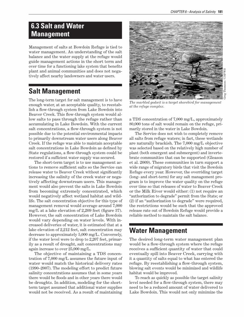
The marbled godwit is a target shorebird for management at the refuge complex.
Gre
g T
hom
son
/ US
FW
S
Water ManagementThe desired long-term water management plan would be a flow-through system where the refuge receives a sufficient quantity of water that could eventually spill into Beaver Creek, carrying with it a quantity of salts equal to what has entered the refuge. By reestablishing a flow-through system, blowing salt events would be minimized and wildlife habitat would be improved.
To reach as quickly as possible the target salinity level needed for a flow-through system, there may need to be a reduced amount of water delivered to Lake Bowdoin. This would not only minimize the

182 Draft CCP and EA, Bowdoin National Wildlife Refuge Complex, Montana
amount of salts entering the refuge but concentrate the salts that are already in the water, allowing them to be more easily removed. Additionally, where practical, the inflow of salts could be reduced at the source by lining portions of irrigation canals and managing saline seeps and irrigation return flows.
Obstacles to Implementing a Flow-Through SystemThe Service would need to address several obstacles in developing an effective flow-through system: the lack of needed water supply, the potential need for State permits, and the removal of structures.
Additional Water Supply. Modeling efforts by Ser-vice hydrologists (using models developed in large part by State hydrologists), show the amount of water currently delivered to the refuge under the MOA with Reclamation—up to 3,500 acre-feet under normal water years—is not sufficient to implement a flow-through system for Lake Bowdoin even if water quality issues were resolved.
To address this shortfall, the Service has filed for an additional 8,000 acre-feet of water, based on the maximum delivery from the Milk River on record of 11,540 acre-feet. This historical use right is not part of the ongoing Federal water rights compact and will be litigated as part of the adjudication process for basin 40J (Milk River watershed). The Service understands this water right would likely be junior to most of the other water rights on the canal and would only be taken during periods when water is available.
Additional water would provide the following benefits to the refuge:
■■ Provide flushing opportunities after water qual-ity issues are addressed.
■■ Help offset evaporation, which can exceed 3 feet per year.
■■ Provide the opportunity to manage Dry Lake and Drumbo Pond as a flow-through system.
■■ Allow all units to fill periodically (whereas many are dry now).
■■ Allow additional management options including more flexibility in filling Piping Plover Pond, de-veloped to provide nesting habitat for the threat-ened piping plover.
Permits. Before discharging water into Beaver Creek or the Milk River, the discharge of refuge wa-ters into State waterways must first meet the DEQ’s water quality standards (DEQ–7). Currently, the
Lake Bowdoin water does not meet these standards. The DEQ water quality standards program has two levels of protection: (1) protection of designated uses of water; and (2) prevention of significant degrada-tion of high-quality waters.
Salinity standards have not been established for the Beaver Creek or the Milk River. The water discharged from Lake Bowdoin, when mixed with water from Beaver Creek or the Milk River, must not exceed the threshold determined by DEQ. As an example, in other rivers, a TDS concentration range from 960–1,600 mg/L during the irrigation season has been established (Bauder et al. 2007). To prevent impairment of aquatic life in Beaver Creek or the Milk River, the TDS concentration would have to be maintained below a threshold of 1,000 mg/L.
In addition to the salinity, elevated levels of sul-fates, arsenic, and uranium are obstacles to releasing water. For example, to safely release water into Beaver Creek or the Milk River without harming aquatic life, a low calculated release rate (estimate of 200:1) from Lake Bowdoin would be permitted to avoid causing harm from sulfates. Therefore, if 200 cfs (cubic feet per second) were the rate of flow of the receiving water, only 1 cfs would be permitted from Lake Bowdoin. This mixing ratio could de-crease under scenarios where sulfates are reduced.
The pollutants arsenic and uranium are both car-cinogens, as defined in DEQ–7. Any release from Lake Bowdoin where the concentrations of either arsenic or uranium were greater than the receiving water concentration would require an “authorization to degrade” permit from the State. It is probable, with the addition of ground water inputs and the his-tory of evapoconcentration, that an “authorization to degrade” permit would be necessary for any surface water release from Lake Bowdoin.
Current Structures and Dikes. To obtain the most effective flow-through system, the Service ideally would need to remove the stoplogs (logs or beams that prevent water flow) in the water control struc-tures to allow water to flow between Lake Bowdoin and Beaver Creek during flood events. However, removing stoplogs would only be possible if salinity issues were resolved sufficiently or extreme flood-ing conditions were such that releases from Lake Bowdoin and Dry Lake were necessary to protect infrastructure. These flood water releases would be be conducted safely in coordination with down-stream irrigators and in accordance with State guid-ance from DEQ. The quality of the discharged water would be monitored. Until that time, the refuge staff would maintain the stoplogs, dikes, and spillways primarily to prevent accidental releases. In addition, the refuge would manage water levels to reduce the chance of a breach in the dike.

CHAPTER 6–Analysis of Salinity 183
Figure 37. Map of the extent of Lake Bowdoin at various water elevations.


185CHAPTER 6 –Analysis of Salinity
Salt and Water ObjectivesThe objectives for the salt and water management program follow:
■■ Achieve and maintain an average salt concentra-tion of 7,000 mg/L at a lake elevation of 2,209 feet in Lake Bowdoin.
■■ Limit blowing salts.
■■ Obtain an additional 8,000 acre-feet of canal de-liveries to allow for a flow-through system, while meeting all DEQ standards.
■■ Use the additional 8,000 acre-feet of canal deliv-eries for more management options.
6.4 Planning ProcessWhen the Service started the preparation of a CCP in October 2006, the first step in the process was pre-planning. A planning team was established, in-ternal issues and qualities of the area were iden-tified, public involvement was planned including development of a mailing list, and available refuge data and relevant research were compiled. Public involvement was initiated on May 15, 2007, when the notice of intent to prepare the CCP was published in the Federal Register. More than 170 individuals and organizations were provided information on the planning process and invited to participate in a pub-lic meeting held in Malta, Montana, on May 22, 2007.
During pre-planning, it became very evident that the most pressing issue for the CCP and environ-mental analysis process would be the salinity and blowing salts on Bowdoin National Wildlife Refuge. The biological implications were evident. Further-more, this was an environmental issue for the State and neighboring landowners, primarily because of past experiences and the future potential for blow-ing salts or a spill due to a flood, which could cause structure failure.
Refer to table 1 in chapter 1 for the detailed steps and timeline in the planning process for this CCP and environmental analysis. A summary fol-lows of the process for developing alternatives, in-volving the public, and completing the CCP.
Development of AlternativesOn May 22, 2007, the Service formed a salinity team comprising hydrologists, biologists, toxicologists,
and researchers from State and Federal agencies. This team discussed options for effectively manag-ing the refuge’s wetland resources while addressing the salinity issue. A smaller salinity group had staff from the refuge, the Compact Commission, DEQ, DNRC, U.S. Geological Survey, and Region 6’s Di-vision of Water Resources and Division of Refuge Planning. This group was tasked with developing alternatives to address the salinity situation.
The salinity group evaluated data and existing models. The group initially modeled and analyzed nine scenarios, including combinations of other sce-narios, to determine their effectiveness in reducing salinity, improving water quality, and reducing blow-ing salts while still providing habitat for migratory birds. The group had five additional meetings while developing these models.
In addition to this effort, researchers from the U.S. Geological Survey’s Northern Prairie Wildlife Research Center completed a separate analysis on the salinity ranges of water and soil for common plants and invertebrates found on Bowdoin Refuge. U.S. Geological Survey conducted a search of the literature on occurrences of plants and invertebrates in relation to salinity and pH of the water and soil. The resulting literature review was used to compile the latest information, develop databases, and write a report with the following:
■■ A general overview of salinity concepts
■■ Published tolerances and adaptations of plants, invertebrates, and animals to salinity
■■ Databases that the Service could use to summa-rize the range of reported salinity values associ-ated with plants and invertebrates
■■ Database summaries of reported salinity ranges associated with plants and invertebrates at Bow-doin Refuge.
The resulting report was titled, “Literature Review and Database of Relations between Salinity and Aquatic Biota—Applications to Bowdoin National Wildlife Refuge, Montana” (Gleason et al. 2009).
Salinity AlternativesOn April 22, 2008, 17 individuals (biologists, hy-drologists, managers, toxicologists, researchers, engineers, and planners), many from the original salinity team, assembled from five State and Federal agencies. The salinity group presented their findings and proposed alternatives. Two proposals early in the process were determined to be either ineffec-tive or cost prohibitive; these are described below.

186 Draft CCP and EA, Bowdoin National Wildlife Refuge Complex, Montana
After meeting for 2 days, the team determined that four of the alternatives would be most effective and warranted further analysis, particularly of the cost, effectiveness, and environmental consequences.
The Service acquired the money to complete fur-ther analysis and entered into a contract with an engineering firm in Denver, Colorado—URS Group, Inc. The contract began in July 2008. URS provided information for three of the four alternatives that the Service decided to analyze:
■■ Evaporation ponds and removal of saline residue■■ Flushing by Beaver Creek■■ Underground injection of saline solution
Concurrently, the refuge staff and a team of biolo-gists and hydrologists from the Service and the State conducted a separate analysis for the fourth alternative. This effort analyzed the cost, effective-ness, and consequences of pumping saline water to the Milk River through a pipeline.
Analysis of the four alternatives took more than a year to complete. Section 6.5 details the resulting evaluations of these four “action” alternatives along with an evaluation of the current situation, or “no-action” alternative.
Alternatives Considered but EliminatedTwo options that the Service did not find viable for addressing the salinity and blowing salts situation were eliminated from further analysis as described below.
Desalinization. The Service considered desaliniza-tion—for example, with reverse osmosis—but elimi-nated this option due not only to the costs (capital, operating, and maintenance costs) but also due to a lack of available disposal locations for the waste-water generated from this process. Desalinization would not remove salts from the site, because the salt would remain in the concentrated waste outflow. Subsequently, this waste outflow would need re-moval—placed on railcars, injected into the ground, or discharged into the Milk River.
Pumping Water into Dry Lake. Pumping saline wa-ter into Dry Lake and allowing the lake to serve as an evaporative basin to blow away salt residues was determined an unacceptable alternative and was dismissed from further consideration.
Public InvolvementBefore completing the draft CCP and EA, the Ser-vice invited the public to a meeting on October 22, 2009, in Malta, Montana, for a review of the salinity alternatives and an opportunity to offer comment.
A planning update was sent to each individual and group on the mailing list, and local media was con-tacted. More than 30 people attended this meeting including local landowners, media, private organiza-tions, and other State and Federal agencies. Mem-bers of the salinity group presented the merits and challenges of each alternative and recorded the com-ments of meeting participants. Afterward, the CCP planning team evaluated the salinity comments from the public. The team incorporated the substantive comments into this final analysis and recommenda-tion for a proposed action for the salinity and blow-ing salts on Bowdoin Refuge.
Plan CompletionFollowing public review of this draft CCP and EA, the planning team will give a briefing to the Re-gional Director (Region 6 of the Service) about the alternatives for the CCP for the Bowdoin National Wildlife Refuge Complex. This will include the salin-ity alternatives and proposed action (salinity alter-native 4) described in this chapter. The Regional Director will make the decision on whether to accept this proposed action as the preferred alternative for salinity and blowing salts or to request further analysis or modifications.
Once approved, the preferred alternative for sa-linity and blowing salts, along with the preferred alternative for all the other management aspects of the refuge complex (refer to chapters 3 and 7), will become the final plan. The Service will publish a notice of availability in the Federal Register and send copies of the final CCP or CCP summary to individuals and groups on the mailing list.
Three-square bulrush grows on the salt-covered shoreline along the southwestern edge of Lake Bowdoin.
Mik
e A
rtm
ann
/ US
FW
S
187CHAPTER 6 –Analysis of Salinity
6.5 Salinity Alternatives Analysis
This section describes the five salinity alternatives and the results of the analysis for each one.
■■ Salinity alternative 1—current management (no action)
■■ Salinity alternative 2—evaporation ponds and removal of saline residue
■■ Salinity alternative 3—flushing by Beaver Creek
■■ Salinity alternative 4—underground injection well and flushing by Beaver Creek (proposed action)
■■ Salinity alternative 5—pumping to the Milk River
There are several elements common to all alterna-tives. Following, a description of each alternative details the actions and expected consequences of carrying out those actions. At the end of this section, table 11 summarizes the actions and consequences.
Elements Common to All AlternativesThe elements described below apply to the five salin-ity alternatives, including the no-action alternative.
Salt and Water InputsFor all modeling scenarios, it was assumed that his-torical conditions would continue into the future. Water inputs, water quality data, and climate data were taken for the period from 1990 through 2007, because data for this period is relatively complete.
In addition, modeling scenarios used the assump-tion that water would be supplied to each wetland unit similarly to previous management and water could flow between all units. From 1990 through 2007, approximately 80 percent of canal water was supplied to Lake Bowdoin, 17 percent to Lakeside, and 3 percent to Drumbo Pond.
Water Rights CompactThe Service would use the preferred salinity alter-native, as selected by the Regional Director (Region
6), as the basis for negotiating the MOU with the State related to the water rights compact.
Sources of SaltsRegardless of which alternative the Regional Direc-tor selects, the Service would evaluate and take measures to reduce the delivery of salt to the refuge. Furthermore, the Service would encourage sur-rounding landowners to use the methods for reduc-ing the size and contributions of salt from saline seeps near the refuge, as suggested by the Montana Salinity Control Association (Jane Holzer, agrono-mist, Montana Salinity Control Association, personal communication, October 2009):
■■ Establish a 5- to 10-year rotation from crops to perennial forage for haying and grazing in the re-charge area. Most commonly use the deep-rooted crop, alfalfa, but also use other legumes and grasses, reducing the amount of water percolat-ing through the root zone.
■■ Plant perennial vegetation in the recharge area through the Conservation Reserve Program to mimic the water use by alfalfa hay.
■■ Switch from the crop-fallow system to a flexible but more intensive annual cropping system. Fol-low the forage rotation, which can include cereal grain, with the flex-crop system.
■■ Line irrigation canals that leak water into the ground water.
■■ Encourage irrigation practices that use water more efficiently to minimize water table rise.
Baseline for Socioeconomic AnalysisThe proposed salinity alternatives would have various effects on visitation to Bowdoin Refuge Complex for hunting and wildlife observation. Cur-rently, there are 25,000 annual visitors to the refuge. Ninety percent, or 22,500 visitors, do not live close to the refuge and contribute a direct economic im-pact of $415,750 for visitation throughout the refuge complex.
Only nonresident visitor spending can be con-sidered when calculating the socioeconomic impact of refuges on the local economy in the four-county region in north-central Montana. The money spent by local residents on visitation to the Bowdoin Ref-uge Complex would likely be spent on other local recreational activities if the refuge complex did not exist, so it cannot be considered a new expenditure in the local economy. Socioeconomic analyses of

188 Draft CCP and EA, Bowdoin National Wildlife Refuge Complex, Montana
visitor spending are compared for each alternative against this baseline data. The analysis assumes that nonresident hunters spend an average of $55 per day and wildlife observers spend an average of $18 per day. The economic impacts of salinity reduction are one-time construction spending, ongoing direct operational spending, and visitation-related effects.
Salinity Alternative 1–Current Management (No Action)Salinity alternative 1 is the no-action alternative, meaning current management would continue. Un-der current management, water deliveries would remain near 3,500 acre-feet and no water would be released from Lake Bowdoin. There would not be any active removal of salts from Lake Bowdoin ex-cept by wind or during a flood event. Salts would continue to accumulate and the salinity situation would become increasingly difficult to manage.
The following describes the alternative’s specific actions and expected environmental consequences if implemented.
Figure 38. Graph of tons of salt in Lake Bowdoin with salinity alternative 1, no action.
280
260
240
220
200
180
ons
of S
alt
160
140
1,00
0 T
120
100
80
60
40
20
0
2011
2012
2013
2014
2015
2016
2017
2018
2019
2020
2021
2022
2023
2024
2025
2026
2027
2028
ActionsThese actions reflect the current management for addressing salinity and blowing salts.
Tons of Salt Removed. No salt would be removed unless there was a major flood event or the salts dried up and blew away when the level of Lake Bow-doin was dropped. The total weight of salt would increase to more than 250,000 tons in less than 20 years (figure 38).
Salinity Concentration. Lake Bowdoin would con-tinue to receive about 7,000 tons of salt per year, causing salinity levels to increase steadily. The in-crease in salt and lack of outflow would cause sa-linity to reach extremely high levels during dry years—more than 30,000–40,000 mg/L. With elimina-tion of the practice of allowing salt residue to con-centrate in Dry Lake and be carried away by wind, the concentration of salts in Lake Bowdoin would reach even higher levels than what has been docu-mented in the past.
Time to Achieve Salinity Objective. The objective of sustaining a brackish water quality level (7,000 mg/L) would never be reached without an accidental spill or major flood event. If one of these two events
0
20,000
40,000
60,000
80,000
100,000
120,000
140,000
160,000
180,000
200,000
220,000
240,000
260,000
280,000

189CHAPTER 6 –Analysis of Salinity
occurred, the salinity objective would likely be met for a short period; however, the salinity level would not be sustained as salts continued to accumulate.
Elevation of Lake Bowdoin. There would be no management of the size of Lake Bowdoin. The lake’s elevation would likely fluctuate between 2,208 feet and 2,211 feet throughout the year if water deliver-ies remained near 3,500 acre-feet. If the historical average of 4,900 acre-feet of canal water were deliv-ered, Lake Bowdoin would fluctuate between 2,210 feet and 2,213 feet in elevation. Elevation of the lake would continue to depend on inflow and evaporation. Except under coordinated efforts with downstream users during floods, water would not be released even during wet years due to the high salinity and the threat of impacting downstream landowners, wildlife, vegetation, and invertebrates.
Amount of Water Removed. There would be no ac-tive removal of saline water from Lake Bowdoin under the current management.
Modifications and Facilities. There would be no changes or modifications to the current water man-agement infrastructure. All water-level manage-ment structures would be maintained and stoplogs would remain in place to prevent accidental releases of water.
Capital Cost. There would be no capital cost as-sociated with the current management practices. There could be indirect costs for tort claims related to an accidental spill of waters down Beaver Creek.
Monitoring and Research. The Service would con-tinue to monitor water delivery, water quality, lake elevation level, wildlife disease outbreaks, migratory bird use, and sites for colonial-nesting birds.
Environmental and Socioeconomic ConsequencesThe actions of salinity alternative 1 would likely have the consequences described below.
Plant Diversity. Under the no-action alternative, plant species diversity in Lake Bowdoin would likely continue to decline as salinity concentrations in-creased to the upper ranges of the subsaline class (20,000–25,000 mg/L), with only a few of the most salt-tolerant species thriving (Gleason et al. 2009). Expansion of plant species requiring fresher sources of water for establishment, such as cattail and hard-stem bulrush, would not occur. If the lake were kept at full-pool level, expansion of any emergent vegeta-tion would likely not occur. Conversely, if the lake were kept lower for several years at a time, some expansion and colonization would be expected to oc-cur. Submerged aquatic vegetation, which provides important food for waterfowl and habitat structure for invertebrates, would likely continue to decline. Plants such as sago pondweed and widgeongrass
are important for migrating waterfowl and other waterbirds.
The strong west-to-east salinity gradient in Lake Bowdoin would remain. Wetland vegetation along the eastern and southeastern shorelines, where sa-linity concentrations are the highest, would remain dominated by salt-tolerant species such as alkaline bulrush, common three-square, and pickleweed, with little expansion into the lake over time. Emergent vegetation on the west side of the lake would likely remain dominated by cattail and hardstem bulrush.
Flow-through wetlands such as Patrol Road Pond, Black Coulee Pond, and Lakeside would re-main in the slightly to moderately brackish wetland classes (less than 3,000 mg/L) as salts were passed into Lake Bowdoin and Dry Lake.
With the fresher water it receives, Black Coulee Pond supports a greater amount of cattail than in more saline wetlands.
Mik
e A
rtm
ann
/ US
FW
S
Invertebrates. Like plants, invertebrate diver-sity in Lake Bowdoin would decline with increased salinity. Fresh wetland systems contain diverse in-vertebrate communities, whereas wetland systems exceeding a brackish state (greater than 9,600 mg/L) tend to be dominated by relatively few groups of invertebrates (Gleason et al. 2009). Given the vari-able inflows of fresh water to Lake Bowdoin, such as the irrigation return flows in Black Coulee and the delivered water via the Dodson South Canal, there would likely be areas within the lake where a higher diversity of species still occurs. However, as the lake moved to a consistently salty state, these areas of invertebrate diversity would decline. Although di-versity of invertebrates would likely decline, the to-tal productivity of the lake may remain high because salt-tolerant species, which can be prolific, dominate.
Waterfowl and Other Waterbirds. Waterfowl use and productivity would likely further decline from

190 Draft CCP and EA, Bowdoin National Wildlife Refuge Complex, Montana
already low levels, as salt accumulations in Lake Bowdoin continued to increase. The salinity con-centration for the lake in September 2009 averaged more than 10,500 mg/L. This concentration exceeds the level that affects the growth rates and survival of waterfowl broods, especially for ducklings less than 6 days old. At salinity concentrations higher than 15,000 mg/L, duckling mortality can exceed 90 percent (Mitcham and Wobeser 1988, Moorman et al. 1991). Furthermore, duckling growth rates are re-duced when salinity concentrations are higher than 3,000 mg/L (Mitcham and Wobeser 1988).
At current salinity concentrations and with no available fresh water, Lake Bowdoin would be a “sink” to waterfowl populations—birds would be at-tracted to the lake for nesting, but conditions would not be conducive for young ducklings to survive. Fortunately, fresher sources of water are located within the lake near input channels and seeps and in nearby freshwater wetlands such as Patrol Road Pond, Drumbo Pond, Teal Ponds, Farm Ponds, Goose Island Pond, and the Lakeside units. These fresh sources would continue to be available even as the overall average salinity continued to rise in the lake.
Lake Bowdoin has a history of avian botulism outbreaks. Bird losses, mostly ducks, have averaged about 1,500 per year since 1979. Research has shown that, in general, the risk of botulism outbreaks de-clines when salinity concentrations increase (higher than 6,000 mg/L) (figure 39) and pH readings in the water exceed 8.5 (Rocke and Friend 1999, Rocke and Samuel 1999). Recent refuge data suggests this pattern may hold at Lake Bowdoin. Losses since 2003 averaged 190 birds while average salinity was higher than 10,000 mg/L. As salinity concentrations continued to rise, the risk of large outbreaks would likely remain low.
If Lake Bowdoin were kept at an elevation of 2,211 feet, an estimated 125 acres within the lake would be less than 3 inches deep; however, most of this is located in densely vegetated areas. Shore-bird use would only increase during drought periods when the lake level lowered and expansive mudflats were available. This would be especially true if a drawdown occurred during the migration period (Fredrickson and Reid 1988b).
Colonial-nesting birds, such as American white pelicans, would likely not be greatly affected by steadily increasing salinity concentrations. Lake levels would likely remain consistent as in the past, and all nesting islands would remain surrounded by water.
Downstream Users. There potentially could be hazards to downstream water users if no action were taken. Increasing salinity would raise the po-tential severity if an accidental spill were to occur.
However, this threat could be lessened substan-tially by keeping the lake at a lower operating level. But by operating the lake at a lower level with no mechanism to remove salts, the concentration would increase further. Furthermore, if salinity concentra-tion reached critical levels, refuge managers may be forced to reconsider using the past practice of mov-ing water from Lake Bowdoin to Dry Lake, which would allow the saline water to evaporate over the summer and be blown away by high winds.
Public Use. There would be no discharge of water, so the water level in most years, given historical deliveries of water, would provide access to existing boat ramps and the accessible pier on Lake Bow-doin. Since water quality would continue to decline, the production and diversity of food sources for wild-life would decline and, over time, there would be less wildlife for the enjoyment of the public.
Socioeconomics. Declining health of wetland habitats and a reduction in bird use of Bowdoin Refuge would decrease the opportunity for wild-life-dependent recreational opportunities including birdwatching and hunting visits. Visitation to the refuge is expected to decline by 4,850 visitors, de-creasing the total to 12,650 (including hunters and wildlife observers). Based solely on nonresident visi-tation (11,380), the direct economic impacts would be $310,700 annually, a decrease of $105,050 from the baseline.
Cumulative Impacts. As salinity would continue to increase and likely reach critical levels, plant and invertebrate diversity and habitat quality would decline. This would be particularly true in dry years when lake levels dropped, salts were further concen-trated, and there were no means other than by wind to remove the salt. Over time, this would result in reduced food resources and habitats for migratory birds and other wetland-dependent wildlife.
As the total amount of salt in the lake increased, the amount of salt available for removal by wind would also increase. If drought conditions were more frequent in the future or if the refuge was unable to acquire sufficient water from the Malta Irriga-tion District, lower lake levels would become more frequent. Increasing the potential opportunity for windblown salt could negatively affect public use opportunities if salt clouds were significant enough to reduce viewing or hunting opportunities. In ad-dition, neighbors to the refuge and the local commu-nity would not view large salt clouds favorably, thus further stressing relationships between the refuge staff and community members. Failure to act on the salinity issues facing Lake Bowdoin would make it more difficult to establish long-term partnerships with State and local interests that have invested much time and effort in this planning process.
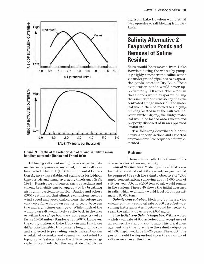
191CHAPTER 6 –Analysis of Salinity
Figure 39. Graphs of the relationship of pH and salinity to avian botulism outbreaks (Rocke and Friend 1999).
If blowing salts contain high levels of particulate matter and exposure is sustained, human health can be affected. The EPA (U.S. Environmental Protec-tion Agency) has established standards for 24-hour time periods and annual averaging timeframes (EPA 1997). Respiratory diseases such as asthma and chronic bronchitis can be aggravated by breathing air high in particulate matter. Bauder and others (2007) estimated that climatic conditions such as wind speed and precipitation near the refuge are conducive for windblown events to occur between two and eight times each year. While much of the windblown salt would likely settle back in the lake or within the refuge boundary, some may travel as far as 10–20 miles (Bauder et al. 2007). However, the configuration of Lake Bowdoin and Dry Lake differ considerably: Dry Lake is long and narrow and subjected to prevailing winds; Lake Bowdoin is relatively circular and somewhat protected by topographic features. Given the differences in topog-raphy, it is unlikely that the magnitude of salt blow-
ing from Lake Bowdoin would equal past episodes of salt blowing from Dry Lake.
Salinity Alternative 2– Evaporation Ponds and Removal of Saline ResidueSalts would be removed from Lake Bowdoin during the winter by pump-ing highly concentrated saline water via underground pipelines to evapora-tion ponds located in Dry Lake. These evaporation ponds would cover ap-proximately 300 acres. The water in these ponds would evaporate during the summer to the consistency of a con-centrated sludge material. The mate-rial would then be moved to a drying building located near the railroad line. After further drying, the sludge mate-rial would be loaded onto railcars and properly disposed of in an approved landfill site.
The following describes the alter-native’s specific actions and expected environmental consequences if imple-mented.
ActionsThese actions reflect the theme of this
alternative for addressing salinity.Tons of Salt Removed. Modeling showed that a wa-
ter withdrawal rate of 800 acre-feet per year would be required to reach the salinity objective of 7,000 mg/L concentration, removing about 7,000 tons of salt per year. About 80,000 tons of salt would remain in the system. Figure 40 shows the initial decrease in salts, which eventually would level off at approxi-mately 80,000 tons.
Salinity Concentration. Modeling by the Service calculated that a removal rate of 800 acre-feet—as-suming historical water inputs—would be needed to reach the salinity objective of 7,000 mg/L.
Time to Achieve Salinity Objective. With a water withdrawal rate of 800 acre-feet and acceptance of all sources of water and salt to match historical man-agement, the time to achieve the salinity objective of 7,000 mg/L would be 10–20 years. The exact time period would be dependent upon the quantity of salts received over this time.

192 Draft CCP and EA, Bowdoin National Wildlife Refuge Complex, Montana
Elevation of Lake Bowdoin. The amount of lake water withdrawn and pumped to the evaporation ponds would have only a small effect on the lake’s water level. Maintaining a lower lake elevation would concentrate the salts, allowing for more ef-fective removal, and decreasing the time required to reach the salinity objective.
Amount of Water Removed. An average with-drawal of 800 acre-feet of water each winter would be required to maintain the salt balance, assuming all water and salt inputs remained consistent with past inputs.
Modifications and Facilities. The Service would develop 300 acres in evaporation ponds to concen-trate salts for removal. A pump station, power source, and 5 miles of pipeline would be needed to pump water to the evaporation ponds. The concen-trated salt sludge would be stored in a newly con-structed salt storage building. After a drying period, the sludge would be loaded onto railcars and dis-posed of at a landfill or sent to a salt mill. This would require construction of a new railroad spur, which would be located near the old town site of Bowdoin and connected with the existing rail line. Heavy equipment and personnel would be acquired to load salts for transport.
Capital Cost. An initial cost estimate for the evap-oration ponds design was $44 million, with an annual operating cost of $2 million. However, the Service has determined that more water needs removal to reach the salinity objective. Therefore, the capital
and operating costs are expected to be higher than the initial estimate.
Monitoring and Research. Monitoring and research activities would be the same as described in salinity alternative 1, plus additional monitoring wells would be drilled in the Black Coulee drainage to monitor water quality and quantity coming into Bowdoin Refuge. Baseline information would be collected on current species of wetland vegetation, waterbirds, and invertebrates before construction activities and the changes would be monitored.
180
160
140
120
ons
of S
alt 100
80
1,00
0 T
60
40
20
0
2011
2012
2013
2014
2015
2016
2017
2018
2019
2020
2021
2022
2023
2024
2025
2026
2027
2028
Figure 40. Graph of tons of salt in Lake Bowdoin with salinity alternative 2.
Environmental and Socioeconomic ConsequencesThe actions of salinity alternative 2 would likely have the consequences described below.
Plant Diversity. Over time, plant diversity and expansion of plant populations would increase as a result of a lower salt concentration in Lake Bowdoin and extended lower water levels. Emergent wetland plants such as cattail and hardstem bulrush on the west end of the lake would likely expand into the lake as lower water levels were consistently held due to winter removal of water. This expansion of plants in the west arm of the lake would be facili-tated by the continued flow of relatively fresh irriga-tion return water from the Black Coulee drainage.
Reduced salinity on the western side of the lake would support reestablishment of submerged aquatic vegetation such as sago pondweed and wid-

193CHAPTER 6 –Analysis of Salinity
geongrass. On the east side of the lake, however, extended periods of higher salt concentrations dur-ing the active salt removal process could lead to further reductions of these species. The footprint of the salt evaporation ponds would likely remain bare soil or sparsely vegetated due to high salt concentra-tions throughout much of the year. Heavy machinery work to clear the salt sludge would hinder plant establishment.
Increased disturbance to the soil from construc-tion of the underground pipeline and the evaporation ponds in Dry Lake would increase the likelihood of infestations of invasive plant species such as Canada thistle.
Invertebrates. During the period of salt removal and lower water levels, elevated salinity concen-trations throughout much of Lake Bowdoin would be expected and would cause some reduction in in-vertebrate diversity, especially on the eastern side. Salt-tolerant invertebrates such as the water boat-man would become more abundant. A decrease in diversity would not necessarily equate to a decrease in the productivity and availability of resources for migratory birds. However, fewer species of migra-tory birds may be able to fully use these resources, depending on where they occurred in the lake. Even with a lower water level, there would remain areas of high invertebrate diversity especially near sig-nificant inputs of fresh water such as from the Black Coulee drainage and the Dodson South Canal. These areas would likely have a higher diversity of inver-tebrates and would serve as a source of invertebrate recolonization when salinity concentrations declined.
Waterfowl and Other Waterbirds. Waterfowl use would increase over time due to fresher conditions in Lake Bowdoin and the increased abundance of preferred invertebrates and plant resources. The
Piping plovers, which have nested near Piping Plover Pond, could be negatively affected by the operation of heavy equipment at the nearby evaporation ponds.
ilson
/ U
SF
WS
Mar
k W
shallower lake areas would provide optimal feed-ing opportunities to many species of waterfowl and shorebirds. The area of the evaporative ponds would be potentially available to migrating waterfowl dur-ing the spring and summer unless methods were used to exclude them (nets or disturbance guns). Bird use of these evaporative ponds would be closely monitored to determine if exclusion techniques were needed to prevent mortality.
Concerns over direct mortality of waterfowl broods would be lessened with lower salinity con-centrations. However, at the target objective for salinity of 7,000 mg/L, ducklings would have reduced growth rates if access to fresher water were not available. Extremely high salt concentrations in evaporation ponds might result in bird mortality if birds were unable to locate fresh sources of water, especially during fall migration (Windingstad et al. 1987).
Although not their preferred habitat, shorebirds and other waterbirds might use the evaporation ponds if they provided shallow-water habitat or mudflats and invertebrates during migration. Dis-turbance from removal of the salt sludge could be significant to birds using adjacent wetlands and up-land; however, much of this disturbance would occur in late summer or fall after the nesting seasons. At the lower lake elevation of 2,208 feet, an estimated 240 acres of open water less than 5 inches deep would provide increased feeding opportunities for shorebirds. If lower water levels corresponded with spring or fall migration periods, increased use of the lake by shorebirds would be likely.
Colonial-nesting birds that traditionally use Woody Island, such as American white pelicans, cormorants, great blue herons, and Franklin’s gulls, would be subject to a higher risk of predation if the lake were consistently held at a lower elevation. At 2,208 feet, Woody Island would cease to be an island, because its closeness to the mainland would allow easier access to mammalian predators. Some preda-tion by coyotes presently occurs.
Downstream Users. Potentially, the hazards for downstream water users would be great if an ac-cidental or flood-induced spill were to occur, given the highly concentrated sludge material that would be within the evaporation ponds. Because of the intended location of the evaporation ponds within Dry Lake, a large flood could pose a threat to the integrity of the ponds.
Public Use. There would be an increase in infra-structure on Bowdoin Refuge: pump station, power source (any power lines would be buried), evapora-tion ponds, underground pipeline, salt storage build-ing, and rail spur. Operation of this system would lead to increased disturbance to not only wildlife but also to refuge visitors. To ensure visitor safety, part

194 Draft CCP and EA, Bowdoin National Wildlife Refuge Complex, Montana
of the refuge surrounding the evaporation ponds and pump would need closure during times of opera-tion and salt removal. The increased noise and area closure could lead to a decrease in visitor satisfaction and might cause a decrease in public use.
Lower water levels would be anticipated as wa-ter is transported from Lake Bowdoin to Dry Lake, with the focus on a smaller lake size during active salt removal. The exposed mudflats and improved habitats would attract shorebirds and waterfowl, which would increase wildlife-viewing opportunities from the auto tour route.
With lower water levels, the area surrounding the western boat launch and accessible pier on Lake Bowdoin would be dry. Hunters could still use the north boat ramp, but the water would be shallow and may require hunters to push their boats further to access the lake. Larger, v-hull boats and motors would not be usable much of the time. The acreage accessible by waterfowl hunters on Lake Bowdoin would decline, and crowding might become an is-sue on other wetland units within the hunting area. Hunter satisfaction may decline.
In the long term, reduction in salinity concen-trations and improvements to habitat on Lake Bowdoin, including increased plant diversity, would increase waterfowl numbers and diversity. These conditions would increase the opportunities for qual-ity wildlife observation and waterfowl hunting.
Socioeconomics. Design and construction work necessary to build the infrastructure would provide an economic boost to the local community of Malta and to Phillips County. To construct the evaporation ponds and associated infrastructure, the capital cost could exceed $44 million, with an annual operating cost of $2 million. Money spent on lodging, food, and other necessities would increase dramatically dur-ing this phase. The annual budget provided to the refuge would be expanded for successful implemen-tation. Hiring additional staff to help manage opera-tions of the evaporation ponds would add permanent resources to the community as well.
Wildlife habitats would have increased wetland vegetation, invertebrates, and wetland-dependent migratory birds. Pumping water out of Lake Bow-doin would likely result in consistently lower water levels; however, the increased number and diversity of waterfowl would offset the effects on waterfowl hunters. Visitation to Bowdoin Refuge is expected have a net increase of 2,000 visitors, increasing the total to 19,500 (including hunters and wildlife observers). Based solely on nonresident visitation (17,580), the direct economic impacts would be $448,600 annually, an increase of $32,850 from the baseline.
Cumulative Impacts. As salinity concentrations decreased over time, plant diversity and wildlife use
would increase. As the lake water level was lowered, up to two colonial-nesting islands would become pen-insulas, which might lead to increased nest abandon-ment and increased risk of predation. There would be more disturbances to waterbirds due to the salt removal process.
The area and buffer designated for the evapora-tion ponds would be permanently affected by the salt removal operation and would become degraded habitat. Because the evaporation ponds would be located in Dry Lake, there would be a real threat of floods damaging the ponds. Given that floodwaters enter the refuge from the east through Dry Lake, the evaporation ponds could be affected and possibly breached even by small floods. This could result in an unacceptable discharge of saline waters down Beaver Creek.
The new railroad spur would increase fragmenta-tion of existing habitats. Beyond the direct impact of the trains and noise, the new railroad spur would be an additional avenue for the spread of invasive plant species.
Salinity Alternative 3–Flushing by Beaver CreekFlooding historically played a major role in remov-ing salts from the lake system and maintaining the salt balance. Many factors have changed, however, which has altered the flood frequency of Beaver Creek. This alternative evaluated the effectiveness of flooding as the primary means to remove salts from Bowdoin Refuge. Six management options were evaluated for the effectiveness of flooding on removal of salts for modeled flood-return frequen-cies of 10, 25, 50, and 100 years:
■■ Option 1—Manage Lake Bowdoin similar to man-agement in the 1990s with the outlet structures set at an elevation of 2,211.93 feet.
■■ Option 2—Manage Lake Bowdoin with the outlet structures completely blocked.
■■ Option 3—Manage Lake Bowdoin with the outlet structures completely open.
■■ Option 4—Remove all dikes, water control struc-tures, and spillways that connect Lake Bowdoin to the outside ponding area.
■■ Option 5—Lower Bowdoin Road (county road).
■■ Option 6—Divert flood flows to Drumbo Pond, and then into Lake Bowdoin.

195CHAPTER 6 –Analysis of Salinity
The following describes the alternative’s specific actions and expected environmental consequences if implemented.
ActionsThese actions reflect the theme of this alternative for addressing salinity and blowing salts.
Tons of Salt Removed. Of the six options modeled, the most effective method of salt removal would be option 4—removing all dikes, water control struc-tures, and spillways. It is estimated that 3,300 tons of salt would be flushed in a 10-year flood and 43,000 tons would be flushed in a 100-year flood.
The other option with significant salt-flushing capabilities would be option 3—managing Lake Bowdoin with the outlet structures completely open. With this option, no salt would be flushed in a 10-year flood; however, 22,200 tons of salt would be flushed in a 100-year flood.
The only other action where any salt flushing would occur is option 6—diverting water through Drumbo Pond. This would result in 28,000 tons of salt flushed in a 100-year flood, the minimal flood event where any substantial salt flushing could oc-cur.
Salinity Concentration. For all options, there would be a temporary reduction in salinity due to water entering Lake Bowdoin during a flood. How-ever, if no water were flushed out of the lake, the long-term salinity concentrations would increase once the water level returned to normal.
Time to Achieve Salinity Objective. The time to flush the salt for each of these options would likely be more than 100 years, because the quantity of salt flushed for the most effective option (4) in a 100-year flood would be 43,000 tons. However, floods are unpredictable and two 100-year flood events could occur in any timeframe.
Elevation of Lake Bowdoin. The water elevation of Lake Bowdoin would vary from 2,208 feet to 2,212 feet if the structures were blocked (option 2) and inputs of water remained similar to past deliver-ies. The elevation of the lake would decrease to the lower end of the range if the outlet structures were removed (option 4) or if the outlet structures were open (option 3).
Amount of Water Removed. There would be no ac-tive removal of water from Lake Bowdoin. However, there would be varying amounts of water removed depending on the flood event; some of this water might enter and leave.
Modifications and Facilities. To maximize salt re-moval, all water-level management structures would be removed including dikes, roads, and water con-trol structures (option 4). The railroad bridge would need to be lengthened, expanding the constriction point, to allow larger volumes of water into the west arm of Lake Bowdoin via a conveyance channel. A large conveyance channel would be constructed from Drumbo Pond to Lake Bowdoin to facilitate increased water flow under option 6.
Capital Cost. The capital costs would be the same as salinity alternative 1 for the no-cost options of managing the structures at historical settings (option 1), completely blocking the outlet struc-tures (option 2), or completely opening the outlet structures (option 3). Additionally, there would be substantial infrastructure costs for the following options: removing all dikes, water control struc-tures, and spillways (option 4); lowering Bowdoin Road (option 5); and diverting water through Drumbo Pond (option 6).
Monitoring and Research. Monitoring and research activities would be the same as alternative 2.
Refuge staff use this outflow dropboard structure to release water from Drumbo Pond to control the pond’s water level.
Mik
e A
rtm
ann
/ US
FW
S
This railroad trestle over a wetland south of Lake Bowdoin creates a constricted waterway.
Mik
e A
rtm
ann
/ US
FW
S
196 Draft CCP and EA, Bowdoin National Wildlife Refuge Complex, Montana
Environmental and Socioeconomic ConsequencesThe actions of salinity alternative 3 would likely have the consequences described below.
Plant Diversity. Consequences to plant diversity would be the same as salinity alternative 1 except, if one of the modeled flood events occurred and the maximum amount of salt were flushed for a given scenario, there would be a short-term decrease in salinity concentrations following the flood. However, only the largest floods (100-year) would likely re-move enough salt to freshen the system for several years following the event. Some improvement in plant diversity could occur if the reduced salinity concentrations were maintained for several years; however, absent another flood, salinity concentra-tions would return to unacceptable levels.
Invertebrates. Consequences to invertebrates would be the same as salinity alternative 1 until a flood occurred. In the case of a large flood, a short-term response by invertebrates to fresher condi-tions, which could last several years, would likely be beneficial in terms of abundance and diversity. However, diversity would continue to decline over the long term.
Waterfowl and Other Waterbirds. Consequences to waterfowl and other waterbirds would be the same as salinity alternative 1, except that a sudden drop in salinity and increase in water level during a flood event could increase the chance of a botulism out-break during the year of the flood. Maintaining Lake Bowdoin at a lower water level would make access with any type of boat more difficult and could po-tentially affect disease monitoring, colonial-nesting surveys, and water quality monitoring throughout the lake.
Downstream Users. The potential hazards for downstream water users would depend on the salin-ity concentration of Lake Bowdoin and the time of year of flooding. If a flood occurred when Lake Bow-doin was highly saline, salt would be transported downstream. Depending on the magnitude of the flood event (the amount of water available for mix-ing), the negative effects on water quality and ag-ricultural interests would range from negligible to severe. If lake levels were consistently low, smaller floods would likely enter the lake, but flooding vol-umes would be small enough that water would likely not exit the refuge.
Public Use. Consequences to public use would be the same as salinity alternative 2, except there would not be any added infrastructure; in fact, some would be removed under option 4. Removing or low-ering the outlet structures would reduce the area available for waterfowl hunting on the lake and re-
quire hunters to drag their lightweight boats farther to access water.
Socioeconomics. An accidental spill or uninten-tional discharge to Beaver Creek during flood events could pose risks and burdens to private landowners downstream of Bowdoin Refuge. Large, windborne dust storms such as occurred in the past could cause salt accumulation on adjacent private lands, reduc-ing productivity for hay and livestock operations.
In the short term, the removal of water control structures (option 4) would result in more shallow-water areas in Lake Bowdoin and fewer opportuni-ties for hunting. Depending on what water control measures were implemented, the capital cost could be quite high. Contracting for construction services to remove the structures might bring some short-term economic benefits to the local community. Over the long term, the lowered salinity within the refuge would attract more waterbirds including waterfowl and shorebirds. This would provide additional op-portunities for birdwatchers and hunters.
A 20-percent decrease in hunters would be ex-pected due to a loss of access for hunting caused by low water levels. An equal or greater increase in wildlife observers would be expected due to an increase in species diversity. Since hunters spend an average of $55 per visit versus $18 per visit for wild-life observers, the overall direct impact would be $418,000 annually, a gain of only $2,250 over baseline impacts. Although visitation would be expected to increase by 950 visitors overall, the loss of hunters would result in this moderate increase.
Cumulative Impacts. Cumulative impacts would be the same as salinity alternative 1, except the in-frastructure surrounding Lake Bowdoin would be modified to allow for enhanced flood flushing. Water quality and habitats for wetland-dependent wildlife would continue to degrade as salinity concentrations rose. Beaver Creek floods so infrequently that man-aging Lake Bowdoin while waiting for the next flood to occur would pose significant challenges to the refuge and downstream users. Some of these chal-lenges would include correctly setting the stoplogs and maintaining the appropriate amount of water in the lake to optimize salt removal in the case of a large flood.
With the modified infrastructure, the Service would need to manage Lake Bowdoin at a sustained low level to have adequate safeguards between the lake elevation and the elevation at which water would move downstream under normal conditions. If the difference between the normal elevation and structure elevation were not great enough, frequent releases would be more likely. Because of possible extended lower lake levels, blown salts could be-came an issue. During a very large flood like that in 1986, a large amount of salts would likely be carried
197CHAPTER 6 –Analysis of Salinity
downstream and sufficiently diluted by the volume of water, thereby removing the risk of direct losses to downstream users.
Salinity Alternative 4– Underground Injection Well and Flushing by Beaver Creek (Proposed Action)An underground injection well would be used to force saline water deep into the ground. Once the salinity objective was met and water in Lake Bow-doin met all applicable water quality standards, modifications to the lake’s infrastructure would be evaluated to determine the best way to re-create a flow-through system that maximized the effects of natural flooding. If natural flooding did not occur or more water to be supplied from the Milk River was not granted, the injection well could be used periodi-cally to maintain salinity at an acceptable level.
Two different options for the injection well were analyzed: (1) use a holding pond; and (2) inject saline water directly from Lake Bowdoin, without a hold-ing pond, into the ground.
For the holding pond option, water from Lake Bowdoin would be pumped to the holding pond only in the winter, when the water under the ice is most concentrated. Without a holding pond, water would be injected year-round directly from Lake Bowdoin. In both options, the water would be injected to a depth of 3,500–6,000 feet throughout the entire year.
The option of injecting directly from Lake Bow-doin into the ground was selected after considering the following consequences:
■■ The capital cost of construction with a holding pond would be about two times greater than con-struction of an injection well without a holding pond.
■■ A large footprint (area) would be required to con-struct a holding pond.
■■ There would be higher annual costs to pump wa-ter from Lake Bowdoin to a holding pond.
■■ A holding pond might be subject to flooding im-pacts from Beaver Creek.
The disadvantage of injecting into the ground di-rectly from Lake Bowdoin is that the time to reach the salinity objective of 7,000 mg/L would be about twice as long. However, the short-term benefit would not justify the additional cost and impact to
the landscape. The injection well might need peri-odic operation once the objective was met, as with a holding pond, if flooding did not naturally flush salts from the system or if more water was not granted.
ActionsThe actions below relate only to the option of inject-ing directly from Lake Bowdoin without a holding pond.
Tons of Salt Removed. Lake Bowdoin would reach a steady state of 7,000 mg/L, at which point there would be 7,000 tons of salt per year removed, with a year-round injection rate of 500 gallons of water per minute directly from Lake Bowdoin and assuming historical water inputs. A total of 800 acre-feet of water per year would be removed, and 80,000 tons of salt would remain on the refuge. Figure 41 shows the decrease of salts in Lake Bowdoin, which even-tually levels off at the 80,000 tons.
Salinity Concentration. Modeling by the Service calculated that a rate of 800 acre-feet (an injection rate of 500 gallons per minute), assuming historical water inputs, would be needed to reach and maintain the salinity objective of 7,000 mg/L.
Time to Achieve Salinity Objective. The time to reach the 7,000 mg/L salinity objective would be 10–20 years with a water withdrawal rate of 800 acre-feet and accepting all sources of water and salt to match historical management. The removal rate of 800 acre-feet would be continued if no other method to discharge salt were identified. Operating Lake Bowdoin in a more saline state would allow for faster disposal of salts.
Elevation of Lake Bowdoin. The amount of water withdrawn from the lake to the injection well would only have a small effect on Lake Bowdoin’s water level. Maintaining a lower lake elevation would con-centrate the salts, resulting in a more saline state. Because more salt would be injected, it would take less time to reach the salinity objective.
Amount of Water Removed. An average with-drawal of 800 acre-feet of water would be required to maintain the salt balance, assuming all water and salt inputs remained consistent with past inputs.
Modifications and Facilities. The Service would install an underground injection well (possibly more than 6,000 feet deep) along with the associated in-take structures. A power source would need to be installed to operate the pump, and a small pump house would be constructed. Once the salinity objec-tive was reached and maintained, Lake Bowdoin infrastructure (dikes, spillways, and water control structures) would be evaluated for removal or modi-fication to facilitate more complete flushing by Bea-ver Creek during a flood event or with more water supplied from the Milk River.

198 Draft CCP and EA, Bowdoin National Wildlife Refuge Complex, Montana
Capital Cost. An initial cost estimate for the injec-tion well was $6.7 million, with an estimated annual operating cost of $100,000. However, the Service determined that more water must be removed to meet the salinity objective. Therefore, the capital and operating costs would likely be larger than the initial estimate.
The estimate for equipment-operating costs was $35,000 per year, primarily due to the electrical costs. Additionally, there would be a Service em-ployee assigned to maintaining and operating the injection well and to working with the necessary contractors. The proposed maintenance position is shown in table 18 under section 7.9 in chapter 7.
Monitoring and Research. Monitoring and research activities would be the same as salinity alternative 2.
180
160
140
ons
of S
alt 120
100
1,00
0 T
80
60
40
20
0
2011
2012
2013
2014
2015
2016
2017
2018
2019
2020
2021
2022
2023
2024
2025
2026
2027
2028
Figure 41. Graph of tons of salt in Lake Bowdoin with salinity alternative 3.
Environmental and Socioeconomic ConsequencesThe consequences below relate only to the option of injecting directly from Lake Bowdoin without a holding pond.
Plant Diversity. Consequences to plant diversity would be the same as salinity alternative 2 exclud-ing the effects of the evaporation ponds. In general, plant species diversity would increase as salinity concentrations decreased; however, in the short term, there would be periods where low lake lev-els would increase salinity to levels detrimental to desirable plant diversity and abundance. In addi-tion, a shift toward more salt-tolerant, less desirable
plants would occur as salts were concentrated and removed. If Lake Bowdoin was held at a sustained low water level (less than 2,208 feet) during the ac-tive salt removal phase (all year), plants such as cat-tail and hardstem bulrush may spread from west to east on the western side of the lake to colonize newly exposed, bare shoreline.
Invertebrates. Consequences to invertebrates would be the same as salinity alternative 2 excluding the effects of the evaporation ponds. Some direct invertebrate losses from pumping activities would be expected, but these losses would be minimal.
Waterfowl and Other Waterbirds. Consequences to waterfowl and other waterbirds would be the same as salinity alternative 2 excluding the effects of the evaporation ponds. Some waterfowl would continue to use Lake Bowdoin for resting, feeding, loafing, and nesting. Intake pipes used for year-round injec-tion could require frequent maintenance, subjecting birds to increased disturbance. Use by shorebirds would likely increase if the lake was consistently held lower during migration periods. More shallowly flooded habitat would be available to migrating birds and resident nesters during spring and fall.
For colonial-nesting birds such as American white pelicans, there could be higher rates of preda-tion and nest abandonment if the lake was consis-tently lower during the salt-reduction phase. This is especially true for species using Woody Island, the largest and closest island to the mainland. The three other primary islands used for nesting are far enough from land, are surrounded by deeper waters,

199CHAPTER 6 –Analysis of Salinity
and would remain as nesting islands. Lower lake levels would reduce the amount of flooded emer-gent vegetation for overwater-nesting birds such as Franklin’s gulls.
Although the botulism bacterium is present in Lake Bowdoin, reducing the lake’s water level and concentrating the salts during the active salt re-moval phase would likely decrease the risk of a large outbreak. An outbreak would be easier to detect along the discrete shorelines resulting from a lower water level. However, a low water level would make it harder to remove sick and dead birds due to more difficult boat access.
Downstream Users. The Service is required to adhere to EPA’s rules and regulations for the in-stallation, operation, and maintenance of a class 1 injection well. The EPA definition for a class 1 well is a well that injects hazardous and non-hazardous wastes into deep, isolated rock formations that are thousands of feet below the lowermost underground source of drinking water (EPA 2010). Strict adher-ence to these rules and regulations would reduce the threat to ground water users downstream from the refuge. An injection well would ideally be drilled into a geologic formation with a background concen-tration of TDS higher than 10,000 mg/L. If a suitable geologic formation was not found meeting this cri-teria, the Service could apply for a waiver if it were determined that (1) the receiving formation could not be used as an underground source of drinking water, and (2) there is no economic benefit of the formation.
Additionally, the risk to surface water users downstream would be lessened as the project elimi-nated salts from the refuge. Consistently keeping Lake Bowdoin at a lower level during the salt re-moval phase would significantly lessen the threat of accidental spills into Beaver Creek, minimizing any effects on downstream users. Exposed shorelines from the lower lake levels would increase the prob-ability of windblown salts. However, Bauder et al. (2007) suggests that conditions conducive for wind-blown removal of salts occur on average 2–8 times per year.
Public Use. Consequences to public use are the same as salinity alternative 2 including the follow-ing. During the periods when Lake Bowdoin was operated at a lower water level to facilitate salt re-moval, there would be less open water available to waterfowl hunting. However, there would be oppor-tunities to hunt waterfowl in Strater, Patrol Road, Drumbo, and Goose Island Ponds.
The area around the intake pipes in the lake and around the pump house would likely be closed to public access. There would be minimal disturbance to the visiting public once an injection well was placed and properly operating.
Socioeconomics. The design and construction costs to build the infrastructure—injection well, pump house, power source, and roads—would likely generate economic revenue for the local commu-nity. To construct the injection well and associated infrastructure, the estimated capital cost would be at least $6.7 million, and estimated annual operating costs would be $100,000. The relatively short-term nature of construction activities would likely result in temporary lodging or housing, with negligible eco-nomic impacts, as opposed to a permanent influx of people to the community. The hiring of more staff to help maintain, service, and operate the pump facility would translate into permanent revenue increases for the local community.
Although meeting the salinity objective would improve wildlife habitats, the water level would be much lower than with past management and might initially have a negative effect on waterfowl hunting. As habitat improved, however, the numbers and spe-cies of waterfowl attracted to Lake Bowdoin should increase, providing additional opportunities for hunting if access were available during low-water periods. Improvements in salinity concentrations from injecting water and from other water manage-ment activities might attract more birdwatchers and hunters in the fall as habitat conditions improved. Visitation to Bowdoin Refuge is expected have a net increase of 2,300 visitors, increasing the total to 19,800 (including hunters and wildlife observers). Based solely on nonresident visitation (17,830), the direct economic impacts would be $439,900 annually, an increase of $24,150 from the baseline.
A low lake level during the pumping phase may lead to salts blowing from the exposed flats. While much of this salt may be redeposited within the ref-uge, public perception may not be favorable at times especially with adjacent landowners. This could be alleviated if landowners were kept fully informed on the proposed plans to manage the water level.
Cumulative Impacts. Reduced salt load over time and lower salinity would be beneficial to plant and animal resources in Lake Bowdoin. Furthermore, the increased diversity of plants and invertebrates would benefit migratory birds and other wetland-dependent wildlife. The lower water level would increase foraging habitat for migrating waterfowl and shorebirds. Short-term, indirect effects on waterbirds would be expected during construction of the injection well and infrastructure if done during nonwinter months. This would likely be minimal, because birds would quickly find the surrounding wetlands. However, some birds might be disturbed to the point of leaving the refuge entirely in search of wetland habitats off-refuge. If primary construc-tion activities (well drilling and infrastructure place-

200 Draft CCP and EA, Bowdoin National Wildlife Refuge Complex, Montana
ment) occurred during the winter, negative effects on migratory birds would be negligible.
The process to design, construct, and operate an injection well would follow all applicable EPA regu-lations as well as any permits required by the State of Montana. If the water in the receiving formation had salinity concentrations higher than 10,000 mg/L during construction of the injection well, it would not considered an underground source of drinking water and, thus, a waiver from EPA would not be required. If the water had salinity concentrations lower than 10,000 mg/L, the EPA could grant a waiver to the Service. Wells for drinking water are rarely 6,000 feet deep. A detailed analysis of existing wells and other uses of water in the area, such as Sleeping Buffalo Hot Springs, would be addressed during the permit process.
The footprint of the injection well would be rela-tively small (less than 0.25 acre), minimizing the risk of excessive disturbance to native vegetation and re-ducing the threat of invasive species. Effects on Dry Lake from an injection well would be nonexistent, and options to restore Dry Lake would be avail-able. A flood entering the refuge from Beaver Creek would not affect the pump house because it would likely be built outside of the floodplain.
Salinity Alternative 5–Pumping to Milk RiverA pipeline would carry saline water pumped from Lake Bowdoin to the Milk River. There are two loca-tions for possible water discharge points, one west of Bowdoin Refuge and one east of the refuge. The distance to the Milk River at the western location would be considerably less than at the eastern loca-tion (4 miles compared with 14 miles); however, the western location would require easements across private property.
The quantity of water pumped to the Milk River would depend on the quantity of water flowing in the river. During high flows, more water could be pumped to the Milk River because there is more wa-ter to mix with the lake water. Similarly, during low flows, less water could be pumped to the Milk River to meet water quality guidelines.
To discharge into the Milk River, an “authoriza-tion to degrade” permit would be required due to water quality issues. While possible to request such a permit, the State has never granted one; moreover, the Service would not want to degrade any water system. Without this permit, the Service would not
be able to carry out this alternative and could not achieve the salinity objective.
The following describes the alternative’s specific actions and expected environmental consequences if implemented.
ActionsThese actions reflect the theme of this alternative for addressing salinity and blowing salts.
Tons of Salt Removed. With varying water pump-ing rates (5–10 cfs), increased during high flows and lowered during low flows, it would be possible to re-move 7,000 tons of salt per year and maintain Lake Bowdoin at a salinity concentration of 7,000 mg/L.
Salinity Concentration. A salinity concentration of 7,000 mg/L (salinity objective) in Lake Bowdoin could be maintained if regular discharges occurred. Lake Bowdoin could be operated in a less saline state and at a higher water level, with the assump-tion that discharge rates could be increased when the water had lower salinity concentrations. Dis-charge rates would be determined for variable flows in the Milk River and be approved by DEQ.
Time to Achieve Salinity Objective. The time to reach the salinity objective would vary depending on flow rates and water quality in the Milk River. A 10- to 20-year period could be expected.
Elevation of Lake Bowdoin. The amount of water withdrawn from the lake would result in only a small drop in the water level.
Amount of Water Removed. An average water withdrawal of 900 acre-feet could be expected if the releases were limited to 1/100th of the flow in the Milk River.
Modifications and Facilities. The Service would construct a pump station, intake structure, and pipe-line from Lake Bowdoin to the Milk River. A power source would be installed to operate the pump. If the western discharge point were selected, a 4-mile pipeline would be constructed and would require at least six easements on private lands. If the eastern discharge point were selected, a 14-mile pipeline would be constructed across public land.
Capital Cost. The capital costs would vary depend-ing on the location of the discharge point and result-ing length and flow size of the pipeline (table 10). The direction chosen would affect the cost, particu-larly the western route, which would require ease-ments across private lands. The eastern route would primarily cross public land, but would be consider-ably longer. The operating costs, mostly for electri-cal pump needs and for staff to operate the pump, are anticipated to be $100,000 per year.
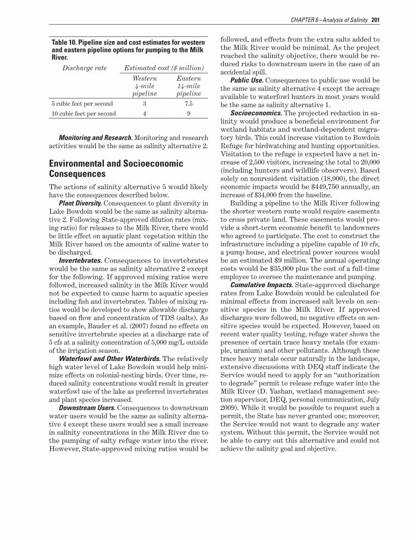
201CHAPTER 6 –Analysis of Salinity
Table 10. Pipeline size and cost estimates for western and eastern pipeline options for pumping to the Milk River.
Discharge rate Estimated cost ($ million)
Western Eastern 4-mile 14-mile
pipeline pipeline5 cubic feet per second 3 7.5
10 cubic feet per second 4 9
Monitoring and Research. Monitoring and research activities would be the same as salinity alternative 2.
Environmental and Socioeconomic ConsequencesThe actions of salinity alternative 5 would likely have the consequences described below.
Plant Diversity. Consequences to plant diversity in Lake Bowdoin would be the same as salinity alterna-tive 2. Following State-approved dilution rates (mix-ing ratio) for releases to the Milk River, there would be little effect on aquatic plant vegetation within the Milk River based on the amounts of saline water to be discharged.
Invertebrates. Consequences to invertebrates would be the same as salinity alternative 2 except for the following. If approved mixing ratios were followed, increased salinity in the Milk River would not be expected to cause harm to aquatic species including fish and invertebrates. Tables of mixing ra-tios would be developed to show allowable discharge based on flow and concentration of TDS (salts). As an example, Bauder et al. (2007) found no effects on sensitive invertebrate species at a discharge rate of 5 cfs at a salinity concentration of 5,000 mg/L outside of the irrigation season.
Waterfowl and Other Waterbirds. The relatively high water level of Lake Bowdoin would help mini-mize effects on colonial-nesting birds. Over time, re-duced salinity concentrations would result in greater waterfowl use of the lake as preferred invertebrates and plant species increased.
Downstream Users. Consequences to downstream water users would be the same as salinity alterna-tive 4 except these users would see a small increase in salinity concentrations in the Milk River due to the pumping of salty refuge water into the river. However, State-approved mixing ratios would be
followed, and effects from the extra salts added to the Milk River would be minimal. As the project reached the salinity objective, there would be re-duced risks to downstream users in the case of an accidental spill.
Public Use. Consequences to public use would be the same as salinity alternative 4 except the acreage available to waterfowl hunters in most years would be the same as salinity alternative 1.
Socioeconomics. The projected reduction in sa-linity would produce a beneficial environment for wetland habitats and wetland-dependent migra-tory birds. This could increase visitation to Bowdoin Refuge for birdwatching and hunting opportunities. Visitation to the refuge is expected have a net in-crease of 2,500 visitors, increasing the total to 20,000 (including hunters and wildlife observers). Based solely on nonresident visitation (18,000), the direct economic impacts would be $449,750 annually, an increase of $34,000 from the baseline.
Building a pipeline to the Milk River following the shorter western route would require easements to cross private land. These easements would pro-vide a short-term economic benefit to landowners who agreed to participate. The cost to construct the infrastructure including a pipeline capable of 10 cfs, a pump house, and electrical power sources would be an estimated $9 million. The annual operating costs would be $35,000 plus the cost of a full-time employee to oversee the maintenance and pumping.
Cumulative Impacts. State-approved discharge rates from Lake Bowdoin would be calculated for minimal effects from increased salt levels on sen-sitive species in the Milk River. If approved discharges were followed, no negative effects on sen-sitive species would be expected. However, based on recent water quality testing, refuge water shows the presence of certain trace heavy metals (for exam-ple, uranium) and other pollutants. Although these trace heavy metals occur naturally in the landscape, extensive discussions with DEQ staff indicate the Service would need to apply for an “authorization to degrade” permit to release refuge water into the Milk River (D. Yashan, wetland management sec-tion supervisor, DEQ, personal communication, July 2009). While it would be possible to request such a permit, the State has never granted one; moreover, the Service would not want to degrade any water system. Without this permit, the Service would not be able to carry out this alternative and could not achieve the salinity goal and objective.
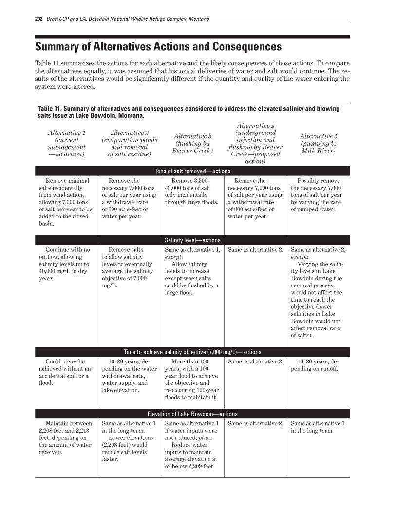
202 Draft CCP and EA, Bowdoin National Wildlife Refuge Complex, Montana
Summary of Alternatives Actions and ConsequencesTable 11 summarizes the actions for each alternative and the likely consequences of those actions. To compare the alternatives equally, it was assumed that historical deliveries of water and salt would continue. The re-sults of the alternatives would be significantly different if the quantity and quality of the water entering the system were altered.
Table 11. Summary of alternatives and consequences considered to address the elevated salinity and blowing salts issue at Lake Bowdoin, Montana.
Alternative 4Alternative 1 Alternative 2 (underground Alternative 3 Alternative 5(current (evaporation ponds injection and (flushing by (pumping to management and removal flushing by Beaver Beaver Creek) Milk River)—no action) of salt residue) Creek—proposed
action)Tons of salt removed—actions
Remove minimal Remove the Remove 3,300– Remove the Possibly remove salts incidentally necessary 7,000 tons 43,000 tons of salt necessary 7,000 tons the necessary 7,000 from wind action, of salt per year using only incidentally of salt per year using tons of salt per year allowing 7,000 tons a withdrawal rate through large floods. a withdrawal rate by varying the rate of salt per year to be of 800 acre-feet of of 800 acre-feet of of pumped water.added to the closed water per year. water per year.basin.
Salinity level—actionsContinue with no Remove salts Same as alternative 1, Same as alternative 2. Same as alternative 2,
outflow, allowing to allow salinity except: except:salinity levels up to levels to eventually Allow salinity Varying the salin-40,000 mg/L in dry average the salinity levels to increase ity levels in Lake years. objective of 7,000 except when salts Bowdoin during the
mg/L. could be flushed by a removal process large flood. would not affect the
time to reach the objective (lower salinities in Lake Bowdoin would not affect removal rate of salts).
Time to achieve salinity objective (7,000 mg/L)—actionsCould never be 10–20 years, de- More than 100 Same as alternative 2. 10–20 years, de-
achieved without an pending on the water years, with a 100- pending on runoff.accidental spill or a withdrawal rate, year flood to achieve flood. water supply, and the objective and
lake elevation. reoccurring 100-year floods to maintain it.
Elevation of Lake Bowdoin—actionsMaintain between Same as alternative 1 Same as alternative 1 Same as alternative 2. Same as alternative 1
2,208 feet and 2,213 in the long term. if water inputs were in the long term. feet, depending on Lower elevations not reduced, plus:the amount of water (2,208 feet) would Reduce water received. reduce salt levels inputs to maintain
faster. average elevation at or below 2,209 feet.

203CHAPTER 6 –Analysis of Salinity
Table 11. Summary of alternatives and consequences considered to address the elevated salinity and blowing salts issue at Lake Bowdoin, Montana.
Alternative 1(current
management—no action)
Alternative 2(evaporation ponds
and removal of salt residue)
Alternative 3(flushing by
Beaver Creek)
Alternative 4(underground injection and
flushing by Beaver Creek—proposed
action)
Alternative 5(pumping to Milk River)
Amount of water removed—actionsWithdraw no
water.Withdraw an aver-
age of 800 acre-feet of water each winter.
Same as alternative 1. Withdraw an aver-age of 800 acre-feet of water each winter.
Withdraw an aver-age of 900 acre-feet of water each winter.
Modifications and facilities—actionsMaintain all
water-level manage-ment structures.
Keep stoplogs in place year-round.
Construct at least 160 acres in evapora-tion ponds.
Install a pump house and 5 miles of pipeline.
Construct a build-ing to dry and store salts.
Install a railroad spur for transporting salts to an accepted disposal site.
Acquire heavy equipment to load salts for transport.
Remove all water-level management structures including dikes, roads, and water control struc-tures.
Expand the railroad truss to allow water flows into the west arm of Lake Bowdoin via a conveyance channel constructed from Drumbo Pond.
Drill a well as deep as 6,000 feet into a formation that is not a source of drinking water.
Install an under-ground injection well and intake structures.
Install a power source to operate the pump and construct a pump house.
Evaluate the need for removal or modification of water-level manage-ment structures to allow flood flushing by Beaver Creek.
Install a power source to operate the pump and construct a pump station and intake structure.
If the western option were selected, construct 4 miles of pipeline, requiring numerous easements on private lands.
If the eastern option were selected, construct 14 miles of pipeline across public land.
Capital cost—actionsContinue to pay
for delivery of water from the Milk River Project, averaging $21,500 per year for 3,500 acre-feet of water.
Same as alternative 1, plus:
$44 million to construct the evapo-ration pond.
$2 million annual operating costs.
Same as alternative 1 (options 1–3).
Significant costs to remove water-level management struc-tures (options 4–6).
Same as alternative 1, except:
Additional costs to modify or remove water-level manage-ment structures.
$6.7 million to build the injection well. Up to an ad-ditional $6.2 million if a holding pond is required.
$35,000 annual operating costs.
Same as alternative 1, plus:
$3–9 million depending on the pipeline length and easement costs.
$35,000 annual operating costs.

204 Draft CCP and EA, Bowdoin National Wildlife Refuge Complex, Montana
Table 11. Summary of alternatives and consequences considered to address the elevated salinity and blowing salts issue at Lake Bowdoin, Montana.
Alternative 1(current
management—no action)
Alternative 2(evaporation ponds
and removal of salt residue)
Alternative 3(flushing by
Beaver Creek)
Alternative 4(underground injection and
flushing by Beaver Creek—proposed
action)
Alternative 5(pumping to Milk River)
Monitoring and research—actionsContinue to
monitor water qual-ity, lake elevation, disease outbreaks, and sites for colonial-nesting birds.
Same as alternative 1, plus:
Drill additional monitoring wells within the Black Coulee drainage to monitor water qual-ity and quantity com-ing into the refuge.
Collect baseline information on current species of wetland vegetation, waterbirds, and invertebrates, before construction ac-tivities and monitor changes.
Same as alternative 2. Same as alternative 2. Same as alternative 2.
Plant diversity—environmental consequencesWith only salt-
tolerant species remaining, plant diversity would decrease as salinity increased.
Plant diversity would increase with the addition of brack-ish species.
Emergent wetland plants would expand into areas that were previously open water.
The evaporation ponds and canals would remain mostly devoid of vegetation.
Same as alternative 2, excluding the evapo-ration ponds and canals.
Same as alternative 3. Same as alternative 3.
Invertebrates—environmental consequencesInvertebrate
diversity would decrease as salinity increased.
Invertebrate diversity would decrease, especially on the eastern side of the lake. The salt-tolerant water boatman and other insects could become more abundant.
Brine shrimp could become estab-lished in evaporation ponds and convey-ance channels and be available for water-fowl and shorebirds.
Same as alternative 1 until flooding, which could result in a short-term (several-year) increase in invertebrates.
Same as alternative 2, excluding the evapo-ration ponds, plus:
There would be minimal losses of invertebrates due to pumping activities.
Same as alternative 2, excluding the evapo-ration ponds, plus:
Increased salinity in Milk River would not harm inverte-brates.

205CHAPTER 6 –Analysis of Salinity
Table 11. Summary of alternatives and consequences considered to address the elevated salinity and blowing salts issue at Lake Bowdoin, Montana.
Alternative 1(current
management—no action)
Alternative 2(evaporation ponds
and removal of salt residue)
Alternative 3(flushing by
Beaver Creek)
Alternative 4(underground injection and
flushing by Beaver Creek—proposed
action)
Alternative 5(pumping to Milk River)
Waterfowl and Other Waterbirds—environmental consequencesAs salinity in-
creased, use by wa-terfowl broods would decrease, broods could have impeded development, or brood mortality could occur.
As salinity in-creased, the risk of botulism outbreaks might decrease.
Waterfowl use would increase due to more plant diver-sity and invertebrate diversity. Annual production and survival of waterfowl broods would im-prove.
More shallow areas and mudflats would be exposed for use by dabbling ducks and shore-birds. Reaching the salinity objective might not increase the risk of a botulism outbreak.
The evaporation ponds would attract waterfowl, which could become en-crusted in salt.
Same as alternative 1, except:
During a flood, sudden changes in salinity and water levels might increase the chance of a botu-lism outbreak.
Same as alternative 2, excluding the evapo-ration ponds.
Same as alternative 4.
Downstream users—environmental consequencesThere would con-
tinue to be the possi-bility of an accidental spill of highly saline water if a structure failed.
If the lake level drops, there would be an increased salt concentration that might be carried by wind.
Water quality would continue to worsen.
As the lake level decreased, water quality would improve over time. Initially there would be some blowing salts (most deposited on the refuge) until the salinity level was reduced.
Same as alternative 2, except:
Water quality would improve dur-ing flooding.
Same as alternative 2. Water quality would continue to worsen if pumping water to the Milk River were not per-mitted (“Authoriza-tion to Degrade”) by the State because of heavy metals.
If pumping water were permitted, the heavy metals would impact the Milk River.

206 Draft CCP and EA, Bowdoin National Wildlife Refuge Complex, Montana
Table 11. Summary of alternatives and consequences considered to address the elevated salinity and blowing salts issue at Lake Bowdoin, Montana.
Alternative 1(current
management—no action)
Alternative 2(evaporation ponds
and removal of salt residue)
Alternative 3(flushing by
Beaver Creek)
Alternative 4(underground injection and
flushing by Beaver Creek—proposed
action)
Alternative 5(pumping to Milk River)
Public use—environmental consequencesWaterfowl hunters
would continue to have access to hunt-ing areas in most years, depending on available water.
Visitors would be able to easily view waterbirds from the auto tour route.
The exposed mud-flats and improved habitat would attract shorebirds and waterfowl, providing additional viewing opportunities. Some birds might move further from the shoreline as water receded. Hunters would need to carry their watercraft further to access the lake.
The west boat launch would not be accessible to boats with motors.
There would be fewer huntable acres for waterfowl hunt-ers.
Same as alternative 2. Same as alternative 2. Same as alternative 2 if the Service received a permit to pump water to the Milk River; otherwise, same as alternative 1.
Socioeconomics—environmental consequencesDeclining wet-
lands and waterbird use would result in an annual reduction of 4,850 wildlife observers and hunt-ers, causing a loss of $105,050 in visitor spending.
Design and con-struction work might provide an economic boost to local com-munities.
Improved wet-lands would attract more wildlife for viewing and hunt-ing for an annual increase of 2,000 visitors, generating an additional $32,850 in visitor spending.
Removing some of the water-level management struc-tures might result in some short-term economic benefits to the local community. Improved wetlands would attract more wildlife for viewing but lower water levels would reduce hunting access. More viewer expenditures, but a loss of hunter expenditures, would result in an overall increase of only $2,250 in visitor spending.
Same as alternative 2, except:
The construction of evaporation ponds may not be neces-sary, eliminating that economic cost and benefit.
Visitation would increase by 2,300 visitors, generating an additional $24,150 in visitor spending.
The quality of pumped water might cause impacts to downstream users.
Where easements were required, there would an economic benefit to landown-ers willing to accept an easement across their lands.
Improved wet-lands would attract more wildlife for viewing and hunt-ing for an annual increase of 2,500 visitors, generating an additional $34,000 in visitor spending.

207CHAPTER 6 –Analysis of Salinity
Table 11. Summary of alternatives and consequences considered to address the elevated salinity and blowing salts issue at Lake Bowdoin, Montana.
Alternative 1(current
management—no action)
Alternative 2(evaporation ponds
and removal of salt residue)
Alternative 3(flushing by
Beaver Creek)
Alternative 4(underground injection and
flushing by Beaver Creek—proposed
action)
Alternative 5(pumping to Milk River)
Cumulative impactsAs plant and in-
vertebrate diversity decreased, wildlife use might decrease along with associated public use.
The cost to deal with increasing salt loads would be greater over time.
There might be increased probability of a more severe accidental spill.
As salinity levels decreased, plant diversity and wildlife use would increase along with associated public use.
As lake levels were lowered, islands used by colonial-nesting birds would become peninsulas, which may cause the birds to abandon them.
Disturbance to waterbirds would increase due to the salt removal process.
The ability to manage the lake at higher levels would be lost, resulting in fewer acres of wet-land habitat.
Salinity levels would continue to increase until a 100-year or greater flood.
Same as alternative 2, except:
There would be minimal disturbance to wildlife while the injection well was constructed.
Same as alternative 4, plus:
There would be monitoring of heavy metals and other pollutants before any water were pumped into the Milk River.
Due to the pres-ence of heavy metals and other pollutants, the State might not approve a permit for the Service to pump water, which would preclude meeting the salinity objective.
6.6 Implementation of the Proposed Action (Salinity Alternative 4)
The salinity and blowing salts issue at Lake Bow-doin is a result of a complex series of factors that have changed the fundamental flow of water into and out of the lake for more than a century. Montana water quality laws protect receiving waters from point and nonpoint sources of pollution. In this case, salts and trace heavy metals are the concern at Lake Bowdoin. As a result, the lake, which once was a flow-through system, must be managed today as a closed basin.
Random droughts and historical floods can and have functioned to remove salts from the lake sys-tem. However, relying on these periodic events is not a viable long-term solution. The Service’s proposed action to address the salinity situation (salinity alternative 4) has the short-term solution of injecting the salts and heavy metals deeply and safely into the ground. However, in the long term, the Service’s goal is to acquire enough water to insti-tute a flow-through system.
Salinity Alternative 4– Underground Injection Well and Flushing by Beaver CreekThe Service is proposing salinity alternative 4 as the most effective and safest way to address salinity and blowing salts at Bowdoin National Wildlife Refuge. After the public’s review and comment on this draft plan, the Regional Director will determine if this or another alternative is the preferred alternative for the final CCP.
Salinity alternative 4 would use a deep well to inject saline water into the ground. If this process could remove enough salt, the long-term goal for the refuge would be to operate the infrastructure to facilitate a flow-through lake system. The injection well would provide an effective method to remove salts from Lake Bowdoin, thereby reversing the upward trend of salt accumulation and, over time, reaching the salinity objective of 7,000 mg/L. To maximize the removal of salts, the Service would manage the lake at a lower level for certain peri-ods. Once salinity concentrations were consistently at or below the objective level, the Service would evaluate lowering or removing the stoplogs at the
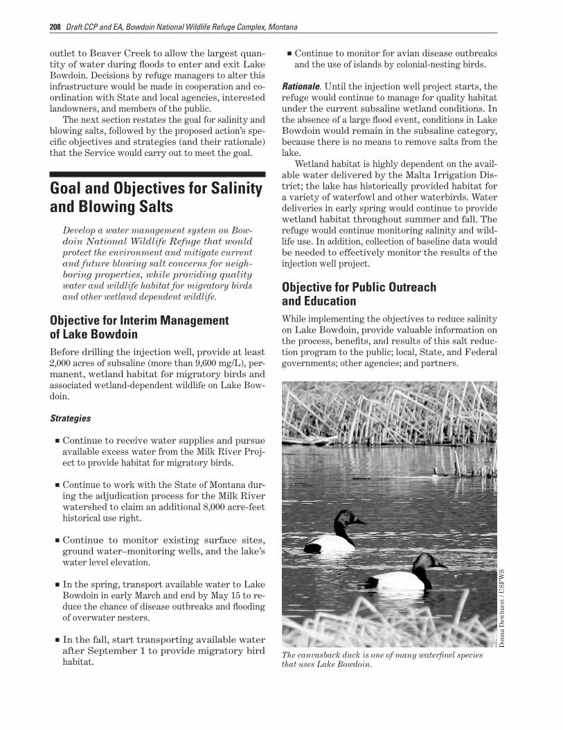
208 Draft CCP and EA, Bowdoin National Wildlife Refuge Complex, Montana
outlet to Beaver Creek to allow the largest quan-tity of water during floods to enter and exit Lake Bowdoin. Decisions by refuge managers to alter this infrastructure would be made in cooperation and co-ordination with State and local agencies, interested landowners, and members of the public.
The next section restates the goal for salinity and blowing salts, followed by the proposed action’s spe-cific objectives and strategies (and their rationale) that the Service would carry out to meet the goal.
Goal and Objectives for Salinity and Blowing Salts
Develop a water management system on Bow-doin National Wildlife Refuge that would protect the environment and mitigate current and future blowing salt concerns for neigh-boring properties, while providing quality water and wildlife habitat for migratory birds and other wetland dependent wildlife.
Objective for Interim Management of Lake BowdoinBefore drilling the injection well, provide at least 2,000 acres of subsaline (more than 9,600 mg/L), per-manent, wetland habitat for migratory birds and associated wetland-dependent wildlife on Lake Bow-doin.
Strategies
■■ Continue to receive water supplies and pursue available excess water from the Milk River Proj-ect to provide habitat for migratory birds.
■■ Continue to work with the State of Montana dur-ing the adjudication process for the Milk River watershed to claim an additional 8,000 acre-feet historical use right.
■■ Continue to monitor existing surface sites, ground water–monitoring wells, and the lake’s water level elevation.
■■ In the spring, transport available water to Lake Bowdoin in early March and end by May 15 to re-duce the chance of disease outbreaks and flooding of overwater nesters.
■■ In the fall, start transporting available water after September 1 to provide migratory bird habitat.
■■ Continue to monitor for avian disease outbreaks and the use of islands by colonial-nesting birds.
Rationale. Until the injection well project starts, the refuge would continue to manage for quality habitat under the current subsaline wetland conditions. In the absence of a large flood event, conditions in Lake Bowdoin would remain in the subsaline category, because there is no means to remove salts from the lake.
Wetland habitat is highly dependent on the avail-able water delivered by the Malta Irrigation Dis-trict; the lake has historically provided habitat for a variety of waterfowl and other waterbirds. Water deliveries in early spring would continue to provide wetland habitat throughout summer and fall. The refuge would continue monitoring salinity and wild-life use. In addition, collection of baseline data would be needed to effectively monitor the results of the injection well project.
Objective for Public Outreach and EducationWhile implementing the objectives to reduce salinity on Lake Bowdoin, provide valuable information on the process, benefits, and results of this salt reduc-tion program to the public; local, State, and Federal governments; other agencies; and partners.
The canvasback duck is one of many waterfowl species that uses Lake Bowdoin.
Don
na D
ewhu
rst
/ US
FW
S

209CHAPTER 6 –Analysis of Salinity
Strategies
■■ Inform people about the salinity situation and op-tions with news releases to the media.
■■ Provide salinity information and monitoring re-sults to the public in several ways including: pre-sentations to community groups, distribution of brochures, and up-to-date Web pages.
■■ Conduct tours of the saline treatment site (injec-tion well).
Rationale. It is likely that the injection well would not be operational for at least 5 years. During this time, the Service would continue to provide informa-tion on the progress for getting money and starting construction. This would be accomplished through news articles and presentations provided at Bow-doin Refuge and to community groups. When the Service started implementing the proposed action, the refuge staff would develop a fact sheet and other outreach methods to describe the installation and operation plan for the injection well, including where the injection well would be drilled. Once the project was fully implemented, the Service would provide updates on how the project was proceeding and meeting the objectives.
Table 12. Partner agencies and expertise for the injection well project at Lake Bowdoin, Montana.Agency Expertise and coordination
Montana Department of Environmental Quality
Montana Department of Natural Resources and Conservation
U.S. Environmental Protection Agency
Bureau of Reclamation
U.S. Geological Survey
Milk River Basin Joint Board of Control (irrigation districts)
Oil and gas companies
Nongovernmental organizations
ContaminantsWater quality standardsRegulatory standards
Hydrology and technical assistanceWater quality monitoringWater rights
Well permitWell operationWell monitoring
Water deliveryNegotiations with irrigation districts
Wetland ecologySalinity and hydrological monitoringGeologic formations
Water quantityWater delivery
Injection well drillingGeologic formations
GrantsOther funding sources
Objective for Salinity ConcentrationWithin 15 years after construction of the injection well, reduce salt concentrations in Lake Bowdoin to an average TDS (salts) of 7,000 mg/L at a lake elevation of 2209.0 feet while accepting all salt and water inputs, to provide the water quality needed to improve the diversity and quantity of wetland plants and invertebrates that can support healthy popula-tions of waterbirds and other wetland-dependent species.
Strategies
■■ Develop a stepdown plan and required envi-ronmental analysis for the design, placement, installation, operation, and maintenance of the injection well in coordination with DEQ, DNRC, EPA, Reclamation, U.S. Geological Survey, ir-rigation districts, and other partners (table 12).
■■ Acquire project funding: (1) minimum of $6.7 million to design and construct the project; and (2) $100,000 to operate and maintain the system annually.
■■ Coordinate with local oil and gas companies and other consultants to determine the most cost-

210 Draft CCP and EA, Bowdoin National Wildlife Refuge Complex, Montana
effective methods to drill and operate the injec-tion well.
■■ Collect baseline information on plant and wildlife diversity and water quality as a basis for moni-toring the effects of reducing salinity concentra-tions and the effectiveness of the method.
■■ Within 5 years, install the infrastructure neces-sary to achieve the objective including an injec-tion well, intake pipes, power source, and pump house.
■■ Allow the water level of Lake Bowdoin to natu-rally recede to achieve maximum concentrations of salts for efficient injection. Limit fall water deliveries to maximize winter salt concentration levels.
■■ Until the salinity objective is achieved, operate the pump year-round to remove the maximum amount of salts annually. Use the pump to main-tain the salinity objective as needed.
■■ Using additional maintenance staff and contrac-tors, maintain or replace the pump and associated infrastructure as needed.
■■ Once the salinity objective is reached, determine the feasibility of modifying the wetland manage-ment structures to help maintain the objective’s conditions by allowing Beaver Creek flooding to flush Lake Bowdoin. If additional water supply is granted, use this water to create a flow-through system.
Rationale. Salinity concentrations in Lake Bowdoin have steadily increased since 2000 due to drought conditions and a management decision not to place saline water into Dry Lake during the winter. Lev-els currently exceed 10,500 mg/L with higher aver-age levels on the east side of the lake. Currently, there is no acceptable way to remove salts from the lake, thus this upward trend would continue in the future until a major flood or accidental spill occurred that would lower the salt load, at least temporarily.
Salinity concentrations are a function of water volume and salt loads. Nearly 7,000 tons of salt are added to the lake every year through various input sources (Kendy 1999; Stan Jones, personal commu-nication, 2009). Extended droughts, which tend to occur on decadal patterns (that is, they reoccur ev-ery decade or once every few decades) in this area (Gleason et al. 2009), result in lower lake levels and elevated salt concentrations. It is estimated that, under relatively normal precipitation and an average
water level of 2,210 feet in Lake Bowdoin, salinity would surpass 15,000 mg/L in the near future.
The salinity objective of 7,000 mg/L with normal water input is an aggressive target. This level was selected for the following reasons:
■❏ It is well within the tolerances of several key invertebrate and plant communities including sago pondweed (Gleason et al. 2009).
■❏ It is below levels considered harmful to water-fowl and other wetland-dependent birds.
■❏ It provides managers with flexibility in operat-ing the lake at higher water levels and reduced salinities.
Plant and invertebrate diversity is significantly lower in wetlands with high salinity concentrations (Euliss et al. 1999, Gleason et al. 2009, Swanson et al. 1984). Plant communities in highly saline wetlands favor a few species (Gleason et al. 2009). While salt-tolerant plants provide habitat for a suite of birds, a larger diversity of plant communities is more ca-pable of providing for the needs of many species of wetland-dependent wildlife. Most invertebrates do not have the capacity to survive in water with salinity concentrations exceeding about 9,000 mg/L (Gleason et al. 2009). The importance of inverte-brates is substantial for a variety of bird groups; invertebrates are critical for shorebirds (Helmers 1992, Skagen and Oman 1996), ducks (Krapu and Swanson 1975, Swanson et al. 1984), swans, cranes, grebes, and many others. Differences in how and where birds feed, as well as differing bill lengths and body size, allow birds to use invertebrates in dif-ferent locations within a wetland, thereby reducing competition for resources. A lack of invertebrate di-versity could result in food resources available for a narrower range of migratory birds that use the lake.
From 1990 to 2003, the refuge produced an aver-age of 3,600 ducklings per year. Undoubtedly, many of these broods spent part of their development on Lake Bowdoin. Waterfowl broods, especially those less than 4 days old, are most at risk by elevated salinity concentrations. At salinity concentrations as low as 3,000 mg/L, reduced growth rates throughout development can occur (Mitcham and Wobeser 1988). If no fresh water is available, lethargy in ducklings can occur at 9,000 mg/L, 10-percent mortality at 12,000 mg/L, and near 100-percent mortality at lev-els higher than 18,000 mg/L (Moorman et al. 1991, Swanson et al. 1984). The influx of water into Lake Bowdoin—via the Black Coulee drainage and the Dodson South Canal—provides a source of fresher water for ducklings, thereby minimizing the threat of direct mortality.
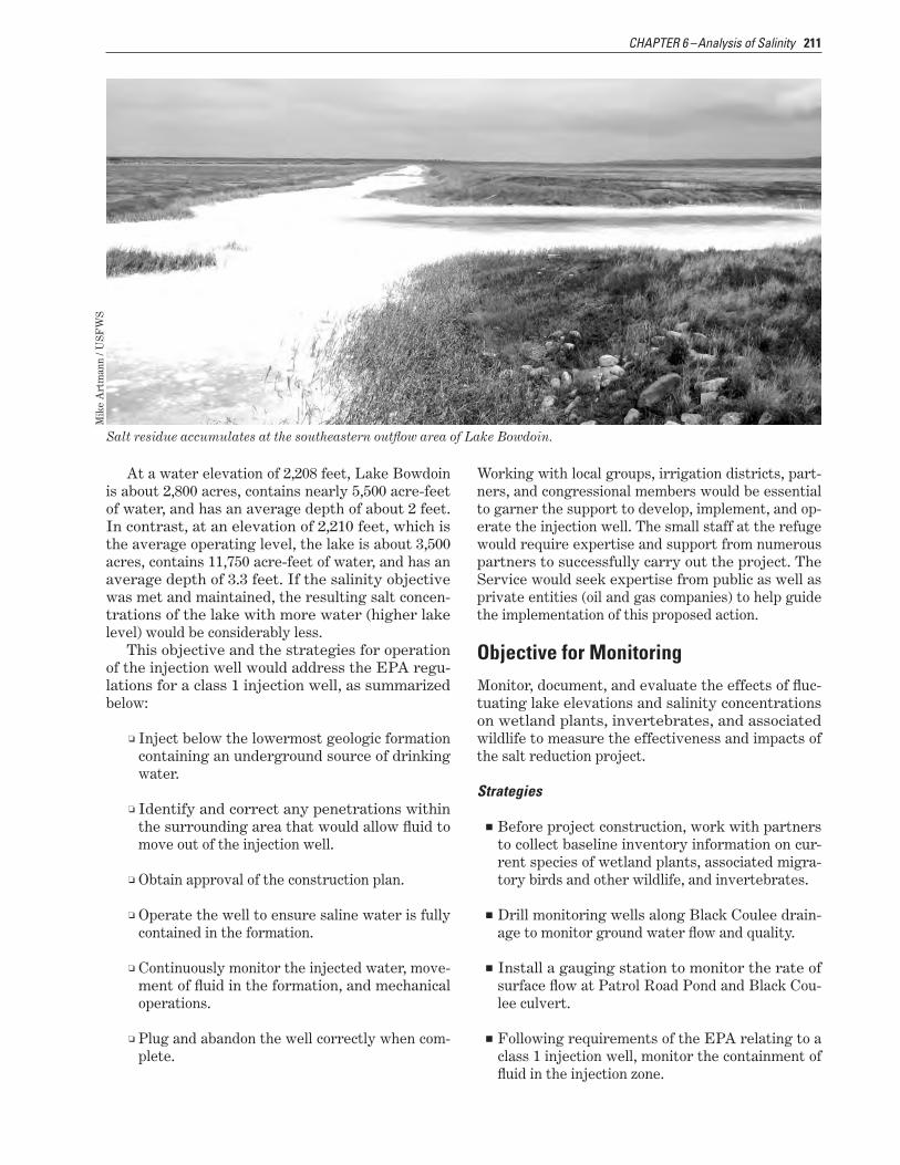
211CHAPTER 6 –Analysis of Salinity
At a water elevation of 2,208 feet, Lake Bowdoin is about 2,800 acres, contains nearly 5,500 acre-feet of water, and has an average depth of about 2 feet. In contrast, at an elevation of 2,210 feet, which is the average operating level, the lake is about 3,500 acres, contains 11,750 acre-feet of water, and has an average depth of 3.3 feet. If the salinity objective was met and maintained, the resulting salt concen-trations of the lake with more water (higher lake level) would be considerably less.
This objective and the strategies for operation of the injection well would address the EPA regu-lations for a class 1 injection well, as summarized below:
■❏ Inject below the lowermost geologic formation containing an underground source of drinking water.
■❏ Identify and correct any penetrations within the surrounding area that would allow fluid to move out of the injection well.
■❏ Obtain approval of the construction plan.
■❏ Operate the well to ensure saline water is fully contained in the formation.
■❏ Continuously monitor the injected water, move-ment of fluid in the formation, and mechanical operations.
■❏ Plug and abandon the well correctly when com-plete.
Working with local groups, irrigation districts, part-ners, and congressional members would be essential to garner the support to develop, implement, and op-erate the injection well. The small staff at the refuge would require expertise and support from numerous partners to successfully carry out the project. The Service would seek expertise from public as well as private entities (oil and gas companies) to help guide the implementation of this proposed action.
Salt residue accumulates at the southeastern outflow area of Lake Bowdoin.
Mik
e A
rtm
ann
/ US
FW
S
Objective for MonitoringMonitor, document, and evaluate the effects of fluc-tuating lake elevations and salinity concentrations on wetland plants, invertebrates, and associated wildlife to measure the effectiveness and impacts of the salt reduction project.
Strategies
■■ Before project construction, work with partners to collect baseline inventory information on cur-rent species of wetland plants, associated migra-tory birds and other wildlife, and invertebrates.
■■ Drill monitoring wells along Black Coulee drain-age to monitor ground water flow and quality.
■■ Install a gauging station to monitor the rate of surface flow at Patrol Road Pond and Black Cou-lee culvert.
■■ Following requirements of the EPA relating to a class 1 injection well, monitor the containment of fluid in the injection zone.
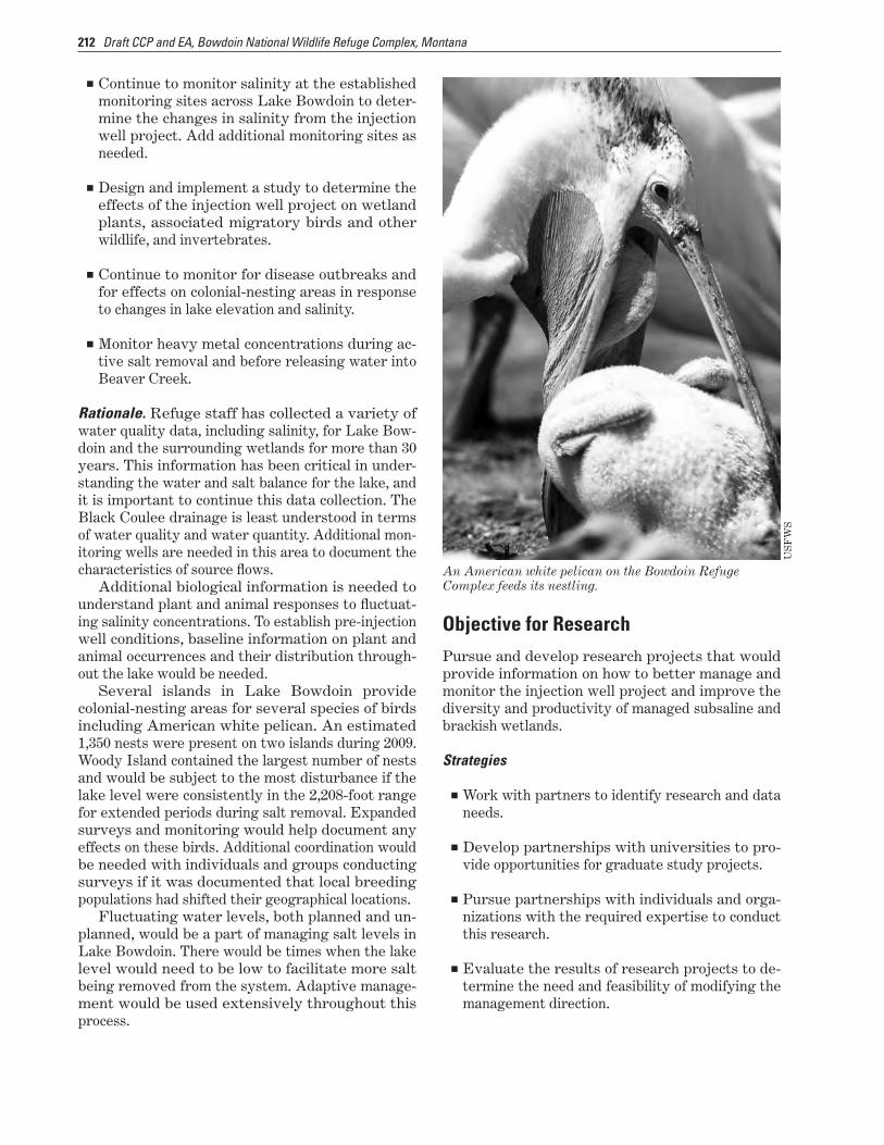
212 Draft CCP and EA, Bowdoin National Wildlife Refuge Complex, Montana
■■ Continue to monitor salinity at the established monitoring sites across Lake Bowdoin to deter-mine the changes in salinity from the injection well project. Add additional monitoring sites as needed.
■■ Design and implement a study to determine the effects of the injection well project on wetland plants, associated migratory birds and other wildlife, and invertebrates.
■■ Continue to monitor for disease outbreaks and for effects on colonial-nesting areas in response to changes in lake elevation and salinity.
■■ Monitor heavy metal concentrations during ac-tive salt removal and before releasing water into Beaver Creek.
Rationale. Refuge staff has collected a variety of water quality data, including salinity, for Lake Bow-doin and the surrounding wetlands for more than 30 years. This information has been critical in under-standing the water and salt balance for the lake, and it is important to continue this data collection. The Black Coulee drainage is least understood in terms of water quality and water quantity. Additional mon-itoring wells are needed in this area to document the characteristics of source flows.
Additional biological information is needed to understand plant and animal responses to fluctuat-ing salinity concentrations. To establish pre-injection well conditions, baseline information on plant and animal occurrences and their distribution through-out the lake would be needed.
Several islands in Lake Bowdoin provide colonial-nesting areas for several species of birds including American white pelican. An estimated 1,350 nests were present on two islands during 2009. Woody Island contained the largest number of nests and would be subject to the most disturbance if the lake level were consistently in the 2,208-foot range for extended periods during salt removal. Expanded surveys and monitoring would help document any effects on these birds. Additional coordination would be needed with individuals and groups conducting surveys if it was documented that local breeding populations had shifted their geographical locations.
Fluctuating water levels, both planned and un-planned, would be a part of managing salt levels in Lake Bowdoin. There would be times when the lake level would need to be low to facilitate more salt being removed from the system. Adaptive manage-ment would be used extensively throughout this process.
Objective for ResearchPursue and develop research projects that would provide information on how to better manage and monitor the injection well project and improve the diversity and productivity of managed subsaline and brackish wetlands.
Strategies
■■ Work with partners to identify research and data needs.
■■ Develop partnerships with universities to pro-vide opportunities for graduate study projects.
■■ Pursue partnerships with individuals and orga-nizations with the required expertise to conduct this research.
■■ Evaluate the results of research projects to de-termine the need and feasibility of modifying the management direction.
An American white pelican on the Bowdoin Refuge Complex feeds its nestling.
US
FW
S

213CHAPTER 6 –Analysis of Salinity
Rationale. Implementing this project would provide opportunities for researchers to study the effects of not only drilling and operating the injection well but also the subsequent changes to habitat and wetland-associated wildlife.
The Service would develop partnerships with universities to provide potential projects for gradu-ate students and would work with other agencies that have the expertise and interest in evaluating the effectiveness of the injection well. Studying the
area before and after installing the injection well could provide valuable information for addressing salinity on other public lands and on private lands.
The results of these analyses would assist the refuge in determining how successful the project was in achieving the salinity objective and expected habitat improvement. These results would also help to determine if modifications were needed in the stepdown plan for installation and operation.
