chapter 6 uhi in the metropolitan cluster of bologna
TRANSCRIPT

131© The Author(s) 2016 F. Musco (ed.), Counteracting Urban Heat Island Effects in a Global Climate Change Scenario, DOI 10.1007/978-3-319-10425-6_6
Chapter 6UHI in the Metropolitan Cluster of Bologna- Modena: Mitigation and Adaptation Strategies
Stefano Zauli Sajani, Stefano Marchesi, Paolo Lauriola, Rodica Tomozeiu, Lucio Botarelli, Giovanni Bonafè, Graziella Guaragno, Federica Fiumi, Michele Zanelli, Lodovico Gherardi, Marcello Capucci, Catia Rizzo, and Filippo Bonazzi
Abstract The pilot action took place in a district of Modena, the Villaggio Artigiano, characterized by the presence of disused small industrial buildings, which is part of a wider redevelopment context and regeneration process.
The innovative mixture of instruments proposed by the Municipality to better re-use the territory and to estimate the environmental restoration achieved with the urban inter-ventions, is a starting point to give the planner flexible and easy to use instruments.
Keywords Cluster Bologna-Modena • Villaggio Artigiano • Urban redevelopment • Urban planning • Urban indexes
S. Zauli Sajani (*) • S. Marchesi • P. Lauriola • R. Tomozeiu • L. Botarelli • G. Bonafè ARPA Emilia-Romagna, Bologna, Italye-mail: [email protected]
G. Guaragno • F. Fiumi Territorial Planning and Mountain Development Service, Emilia Romagna Region, Italy
M. ZanelliUrban Quality and Residencial Policy Department, Emilia Romagna Region, Italy
L. GherardiTerritorial Cooperation Contact Point, Emilia Romagna Region, Italy
M. Capucci Urban Planning Department, Modena, Italy
C. Rizzo Urban Design and Transformation office, Modena, Italy
F. Bonazzi Territorial Planning and Private Building office, Modena, Italy

132
6.1 Implementing Solutions for Climate Change in Urban Context
The effect of climate change on urban scale is often seen as a simple projection of a global risk. In fact, the urban environment is certainly characterized by particularly critical in relation to the effects of extreme events alluvial and heat waves, which is closely connected to the “climate change”. In reality, however, the local and the global influence each other mutually shaping opportunities and constraints. In this sense, an integrated approach to mitigation and adaptation is the only way to reduce the impact of climate change and to turn a threat into an opportunity for sustainable territorial development, economic and social too.
Measures to reduce heat island effect in this regard are a prime example of an action that fits both the perspective of adaptation to climate change and their mitiga-tion. Reduce hardship bioclimatic in urban involves not only the ability to innovate in terms of use of materials and construction techniques but also to change economic and social structures, ensuring over time the quality of life and the environment.
In this chapter we want to draw a picture of the relevance of the heat island phe-nomenon in relation to climate change and illustrate the potential of the interven-tions of urban planning. The urban heat island is certainly one of the best known effects of urbanization on local climate.
6.2 The Metropolitan Cluster Of Bologna-Modena
6.2.1 Urban and Environmental Framework
Emilia-Romagna Region’s territory, in the Padan area, includes the metropolitan area of Bologna and other main conurbations located in the Emilian area and in the coastal area. The first main urban conurbation develops from Bologna along via Emilia (Emilia Street), including the cities of Modena, Reggio Emilia up to Parma, and is characterized by high density settlements with high-intensity exchanges; the second one, distributed along the coastline, concerns the intensely built-up touristic area from Rimini to Cervia.
Emilia-Romagna’s location makes it part of two National corridors which respec-tively connects the Apennine Mountains to the Adriatic Sea and North and South Italy, including: A1 and A14 highways, Piacenza-Rimini railway and a stretch of the high speed railway Milan-Bologna-Rome. Consequently, with a road network of 10.792 Km (which consists of 643 Km of highways and connection roads, 2907 Km of state roads and 7242 Km of provincial roads), the region has a key role for trans-port integration within National and European contexts (Fig. 6.1).
In the past forty years, a high intensity construction activity has affected the region and this has led to the spreading of settlements and of production and service sector activities. The main cities have lost inhabitants to the hinterland and conse-quently a sort of “city-area” characterized by a high and widespread urbanization index (153 inhabitant/kmq) has grown along via Emilia.
S. Zauli Sajani et al.

133
Fig. 6.1 Hierarchy of urban centres – Road and rail network
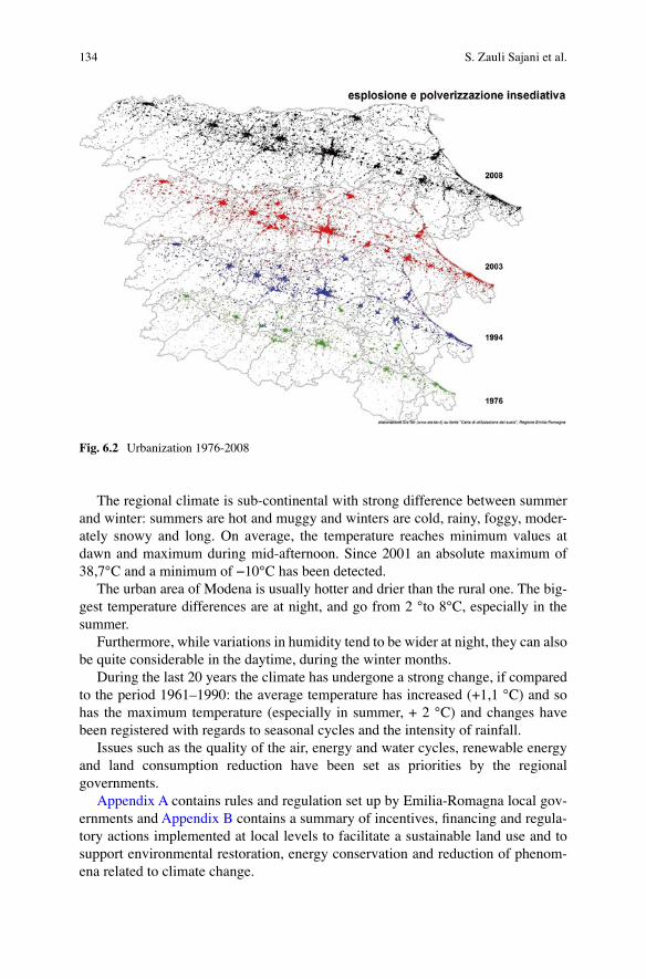
In addition to that, during the past twenty years Bologna’s metropolitan area has doubled, and the conurbations of central Emilia and along the coastline (where the 50 % of the regional population lives). have been affected by an increase in urban-ization and land consumption up to 8–13 % of the total surface (Fig. 6.2).
The pilot area is located in the core of this regional system described above. It is among the more developed areas at the regional and European level as far as its socio-economic development is concerned. The three provinces of Bologna, Modena and Reggio Emilia host 56 % of the regional industries. The local economy is based on the manufacturing sector, especially ceramic, which contributes to make Modena’s province a key productive centre within Europe.
The presence of firms, together with service providers and houses, has a negative impact on road conditions and on the quality of live in the cities and it is the cause of polluting emissions reaching emergency levels for increasingly longer periods. The use of renewable energies in this area is also still low.
In the metropolitan cluster of Bologna-Modena, despite the presence of some of the bigger rivers in the region, the high density settlements (which characterize the area) have reduced the space for natural environment. Furthermore, the develop-ment of man-made infrastructures has a negative impact on landscape and creates more obstacles to policies aimed at (1) integrating the metropolitan areas of Bologna and Modena; (2) decongesting the central areas (along via Emilia) and (3) mitigat-ing the environmental alterations linked to critical traffic conditions (air and noise pollution), which have negative consequences, especially on the health of children and the elderly; (4) improving the connection infrastructures and public transport.
6 UHI in the Metropolitan Cluster of Bologna-Modena...
134
The regional climate is sub-continental with strong difference between summer and winter: summers are hot and muggy and winters are cold, rainy, foggy, moder-ately snowy and long. On average, the temperature reaches minimum values at dawn and maximum during mid-afternoon. Since 2001 an absolute maximum of 38,7°C and a minimum of −10°C has been detected.
The urban area of Modena is usually hotter and drier than the rural one. The big-gest temperature differences are at night, and go from 2 °to 8°C, especially in the summer.
Furthermore, while variations in humidity tend to be wider at night, they can also be quite considerable in the daytime, during the winter months.
During the last 20 years the climate has undergone a strong change, if compared to the period 1961–1990: the average temperature has increased (+1,1 °C) and so has the maximum temperature (especially in summer, + 2 °C) and changes have been registered with regards to seasonal cycles and the intensity of rainfall.
Issues such as the quality of the air, energy and water cycles, renewable energy and land consumption reduction have been set as priorities by the regional governments.
Appendix A contains rules and regulation set up by Emilia-Romagna local gov-ernments and Appendix B contains a summary of incentives, financing and regula-tory actions implemented at local levels to facilitate a sustainable land use and to support environmental restoration, energy conservation and reduction of phenom-ena related to climate change.
Fig. 6.2 Urbanization 1976-2008
S. Zauli Sajani et al.

135
6.2.2 Pilot Area Identification Methodology and Description
Emilia-Romagna Region has decided to select the pilot area of the “Villaggio Artigiano” (Craftsman Village) in Modena as the Administration was preparing the Municipal Operational Plan (POC prescribed by the regional planning law) called “Urban Redevelopment of the West Face of Modena”, and expressed an interest in experimenting and integrating practical solutions aimed at containing the UHI phe-nomenon into urban planning (Fig. 6.3).
In this framework, the Municipality of Modena has concluded the approval of a specific Plan of Urban Redevelopment of the Villaggio Artigiano (http://www.comune.modena.it/laboratoriocitta/laboratoriocitta/i-progetti-del-laboratorio/poc-mow).
Given the new environmental context in which the Village is included, the plan entails interventions aimed at fostering high-performance at the overall urban as well as environmental systems.
The pilot action lies in the urban area of Modena, in the western sector of the city; this is an area which might have been considered “almost suburban” until recently, but is now a rather central location of the city. Today, the Villaggio
Fig. 6.3 POC
6 UHI in the Metropolitan Cluster of Bologna-Modena...
136
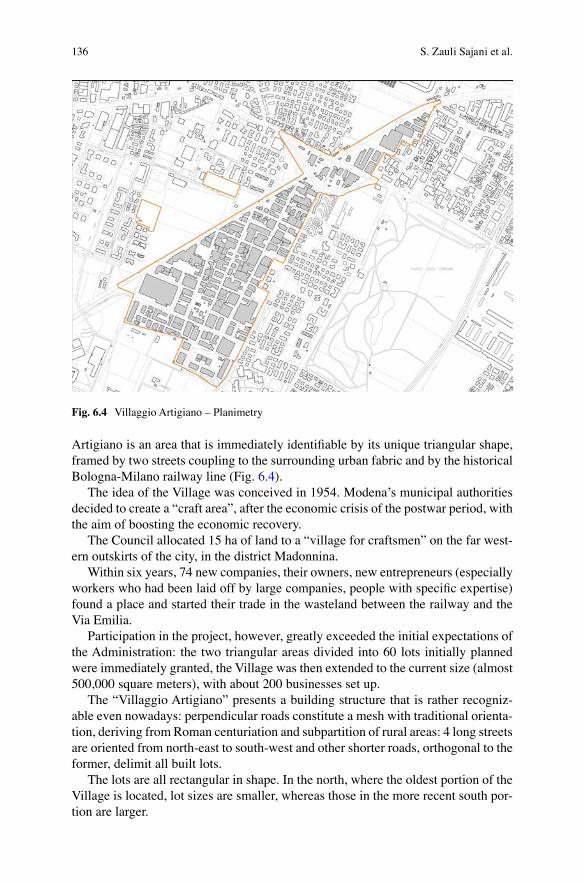
Artigiano is an area that is immediately identifiable by its unique triangular shape, framed by two streets coupling to the surrounding urban fabric and by the historical Bologna-Milano railway line (Fig. 6.4).
The idea of the Village was conceived in 1954. Modena’s municipal authorities decided to create a “craft area”, after the economic crisis of the postwar period, with the aim of boosting the economic recovery.
The Council allocated 15 ha of land to a “village for craftsmen” on the far west-ern outskirts of the city, in the district Madonnina.
Within six years, 74 new companies, their owners, new entrepreneurs (especially workers who had been laid off by large companies, people with specific expertise) found a place and started their trade in the wasteland between the railway and the Via Emilia.
Participation in the project, however, greatly exceeded the initial expectations of the Administration: the two triangular areas divided into 60 lots initially planned were immediately granted, the Village was then extended to the current size (almost 500,000 square meters), with about 200 businesses set up.
The “Villaggio Artigiano” presents a building structure that is rather recogniz-able even nowadays: perpendicular roads constitute a mesh with traditional orienta-tion, deriving from Roman centuriation and subpartition of rural areas: 4 long streets are oriented from north-east to south-west and other shorter roads, orthogonal to the former, delimit all built lots.
The lots are all rectangular in shape. In the north, where the oldest portion of the Village is located, lot sizes are smaller, whereas those in the more recent south por-tion are larger.
Fig. 6.4 Villaggio Artigiano – Planimetry
S. Zauli Sajani et al.

137
The elements that make the Villaggio Artigiano a privileged project area today derive mainly from two sets of issues: one of an urban, economic and social nature, related to the ongoing problems of the area, and the other linked to the context of the Villaggio Artigiano and its strong, untapped potential.
In a nutshell, the themes considered in the redevelopment plan are:
– Identity value of the Villaggio Artigiano: it is a “piece” of the city history and an example of that “model Modena” that mainly contributed to the economic and social development of the city. For this reason, it is important, from the perspec-tive of identity and business, to promote the renewal of the Village without com-promising on its productive nature, and to boost the vitality of the area that seems to derive from the building typology and flexibility, which combines “home & shop” with very particular architectural languages.
– Economic and entrepreneurial value: seen in retrospect, and with a modern per-spective, Villaggio Artigiano was a major help in what today is called the start-up of new businesses. To this one should add, the opportunity for artisans to have their houses built in the vicinity of their workshop, thus reducing significantly their personal and family costs of residence and transport. This particularly applies to the early settlements
– Urban planning value: with regards to urban design and urban planning, the Village, located next to the Old Town, but also well connected to the extra-urban transport axes, is a center of gravity as far as the redevelopment of the whole western sector of the city is concerned. This feature will be greatly enhanced by new road connections and new forms of public transport. In fact, the Village is highly affected by the planned diversion of the railway line bounding the area, which will leave a large “diagonal” line of interconnection to the city center for new public spaces and transport services.
These features make the Village an ideal testing ground from the point of view of urban sustainability through the recovery of the existing fabric, ground-saving ori-ented, and the increase in the functional mix.
One of the main goals of this redevelopment plan is to renew the buildings in the Village, by means of a deep restructuring of the existing edifices, respecting the size and volume relations among them and producing a new estate body, which carries on and updates the typical evolution process of the Villaggio Artigiano (Fig. 6.5).
Therefore, the proposed regulatory actions are aimed at promoting the transfor-mation of the Village, increasing the functional mix among production, which remains prevalent, services and residence, the latter to be rethought in new and experimental ways (home studio, new types of home-workshop, residential com-plexes with shared facilities etc.). In addition to these possible changes, on the pub-lic side, the main object of the redevelopment Plan is to redesign public spaces for meeting and socializing: rethinking and reorganizing the street mobility, creating parking areas and green spaces (using, for example, the large diagonal line on which the Village is grafted), signposting the presence of trade and services as an opportu-nity to generate significant spaces for urban quality of the neighborhood.
6 UHI in the Metropolitan Cluster of Bologna-Modena...

138
To date, the administration has launched a series of initiatives aimed at urban regeneration (buildings and public areas), as well as at economic and social improve-ment, summarized as follows:
– new urban-building rules; – coordinated project for public space: the Village has its only public spaces in the
streets, which have a very small section, are anonymous and not suitable for a non-automotive mobility. Through simulations and sectorial studies various options were examined for the transformation of the road network aimed to inter-connect pedestrian, bicycle and automobile paths and to facilitate public acces-sibility and therefore the settlement of business and services.
– to exploit the dis-used railroad area, to be reinvented as “gateways” to the Village, as a large walk urban connecting two parts of the city historically divided; the Village has indeed a well-defined urban morphology, which makes it easy to identify, but it’s also “closed” to the rest of the city (Fig. 6.6).
Taking the modified environmental conditions of the area into consideration, the redevelopment plan aims to promote measures envisaging high-level performances, in order to ensure the environmental, as well as urban, upgrade of the area.
To counteract the alarming impact of UHI phenomenon the municipality of Modena began to consider the main environmental problems, to identify effective methods of construction.
Fig. 6.5 Villaggio Artigiano – Urban morphology
S. Zauli Sajani et al.

139
The Plan aims to identify a synthesis of the main environmental issues related to the area of intervention, in order to derive a calculation method that can show the environmental performance achieved in the redevelopment of the individual lots.
The main environmental issues focalized in the Village are:
– reduction of the Urban Heat Island – reduction of energy consumption – reduction of the hydraulic risk
The “Artisan Village Guidelines” summarize the main features of the environ-mental method prepared by the administration. It is worth stressing that there are various analyses still under way for the final validation of various technical and procedural issues; as a consequence, although the structural characteristics have already been defined, the approach implemented may still be modified or emended.
In any case, the following items were thoroughly considered:
– Appropriate Building Massing: – Energy Efficiency – Passive strategies including: highly insulated; massing well arranged for summer
radiation and also winter – optimized utilization of daylight,
Fig. 6.6 Villaggio Artigiano – Planimetric view
6 UHI in the Metropolitan Cluster of Bologna-Modena...

140
Also using:
– Buffer zones (such as winter gardens) to harvest passive solar energy and allow natural ventilation under cold/windy conditions
– External solar shading
6.2.3 UHI Phenomenon in the Urban Area of Modena and Application of Models to Simulate Mitigation Measures
Analyses on the UHI phenomenon in the urban area of Modena have been per-formed with a focus on the summer season. We compared data from stations located within the urban area and from stations located in the rural area. The findings showed that minimum temperatures in the urban area were higher than in the rural one. The differences between urban and rural minimum temperatures were gener-ally larger during spring and summer, when they reached values up to 6 °C. The highest intensities of urban heat island effect were found around midnight. On the other hand, the correlation between maximum values of temperature was the oppo-site: rural temperatures tend to be about 1 °C higher than the urban ones. Relevant positive trends were present in the 30-year time-series of temperature. Long term trend of Heating Degree Days (HDD) and Cooling Degree Days (CDD) were also analysed (Figs. 6.7 and 6.8). These parameters show to what extent the temporal
HDD 1980-2010
HDD- urban
HDD- rural
2900
2700
2500
2300
2100
1900
1700
1500
1980
1981
1982
1983
1984
1985
1986
1987
1988
1989
1990
1991
1992
1993
1994
1995
1996
1997
Year
1998
1999
2000
2001
2002
2003
2004
2005
2006
2007
2008
2009
2010
Fig. 6.7 Long term trend of Heating Degree Days (HDD) for the urban and the rural area
S. Zauli Sajani et al.

141
trend of temperatures is either below (HDD) a predefined bioclimatic thresholds or above (CDD). A markedly decreasing trend was present in HDD time-series, while an opposite, less marked trend, appears for CDD.
Two main simulation tools have been applied to the pilot area in order to estimate the effect of some mitigation measures from a quantitative point of view. These simulations were aimed at assessing the effects of types of mitigation actions, and not the effects of specific interventions.
The first model applied in the pilot area was RayMan, a simulation model able to calculate short- and long-wave radiation fluxes inside a complex urban environ-ment. Output from RayMan model consists in the values of several thermal indices derived from human heat-balance model. RayMan calculates the mean radiant temperature using a simplified radiation balance applied to a person which is exposed to:
– direct solar radiation; – long wave radiation from ground, building walls and vegetation – reflected radiation from the same surfaces.
In the present study, RayMan model was applied on a car parking area inside the Villaggio Artigiano. Firstly, the model was run for the actual situation in the domain (reference run) in a typical summer day in August. Then, some changes were intro-duced in the model domain (scenario runs) and the net effects of the mitigation measures on the thermal field and on the bio-meteorological conditions were esti-mated. A number of tests were carried out considering various combination of vegetation, type of materials for pavements and facades, height of buildings. From
CDD 1980-2010
Year
CDD - urban
CDD - rural
1200
1000
800
600
400
200
0
1980
1981
1982
1983
1984
1985
1986
1987
1988
1989
1990
1991
1992
1993
1994
1995
1996
1997
1998
1999
2000
2001
2002
2003
2004
2005
2006
2007
2008
2009
2010
Fig. 6.8 Long term trend of Cooling Degree Days (CDD) for the urban and the rural area
6 UHI in the Metropolitan Cluster of Bologna-Modena...

142
the point of view of thermal comfort, it was quite clear that most effective discom-fort reductions were obtained introducing trees in the domain.
The shade from trees produced the largest impact and the mitigation effect was estimated in around 2 °C in the peak hours. A further point worth of notice is that, the pervious surface obtained by replacing the asphalt and/or concrete pavement with grass had a positive impact on the thermal comfort in its turn; however, the absolute value of this effect was much lower than in the scenario where trees were introduced, and the temperature reductions were below 0.5°. Modification of build-ing heights showed rather small differences in the values of bio-climatic indices.
The second model used to simulate the impact of different scenarios was ENVI- met, a three dimensional, non-hydrostatic model of the atmosphere, based on the fundamental laws of fluid-dynamics and thermodynamics. ENVI-met is a much more complex model than Rayman and is able to simulate the tri-dimensional field of the usual meteorological variables taking into account the interaction between atmosphere, urban surfaces and vegetation characterizing the complex urban fabric.
The model domain was a square of 400 m × 400 m, about a half of the whole Villaggio Artigiano (Fig. 6.9). The horizontal resolution was 5 × 5 m (81 × 81 grid points). Vertical resolution was set to 3 m, with the exception of the first model lay-ers, which were split into 4 additional layers with the aim of showing a better repre-sentation of the interaction between the atmosphere and the surface elements. The simulation were run for the typical summer conditions for the city of Modena. Various mitigation measures were considered: insertion of green elements (grass and trees), change of the albedo of walls, roofs and pavements, insertion of pervious
Fig. 6.9 Example of 2-m height field of temperature as simulated by ENVI-met model
S. Zauli Sajani et al.

143
surfaces in substitution of asphalt and pavements. The findings showed a well- defined ranking in the impact of mitigation measures (Fig. 6.10).
“Green courtyard with trees” was the most effective mitigation measure. A reduction of temperatures was evident for the entire course of the day. The “green roofs” scenario showed a peak of the cooling effect with respect to the control run at a height of around 10 m, with a slightly smaller impact at ground level. On the contrary, “cool roofs” and “pervious courtyard” scenarios showed a peak of cooling at ground level with a relevant decrease of the impact going upwards. On the other hand, scenario with “cool walls” showed a negative effect in terms of mitigation of urban heat island. The cooling effect induced in this scenario was possibly explained by the unsatisfactory consideration of heat balance in model equation for buildings.
6.2.4 Experimental Environmental Quality Index to Assess the UHI’s Mitigation Actions in a Building Lot
As described in the previews paragraphs, in the Villaggio Artigiano pilot area the following main environmental issues are taken into consideration:
– reduction of the Urban Heat Island – reduction of energy consumption – reduction of the hydraulic risk (not strictly connected to UHI phenomenon)
Fig. 6.10 Vertical profiles of “all day” mean differences between each scenarios, labeled as indi-cated in the legend, and the control run
6 UHI in the Metropolitan Cluster of Bologna-Modena...

144
Starting from the experiences carried out by other cities, the Municipality of Modena decided to create a new calculation methodology, to be tested in the rede-velopment of the Village.
Several municipalities are already equipped with calculation methodologies, in order to highlight the environmental performance achieved by the redevelopment of urban lots.
These calculation methodologies, also known as “urban indexes”, are mainly focused on the urban impact created by the analysed phenomena, and are usually characterized by a simple algorithm.
The main existing urban indexes are the BAF, “Biotope Area Factor”, used in Berlin, Malmo and Seattle, and the RIE, “Reduction of the Building’s Impact”, used in Bolzano and Bologna.
Both indexes calculate the ecological value of an urban lot.Unfortunately, these indexes have limitations which make their application to
“Villaggio Artigiano” impossible.The Biotope Area Factor considers only the “green” surfaces and is therefore not
suitable to assess the positive effect of a “cold roof”.The index of Reduction of the Building’s Impact considers only the horizontal
surfaces and is therefore not suitable to assess the positive effect of a “green” wall.The main goal of Modena Municipality was to create a calculation methodology
capable to:
– analyse all the surfaces that make up the urban lot, like the courtyard areas, build-ing walls and roof,
– analyse different types of surfaces, like green or cool surfaces, – stand up to existing indexes in terms of simplicity of data input, – make appropriate approximations, like urban indexes typically do, – highlight the environmental performance on the basis of indicators that predict
physical tangible phenomena, – implement procedures and values already defined by laws or municipal
regulations.
The three main environmental issues (reduction of the Urban Heat Island, reduc-tion of energy consumption, reduction of the hydraulic risk) have been linked to two indicators that have been used to derive two indices, the index “RATE” of “reduc-tion in the absorption of thermal energy” and the index “HYPER” of “reduction of hydraulic risk”.
The creation of the index “RATE” followed four stages:
1. a list of types of surfaces that include the typical materials of the existing context and the materials used today in new projects.
Altogether 20 types of surfaces has been identified: 7 for the courtyard areas, 6 for the walls and 7 for the roofs. Some of these describe existing interventions, typical of the existing context, while others describe innovative interventions of recent use. The interventions that can be implemented in the courtyard areas are: garden or flower bed, tree or shrub, self-locking pavement, lawn driveway, “cold” asphalt, normal asphalt, gravel pavement.
S. Zauli Sajani et al.

145
The interventions that can be implemented in the walls of the building are: green wall with frame on wall, green wall integrated into the wall, ventilated wall with frame on wall, light plaster, dark plaster, wall with exposed brick.
The interventions that can be implemented on the roof of the building are: green roof, “cold” roof, tiled “cold” roof, photovoltaic roof, tiled roof, light flat roof, dark flat roof.
2. identifying a physical quantity, as an indicator, and a calculation methodology.The indicator chosen to estimate the index “rate” is the thermal energy absorp-
tion of each surface of the lot, due to the incident solar radiation.The absorption of thermal energy of a surface represents the amount of energy
that that area is not able to reflect and disperse instantaneously, and therefore represents the amount of thermal energy that will be released for a certain period of time. The absorption of thermal energy is therefore able to highlight the capac-ity of a material to affect the Urban Heat Island.
In order to calculate the absorption of thermal energy a formula is used, which correlates the technical and physical characteristics of a surface with the incident solar radiation.
The technical and physical features used for the calculation of a generic sur-face, are: solar reflectance, emissivity and thermal resistance.
The index “RATE” calculates the sum of the absorption of thermal energy of all surfaces that constitute the urban lot.
3. analysing the technical and physical features of every surface in the list and of the existing context, to estimate the indicator. For each of the 20 types of inter-ventions, the respective values of solar reflectance, emissivity and thermal resis-tance have been estimated. As for walls and roof, different values of thermal resistance have been calculated, depending on the year of construction.
To quantify the incident solar radiation, the values defined by the norm UNI 10349 are used. Municipality of Modena has obtained a value to be applied on the roof and different values to be applied to the walls, depending on their orien-tation. Regarding courtyard areas, an average value was estimated, taking into account the loss of energy caused by the shading by building volume.
4. adopting the typical/needed approximations of urban indexes.
The Artisan Village Guidelines “Feasibility study of environmental quality indexes to be applied to building lots”, made by Municipality of Modena, are attached in Appendix C and the link to the calculation software can be found on the website of the Municipality of Modena:
http://www.comune.modena.it/laboratoriocitta/laboratoriocitta/pubblicazioni- eventi/villaggio-artigiano-di-modena-ovest/esiti-del-progetto
and on the website of the Emilia-Romagna Region:
http://territorio.regione.emilia-romagna.it/programmazione-territoriale
6 UHI in the Metropolitan Cluster of Bologna-Modena...

146
6.2.5 Adaptation Strategy to Heat Risk: Assessment of a Possible Development of the Heat Risk Alert System Based on the Use of Emergency Ambulance Data
Increased temperatures and extreme heat can lead to a rise in mortality. In EU coun-tries, mortality is estimated to increase by 1–4 % for each one-degree rise in tem-perature, meaning that heat related mortality could rise by 30 000 deaths per year by the 2030s and 50 000–110 000 deaths per year by the 2080s.
As regard to the National level the Ministry of Health, in cooperation with the Ministry of Civil Protection, an “Early warning national system to prevent heat waves” has been operating since 2004, after the terrible summer of 2003. Furthermore, in 2005 a “National Operational Plan to prevent effects on human health from heat waves” was issued, and in 2006 “Guidelines to prepare monitoring plans in order to respond to heat waves” were provided to assist local authorities:
http://www.salute.gov.it/emergenzaCaldo/paginaInternaMenuEmergenzaCaldo.jsp?id=413&menu=strumentieservizi
In coordination with national plan in Emilia-Romagna, a risk prevention local plan was designed and implemented to reduce the risk of damage and casualties due to summer heat waves.
Every year the plan guidelines are updated by the Emilia-Romagna Regional Government while ARPA (Regional Agency for Environmental Protection) issues forecasts throughout the summer.
The adaptation action then consists of:
– Alert system managed by ARPA, alerting when temperature and humidity level raise above a risky threshold
– Emilia-Romagna Regional Government coordination actions to assist most exposed people groups.
6.2.5.1 Alert System
ARPA Emilia-Romagna has been endeavouring to provide forecasting systems of some environmental risk factors to local authorities for several years now. Among such factors, the prediction of heat waves has gained relevance, particularly in rela-tion to climate change projections for the coming decades.
The heat waves forecast service has been operating since 2004. ARPA Emilia- Romagna manages a specific website platform: http://www.arpa.emr.it/index.asp?idlivello=97
The forecast service is active between 15 May and 15 September. The forecast is done with 72 h forewarning.
S. Zauli Sajani et al.

147
The Risk Alert alarm is based on the Thom’s Discomfort Index (DI). DI is a measure of the reaction of the human body to a combination of heat and humidity (Fig. 6.11).
This index combines the values of humidity and temperature parameters to describe the conditions of physiological discomfort due to heat and humidity. The threshold of bioclimatic discomfort used for the Alert system were identified through a study of mortality conducted in the urban area of Bologna for the years 1989-2003.
– Weak discomfortWeak discomfort conditions are defined when DI average daily value is 24.
Under such conditions, the population feels discomfort but there are no increases in mortality.
– DiscomfortDiscomfort conditions are defined when DI average daily value is 25. Under
these conditions the weaker sections of the population, and especially the elderly, may experience health effects of various kinds, including headaches, dehydra-tion. Such symptoms may cause fatalities in some extreme cases. The total mor-tality, natural causes and cardiovascular diseases increase on average by about 15 %, and mortality from respiratory causes up to 50 %.
– Strong discomfortStrong discomfort conditions are defined when DI daily average value is 26
(the average daily index values never surpass this mark) or when an index level more or equal to 25 persists for 3 or more days. Under these conditions the cat-egories of persons suffering from heat-related illnesses increase. The total mor-tality, natural causes and cardiovascular ailments, rise by an average of about 30 %. The mortality from respiratory causes raises of about 80 %.
Every day the system automatically alerts all concerned institutions (Healthcare District Services, Civil Protection…) via an email. The email states ALERT or NO
Fig. 6.11 Thom’s discomfort index table
6 UHI in the Metropolitan Cluster of Bologna-Modena...

148
ALERT in the object field, depending on if the DI is higher or equal to 24, or if it is lower than 24. Then the email itself specifies the Discomfort Level forecasted.
The following graphics show as an example the trend registered in 2012 and the one registered in the very hot summer in 2003 (Figs. 6.12 and 6.13).
27262524232221201918171615141315-mag 30-mag
Debole desagio Desagio Forte desagio 2012 Andamento medio
14-giu
Indl
ce d
l Tho
m m
edlo
glo
rnal
lero
29-giu 14-lug 29-lug 13-ago 28-ago 12-set
Fig. 6.12 DI trend registered in 2012
27262524232221201918171615141315-mag 30-mag
Debole desagio Desagio Forte desagio 2003 Andamento medio
14-giu
Indl
ce d
l Tho
m m
edlo
glo
rnal
lero
29-giu 14-lug 29-lug 13-ago 28-ago 12-set
Fig. 6.13 DI trend registered in 2003
S. Zauli Sajani et al.

149
6.2.5.2 Emilia-Romagna Regional Government Coordination Actions
Emilia-Romagna Regional Government coordinates actions to assist people groups who are most exposed to heat waves, through Health Care regional system, Civil Protection, non-profit sector. These actions are activated by the ARPA alert system and they include two main activities:
1. Home care assistance:
– Set up and coordination of Local Networks of all the actors involved in home care assistance, i.e.: Local Health Authorities (AUSL), City Councils, Voluntary associations;
– Map High Risk Groups to be monitored during Heat Waves Alert, i.e.:elder people [>75 Y/old] living alone at home (in particular Local Health Authorities are obliged to notify all cases of elder people discharged from hospital in summer period and living alone), disabled people;
– To strengthen home care assistance services, using all possible collaborations with Civil Protection volunteers and non-profit associations active in welfare.
2. Information actions
It has been shown that information on potential threats can be extremely useful in preparing the public for adverse events, as well as facilitating the response when such events occur. Starting form this assumption, a strong effort has been dedicated to produce an effective communication to citizens regarding heat waves effect on health and practical suggestions to prevent heatstroke.
In particular specific information contents have been prepared on:
– Heat effect on Health: direct effect (sunstroke, heatstroke, heat exhaustion, heat cramps), indirect effect (i.e. health condition worsening of people weakened by physical or psychological diseases), risk groups (elderly people, children, people affected by specific diseases – diabetes, cardiovascular disease…);
– Practical suggestions to prevent Heatstroke: telling how to limit the discomfort (what to eat/drink and what not, most dangerous day time, how to dress, how to manage home air conditioning…); telling what to do in emergency case (symp-toms, 1st aid, who to call…). All this information are spread out both through the specific web platform on Heatwave managed by ARPA ER (http://www.arpa.emr.it) and through specific awareness campaigns managed by Local Health Authorities, addressing the specific high risk groups. (i.e. leaflets have been created by local health governments and addressed to home care staff, informing them on what to do in case of heat waves, what to eat, how to dress, relation with medicines, how to behave at home and outside, early warning signs of a heat stroke).
6 UHI in the Metropolitan Cluster of Bologna-Modena...
150
6.2.5.3 Proposed Pilot Action: Preliminary Assessment of a Possible Development of the Heat Risk Alert System Based on the Use of Emergency Ambulance Data
The suggested pilot action aims at verifying a possible improvement of the Heat Risk Alert System currently operational in the Emilia-Romagna region. The devel-opment would be based on the use of emergency ambulance data.
Today the discomfort index threshold levels have been identified via epidemio-logical analysis based on historical mortality data. A study developed by Arpa on all most important cities of the Emilia-Romagna region, except Rimini, evaluated the exposure–response curve of ambulance dispatches in relation to biometeorological conditions using time series techniques showing a strong correlation between ambu-lance dispatches increase and apparent temperature. The effects of high tempera-tures on health were evaluated for respiratory and cardiovascular diseases as well as for all non-traumatic conditions.
For apparent temperatures lower than 25 °C, ambulance dispatches were not affected by changes in biometeorological conditions. Above that threshold, an increase of ambulance dispatches associated with respiratory diseases has been found, while cardiovascular diseases remained unaffected by variations in apparent temperature. For apparent temperatures higher than 30 °C, the percent increases associated with each unit increment of apparent temperature became very high, with the main effect seen with cardiovascular diseases.
The findings of the study demonstrated the usefulness of ambulance dispatch data due to their strong link with heat and their real-time availability. As a matter of fact, these data are collected and stored with the same software and the same proto-cols across the region Emilia–Romagna, and are the only health data available in real-time.
Based on these reasons ARPA tried to test the possibility of the use of these data for a development of the heat risk alert system. The main goal of the analysis was to verify how strong was the relationship between bioclimatic discomfort conditions and increased ambulance dispatches across the Region on a daily basis.
ARPA defined as “alert day” a day when apparent temperature averaged among the main towns of the region is above 25 °C. The expected number of ambulance dispatches for each summer day was calculated averaging the daily ambulance dis-patches in a 15-day period centered in the selected day over the years 2003-2006 (excluding all the alert days from the computation); a standard deviation was also computed as a variability indicator. Days with a number of ambulance dispatches exceeding the expected number for that day plus twice the standard deviation were considered as days with an elevated number of dispatches (“case day”).
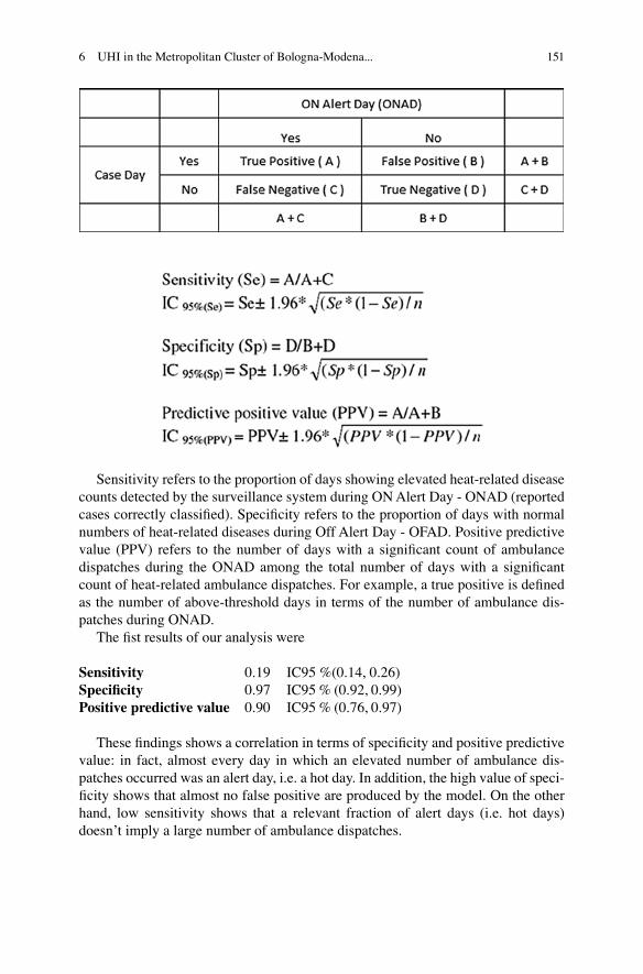
The strength of the correlation between case and alert days was tested using sensitivity, specificity and positive predictive value defined as follows.
S. Zauli Sajani et al.
151
Sensitivity refers to the proportion of days showing elevated heat-related disease counts detected by the surveillance system during ON Alert Day - ONAD (reported cases correctly classified). Specificity refers to the proportion of days with normal numbers of heat-related diseases during Off Alert Day - OFAD. Positive predictive value (PPV) refers to the number of days with a significant count of ambulance dispatches during the ONAD among the total number of days with a significant count of heat-related ambulance dispatches. For example, a true positive is defined as the number of above-threshold days in terms of the number of ambulance dis-patches during ONAD.
The fist results of our analysis were
Sensitivity 0.19 IC95 %(0.14, 0.26)Specificity 0.97 IC95 % (0.92, 0.99)Positive predictive value 0.90 IC95 % (0.76, 0.97)
These findings shows a correlation in terms of specificity and positive predictive value: in fact, almost every day in which an elevated number of ambulance dis-patches occurred was an alert day, i.e. a hot day. In addition, the high value of speci-ficity shows that almost no false positive are produced by the model. On the other hand, low sensitivity shows that a relevant fraction of alert days (i.e. hot days) doesn’t imply a large number of ambulance dispatches.
6 UHI in the Metropolitan Cluster of Bologna-Modena...

152
We also tested the calculation of the same indicators in single towns. The aver-age value of sensitivity, specificity and positive predictive value obtained across the region were 0.13, 0.97, 0.83, respectively.
These preliminary results confirm the usefulness of a surveillance system based on ambulance data. An additional level of alert for the health prevention system would be suitable when alert days are associated with exceptionally elevated num-ber of ambulance dispatches.
The most appropriate spatial scale for the alert system (e.g. single towns, “area vasta”, whole region), a more sophisticated definition of hot days (with the inclu-sion of information on persistence), alternative definition of threshold values for apparent temperature are currently under investigation. The forthcoming availabil-ity of longer time series of ambulance dispatch data will also improve the robustness of the analysis.
The use of Ambulance dispatches to evaluate the risks associated with biometeo-rological discomfort has the following advantages respect the current use of mortal-ity data:
– A higher number of data to correlate with Discomfort Index (10X), taking into account a wider range of the effect of heat on health.
– The ability to monitor the effect on health during heat episodes (real time monitoring)
– Additional information which can be gathered with ambulance dispatches (loca-tion of the calls) could allow spatial analysis to identify geographical areas at higher risk.
– A better categorization of diseases in ambulance dispatches could enable to bet-ter define effect of heat waves in human health (cardiovascular diseases, respira-tory diseases…)
In conclusion, the encouraging results of this preliminary analysis point to the setting-up of a surveillance system, whose actual implementation should be arranged in cooperation with Health Authorities both at local and regional level.
6.2.6 Conclusions
The UHI project sought to boost transnational discussion among policy makers, local administrators and professionals in order to bring about developing policies and actions with the purpose of adapting and mitigating the natural and man-made risks arising from the UHI phenomenon. For this purpose the pilot action of “Villaggio Artigiano” was aimed at:
– providing a deeper knowledge on man-made risk of the UHI and its interactions with global climate change,
– setting up suitable strategies for the mitigation of - and adaptation to UHI, – improving current land-use planning tools and civil management systems accord-
ing to mitigation and adaptation strategies.
S. Zauli Sajani et al.
153
As explained above, the purpose of this case study was to find ways/rules that can mitigate and tackle the UHI phenomenon. Expected results are:
– mitigation of UHI phenomenon through the definition of appropriate construc-tion requirements and standards (green roofs, reflective materials etc..) in accor-dance with urban quality,
– definition of guidelines to develop a specific project.
In this regard the Villaggio Artigiano is a suitable area to tackle UHI phenome-non, because it is part of a wider redevelopment context and regeneration process, strongly supported by public institutions and citizens.
The main objective of the regeneration plan is to allow a redevelopment of the housing stock in the Village, through a deep renewal of existing buildings, including demolition and reconstruction of a new building while maintaining the shape of the previous one, thus preserving the system of dimensional and volumetric relation-ships that characterizes the Village, and achieving a new building organism that continues and updates the typical evolutionary process of the “Villaggio Artigiano”.
Given the new environmental context in which the Village is included, the plan entails interventions aimed at fostering high-performance at the overall urban but also environmental systems.
For this purpose, the Municipality of Modena has defined a set of environmental indexes focused on the assessment of 3 main affecting phenomena: the Urban Heat Island, the energy requirements and the hydraulic risk. Consequently, a new calcula-tion methodology has been defined, to be tested in the redevelopment of the Village, capable to measure the environmental effects and the achievement of the planning targets and to estimate the benefit-cost ratio in the redevelopment of urban lots.
Identifying indexes to measure the multiple environmental effects of the urban transformations is the challenge for urban planners.
6.3 Next Steps
The City of Modena is collaborating with the EELab Department of the University of Modena, to refine the scientific approach adopted in the analysis of phenomena.
Furthermore, Modena is collaborating with engineers from ARPA, the Regional Agency for Environmental Protection, within the European project UHI, in order to analyze the correlation between types of intervention described in the index “rate” and the reduction of the Urban Heat Island phenomenon
The Municipality of Modena is awaiting the conclusions from the ongoing anal-ysis, to finally validate the experimental indexes and put them into practice.
The indexes, evaluating the achievement of valuable solutions from the environ-mental point of view, could be useful to set the potential reward to be given to requalification projects. The municipality is considering to provide the use of the indexes within the redevelopment plan of the Village, so to regulate rewards, through
6 UHI in the Metropolitan Cluster of Bologna-Modena...

154
discount on the contribute for requalification, or through the introduction of “bonus” related to the architectural and urban value of the adopted interventions.
The urban indexes represent an experimental approach with huge potential, a starting point to give the planner flexible and easy to use instruments.
Appendices
Appendix A
Review of the Different Rules and Regulation Set Up by Emilia- Romagna Local Government
Resolution of the regional council n. 344 of 14th March 2011 “Directive 2008/50/CE of the European Parliament on ambient air quality and cleaner air for Europe put into effect by D. Lgs (legislative decree) n. 155 of 13th August 2010 Request for extension of the deadline for accomplishment and dispensation from respecting specific limit values for nitrogen dioxide and PM10”
Resolution of the regional Assembly n. 28 of 10th December 2010Resolution of the regional Assembly n. 1570 of 26th July 2011Resolution of the regional Assembly n. 50 of 26th July 2011Resolution of the regional Assembly n. 156 of 4th March 2008Regional Law n. 26 of 23rd December 2004 “Discipline of the territorial energy planning and other energy related provisions”Regional Energy Plan “PER” (Resolution of the regional Assembly n. 141 of 14/11/2007)Regional Territorial Plan “PTR” (Regional assembly resolution n. 276 of 3/2/2010)
Integrated Transports Regional Plan “PRIT” - 1998Environmental Action Plan – 3/12/2011
Resolution of the Regional Council n. 344 of 14th March 2011“Directive 2008/50/CE of the European Parliament on ambient air quality and cleaner air for Europe put into effect by D. Lgs (legislative decree) n. 155 of 13th August 2010 Request for extension of the deadline for accomplishment and dispen-sation from respecting specific limit values for nitrogen dioxide and PM10”.
This resolution passes the thematic cartographies regarding the areas in the municipalities where PM10 and NO2 value limits are exceeded. These cartogra-phies are the knowledge basis used by the relevant authorities as far as the manage-ment of ambient air quality is concerned in order to detect and put in place the necessary actions to meet the limit values within the shortest period.
The resolution establishes that also the activities of regional planning must con-tribute to reaching the objective of air quality. Especially, as far as the definition of measures and interventions in the sectors of transportation, energy, industry, agri-culture, construction and urban planning are concerned, Emilia-Romagna regional
S. Zauli Sajani et al.

155
authority must take into consideration the necessity of meeting the limit values for nitrogen dioxide and PM10 as established by the Community laws.
Resolution of the Regional Assembly n. 28 of 10th December 2010Resolution of the regional Assembly n. 28 of 10th December 2010 for the imple-mentation of the National Guidelines with regards to the identification of the areas available for installation of photovoltaic solar electrical plants. Regulation of the other kinds of renewable energy is intended to be addressed into a following resolution.
Resolution of the Regional Assembly n. 1570 of 26th July 2011“Identification of the areas available for installation of wind power, biogas, bio-masses and water electrical plants”.
The national and Community legislator have stressed the importance of linking the principle of supporting the development of renewable energies to the other Community principle of land sustainable protection and enhancement in order to maintain the capacity of the territories of providing ecological, economic and social services and to maintain their functions, including the agricultural sector ones.
Resolution of the Regional Assembly n. 50 of 26th July 2011“Second three-year implementation plan of the Regional Energy Plan (PER) 2011–2013”. The first implementation of PER was carried out through the three-year plan 2008–2010, which was passed together with the PER itself (Resolution of the regional Assembly n. 141/2007).
The second implementation plan includes the objectives, commitments and pro-grammes that have been agreed at the European and national level.
Energy efficiency and spare represent the first objective: Emilia-Romagna Region aims at building class A houses staring from 2014, at renewing the building stock, at reducing the emissions of motor vehicles, at spreading the cogeneration and the systems of distributed energy generation, at recovering heat from produc-tion activities and making them more efficient. The other main objective of the second implementation plan is the development of renewable energy.
Resolution of the Regional Assembly n. 156 of 4th March 2008Resolution of the regional Assembly n. 156 of 4th March 2008 which passes the “Orientation Act about the criteria of energy performance and about the procedures for the certification of energy performance of buildings”.
Emilia-Romagna Region is one of the Italian regions which have fully and con-cretely implemented the Community directives on buildings energy performance.
This resolution regulates:
(a) The minimum qualifications for energy performance of buildings and of their energy plants
(b) The methodologies for the assessment of energy performance of buildings and of their energy plants
(c) The issue of the certificate of buildings energy performance
6 UHI in the Metropolitan Cluster of Bologna-Modena...

156
(d) The accreditation system of the building energy performance operators (e) The maintenance of buildings and energy plants (f) The regional information system for monitoring the energy performance of
buildings and of their energy plants (g) The measures supporting energy efficiency and the development of energy ser-
vices for the regional population
The resolution was adopted according to: the Regional Law (L.R.) 20/00; art. 2 and 25 of the L.R. 26/04. It has implemented the provisions of directive 2002/91/CE and 2006/32/CE, also complying with the fundamental principles and the minimum performance standards set by the national legislator.
The provisions included in the resolution have come into force on 1st July 2008.
Regional Law n. 26 of 23rd December 2004 “Discipline of the Territorial Energy Planning and Other Energy Related Provisions”
This law promotes the sustainable development of the regional energy system and guarantees a matching among the energy which is produced, its rational use and the territory and environment carrying capacity.
Provinces are charged of:
(a) authorizing and implementing the energy spare and efficient energy use promo-tion plan, the promotion of renewable energies, the development of provincial energy plants and networks, also through the enhancement of existing buildings;
(b) authorizing the installation and the operation/practice of energy plants which are not covered by the State and regional scope.
Municipalities are charged of:
(a) authorizing programmes and implementing projects for energy qualification of the urban system, especially with regards to: intelligent energy use promotion, buildings energy spare, development of renewable energy plants, other actions and public services aimed at supply the demand of energy in urban areas, including district heating networks and public lighting also in the framework of urban regeneration programmes according to the current law;
(b) functions defined in art. 6 of law n. 10/1991, together with the other functions assigned by other specific laws.
Art. 5 “Tools for urban and territorial planning and adaptation of regulations on building issues” establishes that:
1. Local authorities operate through their tools of territorial and urban planning in order to guarantee the restraint of energy consumption in urban areas, promote renewable energies, promote the supply and usability of other energy related local services also in the framework of urban renovation interventions on exist-ing buildings.
S. Zauli Sajani et al.

157
2. Territorial and urban planning:
(a) set the energy local supply of public interest to be installed or renovated and the corresponding location
(b) can decide to implement transformation interventions where there are infra-structures for renewable energy production, recovery, transportation and dis-tribution or where their construction is planned
3. Municipalities, in the framework of their legislative powers on urban planning and construction activities, acknowledge the minimum qualifications for energy performance set by the regional council and can decide not to put them in place in case of the categories listed in art. 4 paragraph 3, directive 2002/91/CE.
4. Municipalities operate in order to:
(a) in case of new urbanization interventions on a surface bigger than 1.000 mq, get the assessment of technical and economical feasibility for installing renewable energy plants, cogeneration, heat pumps, centralised heating and cooling systems;
(b) in case of newly constructed buildings with centralised heating systems, requesting of putting in place systems for temperature control and heat accounting for each habitation unit;
(c) in case of newly constructed public buildings or buildings used for public scopes, respect the obligation of using renewable energies and adopt elec-tronic control systems;
(d) in case of interventions according to art. 6 of the regional law n. 31 of 25th November 2002 (General construction discipline) on existing buildings with a surface bigger than 1.000 mq, improve their energy performance with the aim of meeting the minimum qualifications described in art. 25, paragraph 1, letter a) of this law and of creating the conditions to put in place systems for heat accounting for each habitation unit.
Regional Energy Plan (PER)PER was approved by the Resolution of the regional Assembly n. 141 of 14th November 2007. The Plan complies with the general objectives of the energy policy of the Regional Law n. 26/04 and with the Community and State fundamental prin-ciples. It set the objectives, the tools and the guidelines for the actions to be carried out by Emilia-Romagna Region and the local authorities on its territory with regards to:
– energy spare – renewable energies promotion – improvement of the territorial energy performances, especially as far as the
buildings, SMEs, mobility, distributed energy systems, agriculture and forest sectors are concerned
– improvement of security, continuity and cheapness of internal delivery
6 UHI in the Metropolitan Cluster of Bologna-Modena...

158
– usability, dissemination and quality of services for the public, especially as far as disadvantage areas and users
– improvement of environmental sustainability of energy supply – reduction of greenhouse gas emissions
PER stresses the need of creating a context which can support the development of practices based on the principles of environmental and energy sustainability, aimed at the rational energy use and the use of renewable energy sources, together with the increase in the supply of high efficiency cogeneration services. This could provide the opportunity of fully using the produced thermic energy, also through the development of district heating networks for local communities. In this way the ter-ritorial planning would comply with the general objectives of energy sustainability set by LR n 26/04, art. 1, paragraph 3.
During the last years electric power plants based on renewable sources (water, wind, solar and biomasses) have grown in the regional territory. Nevertheless, they do not play a key role yet within the regional electrical balance. Among these plants, also thanks to the promotion politics that have been implemented both at national and regional level, the solar (in terms of number of plants) and the biomass (in terms of power) plants have had the biggest success.
Emilia-Romagna Region is aware of the need further promote renewable energy given that its exploitation contributes to climate change mitigation through the reduction of greenhouse gas emissions, sustainable development, security of supply and the development of a knowledge based industry, economic growth. According to directive COM (2008) 19, Italy’s target for share of energy from renewable sources in final consumption of energy to be reached by 2020 is 17 %, with an indicative trajectory set out to meet that share. Italy is the third producer of GHG in EU-27. In order to meet the “Kyoto goal”, in 2012 Italy must reduce its emissions of 6,5 % of 1990 level.
Regional Territorial Plan (PTR)PTR was approved by Regional assembly resolution n. 276 of 3/2/2010 and it replaces the previous one approved in 1990. The regional law n. 20/2000 conceives it as the instrument to be used for setting the goals and ensuring social development and cohesion, improving regional competitiveness, ensuring social and environ-mental sources replicability and enhancement. The Plan does not include a list of issues to be ruled, but it sets economic, social, environmental and territorial goals and objectives to be reached.
According to the Plan, reduction of energy consumption can bring new chances not only for energy, plant and building related firms, but also for innovation of prod-ucts and processes. This can help housing sector improve its quality and security. Emilia Romagna Region is already providing support in this sense through regional norms amendment.
PTR identifies bio-building and energy spare as the sectors where currently inno-vation mechanisms can be included in order to reach excellence, also at interna-tional level. In the framework of new energy politics, firms must play a leading role,
S. Zauli Sajani et al.

159
both with regards to energy spare and renewable and clean energy production (green economy).
Issues such as environment and climate change are conceived by PTR as extremely relevant as far as connection between global and local dimension of envi-ronmental crisis are concerned. Problems exist of environmental quality at local level, such as constant air and noise pollution and the growth of cases of urban heat islands. It is of key importance that PTR sets not only the necessary politics for GHG emissions reduction, but also actions for adapting to climate change aimed at limiting the damages that can incur and to take any related opportunity. As far as urban issues are concerned, the Plan identify urban planning as a priority in order to put in place pilot actions of territorial management aimed at reducing the cases of heat islands. The current trend of setting oneself in low density new urban areas is causing an increase in non-renewable sources consumption and a progressive loss in environmental quality, which have relevant social consequences.
The Integrated Transports Regional Plan (PRIT) Approved in 1998The plan has undergone a revision work and has been assigned by PTR the role of specifying the infrastructural and mobility arrangements providing coherence within the transports sector.
PRIT cannot directly rule urban mobility, but it can boost and promote good practices which can be integrated with regional politicise on suburban territory. PRIT’98 was not committed to reduce nor localize mobility infrastructures, but to maximize transports effectiveness while reducing its costs and environmental impact.
As far as environment is concerned, during the last years relevant results have been obtained with regards to air-quality. Monitoring figures show that regional and local authorities politics have had a positive impact on the levels of air pollutants. Emilia Romagna Region in committed to continue working on politics against atmospheric pollution, especially in urban centres. Focus will be both on private traffic regulation and enhancement –already ongoing- of incentives to sustainable mobility and improvement of public rail and road transport services.
As far as fundamental measures against pollution are concerned, among the main actions there are the renewal of buses and trains (on railways within regional scope), the improvement of cycle lanes and of sustainable people mobility, the reduction of energy consumption in the production and civil sector, cars’ fuel switching into lpg and methane.
Environmental Action PlanThe Plan was approved by the Regional Assembly on 3rd December 2011 and it is aimed to putting in place environmental projects. 150 million Euros have been bud-geted for actions on biodiversity, separate collection of rubbish and rubbish trace-ability, water and air quality and sustainable mobility.
6 UHI in the Metropolitan Cluster of Bologna-Modena...

160
Incentives, Financing and Regulatory Actions in Support of Environmental Restoration, Energy Conservation and Reduction of the Phenomena Related to Climate Change Put in Act from Your Local Authorities to Facilitate a Sustainable Land Use (Local Authorities Means the Communal Level)
Regional Law (LR) 20/2000 “General discipline on territory protection and use”
Municipal Operational Plans “ POC ”Urban and Buildings Regulation “ RUE ”Municipal Structural Plan “ PSC ”
Regional Law (LR) 20/2000 “General discipline on territory protection and use” puts municipalities in charge of a series of tasks in order to facilitate the sustainable use of territory and keep its changes under control as far as urban transformation issues, social, economical and environmental topics are concerned. These tasks are included in two main instruments. The first one is the Municipal Structural Plan (PSC) which acknowledges all prescriptions and orientations set at the national, regional and provincial level and elaborates the politics and objectives aimed ad promoting and improving environmental quality in the framework of territorial management and urban planning. The second one consists of operational instruc-tions for short term transformation and preservation actions, for which the Urban and Buildings Regulation (RUE) provides instructions on the methodology for con-ducting sustainability and feasibility assessments.
In specific terms, operational contents for urban planning are contained in:
– The Municipal Operational Plan (POC) (art. 30 – LR 20/2000): it is the urban instrument that follows the PSC and which sets and regulates protection and renewal actions, territorial management and transformation actions to be put in place in a 5 year period. POC is conceived as a multiannual operational plan, it relies on the municipal multiannual budget and it is an orientation and coordina-tion instrument for the 3 year public works programme and for the other munici-pal instruments set by national and regional laws.
– Urban and Buildings Regulation (RUE) (art. 29 – LR 20/2000): it is the urban instrument that regulates the typologies and methodology of transformation actions, together with the designation of the area for any specific function. The regulation also focuses on: constructions, physical and function transformations, buildings preservation including sanitary and building norms related issues, architecture and urban issues, green areas and other elements which characterize urban areas.
– Implementation Urban Plans (PUA) (art. 31 – LR 20/2000): they are detailed urban instruments that regulate new-urbanization and renewal works scheduled in POC.
PSC stresses the importance of actions aimed improving the quality of urban and periurban areas both with green areas and landscape re-design, through trees plant-
S. Zauli Sajani et al.

161
ing along the borders between city and countryside in order to make landscape more heterogeneous and to protect biodiversity.
PSC orientations also focus on the development and renewal of existing green areas, together with ancient public gardens and those of historical villas. These areas are conceived as urban centres of excellence and can represent the staring point for “green thematic routes” that are further developed by RUE and detailed planning.
Big parks can also play a key role as far as environmental quality and social development of urban areas and outskirts are concerned. Parks are conceived not as equipped free areas, but as locations which can boost social and cultural activities. As a matter of fact, they have become areas providing services and places for spare time and cultural activities. In addition, parks located along the rivers have also the function of an ecological network which connects the different areas within a city.
Finally, green areas acquire a fundamental task in the framework of the transfor-mation processes of urban landscape planned by municipal policies and can have a positive impact on territory and environment.
In the framework of urban planning, wide natural matrices are enhanced through a better definition of the borders between artificial and natural areas and through the creation of wide connection infrastructures (e.g.: main roads and railways).
The work plan that comes out, according to PSC forecasts, presents the follow-ing strengths:
– a strategy for managing accesses to urban areas, with a particular focus on tour-ism, based on intermodality and public transport;
– the improvement of mobility safety conditions; – the protection and development of pedestrian and cycle mobility; – public transports promotion and development.
In conclusion, PSCs, following PTR orientations, contribute to reduction of phe-nomena related to climate change, supporting compact settlements and maintaining the usual dimension of the cities and villages, avoiding duplication of services, planning an ecological network at municipal level aimed at enhancing existing wide environmental matrices and which serves as connection among areas of key envi-ronmental interest.
As far as UHI phenomena are concerned, norms set by municipal authorities and relating to constructions and urban areas transformation are included in RUE and focus on: air and water quality, air and water pollution prevention, water cycle man-agement, reduction of noise and electromagnetic pollution; safeguard of land per-meability and ecological rebalancing of urban environment, separate rubbish collection.
It is important to note that the Department for Urban Quality of Emilia Romagna Region has recently set a list of technical requirements on sustainable construction. They are updated according to the most recent guidelines on environmental protection and energy spare and they are currently tested on a voluntary basis by some municipali-ties, as the regional law does not compel to adopt such norms. Among these require-
6 UHI in the Metropolitan Cluster of Bologna-Modena...
162
ments, standard I 2 (Urban scale 2) focuses on monitoring sun exposure, because if this is not duly taken into consideration it can concur in causing UHI phenomena.
Implementation of the Directive 2001/42/EC on the Assessment of the Environmental Effects of Plans and Programmes
Regional Law n. 6 of the year 2009 “Government and renewal of territory”
Regional Law n. 20 of the year 2000 “General discipline on territory protection and use”
Sustainable development is among the priorities of the EU.At the beginning of the XXI century, the European environmental policy makers
must face hard challenges and must especially put in place the decisions of the Amsterdam Treaty concerning the integration of environmental economical and social politics.
In its conclusions of the Helsinki Summit in 1999, the European Council asks to the Commission to prepare a proposal for the Sixth Environmental Action Programme including a long term strategy to integrate sustainable development policies from an economical, social and ecological point of view. The programme “Environment 2010: our future, our choice” was approved in January 2004.
The sixth Programme consists of a short strategic document including the prior-ity actions for environmental politics at European level for the next ten years, with a special focus on the environmental problems.
Following this Programme, the Commission issued the Communication “A Sustainable Europe for a Better World: A European Union Strategy for Sustainable Development” (COM 2001, 264) which highlights the integration of environmental protection in all the actions and politics within the environmental field.
According to the EU orientations, the economical objective of competitiveness, the social objective of employment and the improvement of an effective use of resources, must be integrated in a unitary strategy which crosses all the levels of territorial planning, from Provinces to Regions and States. This should also involve firms, consumers, economical institutions, fiscal and monetary authorities and the whole society because the general consensus is necessary to support sustainable development.
As a matter of fact, sustainable development is the only success strategy to increase competitiveness together with employment and to develop eco-efficient technologies, dematerialisation strategies, environmentally-friendly policies within all economic sectors.
In Emilia-Romagna Region, the concept of sustainable development is of key importance to evaluate and select the policies and actions to be included in the instruments of territorial planning.
The Environmental Evaluation (VAS) was introduced by the Directive 2001/42/CE of 27th June 2001 concerning the assessment of the environmental effects of plans and programmes. This has been followed by the Decision 871/CE of 20th October 2008 on the VAS Protocol.
S. Zauli Sajani et al.
163
Italy has regulated VAS through the legislative decree (D. Lgs) n. 152 of 3rd April 2006 “Environmental Norms” which has been replaced by D. Lgs. N.4 of 16th January 2008 “Further corrective and integrative regulations on D. Lgs. n. 152 of 3rd April 2006”. This law focuses on procedural aspects: in order to guarantee a high level protection of environment it does not set limits to be respected, but it establishes that impacts on environment must be taken into consideration during the elaboration of plans and before their approval.
Ahead of European law on VAS, Emilia-Romagna Region has approved in 2000 the law n. 20 “General discipline on land protection and use” which introduced, among other innovations, the “pre-emptive evaluation on environmental and territo-rial sustainability” (VALSAT) as a constitutive element of approved plans.
After that, Emilia-Romagna Region has acknowledged the legislative decree n 4/2008 with the Regional Law n. 6 of the year 2009 “Government and renewal of territory”.
Regional Law n. 6/2009 has stressed the importance, already expressed in the previous law n. 20/2000, of the sustainable territorial and urban planning introduc-ing the following issues:
– Starting from the initial elaboration phases and until their approval, plans must take into consideration the impacts that their implementation can have on the environment and territory.
– In the annexes of the approved plan, a specific document must be included where potential impacts on environment of the implementation of the plan are identi-fied, described and evaluated. Besides, the necessary actions to avoid, reduce or compensate these effects must be mentioned, taking into consideration the char-acteristics of the territory and the area.
– In order to avoid any duplications in the evaluation, the results of the higher level plans and of those ones that are intended to be changed.
– The regional and provincial authorities, as competent bodies, express their opin-ions on the environmental evaluation of, respectively, the provincial and munici-pal plans.
– The regional, provincial and municipal authorities must also monitor the imple-mentation of their plans and of their effects on the environment and territory, also with the aim of revising or updating them if needed.
In addition, minimum fulfilments are set for the implementation of the environ-mental evaluation of the plans. Especially, in order to guarantee the transparency of the decisional process, the completeness and reliability of the information used within the evaluation, some obligations are set:
– Both environment related experts and the general public (citizens) must be con-sulted in the evaluation.
– Detailed explanations on how environmental issues have been taken into consid-eration during the elaboration of the plan and a monitoring programme during the plan implementation phase must be provided.
– Environmental documents used during the evaluation, the expressed advices and the final decision must be communicated and must made be available.
6 UHI in the Metropolitan Cluster of Bologna-Modena...

164
Finally, it is important to mention art. 6 of the Regional Law n. 20/2000 which acknowledges the development of mobility infrastructures –especially railways- as conditions that the plans for the transformation of the territory must comply with. Consequently, the concept is stressed once again that territorial planning must link the works for the development of settlements with the relevant conditions that reduce their impacts and that make them compatible with the contexts where the works are implemented. This also includes interventions to mitigate negative impacts such as the construction of mobility infrastructures and especially the pub-lic transports on railways.
Appendix B
Technical Content of the Requirement on Control of Solar Energy Intake
As part of the Emilia Romagna Region’s General Directorate Territorial and negoti-ated planning, agreement, the Urban Quality Department, has recently prepared a list of technical standards relating to building sustainability.
These standards, updated to the latest guidelines in terms of environmental and energy savings, are currently tested voluntarily by some municipalities in the region.
Regional Administrative Arrangements in fact, does not oblige the adoption of similar rules, but leaves it to each municipality, the autonomy of decision regarding the environmental and urban planning.
The Standard I 2 attached, addresses the issue of controlling exposure to the sun, that if not properly designed, can cause the urban heat islands (UHI).
STANDARD I 2 (for residential and commercial areas and city neighbourhoods)
The requirement is part of the Family: Energy Efficiency
NeedContribute to a rational use of climate resources and energy by controlling access of the sunbeams to the building structures, to the active solar and passive systems and outdoor living spaces through the use of an integrated design approach that controls the solar energy and direct and indirect effects that can generate to outward micro-climate and buildings.
ScopeUses: for all purposes (residential and commercial buildings, city neighbourhoods)
Performance LevelThe performance levels are reported separately within the winter and summer sun-shine and in compliance with the methodology of integral design; the solutions must meet both conditions.
S. Zauli Sajani et al.
165
Summer SunshineIn order to contain the phenomenon of “Urban Heat Island”, and the resulting over-heating in the summer, it is necessary to simultaneously control the shading and manage a strategic relationship between the paved and built areas and green spaces, their position with reference to constructed and which finishing materials the outer surfaces have been chosen, within those with high reflectance characteristics of solar radiation. The shell of the buildings must be protected from the effects of solar radiation with specific solutions, such as ventilation of the same or with a double ventilated outer covering, green roofs, etc.
The external parking spaces and pedestrian paths, should be properly shaded. An obvious shielding effect is given by trees and vegetation. It’s important to choose the essences in terms of their form and content of their character but also of their cast shadow. The beneficial effect of shading is more significant if the trees provide shade in the heated season, especially for deciduous plants that do not interfere with the winter sunshine. The use of green roofs is an excellent solution to reduce the load on summer thermal cover and to limit the “heat island phenomenon” in a neighbour-hood next to the intervention. And through the appropriate placement of plants, the local microclimate can be optimized by choosing the type of paved surfaces. The surfaces with which the user can come into contact have to submit poor attitude to overheating, through a feature of high reflectance of solar radiation and emissions.
Winter SunshineThe only access to the building structures and outdoor spaces (in particular the stop-ping places) must be carefully controlled in relation to any external obstructions.
If there are areas devoted to active or passive solar house systems is required to control the sun exposure of the same. It is required that is guaranteed exposure to the sun more than 80 % occurred at 12 pm on December 21.
Method of Verification at the Design StageTechnical report which explains the design process carried out,with reference to the performance specifications as above and giving reasons for decisions taken.
This report will demonstrate the control design through the use of daylight control tools (for instance: solar axonometriy) to analyze and document the effect of strategies on the control of energy intake on the aggregation of buildings and on outdoor spaces.
To control the effects of shading is to analyze the shielding (artificial plants or mixed) that restrict access of direct solar radiation on the outdoor areas of the site and on the fronts of buildings and roofs of the various projects.
The distance between the buildings or the placement of other obstructions induced by the intervention should be calculated on the basis of the above effects.
The verification tools with daylight control is mandatory in the case are provided for passive and active solar systems, the “solar access” must be assessed in places (roofs, roofs, etc. …) in which it is expected they will be installed. This verification will be aimed to the definite project of every single building of the area.
Method of Verification at Work CompletedDeclaration of conformity of the work carried out with respect to the project.
6 UHI in the Metropolitan Cluster of Bologna-Modena...
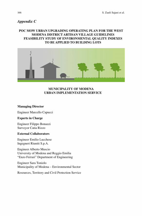
166
Appendix C
POC MOW URBAN UPGRADING OPERATING PLAN FOR THE WEST MODENA DISTRICT ARTISAN VILLAGE GUIDELINES
FEASIBILITY STUDY OF ENVIRONMENTAL QUALITY INDEXES TO BE APPLIED TO BUILDING LOTS
MUNICIPALITY OF MODENA URBAN IMPLEMENTATION SERVICE
Managing Director
Engineer Marcello Capucci
Experts in Charge
Engineer Filippo BonazziSurveyor Catia Rizzo
External Collaborators
Engineer Emilio LuccheseIngegneri Riuniti S.p.A.
Engineer Alberto MuscioUniversity of Modena and Reggio Emilia“Enzo Ferrari” Department of Engineering
Engineer Sara TonioloMunicipality of Modena – Environmental Sector
Resources, Territory and Civil Protection Service
S. Zauli Sajani et al.
1 Introduction .............................................................................................. 1682 Existing Environmental Quality Urban Indexes ................................... 1703 Design of Experimental Environmental Quality Indexes ..................... 176 3.1 Product Characteristics ..................................................................... 178 3.2 Types of Actions ............................................................................... 180 3.3 Data Entry (Actual State – Planned State) ........................................ 1824 “Rate” Index (Reduction in the Absorption
of Thermal Energy).................................................................................. 185 4.1 Phenomena Analysis Methodology ................................................... 186 4.2 Simulation of Plants .......................................................................... 187 4.3 Index Output ..................................................................................... 1885 “Hyper” Index (Hydraulic’s Permeability
and Elements of Retention) ..................................................................... 190 5.1 Index Output ..................................................................................... 1916 Indexes as Guidelines for the Planning Phase ....................................... 193 6.1 Indexes and Economic Assessment of Planning Solutions ............... 1937 Further Guidelines Supporting the Planning Phase ............................. 1948 Incentives, Bonuses and Awards ............................................................. 196 8.1 Limits to the Granting of Bonuses and Awards ................................ 1979 References ................................................................................................. 199
Table of Contents
168
1Introduction
On the main goals of the Artisan Village Upgrade Plan is to renew the buildings in the Village, by means of a deep restructuring of the existing edifices, respecting the size and volume relations among them and producing a new estate body, which car-ries on and updates the typical evolution process of the Artisan Village.
Taking into consideration the modified environmental conditions of the area, the Plan aims to promote measures envisaging high-level performances, in order to ensure the environmental as well as the urban upgrade of the area.
The Plan may envisage the granting of awards in case of upgrade actions which can guarantee such quality levels as to enhance the environmental value of the struc-tures and the recognizability of the urban context. In this respect, the devised plan envisages the implementation of a procedure (“BAF”, see below) for assessing the improvements achieved during the planning phase.
Later, some in-depth analyses were carried out on this index and similar indexes (described below), in order to be sure about the best tool to include in the award attribution Plan.
At the same time, we started to consider what the main environmental issues to work on could be, by means of building procedures. In this phase, a role of the utmost importance was played by the introduction of the Plan among the “pilot cases” of the “UHI” European project, which aimed both to analyse the phenome-non of urban heat islands and the prepare decision-making support tools in order to overcome this phenomenon.
As these issues were studied more and more in depth, we realized that each urban index analysed had certain peculiarities, which could meet specific requirements of the Plan, but at the same time specific issues came up which would limit their applicability.
The more in depth the approaches implemented by the various administration were studied, the more we could outline the main environmental issues to take into consideration in the planning of a building lot and, therefore, what behaviours were to be promoted in order to reduce the building impact. This has also made it possible to define the main characteristics to include in the Plan guidelines, then it was decided to try to develop a new index, an experimental one within the framework of the Plan, to be used both as a synthesis of the guidelines and as an assessment tool. Later, the single environmental issues were analysed, in collaboration with experts from the administrative bodies (Hydraulic Works office, Environmental Sector of the Municipality) and well known professionals (EELab Department, University of

169
Modena). Also due to some further contributions given by the various experts involved in the UHI project (external professionals or bodies, such as the Province and ARPA), and a comparison with the other European subjects involved, a first validation of this approach was reached.
This report summarises the main features of the environmental method prepared by the administration. It is worth stressing that there are various analyses still under way for the final validation of various technical and procedural issues; as a conse-quence, although the structural characteristics have already been defined, the approach implemented may still be modified or emended.
6 UHI in the Metropolitan Cluster of Bologna-Modena...

170
2Existing Environmental Quality Urban Indexes
In order to devise a method for assessing the “environmental” performances of a building lot, several towns in Italy, in Europe and worldwide have included stan-dardized procedures (“urban indexes”) in their building regulations, in order to cal-culate the general impacts of town-planning activities.
In general, for calculating the indexes, it is necessary to know the types of mate-rials/actions present in the building lot and the area they cover (m2). By applying different “weights” to every material/action, a value is obtained, proportional to its “environmental quality”, through the use of simply calculation algorithms. These values make it possible to obtain a number, which expresses the overall characteris-tics of a specific building lot. In order to ensure a suitable performance level, it is generally necessary to plan an activity in such a way as to get an index not lower than a certain threshold.
The common characteristics of the indexes is to provide a relatively simple and clear calculation methodology, aiming to plan building areas without any fixed schemes, since it is based on the achievement of minimum performance levels, which let you free to choose the various materials/actions to apply within a batch.
Biotope Area Factor (BAF) Index – BerlinAs early as in 1990,1 the city of Berlin adopted an index called Biotope Area Factor (BAF), in order to reduce the impacts already present in the town cen-tre and to facilitate an ecological upgrade of the urban context. The BAF is the ratio between ecologically “effective” surfaces and the total area of the land.
From a qualitative point of view, the index aims to safeguard the microcli-mate, to control the use of the land and water, to improve the quality of plants and the habitat for animals, to improve the vital space for human beings by means of the creation of yards with green areas (or areas with a certain perme-ability, such as self-blocking ground or gravel), green roofs, green walls or by means of infiltration of rain water to surfaces with extended vegetation.
1 “The Biotope Area Factor as an Ecological Parameter” – Berlin, 1990.

171
From a quantitative point of view, it provides a value between 0 and 1 and represents the part of the area for plants and other functions of the ecosystem. The higher the value, the better the result obtained in the building lot planning.
The index applies to residential, commercial and infrastructural areas (whether existing or newly made): depending on the various actions to imple-ment, minimum values of the index are set, in a range from a minimum of 0.30 to a maximum of 0.60.
2 Grabs Expert Paper 6 - The Green Space Factor and the Green Points System – 2011.3 The project involves the following countries: Austria, Greece, Italy (Genoa, Catania), Lithuania, Netherlands, Slovakia, Sweden, United Kingdom.
Green Space Factor Index (GSF) – MalmöThis index was designed in 2001, partially drawing inspiration from the BAF in Berlin.
From a qualitative point of view, the index aims to measure the ecological value of a settlement, on the basis of the presence of vegetation and permeable areas. The index takes into consideration the types of surfaces envisaged by the BAF (yards with green areas or in any case permeable areas, green roofs or green walls) and integrates them with water surfaces or rainwater collec-tion systems, quantifying the contributions of trees and bushes and promoting urban agriculture. As regards the quantity, it provides a value between 0 and 1. The minimum value to reach is 0.6.
What is peculiar in Malmö’s approach is the requirement, on the part of planners, to implement the verification of the GSF index by envisaging a cer-tain number of measures, called Green Points, which are pre-determined for certain types of biotopes, animal habitats or urban agriculture.2
Malmö, along with some other European organizations, belongs to the Grabs project (Green and Blue Space Adaptation for Urban Areas and Eco Towns). aiming to integrate strategies to adjust to climate changes within the framework of regional planning tools.3
Green Factor Index – SeattleOn the basis of the experience achieved in Berlin and Malmö, Seattle also designed its own index in 2006. Initially, it was only applied to commercial areas, later it was extended to residential areas. From a qualitative point of view, this index aims to increase the aesthetics of buildings, to increase permeability, to improve energy efficiency of buildings and to reduce the urban heat island.
(continued)
6 UHI in the Metropolitan Cluster of Bologna-Modena...

172
4 “Manuale d’uso del foglio di lavoro Excel per il calcolo del RIE” – Comune di Bolzano – Ufficio Tutela dei Beni Ambientali.
It uses the same action categories envisaged by the BAF (yards with green areas or permeable areas, green roofs or green walls) and those added by the GSF (rainwater collection, trees and bushes, urban agriculture), enlarging them by means of in-depth technical details. From a quantitative point of view, it is absolutely similar to the BAF, although it has a much more specific approach (the administration provides a spreadsheet for processing the index).
The peculiarity of the Green Factor is to carry out a cost analysis relative to each single action, in order to simplify the cost/benefit estimate, and it attributes bonuses for certain actions, such as improving the landscape pub-licly visible.
Seattle was the first American city to apply an index of this type, later it has served as a model for other cities, such as Bellingham, Portland, Chicago, DC, Bewark (etc.).
Building Impact Reduction Index (RIE) – BolzanoSince 2004, the Municipality of Bolzano has been applying a Building Impact Reduction index (RIE), which defines the ratio between green areas and non- green areas, within the framework of its Building Regulations. The index applies to all newly built elements and on actions involving existing buildings, as well as actions which involve external surfaces exposed to rainwater. From a qualitative point of view, the index aims to reorder rainwater and lower urban temperatures. The index is mostly based on permeability of materials, assessing the presence of green surfaces (agricultural, non-agricultural or for sports facilities), trees, water bodies, partially permeable grounds and green roofs. From a quantitative point of view, the calculation algorithm is slightly more complex than the one used for the previous indexes, and results in a value between 0 and 11 (approximately,4 the administration provides a spread-sheet for calculating the index). The higher the value, the better the result obtained in the building lot planning. Depending on the various actions to implement, minimum values of the index are set between a minimum of 1.5 to a maximum of 4.0.
What is peculiar in the RIE is the technical analysis of various types of green hanging covers on roofs (synthetically: intensive and extensive).
S. Zauli Sajani et al.

173
Building Impact Reduction Index (RIE) – BolognaSince 2009, the Municipality of Bologna has also been applying the RIE index in its Building Regulations. The index applies to both existing buildings and newly constructed ones, excluding those with a ratio between building lot and land area higher than 0.5. The algorithm used is fundamentally identical to that of Bolzano (the administration provides a spreadsheet for calculating the index).
Although it implements a coefficient which takes into consideration the pith of non-green areas, the spreadsheet provided for the calculation is designed in such a way as to attribute a single conventional value to the pith of all surfaces.
The peculiarity of the approach of Bologna is the presence of improvement performance levels aiming to promote building actions such as to enable an improvement of sustainability of the buildings: in addition to basic perfor-mances, identical to those defined by the RIE of Bolzano (minimum values of the index ranging between 1.5 and 4.0), “improvement” performance level (index minimum value between 2 and 5) and “excellence” ones (index minimum value between 2.5 and 6) are also envisaged, associated with certain incentives.
Other Italian ExperiencesSeveral towns in Italy have implemented various tools aiming to enhance the environmental value of buildings. In particular, the experiences of Brescia, Florence and Rimini are explained below.
What is different in the approaches of these administrations is the applica-tion of incentives which may result in lower taxes (economic incentives) or in the adjustment of town-planning parameters by means of correction coeffi-cients (procedural incentives).
The Municipality of Brescia, in the building regulations of 2008 (guide-lines, chapter called “Nature”) dealt with the use of green walls, introducing minimum quantitative parameters depending on the possibility of receiving a series of benefits (both procedural and economic).
The Municipality of Florence, in the 2007 building regulations, included a series of indications on the use of green areas, promoting the implementa-tion of measures aiming to “decrease the heat island effect” (by controlling the pith of the ground, the use of urban green areas, designing proper posi-tions for summer shades and the planting of trees and bushes).
The incentives envisaged are both economic and town-planning in nature, they apply to actions on new structures, newly-built edifices, urban restructur-ing actions and building restructuring (percent reduction of concession expenses and application of adjustments which take into consideration the increased extent on the S.U.L.).
(continued)
6 UHI in the Metropolitan Cluster of Bologna-Modena...
174
The Municipality of Rimini, in 2006, introduced a series of incentives for the sustainability of new actions and restructuring works in its building regu-lations. This document calls them “Biobuilding actions”, and they introduce the issue of the use of green on façades and in covers. In the chapter “Quality of life”, under the entries “Urban quality” and “Architectural quality”, green actions which benefit from incentives are listed (for instance, a reduction of up to 50 % of secondary urbanization charges).
These procedures are a concrete approach which has been taken into consider-ation in the planning of buildings for years, promoting their environmental sustain-ability. In particular, the indexes or procedures designed by these administrations highlight the issues which may affect the environmental quality most: the imple-mentation of actions which enhance the quality of buildings and the application of procedures which promote their completion.
Briefly, the favourable features of the indexes or procedures analysed so far are the following.
Actions
• Building of green areas, namely yards with green areas, green roofs (RIE) or green walls (BAF, GSF, GF).
• Building of permeable grounds (BAF, GSF, GF, RIE).• Planting of trees and bushes (GSF, GF, RIE).• Reuse/collection of rainwater (BAF, GSF, GF, RIE).
Procedures
• Implementation of incentives such as to promote high-performance actions (RIE, Municipalities of Brescia, Florence, Rimini).
• Implementation of procedures such as to highlight the quality/price ratio of each type of action (GF).
• Implementation of bonuses relative to actions which increase the quality of the visible landscape (GF).
• Integration of the indexes with a list of actions which describes, from a qualita-tive point of view, how to manage specific issues, providing planners with a series of potential solutions (Green Points, GSF).
An analysis of the indexes, in addition to these positive features, also shows some limits. As already mentioned, the indexes analysed show various approaches, relative to the specific urban contexts they are applied to. These indexes are struc-tured in such a way as to promote the implementation of actions with a particular environmental value, but in some cases no solutions which would be equally profit-able are envisaged, as summarized in the table below.
S. Zauli Sajani et al.

175
Limits
BAF – Berlin The indexes do not take into consideration actions not focusing on “green areas”, for instance Cool Roofs (important in order to lower the heat island effect), capable of exerting a positive effect on the climate and comfort of spaces.
GSF – Malmö They do not quantify a physical measure attributable to a tangible phenomenon.GF – Seattle
RIE – Bolzano The indexes only take into consideration the horizontal surfaces of the building lot, excluding the possibility of assessing the contribution of a “green” wall, and not just to qualify the positive effects of the materials used for building Cool Roofs.5
RIE – Bologna They do not quantify a physical quantity attributable to a tangible phenomenon.
In order to overcome these limits, it would be more suitable to implement the above-mentioned features:
• Actions not on “green areas”, for instance Cool Roofs, as “high-quality” actions to promote a re-designing of the building lot.
• Definition of specific measurement units attributable to tangible physical phe-nomena for the calculation of the index, which enable to quantify the environ-mental sustainability of actions.
5 http://urp.comune.bologna.it/portaleterritorio/portaleterritorio.nsf/a3843d2869cb2055c1256e63003d8c4e/200cfbd63f33a6aac1257671004e6018?OpenDocument
6 UHI in the Metropolitan Cluster of Bologna-Modena...

176
3Design of Experimental Environmental Quality Indexes
In order to implement the procedures analysed in the previous chapter, it was deemed useful to design calculation methods:
• capable of analysing all the surfaces in the building lot, yards, walls and roof,• capable of analysing the various types of surfaces, whether green or not,• capable of keeping the entry of data as easy as in the existing indexes,• capable of applying the typical approximations of town-planning indexes,• capable of highlighting environmental performances on the basis of indicators
which assess tangible physical phenomena,• capable of implementing UNI values, procedures already defined by laws or
municipal rules.
In order to assess the environmental quality of a building lot, an attempt has been made to design an approach based on technical and scientific consistencies, identi-fying specific indicators capable of highlighting the physical properties of the build-ing lot which significantly affect the environment. Lest the typical approach of town-planning indexes be changed excessively, it was decided to apply suitable approximations, such as to not complicate the data entry phase performed by users (appointed technicians or owners).
The main environmental features which are affected by the types of actions which can be carried out within a building lot are the effect of a heat island (outside the building), energy saving (inside the building) and hydraulic risk (outside the building lot). As a consequence, on the basis of a technical analysis of these fea-tures, the indicators chosen to characterise the building lot are the following:
• thermal energy absorbed by the surfaces (yard, walls, roof), with reference to both the heat island effect and energy saving, which shows the extent of solar radiation withheld by the building lot;
• the amount of water leaving the building lot (yards, roof or any tanks), with ref-erence to the hydraulic risk, which shows how much water due to rainfalls is released into the sewers.

177
Conceptual framework applied in the designing of the indexes
The specific analysis of the two indicators resulted in two different calculation procedures and, therefore, two indexes. All the algorithms implemented by the indexes are based on validate procedures or procedures being validated by experi-enced technicians in this field.
In compliance with the preliminary requirement specified above, the complex calculations made in order to calculate the indexes do not make the user’s data entry work more complex.
Note: The indexes listed below are calibrated in such a way as to be applica-ble to the Artisan Village, with the approval of the POC MO.W plan envisaged by the municipal administration. It is believed that this experimental applica-tion may provide useful assessment elements to extend the application of the indexes to any urban context. In this respect, applications to parts of existing towns are particularly interesting.
The index was designed in four phases.
1. In the first phase, a list of building typologies was made, including the typical materials present in the existing context and used for new actions.
2. In the second phase, a physical measurement to be used as an indicator and a calculation method were identified.
3. In the third phase, the technical and physical characteristics of each construction typology and the context necessary to assess the indicator were analysed.
4. In the fourth phase, the typical approximations of town-planning indexes were applied.
6 UHI in the Metropolitan Cluster of Bologna-Modena...

178
3.1 Product Characteristics
The data required for processing the indexes describe the conditions before works (actual state) and the conditions after works (planned state). The following informa-tion is required:
– the value of the Land Area in the actual state (which is also attributed to the planned state),
– the SC (covered area) value in the actual state and planned state (they may be different),
– the average height of the volume built in the actual state and in the planned state, – the length of the longest side of the volume built in the actual state and in the
planned state, – the inclination southward (azimuth) of the longest side in the actual state and in
the planned state,
Software user’s layout
S. Zauli Sajani et al.

179
In order to enable the spreadsheet to describe the hydraulic characteristics of the action area, the following information is also required:
– the hydraulic load class, as defined in the Knowledge Framework of the Municipal Structural Plan,
– the type of action (new building or restructuring).
Software user’s layout
With this information, the building lot is analysed as a geometrically simplified one: in the actual state, just like in the planned state, the building volume is consid-ered as a regular parallelepiped placed in the centre of an “equivalent” yard, in which the distance between the walls of the building volume and the limit of the property are constant on all four sides.
The inclination of the building volume makes it possible to acquire more infor-mation about the amount of solar radiation touching each wall (for this feature, see the following in-depth analyses).
The last two pieces of information (hydraulic load class and type of action) make it possible to define what principle to apply for managing the extents generated by the building lot.
6 UHI in the Metropolitan Cluster of Bologna-Modena...

180
3.2 Types of Actions
The characteristics of the building lot are assessed on the basis of the various typol-ogies of surfaces which characterise the actual state and the planned state. Twenty possible actions have been identified, in order to summarise the possible technical solutions used in the territory.
Note: it is necessary to geometrically simplify the building lot lest the calcula-tion of the index be overloaded with excessive input. By exaggerating in the definition of specific features, the index might be too articulated, thus losing its synthetic capacity. Indeed, it should be borne in mind that the aim of the index is not to create a simulation model, but to implement those already in existence.
However, subsequent implementations more specifically on the structure of the software than its logical setting cannot be excluded.
Note: If experts in this field tested the index, the envisaged typologies might be validated even further.
S. Zauli Sajani et al.
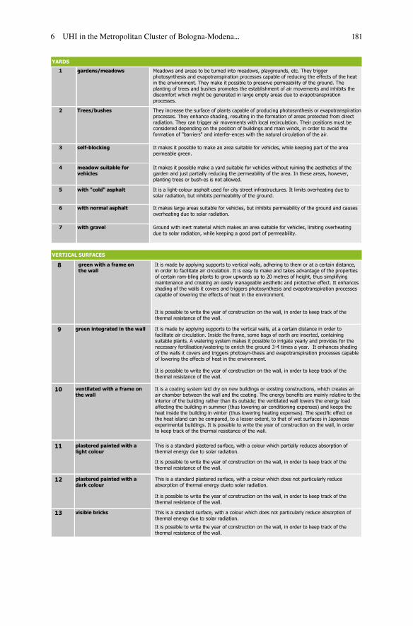
181
YARDS
1 gardens/meadows
2 Trees/bushes
3 self-blocking
4 meadow suitable forvehicles
5 with "cold" asphalt
6 with normal asphalt
7 with gravel
VERTICAL SURFACES
8 green with a frame on the wall
It is possible to write the year of construction on the wall, in order to keep track of thethermal resistance of the wall.
9 green integrated in the wall
It is possible to write the year of construction on the wall, in order to keep track of the thermal resistance of the wall.
10 ventilated with a frame on the wall
11 plastered painted with a light colour
12 plastered painted with a dark colour
13 visible bricks
It is made by applying supports to vertical walls, adhering to them or at a certain distance,in order to facilitate air circulation. It is easy to make and takes advantage of the propertiesof certain ram-bling plants to grow upwards up to 20 metres of height, thus simplifyingmaintenance and creating an easily manageable aesthetic and protective effect. It enhancesshading of the walls it covers and triggers photosynthesis and evapotranspiration processes capable of lowering the effects of heat in the environment.
Meadows and areas to be turned into meadows, playgrounds, etc. They triggerphotosynthesis and evapotranspiration processes capable of reducing the effects of the heatin the environment. They make it possible to preserve permeability of the ground. The planting of trees and bushes promotes the establishment of air movements and inhibits the discomfort which might be generated in large empty areas due to evapotranspiration processes.
They increase the surface of plants capable of producing photosynthesis or evapotranspirationprocesses. They enhance shading, resulting in the formation of areas protected from direct radiation. They can trigger air movements with local recirculation. Their positions must be considered depending on the position of buildings and main winds, in order to avoid the formation of "barriers" and interfer-ences with the natural circulation of the air.
Ground with inert material which makes an area suitable for vehicles, limiting overheatingdue to solar radiation, while keeping a good part of permeability.
It makes large areas suitable for vehicles, but inhibits permeability of the ground and causesoverheating due to solar radiation.
It is a light-colour asphalt used for city street infrastructures. It limits overheating due to solar radiation, but inhibits permeability of the ground.
It makes it possible make a yard suitable for vehicles without ruining the aesthetics of thegarden and just partially reducing the permeability of the area. In these areas, however, planting trees or bush-es is not allowed.
It makes it possible to make an area suitable for vehicles, while keeping part of the areapermeable green.
It is made by applying supports to the vertical walls, at a certain distance in order tofacilitate air circulation. Inside the frame, some bags of earth are inserted, containing suitable plants. A watering system makes it possible to irrigate yearly and provides for the necessary fertilisation/watering to enrich the ground 3-4 times a year. It enhances shadingof the walls it covers and triggers photosyn-thesis and evapotranspiration processes capable of lowering the effects of heat in the environment.
It is a coating system laid dry on new buildings or existing constructions, which creates an air chamber between the wall and the coating. The energy benefits are mainly relative to theinterior of the building rather than its outside; the ventilated wall lowers the energy load affecting the building in summer (thus lowering air conditioning expenses) and keeps the heat inside the building in winter (thus lowering heating expenses). The specific effect on the heat island can be compared, to a lesser extent, to that of wet surfaces in Japanese experimental buildings. It is possible to write the year of construction on the wall, in orderto keep track of the thermal resistance of the wall.
This is a standard plastered surface, with a colour which partially reduces absorption of thermal energy due to solar radiation.
It is possible to write the year of construction on the wall, in order to keep track of the thermal resistance of the wall.
This is a standard plastered surface, with a colour which does not particularly reduce absorption of thermal energy dueto solar radiation.
It is possible to write the year of construction on the wall, in order to keep track of the thermal resistance of the wall.
This is a standard surface, with a colour which does not particularly reduce absorption of thermal energy due to solar radiation.
It is possible to write the year of construction on the wall, in order to keep track of the thermal resistance of the wall.
6 UHI in the Metropolitan Cluster of Bologna-Modena...

182
HORIZONTAL SURFACES
14 "extensive" green
15 "cold"
It is possible to write the year of construction on the wall, in order to keep track of the thermal resistance of the roof.
16 "cold" tiles
17 photovoltaic (roof tile or else)
18 tile roof
19 light colour flat roof
20 dark colour flat roof
It is a garden, generally not accessible and particularly suitable for covering large areas, whose plants have the function of holding the ground. Maintenance is limited and the watering system is simple. Its thickness is approximately 5-12 cm, with a corresponding overload of about 60-250 kg/m2. It triggers photosynthesis and evapotranspiration processesand can keep part of the rainfalls. In case of accessible green areas endowed with trees and bushes, the right term would be "intensive" green, but it is not taken into considerationby this study, due to its high costs. It is possible to write the year of construction on the wall,in order to keep track of the thermal resistance of the roof.
It inhibits the amount of thermal energy going into buildings and its accumulation, with subsequent release into the environment. It is made by applying specific coatings (plasters, resins, paints, ceram-ics, etc.) and does not result in significant overloads. It is mainly appliedto flat surfaces in buildings for productive activities.
It inhibits the amount of thermal energy going into buildings and its accumulation, with subsequent release into the environment. It is made by using specific tiles and does not result in significant over-loads. It makes it possible to also apply the "cold" roof technology to buildings covered with tiles. It is possible to write the year of construction on the wall, in order to keep track of the thermal re-sistance of the roof.
Solar, photovoltaic or transparent roof tiles are an alternative to solar or photovoltaic panels, both in the construction of the roofs of new buildings and in their restructuring, since they make it possible to keep the house cover aesthetically pleasant, without giving up the possibility of using the solar energy for producing electric power or hot water. As an alternative, the use of photovoltaic panels ap-plied to the cover makes it possible to optimiseresults, since they are placed according to the function of the specific latitude. The effect canbe compared to that of a cold roof. It is possible to write the year of construction on the wall, in order to keep track of the thermal resistance of the roof.
It does not particularly inhibit the amount of thermal energy going into buildings and its accumulation, with subsequent release into the environment.
This is a standard surface typical of houses, made of materials which do not particularly reduce absorption of thermal energy due to solar radiation.
It is possible to write the year of construction on the wall, in order to keep track of the thermal resistance of the roof.
This is a standard surface typical of production buildings, with a colour which partially reduces absorption of thermal energy due to solar radiation.
It is possible to write the year of construction on the wall, in order to keep track of the thermal resistance of the roof.
This is a standard surface typical of production buildings, with a colour which does not particularly reduce absorption of thermal energy due to solar radiation.
It is possible to write the year of construction on the wall, in order to keep track of the thermal resistance of the roof.
3.3 Data Entry (Actual State – Planned State)
Having identified the various types of actions characterising the Actual State (SDF) and the Planned State (SDP), the number of square metres relative to each surface typology is to be entered.
S. Zauli Sajani et al.

183
Software user’s layout
For trees, it is necessary to enter the total number of those already present (“tree” means an element of approximately 3 m of height, with a crown of approximately 8 m2, which is deemed to be the equivalent of 4 bushes of about 1.5 m of height and covering a surface of approximately 4 m2).
6 UHI in the Metropolitan Cluster of Bologna-Modena...

184
For the specific calculation of thermal resistance of the walls and roof, it is neces-sary to enter the year when the walls and roof were built. For walls or a newly-built roof, by selecting the “ex lege” option, the minimum parameters required by law are set, whereas by selecting “per detrazioni”, the legal parameters which may benefit from fiscal deductions are set.
In the data entry phase, it is also possible to specify if a rainwater collection tank is present, as defined by the voluntary requirement of the Building Town-Planning Regulations (RUE, No. XXVIII.3.2) of the Municipality of Modena. It is possible to specify the cubic metres of the tank or to calculate the cubic metres necessary in a specific context (by filling in a simple table, based on the provisions in the RUE).
Module implemented in the software for calculations relative to the rainwater collection tank, as defined in the RUE
S. Zauli Sajani et al.

185
4“Rate” Index (Reduction in the Absorption of Thermal Energy)
In days characterised by anticyclonic conditions in the air and strong stability on the ground, a vertical temperature profile is established, with Thermal Inversion (ther-mal inversion on the ground, countryside). The heat produced by the buildings tends to contrast the vertical thermal inversion, without totally breaking it (thermal inver-sion in the air, town), creating an air dome whose maximum height corresponds to the zone with the highest concentration of buildings.
The inversion layer creates a barrier which prevents a redistribution of vertical air all over the atmosphere layer available. This creates a heat island, which there-fore depends on the season, geographic position of the town and its characteristics.
This “blanket” withholds the heat, thus raising the temperature (for instance, minimum temperatures at night).
Graph showing the Urban Heat Island phenomenon
The presence of materials endowed with little capacity to reflect solar radiation (solar reflectivity), in conditions of strong solar irradiation, results in high thermal loads on the surface in general. If this surface has a scarce thermal isolation capacity (thermal resistance), it tends to warm up and, in its turn, if it does not have a good capacity to release this heat by irradiation (emissivity), it will take a certain period of time to return to ambient temperature. Continuing to release heat, even during the night, the material will affect the rising of the temperature within the heat island.
The capacity of materials to reflect solar radiation (solar reflectivity), to release the heat absorbed (emissivity) and to isolate thermally (thermal resistance) make it

186
possible, at the same time, to reduce the heat entering buildings (in summer) and reduce thermal dispersion from the inside to the outside (both in summer and in winter), thus making it possible to reduce both summertime consumption due to air conditioning systems and winter consumption due to heating systems, improving energy saving.
4.1 Phenomena Analysis Methodology
The physical properties of the materials which make up the building lot (solar reflectivity, thermal resistance and emissivity) can be combined along with incident solar radiation in order to obtain a single value expressing the thermal energy absorbed [kWh/m2y].
Summary of the methodological approach
For each type of floor, wall and roof (reported in the table above), the respective identification parameters were obtained (solar reflectivity, thermal resistance and emissivity).
In order to take into consideration the various irradiation conditions of the roofs and walls, energy values per unit of surface were used, obtained by applying norm UNI 10349 (for walls this value was attributed as a function of the azimuth angle). For assessing irradiation of yards, starting from the energy associated to the hori-zontal surface, the amount of energy lost due to the shading caused by the “equiva-lent” building lot was taken into consideration. For this calculation, a calculation file already in existence is used,6 based on the UNI norms in force.
6 “SOLE – Stima Ombreggiamento Locale Edifici” – Dott. Ing. Giulio de Simone – Dipartimento di Ingegneria Meccanica – Università degli studi di Roma “Tor Vergata” – Excel file.
S. Zauli Sajani et al.

187
4.2 Simulation of Plants
For calculating the thermal energy absorbed by trees or bushes, by using parametric coefficients, the part of solar radiation used for the photosynthesis (about 5 %) and which is released as latent heat in evapotranspiration processes (about 45 %) were taken into consideration.
Summary of the methodological approach
Note: deterioration of the technical characteristics of materials and degrada-tion of plant elements are not taken into consideration. For instance, in case of building defects, ageing of surfaces, lack of watering of green areas or increased volume of trees, the typical parameters of each single surface and, as a consequence, their relative indexes might vary.Note: the yards simulated by the “equivalent” lot do not take into consider-ation the real position of the various grounds; the average value of radiation on the yard is associated with them.
6 UHI in the Metropolitan Cluster of Bologna-Modena...

188
In order to assess the effects of trees, the shading in the yards due to the tree crowns (also with reference to the loss of shading due to proximity of trees with the property limits) is assessed, as well as the consequent loss of energy on the garden. In the calculation, the thermal energy absorbed by the tree crowns is also calculated, but the shades, if any, on the building walls is not assessed.
4.3 Index Output
Calculating the index, the total thermal energy absorbed by the surfaces making up the building lot (kWh/year) is calculated in the Actual State and in the Planned State. The ratio between these values and the Land Area (SF) is the index reference parameter (kWh/year per m2 of SF). By associating the thermal energy absorbed by all the surfaces in the building lot with the Land Area only, we take into consider-ation the “weight” of the building volume (if the volume grows, the index grows, the SF being the same).
The output value is the measure of specific “performances” of the building lot and can be highlighted depending on various features.
• the class of the planned scenario (SDP) identifies the quality of the action;• by processing the different classes of energy performance which output values
are associated with, the number of reduced classes between the initial scenario (SDF) and the planned scenario (SDP) highlights the improvements achieved;
• the total reduction of thermal energy absorbed (kWh/year) in the planned sce-nario (SDP), in comparison with the initial scenario (SDF) highlights the extent of the improvements with reference to the building lot size.
Software output
S. Zauli Sajani et al.
189
Note: the canyon effect due to the presence of adjacent buildings is not taken into consideration, therefore it has to be dealt with, from a qualitative point of view, by referring to relevant guidelines.
Note: air circulation is not taken into consideration, therefore the natural movements of the air and the “barriers” which might be caused by the posi-tions of buildings and trees are not assessed. For these issues, see the relevant guidelines.
Note: the energy performance classes used so far are approximate, they will have to be adjusted by analysing various study cases. From a merely qualita-tive point of view, the class typology used draws inspiration from the one used to classify energy performances of buildings (there is no relevance from a quantitative point of view).
Note: the assessments were made with reference to the yearly solar radiation, but the software is also set to calculate the summer solar radiation. In order to enhance improvements even more, in terms of energy consumption reduc-tion (relative to the yearly solar radiation) or reduction of the heat island effect (more relative to the summer solar radiation), some further software implementations are being designed.
6 UHI in the Metropolitan Cluster of Bologna-Modena...
190
5“Hyper” Index (Hydraulic’s Permeability and Elements of Retention)
A building lot capable of ensuring proper disposal of surface water and rainwater, avoiding their stagnation and promoting a controlled outflow, contributes to mitiga-tion of floods in urban area and non-urban areas, thus helping to reduce the hydrau-lic risk. The technical characteristics of building lots, necessary to meet these conditions, are defined in the municipal Building Town-Planning Regulations (RUE, binding requirement No. XXVIII.3.14).
The RUE define various principles to manage the hydraulic risk in the territory. For defining these principles, several data are necessary: the size of the surface of the building lot analysed, the fraction of the total area deemed to be impermeable, the hydraulic load class (which makes it possible to differentiate the various basins as “critical” and “non-critical”) and the type of action (new building or restoration of areas already urbanised).
The applicable principles require a maximum value to be applied for the outgo-ing extent from the building lot in the planned scenario; they may be the following:
• principle of controlled hydraulic increase: it allows a possible specific extent increase of up to 100 %, 50 % or 30 % of the specific value of the outflow of the area in question, as it was before the start of the action;
• hydraulic invariance principle: it keeps the specific value of the outflow of the area in question unaltered, as it was before the start of the action;
• principle of hydraulic attenuation: it requires a specific outflow extent reduction of at least 30 %, 40 % or 50 % of the specific value of the outflow of the area in question, as it was before the start of the action.
All the principles are based on the specific value of the outflow of the area in question unaltered, as it was before the start of the action. This value is usually cal-culated when the hydraulic sheet of the building lot in question is drafted and requires the number of square metres of the various yards and roofs to be specified. These surfaces, associated with specific outflow coefficients and the hydrological parameters defined in the RUE, make it possible to determine the size of the rainwa-ter drainage network (with a return time of 20 years).
191
For calculating the index, a calculation algorithm was implemented which, on the basis of the principle of hydraulic risk management to be applied in the building lot, defines the maximum value allowed for the outflow extent due to the SDP (Qsdp,max). If the outflow extent generated by the input action typologies for char-acterising the SDP (Qsdp) exceeds this value, the index requires a check of this extent and imposes the Qsdp = Qsdp,max equation, envisaging the presence of a lamination tank in the line where exceeding extents flow, then it calculates the vol-ume of the reservoir. The tank is calculated on the basis of a return time of 50 or 100 years (depending on what is envisaged by the RUE).
If the user has chosen to prepare a rainwater collection tank, and the index has calculated that it is necessary to also envisage a lamination tank, then the square metres of the rainwater tank are deducted from those of the tank.
5.1 Index Output
In the calculation of the index, the extent (l/s) in the Actual State and in the Planned State is defined. The ratio between these values and the Land Area (SF) is the index reference parameter (l/s per m2 of SF).
Since the hydraulic risk management principles “calibrate” the plan extent (Qsdp) on the basis of the extent in the actual state and the maximum plan extent acceptable (Qsdp,max), the classes defined for assessing the output have been asso-ciated to the Qsdp,max values required by the various principles. In this case, unlike what was done for the “RATE” index, the output produced by the Planned State was not compared with that of the Actual State, but with the maximum one in the Planned State (determined by the principle applied).
The output value is the measure of specific “performances” of the building lot and can be highlighted depending on various features.
• the planned scenario (SDP) class identifies the quality of the action with refer-ence to what is already required by the principle applied (SDPmax);
• by processing different classes of energy performance output values are associ-ated with, the number of reduced classes between the planned scenario (SDP) and the maximum planned scenario (SDPmax) highlights the improvements achieved;
• the total reduction of extent (l/s) in the planned scenario (SDP), in comparison with the maximum planned scenario (SDPmax) highlights the extent of the improvements with reference to the building lot size.
6 UHI in the Metropolitan Cluster of Bologna-Modena...
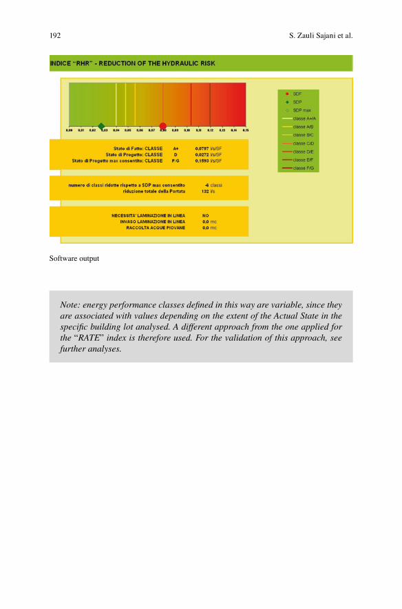
192
Note: energy performance classes defined in this way are variable, since they are associated with values depending on the extent of the Actual State in the specific building lot analysed. A different approach from the one applied for the “RATE” index is therefore used. For the validation of this approach, see further analyses.
Software output
S. Zauli Sajani et al.
193
6Indexes as Guidelines for the Planning Phase
The analysis of the indexes already used by other administrations, the analysis of the possible solutions to implement in yards and to cover buildings, and the analysis of the respective physical and technical characteristics have made it possible to obtain a complete and rational list of types of action, to be included in the experi-mental indexes. This list is the starting point for the various technical criteria explained in the previous chapters for calculating the output of the indexes, and it has been designed in such a way as to guide the planning in the implementation of new buildings and in the upgrading of existing buildings. By defining the character-istics of the existing context and the possible planning solutions, planners receive output which enables them to check the overall improvements achieved (in terms of reduction of the RATE or HYPER index).
If planners intend to modify the overall improvements, they can change the com-bination of types of planned actions and obtain new outputs, to be compared with the previous ones, in order to refine the planning and increase its environmental value.
The types of actions included in the indexes represent, therefore, a reasonable and functional synthesis of planning guidelines, which can provide both support to the architectural planning and an assessment of the impacts generated immediately and with suitable precision.
6.1 Indexes and Economic Assessment of Planning Solutions
As an integration to the planning support tools mentioned above, the indexes also implement an assessment of the parametric costs of the various types of action envisaged. By applying the same approach used for the assessment of impacts pro-duced by the planning solution envisaged by the planner, a dynamic table has been designed, relative to the parametric costs of planning actions.
In this way, planners check the types of action chosen which might be applied in order to find the right balance between costs and resources. Moreover the planner is able to verify the quality/cost ratio of each type of action.
In order to promote such analyses, the software shows the synthesis of all the information relative to the two indicators and the parametric costs. By reading the information relative to each type of action, it is possible to easily check and com-pare the impacts caused and the relative costs.
194
7Further Guidelines Supporting the Planning Phase
In order to design the indexes, the need to implement a greater number of potentials, for calculating the environmental value of the building lot while trying to keep its use suitably simple, was discussed for a long time. While designing the software, it was decided to make some simplifications and not to implement certain physical aspects. The indexes and calculation methods implemented could be improved even more, in order to remove the simplification applied and refine the processing, also including all the necessary physical issues; in this way, though, the immediate appli-cability of a town-planning index would be lost and you would have a calculation software programme with an enormous potential, but only to be used by suitably trained experienced users. Although at the moment it is not possible to exclude such a future development, for the time being the structure of the indexes has willingly been processed in such a way as to make it as simple and self-explanatory as pos-sible. Although the indexes require much more complex processes than those devel-oped for similar indexes already in existence, in the data entry phase the approach has not been altered. Like in the other indexes, observations are put forward about a building lot, the materials present in it and their specific sizes. This approach identi-fies the building lot as an independent item, without putting it into the existing urban context.
This approach is a non-banal simplification of the context analysed, which has two limits:
• since the context in which the lot lies is not known, it is hypothesized that the solar irradiation conditions in the lot are not affected by elements outside the lot itself, like buildings, rows of trees, etc. This simplification makes it possible to apply the same theoretical maximum irradiation to each lot and, as a conse-quence, provides output values comparable among the various lots. The negative side of this approach is not seeing a lot within its specific context; for instance, although the indexes can assess the positive effect due to photovoltaic panels, installing them on a building would make no sense if that building stood in the shade of a skyscraper in the hours of the day when sun exposure is maximum;
• although the context in which the building lot lies is not known, the indexes will merely be used for analysing the impacts caused by the lot “within the lot” and do not allow to check the relationship between impacts caused by the lot and the surrounding lots. Therefore, the indexes cannot simulate how proximity to other
195
buildings, roads or other structural elements of the town may affect the indicators taken into consideration on the whole.
These issues show that the use of the indexes cannot ignore knowledge of the territory in which a general action takes place. The data produced by the indexes must be supported by further assessment elements, to be processed on the basis of a careful analysis of the urban context.
As for the Artisan Village, these elements are represented by the guidelines envisaged ad hoc within the framework of the EU “UHI Project”, in which the Artisan Village Upgrade Plan is a pilot study case. These guidelines have revealed the urban and building characteristics, the main environmental issues, morphologi-cal, climatic and architectural aspects of the town structure already in existence and the possible planning features within the framework of the Artisan Village.
By processing this content even further, the experimental indexes design phase will be completed, and a list of guidelines will be drafted to support the planning. By taking into consideration the various territorial contexts within the Village (for instance: lot on the side of a street, lot inside other lots with buildings of the same height, etc.), these guidelines will be useful for the planning phase.
For example, in this way such phenomena as the Urban Canyon and the air cir-culation dynamics will be taken into consideration and, before deciding what plan-ning actions to enter into the software programme to calculate the indexes, it will be possible to have a further tool for analyses, which can help planners to choose the best types of actions.
Later on, the main features which can affect the planning phase (presence of roads, presence of buildings, presence of green barriers, etc.) will be extracted from these guidelines, and a list of best practices will be drafted, to be applied in the plan-ning of these features. In this way, by following and implementing the experience of the Green Points of Malmö, a list of actions will be drafted, which planners will have to respect in the planning of a building lot, having checked the surrounding context.
6 UHI in the Metropolitan Cluster of Bologna-Modena...
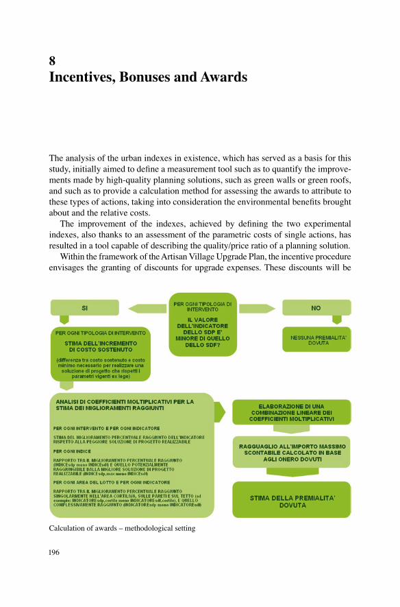
196
8Incentives, Bonuses and Awards
The analysis of the urban indexes in existence, which has served as a basis for this study, initially aimed to define a measurement tool such as to quantify the improve-ments made by high-quality planning solutions, such as green walls or green roofs, and such as to provide a calculation method for assessing the awards to attribute to these types of actions, taking into consideration the environmental benefits brought about and the relative costs.
The improvement of the indexes, achieved by defining the two experimental indexes, also thanks to an assessment of the parametric costs of single actions, has resulted in a tool capable of describing the quality/price ratio of a planning solution.
Within the framework of the Artisan Village Upgrade Plan, the incentive procedure envisages the granting of discounts for upgrade expenses. These discounts will be
Calculation of awards – methodological setting
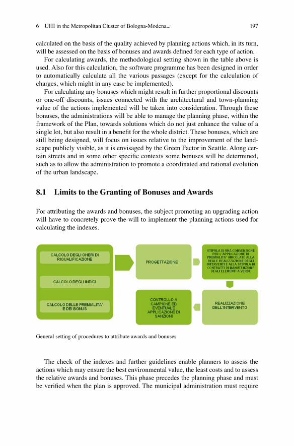
197
calculated on the basis of the quality achieved by planning actions which, in its turn, will be assessed on the basis of bonuses and awards defined for each type of action.
For calculating awards, the methodological setting shown in the table above is used. Also for this calculation, the software programme has been designed in order to automatically calculate all the various passages (except for the calculation of charges, which might in any case be implemented).
For calculating any bonuses which might result in further proportional discounts or one-off discounts, issues connected with the architectural and town-planning value of the actions implemented will be taken into consideration. Through these bonuses, the administrations will be able to manage the planning phase, within the framework of the Plan, towards solutions which do not just enhance the value of a single lot, but also result in a benefit for the whole district. These bonuses, which are still being designed, will focus on issues relative to the improvement of the land-scape publicly visible, as it is envisaged by the Green Factor in Seattle. Along cer-tain streets and in some other specific contexts some bonuses will be determined, such as to allow the administration to promote a coordinated and rational evolution of the urban landscape.
8.1 Limits to the Granting of Bonuses and Awards
For attributing the awards and bonuses, the subject promoting an upgrading action will have to concretely prove the will to implement the planning actions used for calculating the indexes.
The check of the indexes and further guidelines enable planners to assess the actions which may ensure the best environmental value, the least costs and to assess the relative awards and bonuses. This phase precedes the planning phase and must be verified when the plan is approved. The municipal administration must require
General setting of procedures to attribute awards and bonuses
6 UHI in the Metropolitan Cluster of Bologna-Modena...

198
some suitable guarantees, in order to avoid the risk that certain actions envisaged by the project not be implemented or cease due to a lack of suitable ordinary mainte-nance works. In this respect, for each type of action, some necessary and sufficient binding characteristics will be defined in order to grant awards or bonuses. For instance, for the construction of yards, it will be necessary to make an automatic watering system, whereas for green walls or roofs, it will be necessary to prove that a maintenance contract of suitable duration has been signed, etc.
By means of a check system based on sample verifications, the administration will verify the upgraded areas, in order to ensure the preservation of the promoted features in the long run.
Open Access This chapter is distributed under the terms of the Creative Commons Attribution 4.0 International License (http://creativecommons.org/licenses/by/4.0/), which permits use, duplica-tion, adaptation, distribution and reproduction in any medium or format, as long as you give appro-priate credit to the original author(s) and the source, a link is provided to the Creative Commons license and any changes made are indicated.The images or other third party material in this chapter are included in the work’s Creative Commons license, unless indicated otherwise in the credit line; if such material is not included in the work’s Creative Commons license and the respective action is not permitted by statutory regu-lation, users will need to obtain permission from the license holder to duplicate, adapt or reproduce the material.
S. Zauli Sajani et al.

199
References
List of References
“The Biotope Area Facto ras an Ecological Parameter” Principles for its Determination and identification of the target - Berlin, December 1990.
Grabs Expert Paper 6 - The Green Space Factor and the Green Points Sistem - 2011
“Manuale d’uso del foglio di lavoro Excell per il calcolo del RIE” Comune di Bolzano - Ufficio Tutela dei Beni Ambientali
“Recupero edilizio e bioclimatica” – Marco Sala – Sistemi Editoriali“Spazi verdi urbani” – Sistemi Editoriali“Gli strumenti normativi inerenti l’uso del verde in copertura e in facciata”
Università Iuav di Venezia – Valentina Santi, Valeria Tatano – 2007“Gestione della qualità dell’aria”, McGraw-Hill, 2001“Superfici vegetali applicate all’involucro edilizio per il controllo microclimatico
dell’ambiente costruttivo”, Dottorato in “Tecnologia dell’Architettura”, Università degli studi di Ferrara, Dott. Olivieri Michele, 2009
“La pianificazione delle infrastrutture verdi nelle strategie di adattamento ai cam-biamenti climatici in ambito urbano”, Dottorato in “Analisi, pianificazione e ges-tione integrata del territorio”, Università degli studi di Catania, Dott. Anna Maria Caruso
Web Sites
http://www.stadtentwicklung.berlin.de/umwelt/landschaftsplanung/bff/index_en.shtml
http://www.malmo.se/English/Sustainable-City-Development/Green-and-Blue.html
https://www.seattle.gov/dpd/cityplanning/completeprojectslist/greenfactor/whatwhy/
http://www.comune.bolzano.it/urb_context02.jsp?ID_LINK=512&id_context= 4663&page=11

200
http://urp.comune.bologna.it/portaleterritorio/portaleterritorio.nsf/a3843d2869cb2055c1256e63003d8c4e/200cfbd63f33a6aac1257671004e6018?OpenDocument
http://www.eelab.unimore.it/site/home.htmlhttp://www.solarity.enea.it
Software
“SOLE – Stima Ombreggiamento Locale Edifici” – Dott. Ing. Giulio de Simone – Dipartimento di Ingegneria Meccanica – Università degli studi di Roma “Tor Vergata” – Excel file.
S. Zauli Sajani et al.