chapter 6 the sokoto basin (nigerian sector of the iullemmeden … · 2019-09-23 · 78 6 the...
TRANSCRIPT

Chapter 6The Sokoto Basin (Nigerian Sectorof the Iullemmeden Basin)
The Iullemmeden Basin in north-western Nigeria is known locally as the “SokotoBasin”. It consists predominantly of a gently undulating plain with an average ele-vation varying from 250 to 400 m above sea-level. This plain is occasionally inter-rupted by low mesas. A low escarpment, known as the “Dange Scarp” is the mostprominent feature in the basin and it is closely related to the geology.
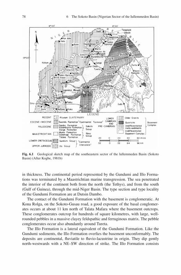
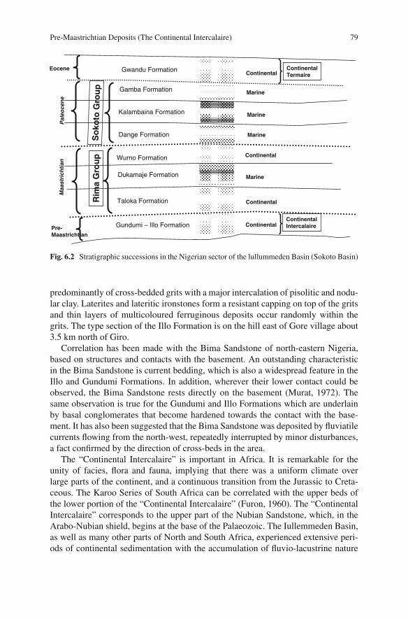
The sediments of the Iullemmeden Basin were accumulated during four mainphases of deposition. Overlying the Pre-Cambrian Basement unconformably, theIllo and Gundumi Formations, made up of grits and clays, constitute the Pre-Maastrichtian “Continental Intercalaire” of West Africa. They are overlain uncon-formably by the Maastrichtian Rima Group, consisting of mudstones and friablesandstones (Taloka and Wurno Formations), separated by the fossiliferous, shellyDukamaje Formation. The Dange and Gamba Formations (mainly shales) separatedby the calcareous Kalambaina Formation constitute the Paleocene Sokoto Group.The overlying continental Gwandu Formation forms the Post-Paleocene ContinentalTerminal. These sediments dip gently and thicken gradually towards the northwest,with a maximum thickness of over 1,200 m near the frontier with Niger Repub-lic. The geological map of the Sokoto Basin of northwestern Nigeria is shown onFig. 6.1 while Fig. 6.2 summarizes the geological sequence in the basin.
Pre-Maastrichtian Deposits (The Continental Intercalaire)
In the Sokoto Basin, the pre-Maastrichtian sediments are of fluviatile and lacustrineorigin. They belong to the Illo and Gundumi Formations which extend northwardsinto Niger Republic. These deposits belong to the upper part of the “ContinentalIntercalaire” which comprises a group of poorly fossiliferous sediments covering avery extensive area, bounded on the west by the crystalline basement rocks of NigerRepublic, and on the east by the Quaternary sands of the Chad Basin. The GundumiFormation lies unconformably on the basement and consists of basal conglomer-ates, and gravels with sand and variegated clays increasing upwards; the maximumthickness is about 350 m. The Illo Formation includes interbedded clays and grits,with an intermediate pisolitic and nodular clay member, and attains over 240 m
N.G. Obaje, Geology and Mineral Resources of Nigeria, Lecture Notesin Earth Sciences 120, DOI 10.1007/978-3-540-92685-6 7,C© Springer-Verlag Berlin Heidelberg 2009
77
78 6 The Sokoto Basin (Nigerian Sector of the Iullemmeden Basin)
Fig. 6.1 Geological sketch map of the southeastern sector of the lullemmeden Basin (SokotoBasin) (After Kogbe, 1981b)
in thickness. The continental period represented by the Gundumi and Illo Forma-tions was terminated by a Maastrichtian marine transgression. The sea penetratedthe interior of the continent both from the north (the Tethys), and from the south(Gulf of Guinea), through the mid-Niger Basin. The type section and type localityof the Gundumi Formation are at Dutsin Dambo.
The contact of the Gundumi Formation with the basement is conglomeratic. AtKona Rolga, on the Sokoto-Gusau road, a good exposure of the basal conglomer-ates occurs at about 11 km north of Talata Mafara where the basement outcrops.These conglomerates outcrop for hundreds of square kilometres, with large, well-rounded pebbles in a massive clayey feldspathic and ferruginous matrix. The pebbleconglomerates occur also abundantly around Tureta.
The Illo Formation is a lateral equivalent of the Gundumi Formation. Like theGundumi sediments, the Illo Formation overlies the basement unconformably. Thedeposits are continental, fluviatile to fluvio-lacustrine in origin. They dip gentlynorth-westwards with a NE–SW direction of strike. The Illo Formation consists
Pre-Maastrichtian Deposits (The Continental Intercalaire) 79
Gundumi – Illo Formation
Taloka Formation
Dukamaje Formation
Wurno Formation
Dange Formation
Kalambaina Formation
Gamba Formation
Gwandu Formation
Ri m
aG
rou
pS
oko
toG
rou
p
Pre-Maastrichtian
Maa
stri
chti
anP
aleo
cen
eEocene
Continental
Marine
Marine
Marine
Marine
Continental
Continental
ContinentalContinentalIntercalaire
ContinentalTermaire
Fig. 6.2 Stratigraphic successions in the Nigerian sector of the lullummeden Basin (Sokoto Basin)
predominantly of cross-bedded grits with a major intercalation of pisolitic and nodu-lar clay. Laterites and lateritic ironstones form a resistant capping on top of the gritsand thin layers of multicoloured ferruginous deposits occur randomly within thegrits. The type section of the Illo Formation is on the hill east of Gore village about3.5 km north of Giro.
Correlation has been made with the Bima Sandstone of north-eastern Nigeria,based on structures and contacts with the basement. An outstanding characteristicin the Bima Sandstone is current bedding, which is also a widespread feature in theIllo and Gundumi Formations. In addition, wherever their lower contact could beobserved, the Bima Sandstone rests directly on the basement (Murat, 1972). Thesame observation is true for the Gundumi and Illo Formations which are underlainby basal conglomerates that become hardened towards the contact with the base-ment. It has also been suggested that the Bima Sandstone was deposited by fluviatilecurrents flowing from the north-west, repeatedly interrupted by minor disturbances,a fact confirmed by the direction of cross-beds in the area.
The “Continental Intercalaire” is important in Africa. It is remarkable for theunity of facies, flora and fauna, implying that there was a uniform climate overlarge parts of the continent, and a continuous transition from the Jurassic to Creta-ceous. The Karoo Series of South Africa can be correlated with the upper beds ofthe lower portion of the “Continental Intercalaire” (Furon, 1960). The “ContinentalIntercalaire” corresponds to the upper part of the Nubian Sandstone, which, in theArabo-Nubian shield, begins at the base of the Palaeozoic. The Iullemmeden Basin,as well as many other parts of North and South Africa, experienced extensive peri-ods of continental sedimentation with the accumulation of fluvio-lacustrine nature

80 6 The Sokoto Basin (Nigerian Sector of the Iullemmeden Basin)
in pre-Cenomanian times. The northern limits of the continental deposition coin-cides with the Algeria- Moroccan Sahara and extends eastward into Egypt and theSudan. The southern limits extend as far as South Africa.
Maastrichtian Deposits (The Rima Group)
The second phase in the depositional history of the sediments of the Sokoto Basinbegan during the Maastrichtian, when the Rima Group was deposited uncon-formably on pre-Maastrichtian continental beds. The type sections of the threeMaastrichtian formations are at Taloka, Dukamaje and Wurno. The unconformityis well exposed at Wurno. The lower sandstones and mudstones of the Rima Groupbelong to the Taloka Formation; with a maximum thickness of about 100 m. Excel-lent exposures of the upper portion of the formation can be observed at Goronyo,Taloka and Shinaka. The basal beds are exposed further to the east near Takarau andGidan Mata. The formation consists essentially of white, fine-grained, friable sand-stones and siltstones, with thin intercalated mudstones and carbonaceous mudstonesor shales. In the Gilbedi district, on the northern side of the Rima valley, the TalokaFormation occupies the base of a high scarp feature which is the northern termi-nal of the “Dange Scarp”, a prominent topographic feature which runs southwardstowards Dange. The upper levels of the escarpment are occupied by younger for-mations. The hills near Goronyo on the southern side of the Rima valley are lower.The greater part of the hill is made up of sediments of the Taloka Formation, withthe overlying Dukamaje Formation poorly developed. The Wurno Formation is onlyrepresented at the summit where it is preserved by laterite.
The Taloka Formation
The type locality of the Taloka Formation is at Taloka village, about 2 km east ofGoronyo. The type section is on a hill that forms part of a continuous exposed ridgebetween Shinaka, through Taloka to Goronyo. These beds disintegrate rapidly onexposure, and the base of the ridge is covered by a layer of overburden. Four majorlithofacies can be recognized.
(i) The lowest siltstone layer is reddish-purple to brown in colour. The siltstone isclayey and poorly consolidated. The total thickness is about 6 m.
(ii) Whitish-grey, light-brown siltstone with thin beds of carbonaceous shale; semi-consolidated with intercalations of grey siltstone with black lignitic siltstone.The total thickness is about 5 m.
(iii) Well-bedded light b rown, friable siltstone with alternate bands of yellowishbrown clay-stone and carbonaceous shale with a total thickness of about 18 m.
(iv) White poorly-consolidated siltstone, alternating with brown layers attaininga maximum thickness of 13 m. The topmost beds are in contact with the

Maastrichtian Deposits (The Rima Group) 81
“Callianassa-burrowed” horizon of the overlying Dukamaje Formation. Thesiltstones are generally finely bedded often varicoloured as a result of chemi-cal alteration. The thin-beds or “laminae” are typical of tidal flat environmentsand each lamina represents an individual tidal cycle. Small load casts and bio-turbation structures are abundant. These are indicative of low energy marineenvironments (e.g. bays), lenticular bedding (“Flaser bedding”) and wavy bed-ding are also common. These point to a tidal-flat environment.
The Dukamaje Formation
The Dukamaje Formation consists predominantly of shales with some limestonesand mudstones. The type section of the formation is exposed on the hill south-westof the village of Dukamaje. The base of the section is well exposed and the sharpcontact with the underlying Taloka Formation can be observed in several sections onthe foot of the hill south-west of the village The formation varies from about 12 mat the type area to less than 0.5 m, 50 km further south. The fauna includes the upperMaastrichtian ammonite, Libycoceras sp., found at Dukamaje and Gilbedi. Excel-lent exposures of the formation can also be observed at the village of Dogondajiabout 3 km south of Dukamaje and at the Wurno Hills where the base of the for-mation does not outcrop. The thickness of the Dukamaje Formation at Taloka isabout 6 m. It thins out rapidly westwards towards Goronyo and disappears about1 km from Taloka. At Gilbedi, on the hills south of the village, excellent sections ofthe Dukamaje Formation can be observed. Details of the base of the formation arebest studied in Gilbedi where the outcrops are well preserved. Detailed lithologicdescription of the Dukamaje Formation exposed at Gilbedi shows that the forma-tion is made up of about 0.15 m ferruginized concretionary bed and ironstone withabundant burrows of “Callianassa” at the base, 0.3 m light grey shale with gyp-sum, 0.5 m of silty shale, 0.1 m of second bone-bed, 0.5 m of siltstone and 0.1 mof second ferruginized concretionary horizon, 3.0 m of greyish gypsiferous shalewith some greyish black horizons. The shales are very rich in reptilian bones, 0.5m of massive gypsiferous and ferruginous altered cocnretionary limestone, 2.0 m ofgrey laminated shale, gypsiferous, with abundant reptilian bones, 0.8 m of lateriticcapping. The presence of two horizons of bone beds at the base of the DukamajeFormation in Gilbedi is significant and supports the view that the bone bed is dueto the action of winnowing forces along the strand-line of a transgressive sea duringthe Maastrichtian (Kogbe, 1981b).
The Wurno Formation
The Wurno Formation is very similar to the Taloka Formation. The sediments con-sist of pale friable, fine-grained sandstones, siltstones and intercalated mudstones. In

82 6 The Sokoto Basin (Nigerian Sector of the Iullemmeden Basin)
boreholes, the sediments of the Wurno Formation are dark-coloured, which is due tothe presence of carbonaceous material and finely disseminated iron sulphides. Goodoutcrops of this formation can be observed at Gada near the frontier with NigerRepublic. The loosely-consolidated nature of the sediments makes them suscepti-ble to weathering. Small-scale load-cast, bioturbation structures and flaser beddingnoted in the Taloka Formation are also abundant in the Wurno Formation, which isevidence of identical origin of both formations.
At Wurno, about 20 m of siltstones outcrop behind the village. The type sectionof the formation was described in Kogbe (1972). Behind the village of Wurno, over50 m of Maastrichtian and Lower Tertiary deposits outcrop. The section begins withthe Taloka Formation, the Dukamaje Formation, the Wurno Formation and upperhalf of the section is made up of Paleocene Dange shales and limestone. Anothergood exposure of the Wurno Formation can be observed at Gada where the erosionalcontact with the Dange Formation can also be seen. At Gada, the Wurno Formationis massive at the base of the section but well bedded towards the contact with theDange Formation.
The sedimentary structures exhibited by the Taloka and Wurno Formations tendto confirm a tidal flat depositional environment. The most convincing evidencefor the tidal-flat environment is the presence of abundant bioturbation structures,the flaser bedding and the wavy bedding. Tidal flats develop along gently dippingcoasts with marked tidal rhythms from high-water level to low-water level (Reineckand Singh, 1973). Since a tidal flat sediment-body is usually elongated parallel tothe shore-line, it is possible to reconstruct the ancient shore-line in the Iullemme-den Basin from the strike of the outcropping beds at Wurno, Taloka, Dukamaje,Gilbedi, etc.
Paleocene Deposits (The Sokoto Group)
The third phase in the depositional history of the sediments of the Sokoto Basintook place during the Paleocene when the Sokoto Group, comprising the Dange,Kalambaina and Gamba Formations, was deposited unconformably on the RimaGroup.
The Dange Formation
The Dange Formation forms the base of the Sokoto Group of sediments of LatePaleocene age. The Dange Formation consists of slightly indurated bluish-greyshale, interbedded with thin layers of yellowish-brown limestone. In surfaceoutcrops, the maximum thickness of the formation is about 22 m near Sokoto, butin subsurface wells, it attains a thickness of over 45 m. Generally, outcrops of theformation are restricted to the slopes of the “Dange Scarp”. The shales include bandsof fibrous gypsum with numerous irregular phosphatic nodules. The nodules are

Paleocene Deposits (The Sokoto Group) 83
characteristically marked with irregular striations, and have an off-white externalcolour, but are bluish-grey internally. Specimens analysed by Jones (1948), werefound to consist largely of calcium phosphate, which is most probably derived fromthe abundant fossil vertebrate remains present in the formation. Numerous verte-brate fossils, including osteoliths have been described by Kogbe (1976). The mostprolific sites for Paleocene fossil vertebrates are Sokoto, Wurno and Gada and onthe slopes of the hills between Gada and Tsagagale (Kogbe, 1981b). At the baseof the Dange Formation there is an erosional plain represented by a thin bed ofconglomerate. The presence of coproliths, gypsum, as well as the remains of mol-luscs (lamellibranchs) in the conglomeratic bed, suggests that the base of the DangeFormation must have been affected by erosion. The siliceous and arenaceous under-lying Wurno Formation also suffered considerable erosion and hence the top of theformation is absent. This erosional horizon now constitutes the Cretaceous-Tertiaryboundary in this part of the Iullemmeden Basin. The intensiveness of the erosion isindicated by the absence of lower Paleocene beds in the basin (Kogbe, 1981b).
The type section of the Dange Formation is at Dange village about 28 km southof Sokoto, along a road-cut on the Sokoto- Gusau road. The section described byKogbe (1976) has suffered considerable erosion but still portrays the essential fea-tures of the formation. The base of the formation does not outcrop at Dange but atWurno and at Gada, limestone beds about 0.5–1.0 m in thickness overlie the ero-sional horizon on top of the Wurno Formation. These basal limestone bands areusually unfossiliferous. They are overlain by grey gypsiferous shales rich in macro-fossils and fossil vertebrates. There is a conformable contact with the overlyingKalambaina Formation. Geological Survey borehole No. 3512, drilled at Dange vil-lage, reveals the thickness of the formation to be over 23 m. South of Birnin Kebbi,the Dange Formation is about 15 m thick in Geological Survey borehole No. 2483.“l”hc upper shales of the formation include bands of fibrous gypsum plus a largenumber of irregularly shaped phosphatic nodules. At the quarry site of the cementfactory near Sokoto, fresh samples of this shale could be observed below the lime-stone. The Dange Formation attains a thickness of 9 m at Kaloye, 50 m at Balle, 4 mat Argungu, and 21 m at Sokoto. Kogbe (1989) identified abundant and rich assem-blages of calcareous benthic and agglutinated foraminifera in the Dange Shale.
The Kalambaina Formation
The Kalambaina Formation consists of marine white, clayey limestones and shales.The type section of the formation is at the quarry of the cement factory, near thevillage of Kalambaina, located about 6 km to the south-west of Sokoto township.The thickness of the formation is quite variable, because of the subsurface dissolu-tion of the limestone. The maximum thickness in the boreholes is over 20 m, butusually only about 12 m of section is exposed in the quarry. Near the village ofDange, the Kalambaina Formation is reduced to about 5 m, but at Birnin Kebbi,further south, the formation is approximately 18 m thick. The formation is rich in

84 6 The Sokoto Basin (Nigerian Sector of the Iullemmeden Basin)
invertebrate fossils, mainly echinoids, corals, nautiloids, lamellibranchs and gas-tropods. Foraminifera and ostracods have also been described from the formationby Reyment (1965), Kogbe (1976) and Petters (1978).
At the type locality, the type sections of the Kalambaina and Gamba Forma-tions are well exposed. The profile consists of the Kalambaina Formation at thebase, overlain conformably by the Gamba Formation, which in turn is succeededby an oolitic ironstone unit. The KaIambaina Formation is generally marly withincreasing caly content upwards. The formation is richly fossiliferous. Megafos-sils include the shallow-water pelecypod Lucina pharaonis, Panopea sahariensis,Ostrea lamellaris,, Ostrea multicostata, the gastropod Volutilithes muricina, andsome nautiloids, Deltoidonautilus molli and Cimomia sudanensis. Echinoids areparticularly abundant, especially Linthia sudanensis, Gisortia brevis, and Rhabdoci-daris cottreaui have also been reported The rich microfaunal assembalege is similarto those described in the Dange Formation.
At Malbaza, in Niger Republic, the limestone is generally purer with a variablethickness of between 6 and 18 m (Kogbe, 1981b). About 16 km south of Sokoto, onthe Sokoto-Gusau road, approximately 4 m of section is exposed in a road cutting;it consists mainly of weathered Kalambaina limestone capped by a thin layer oflaterite. Here, the Gamba Formation has been stripped off so that laterite has formeddirectly on the limestone.
The Gamba Formation
The Gamba Formation consists of grey laminated shale overlying the calcareousKalambaina Formation. The shales appear to be “folded” due to the removal bysolution of the underlying limestone and the slumping of the overlying beds. Exceptwhen overlain by the Gwandu Formation, the formation is covered by a mantle ofloose sand and laterite. The laterite, usually 1.5–3 m thick, often passes down intooolitic ironstone 3–5 m thick.
The type locality of the Gamba Formation is at Gamba village near Sokoto. Thetype section is in the quarry of the Cement Company of Northern Nigeria. The thick-ness of the shale ranges from 4 m in outcrops at the quarry, to 10 m in boreholes(GSN 2458). Within the shale, there is a distinct horizon characterized by the pres-ence of abundant phosphatic pellets and small coproliths from 0.1 to 1.0 cm in size.These are interpreted as being the faeces and other remains of free swimming organ-isms. This horizon probably persists over a wide area and therefore makes a goodpotential marker bed. Phosphatic pellets were not recorded in many of the Geo-logical Survey borehole samples, which could be due to poor core recovery in theuppermost part of the shales. The existence of this marker-bed of phosphatic pelletsjust below the base of the ironstone, even in areas where the limestone is greatlyreduced in thickness, or entirelv absent, proves that the reduction in thickness ofthe limestone cannot be ascribed to erosion and downsward laterization from thesurface, for such a process could not have taken place without the removal of the

Paleocene Deposits (The Sokoto Group) 85
phosphatic marker-bed. The Gamba Formation, which is very richly fossiliferous,is of Late Paleocene age. The Gamba Formation is also very rich in foraminiferalmicrofauna as in the Dange and Kalambaina Formations.
Palaeobiogeographical Deductions and the Transaharan Seaway
Outcrops of the Maastrichtian-Paleocene marine sediments in the Nigerian sec-tor of the Iullemmeden Basin form an arcuate belt that trends in a north-south-west direction. Regionally, the outcrop belt narrows south-westwards where thereis pronounced thinning and wedging-out of marine units. They represent the prox-imal portion of the sedimentary sequence that thickens towards the north-west andattains its maximum development in Niger. Marginal marine conditions prevailedon the Nigerian side during Maastrichtian times, when the Tethys sea extended tothe south-east of the interior of western Africa. This resulted in the deposition ofevaporite-bearing shales, the Dukamaje Formation, well known for its reptilian andfish remains. The localities described by Kogbe (1989) contain abundant arenaceousforaminifera but an extremely limited calcareous microfauna. Pelagic foraminifersare absent in these sediments; attesting to the shallow and marginal conditions underwhich sedimentation took place.
Following a mild regression of Danian-Montain age, a transgressional maximumoccurred in the late Paleocene (Thanetian), which resulted in a marly, limestonelithofacies, the Kalambaina Formation. This formation is underlain and overlainby gypsiferous grey shale. The bottom shale, the Dange Formation, contains ver-tebrate remains, and the foraminiferal assemblage is entirely arenaceous and ratherimpoverished. The ostracod fauna, reported by Kogbe (1972) from the subsurface,supports a late Paleocene age for the Dange Formation and further indicates thatthere is no real age difference between the Dange, Kalambaina and Gamba Forma-tions. The arenaceous microfauna would support a lithofacies interpretation that theDange Formation is the transitional facies equivalent of the open marine calcare-ous Kalambaina Formation. The contact between the Dange and Kalambaina For-mations is gradational and well-exposed on the slopes of the ridge at the northernextremity of Sokoto Basin. The lithologic change is marked by a gradual increasein the lime content. These lower marls contain the richest microfauna of the Kalam-baina Formation. This is a shallow-water benthic foraminiferal assemblage domi-nated by larger rotaliids, nonionids and cibicidids. In addition, the overlying marlscontain larger foraminifers that permit precise age assignment. Planktic foraminifersare absent. The thinly laminated grey shales of the formation bear a striking similar-ity to the Dange shales and overlie the Kalambaina marly limestones conformably.The best exposure of this formation is at its type locality in the Kalambaina quarry.It represents the return to marginal marine conditions and the final withdrawal ofthe sea from the region.
The similarity of the ostracod assemblages between North Africa (Libya), theSudan district (Mali, etc.), the Iullemmeden Basin and southern Nigeria (Reyment,

86 6 The Sokoto Basin (Nigerian Sector of the Iullemmeden Basin)
1965) confirms the existence of epicontinental seas during the Paleocene. Theresults of the study by Kogbe (1989) support the view that the southern Nigeriancoastal basin was connected with the northern sea during the Paleocene through theMid-Niger Basin and not via the Benue Trough as suggested some workers.
Most workers on Saharan and sub-Saharan geology tend to agree on the existenceof several transgressive periods during the Cretaceous when marine waters from theTethys sea moved southwards into the African continent through the Sahara. Simul-taneously, Atlantic waters from the Gulf of Guinea moved northwards through theBenue Trough in the Turonian, and most probably through the mid- Niger Basin inthe Maastrichtian, to link up with the Tethys transgression somewhere in the NigerRepublic (Furon, 1960; Reyment, 1966; Adegoke, 1969; Adegoke, 1972; Adeleye,1975; Kogbe 1976; Offodile, 1976). According to Kogbe (1989), the Turonian sea-way passed through the east of the Hoggar but field evidence seems to suggestthat the seaway was gradually displaced westwards during the Senonian (Reyment,1966). By the end of the Maastrichtian, it was restricted to the western fringes of theHoggar as evidenced by the absence of marine deposits of Maastrichtian age east ofthe Hoggar and none as well in the Upper and Middle Benue where the continentalGombe and Lafia Formations were deposited, respectively. The absence of fossilif-erous limestones with the diagnostic Cenomanian ammonite genus Neolobites in theGoa Trench and the abundance of representatives of this genus in well documentedbeds in the Tenere, Damergou and Adar Doutchi, all east of the Hoggar, constitutesexcellent evidence in favour of an eastern passage for the Turonian transaharan sea-way. It is still difficult to establish whether the Turonian sediments of the Damergouand Bilma were deposited in a sea extending from north Africa, or whether theyderived from an extension of the sea stretching inland from the Gulf of Guinea.This difficulty does not however, eliminate the strong probability of a linkage ofboth waters during the Turonian (Kogbe, 1989). The Turonian transgression musthave passed through the Benue Trough, as there is no record of any marine LowerCretaceous sediments in the Mid-Niger and Sokoto Basins. In these basins conti-nental deposition prevailed at this time with the deposition of the Illo and GundumiFormations (Continental Intercalaire) in the Iullemmeden Basin.
During the Maastrichtian, the connection was definitely through the Mid-Nigerbasin where the marine Patti Formation alongside the Nkporo Shale of the LowerBenue (Anambra Basin) and the Dukamaje Formation in the Sokoto Basin weredeposited.
Post-Paleocene Deposits (The Continental Terminal)
The fourth phase in the depositional history of the sediments of the Sokoto Basintook place during the Eocene when the Gwandu Formation of the Continental Ter-mial was deposited.
The term “Continental Terminal” was first proposed by Kilian (1931) for Saharancontinental sediments of Miocene-Pliocene age. The terminology is now widely

Post-Paleocene Deposits (The Continental Terminal) 87
used in West and Central Africa as a stratigraphic unit covering sediments which areboth continental and marine in origin. As a result of this imprecise utilization of theterm, it has become a most inappropriate designation in West African stratigraphy.Project 127 of the International Geological Correlation Programme tried to reviewthe concept of the “Continental Terminal”. One of the important decisions of theworking group on Project 127 was to restrict the usage of the term “ContinentalTerminal” to sediments of continental origin of Post-Paleocene and Pre-Quaternaryage” (Kogbe, 1979). According to the new definition of the Continental Terminal,the upper and lower boundaries are determined by geodynamic events. AIthoughthese tectonic events are not strictly synchronous over the whole of north and WestAfrica, they are considered to have been caused by related stress patterns of supra-regional validity.
The Gwandu Formation
Throughout the sedimentary basin of north-western Nigeria, the Tertiary marinesediments of the Sokoto Group are overlain disconformably by a thick series ofdeposits consisting predominantly of red and mottled massive clays, with sandstoneintercalations. These sediments belong to the Gwandu Formation, with the type sec-tion and the type area in the Gwandu Emirate of northern Nigeria (Kogbe, 1972).Outcrops of the formation cover almost 22,000 km2 in north-western Nigeria. Itcontains a number of prominent ridges and groups of flat-topped, steep-sided hillscapped by ironstone. Other hills covered with ironstone debris occur in all stages ofdisintegration, rising out of the sandy plain over which the products of erosion havebeen distributed. Rock exposures are rare on the plain, but numerous on the hillsideswhere, however, they are usually small and obscured by rain-wash and ironstonescree. These sediments also outcrop extensively in Niger Republic, and northernBenin, where they were referred to by Hubert (1908) as the “Gres du Niger” and byUrvoy (1936) as “Gres du Moyen Niger”. They have been correlated with depositsof Miocene-Pliocene age in the Central African Republic and in Mauritania, wherethey are known as the “Continental Terminal” (Kilian, 1931). The non-marine originof the Gwandu Formation is certain, and the sediments can be correctly attributed toa continental environment, or more precisely, to a lacustrine environment (Kogbe,1976). The best outcrops of the Gwandu Formation occur around Birnin-Kebbi andArgungu. The sediments consist of massive white clays interbedded with coarseand medium-grained red sandstones and mudstones with occasional peat bands.The type section proposed for the formation by Kogbe (1976) shows the typicallithologic characteristic of the formation. Beneath the lateritic capping is a hard fer-ruginous sandstone layer which is easily eroded into a network of gullies. These areunderlain by red sandy clays and white massive mudstones, which are invariablystained pale brown or pink. The mudstone with sandstone intercalations extendsmonotonously throughout the sections. Similar sections of the Gwandu Formationoccur on the slopes of the Gwandu outliers within the Kalambaina Formation on the

88 6 The Sokoto Basin (Nigerian Sector of the Iullemmeden Basin)
outskirts of Sokoto township near the cement factory. The sands at the surface arequite red in colour, often showing colour banding and poor stratification. The mud-stones often show a nodular structure with nodules suggestive of local turbulence inthe depositional environment. By correlation with palynomorphs from tropical Ter-tiary deposits earlier mentioned, the age of the Gwandu Formation was tentativelyput as Eocene- Miocene (Kogbe, 1976).
Lateritic and Ferruginous Cappings
The ferruginous deposits of Sokoto Basin occur extensively, capping sedimentswhich outcrop over thousands of square kilometres. These deposits can be subdi-vided into three major groups:
1. Ferruginous oolites – (Primary deposits of Paleocene age).2. Crusty-concretionary laterites – (Post Gwandu Formation)-secondary deposits.3. Ferruginous sandstones – Mostly primary deposits capping continental deposits.
The iron-rich oolites are primary deposits and the deposition of ferruginousmaterials occurred during the late Paleocene. All gradations can be traced betweena pure oolitic ironstone and concretionary laterite, with scattered oolitic grainsof limonite. The primary nature of these deposits is evident from the primarybedding concordant with those of the underlying Gamba shales. The crusty lat-erites and ferruginous sandstone were formed during the late Tertiary or earlyQuaternary. They are definitely post-Miocene in age, and consist of abundantangular quartz grains embedded in a matrix of goethite, haematite, limonite andclay. The laterites and oolites possess different element concentrations whichindicate formation under different environmental conditions ranging from deepmarine through shallow near shore, marine, to continental (fluviatile and lacus-trine). The crusty laterites and ferruginous sandstones in the Sokoto Basin attaina thickness of approximately 4 m or more, forming the crust of flat-toppedhills or mesas. They are almost certainly equivalent to the laterites coveringmuch of the northern plains and the fluvio-volcanic series of the Jos Plateau.In north-western Nigeria the laterites are restricted to outcrops of sediments offavourable composition and drainage properties (e.g. sandstones). These ferrugi-nous sandstone deposits are usually massive and stratified with almost horizon-tal bedding planes, marked by abrupt or gradual changes in morphology andlithology. Cross-bedding and ripple-marks were observed by Kogbe (1989) atGundumi, Imasa and Birnin Kebbi as well as on the Gwandu outliers on the out-skirts of Sokoto. Laminations are generally localized. The abundance of ferruginousoolites, laterites and ferruginized sandstones in the Iullemmeden Basin has beenknown for a long time (Falconer, 1911; Kogbe, 1976). These beds form a cappingof considerable thickness. There is usually a band of pale, clayey material betweenthe ironstones and the unaltered rock, and at many localities there are several levels
Post-Paleocene Deposits (The Continental Terminal) 89
of these ironstone deposits, indicating several periods of laterization. Three majormorphologic types are distinguishable, varying with the lithologic nature of theunderlying deposits as well as the environment of deposition. Several hypotheseshave been put forward to explain the mode of formation, or origin, of these ferrugi-nous oolites and laterites. According to Falconer (1911) the oolites and laterites areof primary origin, and the deposition of ferruginous material took place during thelatest stage in the history of Eocene sedimentation. Reformatsky (1935) studied theironstones in the west of the Niger Kepublic which cap the “Gres du Niger” cor-responding to the Gwandu Formation of northwestern Nigeria. He stated that theywere formed during the decomposition of the rocks and could be regarded as truelaterites. Lambert (1938) mentioned the “lateritic crust” on the Gwandu and SokotoGroups, but did not describe their mode of formation.
Kogbe (1989) proposed a subdivision of the Sokoto Basin ferruginous depositsinto two groups:
(1) The ferruginous oolites overlying the Paleocene sediments and(2) The crusty laterites and ferruginized sandstones overlying the Gwandu and all
other formations.
According to him, the former are autochthonous in origin and must have beenformed by precipitation of the iron brought by incoming streams into the openPaleocene sea. The latter is obviously a superficial deposit of autochthonous andallochthonous origin. The crusty laterites are most probably allochthonous and theferruginous sandstones are most probably autochthonous. These are both of conti-nental origin.
Economic mineral deposits in the Sokoto Basin include Clays, Limestone, Gyp-sum, and Phosphate.